Embed Size (px)
Citation preview
The New Urbanism and New Ruralism Frameworks as Potential Tools for Sustainable Rural Development in
South Africa
Thesis presented in fulfilment of the requirements for the degree Master of Philosophy (Sustainable Development Planning & Management) in the Faculty of Economic and Management Sciences at the
University of Stellenbosch
Supervisor: Anneke Muller
by Michael Paul Louw
March 2012
- i -
Declaration
By submitting this dissertation electronically, I declare that the entirety of the work
contained therein is my own, original work, that I am the owner of the copyright
thereof (unless to the extent explicitly otherwise stated) and that I have not
previously in its entirety or in part submitted it for obtaining any qualification.
Copyright ©2012 Stellenbosch Unive rsity
All rights reserved
Stellenbosch University http://scholar.sun.ac.za
- ii -
Abstract
Sustainable rural development is currently one of the priority items for the South
African government. Agricultural advancement, high rates of unemployment,
widespread poverty, a lack of access to employment opportunities, transport,
education and other services, skewed land ownership patterns that are partly due to
Apartheid policies, a lack of access to land and numerous social and health‐related
issues are just some of the problems that rural communities are currently faced with.
This study focuses mainly on the spatial planning aspects of rural development and it
explores the possibilities of adaptating strategies from the New Urbanism and New
Ruralism movements, together with a number of tools typically associated with
sustainable rural development, for use in the South African context.
Through the study of available literature on the subject, personal interviews and
practical experience, a range of strategies have been investigated and a selected
number have been identified that may be applicable to the local context. A number
of case studies are assessed, which include a new model being implemented at
Crossways Farm Village in the Eastern Cape which combines elements from the
above‐mentioned approaches. From some of the results achieved to date it seems
that the implementation of these particular spatial planning models, combined with
models like the biosphere concept that focuses on biodiversity, together with a
range of additional socio‐economic strategies, may contribute to the promotion of
sustainable rural development in South Africa. It is hoped that this study shows the
potential and challenges of these spatial planning models as a tool for sustainable
rural development, and that it may lead to further study on the subject.
Stellenbosch University http://scholar.sun.ac.za
- iii -
Opsomming
Volhoubare landelike ontwikkeling is tans een van die prioriteitsitems vir die Suid‐
Afrikaanse regering. Landboukundige vooruitgang, hoë vlakke van werkloosheid, wyd
verspreide armoede, ‘n tekort aan toegang tot werksgeleenthede, vervoer,
onderwys en ander dienste, verwronge patrone van grondbesit wat deels toegeskryf
kan word aan Apartheidsbeleide, ‘n tekort aan toegang tot grond en talle sosiale‐ en
gesondheidskwessies is net ‘n paar van die probleme waarmee landelike
gemeenskappe tans gekonfronteer is. Hierdie studie fokus hoofsaaklik op die
ruimtelike beplanningsaspekte van landelike ontwikkeling en dit ondersoek die
moontlikhede om strategië van die New Urbanism en New Ruralism bewegings,
tesame met ‘n aantal werktuie wat tipies met volhoubare landelike ontwikkeling
geassosieër word, te gebruik in die Suid‐Afrikaanse konteks.
Deur die studie van die beskikbare literatuur oor die onderwerp, persoonlike
onderhoude en praktiese ondervinding, word ‘n reeks strategië ondersoek en ‘n
uitgekose aantal word geidentifiseer wat moontlik van toepassing kan wees op die
plaaslike konteks. Daar word verwys na ‘n aantal gevallestudies, wat ook ‘n nuwe
model insluit wat tans op Crossways Farm Village in die Oos‐Kaap geimplementeer
word, wat elemente van die bogenoemde benaderings kombineer. Van sommige van
die resultate wat tot op hede verkry is, blyk dit dat die implementering van hierdie
spesifieke ruimtelike beplanningsmodelle, gekombineer met modelle soos die
biosfeer konsep wat fokus op biodiversiteit, tesame met ‘n reeks addisionele sosio‐
ekonomiese strategië, moontlik mag bydra tot die bevordering van volhoubare
landelike ontwikkeling in Suid‐Afrika. Daar word gehoop dat hierdie studie die
potensiaal en die uitdagings wys van hierdie ruimtelike beplanningsmodelle as ‘n
werktuig vir volhoubare landelike ontwikkeling en dat dit mag lei tot verdere studie
oor die onderwerp.
Stellenbosch University http://scholar.sun.ac.za
- iv -
Key words
New Urbanism, Traditional Neighbourhood Development, New Ruralism, Smart
Growth, Sustainable Rural Development, Sustainable Agriculture, South Africa,
Crossways Farm Village.
Acknowledgements
• God – the best spatial planner.
• Cordia, Teia and Anik for letting me go, for all their lonely nights and all the
love & support.
• My fellow Directors Chris, Steff, Eugene & Cordia and all our colleagues
(current and previous) at CMAI Architects for allowing me the time to study
and for the shared vision of what diligent planning can achieve.
• My Supervisor Anneke Muller for all of her insights.
• Alex Boshoff for the proof reading and Dorie for putting up with it.
• Koot and Marianne Louw for their encouragement.
• De Krans and Boplaas for helping the words to flow.
Stellenbosch University http://scholar.sun.ac.za
- v -
Contents
Declaration
Abstract
Opsomming
Key words
Acknowledgements
List of contents
List of acronyms and abbreviations
List of figures and tables
Chapter 1: Background & methodology
1.1 Introduction
1.2 Research problem
1.3 Research objectives
1.4 Importance of the research
1.5 Limitations & assumptions of the study
1.6 Ethical implications
1.7 Rationale for the study
1.8 Research approach and strategy
1.9 Literature analysis
1.10 Case study research
1.11 Conclusion
Chapter 2: The New Urbanism
2.1 Definition
2.2 History (Urbanisation, sprawl, transport)
2.3 Principles
2.4 Smart growth and the smart code
2.5 Coding and governance
2.6 Public participation
2.7 Performance
2.8 Examples
2.9 Adapting the concept to local conditions
i
ii
iii
iv
iv
v
vii
vii
1
1
3
4
5
5
6
7
9
12
14
16
17
17
18
21
31
35
36
38
41
49
Stellenbosch University http://scholar.sun.ac.za
- vi -
2.10 Conclusion
Chapter 3: The New Ruralism
3.1 Definition
3.2 History
3.3 Principles
3.4 Rural smart growth
3.5 Examples
3.6 Adapting the concept to local conditions
3.7 Conclusion
Chapter 4: Sustainable rural development
4.1 Defining sustainable development and rural development
4.2 The South African context
4.3 Urban and rural linkages
4.4 Sustainable agriculture
4.5 Biodiversity and ecosystem services
4.6 Food security
4.7 Land ownership
4.8 Rural livelihoods and poverty alleviation
4.9 Conclusion
Chapter 5: Case study – Crossways Farm Village
5.1 Introduction
5.2 Context
5.3 Strategies
5.4 Power, planning, credibility and teamwork
5.5 Outcomes to date
5.6 Conclusion
Chapter 6: Critical assessment and conclusion
Bibliography
Annexure
1. Crossways Farm Village Site Development Plan
53
54
54
54
57
59
63
70
72
73
73
74
78
82
86
88
90
95
98
99
99
100
102
110
112
114
115
121
133
134
Stellenbosch University http://scholar.sun.ac.za

- vii -
List of acronyms and abbreviations
CFV: Crossways Farm Village
CNU: The Congress of the New Urbanism
CPTED: Crime Prevention through Environmental Design
CRDP: Comprehensive Rural Development Programme
CSA: Community Supported Agriculture
DWN: Designing with Nature
NR: The New Ruralism
NU: The New Urbanism
TND: Traditional Neighbourhood Development
TOD: Transit‐Oriented Development
UNESCO: United Nations Educational, Scientific and Cultural Organization
List of figures and tables
Figure 1: Map of the study
Figure 2: Process of the study
Figure 3: Henderson in Las Vegas, Nevada
Figure 4: Comparing a traditional town layout to land patterns typically
associated with sprawl
Figure 5: A typical TND neighbourhood layout
Figure 6: The TND pattern
Figure 7: The TOD pattern
Figure 8: A typical rural – urban transect with transect zones
Figure 9: Transect zone descriptions
Figure 10: DPZ’s map of Seaside
Figure 11: Tupelo Circle in Seaside
Figure 12: An aerial photo of Thesen Islands taken in 2008
Figure 13: The construction of the canal edges on Thesen Islands
Figure 14: “The three magnets”
Figure 15: A comparison between standard development, farmhouse
clusters and villages
10
11
19
21
23
25
27
33
34
43
44
45
48
55
58
64
Stellenbosch University http://scholar.sun.ac.za
- viii -
Figure 16: The Serenbe layout plan
Figure 17: An agricultural patch in Serenbe
Figure 18: The Maselspoort site development plan
Figure 19: Farm cottages along one of the greenbelts in Maselspoort
Figure 20: The chronology of the development of local government and
rural development in South Africa
Figure 21: Poverty and the rural‐urban continuum
Figure 22: Factors that influence sustainable agriculture
Figure 23: The links between ecosystem services and human wellbeing
Figure 24: Crossways Farm Village, an artist’s impression of the dam precinct
Figure 25: Crossways Farm Village location plan
Figure 26: The central area of the proposed CRDP
Figure 27: Opportunities and constraints map for Crossways Farm Village
Figure 28: Crossways Farm Village site development plan
Figure 29: A typical farmstead cluster explained
Figure 30: Anticipated employment opportunities on Crossways Farm Village
Figure 31: Crossways Farm Village opening ceremony
Figure 32: Crossways Farm Village, overall view
Figure 33: Foodstuff production related to the transects
Table 1: Rural socio – economic characteristics in South Africa
Table 2: Current and proposed land – use on Crossways Farm Village
65
68
69
75
80
85
87
99
101
102
104
104
107
109
112
114
118
97
106
Stellenbosch University http://scholar.sun.ac.za
1
Chapter 1: Background and methodology
1.1 Introduction
The focus of this study is predominantly concerned with spatial planning and urban
design, as well as the use of specific models and design principles or combinations
and adaptations of these to make them suitable for the South African context. The
use of these models, and models in general, may have several advantages and
disadvantages, and the appropriateness of transplanting foreign models to local soil
is open for debate, since models are usually static phenomena that are rooted in a
specific place and time. The growth over time, the adaptation and the combination
of certain strategies from different models are all important aspects in the use of
land‐use models.
It may be worth mentioning at this stage that “Land‐use planning is a hopelessly
complex human endeavour. It involves actions taken by some to affect the use of
land controlled by others, following decisions taken by third parties based on values
not shared by all concerned, regarding issues no one fully comprehends, in an
attempt to guide events and processes that very likely will not unfold in the time,
place, and manner anticipated.” (Couclelis, 2005, pp. 1355)
According to the Economic Commission for Europe (2008, pp. vii) “Spatial planning is
a key instrument for establishing long‐term, sustainable frameworks for social,
territorial and economic development both within and between countries. Its
primary role is to enhance the integration between sectors such as housing,
transport, energy and industry, and to improve national and local systems of urban
and rural development, also taking into account environmental considerations.” The
Commission sees spatial planning as a tool to create a more rational territorial
organisation of land‐uses with effective linkages in order to ensure a balance
between the need for development with environmental, social and economic
concerns. The importance of spatial planning is its role in providing an environment
Stellenbosch University http://scholar.sun.ac.za
2
that’s suitable for investment and development that can lead to social and economic
advantages for local communities while preserving the natural resource base. The
Commission identifies four key challenges for spatial planning initiatives:
Globalisation, the need for sustainable development, market economy reforms and
demographic change.
The connection between land‐use models and planning has long been an area of
interest: Couclelis (2005, pp. 1354) also mentions “…the continuing tensions
between modelling and planning, tensions based on the many contrasts between
science and policy, social and natural science, domain expertise and integrative
thinking, analysis and synthesis, knowledge and action, and – especially – between
studying the past and preparing for the future.” She argues that the improved access
to information and the improvements in digital land‐use modelling have
strengthened the view that models can improve the effectiveness and credibility of
spatial planning: Three distinct roles that models can play in future‐oriented planning
approaches are the development of different scenarios and comparing them with
other planning strategies, the back‐casting of desired outcomes to the current
environment, and the development of scientific and visually attractive descriptions
that can promote strategies preferred by the community.
Numerous land‐use models have been developed over time, including a few that
deal specifically with rural development or agrarian urbanism like Garden Cities,
Frank Lloyd Wright’s “Broadacre City”, Ludwig Hilbersheimer’s “New Regional
Pattern” and Andrea Branzi’s “Agronica” and “Territory for the New Economy” as
mentioned in Waldheim (2010, pp. 2). These “Utopias” are usually based on patterns
drawn from the past and some may have missed their true potential because of that
and because they were general models not adapted for specific localities. The New
Urbanism and New Ruralism are models that will be investigated further in this
study, while various models and strategies of sustainable rural development will also
be incorporated to investigate their appropriateness to the South African context.
This context and the concept of sustainable rural development will be explored in
more detail in later chapters.
Stellenbosch University http://scholar.sun.ac.za
3
“Most important is the difference in time orientation: Models are built today on the
basis of trends and data gathered from the past, whereas planning needs to act
today on the basis of conceptions of what the future might be like.” (Couclelis, 2005:
pp. 1359)
1.2 Research problem
Some questions asked in order to define the research problem were:
• What is the New Urbanism concept?
• What is the New Ruralism concept?
• What is sustainable development and, more particularly, sustainable rural
development?
• What is the context of rural development in South Africa (legislation, policy,
distribution, agriculture, employment)? This is applied to the specific case
study to narrow the field and also to focus on a specific area with specific
local conditions.
• Can the New Urbanism and New Ruralism concepts be adapted to South
African conditions and how could this potentially be done?
• Can the New Urbanism and New Ruralism concepts be used in rural areas to
promote sustainable development and how could this potentially be done?
This is investigated through the relevant case studies.
• Why are the New Urbanism and New Ruralism concepts good tools for
sustainable rural development in South Africa if at all?
The key concepts to consider are the New Urbanism, New Ruralism, Traditional
Neighbourhood Design (TND), Transit‐Oriented Development (TOD) and Sustainable
Development. Rural development, sustainable agriculture, rural livelihoods, land
ownership and ecological design are all integral parts of these concepts.
Stellenbosch University http://scholar.sun.ac.za
4
The above‐mentioned questions can be combined into one: Can the New Urbanism
and New Ruralism concepts be adapted to local conditions and used as tools to
promote sustainable rural development in South Africa and how can this be done?
This would suggest that the problem statement is:
There is a distinct lack of sustainable rural development in South Africa, mainly due
to the lack of appropriate spatial planning strategies that address social, economic
and environmental sustainability.
1.3 Research objectives
The study would have to answer adequately the above‐mentioned research
questions, which means that a number of topics needed to be studied:
• The New Urbanism and New Ruralism concepts have to be clearly defined
and the important principles and strategies of the movements promoting
these concepts have to be explained in detail.
• A large body of literature has to be read and understood in order to extract
the appropriate strategies and tools that could potentially be adapted and
used in our local context.
• The local context (spatial, social, economic and environmental) associated
with rural development has to be established, preferably in relation to a
specific case study.
• Through the analysis of case studies, the potential contribution of these
concepts to promote sustainable rural development can be assessed.
This would lead to the following objective:
To investigate and synthesise the strategies contained in the New Urbanism and
New Ruralism movements and to assess critically whether their application in the
South African context can promote sustainable rural development.
Stellenbosch University http://scholar.sun.ac.za
5
1.4 Importance of the research
This research could prove to be important to a large number of role players, from
farm workers, farmers, land owners, potential land owners, developers, planners,
government officials and academics. If the Crossways Farm Village case study proves
to be effective in promoting sustainable rural development, it could have wide
implications for a large number of people and this study could be a way of making
that knowledge available for further study or for use in practice.
The case study is only in its initial construction phases at present, but the initial
projections and feasibilities could be used as a model for further development.
Unfortunately with all projects of this nature, the true effect will only be known in a
few years’ time, but it is clear that there is currently a lack of appropriate spatial
planning strategies that can be feasibly packaged for a wide range of role players in
order to promote sustainable rural development.
The lack of resources, food security, transport, the lack of rural employment
opportunities and investment and a lack of integrated rural settlements are all very
relevant problems and some of the strategies and principles of the New Urbanism
and New Ruralism concepts may be a first step to addressing some of these.
1.5 Limitations and assumptions of the study
The study is limited to research related to the strategies promoted by the New
Urbanism and New Ruralism movements and how these have been applied to
certain case studies. An assessment is also made to determine whether these
strategies could be implemented successfully to promote sustainable rural
development in South Africa.
The proposed case study to be evaluated is a local development project by the
company CMAI Architects. It is called Crossways Farm Village and it is a large mixed‐
use agricultural development in the Eastern Cape close to the Van Stadens River
Stellenbosch University http://scholar.sun.ac.za
6
bridge. It incorporates an existing dairy farm, a commercial node, a primary school,
an area earmarked for agri‐industries and several residential areas for various
income groups.
As mentioned previously, the project is currently in its initial stages and has not been
built out yet, so the analyses and findings of the case study are limited to principles
and projections and will not include operational data. It is not assumed that the New
Urbanism and New Ruralism movements are the gospel of spatial planning
strategies, but it is believed that they contain certain specific tools and principles
that can be adapted to local South African conditions.
Another potential limitation could be personal subjectivity: Since I was a Director at
CMAI Architects and have been involved in certain aspects of the design of
Crossways Farm Village, the design of other case studies like Thesen Islands and in
the promotion of the New Urbanism and New Ruralism movements, a conscious
effort had to be made to retain an appropriate level of objectivity while conducting
the research. However, Flyvbjerg (2006, pp. 236) sees direct involvement in such
cases as an advantage: “If one assumes that research, like other learning processes,
can be described by the phenomenology for human learning, it then becomes clear
that the most advanced form of understanding is achieved when researchers place
themselves within the context being studied. Only in this way can researchers
understand the viewpoints and the behaviour, which characterises social actors.”
1.6 Ethical implications
There are a number of ethical factors that had to be considered during the proposed
study. The first of these are the people involved in the case study: The study and
findings may create certain expectations with farmers, farm labourers, land owners,
developers, planners and government officials. These findings will be closely related
to a specific context and a realistic assessment will not be possible until the relevant
developments have been completed and have been in operation for some time.
Stellenbosch University http://scholar.sun.ac.za
7
The primary consultants, developers and owners of the developments covered in the
case studies have been made aware of the study and its contents to ensure that
there is no information used in the thesis that may be of a confidential nature.
Fortunately a lot of the information has already been made available to the public in
open days, newsletters, newspaper articles, over the internet and in various
advertisements. Should the study generate any publicity, any advantages should be
fair in proportion to the contributions by the relevant companies (including
colleagues, co‐workers and employees). All sources of support should be
acknowledged.
The study is of such a nature that information was gathered from people, but none
of the information is anticipated to be of a sensitive nature. These peoples’ right to
privacy and confidentiality of personal information is respected and their approval
has been obtained for the use of information gathered during interviews or personal
discussions. Since the research study involves the study of the physical and biological
environment, any irresponsible intervention has been avoided and care was taken to
make the audience aware of any negative effects that the proposal may have on the
environment.
The information should be made available to the public in a responsible way and
established scientific norms and standards were used during the compilation of the
thesis document. The study was approached in a professional and honest manner
and all sources used have been acknowledged (text, images, maps, plans and
bibliographical sources). As far as personal responsibility is concerned, I do not
anticipate obtaining any improper advantage from the research and have strived to
act in an ethically justifiable manner as stipulated in the University’s guidelines.
1.7 Rationale of the research
The core research idea is to explore the theoretical background of the New Urbanism
and New Ruralism movements developed in the United States and how these can be
adapted to suit local conditions in order to promote sustainable rural development
Stellenbosch University http://scholar.sun.ac.za
8
in South Africa. There are a number of case studies that will be investigated to
support the theoretical base; these focus primarily on spatial planning, the creation
of sustainable livelihoods and the promotion of sustainable agriculture.
This research could prove to be important in the South African context since there
currently seems to be a lack of potential solutions to sustainable rural development.
There is also a gap in local literature related to the New Urbanism and New Ruralism
concepts, both of which could be adapted to our local context and could potentially
be used as spatial planning tools to promote sustainable development. There are a
few examples where principles of the New Urbanism framework have been used in
an urban context locally, but as far as can be seen, this has not been used in a rural
South African context yet, nor has the New Ruralism framework been applied locally,
except in a few project proposals that have been developed and submitted to the
authorities by CMAI Architects.
My source of interest in the subject stems from a number of readings studied over
the past few years relating to the New Urbanism and I’ve worked on a number of
projects where some principles of this movement have been adapted successfully to
local conditions. While the New Urbanism framework is by no means seen as the
“be‐all and end‐all” of spatial planning, it does offer some very useful strategies and
approaches to certain spatial problems in South Africa. The New Ruralism framework
is a fairly new offshoot of the New Urbanism framework and while CMAI Architects
has begun to implement some of its strategies, they have not completed any
projects where these have been used. I would like to synthesise and interpret a
wider range of literature on these subjects and then critically analyse some of the
projects where the principles of New Urbanism and New Ruralism movements have
been applied.
There is currently no synthesis of the strategies and principles of the New Urbanism
and New Ruralism movements for use in the local South African context and the
relevant case studies may point the way for further research and development to
Stellenbosch University http://scholar.sun.ac.za
9
assist in the quest of finding answers to the problem of sustainable rural
development in South Africa.
1.8 Research approach and strategy
The research approach consisted of a comprehensive literature review in order to
synthesise the large body of readings available on the concepts of New Urbanism
and New Ruralism. The initial investigation of these concepts also involved
interviews with some of my former colleagues who have attended a variety of New
Urbanism workshops and congresses in the United States.
The relevant local case study was investigated by reading through its respective
reports, studying the development proposals and submissions and personal
interviews. The records of the open days, public comments, comments by interested
and affected parties and feedback from farm workers were studied to determine
their general opinion of the potential projects. Numerous site visits were also made
to re‐evaluate the physical context.
This means the first part of the study is of a non‐empirical nature where certain
concepts and philosophies are analysed in the form of a literature review. It is mainly
conceptual research where the strengths and weaknesses of the New Urbanism and
New Ruralism frameworks are evaluated to determine the appropriate strategies for
our given context. The large body of existing literature is used as a source of
reference for previous case studies and as a source for the body of research
pertaining to this study. Important considerations were to include the key theories
and to ensure that the body of knowledge is current. The strengths and weaknesses
of previous research contained in the literature were evaluated and assessed as far
as possible.
The second part of the study is of a more empirical nature where the case study is
analysed. Research of an empirical nature is based on data gathered through
observation and experience or through fieldwork, so this section includes contact
Stellenbosch University http://scholar.sun.ac.za
10
with the relevant role players, and analyses of the successes and potential
shortcomings of the development. Since the case study is still in its infancy, this part
of the study may also be deemed to be non‐empirical since the outcomes are also
projections based on the results achieved in other developments. However, the
availability of information made it possible to evaluate it critically through
interviews, personal discussions, workshops, direct observation, aerial photos, plans,
maps, surveys, open day panels, the available Environmental Impact Assessments
(EIAs) and various other documents.
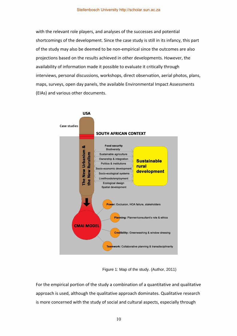
For the empirical portion of the study a combination of a quantitative and qualitative
approach is used, although the qualitative approach dominates. Qualitative research
is more concerned with the study of social and cultural aspects, especially through
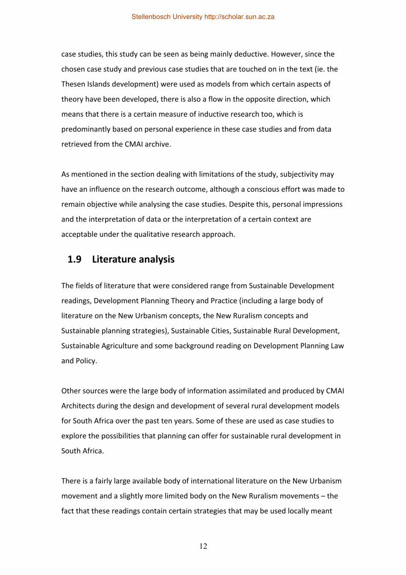
Figure 1: Map of the study. (Author, 2011)
Stellenbosch University http://scholar.sun.ac.za
11
the research of case studies, and this forms the bulk of the second part of the thesis.
The interviews, conversations, personal observations, available documentation and
my own impressions all fall under the qualitative umbrella. Quantitative research is
usually based on scientific data and numbers, of which there is only a small
proportion available as part of the case study documentation. This takes the form of
feasibilities, socio‐economic projections and agricultural projections of either the
case studies or actual data gathered from previous developments that have been in
operation for some time. This data has mostly been retrieved from the CMAI archive.
The research methodology can also be described as a combination of deductive and
inductive research: Since deductive research is research based on the development
of a theory followed by the testing of that theory through the analysis of particular
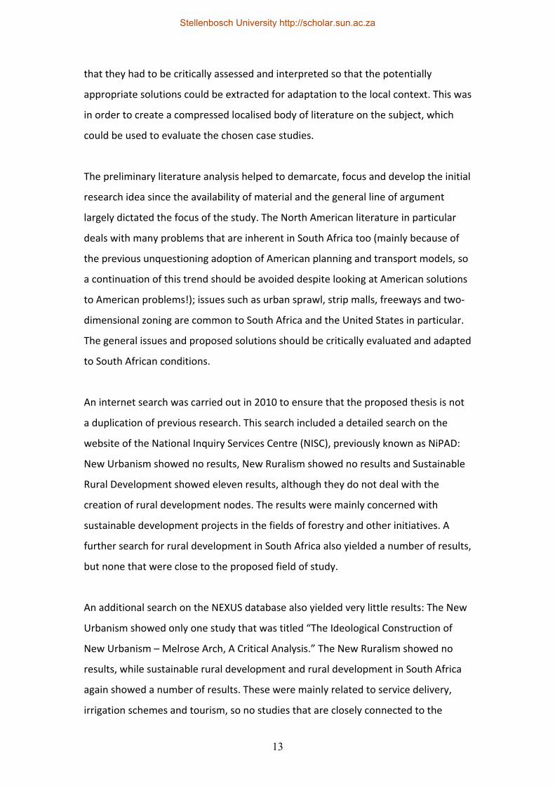
Analyse and review the literature on the New Urbanism and New Ruralism concepts
Review international and local case studies
Synthesise principles and strategies ‐ select those
appropriate to SA
Define sustainable development in the context of rural development in SA
Critically review the New Urbanism and the New Ruralism concepts and what is defined as
sustainable rural development
Critically assess the case study of Crossways Farm Village
Conclusion – assess the ability of the New Urbanism and New Ruralism concepts to act as tools for sustainable rural development in SA
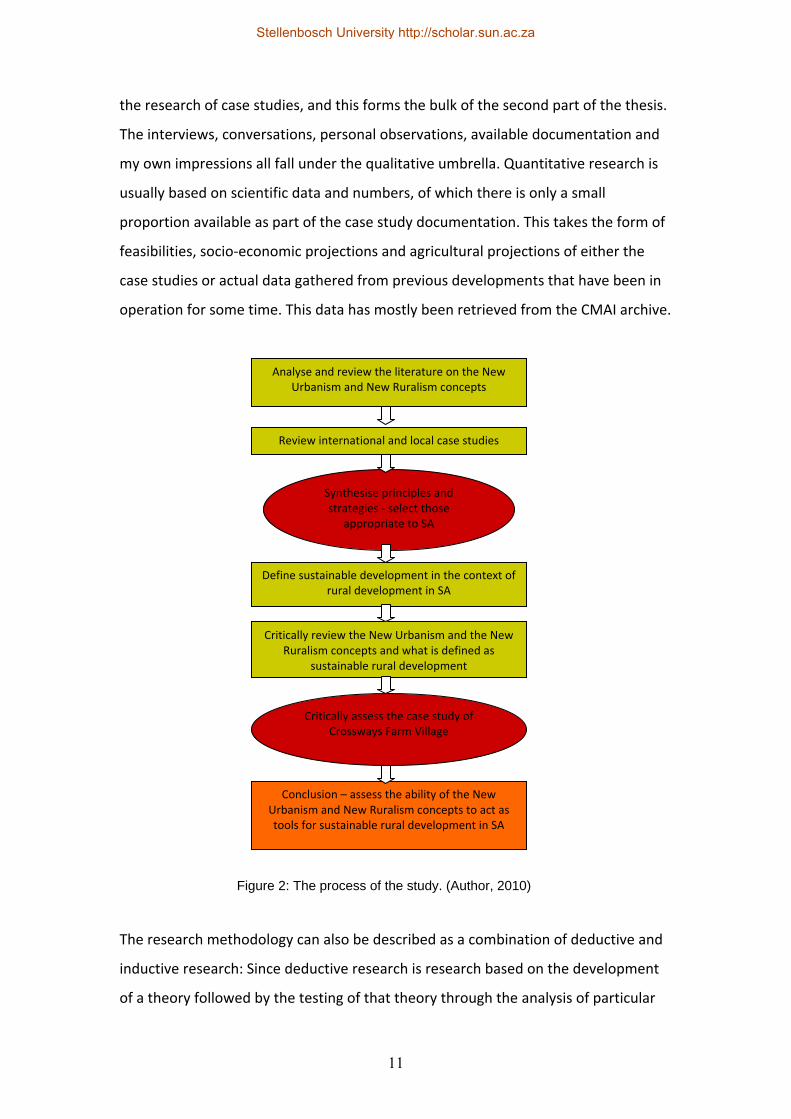
Figure 2: The process of the study. (Author, 2010)
Stellenbosch University http://scholar.sun.ac.za
12
case studies, this study can be seen as being mainly deductive. However, since the
chosen case study and previous case studies that are touched on in the text (ie. the
Thesen Islands development) were used as models from which certain aspects of
theory have been developed, there is also a flow in the opposite direction, which
means that there is a certain measure of inductive research too, which is
predominantly based on personal experience in these case studies and from data
retrieved from the CMAI archive.
As mentioned in the section dealing with limitations of the study, subjectivity may
have an influence on the research outcome, although a conscious effort was made to
remain objective while analysing the case studies. Despite this, personal impressions
and the interpretation of data or the interpretation of a certain context are
acceptable under the qualitative research approach.
1.9 Literature analysis
The fields of literature that were considered range from Sustainable Development
readings, Development Planning Theory and Practice (including a large body of
literature on the New Urbanism concepts, the New Ruralism concepts and
Sustainable planning strategies), Sustainable Cities, Sustainable Rural Development,
Sustainable Agriculture and some background reading on Development Planning Law
and Policy.
Other sources were the large body of information assimilated and produced by CMAI
Architects during the design and development of several rural development models
for South Africa over the past ten years. Some of these are used as case studies to
explore the possibilities that planning can offer for sustainable rural development in
South Africa.
There is a fairly large available body of international literature on the New Urbanism
movement and a slightly more limited body on the New Ruralism movements – the
fact that these readings contain certain strategies that may be used locally meant
Stellenbosch University http://scholar.sun.ac.za
13
that they had to be critically assessed and interpreted so that the potentially
appropriate solutions could be extracted for adaptation to the local context. This was
in order to create a compressed localised body of literature on the subject, which
could be used to evaluate the chosen case studies.
The preliminary literature analysis helped to demarcate, focus and develop the initial
research idea since the availability of material and the general line of argument
largely dictated the focus of the study. The North American literature in particular
deals with many problems that are inherent in South Africa too (mainly because of
the previous unquestioning adoption of American planning and transport models, so
a continuation of this trend should be avoided despite looking at American solutions
to American problems!); issues such as urban sprawl, strip malls, freeways and two‐
dimensional zoning are common to South Africa and the United States in particular.
The general issues and proposed solutions should be critically evaluated and adapted
to South African conditions.
An internet search was carried out in 2010 to ensure that the proposed thesis is not
a duplication of previous research. This search included a detailed search on the
website of the National Inquiry Services Centre (NISC), previously known as NiPAD:
New Urbanism showed no results, New Ruralism showed no results and Sustainable
Rural Development showed eleven results, although they do not deal with the
creation of rural development nodes. The results were mainly concerned with
sustainable development projects in the fields of forestry and other initiatives. A
further search for rural development in South Africa also yielded a number of results,
but none that were close to the proposed field of study.
An additional search on the NEXUS database also yielded very little results: The New
Urbanism showed only one study that was titled “The Ideological Construction of
New Urbanism – Melrose Arch, A Critical Analysis.” The New Ruralism showed no
results, while sustainable rural development and rural development in South Africa
again showed a number of results. These were mainly related to service delivery,
irrigation schemes and tourism, so no studies that are closely connected to the
Stellenbosch University http://scholar.sun.ac.za
14
proposed field of research were found. While there is generally a wide range of
literature on rural development in South Africa and on sustainable development in
South Africa, the research on, and use of the New Urbanism and New Ruralism has
been fairly limited. There also seems to be a lack of answers to the questions of
spatial planning linked to the creation of rural livelihoods and despite the
government’s aims for rural development, the existing legislation makes it difficult to
achieve.
One can therefore conclude that this proposed research study should fill a gap in the
local literature on sustainable development and could provide an alternative
direction for further study, research or development.
1.10 Case study research
While several case studies are examined during the exploration of the New
Urbanism and the New Ruralism frameworks, only a single case study (Crossways
Farm Village) is used to test the hypothesis and to provide a potential starting
point for further development. Eisenhardt (1989, pp. 534) describes a case study as
a research tool that focuses on exploring the dynamics present within a single
context. Flyvbjerg (2006, pp. 220) defines a case study as the detailed exploration
of a single type, but disagrees with the traditional view that a single case study
can’t provide reliable information about a wider range of applications. Donald
Campbell’s original view that case studies as a methodology are pointless (as cited
in Flyvbjerg, 2006, pp. 220) may also be mentioned here (although Campbell later
changed this view) and dismissed.
Flyvbjerg continues by providing five general misunderstandings about case study
research: 1. That general theoretical knowledge is worth more than practical
knowledge, 2. That one can’t build generally applicable theories from one case and
therefore one case can’t contribute to scientific development, 3. That case studies
can only generate hypotheses as a first stage in a longer research process, while
other research methods are more applicable to the testing of hypotheses, 4. That
Stellenbosch University http://scholar.sun.ac.za
15
case studies are often interpreted by the researcher in such a way as to confirm his
or her preconceived viewpoint and 5. That it is usually difficult to generate widely
applicable theories from one case study. Since the Crossways Farm Village case
study will be used to test a hypothesis in order to offer a generally applicable
theory it will be useful to briefly examine Flyvbjerg’s alternative view about the
above five misunderstandings. During case selection, different case types may be
investigated, but the the most favourable type in this case would be what Flyvbjerg
calls a Critical case. This is a type that permits the testing of a theory on a local
application and a good way of choosing a Critical case is to look for something that
is most likely able to prove the hypothesis (ie. that the New Urbanism and New
Ruralism frameworks may be suitable for South African conditions) – Crossways
Farm Village would seem to be the most likely (if not the only) example of
sustainable rural development based on New Urbanism and New Ruralism in South
Africa at present. Yin (2009, pp. 59) agrees with the use of case study research by
describing a case study as a research tool that can provide a detailed investigation
of something new, not‐understood or unexamined, which seems to be the case in
South Africa as far as the New Urbanism and New Ruralism frameworks are
concerned.
Case study research is described as a tool to create context‐dependent knowledge
and it is stated that only by experience in case studies can a beginner become an
expert. According to Flyvbjerg (2006, pp. 222), real‐life practical experience is
necessary to attain a more realistic view away from the rigid rules of pure theory
and case studies are said to generate the best theory. Flyvbjerg further argues that
one can generalise on the basis of the findings of a single case study and that it can
be used with or in lieu of other research methods; the power of practical examples
should not be underestimated. Researchers tend to look for verification of their
findings whether case studies are used or not, but it would seem that case studies
make it more difficult than theoretical research to interpret findings in the
affirmative.
Stellenbosch University http://scholar.sun.ac.za
16
Eisenhardt (1989, pp. 534) generally agrees with Flyvbjerg’s views that a case study
can be used to test and generate theories. Qualitative and quantitative research
should be combined and anecdotal data should not be underestimated since this
“soft data” can sometimes be used to substantiate the “hard” data. Levy (2008,
pp. 2) supports Flyvbjerg and Eisenhardt by saying “The common view that good
case study research lacks method is unwarranted.” He also confirms that good case
studies can test certain hypotheses and that case study research combined with
quantitative and formal methods can be advantageous.
“Today, when students and colleagues present me with the conventional wisdom
about case‐study research – for instance, that one cannot generalise on the basis
of a single case or that case studies are arbitrary and subjective – I know what to
answer. By and large, the conventional wisdom is wrong or misleading. For the
reasons given above, the case study is a necessary and sufficient method for
certain important research tasks in the social sciences, and it is a method that
holds up well when compared to other methods in the gamut of social science
research methodology.” (Flyvbjerg, 2006, pp. 241)
1.11 Conclusion
There seems to be a distinct lack of research on the New Urbanism and New
Ruralism frameworks in South Africa, especially in light of the shortcomings related
to spatial planning that many areas in the country are experiencing. Many sources
support the use of case studies to test and support theoretical research, so the
combination of both case studies and theoretical research is used to address the
research problem and objectives of this particular study.
While there may be problems associated with the use of spatial planning models
(and particularly transplanted models); the hard and soft data of a number of case
studies can be evaluated in the light of the literary background to establish the
potential benefits and problems associated with the strategies that are deemed
suitable to the local South African context.
Stellenbosch University http://scholar.sun.ac.za
17
Chapter 2: The New Urbanism
2.1 Definition
Duany Plater‐Zyberk and Company (2002, pp. A5) defines Urbanism as “The body of
knowledge dedicated to the habitat of humanity. New Urbanist usage implies
opposition to suburban (sub‐urban), a lesser or permanently incomplete version of
urbanism.” The New Urbanism is essentially a spatial planning strategy that aims to
recreate the neighbourhoods and communities found in older settlements before
the advent of sprawl, highways and single‐use suburbs. Fainstein (2005, pp. 10)
compares it to Ebenezer Howard’s Garden City movement that also aimed to create
close‐knit communities through the use of specific spatial planning techniques,
although she contends that it doesn’t display much theoretical rigour. She is also
concerned that it perpetuates the modernist idea that spatial order can result in
social order and the idea that spatial aspects are more important than the related
social processes.
Steuteville (2000, pp. ix) describes it as follows: “The New Urbanism, also called
traditional neighbourhood development, liveable communities, transit‐oriented
development, and smart growth, is a method of building human‐scale
neighbourhoods in place of single‐use subdivisions, shopping centres and office
parks.” Katz (1994, pp. xxv) says that “In one sense, it represents a rediscovery of
planning and architectural traditions that have shaped some of the most liveable,
memorable communities in America – urban precincts like Boston’s Back Bay and
downtown Charleston, South Carolina; neighbourhoods like Seattle’s Capitol Hill and
Philadelphia’s Germantown; and traditional small towns where life centres around a
courthouse square, common, plaza, train station or main street. For planners and
architects who embrace the New Urbanism, places like these provide both
inspiration and countless practical lessons for the design of new communities.”
There are, naturally, numerous critics of the New Urbanism and Loomis (1999, pp. 4)
mentions the reaction to a question by the well‐known Architect and theorist Rem
Stellenbosch University http://scholar.sun.ac.za
18
Koolhaas directed at Andres Duany asking him why he is not interested in
contemporary urban placemaking before comparing the New Urbanism to the new
Volkswagen Beetle: “…a cutesy consumer product translated from a vehicle intended
for the mass introduction of automobility.” Gordon (1998, pp. 2) goes one step
further when he asks: “What is wrong with this approach? Most of all, it embraces
pie‐in‐the‐sky social engineering based on a false diagnosis of society’s urban
problems, an excessive faith in the ability to change the world, and the prescription
of policies that are implementable only under very special circumstances.”
2.2 History (Urbanisation, sprawl, transport)
Traditionally people lived together in denser communities for security or to be close
to important resources like water or food, but in recent times, transit points like
railway stations or ports have been added to this list together with employment
opportunities. The car (amongst other factors) caused many of these denser
communities to disperse and suburbia became the new way of living for many
people – this naturally led to the fragmentation of communities on various levels.
Sprawl went hand‐in‐hand with numerous problems in addition to the destruction or
deterioration of once integrated neighbourhoods: Single‐use zoning laws, regulations
that enforce property sizes and setbacks, the increased distance between home and
the workplace, which also led to many people not having the opportunity to work,
the increased cost of transport infrastructure (which means less money being
available for other civic projects), increased pollution due to increased travelling
(which is usually in cars occupied by just one person at a time), increased time spent
on the road, which also leads to more stress and reduced productivity, higher crime
rates and environmental degradation. Standard traffic engineering requirements
that regulate oversized road widths for contingencies (ie. multiple fire & rescue
contingencies that may only occur once every ten years), national housing projects
that do not employ any form of proper community planning, the total lack of
contextuality where zoning laws are applied irrespective of context and the isolation
of professional disciplines results in further deterioration. Added to this are the
Stellenbosch University http://scholar.sun.ac.za
19
problems that are inherent to South African planning, where formerly (and in most
cases presently) disadvantaged communities were purposefully positioned far away
from employment and educational opportunities.
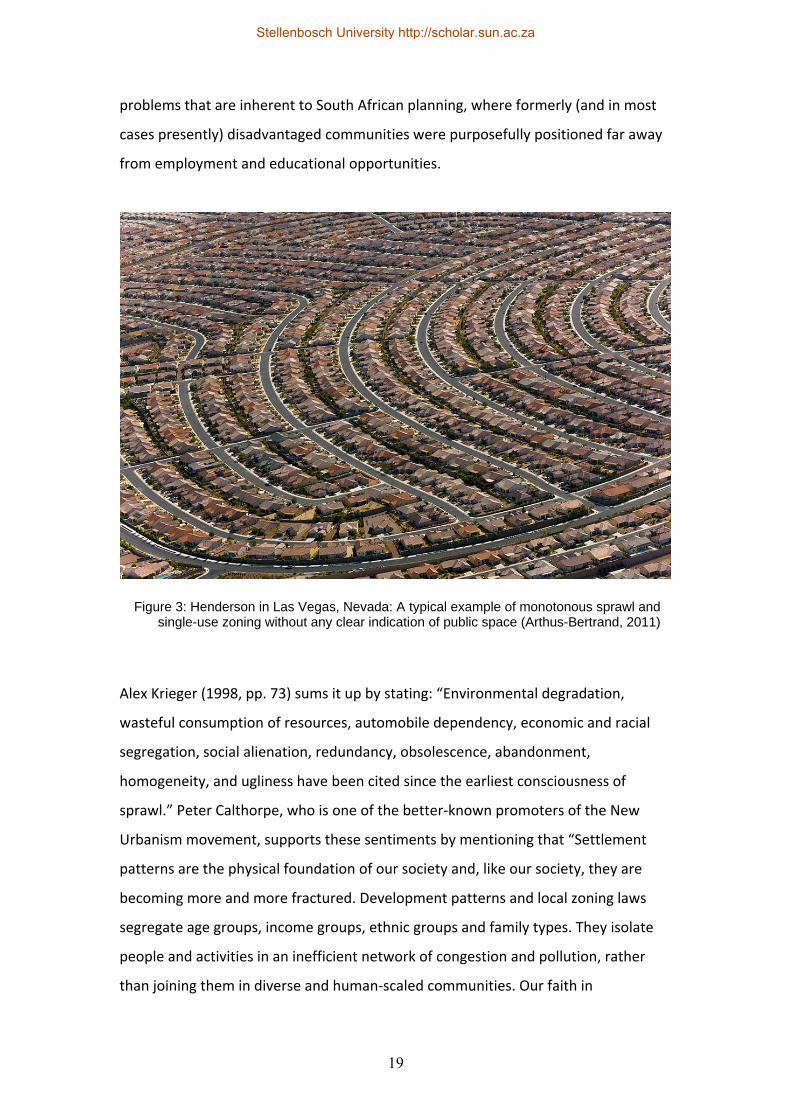
Alex Krieger (1998, pp. 73) sums it up by stating: “Environmental degradation,
wasteful consumption of resources, automobile dependency, economic and racial
segregation, social alienation, redundancy, obsolescence, abandonment,
homogeneity, and ugliness have been cited since the earliest consciousness of
sprawl.” Peter Calthorpe, who is one of the better‐known promoters of the New
Urbanism movement, supports these sentiments by mentioning that “Settlement
patterns are the physical foundation of our society and, like our society, they are
becoming more and more fractured. Development patterns and local zoning laws
segregate age groups, income groups, ethnic groups and family types. They isolate
people and activities in an inefficient network of congestion and pollution, rather
than joining them in diverse and human‐scaled communities. Our faith in
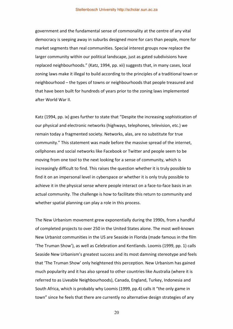
Figure 3: Henderson in Las Vegas, Nevada: A typical example of monotonous sprawl andsingle-use zoning without any clear indication of public space (Arthus-Bertrand, 2011)
Stellenbosch University http://scholar.sun.ac.za
20
government and the fundamental sense of commonality at the centre of any vital
democracy is seeping away in suburbs designed more for cars than people, more for
market segments than real communities. Special interest groups now replace the
larger community within our political landscape, just as gated subdivisions have
replaced neighbourhoods.” (Katz, 1994, pp. xii) suggests that, in many cases, local
zoning laws make it illegal to build according to the principles of a traditional town or
neighbourhood – the types of towns or neighbourhoods that people treasured and
that have been built for hundreds of years prior to the zoning laws implemented
after World War II.
Katz (1994, pp. ix) goes further to state that “Despite the increasing sophistication of
our physical and electronic networks (highways, telephones, television, etc.) we
remain today a fragmented society. Networks, alas, are no substitute for true
community.” This statement was made before the massive spread of the internet,
cellphones and social networks like Facebook or Twitter and people seem to be
moving from one tool to the next looking for a sense of community, which is
increasingly difficult to find. This raises the question whether it is truly possible to
find it on an impersonal level in cyberspace or whether it is only truly possible to
achieve it in the physical sense where people interact on a face‐to‐face basis in an
actual community. The challenge is how to facilitate this return to community and
whether spatial planning can play a role in this process.
The New Urbanism movement grew exponentially during the 1990s, from a handful
of completed projects to over 250 in the United States alone. The most well‐known
New Urbanist communities in the US are Seaside in Florida (made famous in the film
‘The Truman Show’), as well as Celebration and Kentlands. Loomis (1999, pp. 1) calls
Seaside New Urbanism’s greatest success and its most damning stereotype and feels
that ‘The Truman Show’ only heightened this perception. New Urbanism has gained
much popularity and it has also spread to other countries like Australia (where it is
referred to as Liveable Neighbourhoods), Canada, England, Turkey, Indonesia and
South Africa, which is probably why Loomis (1999, pp.4) calls it “the only game in
town” since he feels that there are currently no alternative design strategies of any
Stellenbosch University http://scholar.sun.ac.za

21
merit. This is debatable and it may be a case of not being “the only game in town”,
but merely the game making the most noise at present.
2.3 Principles
Where the New Urbanism is applied on the neighbourhood scale, it is referred to as
Traditional Neighbourhood Development (TND). A TND is different to standard urban
or suburban development since it is based on mixed zoning where different uses are
found in the same area, together with different housing types. Streets are usually
narrower and interlinked to allow a range of movement choices to reduce potential
blockages – cul de sacs are rarely used and main streets are developed as shopping
precincts in lieu of shopping malls. Traditional neighbourhood development (TND)
and Transit Oriented Development (TOD) are defined as “A comprehensive planning
system with the mixed‐use neighbourhood as its basic element and the single‐use
district as an exception.” (Duany Plater‐Zyberk & Company, 2002, pp. B1)
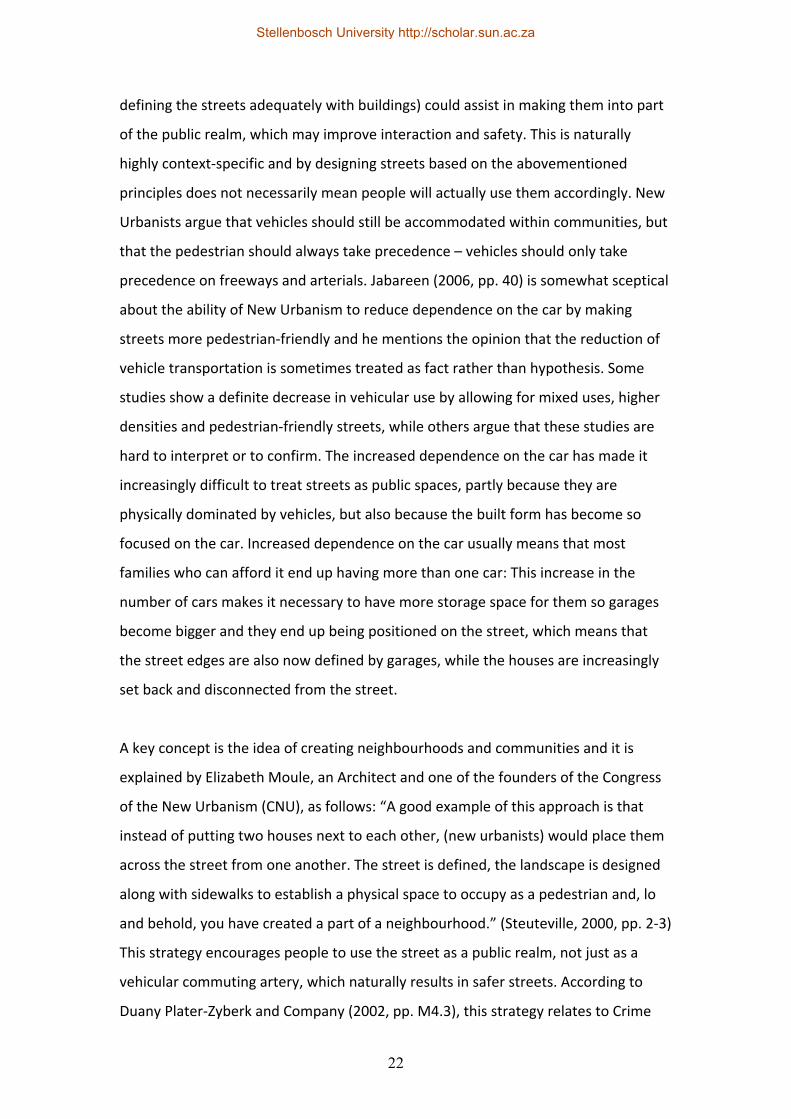
Different daily activities should
be available within walking
distance, which is beneficial to
all residents, especially young
people and the elderly.
Through the provision of
different housing types, a
wider variety of income
groups, ages and ethnicities
can be accommodated in the
same area, which some argue
strengthens the community.
By making the streets more
pedestrian friendly (both by
designing the streets
themselves, but also by
Figure 4: Comparing a traditional town layout to land patterns typically associated with sprawl.
(Steuteville, 2000, pp. 9-3)
Stellenbosch University http://scholar.sun.ac.za
22
defining the streets adequately with buildings) could assist in making them into part
of the public realm, which may improve interaction and safety. This is naturally
highly context‐specific and by designing streets based on the abovementioned
principles does not necessarily mean people will actually use them accordingly. New
Urbanists argue that vehicles should still be accommodated within communities, but
that the pedestrian should always take precedence – vehicles should only take
precedence on freeways and arterials. Jabareen (2006, pp. 40) is somewhat sceptical
about the ability of New Urbanism to reduce dependence on the car by making
streets more pedestrian‐friendly and he mentions the opinion that the reduction of
vehicle transportation is sometimes treated as fact rather than hypothesis. Some
studies show a definite decrease in vehicular use by allowing for mixed uses, higher
densities and pedestrian‐friendly streets, while others argue that these studies are
hard to interpret or to confirm. The increased dependence on the car has made it
increasingly difficult to treat streets as public spaces, partly because they are
physically dominated by vehicles, but also because the built form has become so
focused on the car. Increased dependence on the car usually means that most
families who can afford it end up having more than one car: This increase in the
number of cars makes it necessary to have more storage space for them so garages
become bigger and they end up being positioned on the street, which means that
the street edges are also now defined by garages, while the houses are increasingly
set back and disconnected from the street.
A key concept is the idea of creating neighbourhoods and communities and it is
explained by Elizabeth Moule, an Architect and one of the founders of the Congress
of the New Urbanism (CNU), as follows: “A good example of this approach is that
instead of putting two houses next to each other, (new urbanists) would place them
across the street from one another. The street is defined, the landscape is designed
along with sidewalks to establish a physical space to occupy as a pedestrian and, lo
and behold, you have created a part of a neighbourhood.” (Steuteville, 2000, pp. 2‐3)
This strategy encourages people to use the street as a public realm, not just as a
vehicular commuting artery, which naturally results in safer streets. According to
Duany Plater‐Zyberk and Company (2002, pp. M4.3), this strategy relates to Crime
Stellenbosch University http://scholar.sun.ac.za
23
Prevention through Environmental Design (CPTED) which aims to reduce crime by
applying behavioral and social science. The key principles of CPTED are the
monitoring of streets through the adequate provision of street‐fronting windows,
the clear separation of public and private open space, the demarcation of private
space through walls or fences, adequate lighting, clear sight lines and the
minimisation of dense low‐lying vegetation. Jabareen (2006, pp. 41) agrees that
proper urban design can increase security, especially where different uses are
accommodated in the same area.
Marcuse (2000, pp. 5) and Harvey (1997, pp. 2) both question the validity of the
theory that spatial order can lead to moral and aesthetic order; statements such as
Moule’s mentioned above, indicate how some New Urbanists accept this as fact. It is
also rather optimistic to imply that part of a neighbourhood can be created by
placing two houses on either side of a street (while placing two next to each other
might be less adequate), but it is a well‐established notion that many New Urbanists
hold that the most basic form of spatial planning will naturally lead to a
predetermined social outcome.
Quite an emphatic critic of the New Urbanism is Alex Krieger who challenged some
of the leading
proponents of the
New Urbanism by
stating: “The New
Urbanism
movement is
impressive,
powerful, growing,
and great, but
perhaps not as
great as you, its
founders, claim it to be. Figure 5: A typical TND neighbourhood unit.
(Duany Plater-Zyberk & Company, 2002, pp. C1)
Stellenbosch University http://scholar.sun.ac.za
24
Lighten up. Enough self‐congratulatory testimonials. You are practically the
establishment now. One of the few things still missing is some humility, or barring
that, a bit less hyperbole, and barring that, at least a sense of humour.” He also feels
that many of its basic principles are strategies that other movements also advocate,
although the New Urbanists claim them for themselves: “Among your notable
achievements is crafting a text that contains what most [in] the planning community
believe and making those beliefs appear proprietary to the movement. That is
impressive!” (Krieger, 1998, pp. 73) Loomis (1999, pp. 1) shares the view that the
singular theory of New Urbanism has co‐opted the language of urbanism and that it
is claiming common urban terminology for itself.
Compared to conventional suburban development, Andres Duany and Elizabeth
Plater‐Zyberk describe New Urbanist planning in thirteen points (Steuteville, 2000,
pp. 9‐3):
• A New Urbanist neighbourhood has a discernible centre, which could be a
park, a green, a well‐known corner etc. This is usually used in conjunction
with a discernible edge and they argue that a combination of these two
elements can provide a strong sense of community within a specific
neighbourhood.
• Most residential units are within a 5 minute walk of the centre.
• The provision of a variety of housing types, from single residential dwellings
to row houses and apartments provides the possibility of catering for a range
of age and income groups.
• Positioning shops and offices at the edge of the residential area to cater for
the weekly needs of residents.
• The allowance of a small secondary building that can be used as a small rental
unit or a home office on each property.
• Placing a primary school within walking distance of the residential properties.
• Providing small parks or playgrounds close to all houses.
• The dispersion of traffic via a network of streets that can cater for
pedestrians and cars.
Stellenbosch University http://scholar.sun.ac.za
25
• The provision of narrow, shaded streets that can calm traffic speeds.
• The placement of buildings in the core close to the street.
• The placement of parking areas and garages in the rear of properties.
• Prominent sites (ie. at the visual termination of streets) are designated for
civic buildings.
• Neighbourhoods are planned to be self‐governing.
Something not mentioned in this list, but which is one of the more important
strategies of the New Urbanism, is the use of traditional shopping streets or ‘high
streets’ instead of shopping malls. This fits into the practice of making the street part
of the public realm again where the car is relegated to the back of the buildings.
Duany and Plater‐Zyberk view the basic organisational elements of New Urbanism as
the neighbourhood, the district and the corridor (Katz, 1994, pp. xvi). The
neighbourhood is a mixed‐use urbanised area, a district is a single‐use area and
corridors are the elements that connect or separate these two. These elements also
form the basic building blocks of what is referred to as Transit‐Oriented
Development.
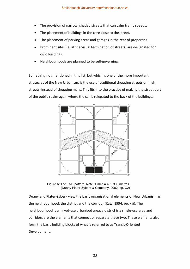
Figure 6: The TND pattern. Note ¼ mile = 402.336 metres.(Duany Plater-Zyberk & Company, 2002, pp. C2)
Stellenbosch University http://scholar.sun.ac.za
26
A Transit‐oriented development (TOD) is typically a TND that is established around a
mass transit station. This can either take the form of a neighbourhood TOD which is
centred on a feeder bus line or an urban TOD which is located on a main transit line.
Challenges inherent in both types are difficulties in coordinating with transit agencies
that have their own agendas and convincing banks or lending agencies about their
merits. Strangely enough, something that banks and lending agencies are struggling
to deal with is the mixed‐use aspect of most TODs, since they usually specialise in
single‐use financing. The irony in this is that potential apartment buyers buy into a
lifestyle, so by merely placing apartments close to transit isn’t enough – the
necessary amenities also have to be provided. A potential negative of TOD
developments is that the amount of parking required around transit stops together
with transit routes may result in negative pedestrian spaces and the separation of
certain neighbourhood sections. However, if authorities can be convinced to allow
shared parking, this problem may be mitigated to some extent, since the overall
required parking requirement can be reduced.
Calthorpe Associates supports Duany and Plater‐Zyberk’s New Urbanist principles by
describing the main principles of TOD as follows (Steuteville, 2000, pp. 3‐6):
• Providing an adequate density of housing and employment close to the
transit point. This typically equates to 17 residential units per hectare in
suburban areas and 20 to 30 units in urban areas.
• The spatial extent of a TOD should typically be a 5 minute walking distance to
the transit stop, which is a radius of about 400 metres.
• A TOD has to have a mix of uses, from residential to civic uses, as well as
retail and services.
• Pedestrian‐oriented planning with comfortable walkways, public outside
spaces and buildings fronting onto these to increase safety.
• A network of streets to maximise choice of movement. Neighbourhood
streets should be narrow to calm traffic effectively.
• The transit point and core of the development should be roughly at the
centre without creating pedestrian blocks (ie. with railway tracks or
Stellenbosch University http://scholar.sun.ac.za
27
highways). If that could potentially happen the core should rather be on the
edge of the development.
• The minimum size of a TOD should typically be 12‐24 hectares, but it could go
up to approximately 50 hectares.
• The area outside the standard TOD can accommodate less intense uses, like
low‐density residential, light industrial, offices or parks up to about 1.5
kilometres from the centre.
Calthorpe (in Steuteville, 2000, pp. 3‐10) suggests that public agencies should
educate the public, banks, retailers and employers about TODs via workshops, tours
and websites. Typically, the authorities will also have to be educated, since existing
development controls and local laws may not cater for TOD‐based projects. Local
laws are typically the primary obstacle to any new urbanist development, since
existing zoning laws mostly cater for single‐use zoning, whereas New Urbanism
promotes mixed‐use zoning. Typically, New Urbanist planning schemes are used as
overlays in conjunction with existing zoning schemes and certain concessions are
regularly made overseas (like reduced rates and taxes) since mixed‐use development
creates less strain on Municipal infrastructure.
Figure 7: The TOD pattern. Note 1 mile = 1609.344 metres and ½ mile = 804.672 metres.(Duany Plater-Zyberk & Company, 2002, pp. C2)
Stellenbosch University http://scholar.sun.ac.za
28
The urban core is one of the most important aspects of a TOD, and in fact any New
Urbanist development, since it’s usually based on traditional commercial districts
where buildings create walls or well‐defined edges with large shop windows to the
shopping area or shopping street, usually with specific architecture, signage and
street furniture. Buildings are typically placed on the street property boundary, with
shared parking to the rear and on‐street customer parking, while loading areas and
refuse are positioned to the rear of the buildings, and larger lots with set‐back
buildings have low walls on the street boundary in order to define the edge. Side
yard parking is highly discouraged, while paved walkways from the street to the rear
yard parking areas are highly recommended. The massing and composition of
buildings is equally important since shops were traditionally smaller than today’s
retail outlets, so façades are broken up to provide a more human scale. The urban
core is mostly designed with a fine‐grained, interconnected street network with
mixed‐use buildings, including residential portions. This is supposed to assist in
prolonging the active life of the area, making it more vibrant, more viable and less
car‐dependent. A potential downside of the commercial cores of Traditional
Neighbourhood Developments is that they sometimes only sustain neighbourhood‐
level retail outlets, but these can always grow and expand over time.
Designing with nature (DWN) is a methodology regularly used in conjunction with
the New Urbanism; it was initially described in a book by Ian McHarg in 1963 and it’s
basically an in‐depth site analysis whereby key site determinants or traces on the
land are catalogued or mapped and used as planning guides. Environmentally
sensitive areas, steep slopes, heritage areas (or areas of natural beauty) and traces
on the land are identified as no‐go zones and the remaining areas on site are then
deemed developable. A potential downside to this methodology is that it doesn’t
provide guidelines for the development of the remaining “developable” area, but if
it’s used in conjunction with New Urbanist principles it may form a symbiotic
relationship. “Architecture and landscape design should grow from the climate,
topography, history and building practices of the region.” (Duany Plater‐Zyberk &
Company, 2002, pp. A3)
Stellenbosch University http://scholar.sun.ac.za

29
Another concept that is regularly used in conjunction with the New Urbanism is that
of ‘regionalism’. It is defined by Duany Plater‐Zyberk and Company (2002, pp. M4.6)
as “The thesis that the design of artifacts should be informed by the ethos of a
region. Regionalism has a salutary effect on the urban pattern, a decidedly positive
one on building type, and an essential one on the architectural vernacular.”
Vernacular is in turn defined as “The common language of a region, particularly in
reference to the architectural tectonics. Through time and use, the vernacular has
intrinsically resolved the architectural response to climate, construction technique,
and to some extent social mores. The writing of codes based on the emulation of the
vernacular can dispense with basic research, resulting in design efficiency and the
minimizing of errors.” While this may be true in some cases, it is also sometimes
based on imported styles (especially colonial imports) that have become the
vernacular due to their sheer distribution. Climate concerns were not always the
prime motivator, nor were local construction techniques, since many styles like the
better‐known English styles (ie. the Victorian style amongst others) consisted of mail‐
order elements that were manufactured overseas with no conception of the climates
or localities where the elements would eventually be used. However, implemented
sensibly, critical regionalism can be quite successful, although it should be accepted
that it will usually reflect a specific cultural group rooted in a specific historic
timeframe, which may have an exclusionary effect on other cultural groupings.
Krieger (1998, pp. 74) raises another view when he states that style does not
determine community and quotes Andres Duany as saying “We New Urbanists are
allergic to nostalgia.” This is despite the fact that most New Urbanist developments
regulate the implementation of revivalist Architecture. He goes on to ask “Can you
separate out the search for the ‘image of community’ from the desire for community
itself?” Ellis (2002, pp. 274) feels the arguments centered on nostalgia are without
merit and that the Architectural establishment is increasingly losing touch with the
marketplace. Marcuse (2000, pp. 4) opposes this view when he states “For it
purports to hearken back to a form of ‘community’ that in fact very rarely existed in
the past: The small‐town America of nostalgic recollection (and of much of Disney
Stellenbosch University http://scholar.sun.ac.za
30
World), the ideal of middle America promulgated in the promotions for single family
homeownership, the democracy of town meetings in colonial New England, the
stable, family‐oriented, homogenous community of a rural county. It is false
historically; it evokes a past that never existed in the form in which the New
Urbanism pictures it, and certainly not one that existed in an urban setting. It is more
the image of community, than community that is recaptured.” Harvey (1997, pp.2)
poses the question whether collective memory is being recaptured or reinvented.
While the New Urbanism seems to have many advantages, its promotion of
traditional building styles attracts a fair amount of criticism; Todd Bressi (as cited in
Katz, 1994, pp. xxxvi) argues that New Urbanist proposals advocate overly romantic
building styles and that many critics feel that visual style is given more importance
than planning substance. This leads to many uninformed developers using the New
Urbanism superficially by advocating revivalist building styles to improve
marketability, without implementing the key aspects of the movement to try to
improve specific neighbourhoods. He goes on to say that while some New Urbanist
proposals may lead to improved neighbourhoods at a local level, these efforts will be
meaningless on a broader scale if they do not propose or inform regional planning
strategies.
As far as housing types are concerned, these are usually provided only for certain
income brackets, which leads to the exclusion of low‐income families and Bressi also
feels that the movement has not sufficiently addressed ecological concerns, while
only partly addressing social and economic aspects of sustainability. He contends
that good design does not necessarily result in good communities and a community
evolves over time with its own overlayed structures. Public spaces and civic buildings
may be controlled by Homeowners Associations, so he asks the question whether
they can then be considered true public spaces and whether civic buildings like
clinics or churches will be available to the wider community or only to certain
community members. Loomis (1999, pp. 3) mentions the view of several critics that
Homeowners Associations are replacing citizenship and democracy, while
strengthening middle‐class identity. Marcuse (2000, pp. 4) confirms this when he
Stellenbosch University http://scholar.sun.ac.za
31
states that “The fully completed New Urbanist developments are in fact
homogenous, and at a fairly high income level. Where an attempt is made to include
some housing affordable to lower income families, Duany and Plater‐Zyberk, gurus
of the New Urbanism, suggest that 10% is the ‘right ratio for achieving a mix without
diminishing the value of surrounding properties.’”
Katz (1994, pp. xlii) is one of many who feel that the movement does have merits,
although he is slightly more careful with his compliments than most: “The New
Urbanism is a welcome step forward, but it is only a step. At best, the movement has
refocused the public’s attention more strongly on how the design of our
communities has a very real impact on our lives. If the presence of projects in the
landscape can inspire a broadened, sustained public debate about the nature of
American communities; if Seaside, Laguna West, Riviera Beach and their
descendants can create vivid alternatives to current atomised, privatised
development patterns, then the New Urbanism might truly begin to reshape the
American Dream.” The same can be said for its application in South Africa or any
other country that has similar planning problems to those found in the United States.
2.4 Smart growth and the Smart Code
In the United States of America, a code is what is typically referred to as a Zoning
Scheme, Town Planning Scheme or Urban Regulation in South Africa; it is a set of
rules in terms of which land may be used and developed. Growth management is a
set of policies at the regional scale and it is used to manage growth over a wider
area. Daniels (2001, pp. 277) describes the concepts of Smart Growth and the Smart
Code as follows: “The term ‘smart growth’ suggests a public‐private approach to
managing growth that will produce the best of both worlds: Economic growth
without the ugliness, congestion, environmental degradation, and wasteful public
subsidies of sprawling development.” Jabareen (2006, pp. 45) has a similar
interpretation: “Management programs that attempt to balance growth while
fulfilling economic, social, and environmental needs are often termed smart growth
programs.” He also acknowledges that smart growth borrows heavily from the
Stellenbosch University http://scholar.sun.ac.za
32
concept of New Urbanism since it also promotes densification, mixed‐use
development and pedestrian‐friendly streets although it doesn’t always support
extreme densification or intensification.
According to Smart Code Central (2011), the Smart Code is “…a model transect‐
based planning and zoning document based on environmental analysis.” It was
originally drafted in 2002 by Duany, Plater‐Zyberk and Company, but since 2004 it is
an Open Source document. Duany, Sorlien and Wright (2005, pp. 2) describe the
Smartcode as a tool that addresses the problems associated with sprawl at the
decisive point where the law and design intersect. They call it a form‐based code
where the form of a region, community, block or building is planned and encouraged
to represent the traditional forms of villages or neighbourhoods; this means that an
actual physical outcome is envisaged at the outset. Duany, Speck and Lydon (2010,
App. A) define Smart Growth in terms of six basic goals: Improving the living quality
in neighbourhoods, better access to different daily uses with reduced traffic, the
creation of thriving cities, suburbs and towns, shared benefits for people of different
incomes and races, reduced costs and taxes due to a reduction of sprawl, and the
retention of open spaces. They go on to recommend ten strategies in order to
achieve these goals: The provision of mixed land uses, making the most of existing
neighbourhood assets (ie. existing transport nodes, schools and parks), providing a
wider range of housing types, the creation of walkable neighbourhoods, reinforcing
the sense of place of specific neighbourhoods, preserving open spaces, promoting
growth in existing communities, providing a variety of transport types, making Smart
Growth developments as easy to implement as normal types of development, and
encouraging public participation during the planning phases. These strategies are
listed almost verbatim by ICMA (2010, pp. 6).
The New Urbanism framework and the Smart Code are usually applied in terms of
the transect. This is a concept developed by Andres Duany whereby any region can
be divided up into different zones or transects depending on the relative density and
types of uses that should be found in each zone. This means that specific forms fit
into specific transects, like an apartment building would only fit in a more urban
Stellenbosch University http://scholar.sun.ac.za
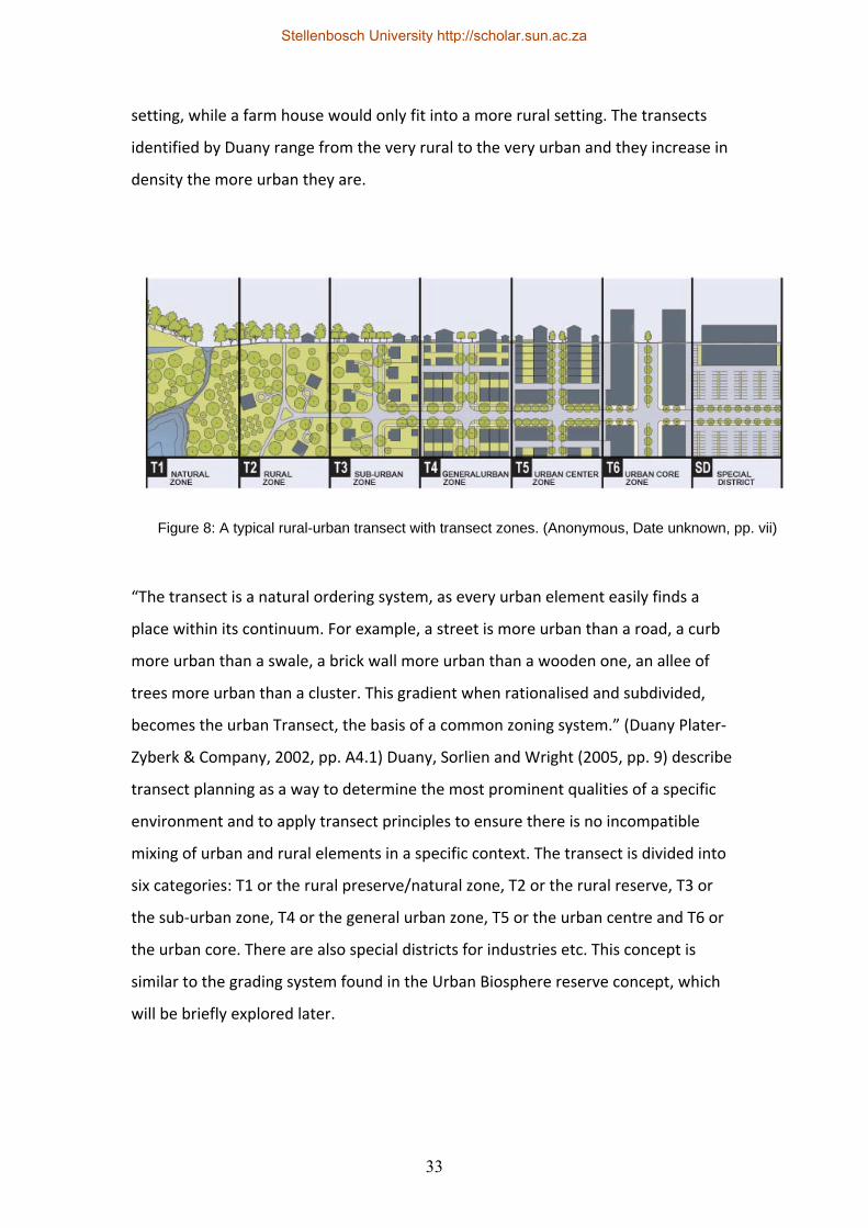
33
setting, while a farm house would only fit into a more rural setting. The transects
identified by Duany range from the very rural to the very urban and they increase in
density the more urban they are.
“The transect is a natural ordering system, as every urban element easily finds a
place within its continuum. For example, a street is more urban than a road, a curb
more urban than a swale, a brick wall more urban than a wooden one, an allee of
trees more urban than a cluster. This gradient when rationalised and subdivided,
becomes the urban Transect, the basis of a common zoning system.” (Duany Plater‐
Zyberk & Company, 2002, pp. A4.1) Duany, Sorlien and Wright (2005, pp. 9) describe
transect planning as a way to determine the most prominent qualities of a specific
environment and to apply transect principles to ensure there is no incompatible
mixing of urban and rural elements in a specific context. The transect is divided into
six categories: T1 or the rural preserve/natural zone, T2 or the rural reserve, T3 or
the sub‐urban zone, T4 or the general urban zone, T5 or the urban centre and T6 or
the urban core. There are also special districts for industries etc. This concept is
similar to the grading system found in the Urban Biosphere reserve concept, which
will be briefly explored later.
Figure 8: A typical rural-urban transect with transect zones. (Anonymous, Date unknown, pp. vii)
Stellenbosch University http://scholar.sun.ac.za
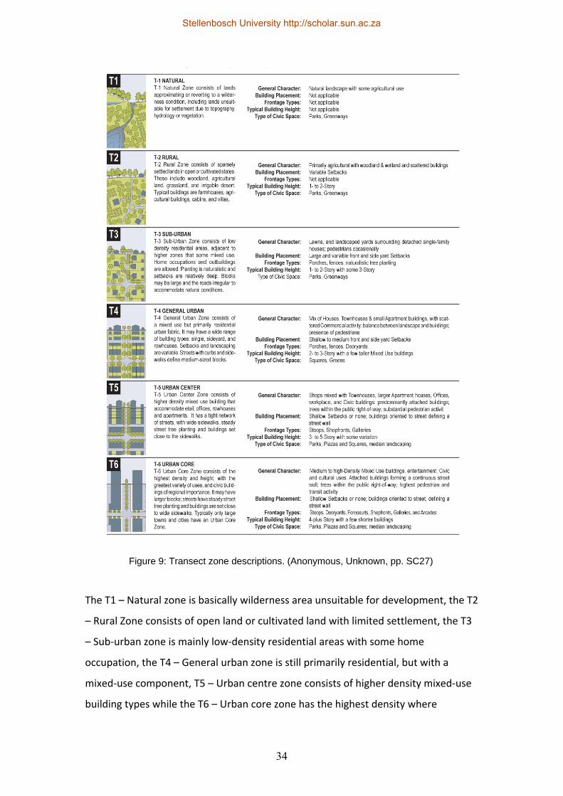
34
The T1 – Natural zone is basically wilderness area unsuitable for development, the T2
– Rural Zone consists of open land or cultivated land with limited settlement, the T3
– Sub‐urban zone is mainly low‐density residential areas with some home
occupation, the T4 – General urban zone is still primarily residential, but with a
mixed‐use component, T5 – Urban centre zone consists of higher density mixed‐use
building types while the T6 – Urban core zone has the highest density where
Figure 9: Transect zone descriptions. (Anonymous, Unknown, pp. SC27)
Stellenbosch University http://scholar.sun.ac.za
35
regionally important civic buildings are located. The Smart Code usually requires
local calibration so it fits with a specific regional character and it can either replace
local zoning laws or it can be used as an overlay in conjunction with local zoning
laws.
2.5 Coding and governance
New Urbanist developments usually enforce their rules by means of Code Books or
Pattern Books; these tend to be very specific Architectural regulations that are
enforced by the developments or Homeowners Associations themselves and where
local authorities have bought into the codes, they usually tend to enforce them too
once the proposals reach their offices. The codes typically include regulating master
plans that indicate overall planning principles, regulation plans or urban standards
that govern the public faces of private buildings, thoroughfare standards or street
sections and Architectural/Landscape design guidelines that regulate the detailed
design of buildings and landscapes. This is meant to ensure visual and functional
coherence in the development, while also making it possible for a wider range of
practitioners to be involved in the project.
According to Steuteville (2000, pp. 11‐5), many Architects criticise the use of code
books and pattern books since they tend to inhibit their creativity, but he goes on to
state that the rules aren’t cast in stone and that they challenge professionals to be
creative within set limits. According to him, the residential and commercial buildings
should not be too individualistic, but should form a coherent whole or a community
of buildings; the civic buildings should be the ones that shine and where more
freedom is allowed in the design. Loomis (1999, pp. 2) feels that New Urbanist codes
are usually somewhat ambiguous and that they only promote homogeneity and
inhibit individual creativity; this is in addition to the previously mentioned criticisms
related to nostalgia. Ellis (2002, pp. 275) has a different view and feels that properly
drafted codes can enhance creativity while improving the public realm (ie. by
removing garage doors from the street). Some believe the strictness of these rules
often leads to over‐design and too much monotonous similarity, sometimes at the
Stellenbosch University http://scholar.sun.ac.za
36
cost of flexibility or adaptability over time. An example of this is Thesen Islands
where some see the strict enforcement of the original guidelines as severely limiting
to individual expression, despite many attempts by home owners, Planners and
Architects to implement new elements or to apply for adjustments to the original
guidelines. Ford (1999, pp. 254) refers to Kevin Lynch’s book “What Time is this
Place?” (1972, pp. unknown) when he says that “A problem arises, however, when
neighbourhoods become frozen in time and change is disallowed.”
These rules are enforced initially by the developer, but this function is gradually
taken over by a Homeowners Association or Commercial Owners Association and the
necessary management rules and deterrents for non‐compliance are usually written
into the initial sales documentation to ensure that buyers comply with the
guidelines. There is usually also a building time limit, where a buyer has to construct
a building of the required size and type within a set period of time from the date of
transfer. Ford (1999, pp. 252) asks the question whether neighbourhoods can be
referred to as “traditional neighbourhoods” if they are designed, controlled and
maintained by corporations.
2.6 Public participation
The planning and governance of projects based on the New Urbanism and New
Ruralism concepts is also mostly linked to participatory processes. Public
participation in the New Urbanism is usually initiated through the use of a charette
process, where experts from different disciplines work with stakeholders to develop
a project proposal. It can be a fairly time consuming process and according to
Steuteville (2000, pp. 10‐3) costs for a charette process in the United States can
range from $10 000.00 (R71 718.00 based on the September 2011 exchange rate) if
it’s a voluntary or sponsored charette to over $300 000.00 (R2 152 000.00 based on
the September 2011 exchange rate) if it’s a high‐end professional charette.
According to New Urbanists, the aim of any charette is to bring about real change in
planning, people’s understanding and governance: It should be an inclusive process
Stellenbosch University http://scholar.sun.ac.za
37
which is managed by an interdisciplinary professional team and it typically lasts for
approximately one week.
The principles of the charette process are to involve all stakeholders from the very
beginning, by allowing for interdisciplinary planning, short feedback loops and detail
design. By involving the whole professional team, as well as the public (including
potential objectors), and end users and officials; everyone’s comments can be given
attention, which New Urbanist practitioners feel results in a better product with the
buy‐in of the people who eventually need to approve it and/or use it. By involving
different disciplines throughout the design process, a more continuously realistic
project evolves – this is also aided by the shorter feedback loops where the design
team doesn’t retreat to their offices, only to present a “master plan” some weeks
later. With a charette, the design is continuously revised, updated and presented to
all the attendees until the project is understood by everyone and everyone has
voiced their opinions while the process is still ongoing.
Duany Plater‐Zyberk and Company (2002, pp. M4.1) promotes the same process and
cites similar advantages like efficiency, increased agreement with the proposals and
focused responses to opportunities and constraints. They go on to define a charette
as “A term common to Architects, meaning to work continuously and quickly toward
an impending deadline. It is derived from the French for little cart. Architecture
students at the École des Beaux Arts in Paris had their drawings taken by such a cart
to be judged by the assembled professors. The cart’s approach was heralded by
frantic work. The modern usage refers to a design process taking place in proximity
to the site and in the presence of those affecting and affected by the outcome,
generally the neighbours, developers, elected officials and administrators. All who
will ultimately pass judgement on it.”
The process usually consists of an initial one‐day meeting by the project team to
prepare a basic start‐up plan, discuss desired outcomes, identify stakeholders and
plan the charette process. This is followed by a preparation period where baseline
data are assimilated, initial input is received from stakeholders and participants are
Stellenbosch University http://scholar.sun.ac.za
38
familiarised with the charette process. An initial public meeting is held to introduce
the project while allowing participants an opportunity to make initial comments,
before a site visit is arranged. An open studio is then established on site by the
project team (this includes all the necessary equipment to develop the plans),
meetings are held continuously with key role players and members of the public are
free to visit the studio and interact with the team. Evening meetings are held with
participants to present progress and receive input. The plans are continuously
updated to reflect the feedback received until the charette finally ends with a full
public presentation. The plans are then reviewed, revised and finalised before
presenting them again before submission.
Duany, Sorlien and Wright (2005, pp. 3) emphasise that the involvement of many
different participants is vital, since projects solely envisaged by a single designer or
group of designers will only result in large Architectural projects instead of real
urbanism. They also mention the importance of a fourth dimension, ie. time; real
environments can only evolve over longer periods of time and can’t be
manufactured over short cycles. This is contradictory to most New Urbanist
developments where the project is planned and completed within a fixed timeframe,
while change over time is inhibited by the strict enforcement of the original
guidelines or Codebooks.
Fainstein (2005, pp. 11) feels that the charette process is often just window‐dressing
since the planners generally tend to overpower the comments of other stakeholders
and because they have predetermined outcomes in mind prior to the participation
process starting: “The New Urbanists do not fear playing the role disdained by the
communicative theorists – that of persuasive salespersons for a particular point of
view and deployers of strategies aimed at co‐opting people.”
2.7 Performance
New Urbanism has gained a very large body of supporters, from the private sector to
government, and its supporters are generally very vocal: One organisation in
Stellenbosch University http://scholar.sun.ac.za
39
particular, The Congress for the New Urbanism (CNU), is doing a lot to spread the
word and it publishes regular newsletters showcasing the latest New Urbanist
developments. Jabareen (2006, pp. 43) mentions various sources that confirm the
basic aims and principles that Duany and Plater‐Zyberk advocate, although he also
cites a number of critics like Timothy Beatley who believes that there is a gap
between the rhetoric of the New Urbanism and its results in practice and that New
Urbanist developments sometimes lack the mixed uses, public transit and
appropriate densities that would make them more sustainable. He calls for specific
types of the New Urbanism that are more concerned with ecological design. Banjo
(2008, pp. R13) confirms the view that New Urbanism doesn’t place enough
emphasis on the ecology: “When the Congress for the New Urbanism was founded in
1993, the emphasis was on fostering a sense of community, not saving the planet.”
While densification, transit and some of the principles of New Urbanism do reduce
emissions and resource use, there are critics who suggest that New Urbanists
generally don’t pay enough attention to energy efficiency, resource consumption or
stormwater management during building or infrastructure design: “…many critics
argue that new urbanism goes only halfway in its environmentalism.” (Banjo, 2008,
pp. R13) Harvey (1997, pp. 2) mentions the fact that most New Urbanist
developments are on greenfield sites and that they cater mainly for the wealthy who
are possibly not after real community but the image of community.
Krieger (1998, pp. 74) argues along the same lines as Beatley when he claims that the
New Urbanists have helped produce more subdivisions than towns, an increase in
the private management of neighbourhoods instead of elected public governance,
fairly homogenous enclaves, new desirable planned neighbourhoods and not enough
infill development, a bigger focus on real‐estate marketing than the convincing of
local officials, the belief that good design can assure good communities, the belief
that sustainable urban environments can be created among pastoral settings and the
theory that city dwellers will move to new neighbourhoods reminiscent of older
towns and villages that people left for the city a century ago. Despite that, he admits
that the New Urbanism has exposed the shortcomings of current planning strategies
and that it has refocused debate on the importance of real community, and while he
Stellenbosch University http://scholar.sun.ac.za
40
may contend that the New Urbanism’s principles aren’t all unique, it does not
necessarily make them any less valid.
Moudon (2000, pp. 39) refers to studies that were done by transportation planners
who compared existing cityscapes to test the claims of New Urbanism and the
outcome was that New Urbanist neighbourhoods have less traffic congestion and
better pedestrian travel than standard suburban neighbourhoods. She also mentions
consumer preference surveys where prospective buyers much preferred New Urban
neighbourhoods to others, although they usually felt that the stand sizes were too
small; most people preferred the standard larger suburban property sizes. Ellis
(2002, pp. 264) also states that there is a lot of evidence that New Urbanist planning
improves pedestrian and cyclist traffic while arguing that New Urbanism won’t be
able to get rid of congestion completely, but that historical neighbourhoods in cities
like San Francisco and Paris have public streets that enable a high quality of life with
many transport alternatives despite also being congested.
Allen (1999, pp. 16) states that: “Features of the New Urbanism such as density, a
compact mix of uses, street connectivity, pedestrian‐orientation and transit
suitability as well as its call for regional coordination of growth, have an effect on the
trend’s ‘environmental footprint’ in two ways. The New Urbanism reduces
environmental impacts compared to conventional suburban development (CSD), and
it enables environmental technologies that might be otherwise less feasible with
CSD.” He goes on to cite estimates by the California Air Resources Board that New
Urbanist densities and mixed‐use developments can reduce household‐related
carbon monoxide travel emissions from 700 pounds (317.5 kilograms) in
conventional suburban developments to 400 pounds (181.4 kilograms) and nitrogen
emissions from 55 pounds (25 kilograms) to 30 pounds (13.6 kilograms). Allen writes
for the New Urban Network, so the findings may not be as objective as one would
hope and they are not verified by other sources – furthermore, they are estimates
only and are not based on actual measured data. Despite these seemingly positive
estimates, Harvey (1997, pp. 2) feels that a sense of community or neighbourhood
will not easily displace the public’s love affair with the automobile. Allen (1999, pp.
Stellenbosch University http://scholar.sun.ac.za
41
17) also mentions a study undertaken by the University of Washington in 1997,
where it was found that smaller traditional‐style properties may use sixty percent
less water than standard suburban properties, while research conducted by the
University of North Carolina indicates that higher‐density attached units have less
embodied energy in their construction materials than freestanding buildings do.
Unfortunately the physical measurement of the effectiveness of various urban forms
(including the New Urbanism framework in particular) seems to have been fairly
difficult and studies are not readily available; Moudon (2000, pp. 39) suggests that
the New Urbanists should make a point of studying their own work critically in order
to establish a baseline for measuring future projects. Ellis (2002, pp. 261) comes to a
similar conclusion when he argues that criticism centred around aesthetics, ideology,
culture and the performance of the New Urbanism is still premature and
unconvincing: “While New Urbanists can learn from the critiques of their work, and
research gaps need to be filled, the New Urbanism remains a resilient, practical and
well‐founded alternative to conventional land development practices.”
2.8 Examples
Seaside, Florida, United States
The town of Seaside on Florida’s northern Gulf Coast (sometimes referred to as the
“Redneck Riviera”) is widely cited as the first Traditional Neighbourhood
Development and as one of its best examples: It consists of approximately 350
houses, a successful commercial area and various civic buildings. Designed by Andres
Duany and Elizabeth Plater‐Zyberk of the firm DPZ, it exceeded the expectations of
most people, especially the developer Robert Davis, who created it with a view to
providing for average income earners. However, due to its success and location it
ended up becoming a playground for the wealthy, which is similar to what happened
on the Thesen Islands development in South Africa. According to Steuteville (2000,
pp. 1‐4) certain stands in Seaside started selling in 1982 at $15 000 (R107 577.00
based on the September 2011 exchange rate) and the same type of stand was selling
Stellenbosch University http://scholar.sun.ac.za
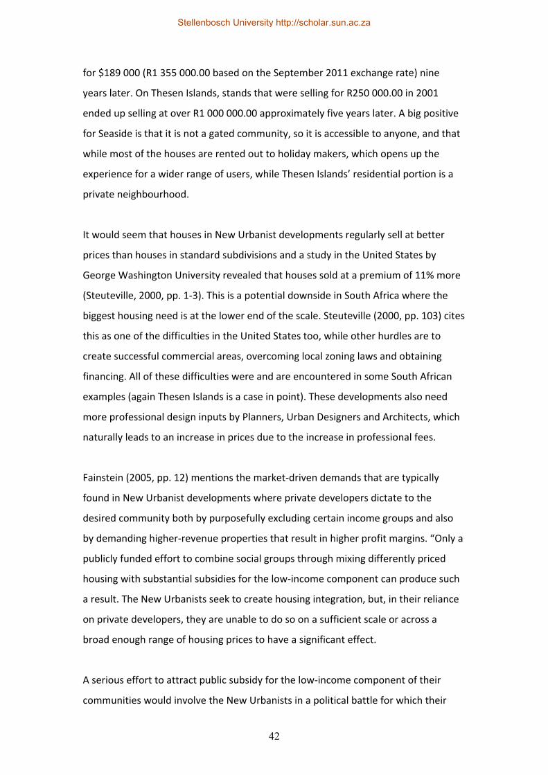
42
for $189 000 (R1 355 000.00 based on the September 2011 exchange rate) nine
years later. On Thesen Islands, stands that were selling for R250 000.00 in 2001
ended up selling at over R1 000 000.00 approximately five years later. A big positive
for Seaside is that it is not a gated community, so it is accessible to anyone, and that
while most of the houses are rented out to holiday makers, which opens up the
experience for a wider range of users, while Thesen Islands’ residential portion is a
private neighbourhood.
It would seem that houses in New Urbanist developments regularly sell at better
prices than houses in standard subdivisions and a study in the United States by
George Washington University revealed that houses sold at a premium of 11% more
(Steuteville, 2000, pp. 1‐3). This is a potential downside in South Africa where the
biggest housing need is at the lower end of the scale. Steuteville (2000, pp. 103) cites
this as one of the difficulties in the United States too, while other hurdles are to
create successful commercial areas, overcoming local zoning laws and obtaining
financing. All of these difficulties were and are encountered in some South African
examples (again Thesen Islands is a case in point). These developments also need
more professional design inputs by Planners, Urban Designers and Architects, which
naturally leads to an increase in prices due to the increase in professional fees.
Fainstein (2005, pp. 12) mentions the market‐driven demands that are typically
found in New Urbanist developments where private developers dictate to the
desired community both by purposefully excluding certain income groups and also
by demanding higher‐revenue properties that result in higher profit margins. “Only a
publicly funded effort to combine social groups through mixing differently priced
housing with substantial subsidies for the low‐income component can produce such
a result. The New Urbanists seek to create housing integration, but, in their reliance
on private developers, they are unable to do so on a sufficient scale or across a
broad enough range of housing prices to have a significant effect.
A serious effort to attract public subsidy for the low‐income component of their
communities would involve the New Urbanists in a political battle for which their
Stellenbosch University http://scholar.sun.ac.za
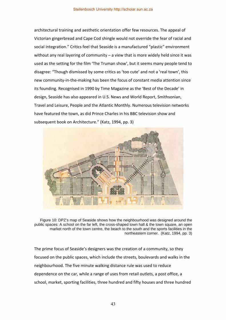
43
architectural training and aesthetic orientation offer few resources. The appeal of
Victorian gingerbread and Cape Cod shingle would not override the fear of racial and
social integration.” Critics feel that Seaside is a manufactured “plastic” environment
without any real layering of community – a view that is more widely held since it was
used as the setting for the film ‘The Truman show’, but it seems many people tend to
disagree: “Though dismissed by some critics as ‘too cute’ and not a ‘real town’, this
new community‐in‐the‐making has been the focus of constant media attention since
its founding. Recognised in 1990 by Time Magazine as the ‘Best of the Decade’ in
design, Seaside has also appeared in U.S. News and World Report, Smithsonian,
Travel and Leisure, People and the Atlantic Monthly. Numerous television networks
have featured the town, as did Prince Charles in his BBC television show and
subsequent book on Architecture.” (Katz, 1994, pp. 3)
The prime focus of Seaside’s designers was the creation of a community, so they
focused on the public spaces, which include the streets, boulevards and walks in the
neighbourhood. The five minute walking distance rule was used to reduce
dependence on the car, while a range of uses from retail outlets, a post office, a
school, market, sporting facilities, three hundred and fifty houses and three hundred
Figure 10: DPZ’s map of Seaside shows how the neighbourhood was designed around the public spaces: A school on the far left, the cross-shaped town hall & the town square, an open
market north of the town centre, the beach to the south and the sports facilities in the northeastern corner. (Katz, 1994, pp. 3)
Stellenbosch University http://scholar.sun.ac.za
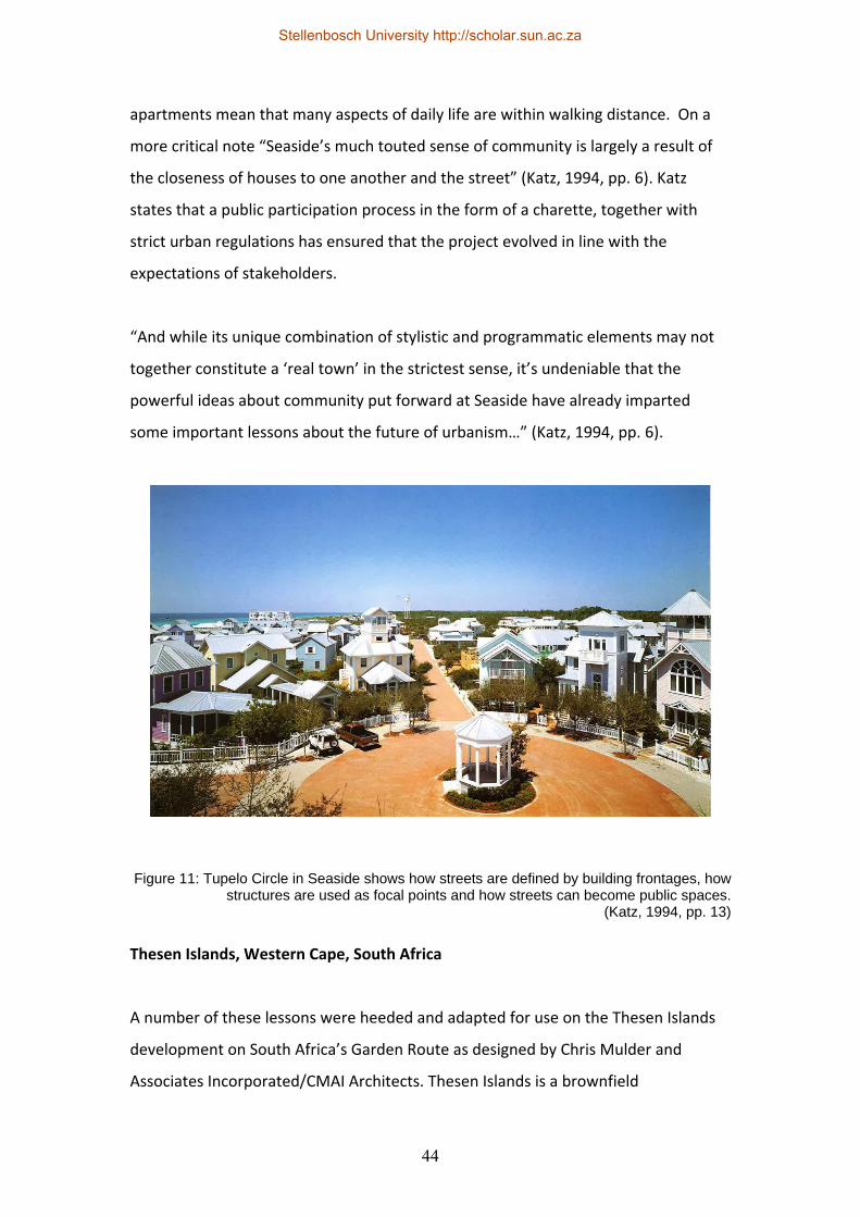
44
apartments mean that many aspects of daily life are within walking distance. On a
more critical note “Seaside’s much touted sense of community is largely a result of
the closeness of houses to one another and the street” (Katz, 1994, pp. 6). Katz
states that a public participation process in the form of a charette, together with
strict urban regulations has ensured that the project evolved in line with the
expectations of stakeholders.
“And while its unique combination of stylistic and programmatic elements may not
together constitute a ‘real town’ in the strictest sense, it’s undeniable that the
powerful ideas about community put forward at Seaside have already imparted
some important lessons about the future of urbanism…” (Katz, 1994, pp. 6).
Thesen Islands, Western Cape, South Africa
A number of these lessons were heeded and adapted for use on the Thesen Islands
development on South Africa’s Garden Route as designed by Chris Mulder and
Associates Incorporated/CMAI Architects. Thesen Islands is a brownfield
Figure 11: Tupelo Circle in Seaside shows how streets are defined by building frontages, how structures are used as focal points and how streets can become public spaces.
(Katz, 1994, pp. 13)
Stellenbosch University http://scholar.sun.ac.za
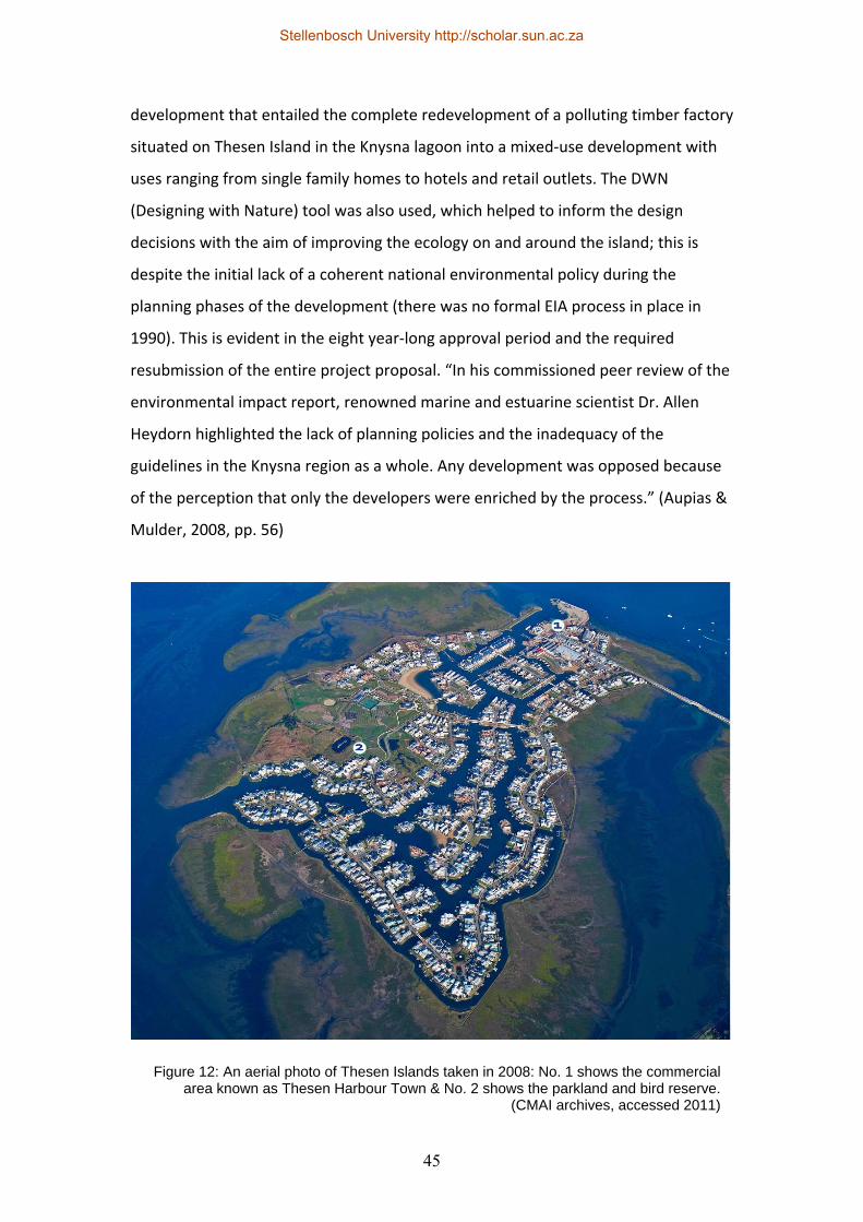
45
development that entailed the complete redevelopment of a polluting timber factory
situated on Thesen Island in the Knysna lagoon into a mixed‐use development with
uses ranging from single family homes to hotels and retail outlets. The DWN
(Designing with Nature) tool was also used, which helped to inform the design
decisions with the aim of improving the ecology on and around the island; this is
despite the initial lack of a coherent national environmental policy during the
planning phases of the development (there was no formal EIA process in place in
1990). This is evident in the eight year‐long approval period and the required
resubmission of the entire project proposal. “In his commissioned peer review of the
environmental impact report, renowned marine and estuarine scientist Dr. Allen
Heydorn highlighted the lack of planning policies and the inadequacy of the
guidelines in the Knysna region as a whole. Any development was opposed because
of the perception that only the developers were enriched by the process.” (Aupias &
Mulder, 2008, pp. 56)
Figure 12: An aerial photo of Thesen Islands taken in 2008: No. 1 shows the commercial area known as Thesen Harbour Town & No. 2 shows the parkland and bird reserve.
(CMAI archives, accessed 2011)
Stellenbosch University http://scholar.sun.ac.za
46
Improving the local natural environment by cleaning up an island severely polluted
by decades of timber treatment processes was one of the biggest challenges on the
project and the island now has a much improved natural environment (both above
and below the waterline): The canals, canal edges, the salt marsh around the islands,
roadside planting, the parkland, manmade beaches, the orchard with its urban
agriculture, the crofts/potagers (private vegetables gardens in the parkland) and the
bird reserve are just some of the areas where this is clearly evident.
Aupias and Mulder (2008, pp. 78) list the most important design strategies that were
employed on the project as follows:
• An interconnected grid of pathways for pedestrians and cars (although there
is only one vehicular access point onto the island and into the residential
portion of the development).
• Ensuring that the pedestrian takes precedence over the car.
• Allowing for a mix of uses from retail outlets, restaurants, offices, hotels,
apartments and freestanding single family homes. (A range of cultures and
income groups is mentioned despite the fact that the development caters
mainly for higher income groups; if some entry‐level housing or inclusionary
housing could have been included during the initial design phases the
development may have been more inclusive.)
• A range of housing types and sizes including a number of apartments, guest
flats, second dwellings and freestanding houses on erven ranging from 300m²
to 1500m². (Due to the unexpectedly fast increase in property prices and
building costs on the island, most properties were developed by higher‐
income individuals, which resulted in a more homogenous end product than
was originally anticipated.)
• Quality Architecture and Design (albeit according to very rigid stylistic
guidelines).
• The provision of a central high street lined with shops in lieu of an internal
shopping mall.
Stellenbosch University http://scholar.sun.ac.za
47
• Higher densities than the norm.
• Smart transport that allows for walking, cycling and the use of boats instead
of cars. (This is however, only on the island itself – most of the inhabitants
work in the town or commute farther afield, which naturally still results in
widespread automobile usage.)
• Sustainability related to reduced automobile use, the reduction of pollution
and the improvement of the ecology.
• Enhancement of the natural environment.
• Respecting the past by acknowledging the vernacular Architecture of the
region (although the vernacular refers to a particular cultural grouping in a
particular time period), but also by retaining many of the existing industrial
structures and equipment.
• Improving the quality of life through the use of traditional neighbourhood
design strategies.
From a socio‐economic perspective the development had to consider a wide range of
people who would be impacted by the redevelopment: “Thesen Islands became the
town’s largest employer and payer of rates and taxes. Since the policy from the start
was to use local labour, workers were recruited and retrained. Figures show that
more than 10 000 people have been employed on the island, with new jobs created
daily. Former factory workers were encouraged to learn new trades, and although
many opted to move to the relocated factory, others became builders, carpenters,
painters, maintenance and domestic workers… Small firms of contractors that sprang
up grew from one‐man operators to medium‐sizes enterprises to meet the needs of
the region.” (Aupias & Mulder, 2008, pp. 138)
Labour‐intensive construction was a key aspect taken into consideration during
design decisions: The canal edges that were built out of gabion baskets filled with
stone created work for more than a hundred and fifty formerly unemployed people,
while all the street furniture and bridge rails were hand made by local craftsmen.
Stellenbosch University http://scholar.sun.ac.za
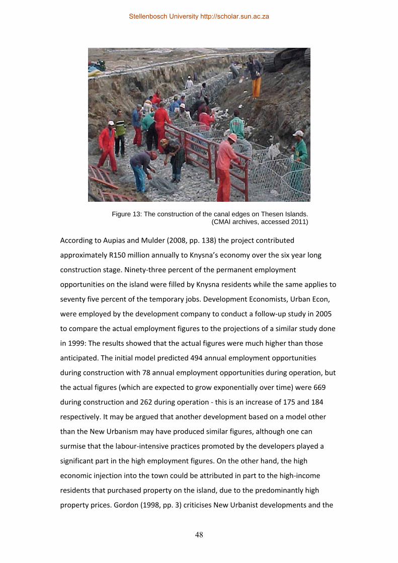
48
According to Aupias and Mulder (2008, pp. 138) the project contributed
approximately R150 million annually to Knysna’s economy over the six year long
construction stage. Ninety‐three percent of the permanent employment
opportunities on the island were filled by Knysna residents while the same applies to
seventy five percent of the temporary jobs. Development Economists, Urban Econ,
were employed by the development company to conduct a follow‐up study in 2005
to compare the actual employment figures to the projections of a similar study done
in 1999: The results showed that the actual figures were much higher than those
anticipated. The initial model predicted 494 annual employment opportunities
during construction with 78 annual employment opportunities during operation, but
the actual figures (which are expected to grow exponentially over time) were 669
during construction and 262 during operation ‐ this is an increase of 175 and 184
respectively. It may be argued that another development based on a model other
than the New Urbanism may have produced similar figures, although one can
surmise that the labour‐intensive practices promoted by the developers played a
significant part in the high employment figures. On the other hand, the high
economic injection into the town could be attributed in part to the high‐income
residents that purchased property on the island, due to the predominantly high
property prices. Gordon (1998, pp. 3) criticises New Urbanist developments and the
Figure 13: The construction of the canal edges on Thesen Islands. (CMAI archives, accessed 2011)
Stellenbosch University http://scholar.sun.ac.za
49
Congress for the New Urbanism in particular when he states: “CNU rhetoric gives
substantial attention to promoting equity, fostering residential mixing, affordable
housing provision, and reducing central city‐suburb income differentials via middle‐
class infill development. Yet there is little evidence that NU communities have
achieved these goals. Instead, they are turning out to be rather elitist settlements
with average income levels much higher than in the surrounding areas.”
2.9 Adapting the concept to local conditions
The New Urbanism concept clearly evokes extensive debate and it has both ardent
supporters and many critics. While it has, like most spatial planning models, various
negative points and while it does lack a more rigorous focus on social and
environmental aspects, it does seem to have merit from a spatial planning point of
view as even some of its critics admit. Based on the principles and strategies
discussed in the previous sections, it would appear that there are a number of
strategies that may be applicable to the South African context. How to implement
these strategies is somewhat more challenging than merely listing them and the
Crossways Farm Village case study may show how some of the strategies can be
implemented in practice:
1. The creation of integrated, discernible neighbourhoods that have a legible
core and clearly defined edges in order to strengthen the feeling of
community within a specific neighbourhood. However, in the South African
context with its historic group areas concept, discernible neighbourhoods
with defined edges contributed to spatial exclusion and fragmentation, so a
focus on activity routes that link the various neighbourhoods should be
strongly considered.
2. The creation of mixed‐use developments where the daily or weekly needs of
residents are within easy reach. This naturally reduces the need for vehicular
travel which has its own benefits, but it also provides employment
opportunities closer to home and it makes neighbourhoods safer and more
vibrant if there is activity throughout different times of the day. (This can be
Stellenbosch University http://scholar.sun.ac.za
50
used in conjunction with the principles of CPTED as mentioned previously.)
Unfortunately, most people living in New Urbanist developments still work
outside the development where they live, which means automobile use
remains fairly high despite the fact that people may walk more inside the
development itself.
3. The implementation of the five‐minute walking radius (which equates to
approximately 400 metres) – research has shown that this reduces the use of
vehicular transport within the development, it can lead to improved
community interaction (and safety) and it also has health benefits. It
empowers residents who do not have access to private vehicular transport,
especially the poor, older people and younger people, although as mentioned
previously, it is one matter allowing for the necessary amenities within
walking distance, but quite another to convince people not to use their cars.
4. The provision of a wide range of housing types in every neighbourhood. This
results in better integration of age, income (and by default, race) and it
creates a more vibrant community. By allowing opportunities for entry‐level
home buyers, inclusionary housing and smaller rentable apartments or
granny flats makes it possible for a much wider range of people to live in
areas that would otherwise be too expensive, although most New Urbanist
developments still mainly cater for the high‐income earning end of the
spectrum.
5. The provision of more useable public spaces. This includes the positioning of
a small park close to every neighbourhood block, the positioning of civic
buildings like schools, community halls, churches and post offices on
prominent sites and most importantly the treatment of roads as public
spaces. Enhancing the public realm by encouraging pedestrians to use the
streets and open spaces through good design may result in increased
defensibility of these spaces, while encouraging interaction.
6. The provision of schools (preferably within walking distance of
neighbourhoods) in new developments. Schools can be positioned on the
edges of neighbourhoods so more than one neighbourhood can be serviced
simultaneously.
Stellenbosch University http://scholar.sun.ac.za
51
7. Making use of existing services and amenities, like transit nodes, existing
schools or educational facilities and employment opportunities.
8. The implementation of effective community governance. Despite the
criticism against Homeowners Associations, they can be very effective in
lightening the burden on local Municipalities by managing their own electrical
billing systems, maintaining local infrastructure themselves, managing on‐site
waste treatment, and managing their own integrated stormwater solutions.
9. The use of critical regionalism to enhance the sense of place and to maximise
the use of locally available materials and skills, while using locally applicable
passive design elements that may typically be evident in regionally
appropriate vernacular Architecture. The challenge here is not to cling too
rigorously to one specific cultural vernacular and to allow change over time
to allow a neighbourhood to develop the layering that is so needed to create
a visually vibrant area.
10. The application of the Designing with Nature (DWN) methodology whereby
all the relevant constraints on a specific site are mapped and the appropriate
areas are designated as no‐go areas for development.
11. Promoting Smart growth principles and the education of local governing
bodies on how to implement and evaluate Smart growth strategies (and by
default New Urbanist principles). During the Thesen Islands planning phases,
the officials did not have existing guidelines for the approval of some of the
smaller single residential property sizes and only by working with them were
these smaller properties able to be developed. There are also issues like
overly wide road widths required by local officials or transport planners that
are a regular bone of contention and the smaller pedestrian‐friendly road
types usually have to be demonstrated through the use of previous physical
examples.
12. The use of charettes as part of the public participation process in order to
physically involve local communities and stakeholders in the planning and
decision‐making process. This goes one step further than just getting
feedback on completed project proposals.
Stellenbosch University http://scholar.sun.ac.za
52
There are some additional strategies that do not typically form part of most New
Urbanist developments, but that have surfaced during the analysis of specific case
studies like Thesen Islands: The use of ecological design principles (both passive and
active measures to improve energy‐efficiency, save water resources and improve the
natural environment) for civil works and general building works, the use of labour
intensive construction techniques to provide more opportunities for locally available
unskilled labourers (which also leads to local economic development, skills building
and the potential for growth) and the use of indigenous planting and integrated
landscape planning.
A potential option would be to combine the New Urbanism framework with the
Urban Biosphere concept. The biosphere reserve concept was first developed by
UNESCO’s Man and the Biosphere (MAB) programme in 1974, but in recent times, its
promotion in urban areas has gained increasing popularity in the Madrid Action Plan
for Biosphere Reserves (UNESCO, 2008). It is primarily concerned with improving the
relationship between people and the natural environment, so a biosphere reserve
should be a place where biological diversity is preserved, economic development is
promoted and where cultural values are maintained. A biosphere reserve should
ideally consist of core areas that are devoted to conservation, transitional areas
where conservation‐compatible human activities take place and buffer areas where
sustainable resource use is promoted. This staged approach should be fairly
compatible with the transect‐based approach of the New Urbanism concept. Frost
(2001, pp. 2) mentions some models that can cover urban areas in whole or in part:
Where an entire urban area is designated as a biosphere reserve, where the
biosphere reserve permeates the urban area, or where the biosphere reserve
borders urban areas.
Stellenbosch University http://scholar.sun.ac.za
53
2.10 Conclusion
It would seem that the New Urbanism framework has many potential benefits and
lessons for South Africa, especially if it is adapted for the local context, and
combined with other concepts like urban biospheres. While the abovementioned
strategies for adaptation may not encompass all the tools available to experienced
planners, these are deemed the most appropriate to the South African context and
they are also those strategies that are the most likely to be achievable. Gordon
(1998, pp. 1) makes the important point that it is simplistic to think that physical
planning interventions alone can address issues like sprawl, the loss of agricultural
lands, racial segregation and segregation by income. These strategies will have to be
critically evaluated and combined with socio‐economic policies based on specific
contexts before implementation, together with environmental design strategies and
concepts like the Urban Biospheres ‐ cognisance has to be taken of some of the
potentially negative aspects that have been highlighted in order to find a balanced
solution to each particular project.
Stellenbosch University http://scholar.sun.ac.za
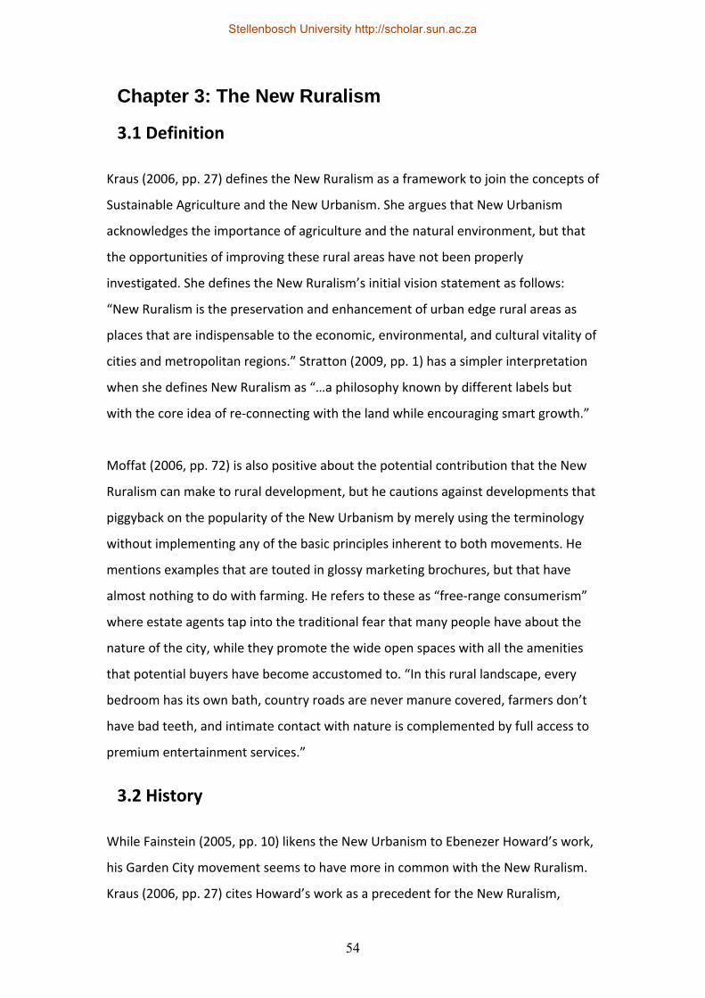
54
Chapter 3: The New Ruralism
3.1 Definition
Kraus (2006, pp. 27) defines the New Ruralism as a framework to join the concepts of
Sustainable Agriculture and the New Urbanism. She argues that New Urbanism
acknowledges the importance of agriculture and the natural environment, but that
the opportunities of improving these rural areas have not been properly
investigated. She defines the New Ruralism’s initial vision statement as follows:
“New Ruralism is the preservation and enhancement of urban edge rural areas as
places that are indispensable to the economic, environmental, and cultural vitality of
cities and metropolitan regions.” Stratton (2009, pp. 1) has a simpler interpretation
when she defines New Ruralism as “…a philosophy known by different labels but
with the core idea of re‐connecting with the land while encouraging smart growth.”
Moffat (2006, pp. 72) is also positive about the potential contribution that the New
Ruralism can make to rural development, but he cautions against developments that
piggyback on the popularity of the New Urbanism by merely using the terminology
without implementing any of the basic principles inherent to both movements. He
mentions examples that are touted in glossy marketing brochures, but that have
almost nothing to do with farming. He refers to these as “free‐range consumerism”
where estate agents tap into the traditional fear that many people have about the
nature of the city, while they promote the wide open spaces with all the amenities
that potential buyers have become accustomed to. “In this rural landscape, every
bedroom has its own bath, country roads are never manure covered, farmers don’t
have bad teeth, and intimate contact with nature is complemented by full access to
premium entertainment services.”
3.2 History
While Fainstein (2005, pp. 10) likens the New Urbanism to Ebenezer Howard’s work,
his Garden City movement seems to have more in common with the New Ruralism.
Kraus (2006, pp. 27) cites Howard’s work as a precedent for the New Ruralism,
Stellenbosch University http://scholar.sun.ac.za
55
together with some of the elements typically found in eco‐villages, while Wartzmann
(2007, pp. 1) also mentions Howard’s aims of combining the urban and rural areas
into a single environment called the Garden City. Howard (1902, pp. 17) describes his
vision as follows: “But neither the Town magnet nor the Country magnet represents
the full plan and purpose of nature. Human society and the beauty of nature are
meant to be enjoyed together. The two magnets must be made one. As man and
woman by their varied gifts and faculties supplement each other, so should town
and country.”
Figure 14: “The three magnets”. (Howard, 1902, pp. 16)
Stellenbosch University http://scholar.sun.ac.za
56
“New Ruralism is built on twenty years of reform – in food, agriculture, and land use
planning. The sustainable agriculture and local food systems movements have taken
organic foods mainstream, made farmers’ markets a basic town‐centre amenity, and
put ‘slow food’ on a fast track. At the same time, New Urbanism projects and Smart
Growth initiatives have demonstrated the possibilities of creating healthier, more
liveable urban centres.” (Kraus, 2006, pp. 27)
The rationale for the development of the movement is that cities and regions need a
productive hinterland where individual farms and rural communities can look after
natural resources while making a sustainable living. Moffat (2006, pp. 74) supports
this statement by saying that farmers are not only producers of food, but that they
are also the stewards of the public’s natural heritage. The agricultural areas around
larger cities are increasingly under threat from sprawling suburbs and these areas
face additional pressures due the degradation of the natural environment,
industrialised farming practices and the global food economy. Kraus (2006, pp. 27)
feels that industrial farming practices and suburban sprawl are similar in that they
both have little regard for their natural environmental context.
While urban infill, redevelopment and regeneration may be the ideal focus of
development, there are not always enough available properties for this type of
development and neighbourhood groups who oppose development in their
respective areas (also referred to NIMBY – “Not in my backyard”) hamper inner‐city
infill. While the global figure for urbanisation has now passed 50% according to many
reports, the remaining 50% of people still live in rural areas. With current planning
legislation (especially in the Western Cape) not catering for rural development
through the enforcement of Spatial Development Frameworks and urban edges, a
large portion of the population is totally cut out of economic development, social
upliftment and opportunities for growth.
Stellenbosch University http://scholar.sun.ac.za
57
3.3 Principles
To take advantage of urban‐rural linkages in terms of transport, infrastructure and
markets, New Ruralism projects are typically established close to larger metropolitan
centres. This also means that permanent agricultural and natural areas can be
provided close to urban centres to contribute to food security while also allowing
urbanites some connection with the land. Wartzmann (2007, pp. 1) argues that the
key to the success of New Ruralism projects is to understand that they form an
integral part of metropolitan regions.
Kraus (2006, pp. 28) defines the principles of New Ruralism projects as the following:
1. Establishing very specific rural communities close to an urban area within a
larger metropolitan region. These rural communities should be uniquely
contextual in terms of culture, landscape, farming and the environment.
2. The primary land use should be small to medium‐scale agriculture that’s
interlinked with natural areas.
3. Effective urban‐rural linkages for the provision of locally grown produce.
Other linkages in addition to this one could include physical links in the form
of hiking trails, bicycle routes and equestrian routes, environmental linkages
in terms of ecosystem services like composting, the recharging of
groundwater, protection against flooding and forest fires and the
enhancement of biodiversity.
4. Welcoming the public as visitors and residents. This principle should apply to
a wider section of the community and it should not be exclusive to higher
income earners; this can typically be achieved by a better range of housing
types that include higher density units (which also means that more land is
available for farming or preservation).
5. The implementation of a comprehensive development and management
plan. The planning involved may include specific targets for local
employment, education and food production.
Stellenbosch University http://scholar.sun.ac.za
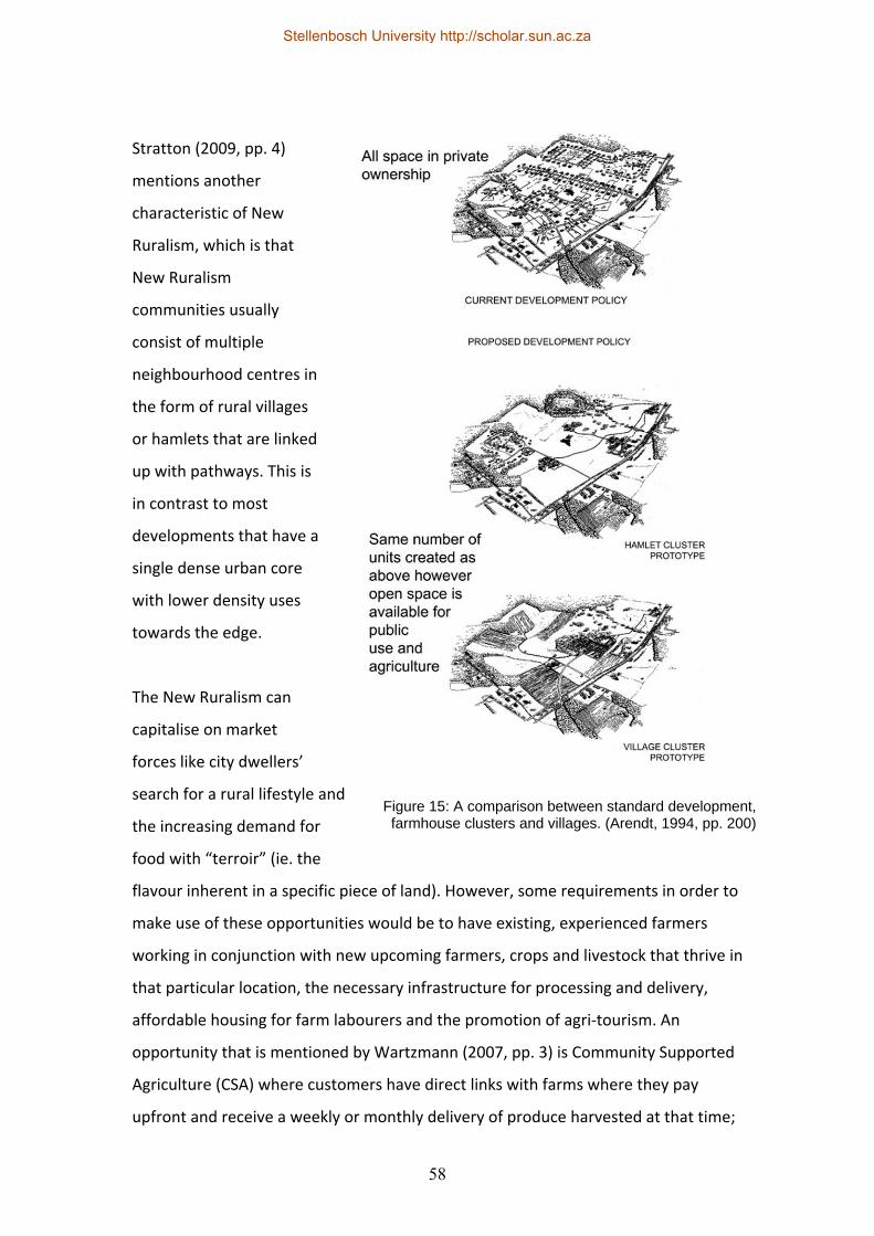
58
Stratton (2009, pp. 4)
mentions another
characteristic of New
Ruralism, which is that
New Ruralism
communities usually
consist of multiple
neighbourhood centres in
the form of rural villages
or hamlets that are linked
up with pathways. This is
in contrast to most
developments that have a
single dense urban core
with lower density uses
towards the edge.
The New Ruralism can
capitalise on market
forces like city dwellers’
search for a rural lifestyle and
the increasing demand for
food with “terroir” (ie. the
flavour inherent in a specific piece of land). However, some requirements in order to
make use of these opportunities would be to have existing, experienced farmers
working in conjunction with new upcoming farmers, crops and livestock that thrive in
that particular location, the necessary infrastructure for processing and delivery,
affordable housing for farm labourers and the promotion of agri‐tourism. An
opportunity that is mentioned by Wartzmann (2007, pp. 3) is Community Supported
Agriculture (CSA) where customers have direct links with farms where they pay
upfront and receive a weekly or monthly delivery of produce harvested at that time;
Figure 15: A comparison between standard development, farmhouse clusters and villages. (Arendt, 1994, pp. 200)
Stellenbosch University http://scholar.sun.ac.za
59
this removes the middlemen (which ensures increased profit to the farmers and
lower costs to the consumer), it educates the public about seasonal eating and
carbon miles, it gets fresh produce to the market quickly and it improves awareness
about the origin of food.
Moffat (2006, pp. 75) lists some incentives and deterrents in order to retain
agricultural areas around urban centres ‐ these include increasing the value of
agricultural outputs by switching to organic varieties and the establishment of direct
links with the public through farmers markets or supply arrangements with
restaurants, the improved branding of locally sourced foods, subsidies for farmers
who contribute to ecosystem services or tradeoffs where urban developers can be
allowed higher densities if they purchase land for conservation (as agriculture or in
its natural state) in rural areas. Wartzmann (2007, pp. 2) is somewhat more cynical
when he asks the question whether farmers markets will remain accessible only to
the wealthy and whether farmers can be persuaded not to sell their land to the
highest bidder, since many farmers bargain on selling their property to a standard
suburban developer as a kind of retirement policy. Another challenge as mentioned
by Stratton (2009, pp. 7) is how to ensure the land is preserved as farmland or
nature in perpetuity.
3.4 Rural smart growth
ICMA (2010, pp. 8) identifies the three goals of rural smart growth as support for the
rural landscape, assistance to existing places in order to help them become vibrant
again and the creation of good quality new places. These goals can be applied to the
different types of rural communities, which can be categorised as gateway
communities (these are typically close to large amenities like national parks),
resource‐dependent communities (like farming or mining communities), edge
communities that are close to metropolitan areas, traditional main street
communities and second home/retirement communities. Many communities may
be a combination of some of the above and may be connected to others in a
different category.
Stellenbosch University http://scholar.sun.ac.za

60
According to ICMA, some of the primary challenges of these rural communities are
the reduction in farms and farmers (which is mainly due to the expansion of larger
commercial farms), the loss of natural environments due to uncontrolled
development in many cases, excessive growth at the metropolitan edges, the
shrinking population in rural areas due to urbanisation (which is mainly due to the
lack of opportunities, amenities and linkages to urban areas), limited access to
employment, services, health care and education and a lack of planning capacity,
especially at governmental level.
The first goal of rural smart growth is to support the rural landscape. This means
the establishment of an economic climate that can make rural areas more
economically feasible while at the same time preserving natural areas. The
following strategies with their respective tools and policies are suggested as
starting points:
1. Ensuring the feasibility of regional resource economies. This can be done
through the voluntary adoption of “use value” taxation where rural land is
taxed according to its current use instead of on valuations based on its
anticipated value that takes potential development rights into account.
Giving tax rebates for the donation of conservation areas, the granting of
rights to farmers to prevent nuisance lawsuits by neighbours, establishing
ecosystem services markets (where heavy carbon emitters pay farmers for
carbon credits) and the granting of rights to develop renewable energy
systems on agricultural land (for example wind turbines, biomass or solar
power installations) are some alternative policy approaches that could be
adopted by local government. Farmers can also add value to their products
by processing the products locally through cooperatives; this also provides
additional local employment opportunities.
2. Promoting developmental strategies that make use of the rural landscape.
This can be done through the Purchase of Development Rights (PDR) where
the development rights on a piece of rural land is purchased from the farmer
Stellenbosch University http://scholar.sun.ac.za
61
and the development rights are rescinded upon purchase in order to
conserve the land, or it can take the form of an agreement with government
where a piece of land is declared as a conservation area in return for tax
credits, or alternatively government can purchase the land directly. Another
vital tool to make use of the rural landscape is agri‐tourism or ecotourism
which can lead to additional employment opportunities too.
3. Promoting linkages with urban areas and marketing rural produce. This can
be done through farmers markets or Community Supported Agriculture (CSA)
as mentioned previously, “buy local” campaigns or the purchasing of goods
by government agencies like schools, hospitals or prisons.
4. Combining conservation and community. This can be done through the
Transfer of Development Rights (TDR) where one area is declared a
conservation area while transferring its development rights to another area,
identifying priority funding areas (PFAs) that qualify for subsidies or
assistance, the granting of zoning rights for agricultural purposes or allowing
denser development in hamlets or villages in order to retain additional open
space on the remaining properties.
The second goal of making existing rural places thrive includes the maintenance
and protection of existing amenities, infrastructure and places that have meaning
for the local community. The following strategies with their respective tools and
policies are suggested as starting points:
1. Public investment in rural areas. The five tools to consider for this strategy
are repairing and maintaining existing infrastructure, the preservation of
historic structures or areas, developing parks and rural areas as destinations,
improving existing streetscapes and focusing new developments in existing
nodes.
2. Private investment in rural areas. This can be encouraged by providing
incentives for infill in existing nodes while adjusting local laws to make it
possible. Communities can declare themselves ready for redevelopment and
Municipalities can split rates and taxes in order to separate land from
Stellenbosch University http://scholar.sun.ac.za
62
buildings. By lowering tax for buildings and improvements, private developers
can be encouraged to invest in the maintenance and improvements of
structures.
3. Using existing rural amenities. This is mainly the adaptive re‐use of existing
structures and the rehabilitation of existing educational facilities.
4. Encouraging growth in existing rural centres. Conducting surveys to
determine the strengths and weaknesses of local business can help to focus
development, while businesses that contribute positively should be
recognised and rewarded accordingly.
The third goal of creating good new places is about establishing sustainable
communities where people of all age groups want to stay permanently. The
following strategies with their respective tools and policies are suggested as
starting points:
1. Making allowance for compact growth by updating regional policies. A
starting point for doing this would be for communities to organise visioning
workshops, decide on conservation‐worthy areas in their region, prioritise
areas for growth, recognise the unique characteristics of their area and
maximise transportation grids in their hamlets and villages.
2. Reduce the amount of red tape for responsible development. Local policies
and zoning schemes should be updated especially to allow for mixed‐use
development, more compact pedestrian‐friendly communities with plenty of
open space and Traditional Neighbourhood Development (TND) principles.
This can include the adoption of form‐based codes that can improve the
predictability of new developments. Contextually appropriate development,
“green” street design and low‐impact development where roadways are
designed to allow the natural management of stormwater are further tools
that can be employed.
3. Provide incentives for developments that incorporate smart growth and
green building. This could take the form of smart growth recognition
programmes or green building rating tools.
Stellenbosch University http://scholar.sun.ac.za
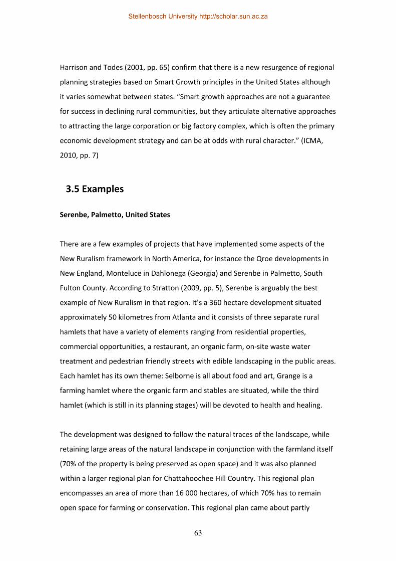
63
Harrison and Todes (2001, pp. 65) confirm that there is a new resurgence of regional
planning strategies based on Smart Growth principles in the United States although
it varies somewhat between states. “Smart growth approaches are not a guarantee
for success in declining rural communities, but they articulate alternative approaches
to attracting the large corporation or big factory complex, which is often the primary
economic development strategy and can be at odds with rural character.” (ICMA,
2010, pp. 7)
3.5 Examples
Serenbe, Palmetto, United States
There are a few examples of projects that have implemented some aspects of the
New Ruralism framework in North America, for instance the Qroe developments in
New England, Monteluce in Dahlonega (Georgia) and Serenbe in Palmetto, South
Fulton County. According to Stratton (2009, pp. 5), Serenbe is arguably the best
example of New Ruralism in that region. It’s a 360 hectare development situated
approximately 50 kilometres from Atlanta and it consists of three separate rural
hamlets that have a variety of elements ranging from residential properties,
commercial opportunities, a restaurant, an organic farm, on‐site waste water
treatment and pedestrian friendly streets with edible landscaping in the public areas.
Each hamlet has its own theme: Selborne is all about food and art, Grange is a
farming hamlet where the organic farm and stables are situated, while the third
hamlet (which is still in its planning stages) will be devoted to health and healing.
The development was designed to follow the natural traces of the landscape, while
retaining large areas of the natural landscape in conjunction with the farmland itself
(70% of the property is being preserved as open space) and it was also planned
within a larger regional plan for Chattahoochee Hill Country. This regional plan
encompasses an area of more than 16 000 hectares, of which 70% has to remain
open space for farming or conservation. This regional plan came about partly
Stellenbosch University http://scholar.sun.ac.za
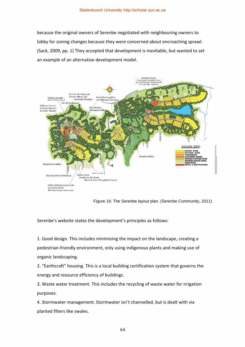
64
because the original owners of Serenbe negotiated with neighbouring owners to
lobby for zoning changes because they were concerned about encroaching sprawl.
(Sack, 2009, pp. 1) They accepted that development is inevitable, but wanted to set
an example of an alternative development model.
Serenbe’s website states the development’s principles as follows:
1. Good design. This includes minimising the impact on the landscape, creating a
pedestrian‐friendly environment, only using indigenous plants and making use of
organic landscaping.
2. “Earthcraft” housing. This is a local building certification system that governs the
energy and resource efficiency of buildings.
3. Waste water treatment. This includes the recycling of waste water for irrigation
purposes.
4. Stormwater management. Stormwater isn’t channelled, but is dealt with via
planted filters like swales.
Figure 16: The Serenbe layout plan. (Serenbe Community, 2011)
Stellenbosch University http://scholar.sun.ac.za
65
5. Organic farming. The farming operations are certified organic and biodynamic with
well‐established CSA networks. Weekly farmers markets are also held for the
improved delivery of fresh produce.
6. The preservation of land in its natural state and for agriculture.
Serenbe basically conforms to Kraus’s principles as mentioned earlier in this chapter.
It’s close to Atlanta, the primary use is farming, it has good urban‐rural linkages
(although there does not seem to be any form of public transit so the physical
linkages are mainly via private cars) and it is part of a larger regional plan. It’s also
open to visitors and Sack (2009, pp. 1) confirms that it has become a destination for
people from Atlanta who want to go on daytrips. Langdon (2009, pp. 2) states that
the farming operation is highly regarded in the region for the quality of its produce
and that people pay $750.00 (R5378.00 based on the September 2011 exchange
rate) for a full share of the farm from April to October. Some criticisms are that the
individual hamlets are not dense or compact enough and that there is no gradual
transition from the natural landscape to the higher density centre, mainly due to the
omega‐shaped layout forms. This is despite the Serenbe website mentioning that
some New Urbanism principles and the transect model was used to organise the
layout. On the positive side, the Architecture is not as homogenous as most in New
Figure 17: An agricultural patch in Serenbe. (Sack, 2009, pp. 1)
Stellenbosch University http://scholar.sun.ac.za
66
Urbanist/New Ruralist developments since there is a fairly diverse mix of vernacular
and modern typologies; there is a good mix of housing types and a variety of uses.
As far as conservation is concerned, a study by Arborguard Tree specialists from
Atlanta showed that Serenbe’s trees (which consist mainly of Loblolly pine, White
Oak, Sweetgum and Water Oak) store 1 333 840 tonnes of carbon, and they
sequester an additional 52 660 tonnes of carbon annually, while also removing
1481.01 tonnes of pollution out of the atmosphere annually. This is equal to
sequestering the annual carbon emissions of 7 213 cars and storing the equivalent of
the emissions of 182 717 cars. (Atlanta Business Chronicle, 2009, pp. 25A) In addition
to this, the trees naturally add to the biodiversity and local ecosystems while helping
with stormwater management and climate control.
It seems that Serenbe’s approach is paying off – while the National Association of
Realtors in the United States reported a 37% slump in new house sales in 2008 and
predicted a further slump of 39% in 2009 at the time, Serenbe had a steady sales
rate: “Serenbe, a community founded on principles of farm‐to‐table cooking and
environmentally conscious building techniques, has seen its fortunes rise while the
rest of the country struggles. The development’s founders have sold four homes and
five building lots at the development since January alone, and they believe that
innovation may be just the thing the economy needs.” (Eastment, 2009, pp. 1) This is
confirmed by Langdon (2009, pp. 2) after he attended a meeting of the National
Town builders Association (NTBA) in Georgia: “Yet for the most part, they seemed
confident that if business has been slow for new urbanists, it’s even worse for
developers of conventional subdivisions.”
Stellenbosch University http://scholar.sun.ac.za
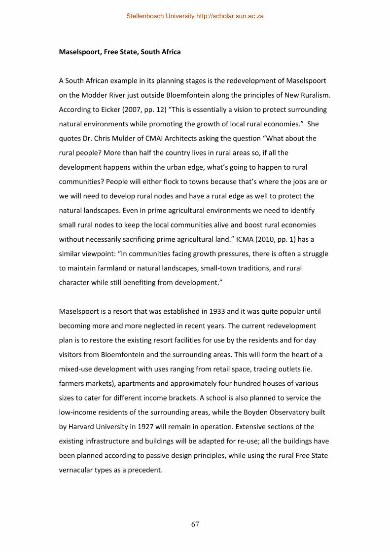
67
Maselspoort, Free State, South Africa
A South African example in its planning stages is the redevelopment of Maselspoort
on the Modder River just outside Bloemfontein along the principles of New Ruralism.
According to Eicker (2007, pp. 12) “This is essentially a vision to protect surrounding
natural environments while promoting the growth of local rural economies.” She
quotes Dr. Chris Mulder of CMAI Architects asking the question “What about the
rural people? More than half the country lives in rural areas so, if all the
development happens within the urban edge, what’s going to happen to rural
communities? People will either flock to towns because that’s where the jobs are or
we will need to develop rural nodes and have a rural edge as well to protect the
natural landscapes. Even in prime agricultural environments we need to identify
small rural nodes to keep the local communities alive and boost rural economies
without necessarily sacrificing prime agricultural land.” ICMA (2010, pp. 1) has a
similar viewpoint: “In communities facing growth pressures, there is often a struggle
to maintain farmland or natural landscapes, small‐town traditions, and rural
character while still benefiting from development.”
Maselspoort is a resort that was established in 1933 and it was quite popular until
becoming more and more neglected in recent years. The current redevelopment
plan is to restore the existing resort facilities for use by the residents and for day
visitors from Bloemfontein and the surrounding areas. This will form the heart of a
mixed‐use development with uses ranging from retail space, trading outlets (ie.
farmers markets), apartments and approximately four hundred houses of various
sizes to cater for different income brackets. A school is also planned to service the
low‐income residents of the surrounding areas, while the Boyden Observatory built
by Harvard University in 1927 will remain in operation. Extensive sections of the
existing infrastructure and buildings will be adapted for re‐use; all the buildings have
been planned according to passive design principles, while using the rural Free State
vernacular types as a precedent.
Stellenbosch University http://scholar.sun.ac.za
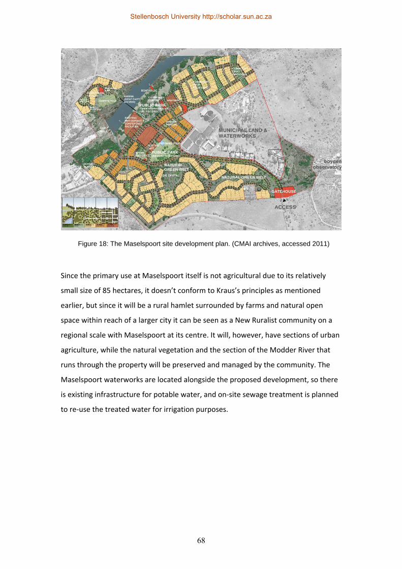
68
Since the primary use at Maselspoort itself is not agricultural due to its relatively
small size of 85 hectares, it doesn’t conform to Kraus’s principles as mentioned
earlier, but since it will be a rural hamlet surrounded by farms and natural open
space within reach of a larger city it can be seen as a New Ruralist community on a
regional scale with Maselspoort at its centre. It will, however, have sections of urban
agriculture, while the natural vegetation and the section of the Modder River that
runs through the property will be preserved and managed by the community. The
Maselspoort waterworks are located alongside the proposed development, so there
is existing infrastructure for potable water, and on‐site sewage treatment is planned
to re‐use the treated water for irrigation purposes.
Figure 18: The Maselspoort site development plan. (CMAI archives, accessed 2011)
Stellenbosch University http://scholar.sun.ac.za
69
It incorporates many of the basic principles of the New Urbanism framework in
addition to the mixed uses and range of housing types, like the 5 minute walking
shed, pedestrian friendly streets designed as public spaces, a clearly defined centre
and edges, the provision of a school, the use of existing infrastructure and a local
management system. The Designing with Nature (DWN) methodology and a well
attended public participation process were also part of the design process.
The use of locally available materials in conjunction with labour‐intensive
construction methods could provide much‐needed benefits for the region. According
to Eicker (2007, pp. 17) unemployment of the economically active portion of the
population in Mangaung Municipality is 40.1%, so the projected nine thousand
employment opportunities during construction and one thousand opportunities
after construction would provide a welcome boost to the local economy.
Figure 19: Farm cottages along one of the green belts in Maselspoort. (CMAI archives, accessed 2011)
Stellenbosch University http://scholar.sun.ac.za
70
3.6 Adapting the concept to local conditions The New Ruralism concept is a spatial planning model with many principles (and
marketing terms) that are similar to those of the New Urbanism concept, except that
it is centred on agriculture. New Ruralist developments are typically close to larger
urban centres with strong rural‐urban linkages and the concept of New Ruralism
aims to connect agricultural regions’ produce and tourism potential with urban
markets.
New Ruralists (similar to New Urbanists) emphasise the need for spatial planning,
regional planning and institutional involvement in order to change rural policies to
become more favourable to rural development. Some of the strategies that may be
suitable to the South African context are:
1. The development of rural communities close to urban areas and the creation of
sustainable livelihoods for these communities, while enhancing the agricultural
capacity together with educational facilities. South Africa is littered with forgotten
hamlets and villages that were placed between twenty and fifty kilometres outside
of existing towns and cities by Apartheid planners. Small settlements like Kurland,
Zoar and Thornhill are just some of the typical examples where people were
“dumped” with very little opportunity for employment, education or development.
2. Making the primary land use of these developments agriculture or open space
provides opportunities for rural and urban areas and it promotes the urban‐rural
linkages that are so important. Food security, agri‐tourism, biodiversity, the
environment, education and employment are just some of the advantages provided
by agriculture close to towns or cities.
3. By establishing effective urban‐rural linkages, various opportunities can be created
for urban and rural communities. This is especially effective if projects are positioned
close to existing transit stops or infrastructure. Local processing, “buy local”
Stellenbosch University http://scholar.sun.ac.za
71
campaigns, farmers markets and community‐supported agriculture are excellent
tools, together with effective communication networks.
4. By not making New Ruralism hamlets closed towns, they can contribute greatly to
the abovementioned opportunities. By welcoming the public, day visits from towns
and cities will increase and it would make these communities more inclusive and
result in a much more vibrant character.
5. All rural developments should form part of a larger regional plan. No development
can exist in isolation and this is especially true in rural areas that are so intimately
connected to the land. “However, regional policies alone will neither succeed in
transforming the lives of the poor nor eradicate rural‐urban inequalities. Regional,
economic and spatial policies need to be part of general national development
programmes to reduce poverty through different sectoral strategies, such as land
redistribution, improved access to credit, health and education, amongst others.”
(United Nations, 2001, pp. 87)
6. The provision of multiple cores or clusters means higher densities in contained
areas, which means that much more space is available for farming or preservation.
7. The combination of experienced farmers with upcoming farmers (or previously
disadvantaged farmers or farm labourers in South Africa’s case) can provide much‐
needed vitality in rural areas, contribute to skills building and result in improved
stewardship of the land.
8. Re‐using and maintaining existing amenities, buildings and infrastructure can
enhance the specific sense of place, while also saving resources and encouraging
additional investment.
9. The preservation and promotion of land, either in its natural form or as farmland
can contribute to agri‐tourism or eco‐tourism initiatives.
Stellenbosch University http://scholar.sun.ac.za
72
10. The implementation of rural smart growth strategies can assist in the
improvement of regional planning strategies.
11. Use‐value and split‐rate taxation, tax rebates for farmland and conservation
areas, carbon credits for open space and carbon trading are all potential tools that
can be investigated.
12. Renewable energy development in conjunction with agricultural practices can be
of great benefit to the environment and it can also have economic benefits.
3.7 Conclusion
Langdon (2009, pp. 2), as a supporter of the New Ruralism concept, feels that: “The
nation appears to be on the cusp of a more satisfying relationship to food
production. New Urbanism, thanks to a varied crew of innovators, is part of a much
needed vanguard.” The New Ruralism concept does seem to have many potential
benefits, as shown in this chapter. However, being primarily a spatial planning
model, the New Ruralism framework will have to be coupled with a range of social,
economic and institutional tools in order to contribute meaningfully to rural
development. Creating pleasant hamlets on farms close to urban areas without
addressing the deeper socio‐economic concerns of the particular surrounding areas
will not deal with some of the fundamental challenges highlighted in the following
chapter.
Stellenbosch University http://scholar.sun.ac.za
73
Chapter 4: Sustainable rural development
4.1 Defining sustainable development and rural
development
One of the most appropriate starting points to define sustainable development is
arguably the Brundlandt Report, which calls for “Development that meets the needs
of the present without compromising the ability of future generations to meet their
own needs.” Gutberlet (1999, pp. 223) describes it as “…the adequate management,
use and protection of natural resources, guaranteeing the livelihood of humanity.
According to prominent international conservation agencies (IUCN 1980),
sustainable utilisation is based on a rate of resource use which equals, or is less than,
the rate of renewal, restoration or replenishment.”
“We threaten nature and nature now threatens us in return: Sunlight causes cancer,
air threatens our lungs, rain burns the trees, streams are polluted and soils are toxic.
Understanding the qualities of nature in each place, expressing it in the design of
communities, integrating it within our towns and respecting its balance are critical to
making the human place sustainable and spiritually nourishing.” (Katz, 1994, pp. xiii)
The Integrated Sustainable Rural Development Strategy (ISRDS) of South Africa
states that there isn’t agreement on the actual meaning of rural or rural populations.
This view is confirmed by the Ministry of Rural Development and Land Reform in the
Comprehensive Rural Development Programme (2009, pp. 8), and the fact that the
areas and populations generally accepted as being rural are not homogenous: “For
example, most concepts of rural areas and populations include commercial farmers,
subsistence farmers, some small towns and villages, and nature reserves that have
very different – and even contradictory – functions and developmental needs. In
South Africa these differences have been complicated by past policies of racial
segregation and especially the creation of independent and self‐governing
homelands that have reinforced some existing divisions and blurred others.”
(Independent Development Trust, 2000, pp. 9)
Stellenbosch University http://scholar.sun.ac.za
74
Patel (2010, pp. 3) cites the definition of the United Nations Development
Programme (2010): “’Rural’ and ‘urban’ areas are often conceptualised in opposing
terms to each other. Population density and economic activity are the predominant
criteria that have been used to define ‘urban’ versus ‘rural’ areas. However, related
criteria such as administrative functions and infrastructure development are also
used. Rural areas are generally regarded as places of low population densities with
predominantly agricultural economies whereas ‘urban’ areas are regarded as places
with high population densities distinguished by a service economy. Hence small
towns with even a minimum of ‘urban’ characteristics are regarded as urban.”
The ISRDS goes on to define rural development as “…multi‐dimensional and much
broader than poverty alleviation through social programmes and transfers. It places
emphasis on changing environments to enable poor people to earn more, invest in
themselves and their communities and contribute toward maintenance of key
infrastructure; a successful strategy will make people less poor, rather than more
comfortable in their poverty.” (Independent Development Trust, 2000, pp. viii) The
Comprehensive Rural Development Programme (Ministry of Rural Development and
Land Reform, 2009, pp. 4) has a similar view where “Rural development is about
enabling rural people to take control of their destiny, thereby dealing effectively with
rural poverty through the optimal use and management of natural resources. It is a
participatory process through which rural people learn over time, through their own
experiences and initiatives, how to adapt their indigenous knowledge to their
changing world.”
4.2 The South African context
The current spatial (and socio‐economic) structures in rural South Africa today are
still largely the result of Apartheid planning policies that were enforced prior to the
advent of democracy. These include the Group areas act of 1950, the Promotion of
Bantu Homelands Citizens Act of 1970 and the policies and laws instituted under
“Grand Apartheid”. These policies had implications in terms of the ownership and
Stellenbosch University http://scholar.sun.ac.za
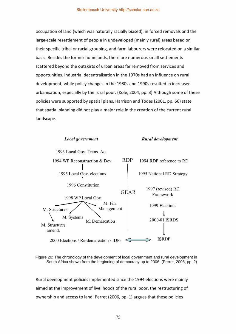
75
occupation of land (which was naturally racially biased), in forced removals and the
large‐scale resettlement of people in undeveloped (mainly rural) areas based on
their specific tribal or racial grouping, and farm labourers were relocated on a similar
basis. Besides the former homelands, there are numerous small settlements
scattered beyond the outskirts of urban areas far removed from services and
opportunities. Industrial decentralisation in the 1970s had an influence on rural
development, while policy changes in the 1980s and 1990s resulted in increased
urbanisation, especially by the rural poor. (Kole, 2004, pp. 3) Although some of these
policies were supported by spatial plans, Harrison and Todes (2001, pp. 66) state
that spatial planning did not play a major role in the creation of the current rural
landscape.
Rural development policies implemented since the 1994 elections were mainly
aimed at the improvement of livelihoods of the rural poor, the restructuring of
ownership and access to land. Perret (2006, pp. 1) argues that these policies
Figure 20: The chronology of the development of local government and rural development in South Africa shown from the beginning of democracy up to 2006. (Perret, 2006, pp. 2)
Stellenbosch University http://scholar.sun.ac.za
76
followed two parallel but separate streams: That of the strengthening of local
government as part of decentralisation, and that of rural development. They are only
now beginning to converge through the attempted integration of the Integrated
Sustainable Rural Development Programme (ISRDP) and the Integrated Development
Plans (IDPs) of local municipalities.
When it was adopted, the ISRDP was the last in a long line of rural development
documents, but the first promising document in the series since the advent of
democracy was arguably the National Rural Development Strategy of 1995. While it
considered elements of the Reconstruction and Development Programme (RDP),
Perret (2006, pp. 4) feels that it did not take local government issues into account
and “Also, it did not address the key issue of the actual potential of rural economy, in
areas left under‐developed by the previous apartheid regime. Finally, it mixed up
since the outset two approaches, on the one hand a right‐based, gap‐filling, supply‐
driven, and welfarist approach to development, and on the other hand, an approach
based upon productivity, economic efficiency, and cost recovery.” The next
document was a revised Rural Development Framework in 1997 that was RDP‐driven
until RDP was replaced with the Growth, Employment and Redistribution
Programme (GEAR), after which it fell under the Department of Land Affairs. This
was followed by the Integrated Sustainable Rural Development Strategy (ISRDS) in
2000‐2001. The ISRDS took local IDPs and local government into account, while
focusing on the district level, and some of its key elements are rural development,
sustainability, integration, rural growth, the integration with existing programmes
and rural safety nets. “The vision of the ISRDS [is] to attain socially cohesive and
stable communities with viable institutions, sustainable economies and universal
access to social amenities, able to attract skilled and knowledgeable people,
equipped to contribute to their own and the nation’s growth and development.”
(Independent Development Trust, 2000, pp. 23) The ISRDS was subsequently turned
into the Integrated Sustainable Rural Development Programme (ISRDP) to focus
more on implementation.
Stellenbosch University http://scholar.sun.ac.za
77
According to Perret (2004, pp. 4) it is essentially a spatial development framework
that attempts to address environmental, as well as social and economical issues and
although it focuses mainly on 13 specific nodes throughout the country (none of
which are close to Crossways Farm Village) it may still influence general
governmental decision‐making. Some potential challenges with the programme are
the shortage of skills at local municipal level, the lack of active civil society in rural
areas and the difficulties of public participation in rural areas (distance, transport,
and a lack of participation by females, younger people and the elderly). While
agriculture is usually seen as the answer to development in rural areas, rural people
usually do not see it as the answer to their problems. Changes to subsidies and tax
breaks, a reduction in government support, a more open market and better
information meant a big reduction of farm labour without a decline in output.
(Independent Development Trust, 2000, pp. 18) Added to this is the global
restructuring of farming and food distribution that started in the 1970s and also led
to agriculture job losses and an increase in rural landlessness. (Gutberlet, 1999, pp.
226)
Harrison and Todes (2001, pp. 65) expect to see an increase in the role that spatial
planning will play on a regional level as part of the compulsory Integrated
Development Plans that are required from local municipalities, although they are
under no illusion of the challenges that may be encountered to implement these
plans. They are also of the opinion that not much progress has been made since
1994 to rectify unequal distribution in rural areas. The continuation of current
unequal distribution in rural areas is one of the reasons that led to the formation of
the new Department of Rural Development and Land Reform (DRDLR) and one of the
department’s primary strategies is the Comprehensive Rural Development
Programme (CRDP). The CRDP’s development was informed by the Rural
Development Framework, the Constitution, the RDP, GEAR and the Medium Term
Strategic Framework (MTSF) for 2009 to 2014 in conjunction with various other
national and provincial programmes. Its three primary strategies are agrarian
transformation, rural development and land reform – the intention is that these will
be used to create vibrant rural communities by reducing poverty and increasing food
Stellenbosch University http://scholar.sun.ac.za
78
security through the optimisation of natural resources. (Ministry of Rural
Development and Land Reform, 2009, pp. 4)
Agrarian transformation in terms of the CRDP is concerned mainly with the
facilitation of business development, rural community empowerment, addressing
environmental vulnerability of the rural poor, the increase of sustainable livestock
and crop production, improvement of rural livelihoods, food security and quality of
life with the use of appropriate knowledge and technologies. Rural development can
take the form of physical infrastructure and social infrastructure while land reform
deals with restitution, tenure reform and redistribution. In line with Harrison and
Todes’ expectations, the CRDP also lists the role that spatial planners can play to
assist with social and technical facilitation of the programme. While the CRDP has
been implemented at twenty‐one sites throughout the country to date, the aim is to
include hundred and sixty sites by 2014. (Ministry of Rural Development and Land
Reform, 2010, pp. 3) It has also absorbed the nodes that were originally identified by
the Integrated Sustainable Rural Development Programme (ISRDP). However, it does
seem that different government departments and levels of government do not
mention the strategies of other departments in much of their documentation. The
CRDP is not mentioned in the Eastern Cape Rural Development Strategy of 2010,
while the former ISRDS and ISRDP are not mentioned in most CRDP documents. This
may be due to overlapping preparation and publication dates, but it is hoped that
the new Department of Rural Development and Land Reform will take ownership of
all the previous programmes and policies to create one holistic vision for future rural
development.
4.3 Urban and rural linkages
IIED (2003, pp.1) argues along the same lines as Ebenezer Howard and the New
Ruralists that urban and rural development are usually planned separately. This
artificial division exists despite the flows from rural to urban areas that include
agricultural and other products, the flows from urban to rural areas that include
services and products, the flow of people in both directions, the flow of information
Stellenbosch University http://scholar.sun.ac.za
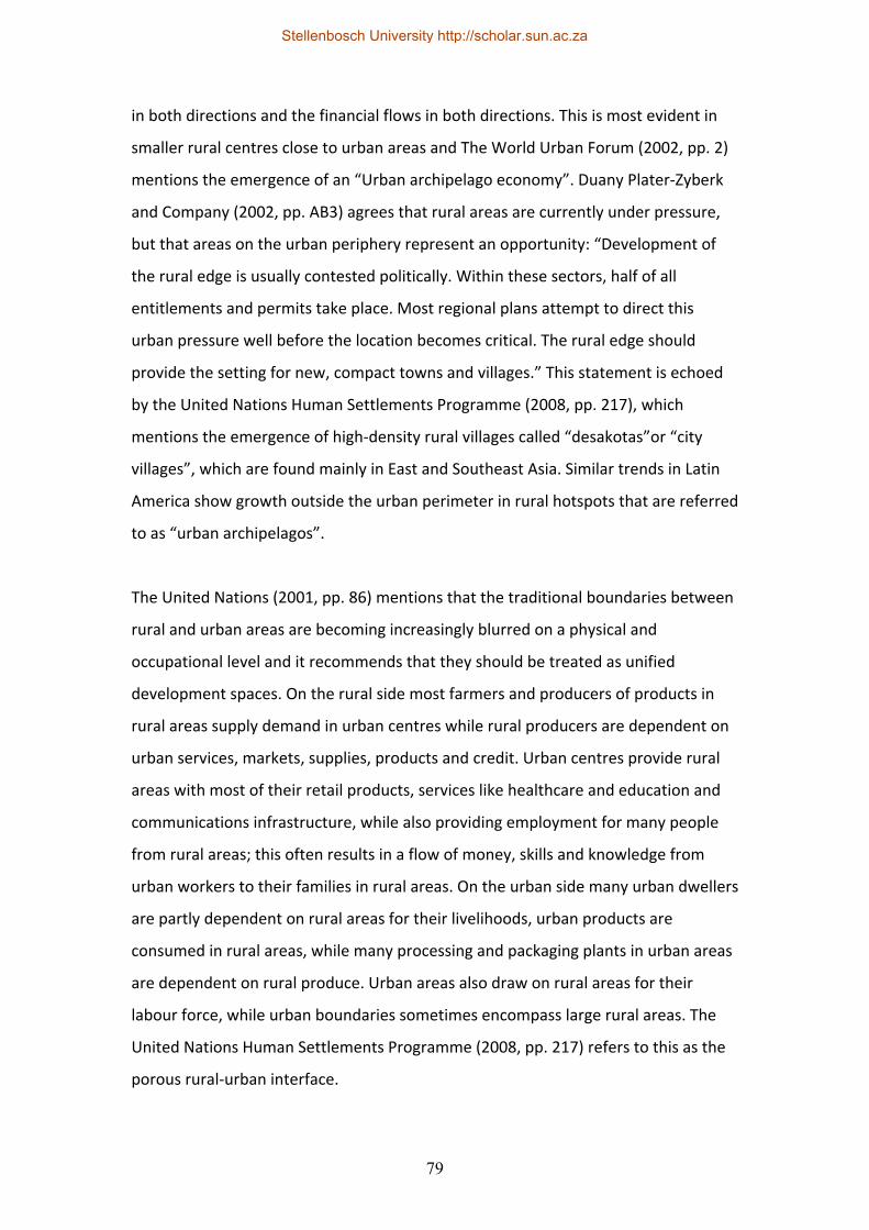
79
in both directions and the financial flows in both directions. This is most evident in
smaller rural centres close to urban areas and The World Urban Forum (2002, pp. 2)
mentions the emergence of an “Urban archipelago economy”. Duany Plater‐Zyberk
and Company (2002, pp. AB3) agrees that rural areas are currently under pressure,
but that areas on the urban periphery represent an opportunity: “Development of
the rural edge is usually contested politically. Within these sectors, half of all
entitlements and permits take place. Most regional plans attempt to direct this
urban pressure well before the location becomes critical. The rural edge should
provide the setting for new, compact towns and villages.” This statement is echoed
by the United Nations Human Settlements Programme (2008, pp. 217), which
mentions the emergence of high‐density rural villages called “desakotas”or “city
villages”, which are found mainly in East and Southeast Asia. Similar trends in Latin
America show growth outside the urban perimeter in rural hotspots that are referred
to as “urban archipelagos”.
The United Nations (2001, pp. 86) mentions that the traditional boundaries between
rural and urban areas are becoming increasingly blurred on a physical and
occupational level and it recommends that they should be treated as unified
development spaces. On the rural side most farmers and producers of products in
rural areas supply demand in urban centres while rural producers are dependent on
urban services, markets, supplies, products and credit. Urban centres provide rural
areas with most of their retail products, services like healthcare and education and
communications infrastructure, while also providing employment for many people
from rural areas; this often results in a flow of money, skills and knowledge from
urban workers to their families in rural areas. On the urban side many urban dwellers
are partly dependent on rural areas for their livelihoods, urban products are
consumed in rural areas, while many processing and packaging plants in urban areas
are dependent on rural produce. Urban areas also draw on rural areas for their
labour force, while urban boundaries sometimes encompass large rural areas. The
United Nations Human Settlements Programme (2008, pp. 217) refers to this as the
porous rural‐urban interface.
Stellenbosch University http://scholar.sun.ac.za
80
“In this reciprocal relationship, urban markets provide a powerful incentive for
increased rural production, while expanding rural markets provide an equally
powerful incentive for increased production of goods manufactured in urban areas.”
(World Urban Forum, 2002, pp. 4) “Synergy between agricultural production and
urban‐based enterprises is often key to the development of more vibrant local
economies and to less unequal and more ‘pro‐poor’ regional economic growth.”
(IIED, 2003, pp. 2) Mutizwa‐Mangiza (1999, pp. 4) mentions that rural‐urban linkages
are usually divided into five categories: Economic linkages, service linkages,
demographic linkages, environmental linkages and infrastructural linkages.
“Design must preserve the proximate relationships between urbanised areas and
both agricultural and natural lands in order to provide for local food sources;
maintain local watersheds and a clean and ready water supply; preserve clean air;
Figure 21: Poverty and the rural-urban continuum. (United Nations Human Settlements Programme, 2008, pp. 223)
Stellenbosch University http://scholar.sun.ac.za
81
allow access to local natural resources; conserve natural habitat; and guard regional
biodiversity.” (Duany, Speck & Lydon, 2010, App. A)
The World Urban Forum (2002, pp. 2) identifies some emerging trends that may
impact these relationships between urban and rural areas: Globalisation, the
increased occurrence of urban agriculture, “return migration” where retrenched
urban dwellers return to the rural areas where they came from and also the
“ruralisation” of urban employment where seasonal farm labourers live in urban
areas when they are not contracted. The United Nations Human Settlements
Programme (2008, pp. 219) lists a range of migratory flow patterns other than rural‐
urban migration: Rural‐rural migration, urban‐rural migration, circular migration,
step‐wise migration (commuting from shared dwellings outside urban areas),
straddling (keeping one foot in urban areas and one foot in rural areas) and
commuting from rural to urban areas.
Because of improved infrastructure and communications networks, people in rural
areas are becoming increasingly urbanised without actually moving to urban centres
and the World Urban Forum (2002, pp. 5) mentions that this can also affect the
behavioural patterns of people in rural areas. The combined approach between rural
and urban areas should take place on a regional level, but very importantly it has to
be appropriate to each specific context. Something that is also not always taken into
account is the fact that the boundaries between rural and urban can often be quite
ambiguous: “Production systems and chains are not so much a bridge over a rural‐
urban divide as a complex web of connections in a landscape where many places are
neither “urban” nor “rural”, but have features of both. This is especially so in areas
around urban centres or along the roads out of such centres.” (IIED, 2003, pp. 2)
The World Urban Forum (2002, pp. 7) mentions specific actions that are identified by
the Habitat Agenda, which was produced as part of the United Nations Conference
of Human Settlements in Istanbul in 1996: These are to encourage the sustainable
development of rural settlements, combining better technology and suitable
traditional practices in rural developments, to implement appropriate policies for
Stellenbosch University http://scholar.sun.ac.za
82
rural development, to provide rural employment opportunities and to foster
effective rural‐urban linkages. The United Nations Human Settlements Programme
(2008, pp. 221) recommends planning on a regional scale to deal with rural‐urban
pressures and flows; it lists several key focus areas to strengthen the linkages
between urban and rural areas as mobility, agricultural and non‐agricultural
production, trade and commodities, and natural resources and wastes. “There is now
a considerable and expanding body of evidence supporting the notion that rural‐
urban interactions can result in harmonious regional development outcomes.
However, unless carefully managed, rural‐urban linkages can also increase the
vulnerability of the urban and rural poor. The increasing interdependency of urban
and rural systems is not only spawning new forms of urbanisation but also new rural‐
urban coping strategies to avoid poverty and to reduce poor communities’
vulnerability to socio‐economic, environmental and political shocks and stress.“
(United Nations Human Settlements Programme, 2008, pp. 223)
4.4 Sustainable agriculture
Wartzmann (2007, pp. 1) defines sustainable agriculture as “…cultivating food in a
way that, without sacrificing profitability, promotes environmental health and socio‐
economic equity.” Bowler (2002, pp. 205) has a similar viewpoint when he says that
the three legs of sustainability namely environmental, economic and social aspects,
can all be applied to agriculture. Environmentally, he mentions the enhancement of
biodiversity, the recycling of agricultural wastes and the improvement of soil and
water. On the economic side he mentions the provision of goods and services to
rural communities, the economic growth of farms, rural economies and
farmers/farm workers; while on the social side he lists the maintenance of rural
populations, the quality of life, the equitable distribution of economic benefits and
skills building.
According to Salamini (2000, pp. 59), food production will not be able to supply the
demand in developing countries by the year 2020; the required demand will mean
increasing the production of cereals by 41%, meat by 63% and roots/tubers by 40%
Stellenbosch University http://scholar.sun.ac.za
83
and this is despite the fact that approximately 24 percent of the planet’s surface is
already taken up by agricultural systems (Millennium Ecosystem Assessment, 2005,
pp. 18). The environmental costs of attempts to meet these targets will be
substantial. The increased use of fertilisers, soil erosion (which again results in
reduced production), soil degradation, a lack of water, climate change, the loss of
biodiversity and increased poverty in rural areas will all have long term impacts on
the ecology and these will be due in a large part to unsustainable agricultural
practices. Bowler (2002, pp. 206) describes some of the prime causes of the
widespread occurrence of unsustainable farming practices as the so‐called
modernisation of farming practices (which consists mainly of more intensive
agricultural inputs or “intensification”, the acquisition of smaller farms by larger
corporate farms or “concentration” and “specialisation” that result in
monocropping), a more industrialised distribution and marketing system (that goes
hand‐in‐hand with globalisation) and government support for these practices. He
mentions three new approaches that can be implemented to promote more
sustainable forms of agriculture. These are the production of environmental goods,
the use of integrated farming systems and alternative farming practices:
1. As far as the production of environmental goods is concerned, he
recommends three approaches: “Extensification”, which is a reduction of
agricultural inputs like fertilisers and chemicals and a reduction in the
concentration of farm animals, improved regulations (for instance rules that
govern codes of conduct for farmers, the penalties for non‐compliance and
the granting of permits for actions that may be detrimental to the
environment) and finally sustainable policy measures that can take the form
of government subsidies for environmental services. Salamini (2000, pp. 64)
also mentions the importance of government policy to improve farming
practices, especially in the fields of water management, land and resource
property rights, opportunities and subsidies for low‐income farmers, energy
management and rural infrastructure.
2. Integrated Farming Systems (IFS) is the integration of more sustainable
agricultural practices into existing farms; this includes Integrated Crop
Stellenbosch University http://scholar.sun.ac.za
84
Management (ICM), Integrated Livestock Management (ILM), Integrated Pest
Management (IPM) and Agro‐forestry (AF). Practices like rotating crops, the
biological treatment of pests and diseases to reduce the use of chemicals, the
advancement of biodiversity to also provide habitats for natural predators,
using natural inputs to reduce the use of fertilisers, the prevention of soil
erosion, water management, the use of winter cover‐cropping and contour
ploughing are all tools that can be implemented as a third option other than
conventional or alternative agricultures.
3. “Alternative agricultures cover a range of philosophies on sustainable
farming, including ecological, biodynamic, humus, low external input,
permaculture, biological, resource‐conserving and regenerative systems. In
more detail, the following range of principles is advanced: The holism of a
farming system; a return to natural crop‐based (protein) diets so as to
remove the inefficiencies associated with feeding cereals to livestock for
intensive meat and milk production; a reduction in the fossil fuel inputs to
farming (e.g. as inorganic fertilisers, agri‐chemicals or diesel for engine
power); a return to polyculture; a return to national and regional self‐reliance
in food production; the maintenance of smaller farming units; the absence of
inorganic fertilisers and agri‐chemicals; multifunctional land use; minimum
soil cultivation; the reintegration of crop and grass‐based livestock farming;
crop rotations; organic manures; nutrient recycling; low energy inputs; and
biological pest and disease control. Together the principles offer a challenge
to most of the features of the industrial model of productivist agricultural
development.” (Bowler, 2002, pp. 209) Salamini (2000, pp. 63) confirms most
of these principles, including the use of natural manures, the recycling of
wastes, improved management of the use of fertilisers and increased protein
levels in diets. Added to this is the prevention of soil erosion, the increased
use of natural pesticides, more radical scientific farming systems that can
contribute to the sustainability of farming practices and the selective use of
biotechnology.
Stellenbosch University http://scholar.sun.ac.za
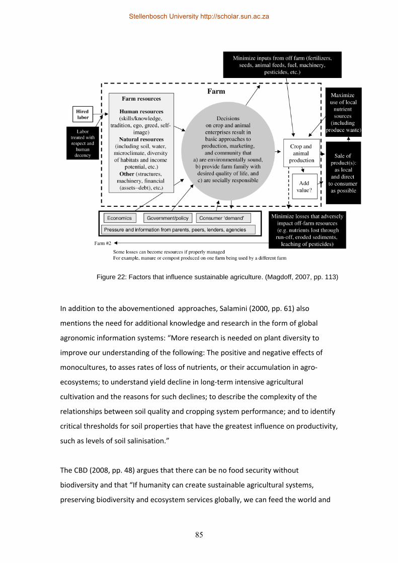
85
In addition to the abovementioned approaches, Salamini (2000, pp. 61) also
mentions the need for additional knowledge and research in the form of global
agronomic information systems: “More research is needed on plant diversity to
improve our understanding of the following: The positive and negative effects of
monocultures, to asses rates of loss of nutrients, or their accumulation in agro‐
ecosystems; to understand yield decline in long‐term intensive agricultural
cultivation and the reasons for such declines; to describe the complexity of the
relationships between soil quality and cropping system performance; and to identify
critical thresholds for soil properties that have the greatest influence on productivity,
such as levels of soil salinisation.”
The CBD (2008, pp. 48) argues that there can be no food security without
biodiversity and that “If humanity can create sustainable agricultural systems,
preserving biodiversity and ecosystem services globally, we can feed the world and
Figure 22: Factors that influence sustainable agriculture. (Magdoff, 2007, pp. 113)
Stellenbosch University http://scholar.sun.ac.za

86
ensure resources for future generations. If we fail in this collective challenge,
environmental security and human wellbeing will be in peril.”
4.5 Biodiversity and ecosystem services
Cape Nature (Undated, pp. 1) states that “Biodiversity is the sum total of all living
things on earth, from genes to species to entire ecosystems.” The Convention on
Biological Diversity (2008, pp. 6) has a more detailed definition that describes
biodiversity as “...the variability among living organisms and the ecological
complexes of which they are part, including diversity within species (genetic
diversity), between species, and of ecosystems.”
Biodiversity is the basis of agriculture and it provides the ecosystem services that are
necessary for its existence, while agriculture in turn can also contribute to
biodiversity and ecosystem services. These ecosystem services (ie. the services and
benefits that ecosystems provide) can be categorised as provisioning services like
food, water and fuel, regulating services like pollination, natural pest control and
water purification, cultural services like recreation and aesthetic value and
supporting services that include the provision of habitats, food, oxygen and water
cycling. They can directly influence human well‐being and the Millennium Ecosystem
Assessment (2005, pp. 19) relates ecosystem services to the basic material needs for
a decent quality of life, health, good social relations, security and freedom of choice
or action.
Stellenbosch University http://scholar.sun.ac.za
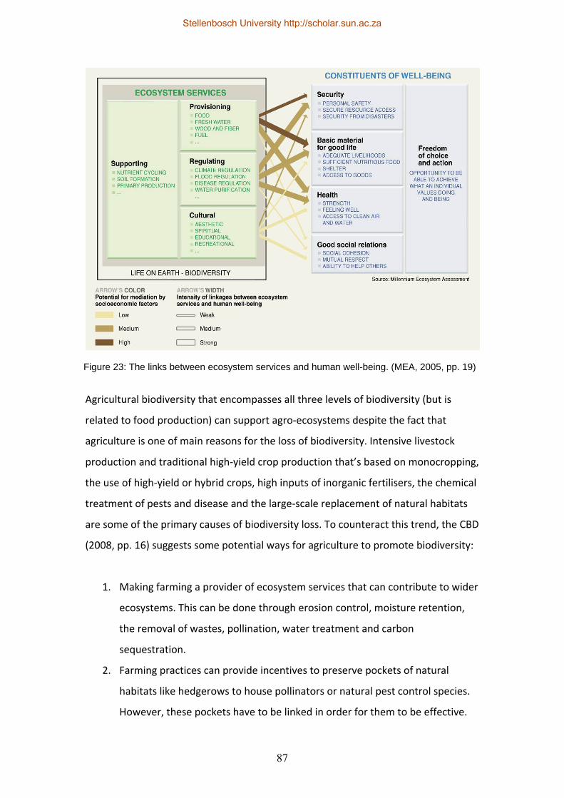
87
Agricultural biodiversity that encompasses all three levels of biodiversity (but is
related to food production) can support agro‐ecosystems despite the fact that
agriculture is one of main reasons for the loss of biodiversity. Intensive livestock
production and traditional high‐yield crop production that’s based on monocropping,
the use of high‐yield or hybrid crops, high inputs of inorganic fertilisers, the chemical
treatment of pests and disease and the large‐scale replacement of natural habitats
are some of the primary causes of biodiversity loss. To counteract this trend, the CBD
(2008, pp. 16) suggests some potential ways for agriculture to promote biodiversity:
1. Making farming a provider of ecosystem services that can contribute to wider
ecosystems. This can be done through erosion control, moisture retention,
the removal of wastes, pollination, water treatment and carbon
sequestration.
2. Farming practices can provide incentives to preserve pockets of natural
habitats like hedgerows to house pollinators or natural pest control species.
However, these pockets have to be linked in order for them to be effective.
Figure 23: The links between ecosystem services and human well-being. (MEA, 2005, pp. 19)
Stellenbosch University http://scholar.sun.ac.za
88
3. The provision of ecological knowledge; according to the FAO most of the
knowledge gained on biodiversity or ecosystem services has been provided
by agricultural practices.
Cape Nature (Undated, pp. 2) makes similar suggestions when it calls for more
sustainable farm planning where larger pieces of natural habitat are maintained, and
that these natural areas do not have excessively irregular shapes that can amplify
edge effects. In addition they suggest that natural corridors are provided to allow for
plant and animal movement, and that natural habitats are preserved in networks so
that fragments of these areas are fairly close to one another.
“However, the Earth’s biodiversity is being lost at an alarming rate, putting in
jeopardy the sustainability of ecosystem services and agriculture, and their ability to
adapt to changing conditions. The conservation and sustainable use of biodiversity is
essential for the future of agriculture and humanity. At the same time, since
agricultural lands extend across such a considerable proportion of the Earth’s surface
and harbour significant biodiversity, the conservation of biodiversity within
agricultural landscapes must play an important part in global conservation
strategies.” (CBD, 2008, pp. 7)
4.6 Food security
According to the United Nations Environment Programme (UNEP) and the United
Nations Conference on Trade and Development (UNCTAD), the number of hungry
people in Sub‐Saharan Africa increased by twenty percent between 1990 and 2008
to approximately two hundred million; this is despite the fact that modern
agricultural processes have increased the global production of food significantly in
recent years (UNEP & UNCTAD, 2008, pp. 1). While many feel that increased
production is the answer to food insecurity, it is also becoming increasingly evident
that the control of food production, the control of food production technology and
difficulties related to access to food can counteract any increases in total output.
This relates directly to what is referred to as “Entitlement theory” where the unequal
distribution of food or the lack of access to food and not the overall lack of sufficient
Stellenbosch University http://scholar.sun.ac.za
89
food can be the root cause of hunger. Other aspects like nutrition and human well‐
being should also be considered in addition to the basics of food supply and access.
The FAO (2003, pp. 29) views food security as a situation in which “…all people, at all
times, have physical, social and economic access to sufficient, safe and nutritious
food which meets their dietary needs and food preferences for an active and healthy
life.”
UNEP and UNCTAD (2008, pp. 4) list a range of factors that are contributing to the
lack of food security in Africa. Problems related to the availability of food can range
from a lack of funds to buy food or the inability to produce it, the lack of market
access, the lack of access to land, insecure tenure, or inconsistent production
throughout the year so people can be hungry periodically. The degradation of the
environment and the inability of monocropping farming practices to deal with
environmental stresses lead to a reduction of natural capital, while weak social
linkages together with a lack of skills or agricultural knowledge lead to a reduction in
social capital. The lack of adequate and nutritious food also affects peoples’ health
negatively and it leads to a vicious cycle since malnourished or undernourished
people are also less productive, while the prevalence of HIV/AIDS further
compounds the issue. Poor infrastructure provision, a lack of effective governance
(which includes corruption) and unrest directly and indirectly influence food security,
while climate change and natural disasters pose continual challenges to food
production.
UNEP and UNCTAD argue that increased production based on modern farming
techniques has not reduced poverty or hunger in developing countries and they
suggest that sustainable agriculture may be a tool to improve food security. The
basic elements of their proposal are to integrate farming with natural ecological
processes, minimising agricultural inputs, using the knowledge and skills of
experienced farmers and using the combined skills of communities to address local
resource problems.
Stellenbosch University http://scholar.sun.ac.za

90
The South African Constitution mandates the right to food, while the Integrated
Food Security Strategy (IFSS) lists a range of strategic objectives to improve food
security, such as increased household food production, improved employment
opportunities, improved nutrition and food security and better safety nets and
emergency strategies. It would then seem that food security is not purely dependent
on agricultural or natural sustainability, but on a wider range of factors that involve
social and economic sustainability, especially in relation to rural livelihoods and
communities. The FAO (2003, pp. 11) confirms this when they state that: “For other
households, both rural and urban, access to productive resources may be less
relevant. These will seek, according to their location and particular skills, to generate
entitlement to food through trade or direct employment. The promotion of income‐
generating activities, both local employment opportunities and self‐employment
(particularly those associated with the rural informal sector), forms a second
essential approach to food security.”
4.7 Land ownership
“The law locks up the man or woman
Who steals the goose from off the common
But leaves the greater villain loose
Who steals the common from off the goose.”
(Anonymous, 17th Century English protest poem, Wealth and Want, 2011)
Land reform is a national priority in South Africa that was written into the
Constitution of the Republic of South Africa in 1996 and it is aimed at tenure reform,
restitution and land distribution. The Integrated Sustainable Rural Development
Strategy (ISRDS) cites the unequal ownership and access to land, especially farmland,
as one of the most visible legacies of Apartheid’s spatial planning policies: “Most of
the specific characteristics of rural South Africa are strongly related to the fact that
most of the country’s rural land is concentrated in the hands of a relatively small and
wealthy minority. Detailed analysis has shown that land reform, when conducted in
an appropriate manner, will lead to increases in economic, financial, social and
Stellenbosch University http://scholar.sun.ac.za
91
environmental efficiency, equity and sustainability.” (Independent Development
Trust, 2000, pp. 41). Hall, Isaacs & Saruchera (2007, pp. 4) confirm this when they
mention that eighty‐seven percent of South Africa was owned by white landowners
(private and corporate) in 1994, with thirteen percent being in the former
homelands; the goal of land reform is to equalise this disproportionate ownership
ratio by implementing the following three tools:
Restitution: A Commission on the Restitution of Land Rights (CRLR) was formed,
together with a Land Claims Court, to give land back to people who were unfairly
dispossessed or to provide them with alternative compensation. 63 455 land
restitution claims were received by the deadline of 31 December 1998 and just over
56 000 had been dealt with by 2004, although almost three quarters of the claims
were in urban areas (Hall et al, 2007, pp. 4). This is confirmed by Kepe & Cousins
(2002, pp. 2). Hall et al also note that restitution is mostly not mentioned in local
economic development strategies or in IDPs, despite the fact that land reform can be
deemed to be classified as Local Economic Development.
Redistribution: This strategy consists mainly of grants provided by the state to
enable people to purchase and improve land, sometimes through equity share
schemes. This was initially done via a Settlement/Land Acquisition Grant (SLAG), but
this has now been replaced by the programme for Land Redistribution for
Agricultural Development (LRAD).
Tenure reform: This mainly applies to labourers, farm workers and their dependents
who live on (mainly white‐owned) farms and whose tenure is legally insecure,
despite secure tenure being a basic human right. According to Hall et al (2007, pp. 6)
almost one million people had been evicted from farms from 1994 to 2007, while
Kepe & Cousins (2002, pp. 2) are of the opinion that very little has been achieved in
terms of tenure reform.
The ISRDS predicted economic growth in rural areas due to the acquisition of specific
portions of land and start‐up farming grants, which were also expected to result in
Stellenbosch University http://scholar.sun.ac.za
92
the increased demand for services, increased production, the in‐flow of capital from
urban areas, increased security and improved land value. Since the ISRDS was
formalised into the ISRDP (which is described as an attempt at best practice for
integrated rural development planning) it has been criticised for not providing
additional resources and only dealing with the coordination of various government
departments, because it only focuses on specific nodes instead of suggesting
overarching strategies and because it doesn’t specifically deal with poverty, but only
deals with infrastructure and service delivery (Hall et al, 2007, pp. 8). A potential
problem with infrastructure and service delivery is that the government is unwilling
to invest in improvements on private property, which means that farm dwellers on
most commercial farms (and settlements on these farms) can’t benefit. Even the
provision of services up to farm boundaries is problematic since the unit cost per
household in sparsely populated rural areas is too high to be justifiable. Where land
is owned by the community, service delivery may be somewhat easier; municipal
commonage (as found mostly in the former Cape Colony) may provide an
opportunity for economic development although most Municipalities seem to be
unaware of the legalities related to commonages. Cousins (2007, pp. 12) also
criticises the ISRDP mainly because of the lack of governmental capacity to
implement it because it doesn’t indicate any key areas for rural growth. Turner
(2001, pp. 2) is also doubtful of the ISRDP’s effectiveness since it marginalises land
reform and it doesn’t provide strategies to encourage effective farming strategies for
the promotion of rural livelihoods. He argues that appropriate farming practices are
a vital tool that needs to be employed in conjunction with land reform
Lahiff, Borras and Kay (2007, pp. 1417) take a more critical stance by saying that
market‐led agrarian reform (MLAR) can’t challenge the power of private land owners
in favour of the rural poor; they describe it as a pro‐elite/anti‐poor strategy. The lack
of support for new farmers after land has been transferred results in low
productivity, together with the trend that less productive land is sometimes
transferred to “unqualified” beneficiaries. Corruption during the transfer process has
also been encountered since officials decide on the beneficiaries, while from the side
of the land owners, land reform can be perceived as a form of confiscation, which
Stellenbosch University http://scholar.sun.ac.za
93
leads to increased resistance. Lahiff et al (2007, pp. 1432) argue that “…the system of
‘willing buyer, willing seller’ has not only fallen far short of its targets but has
effectively postponed the resolution of the land question inherited from colonialism
and apartheid, a question that should have been squarely addressed at the moment
of political transition, but which is now likely to be addressed under very different
circumstances at an unknown date in the future.” From a policy point of view, Hall et
al (2007, pp. 47) recommend better information and communication systems, better
coordination between government departments, better guidelines for the
development of IDPs and additional research.
The CRDP (Ministry of Rural Development and Land Reform, 2010, pp. 4) echoes
Harrison and Todes’ previously mentioned view that land reform in South Africa
hasn’t delivered and has not been sustainable to date – effective support and
development is vital and this can be done through mentorship programmes based on
skills transfer and joint management by experienced farmers. Cousins (2007, pp. 17)
supports this statement by saying that land reform on its own isn’t sufficient and
that infrastructure, services, training and assistance is vital for it to succeed.
The current land reform strategy and the Land and Agrarian Reform Programme
(LARP) aims to redistribute thirty percent of white‐owned farmland to previously
disadvantaged people, while re‐evaluating all the other land reform strategies that
have been developed to date. Land reform is to be fast‐tracked, together with land
tenure reform and restitution, through the effective use of land planning
information, and a new Green Paper and Land Tenure Security Bill are proposed by
the Department of Rural Development and Land Reform to deal with some of the
more pertinent issues. It may be that a new model based on a mixture of the
abovementioned strategies could help to address some of the more difficult
challenges and to promote the “accumulation from below” both in agriculture and
other rural livelihood strategies. “South African experience suggests that rural
development cannot be environmentally sustainable without land reform. Nor can
land reform be sustainable without adequate provision for environmental care.
While government has acted on this second lesson, it needs to do more to address
Stellenbosch University http://scholar.sun.ac.za
94
the first.” (Turner, 2001, pp. 4) Kepe & Cousins (2002, pp. 1) share this sentiment
when they state that “Sustainable rural development in 21st century South Africa will
never be achieved without a radical assault on the structural underpinnings of
poverty and inequality inherited from three centuries of oppression and exploitation.
A large‐scale redistribution of land and resources, accompanied by the securing of
tenure rights in practice as well as in law, is required for long‐term sustainability.”
This link between land reform and sustainability is explored further by Attfield,
Hattingh and Matshabaphala (2004, pp. 411): “The basic human right to a livelihood
and the ability to support one’s family typically (although not invariably) involves
access to natural resources such as land and, at that, to land that has not been
hopelessly degraded through overgrazing, erosion or industrial pollution. This brings
into play another human right, recognised in South Africa’s Constitution, the right to
a sustainable environment and to sustainable development. Land reform would in
many circumstances be the best and sometimes the only way to implement these
constitutional rights.” They argue that there are conceptual linkages and contingent
discontinuities between land reform, sustainable livelihoods and sustainable
development.
Unfortunately land reform in South Africa has not been successful to date. The focus
on the thirty percent as the only measure of success, has lead to some working farms
being taken out of production, with the loss of linked (downstream and upstream)
jobs (such as those that serviced farms, including farm workers or industries that
were based on farm produce. “Further, since sustainable livelihoods are a necessary
condition of sustainable development, including development that is ecologically
sustainable, the prospects of such sustainable development are poor if action to
inaugurate land reform is not taken.” (Attfield, Hattingh & Matshabaphala, 2004, pp.
413)
Stellenbosch University http://scholar.sun.ac.za
95
4.8 Rural livelihoods and poverty alleviation
According to Wiggins (2008, pp. 1), almost half of the global agricultural labour force
(which is estimated at 1 100 million people) are hired labour. Temporary
employment at this scale means that almost fifty percent of farm workers have very
little job security and added to the lack of financial security, farming has other
hazards if one takes the number of fatalities of farm workers into account, which is
estimated at 170 000 annually. These factors are leading to a rise in multiple
employment, especially among poorer workers who are increasingly engaged in
other forms of employment when they’re not busy farming; this is made possible
because of improved rural‐urban linkages as mentioned previously. The occurrence
of multiple forms of employment is confirmed in South Africa’s ISRDS: “Furthermore,
because of their poverty and vulnerability, rural households commonly resort to a
variety of different strategies to ensure their survival so that it has become more
appropriate to describe their economic activities as livelihood strategies rather than
jobs or employment.” (Independent Development Trust, 2000, pp. 9) Cousins (2007,
pp. 4) also mentions this trend and lists farming on a variable scale, formal jobs,
remittances, welfare (like pensions) and small enterprises as alternative livelihood
strategies.
Kepe and Cousins (2002, pp. 1) state that more than seventy percent of South
Africa’s poor live in rural areas, while more than seventy percent of rural people are
considered poor. (Unfortunately no indicators are provided by them to describe the
baseline determinants for being considered poor.) Due to government policies prior
to the 1994 elections, many rural poor live in dislocated settlements that have a
relatively high population density and that are far from employment opportunities
with weak rural‐urban linkages. Farm workers represent one of the worst‐off rural
segments. They are usually dependent on farm owners for wages, accommodation,
water, electricity, education, health services and transport, while Hall et al (2007, pp.
15) mention a reduction in the provision of goods and services by farmers as a direct
response to new labour regulations and tenure reform. According to the ISRDS, farm
workers’ wages are mostly lower than the minimum living wage, while temporary or
Stellenbosch University http://scholar.sun.ac.za
96
seasonal labourers earn about ten percent less than permanent employees.
Opportunities for education are also limited and a 1997 survey in South Africa found
that fifty percent of black farm workers had no formal education, while forty percent
only attended school up to grade two to seven. (Independent Development Trust,
2000, pp. 11) Added to these problems are adjustments made to agricultural
subsidies, taxes and changes in export controls that resulted in a reduction in
agricultural employment. Hall et al (2007, pp. 15) estimate that there are about 800
000 farm workers in South Africa and that they take care of about three million
dependents. Despite this, most Municipalities often do not see them as parties
requiring support since they are living on privately owned land.
HIV/AIDS has a massive influence on rural livelihoods, where one infected individual
can affect the entire household, especially if the most productive member is
infected. It usually means that poor households have to shift from wage‐earning to
subsistence farming and that usually means a deterioration of the quality of life for
the entire household. In addition to subsistence farming, the rural poor may be
forced to exploit natural resources, which results in environmental degradation,
which in turn has a further negative impact on population health. The limited access
to health services, welfare and education means the rural poor are being
marginalised to the point where Gutberlet (1999, pp. 222) feels they are losing their
status as citizens. They are economically, and also spatially and socially, marginalised
due to the lack of access to services. She lists a number of factors experienced by the
rural poor in a South American case study (and these would arguably be applicable
to rural populations in other developing countries, South Africa included): Insecure
land tenure, the reduced access to farmland, new pests and weeds due to the
prevalence of monoculture farming practices, the inability to get loans, the lack of
technical assistance (and where assistance is available it is usually based on “Green
revolution” farming practices), limited access to the market and political exclusion.
The outflow of skills, labour and capital to urban areas as discussed previously is also
a prevailing challenge. Cousins (2007, pp. 6) refers to the marginalised rural poor as
the “surplus population” and also mentions that the HIV/AIDS pandemic is
exacerbating their already precarious situation. Some possible approaches suggested
Stellenbosch University http://scholar.sun.ac.za
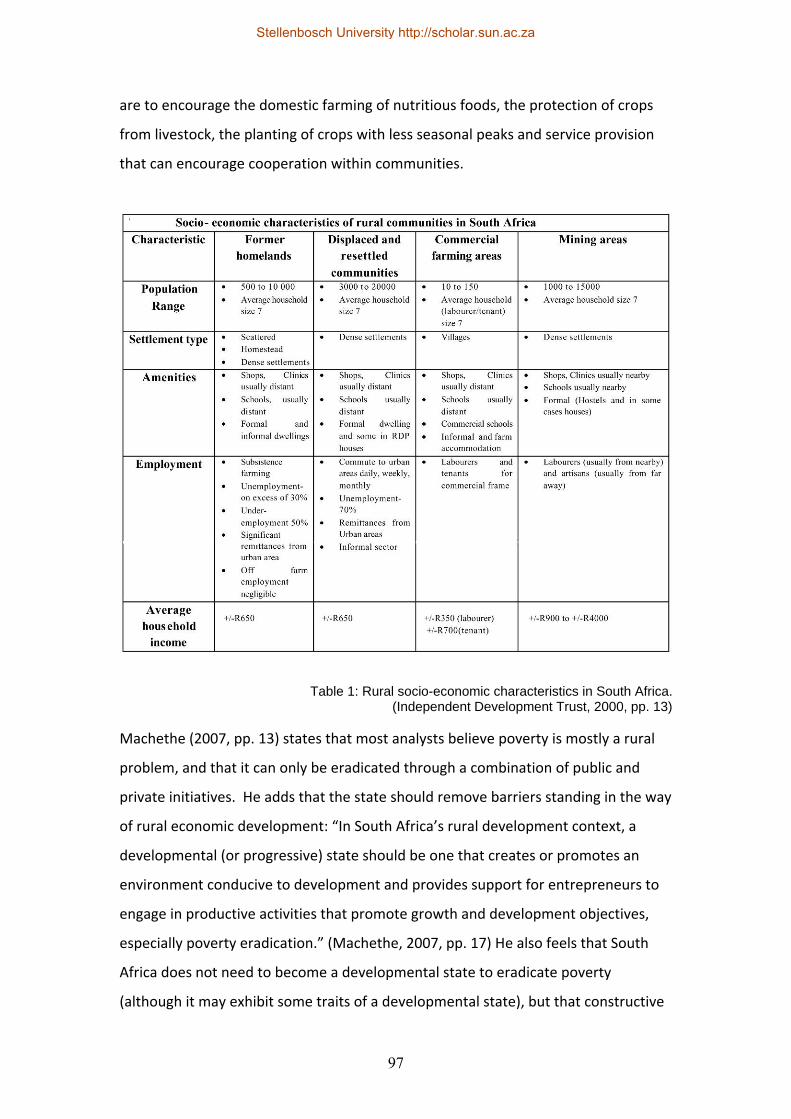
97
are to encourage the domestic farming of nutritious foods, the protection of crops
from livestock, the planting of crops with less seasonal peaks and service provision
that can encourage cooperation within communities.
Machethe (2007, pp. 13) states that most analysts believe poverty is mostly a rural
problem, and that it can only be eradicated through a combination of public and
private initiatives. He adds that the state should remove barriers standing in the way
of rural economic development: “In South Africa’s rural development context, a
developmental (or progressive) state should be one that creates or promotes an
environment conducive to development and provides support for entrepreneurs to
engage in productive activities that promote growth and development objectives,
especially poverty eradication.” (Machethe, 2007, pp. 17) He also feels that South
Africa does not need to become a developmental state to eradicate poverty
(although it may exhibit some traits of a developmental state), but that constructive
Table 1: Rural socio-economic characteristics in South Africa. (Independent Development Trust, 2000, pp. 13)
Stellenbosch University http://scholar.sun.ac.za
98
engagement with the private sector is the key for rural development. In dealing with
rural poverty in South Africa, one should recognise that the country has a dual
economy; different strategies may be required for each, while the state would most
probably have to play the leading role in developing the “second economy”.
On the positive side, the Independent Development Trust (2000, pp. 24) mentions
the view that “Rural communities hold a wealth of social capital in the form of
extended networks of mutual solidarity, shared beliefs and traditions, and
commitments to retain long‐standing practices of daily life.” Harrison and Todes
(2001, pp. 70) also mention the potentially positive trend that the government’s
attention seems to be shifting towards rural development at a national and
provincial level. This can be seen in the “War on poverty”, which is a Presidential
Special Programme and governmental priority, and according to the Ministry of Rural
Development and Land Reform (2010, pp. 8) some of the key priorities of the
national government are job creation and sustainable livelihoods, improved access
to education, improved access to health, rural development, food security and land
reform and a reduction in crime and corruption.
4.9 Conclusion
The complexity of the South African situation as far as rural development goes is
evident in the range of different policies and departments that have been developed
to address the issues of rural transformation. None have been very successful to
date, although the strategies seem to be shifting towards public‐private partnerships
that focus on livelihoods instead of pure agriculture. An important focus should be
on the “in‐between” where apparently opposing forces meet: How rural and urban
areas are linked, where agriculture and nature/biodiversity intersect, where
economic injections benefit impoverished rural populations, and where land
ownership is made possible for the landless. The strengthening of the complex links
between these supposedly disparate elements are the key to sustainable rural
development in South Africa and spatial planning might be one of the enabling tools
that can establish the context where these links may be established.
Stellenbosch University http://scholar.sun.ac.za
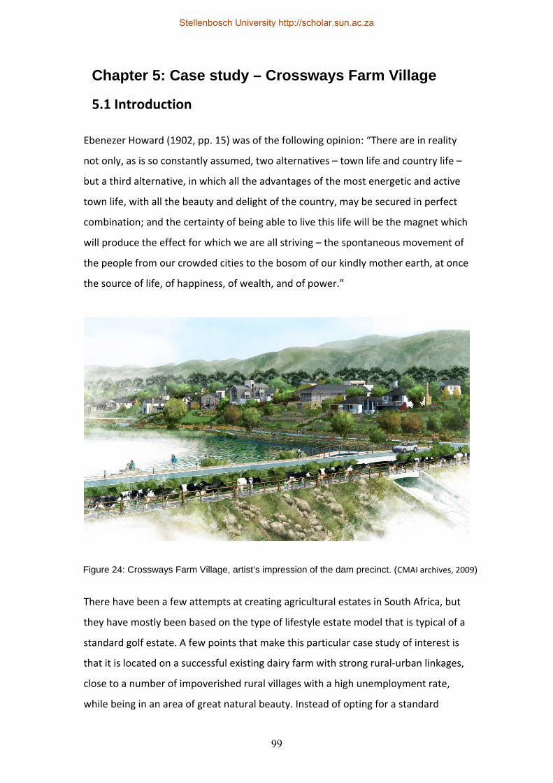
99
Chapter 5: Case study – Crossways Farm Village
5.1 Introduction
Ebenezer Howard (1902, pp. 15) was of the following opinion: “There are in reality
not only, as is so constantly assumed, two alternatives – town life and country life –
but a third alternative, in which all the advantages of the most energetic and active
town life, with all the beauty and delight of the country, may be secured in perfect
combination; and the certainty of being able to live this life will be the magnet which
will produce the effect for which we are all striving – the spontaneous movement of
the people from our crowded cities to the bosom of our kindly mother earth, at once
the source of life, of happiness, of wealth, and of power.”
There have been a few attempts at creating agricultural estates in South Africa, but
they have mostly been based on the type of lifestyle estate model that is typical of a
standard golf estate. A few points that make this particular case study of interest is
that it is located on a successful existing dairy farm with strong rural‐urban linkages,
close to a number of impoverished rural villages with a high unemployment rate,
while being in an area of great natural beauty. Instead of opting for a standard
Figure 24: Crossways Farm Village, artist’s impression of the dam precinct. (CMAI archives, 2009)
Stellenbosch University http://scholar.sun.ac.za
100
subdivisional plan, the developers have decided to use the New Urbanism and New
Ruralism frameworks together with a number of sustainable rural development tools
in order to generate a new model for sustainable rural development. While there are
many challenges to overcome, this case study could form the basis for critical
evaluation of these frameworks as it progresses.
5.2 Context
In the current South African context, farms are increasingly becoming larger mass‐
producing enterprises with typically a smaller (albeit better skilled) workforce. This is
leading to increased rural unemployment and urbanization and it also means that
agriculture can’t be the sole driver of sustainable rural development. Another
alternative is needed to create sustainable economic and social development in rural
areas, while ensuring the environmental vitality of these regions. The South African
government has made rural development one of its priorities and it is implementing
various policies to achieve this, but the real test will be to encourage the private
sector to invest in these projects.
The site of the proposed Crossways Farm Village is situated on an existing dairy farm
of approximately 520 hectares in the Kouga District of the Eastern Cape and it is
approximately forty kilometers west of Port Elizabeth. The Kouga District is
characterised by a low development and high unemployment rate, with a number of
scattered villages that are typical remnants of apartheid policies with their
communities far removed from any public transport systems or potential
employment opportunities. The village of Thornhill is just one example and it is in
close proximity to the proposed development; the area around the two has been
denoted as a rural development node and its proximity to Port Elizabeth,
Humansdorp, Jeffreys Bay and St. Francis means that the area has many
opportunities if the right planning strategies are implemented.
Stellenbosch University http://scholar.sun.ac.za
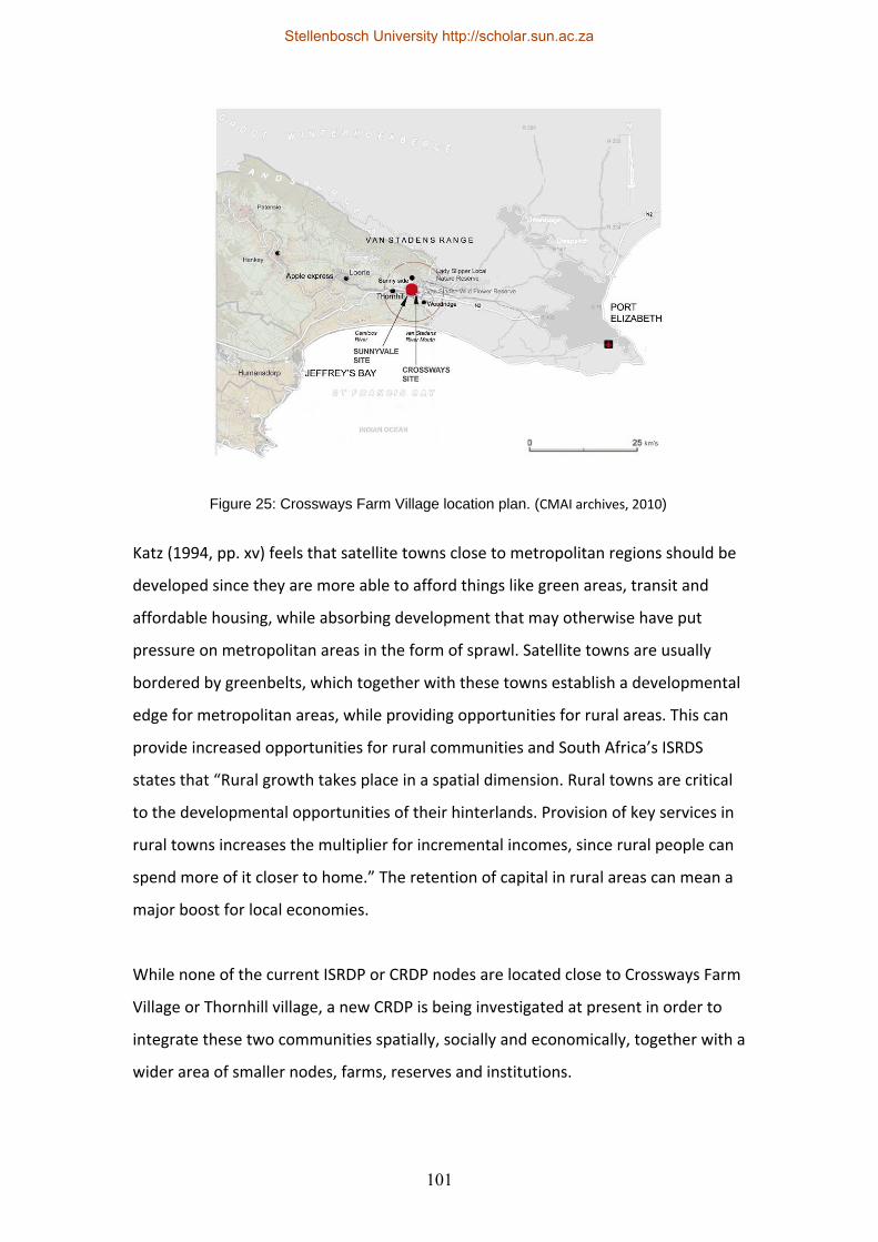
101
Katz (1994, pp. xv) feels that satellite towns close to metropolitan regions should be
developed since they are more able to afford things like green areas, transit and
affordable housing, while absorbing development that may otherwise have put
pressure on metropolitan areas in the form of sprawl. Satellite towns are usually
bordered by greenbelts, which together with these towns establish a developmental
edge for metropolitan areas, while providing opportunities for rural areas. This can
provide increased opportunities for rural communities and South Africa’s ISRDS
states that “Rural growth takes place in a spatial dimension. Rural towns are critical
to the developmental opportunities of their hinterlands. Provision of key services in
rural towns increases the multiplier for incremental incomes, since rural people can
spend more of it closer to home.” The retention of capital in rural areas can mean a
major boost for local economies.
While none of the current ISRDP or CRDP nodes are located close to Crossways Farm
Village or Thornhill village, a new CRDP is being investigated at present in order to
integrate these two communities spatially, socially and economically, together with a
wider area of smaller nodes, farms, reserves and institutions.
Figure 25: Crossways Farm Village location plan. (CMAI archives, 2010)
Stellenbosch University http://scholar.sun.ac.za
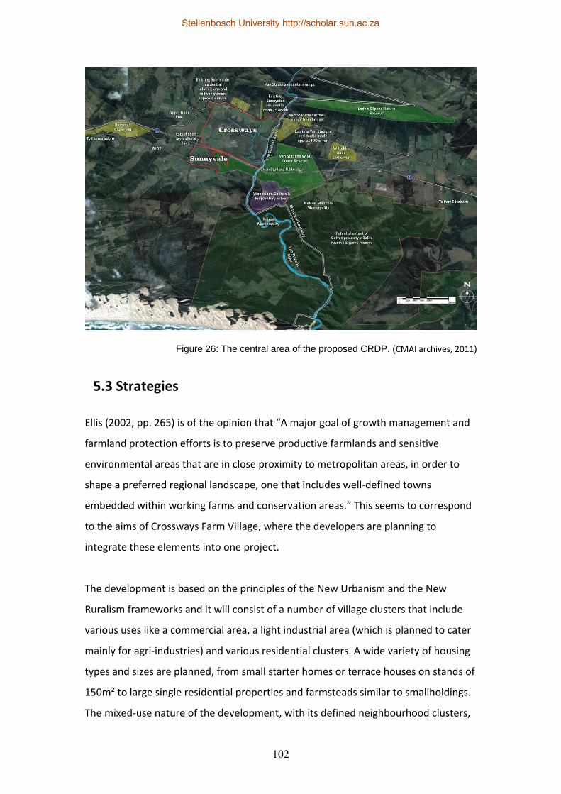
102
5.3 Strategies
Ellis (2002, pp. 265) is of the opinion that “A major goal of growth management and
farmland protection efforts is to preserve productive farmlands and sensitive
environmental areas that are in close proximity to metropolitan areas, in order to
shape a preferred regional landscape, one that includes well‐defined towns
embedded within working farms and conservation areas.” This seems to correspond
to the aims of Crossways Farm Village, where the developers are planning to
integrate these elements into one project.
The development is based on the principles of the New Urbanism and the New
Ruralism frameworks and it will consist of a number of village clusters that include
various uses like a commercial area, a light industrial area (which is planned to cater
mainly for agri‐industries) and various residential clusters. A wide variety of housing
types and sizes are planned, from small starter homes or terrace houses on stands of
150m² to large single residential properties and farmsteads similar to smallholdings.
The mixed‐use nature of the development, with its defined neighbourhood clusters,
Figure 26: The central area of the proposed CRDP. (CMAI archives, 2011)
Stellenbosch University http://scholar.sun.ac.za
103
is intended to reduce automobile use within the development and encourage
walking or cycling. However, similarly to Thesen Islands, many inhabitants will still
have to make use of motorised transport to get to their place of employment outside
the development – as Gordon (1998, pp. 3) states: “Only by developing a broad mix
of land uses can the goals, perhaps a dream, of walking to work and walking to shop
be met.” An extensive network of public open spaces, used in conjunction with
numerous civic buildings like a community centre, farmers market, sporting facilities,
a school and potential campus facilities are indicated on the drawings. Unfortunately
an existing station on the property (which is bordered by the railway line that used
to accommodate the Apple Express train) has been decommissioned for the time
being, so a good opportunity for public transit to Port Elizabeth has been lost,
although a community bus service may be able to fulfil this role until such time as
the railway lines in this region are rehabilitated. (A reduction in private transport use
may mitigate some of the emissions that are common to livestock farming!)
Some of the economic and social infrastructure improvements as mentioned in the
CRDPs (Ministry of Rural Development and Land Reform, 2009, pp. 14) that are
planned for Crossways Farm Village are roads, a state‐of‐the‐art milking
parlour/dairy, community gardens, new fencing, transport infrastructure,
communications infrastructure, water harvesting and water shed management, the
provision of retail outlets and a post office, a clinic, sporting facilities and a school.
The Designing with Nature (DWN) tool was used to determine the developable
portions on the land, so any steep slopes, productive agricultural land, areas affected
by noise pollution from the N2, streams, rivers and dams, areas in deep shadow,
conservation‐worthy land, sensitive vegetation and biodiversity corridors have all
been designated as no‐go areas, so only the remainder was earmarked for
development. This remainder was also planned with extensive public open spaces
and low coverage ratios so that the actual area that will be covered by buildings or
hard landscaping can be constrained.
Stellenbosch University http://scholar.sun.ac.za
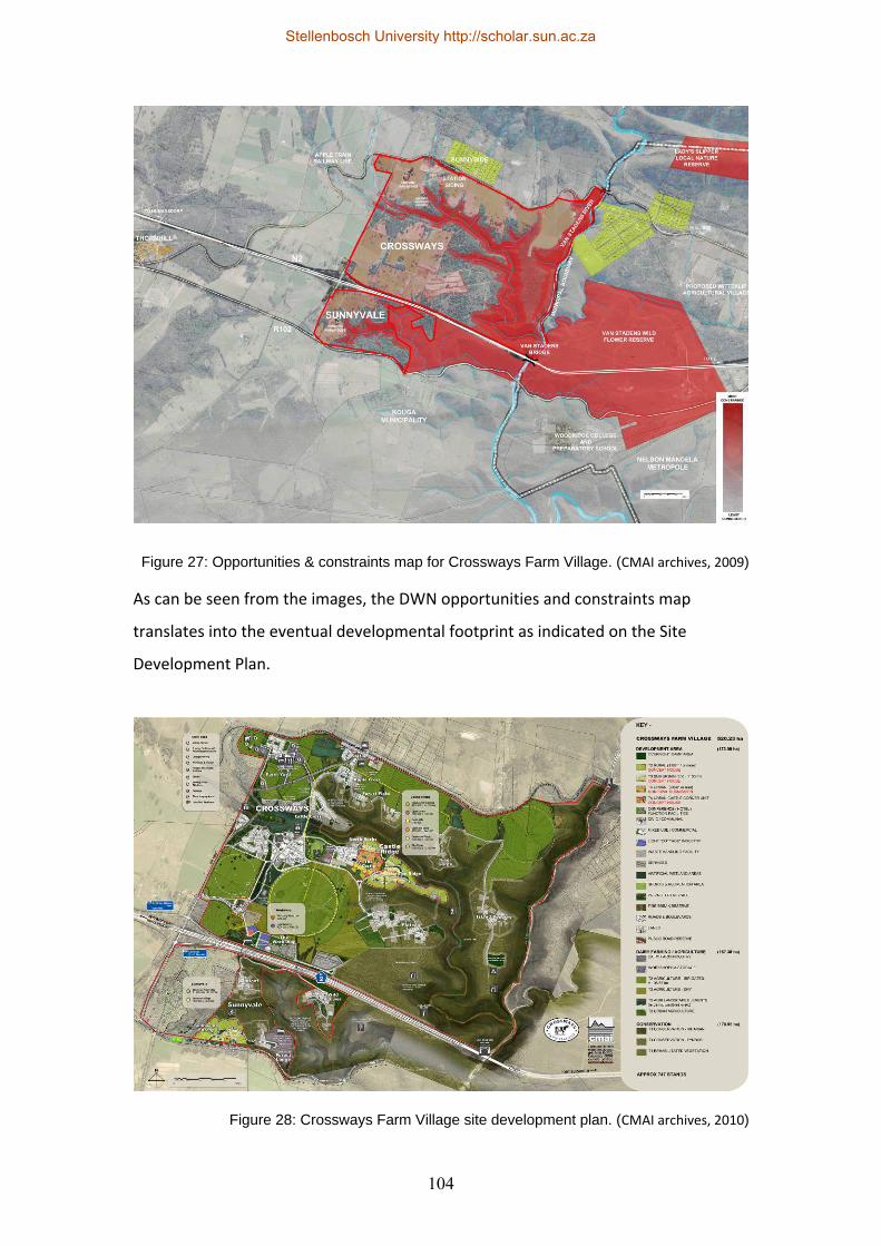
104
As can be seen from the images, the DWN opportunities and constraints map
translates into the eventual developmental footprint as indicated on the Site
Development Plan.
Figure 27: Opportunities & constraints map for Crossways Farm Village. (CMAI archives, 2009)
Figure 28: Crossways Farm Village site development plan. (CMAI archives, 2010)
Stellenbosch University http://scholar.sun.ac.za
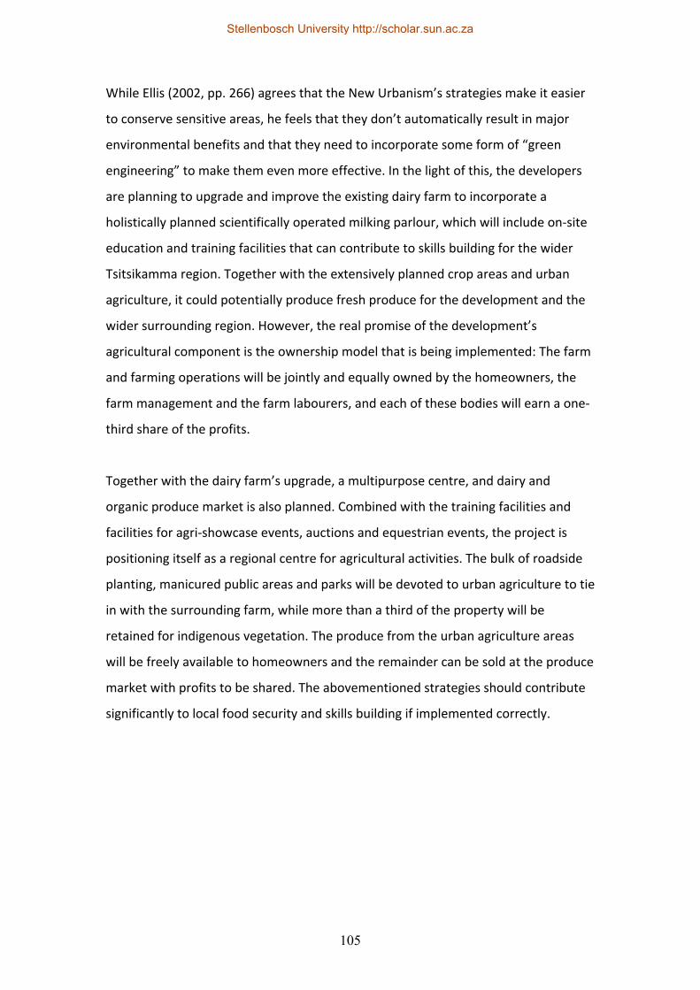
105
While Ellis (2002, pp. 266) agrees that the New Urbanism’s strategies make it easier
to conserve sensitive areas, he feels that they don’t automatically result in major
environmental benefits and that they need to incorporate some form of “green
engineering” to make them even more effective. In the light of this, the developers
are planning to upgrade and improve the existing dairy farm to incorporate a
holistically planned scientifically operated milking parlour, which will include on‐site
education and training facilities that can contribute to skills building for the wider
Tsitsikamma region. Together with the extensively planned crop areas and urban
agriculture, it could potentially produce fresh produce for the development and the
wider surrounding region. However, the real promise of the development’s
agricultural component is the ownership model that is being implemented: The farm
and farming operations will be jointly and equally owned by the homeowners, the
farm management and the farm labourers, and each of these bodies will earn a one‐
third share of the profits.
Together with the dairy farm’s upgrade, a multipurpose centre, and dairy and
organic produce market is also planned. Combined with the training facilities and
facilities for agri‐showcase events, auctions and equestrian events, the project is
positioning itself as a regional centre for agricultural activities. The bulk of roadside
planting, manicured public areas and parks will be devoted to urban agriculture to tie
in with the surrounding farm, while more than a third of the property will be
retained for indigenous vegetation. The produce from the urban agriculture areas
will be freely available to homeowners and the remainder can be sold at the produce
market with profits to be shared. The abovementioned strategies should contribute
significantly to local food security and skills building if implemented correctly.
Stellenbosch University http://scholar.sun.ac.za
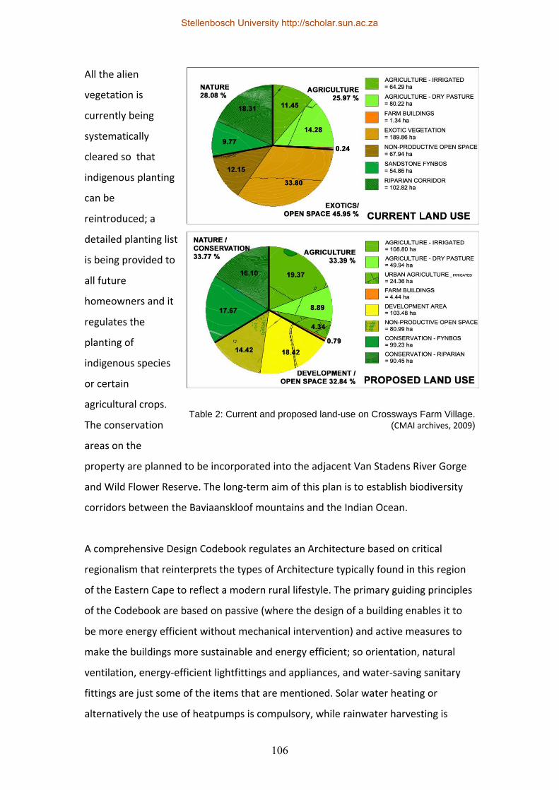
106
All the alien
vegetation is
currently being
systematically
cleared so that
indigenous planting
can be
reintroduced; a
detailed planting list
is being provided to
all future
homeowners and it
regulates the
planting of
indigenous species
or certain
agricultural crops.
The conservation
areas on the
property are planned to be incorporated into the adjacent Van Stadens River Gorge
and Wild Flower Reserve. The long‐term aim of this plan is to establish biodiversity
corridors between the Baviaanskloof mountains and the Indian Ocean.
A comprehensive Design Codebook regulates an Architecture based on critical
regionalism that reinterprets the types of Architecture typically found in this region
of the Eastern Cape to reflect a modern rural lifestyle. The primary guiding principles
of the Codebook are based on passive (where the design of a building enables it to
be more energy efficient without mechanical intervention) and active measures to
make the buildings more sustainable and energy efficient; so orientation, natural
ventilation, energy‐efficient lightfittings and appliances, and water‐saving sanitary
fittings are just some of the items that are mentioned. Solar water heating or
alternatively the use of heatpumps is compulsory, while rainwater harvesting is
Table 2: Current and proposed land-use on Crossways Farm Village. (CMAI archives, 2009)
Stellenbosch University http://scholar.sun.ac.za
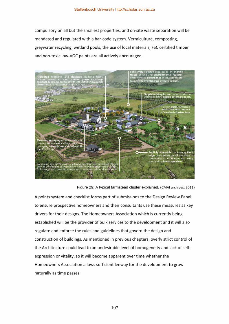
107
compulsory on all but the smallest properties, and on‐site waste separation will be
mandated and regulated with a bar‐code system. Vermiculture, composting,
greywater recycling, wetland pools, the use of local materials, FSC certified timber
and non‐toxic low‐VOC paints are all actively encouraged.
A points system and checklist forms part of submissions to the Design Review Panel
to ensure prospective homeowners and their consultants use these measures as key
drivers for their designs. The Homeowners Association which is currently being
established will be the provider of bulk services to the development and it will also
regulate and enforce the rules and guidelines that govern the design and
construction of buildings. As mentioned in previous chapters, overly strict control of
the Architecture could lead to an undesirable level of homogeneity and lack of self‐
expression or vitality, so it will become apparent over time whether the
Homeowners Association allows sufficient leeway for the development to grow
naturally as time passes.
Figure 29: A typical farmstead cluster explained. (CMAI archives, 2011)
Stellenbosch University http://scholar.sun.ac.za
108
All organic waste from the farm, commercial and residential areas will be turned into
compost on site, while sewage will be treated in an on‐site package plant before
being fed through a wetland to be reused for irrigation purposes. In addition to
rainwater harvesting on the buildings, an extensive stormwater management plan
will be implemented, which will include swales, soakaways, infiltration trenches,
infiltration basins, detention basins, retention ponds, wetlands and filter strips.
Various open days and interactive sessions were held with the local communities
(especially the people of Thornhill) and the farm labourers to determine what their
needs and aspirations are, so a number of strategies have been integrated into the
development plan to cater for these. The main concerns raised by the local
community are the provision of jobs, the provision of services, especially in Thornhill,
and the provision of training. A percentage of every property purchased will be
transferred into the Thornhill community trust up to a maximum of R15 million to be
used for local community projects, while labour intensive construction practices and
the use of the local community for labour is mandated, so all Contractors have to
adhere to this. Unfortunately the development is not physically adjacent to, or
connected to, the village of Thornhill (except via transportation links), which is one of
the basic charges against neo‐traditional urban developments that Ford (1999, pp.
252) mentions when he states that most large New Urbanist projects are physically
disconnected from existing urban fabrics or communities.
The training facilities as mentioned previously should assist in the development of
local skilled labour, although many local inhabitants do not see agriculture as a
preferred employment option. The labourers who have been working on the farm
for some time will all receive free housing and title to land in the development, and
the inclusion of more affordable housing types could mean that more lower and
middle income earners from the surrounding region may be able to acquire property
in the development. Unfortunately the high infrastructural cost and exacting
construction standards mean that the more affordable properties in the
development are still too expensive for many people to afford. On the positive side,
Crossways is not being planned as a gated community in order to ensure that the
Stellenbosch University http://scholar.sun.ac.za
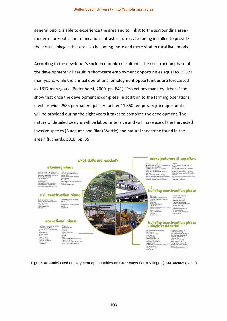
109
general public is able to experience the area and to link it to the surrounding area ‐
modern fibre‐optic communications infrastructure is also being installed to provide
the virtual linkages that are also becoming more and more vital to rural livelihoods.
According to the developer’s socio‐economic consultants, the construction phase of
the development will result in short‐term employment opportunities equal to 15 522
man‐years, while the annual operational employment opportunities are forecasted
as 1817 man‐years. (Badenhorst, 2009, pp. 841) “Projections made by Urban‐Econ
show that once the development is complete, in addition to the farming operations,
it will provide 2583 permanent jobs. A further 11 860 temporary job opportunities
will be provided during the eight years it takes to complete the development. The
nature of detailed designs will be labour intensive and will make use of the harvested
invasive species (Bluegums and Black Wattle) and natural sandstone found in the
area.” (Richards, 2010, pp. 35)
Figure 30: Anticipated employment opportunities on Crossways Farm Village. (CMAI archives, 2009)
Stellenbosch University http://scholar.sun.ac.za

110
5.4 Power, planning, credibility and teamwork
Crossways Farm Village can be seen as a megaproject due to its sheer size,
complexity and range of uses. Generally, however, megaprojects have their fair
share of problems, particularly social exclusion (especially of the poor and the
informal sector), inequality and the continuation of social segregation. The
proliferation of megaprojects can result in regions becoming more fragmented,
instead of creating new mixed‐use and mixed‐income zones where employment
opportunities are in the same locality as housing opportunities. There generally
seems to be very little community participation and the planning process is
sometimes marred by power struggles within the political and government spheres
(not discounting the power relations between planners, officials, consultants and
clients or stakeholders).
Utopia can easily become dystopia and the power employed by the public or private
sector to control environments could potentially erase local identity and
involvement, and Jones and Moreno‐Carranco (2007, pp. 11) show “…glimpses that
spontaneous, diverse, encounters take place in the megaprojects that challenge or
subvert their designed use…” The fragile power networks of the disadvantaged can
actually become stronger than the power of officials and they exhibit informal
improvisation on the fringes of these megaprojects to create their own livelihoods
and social meaning. “The megaprojects are cut across with small interjections of
everyday life beyond the intention of administrators or architects.” (Jones &
Moreno‐Carranco, 2007, pp. 11) Coetzee and Oranje (2006, pp. 5) call this micro‐
political resistance to power and it can take the form of struggles against
domination, exploitation and subjection.
The CRDP’s approach to sustainable rural development does not deal primarily with
spatial planning, although it mentions spatial planners as key role players in
achieving its objectives. The challenges mentioned above make planners’ jobs that
much more difficult and being neutral or objective is not enough. Coetzee and
Stellenbosch University http://scholar.sun.ac.za
111
Oranje (2006, pp. 3) mention five possible ways for ensuring ethical behaviour by
planners: Being aware of preference and prejudice, being cynical and challenging
decisions, being open to evidence for or against the professional team’s viewpoint,
ensuring that a holistic view is taken of the process and searching for supporting
evidence of the proposed plan. Findings should be “triangulated” by using various
research methodologies and different types of evidence; the prominent role players
and stakeholders should also be approached for input and feedback, which has to be
taken into account.
The professional team has a responsibility and accountability to the disadvantaged
communities and they have to take care to place communicative action, the building
of social capital, skills building and inclusivity high on the agenda of any planning
process. An inclusive stakeholder participation process would be one of the only
ways for a planner to balance his/her responsibility and accountability to their
employer, the poor and the environment. If a planner assumes the role of facilitator
rather than wielding power in a top‐down process (although facilitation also implies
a certain amount of power), rationality may be able to prevail over power.
Innovation, creativity and good communication skills can add great value to a
process. Marks, R. and Bezzoli, M. (2000, pp. 16) argue that planners should
“…develop more critical forms of practice, at the professional as well as the political
level, which questions and resists the exploitation of the urban environment and
seeks a more progressive and meaningful vision for the city”.
It is quite clear that any megaproject is an extremely complex issue that is intricately
tied to its context, although it usually ignores this in favour of global trends. Jones
and Moreno‐Carranco (2007: 1) describe this trend as “…megaprojects that seem to
offer diluted representations of national and regional identities”. Good intentions
can sometimes have unintended negative consequences, especially when well‐
meaning officials or consultants decide to deliver a masterplanned project without
local knowledge and local involvement. It would seem that by involving the local
stakeholders a better balance can be achieved, which will result in more inclusive
and representative human settlements. As mentioned by Machethe (2007, pp. 17),
Stellenbosch University http://scholar.sun.ac.za
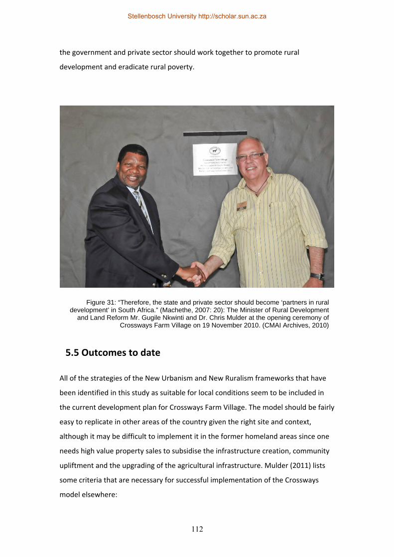
112
the government and private sector should work together to promote rural
development and eradicate rural poverty.
5.5 Outcomes to date
All of the strategies of the New Urbanism and New Ruralism frameworks that have
been identified in this study as suitable for local conditions seem to be included in
the current development plan for Crossways Farm Village. The model should be fairly
easy to replicate in other areas of the country given the right site and context,
although it may be difficult to implement it in the former homeland areas since one
needs high value property sales to subsidise the infrastructure creation, community
upliftment and the upgrading of the agricultural infrastructure. Mulder (2011) lists
some criteria that are necessary for successful implementation of the Crossways
model elsewhere:
Figure 31: “Therefore, the state and private sector should become ‘partners in rural development’ in South Africa.” (Machethe, 2007: 20): The Minister of Rural Development
and Land Reform Mr. Gugile Nkwinti and Dr. Chris Mulder at the opening ceremony of Crossways Farm Village on 19 November 2010. (CMAI Archives, 2010)
Stellenbosch University http://scholar.sun.ac.za
113
• The site must have scenic qualities to encourage potential homeowners to
purchase stands.
• It must be close to an existing rural village that can benefit from the
development.
• The site should be close to where a large number of people would want to
live or go on vacation.
• There should be schools nearby, good access and the capacity to
accommodate and provide bulk services on site.
• Services not dealt with on‐site should be purchased in bulk and distributed
internally by a Homeowners Association.
• The site should have good agricultural properties.
• The price of the land should be established at agriculture value and the
existing owner should preferably stay involved in the development.
• The system of equal distribution of equity and ownership in the farming
operations should be implemented.
• The concept can work for dairy, fruit, wine, cattle and game.
The Crossways Farm Village development was approved by the authorities in 2010
and it was formally launched in November of the same year. The civil works are
almost under way and construction of the first homes is expected to commence
early in 2012, while the farming activities continue as normal. Mulder (2011)
proclaims that agriculture is the new golf and that golf course developments are not
economically or ecologically feasible any more: “Instead of fairways, Crossways Farm
Village will have chemical‐free grazing pastures. The club members will be 500
Holstein cows and the clubhouse will be a state‐of the‐art milking parlour.”
While there are some elements of tenure reform present in the current project
proposal, there may also be some opportunities for redistribution if the government
is willing to invest. The possibility exists that this may deter some potential buyers,
but without at least some elements of land reform the project will not be sustainable
in the long term.
Stellenbosch University http://scholar.sun.ac.za
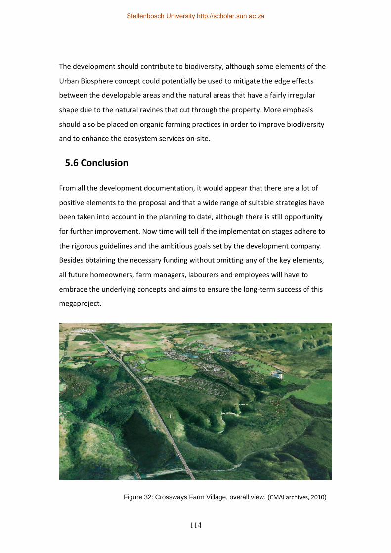
114
The development should contribute to biodiversity, although some elements of the
Urban Biosphere concept could potentially be used to mitigate the edge effects
between the developable areas and the natural areas that have a fairly irregular
shape due to the natural ravines that cut through the property. More emphasis
should also be placed on organic farming practices in order to improve biodiversity
and to enhance the ecosystem services on‐site.
5.6 Conclusion
From all the development documentation, it would appear that there are a lot of
positive elements to the proposal and that a wide range of suitable strategies have
been taken into account in the planning to date, although there is still opportunity
for further improvement. Now time will tell if the implementation stages adhere to
the rigorous guidelines and the ambitious goals set by the development company.
Besides obtaining the necessary funding without omitting any of the key elements,
all future homeowners, farm managers, labourers and employees will have to
embrace the underlying concepts and aims to ensure the long‐term success of this
megaproject.
Figure 32: Crossways Farm Village, overall view. (CMAI archives, 2010)
Stellenbosch University http://scholar.sun.ac.za
115
Chapter 6: Critical assessment and conclusion All of the abovementioned models are based on the premise that spatial form and
planning can contribute to the betterment of society. This is especially evident in the
gospel of the New Urbanism framework where a return to traditional communities
and values are viewed as the direct result of New Urbanist planning – this spatial
determinism has been a key element of many models in the past, but it is especially
evident in this movement. “The connection between spatial form and social process
is here made through a relation between architectural design and a certain ideology
of community. The New Urbanism assembles much of its rhetorical and political
power through a nostalgic appeal to “community” as a panacea for our social and
economic as well as our urban ills.” (Harvey, 1997, pp. 2)
Gordon (1998, pp. 4) refers to this spatial determinism as ‘communitarianism’ and
states: “Although the New Urbanists are regarded as very conservative, reactionary,
and even stodgy, from an architectural point of view, they take a very old
architectural tradition, that design affects social behaviour, and radicalise it to the
extent that they argue that incorporating specific design elements not only in
buildings but in street layouts and neighbourhood patterns can generate a
communitarian spirit and dramatically increase social interaction. Although there are
precedents for this view (in the writings of Jane Jacobs [1992] for example), and
most people would accept that our behaviour is sensitive to, and affected by, the
surrounding physical environment, the New Urbanists take the argument to
extremes.” He goes on to say that: “A more fundamental problem is that many New
Urbanist projects are so influenced by the nostalgic longing for the archtypical small
town of the past that they fall into the trap of believing that recreating its physical
structure (at least to some degree) can simultaneously recreate its social and civic
behaviour.” Ford (1999, pp. 252) writes that “…neotraditional urbanism is based on a
kind of architectural determinism that has long been discredited. The ‘If you build it,
they will socialise’ idea that advocates of front porches and narrow streets desire
cannot be supported by existing evidence.”
Stellenbosch University http://scholar.sun.ac.za
116
“A more proper antidote to the underlying spatial determinism of both modernism
and the new urbanism is not to abandon all talk of the city (or even of the possibility
of utopia) as a whole, but to understand urbanisation as a group of fluid processes in
a dialectical relation to the spatial forms to which they give rise and which in turn
contain them. A utopianism of process looks very different from a utopianism of
spatial form. The problem is then to enlist in the struggle to advance a more socially
just, politically emancipatory, and ecologically sane mix of spatio‐temporal
production processes rather than to acquiesce to those imposed by uncontrolled
capital accumulation, backed by class privilege and gross inequalities of political‐
economic power.“ (Harvey, 1997, pp. 3)
The emphasis on the process is an important one, and one that is quite often lacking
in many New Urbanist and New Ruralist developments. Proper public participation
(more inclusive and intensive than a typical charette) and collaborative partnerships
are both key issues that need to be integrated into the model. The inclusion of the
community in the process, together with the resources and the developed spaces
may help to address injustices in both the spatial and the social realm. “In the
broadest sense, spatial (in)justice refers to an intentional and focused emphasis on
the spatial or geographical aspects of justice and injustice. As a starting point, this
involves the fair and equitable distribution in space of socially valued resources and
the opportunities to use them.” (Soja 2008, pp.1) Marcuse (2008, pp. 5) argues that
the two primary forms of spatial injustice are the involuntary confinement or
segregation of a specific group to a specific area, and the unequal distribution of
resources like employment, wealth, political power and social status. He also
mentions several viewpoints that are either in favour of the notion that social justice
may lead to spatial justice, or alternatively that social justice also has certain spatial
aspects that need to be addressed, and he mentions the view that the achievement
of the just city is the ultimate goal of spatial planning. According to Patel (2010, pp.
12): “The question of spatial justice is critical in addressing structural unemployment
and inequality in South Africa. The move towards prioritising rural development is
important in this regard.”
Stellenbosch University http://scholar.sun.ac.za
117
New Urbanism projects tend to be economically strong with high property prices,
sufficient amounts of money for amenities and sufficient profit for the developer,
but more attention needs to be given to the social and ecological aspects of the
model. The use of ecological design principles, biodiversity and resource efficiency
are just some of the principles that have to be added to the New Urbanist toolbox;
the New Urbanism framework generally does not place much emphasis on resource
consumption other than the principle of reduced vehicular transport. Combined with
a strategy like the urban biosphere concept, more emphasis may be placed on the
preservation of natural environments and as Frost (2001, pp. 4) states: “Perhaps
then we will see towns and cities at ease with themselves and their hinterlands;
creating high‐quality environments that contribute to a high quality of life and
attract high‐value businesses.”
Jabareen (2006, pp. 38) lists several design tools that are regularly used to create
more sustainable urban forms (urban in this case being interpreted as human
settlements that include rural towns): Compactness, sustainable transport, higher
densities, passive solar design and greening. These tools correspond to some of the
principles of the New Urbanism and the New Ruralism frameworks. In addition to
these tools, Jabareen also identifies four types of sustainable urban forms:
Neotraditional development, urban containment, the compact city and the eco‐city;
so he is clearly familiar with the New Urbanism framework, although he admits that
there seems to be no agreement as to what is the most desirable urban form as far
as sustainability is concerned. As mentioned previously, he also cites sources that call
for a New Urbanist approach that is more concerned with the ecology. As far as the
seven tools are concerned, compactness relates mainly to the New Urbanism where
densification or intensification are used in existing urban areas, while sustainable
transport is mainly about reducing the need for transport; this ties in to the concept
of mixed land use and the diversity of activity, although diversity goes one step
further than mixed use by addressing issues like the variation of building types, age
groups, income groups, cultures, household sizes and building densities. Increased
density in turn relates to the reduction in energy consumption together with the use
of passive solar design. Greening the city means bringing nature into the urban form;
Stellenbosch University http://scholar.sun.ac.za
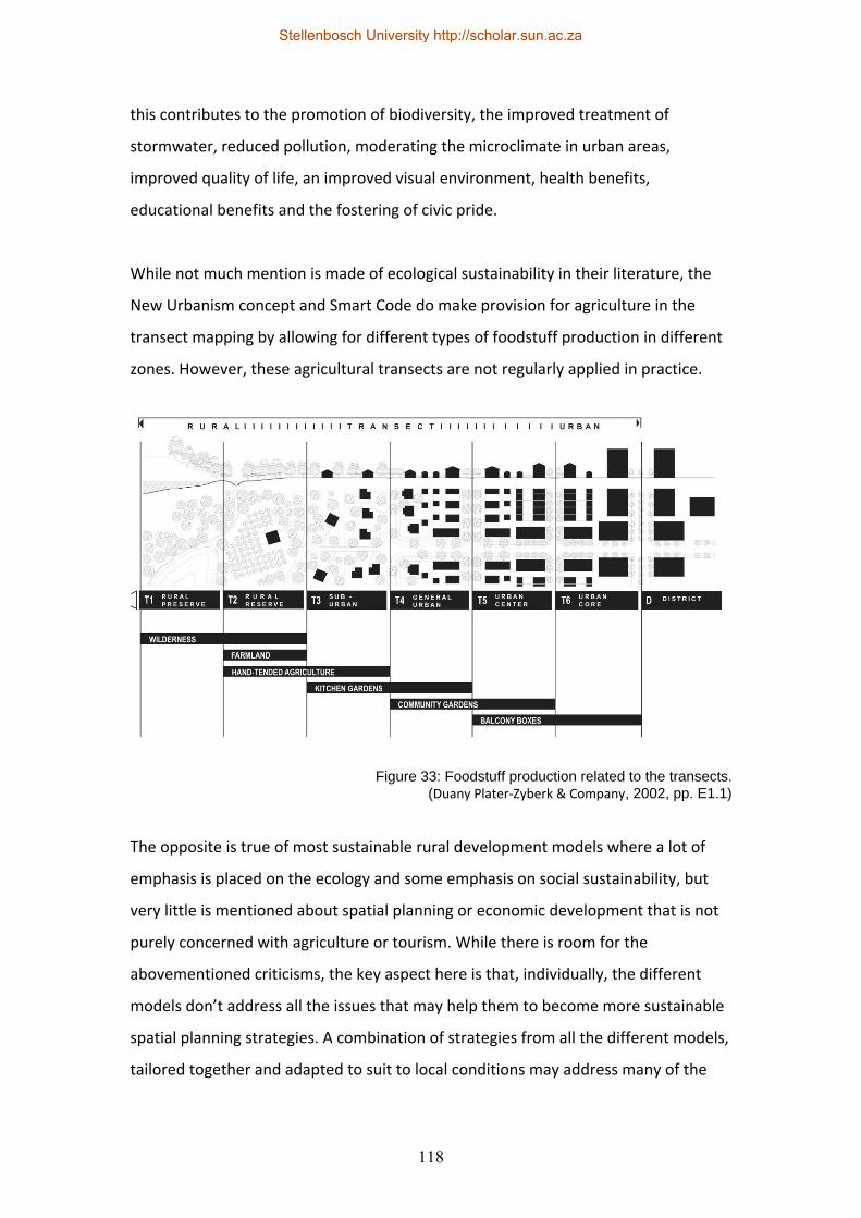
118
this contributes to the promotion of biodiversity, the improved treatment of
stormwater, reduced pollution, moderating the microclimate in urban areas,
improved quality of life, an improved visual environment, health benefits,
educational benefits and the fostering of civic pride.
While not much mention is made of ecological sustainability in their literature, the
New Urbanism concept and Smart Code do make provision for agriculture in the
transect mapping by allowing for different types of foodstuff production in different
zones. However, these agricultural transects are not regularly applied in practice.
The opposite is true of most sustainable rural development models where a lot of
emphasis is placed on the ecology and some emphasis on social sustainability, but
very little is mentioned about spatial planning or economic development that is not
purely concerned with agriculture or tourism. While there is room for the
abovementioned criticisms, the key aspect here is that, individually, the different
models don’t address all the issues that may help them to become more sustainable
spatial planning strategies. A combination of strategies from all the different models,
tailored together and adapted to suit to local conditions may address many of the
Figure 33: Foodstuff production related to the transects. (Duany Plater‐Zyberk & Company, 2002, pp. E1.1)
Stellenbosch University http://scholar.sun.ac.za
119
individual shortcomings; this could result in improved models and processes where
the whole becomes bigger than the sum of its parts.
“The ideal sustainable urban form according to the design concepts of sustainable
urban form is that which has a high density and adequate diversity, compact with
mixed land uses, and its design is based on sustainable transportation, greening and
passive solar energy. Ultimately, sustainable urban forms aim to achieve different
objectives. The most prominent among them are decreased energy use, reduced
waste and pollution, reduced automobile use, preservation of open space and
sensitive ecosystems, and liveable and community‐oriented human environments.”
(Jabareen, 2006, pp. 48)
The Integrated Sustainable Rural Development Strategy (ISRDS) warned against the
development of “showcase fever” and projects that are unsustainable or that are not
replicable. Del Grande (2006, pp. 31) also mentions that a number of land‐use
“products” or “trends” have been developed over the past few years that have been
hailed as an answer to poverty and land‐use challenges. “Rather than imposing
models based on urban middle class assumptions about what people need to
develop, flexible models should be developed in consultation with the proposed
affected group, to establish how they currently live and survive. This would begin to
ensure that the models are appropriate to the realities of peoples’ livelihoods, and
strengthen their strategies rather than change them altogether.” (Del Grande, 2006,
pp. 33) Everyone and the government in particular, is searching for an appropriate
rural development model that will show their commitment to sustainable rural
development. The danger is that the wrong models are developed, which may
diminish the already sceptical rural communities that have heard many promises,
but are consistently left on the developmental fringe.
From a spatial development perspective, it is evident from the various case studies
that there is space for the positive contribution to environmental, economic and
social development in rural areas through the use of specific tools and it would seem
that the New Urbanism and New Ruralism frameworks with the addition of
Stellenbosch University http://scholar.sun.ac.za
120
sustainable rural development strategies as mentioned, may be a very good starting
point. It is clear that only through a combination of all the abovementioned models
and probably a number of additional tools and policies, will rural development in
South Africa be adequately and sustainably addressed. While the New Urbanism and
particularly the New Ruralism framework may romanticise rural living within a
specific spatial model, the real challenge will be to facilitate sustainable rural
livelihoods both for unemployed and impoverished rural populations and for
relocating city‐dwellers who are drawn to the supposedly idyllic rural lifestyle (and
who are supposed to provide the economic injection that can facilitate rural growth).
Spatial planning is a vital tool for rural development and the New Urbanism and New
Ruralism frameworks seem to offer a number of tools that could be used to make it
more sustainable, although spatial planning is not enough on its own. It can only be
applied within a wider institutional, social and economic sphere, although if these
different spheres are integrated into a model that turns out to be fairly successful
and replicable, it may galvanise policy and investment to repeat and improve on it in
other rural areas. This study has highlighted a number of potential spatial planning
tools or models that could be used to promote sustainable rural development in
South Africa, but they need to be implemented and tested in practice in order to
really determine the outcome of their potential impact. The critical analysis of their
physical performance may lead to further study or improvement and replication in
practice to hopefully lead to some advantage to the rural populations and rural
contexts that need it most.
Stellenbosch University http://scholar.sun.ac.za
121
Bibliography
Allen, E. (1999). Measuring the Environmental Footprint of the New Urbanism, New
Urban Network, May/June 1999, pp. 16. [Online] Available:
http://newurbannetwork.com/article/measuring‐environmental‐footprint‐new‐
urbanism [Accessed 10 September 2011]
Anonymous. (Unknown date). 17th Century English Protest Poem. [Online] Available:
http://www.wealthandwant.com/docs/Goose_commons.htm [Accessed 10
September 2011]
Anonymous. (Unknown date). The Smart Code, Version 9.2. Unknown: The Town
Paper Publisher.
Arendt, R., Brabec, E. A., Dodson, H. L., Reid, C. & Yaro, R. D. (1994). Rural by Design.
Chicago: American Planning Association.
Arthus‐Bertrand, Y. (Unknown date). Photograph of Henderson in Las Vegas, Nevada.
[Online] Available: www.yannarthusbertrand.org [Accessed 10 September 2011]
Atlanta Business Chronicle. (2009). Lungs of Atlanta: Conservation efforts, tree
preservation help metro area breathe. Atlanta Business Chronicle, October 23‐29,
2009, pp. 25A‐29A.
Attfield, R., Hattingh, J. & Matshabaphala, M. (2004). Sustainable Development,
Sustainable Livelihoods and Land Reform in South Africa: A Conceptual and Ethical
Enquiry, Third World Quarterly, Vol. 25, No. 2, pp. 405 – 421.
Aupias, L. & Mulder, C. (2008). Thesen Islands: Rise with the Sun, Fish with the Tides
and Rest with the Moon. Cape Town: Quivertree.
Stellenbosch University http://scholar.sun.ac.za

122
Badenhorst, P. (2009). Final Environmental Impact Report: Proposed Crossways &
Sunnyvale Development. Wellington: PBPS.
Banjo, S. (2008). You are how you Live, The Wall Street Journal, Monday, March 24,
2008, Vol. CCLI No. 69, pp. R13.
Bhorat, H. & Kanbur, R. (2006). Introduction: Poverty & Well‐being in Post‐Apartheid
South Africa: An Overview of Data, Outcomes and Policy. In Bhorat, H. & Kanbur, R.
(Eds.), Poverty and Policy in Post‐Apartheid South Africa. Pretoria: HSRC.
Bowler, I. (2002). Developing Sustainable Agriculture, Geography, Volume 87(3), July
2002.
Calthorpe, P. (1993). The Next American Metropolis: Ecology, Community, and the
American Dream. New York: Princeton Architectural Press.
Cape Nature. (Undated). A Landowner’s Guide to Managing Biodiversity in an
Agricultural Landscape. Cape Town: Cape Nature.
Coetzee, J. & Oranje, M. (2006). Power Dynamics in a Tranforming Local Authority‐
Planning Environment: The Tshwane Experience; Town and Regional Planning, No.
50, pp. 1‐12. Bloemfontein: University of the Free State.
Convention on Biological Diversity (CBD). (2008). Biodiversity and Agriculture:
Safeguarding Biodiversity and Securing Food for the World. Montreal: Convention on
Biological Diversity.
Couclelis, H. (2005). “Where has the Future Gone?” Rethinking the Role of Integrated
Land‐use Models in Spatial Planning; Environment and Planning A, 2005, Volume 37,
pp. 1353 – 1371. Santa Barbara: University of California.
Stellenbosch University http://scholar.sun.ac.za
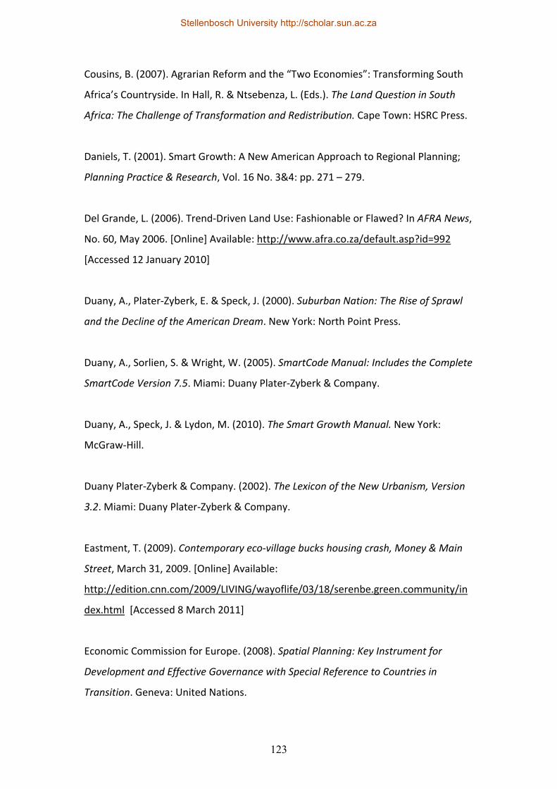
123
Cousins, B. (2007). Agrarian Reform and the “Two Economies”: Transforming South
Africa’s Countryside. In Hall, R. & Ntsebenza, L. (Eds.). The Land Question in South
Africa: The Challenge of Transformation and Redistribution. Cape Town: HSRC Press.
Daniels, T. (2001). Smart Growth: A New American Approach to Regional Planning;
Planning Practice & Research, Vol. 16 No. 3&4: pp. 271 – 279.
Del Grande, L. (2006). Trend‐Driven Land Use: Fashionable or Flawed? In AFRA News,
No. 60, May 2006. [Online] Available: http://www.afra.co.za/default.asp?id=992
[Accessed 12 January 2010]
Duany, A., Plater‐Zyberk, E. & Speck, J. (2000). Suburban Nation: The Rise of Sprawl
and the Decline of the American Dream. New York: North Point Press.
Duany, A., Sorlien, S. & Wright, W. (2005). SmartCode Manual: Includes the Complete
SmartCode Version 7.5. Miami: Duany Plater‐Zyberk & Company.
Duany, A., Speck, J. & Lydon, M. (2010). The Smart Growth Manual. New York:
McGraw‐Hill.
Duany Plater‐Zyberk & Company. (2002). The Lexicon of the New Urbanism, Version
3.2. Miami: Duany Plater‐Zyberk & Company.
Eastment, T. (2009). Contemporary eco‐village bucks housing crash, Money & Main
Street, March 31, 2009. [Online] Available:
http://edition.cnn.com/2009/LIVING/wayoflife/03/18/serenbe.green.community/in
dex.html [Accessed 8 March 2011]
Economic Commission for Europe. (2008). Spatial Planning: Key Instrument for
Development and Effective Governance with Special Reference to Countries in
Transition. Geneva: United Nations.
Stellenbosch University http://scholar.sun.ac.za
124
Eicker, K. (2007). New Ruralism – Return to the Village, Urban Green File, Volume 12,
No. 2, June 2007, pp. 12 – 17.
Eisenhardt, K.M. (1989). Building Theories from Case Study Research; Academy of
Management Review, 14 (4): pp. 532‐550.
Ellis, C. (2002). The New Urbanism: Critiques and Rebuttals, Journal of Urban Design,
Vol. 7, No. 3, pp. 261 – 291. Lawrence, US: Carfax Publishing.
Fainstein, S. (2005). New Directions in Planning Theory. [Online] Available:
http://144.122.21.201/crp372/new_directions_in_planning_theory.pdf [Accessed
on unknown date]
Fainstein, S.. (2008). Spatial Justice and Planning; Justice Spatiale/Spatial Justice.
[Online] Available: www.jssj.org/archives/01/media/dossier_focus_vo5.pdf
[Accessed 20 June 2011]
Farr, D. (2008). Sustainable Urbanism: Urban Design with Nature. Hoboken, New
Jersey: John Wiley & Sons.
Flyvbjerg, B. (2006). Five Misunderstandings about Case study Research, Qualitative
Inquiry, 12(2): pp. 219‐245.
Food and Agriculture Organisation of the United Nations. (2003). Trade Reforms and
Food Security: Conceptualising the Linkages. Rome: FAO.
Ford, L. R. (1999). Lynch Revisited: New Urbanism and Theories of Good City Form,
Cities, Vol. 16, No. 4, pp. 247‐257.
Frost, P. (2001). Urban Biosphere Reserves: Reintegrating People with the Natural
Environment, Town and Country Planning, Volume 70, Number 7/8, July/August
2001, pp. 1‐4.
Stellenbosch University http://scholar.sun.ac.za
125
Gordon, P. & Richardson, H. W. (1998). A Critique of New Urbanism. Paper presented
at the November, 1998 Meeting of the American Collegiate Schools of Planning. Los
Angeles: University of Southern California.
Groenewald, J. & Nieuwoudt, L. (2003). The Challenge of Change: Agriculture, Land
and the South African Economy. Pietermaritzburg: University of Natal Press.
Gutberlet, J. (1999). Rural Development and Social Exclusion: A Case Study of
Sustainability and Distributive Issues in Brazil; Australian Geographer, vol. 30 No. 2:
pp. 221 – 237.
Hall, R., Isaacs, M. & Saruchera, M. (2007). Land and Agrarian Reform in Integrated
Development Plans (IDPs), Report prepared for GTZ in collaboration with the
Department of Provincial and Local Government, Programme for Land and Agrarian
Studies (PLAAS), Research Report No.23, January 2007.
Harrison, P. & Todes, A. (2001). The Use of Spatial Frameworks in Regional
Development in South Africa; Regional Studies Vol. 35 No. 1: pp. 65 – 85.
Hart, G. (2006). Post‐Apartheid Development in Historical and Comparative
Perspective. In Padayachee, V. (Ed.). The Development Decade? Economic and Social
Change in South Africa. Pretoria: HSRC.
Harvey, D. (1997). The New Urbanism and the Communitarian Trap; Harvard Design
Magazine, Winter/Spring, 1997, Number 1, pp. 1‐3.
Howard, E. (1902). Garden Cities of To‐morrow. London: Swan Sonnenstein & Co.,
Ltd.
ICMA. (2010). Putting Smart Growth to Work in Rural Communities. Washington, DC:
The International City/County Management Association.
Stellenbosch University http://scholar.sun.ac.za
126
IIED. (2003). Rural‐Urban Transformations and the Links between Urban and Rural
Development, Environment & Urbanisation Brief, Vol. 15, No. 1, April 2003, pp. 1 – 6.
Independent Development Trust. (2000). The Integrated Sustainable Rural
Development Strategy (ISRDS). Unpublished report.
Jabareen, Y.R. (2006). Sustainable Urban Forms: Their Typologies, Models and
Concepts, Journal of Planning Education and Research, Vol. 26: pp. 38 – 52.
Jones, G.A. & Moreno‐Carranco, M. (2007). Megaprojects – Beneath the Pavement,
Excess; City, Vol. 11, No.2, July 2007. London: Routledge.
Katz, P. (1994). The New Urbanism: Toward an Architecture of Community. New York:
McGraw‐Hill.
Kepe, T. & Cousins, B. (2002). Radical Land Reform is Key to Sustainable Rural
Development in South Africa, PLAAS Policy Brief: Debating Land Reform and Rural
Development, No.3, August 2002.
Kole, N. M. (2004). An Evaluation of the Integrated Sustainable Rural Development
Programme Highlighting Stakeholder Mobilisation and Engagement. Unpublished M.
Inst. Agrar (Rural Development) Thesis. Pretoria: University of Pretoria.
Kraus, S. (2006). A Call for New Ruralism. In Frameworks, Issue 3. [Online] Available:
www.farmlandinfo.org/documents/37270/new‐ruralism.pdf [Accessed 12 January
2010]
Krieger, A. (1998). Whose Urbanism? Architecture Magazine, November, pp. 73 – 76.
Lahiff, E., Borras, S. M. Jr & Kay, C. (2007). Market‐led Agrarian Reform: Policies,
Performace and Prospects; Third World Quarterly, Vol. 28 No. 8: pp. 1417 – 1436.
Stellenbosch University http://scholar.sun.ac.za

127
Langdon, P. (2009). Down on the New Urban Farm. In The New Urban News,
December 2009. [Online] Available:
http://www.newurbannews.com/14.8/downonthenewurbanfarm.html [Accessed 12
January 2010]
Levy, J.S. (2008). Case Studies: Types, Designs, and Logics of Inference, Conflict
Management and Peace Science, 25: pp. 1‐18.
Loomis, A. A. (1999). My Urbanism is better than Yours: Exploring (New) Urbanism at
the GSD, Delirious LA. [Online] Available: http://www.deliriousla.net/essays/1999‐
debates.htm [Accessed 3 March 2011]
Machethe, C. (2007). Developmental State: Meaning, Relevance and Implications for
Rural Development in South Africa; New Agenda, 28, 4: pp. 13 – 20.
Magdoff, F. (2007). Ecological Agriculture: Principles, Practices, and Constraints.
Burlington, USA: University of Vermont.
Marcuse, P. (2000). The New Urbanism: The Dangers so Far, DISP 140, pp. 4‐6.
Marcuse, P. (2008). Spatial Justice: Derivative but Causal of Social Injustice; Justice
Spatiale/Spatial Justice. [Online] Available:
www.jssj.org/archives/01/media/dossier_focus_vo5.pdf [Accessed 20 June 2011]
Marks, R. & Bezzoli, M. (2000). Palaces of Desire: Century City and the Ambiguities of
Development; Paper presented to the Urban Futures Conference, Johannesburg.
Millennium Ecosystem Assessment. (2005). Ecosystems and Human Well‐being:
Biodiversity Synthesis. Washington, D.C.: World Resources Institute.
Stellenbosch University http://scholar.sun.ac.za
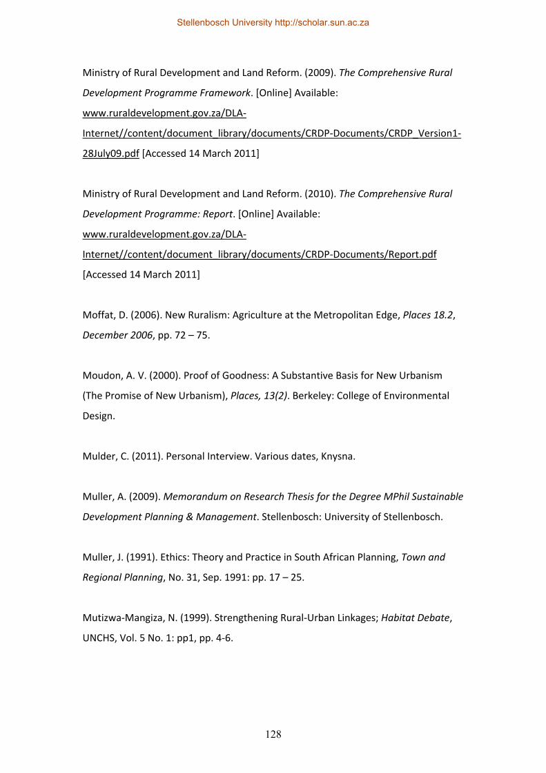
128
Ministry of Rural Development and Land Reform. (2009). The Comprehensive Rural
Development Programme Framework. [Online] Available:
www.ruraldevelopment.gov.za/DLA‐
Internet//content/document_library/documents/CRDP‐Documents/CRDP_Version1‐
28July09.pdf [Accessed 14 March 2011]
Ministry of Rural Development and Land Reform. (2010). The Comprehensive Rural
Development Programme: Report. [Online] Available:
www.ruraldevelopment.gov.za/DLA‐
Internet//content/document_library/documents/CRDP‐Documents/Report.pdf
[Accessed 14 March 2011]
Moffat, D. (2006). New Ruralism: Agriculture at the Metropolitan Edge, Places 18.2,
December 2006, pp. 72 – 75.
Moudon, A. V. (2000). Proof of Goodness: A Substantive Basis for New Urbanism
(The Promise of New Urbanism), Places, 13(2). Berkeley: College of Environmental
Design.
Mulder, C. (2011). Personal Interview. Various dates, Knysna.
Muller, A. (2009). Memorandum on Research Thesis for the Degree MPhil Sustainable
Development Planning & Management. Stellenbosch: University of Stellenbosch.
Muller, J. (1991). Ethics: Theory and Practice in South African Planning, Town and
Regional Planning, No. 31, Sep. 1991: pp. 17 – 25.
Mutizwa‐Mangiza, N. (1999). Strengthening Rural‐Urban Linkages; Habitat Debate,
UNCHS, Vol. 5 No. 1: pp1, pp. 4‐6.
Stellenbosch University http://scholar.sun.ac.za
129
Norberg‐Hodge, H., Merrifield, T. & Gorelick, S. (2000). Bringing the Food Economy
Home: The Social, Ecological and Economic Benefits of Local Food. Devon:
International Society for Ecology and Culture.
Padayachee, V. (2006). Development Discourses in Post‐Apartheid South Africa. In
Padayachee, V. (Ed.). The Development Decade? Economic and Social Change in
South Africa. Pretoria: HSRC.
Patel, Y. (2010). A Dynamic and Creative Economy in South Africa: Exploring Rural‐
Urban Linkages. Paper presented at a Rural Development Conference in India, 14 –
16 April, 2010. Pretoria: Department of Cooperative Governance and Traditional
Affairs.
Perret, S. (2006). Matching Policies on rural Development and Local governance in
South Africa: Recent History, Principles, and Current Challenges. Paper presented at
the workshop on Local Governance and Rural Development. Pretoria: University of
Pretoria.
Pyatok, M. (2000). The New Urbanism: to Whom Should We Listen, Studs Terkel or
Martha Stewart? New Village Journal, Issue 2, 2000. [Online] Available:
http://www.pyatok.com/writingsArticle9.html [Accessed 10 September 2011]
Richards, K. (Ed.) (2010). Crossways Farm Village. In Landscape SA, No. 37,
September/October 2010, pp. 32 – 35.
Rogers, P. P., Jalal, K. F. & Boyd, J. (2005). An Introduction to Sustainable
Development. Canada: The Continuing Education Division, Harvard University and
Glen Education Foundation.
Sack, K. (2009). Outside Atlanta, a New Utopia rises, The New York Times Travel,
March 1. [Online] Available:
Stellenbosch University http://scholar.sun.ac.za
130
http://travel.nytimes.com/2009/03/01/travel/01heads.html?th&emc=th [Accessed 8
March 2011]
Salamini, F. (2000). Sustainable Agricultural Production. In B. Heap & J. Kent (Eds.).
Towards Sustainable Consumption – A European Perspective. London: The Royal
Society. Pp. 59 – 66.
Serenbe Community. (2009). Serenbe Layout Plan. [Online]. Available:
http://www.serenbecommunity.com [Accessed 8 March 2011]
Serenbe Community. (2009). Serenbe Overview. [Online]. Available:
http://www.serenbecommunity.com/serenbeoverview.html [Accessed 8 March
2011]
Shaban, Ramon (2009) Book review Yin, R.K (2008). Case Study Research: Design and
Methods, 4th Edition, Australasian Emergency Nursing Journal, No. 12: pp. 59—60
Smart Code Central. (2011). Smart Code Central. [Online] Available:
http://www.smartcodecentral.org/ [Accessed 18 October 2011]
Smith‐Mueller, W. & Lourens, A. (2008). The Harvard Style of Referencing Sources.
Unknown publisher.
Soja, E. W. (2008). The City and Spatial Justice; Justice Spatiale/Spatial Justice.
[Online] Available: www.jssj.org/archives/01/media/dossier_focus_vo5.pdf
[Accessed 20 June 2011]
Steuteville, R. (Ed.) (2000). New Urbanism and Traditional Neighbourhood
Development: Comprehensive Report & Best Practices Guide. Ithaca, New York: New
Urban News.
Stellenbosch University http://scholar.sun.ac.za
131
Stiftel, B. & Watson, V. (2005). Dialogues in Urban and Regional Planning 1. London:
Routledge.
Stratton, E. M. (2009). New Ruralism. Athens, Georgia, (U.S.): Land Use Clinic,
University of Georgia.
Theron, F., Oosthuizen, R. & Cloete, F. (2003). Guidelines for Writing Academic
Papers/Assignments. Stellenbosch: University of Stellenbosch.
Todes, A. (2004). Regional Planning and Sustainability: Limits and Potentials of South
Africa’s Integrated Development Plans, Journal of Environmental Planning and
Management, 47(6): pp. 843‐861.
Turner, S. (2001). Sustainable Development: What’s Land Got to Do with It? PLAAS
Policy Brief: Debating Land Reform and Rural Development, No.2, November 2001.
Turok, I., Kearns, A. & Goodlad, R. (1999). Social Exclusion: In What Sense a Planning
Problem? Town Planning Review, Volume 70, No. 3, pp. 363 – 384.
United Nations Educational, Scientific and Cultural Organization (UNESCO). (1995).
The Seville Strategy for Biosphere Reserves ‐ Biosphere Reserves: The First 20 Years,
Nature and Resources, 31, 2, pp. 2 – 17.
United Nations Educational, Scientific and Cultural Organization (UNESCO). (2008).
Madrid Action Plan for Biosphere Reserves (2008 – 2013). [Online] Available:
http://unesdoc.unesco.org/images/0016/001633/163301e.pdf [Accessed 18 October
2011]
United Nations Centre for Human Settlements. (2001). Urban Economy: Urban‐Rural
Linkages, The State of the World’s Cities Report 2001, pp. 86 – 89.
Stellenbosch University http://scholar.sun.ac.za
132
United Nations Environment Programme & United Nations Conference on Trade and
Development. (2008). Organic Agriculture and Food Security in Africa. New York:
United Nations.
United Nations Human Settlements Programme. (2008). Addressing Rural‐Urban
Disparities for Harmonious Regional Development, State of the World’s Cities
2008/2009, pp. 216 – 225.
University of Stellenbosch. (2007). Ethical Aspects of Scholarly and Scientific
Research. Stellenbosch: University of Stellenbosch.
Waldheim, C. (2010). Notes Toward a History of Agrarian Urbanism; Green Building
South Africa, Volume 4, Issue 8, 15 December 2010. [Online] Available:
http://www.greenbuilding.co.za/content/green‐building/ejournal/item/895‐notes‐
toward‐a‐history‐of‐agrarian‐urbanism.html [Accessed 22 December 2010]
Wartzman, R. (2007). Can the City Save the Farm? New Ruralism – an Eclectic
Outgrowth of Farmers and Urban Planners – wants to Remarry Town and Country,
California Magazine, May/June 2007. [Online] Available:
http://www.newamerica.net/publications/articles/2007/can_city_save_farm_5422
[Accessed 12 January 2010]
Wiggins, S. (2008). Rural Livelihoods: New Thinking Needed to Tackle the Rural
Employment Crisis, id21 Natural Resources Highlights, No. 6, April 2008, pp. 1‐2.
World Urban Forum. (2002). The Rural Dimension of Sustainable Urban
Development. Nairobi: UN Habitat.
Stellenbosch University http://scholar.sun.ac.za
133
Annexure
1. Crossways Farm Village Site Development Plan
Stellenbosch University http://scholar.sun.ac.za
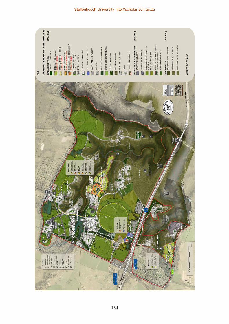
134
Stellenbosch University http://scholar.sun.ac.za