Embed Size (px)
Citation preview
1
The Natural Resources of Dutchess County in the Past, Present and Future*
______________________________________________________________________________
Harvey K. Flad, Vassar College1
Introduction
In this essay, I would like to present a broad view of the history of environmental and land use
planning in Dutchess County – one that encompasses both the humanities and the social sciences as
well as the natural sciences in order to understand the various approaches that have been used to
observe, describe, interpret, analyze, understand, and manage our county‟s natural resources. This
seems to me to be a fitting approach since we are here, at Vassar College, which, through its
Multidisciplinary Program in Environmental Studies (this past weekend‟s 10th Anniversary) attempts
to integrate these often-diverse fields of knowledge into something of a coherent whole when
examining human-environment relationships. I hope to suggest that in most of these approaches an
initial “inventory” acts as a foundation for the effort; it may simply be one of curiosity or it may be as
focused as a scientific examination, but it will form the empirical base for later contemplation, policies
or planning.
Ethical Approaches to Conservation
In A Sand County Almanac (1949, OUP 1966), the great conservationist Aldo Leopold (1887-1948)
posits a “Land Ethic” as a philosophical basis for land stewardship. In creating policies for
appropriate use of the land as natural resource, he argued, “[Q]uit thinking about decent land use as
solely an economic problem. Examine each question in terms of what is ethically and esthetically
right, as well as what is economically expedient. A thing is right when it tends to preserve the
integrity, stability, and beauty of the biotic community. It is wrong when it tends otherwise.”
Furthermore, “We can be ethical only in relation to something we can see, feel, understand, love, or
otherwise have faith in.”
1 Harvey K. Flad is Emeritus Professor of Geography at Vassar College in Poughkeepsie, NY. This talk was originally presented by Dr. Flad as the keynote address for the Conference on the Natural Resource Inventory of Dutchess County, NY at Vassar College on November 6, 2010.

The Natural Resources of Dutchess County in the Past, Present and Future
2
Inventories – both Natural Resource Inventories (NRI‟s) and Cultural Resource Inventories (CRI‟s) -
can help us “see, feel and understand” these resources, and hopefully even “love or otherwise have
faith in” our local landscapes, and thereby construct ethical land use policies. As Leopold observed,
“A conservationist is one who is humbly aware that with each stroke he is writing his signature on the
face of the land.” The Dutchess County landscape is a text upon which we, and generations before
us, have written our signatures. Inventories, such as NRI‟s and CRI‟s, organize the elements of the
landscape; they are the words, so-to-speak of the text, and help us discern how well its “integrity,
stability, and beauty” has been maintained.
Over the last 300 years, the mid-Hudson and Dutchess County landscape has been perceived and
shaped according to a number of different, and often, contrasting, approaches. Thirty years ago, D.W.
Meinig, Maxwell Research Professor of Geography Emeritus at Syracuse University (who was recently
elected to the National Academy of Arts and Sciences), offered ten separate categories for defining
how one may perceive a landscape: for example, certain perspectives, such as “landscape as wealth,”
which is a utilitarian view of land as an economic resource, often contrast with landscape as “nature”
or “habitat” or “system” which consider landscape elements, that is, its natural resources, as
composing a bioregion apart from human influence. Natural scientists often study the individual
natural resources, or landscape elements, through such lenses, while humanists and social scientists
lean towards Meinig‟s categories of understanding the composition of a landscape as “ideology,”
“history,” “place,” or “aesthetic.”
Today, I would like to briefly examine these perspectives with relation to the many ways in which
both the natural and cultural resources that compose the Dutchess County landscape have been
perceived, described, used, abused, promoted and planned.
Natural History – Early Narratives
Many of the earliest descriptions of the Hudson Valley were traveler‟s narratives. Within the frame of
natural history writing, many were simply lists and descriptions of “factual” observations, often of
“curiosities,” or of natural resources according to potential economic value, such as forests, fauna,
flora, soil fertility or minerals, such as iron ore in the Taconic Hills and eastern Dutchess County or
clays for brick making along the Hudson River‟s banks. Some of these 18th and early 19th century
“inventories” attempted to place their observations into one or another of the emerging natural
The Natural Resources of Dutchess County in the Past, Present and Future
3
sciences, such as geology or botany, with attempts at identifying species diversity or geological
formations. They were, at least among the best of them, holistic in their review of the elements that
composed the natural world. Certainly, some tended towards a teleological, that is, a Divinely-
centered, perspective of an organized, organic world. But, on the whole, they gathered thousands of
“factual observations” which would – in the 19th century – begin to become part of a coherent system,
something that we could eventually call “ecology.”
Meanwhile, local settlers expressed occasional concern at the growing overuse of the former natural
resource bounty. For example, Hector St. John de Crevecoeur, author of the significant eighteenth-
century work Letters from an American Farmer (1782) where he asked rhetorically, “What, then, is this
new American?” and whose estate in Orange County was in the Hudson Valley bioregion, observed
the relationship between deforestation and the drying up of the land. An interest in environmental
conservation would develop into the nineteenth century. For example, in 1864, George Perkins Marsh
published the first major treatise on conservation in America, Man and Nature; or, Physical Geography as
Modified by Human Action, in which he posited “Man has too long forgotten that the earth was given to
him for usufruct alone, not for consumption, still less for profligate waste.” Marsh‟s call for
stewardship of the land‟s resources would lead to contrasting views of the domestication of the
landscape, one where the role of man became the ecological dominant to shape, or “modify,” the
landscape.
The study of Nature (always with a capital “N”) in the nineteenth-century was both scientific and
practical, while also considered a moral undertaking. Although its rather eclectic collections of facts,
objects and processes would eventually lead to the concept of the bioregion, such studies became
subsumed by the rise of natural science. Yet, it is to the many longitudinal base-line collections that
current Natural Resource Inventories refer. For example, the weather and ecological data that one of
the last of the great “natural historians,” Daniel Smiley, collected at the Mohonk Mountain House and
on the Mohonk Preserve here in the mid-Hudson bioregion is extraordinarily important for current
research on climate change. Paul Huth carries on this tradition.
The Nineteenth-Century Landscape Aesthetic
In the 19th century, a concern for the human despoliation of the landscape engaged those who viewed
landscape through a variety of lenses; for those who recognized a utilitarian perspective of the land‟s

The Natural Resources of Dutchess County in the Past, Present and Future
4
natural resources, deforestation and the loss of soil fertility argued for modernizing agricultural
practices, such as the use of guano to fertilize depleted fields, while artists, essayists and gardeners
portrayed the changing scene in ideological terms; some, positively as “improvements” and
“progress,” while others deplored the loss of the natural environment.
Thomas Cole (1801-1848), considered the founder of the Hudson River School of Art, was also an
essayist and an early advocate of conservation. In his “Essay on American Scenery” (1836), Cole not
only presented the natural elements that are essential for a landscape painting (such as forests,
waterfalls, and sky) and the emotions they symbolized, but also argued that the dialectic between the
American wilderness and the cultivated landscape was being challenged by “improvements” such that
“the sublimity of the wilderness should pass away.” He lamented that the “ravages of the axe are daily
increasing – the most noble scenes are made desolate, and oftentimes with a wantonness and
barbarism scarcely credible in a civilized nation.” Furthermore, he offered one of the earliest
arguments for conservation, where “spots, now rife with beauty” should be preserved for future
generations: “The way-side is becoming shadeless, and another generation will behold spots, now rife
with beauty, desecrated by what is called improvement; which, as yet, generally destroys Nature‟s
beauty without substituting that of Art.” He admonished his readers, who were members of the
emerging middle class, to develop a conservation ethic: “It would be well to cultivate the oasis that yet
remains to us, and thus preserve the germs of a future and a purer system.”
Landscape elements noted in Cole‟s essay were painted by fellow artists of the Hudson River School
in the manner of the 19th century landscape aesthetic of the sublime, picturesque or the beautiful.
Artists sought the sublime in the awe-inspiring power of waterfalls or the mystery of the dark and
deep wilderness. Pastoral or bucolic scenes were picturesque, while other more domesticated scenes
often beautiful.
The Hudson River Valley, with its Catskill Mountain wilderness, sky lakes and conglomerate sheer
cliffs of the Shawangunk Mountains, and the farmlands and villages of Dutchess County inspired
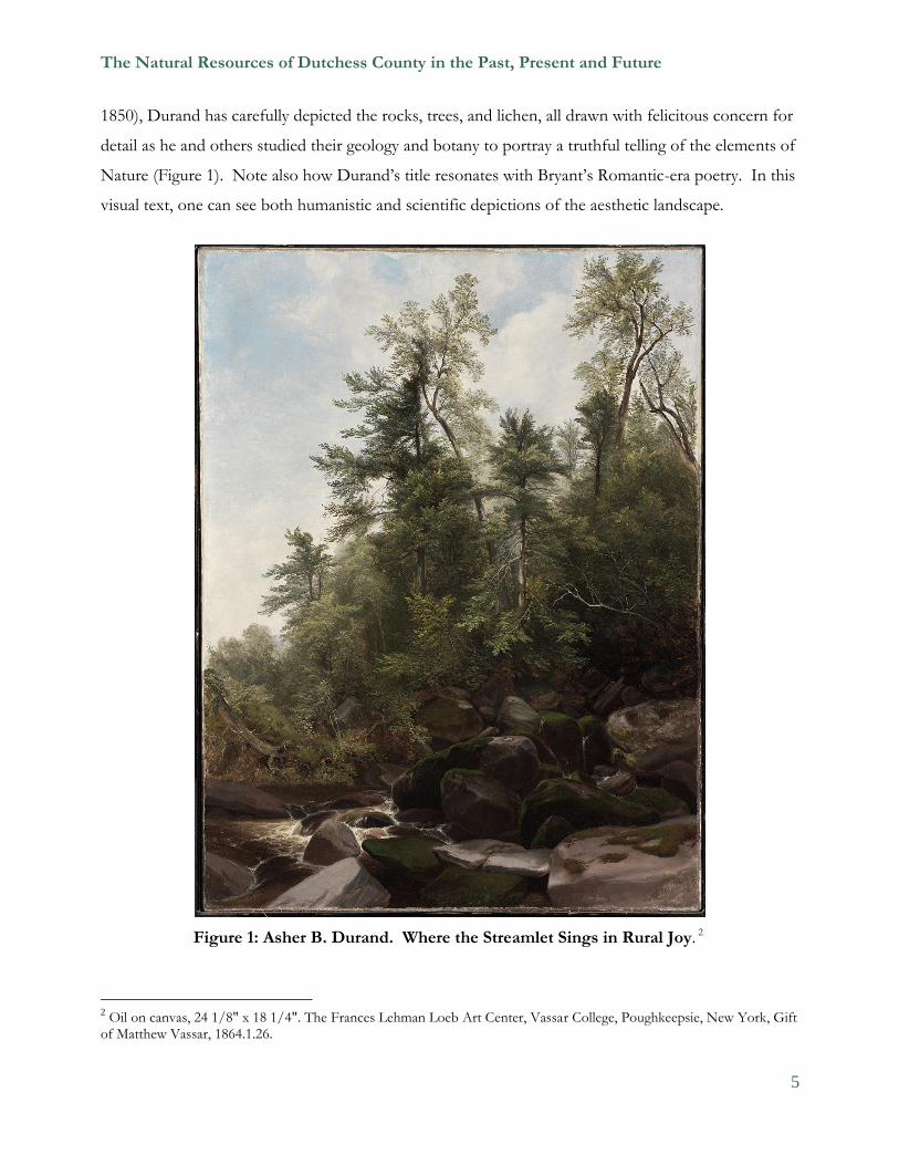
other artists, poets and essayists in early conservation efforts. The artist Asher B. Durand (1796-1886)
memorialized Cole along with the poet and journalist William Cullen Bryant (1794-1878) upon Cole‟s
death in 1848 in his painting “Kindred Spirits” with both standing in a forest setting with Kaaterskill
Falls in the background. And in this painting, as in his “Where the Streamlet sings in Rural Joy” (ca.
The Natural Resources of Dutchess County in the Past, Present and Future
5
1850), Durand has carefully depicted the rocks, trees, and lichen, all drawn with felicitous concern for
detail as he and others studied their geology and botany to portray a truthful telling of the elements of
Nature (Figure 1). Note also how Durand‟s title resonates with Bryant‟s Romantic-era poetry. In this
visual text, one can see both humanistic and scientific depictions of the aesthetic landscape.
Figure 1: Asher B. Durand. Where the Streamlet Sings in Rural Joy. 2
2 Oil on canvas, 24 1/8" x 18 1/4". The Frances Lehman Loeb Art Center, Vassar College, Poughkeepsie, New York, Gift
of Matthew Vassar, 1864.1.26.

The Natural Resources of Dutchess County in the Past, Present and Future
6
In 1847, one year before Cole‟s death, Durand traveled through Dutchess County on a visit to the
Stone Church, a natural rock cavern in the shape of a Gothic arch seventy feet high and fourteen feet
wide. (From early on, then, we might argue that the Stone Church has been both a natural and a
cultural resource.) From his 1847 visit Durand painted “Dover Plains, Dutchess County, New York”
(1848, Figure 2). It is a rather bucolic view of farms, fields and the Fishkill Hills in the background.
It is in the picturesque manner, with three visitors viewing the scene from a prospect on the lower left
and cows contentedly in the mid-ground. On the lower right hand side is a small drumlin, which, a
century-and-a-half later, has been removed for its gravel to pave roads. The painting is one of
Durand‟s most interesting as it depicts a domesticated landscape of harmony between man and nature
in which, according to Meinig‟s “landscape as artifact,” “every landscape is… a blend of man and
nature.”
Figure 2: Asher B. Durand, Dover Plains, Dutchess County, New York.3
3 Oil on canvas, 42 1/2” x 60 1/2”. Smithsonian American Art Museum, Smithsonian Institution, Washington, D.C., Gift of Thomas M. Evans and museum purchase through the Smithsonian Institution Collections Acquisition Program, 1978, 126.

The Natural Resources of Dutchess County in the Past, Present and Future
7
Dutchess County, and the rest of the Hudson Valley, were indeed becoming domesticated during the
1840s, with many of the large river estates hiring European gardeners to beautify their grounds.
Andrew Jackson Downing (1815-1852), horticulturist with a nursery in Newburgh, became the
“Arbiter of Taste” in landscape gardening throughout America during the heady days of
industrialization and the move of many middle class out of the smoky polluted cities to the
countryside. In his Treatise on the Theory and Practice of Landscape Gardening, Adapted to North America
(1841), he laid the groundwork (so to speak) of landscape architecture and planning in America. In his
other books, editorship of The Horticulturist monthly journal, and personal visits to local properties, he
was instrumental in forming a landscape aesthetic that sought a harmony between the picturesque, with
its ragged asymmetries of the wild, and with the beautiful and its rounded, formal and symmetrical
elements.
A number of properties in Dutchess County landscaped their grounds with both picturesque and
beautiful elements including groves of native trees, stream gorges, and vistas of the Hudson River or
of forested hills and mountains. Two in particular remain as examples of Downing‟s influence today:
Montgomery Place in Rhinebeck and Springside in Poughkeepsie. The latter was Matthew Vassar‟s
summer estate. Downing worked with his partner Calvert Vaux to plan and develop the Springside
property from 1850-52. Upon Downing‟s tragic death by drowning during a steamboat fire on the
Hudson River in 1852, Vassar commissioned four paintings by Henry Gritten of the site, which, along
with Downing and Vaux‟s signed drawings in the Vassar archive, an engraving in a contemporary
copy of The Horticulturist, and the engravings in Benson Lossing‟s biography of Matthew Vassar
(1867), constitute the only extant documented materials of Downing‟s work. The site is listed as a
National Historic Landmark and the landscape is being restored through the efforts of volunteers led
by John Mylod and Virginia Hancock.
After Downing‟s death, Vaux would go to New York City to collaborate with Fredrick Law Olmsted
to design Central Park, and thereby establish landscape architecture as a major design force to bring
Nature into urban America. Although the aesthetic tradition in depicting natural resources as
elements of Nature persisted throughout the 19th century, natural scientists offered new and
competing ways of understanding and managing the natural world.
The Natural Resources of Dutchess County in the Past, Present and Future
8
Natural Science in Dutchess County
Ante-bellum scientific surveys of Dutchess County created controversy in Natural Science. Ebenezer
Emmons, a student of Amos Eaton, studied the geology of the Taconic Hills and declared a separate
system from the European Silurian and Ordovician, setting up a major controversy within the
emerging field of geology, which was only then determining its geologic time-table of rock facies. The
study of both the Taconics and the Fishkill segment of the Highlands continued throughout the mid-
and late 19th century to determine both their composition, of gneiss, limestone, and shale, and their
origins. The Poughkeepsie newspapers in the 1840s published articles, prior to Agassiz‟s trip to New
York State to generate glacial theory, which attempted to understand the processes of landscape
change. In the 1860s, Vassar geology (and Natural History) professors William B. Dwight and
George Shattuck discovered fossils in the Taconic limestone; they also described the drumlins in
Poughkeepsie and the ponds in Pine Plains left behind by the glaciers of the last Quaternary retraction
that had left Long Island as its terminal moraine. Their research of the county‟s geology,
geomorphology and topography was significant in the evolution of the earth sciences. Both also
added local specimens to Vassar‟s Natural History Museum that had been established at the opening
of the college after Matthew Vassar purchased, in 1862, the first “cabinet” of minerals and other
natural objects sold by Henry Ward of Rochester, New York.
These early geologic surveys would continue into the early and mid-twentieth century with local
studies by Thomas Hills and A. Scott Warthin. In 1924, Hills created relief maps of the Poughkeepsie
and Clove quadrangles for the geology museum, while both he and Warthin gathered many specimens
of local rocks and fossils for students to examine. Scott‟s local geologic studies identified the tectonic
forces that created the “Dutchess Melange” with its location on the edge of the Hudson River under
the Mid-Hudson Bridge. He was also involved in hydrologic studies in the county, especially of the
Wappinger Creek. Discussions with faculty from biology and zoology led to Scott and professor of
botany Edith Roberts to found a Conservation Division in the Vassar curriculum in 1941. Warthin
noted in his 1960 report that flooding forecasts by Conservation students “saved many lives” during
the 1955 floods in Dutchess County. Warthin‟s scientific work on the natural resources of the county
eventually led to him becoming a founding board member of the Hudson River Environmental
Society and Pattern for Progress, a regional planning organization, of which more later.

The Natural Resources of Dutchess County in the Past, Present and Future
9
In the 1950s, John H. Johnsen continued the study of Dutchess County geology, particularly its
limestone and shale quarries and sand and gravel resources. In 1966, he co-authored with John
Gerard Broughton and James F. Davis the publication Geology and Mineral Resources of the Hudson Valley.
It was one of the major reports, along with its companion Biological Resources, that were commissioned
by Governor Rockefeller‟s Hudson River Valley Commission, to enable their regional planning
efforts, of which, also, more to follow. Geologist Roy Budnik continues Johnny Johnsen‟s work in
the county‟s sand and gravel quarries.
During the 1930s, Edith Adelaide Roberts, professor of plant science, studied and mapped the biota
of the entire county. Together with historian Helen Wilkinson Reynolds, they collaborated on The
Role of Plant Life in the History of Dutchess County (1938), a volume that indicated 29 plant associations of
five groupings related to the locations where they were most likely to be found: open field; bog forest;
aquatic plant; ravine; and floating mat. Along with tables on the plant species and maps of their
locations throughout the county by Roberts, Reynolds complemented the study with cultural history;
for example, where the sites of mills would have been constructed in the 17th and 18th century and the
different field histories for what would be milled, such as timber or grains. Both argued for the
planting of native plants rather than exotics in parks and more humanized landscapes, as A. J.
Downing had espoused almost a century earlier, and the need, therefore, of a natural science base for
regional and local planning. Roberts also developed a plant laboratory at Vassar College of all the
native species, beginning in 1920. With Roberts‟ plans in hand, Professor of Biology Margaret
Ronsheim is currently studying aspects of plant succession at this site and the prospects for
restoration.
Franklin Delano Roosevelt was a farmer and conservationist as well as Dutchess County‟s most
significant national and international political figure. In his first term in Albany in 1911-12 as a state
senator representing Dutchess County, he was selected as Chairman of the Forest, Fish and Game
Committee, and in his second term, he chaired the Agricultural Committee. He was an ardent
supporter of open-space management and forestry on his estate in Hyde Park. In 1911, Roosevelt
had his farm crew clear over-grown farmland at Springwood and the following year planted thousands
of white pine, red pine, Scotch pine, and Norway spruce seedlings that he got from the New York
State Conservation Commission. He ordered and planted close to one-half million trees on his
property throughout his life. Roosevelt worked with professional foresters from the College of
The Natural Resources of Dutchess County in the Past, Present and Future
10
Forestry at Syracuse University to plan his tree-planting efforts. After the chestnut blight moved up
the Hudson valley, FDR attempted experiments to reintroduce the chestnut with Asian varieties in
1937. As president, FDR‟s interest in forestry became an important part of the work of the Civilian
Conservation Corps (CCC) in the TVA project and the national park system.
Even while busy as president of the United States, he continued to support ecological surveys and
historical research in the Hudson valley. In a letter to historian and friend Helen Wilkinson Reynolds
in 1937, Roosevelt wrote of his support for the survey work of Vassar College professor Edith
Adelaide Roberts on the botanical resources of Dutchess County, and added some historical
landscape comments of his own: “I am glad Miss Roberts is doing the ecological survey. Does she
know the story about the two fields in front of our house? There are still three or four very old white
oaks …we figured that they dated to about the year 1650…They grew up as field trees because they
spread out from the bottom without hindrance from other trees.” As “wolf” trees, and with some
archaeological data, Roosevelt surmised that Indians had cultivated the fields. Like the Stone Church,
Springwood‟s oak trees can be considered both natural and cultural resources.
Dutchess County as a Regional Study in Natural Resources
During the 1940s, a composite perspective of the natural resources of Dutchess County was created
as a diorama of Stissing Mountain, located in Pine Plains, in the American Museum of Natural History
in New York City. The main exhibit is titled “An October Afternoon near Stissing Mountain,” one of
the four seasons displayed in the overall exhibit, along with specific displays of the local history,
geology, soil, plant and animal life above and below ground. The exhibits are located in the Felix M.
Warburg Memorial Hall of the museum; together they illustrate the ecology of plant and animal life
over forty square miles in the Pine Plains area. The exhibits were opened in 1951 under the
leadership of Henry K. Svenson, then chairman and curator of the museum‟s Department of Forestry
and General Botany, who conducted years of field research on the natural resources of the Pine Plains
area, and Harry L. Shapiro, head of the Department of Anthropology, a summer resident of the town.
They examine both the natural cycles and the human imprint on the land from the period of early
settlement in 1790, through the height of agricultural production through the Civil War period,
subsequent exhaustion of the land after 1870, and the restoration of fertility and improved land use
practices in the twentieth century.
The Natural Resources of Dutchess County in the Past, Present and Future
11
Staff from Cornell Cooperative Extension Dutchess County assisted property owners in restoring
their land, while natural scientists continued to study the natural resources of the area. These studies
led to the effort by the Nature Conservancy in 1959 to create the Stissing Mountain and Thompson
Pond nature preserve. Continued research by scientists including Madeleine Peirce from Vassar in
1973 and Eric Kiviat from Bard in 1990 and a report by the Town Conservation Advisory Committee
(CAC) in 2004 led to the declaration of “The Stissing Mountain Critical Environmental Area” by New
York State.
Cornell Cooperative Extension also promoted the preservation efforts by local land trusts including
the Dutchess Land Conservancy in eastern Dutchess County and the Winnakee Land Trust in
northern Dutchess County. For example, from 1985 to 2010 the Dutchess Land Conservancy
worked with 330 landowners to protect over 33,000 acres. National and regional organizations,
including the Nature Conservancy, Open Space Institute and Scenic Hudson, also worked to conserve
land in the area, while many county residents engaged in creative approaches. For example, Frances
and Willis Reese offered land along the Wappinger Creek to the town for a public park, Mary and
William Lunt spearheaded the purchase of Peach Hill in the town of Poughkeepsie, and former
orthopedic surgeon turned dairyman Samuel Simon organized a handful of family dairy farms into
Hudson Valley Fresh, saving over 5,000 acres of farmland. In the region, with the leadership of
Dutchess County resident Glenn Hoagland, Mohonk Preserve is the land steward of nearly 7,000
acres.
Regional Planning
Along with FDR, Dutchess County‟s most famous public intellectual, author Louis Mumford was a
proponent of open space planning. Mumford lived in Amenia and worked in New York City for the
Regional Plan Association (RPA). In the 1930s, Mumford advocated to set aside space in the fast-
growing New York Metropolitan region as parkland, such as linear parkways including the Taconic
Parkway in Dutchess County. Among other ideas promoted by Mumford and his colleague Benton
McKaye, would be the delineation of a trail along the ridges of the Appalachian Mountains from
Georgia to Maine. A segment of the Appalachian Trail runs through eastern Dutchess County, not
too far from Mumford‟s country home.

The Natural Resources of Dutchess County in the Past, Present and Future
12
Many Dutchess County residents have taken care of the trail over the years, and during a period of re-
routing in the 1970s, Vassar students in one of my land use seminars, assisted the Boston Regional
office of the National Park Service to design the booklet that mapped out the new route. Over the
next few years, other students in that seminar would delineate and map the Hyde Park Trail
connecting NPS and New York State historic properties and parks. In 1976, my seminar students
worked alongside Landscape Architecture students from Cornell University, to develop from the
former Children‟s Aid Society Summer Camp into a new county park, Bowdoin Park, with significant
views of the Hudson River. This effort involved many levels of cooperation, as students were
coordinated in the field by Bill Hogan of Cornell Cooperative Extension Dutchess County, assisted by
County Planner Eric Gillert, and received ecological and natural resource advice from Axel Horne,
Peter Dykeman and Gus Tillman of the Cary Arboretum (now the Cary Institute of Ecosystem
Studies in Millbrook).
Regional planning efforts by various organizations and agencies would become more expansive in the
second half of the 20th century. A number of different organizations would form, such as Mid-
Hudson Pattern for Progress, which, like the RPA, is primarily interested in economic development,
although environmental quality issues are also important as indicators of the quality of life. A major
issue that planning agencies, such as the Dutchess County Department of Planning and Development,
have studied and attempted to reverse, is that of “sprawl” and the loss of open space and farmland.
Sprawl had entered the lexicon of environmental planning and community development issues in
1965 when Secretary of Housing and Urban Development Robert C. Weaver spoke at the dedication
of the Dutchess County office building in downtown Poughkeepsie. He posited that the containment
of sprawl would be through “comprehensive area-wide planning,” that is, through both central city
renewal and by careful land use planning and zoning in the villages and countryside.
County Commissioner of Planning Henry Heissenbuttel and his deputy Kenneth Toole took up the
challenge. In their publication The Future of Dutchess County, published in 1972, they created a
conceptual land use framework that distinguished between city, village and countryside, to enhance
economic growth, while supporting social communities and conserving the county‟s significant natural
resources and landscapes. The guidelines were published by the Regional Plan Association, in
cooperation with the County and Mid-Hudson Pattern for Progress, and the next year became the
foundation for the RPA‟s and Pattern‟s own publication The Mid-Hudson: A Development Guide, in
The Natural Resources of Dutchess County in the Past, Present and Future
13
which open space and agricultural areas were a part of the overall planning to preserve regional
natural resources. These two sets of guidelines from 35 years ago have formed the basis for the
currently proposed Centers and Greenspaces Guide by the county planning department.
In the late 1960s under Toole‟s direction, the county had already begun a cultural resources survey to
update the 1966 Hudson River Valley Commission report Historic Sites and Buildings in the Hudson River
Valley. In the 1969 Landmarks of Dutchess County, 1683-1867, published in the Architecture Worth
Saving in New York series by the New York State Council on the Arts, over 300 structures were
researched and photographed and with consultation from Jeh V. Johnson, local and nationally
recognized architect and professor of architecture at Vassar. The volume was published in order to
guide “growth and development” and “encourage selective preservation of this inheritance.”
A decade later, the State got back into the act of inventorying the natural and cultural resources of the
Hudson River Valley. In the 1979 The Hudson River Valley Study, the DEC, under Commissioner
Robert Flacke and former Commissioner Peter Berle and his special assistant Peter Borrelli, directed a
report to the state legislature to enact legislation “with regard to the need to protect the scenic,
recreational and ecologically-important resources” of the mid-Hudson river valley. The cultural and
natural resource study coincided with the development of the Coastal Zone Management Program in
the same years. Both of these studies eventually led to state legislation to develop the Hudson River
Valley Greenway in 1990. Other later studies, inventories, and planning documents, such as DEC‟s
Conserving Open Space in New York State, 1998 and the Dutchess County Agricultural and Farmland Protection
Plan of the same year, would lead Congressman Maurice Hinchey, this year (2010), to request the
National Park Service to revisit the earlier studies promoted by Laurance Rockefeller after the demise
of the Hudson River Valley Commission in 1976 about a possible NPS heritage area.
Scenic Hudson led the effort to develop the Greenway, and included the public agencies of the New
York State Department of Environmental Conservation (DEC) and Office of Parks, Recreation and
Historic Preservation (OPRHP), NYS Council on the Arts, and the National Park Service. Most of
the promotional effort came from Dutchess County and included Franny Reese, “Godmother of the
Hudson River,” Dennis Murray, president of Marist College, Jay Rolison, state senator from the
county, and Richard Wager, publisher of the Poughkeepsie Journal, who, according to Scenic Hudson‟s
then-executive director Klara Sauer, personally persuaded Governor George Pataki to sign the
legislation in the final hour. Dutchess County was the first county to sign on to the Compact, and the
The Natural Resources of Dutchess County in the Past, Present and Future
14
Greenway across the Beacon-Newburgh Bridge along I-84 linking the two cities would be among the
first trails generated by the state program. As of 2010, the Greenway Compact has been adopted by
29 of the county‟s 30 municipalities.
In 2009, the Walkway Over the Hudson opened as the “longest pedestrian bridge in the world” with
overwhelming support from mid-Hudson citizens, linking the counties of Dutchess and Ulster.
Hiking and biking trails from the Harlem Valley in eastern Dutchess County to New Paltz and west
will soon connect twenty to thirty miles of trails, fulfilling Mumford‟s vision from his home in
Amenia. The last five years of the effort to secure the former Poughkeepsie Railroad Bridge was led
by Dutchess County resident and avid biker Fred Schaeffer who garnered funding from the Dyson
Foundation in Millbrook, Scenic Hudson, and state and federal grants. Over 700,000 walkers,
bicyclists, and strollers have used the Walkway in its first year, allowing views of the natural and
cultural resources of the Mid-Hudson valley, including Scenic Hudson‟s Frances Reese Park on the
west shore south of the Walkway and the Mid-Hudson Bridge.
Three decades earlier, in northern Dutchess County, the Hudson River Shorelands Task Force was
formed by the non-profit historic preservation organization Hudson River Heritage, who, with active
volunteers, developed a survey of major river estate properties, from the Roosevelt and Vanderbilt
NPS historic sites to Wilderstein and Montgomery Place estates in the Towns of Hyde Park,
Rhinebeck, Red Hook and Tivoli. The completion of the initial survey led to many more estate
properties being placed on the National Register of Historic Places, and declaration of the entire 16-
mile District as the “longest historic district in the nation.” As Executive Director of the Shorelands
Task Force in 1979-80, I worked to get all the affected municipalities to sign on to a compact to
recognize the historic district as they planned for development. We were eventually successful, and it
would become a model for the Greenway Compact about a decade later.
The first New York State Scenic Roads guidelines were developed for the estates district, which, over
the years expanded from its original 16 miles in Dutchess County northward into Columbia County to
include the historic Livingston lands and historic site of Clermont and the state historic site of Olana.
New York State has recognized the “Estates District Scenic Area” as an Area of Statewide
Significance for use in regional and local planning.

The Natural Resources of Dutchess County in the Past, Present and Future
15
In addition, the initial success encouraged Hudson River Heritage to develop Cultural Resource
Inventories (CRIs) for each of the towns to be incorporated into their master plans and zoning maps.
This effort was coordinated with the development of Natural Resource Inventories (NRI‟s) through
assistance of Cornell Cooperative Extension Dutchess County and the exhaustive and impeccable
scientific research of Eric Kiviat at Hudsonia, the environmental research institute located at Bard
College. Eric‟s research and publications on the wetlands, plants, animals (especially the Blanding‟s
turtle), and human ecology of Dutchess County, and indeed the entire mid-Hudson bioregion, has
been instrumental in writing a set of Biodiversity Guidelines in 2001 for the Dutchess County
Environmental Management Council (EMC) and local CACs to develop NRIs for the county‟s
planning efforts, town and village master plans, and the Hudson River Estuary Program‟s “Significant
Biodiversity Areas.”
Environmental Planning
The use of environmental research through NRIs and special scientific-based reports by consultants
or non-profit environmental organizations evolved through legislation and public policies during the
1960s and 70s. In 1962, Rachel Carson‟s Silent Spring had brought the dangers of pesticides to the
forefront of national consciousness, while various landscape conservation and wilderness preservation
battles that led to the enactment of the Wilderness Act in 1964 continued to make the national news.
Aldo Leopold‟s A Sand County Almanac was published in 1966. In that same period, Consolidated
Edison (Con Ed) proposed a hydroelectric power plant on Storm King Mountain in the Hudson
Highlands. Conservationists throughout the Hudson Valley were outraged at the potential
desecration of the mountain, and a small group organized themselves into the Scenic Hudson
Preservation Conference, later simply Scenic Hudson, fought to stave off the project. After many
scientific reports were filed about the potential harm to the river and its ecology and to the mountain
itself, the U.S. Court of Appeals in 1965 ruled against Con Ed and the Federal Power Commission.
The judgment had national implications, as it became the basis for federal environmental policy. For
example, the government passed the National Environmental Policy Act in 1969 (NEPA), signed
January 1, 1970, and further policy acts would emerge over the next few years to protect air, water,
and endangered species. NEPA also created procedures to study potential impacts of a proposal on
an area‟s aesthetics, ecology, and social services; these were to be considered as important as
economic issues. And, most important for Scenic Hudson and other environmental non-
The Natural Resources of Dutchess County in the Past, Present and Future
16
governmental organizations (NGO‟s), the right to question development proposals was broadened
beyond appurtenant landowners to other concerned citizens.
Potential aesthetic impacts became important in 1979 during hearings before the U. S. Nuclear
Regulatory Commission and the Power Authority of the State of New York for a proposed nuclear
power plant in Greene County, within viewsheds of Dutchess and Columbia counties. The successful
defeat of the proposed three-and-a-half-billion dollar power plant led to the development of Visual
Impact Analysis by New York State as a component of its review process. Further refinement of
aesthetic and visual impact analysis of local historical cultural landscapes would lead to the analysis of
“community character,” which, along with computerized viewshed analysis and projected economic
impacts became the significant arguments to defeat the proposed St. Lawrence Cement plant across
the Dutchess County border near Hudson in Columbia county. The viewshed analysis prepared for
the Town of Amenia and presented at this conference, is based, in part, on work done in 1986 by
Stephanie Mauri of the Dutchess County Historical Society and is a fine example of combining both
cultural and natural resource analysis. Developed over the past few years as part of the town‟s NRI,
and presented at today‟s conference, it is a major step towards defining the town‟s community
character and will be an essential tool in the town‟s development of a master plan as a “Scenic
Protection Overlay District” that harmonizes both natural and cultural resources.
After the passage of NEPA, New York State, like most all other states, soon developed its own “little
NEPA.” The explosion in the use of SEQR (State Environmental Quality Review Act) in the 1980s
and 1990s necessitated an equally important need for natural resource data. To fulfill this need for
local and regional planning, the EMC and affiliated CAC‟s, with assistance in GIS mapping and public
outreach by Cornell Cooperative Extension, compiled the first countywide NRI in 1985 and expanded
it in 2010 for today‟s presentation.
During the past three-decades, the DEC compiled, mapped and assessed natural resource data and
identified certain specific areas for protection. These areas might contain flora or fauna on the state‟s
rare or endangered species list or composite micro-ecosystems where potential disturbance could
seriously damage fragile energy pathways. In Dutchess County, the DEC has registered 31 “Critical
Environmental Areas” as of 2010.

The Natural Resources of Dutchess County in the Past, Present and Future
17
Meanwhile, the loss of biodiversity due to increasing development, specifically sprawl, necessitated
updating of former town master plans. Researchers associated with both public and private agencies,
especially Dutchess County Planning and Cornell Cooperative Extension, NGOs, colleges, and citizen
groups, especially CACs through the EMC, worked to update the local and county NRI. They
engaged in specific studies of natural landscape features that included a focus on the ecology,
pollution, and cultural histories of the county‟s waterways, such as Wappinger Creek, the Casperkill,
and the Fall Kill. For example, Vassar geologists Jeffrey Walker and Kirsten Menking have led a team
that has completed a comprehensive study of the Casperkill, while Marist biologist Thomas Lynch
and his students have studied the Fall Kill‟s stream ecology, hands-on efforts by local members of
Clearwater and the Hyde Park CAC have worked on the stream‟s natural wildlife corridor, and Vassar
students mapped a greenway trail along the creek to include historic and cultural properties from the
mouth at the Hudson northeast upstream to the National Park Service site at Eleanor Roosevelt‟s Val-
Kill. The county‟s forested landscape is also being studied by biologist Margaret Ronsheim and
geographer Mary Ann Cunningham using Edith Roberts‟ work and map of the 1930s, along with the
aerial survey of the county of that period and comparing it to recent aerial photographs, using GIS
methodology, as well as research in the field locating specific plants and landscape features with GPS
technology.
Conclusion
Since, according to geographer David Lowenthal, we are all “unavoidably implicated in environmental
change, we must try to manage it despite knowing we will always make mistakes.” To assist in our
efforts at managing our environment through better land use decisions, years of research by local
citizens and scientists have resulted in useable natural and cultural resource inventories. Research
specifically designed for local Natural Resource Inventories emerged during the late 1970s and early
1980s, and continues, as we have seen and heard this morning, up to today. Staff from the Dutchess
County EMC and Cornell Cooperative Extension collated the data and maps collected by individuals
and citizen groups in 1985. The new NRI that we have heard about today is a much anticipated and
updated product, with extensive maps produced by 21st century GIS technology and the broad
cooperation of natural scientists and conservationists from throughout the region. They follow in the
footsteps of many who have worked in these vineyards before them. They have, as Aldo Leopold
would have hoped, related to their environment as “something we can see, feel, understand, love, or

The Natural Resources of Dutchess County in the Past, Present and Future
18
otherwise have faith in.” Dutchess County‟s landscape, especially its role in creating a quality of life
for its ecological and human inhabitants, will be indebted to their efforts. Thank you.
Notes*
I wish to acknowledge and thank the organizers of the Conference on Dutchess County‟s Natural
Resource Inventory (NRI), held on November 6, 2010, for the honor of giving the keynote address,
especially Jeffrey Walker (Vassar College), Allison Chatrchyan and Emily Vail (both of Cornell
Cooperative Extension Dutchess County), and Lalita Malik (Dutchess County Environmental
Management Council). This essay is an extended version of my talk and retains much of its informal
style with references to colleagues in the audience who have been involved in the scientific efforts to
develop the 2010 NRI that was presented at the conference. I also accepted Jeff‟s invitation to tell a
few personal stories of my work in the region.
The following notes constitute a bibliographic essay in lieu of more formal footnotes for the reader to
follow up on themes and information presented in this introductory sketch on Dutchess County‟s
history of environmental planning, with its focus on the development of natural and cultural resource
inventories. Although the conference focused specifically on natural resource inventories, this essay
suggests that the development of a conservation ethic, and hence a need to create NRIs for town and
regional planning decisions, developed through an integration of a humanistic as well as natural
scientific examination of the landscape.
Annotated Bibliography
Quotations from Aldo Leopold are from A Sand County Almanac, first published in 1949 (NY: Oxford
University Press, 1966). D. W. Meinig‟s landscape categories are found in his essay “The Beholding
Eye: Ten Versions of the Same Scene,” in The Interpretation of Ordinary Landscapes: Geographical Essays,
edited by D. W. Meinig (NY: Oxford University Press, 1979). I have previously used Meinig‟s
terminology to examine the historical construction of the Mohonk Mountain House landscape in
“The Parlor in the Wilderness: Domesticating an Iconic American Landscape,” The Geographical Review,
vol. 99, no. 3 (July 2009).
Examples of early natural history narratives, including observation of deforestation‟s effect of soil by
Crevecoeur in 1782, the geologist Sir Charles Lyell of the Palisades in 1841, and geologist W.W.

The Natural Resources of Dutchess County in the Past, Present and Future
19
Mather in his Natural History of New York State in 1845 can be found in Harvey K. Flad, “The Hudson
River Valley and the Geographical Imagination,” From the Hudson to the Hamptons: Snapshots of the New
York Metropolitan Area, edited by Ines M. Miyares, Marianna Pavlovskaya and Gregory A. Pope
(Washington, D.C.: Association of American Geographers, 2001); reprinted in Watershed Journal: The
Hudson Valley Art Project, edited by Miwon Kwon (NY: Minetta Brook, 2002). A brief history of
natural history collecting is found in Sue Ann Prince, ed., Stuffing Birds, Pressing Plants, Shaping Knowledge:
Natural History in North America, 1730-1860 (Philadelphia: American Philosophical Society, 2003). For
a local study see Margaret R. Wright, Nineteenth Century Natural History at Vassar College: Darwinian
Theory in the Classroom? (Poughkeepsie: Vassar College, 1988); and Rick Jones, The Evolution of the
Natural Sciences: Selections from the Natural History Museum at Vassar College (Poughkeepsie: Warthin
Museum of Geology and Natural History, Vassar College, 2008). For a biography of George Perkins
Marsh see David Lowenthal, George Perkins Marsh: Prophet of Conservation (Seattle: University of
Washington Press, 2000). For more information about the Natural History Museum, see the link to
the Vassar College Encyclopedia in the Earth Science and Geography Department entry in
“Histories” at http://150.vassar.edu. For a biography of Daniel Smiley see Larry E. Burgess, Daniel
Smiley of Mohonk: A Naturalist’s Life (Fleischmanns, NY: Purple Mountain Press).
Thomas Cole‟s paintings and his 1836 “Essay on American Scenery” can be found in the many
volumes devoted to the art of the Hudson River School. I have quoted his remarks elsewhere in my
catalog essay “Following „the pleasant paths of Taste‟: The Traveler‟s Eye and New World
Landscapes,” in Humanizing Landscapes: Geography, Culture and the Magoon Collection (Poughkeepsie, NY:
Frances Lehman Loeb Art Center, Vassar College, 2000), which also contains an excellent
reproduction of Asher B. Durand‟s painting “Where the Streamlet Sings in Rural Joy,” (ca. 1850), part
of Vassar College‟s Magoon Collection. David Schuyler also notes Cole‟s concerns about the
despoliation of the local environment in his catalog essay “The Mid-Hudson as Iconic Landscape:
Tourism, Economic Development, and the Beginnings of a Preservationist Impulse,” in Within the
Landscape: Essays in Nineteenth-Century American Art and Culture, edited by Phillip Earenfight and Nancy
Siegel (Carlisle, PA: The Trout Gallery, Dickinson College, 2005). An 1841 reprinting of Cole‟s
“Essay on American Scenery” can be found in Bonnie Maranca, A Hudson Valley Reader (Woodstock,
NY: The Overlook Press, 1991). For reproductions of Durand‟s “Kindred Spirits” (1848) and
“Dover Plains, Dutchess County, New York” (1848), see Linda Ferber, ed. Kindred Spirits: Asher B.
Durand and the American Landscape (NY: Brooklyn Museum, 2007).
The Natural Resources of Dutchess County in the Past, Present and Future
20
The history of Andrew Jackson Downing‟s landscape design at Matthew Vassar‟s estate “Springside”
is documented in Harvey K. Flad, “Matthew Vassar‟s Springside: „…the hand of Art, when guided by
Taste,‟” in Prophet with Honor: The Career of Andrew Jackson Downing, 1815-1852, edited by George B.
Tatum and Elisabeth Blair MacDougall, Dumbarton Oaks Colloquium on the History of Landscape
Architecture XI (Washington, D.C.: Dumbarton Oaks Trustees for Harvard University, 1989).
Downing‟s efforts in other Dutchess County estates is discussed in Judith K. Major, To Live in the New
World: A. J. Downing and American Landscape Gardening (Cambridge: Massachusetts Institute of
Technology, 1997). For a biography of Downing see David Schuyler, Apostle of Taste: Andrew Jackson
Downing 1815-1852 (Baltimore: The Johns Hopkins University Press, 1996).
A discussion of the geological research conducted by Vassar College‟s professors of natural history
and geology is sketched in Harvey K. Flad,. “Earth Science and Geography Department History” on
Vassar College‟s website devoted to the college‟s sesquicentennial in 2011 at
http://150.vassar.edu/histories/history-of-earth-science-and-geography-at-vassar-college/index.html.
Volumes of the reports for the Hudson River Valley Commission will be found in most regional
research libraries (Vassar, Marist, or Adriance in Poughkeepsie). The Role of Plant Life in the History of
Dutchess County by Edith Adelaide Roberts and Helen Wilkinson Reynolds (Poughkeepsie, NY:
authors, 1938) is housed in Special Collections, Vassar College.
Franklin Delano Roosevelt as conservationist is examined in essays in Henry L. Henderson and David
B. Woolner, eds., FDR and the Environment (NY: 2005). Comments on FDR‟s influence on the
landscape of Dutchess County and excerpts from his letter about his oak trees are found in Harvey K.
Flad and Clyde Griffen, Main Street to Mainframes: Landscape and Social Change in Poughkeepsie (Albany:
State University of New York Press, 2009).
Photographs of the Stissing Mountain display and of aspects of Pine Plains and Dutchess County
ecological history are displayed on the American Museum of Natural History in New York‟s website
(http://www.amnh.org/).
Copies of the regional and county planning reports can be found in the library of the Dutchess
County Planning Department and at most local libraries, while the Landmarks study of historic
The Natural Resources of Dutchess County in the Past, Present and Future
21
architecture is also in the Dutchess County Historical Society library. Poughkeepsie resident Ralph
Arlyck‟s national award-winning film “Hyde Park” offers a unique perspective on small town land use
issues and the personalities involved in local planning. Robert C. Weaver‟s quote on “comprehensive
area-wide planning” and Klara Sauer‟s recollection on the origins of the Greenway are reported in
Flad and Griffen‟s Main Street to Mainframes (op.cit.). The role of Hudson River Heritage in developing
cultural resource inventories of the Estates District is noted in Robbe Stimson and Harvey K. Flad,
“Preservation of an Historic Rural Landscape: Roles for Public and Private Sectors,” in Farmsteads &
Market Towns: A Handbook for Preserving the Cultural Landscape (Albany: Preservation League of New
York State, 1982). The Hudson River Shorelands Task Force in 1979-80 worked to get all affected
municipalities to sign on to a compact to recognize the historic district as they planned for
development through new zoning and master plans. This was rather difficult, for, as some in the
audience at the conference who have been around for a while may recall, the very idea of regional
planning was considered a “socialist plot” for many towns and villages in the late 70‟s and early 80‟s.
However, the Task Force, working with some of the local citizen-members on their town planning
boards, planners from Dutchess County Planning Department and community development
specialists from Cornell Cooperative Extension, was eventually successful, and the joining of the
northern Dutchess communities together into a “compact” would become a model for the Greenway
Compact a decade later. As Stuart Findlay from the Cary Institute of Ecosystem Studies remarked at
the conference, “Local Control requires Local Responsibility.”
The Storm King story and its role in federal legislation to enact the National Environmental Policy
Act is told in Alan R. Talbot, Power Along the Hudson: The Storm King Case and the Birth of Environmentalism
(NY: E. P. Dutton, 1972) and Frances F. Dunwell, The Hudson: America’s River (NY: Columbia
University Press, 2008). Commentary on the significance of early use of visual impact analysis and
aesthetic impact, such as Flad‟s “Prepared Testimony on Aesthetic Impact of Greene County Nuclear
Power Plant” in 1979, and further development of community character analysis, can be found in
Katie Ghilain, “Improving Community Character Analysis in the SEQRA Environmental Impact
Review Process: A Cultural Landscape Approach to Defining the Elusive „Community Character,‟” in
N.Y.U. Environmental Law Journal 17 (2009); also Harvey K. Flad, “The Influence of the Hudson River
School of Art in the Preservation of the River, its Natural and Cultural Landscape, and the Evolution
of Environmental Law,” in Robert Henshaw, ed., Environmental History of the Hudson River: Ecology that
The Natural Resources of Dutchess County in the Past, Present and Future
22
Changed Human Uses, Human Uses that Changed Ecology (Albany: State University of New York Press,
forthcoming 2011).
David Lowenthal‟s remarks to accept our limits in managing the environment come from his essay
“Environmental History: From the Conquest to the Rescue of Nature,” in Alexander B. Murphy and
Douglas L. Johnson, eds., Cultural Encounters with the Environment (NY: Rowen and Littlefield, 2000).
Aldo Leopold‟s quotation is from A Sand County Almanac (op.cit.).


![[THVInstitute13] Social Studies Tool Kit for Dutchess County Educators](https://img.dokumen.tips/doc/110x75/545c4159af7959c8098b46fb/thvinstitute13-social-studies-tool-kit-for-dutchess-county-educators.jpg)