Embed Size (px)
Citation preview

at SciVerse ScienceDirect
Marine and Petroleum Geology 45 (2013) 17e41
Contents lists available
Marine and Petroleum Geology
journal homepage: www.elsevier .com/locate/marpetgeo
The morpho-tectonic setting of the Southeast margin of Iberia andthe adjacent oceanic Algero-Balearic Basin
J. Acosta a,*, A. Fontán a, A. Muñoz b, A. Muñoz-Martín c, J. Rivera a, E. Uchupi d
a Spanish Oceanographic Institute, Servicios Centrales, C/ C. de Maria 8, 28002 Madrid, Spainb Tragsa-SGP, C/Julián Camarillo 6B, 28037 Madrid, SpaincUniversidad Complutense, Fac. CC. Geológicas, Instituto de Geociencias (UCM, CSIC), C/ J.A. Novais 2, 28040 Madrid, SpaindWoods Hole Oceanographic Institution, Woods Hole, MA 02543, USA
a r t i c l e i n f o
Article history:Received 23 August 2012Received in revised form10 April 2013Accepted 12 April 2013Available online 1 May 2013
Keywords:Mazarrón EscarpmentAlgero-Balearic Abyssal PlainMessinian diapirsAfrican-Eurasian platesFaultsPockmarksSeismicityBétic Cordillera
* Corresponding author. Tel.: þ34 91 5107500; fax:E-mail addresses: [email protected],
(J. Acosta).
0264-8172/$ e see front matter � 2013 Elsevier Ltd.http://dx.doi.org/10.1016/j.marpetgeo.2013.04.005
a b s t r a c t
Multi-beam bathymetry and high-resolution low-penetration seismic reflection profiles of the offshoreextensions of the Bétic Internal Zone off Sierra de Cartagena-La Unión margin along its south side and theMar Menor margin along its east side, the Mazarrón Escarpment forming its southern boundary and theadjacent oceanic Algero-Balearic basin have provided images of the neo-tectonic structures of the regionequal to those provided by subaerial photography. For the first time we mapped with unprecedenteddetail the Mazarrón Escarpment and the Southeast margin of Iberia.
The first-order structures of the region are due to the consequence of the collision of the African andEurasian plates during the Alpine orogeny in late OligoceneeMiddle Miocene, the westward migration ofthe Alborán plate in the Middle Miocene and the desiccation of the Mediterranean in the Messinian (LateMiocene) that led to the deposition of evaporites in the Algero-Balearic basin and erosion of theMazarrón Escarpment, the Sierra de Cartagena-La Unión shelf, the Mar Menor margin and the adjacentcoast. Our data images second order tectonic features (neo-tectonic features) superimposed on the largerstructures. These include the deformation of the strata in the Algero-Balearic basin by the gliding of thePlio-Quaternary sediments on Messinian halite on the margins of the basin and sediment loading in itscenter, the Late MioceneeQuaternary deformation of the area north of the Mazarrón Escarpmentresulting from the continuous oblique convergence of the African and Eurasian plates in a NNWeSSEdirection, the Miocene to Pleistocene volcanic edifices and pinnacles (dikes), the pockmarks formed bythe extrusion of gas/water via faults and the massive gravitational failure of the Mazarrón Escarpmenttriggered by this plate convergence. The data also show in detail features formed on the MazarrónEscarpment during the Messinian, Pliocene and Pleistocene regressions and those on the shelf formedduring the Pleistocene glacially induced regressions/transgression and sediment drifts generated bymodern currents.
� 2013 Elsevier Ltd. All rights reserved.
1. Introduction
The Algero-Balearic Basin and the adjacent Spanish marginconsist of two distinct tectonic realms. The Iberian continentalmargin is the creation of the convergence of the African andEurasian plates during the Alpine orogeny in Late OligoceneeMiddle Miocene. The Algero-Balearic Basin is an oceanic basinformed by the western migration of the Alborán plate in MiddleMiocene. The eastewest trending Mazarrón Escarpment, a right-lateral transform, separates the two realms.
þ34 91 [email protected]
All rights reserved.
The objectives of the present investigation were to determinethe morphology of the offshore extension of the terminal splay ofthe Eastern Bétic Shear Zone in the Internal Zone, to define itsshallow structure, to integrate these data to determine the geo-dynamic setting of the offshore extension of the Bétic Internal Zoneand finally to compare the onshore and offshore settings of thezone (Fig. 1). The Internal Zone, extending from east of the Strait ofGibraltar to the Mediterranean, is comprised of three nappe com-plexes of variable metamorphic grade and Triassic to lowerNeogene (Azañón et al., 2002). The Neogene deformation wasaccompanied by subsidence of Neogene basins and uplift of thepre-Neogene basement creating a discontinuous chain of sierrasseparated by MioceneeQuaternary basins (Huibregtse et al., 1998;Woodside and Maldonado, 1992; Silva et al., 2003, 2004).

Figure 1. A. Bathymetric-tectonic map of SE Spain showing the location of survey area. Thick black line shows the study area (35,269 km2). Bathymetric contours in meters. Basemap from MediMap Group (2005). Additional data from Alfaro et al. (2002a, 2002b), Bousquet (1979), Gràcia et al. (2010), López-Ruiz et al. (2002), Mauffret (2007), Perea et al.(2009), Silva et al. (2003, 2004), Soria et al. (2008) and Robles-Arenas and Candela (2010). B. DTM of the study area.
J. Acosta et al. / Marine and Petroleum Geology 45 (2013) 17e4118
We extended our study southward as to include the 2800 mdeep, 100e120 kmwide and 400 km long Algero-Balearic basin. Itsoceanic crust, inferred by Panza et al. (2007) to be of MiddleMiocene age, is mantled by approximately 1.8 km of Miocenesediments that include less than 1 km of Messinian evaporites(Gallart et al., 1995; Sábat et al., 1995; Mauffret et al., 2004).Deposition of the Messinian evaporites is a result of the closure ofthe portal between the Atlantic and the Mediterranean by LateMiocene compressional tectonics (Duggen et al., 2004).
2. Area of investigation and methods used
The offshore extension of the Bétic Internal Zone and adjacentAlgero-Balearic Basin investigated during the present study aredepicted in Figures 1 and 2. It has maximum extensions of 334
(eastewest) � 130 (northesouth) km. The area was surveyed withtwo Simradmulti-beam systems. An EM-3000 D system (300 kHz)was used in depths of less than 150 m aboard R/V Emma Bardán incruises during 2001 and 2003 and a Simrad EM-300 (30 kHz) forgreater depths aboard the R/V Vizconde de Eza during cruises in2003, 2004, 2007, 2010 and 2011 (this last year only working withTopas PS18). Information on the shallow structure of the area wasobtained with a hull mounted Topas PS 18 High-resolution para-metric profiler system, with integrated transmitter and receivers.Navigation was via a differential GPS Simrad GN33 using satellitecorrections from a Fugro system integrated in a MDM 400 soft-ware package with an inertial integrated aided Seapath 200 Sys-tem for an accuracy of 0.7 Rms. The multi-beam data sets fromCapesme Project (present paper) is gridded at 50 � 50 m, EspaceProject (present paper) is gridded at 5� 5m. Sbal Deep Project has

Figure 2. A. DTM of the study area showing the locations of Topas seismic profiles. B. Map showing the variations in slope angle recorded in the study area based on multi-beambathymetry data.
J. Acosta et al. / Marine and Petroleum Geology 45 (2013) 17e41 19
a 200 � 200 m grid and Balcom Project have a 50 � 50 m of gridsize.
Supplementary video related to this article can be found athttp://dx.doi.org/10.1016/j.marpetgeo.2013.04.005.
3. Geomorphic setting
3.1. The coastal zone
Three geologic terranes dominate the eastern end of the BéticInternal Zone. Along the EeWtrending coast, at the southern end ofthe zone, is the 30 km long and 8 km wide Sierra de Cartagena-LaUnión (Fig. 1; López-Ruiz et al., 2002; Duggen et al., 2005). It has arelief of 0e400 m and high slopes a result of its proximity to thecoast (Conesa and Jiménez-Cárceles, 2007). At its eastern tip is Cabode Palos where Miocene volcanics rest on Bétic Internal Zone strata(Jiménez-Martínez et al., 2012). The Internal Zone units are locallycovered by MioceneeQuaternary sediments and cut by NWeSE-and EeW-trending fault systems formed during the Eocene andMiddle Miocene (Robles-Arenas and Candela, 2010). A MiddleMiocene reactivation of the fractures led to the formation of a seriesof horst and graben structures (Manteca Martínez and Ovejero
Zappino, 1992). As a consequence of tectonic activity during theLate MioceneePliocene rhyolitesedacites, andesites and alkalinebasalts were extruded along these faults (Duggen et al., 2005;Robles-Arenas and Candela, 2010; Jiménez-Martínez et al., 2012).According to Manteca Martínez and Ovejero Zappino (1992),Azañón et al. (2000), and Robles-Arenas and Candela (2010) thoseEeW trending faults and the NWeSE trending transcurrent faultsin the coastal area between Mazarrón and Cabo de Palos appear tobe related to recent tectonic events involving strike-slip andcompression.
North of the Sierra de Cartagena-La Unión is the NeogeneMurcia Basin whose top, the Campo de Cartagena, have an areaof 1440 km2 (Jiménez-Martínez et al., 2012). The Campo deCartagena represents the subaerial westward extension of theMar Menor Shelf level (Jiménez-Martínez et al., 2012). Thesediment cover atop the Bétic System consists of Neogene andQuaternary strata with a maximum thickness of 2000 m. TheNeogene sequence is deformed by normal faults and joints someof which affect the Quaternary. Jiménez-Martínez et al. (2012)reported that the Quaternary sediments that cover much ofthe Campo de Cartagena have been affected locally by recenttectonic activity.

J. Acosta et al. / Marine and Petroleum Geology 45 (2013) 17e4120
At the eastern end of the Campode Cartagena is theMarMenor, atriangular-shape coastal lagoonwith dimensions of 13�15�21km,a mean depth of 2.5 m and a maximum depth of 6 m. It is separatedfrom the open sea by a 20 km long and 100e900 m wide barrierisland, La Manga (Conesa and Jiménez-Cárceles, 2007). At thesouthern end of La Manga is Cabo de Palos consisting of 14 smallledges composed of Miocene volcanics (López-Ruiz et al., 2002).Within the lagoon are five islands composed of Miocene volcanics(López-Ruiz et al., 2002).
North of Mar Menor are the NE-trending Torrevieja andPedraza-Guardamar anticlines and the EeW-trending anticlinesouth of Pinet Lagoon, the Santa Pola Anticline and an anticlinenorth of Santa Pola (Soria et al., 2008). Along the northwest side ofthe Pedraza structure is the EeW-trending left-lateral Bajo SeguraFault. Cutting across both anticlines are NWeSE San Miguel, Tor-revieja and Guardarmar right lateral faults (Alfaro et al., 2002b;Soria et al., 2008). North of the Bajo Segura fault is the Bajo Segurabasin flanked on its northwest side by the northeast trendingCrevillente anticline and left-lateral Crevillente fault. This faultforms the boundary between the Bétic External zone to thenorthwest and the Internal Zone to the southeast (Reicherter andReiss, 2001).
3.2. The Mar Menor and the Sierra de Cartagena-La Unióncontinental shelves
The Mar Menor Shelf, east of Mar Menor, is 32e42 kmwide andthat south of Sierra de Cartagena-La Unión is 10 to 3 km wide(Figs. 1 and 2; Table 1). Off La Manga, at depths of 10e20 m, arethree volcanic islands of the Isla Grosa group. Farther east, at adepth of about 58 m, is the three islands of the SWeNE trendingIslas Hormigas group. The shelf’s edge east of Mar Menor is about200 m and that south of Sierra Cartagena ranges from 146 m in theeast to 78 m in the west.
On the shelf east of Mar Menor are at least eight relic barrierislands with the easternmost trending northesouth and thewestern ones (bars 7 and 8; Fig. 3B) trending slightly west of northand parallel the present one, La Manga. Between the relict bars arenortheastesouthwest trending sediment waves with their steepsides facing southeast. Similar, but having less reliefs also occur insecondary bars between bars 7 and 8 parallel to La Manga (Fig. 3B).These sediment drifts have been reported as far north as theColumbretes Islands at 39�530N; 0�400E (Fig. 1; Muñoz et al., 2005).We propose that they are being formed by southwest flowingcurrent known as the Liguro-Provençal-Catalán Current or NorthCurrent (Font et al., 1995). Some of the sediments transported
Table 1Morphometry of the physiographic provinces.
Area First order morphologicalfeature
Widthmax (km)
Widthmin (km)
Widthmean
Mar Menor Continental shelf 42 32 37.6Mar Menor Continental slope 95 50 64Mar Menor Continental rise 40 11 19Mar Menor Abyssal plain e e e
Mazarrón Inner continental shelf 10.3 2.7 8.2Mazarrón Outer continental shelf 4.6 2.5 3Mazarrón Continental slope 31.6 17.2 21
Mazarrón Continental rise 24 1.5 e
Mazarrón Abyssal plain e e e
Águilas/Palomares Inner continental shelf 7.3 0 4.7Águilas/Palomares Outer continental shelf 8.5 0 3.5e4Águilas/Palomares Continental slope 42 28 38Águilas/Palomares Continental rise 61 52 55Águilas/Palomares Abyssal plain e e e
southward by the North Current may be trapped by the eastewesttrending Torrevieja half-graben and then transported eastward intothe deep-sea (Fig. 4A). Off Cabo de Palos is a chain of rocky ledges,representing dikes, trending northeastward in the direction of IslasHormigas (Fig. 3B and General Map.tif in the web version). Theywere probably extruded along a fault trending in that direction. Thethree islands of the Isla Grosa group and the three islands of thenortheastesouthwest trending Islas Hormigas group also are ofvolcanic origin and are correlative with the Miocene volcanicislands in Mar Menor and the seamounts on the slope (inner SanPedro Basin; see below) east of the shelf. The sediment drifts havepreferentially accumulated on the northwest side of the rockyledges off Cabo Palos. Gaps between them have served as portals forsediment transport to the southeast. Along the southeast of therocky ledges also are bottom current created scours.
At the east end of the Sierra de Cartagena-La Unión Shelf, is anirregular outlined pavement whose surface is scarred by north andnorthwest trending lineations which we speculated is a rockysurface, possibly a seaward extension of the Sierra de Cartagena-LaUnión (Fig. 3C). Along its western edge is a chain of pimple-likehighs of less than 1 m relief of unknown origin and composition.They could represent igneous dikes as MioceneePliocene volca-nism occurs in the sierra (Robles-Arenas and Candela, 2010). Thisrocky pavement forms the top of a broad swell whose outer edge isrelative smooth to undulating. The seafloor to the southeast of theswell is irregular, displaying a patch of flat-floored irregular out-lined lows that may be the result of sediment sheet flow. Thistopography extends to the shelf edge and terminates westwardagainst a northwest trending scarp that extends across the shelf.This scarp with a relief of 30e40 m may represent a fault scarp.Farther west, the Sierra de Cartagena-La Unión Shelf surface isdominated by northwestesoutheast aligned lineations with reliefsof 4 m that extend across much of the shelf (Fig. 3C). They too mayrepresent fault scarps. Superimposed on these larger structures isan extensive field of sediment waves with amplitudes of 25 cm andtrending northenorthwest. As imaged in Figure 2A along the edgeof the shelf in front of Sierra de Cartagena-La Unión, are promon-tories that divide the heads of submarine canyons. Both, the headsof the canyons and promontories display features suggestive ofmass movements with the canyons serving as pathways down theMazarrón Escarpment for the displaced sediments. The Sierra deCartagena-La Unión Shelf off Águilas is 4.7 km wide and shows a7.5 � 2.8 km sediment wave field from Cabo Cope to Águilas, be-tween 56 and 81mwater depth. Thewaves have amplitudes of 1 m,their crest are oriented NNWeSSE, and they seems to be boundedby NWeSE faults (Fig. 3D).
(km)Depth (m) Shelf break
(m)Slopedegrees
Slope degreesmax
Baseslope (m)
0e200 150e200 0e1 3 e
200e2700 e 3e7 35 27002450e2770 e 0e7 e e
e e 0e1 e e
0e300 100 0e1 e e
100e300 150e300 0e3 e e
300e2700 e 14e31 64 2700N2500S
2350e2750 e 1e3 e e
e e 0e1 12 e
0e100 75e100 1e3 e e
100e450 300e450 1e7 e e
450e2500 e 1e7 32 25002500e2675 e 0e7 13 e
e e 0e1 2 e

Figure 3. A. 3D bathymetry of the Mar Menor Shelf displaying a chain of northeast trending volcanic ledges off Cabo de Palos. B ¼ Barrier islands; LM ¼ La Manga; PI ¼ Pavement; B.3D of the Mar Menor Shelf imaging 8 relict barriers constructed during the Holocene transgression and recent northeast trending sediment waves between the barriers created bythe south flowing North Current. GI ¼ Grosa Islands. C. 3D bathymetry of the inner Sierra de Cartagena-La Unión Shelf showing a rocky pavement (PI), with an irregular edge.C ¼ Canyons; F ¼ Fault. D. Sediment wave field between Cabo Cope and Águilas. F? ¼ Fault?.
J. Acosta et al. / Marine and Petroleum Geology 45 (2013) 17e41 21
3.3. Mar Menor Slope
The morphology of the Mar Menor Slope is shown in the DigitalTerrain Model (DTM) in Figure 2A, and the 3D bathymetry views ofFigure 4A. The upper Mar Menor Slope descending from the MarMenor Shelf edge at a depth of 200 m bottoms out on a terrace at adepth of 400 m. Its surface has a slope of 0�400 and is smooth. Theslope segment descending from this terrace displays two surfaces,one from 400 to 525 m that has a slope of 0�300 and another from525 to 625 m with a gradient of about 2�. Along the northern edgeof the shallower surface is a flat-top seamount with a relief abovethe seafloor of about 200 m and whose top is at a depth of 225 m.Along its north side is a lenticular-shaped depression. Scatteredover this surface is a vast network of circular depressions with di-ameters of several hundred meters and relief from 5 to 60 m belowthe surrounding seafloor. The slope segment from 525 to 625 mdepth also displays circular depressions. On the eastern side of thissurface, is a 1.5 � 4.5 km seamount with a sharp crest at a depth of375 m. Along the west side of this seamount also is a lenticulardepression. From 625 to 2700 m the gradient of the Mar MenorSlope increases to 4� and its sides are deeply cut by gullies. Theseafloor beyond this scarp is relatively smooth and terminatesagainst an NeS trending high whose sides are scalloped and cut bygullies draining east and west. An aerial view of the Mar Menorshelf and slope imaged in Figure 4A displays the smooth topog-raphy of the shelf and upper slopewith the lower slope divided intothree gullied lobes separated by eastewest trending narrowtroughs.
Along the NortheasteSouthwest side of the Mar Menor slope isa flat-floored channel (Torrevieja Half-Graben; Fig. 4A). At its headis a 15 km wide fan that terminates against the base of the MarMenor slope and whose surface is disrupted by a chain of de-pressions oriented EasteWest. The channel drains into the Algero-Balearic Abyssal Plain via a 2 km wide gap at 0�330E between MarMenor Slope and the NeS high. A 12 km wide NeS trending gapeast of the NeS trending high also links the channel with theAlgero-Balearic Abyssal Plain (Fig. 2A). This path is divided in twoby two low relief highs oriented parallel to its axis.
The surface of the Algero-Balearic Abyssal Plain, is disrupted byintrusives rising tens of meters above its surface (See next section)and a few kmwide furrows trending NeS and NEeSW. About 15 kmnortheast of the mouths of the channel, in the abyssal plain, thediapirs form a circular structure with a diameter of 14 km (Fig. 2B).
The scarp, probably a fault scarp, along the NE side of thechannel (Figs. 2A and 18) is cut by gullies and divided in two by a5 kmwide gap at 0�30E. The gap has a V-shaped cross section, steepside slopes is cut by gullies and have a smooth floor. West of thisgap, along the crest of the scarp, is Don Juan Seamount described byMaillard and Mauffret (2013). West of the seamount is a platformdipping northward. Cutting across this platform is a northwesttrending low relief swell with circular depressions along its crest.The seafloor immediately to the northeast consists of a smoothfloored low, bordered on the northeast by an irregular slope facingsouthwest. Farther northeastward the topographic trend changesfrom NW to NE. As mapped by Camerlenghi et al. (2009) thisterrain, south of Formentera (Fig. 1), consists of concave erosional

Figure 4. A. Oblique 3D bathymetry diagram of the Mazarrón and Palomares escarpments. A west-dipping ramp divides the canyons cut into the Mazarrón Escarpment into twogroups with that west of the ramp having a more youthful appearance. Note canyon cutting the flank of Seco de Palos Seamount (Psmt). B ¼ Flat-top bank with core of Betic InternalZone rocks; V ¼ Seamount. B. 3D bathymetry of the rough terrain at the base of the Mazarrón Escarpment. C ¼ Canyons; F ¼ Fault; OS ¼ Outer Shelf; SE ¼ Shelf’s edge; C. Close-up ofthe eastern end of Mazarrón Escarpment. ML ¼ Mar Menor Slope; P ¼ Pockmarks; V ¼ Seamount.
J. Acosta et al. / Marine and Petroleum Geology 45 (2013) 17e4122
escarpments, from which a dendritic drainage system originates(Fig. 2A).
3.4. Mazarrón Escarpment
The Mazarrón Escarpment is located south of Sierra deCartagena-La Union and the Mar Menor slope. It has a totallength of 145 km long, 7e19 km wide and has a maximum reliefof 2300 m with a gradient that ranges from 14 to 31� (Fig. 2B). Itscrest ranges in depth from 2400 m at its eastern end to 225 m atthe southern edge of the Mar Menor Shelf, 112e149 m along theSierra de Cartagena-La Unión Shelf edge from 0�450W to 1�150
and 676 m at 1�450W west of the present survey. From 0�430W to0�330W the scarp is disrupted by a 25 km wide and about 5 kmdeep south facing embayment. East of this embayment, at0�300W, the scarp is partially offset in two by a northeasttrending ramp that extends halfway down the scarp (Fig. 4A).The floor of the ramp is relatively smooth and its north slopedisplays a smooth topography to the east and gullied one towardthe west (Fig. 4A). The Mazarrón Escarpment displays distinctmorphology on either side of the ramp. Extensive slumps frontthe segment of the Mazarrón Escarpment west of the ramp withmany of them covering the lower part of the scarp (Fig. 4B).
West of the ramp, the top of the scarp is convex southward, andeast of the ramp the scarp is made of two segments separated bya northesouth trending east facing slope at about 0�100W thatwe infer is the trace of a fault. West of this fault the MazarrónEscarpment is displaced to the south and is somewhat convex inoutline. East of this fault the Mazarrón Escarpment is morelinear, trends eastewest and gradually decreasing in relief,ending abruptly along the west side of a northesouth trendingchannel.
The Mazarrón Escarpment west of the ramp, like the EmileBaudot Escarpment east of 2�E (Fig. 1), is cut by short canyons(Fig. 2A; Table 2). The divides between the canyons are very narrow,in the order of a few km or less and are sharp crested. The canyonsheads indenting the outer shelf are convex in shape and are cut bynumerous gullies. Side-scan sonar data also indicate that the sharp-crested divides form the apex of chevron-patterned gullies cuttingthe sides of the canyons (Woodside et al., 2000). Flat-ironmorphology also is present on some of the distal ends of thecanyon divides east of the ramp (Fig. 4C). On land such morphologyis created by differential erosion of a resistant rock dipping in thesame direction, but at a steeper angle than the mountain slope.Their limited distribution offshore suggests that may not haveoriginated in this manner.

Table 2Characteristics of submarine canyons.
Lengtha
(km)Branch lengthb (km) Head
depthc
(m)
Conf.depthd
(m)
Sinuositye Gradientf Knickpoints(mem0)g
LatitudeLongitude(head)
LatitudeLongitude(slope)
LatitudeLongitude (end)
Almanzora-Alias-Garrucha
72,437 Branch (N) 30,345 371 1813 1100 1e7 4 (11e34 m) 37�10014,97800N1�47058,14500W
37�6055,02300N1�18042,0100W
37�9019,15900N1�4059,02300W
Águilas 54,734 e 467 e 1,004 1e10 4 (26e93 m) 37�1702,60600N1�3808,64400W
37�15026,01300N1�6059,04200W
37�13022,64100N1�1037,56300W
Cartagena (W) 25,726 e 2058 e 1024 1e7 4 (3e10 m) 37�22048,79500N0�49057,68700W
37�13019,21300N0�4007,3600W
37�1200,36200N0�39058,78700W
Cartagena (E) 32,292 e 331 e 1374 1e14 5 (36e92 m) 37�29028,29400N0�46059,27500W
37�180699700N0�40024,50500W
37�180699700N0�40024,50500W
Tiñoso 42,263 e 471 e 1164 1e10 15 (7e40 m) 37�29036,9100N0�44043,21300W
37�22040,7900N0�32045,86200W
37�16055,0800N0�26015,800W
Palos 44,185 e 1125 e 1148 1e14 3 (10e43 m) 37�30033,62500N0�36057,35800W
37�23056,03400N0�22020,04900W
37�2301,31300N0�12041,38600W
a Total length of the main canyon/branch, including shared path.b Length of the branch until it joins the main canyon.c Starting depth of the main canyon/branch.d Depth of confluence, at which the branch joins the main canyon.e Total sinuosity index over the whole main canyon.f MaxeMin gradient along the main canyon/branch.g Knickpoints; number and maxemin relief of upper/lower sides.
J. Acosta et al. / Marine and Petroleum Geology 45 (2013) 17e41 23
The canyons west of the ramp have channel extensions ontothe uppermost continental rise (Fig. 2B), but those east of theramp end abruptly at or near the base of the scarp (Fig. 4C). Thecanyons east of the ramp also are more subdued and appear to beolder than that west of the ramp. They lack slumps at their mouthsand the Algero-Balearic Abyssal Plain is separated from theMazarrón Escarpment by a narrow continental rise or abuts thescarp. The heads of two of the canyons, at 0�100W (east of theramp) and about 0�350W (west of the ramp) are unusually wide,probably as a result of mass wasting (Figs. 2 and 4A). Most of thecanyons, east and west of the ramp, trend NeS and have reliefs ofseveral hundred meters. Three of the canyons (Tiñoso, CartagenaE, and Cartagena W canyons), between 0�300W and 0�450W, westof the ramp, display channel extensions in the upper rise that cutthe slumps at the base of the Mazarrón Escarpment (Figs. 2 and4B). The westernmost one (CartagenaWCanyon) cuts a spur at thebase of the scarp in two and another first flows parallel to thescarp and then changes its course abruptly to the southeast on therise as it cut through the a 45 km long and 15 km wide area ofrough topography. This topography is at the mouth of the47 � 33 km embayment entrenched on the Mazarrón Escarpmentfrom 0�430W to 0�330W (Fig. 4B). The third continental risechannel extension is along the base of the scarp along the contactbetween the rough topography and the scarp draining eastward ofthe ramp (Fig. 4B).
Near 0�150W this channel turns southward at the east end ofthe rough topography and drains into a smooth area between theintrusions in the Algero-Balearic Abyssal Plain. This smoothtopography, with five intrusions rising above its general level,extends to the eastern end of the Mazarrón Escarpment. An over50 km long ridge that meanders along its strike forms its south-east border (Fig. 4A). That few of the intrusions on the rise andabyssal plain occur within this smooth section suggests thatdeposition exceeds the growth of the intrusions. One of the can-yons east of the ramp cuts deeply into the seamount slightly westof 0� (Seco de Palos Seamount) with the canyon immediately eastof the seamount being oriented obliquely to the MazarrónEscarpment (Fig. 4). The presence of this volcanic edifice suggeststhat differences in the morphology of the Mazarrón Escarpmenteast and west of the ramp at 0�300Wmay be due to the possibilitythat the scarp east of the ramp in part consists of volcanics. Asdisplayed in the 3D bathymetry in Figure 4A canyon cutting theSierra de Cartagena-La Unión Shelf appear to be concentrated into
the strata below the Plio-Quaternary surficial sediments coveringthe shelf.
3.5. Continental rise and Algero-Balearic Abyssal Plain
The continental rise south of the Mazarrón Escarpment is bestdeveloped west of 0�150W. It appears to be missing or is verynarrow in an embayment of the Mazarrón Escarpment at 1�W(Fig. 2). From 0�150W to about 0�300W the rise displays noticeablerelief, a rough terrain flanked on its west side by a tens of metershigh northwestesoutheast trending spur oblique to the base ofthe Mazarrón Escarpment. Located at its tip is Águilas Seamount(Fig 4B). East of 0�150W the continental rise is missing or poorlydeveloped and the Algero-Balearic Abyssal Plain extends to ornear the base of the Mazarrón Escarpment. An abyssal plain ap-pears to occupy an embayment in the Mazarrón Escarpment at1�W. North of 37�400N and east of 0�300E the Algero-BalearicAbyssal Plain southeast of the Ibiza Channel is bordered on theeast by a NWeSE trending less than 100 m high scarp (Fig. 1A).West of 0�500E the top of the scarp is mantled by a sediment apronextending northward to the base of a rough surfaced severalhundred meters high scarp. A 20 km wide gap cuts the scarp intwo at 0�500E with the ridge segment southeast of the gap havinga sharp crest with its flanks cut by gullies draining north andsouth. The gap in the ridge appears to have served as a pathwayfor sediments draining southward from the rise northeast of theridge. Furrows oriented at right angles to the ridge cut the seafloornortheast of the ridge. Southwest of the ridge (Fig. 1A), the abyssalplain is cut by a 3 to 1.5 km long and several hundred meters widefurrows oriented northeastesouthwest. At the northern edge ofthe abyssal plain also is a circular structure with a diameter of14 km consisting of short parallel highs separated by about hun-dreds of meters wide troughs.
Rising from the surface of the Algero-Balearic Abyssal Plainsouth of the Mazarrón Escarpment in the Mar Menor Margin areNeS, EeW and NEeSW trending highs with reliefs of <40 m andlengths of 2e50 km (Fig. 1B). They are in the form of ridges thatmeander and widen along their lengths, blister-like highs with atail, an ellipse with a 100 m wide depression in the middle, rodssome of which have depressions along their axes, mounds, othersresemble fish-hooks or in the form of a “T” shaped low with raisedrims. At the western end of the field, slightly east of 1�W, the northside of one of the structures displays a system of channels that

J. Acosta et al. / Marine and Petroleum Geology 45 (2013) 17e4124
diverge toward the north. South of this high are two 10 km long,parallel ridges that are 5 km apart.
4. Seismic stratigraphy
Information on the shallow structure of the area was obtainedwith a hull mounted Topas PS 18 High-resolution parametric pro-filer system, with integrated transmitter and receivers. The acousticstratigraphy imaged by these profiles coupled with the multi-beamwe use below to reconstruct the geologic fabric of the offshoreextension of the terminal splay of the Eastern Bétic Shear Zone inthe Internal Zone.
4.1. The Mar Menor and the Sierra de Cartagena-La Unióncontinental shelves
The acoustic stratigraphy of the Mar Menor Shelf is displayed inFigures 5 and 6, whose locations are shown in Figure 2A. Line 062(Fig. 5A) in the Mar Menor Shelf off Torrevieja, images two of the
Figure 5. High-resolution seismic reflection profiles of the Mar Menor (L062) and Sierra deLS? ¼ Lagoonal Sediments deposited behind the barrier islands. R ¼ Ravinement surfacT ¼ Terraces; M ¼ Multiple. Along Line 011 the Internal Zone strata are exposed or thinly co
relict barrier islands and a stratified sequence (LS?) between themthat we infer are lagoon sediments deposited behind the barrierislands. The barriers consist of some strong reflecting materialmasking the reflectors beneath them. Line 036 (Fig. 6A) extendsacross the topographic bank on the outer edge Mar Menor Shelf tothe ramp cutting the Mazarrón Escarpment in two at 0�300W. Thehigh has a flat-top whose depth is 0.2 s (150 m) and parts of itssouth and east sides are exposed. Possibly the strata below thissurface (R) may be equivalent to IZ (the Bétic Internal Zone) in theSierra de Cartagena-La Unión Shelf. Its north side is covered by twosequences separated by an irregular unconformity dipping north-ward. The lower unit resting unconformably on the north dippingside of the high is acoustically transparent and is about 0.05 s thick.The stratified sequence above the transparent unit is 0.05 s thickand consists of two sediment units with the upper one being morereflective; both units display southward prograding geometry. Thesouth side of the high, descending to the ramp dividing theMazarrón Escarpment in two, is onlapped by sediments extendingdown to the ramp’s axis. The sediments on the south slope of the
Cartagena-La Unión shelves (011e1111, 010e1111 and 009e1111). B ¼ Barrier Islands;e eroded during the Holocene transgression on the Betic Internal Zone strata (IZ),vered, whereas on lines 010 and 009 IZ is buried. See Figure 2A for locations of profiles.

Figure 6. A. High-resolution seismic reflection profile (Line 036e1111) extending fromthe flat-top high on the southern edge of Mar Menor Shelf to the ramp in the MazarrónEscarpment. F ¼ Fault; IZ ¼ Bétic Internal Zone rocks; R ¼ Ravinement surface erodedduring the Holocene transgression; U1 and U2 ¼ Unconformities. B. High-resolutionseismic reflection profile (Line 037e1111) extending from the bank in the MarMenor Shelf to the ramp in the Mazarrón Escarpment. C. Seismic reflection profile035e1111 along the west side of the Mar Menor Slope. 1 and 2 ¼ seismic sequences; D.High-resolution seismic profile 034e1111 along the west side of the Mar Menor Slope,west of the bank on profiles 036e1111 and 037e1111. The sequence along this profileconsists of a complex of sediment drift units prograding toward the top of theMazarrón Escarpment and resting on a strong reflector (IZ) that represents the top ofthe Bétic Internal Zone rocks. See Figure 2A for locations of profiles.
J. Acosta et al. / Marine and Petroleum Geology 45 (2013) 17e41 25
ramp dips northward with a reversal in dip from south to north.Such a reversalmay be indicative of a fault. Line 037 (Fig. 6B), east of036, also extends from the top of the bank, probably cored with IZstrata, to near the top of the Mazarrón Escarpment. Possibly one ofthe topographic irregularities on the bank may be of fault origin asits southern side. Along this line the bank displays no acousticpenetration and its southern faulted slope is onlapped by two se-quences resting unconformably on one another. The upper unit isdeformed at its lower end, an irregularity that may be the result offaulting.
The NeS-trending Line 011 (Fig. 5B) in the Sierra de Cartagena-La Unión Shelf displays three terraces (T) at 0.035, 0.040 and 0.045 s(or 26, 30 and 34 m; based on a velocity of 1500 m/sec) at the northend of the profile. A gently undulating strong reflecting surface, R,at a depth of 0.10 s (75 m; based on a velocity of 1500 m/sec)
extends across much of the profile. We infer that R is an erosionalsurface cut during the Holocene transgression. Projection fromcoastal exposures suggests that unit IZ on which R was erodedrepresents the Bétic Internal Zone of the Sierra de Cartagena-LaUnión (see Discussion; Section 6.1). At the outer shelf on profile011 (Fig. 5B) a 4.5 kmwide terrace, backed by 50 ms high scarp, hasbeen cut on the R into the Bétic Internal Zone of the Sierra deCartagena-La Unión strata. These strata are exposed on theMazarrón Escarpment. The sediment cover on the terrace displaysevidence of reworking. Along Line 010 (Fig. 5C) the R surface isexposed on the inner shelf. Sediments prograding over the R sur-face has led to the formation of a wave built terrace (T) at a depth of0.070 s (53 m). Seaward of this terrace the R surface, which dipsgently seaward, is covered by sediments about 0.050 s thick. Theouter edge of this sediment cover is cut by a terrace at a depth of0.150 s (113 m). The terrace is backed by a south facing 30 m highscarp. At the base of this scarp is a few hundred meters wide wavecut terrace onwhich R is exposed and the strata of the Bétic InternalZone crop out. These rocks also are exposed on the crest of theMazarrón Escarpment at a depth of 140 m.
Along Line 009 the Sierra de Cartagena-La Unión Shelf consistsof an acoustically transparent unit 0.06 to 0.02 s thick capped by R.This unit is divided in two by a reflector at a depth of 0.02e0.03 sbelow the seafloor that onlaps northward (landward) on IZ at adepth of 0.02 s. Above Reflector R are acoustically transparentsediments less than 0.001 s thick. The northesouth trending Line001 (at 1�240W; west of the present survey) on Figure 7 indicatesthat the mid to outer shelf seaward facing scarp is the front of asediment wedge. The scarp has a relief of 0.17 s (128 m) and thesediments behind it are acoustically transparent. Its edge is at adepth of 68 m. The wedge, representing the inner shelf, rests un-conformably on a sequence of parallel reflectors dipping southwardto a depth of 0.90 s (675 m) to the crest of the Mazarrón Escarp-ment. The top of these reflectors with a southerly gradient of 1�
forms the outer shelf.The acoustic stratigraphy of the Sierra de Cartagena-La Unión
Shelf is different from that of the Mar Menor Shelf. East of 1�W theshelf is a seaward dipping platform terminating on a tens of metershigh scarp resting on the crest of the Mazarrón Escarpment. Alongone seismic profile (Line 011; Fig. 5B) the scarp along the shelf edgehas experienced erosion. Along its base is a wave built terraceseaward which is a narrow platform, probably cored with Béticrocks. Along a profile west of line 011 (line 010; Fig. 5C) the scarp isseparated from the Mazarrón Escarpment by a narrow terrace onwhich the Bétic Internal Zone metamorphic complexes also cropout. On Line 009 (Fig. 5D), farther west at 0.550W, the scarp alongthe seaward edge of the inner shelf is on the top of the MazarrónEscarpment and the Bétic rocks crop out at a depth of 113 on theMazarrón Escarpment. West of this line the scarp along the shelf’sedge displays an undulating aerial view, trends EeWand graduallymigrates northward from the Mazarrón Escarpment as theMazarrón trend changes from EeW to NEeSW. Still farther westthe scarp separating the inner and outer shelf is at a considerabledistance from the Mazarrón Escarpment (Line 001; Fig. 7). The in-ner shelf and scarp lack stratification and the outer shelf consistingof a sequence of parallel reflectors pinching out on top of theMazarrón Escarpment at a depth of 675 m at the top of theMazarrón Escarpment. The top of the Bétic rocks is not imagedalong the length of this profile. Apparently the top of the Bétic rocksis beyond the limit of the penetration of the seismic system used.Comparison of lines 011, 010, 009 and 001 indicates that the top ofthe Bétic rocks deepens westward with a concurrent thickness ofthe strata resting on the Bétic.
The relationship between the Mazarrón Escarpment and thescarp separating the inner and outer Sierra de Cartagena-La Unión

Figure 7. High-resolution seismic profile (Line 001e1111) demonstrating the seaward facing scarp separating the inner and outer shelves. U ¼ Unconformity; R ¼ Ravinementsurface eroded during the Holocene transgression. The south-facing cliff in this and in the profiles in Figure 5 may represent a sea cliff eroded during the Pleistocene glaciallyinduced regressions. See Figure 2A for location of profile.
J. Acosta et al. / Marine and Petroleum Geology 45 (2013) 17e4126
Shelves is illustrated by the 3D bathymetry in Figure 4A. East ofCape Tiñoso the shelf is one continuous surface extending to the topof Mazarrón Escarpment and the scarp is along the top of theMazarrón Escarpment. West of this cape the shelf consists of twosurfaces, the inner and outer shelves, and the scarp is at somedistance north of the Mazarrón Escarpment. Along line 001 (Fig. 7)the scarp has a relief of 0.125 s (93.75 m) and is bordered on thesouthern side by a gently seaward plain (the outer shelf) thatintersecting the Mazarrón Escarpment at a depth of 0.9 s (675 m;based on a velocity of 1500 m/sec). The cause or causes of thisnorthward migration of the scarp is to be resolved.
4.2. The Torrevieja Half-Graben and the San Pedro Basin (MarMenor slope)
The onshore area of the Mar Menor margin represents the ter-minal splay of the Eastern Bétic Shear Zone (Bousquet, 1979; Alfaroet al., 2002a, 2002b; Silva et al., 2004; García-Mayordomo andMartínez-Díaz, 2006). Deformation on the splay that occurredfrom Late Miocene to the present, is driven by the NWeSEconvergence of the African and Eurasian plates at a rate of 4e5mm/yr, a convergence accommodated by folding and reverse and right-lateral faulting of the sediment cover onshore (De Mets et al., 1990).Alfaro et al. (2002b) stated that the deformation of the onshoreupper MioceneeQuaternary in southeast Spain continues offshoreforming an ENEeWSW 20e30 km wide and at least 80 km longanticlinorium, the Tabarca anticlinorium, extending along the coastfrom Santa Pola to Torrevieja. Recent faults and folds have upliftedthis structure (Alfaro et al., 2012). Maillard and Mauffret (2013)stated that the Tabarca anticlinorium (also known as the TabarcaHigh) east of 0�E splits into the Alicante anticlinorium (also knownas the Alicante High) and the Elche Ridge (also known as the ElcheHigh) to the north (Fig. 18). Alfaro et al. (2002b) inferred that thedeformation offshore is obscured by undisturbed Late PleistoceneeHolocene sediments. However, more recently, Perea et al. (2009,2010), Gràcia et al. (2010), and Maillard and Mauffret (2013) re-ported that the offshore extensions of the onshore folds and faultsof the Bajo Segura fault zone are active and reach up to the seafloor.
South of the Tabarca anticlinorium are the EeW trending Tor-revieja half-graben and San Pedro Basin (Mauffret et al., 1992;Maillard and Mauffret, 2013; Fig. 8A). From Figure 6 in Alfaro et al.(2002b) the Torrevieja half-graben appears to be on line with anasymmetrical syncline in their line S8-1-B-2. It is also on line withsubsurface San Javier sub-basin, a graben in the basement in theMurcia basin that is filled with 2000 m of NeogeneeQuaternary
sediments (Jiménez-Martínez et al., 2012). Northeast of the Torre-vieja half-graben (Fig. 8B and C) is a broadly faulted and foldedterrane along the eastern end of the Tabarca anticlinorium. Similarsubsurface structures on the shelf were inferred by Alfaro et al.(2002b) to be the product of active reverse faults. At the tops oftwo of the offshore faults mapped by us are small, “V” shaped de-pressions that may represent pockmarks created by the expulsionof gas/water. Such circular depressions are quite extensive in theregion of the faulted folds (Fig. 18). Associated with two of thepockmarks are mounds with tens of meters of relief (Fig 8B and C).Although we have no samples to verify their origin, we infer thatthey are mud volcanoes formed from material extruded via thepockmarks. Line 055 (Fig. 9A) cuts across the Don Juan Seamountterminating in the Torrevieja half-graben. The profile shows thatthe seamount is fault bound, has a rounded top, that the sedimentsin the perched basin north of the seamount are stratified and that ahigh on the north side of the basin is made up of folded sediments.Sediments in the Torrevieja half-graben south of the scarp arestratified with their surface displayed evidence of erosion.
Maillard and Mauffret (2013) inferred that San Pedro Basin(seaward extension of the Murcia basin) is divided in two byCogedor ridge parallel to the Tabarca anticlinorium. Their Figure 3shows the western end of this high at Mar Menor and from thereextending eastward to 0�E. They further postulated that the vol-canic edifice, Don Juan Seamount south of Alicante anticlinorium,might be an eastward extension of the Cogedor Ridge. Our inter-pretation is different. First the Don Juan Seamount is not related tothe Cogedor Ridge but forms the northern boundary of the Torre-vieja half-graben. Our seismic data suggests that the Cogedor Ridgedividing the San Pedro Basin in two is a volcanic high whose strikeis defined by seamounts, volcanic pinnacles and pockmarks in theMar Menor slope, the volcanic Isla Grosa and Islas Hormigas groupsin the Mar Menor shelf, the volcanic islands in Mar Menor and thedivide between San Javier and Torre-Pacheco subsurface basins inCampo de Cartagena.
Another high binds San Pedro Basin along its southern margin.This high, whose southern side forms the Mazarrón Escarpment, isin part volcanic as indicated by the presence of Seco de PalosSeamount in Figure 4. This High is the eastern extension of theInternal Zone in the Sierra Cartagena-La Unión.
Sediments on the inner San Pedro Basin (the upper Mar Menorslope) are tectonically undisturbed. A well drilled at a water depthof 144 m at the outer edge of the shelf at 0�23054.5700W;37�58029.5800N consisted of 388 m of Quaternary calcareous mudsinterbedded with fine sands, 70 m of Quaternary and upper
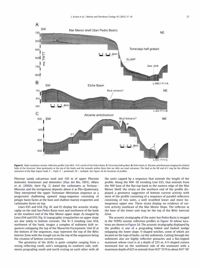
Figure 8. High-resolution seismic reflection profile (Line 063e1111) north of San Pedro Basin. A. Torrevieja half-graben. B. Elche basin. C. Alicante anticlinorium imaging the faultedfolds of the structure. Note pockmarks at the top of the faults and the mounds within them that we infer are mud volcanoes. The fault at the NE end of C may be the offshoreextension of the Bajo Segura Fault. F ¼ Fault; P ¼ pockmark; M ¼ multiple. See Figure 2A for locations of profiles.
J. Acosta et al. / Marine and Petroleum Geology 45 (2013) 17e41 27
Pliocene sandy calcareous mud and 120 m of upper Pliocenedolomitic limestones and dolomites (Díaz del Río, 1993). Alfaroet al. (2002b; their Fig. 2) dated the carbonates as TertiaryeMiocene and the terrigenous deposits above it as Plio-Quaternary.They interpreted the upper TortonianeMessinian sequence as aprogressive shallowing upward mega-sequence consisting ofpelagic basin facies at the base and shallow marine evaporites andcarbonates facies on top.
Lines 035 and 034 (Fig. 6C and D) display the acoustic stratig-raphy on the mid San Pedro Basin west and northwest of the bankat the southern end of the Mar Menor upper slope. As imaged byLines 034 and 035 (Fig. 6) topographic irregularities on upper slopeare due solely to bottom currents. The NeS trending Line 034,northwest of the bank, images a complex of sediment drift se-quences onlapping the top of the Mazarrón Escarpment. Unit IZ atthe bottom of the sequences, may represent the top of the BéticInterior Zone with the trough cut on the top of the sequences beingthe creation of bottom current erosion.
The geometry of the drifts is quite complex ranging from astrong reflecting swell, unit’s onlapping its southern side, sedi-ments prograding south and north resting on each other with all
the units capped by a sequence that extends the length of theprofile. Along the NWeSE trending Line 035, that extends fromthe NW base of the flat-top bank to the eastern edge of the MarMenor Shelf, the strata on the northern end of the profile dis-played a geometry suggestive of bottom current activity withmost of the profile consisting of a sequence of parallel reflectorsconsisting of two units, a well stratified lower and more ho-mogenous upper one. These strata display no evidence of cur-rent activity southeast of the Mar Menor Slope. The reflector atthe base of the lower unit may be the top of the Bétic InternalZone.
The acoustic stratigraphy of the outer San Pedro Basin is imagedin the TOPAS seismic reflection profiles in Figure 10 whose loca-tions are shown in Figure 2A. The acoustic stratigraphy displayed bythe profiles is one of a prograding folded and faulted wedgeonlapping the lower slope. V-shaped notches, some of which arelocated on the tops of faults, cut the sediments. Cutting through thesediments also are highly reflective pinnacles and a flat-toppedseamount whose crest is at a depth of 225 m. A V-shaped convexwestward low on the southwest side of the seamount with amaximumdepth of 625m extends fromN37�550N to about N37�500

Figure 9. High-resolution seismic reflection profiles (055e1111, 051e1111, 049e1111)of the Torrevieja Half-Graben (A), and the northwestesoutheast trending scarp east ofthe Mar Menor Slope. The scarp along lines 051 (B) and 049 (C) is the result of thecompression and plastic flow of Messinian evaporites along the fault scarp. F ¼ Faults;MTD ¼ Mass Transport Deposits; AB-B ¼ Algero-Balearic Abyssal Plain. See Figure 2Afor locations of profiles.
J. Acosta et al. / Marine and Petroleum Geology 45 (2013) 17e4128
(Figs. 2 and 10A). Sediments on the slope descending westward to alow are faulted.
The folded and faulted sediments in the outer San Pedro Basinare crossed by two northesouth trending left lateral faults and isdisrupted by four seamounts, circular depressions and intruded byigneous pinnacles of the Cogedor ridge. The faults oriented at rightangles to the master fault, the Mazarrón Escarpment, may repre-sent antithetic strike-slip faults. As there is no evidence of bottomcurrent activity in the area, we speculate that the lenticular shapeddepressions in the slope are probably due to faulting, not bottomcurrent erosion. We have no information as to the composition orage of the seamounts, which probably represent volcanic edifices.They may be correlative with the volcanic ledges in Cabo de Palos,the ledges and volcanic islands in the Mar Menor Shelf and thevolcanic islands in Mar Menor composed of calc-alkaline basalts ofLate Miocene age (López-Ruiz et al., 2002).
The pinnacles, probably of volcanic origin, cover an area of45 � 10 km and are intruded into the Plio-Quaternary sedimentary
wedge, demonstrating that they are younger than the seamounts.They are probably Quaternary in age and may be correlative witheither the pinnacles in the vicinity of the 1.46 � 0.18 my EmileBaudot Seamount south of Mallorca (Acosta et al., 2004) or thepinnacles in the area of the Columbretes Islands at 39�530N; 0�400Eon the outer shelf (Muñoz et al., 2005).
Deformation of the Holocene sediment drift by igneous intru-sion, up-doming of the seafloor by an igneous plug, pimples on theseafloor that probably represent the tops of dikes and their pristinepreservation led Muñoz et al. (2005) to infer that the dikes in theColumbretes Islands area at a depth of 80/70 m are Holocene andare younger than 13,000 years when sea level reached an elevationof 60 m below its present level.
At the intersection of some of the faults in the San Pedro Basinwith the seafloor, are circular depressions with diameters of tens ofmeters, but other depressions do not appear to be associated withthe faults. We interpret these features as pockmarks formed by theexpulsion of gas/water. Their occurrence near the volcanic edificesand their association with faults support the possibility that thepockmarks were formed by the expulsion of gases and associatedwaters along the faults from a hydrothermal field beneath thesurficial sediments. Acosta et al. (2001b) proposed such an originfor the pockmarks in the Ibiza Channel. Possibly, the faults thatserved as passageways for the gases/fluids reflect deep structures,beyond the depth penetration of our seismic profiles.
4.3. Algero-Balearic Abyssal Plain Southeast of Ibiza Channel
Lines L026 1010 and L027 1010 (Fig. 11), in the Algero-BalearicAbyssal Plain, display the acoustic stratigraphy of a circular struc-ture west of the NWeSE trending scarp. Line 026 (Fig. 11A) cutsacross the structure in an eastewest directionwith its western endterminating on the eastern flank of the NeS trending high east ofthe Mar Menor Slope. Sediments east of the circular structure aregently warped; the circular structure is a complex of intrusives (SeeSection 6.3 in Discussion for the origin of these structures) withmaximum reliefs of about 35 m (assuming a velocity of 1500 m/sec). The sediments between the structure and the NeS high east ofthe Mar Menor Slope are folded, faulted and intruded and the highconsists of reflective material that provides no information as to itsinternal structure. At its base is a narrow faulted furrow. At LineL027 (Fig. 11B) the circular structure consists of faulted tightlyfolded uplifted blocks and intervening narrow basins. A basin at thenorthwest end of the profile is divided in two by a faulted intrusivedisplaying evidence of bedding. The segment of the basin north-west of the intrusive is divided in two by an unconformity with thestrata above it being horizontal. The stratum southeast of theintrusion also is divided in two by an unconformity with the bedsabove it being horizontal. A narrow body having seafloor expres-sion intrudes the two sequences.
4.4. Mazarrón Escarpment and the adjacent oceanic Algero-Balearic Basin
The morphology displayed by the Mazarrón Escarpment westand east of the ramp at 0�300W in the Mar Menor Margin is re-flected in its composition and acoustic stratigraphy. The presence ofthe Seco de Palos Seamount along its crest suggests that, in contrastto the scarp segment west of the ramp that consists of Bétic InternalZone rocks, that east of the ramp may consists of a mixture of In-ternal Zone Bétic rocks and volcanics. A seismic line recorded byComas et al. (2000) west of the ramp on the upper part of theMazarrón Escarpment only displays an acoustic gullied unit havingacoustic basement characteristics, whereas a seismic line east ofthe ramp displays two seismic units with average thickness 150 and

Figure 10. High-resolution seismic reflection profiles (Lines SIS-5e1010) (A) and SIS-8e1010 (B) of the Mar Menor Slope (San Pedro Basin). F ¼ Faults; P ¼ Pockmarks; PI ¼ VolcanicPinnacles; V ¼ Seamount. 3D bathymetry insert shows distribution of circular depressions on the slope that we infer represent pockmarks created by the expulsion of gas/water. SeeFigure 2A for locations of profiles.
J. Acosta et al. / Marine and Petroleum Geology 45 (2013) 17e41 29
100 ms respectively. As described by Comas et al. (2000) the unitseast of the ramp (volcanics?) cover the gullies in the acousticbasement and are affected in turn by erosion and tectonism. Twolines farther down the scarp, on the uppermost continental rise, oneither side of the ramp, display those two units affected by faultingand erosion. A planar fault cutting the units west of the ramp has aseafloor relief of 300 ms (225 m; based on a velocity of l500 m/sec)and another along the west side of the spur at the base of the scarphas a relief of 600 ms (450 m).
Along Profile 051 (Fig. 9B), east of the San Pedro Basin, is a NWe
SE trending scarp that cuts across the continental rise. The scarplacks stratification throughout much of its slope. Sediments at thefoot of the scarp are faulted and folded with those at the base of thescarp displaying evidence of uplift, an uplift that is due to motionalong the scarp. Warping of sediments in the abyssal plain isprobably due to intrusion (See Section 6.3 in Discussion for the
origin of these structures), with a low between the warped sedi-ments and the uplifted sediments at the foot of the scarp beingfilled by horizontal strata. Along Line 049 (Fig. 9C), the eastern endof the scarp (SE extension of the Don Juan Fault Zone), consists of anasymmetrical hill whose steep south side is dominated by hyper-bolic echoes. Sediments at its base display an acoustic signaturesuggestive of mass wasting, beyond which the stratified sedimentsare disrupted by a faulted-furrow and are slightly warped. Alongthe gentler north side of the hill the sediments extending to near itscrest are warped and faulted. Apparently the hill is a block that istilted northward, a tilting supported by the reversal in dip on theother side of the block farther north.
The northeastesouthwest trending line TDS4-L026 (Fig. 12A) offthe NeS trending high east of the Mar Menor Slope, shows that thehigh has an irregular surface and displays acoustic basementcharacteristics. At the base of the high, at a depth of 3.5 s, is a

Figure 11. High-resolution seismic reflection profiles of the circular structure in the Algero-Balearic Abyssal Plain. Line 026e1010 (A) cuts across the center of the structure and Line027e1010 (B) cuts its southern edge. D ¼ Diapirs with cores of Messinian evaporites. Arabic numbers ¼ relief in meters of diapirs above seafloor (based on a velocity of 1500 m/sec;same velocity was used in Figures 12e16). F ¼ Faults. FU ¼ Furrow. AB-B ¼ Algero-Balearic Abyssal Plain. See Figure 2A for locations of profiles.
J. Acosta et al. / Marine and Petroleum Geology 45 (2013) 17e4130
sediment mound about 0.025 s thick. Farther south is a multi-peakintrusion, in the abyssal plain, rising 0.075 s (56 m) above theseafloor. Line 009 (Fig. 12B), trending somewhat more northerlythan line TDS4-L026 displays a pinnacle at the NE end of the profilethat could be of igneous origin. This profile also displays acoustictransparent sediment mounds at the base of the northesouth high.An acoustic transparent unit in a narrow trough separates thetransparent mound from the high. At the southwest of the profile isa faulted sequence cut by a faulted furrow.
The lines in Figure 13 image the stratigraphy of the Algero-Balearic Abyssal Plain from slightly east of 0�40E to 0�, crossingthe 50 km long northeast trending ridge extending from 0�230Eto 0�110W and an ellipsoidal structure north of the ridge. At thenorthern end of Line TR L5eL6 (Fig. 13A) the ellipsoidal struc-ture consists of two intrusives with reliefs of 35 and 40 mseparated by a syncline that has seafloor expression. The ridgeconsists of an asymmetrical intrusive with a relief of 58 m.Between the ridge and the ellipsoidal structure is a syncline thatalso has seafloor expression. Along the south side of the ridge isa rim syncline and south of it the abyssal plain sediments arewarped and disrupted by fault-controlled furrow with amaximum relief of nearly 0.025 s (18.75 m; assuming a velocityof 1500 m/sec).
One of the most enigmatic features mapped during the presentinvestigation is a zone of complex topography at the base of theMazarrón Escarpment west of the ramp at 0�300W. Lines 021 and022 in Figure 14 and lines 024 and 026 in Figure 15 are orientedNWeSE and NEeSW. The northwest end of Line 021 is the south-east end of the spur oblique to the Mazarrón Escarpment, andcrosses a channel next to the spur and a field of circular depressionssoutheast of the channel. The spur is mantled by strata dippingsoutheastward, the channels has a flat-bottom and is bordered onthe southeast by a high, which we infer is an intrusive. The lowbeyond the intrusive may be one of the circular depressions crossedby the line. To the southeast is another similar depression. Most ofLine 021 displays a somewhat irregular seafloor consisting of somehighly reflective material. The acoustic nature of the seafloor alongLine 022, located in the center on the irregular terrain, is differentfrom that in 021. The topography displayed by this profile is a chainof flat to slightly convex topped highs separated by surfaces dippingto the northeast. There is some suggestion that horizontal stratacap the highs. Southwest of this terrain is a 75m high intrusive. Theseafloor SW of the intrusive displays undulations either currentinduced or due to mass wasting.
A different type of acoustic signature is displayed by Line 026e1111 (Fig.15A). The terrain along this profile has the appearance of a

Figure 12. High-resolution seismic profiles (Lines TDS4-L026 and L009e1111) off the NortheSouth High east of the Mar Menor Slope. We infer that the acoustically transparentmounds are Mass Transport Deposits ¼ MTD; D ¼ Diapirs with cores of Messinian evaporites; F ¼ Faults; PI ¼ Volcanic Pinnacles. See Figure 2A for location of profiles.
Figure 13. High-resolution seismic reflection profiles (Lines TR L5eL6 and 031e1111) south of the Mazarrón Escarpment. (A) The asymmetrical 58 m high on the left is the 50 kmlong northeastesouthwest trending diapiric ridge south of the Mazarrón Escarpment and the structures on the left are the ellipsoid structures north of the ridge. On line 031 (B) theridge is represented by the two diapirs on the right of the profile and the diapirs and warped and faulted sediments on the left side of the profile are associated with a diapir in theform of a “T”. D ¼ Diapirs with cores of Messinian evaporites; F ¼ Faults; SY ¼ Syncline. Arabic numbers are the reliefs in meters of diapirs above seafloor. See Figure 2A for locationof profiles.
J. Acosta et al. / Marine and Petroleum Geology 45 (2013) 17e41 31

Figure 14. High-resolution seismic reflection profiles of the irregular terrain at the base of the Mazarrón Escarpment west of 0�300W. These lines (021e1111 and 022e1111) cutacross the terrain in a northwestesoutheast and northeastesouthwest direction. D ¼ Diapirs; F/TR ¼ Fault or sediment wave Trough. CH ¼ Channel. Arabic numbers are the reliefsof the structures in meters above seafloor. Features on Line 022 probably represent warped layers bound by faults or sediment waves formed by turbidity currents. We infer that themorphology imaged in these profiles is due to a massive gravitational failure of the Mazarrón Escarpment. See Figure 2A for locations of profiles.
J. Acosta et al. / Marine and Petroleum Geology 45 (2013) 17e4132
field of folds, the highest of which has a relief of 75 m. The seafloorto the NWof the highest structure is a zone dominated by low reliefhyperbolic echoes and to its SE is a zone suggestive of bottomcurrent activity or mass wasting. At the NWend of the profile is thedistal end of a fan at the base of the Mazarrón Escarpment. The 3Dbathymetry in Figure 4B indicates that these features are low reliefridges parallel to the Mazarrón escarpment, features that extend tothe ramp at 0�300W that cuts the Mazarrón Escarpment nearly intwo. Line 024e1111 extending southwestward from the base of the
Figure 15. High-resolution seismic profiles of the irregular terrain at the base of the Mazar026e1111 have led us to speculate that these features may be due either to compressiongravitational tectonics. The folded massif in Line 024e1111 probably has the same origin. Thedown-slope processes. Arabic number is relief in meters of the higher structures above sea
Mazarrón Escarpment (Fig. 15B) images the channel at the base ofthe scarp, a folded multi-peaked high along the southwest sidechannel and a high relief hummocky terrain into which are cut twopot-holes by turbidity currents.
An oblique view of the rough terrain crossed by the profiles inFigures 14 and 15 is provided by the 3D bathymetry in Figure 4B.This image illustrates the continental rise meandering channelextensions off Tiñoso, Cartagena and Palos canyons on the Mazar-rón Escarpment, the channel eroded on the spur with its tributaries
rón Escarpment at 0�300W. Their stratification and proximity of fold structures in Lineagainst the Mazarrón Escarpment, rather than the plastic flow of Messinian salt, orhummocky surface between two of the structures and the pot holes are the creations offloor. CH ¼ Channel. See Figure 2A for locations of profiles.

J. Acosta et al. / Marine and Petroleum Geology 45 (2013) 17e41 33
at its northwest end and the rough terrain cut by the channels. Thesharp change in the course of the channel off Palos Canyon fromNEeSW to EeW is due to differential erosion along the base of theMazarrón Escarpment. No evidence of intrusion is displayed by the3D within the rough east of the spur indicating that intrusion didnot play a role in the formation of the rough terrain. Two of suchfeatures only occur west of the spur. This rough terrain fronts anembayment in the Mazarrón Escarpment. Highs within the roughterrain display a complex of geometries from linear, highs with spurlike projections to short lobes. Cut into this terrain are channelextensions of the canyons on the Mazarrón Escarpment with thecourse of one the channels (Fig. 4B) being constricted by a structureparalleling the base of the Mazarrón Escarpment. Similar roughterrain also occurs along the north side of Águilas Canyon cuttingthe NW trending Palomares Escarpment that joins the MazarrónEscarpment at about 1�150W. This terrain consists of flat-top blocksseparated by steep slopes.
Line 007 (Fig.16) displays the acoustic nature of the spur obliqueto the Mazarrón Escarpment. The high is cut into three highs bychannels originating at the northwest of the spur (Fig. 4B). Thespur’s southwest segment is a flat-topped horst tilted to thenortheast whose top is mantled by strong reflecting sediments. Theother two segments of the spur are sharp peaked and display anacoustic basement signature. Rising above the surface of the abyssalplain are five intrusives, one of which rises a few meters above itssurface, and the other rise from 38 to 98 m above it. The channelsbetween them are filled with an acoustic transparent unit.
5. Seismicity
The eastern margin of the Bétic Internal Zone is one of the mostseismically active areas in the Iberian Peninsula. Historical eventshave been documented since the 1500s to present day (Silva et al.,2004). An example of such activity was the 1829 earthquake (Ms of6.3e6.9) that destroyed the town of Torrevieja (Silva et al., 2004)(Fig. 17). Seismic activity in the splay is associated with the WSWe
ENE Crevillente, WeE Bajo Segura, and the NWeNE San Miguel,Torrevieja and Guardamar faults (Alfaro et al., 2002a, 2002b, 2012).About 90 percent of the events have depths of less than 15 kmwithmost of them having magnitudes of less than 4.0 mb. Earthquakeson land display two trends, a wide band oriented NEeSW and anarrower one on the seaward extensions of the San Miguel, Tor-revieja and Guardamar faults that trend NWeSE (Fig. 17). Off SantaPola, the offshore epicenters display two orientations, northeast ofSanta Pola and ENEeWSW to EeW east of Santa Pola (Fig. 17). Thelatter trend is associated with the Tabarca-Alicante anticlineswhose folds trend in this direction. Some epicenters show clearrelationships with active structures offshore (Fig. 17) as the eastern
Figure 16. High-resolution seismic profile (007e1111) of the spur trending oblique to theF ¼ Faults. The fault on the west side of the spur is the Tiñoso fault. Arabic umbers indicat
prolongation of the blind thrusts of Tabarca and Alicante. Otherseismicity locations are associated with NWeSE transpressivestructures shown in Figure 18. According to Mauffret (2007) thesecompressive structures extend into the Elche (Alicante) basin northof Tabarca-Alicante as far north as Ibiza Channel. An event (4 ofAlfaro et al., 2002b) within the Tabarca-Alicante anticlinorium thatwe infer is on the seaward extension of the Bajo Segura fault(Fig. 17), with a magnitude of 3.8 mb and depth of 4 km, has a so-lution with an ENEeSSW trending possible plane, compatible withthe fault trends displayed in Figures 17 and 18.
Similar ENEeWSW seismicity locations also occur south ofTabarca anticlinorium in the San Pedro Basin. Several events southof the Sierra de Cartagena-La Unión also are associated with theMazarrón Escarpment indicating that the scarp is tectonicallyactive. One event, slightly north of 37�200N and slightly east of0�500W is associated with the spur oblique to the MazarrónEscarpment, further indication that this high is tectonically active.The seven events south the Sierra de Cartagena-La Unión on theMazarrón Escarpment are in the area of complex topography thatmay have been formed by gravitational tectonics and the twoevents slightlywest of 0�300Ware in the rough terrain at the base ofthe scarp suggesting that seismicity may have played some role inits formation. The other three events west of 0� are in the Algero-Balearic Abyssal Plain.
5.1. Focal mechanisms and stress inversion
Eleven focal mechanisms, calculated from Moment Tensor So-lution eMTS (Dziewonski et al., 1982; Stich et al., 2006; Rueda andMezcua, 2005), have been analyzed in order to constraint the ki-nematics and dynamics of the area, and to correlate with activefaults (Table 3 and Fig.17). Themain advantage of focal mechanismscalculated from MTS is their higher reliability, especially if double-couple components of the moment tensors are taken into account(Dziewonski and Woodhouse, 1983; Olaiz et al., 2009). Analyzedfocal mechanisms show a focal depth shallower than 15 km, andmagnitudes (Mw) between 2.7 and 4.8. Most of them are obliquemechanisms (5 compressive-strike slip and 3 extensional-strikeslip), 2 corresponds with pure strike slip and one is compressive.Five onshore focal mechanisms are located along ENE trendingfaults (i.e. Crevillente fault), one near San Miguel Fault and one inthe north of the Don Juan Fault Zone. Offshore focal mechanismsare transpressive (2), strike-slip (1) and compressive (1). A trans-pressive focal mechanism is located on the eastern continuation ofthe EeW Tabarca anticline, and the other three are located east-wards, with a NEeSW direction along the Don Juan Fault Zone(Fig. 17). These focal mechanisms are compressive and strike-sliptypes.
Mazarrón Escarpment, and showing its structural origin. CH ¼ Channel; D ¼ Diapirs;e relief of diapirs in meters above seafloor. See Figure 2A for location of profile.

Figure 17. Top: Stress inversion results obtained from the focal mechanism nodal planes (Table 3) following stress inversion method (Reches et al., 1992). Focal Mechanisms arefrom Herraiz et al. (2000). Similar results have been calculated for the total population (Left) and for offshore focal mechanisms (Right). Rose diagram shows the active faultorientations deduced for the study area from focal mechanism analysis. Bottom: Combined topographic and bathymetric map for the study area, with plotted epicenters fromInstituto Geográfico Nacional (I.G.N.) and focal mechanism (Table 3). Some active faults have been mapped, including kinematics. Black arrows indicate compression and whitearrows extension. DTM bathymetric data from this paper. BSF-Bajo Segura-Carrascoy faults; SP ¼ Santa Pola.
J. Acosta et al. / Marine and Petroleum Geology 45 (2013) 17e4134
To calculate the active stress tensor in the zone, a stress inver-sion procedure (Reches et al., 1992) has been applied to the entirepopulation of earthquakes, as well as to offshore and onshorepopulations separately (Fig. 17). In both cases the stress tensorobtained has a strike-slip regime (stress ratio of 0.35) with S1 close
to NeS and S3 EeW (S2 vertical). Under this stress regime NWeSEfaults are right-lateral strike-slip with a reverse component, andNEeSW faults move as reversewith a left lateral component. Underthese conditions the EeWearthquake concentration at the Tabarcaanticlinorium’s should act as a thrust area, supporting Alfaro et al.

Figure 18. Morpho-tectonic-seismic map of the of the region surveyed based on data collected during the present investigation supplemented by data from Alfaro et al. (2002a, 2002b), Camerlenghi et al. (2009), Gràcia et al. (2010),Jiménez-Martínez et al. (2012), López-Ruiz et al. (2002), Maillard and Mauffret (2013), Mauffret (2007), Perea et al. (2009, 2010), Silva et al. (2003, 2004) and Soria et al. (2008).
J.Acosta
etal./
Marine
andPetroleum
Geology
45(2013)
17e41
35

Table 3Focal mechanisms used to calculate stress tensors following Reches et al. (1992) procedure and plotted in Figure 17.
N Longitude Latitude Depth (km) Nodal plane 1 Nodal plane 2 Mw Source
Azimut Dip Rake Azimut Dip Rake
1 �0.2100 38.2100 8 42 66 34 297 59 152 3.7 Stich et al., 20062 �1.4900 38.1100 6 41 69 �25 141 66 �157 4.6 Stich et al., 20063 0.4600 37.9500 4 49 26 57 265 68 105 3.2 Stich et al., 20064 0.6300 38.0000 14 12 85 �13 103 77 �175 2.7 Stich et al., 20065 �1.3800 37.6700 4 335 82 �149 240 60 �8 3.2 Stich et al., 20066 �1.0800 38.1700 8 253 75 7 162 84 165 3.7 Stich et al., 20067 �0.90000 37.9500 4 298 73 113 63 28 38 3.5 Stich et al., 20068 �0.90000 38.2700 4 148 51 160 251 74 41 3.7 Stich et al., 20069 �1.16740 38.2393 10 64 85 20 332 70 175 3.6 I.G.N.10 �1.02210 38.3463 3 310 81 �155 216 66 �10 3.8 I.G.N.11 0.50770 38.0972 3 266 77 44 164 48 163 3.7 I.G.N.
J. Acosta et al. / Marine and Petroleum Geology 45 (2013) 17e4136
(2012) thesis. Mechanisms located further east are explained by themovements of NWeSE right lateral faults with a reversecomponent.
Finally the only focal mechanism located in the south lies inSierra de La Unión-Cartagena is a compressive mechanism andcompatible with the thrust front of this Sierra. No conclusive datapermit us to discriminate the current tectonic activity of theMazarrón Escarpment, but the EeW direction is compatible withright lateral movement, without excluding gravitational processes.The few earthquakes located at the Mazarrón Escarpment agreewell with the GPS displacements (Serpelloni et al., 2007; PérezPeña et al., 2010) as well as the model of Alfaro et al. (2002a;2012). All seismicity data support Alfaro’s et al. (2002b) thesis ofan actual NNWeSSE compression under a strike-slip to compres-sive stress regime at the eastern end of the Bétic System, and thatthis system extends offshore.
6. Discussion
In this section of the paper we bring together all the data on thegeomorphology and high-resolution seismic data to reconstruct thegeologic setting of the offshore extension of the Bétic System. Ourobjective is to determine whether similar or different tectonicprocesses form the onshore and offshore segments of the BéticSystem and if they are different how andwhy they are different. Weinfer that the quality acquired during this investigation allows us todo this.
The 3D bathymetry constructed frommulti-beam data recordedduring the present investigation coupled with high-resolutionTOPAS seismic reflection profiles have provided images of theAlgero-Balearic basin and adjacent margins comparable to that ofthe photogenic perception of subaerial topography and geology.The area has a complex morphology, resulting from the interactionof surface and deep processes, within a tectonic NWeSE conver-gence between Africa and Iberia. Surface processes offshoreinclude: a) the impact of Pleistocene glacially induced trans-gressions/regressions, b) present day modern currents molding thesurface of the continental shelf, b) development of large-scale fieldof pockmarks formed by the expulsion of gas/water, and c) themasswasting on the Mazarrón Escarpment caused by sediment loadingand stresses associated with the AfricaeIberia convergence. Depthprocesses including: a) the presence of an important recentvolcanism inshore and offshore, b) the extensive field of salt diapirswith their surrounding synclines in the Algero-Balearic AbyssalPlain and evaporites in the coastal basins (Riding et al., 1998), and c)a distributed deformation, including brittle and ductile structures,acting in response to the AfricaeIberia convergence, which isresponsible for the present-day seismicity.
6.1. Offshore extension of the Bétic Internal Zone
The present and previous investigations clearly demonstratethat the deformation of the onshore upper MioceneeQuaternary insoutheast Spain associated with the terminal splay of the EasternBétic Shear Zone continues offshore. This compression, driven bythe convergence of the African and Eurasian plates, for example,formed the 80 km long, 20e30 km wide Tabarca anticlinoriumnorth of Mar Menor. This tectonic deformation is also responsiblefor the extensive volcanism in the Mar Menor lagoon, shelf (IslaGrosa group and the Hormigas Islands), and San Pedro Basin(offshore extension of the coastal Murcia basin), east of Mar Menor.Volcanism is in the form of seamounts and pinnacles. Morpholog-ically the pinnacles resemble dikes off Cape Verde Islands off thewest coast of Africa (Emery and Uchupi, 1984). The volcanics anddikes in the region range in age from the Miocene to the Pleisto-cene. Seismicity is present throughout the regionwith focal depthsbeing shallower than 15 km, the magnitudes ranging between 2.7and 4.8. Most focal mechanisms belong to compressive to strike-slip stress regime. Many faults extend to the seafloor with someof them serving as passageways for the expulsion of gas/fluids andthe creation of pockmarks. These faults may be the surfaceexpression of much deeper and larger structures in the basement.Along the southern side of the Bétic Shear Zone, defined by theSierra de Cartagena-La Unión, the NWeSE trending transcurrentfaults in the coastal area are related to recent tectonic eventsinvolving strike-slip and compression. Seismic activity associatedwith the transcurrent faults that extend across the Sierra deCartagena-La Unión shelf to the Mazarrón Escarpment, is respon-sible for the Holocene mass wasting and turbidity current activityon the scarp. Seismic reflection profiles recorded on the Sierra deCartagena-La Unión Shelf also indicate that the Paleozoic, Permianand Triassic metamorphic complexes of the Internal Bétic Zone ofthe Sierra de Cartagena-La Unión extend across the shelf on thesubsurface to the Mazarrón Escarpment. Whereas the easternextension of the Bétic system has a thick MioceneeQuaternarycover, the system in the Sierra de Cartagena-La Unión Shelf is onlythin sediment veneer, so thin as to be imaged in our low energyTOPAS seismic reflection profiles. Only the western end of the shelfis the sediment thick enough so that the Bétic system is too deep tobe imaged in our profiles.
6.2. The Mazarrón Escarpment
The most prominent feature displayed by Figure 18 is the1800 m high, 7e19 km wide and 145 km long Mazarrón Escarp-ment with a gradient that ranges from 14� to 31�. Its crest rangesfrom 2400 m at its eastern end to 225 m south of the Mar Menor

J. Acosta et al. / Marine and Petroleum Geology 45 (2013) 17e41 37
Shelf, 112e149 m at 0�450e1�150W off the Sierra de Cartagena-LaUnión and 675 m at 1�240W. These depths indicate that the scarpis warped along its strike, a warping that may result from differ-ential transcurrent/transpression movement along the strike-slipfaults that are orthogonal to oblique to the scarp. This scarp,together with the Emile Baudot Escarpment to the east are firstorder morphologic features forming the boundary between twomega-structural elements of the region, the Bétic System and theoceanic Algero-Balearic Basin. It has been proposed that theAlborán microplate, forming the foundation of the Alborán Basinwest of the Algero-Balearic Basin, migrated westward along theright lateral fault Emile Baudot fault (Vegas, 1992; Acosta et al.,2001a; Fig. 1). The presence of cataclastic fine-grained brecciascomposed of slates and carbonates at its base (Fernández-Soler,2000a) suggests that the Mazarrón Escarpment also has the sameorigin. If such a migration took place along the Mazarrón Escarp-ment it is not reflected in its morphology. However, the MazarrónEscarpment is not the only transform that lacks topographic ir-regularities. The Ivory-Ghana Ridge, in the Gulf of Guinea, alongwhich South America separated from Africa, for example, also lackstopographic irregularities created by this continental separation(Emery and Uchupi, 1984).
The western end of the Mazarrón Escarpment is at 1�180Wwhere the trend of the scarp changes from EeW to NWeSE (Pal-omares Escarpment), a change marked by slumping at the base ofthe scarp. Mazarrón Escarpment rapidly loses its relief east of0�090E, but still has a height of several hundred meters at 200Ewhere it terminates abruptly along the west side of a northesouthtrending channel. Like the Emile Baudot Escarpment, there is noevidence of the Mazarrón Escarpment within the 60 km widesoutheastern approach to the Ibiza Channel. Apparently the IbizaChannel separating the Balearic Promontory from the Mar MenorMargin is a major structural discontinuity. The topography withinthis structural terrane is complex consisting of two right-lateralNW trending strike-slip faults which we have named the DonJuan Fault Zone (Fig. 17), reverse faults, anticlinoriums, seamounts,mud volcanoes, pockmarks formed by the extrusion of gases/fluidsand possibly diapirs with cores of Messinian evaporites. Possiblythe channel is the creation of a change in the direction of migrationof the Alborán plate from NEeSW, the trend of the Emile BaudotEscarpment, to EeW, the trend of the Mazarrón Escarpment.
The northwestesoutheast 10 � 20 km spur oblique to theMazarrón Escarpment at about 0�400W is bounded by high-anglenormal faults with the one on the west side of the spur, theTiñoso Fault, having a relief of 600 ms (or 450 m assuming a ve-locity of 1500m/sec; Comas et al., 2000; Marro et al., 2006). Similarfeatures at the southern end of the Emile Baudot Escarpment wereinferred by Camerlenghi et al. (2009) to be of volcanic origin.Seismic profiles (Fig. 16) indicate that the high is a horst oblique tothe scarp, and dredge samples indicate that is not volcanic. Adredge sample from the tip of the horst consisted of three roundedclasts and some coral rich-crust pieces (Fernández-Soler et al.,2000a). The lithic fragments consisted of carbonate covered bycorals that overlie orthogneiss. Fernández-Soler et al. (2000a,2000b) correlated the carbonate clasts with the Bétic InternalZone in the Cartagena area. They also stated that the only lithologycomparable to the granitoids is the isolated plutonic pebble zen-oliths in the Cabo de Gata Miocene volcanics. We have no data as tohow the spur came into existence, but is probably the consequenceof pure strike-slip or transpressive motion along the MazarrónEscarpment. Possibly the spur is a divergent splay formed by aminor change in the strike of the scarp of Mazarrón. Harding et al.(1985) has described such structures along a plate boundary whereit bends or splays. An alternative explanation for the spur and themassive collapse of the Mazarrón Escarpment east of the spur may
be due to motion along the strike-slip faults extending across theSierra de Cartagena-La Unión shelf to the crest of the scarp (Figs. 17and 18), at 0�330E.
Another possibility is that the spur is an allochthonous block,comparable to the Rio Grande del Norte off northeast Brazil (Emeryand Uchupi, 1984 and references therein), which became attachedto the Mazarrón Escarpment as the Alborán plate migratedwestwards.
The Mazarrón Escarpment displays distinct tectonics and mor-phologies features east and west of a ramp that cuts the scarpnearly in two at 0�300W (Figs. 1B and 2A). West of the ramp the topof the scarp is cut by one NW trending and one nearly EW trendingright lateral faults and one NE trending left lateral fault (Figs. 17 and18). The canyons west of the ramp also appear younger than thoseeast’s of the ramp, and their heads are located at or near the shelf’sedge. A seismic line recorded by Comas et al. (2000) west of theramp of the Mazarrón Escarpment only displays gullied unit havingacoustic basement. Another seismic reflection profile recorded byMarro et al. (2006) on the upper part of the Mazarrón Escarpmentimmediately west of the ramp images a faulted, thin, well-beddedsequence resting on acoustic faulted basement. From 1�W to thewestern edge of the survey area at 1�300W the upper part of theMazarrón Escarpment is covered by a prograding sediment wedgewhose base ranges in depth from 113 m on the east to 675m on thewest. Its surface is smooth and not cut by gullies. East of the ramp,the upper part of the Mazarrón Escarpment is cut by three parallelNE trending left-lateral faults, the Seco de Palos fault zone (Figs. 17and 18). Two of these faults extend the width of the MazarrónEscarpment. Acoustically, the scarp east of the ramp displays twoseismic units with average thickness 150 and 100 ms respectivelythat are affected by erosion and tectonism. The presence of Seco dePalos Seamount (or Palos Seamount) along the crest of the scarp,that is nearly cut in two by one of those gullies eroded along a left-lateral fault of the east of north trending Seco de Palos fault zone(see Fig. 17), indicates that part or all of the two seismic unitsconsist of volcanics. As described by Comas et al. (2000), these unitsthat cover the gullies cut in the acoustic basement that probablyrepresents the Bétic Internal Zone in the Mazarrón Escarpment.Two lines on the uppermost continental rise south of the scarp, oneither side of the ramp, display those two units affected by faultingand erosion. Such deformation also is imaged by the multi-beambathymetry and the seismic reflection profiles we recordedseaward of the Mazarrón Escarpment.
The absence of a continental rise and their more subduedtopography (Fig. 4A), suggest that the canyons east of the ramp arenot presently active. Their narrow sharp crested divides, evidenceof mass wasting at their heads and continental rise channel ex-tensions, suggest that the canyons west of the ramp at 1�060W areactive today. Such mass wasting has led to the massive collapse ofMazarrón Escarpment creating a 27 kmwide embayment centeredat 0�400W (Figs. 4B and 18). At the foot of the embayment is a 47 kmby 33 km slide deposit involving Quaternary and Late Pliocenesediments displaying a chaotic topographic geometry of ridges,faulted blocks bound by high angle faults and folded massifs thatare cut by channel extensions of the canyons on the MazarrónEscarpment (Figs. 14 and 15). If this slide is the Cartagena Slidedescribed by Comas and Ivanov (2006), then its area is much largerthan the one estimated by them. They stated that it had an area ofseveral square kilometer whereas our data suggests that it has anarea of at least 1035 km2. Both data sets confirm Woodside et al.(2000) conclusion from analyses of side-scan data indicating thattheMazarrón Escarpmentwest of the ramp centered at 0�300W, hasundergone or is undergoing massive wastage by gravitationalprocesses. We infer that the slide probably occurred as a result ofactivity along a NWeSE strike fault that can be traced across the

J. Acosta et al. / Marine and Petroleum Geology 45 (2013) 17e4138
Sierra de Cartagena-La Unión Shelf to its outer edge (Figs. 3C and17). Another massive failure also occurs in the area of ÁguilasCanyon, cut into the NW trending Palomares Escarpment (Fig. 18).This structure consists of a series of fault bound blocks in troughflanked by a flat-top high to the south and the NW trending Pal-omares Escarpment. Águilas Canyon was cut along the contactbetween the slide and the flat-top high subsequent to the slide.
Erosion of the Mazarrón Escarpment probably took place duringthree distinct episodes. The earliest was during the Messinianregression and desiccation of the Mediterranean 5.6e5.3 Ma, whensea level dropped over 2000 m in the Mediterranean Sea (Meijerand Krijgsman, 2005). It is at this time that the gullies on the MarMenor Slope and adjacent highs (Figs. 1A and 2A) were fluviallyeroded to create “badland” topography. It is at this time thatevaporites were deposited in the deep basins (Clauzon et al., 2011;García et al., 2011; Lofi et al., 2005;Maillard et al., 2006; Rouchy andCaruso, 2006; Ryan, 1978; Ryan and Cita, 1978). Possibly it was atthis time that the scarp east of the ramp was mantled by volcanicsediments, but we have no data to verify this.
During and subsequent to the Zanclean flood the upper parts ofthe canyons east of the ramp and the heads of those west of theramp from 1�060Wto thewestern edge of the survey area at 1�300Wwere buried by Plio-Quaternary sediments; possibly the canyonsimmediately west of the ramp to 1�060W remained exposed. Thescarp underwent a second cycle of erosion (Pliocene?/Early Pleis-tocene?) during which the volcanic and sediment cover on thecanyons east of the ramp was eroded.
A third erosional cycle took place during the glacially inducedregression in Late Pleistocene when sea level dropped to about120 m below its present level. This erosional cycle only affected thecanyons immediately west of the ramp; the heads of the othercanyons are too deep. The canyons east of the ramp and those westof 1�060W are inactive today, whereas those immediately west ofthe ramp to 1�060W are active and are serving as pathways forsediments onto the continental rise and abyssal plain. This differ-ence is a consequence of sedimentary processes taking place on theadjacent shelf today and recent tectonism associatedwith the faultsextending across the shelf.
The eastern Sierra de Cartagena-La Unión Shelf is covered by anextensive field of sediment waves trending obliquely to the shore,the creations of west flowing currents. The heads of the canyonsindenting the shelf are trapping some of these westward movingdetritus. With continuous accumulation, the sediments at theheads of the canyons become unstable and move down canyons tothe deep-sea, leading to mass wasting at their heads, erosion alongtheir axes, formation of channels on the continental rise and inter-channel turbiditic deposits with their undulating surfaces createdby the turbidity currents that overflow the channels. Tectonic ac-tivity along the transcurrent faults extending across the shelf to theMazarrón Escarpment also must have contributed to the masswasting and turbidity currents on the canyons. Several of theoffshore seismic events are associated with the Mazarrón Escarp-ment indicating that the scarp is tectonically active.
6.3. Salt structures
The 3D bathymetry in Figure 4A, the seismic reflection profilesin Figures 11e13 and the morpho-tectonic map in Figure 18 imagenumerous single to multiple peak structures rising 10’s of metersabove from the seafloor of the Algero-Balearic basin. Although noevaporites have been sampled in any of these structures to date(Bobrov, 2000; Fernández-Soler et al., 2000a), it is geologicallyreasonable to infer that these relief features could be related to theplastic flow of the Messinian evaporites below the Plio-Quaternarysediments. The Messinian evaporites in the westernMediterranean
consist essentially of halite, a material that can deform in a plasticmanner leading to gravity spreading and/or gliding of the halite andthe sediments above (Gaullier et al., 2010). The basin provides thegravity instability slope along which are three domains: exten-sional domain up slope, a translation domain on mid slope and acontractional domain (salt anticlines, diapirs, thrusts) down slope(Vendeville, 2005). Gaullier et al. (2010) and Maillard et al. (2003)have further pointed out that structural trends within the glidedformations mimic the trends in the formations beneath the saltdécollement. Brun and Fort (2010) stated that from a theoreticalpoint of view, gliding on any basal slope, not matter how small, ismore efficient than sediment loading in creating salt diapirism. Yetthe question remains is the gradient on an abyssal plain, probablymeasured in minutes, is too small to trigger such gliding of thesediments over the salt. According to Gaullier et al. (2010), suchtectonics slows or stops when the general slope decreases. In suchcase, gravitational salt tectonics in a structure, such as the Algero-Balearic Basin, would be restricted to its margins with the drivingforce in the center of the basin being sediment loading. Lack ofpenetration of our seismic reflection profiles makes it impossible todiscern whether the structures displayed by our profiles in theAlgero-Balearic Basin are the result of gliding caused by uplift alongthe Mazarrón Escarpment, sediment loading or regional foldingdue to the convergence of the Eurasian and African plates as pro-posed by Mauffret (2007). However, our data do indicate that thestructures have a higher concentration in the direction of theMazarrón Escarpment and diminished in number toward the cen-ter of the basin and against the scarp (Fig. 18). Thus, some of thediapirs could be due to uplift along the scarp.
Stanley et al. (1974) have demonstrated that the salt structurescontinue through Horizon M, the top of the Messinian evaporites,and that the horizon is deformed by the diapirs. Our data does showthat the diapiric structures in the Algero-Balearic Basin south of theMazarrón Escarpment are not evenly distributed through theabyssal plain and that they are separated from the escarpment by anarrow strip of undisturbed seafloor. Our data also indicate that thestructures have a higher concentration in the direction of theMazarrón Escarpment and diminished in number toward the cen-ter of the basin and against the scarp (Fig. 18).
The morphology of the salt diapirs ranges from elongate ridgestrending northeast, ellipsoid-shape with a central syncline, “Y”shaped mounds or single isolated diapirs of sub-circular shape. Thedeformed strata along the NW trending scarp in Fig. 9B and C mayrepresent salt walls formed along normal faults in the overburdenin the manner described by Jackson and Vendeville (1994). Thewalls south of the Mazarrón Escarpment may mimic structuraltrends in the layer beneath the salt as described by Gaullier et al.(1993) and Maillard et al. (2003). If these features do mimic thestructural trend of the layers beneath the salt, these trends mayrepresent divergent wrench structures associated with thetranscurrent-transpression motion along Mazarrón Escarpment asthe Alborán microplate migrated westward. According to Hardinget al. (1985) such divergent styles occur along transform systems,such as the Mazarrón Escarpment, where the displacement zonebends or splays.
Reliefs of the diapirs are from several to 75 m and the shapes oftheir crests varied from sharp peaks to rounded ones. The struc-tures occurs as individual peaks to a complex of several structuresseparated by synclines (Figs. 12 and 13). In some of the synclinesassociated with the diapirs, the dips of the folded sediments in-crease below the surface. Stanley et al. (1974) infer that this is eitherdue to an upward decrease in subsidence or a progressive increasein sedimentation. Unconformities within the synclines also indicatethat synclinal formation was episodic. Whereas, some of the syn-clinal structures have seafloor expression, in others horizontal

J. Acosta et al. / Marine and Petroleum Geology 45 (2013) 17e41 39
strata fill the synclinal lows form the abyssal plain. Stanley et al.(1974) proposed that this abrupt termination in synclinal forma-tion is due to local deposition exceeding deformation. Anticlinalstructures bounded by faults having seafloor expression also arecommonly associated with the diapirs. Warping adjacent to thefaults is probably due to drag, but Stanley et al. (1974) has pointedthat such warping could also be due to local compaction caused bythe release of interstitial fluids.
Where sedimentation and salt movement are coeval, the stratalgeometry is different from that in the Algero-Balearic Basin. In theLa Popa Basin, Mexico, for example, the rise of the El Gordo diapirinfluenced depositional patterns in the vicinity of the salt structure.A siliciclastic apron onlap and thin toward the diapir, there areprogressive unconformities proximal to the diapir, carbonate lensesoccur next to the diapir and diapiric derived metamorphic clastsoccur within the carbonate lenses (Mercer and Giles, 2005). Thecarbonate lenses are thicker next to the diapir and their depositionwas influenced by the relief of the diapir. The carbonate reefal faciesare underlain by debris lows generated by the diapiric rise thatcaused its slope to fail.
The most unusual structure mapped within the diapiric fieldduring our investigation is a circular structure west of the scarpcutting obliquely across the Algero-Balearic Abyssal Plain. Thestructure, with a diameter of 14 km, located east of the MazarrónEscarpment (Figs. 2B, 11 and 18), consists of diapirs separated byfolded and uplifted sediments (Fig. 11). The structures are locatedon a circular basement low, in a basement map compiled byMauffret (2007, his Fig. 3). Lack of penetration in our seismic pro-files makes it impossible to discern the cause of the associationbetween the basement low and the diapirs. Possibly the diapirs area reflection of the morphology of the basement around theperimeter of the depression. Possibly the faulted furrows west andnorthwest of the circular structure that circumscribe the low alsoreflect the configuration of the basement beneath the salt. Struc-tures having the same trends were formed by Maillard et al. (2003,their Fig. 9) in a physical experiment where silicone was used torepresent the halite. In their model, tilted 3�, differential compac-tion of pre-Messinian sediments over a basement step transmittedthe dormant fault controlled basement step into the evaporitescreating features comparable to the furrows 3 h later. Except intheir model the look-alike features are folds and the features inFigure 18 are horsts.
6.4. Shelf micro-topography
The shelf surface is defaced by bottom current generatedstructures; relict features formed during the Holocene trans-gression and small islands rocky ledges of volcanic origin northeastoff Cabo de Palos and the low relief Hormigas and Grosa islands.López-Ruiz et al. (2002) inferred that this volcanism is due to anincreased in the rate of convergence of the African and Eurasianplates from latest Miocene to the present. Superimposed on theshelf’s surface are linear ridges and between them a wide expenseof sediment waves oriented obliquely to shore with their steepslopes facing southeastward. We interpret those ridges as formerbarrier islands. The bars appear to consist of some strong reflectingsediment, possibly carbonates in the form of dunes, which maskthe sediments beneath them. Possibly, the stratified sedimentnorthwest of the bars represents lagoon sediments. The sedimentdrifts between the barrier islands are being formed today bysouthwest flowing current known as the Liguro-Provençal-CatalánCurrent or North Current. Some of the sediments transportedsouthward by the North Current are trapped by the eastewesttrending Torrevieja half-graben and then transported eastwardinto the deep-sea.
7. Conclusion
The seismically active southeastern Iberian continental margin,the seaward extension of the eastern end of the Bétic System, is thecreation of the convergence of the African and Eurasian plates fromLate Oligocene to the present, a convergence that has varied inintensity and direction with time. Newly acquired multi-beam ba-thymetry and high-resolution seismic reflection profiles, at a den-sity not available to date, has made possible for us to map themorpho-tectonic fabric of this margin in detail. We not only map-ped the primary geomorphic features of the southeastern Spanishmargin, but also the distribution and geometry of such secondaryfeatures as seamounts and pinnacles, pockmarks due to theexpulsion of thermogenic fluids and gases, folds and reverse andright/left lateral faults, bars formed during the Holocene trans-gression on the shelf surface east of Mar Menor, and recent sedi-ment drifts created by the southern flowing Northern Current onthe shelf. These data also provided detailed information on themorphology of the Mazarrón Escarpment separating the Bétic Zonefrom the oceanic Algero-Balearic Basin, a morphology created by acombination transcurrent faulting, turbidity current erosion andmass wasting probably triggered by recent seismic events, eventsthat are scattered throughout the margin. The sediments of theAlgero-Balearic Basin, an oceanic basin formed by the westernmigration of the Alborán plate along the Mazarrón Escarpment inMiddle Miocene, are deformed by the plastic flow of Messinianevaporites. This diapirism could be the consequence of a combi-nation of gliding of PlioceneeQuaternary sediments atopMessinianhalite, uplift along theMazarrón Escarpment, sediment loading andconvergence of the African and Eurasian plates.
Acknowledgments
We thank officers and crew of R/V Vizconde de Eza and R/VEmma Bardán (General Secretariat of the Seae SGM) for their effortduring the cruises to the Spanish southeast margin, as well asmembers of the Spanish Oceanographic Institute (IEO) whoparticipated in the various cruises. The Cartography Group SGM-TRAGSA participated in the different cruises and processed themulti-beam data. Thanks also are due to Andrew Bell, associateeditor, Agnès Maillard and an anonymous referee. Their construc-tive comments were of considerable help in revising and improvingthe manuscript. This is a contribution to Capesme and EspaceProjects, which are funded by IEO in collaboration with SGM.
Appendix A. Supplementary data
Supplementary data related to this article can be found at http://dx.doi.org/10.1016/j.marpetgeo.2013.04.005.
References
Acosta, J., Muñoz, A., Herranz, P., Palomo, C., Ballesteros, M., Vaquero, M., Uchupi, E.,2001a. Geodynamics of the Emile Baudot Escarpment and the Balearic Prom-ontory, western Mediterranean. Marine and Petroleum Geology 18, 349e369.
Acosta, J., Muñoz, A., Herranz, P., Palomo, C., Ballesteros, M., Vaquero, M., Uchupi, E.,2001b. Pockmarks in the Ibiza Channel and the western end of the BalearicPromontory (western Mediterranean) revealed by multi-beam mapping. Geo-Marine Letters 211, 123e130.
Acosta, J., Ancochea, E., Canals, M., Huertas, M.J., Uchupi, E., 2004. Early Pleistocenevolcanism in the Emile Baudot Seamount, Balearic Promontory (WesternMediterranean Sea). Marine Geology 207, 247e257.
Alfaro, P., Andreu, J.M., Delgado, J., Estévez, A., Soria, J.M., Teixid, T., 2002a. Qua-ternary deformation of the Bajo Segura blind fault (eastern Betic Cordillera,Spain) revealed by high-resolution reflection profiling. Geological Magazine139, 331e341.
Alfaro, P., Delgado, J., Estévez, A., Soria, J.M., Yébenes, A., 2002b. Onshore andoffshore compressional tectonics in the eastern Bétic Cordillera (SE Spain).Marine Geology 186, 337e349.

J. Acosta et al. / Marine and Petroleum Geology 45 (2013) 17e4140
Alfaro, P., Bartolomé, R., Borque, M.J., Estévez, A., García-Mayordomo, J., García-Tortosa, F.J., Gil, A., Gràcia, E., Lo Iacono, C., Perea, H., 2012. The Bajo Segura FaultZone: active blind thrusting in the Eastern Bétic Cordillera (SE Spain). Journal ofIberian Geology 38 (1), 271e284.
Azañón, J.M., Martínez-Martínez, J.M., Rodríguez-Fernández, J., Sánchez-Gómez, M.,Soto, J.I., BASACALB Cruise (TTR-9 Leg 3) Scientific Party, 2000. Extensionalstructures in the Mazarrón margin and onshore area (Betics, SE Spain).Geological processes on the European continental margins. In: InternationalConference and Eighth Post-Cruise Meeting of the Training-Through-ResearchProgramme. Granada, Spain, 31 Januarye3 February 2000. IntergovernmentalOceanographic Commission, p. 30. Workshop Report No. 168.
Azañón, J.M., Galindo-Zaldívar, J., García-Dueñas, V., Jabaloy, A., 2002. Alpine tec-tonics II; Betic and Balearic Islands. In: Gibbons, W., Moreno, T. (Eds.), TheGeology of Spain. The Geological Society of London, pp. 401e416.
Bobrov, A.M., 2000. The bottom of upper Messinian evaporites observed withindiapirs of the South Balearic Basin. Geological processes on the Europeancontinental margins. In: International Conference and Eight Post-CruiseMeeting of the Training-Through-Research Program Granada, Spain, 31Januarye3 February 2000. Intergovernmental Oceanographic Commission,p. 24. Workshop Report No. 168.
Bousquet, J.C., 1979. Quaternary strike-slip faults of southeastern Spain. Tectono-physics 52, 277e286.
Brun, J.P., Fort, X., 2010. The analysis of salt tectonic systems: Salt Tectonics, sedi-ments and prospectivity. In: A Research Conference Sponsored by the Petro-leum Group of the Geological Society of London and SEPM Society forSedimentary Geology, 2e22 January 2010. Burlington House, London, UK, p. 15.
Camerlenghi, A., Accettella, D., Costa, S., Lastras, G., Acosta, J., Canals, M., Wardell, N.,2009. Morphogenesis of the SW Balearic continental slope and adjacent abyssalplain, western Mediterranean Sea. International Journal Earth Sciences 98,735e750.
Clauzon, G., Suc, J.P., Gautier, F., Berger, A., Loutre, M.F., 2011. Alternate inter-pretation of the Messinian salinity crisis: controversy resolved? Geology 24,363e366.
Comas, M., Ivanov, M., 2006. The Palomares and Cartagena Margins. In: Interdis-ciplinary Geosciences Studies of the Gulf of Cadiz and Western MediterraneanBasins. IOC Technical Series No. 70. UNESCO, pp. 55e56. (English).
Comas, M., Talukder, A., Woodside, J., Volkonskaya, A., 2000. South Balearic Basin:the Palomares and Mazarrón Margins. In: Multidisciplinary Study of GeologicalProcesses on the North East Atlantic and Western Mediterranean Margins. IOCTechnical Series No. 56. UNESCO, pp. 91e95. (English).
Conesa, H.M., Jiménez-Cárceles, F.J., 2007. The Mar Menor lagoon (SE Spain): asingular natural ecosystem threatened by human activities. Marine PollutionBulletin 54, 839e849.
De Mets, C., Gordon, R.G., Argus, D.F., Stein, S., 1990. Current plate motions.Geophysical Journal International 101, 425e478.
Díaz del Río, V., 1993. Estudio Geoambiental del Mar Menor. Monografías delInstituto Español de Oceanografía 4, 223.
Duggen, S., Hoernle, K., ven den Boaggard, P., Harris, C., 2004. Magmatic evolutionof the Alborán region: the role of subduction in the forming of the westernMediterranean and causing the Messinian crisis. Earth and Planetary ScienceLetters 218, 91e108.
Duggen, S., Hoernle, K., van den Boggard, P., Garbe-Schönberg, D., 2005. Post-collisional transition from subduction to intraplate-type magmatism in thewesternmost Mediterranean: evidence from continental edge delamination ofsubcontinental lithosphere. Journal of Petrology 46, 1155e1201.
Dziewonski, A.M., Woodhouse, J.H., 1983. An experiment in the systematic study ofglobal seismicity: centroid moment-tensor solutions for 201 moderate andlarge earthquakes of 1981. Journal of Geophysical Research 88, 3247e3271.
Dziewonski, A.M., Chou, T.A., Woodhouse, J.H., 1982. Determination of earthquakesource parameters from waveform data for studies of global and regionalseismicity. Journal of Geophysical Research 86, 2825e2852.
Emery, K.O., Uchupi, E., 1984. The Geology of the Atlantic Ocean. Springer-Verlag,New York, p. 1050.
Fernández-Soler, J., Martínez-Ruiz, F., Akhmanov, G., Akhmetzhanov, A.,Stadnitskaya, A., Kozlova, E., Sautkin, A., Mazurenko, L., Ovsyannikov, D.,Sadekov, A., Belenkaya, I., Suslova, E., Goncharov, D., 2000a. South BalearicBasin: The Palomares and Mazarrón Margins. In: Bottom Sampling Results.Multidisciplinary Study of Geological Processes on the North East Atlantic andWestern Mediterranean Margins. IOC Technical Series No. 56. UNESCO, pp. 98e99. (English), Annexe I, pp. 22e25.
Fernández-Soler, J.M., Azañón, J.M., Sánchez-Gómez, M., Soto, J.I., Martínez-Martínez, J.M., BASACALB Cruise (TTR-9 Leg 3) Scientific Party, 2000b. Majorfindings on the nature of acoustic basement rocks in the Alborán and SouthBalearic basins from BASACALB cruise (TTR-9, Leg 3). Geological processes onthe European Continental Margins. In: International Conference and EighthPost-Cruise Meeting of the Training-Through-Research Programme. Granada,Spain, 31 Januarye3 February 2000. Intergovernmental Oceanographic Com-mission, p. 31. Workshop Report No. 168.
Font, J., García-Ladona, E., Gorriz, E.,1995. The seasonality of mesoscalemotion of theNorthernCurrenton thewesternMediterranean. OceanologicaActa18, 207e218.
Gallart, J., Vidal, N., Estévez, A., Pous, J., Sábat, F., Santisteban, C., Suriñach, P., theValencia Trough Group, 1995. The ESCI-Valencia Trough vertical experiment: aseismic image of the crust from the NE Iberian Peninsula to the westernMediterranean. Revista Sociedad Geológica de España 8, 405e415.
García, M., Maillard, A., Aslanian, D., Rabineau, M., Alonso, B., Gorini, C., Estrata, F.,2011. The Catalán margin during the Messinian Salinity Crisis: physiography,morphology and sedimentary record. Marine Geology 284, 158e174.
García-Mayordomo, J., Martínez-Díaz, J.J., 2006. Caracterización del Anticlinorio delBajo Segura (Alicante): fallas del Bajo Segura, Torrevieja y San Miguel de Salinas.Geogaceta 40, 19e22.
Gaullier, V., Brun, J.P., Guerin, G., Lecanu, H., 1993. Raft tectonics: the effects of re-sidual topography below a salt decollement. Tectonophysics 228 (3/4), 363e381.
Gaullier, V., Loncke, L., Vendeville, B., Obone Zue Obame, E., Déverchère, J., Droz, L.,2010. Interaction between salt tectonics and deep-seated tectonics. Part I; ex-amples from the western Mediterranean. In: Salt Tectonics, Sediments andProspectivity. A Research Conference Sponsored by the Petroleum Group of TheGeological Society of London and SEPM Society of Sedimentary Geology. Bur-lington House, London, UK, p. 84.
Gràcia, E., Bartolom, R., Lo Iacono, C., Moreno, X., Martínez-Loriente, S., Perea, H.,Masana, E., Pàllas, R., Diez, S., Dañobeitia, J., Terrinha, P., Zitellini, N., 2010.Characterizing active faults and associated mass transport deposits in the southIberian margin (Alborán Sea and Gulf of Cadiz): on-fault and off-fault paleo-seismic evidence. In: Resúmes de la 1� Reunión Sobre Fallas Activas y Paleo-sismología. Sigüenza, Spain, pp. 163e166.
Harding, T.P., Vieerbuchen, R.C., Christie-Blick, N., 1985. Structural styles, platetectonic settings, and hydrocarbon traps of divergent (transtensional) wrenchfaults. In: Biddle, K.T., Christie-Blick, N. (Eds.), Strike-Slip Deformation, andSedimentation. Soc. Econ. Paleontologists and Mineralogists Special Publication,vol. 37, pp. 51e78.
Herraiz, M., De Vicente, G., Lindo-Naupari, R., Giner, J., Simón, J.L., Gonzáles-Casado, J.M., Vadilla, O., Rodríguez-Pascua, M.A., Cicuéndez, J.I., Casas, A.,Cabañas, L., Rincón, P., Cortés, A.L., Ramírez, M., Lucini, M., 2000. The recent(upper Miocene to Quaternary) and present tectonic stress distribution in theIberia Peninsula. Tectonics 19, 762e786.
Huibregtse, P., van Alebeek, H., Zaal, M., Biermann, C., 1998. Palaeostress analysis ofthe northern Nijar and southern Vera basins: constrained for Neogenedisplacement history of major strike-slip faults in the Betic Cordilleras, SESpain. Tectonophysics 300, 79e101.
Jackson, M.P.A., Vendeville, B.C., 1994. Regional extension as a geologic trigger fordiapirism. Geological Society of America Bulletin 106, 57e73.
Jiménez-Martínez, J., Candela, L., García-Aróstegui, J.L., Aragón, R., 2012. A 3Dgeological model of the Campo de Cartagena, SE Spain: hydrological implica-tions. Geologica Acta 10 (1), 1e14.
Lofi, J., Gorini, C., Bern, S., Clauzon, G., Tadeu Dos Reis, A., Ryan, W.B.F., Stickler, M.S.,2005. Erosional processes andpaleo-environmental changes in thewesternGulf ofLions (SW France) during the Messinian Salinity Crisis. Marine Geology 217, 1e30.
López-Ruiz, J., Cebri, J.M., Doblas, M., 2002. Cenozoic volcanism I: the IberianPeninsula. In: Gibbons, W., Moreno, T. (Eds.), The Geology of Spain. TheGeological Society of London, pp. 417e438.
Maillard, A., Mauffret, A., 2013. Structure and present-day compression in theoffshore area between Alicante and Ibiza Island (Eastern Iberian Margin). Tec-tonophysics 591, 116e130.
Maillard, A., Gaullier, V., Vendeville, B.C., Odonne, F., 2003. Influence of differentialcompaction above basement steps on salt tectonics in the Ligurian-ProvençalBasin, northwest Mediterranean. Marine and Petroleum Geology 20, 13e27.
Maillard, A., Gorini, C., Mauffret, A., Sage, F., Lofi, J., Gaullier, V., 2006. Offshoreevidence of polyphase erosion of the Valencia Basin (northwestern Mediter-ranean): scenario for the Messinian Salinity Crisis. Sedimentary Geology 188e189, 69e91.
Manteca Martínez, J.I., Ovejero Zappino, G., 1992. Los Yacimientos Zn, Pb, Ag-Fe deldistrito minero de la Unión-Cartagena, Bética Oriental. In: García Guinea, J.,Martínez Frias, J. (Eds.), Recursos Minerales de España. Consejo Superior deInvestigaciones Científicas. CSIC, Madrid, pp. 1085e1101.
Marro, G., Sánchez-Gómez, M., Fernández Ibánez, F., García, M., Román-Alpiste, M.J.,Vanneste, H., Comas, M., 2006. The Cartagena Margin: Seismic Interpretation.In: Interdisciplinary Geoscience Studies of the Gulf of Cadiz and WesternMediterranean Basins. IOC Technical Series No. 70. UNESCO, p. 61. (English).
Mauffret, A., 2007. The northwestern (Maghreb) boundary of the Nubia (Africa)plate. Tectonophysics 429, 21e44.
Mauffret, A., Maldonado, A., Campillo, A., 1992. Tectonic framework of the easternAlboran and western Algerian basins (western Mediterranean). Geo-MarineLetters 12, 104e110.
Mauffret, A., Frizon de Lamotte, D., Lallemant, S., Gorni, C., Maillard, A., 2004. EeW opening of the Algerian Basin (western Mediterranean). Terra Nova 16,257e264.
MediMap Group, 2005. Morpho-bathymetry of the Mediterranean Sea. CIESM/Ifremer Special Publication, Atlases and Maps, Two Maps at 2 000 000.
Meijer, P.T., Krijgsman, W., 2005. A quantitative analysis of the desiccation and re-filling of the Mediterranean during the Messinian Salinity Crisis. Earth andPlanetary Science Letters 240, 510e520.
Mercer, D.W., Giles, K.A., 2005. Upper Cretaceous to Lower Paleogene carbonategrowth strata associated with a passive salt diapir, La Popa Basin, Mexico: anoutcrop analog to shelf salt exploration (Abstract). In: AAPG Search and Dis-covery Article #9004�2000 AAPG/EAGE International Research Conference, ElPaso Texas, October 1e5, 2000, p. 46.
Muñoz, A., Lastras, G., Ballesteros, M., Canals, M., Acosta, J., Uchupi, E., 2005. Seafloor morphology of the Ebro Shelf in the region of the Columbretres Islands,western Mediterranean. Geomorphology 72, 1e18.
J. Acosta et al. / Marine and Petroleum Geology 45 (2013) 17e41 41
Olaiz, A.J., Muñoz-Martín, A., De Vicente, G., Vegas, R., Cloetingh, S., 2009. Europeancontinuous active tectonic strainestress map. Tectonophysics 474, 33e40.
Panza, G.F., Raykova, R.B., Carminati, E., Doglioni, C., 2007. Upper mantle flow in thewestern Mediterranean. Earth and Planetary Science Letters 257, 200e214.
Perea, H., Gràcia, E., Bartolom, R., Lo Iacono, C., Masana, E., EVENT-SHELF Team,2009. Structure and potential seismogenic tsunamigenic sources of the offshoreBajo Segura Fault zone, SE Iberian Peninsula (Mediterranean Sea): preliminaryresults. Geophysical Research Abstracts 11. EGU2900-B8319, EGU General As-sembly 2009.
Perea, H., Gràcia, E., Bartolomee, R., Lo Iacono, C., Masana, E., 2010. Structure andpotential sources of the offshore Bajo Segura Fault Zone, SE Iberian Peninsula(Mediterranean Sea). Looking for the source of the 1828 Torrevieja earthquake.In: Resúmenes de la 1a Reunión Sobre Fallas activas y Paleosismologia,Sigüenza, España, pp. 113e116.
Pérez Peña, A., Martín-Dávila, J., Gárate, J., Berrocoso, M., Buforn, E., 2010. Ve-locity and tectonic strain solutions in southern Spain and the surroundingareas derived from GPS episodic measurements. Journal of Geodynamics 49,232e240.
Reches, Z., Baer, G., Hatzor, Y., 1992. Constraints on the strength of the upper crustfrom stress inversion of fault slip data. Journal of Geophysical Research 97 (B9),12481e12493.
Reicherter, K.R., Reiss, S., 2001. The Carboneras Fault Zone (southeastern Spain)revisited with Ground Penetrating Radar-Quaternary structural styles fromhigh-resolution images. Netherlands Journal of Geosciences/Geologie en Mijn-bouw 80, 129e138.
Riding, R., Braga, J.C., Martín, J.M., Sánchez-Almazo, I.M., 1998. MediterraneanMessinian Salinity Crisis: constraints from a coeval margin basin. Sorbas,southeastern Spain. Marine Geology 46, 1e20.
Robles-Arenas, V., Candela, L., 2010. Hydrological conceptual model characteriza-tion band abandoned mine site in semiarid climate. The Sierra de Cartagena-LaUnión (SE Spain). Geologica Acta 8, 235e248.
Rouchy, J.M., Caruso, A., 2006. The Messinian Salinity Crisis in the Mediterraneanbasin: a reassessment of the data and an integrated scenario. SedimentaryGeology 188e189, 35e67.
Rueda, J., Mezcua, J., 2005. Near-real-time seismic moment-tensor determination inSpain. Seismological Research Letters 76 (4), 455e465.
Ryan, W.B.F., 1978. Messinian badlands of the southeastern margin of the Medi-terranean Sea. Marine Geology 27, 349e363.
Ryan, W.B.F., Cita, M.B., 1978. The nature and distribution of the Messinian erosionalsurfaces, indicators of several kilometer-deep Mediterranean in the Miocene.Marine Geology 27, 193e230.
Sábat, F., Roca, E., Muñoz, J.A., Veregés, J., Santanach, P., Sans, M., Mansana, E.,Estébez, A., Santisteban, C., 1995. Role of extension and compression in theevolution of the eastern margin of Iberia: the ESCI-Valencia Trough seismicprofile. Revista Geológica de España 8, 431e448.
Serpelloni, E., Vannuci, G., Argnani, A., Casula, G., Anzidei, M., Baldi, P., Gsperini, P.,2007. Kinematics of the western Africa-Eurasia plate boundary from focalmechanisms and GSP data. Geophysical Journal International 169, 1180e1200.
Silva, P.G., Goy, J.L., Zazo, C., Bardaj, T., 2003. Fault-generated mountain front insoutheast Spain: geomorphologic assessment of tectonic and seismic activity.Geomorphology 50, 203e225.
Silva, P.G., Alfaro, P., Masana, E., Martínez Díaz, J.J., Bardaj, T., Estévez, A., Goy, J.L.,Santanach, P., Zazo, C., Reicherter, K.R., 2004. Active tectonics in the Mediter-ranean sector of the Iberian Peninsula (east Spain). In: 32nd InternationalGeological Congress, Florence e Italy, August 20e28, 2004, vol. 1 (B10), p. 38.
Soria, J.M., Caracuel, J.E., Corb, H., Dinarés-Turell, J., Lancis, C., Tent-Manclús, J.E.,Yébenes, A., 2008. The Bajo Segura Basin (SE Spain): implications for the Messi-nian Salinity Crisis in the Mediterranean margins. Stratigraphy 5, 257e263.
Stanley, D.J., McCoy, F.W., Diester-Haass, L., 1974. Balearic Abyssal Plain: anexample of modern basin plain deformation by salt tectonism. MarineGeology 7, 183e200.
Stich, D., Serpelloni, E., Mancilla, F.L., Morales, J., 2006. Kinematics of the Iberia-Maghreb plate contact from seismic moment tensors and GPS observations.Tectonophysics 426, 295e317.
Vegas, R., 1992. The Valencia Trough and the origin of the western Mediterraneanbasins. Tectonophysics 203, 249e261.
Vendeville, B.C., 2005. Salt tectonics driven by sediment progradation, part 1:mechanics and kinematics. American Association of Petroleum GeologistsBulletin 89, 1071e1079.
Woodside, J.M., Maldonado, A., 1992. Styles of compressional neotectonics in theeastern Alborán Sea. Geo-Marine Letters 12, 111e116.
Woodside, J., Ivanov, M., Koelewjin, R., Zeldenrust, I., Shashkin, P., 2000. SouthBalearic Basin: the Palomares and Mazarrón Margins. Sidescan Sonar Data. In:Multidisciplinary Study of Geological Processes on the North East Atlantic andWestern Mediterranean Margins. IOC Technical Series No. 56. UNESCO, pp. 95e98. (English).