Embed Size (px)
Citation preview

The Massachusetts TurnpikeThe Massachusetts Turnpike
By Jared Malise and Matt KuzmeskasBy Jared Malise and Matt Kuzmeskas

HistoryHistory
1948: Massachusetts Dept. of Public Works1948: Massachusetts Dept. of Public Worksproposed an access controlled road to connectproposed an access controlled road to connectBoston to its neighboring communities. (TheBoston to its neighboring communities. (The“Western Highway”)“Western Highway”)
1955: Construction of the initial portion of the1955: Construction of the initial portion of theturnpike begins. This portion will connect Westturnpike begins. This portion will connect WestStockbridge to Weston.Stockbridge to Weston.
1956: Federal Highway act passed. The act1956: Federal Highway act passed. The actallowed states to build highways while onlyallowed states to build highways while onlypaying 10% of the costs.paying 10% of the costs.

History Cont.History Cont.1962: A new extension, the “Boston Extension”1962: A new extension, the “Boston Extension”began constructionbegan construction
1964: The Boston Extension was completed to1964: The Boston Extension was completed toexit 18 (Allston-exit 18 (Allston-BrightonBrighton--CambridgeCambridge))
1965: The entire 135 mile length of the Mass1965: The entire 135 mile length of the MassPike opened on February 18Pike opened on February 18thth..
2003: The “Big Dig” extended the Mass Pike to2003: The “Big Dig” extended the Mass Pike toLogan Airport and Rt. 1A.Logan Airport and Rt. 1A.

Looking north from Fulton Street inthe North End in 1954
The steel highway begins to snake itsway through downtown in 1954
A view of the nearly completed Artery fromthe Custom House Tower in May 1955

138Logan Airport26
136South Boston25
134.6On and off, I-9324
133.9On, to west23
133.4Copley/Prudential22
132.9On, to west21
130.9Allston/Brighton18-20
127.7On & off, east and west17
125.2West Newton16
123.3Newton/Boston15
123.3Weston (Route 128/I-95)14
116.8Natick13
111.4Framingham12
106.2Westborough (I-495)11A
96.5Millbury/Worcester11
94.1(Route 146)10A
90.2Auburn/Worcester (I-290, I-395)10
78.5Sturbridge (I-84)9
62.8Palmer8
54.9Ludlow7
51.3Springfield (I-291)6
49Chicopee5
45.7W. Springfield (I-91)4
40.4Westfield3
10.6Lee2
2.9West Stockbridge1
Miles from NYInterchange
•The Mass Pike is anetwork diagramconsisting of 25 nodes(exits), and 24 links(sections of the highway).
•There is, however, onlyone path because it issimply one road.
•The exits are listed onthe right along with theirapproximate distancefrom the NY State Line
•Mass Pike Tolls

COMMUTER SERVICESDue to the high costs of living the Boston area and the fact thatmany people prefer to raise a family outside of the city, thereare a large number of commuters who travel to and fromBoston everyday.
Below is a map of the Mass Pike and the services available tocommuters who drive this road.
Map Key on next Page

Commuter Service Cont.Commuter Service Cont.
•The purple cars represent the Park-N-Ride lots provided to commuters. There are14 in total along Rt. 90 (the Mass Pike).
•Blue dots signify service centers. Many different services such as food and gas areavailable at these different locations.
•The black cars show where the 5 state police offices that are situated across thestate.

TourismTourism
Visitor Information CenterCharlton, Mass
The purple houses on this map represent the threevisitor information centers
•Eastbound in Charlton•Westbound in Charlton•Eastbound in Lee
The blue dots represent the service center just likethey did in the commuters map
Tourism Cont.Tourism Cont.Massachusetts' Annual Travel Volume
Total person trips 27.2 million Domestic travel 25.7 million
International travel1.5 million
Economic Impact of Travelers on Massachusetts Direct Spending $11.1 billion
State & local taxes $730.5 million Jobs supported $124,200 Wages paid $3.1 billion

Massachusetts Road MapMassachusetts Road Map

Rt. 2 vs. Mass PikeRt. 2 vs. Mass PikeRt. 2 is the otherRt. 2 is the otherviable East/West roadviable East/West roadspanning from NY tospanning from NY toBoston.Boston.Travel time on Rt. 2 isTravel time on Rt. 2 islonger for the followinglonger for the followingreasons:reasons:–– Small winding road (inSmall winding road (in
the west)the west)–– More scenicMore scenic
(Foliage/Mohawk Trail)(Foliage/Mohawk Trail)–– Etc.Etc.

Cost/Time Saving ServicesCost/Time Saving Services
The Massachusetts Turnpike AuthorityThe Massachusetts Turnpike Authorityprovide several programs to saveprovide several programs to savecommuters time and money.commuters time and money.
• Fast Lane: Fast Lane is a service available throughoutMassachusetts. Instead of stopping at tolls, a sensordetects a Fast Lane plate that is installed on yourdashboard and your credit card is automatically billedfor the toll.
Fast Lane is interoperable with theEZ-Pass System.

Cost/Time Saving Cont.Cost/Time Saving Cont.Fast Lane Carpool ProgramFast Lane Carpool Program
This program is very similar to the regular Fast Lane but with oneThis program is very similar to the regular Fast Lane but with onestipulation. Commuters can save even more money is there arestipulation. Commuters can save even more money is there areat least 3 people in their automobile.at least 3 people in their automobile.
A special transponder detects that you have a high occupancyA special transponder detects that you have a high occupancyvehicle and therefore less money is charged when passingvehicle and therefore less money is charged when passingthrough tollsthrough tolls
Children riding with their parents are considered commuters andChildren riding with their parents are considered commuters andare therefore counted towards the 3 person minimumare therefore counted towards the 3 person minimum
$12.50-$34.00 Semi-annually depending on what part of the Pike you$12.50-$34.00 Semi-annually depending on what part of the Pike youdrivedrive

Cost/Time Savings Cont.Cost/Time Savings Cont.Park-N-Ride LotsPark-N-Ride Lots(mentioned earlier)(mentioned earlier)
There are 14 of them acrossThere are 14 of them acrossthe state.the state.
These 14 lots have over 2,000These 14 lots have over 2,000parking spots availableparking spots available
They are available free on aThey are available free on afirst come-first served basis forfirst come-first served basis forthose who carpool, vanpool orthose who carpool, vanpool orboard a commercial bus serviceboard a commercial bus service
The main purpose of these areThe main purpose of these areto encourage ridesharing andto encourage ridesharing andthereby reduce trafficthereby reduce trafficcongestion and air pollutioncongestion and air pollution

Cost/Time Savings Cont.Cost/Time Savings Cont.Commercial Bus ServiceCommercial Bus Service
4 of the Park-N-Ride Lot have4 of the Park-N-Ride Lot havecommercial bus companies pickcommercial bus companies pickup commuters who do not wantup commuters who do not wantto drive.to drive.
Both Peter Pan and Both Peter Pan and GulbankianGulbankianBus Company provide rides forBus Company provide rides forcommuters from these lots.commuters from these lots.
Residential Discount for theResidential Discount for theTunnelsTunnels
Residents of East and SouthResidents of East and SouthBoston and the North End areBoston and the North End areeligible for discounts thateligible for discounts thatreduce tunnels tolls to $.40reduce tunnels tolls to $.40from $2.from $2.

Qualifications for Tunnel DiscountsQualifications for Tunnel Discounts
Residents must be traveling in their registered motor vehicle orResidents must be traveling in their registered motor vehicle ormotorcycle.motorcycle.
No business/commercial vehicles are eligible for the program. If youNo business/commercial vehicles are eligible for the program. If youhave a company car that is also for personal use, a sticker will behave a company car that is also for personal use, a sticker will beissued provided you produce documentation showing that theissued provided you produce documentation showing that thevehicle is principally garaged and insured in either East Boston,vehicle is principally garaged and insured in either East Boston,South Boston, or the North End.South Boston, or the North End.
Leased vehicles must be for private passenger use only. LeasedLeased vehicles must be for private passenger use only. Leasedvehicles used for commercial purposes are not eligible for thisvehicles used for commercial purposes are not eligible for thisprogram.program.
Vehicles that have commercial plates are not eligible for thisVehicles that have commercial plates are not eligible for thisprogram.program.
Source: http://www.masspike.com/fastlane/tmsresident.html

Central ArteryCentral Artery
Built in the 50’sBuilt in the 50’s–– Demolished 1,000 buildingsDemolished 1,000 buildings–– Displaced 20,000 from their homesDisplaced 20,000 from their homesHandles 190,000 vehicles per dayHandles 190,000 vehicles per dayNo breakdown lanesNo breakdown lanes4 times the rate of accidents compared to4 times the rate of accidents compared toother urban highwaysother urban highwaysEstimated that by 2010 it would be inEstimated that by 2010 it would be ingridlock 15-16 hours per daygridlock 15-16 hours per day
source: www.boston.com

The Big DigThe Big Dig"The Road to Hell is paved with good intentions""The Road to Hell is paved with good intentions"
The Big Dig is a 7.5 mile underground centralThe Big Dig is a 7.5 mile underground centralartery roadway through Bostonartery roadway through Boston
The Big Dig was originally proposed inThe Big Dig was originally proposed inSeptember 1983.September 1983.
Its estimated costs were $2.2 billion andIts estimated costs were $2.2 billion andestimated completion was 1995.estimated completion was 1995.
Presently it is 2004 and costs are estimated atPresently it is 2004 and costs are estimated at$14.5 billion.$14.5 billion.

Why Big Dig?Why Big Dig?
Replace theReplace thecentral arterycentral artery–– Reconnect BostonReconnect Boston
to the waterfrontto the waterfront–– Relieve congestionRelieve congestion
problemsproblems–– Beautify the cityBeautify the city

Big Dig Progress in 2004Big Dig Progress in 2004
JulyJuly: Parks along Charles, landfills, downtown: Parks along Charles, landfills, downtownJuneJune: East Boston, Airport T station, downtown: East Boston, Airport T station, downtownMayMay: Fort Point Channel, river parks, Spectacle: Fort Point Channel, river parks, SpectacleAprilApril: South to north, above and below; parks: South to north, above and below; parksMarchMarch: Demolition, Flower Show, South Bay area: Demolition, Flower Show, South Bay areaFebruaryFebruary: Demolition: south to north through: Demolition: south to north throughBostonBostonJanuaryJanuary: Demolition of the old artery - north: Demolition of the old artery - northareaarea–– Pictures available atPictures available at
http://http://www.bigdig.com/thtml/photos.htmwww.bigdig.com/thtml/photos.htm

Downtown ConstructionDowntown Construction
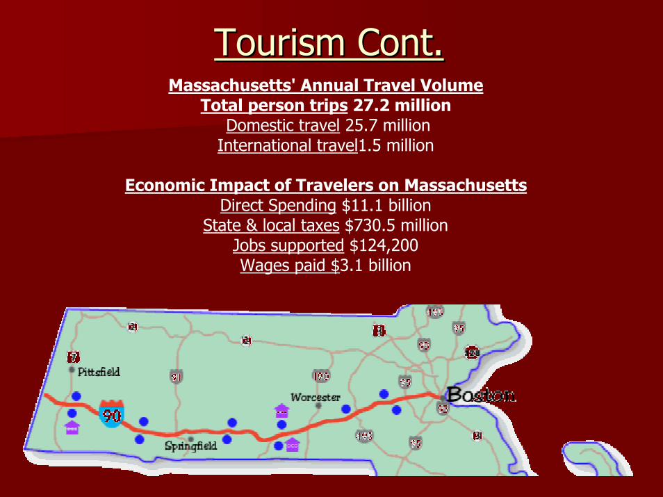
BulfinchBulfinch Triangle Area Triangle Area

DOWNTOWN

Big Dig ProblemsBig Dig Problems
LeaksLeaks
–– The Big Dig is a “Big Sieve” (Steve Leblanc AP Writer)The Big Dig is a “Big Sieve” (Steve Leblanc AP Writer)
–– ““Hundreds of leaksHundreds of leaks”: An early report stated that the walls”: An early report stated that the wallsof the tunnels are ridden with hundreds (400-500+) of leaksof the tunnels are ridden with hundreds (400-500+) of leaks
–– “Fixing the leaks could take years, cost untold millions and“Fixing the leaks could take years, cost untold millions andlead to the closing of some lanes of traffic, at least at night.”lead to the closing of some lanes of traffic, at least at night.”
–– builders may have known about serious flaws in the $14.6builders may have known about serious flaws in the $14.6billion project as early as 1997.billion project as early as 1997.
'97 report warned of tunnel problems'97 report warned of tunnel problems
Congress to hold Big Dig hearingCongress to hold Big Dig hearing
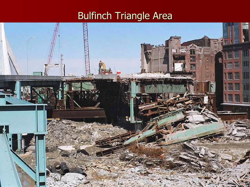
More about the leaksMore about the leaks
Nearly 1,000 leaksNearly 1,000 leakswere reported as ofwere reported as ofJanuaryJanuaryEstimate cost of $35Estimate cost of $35million to fix leaksmillion to fix leaks–– Number of leaks haveNumber of leaks have
already been cut in halfalready been cut in halfto 500to 500

Necessary Changes due to LeaksNecessary Changes due to Leaks
•“The Sumner Tunnel will bereduced to one lane through early2005.”
•“I-93 South has been reduced totwo lanes through the SouthStation tunnel”
•“Construction work will continueinside the South Station tunnel, atLeverett Circle, and in the SouthBay interchange”
Source: http://www.boston.com/news/traffic/bigdig/

THE ENDTHE END