Embed Size (px)
Citation preview

7/24/2019 The MapInfo Professional Journal Intro
http://slidepdf.com/reader/full/the-mapinfo-professional-journal-intro 1/2
(c) 2012 Pitney Bowes Software
Every connection is a new opportunity™
The MapInfo Professional
Introducing “The MapInfo Professional”
A journal full of Tips, tricks and advice for MapInfo Professional Users!
“The MapInfo Professional” is an online monthly journal designed to help MapInfo Professional users get the most
from the software. The following are examples of what you can expect if you sign up to receive the journal.
To be added to the e-mail list to receive this survey, please visit our Web site here:
http://www.pbsoftware.eu/miprosignup
Tom Probert, Editor
Easy tip - Check out the free video tutorials!The first tip we want to share is a link to a whole host of video tutorials. So
don’t think of it as just one tip but a link to a lot of help to learn how to use
different aspects of MapInfo Professional.
Tutorials are available in English, French, German and Spanish
http:// www.pbinsight.com/miprotutorials
Rummaging in the Toolbox ...
Find the tools to help you do more!
Did you know that MapInfo Professional includes a host of tools and utilities
to help you to get more done? To find these, click on Tools > Tool Manager.
In each full issue of the journal, we will highlight one of the tools or utilities in
detail.
The Tool Manager is accessed from the Tools menu in MI Pro.
Featured Link:
Each issue of the journal will
include one or more afeatured links to a useful
resource.
Sign up to receive “The
MapInfo Professional”
http://www.pbsoftware.eu/
miprosignup
It is quick and easy! We only ask
you for basic contact details and
this list will only be used for
sending out the journal.
Quick Tip
In the map window, if you are
using the cross-hair cursor (such
as with the ‘Info’ tool, you can
switch between 3 different
cusrsor styles. Press the “x” key
on the keyboard.
Subscribe
Now!
7/24/2019 The MapInfo Professional Journal Intro
http://slidepdf.com/reader/full/the-mapinfo-professional-journal-intro 2/2
(c) 2012 Pitney Bowes Software
Every connection is a new opportunity™
The MapInfo Professional
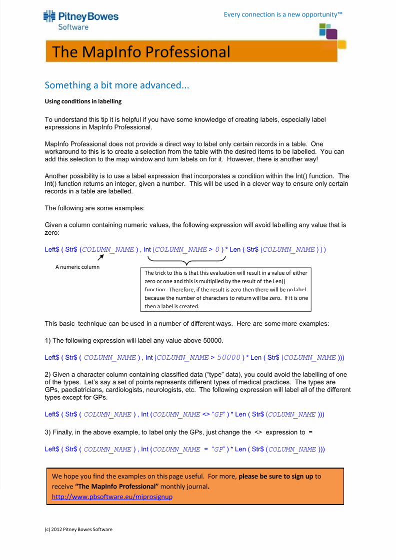
Something a bit more advanced...
Using conditions in labelling
To understand this tip it is helpful if you have some knowledge of creating labels, especially labelexpressions in MapInfo Professional.
MapInfo Professional does not provide a direct way to label only certain records in a table. Oneworkaround to this is to create a selection from the table with the desired items to be labelled. You canadd this selection to the map window and turn labels on for it. However, there is another way!
Another possibility is to use a label expression that incorporates a condition within the Int() function. TheInt() function returns an integer, given a number. This will be used in a clever way to ensure only certainrecords in a table are labelled.
The following are some examples:
Given a column containing numeric values, the following expression will avoid labelling any value that iszero:
Left$ ( Str$ (COLUMN_NAME ) , Int (COLUMN_NAME > 0 ) * Len ( Str$ (COLUMN_NAME ) ) )
This basic technique can be used in a number of different ways. Here are some more examples:
1) The following expression will label any value above 50000.
Left$ ( Str$ ( COLUMN_NAME ) , Int (COLUMN_NAME > 50000 ) * Len ( Str$ (COLUMN_NAME )))
2) Given a character column containing classified data (“type” data), you could avoid the labelling of oneof the types. Let’s say a set of points represents different types of medical practices. The types are
GPs, paediatricians, cardiologists, neurologists, etc. The following expression will label all of the differenttypes except for GPs.
Left$ ( Str$ ( COLUMN_NAME ) , Int (COLUMN_NAME <> “GP ” ) * Len ( Str$ (COLUMN_NAME )))
3) Finally, in the above example, to label only the GPs, just change the <> expression to =
Left$ ( Str$ ( COLUMN_NAME ) , Int (COLUMN_NAME = “GP ” ) * Len ( Str$ (COLUMN_NAME )))
The trick to this is that this evaluation will result in a value of either
zero or one and this is multiplied by the result of the Len()
function. Therefore, if the result is zero then there will be no label
because the number of characters to return will be zero. If it is one
then a label is created.
A numeric column
We hope you find the examples on this page useful. For more, please be sure to sign up to
receive “The MapInfo Professional” monthly journal.
http://www.pbsoftware.eu/miprosignup