Embed Size (px)
Citation preview

33 IGC excursion No 34, August 14 – 23, 2008
The Late Pleistocene interglacial, late glacial landforms and Holocene
neotectonics of the Kola Peninsula Organizers: Vasili Kolka, Olga Korsakova, Svetlana Nikolaeva & Vladimir Yevzerov,
Geological Institute of the Kola Science Centre Russian Academy of Sciences, Apatity, Russia.
2
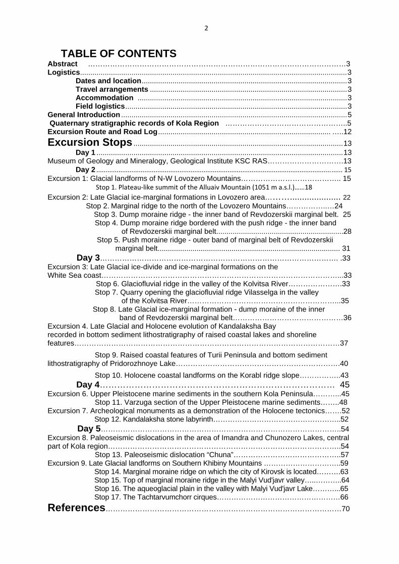
TABLE OF CONTENTS Abstract ……………………………………………………………………………………………3 Logistics..................................................................................................................................3
Dates and location....................................................................................................3 Travel arrangements ................................................................................................3 Accommodation ......................................................................................................3 Field logistics............................................................................................................3
General Introduction ..............................................................................................................5 Quaternary stratigraphic records of Kola Region …………………………………………..5 Excursion Route and Road Log .................................................................................... …..12 Excursion Stops ......................................................................................................13
Day 1 ........................................................................................................................13 Museum of Geology and Mineralogy, Geological Institute KSC RAS………………………….13
Day 2 ..................................................................................................................................... 15 Excursion 1: Glacial landforms of N-W Lovozero Mountains………………………………….. 15
Stop 1. Plateau‐like summit of the Alluaiv Mountain (1051 m a.s.l.)……18 Excursion 2: Late Glacial ice-marginal formations in Lovozero area………..................... 22 Stop 2. Marginal ridge to the north of the Lovozero Mountains……………..…24 Stop 3. Dump moraine ridge - the inner band of Revdozerskii marginal belt. 25 Stop 4. Dump moraine ridge bordered with the push ridge - the inner band of Revdozerskii marginal belt..............................................................28 Stop 5. Push moraine ridge - outer band of marginal belt of Revdozerskii marginal belt......................................................................................... 31 Day 3……………………………………………………………………………………. .33 Excursion 3: Late Glacial ice-divide and ice-marginal formations on the White Sea coast……………………………………………………………………………………...33
Stop 6. Glaciofluvial ridge in the valley of the Kolvitsa River………………….33 Stop 7. Quarry opening the glaciofluvial ridge Vilasselga in the valley of the Kolvitsa River……………………………………………………...35 Stop 8. Late Glacial ice-marginal formation - dump moraine of the inner band of Revdozerskii marginal belt………………………………………36 Excursion 4. Late Glacial and Holocene evolution of Kandalaksha Bay recorded in bottom sediment lithostratigraphy of raised coastal lakes and shoreline features………………………………………………………………………………………………37 Stop 9. Raised coastal features of Turii Peninsula and bottom sediment lithostratigraphy of Pridorozhnoye Lake………………………………………………………….40 Stop 10. Holocene coastal landforms on the Korabl ridge slope……………..43 Day 4……………………………………………………………………… 45 Excursion 6. Upper Pleistocene marine sediments in the southern Kola Peninsula………...45 Stop 11. Varzuga section of the Upper Pleistocene marine sediments……..48 Excursion 7. Archeological monuments as a demonstration of the Holocene tectonics…….52 Stop 12. Kandalaksha stone labyrinth……………………………………………..52 Day 5……………………………………………………………………………………..54 Excursion 8. Paleoseismic dislocations in the area of Imandra and Chunozero Lakes, central part of Kola region…………………………………………………………………………………..54 Stop 13. Paleoseismic dislocation “Chuna”……………………………………..57 Excursion 9. Late Glacial landforms on Southern Khibiny Mountains …………………………..59 Stop 14. Marginal moraine ridge on which the city of Kirovsk is located……….63 Stop 15. Top of marginal moraine ridge in the Malyi Vud'javr valley…..………..64 Stop 16. The aqueoglacial plain in the valley with Malyi Vud'javr Lake………...65 Stop 17. The Tachtarvumchorr cirques……………………………………………66 References……………………………………………………………………………………70
3
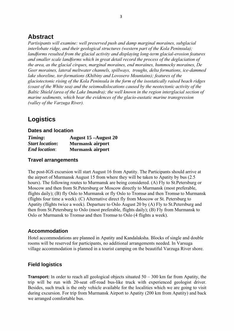
Abstract Partisipants will examine: well preserved push and damp marginal moraines, subglacial interlobate ridge, and their geological structures (western part of the Kola Peninsula); landforms resulted from the glacial activity and displaying long-term glacial-erosion features and smaller scale landforms which in great detail record the process of the deglaciation of the area, as the glacial cirques, marginal moraines, end moraines, hummocky moraines, De Geer moraines, lateral meltwater channels, spillways, troughs, delta formations, ice-dammed lake shoreline, tor-formations (Khibiny and Lovosero Mountains); features of the glaciotectonic rising of the Kola Peninsula in the form of the isostatically raised beach ridges (coast of the White sea) and the seismodislocations caused by the neotectonic activity of the Baltic Shield (area of the Lake Imandra); the well known in the region interglacial section of marine sediments, which bear the evidences of the glacio-eustatic marine transgression (valley of the Varzuga River).
Logistics Dates and location Timing: August 15 –August 20 Start location: Murmansk airport End location: Murmansk airport
Travel arrangements
The post-IGS excursion will start August 16 from Apatity. The Participants should arrive at the airport of Murmansk August 15 from where they will be taken to Apatity by bus (2.5 hours). The following routes to Murmansk are being considered. (A) Fly to St.Petersburg or Moscow and then from St.Petersburg or Moscow directly to Murmansk (most preferable, flights daily); (B) fly Oslo to Murmansk or fly Oslo to Tromsø and then Tromsø to Murmansk (flights four time a week). (C) Alternative direct fly from Moscow or St. Petersburg to Apatity (flights twice a week). Departure to Oslo August 20 by (A) Fly to St.Petersburg and then from St.Petersburg to Oslo (most preferable, flights daily); (B) Fly from Murmansk to Oslo or Murmansk to Tromsø and then Tromsø to Oslo (4 flights a week).
Accommodation Hotel accommodations are planned in Apatity and Kandalaksha. Blocks of single and double rooms will be reserved for participants, no additional arrangements needed. In Varsuga village accommodation is planned in a tourist camping on the beautiful Varzuga River shore.
Field logistics
Transport: In order to reach all geological objects situated 50 – 300 km far from Apatity, the trip will be run with 20-seat off-road bus-like truck with experienced geologist driver. Besides, such truck is the only vehicle available for the localities which we are going to visit during excursion. For trip from Murmansk Airport to Apatity (200 km from Apatity) and back we arranged comfortable bus.
4
Breakfast and dinner are usually associated with overnight accommodation. Lunches are planned in the nice outcrops in the field and trip organizers will prepare all necessary lunch materials. Weather: Kola Peninsula is situated at the latitude of 68 degrees N behind the polar circle. Besides, Khibina and Lovozero massifs occupy mountainous area up to 1200 m above sea level. Because of these two factors temperature during excursion may vary dramatically from +25oC near the Apatity town down to +10 oC at the top of the mountains. Weather in the middle of August on White Sea shore is usually mild and cloudy. Rains are quite often.
5
General introduction
Kola Peninsula is a key area for understanding of the glaciations evolution, especially at their final stages, of the development of glacioisostatic, eustatic and tectonic events during the Late Glacial and Interglacial time, and the character of interaction between the Ice Sheet and local mountain glaciations in high latitudes conditions. During the field trip we will examine: well preserved push and damp marginal moraines, subglacial interlobate ridge, and their geological structures (western part of the Kola Peninsula); landforms resulted from the glacial activity and displaying long-term glacial-erosion features and smaller scale landforms which in great detail record the process of the deglaciation of the area, as the glacial cirques, marginal moraines, end moraines, hummocky moraines, De Geer moraines, lateral meltwater channels, spillways, troughs, delta formations, ice-dammed lake shoreline, tor-formations (Khibiny and Lovosero Mountains); features of the glaciotectonic rising of the Kola Peninsula in the form of the isostatically raised beach ridges (coast of the White sea) and the seismodislocations caused by the neotectonic activity of the Baltic Shield (area of the Imandra Lake); the well known in region interglacial section of marine sediments, which bear the evidences of the glacio-eustatic marine transgression (valley of the Varzuga River).
Quaternary stratigraphic records of Kola Region Geological chronicle of the formation of unconsolidated cover on the Kola region begins with the Moscowian (Saalian) glacial horizon. It is overlaid by the Mikulinian (Eemian) Interglacial horizon and the Valdaian (Weichselian) glacial superhorizon. Moscowian (Saalian) glacial horizon (QBIIBms, MIS 6) Moscowian tills and melt-water deposits (gIIms, fIIms, lgIIms, gmIIms) overlie the basement rocks and eluvium and are located in the deepest depressions of the pre-glaciation relief and river valleys. They are found by same researchers in various times (Armand et al., 1969; Yevzerov, Koshechkin, 1980; Semjonova, 1998; Korsakova et al., 2004; and another) on western and central parts of Kola region (on the northeastern slopes of the Pechenga Tundra, in the area of the Kovdor alkaline-ultrabasic massif and Umbozero Lake), on the South and Northeast Kola Peninsula within the Terskii Coast of White Sea (at the lower parts of the Kamenka, Strel'na, Chapoma, Ust-Pyalka, Ponoi rivers, and at the valley of the Iokanga river and at the head part of the Svyatoj Nos Bay). There is an opinion (Armand et al., 1969), that in these cases the formation of the Moscowian (Saalian) Glaciation’ till came to the end in marine basin under the Dryas-like conditions (according to paleontological data). Judging from petrographic composition of the detrital material from the till horizon of the Moscowian (Saalian) Glaciation, ice flows moved towards the north-east in the north-western part of the region, and towards the south-east in the area of Kovdor massif and southern coast of the Kola Peninsula (Geology ..., 1995). Moskowian (Saalian) Glacial Horizon is overlaied by the Mikulinian (Eemian) or the Valdaian (Weichselian) Horizons in the all known sections.

6
Mikulinian (Eemian) Interglacial Horizon (QBIIIBmk, MIS 5e) The Mikulinian (Eemian) Interglacial sediments are revealed in the peripheral parts of the Kola Peninsula and confined to the valleys of the rivers in the southern, eastern and north-eastern coast. In the central part of the region, the sediments of the Mikulinian Interglacial were found only in one place. The marine sediments of that time in the Kola region are known as the Ponoi beds (mIIIpn) in Russian scientific publications. This unit, which is composed of compact clays, loams, sandy loams, and fine-grained sands of the littoral and sublittoral zones, crops out in the lower parts of the examined sections along the Varzuga, Strel'na, Chapoma, Ponoi, Kachkovka rivers, and at the front part of the Svyatoj Nos Bay. Paleoecological reconstructions (Lavrova, 1960, Grave et al., 1969, Gudina, Yevzerov, 1981) demonstrate that the sea basin, where these sediments accumulated, was characterized by a more favorable environment as compared with the modern one. The water salinity was close to the normal one, and its temperature was higher than that of the present-day White Sea, which is typical of the first optimum of the Mikulinian (Eemian) Interglacial and correlated presently with oxygen isotope substage (OISS) 5e. All the data unambiguously indicate the Mikulinian age of the Ponoi Beds, which accumulated during the Boreal transgression. The upper sea limit reached near 150 m a.s.l. at the time of a climatic optimum. The sea occupied a considerable area within the continent. The Barents Sea and the White Sea were connected by numerous straits. The Atlantic warm waters freely penetrated into the White Sea, where the boreal and boreal-lusitanian species of marine organisms started to extend. The ESR/OSL-age of the Ponoi Beds ranges from approximately 120--130 to 100--105 ka (Korsakova et al., 2004). The lacustrine and peat interglacial sediments are confined to the depressions of the basement relief in the stable tectonic areas of the central part of the Kola region. They were found on the northern slopes of the Lovozero Tundras. Most of the interglacial sections are confined to the areas of weak tectonic activity typical of the eastern Baltic Shield. The present-day absolute elevation of the roof varies from several meters up to 140 -150 m a.s.l. for the marine interglacial deposits, and reaches 210 m a.s.l. for the continental interglacial deposits. Podporozh'e (Early-Middle Weichselian) Glacial Horizon (QBIIIBpd, MIS 5d – MIS 4) The Podporozh'e horizon is credibly dated. Its position in the regional stratigraphy, the timing and the geological volume are still disputable (Semjonova, 1998, Yevzerov, Nikolaeva, 2000, Korsakova et al., 2004). At present the Podporozh'e horizon combines marine (mIIIst), glacial (gIIIpd), glaciomarine (gmIIIpd), glaciofluvial (fIIIpd), glaciolacustrine (lIIIpd) sediments of the Early-Middle Valdaian (Early-Middle Weichselian) age. The marine deposits (in Russian scientific publications known as the Strel'na beds (mIIIst)) are mainly represented by marine and subsaline sediments of the up to 30-35 m thick littoral and sublittoral zones. Strel'na beds are composed of loams and sandy loams with mollusk shells, pebbles, boulders, and of fine- to medium-grained sands with lenses of coarse-grained varieties. The bedding conditions and structural--textural features of these marine sequences,

7
ESR-age of subfossil mollusk shells, and OSL-age of host sediments (Korsakova et al., 2004) imply that they formed during low-amplitude transgression, interrupted by short-term regressions and erosion during interstadial coolings, and followed the Boreal transgression. This transgression is named Belomorian by M.A. Lavrova (1960) and Strel’nitskaya by V.Ya. Yevzerov (Gudina, Yevzerov, 1973). The early Valdaian sea appeared not earlier than 100--80 ka in the southern Kola Peninsula. Paleontological remains enclosed in these sediments indicate ecological conditions close to the modern one or colder (Grave at el., 1969, Lavrova, 1960). The lower part of the Strel'na Beds composed of compact loam with abundant mollusk shells is exposed under glaciofluvial sands near the water level of the Chavan'ga River at the altitude of 29 masl or lower. The Strel'na Beds (loams and sandy loams with mollusk shells, pebbles, boulders, and fine- to medium-grained sands with lenses of coarse-grained varieties) sandwiched between glacial sediments are observed at 42--52 masl near the Ludyanoi Creek mouth. Similar sediments are also recorded along the Varzuga and Chapoma river valleys, where they overlie the eroded surface of the Ponoi Beds. However, Yezerov (2006) considers that in the Kola region as well as in the Arkhangelsk area (Grøsfjield et al., 2006; Jensen et al., 2006) two independent transgressions (Yevzerov, 2006) took place. One of them concerns to Miculinian interglacial (MIS 5e). The second transgression in the Kola region in accordance with the palinological characteristic is carried to the Early Valday (MIS 5a), and in the Arkhangelsk area according to OSL-dating only is carried - to the Middle Valday (Jensen et al., 2006).
The deposits of the glacial paragenetic series of Podporozh'e horizon (till; glaciofluvial, glaciolacustrine, glaciomarine sand, clay, gravel, etc.) were revealed by studying boreholes and shafts in the central (Grave et al., 1964), south-western (Biske, 1959), north-western (Nikonov, 1964), and western (Yevzerov, Koshechkin, 1980) parts of the Kola region. The till (gIIIpd) is represented by rubble sandy loam and loam in the Western Kola region. Glaciofluvial sediments, such as inequigranular sand and sandy loam are known in the Kovdor area. The fixed thickness ranges from 1-2 to 22 m. Natural exposures of the deposits that can be related to the Podporozh'e glacial horizon have been established on the Terskii Coast of the White Sea (Gudina, Yevzerov, 1973, Korsakova et al., 2004). It is the till (boulder loam, (gIIIpd)) in the Kamenka section, probably glaciomarine (gmIIIpd) boulder sandy loam and sand in the Bol'shaya Kumzhevaya section, glaciofluvial (fIIIpd) and glaciolacustrine (lgIIIpd) sand and sandy loam in the Chavan'ga section. For the present, the available data are not enough to reconstruct the limits of the distribution of the Early – Middle Valdaian (Weichselian) glacier in the entire area of the Kola region. There is an opinion (Yevzerov, Koshechkin, 1980) that the Early Weichselian ice sheet, advancing to the Kola region from the west, assimilated mountain glaciers in the western and central parts of the Kola region. The ice flow occurred north-east and south- east of the ice divide zone. The ice divide zone stretched in sublatitudinal direction from the Lotta river head to the northern foothills Chibiny and Lovozero Mnts. According to computer modeling made by Swedish and American researchers, the eastern part of the Kola Peninsula was free of ice of the Scandinavian center until approximately 70 ka (Näslund et al., 2003). The formation of the Podporozh'e glacial horizon in these areas was likely related to the development of the Kara glacier rather than the Scandinavian glacier, in this area during the early Pleniglacial (OIS 4). This assumption is indirectly supported by
8
findings of carbonate rock pebbles and boulders that are unknown in the Kola Peninsula but typical of the Paleozoic rocks in the northern Russian Platform (Zozulya et al., 2004). The Podporozh'e horizon overlies the marine and continental sediments of the Mikulinian (Eemian) Interglacial or the Moscowian (Saalian) till or basement crystalline rocks. Leningrad (Middle Weichselian) Interstadial Horizon (QBIIIBln, MIS 3) The deposits of Leningrad Interstadial horizon are known in the central part of the Kola region from Imandra Lake to Pana Tundra, outcropped in more than ten localities (Lavrova, 1960, Grave et al., 1964, Armand et al, 1969, ets.), in the south-western Murmansk region (Armand, 1969), in the Terskii Coast of the White Sea (Gudina, Yevzerov, 1981, Korsakova et al., 2004). As a rule, these deposits are placed between two horizons of Valdaian (Weichselian) sediments of glacial paragenetic series. They are represented by 2-20-m thick glaciolacustrine (lgIIIln) and melt-water (fIIIln) sediments (sandy loam, loam, inequigranular sand with pebble and boulder) in the central part of the Peninsula (Armand et al., 1969), and by marine (mIIIln), interstadial sediments (mainly by clay, loam, sandy loam with subfossil mollusk shells and other fossil remnants) with the thickness of 1 m and less in the area of the Kandalaksha Gulf (Armand et al., 1969; Armand, 1969) and of 2-6 m in the Terskii Coast (Korsakova et al., 2004). The latter ones were dated using the ESR- and OSL-methods, which made it possible to specify the geological--stratigraphic position of the interstadial marine sedimentary units. The obtained geochronological data (approximately 44 and 58 ka) indicate its Middle Pleniglacial age (MIS 3). There is an opinion (Yevzerov, Koshechkin, 1980) that the Valdaian (Weichselian) glacial superhorizon combines sediments of two stages of the glaciation separated by interstadial deposits. The first stage of the Scandinavian sheet glaciation took place in Early Valdaian (Weichselian) and corresponds to the MIS 5b, the second one – in Early (partly), Middle and Late Valdaian (Weichselian) (MIS 2-4). The interstadial warming corresponds to Early Valdaian (Weichselian) (MIS 5a) and in the Kola region the Middle Valdaian (Weichselian) interstadial deposits (MIS 3) are not found between horizons of the Scandinavian glaciation tills as is in the case in northern Finland (Helmens et al., 2000). Ostashkovian (Late Weichselian) Glacial Horizon (QBIIIBos, MIS 2) The last glaciation tills and melt-water sediments are the most common in the region. They are absent only in the Keivy Mnts. (eastern Kola Peninsula), and at the summits of the mountains and uplands in the central and western parts of the region. In most cases they form top-section rocks and are rarely overlain by latest lacustrine peat-bog, marine and deluvial deposits. Till is composed of the diamicton (rubbly silty sands, rubbly sandy loam and loam). The tills (gIIIos, gaIIIos, gkIIIos) of the Kola region are distinguished by the higher content of sandy fraction in all the facial varieties. The thickness ranges from tens of centimetres to 30 m (Armand et al., 1969). The glaciofluvial (fIIIos), glaciolacustrine (lgIIIos) deposits are throughout confined to the tills of the last glacier. The glaciolacustrine deposits are represented by varved clay, loam, sandy loam and sand, and the glaciofluvial deposits are represented by inequigranular sand, gravel and rubbly pebble-bed. Presently, there are three viewpoints on the evolution of the last glaciation and deglaciation in the region. According to the first viewpoint the Kola region experienced the Scandinavian ice-sheet composed of two flows and numerous lobes. During the late-glacial time the
9
independent low active Ponoi Glacier existed in the eastern Kola Peninsula (Lavrova, 1960; Strelkov, 1976; Yevzerov, 1990). The Late Valdaian (Weichselian) Scandinavian Glacier moved from the west conformably to the relief of the basement and was broken down into two ice flows - Barents and Belomorian. The local glaciers and an independent ice dome in the Keivy Mnts. formed in the western, central and eastern parts of the Kola in the course of continental ice expansion. The local glaciers were assimilated by the Scandinavian ice-sheet and became active again during the deglaciation of the area. According to the overall gradient of the surface, the above-mentioned ice flows extended to the north-east and south-east. The Belomorian flow was split into the Belomorian depression complicated Khibina-Kolvitza and Umbozero lobes. The most active Belomorian lobe of the Belomorian flow occupied the sea basin and reached the White Sea Throat (Strelkov et al., 1976, Yevzerov, 1990). The front of the Khibina-Kolvitza lobe was placed in the lower streams of the Strel'na River. It was clamped between the Belomorian lobe and the Ponoi Glacier and was of low activity. The Umbozero lobe was also of low activity because of the same reason (Yevzerov, 1990). The Barents flow dipped into the sea shelf (Samoylovich, Kostin, 1992), and as the Belomorian one, came in contact with the Ponoi ice-sheet. According to the next view point, the Barents Sea ice-sheet invaded the Kola Peninsula from north in the Late Valdaian (Grosswald, Hughes, 2002). The theory has not been approved. The third approach suggests the occurrence of only the Scandinavian ice-sheet, invaded by the two flows. There was no Ponoi Ice Cap in late glacial time (Yevzerov, Nikolaeva, 2000, Hättestrand et al., 2003). The evolution of the glacial flows and lobes resulted in the generation of the marginal forms. The multiple marginal forms have been distinguished. Four generation of end moraines (terminal and recessional moraines) are distinguished in the Kola region (Yevzerov, Nikolaeva, 2000). At the last glacial maximum time (16-17 ka) the ice sheet covered the Kola Peninsula. The ice thickness amounted at 2500 m. The degradation stages of the Scandinavian ice sheet have been correlated to the Late Glacial climatic cycles in the Kola region. Extensive peripheral covers were cut off the active glacier and thick glaciofluvial deposits accumulated in the periglacial basins during the interstadial warmings. The glacier deformed the glaciofluvial deposits and built mainly push moraine ridges advancing during the interstadial coolings. Thus, each marginal belt formed during the interstadial-stadial cycle of the glacier activity and was made up of two bands of marginal ridges: the inner band - dump moraine (marginal esker), and the outer band - push moraine (Yevzerov, Nikolaeva, 2000). The formation of three outer bands of marginal ridges corresponds to the three final stages (Oldest, Older and Younger Dryas) of the glacier activity in the Kola region: Terskaya (13,5 ka), Revdozerskaya (12,5 ka), Kandalakshskaya (10--11 ka). The total reduction of the glacier and its melting (i.e. the beginning of the deglaciation on the Kola region) is related to the glacier retreat from the marginal forms of Terskaya stage. Of note, the late glacial age of such forms is doubtful according to the recent studies. This ice marginal system, the Keiva moraine complex, has been formed before the ice sheet reached the thickness and extent that it could overrun the whole Kola Peninsula, which probably was during a time near the Late Glacial Maximum. Hence, it appears that the Keiva moraine is a pre-LGM feature (Hättestrand, Clark; in press).
10
The termination of the deglaciation is related to the ice extinction in the western part of the region, about 9500 BP. Around 9500 years BP glaciomarine sediments were replaced by marine deposits in the Pechenga River valley (Bakhmutov et al., 1994). The Holocene (QBIVB, MIS 1) The Holocene sediments are everywhere represented by marine, lacustrine, alluvial, eluvial-deluvial, peaty and bog deposits, and by diatomite.

11
Fig. 1. Quaternary deposits of the Kola region (extract from Niemelä et al., 1993)
12
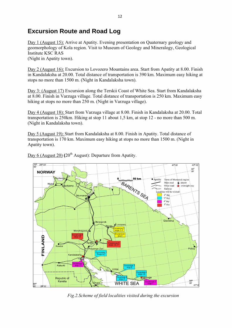
Excursion Route and Road Log
Day 1 (August 15): Arrive at Apatity. Evening presentation on Quaternary geology and geomorphology of Kola region. Visit to Museum of Geology and Mineralogy, Geological Institute KSC RAS (Night in Apatity town). Day 2 (August 16): Excursion to Lovozero Mountains area. Start from Apatity at 8.00. Finish in Kandalaksha at 20.00. Total distance of transportation is 390 km. Maximum easy hiking at stops no more than 1500 m. (Night in Kandalaksha town). Day 3: (August 17) Excursion along the Terskii Coast of White Sea. Start from Kandalaksha at 8.00. Finish in Varzuga village. Total distance of transportation is 250 km. Maximum easy hiking at stops no more than 250 m. (Night in Varzuga village). Day 4 (August 18): Start from Varzuga village at 8.00. Finish in Kandalaksha at 20.00. Total transportation is 250km. Hiking at stop 11 about 1,5 km, at stop 12 - no more than 500 m. (Night in Kandalaksha town). Day 5 (August 19): Start from Kandalaksha at 8.00. Finish in Apatity. Total distance of transportation is 170 km. Maximum easy hiking at stops no more than 1500 m. (Night in Apatity town). Day 6 (August 20) (20th August): Departure from Apatity.
Fig.2.Scheme of field localities visited during the excursion
13
EXCURSION STOPS
Day 1: Arrive at Apatity. Evening presentation on Quaternary geology and geomorphology of the Kola region. Visit to Museum of Geology and Mineralogy, Geological Institute KSC RAS. (Night in Apatity).
Museum of Geology and Mineralogy, Geological Institute KSC RAS
The Museum of Geology and Mineralogy was founded in 1930-ies attached to the Khibiny Mining Station of the USSR Academy of Sciences, which was later reorganized into the Kola Science Centre RAS. The Museum and associated archives store over 9000 samples of the minerals, ores and rocks of the Kola Peninsula, and exhibit the following:
- a systematic collection of minerals; - a collection of ores and other types of mineral resources; - a collection of rocks, and new minerals, discovered on the Kola Peninsula. The collections appear to be a most complete range of the Kola Peninsula minerals,
including rare and new minerals, which are unique in habit, colour, size and assemblages that make the collections valuable and excite curiosity of the visitors.
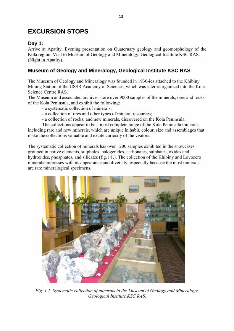
The systematic collection of minerals has over 1200 samples exhibited in the showcases grouped in native elements, sulphides, halogenides, carbonates, sulphates, oxides and hydroxides, phosphates, and silicates (fig.1.1.). The collection of the Khibiny and Lovozero minerals impresses with its appearance and diversity, especially because the most minerals are rare mineralogical specimens.
Fig. 1.1. Systematic collection of minerals in the Museum of Geology and Mineralogy, Geological Institute KSC RAS.
14
The Kola Peninsula is a mining area extremely rich in apatite, copper, nickel and cobalt, iron, rare metals, and micas, as well as in high-alumina ceramic and abrasive materials, and facing and decorative stones. Over 800 samples of different ores and minerals from these deposits are exhibited in the Museum. The petrography collection of igneous, metamorphic and sedimentary rocks from different massifs of the Kola Peninsula has over 900 samples. Over 130 new minerals of 210 first found on the Kola Peninsula, including 56 minerals discovered by the researchers of the Geological Institute, are to be admired in the exposition hall of the museum.
15
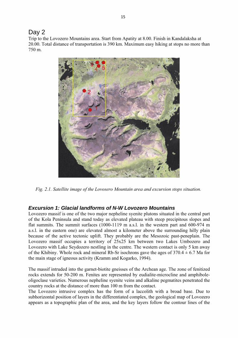
Day 2 Trip to the Lovozero Mountains area. Start from Apatity at 8.00. Finish in Kandalaksha at 20.00. Total distance of transportation is 390 km. Maximum easy hiking at stops no more than 750 m.
Fig. 2.1. Satellite image of the Lovosero Mountain area and excursion stops situation.
Excursion 1: Glacial landforms of N-W Lovozero Mountains Lovozero massif is one of the two major nepheline syenite plutons situated in the central part of the Kola Peninsula and stand today as elevated plateau with steep precipitous slopes and flat summits. The summit surfaces (1000-1119 m a.s.l. in the western part and 600-974 m a.s.l. in the eastern one) are elevated almost a kilometer above the surrounding hilly plain because of the active tectonic uplift. They probably are the Mesozoic past-peneplain. The Lovozero massif occupies a territory of 25x25 km between two Lakes Umbozero and Lovozero with Lake Seydozero nestling in the centre. The western contact is only 5 km away of the Khibiny. Whole rock and mineral Rb-Sr isochrons gave the ages of 370.4 ± 6.7 Ma for the main stage of igneous activity (Kramm and Kogarko, 1994). The massif intruded into the garnet-biotite gneisses of the Archean age. The zone of fenitized rocks extends for 50-200 m. Fenites are represented by eudialite-microcline and amphibole-oligoclase varieties. Numerous nepheline syenite veins and alkaline pegmatites penetrated the country rocks at the distance of more than 100 m from the contact. The Lovozero intrusive complex has the form of a laccolith with a broad base. Due to subhorizontal position of layers in the differentiated complex, the geological map of Lovozero appears as a topographic plan of the area, and the key layers follow the contour lines of the

16
map (Fig. 2.2). The alkaline rocks forming the Lovozero massif are represented mainly by plutonic and less abundant subvolcanic and volcanic magma products. The plutonic derivatives can be grouped into the following principal components: 1). Poikilitic feldspathoid syenites; 2). Lujavrite-foyaite-urtite layered complex; 3). Eudialite nepheline syenite complex (Arzamastsev, 2002). The Lovozero massif is rich in landforms resulted from the glacial activity and displaying both long-term glacial-erosion features and smaller scale landforms, which in great detail record the process of the deglaciation of the area. Figure 1.2 shows main glacial-geomorphology features of the Khibiny and Lovozero Mountains: glacial cirques, glacial lineated forms (drumlins, flutings), marginal moraines, end moraines, hummocky moraines, De Geer moraines, lateral meltwater channels, spillways, eskers, delta formations, ice-dammed ake shoreline, tors. The main valleys are U-shaped with rivers and elongated lakes. The largest valleys are situated in the eastern (Chinglusuai, Chivruai, Seyd'iavriok Rivers with the tributaries and Seydozero Lake), northern (headstreams of Sergevan' River system) and western (Kitkuaiv, Tavajok, Sengisjok Rivers) parts of the massif. The main feature of the massif is that in late glacial when the glacier frontier was to the east of the massif, the most high summits were the nunataks. At time the frontier moved to the west of the massif, the local glaciers formed in the most of large cirques.
0 2 4 6 8 10 km
Mt.Vavnbed
Mt. Selsurt
Mt. Kuivchorr
Mt. Karnasurt
Mt. Alluaiv
Mt. Sengischorr
Mt. Parguaiv
Mt. Strashempahk
Mt. Punkaruaiv
Quaternary moraine
Phonolite porphyres, syenite porphyres
Augite porphyres, alkaline picrites
Precambrian basement
Eudialite lujavrite, lovozerite-murmanite and porphyric lujavrite
Foyaite, foyaite-lujavrite
Ijolite with apatite and titanite
Poikilitic nepheline-sodalite syenite
Pegmatoid foyaite, lujavrite and alkaline syenite of the contact zone
Rhythmic lujavrite, foyaite, urtitelayered sequence with loparite-bearing layers
Seidozero lake
U m b o z e r o l a k e
L o
v o
z e r
o l
a k
e
Fig. 2.2. Geological map of the Lovozero massif (after Arzamastsev, 2002).

17
Fig. 2.3. Geomorphological map of Khibiny and Lovozero Mountains.

18
Stop No 1. Plateau-like summit of the Alluaiv Mountain (1051 m a.s.l.)
Alluaiv plateau-like summit (N-W Lovozero Mountains) is accessible by car up to the top of 1000-1100 m a.s.l (Fig. 2.1, stop 1). Rocks of lujavrite-foyaite-urtite layered complex, eudialite nepheline and poikilitic feldspathoid syenites are exposed here. The signature of weathering. The summit surfaces of Alluaiv Mountain and another points display extensive signs of prolonged weathering, such as felsenmeers and tors (Fig. 2.4). The height of the tors reaches 8-10 m. These landforms occupy the top position of almost all summits of Lovozero Mountains; especially in the more elevated western part. The surrounding tors have adjacent areas of spacious felsenmeers with different size blocs. The rare erratic boulders are usual for such weathering landforms (Fig. 2.4). The top of Alluaiv Mountain is a tor surrounded by felsenmeers with single erratic boulders. Such landforms take a very long time to form, and they are easily eroded if subject to wet-based erosional ice flow. Hence, their presence indicates that these surfaces have escaped glacial erosion through multiple glacial cycles. However, shield erratics, which are commonly found all over these relict surfaces, indicate that the mountains were indeed completely overridden by Fennoscandian ice. However, the ice sheet over the mountain summits must have been cold-based; otherwise, the tors and felsenmeers would have been eroded away. It is likely that the ice over the plateau was frozen to the bed and slow-moving, protecting it from erosion. Glacial erosional landforms. The summit surfaces of Lovozero Mountains are dissected by numerous glacial cirques and glacial troughs (U-shaped valleys). The 1st nd and 2 Raslaka Cirques, the cirque with Gornoe Lake, the U-shaped upper valleys of Sergevan' River system and Azimut River on N-W Lovozero Mountains are the forms of this kind (Fig. 2.5 - 2.6). The floors of the cirques are situated between 600-700m a.s.l. and the headwalls rise above the cirques up to 1000-1100 m a.s.l. The cirques are opened into U-shaped valleys with rivers and elongated lakes. Most of the valleys in the peripheral parts of the Lovozero Mountains show pure fluvial character.
Fig. 2.4. The tor and felsenmeers on the top of Alluaiv Mt., N-W Lovozero Mountains (a)

19
Fig. 2.5. U-shaped valley with Sergevan' River
stFig. 2.6. 1 and 2nd Raslaka Cirques on North slope of Lovozero Mountains.
20
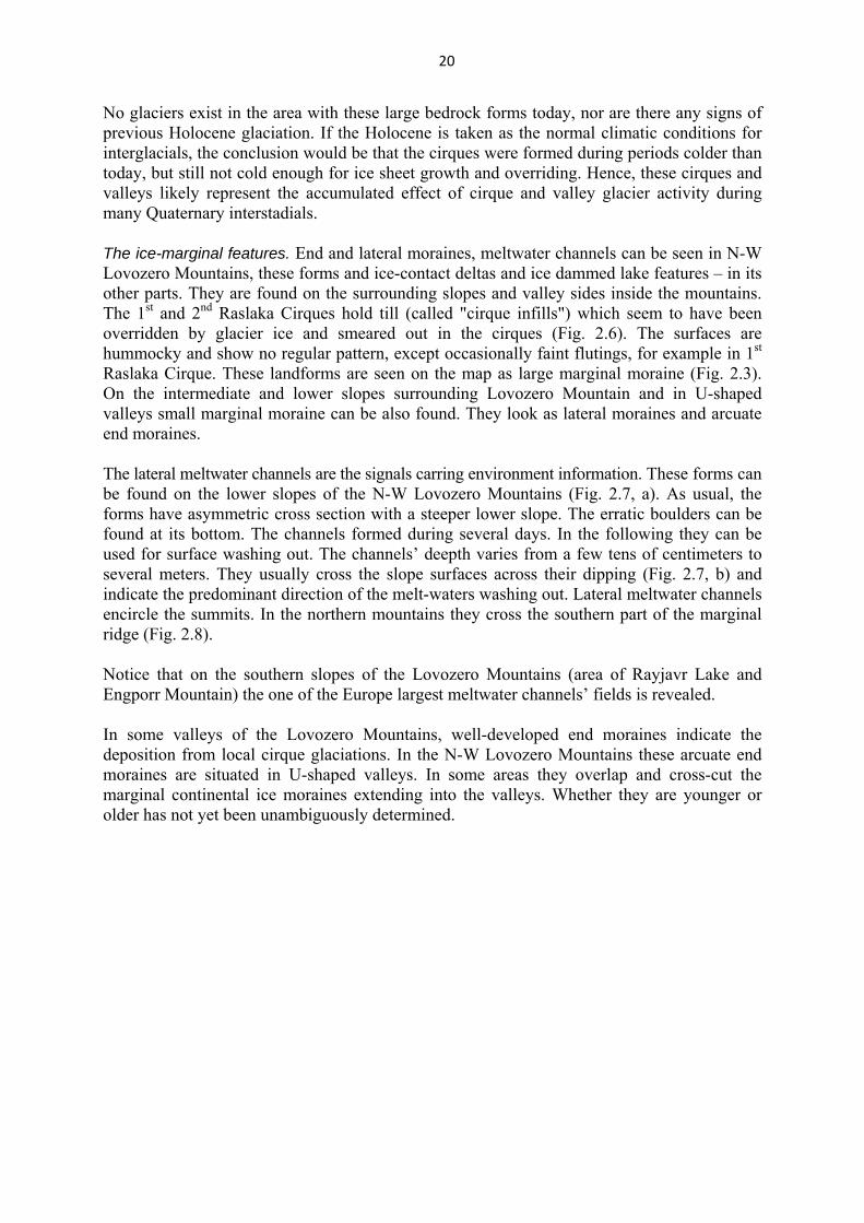
No glaciers exist in the area with these large bedrock forms today, nor are there any signs of previous Holocene glaciation. If the Holocene is taken as the normal climatic conditions for interglacials, the conclusion would be that the cirques were formed during periods colder than today, but still not cold enough for ice sheet growth and overriding. Hence, these cirques and valleys likely represent the accumulated effect of cirque and valley glacier activity during many Quaternary interstadials. The ice-marginal features. End and lateral moraines, meltwater channels can be seen in N-W Lovozero Mountains, these forms and ice-contact deltas and ice dammed lake features – in its other parts. They are found on the surrounding slopes and valley sides inside the mountains. The 1st and 2nd Raslaka Cirques hold till (called "cirque infills") which seem to have been overridden by glacier ice and smeared out in the cirques (Fig. 2.6). The surfaces are hummocky and show no regular pattern, except occasionally faint flutings, for example in 1st Raslaka Cirque. These landforms are seen on the map as large marginal moraine (Fig. 2.3). On the intermediate and lower slopes surrounding Lovozero Mountain and in U-shaped valleys small marginal moraine can be also found. They look as lateral moraines and arcuate end moraines. The lateral meltwater channels are the signals carring environment information. These forms can be found on the lower slopes of the N-W Lovozero Mountains (Fig. 2.7, a). As usual, the forms have asymmetric cross section with a steeper lower slope. The erratic boulders can be found at its bottom. The channels formed during several days. In the following they can be used for surface washing out. The channels’ deepth varies from a few tens of centimeters to several meters. They usually cross the slope surfaces across their dipping (Fig. 2.7, b) and indicate the predominant direction of the melt-waters washing out. Lateral meltwater channels encircle the summits. In the northern mountains they cross the southern part of the marginal ridge (Fig. 2.8).
Notice that on the southern slopes of the Lovozero Mountains (area of Rayjavr Lake and Engporr Mountain) the one of the Europe largest meltwater channels’ fields is revealed. In some valleys of the Lovozero Mountains, well-developed end moraines indicate the deposition from local cirque glaciations. In the N-W Lovozero Mountains these arcuate end moraines are situated in U-shaped valleys. In some areas they overlap and cross-cut the marginal continental ice moraines extending into the valleys. Whether they are younger or older has not yet been unambiguously determined.

21
a
b
Fig. 2.7. Lateral meltwater channels on lower slopes of Northern (a) and Southern (b) Lovozero Mountains.
22
Fig. 2.8. Lateral meltwater channels crossing the southern part of moraine ridge on N-W Lovozero Mountains.
Excursion 2: Late Glacial ice-marginal formations in Lovozero area
Degradation of the Late Valdai ice sheet in the Kola region occurred in conditions of arctic climate with alternating phases of stadial falls of temperature and interstadial warming. External heat was not enough for the active ice margin to retreat (Yevzerov, 1996). In these environments, three belts of marginal ridges formed in the region (Fig. 2.9). The degradation stages of the ice sheet in the Kola region have been correlated to climatic cycles - Oldest, Older and Younger Dryas, and to the previous interstadial warmings. Note, each marginal belt was formed during the interstadial-stadial cycle of the glacier activity and was made up of two bands of marginal ridges: the inner band - dump moraine (marginal esker), and the outer band - a push moraine. The formation of three outer bands of marginal ridges corresponds to the three final stages (Oldest, Older and Younger Dryas) of the glacier activity in the Kola region: Terskaya (13,5 ka), Revdozerskaya (12,5 ka), Kandalakshskaya (10 - 11 ka). The inner band - dump moraine formed under interstadial conditions and the outer band - push moraine formed during followed stadial cooling. The all the belts of marginal ridges are named after stadial cooling - Terskii, Revdozerskii, Kandalakshskii. Most investigated of them are the recessive formations related to the Revdozerskaya stage of Scandinavian ice-sheet development. In one case (Ekman, Iljin, 1991), the marginal ridges north of Lovozero Mountains are related to the Younger Dryas (Salpausselka) stage, and south of Lovozero Mountains - to the Older Dryas (Neva stage). In next case (Yevzerov, 1996), the all the marginal ridge complexes consist of two bands of the marginal formations and are correlated to the Older Dryas (Neva) stage.
23
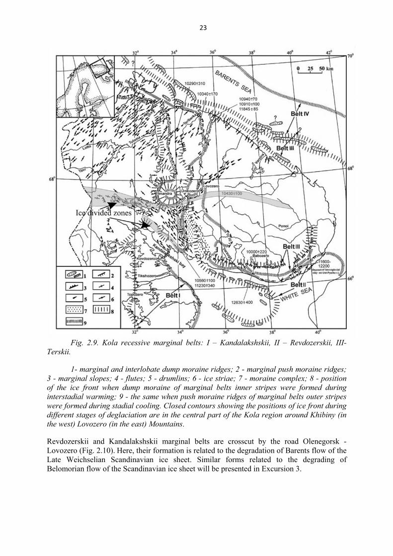
Fig. 2.9. Kola recessive marginal belts: I – Kandalakshskii, II – Revdozerskii, III-
Terskii. 1- marginal and interlobate dump moraine ridges; 2 - marginal push moraine ridges;
3 - marginal slopes; 4 - flutes; 5 - drumlins; 6 - ice striae; 7 - moraine complex; 8 - position of the ice front when dump moraine of marginal belts inner stripes were formed during interstadial warming; 9 - the same when push moraine ridges of marginal belts outer stripes were formed during stadial cooling. Closed contours showing the positions of ice front during different stages of deglaciation are in the central part of the Kola region around Khibiny (in the west) Lovozero (in the east) Mountains.
Revdozerskii and Kandalakshskii marginal belts are crosscut by the road Olenegorsk - Lovozero (Fig. 2.10). Here, their formation is related to the degradation of Barents flow of the Late Weichselian Scandinavian ice sheet. Similar forms related to the degrading of Belomorian flow of the Scandinavian ice sheet will be presented in Excursion 3.
24
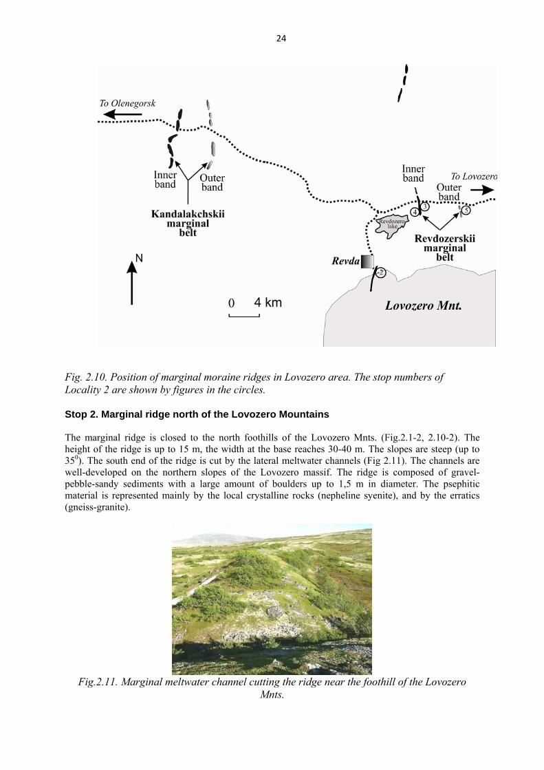
Fig. 2.10. Position of marginal moraine ridges in Lovozero area. The stop numbers of Locality 2 are shown by figures in the circles.
Stop 2. Marginal ridge north of the Lovozero Mountains
The marginal ridge is closed to the north foothills of the Lovozero Mnts. (Fig.2.1-2, 2.10-2). The height of the ridge is up to 15 m, the width at the base reaches 30-40 m. The slopes are steep (up to 350). The south end of the ridge is cut by the lateral meltwater channels (Fig 2.11). The channels are well-developed on the northern slopes of the Lovozero massif. The ridge is composed of gravel-pebble-sandy sediments with a large amount of boulders up to 1,5 m in diameter. The psephitic material is represented mainly by the local crystalline rocks (nepheline syenite), and by the erratics (gneiss-granite).
Fig.2.11. Marginal meltwater channel cutting the ridge near the foothill of the Lovozero
Mnts.

25
There are two opinions on the genesis of this marginal ridge: 1. This marginal esker marks the position of the glacier edge during the interstadial warming. It could be compared to the inner band of the Revdozerskii marginal belt (?). As the ridge is cut by the washout meltwater channels, traceable here and on the mountain slopes, the esker formed before the glacier has moved to the east and climbed to the mountains along the river valleys.
2. This ridge is the marginal form of the local (mountain) glacier, moving from the Raslak Cirques (Yevzerov et al., 2007) (Fig.2.12.). The material composing the ridge is predominated by nepheline syenite of the Lovozero nepheline syenite pluton (from 64 up to 98 %) while the ridge being located outside the contact of Lovozero nepheline syenite pluton.
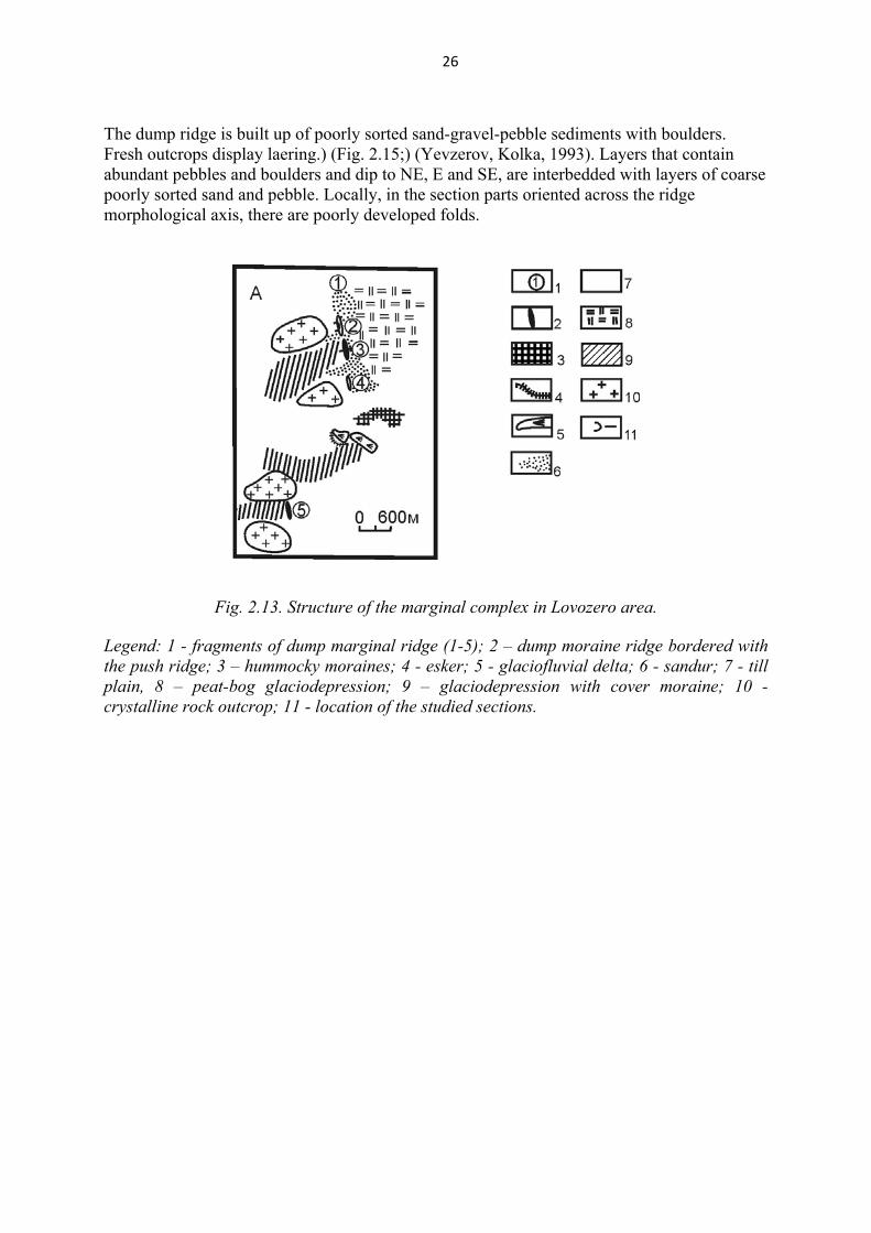
Fig. 2.12. Position of the submountain glacial deposits and petrographic composition of their pebble fraction. 1 - ridges of marginal and medial moraines of submountain glacier, 2 - contact of the Lovozero massif, 3 - content of pebbles in the nepheline syenites of the Lovozero massif, 4 - content of pebbles in the acid and basic rocks of the basement. Stop 3. Dump moraine ridge - the inner band of Revdozerskii marginal belt.
The marginal moraine complex is situated north-east of the settlement of Revda, in the area of the north-eastern extremity of Lake Revdozero, south of the road Olensgorsk-Lovozero(fig.2.1-3). The marginal complex has a complicated structure. It is represented bу а locally developed dump moraine ridge extending from the north-west to the south-east in the form of five fragments, and a small glaciofluvial delta (Fig. 2.13). Stop 3 is located in the former open-pit, outcropping the fragment 2. Some fragments of the dump moraine ridge (fragments 3 and 5 on Fig. 2.13) borders on the push ridge in the west. The fragments of the dump moraine ridge (Fig. 2.14) are up to 15-20 m high above the foot and up to 0,6 km long. Near the distal (eastern) side, a terrace-like bench takes place, likely formed by the flowage of the debris from the glacier takes plase.
26
The dump ridge is built up of poorly sorted sand-gravel-pebble sediments with boulders. Fresh outcrops display laering.) (Fig. 2.15;) (Yevzerov, Kolka, 1993). Layers that contain abundant pebbles and boulders and dip to NE, E and SE, are interbedded with layers of coarse poorly sorted sand and pebble. Locally, in the section parts oriented across the ridge morphological axis, there are poorly developed folds.
Fig. 2.13. Structure of the marginal complex in Lovozero area.
Legend: 1 - fragments of dump marginal ridge (1-5); 2 – dump moraine ridge bordered with the push ridge; 3 – hummocky moraines; 4 - esker; 5 - glaciofluvial delta; 6 - sandur; 7 - till plain, 8 – peat-bog glaciodepression; 9 – glaciodepression with cover moraine; 10 - crystalline rock outcrop; 11 - location of the studied sections.
27
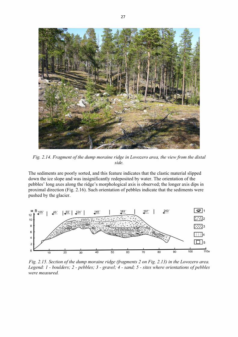
Fig. 2.14. Fragment of the dump moraine ridge in Lovozero area, the view from the distal side.
The sediments are poorly sorted, and this feature indicates that the clastic material slipped down the ice slope and was insignificantly redeposited by water. The orientation of the pebbles’ long axes along the ridge’s morphological axis is observed; the longer axis dips in proximal direction (Fig. 2.16). Such orientation of pebbles indicate that the sediments were pushed by the glacier.
Fig. 2.15. Section of the dump moraine ridge (fragments 2 on Fig. 2.13) in the Lovozero area. Legend: 1 - boulders; 2 - pebbles; 3 - gravel; 4 - sand; 5 - sites where orientations of pebbles were measured.
28
Fig. 2.16. Orientation diagrams for long axes of pebbles in the dump moraine ridge (fragments 2 on Fig. 2.13) in the Lovozero area. Sites where the measurements were
conducted are shown in Fig. 2.14.
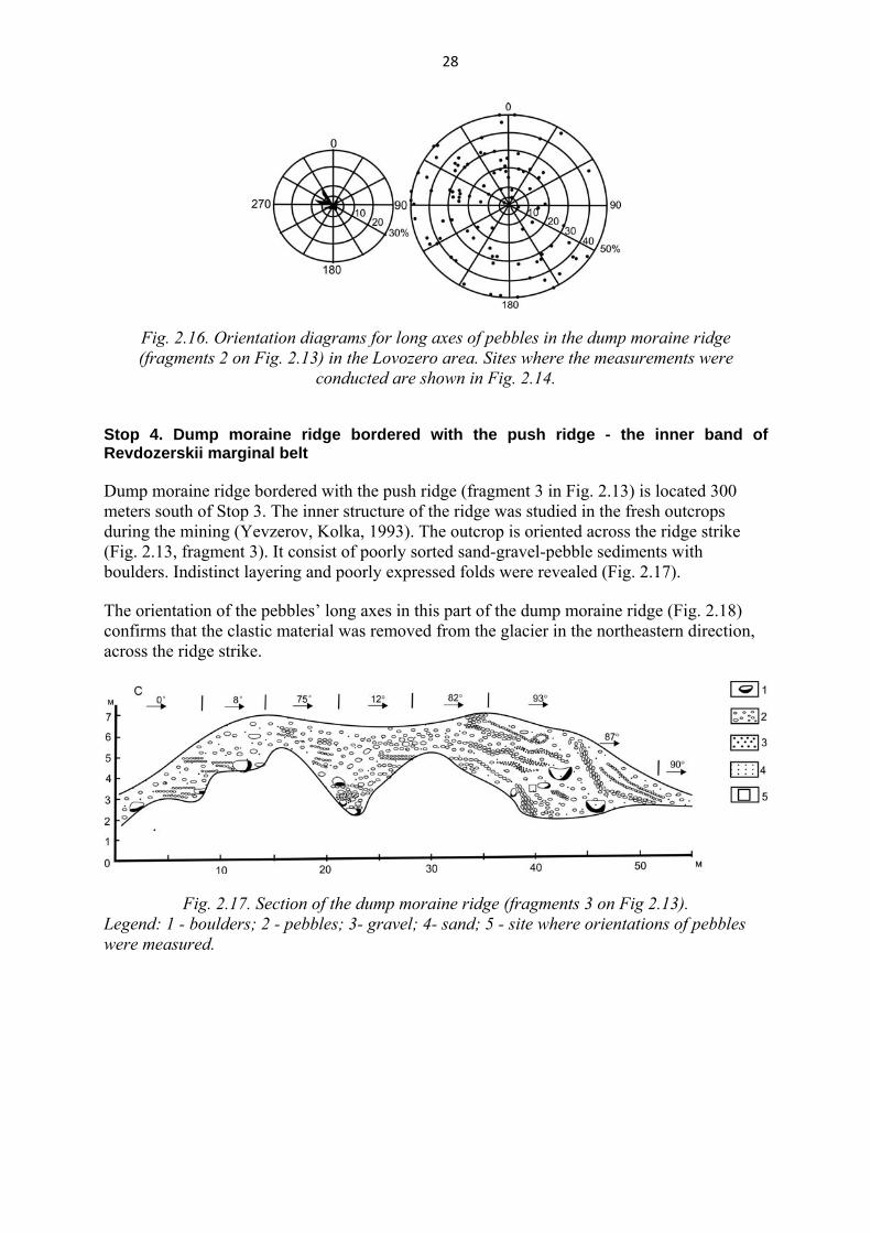
Stop 4. Dump moraine ridge bordered with the push ridge - the inner band of Revdozerskii marginal belt
Dump moraine ridge bordered with the push ridge (fragment 3 in Fig. 2.13) is located 300 meters south of Stop 3. The inner structure of the ridge was studied in the fresh outcrops during the mining (Yevzerov, Kolka, 1993). The outcrop is oriented across the ridge strike (Fig. 2.13, fragment 3). It consist of poorly sorted sand-gravel-pebble sediments with boulders. Indistinct layering and poorly expressed folds were revealed (Fig. 2.17). The orientation of the pebbles’ long axes in this part of the dump moraine ridge (Fig. 2.18) confirms that the clastic material was removed from the glacier in the northeastern direction, across the ridge strike.
Fig. 2.17. Section of the dump moraine ridge (fragments 3 on Fig 2.13). Legend: 1 - boulders; 2 - pebbles; 3- gravel; 4- sand; 5 - site where orientations of pebbles were measured.
29
Fig. 2.18. Orientation diagrams for long axes of pebbles in the dump moraine ridge
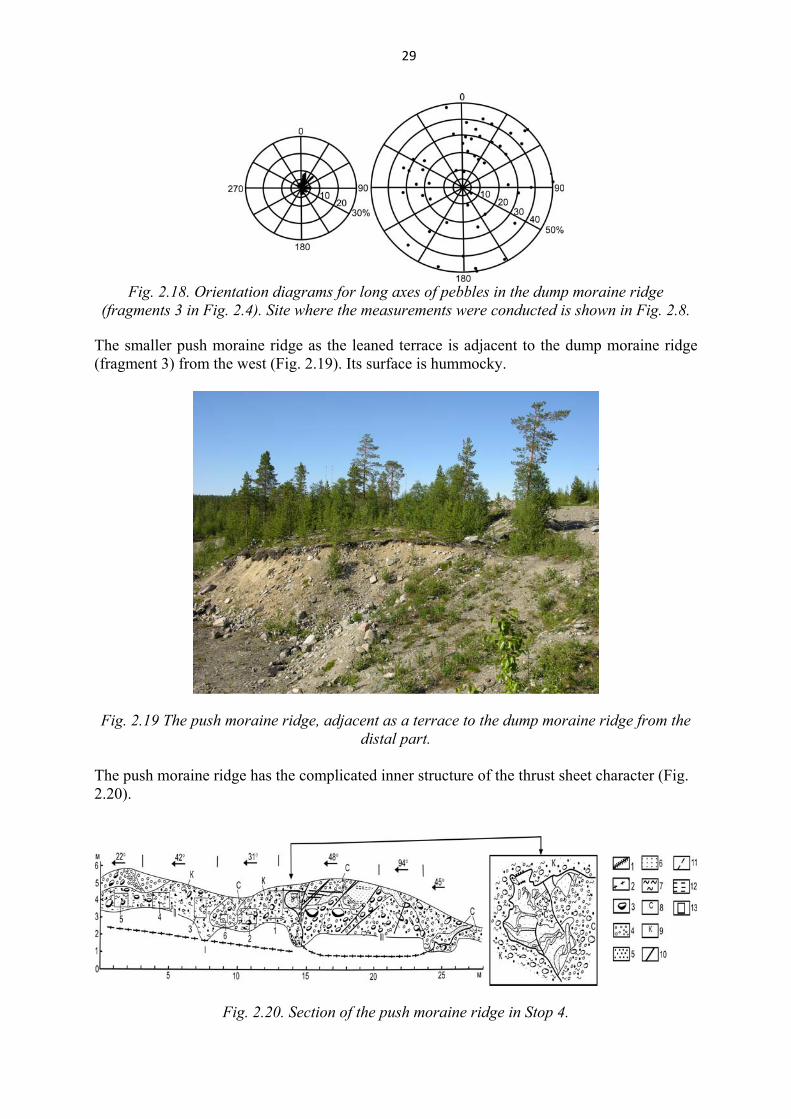
(fragments 3 in Fig. 2.4). Site where the measurements were conducted is shown in Fig. 2.8.
The smaller push moraine ridge as the leaned terrace is adjacent to the dump moraine ridge (fragment 3) from the west (Fig. 2.19). Its surface is hummocky.
Fig. 2.19 The push moraine ridge, adjacent as a terrace to the dump moraine ridge from the distal part.
The push moraine ridge has the complicated inner structure of the thrust sheet character (Fig. 2.20).
Fig. 2.20. Section of the push moraine ridge in Stop 4.

30
Legend: boundaries between thrust sheets (I – III): 1 - established; 2 - interred; 3 - boulders; 4 - pebbles; 5 - gravel; 6 - sand; 7 - clay; 8 - greenish-grey till; 9 - brown till; tectonic faults: 10 - established; 11 - inferred; 12 - foliation; 13 - sites where orientations of pebbles were measured. Thrust sheet I is stand out in the section in Fig. 2.20 speculatively and its border is inferred by the underground waters discharges. The thrust sheet II (Fig. 2.20) is represented by brown foliated till. The structures of the layering-plastic flow in the basal till, being a flow cleavage, always dip in the opposite direction of the ice movement (Lukashov, 1980). Relics of the early paragenesis structural elements are found in the section: a foliated structure dipping to 180°-210° S at an angle of 10-20°. Late paragenesis elements were manifested in foliation bends resulting in the development of asymmetric folds (with a more gentle western limb); it is related to the deformation in high-density and high-viscosity rocks, which were almost frozen. The orientation of early and later paragenesis structural elements is shown on diagram A, Fig. 2.21. The averages hinge-line is oriented across the ridge morphological axis and plunges south-eastwards.
Fig. 2.21. Orientations of glaciotectonic structures and pebbles (section of the push moraine ridge). Legend: diagram A: 1- maximum of foliation poles formed by shearing; 2 - averaged hinge line of folds formed by shearing; numbers on the diagram correspond to numbers of sites of measurements on the section (amount of measurements: in site 1 - 75, in sites 2-5 - 50), a - early paragenesis structural elements, (b) - later paragenesis elements; diagram B: 3 - poles of axial planes of folds that deform contacts and layering of the folds, 4 - poles of averaged hinge line of the folds; diagram С: 5 - poles of shear joints, 6 - their averaged planes, 7 - major normal stresses in the thrust sheet III; diagrams D and E: long and short axes of pebbles in site of measurements (site 6 on the section; amount of measurements – 50). The thrust sheet III (Fig. 2.20) is composed of glaciofluvial and glacial deposits. Its section illustrated both plicative and disjunctive dislocations. Tectonic faults cut the folds. The folds were found in the front of the thrust sheet III (Yevzerov, Kolka, 1993); they were of a complicated shape (Fig. 2.20, in a box) which is possibly due to the influx of material. In the middle part of thrust sheet III, folds deform the layering and the geological contacts. Axial poles of fold planes are scattered along the great-circle path, which is common for cylindrical folds (Kazakov, 1980). On the diagram B (Fig. 2.21), all the poles are practically within the same plane to indicate that the plicative structures develop in a single field of paleoglaciotectonic stresses. Earlier the disjunctive dislocations were investigated. They were represented by various generations of shear joints (Fig. 2.20). The sequence of joint development was determined by observations in places where the joints are cross-cutting. Assuming the shear joints to have

31
been developed in a single field of paleoglaciotectonic stresses. The statistic of the measurements was calculated and a common system of the joint orientation was obtained (Fig. 2.20, diagram C). Most of them dip ENE at angles of about 50°. On the diagram, the same scattered points are noted. It is accounted for by the fact that in the till due to its anisotropy, the shearing could not be formed in straight lines, and in boulders the shear joints are developed mostly along weakened zones. The axis orientation for major normal stresses was reconstructed using the method of M.V. Gzovsky (1975). The latest were the subhorisontal shear joints, along which a slight eastward displacement of upper blocks was observed (Fig. 2.20). After the development of shear joints dipping to the northeast, sand, loam and till were pushed along some of them. The till wedge was observed in the section (Fig. 2.20, part 6). Pebble long axes measured in the wedge middle are scattered along the great-circle path (Fig. 2.21, diagram D). It witnesses the flattening of the sediments (Lukashov et al., 1981). In the opposite side of the quarry, in front of the wedge, glaciofluvial material was protrusively intruded along a shear joint with a similar orientation
Stop 5. Push moraine ridge - outer band of marginal belt of Revdozerskii marginal belt.
Recessive moraine ridge, corresponding to the outer band of Revdozerskii marginal belt, is located 6 km east of the marginal esker (Stops 2 and 3), south of the road Olensgorsk-Lovozero (Fig. 2.10). The ridge stands out morphologically against adjacent gentle-hillocky plane, covered by the forest and locally swamped. It strikes from the north to the south up to 450 m. The relative height reaches 10-12 m, and the absolute levels are 205-209 m. As a rule, the western slope is longer and flat (Fig. 2.22). The interrupting terrace-like benches take place on the eastern slope. The numerous erratics of the gneiss-granites of up to 1.5 m in diameter occur on the ridge surface, and especially on its eastern slope. The ridge formation in this place was caused by the occurrence of the hard rock ledge in front of extending glacier. The ledge stands out presently as a hill of 240 m a.s.l. (Sergevan’ Mountain).
Of note, the age of the push moraine ridge of Revdozerskaya stage was determined beyond the Locality 2. The paleomagnetic study of the limnoglacial clay from the periglacial lake in the southern Kola Peninsula was performed (Fig. 2.9). It was established that the clay was deposited during Alleröd (Bakhmytov et al., 1993). It means that the push moraine ridges were formed during the Older Dryas reactivation of the glacier, becoming the dam for the periglacial lake.
32
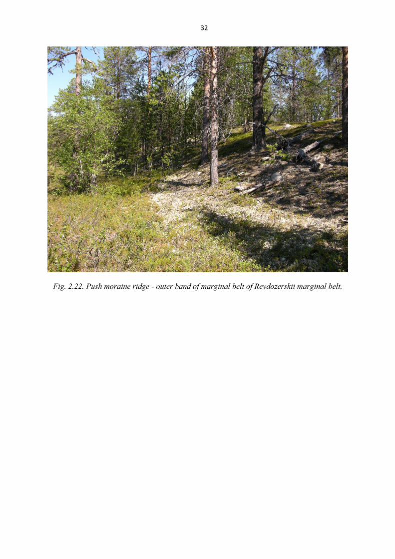
Fig. 2.22. Push moraine ridge - outer band of marginal belt of Revdozerskii marginal belt.

33
Day 3: Trip along the Tersky Coast of White Sea. Start from Kandalaksha 8.00. Finish in Varzuga village. Total distance of transportations is 250 km. Maximum easy hiking at stops no more than 250 m. Excursion 3: Late Glacial ice-divide and ice-marginal formations on the White Sea coast. The marginal glacial forms are established on the Kandalaksha Bay shore and at the bottom of the White Sea Basin. These forms are compared with the three final stages of the regional deglaciation of the Scandinavian ice shield: Terskaya (13.5 ka), Revdozerskaya (12.5 ka) and Kandalakshskaya (10 - 11 ka) stages (Oldest, Older and Younger Dryas). According to the scheme presented in fig. 2.9, they are part of the recessive Belt III, II and I. The formation of these marginal forms here is connected with degradation of the Belomorian flow of the Late Weichselian Scandinavian glacier The derivation of the Belomorian ice flow and its discrete lobes (Belomorian and Khibinsko-Kolvitskaya) in the western part of the region took place as the ice-sheet has degraded and the position of the ice divides and glacier frontier has been changed. The dynamics of the Belomorian ice flow was complicated (especially during its degradation and breaking down to the lobes, different in activity), resulted in the complex of the marginal forms in the southern Kola region. These forms are known under the general name First/Marine Keiva (Lavrova, 1960). The separate parts of the Marine Keiva have its own local names. The westernmost part (from the Kolvitsa Bay to the Pilskaja Bay) is named Vilasselga, and it extents up to 65 km. It has the different interpretations: as the marginal eskers (Lavrova, 1960); as the ice-divide glaciofluvial ridges (Ekman, Iljin, 1993).
Vilasselga ice marginal formation extents initially in sublatitudal direction along the depression between the Kandalaksha and Kolvitsa Mountains. There it is represented by the several ridges in the valleys of the Kolvitsa, Luven’ga and Tiksha Rivers. The Vilasselga turns to the south-east in the depression of Kolvitskoye Lake and extend up to the Pilskaja Bay. The thickest ridge is located in the valley of the Kolvitsa River. There it is abraded by the sea and partly overlain by the marine sediments. The road Umba-Varzuga crosses the inner band of Belt II. Similar regional forms of the Revdozerskii marginal belt formed at the degradation Barents lobe of the Late Weichselian Scandinavian Glacier have been shown within Excursion 2.
Stop 6. Glaciofluvial ridge in the valley of the Kolvitsa River
The southern ridge of the Vilasselga has the subparallel extension along the Kandalaksha Bay coast, the Kolvitsa River and Kolvitsa Lake depression (Fig. 3.1).
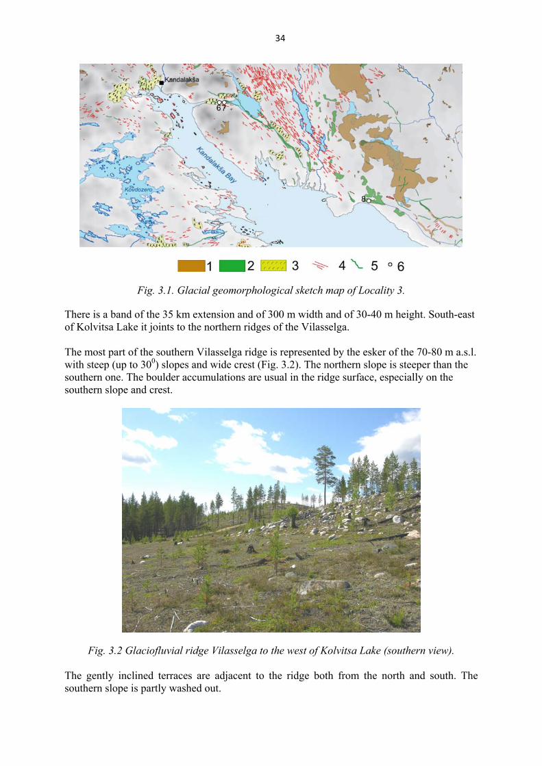
34
Fig. 3.1. Glacial geomorphological sketch map of Locality 3.
There is a band of the 35 km extension and of 300 m width and of 30-40 m height. South-east of Kolvitsa Lake it joints to the northern ridges of the Vilasselga. The most part of the southern Vilasselga ridge is represented by the esker of the 70-80 m a.s.l. with steep (up to 300) slopes and wide crest (Fig. 3.2). The northern slope is steeper than the southern one. The boulder accumulations are usual in the ridge surface, especially on the southern slope and crest.
Fig. 3.2 Glaciofluvial ridge Vilasselga to the west of Kolvitsa Lake (southern view). The gently inclined terraces are adjacent to the ridge both from the north and south. The southern slope is partly washed out.
35
Stop 7. Quarry opening the glaciofluvial ridge Vilasselga in the valley of theKolvitsa River
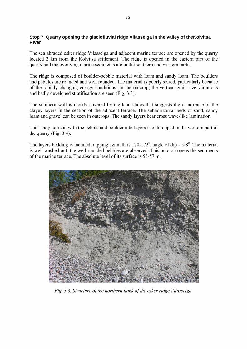
The sea abraded esker ridge Vilasselga and adjacent marine terrace are opened by the quarry located 2 km from the Kolvitsa settlement. The ridge is opened in the eastern part of the quarry and the overlying marine sediments are in the southern and western parts. The ridge is composed of boulder-pebble material with loam and sandy loam. The boulders and pebbles are rounded and well rounded. The material is poorly sorted, particularly because of the rapidly changing energy conditions. In the outcrop, the vertical grain-size variations and badly developed stratification are seen (Fig. 3.3). The southern wall is mostly covered by the land slides that suggests the occurrence of the clayey layers in the section of the adjacent terrace. The subhorizontal beds of sand, sandy loam and gravel can be seen in outcrops. The sandy layers bear cross wave-like lamination. The sandy horizon with the pebble and boulder interlayers is outcropped in the western part of the quarry (Fig. 3.4). The layers bedding is inclined, dipping azimuth is 170-1720, angle of dip - 5-80. The material is well washed out; the well-rounded pebbles are observed. This outcrop opens the sediments of the marine terrace. The absolute level of its surface is 55-57 m.
Fig. 3.3. Structure of the northern flank of the esker ridge Vilasselga.
36
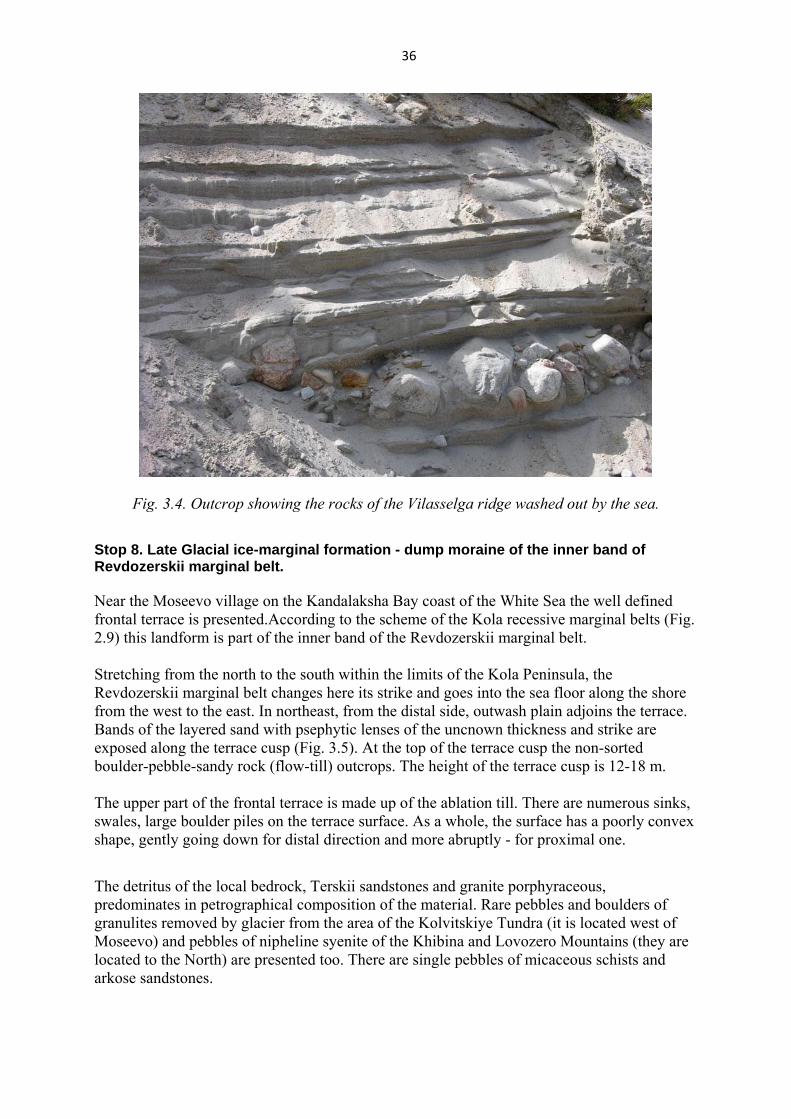
Fig. 3.4. Outcrop showing the rocks of the Vilasselga ridge washed out by the sea.
Stop 8. Late Glacial ice-marginal formation - dump moraine of the inner band of Revdozerskii marginal belt.
Near the Moseevo village on the Kandalaksha Bay coast of the White Sea the well defined frontal terrace is presented.According to the scheme of the Kola recessive marginal belts (Fig. 2.9) this landform is part of the inner band of the Revdozerskii marginal belt. Stretching from the north to the south within the limits of the Kola Peninsula, the Revdozerskii marginal belt changes here its strike and goes into the sea floor along the shore from the west to the east. In northeast, from the distal side, outwash plain adjoins the terrace. Bands of the layered sand with psephytic lenses of the uncnown thickness and strike are exposed along the terrace cusp (Fig. 3.5). At the top of the terrace cusp the non-sorted boulder-pebble-sandy rock (flow-till) outcrops. The height of the terrace cusp is 12-18 m.
The upper part of the frontal terrace is made up of the ablation till. There are numerous sinks, swales, large boulder piles on the terrace surface. As a whole, the surface has a poorly convex shape, gently going down for distal direction and more abruptly - for proximal one. The detritus of the local bedrock, Terskii sandstones and granite porphyraceous, predominates in petrographical composition of the material. Rare pebbles and boulders of granulites removed by glacier from the area of the Kolvitskiye Tundra (it is located west of Moseevo) and pebbles of nipheline syenite of the Khibina and Lovozero Mountains (they are located to the North) are presented too. There are single pebbles of micaceous schists and arkose sandstones.
37
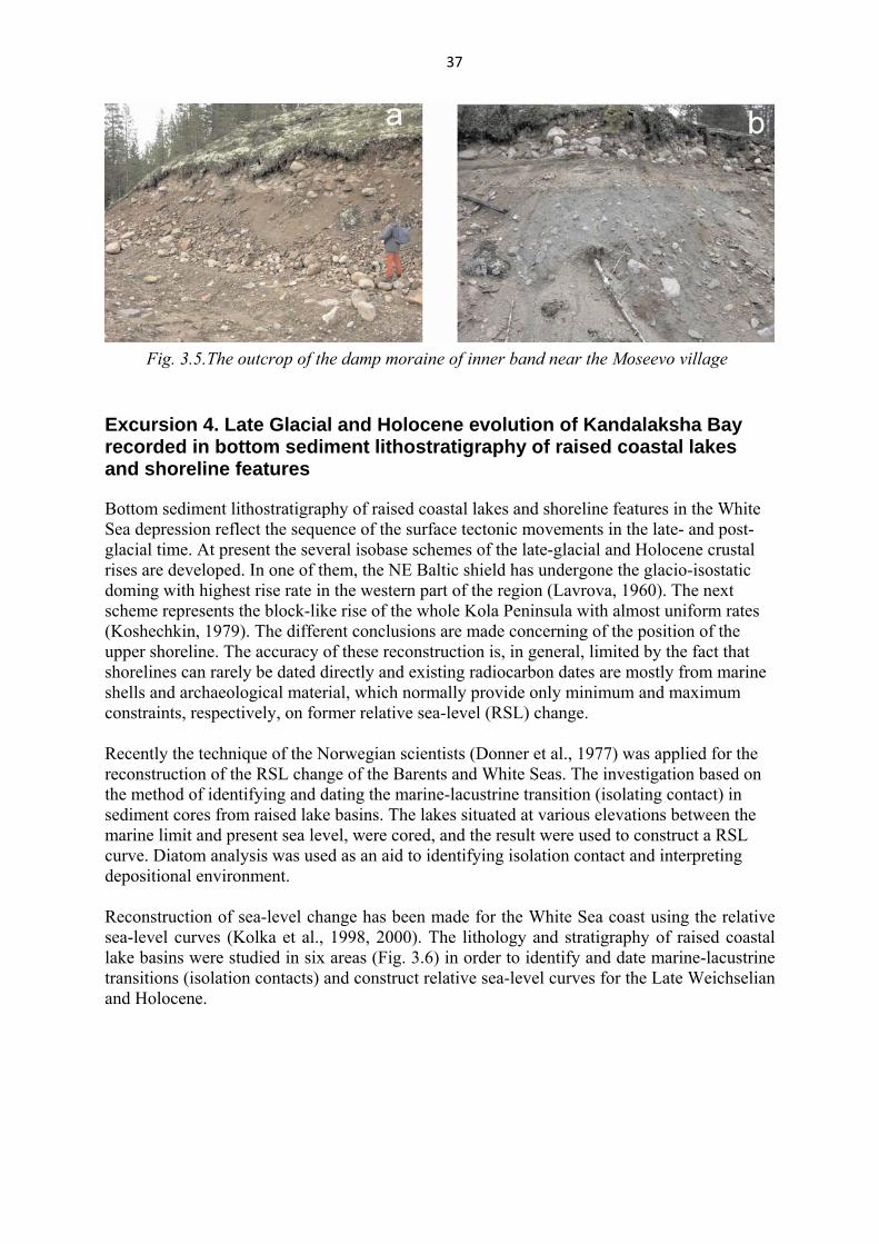
Fig. 3.5.The outcrop of the damp moraine of inner band near the Moseevo village
Excursion 4. Late Glacial and Holocene evolution of Kandalaksha Bay recorded in bottom sediment lithostratigraphy of raised coastal lakes and shoreline features
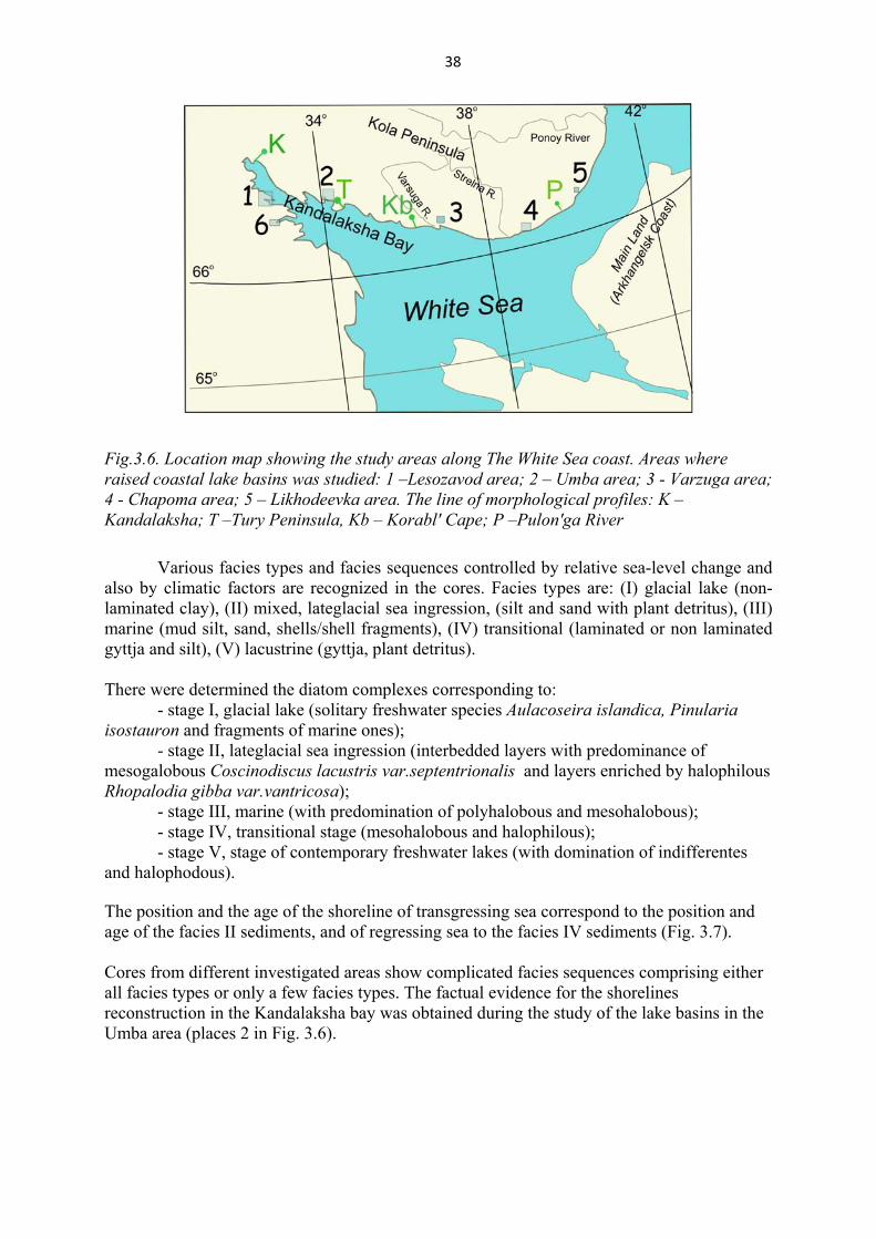
Bottom sediment lithostratigraphy of raised coastal lakes and shoreline features in the White Sea depression reflect the sequence of the surface tectonic movements in the late- and post-glacial time. At present the several isobase schemes of the late-glacial and Holocene crustal rises are developed. In one of them, the NE Baltic shield has undergone the glacio-isostatic doming with highest rise rate in the western part of the region (Lavrova, 1960). The next scheme represents the block-like rise of the whole Kola Peninsula with almost uniform rates (Koshechkin, 1979). The different conclusions are made concerning of the position of the upper shoreline. The accuracy of these reconstruction is, in general, limited by the fact that shorelines can rarely be dated directly and existing radiocarbon dates are mostly from marine shells and archaeological material, which normally provide only minimum and maximum constraints, respectively, on former relative sea-level (RSL) change. Recently the technique of the Norwegian scientists (Donner et al., 1977) was applied for the reconstruction of the RSL change of the Barents and White Seas. The investigation based on the method of identifying and dating the marine-lacustrine transition (isolating contact) in sediment cores from raised lake basins. The lakes situated at various elevations between the marine limit and present sea level, were cored, and the result were used to construct a RSL curve. Diatom analysis was used as an aid to identifying isolation contact and interpreting depositional environment. Reconstruction of sea-level change has been made for the White Sea coast using the relative sea-level curves (Kolka et al., 1998, 2000). The lithology and stratigraphy of raised coastal lake basins were studied in six areas (Fig. 3.6) in order to identify and date marine-lacustrine transitions (isolation contacts) and construct relative sea-level curves for the Late Weichselian and Holocene.
38
Fig.3.6. Location map showing the study areas along The White Sea coast. Areas where raised coastal lake basins was studied: 1 –Lesozavod area; 2 – Umba area; 3 - Varzuga area; 4 - Chapoma area; 5 – Likhodeevka area. The line of morphological profiles: K – Kandalaksha; T –Tury Peninsula, Kb – Korabl' Cape; P –Pulon'ga River
Various facies types and facies sequences controlled by relative sea-level change and
also by climatic factors are recognized in the cores. Facies types are: (I) glacial lake (non-laminated clay), (II) mixed, lateglacial sea ingression, (silt and sand with plant detritus), (III) marine (mud silt, sand, shells/shell fragments), (IV) transitional (laminated or non laminated gyttja and silt), (V) lacustrine (gyttja, plant detritus). There were determined the diatom complexes corresponding to:
- stage I, glacial lake (solitary freshwater species Aulacoseira islandica, Pinularia isostauron and fragments of marine ones);
- stage II, lateglacial sea ingression (interbedded layers with predominance of mesogalobous Coscinodiscus lacustris var.septentrionalis and layers enriched by halophilous Rhopalodia gibba var.vantricosa);
- stage III, marine (with predomination of polyhalobous and mesohalobous); - stage IV, transitional stage (mesohalobous and halophilous); - stage V, stage of contemporary freshwater lakes (with domination of indifferentes
and halophodous). The position and the age of the shoreline of transgressing sea correspond to the position and age of the facies II sediments, and of regressing sea to the facies IV sediments (Fig. 3.7). Cores from different investigated areas show complicated facies sequences comprising either all facies types or only a few facies types. The factual evidence for the shorelines reconstruction in the Kandalaksha bay was obtained during the study of the lake basins in the Umba area (places 2 in Fig. 3.6).

39
Fig. 3.7. Internal structure of facies II, III and stratigraphy of the transition between marine (facies III) and lacustrine (facies V) sediments.
1-gyttja; 2 – mud, sandy mud; 3 – lamination; 4 – weak lamination; 5 – sharp contact; 6 – gradational contact; 7 – marine-freshwater diatom transition; 8 – isolation contact; 9 –diatoms: HB-halophobous; I – indifferent; HL – halophilous; M – mesohalobous; P –polihalobous.
Umba area (66°41’, 34°28’) The Umba area is located near the Younger Dryas marginal moraine. Nine lakes with different threshold altitudes (from 12 m a.s.l. to 72 m a.s.l.) were cored (Fig. 3.8). No marine sediment was found in lakes having a threshold altitude more than 50 m a.s.l. (lakes 7, 8, 9 in Fig. 3.8, A, B). Here, gyttia (facies V) lies directly upon glaciofluvial sediments (sand, coarse silt). This is explained by the fact that the lake basins situated presently above 50 m a.s.l. were packed by the dead ice during the Late Glacial. The whole set of facies is established in the lakes situated between 30 and 40 m a.s.l. (lakes 1, 3, 4, Fig. 3.8, A). The sediments of the lowest-lying lakes (lakes 2, 5, 6, Fig. 3.8, A) are represented only by the regressive (from marine to freshwater) sequence. The transition sediments (from freshwater to marine) are dated in the sections 1, 3 and 4. Their ages are 9940, 11230 and 10560 yrs BP, respectively. Except, the transition sediments (from marine to freshwater) were dated in lakes 1-6. The ages range from 3300 to 9000 yrs BP (Fig. 3.8, B). The data indicate that the late glacial marine transgression started ca. 11000 yrs BP and followed by the regression at 10000 yrs BP.
40
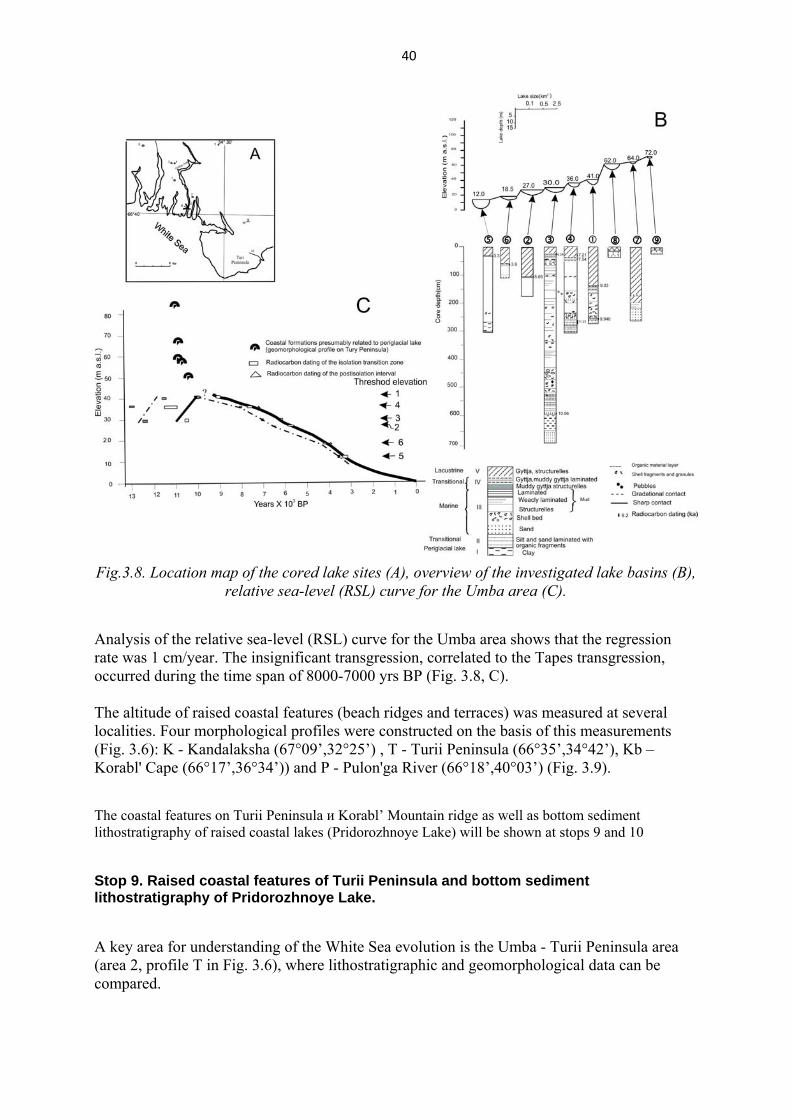
Fig.3.8. Location map of the cored lake sites (A), overview of the investigated lake basins (B),
relative sea-level (RSL) curve for the Umba area (C).
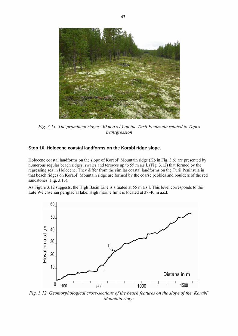
Analysis of the relative sea-level (RSL) curve for the Umba area shows that the regression rate was 1 cm/year. The insignificant transgression, correlated to the Tapes transgression, occurred during the time span of 8000-7000 yrs BP (Fig. 3.8, C). The altitude of raised coastal features (beach ridges and terraces) was measured at several localities. Four morphological profiles were constructed on the basis of this measurements (Fig. 3.6): K - Kandalaksha (67°09’,32°25’) , T - Turii Peninsula (66°35’,34°42’), Kb – Korabl' Cape (66°17’,36°34’)) and P - Pulon'ga River (66°18’,40°03’) (Fig. 3.9). The coastal features on Turii Peninsula и Korabl’ Mountain ridge as well as bottom sediment lithostratigraphy of raised coastal lakes (Pridorozhnoye Lake) will be shown at stops 9 and 10
Stop 9. Raised coastal features of Turii Peninsula and bottom sediment lithostratigraphy of Pridorozhnoye Lake. A key area for understanding of the White Sea evolution is the Umba - Turii Peninsula area (area 2, profile T in Fig. 3.6), where lithostratigraphic and geomorphological data can be compared.

41
On the Turii Peninsula profile (Fig. 3.9) it is seen that the numerous regular beach ridges up to 50 m a.s.l. were formed by the regressing sea in Holocene. When the periglacial lake existed in the White Sea depression irregular beach ridges of the upper part of profile formed (Fig. 3.9) and the varve clays deposited (sediments of facies I, interval 13.82 – 13. 53 m on Fig. 3.10). The salinization of the basin occurred ca. 11000 yrs BP, and the regression of the sea began. That time the beach ridges formed at 50 m a.s.l. (Fig. 3.9) and the sediment of the transition zone (interbedding of mud and organic material, facies II in Fig. 3.10) was deposited in the lake basin. The formation of the regular beach ridges below 50 m a.s.l. is related to the marine regression. During the Holocene regression marine sediments were deposited and they are presented in the section of the bottom sediments (facies III on Fig. 3.10). The short-term Tapes transgression caused the prominent beach ridges to form at 30 m a.s.l. There are four prominent ridges at elevation of 30 m a.s.l. corresponding to the Tapes transgression (Fig. 3.9, 3.11). At that time the dark brown to black laminated muddy gyttja (facies IV in Fig. 3.10) began to deposit in the coastal lake depressions situated on the same altitude. Holocene marine regression continued into White Sea depression after the Tapes transgression and dark brown weakly laminated lacustrine gyttja started to accumulate in the coastal lake depressions. The drill core of the Pridorozhnoye Lake (lake3 with threshold of 30 m a.s.l in Fig. 3.8) will be presented during the excursion at the Stop 9.
Fig. 3.9. Geomorphological cross-section of Tuii Peninsula
Morphological profiles allow two shore levels to be defined: High dasin line (HBL) and (with variable definition) the Tapes transgression limit. HBL represents the highest glacial lake during the Late Weichselian.
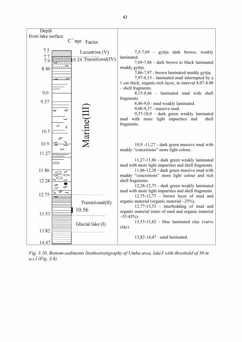
42
7,5-7,69 - gyttja dark brown, weakly
laminated. 7,69-7,86 - dark brown to black laminated
muddy gyttja. 7,86-7,97 - brown laminated muddy gyttja. 7,97-8,15 - laminated mud interrupted by a
1 cm thick, organic-rich layer, in interval 8.07-8.08 – shell fragments.
8,15-8,46 - laminated mud with shell fragments.
8,46-9,0 - mud weakly laminated. 9,00-9,37 - massive mud. 9,37-10,9 - dark green weakly laminated
mud with more light impurities and shell fragments.
10,9 -11,27 - dark green massive mud with
muddy “concretions” more light colour. 11,27-11,86 - dark green weakly laminated
mud with more light impurities and shell fragments. 11,86-12,28 - dark green massive mud with
muddy “concretions” more light colour and rich shell fragments.
12,28-12,75 - dark green weakly laminated mud with more light impurities and shell fragments.
12,75-12,77 - brown layer of mud and organic material (organic material ~25%).
12,77-13,53 - interbedding of mud and organic material (ratio of mud and organic material ~55:45%).
13,53-13,82 - blue laminated clay (varve clay).
13,82-14,47 - sand laminated.
Fig. 3.10. Bottom-sediments litothostratigraphy of Umba area, lake3 with threshold of 30 m a.s.l (Fig. 3.8).
43
Fig. 3.11. The prominent ridge(~30 m a.s.l.) on the Turii Peninsula related to Tapes transgression
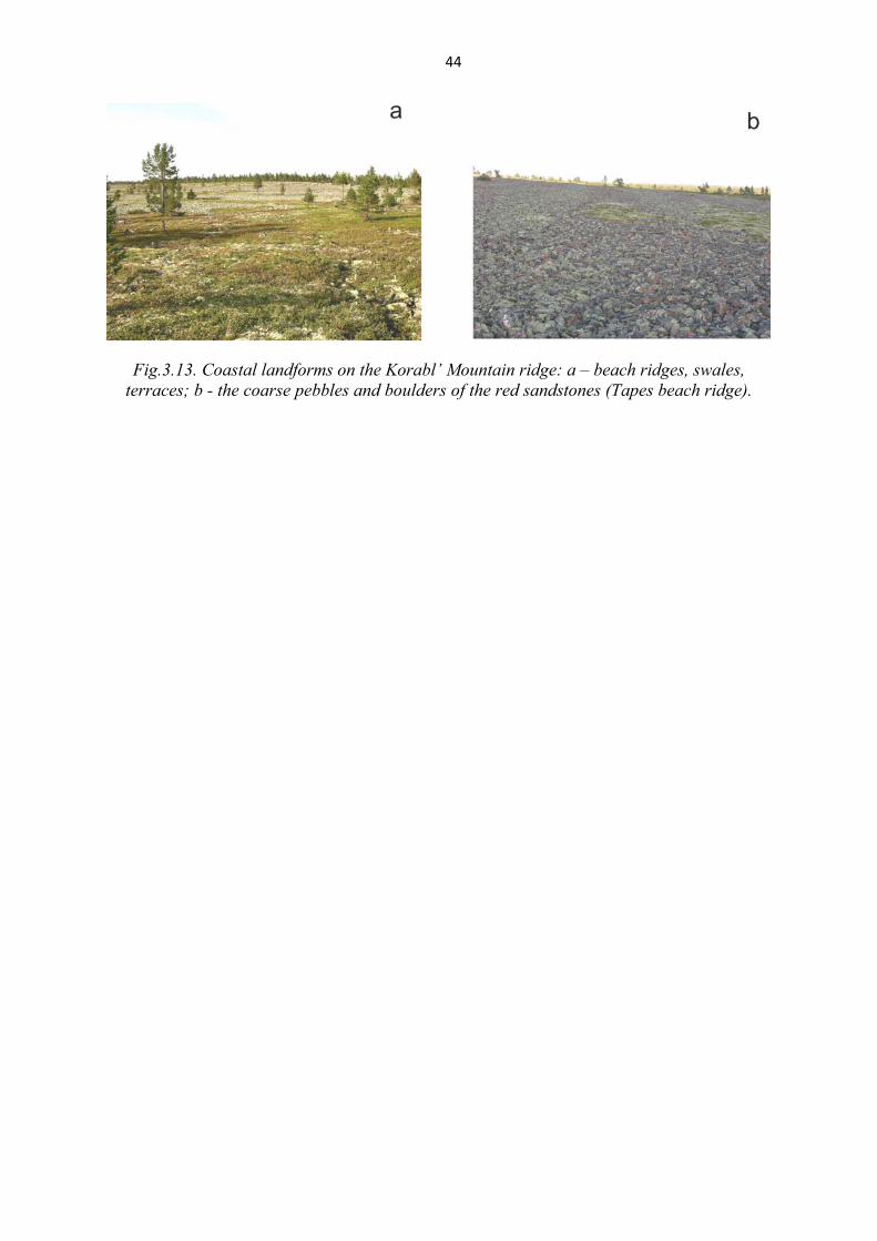
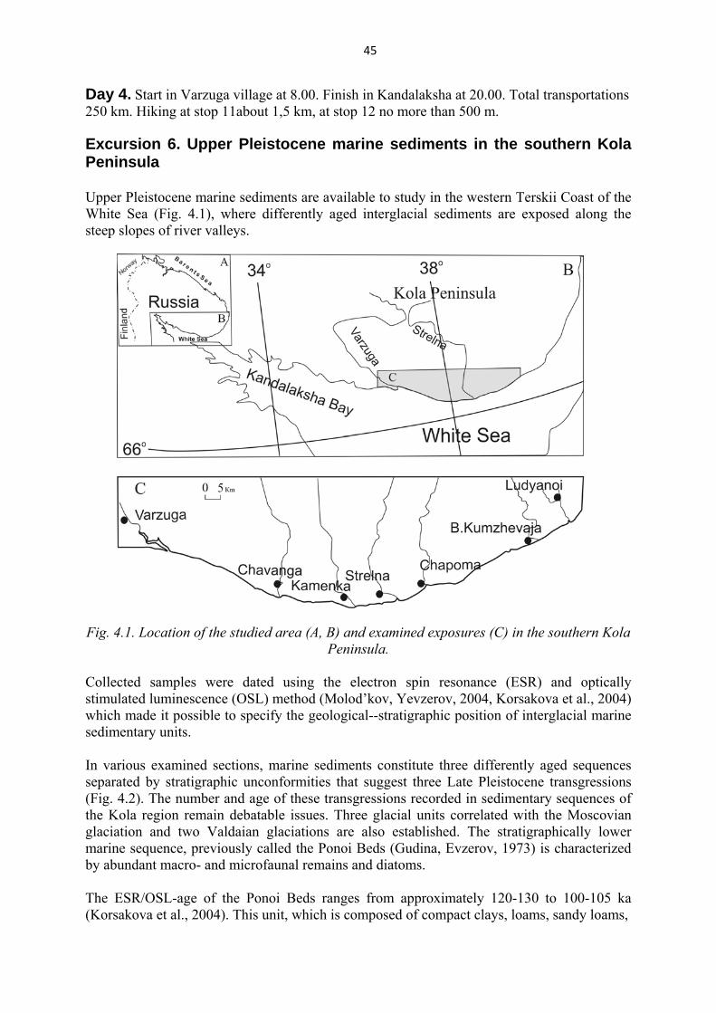
Stop 10. Holocene coastal landforms on the Korabl ridge slope. Holocene coastal landforms on the slope of Korabl’ Mountain ridge (Kb in Fig. 3.6) are presented by numerous regular beach ridges, swales and terraces up to 55 m a.s.l. (Fig. 3.12) that formed by the regressing sea in Holocene. They differ from the similar coastal landforms on the Turii Peninsula in that beach ridges on Korabl’ Mountain ridge are formed by the coarse pebbles and boulders of the red sandstones (Fig. 3.13). As Figure 3.12 suggests, the High Basin Line is situated at 55 m a.s.l. This level corresponds to the Late Weichselian periglacial lake. High marine limit is located at 38-40 m a.s.l.
Fig. 3.12. Geomorphological cross-sections of the beach features on the slope of the Korabl’
Mountain ridge.
44
Fig.3.13. Сoastal landforms on the Korabl’ Mountain ridge: a – beach ridges, swales, terraces; b - the coarse pebbles and boulders of the red sandstones (Tapes beach ridge).
45
Day 4. Start in Varzuga village at 8.00. Finish in Kandalaksha at 20.00. Total transportations 250 km. Hiking at stop 11about 1,5 km, at stop 12 no more than 500 m.
Excursion 6. Upper Pleistocene marine sediments in the southern Kola Peninsula Upper Pleistocene marine sediments are available to study in the western Terskii Coast of the White Sea (Fig. 4.1), where differently aged interglacial sediments are exposed along the steep slopes of river valleys.
Fig. 4.1. Location of the studied area (A, B) and examined exposures (C) in the southern Kola Peninsula.
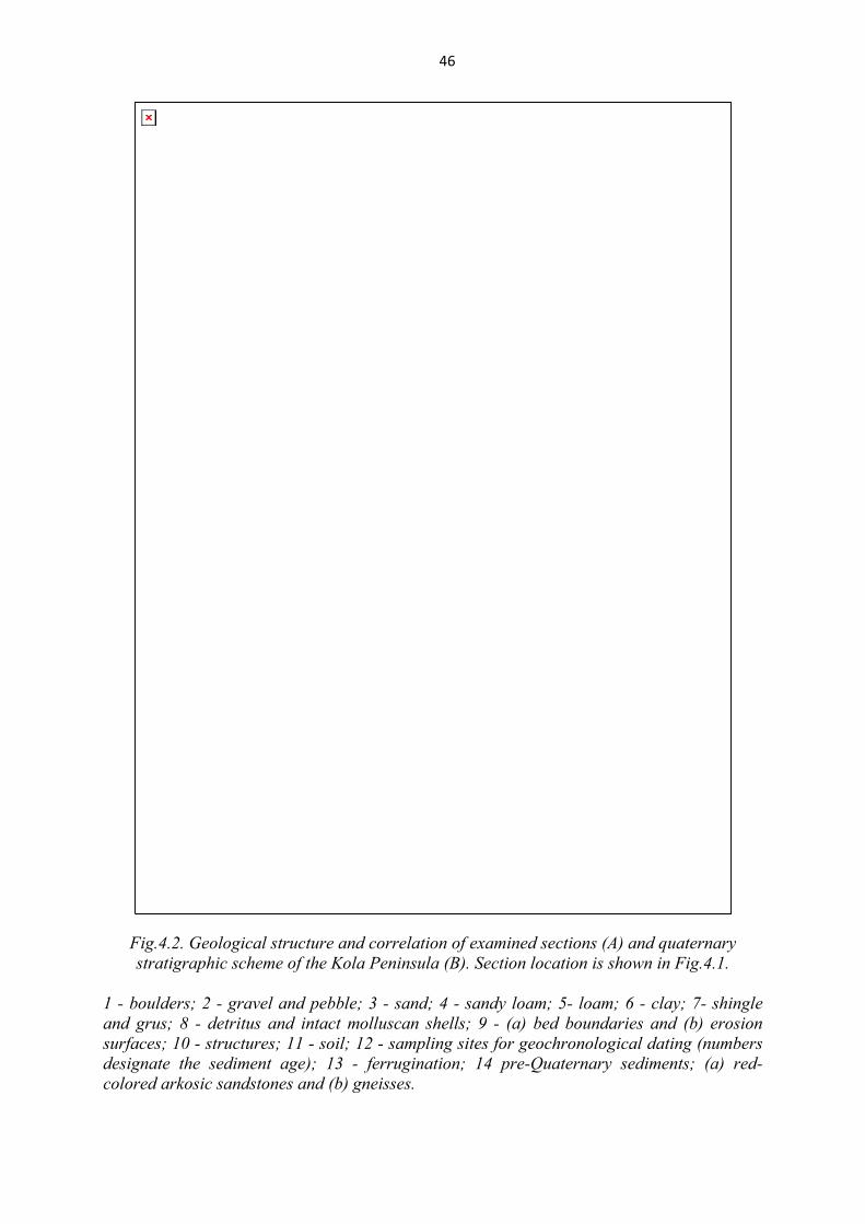
Collected samples were dated using the electron spin resonance (ESR) and optically stimulated luminescence (OSL) method (Molod’kov, Yevzerov, 2004, Korsakova et al., 2004) which made it possible to specify the geological--stratigraphic position of interglacial marine sedimentary units. In various examined sections, marine sediments constitute three differently aged sequences separated by stratigraphic unconformities that suggest three Late Pleistocene transgressions (Fig. 4.2). The number and age of these transgressions recorded in sedimentary sequences of the Kola region remain debatable issues. Three glacial units correlated with the Moscovian glaciation and two Valdaian glaciations are also established. The stratigraphically lower marine sequence, previously called the Ponoi Beds (Gudina, Evzerov, 1973) is characterized by abundant macro- and microfaunal remains and diatoms. The ESR/OSL-age of the Ponoi Beds ranges from approximately 120-130 to 100-105 ka (Korsakova et al., 2004). This unit, which is composed of compact clays, loams, sandy loams,
46
Fig.4.2. Geological structure and correlation of examined sections (A) and quaternary stratigraphic scheme of the Kola Peninsula (B). Section location is shown in Fig.4.1.
1 - boulders; 2 - gravel and pebble; 3 - sand; 4 - sandy loam; 5- loam; 6 - clay; 7- shingle and grus; 8 - detritus and intact molluscan shells; 9 - (a) bed boundaries and (b) erosion surfaces; 10 - structures; 11 - soil; 12 - sampling sites for geochronological dating (numbers designate the sediment age); 13 - ferrugination; 14 pre-Quaternary sediments; (a) red-colored arkosic sandstones and (b) gneisses.

47
and fine-grained sands, is exposed in the lower parts of the examined sections along the Varzuga, Strel'na, and Chapoma Rivers (Fig. 4.2A). It overlies the Moscovian till, which is exposed in the Chapoma River valley at an altitude of 5-7 m. In other sections, the base of this unit is not observed and its roof occurs at 35 masl (Strel'na section).
Paleoecological reconstructions (Lavrova, 1960, Grave et al, 1969, Gudina, Evzerov, 1973) demonstrate that the sea basin, where this sequence accumulated, was characterized by a more favorable environment as compared with the modern one. The water salinity was close to the normal one, and its temperature was higher than that of the present-day White Sea, which is typical of the first optimum of the Mikulinian (Eemian) Interglacial now correlated with oxygen isotope substage (OISS) 5e. All the data unambiguously indicate the Mikulinian age of the Ponoi Beds, which accumulated during the Boreal transgression. Two stratigraphically higher marine sequences are depleted in organic remains and composed of shallow-water near-shore and coastal facies. It was previously thought that they form a single unit accumulated during the Middle Valdaian transgression (Gudina, Evzerov, 1973), which is correlated with oxygen isotopic stage (OIS) 3. The bedding conditions and structural--textural features of the upper marine sequences (Fig. 4.2A), ESR-age of subfossil molluscan shells, and OSL-age of host sediments (Molod’kov, Yevzerov, 2004, Korsakova et al., 2004) imply that they formed in the course of low-amplitude transgressions that followed the Boreal transgression. It is established that the middle marine sequence, traditionally called the Strel'na Beds (Gudina, Evzerov, 1973), corresponds to the early Valdai. In the southern Kola Peninsula, the early Valdaian sea appeared no less than 100--80 ka as a low-amplitude transgression interrupted by short-term regressions and erosion during interstadial coolings. The early Valdaian sea accumulated intricate sequences of mainly sand, loam, and sandy loam. Paleontological remains enclosed in these sediments indicate ecological conditions close to the modern ones or colder (Lavrova, 1960, Grave et al, 1969). The most complete section of the Strel'na Beds is exposed and studied in the eponymous river valley at the altitude of 35--60 m, where they rest upon the eroded surface of the Ponoi Beds (Fig. 4.2A). The lower part of the Strel'na Beds, composed of compact loam with abundant molluscan shells, is exposed under fluvioglacial sands near the water level of the Chavan'ga River at the altitude of 29 masl or lower. The Strel'na Beds (loams and sandy loams with molluscan shells, pebbles, boulders, and fine- to medium-grained sands with lenses of coarse-grained varieties) sandwiched between glacial sediments are observed at 42--52 masl near the Ludyanoi Creek mouth. Similar sediments are also recorded along the Varzuga and Chapoma river valleys, where they overlie the eroded surface of the Ponoi Beds (Fig. 4.2A). The data obtained correlate with the assumption of a new (Belomorian) transgression phase after a short-term regression of the Boreal sea and significant erosion of the relevant sediments. The geological position of the upper Valdaian marine sequence in the examined sections (Fig. 4.2A; Varzuga, Strel'na, Chapoma, and Ludyanoi sections) indicates that the marine regime in the White Sea existed during the entire period, which correlates with OIS 5. The maximal depth of the sea in the southern Kola Peninsula did not exceed a few tens of meters. The shoreline of the early Valdaian sea fluctuated within a depth range of approximately 50--100 m above the present-day sea level during transgressions and regressions.

48
At present, the timing of the stratigraphical break separated the Ponoi and Strel'na Beds is being discussed. The beginning of the early Valdaian Pleniglacial (OIS 4) was marked by a distinct cooling, which is reflected in the sediments of the glacial paragenetic association in the Chavan'ga, Kamenka, and Bol'shaya Kumzhevaya sections (Fig. 4.2A). According to the available regional stratigraphic scheme, these sediments correspond to the Podporozh'e glacial horizon. Norwegian scientists (Lauritzen, 1995) established the existence of ice-free environments 150-71 ka in the immediate vicinity of the Scandinavian glaciation center. According to computer-based modeling data of Swedish and American researchers, the eastern part of the Kola Peninsula was free of ice of the Scandinavian center until approximately 70 ka (Naslund et al., 2003). The formation of the Podporozh'e glacial horizon in the Terskii Coast of the White Sea was likely related to the development of the Kara glacier rather than the Scandinavian glacier, in this area during the early Pleniglacial (OIS 4). This assumption is indirectly supported by findings of carbonate rock pebbles and boulders that are unknown in the Kola Peninsula but typical of Paleozoic rocks in the northern Russian Platform. The Podporozh'e Horizon is overlain by the third marine sequence of interglacial origin (according to our geological data and subfossils therein (Grave et al, 1969, Gudina, Evzerov, 1973)). The available geochronological data (Korsakova et al., 2004) point to its Middle Pleniglacial age (OIS 3). The sequence (sands, sandy loams, and loams) is overlain by marine or glaciomarine sediments (Fig. 6.2A) and correlated with the Leningrad Horizon (Fig. 6.2B). Thus, it is established that the geological-stratigraphic position of the Upper Pleistocene marine sediments in the southern Kola Peninsula was determined by the development of at least three transgressions. The last transgression predated the early Pleniglacial (OIS 4) continental glaciation. Geochronological data indicate the Mikulinian age of the first transgression, which correlates with the Boreal transgression in the northern East European Plain. This is indicated by the presence of the Ponoi marine beds (Fig. 4.2B). The second transgression, which correlates with the Strel'na marine beds, has an early Valdaian age (Fig. 6.2B). The marine environment was interrupted by glaciation (OIS 4) in the southern Kola Peninsula, and the late Pleistocene transgression III 60-40 ka was referred to the middle Pleniglacial (OIS 3). The relevant marine sediments (Leningrad Horizon) are everywhere overlain by the Late Valdaian glacial sediments that make up the Ostashkovian Horizon (Fig. 6.2B).
Stop 11. Varzuga section of the Upper Pleistocene marine sediments
The Varzuga outcrop (Fig. 4.3, 4.4) located on the south coast of the Kola Peninsula at about 66.4°N and 36.6°E on the right bank of the Varzuga River where in the c. 700-m-long area upstream of the Kojtugov and Kletnoy rapids several exposures over 30 m high occur.
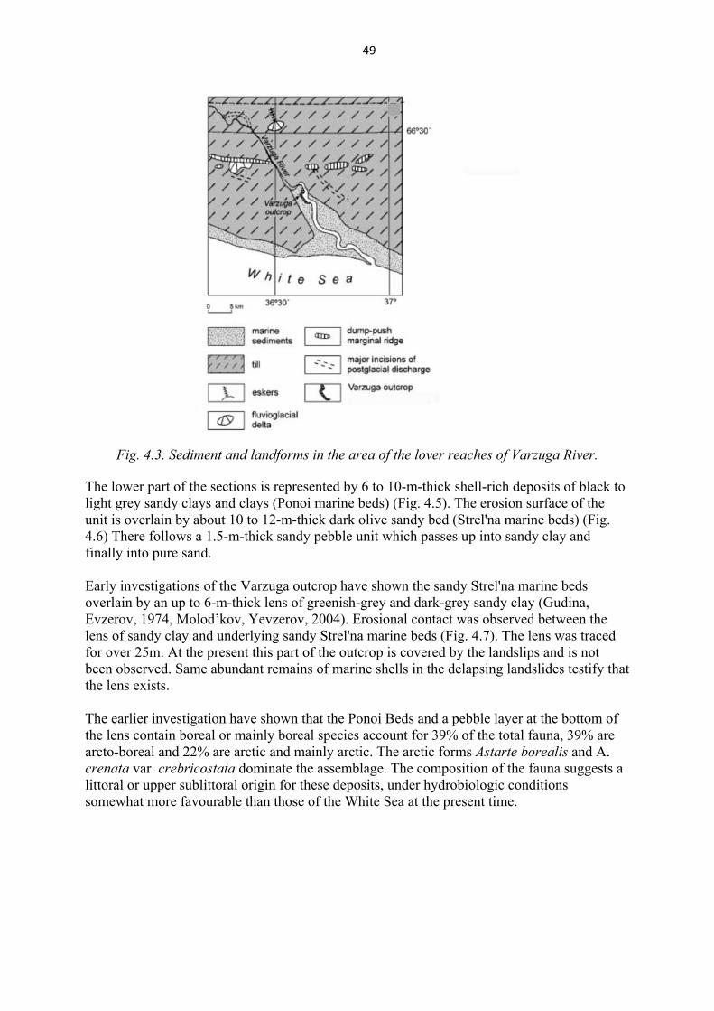
49
Fig. 4.3. Sediment and landforms in the area of the lover reaches of Varzuga River.
The lower part of the sections is represented by 6 to 10-m-thick shell-rich deposits of black to light grey sandy clays and clays (Ponoi marine beds) (Fig. 4.5). The erosion surface of the unit is overlain by about 10 to 12-m-thick dark olive sandy bed (Strel'na marine beds) (Fig. 4.6) There follows a 1.5-m-thick sandy pebble unit which passes up into sandy clay and finally into pure sand. Early investigations of the Varzuga outcrop have shown the sandy Strel'na marine beds overlain by an up to 6-m-thick lens of greenish-grey and dark-grey sandy clay (Gudina, Evzerov, 1974, Molod’kov, Yevzerov, 2004). Erosional contact was observed between the lens of sandy clay and underlying sandy Strel'na marine beds (Fig. 4.7). The lens was traced for over 25m. At the present this part of the outcrop is covered by the landslips and is not been observed. Same abundant remains of marine shells in the delapsing landslides testify that the lens exists. The earlier investigation have shown that the Ponoi Beds and a pebble layer at the bottom of the lens contain boreal or mainly boreal species account for 39% of the total fauna, 39% are arcto-boreal and 22% are arctic and mainly arctic. The arctic forms Astarte borealis and A. crenata var. crebricostata dominate the assemblage. The composition of the fauna suggests a littoral or upper sublittoral origin for these deposits, under hydrobiologic conditions somewhat more favourable than those of the White Sea at the present time.
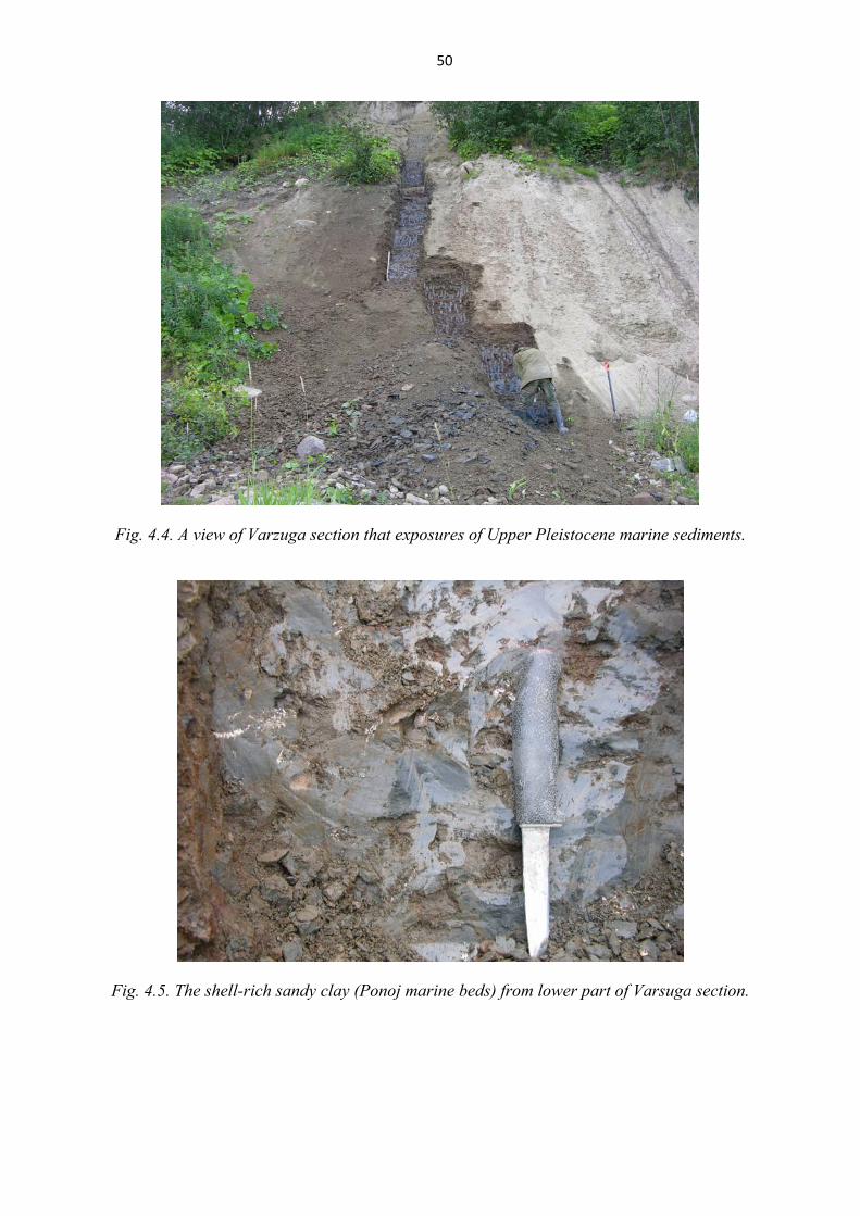
50
Fig. 4.4. A view of Varzuga section that exposures of Upper Pleistocene marine sediments.
Fig. 4.5. The shell-rich sandy clay (Ponoj marine beds) from lower part of Varsuga section.
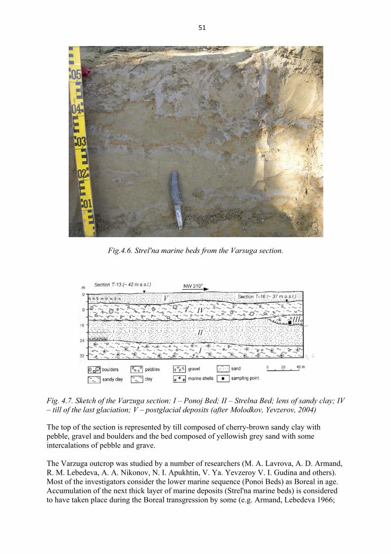
51
Fig.4.6. Strel'na marine beds from the Varsuga section.
Fig. 4.7. Sketch of the Varzuga section: I – Ponoj Bed; II – Strelna Bed; lens of sandy clay; IV – till of the last glaciation; V – postglacial deposits (after Molodkov, Yevzerov, 2004) The top of the section is represented by till composed of cherry-brown sandy clay with pebble, gravel and boulders and the bed composed of yellowish grey sand with some intercalations of pebble and grave. The Varzuga outcrop was studied by a number of researchers (M. A. Lavrova, A. D. Armand, R. M. Lebedeva, A. A. Nikonov, N. I. Apukhtin, V. Ya. Yevzeroy V. I. Gudina and others). Most of the investigators consider the lower marine sequence (Ponoi Beds) as Boreal in age. Accumulation of the next thick layer of marine deposits (Strel'na marine beds) is considered to have taken place during the Boreal transgression by some (e.g. Armand, Lebedeva 1966;
52
Grave et al., 1969), and the independent Middle Valdai Strel'ninian transgression by the others (Yevzerov, 1993). The deposits of the third and the most debatable interglacial transgression are revealed in the type section T-16 (Fig. 6.7), where they form a lens of fossil-bearing sandy clay.
Excursion 7. Archeological monuments as a demonstration of the Holocene tectonics.
Eleven stone labyrinths are known on the Kola region. The native people call them “babylons”. The first description of the stone labyrinth was made by Academician K.M. Ber in 1844. He described the Ponoj labyrinths. The stone labyrinths represent sub-aerial structures, forming the oval or circle. The short axis of the labyrinth passes through the “entry” of the labyrinth. The labyrinths are built up of the rounded stones of 20-40 cm in diameter. The whale vertebra was found in the labyrinth near the Varzina River. The labyrinths are of two types: simple and complex. The simple labyrinths are composed of the single stone line and formed the concentric spirals. The complex labyrinths are composed of two or three stone lines. The stone labyrinths are found also in Northern Karelia, Arkhangelsk region, Norway, Denmark, Sweden, and most numerous labyrinth are found in Finland (more than fifty) (Gurina, 1982). The all known Kola labyrinths are located in the sea coast, on terraces and beach ridges. They are separated from the present sea level by the several beach ridges, marking the sea regression. Even the low altitude of the labyrinths (4-7 m a.s.l.), the archeologists argue that the labyrinths were never flood by the sea. The absence of marine sediments and of surf traces in the labyrinths support the point. There are several explanations for labyrinths’ construction. Most of investigators suggest religious character of the labyrinths. Another viewpoint is that the labyrinths are of fishery meaning. All of them are situated near the places rich in fish. It is suggested that the labyrinths are the drawings of the fishery tools or, probably, they mark the places rich in fish. From the present-day position of the labyrinths, built in ancient time along the shoreline, it is possible to assess the intensity of rise of the areas of their locations.
Stop 12. Kandalaksha stone labyrinth
The Kandalaksha labyrinth is located on the Pitkul’ Navolok Cape at 4 m a.s.l. It was found and firstly described by S.N.Durylin in 1913. The Kandalaksha labyrinth is of complex type with encircled central part (Fig. 4.8). Its short axis is of 6 meters. The age of a labyrinth is defined by archeologists in the second millennium B.C.
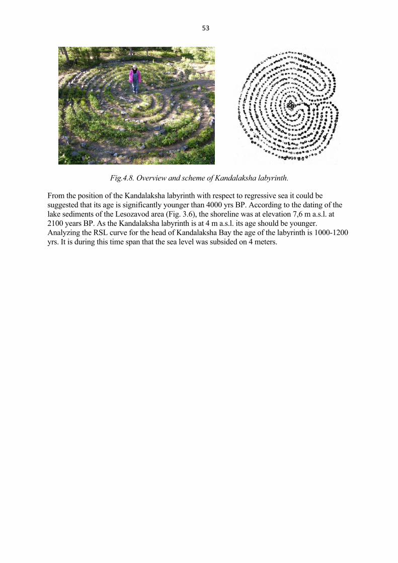
53
Fig.4.8. Overview and scheme of Kandalaksha labyrinth.
From the position of the Kandalaksha labyrinth with respect to regressive sea it could be suggested that its age is significantly younger than 4000 yrs BP. According to the dating of the lake sediments of the Lesozavod area (Fig. 3.6), the shoreline was at elevation 7,6 m a.s.l. at 2100 years BP. As the Kandalaksha labyrinth is at 4 m a.s.l. its age should be younger. Analyzing the RSL curve for the head of Kandalaksha Bay the age of the labyrinth is 1000-1200 yrs. It is during this time span that the sea level was subsided on 4 meters.
54
Day 5. Start from Kandalaksha at 8.00. Finish in Apatity at 20.00. Total distance of transportations is 170 km. Maximum easy hiking at stops no more than 1500 m
Excursion 8. Paleoseismic dislocations in the area of Imandra and Chunozero Lakes, central part of Kola region
Introduction. The Kola Peninsula, an element of the northwestern Baltic Shield, is not a high-seismicity region at present. The existing knowledge about seismicity of the region corresponds to the short-term period of instrumental and macroseismic observations. The instrumental measurements began to be registered here since 1956 with the start-up of the seismic station “Apatity”. For this period the territory of region was subjected to earthquakes with intensity 3 - 4, on the local parts - up to 5. Seismic activity zones are situated in the Kandalaksha Bay, on the Murmanskii Coast, especially in area of the Kola gulf, and in the Khibiny Mountains. The information about historical earthquakes is recorded in the archival documents, annals and newspaper publications. Such events are known on the Kola Peninsula since the 17th century. The strongest historical earthquake has taken place in the Kandalaksha Bay in 1627 with intensity 8 in terms of the MSK-64 scale (Deep structure …, 2004). The traces of ancient strong earthquakes (paleoseismic dislocations) have been detected in the Kola region as a result of specific geological and geomorphological investigations (Nikolaeva, 2001). Paleoseismic dislocations (PSD) are expressed in topography as of seismic ditches, scarps, gorges, fractures in crystalline rocks and disturbance in Quaternary sediments bedding structures. The dislocations are accompanied by such phenomena as collapses, rock pillars, rock falls, empty niches (blocks displaced away) and other seismic signatures, which are not found outside seismogenous structures, and are confined to active fault zones. Deformations in incoherent sediments provoked by modern earthquakes are not known only in seismoactive regions, but also in territories of moderate seismicity, such as Canada, Sweden, Norway, Finland (Stewart et al., 2000; Firth & Stewart, 2000). Recently, special studies were carried out to define different types of deformations in Quaternary sediments exposed in quarries and natural outcrops along river banks in the northwestern Kola region and to discriminate them from those related to the glaciotectonicsructures. All paleoseismic dislocations were formed during the late-glacial and post-glacial periods. Previously, we established that strong earthquakes occurred in the Murmansk district about 8950±150 years BP (Geology…, 1995). This age value characterizes the initial stage of organic matter accumulation in the lake whose formation was related to the damming of a small creek valley by landslides after the earthquake. The similar age of seismic event - 8720±170 ca BP. was obtained in Finnish Lapland (Sutinen, 2005). The seismogenic deformations were found in postglacial marine sediments of the valley Pechenga River (Nikolaeva, 2006). The time of seismic event is determined by radiocarbon date of sea shells. The deformations formed earlier 8.5 - 8.7 ca BP. This period corresponds to the Boreal warm climatic phase, which excludes any influence of glaciers or cryogenic processes on the deformation of sediments. Thus, the available data indicate that at least two seismic events occurred in the Holocene. Observed features of the morphology, dimensions and characteristic types of the paleoseismic deformations allow us to infer the intensity of earthquakes (I) to be no less than 7 and possibly 8 or greater of the MSK-64 scale. The magnitude of ancient earthquakes was calculated near 7.5. Naturally, these are approximate values because it is unknown how many earthquakes were responsible for the formation of the paleoseismic dislocations in each specific locality. However, these values are similar to the estimate of the magnitude of

55
possible earthquakes (6.5), obtained by S.Mijamura (Miyamura, 1963) on the basis of instrumental data on the modern earthquakes of the Fennoscandian Shield, and also to the estimate of the magnitude of ancient earthquakes in Russian Karelia (6.1 to 7.5), obtained from the study of PSD by A. Lukashov (Lukashov, 1995). It is possible to assume, that in the late and post-glacial period the seismicity of territory much more surpassed the present-day one. The scheme of ancient earthquake epicenters was made on the basis of geological data and aerial photograph interpretation (Fig. 5.1). Seismic dislocations are direct indications of residual tectonic deformations in the epicenter zones of ancient earthquakes. Largely, they are concentrated in the west and in the center of the Kola Peninsula. The epicenter of ancient earthquakes and the epicenters of most of historical and recent earthquakes coincide. This apparently testifies to the inherited nature of the historical and recent ones. The epicenters are concentrated in the area, which has been occupied by active ice during the Older and Younger Dryas (Yevzerov & Nikolaeva, 2003). Such distribution of dislocations is explained probably by fast deglaciation of the territory occupied by the Younger Dryas ice cover, and by the highest topographic gradient of the ice surface in some places of the area which was covered by active ice in the Older Dryas.
Fig.5.1. Scheme showing the density of residual deformations, the epicenters of present-
day earthquakes and the disposition of the edge of active ice in the northeastern Baltic Shield. Residual deformations density distribution scale (numerals indicate the number of residual deformations over an area of 15x15 km): 1 – 1-3; 2 – 3-5; 3 – 5-7; 4 >7; the epicenters of 1542-2002 earthquakes, magnitude (M): 5 - ≥5.1; 6 -4.1-5.0; 7 - 3.1-4.0; 8 - ≤3. The disposition of the edge of active ice is shown on scheme 5.1 by dotted line (Younger Dryas) and continuous line (Older Dryas).

56
Thus, it is possible to recognize that the northeast part of the Baltic shield is the area with rather high level tectonics of activity and seismic potential, than it was considered before. The wide development of newest dislocations and data on modern and ancient earthquakes testify the point.
Fig. 5.2. Geological-geomorphological sketch map of Imandra and Сhunozero Lakes area. 1 - outcrops of Pre-Quaternary bedrock; 2 - outcrops of Pre-Quaternary bedrock, covered glacial sediments; 3 - till; 4 - glaciofluvial deposits; 5 - alluvial deposits; 6 - peat deposits; 7 - hills: covered glacial sediments (а), without till cover (b); 8 - slopes covered glacial sediments (a), rock steps (b); 9 - strike and dip of gneissousity; 10 - faults; 11 - gorges (а), scarps (b); 12 - meltwater channel (a), glacier movement direction (b).
57
Stop 13. Paleoseismic dislocation “Chuna”
Location. “Chuna” dislocation (32º 29`E; 67º 34`N) is located to the south of Chunozero Lake within the zone of active fault. The tectonic active zone strikes northeastward (5 - 25 º) for the distance of 5 km (Fig.5.2). PSD is expressed in a relief as a narrow gorge. The gorge disrupts the hill of absolute level 252.2 m a.s.l. (Fig. 5.2, 5.3 - A). Introduction. “Chuna” dislocation is situated in the southern part of the Kola Peninsula, approximately on the continuation of the Kandalaksha Bay, in the area of Imandra and Chunozero Lakes (Fig. 5.2). The area is located in Belomorian domain with the Late Archean dome-fold and complex-fold structures reworked in Early Proterozoic. For the most part the area is composed of granite-gneiss, migmatite and gneiss containing amphibolite lenses, and also small bodies of the Early Proterozoic intrusion (Geology …, 1995). The structural elements of system strike NW-SE (300°) and in sublatitudinal direction. The territory is characterized by the dissected topography. Relative elevation of the relief reaches tens of meters. The outcrops of crystalline rocks are numerous, however largely the surface is the low-thickness cover of colluvial, glacial, glaciofluvial sediments and bogs (Fig. 5.2). The direction of glacier movement predominantly coincides with the direction of structural elements. Interpretation of aerial photos has revealed on-land paleoseismogenic dislocations on the Kola Peninsula. They are expressed in topography as scarps, gorges, ditches and fractures. Morphology “Chuna” dislocation. The gorge strikes NNE for the distance of 0.4 km. The depth of the gorge is 27 m, and the width reaches 43 m in the central part, narrowing at the ends. The bottom of the gorge is filled with fresh sharp-edged blocks of different sizes up to 5 m. The gorge has no drainage. The edges of the slopes are sharp. Numerous rockfalls, rock pillars, rock-slide, empty niches (blocks displaced away) belong to the zone of an active fault (Fig. 5.3, B-E). It is a normal fault. The maximum visible vertical displacement is 6 meters. The southeastern block is settled. Some more similar structures were revealed in this area. Genesis of “Chuna” dislocation. The gorge extents at an angle of 45° to the last direction of the ice-flow and on the continuation crosscuts the glaciofluvial fan (Fig. 5.2). It is not concordant with the trend of geological structures and relief. It seems unlikely, that the deformations could be formed by glacial processes or intensive weathering of crystalline rock. The dislocations are accompanied by such phenomena as rockfalls, pillars, empty niches (blocks displaced away) and other seismic signatures, which are not found outside seismogenous structures, and are confined to active fault zones. According to the classification developed by V.P. Solonenko (Solonenko, 1973) the following types of PSD are distinguished on the Kola Peninsula: local seismotectonic (fault scarps, seismotectonic depressions and gorges, fracturing and brecciation, grabens); gravitational-seismotectonic (displacement-related rockfalls, rock slides, blocks displaced from ledges, niches); seismogravitational (rockfalls of crystalline rocks, slumps and debris flow slides and deformations of sedimentary layering in unconsolidated Quaternary sediments) (Fig. 5.3, B - E). Local paleoseismic dislocations form paragenetic groups characterized by seismotectonic, gravitational-seismotectonic, seismogravitational formations. They are concentrated within restricted areas and correlate with distinct geological structures and faults that show indications of Holocene movements. It is essential to note, that the gorges of the similar forms of relief were formed as a result of catastrophic earthquakes with intensity 9 - 10 numbers in areas of high seismicity. At the
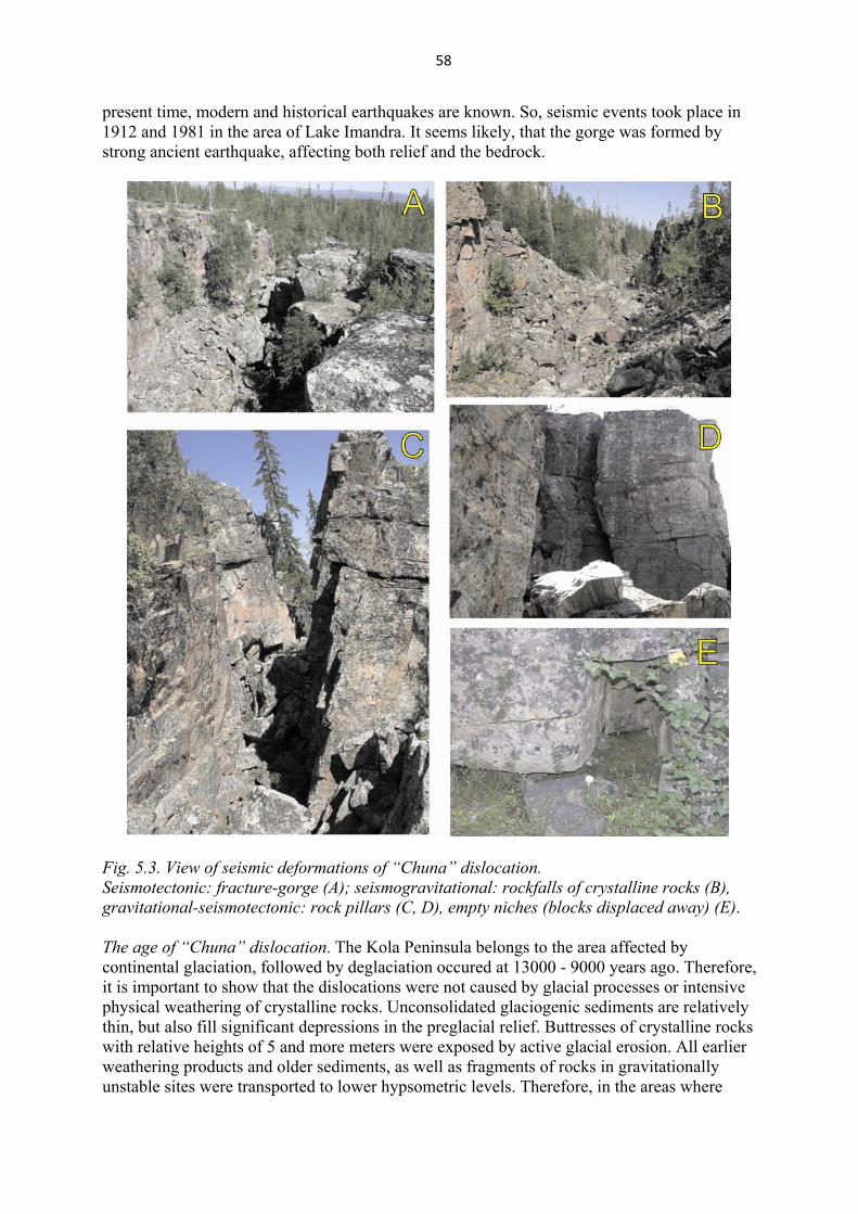
58
present time, modern and historical earthquakes are known. So, seismic events took place in 1912 and 1981 in the area of Lake Imandra. It seems likely, that the gorge was formed by strong ancient earthquake, affecting both relief and the bedrock.
Fig. 5.3. View of seismic deformations of “Chuna” dislocation. Seismotectonic: fracture-gorge (A); seismogravitational: rockfalls of crystalline rocks (B), gravitational-seismotectonic: rock pillars (C, D), empty niches (blocks displaced away) (E). The age of “Chuna” dislocation. The Kola Peninsula belongs to the area affected by continental glaciation, followed by deglaciation occured at 13000 - 9000 years ago. Therefore, it is important to show that the dislocations were not caused by glacial processes or intensive physical weathering of crystalline rocks. Unconsolidated glaciogenic sediments are relatively thin, but also fill significant depressions in the preglacial relief. Buttresses of crystalline rocks with relative heights of 5 and more meters were exposed by active glacial erosion. All earlier weathering products and older sediments, as well as fragments of rocks in gravitationally unstable sites were transported to lower hypsometric levels. Therefore, in the areas where
59
glacial formations occurred, positive topographical elements of the preglacial landscape have been exposed and consisted of crystalline rocks. As such areas were not subsequently weathered and were not covered by postglacial sediments, they were more susceptible to gravitational rockfall and landslides. The gorge must have formed after the last deglaciation of the region. The absence of till at the bottom of the gorge and also the absence of traces of glaciofluvial processes on the walls of the gorge testify to it. The fault crosscuts glaciofluvial deposits, indicating that at least the fragment of the fault is of Holocene age. The study of PSD has recently become an actively developing trend of seismogeological research. Although Fennoscandia is not the area of high present-day seismicity, many PSD are at present known and partially studied within the area (Lukashоv, 1995; Lagerback, 1990; Morner, 2003). At the present time there is little doubt that these disturbances were produced by ancient strong earthquakes which have hit on different areas of the Eastern Fennoscandia. Observed features as morphology, dimensions and characteristic types of the PSD allow us to infer the intensities of earthquakes to be not less than 7 and possibly 8 or greater in terms of the MSK-64 scale. Study of PSD and paleoearthquakes in Fennoscandia is of importance as a very serious problem and should be a subject of special research.
Excursion 9. Late Glacial landforms in the Southern Khibiny Mountains
The Khibiny Mountains are situated in the central part of the Kola Peninsula. Topographically, it is a dome-shaped mountain massif with the highest point at 1200 m a.s.l. (the highest point on the Kola Peninsula). The massif covers an area of 35x38 km (1330 km2). The main orographic feature of the Khibiny Mountains is their table form shape. The largest river valley, Tul'jok River, is situated in the eastern Khibiny. Most valleys represent troughs, and the widest ones (for example Tul'jok, Belaja Rivers) have a box-like shape due to the flat floor. Large trough valleys of the Kunijok and Kukisjok Rivers and elongated lakes cross Khibiny from north to south. Deep canyons, U-shaped and wide river valleys cut through the massif. Some of the mountains are cupped with extensive plateaus, and encircled with cirques and steep slopes. The deepth of the large cirques reaches 400m. As large landforms in the Khibiny massif, some plateau-like summits and cutting valleys are formed by long-time interaction of endogenic and exogenic processes. Cutting valleys reach the 800 m inamplitude. The smaller landforms are of glacial and meltwater origin. The Khibiny Mountains is the world's biggest alkaline pluton. The massif is located in the contact of Archaean gneisses and Early Proterozoic Imandra-Varzuga palaeoriftogenic volcanic-sedimentary complexes which form Lapland-Kola-Belomorian collisional structure. The Khibiny massif is a concentrically zoned multiphase intrusion composed of agpaitic nepheline syenites and to a lesser amount, of ultrabasic alkaline rocks (Fig. 5.4). From oldest to youngest the components are as follows: remnants of the alkaline volcanic complex; peridotites, pyroxenites, melilite-bearing rocks; nepheline syenites of the peripheral zone ("khibinites"); melteigite-ijolite-urtite layered complex; K-nepheline syenites ("rischorrites"), juvites, urtites and related apatite-nepheline rocks; nepheline syenites of the central part of the massif (foyaites) and pulaskites; dykes of essexite, alkaline picrite, nephelinite, phonolite, trachyte; carbonatites; pegmatites and hydrothermal veins (Arzamastsev, 2002). Rb-Sr isochron dating give the age of the Khibiny nepheline syenites of 367.5 ± 5.5 Ma, foidolites and carbonatites yield the age of 366.6 ± 19.8 Ma (Kramm and Kogarko, 1994).
60
As in the case with the Lovozero Mountains, the Khibiny Mountains are also extraordinarily rich in glacial erosional features and landforms which record the course of deglaciation of the central area of the Kola region (Fig. 2.3). Most evidence of glacial activity is observed in the central part of the massif. (Fig. 5.5). The highest plateaus are surrounded by glacial cirques and steep slopes. Some of the plateaus have tor-formations. The summit surfaces are covered by felsenmeers of nepheline syenite, and few erratics are found on the plateaus comparing to the Lovozero Mountains. On the weathered bedrock no glacial striae is seen. Large areas of drumlins are present in the south of the Khibiny Mountains. These have size values of 300 m – 10 km in length, and 100–1000 m in width, and elongation ratios are between 3 and 10. The orientation of the drumlins suggests two main directions of ice movement – towards east-north-east and south-east (Yevzerov, 1993, and others). Extensive suites of ice-marginal features, such as end and lateral moraines, meltwater channels, ice-contact deltas and ice dammed lakes features are found on the surrounding slopes and on the valley sides inside the Khibiny Mountains. Marginal moraine ridges often appear in valleys as large end moraines, for example in trough valley of the Kunijok and Kukisjok Rivers. In rare cases they are represented by arcuate end moraines, for example, in the north-east part of the massif (Fig. 5.5). Marginal moraine ridges commonly include both till and glaciofluvial material.
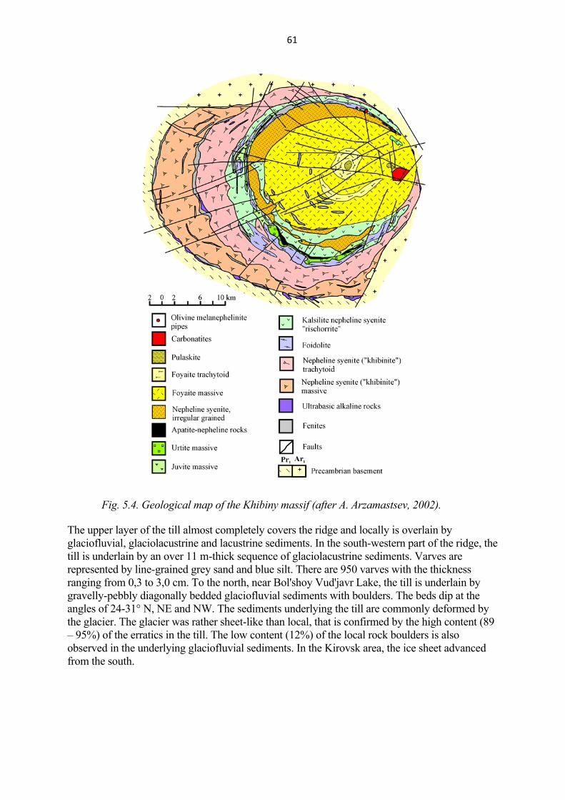
61
Fig. 5.4. Geological map of the Khibiny massif (after A. Arzamastsev, 2002).
The upper layer of the till almost completely covers the ridge and locally is overlain by glaciofluvial, glaciolacustrine and lacustrine sediments. In the south-western part of the ridge, the till is underlain by an over 11 m-thick sequence of glaciolacustrine sediments. Varves are represented by line-grained grey sand and blue silt. There are 950 varves with the thickness ranging from 0,3 to 3,0 cm. To the north, near Bol'shoy Vud'javr Lake, the till is underlain by gravelly-pebbly diagonally bedded glaciofluvial sediments with boulders. The beds dip at the angles of 24-31° N, NE and NW. The sediments underlying the till are commonly deformed by the glacier. The glacier was rather sheet-like than local, that is confirmed by the high content (89 – 95%) of the erratics in the till. The low content (12%) of the local rock boulders is also observed in the underlying glaciofluvial sediments. In the Kirovsk area, the ice sheet advanced from the south.
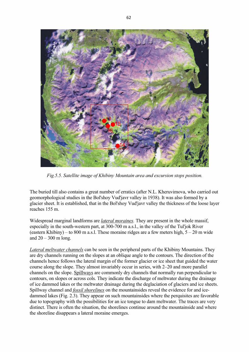
62
Fig.5.5. Satellite image of Khibiny Mountain area and excursion stops position.
The buried till also contains a great number of erratics (after N.L. Kheruvimova, who carried out geomorphological studies in the Bol'shoy Vud'javr valley in 1938). It was also formed by a glacier sheet. It is established, that in the Bol'shoy Vud'javr valley the thickness of the loose layer reaches 155 m.
lateral morainesWidespread marginal landforms are . They are present in the whole massif, especially in the south-western part, at 300-700 m a.s.l., in the valley of the Tul'jok River (eastern Khibiny) – to 800 m a.s.l. These moraine ridges are a few meters high, 5 – 20 m wide and 20 – 300 m long. Lateral meltwater channels can be seen in the peripheral parts of the Khibiny Mountains. They are dry channels running on the slopes at an oblique angle to the contours. The direction of the channels hence follows the lateral margin of the former glacier or ice sheet that guided the water course along the slope. They almost invariably occur in series, with 2–20 and more parallel channels on the slope. Spillways are commonly dry channels that normally run perpendicular to contours, on slopes or across cols. They indicate the discharge of meltwater during the drainage of ice dammed lakes or the meltwater drainage during the deglaciation of glaciers and ice sheets. Spillway channel and fossil shorelines on the mountainsides reveal the evidence for and ice-dammed lakes (Fig. 2.3). They appear on such mountainsides where the perquisites are favorable due to topography with the possibilities for an ice tongue to dam meltwater. The traces are very distinct. There is often the situation, the shorelines continue around the mountainside and where the shoreline disappears a lateral moraine emerges.

63
Ice dammed lakes features are large glaciofluvial deltas in trough valley of the Kunijok and Kukisjok Rivers and in the southern foothills Khibiny Mountains (Lovchorr area), aqueoglacial plain in the valley of Malyi Vud'javr Lake.
sandurA with meltwater channels running in a different direction than present channels covers the floor of largest fluvial valley of the Tul'jok River in the eastern part of the Khibiny Mountains (Fig. 2.3.). Fossil small deltas are present here. A few eskers are situated in the south-eastern Khibiny piedmont. Landforms similar to De Geer moraines are found in several valleys and cirques, for example in the Tachtarvumchor area. They look as discrete ridges ranging from short and straight to long and undulating. The width of the ridges is about 15 m, the distance between them - 50-300 m, their height – a few meters. The ridges sometimes continue into the lateral moraine along the mountainside.
Hummocky moraine areas can be seen in the eastern part of the massif and in the trough valley of the Kukisjok, Kunijok Rivers and elongated lakes; smaller areas are present over the Khibiny. The areas with hummocky moraine are found below 700 m a.s.l. Their size is 500x200 – 5000x3000 m (Fig. 2.3).
Stop 14. Marginal moraine ridge on which the city of Kirovsk is located.
The town of Kirovsk is built on the Khibiny largest marginal moraine ridge (Fig. 5.6). Geological and geophysical data of V.I. Kotelnikov and D.P. Tsymplyakov (1937) show that the ridge consists of two, or maybe three moraine layers, that are separated by the sediments of varied granulometric composition. The uppermost part of the ridge section was studied in detail by A.D. Armand (1964).
Fig. 5.6. The dump marginal moraine ridge on which is situated the Kiravsk.

64
Stop 15. Top of marginal moraine ridge in the Malyi Vud'javr valley
The floor of the Malyi Vud'javr valley represents the aqueoglacial plain. The south-eastern slope of the valley is formed by the thick marginal moraine ridge (large end moraine), Stop 16 is on its surface (Fig. 5.7). The relative height of the ridge reaches of 80 m, the width of the basement is 400-500 m. Erratics are universally distributed on its surface. The large end moraine marks the position of the glacier lobe, invaded into the inner part of Khibiny from the south along the Belaya River valley and Bol’shoi Vud’javr Lake.
Fig. 5.7. Overall view to the Malyi Vud'javr valley. Stop 16 is situated on the top of the end moraine ridge.
The cirques of Tachtarvuwchorr and Kukisjok trough valley (Fig. 5.8.) in western part of Malyi Vud'javr valley can be seen from the stop 16.
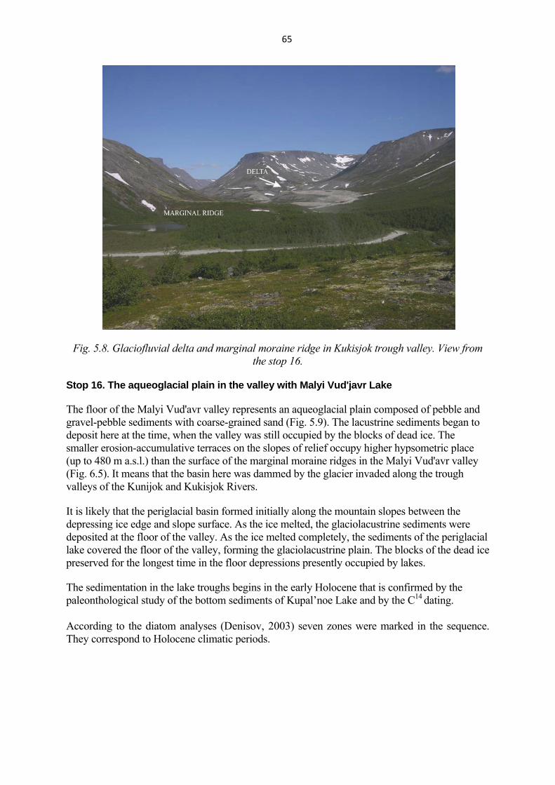
65
Fig. 5.8. Glaciofluvial delta and marginal moraine ridge in Kukisjok trough valley. View from the stop 16.
Stop 16. The aqueoglacial plain in the valley with Malyi Vud'javr Lake
The floor of the Malyi Vud'avr valley represents an aqueoglacial plain composed of pebble and gravel-pebble sediments with coarse-grained sand (Fig. 5.9). The lacustrine sediments began to deposit here at the time, when the valley was still occupied by the blocks of dead ice. The smaller erosion-accumulative terraces on the slopes of relief occupy higher hypsometric place (up to 480 m a.s.l.) than the surface of the marginal moraine ridges in the Malyi Vud'avr valley (Fig. 6.5). It means that the basin here was dammed by the glacier invaded along the trough valleys of the Kunijok and Kukisjok Rivers. It is likely that the periglacial basin formed initially along the mountain slopes between the depressing ice edge and slope surface. As the ice melted, the glaciolacustrine sediments were deposited at the floor of the valley. As the ice melted completely, the sediments of the periglacial lake covered the floor of the valley, forming the glaciolacustrine plain. The blocks of the dead ice preserved for the longest time in the floor depressions presently occupied by lakes. The sedimentation in the lake troughs begins in the early Holocene that is confirmed by the paleonthological study of the bottom sediments of Kupal’noe Lake and by the С14 dating.
According to the diatom analyses (Denisov, 2003) seven zones were marked in the sequence. They correspond to Holocene climatic periods.
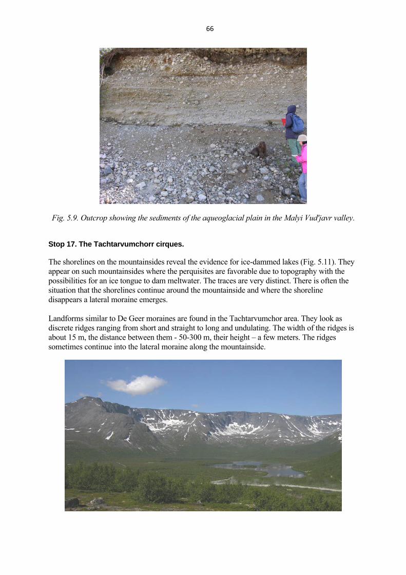
66
Fig. 5.9. Outcrop showing the sediments of the aqueoglacial plain in the Malyi Vud'javr valley.
Stop 17. The Tachtarvumchorr cirques. The shorelines on the mountainsides reveal the evidence for ice-dammed lakes (Fig. 5.11). They appear on such mountainsides where the perquisites are favorable due to topography with the possibilities for an ice tongue to dam meltwater. The traces are very distinct. There is often the situation that the shorelines continue around the mountainside and where the shoreline disappears a lateral moraine emerges. Landforms similar to De Geer moraines are found in the Tachtarvumchor area. They look as discrete ridges ranging from short and straight to long and undulating. The width of the ridges is about 15 m, the distance between them - 50-300 m, their height – a few meters. The ridges sometimes continue into the lateral moraine along the mountainside.
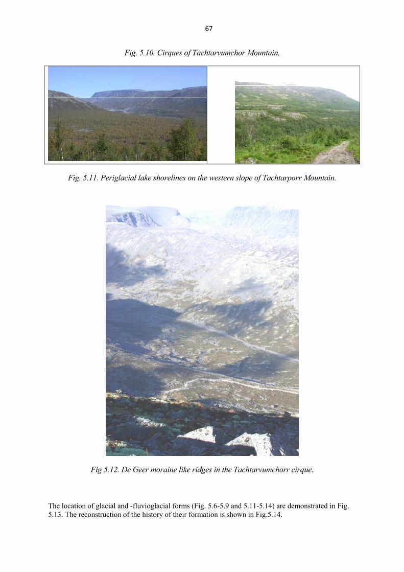
67
Fig. 5.10. Cirques of Tachtarvumchor Mountain.
Fig. 5.11. Periglacial lake shorelines on the western slope of Tachtarporr Mountain.
Fig 5.12. De Geer moraine like ridges in the Tachtarvumchorr cirque.
The location of glacial and -fluvioglacial forms (Fig. 5.6-5.9 and 5.11-5.14) are demonstrated in Fig. 5.13. The reconstruction of the history of their formation is shown in Fig.5.14.

68
Fig.5.13. Scheme of glacial formations distribution in the southern part of the Khibiny massif.
1 - ice sheet marginal moraines: a-dump moraine, b-push moraine, 2 - end and circus moraines of local glaciers (a), De Geer moraines (b); 3 - glaciofluvial delta deposits; 4 -
sandur; 5 - shoreline of ice-dammed lake; 6 - profile line; 7 - content of pebbles of acid and basic basement rocks (a), and pebbles of the Khiniby nepheline syenites.
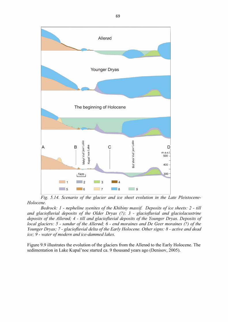
69
Fig. 5.14. Scenario of the glacier and ice sheet evolution in the Late Pleistocene-
Holocene. Bedrock: 1 - nepheline syenites of the Khibiny massif. Deposits of ice sheets: 2 - till
and glaciofluvial deposits of the Older Dryas (?); 3 - glaciofluvial and glaciolacustrine deposits of the Allerød; 4 - till and glaciofluvial deposits of the Younger Dryas. Deposits of local glaciers: 5 - sandur of the Allerød; 6 - end moraines and De Geer moraines (?) of the Younger Dryas; 7 - glaciofluvial delta of the Early Holocene. Other signs: 8 - active and dead ice; 9 - water of modern and ice-dammed lakes. Figure 9.9 illustrates the evolution of the glaciers from the Allerød to the Early Holocene. The sedimentation in Lake Kupal’noe started ca. 9 thousand years ago (Denisov, 2005).
70
References
Additions to Russian Stpatigraphic Code, 2000. Saint-Petersburg: VSEGEI, (in Russian). Armand, A.D., 1964. Evolution of the relief of Khibiny and Prikhibin’e plain. Apatity, Geological Institute, Kola
Science Centre, 244 p., (in Russian). Armand, A.D., 1969. Salpausselka stage and the lateglacial sea channels of SW Murmansk region // Main problems
of the Anthropogenic geomorphology and stratigraphy of Kola Peninsula. Leningrad: Nauka, pp.86-95, (in Russian).
Armand, A.D, Armand, N.N., Grave, M.K., Yevzerov, V.Ya., Lebedeva, R.M., 1969. Generalized scheme of Quaternary (Anthropogen) Deposits of the Kola Peninsula in the light of the new data. In: Main problems of geomorphology and anthropogenic stratigraphy of the Kola Peninsula. Leningrad: Nauka, pp.7-25, (in Russian).
Armand, A.D. and Samsonova, L.Ya., 1969. Marine deposits and Holocene tectonic in the Kandalaksha area // Main problems of the geomorphology and anthropogenic stratigraphy of the Kola peninsula. Nauka, Leningrad, pp. 96-111, (In Russian).
Arzamastsev, A.A., 2002. The Lovozero massif // Mitrofanov, F.P. and Zozulya, D.R., (eds): Major geological sights of the Kola Peninsula, Apatity, pp.117-125.
Arzamastsev, A.A., 2002. The Khibiny massif // Mitrofanov, F.P. and Zozulya, D.R., (eds): Major geological sights of the Kola Peninsula, Apatity, pp.102-116.
Bakhmutov, V.G., Yevzerov, V.Ya. & Kolka, V.V., 1993. Paleomagnetism and lithology of Late Weichselian deposits in Ust-Pjalka`s periglacial lake, south-east of the Kola Peninsula // Geologica Carpatica, 44, p. 315-324.
Bakhmutov, V., Yevzerov, V., Kolka, V., 1994. Geomagnetic secular variations of high-latitude glaciomarine sediments: data from the Kola Peninsula, northwestern Russia // Phys. Earth. Planet. Inter., v.85, pp.143-153.
Biske, G.S., 1959. Quaternary deposits and geomorphology of Karelia. Petrozavodsk: Karelian Branch of AN USSR, 307p., (in Russian).
Denisov D., 2003. Regularities of change in diatom assemblages structure under the long term climatic changes in the central Kola Peninsula // Book of abstracts of the ACSYS Final Science Conference "The FCSYS Decade and Beyond" (11-14 November 2003, St.Petersburg, Russia). AARI of Roshydromet, St.Petersburg, .25-27.
Deep structure and seismisity of the Karelian region and its margins. 2004 / Sharov, N. (ed.), Petrozavodsk: Karelian S.C. of Russian Academy of Sciences, 353 p. (in Russian).
Donner, J., Eronen, M. and Jungner, H., 1977. The dating of the Holocene relative sea-level changes in Finnmark, North Norway // Norsk geografisk Tidsskrift, 31, 103-128.
Ekman, I.M., Iljin V.A., 1991. Deglaciation, the Younger Dryas end moraines and their correlation in the Karelian A.S.S.R. and adjacent areas // H.Rainio and M.Saarnisto (eds.): Eastern Fennoscandian Younger Dryas end moraines, Excursion guide. Geological Survey of Finland, Espoo, pp.73-101.
Firth C.R.& Stewart I.S. 2000. Postglacial tectonics of the Scottish glacio-isostatic uplift centre. Quaternary Science Reviews 19. 1469-1493
Geology of the Kola Peninsula (Baltic Sheald), 1995 / Mitrofanov, F.P., Pozhilenko, V.I., Smolkin, V.E. et al. Apatity, 145p., (in Russian).
Grave, M. K., Gunova, V. S., Devyatova, E. I., et al., 1969. Mikulino Interglacial in the South-East of the Kola Peninsula // Main Problems of geomorphology and anthropogenic stratigraphy of the Kola Peninsula. Leningrad: Nauka, pp. 25-56, (in Russian).
Grave, M.K, Yevzerov, V.Ya., Likhachev, A.B., Spicin, A.G., 1964. New data on detrital deposits and relief formation of Seydozero area (Lovozero Tundra) // Relief and geological structure of the sedimentary cover of the Kola Peninsula. Moscow-Leningrad: Nauka, pp.5-48, (in Russian).
Grosswald, M.G. and Hughes, T.J., 2002. The Russian component of an Arctic Ice Sheet during Last Glacial Maximum // Quaternary Science Reviews, 21, 121-146.
Grøsfjield K., Funder S., Seidenkrantz M.-S., Glaister Ch. Last Interglacial marine environments in the White Sea region, northwestern Russia// Boreas, 2006, vol. 35, no 6, 493-520.
Gudina, V.I., Yevzerov, V.Ya., 1981. The stratigraphy and foraminifer of the Upper Pleistocene in the Kola Peninsula. The British Library Lending Division, 153p.
Gurina N.N., 1982. Time, entrenched into the stone. Murmansk Book Press, Murmansk, 120p., (in Russian). Gzovsky, M.V., 1975. Basic aspects of tectonophysics. Moscow: Nauka, 536 p, (in Russian). Hättestrand, C. and. Clark, Ch. D. The glacial geomorphology of Kola Peninsula and adjacent areas in
Murmansk Region, Russia // in press.
71
Helmens, K.F., Räsänen, M.E., Jochansson, P.W., Junger, H., Korjonen, K., 2000. The Last Interglacial-Glacial cycle in NE Fennoscandia: a nearly continuous record from Sokli (Finnish Lapland) // Quaternary Science Reviews, 19, 1605-1623.
Hromovskih, V.S., 1965. Seismogeology of Transbaikalia. M.: Nauka, 121p., (in Russian). Jensen M., Larsen E., Demidov I. N., Funder S., Kjær H. Depositional environments and sea-level changes
deduced from Middle Weichselian tidally influenced sediments, Arkhangelsk region, northwestern Russia// Boreas, 2006, vol. 35, no 6,. 521-538.
Juozapavichus, G.A., Jurgaitis, A.A., Zimkute, J.Z., 1981. Peculiarities of lithogenesis of marginal glaciofluvial ridge deposits and implications for paleogeographic studies // Pleistocene geology of the north-west of the USSR. Apatity, pp. 23-30, (in Russian).
Jurgaitis, A.A. 1984. Lithogenesis of glaciofluvial deposits in the area of last continental glaciation. Moscow: Nedra, 184 p., (in Russian).
Kazakov, A.N., 1980. Geometric analysis of fold structures with the use of stereograms // Geological survey of strongly dislocated sequences. Leningrad: Nedra, pp.28-48, (in Russian).
Kolka, V.V., Yevzerov, V Ya., Møller, J.J. and Corner, G.D., 1998. Postglacial sea-level change at Umba, Kola Peninsula, Northern Russia // Abstract of Fourth Quaternary Environment of the Eurasian North (QUEEN) workshop, S.-Petersburg, Russia, 5-8 February 1998, p.27.
Kolka, V.V., Yevzerov, V.Ya., Møller, J.J. and Corner, G.D., 2000. Environmental history and postglacial relative sea -level change in the White sea basin, northwest Russia // Abstract of Fourth Quaternary Environment of the Eurasian North (QUEEN) workshop, Lund, Sweden, 7-10 April 2000, p.24.
Korsakova, O.P., Molod'kov, A.N., Kol'ka, V.V., 2004. Geological-stratigraphic position of Upper Pleistocene marine sediments in the Southern Kola Peninsula: evidence from geochronological and geological data // Doklady Akademii Nauk, v.398, №2,. 218-222, (in Russian).
Koshechkin, B.I., 1979. The Holocene tectonics of the Eastern part of the Baltic Shield. Leningrad: Nauka, 160 p., (in Russian).
Kotelnikov, V.I. and Tsymplyakov, D.P., 1937. Geological-exploration and geophysical studies from construction places of the bridges across Belaya river near 16 and 19 kilometer of the railroad of the “Apatit” Co. Report, “Apatit” Co.
Kramm, U. and Kogarko, L.N., 1994. Nd and Sr Isotope Signatures of the Khibina and Lovozero Agpaitic Centres, Kola Alkaline Province, Russia // Lithos, vol. 32, 225-242.
Lagerback, R. 1990. Late Quaternary faulting and paleoseismicity in northern Fennoscandia, with particular reference to the Lansjarv area, northern Sweden // Geologiska Foreningens i Stockholm Forhandingar, v.112, № 4, .333-354.
Lavrova, M.A., 1960. Quaternary geology of the Kola Peninsula. Moscow-Leningrad: Publ.of Acad.Sc.of USSR, 233 p., (in Rusian).
Lavrushin, Yu. A., Geptner, A.R., Golubev, Yu.K., 1986. Glacial type of sedimentary and lithologic genesis. Moscow: Nauka, 156 p., (in Russian).
Lintinen, P. and Nenonen, J., 1997. Glacial History of the Vestfjella and Heimefrontfjella Nunatak Ranges in Western Dronning Maud Land, Antarctica // C.A. Ricci (ed.): The Antarctic Region: Geological Evolution and Processes, . 845-852.
Lukashov, A. D., 1980. The study of orientations of pebbles and structures aimed at establishing the conditions of formation of some accumulative glacial formations // Field and laboratory methods of investigation of glacial deposits. Tallinn, pp.87-89, (in Russian).
Lukashov, A.D., 1995. Paleoseismotectonics in the Northern part of Lake Onega (Zaonezhskij peninsula, Russian Karelia). Nuclear Waste Disposal Rec. Peport YST-90. Geol. Survey of Finland, Espoo, 36p.
Lukashov, A.D., Iljin, V.A., Ekman, I.M., 1981. Marginal glacial formations of the Salpausselka stage in Soviet Karelia // Glacial deposits and glacial history in Eastern Fennoscandia. Apatity, pp.128-139.
Miyamura. S., 1963. A note on Fennoscandian seismicity // Geophysica, v.7, №4, Helsinki, p.21. Molodkov,A., Yevzerov,V. 2004. ESR/OSL ages of long-debated subtill fossil-bearing marine deposits from the
southern Kola Peninsula: stratigraphic implications. Boreas, Vol.33, pp.123-131. Mörner, N.A., 1995. Paleoseismisity - the Swedish Case // Quaternary International, v.25, .75-80. Morner N.-A. Paleoseismisity of Sweden. Stockholm, 2003. 300p. Näslund, J. O., Rodhe, L., Fastook, J. L., Holmlund, P., 2003. New ways of studying ice sheet flow directions
and glacial erosion by computer modeling-examples from Fennoscandia // Quaternary Science Reviews, 22, .245–258.
Nikolaeva, S.B. 2001: Paleoseismic dislocations of the north-eastern part of the Baltic shield and their geological-tectonical position. Geomorphology 4, 66-74 (in Russian).
Nikolaeva, S.B. 2006: Seismogenic Deformations in Early Holocene Sediments of the Pechenga River Terrace (Kola Peninsula). Doklady Earth Sciences 406, 4-7.
72
Nikonov, A. A., 1964. Relief development and paleogeorgaphy of Anthropogene in the west Kola Peninsula. Moscow-Leningrad: Nauka, 183p., (in Russian).
Samoylovich, Yu.G., Kostin, D.A., 1992. The marginal glacial formation on the Kola shelf on the Barents Sea // Geology of quaternary deposits and geotectonic of the glaciated areas of Western Europe. Apatity: Publ.of KSC RAS, p.9, (in Russian).
Semyonova, L.R., 1998. Subdividing of the Upper Pleistocene (Kola Peninsula) // RGA, Scince-and-techniques information bulletin. S-Petersburg, pp.18-23, (in Russian).
Deep structure and seismisity of the Karelian region and its margins, 2004 / Sharov, N. (ed.), Petrozavodsk: Karelian S.C. of Russian Academy of Sciences, 353p., (in Russian).
Solonenko, V.P., 1973. Paleoseismology // Physics of Earth, №9, pp.3-16, (in Russian). Stewart, I.S., Sauber, J.& Rose, J. 2000. Glacio-seismotectonics: ice sheets, crustal deformation and seismicity.
Quaternary Science Reviews 19. 1367-1389. Strelkov, S.A., Yevzerov, V.Ya, Koshechkin, B.I., 1976. The history of the relief and unconsolidated deposits
formation NE Baltic Shield. Leningrad: Nauka, 164p., (in Russian). Sutinen, R. 2005: Timing of early Holocene landslides in Kittilä, Finnish Lapland. In: Antti E.K. Ojala (Ed.)
Quaternary studies in the northern and Arctic regions of Finland. Geological Survey of Finland, Special Paper 40, 53-58.
Tarnogradskii, V.D., Kapljanskaja, F.A., 1992. Global changes in last time // Sovietskaia geology, №6, .3-11, (in Russian).
Yevzerov, V.Ya., 1990. Deglaciation of the NE Baltic Shield // Quaternary period: methods of investigation, stratigraphy and lithology. Tallinn, pp.192-193.
Yevzerov, V.Ya., 1996. Formation of marginal ridges of the Late Valdai ice sheet in conditions of Arctic climate // Geomorphology, № 2, pp., (in Russian).
Yevzerov, V.Ya., Khomutova, V.I., Møller, J.J,. 1998. Evolution of the last surface glaciation on the data of the lakes sediment study // History of Pleistocene lakes of the East European Plain. St.Petersburg: Nauka, pp. 47-54, (in Russian).
Yevzerov, V.Ya, Kolka, V.V., 1993. End moraines of Younger Dryas and deglaciation of northen and central Kola Peninsula // V.Yevzerov (ed.): Eastern Fennoscandian Younger Dryas End Moraines and Deglaciation, Excursion guide, Apatity, . 5-38.
Yevzerov, V.Ya., Koshechkin, B.I., 1980. Paleogeography of the Pleistocene on the western Kola Peninsula. Leningrad: Nauka, 105p., (in Russian).
Yevzerov, V.Ya., Nikolaeva, S.B., 2000. Marginal belts of the Kola region // Geomorphology, № 1, 61-73, (in Russian).
Yevzerov V. Ya., Nikolaeva S.B., 2003. Seismotectonic consequences of the Quaternary ice sheets development in the Kola region // Geomorphology, №2, .61-64, (in Russian).
Yevzerov, V.Ya., Strelkov, S.A., 1969. About relationship between Scandinavian ice covers and local mountain glaciers of Lovozerskije Tundry // Nature and Economy in the Northe, 2, pp.5-8, (in Russian).
Yevzerov V.Ya. Late Pleistocene marine transgression in the Kola region//Abstracts volume of International Workshop “Correlation of Pleistocene Events in the Russian North”, December 4-6, 2006, St. Petersburg. P. 108.
Zozulya D.R., Chickiryov I.V., Gavrilenko B.V., 2003. Some data for transgression of the Kara ice sheet on the Kola region // Excursion Guide and Abstracts, Int. Symp. “Human Impact and Geological Heritage”, 12-17 May 2003, Tallinn, Estonia. Tallinn, pp.141-142.