Embed Size (px)
Citation preview

BAILDON HERITAGE TRAILS
The Kirklands Walk
Produced by Baildon Local History Society ©
2014

First edition 2009Second edition 2014
This Heritage Trail is one of several created by Baildon Local History Society andcommissioned by Baildon Town (then Parish) Council. Please see inside the back coverfor a list of the Trails in the series.
The Walks are available in booklet form from Baildon Library for a small fee, or youcan download them free from the Baildon Town Council web site –www.baildontowncouncil.gov.uk
Countryside Code and PrivacySeveral of these walks use public rights of way over farm land and others go close to
houses. Please help keep Baildon the beautiful place it is:Be safe, plan ahead and follow any signs.
Leave gates and property as you find themProtect plants and animals and take your litter home
Keep dogs under close controlRespect other people and their property
How to get thereBus: Service 737 (Airport and Harrogate) runs along Otley Road, and some others.
Rail: Wharfedale Line trains run from Bradford, Shipley and Ilkley to Baildon.From the station, walk through the car park and turn left along Ridgewood Close.At the end of the houses on the right, before the flats, turn right up a footpathkeeping the flats on your left. Cross Kirklands Road into Hawthorn View, at theend of which turn left down over the railway footbridge. Turn right into FyfeLane and follow it down the hill to Otley Road (the main road). Turn righttowards the pedestrian crossing at St John’s Court where this walk starts.
For times of buses and trains check with MetroLine(0113 245 7676 or www.wymetro.com)
Car: If coming by car, park at St John’s Court shopping area, just off Otley Road(A6038)
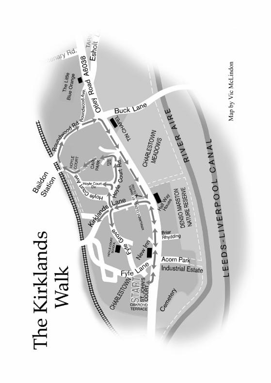
See the end of this Guide for a map of the walk.

Baildon Heritage Trails The Kirklands Walk
1
BAILDON HERITAGE TRAILS
The Kirklands Walk (Distance: about 2 miles or 3.3 km.)
This walk starts and finishes at St John’s Court on Otley Road, and covers points ofinterest in Charlestown along the Otley Road and the Kirklands area, including StJames’s Church.
From St John’s Court to the Half Way HouseSt John’s Court is a small modern shopping area built in the late 1970s on the site ofdemolished older terrace housing including a street named St John Street. A separatebooklet gives more information about this central area of Charlestown.
From St John’s Court turn left along Otley Road, towards Otley. You will pass on theleft the bottom of Ada Street, a row of nineteenth century housing which escaped the1970s redevelopment, and further along is Fyfe Lane with a huge sycamore on thecorner which gives its name to Sycamore Court.
Cross Fyfe Lane and continue along Otley Road to a pair of old stone gate posts withthe names Kirklandsand Kirkbourne re-spectively. To the leftof these on the mainroad are a pair of stonehouses. These werelodges which werepart of the Kirklandsestate. According tothe 1912 BradfordKelly’s Directory onehoused the coachmanand one a gardener.The gateposts stand atthe entrance to what isnow a private drivecalled KirkbourneDrive.
This used to be the long tree lined drive up to the house called Kirklands House. Thegardens were large and a 1906 plan shows they contained a vinery, a fernery andstables; and in the grounds at the rear was a coach house. Most of the land was sold off
Gateposts at Kirkbourne Drive

Baildon Heritage Trails The Kirklands Walk
2
and the drive nowleads to somemodern housesand Kirkbourne.Kirklands Houseitself was split upand is now ap-proached fromKirklands Lane,and the coachhouse was con-verted into sever-al houses whichare approachedfrom Fyfe Grove– both of whichwe shall see later.
Charlestown Ropeworks
The New Inn, with the Half Way House in the distance

Baildon Heritage Trails The Kirklands Walk
3
On the opposite side of the main road, where Fern Cottage and the kennels now are,from the latter half of the nineteenth century there used to be the ropeworks of GeorgeCopley, rope and twine maker. In 1914 the ropewalk was powered by a 6hp gas engine.
Just past the gateposts of Kirkbourne drive you reach the New Inn pub. This appears onthe 1860 OS map but not the 1850 map or 1853 White’s Directory. This is where CecilWoodward was born (see later). His mother’s family were Yates and it is said they hadthe New Inn for up to a hundred years. Joseph Yates, a widower, was innkeeper therein 1881 with his 3 sons, 3 daughters and grand-daughter. In the 1970s customers wereserved by a waiter. Prosperity since then has dipped for such establishments: this pubhas recently re-opened after a short period of closure, whilst further back along Otleyroad at Woodbottom the Queens pub closed down and was reopened as an Italianrestaurant. This is in keeping with a current trend.
Opposite the New Inn is a road called Briar Rhydding. The old word rhydding indicatesthat it was cleared (ridden) at some time in the past, presumably of prickly bushes suchas wild roses. There used to be an orchard opposite the old stone houses down there,and in one of the houses Cecil Woodward lived in the 1940s and 50s when he searched
and discovered manyMesolithic (middlestone age) microlithsi.e., tiny flint arrowheads in CharlestownMeadows, the fields be-tween the River Aireand further along OtleyRoad behind the HalfWay House and to-wards Buck Lane (seemap) – a ‘Baildon busi-ness park’ is plannedfor this area, so thefields may no longer beobvious when you getthere. By the terrace ofstone houses is a small
block of privies and perhaps a wash house. At the bottom of Briar Rhydding is BaildonTimber, a family business owned by the Baildon family who are descended from the deBayldon’s of Baildon Hall.
Further along on the right hand side of Otley Road is DENSO Ltd. This is a group offirms with a Japanese parent. The first site before expansion on Otley road waspurchased in 1974 for Marston Radiators Ltd, which developed from a small tinsmith’sbusiness making and repairing car radiators behind Leeds Town Hall in 1904 when carswere few, handmade and very expensive. It was taken over by Excelsior Radiator
The old houses at Briar Rhydding

Baildon Heritage Trails The Kirklands Walk
4
Company and made radiators for a range of cars including the Airedale before becomingpart of ICI then IMI and later Denso. It now makes engine cooling systems for vehiclesincluding major car manufacturers across the world as well as for electric powergeneration. One of the benefits Denso has conferred on the area is the creation of anature reserve down by the river in 1991: the Riverside Walk booklet takes you throughit.
Further along Otley Road, opposite Kirklands Lane, you will see the Half Way Housepub, which was previously called the Fleece – indeed, on the 1841 OS map it was theGolden Fleece! On the 1950 OS map it is the Fleece and on the 1960 OS map the HalfWay House, so called because it is almost half way between Otley and Bradford asindicated by the old milestone at the bottom of Hollins Hill: Otley 5 miles, Bradford 5miles. This road, built about 1825, was a Turnpike Trust Road, built for the Kirkstall,
Otley and Shipley Trust who charged users a toll. It was the law that there had to bemilestones on such roads every mile, and two remain on this stretch of road. Inns alongthe route provided lodgings and stabling for the horses. In 1921 the Fleece Inn alteredits stable into a garage. The Half Way House has been greatly enlarged in recent yearsparticularly the restaurant, part of which was once a games room with dart board. Alittle past the pub on the right hand side there is a public footpath leading to the riversidefootpath and the Denso Marston Nature Reserve.
St James’s: The white wooden churchOpposite the pub on the bottom corner of Kirklands Lane is the white wooden St JamesChurch, which has not always occupied its present site, nor even has it always been inBaildon. In 1881 a Rev Hammond Roberson Bailey was living at Kirklands with acook, house maid and parlour maid. He was a very intelligent and well educatedCambridge don who became the rector of Great Warley in Essex in 1866. He was anephew of one of the Rands (see below) and became wealthy through inheritance.
The Half Way House
Baildon Heritage Trails The Kirklands Walk
5
Before he died in 1900 he arranged for the temporary church in the grounds of hisRectory at Great Warley to be moved to Baildon when repairs to the medieval perma-nent church there were completed. First consecrated in 1892 and dedicated to St. Mary,it was transported in numbered sections by steam traction engine and opened in 1904 inthe middle of a small field which was part of the land owned by the church sincemedieval times. This was the old white wooden St James’s, which became a strikinglandmark, being affectionately dubbed ‘the church on the prairie’. It is a Grade II listedbuilding. The church was originally one of two, and the other – which until recently wasthought not to have survived – is now thought to be the Church of the Redeemer atLower Pendock in Worcestershire, erected in c1890. St James’s was one of threedaughter churches in Baildon Parish. The others were St. Mary’s at Baildon Green andSt. Peter’s at Woodbottom, but both have been demolished.
However, maintenance of the church structure proved expensive over the years, andrecently it was moved a few yards to its present site at the corner of its field to releasethe rest of the land for houses – the sale of which financed a major renovation. It closedon Easter Sunday 2007, and the building was modernised with meeting room, modernkitchen and toilet facilities which replaced the old church hall. There is also a ‘biblicalgarden’ of plants and trees mentioned in the Bible, including olive, fig and vine. Itre-opened on 27 April 2008, and is now used for community purposes as well as churchservices.
St James’s Church

Baildon Heritage Trails The Kirklands Walk
6
This sale of land follows a longtradition of church support inBaildon. As long ago as thetwelfth century land known asKirklands was given to support achapel of ease in Baildon on HallCliffe by a Dame Alice Quintain.Baildon was in Otley Parish until1869 and the chapel saved peoplethe long trek across the moor forfunerals or in bad weather. Forthose who lived in Low Baildonand the Charlestown area theroute would be along old lanesand through hamlets such as Esh-olt in the valley. The old chapel
was replaced in 1848 by the new St John’s parish church (the tower was added after theFirst World War in memory of those killed) and the church lands have been sold overthe centuries to raise money for the church, the most recent being the development of StJames Close – the houses immediately beside the white wooden church. Nearby streetswith names which include Kirklands, such as Kirklands Lane and Close, indicate thatthe land was once part of the Kirklands owned by the church.
Within living memory (1950s) local residents (including Willie Rowling – see later)remember there being a farm house and barn immediately behind St James’s at its oldsite which they called Hoyle Court farm. There was grazing land for animals stretchingup to the railway. A short track led to the farm from Otley Road.
Kirklands HouseIf you walk up Kirklands Lane you will pass Kirklands Close and Kirkands Villas onthe left and Hartlington Court on the right. The old cobbled courtyard and KirklandsVillas are at the rear part of the old Kirklands House which still remains (the house usedto be approached from Otley Road by what is now Kirkbourne Drive). Old maps showa row of buildings on the opposite side of the lane to Kirklands House. In the 1841Census there are 7 houses at Kirklands housing five farming families, including MajorBradley and a farm labourer and a weaver. Major Bradley is still living there in 1871with his family and farming 22 acres. He was a tenant farmer.
The Mayor of Bradford William Rand had Kirklands House rebuilt and was still livingthere when he died in 1868. A window was erected in Baildon Parish Church in hismemory by his sister Mrs Anne Dodsworth. William was one of the pew owners listedin 1848 when the Parish Church was rebuilt, according to the book Baildon: a churchhistory by Philip Baxter. Pews were then paid for annually by qualifying propertyowners: William qualified by owning houses at Kirklands; and others listed owned
A steam lorry passing through CharlestownThe steam traction engine would have been much older

Baildon Heritage Trails The Kirklands Walk
7
property at Kirklands, Hoyle Farm and Upper Hoyle. However, by 1850 all pews werefree.
William was a member of the Rand family who owned a mill on the site of the presentAlhambra theatre, Victoria statue, and war memorial in Bradford. The Rev. HammondRoberson Bailey inherited Kirklands from his aunt Anne Dodsworth (née Anne Rand,his mother’s sister). His father’s mother, another Ann, was Ann Roberson, HammondRoberson’s sister. Hammond Roberson is described in Elizabeth Gaskell’s ‘Life ofCharlotte Bronte’, and features in Charlotte Bronte’s Shirley, as Rev. Matthewson. Rev.Hammond R. Bailey’s maternal grand-father, John Rand senior, came from the villageof Worstead in Norfolk. This was where the worstead branch of the wool textileindustry started, before moving to Bradford which became the centre of the industry asNorfolk declined. In 1803 John Rand senior built a factory which was only the thirdsteam driven factory for worsted spinning in Bradford.
In 1891 George Ambler was living at Kirklands House with his two unmarried sistersSarah and Harriet. They later moved to Woodlands on Roundwood Road. Georgeowned land locally and had a share in the family firm of Jeremiah Ambler and Sons inBradford. When he died in 1905 he was a very wealthy man. According to theYorkshire Daily Observer he left about a quarter of a million pounds. In 1951 PercyMonkman, a local artist, was given permission to convert the conservatory of KirklandsHouse into a studio and garage. In 1961 he was living at 2 Kirklands Villas beforemoving to Baildon village. Numbers 2 and 4 Kirklands Villas were originally part of
Kirklands Villas, Kirklands Lane

Baildon Heritage Trails The Kirklands Walk
8
the servants quarters of the House. The houses of Hartlington Court were built on thesite of Hartlington House which was burnt down in the early 1970s. According to a1918 indenture the house was previously known as Kirklands Villa.
Kirklands Farm and the old Coach HouseContinue up Kirklands Lane and at the crossroads turn left into Fyfe Grove, past the
front of KirklandsFarm on the rightand some modern(early 1970s) de-tached houses onthe left, until youreach the old CoachHouse on the left(this used to be thecoach house ofKirklands House,approached fromOtley Road by whatis now KirkbourneDrive). Behind it in
the background you will see the top of Kirkbourne.
Before returning to the crossroads notice the grounds of Hoyle Court Primary School alittle further ahead on the right, officially opened on the 23rd March in 1974 byCouncillor Keith Vickerman. Children had started on the previous September 5th. Notmany years after the school was built, Woodbottom Primary School in Lovatt Foldclosed (in 1981) and was later demolished. That was followed by the closure in 2000by Tong Park School on Otley Road, which was also demolished. Children from thoseareas went to the newHoyle Court School,which was expandedand refurbished – a ma-jor investment. Howev-er, in 2002, while thatwork was still going on,plans were announced toclose Hoyle CourtSchool by 2004! Thiswas vigorously and suc-cessfully resisted by theparents, however, basedon their own re-analysisof the data on which thatdecision had been based.
The Old Coach House on Fyfe Grove
Hoyle Court School

Baildon Heritage Trails The Kirklands Walk
9
Since then the school has been extended again, and has a nursery. Under the three tiersystem children from there went on to Ladderbanks Middle School on Coverdale Wayat age 9 and stayed until age 13. Since the education system reverted to the two tiersystem they move at age 11 and Ladderbanks has become the new Baildon ChurchPrimary School.
Return to the crossroads, turn left and follow Kirklands Lane round to the left. You willsee the back of Kirklands Farm and then Kirklands Cottage on the left. There is theremains of an old beehive oven in the converted farmhouse. According to SydneyJackson, the late curator of Cartwright Hall Museum, these ceased to be made by about1700. An indenture dated 1784 concerns Kirklands farm which had been part of theestate of the then deceased William Bol-ling, father of Francis and Robert Bol-ling. (This was a branch of the Bollingfamily of Bolling Hall which had movedto Ilkley.) The farm was worth the yearlysum of £7:10s (£7.50). The indenturerecords that Francis and Robert Baildoninherited and were entitled to the annualfee farm rent on payment of £178. In1971 it was a dairy farm rented by a MrHamilton Smith from Shipley Council,and the milk was delivered from a churnby horse and cart, before it was bought
The back of Kirklands Farm, Kirklands Lane
Shepherd’s crooks on St Helena gate

Baildon Heritage Trails The Kirklands Walk
10
by its present owner Mrs Greene and her late husband at which time it had two barnsand two adjacent cottages. They converted it into the large modern house which it istoday whilst retaining some original features.
A little further up Kirklands Lane on the right is a small row of old cottages called StHelena with an attractive small wrought iron gate which appears to include two shep-herd’s crooks. It is thought that this indicates origins connected with wool trade,although in the early C20th the houses were occupied by railway workers.
Hoyle CourtAs you retrace your steps back down Kirklands Lane to the cross roads yet again, noticethe row of villas opposite on the left, some with black and white gables, namedKirklands Avenue. These houses were built by 1901 and are included in the census ofthat year. They were conveniently placed for Baildon Station which at that time wasdouble track with platform and waiting room at this side of the line (you can read moreabout this in the Railway Walk). At the cross roads turn left and walk straight alongHoyle Court Road past Hoyle Court Avenue to the junction with Hoyle Court Drive.On the opposite pavement on the corner of Hoyle Court Drive, embedded in the grassof the open-plan blocks of flats, youwill see a large rock: it is an exam-ple of a cup and ring stone with 3cups and rings. Dating from thebronze age there is no known rea-son for this ‘rock art’ althoughmany suggestions have been made,both practical and abstract. Thereare many other examples in Bail-don and elsewhere, but this is theonly one locally at such a low ele-vation – all the others are on themoor. This one was moved 100metres to here to make for easyviewing when the Hoyle Court estate was being built in the 1970s.
Continue along Hoyle Court Road, following the road round towards Otley Road.Notice immediately after the post box on the left a long drive which leads towards thefront of a large house which can partially be seen in amongst the trees. This is HoyleCourt, now a Masonic Lodge, a large house built in 1912 for Sam Ambler, a director andmember of the mill owning family. More of this family later.
Turn up left past the post box, keeping Hoyle Court to your right. Walk past the blocksof flats until you reach the road (Hoyle Court Avenue). Here turn right, and at the endof the road left up a short flight of steps to a stone bridge across the railway. However,just before the bridge, turn right down some steps into a footpath: the railway is on yourleft, a house in a hollow with an old stone roof on your right.
The cup and ring stone at Hoyle Court Drive
Baildon Heritage Trails The Kirklands Walk
11
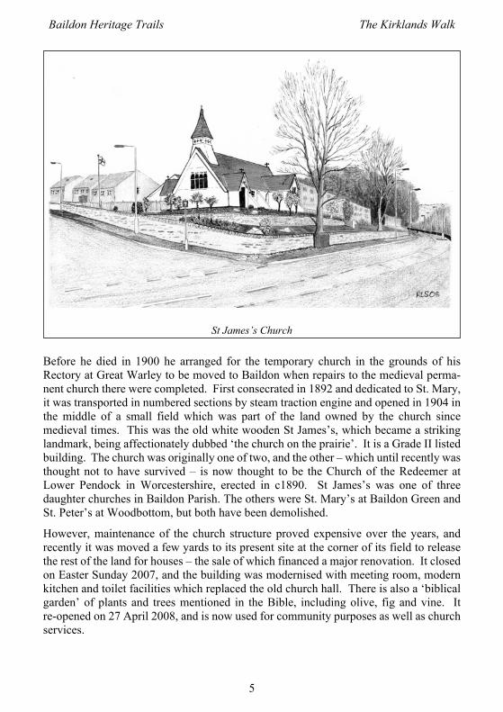
This is Hoyle Court Cottage, built in the eighteenth century when this area was calledHole. There are Parish records of people living ‘in ye Hole’ as long ago as the midseventeenth century: in 1657 the parish registers record the birth of a child called Mercyat Hole. In 1811 a woolcomber called James Frankland was living there. The Rowlingfamily, headed by Hugh (who farmed 35 acres in 1881) and then his son SamuelWhitehead Rowling, occupied Hole Farm in the nineteenth century, though it wasowned by the Ambler family. On the 1893 OS map Hole Farm was here. In the firsthalf of last century there were more buildings. The farm was extended and improvedwith the addition of a stable and cart shed, and there was more building later – the 1934Ordnance Survey map shows buildings (now demolished) on the Hoyle Court side ofthe bridge.
From the middle of the twentieth century the owners of Hoyle Court Cottage, the lateBetty Reid and her husband, modernised the house, installing water and electricity, andkept horses in a paddock and 400 pigs on some of the land nearby, before it was boughtby compulsory purchase by Shipley Council for building the Hoyle Court estate ofcouncil owned flats in the 1960s and 70s – which you have just walked through. (Theseflats were in preparation for a large new tax office in Shipley, but after the houses hadbeen built that idea was dropped. When the flats had been let, the tax office was builtafter all.) Private housing followed soon after. Hoyle Court Cottage was significantlyredeveloped in 2014.
Hoyle Court Cottage, before redevelopment in 2014

Baildon Heritage Trails The Kirklands Walk
12
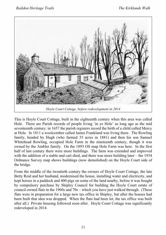
Roundwood and back to St John’s CourtContinue along the path, which joins a residential drive where you will pass GreyGables. At one time adrive led from theback to RoundwoodGrange, the large Vic-torian house on thecorner where the drivemeets RoundwoodRoad, because thiswas its lodge andcoach house. It had astable and loft abovewhere the stable boywould sleep. Whenthe present owner(Betty Hart) and herlate husband moved inthey found some strawupstairs.
Roundwood Grange, on the corner, is almost hidden by trees – the remains of the roundwood which gives the house and road their names. This, another Grade II listedbuilding, was built in 1898 for John and Alice Ambler, members of the Jeremiah Amblerand Sons family. The date and their initials are on the building. John and Samuel weresons of Edward Binks Ambler and grandsons of the Jeremiah who founded the firm in1783. Combers, spinners and weavers of all kinds of wool and hair, the firm moved toMidland Mills on Valley Road in 1869. Some parts of the mill buildings are stillstanding within view of Forster Square station. John (known as John junior) was adirector of the company and a JP. His uncle John (John senior) lived at Heaton Mount,Bradford.
Roundwood Grange was built in the Arts and Craft Gothic style with beautiful stainedglass and oak panelling. As well as two conventional WCs, when built it contained aDuckett’s Tippler. This was a type of toilet which could only be found in SE Lancashireand the West Riding of Yorkshire. On the ground floor of the house the sewerage wascarried away from the toilet by liquid kitchen waste. A Duckett’s and Son of Burnleytippler toilet (or slop closet) from 1890 can be seen in the underground gallery at TheMuseum of Science and Industry at Manchester.
From Roundwood Grange John Ambler moved to Thorpe Underwood Hall near York.That building has since become a private girls school. A neighbour of the Amblers ofRoundwood Grange was John’s younger brother Samuel Ambler, who had Hoyle Courtbuilt in 1912 (see above) and moved there from Heaton. Sam was also a Director ofJeremiah Ambler and Sons Ltd. In the early 1960s the Ormondroyd family were living
Grey Gables
Baildon Heritage Trails The Kirklands Walk
13
at RoundwoodGrange. They had abig works building,Ormondroyd & CoLtd (now demol-ished), at the bottomof Nelson Street inBradford which wasin the wool trade.
Turn right downRoundwood Road.The first road youpass on the left isPark Lane, on whichsome of the earliesthouses were built as
part of Tong Park for workers who walked to work at the local mill. The first smallinhabited area on Park Lane was known as Park. Further down on the left is RoundwoodAvenue which leads behind St James Place. This road used to be called Esholt Laneaccording to a map of 1841. It was a continuation of the lane from Esholt which passedwhat was the Shoulder of Mutton pub (now redeveloped and renamed the Little BlueOrange) on the corner and led up to Baildon village. By the wall, close to the downhillcorner of Roundwood Avenue with Roundwood Road is an old stone which looks tohave the initials ‘WR’ carved on it. They could stand for West Riding, or they could bethe initials of someone whose land boundary the stone marked, not necessarily where itis now sited. For instance, the tithe award and map of 1845/6 show that William Randowned fields near Kirklands. The stone is known to have been in its present locationsince at least 1926.
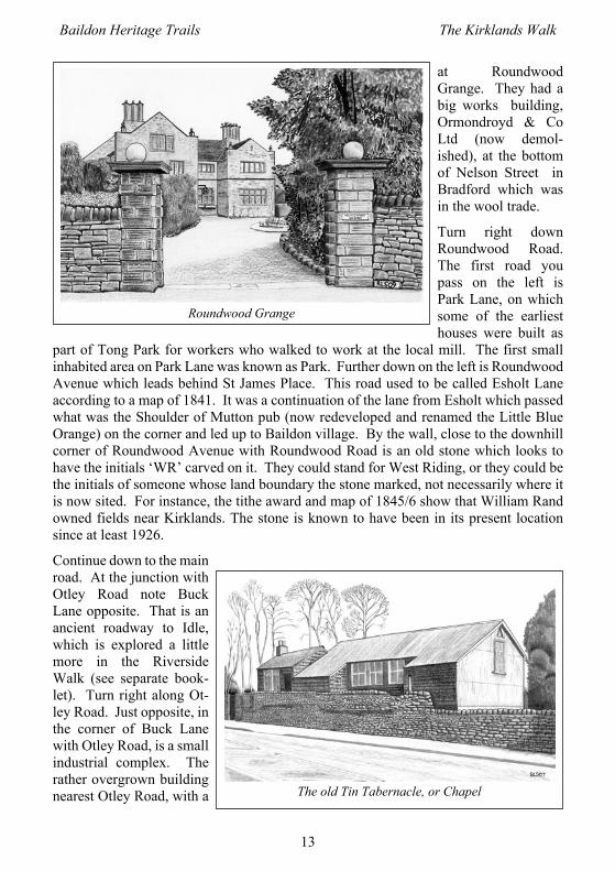
Continue down to the mainroad. At the junction withOtley Road note BuckLane opposite. That is anancient roadway to Idle,which is explored a littlemore in the RiversideWalk (see separate book-let). Turn right along Ot-ley Road. Just opposite, inthe corner of Buck Lanewith Otley Road, is a smallindustrial complex. Therather overgrown buildingnearest Otley Road, with a
Roundwood Grange
The old Tin Tabernacle, or Chapel

Baildon Heritage Trails The Kirklands Walk
14
metal roof and still with some shingle sides, was built as St James Mission Church in1869 and seated 200. It used to have a corrugated iron roof, and was known by localsas the Tin Tabernacle. This also is described in more detail in the Riverside Walkbooklet.
Continue along Otley Road until you come to Hoyle Court Road. Before the HoyleCourt estate was built there was a lodge here at the end of a tree lined drive leading upto the rear of Hoyle Court (the Masonic Lodge noted earlier) and stopping at a row ofbuildings (now demolished) at the side of Hoyle Court Cottage up by the railway line(as shown on the 1934 OS map). Willie Rowling (see above) and his wife and familylived at the lodge in the 1940s. The 1861 census records a farmer called William Ivesat Hole Top. The 1845-6 Baildon tithe map shows a small group of buildings and landfarmed by William Ives at the end of a track straight on from where there is now therailway footbridge to the other side of the line.
This completes the walk, and your way back to St John’s Court lies along Otley Road.For a quieter route you can walk along Hoyle Court Road to the cross roads, thenstraight across into Fyfe Grove to the next cross roads where you turn left down FyfeLane to Otley Road. Turn right towards the zebra crossing at St John’s Court.
If you came by train, make your way back up through the flats towards the railway andacross the footbridge you have already seen on this walk. This takes you to the station.
Note about distanceThis is a reasonably short walk, but you may well find you walk further than theindicated 2 miles (3.3 km.). Distances were measured from Google maps using theirdistance measuring tool in straight lines, but you are likely to wander here and there abit, and add a few detours of your own. So regard the distance given as an approximateminimum.
Baildon Heritage Trails The Kirklands Walk
15
Notes

Baildon Heritage Trails The Kirklands Walk
16
Notes

List of the Baildon Heritage TrailsAll these publications can be downloaded free at www.baildontowncouncil.gov.ukExcept as noted, they are available in booklet form for a small charge at Baildon Library.
1. The Baildon Village Walk: the old lanes, folds and corners of central Baildon.2. Coach Road to Shipley Glen: a short walk through lanes and woodlands.3. The Charlie Thompson Walk: old Charlestown round St John’s Court.4. The Turnpike Walk: between the two old turnpike road milestones on Otley Road.5. The Kirklands Walk: St John’s Court to St James’s, Kirklands and Hoyle Court.6. The Riverside Walk: from Roundwood Road to Charlestown by the River Aire.7. The Railway Walk: the Arches at Woodbottom to the great Viaduct at Tong Park.8. The Threshfield and Low Baildon Walk: Based on Station Road, with glimpses
of clothiers cottages and grand houses of later mill owners.9. The Lost Hamlets of Baildon Moor: the remains of Moorside, Low Hill and Sconce,
and the archaeology of the moor.10. Ferniehurst and Baildon Green: A walk looking principally at the sites of two
Victorian mansions with Salt family connections.11. The Salt Market Walk: Sconce, Birch Close and Faweather by old lanes.Also availableExploring Baildon: a Guide to Public Spaces: brief information on 55 selected sites
within the extensive, interesting and beautiful network of public spaces in Baildon.The Baildon Peace Walk: a short walk based on the Baildon Peace Garden betweenCliffe Avenue and Green Road. Published by and available from Baildon CommunityLink: 01274 588681 [email protected].
AcknowledgementsThe information for this walk was researched and gathered by
Mike Lawson, Tish Lawson, Stewart Main and Marian Taylor.Drawings by Roy Lorrain-Smith ©Maps by Vic McLindonHelp from many people and sources is gratefully acknowledged.
Comments on this walk are welcome and should be sent to:The Clerk of Baildon Town Council, Baildon Community Link, Cliffe Avenue,
Baildon BD17 [email protected]
Map
by
Vic
McL
indo
n
![Report of the Strategic Director of Regeneration and …...2. Hoyle Court Primary School Fyfe Grove Baildon BD17 6DN - 15/06897/ADV [Approve] (page 9) Baildon 3. Sunways Otley Road](https://img.dokumen.tips/doc/110x75/5f06946a7e708231d418b155/report-of-the-strategic-director-of-regeneration-and-2-hoyle-court-primary.jpg)