Embed Size (px)
Citation preview
www.agenziaentrate.gov.it
September 2017
(data as at 31 December 2016)
2016
Agenzia delle Entrate
Central Directorate Cadastre, Cartography and
Land Registry
The Italian Cadastral System

Central Directorate Cadastre, Cartography
and Land Registry
1
TABLE OF CONTENTS
1. BACKGROUND INFORMATION ........................................................................................ 2
2. THE CONTENTS OF THE CADASTRAL INFORMATION SYSTEM .............................. 3
2.1 The cartographic archive ................................................................................................. 3
2.2 The Land Cadastre archive .............................................................................................. 4
2.3 The Urban Building Cadastre archive .............................................................................. 5
2.4 The real estate urban units plans archive ......................................................................... 7
2.5 The archive of Buildings ................................................................................................. 8
3. THE UPDATING PROCEDURES ......................................................................................... 8
3.1 The PREGEO procedure for Land Cadastre .................................................................... 9
3.2 The DOCFA procedure for Urban Building Cadastre ................................................... 10
3.3 The VOLTURA procedure ............................................................................................ 11
3.4 The DOCTE procedure .................................................................................................. 11
4. THE PROVIDED SERVICES .............................................................................................. 12
4.1 Services for the GENERAL PUBLIC ............................................................................ 12
4.2 Services for PROFESSIONALS .................................................................................... 14
4.3 Services for MUNICIPAL AUTHORITIES and INSTITUTIONS ............................... 15
5. THE MAIN PROJECT ACTIVITIES ................................................................................... 16
5.1 The identification of “hidden buildings” ....................................................................... 16
5.2 Partial revision of categorization ex paragraph 335....................................................... 17
6. THE VALUATION SYSTEM OF THE URBAN BUILDING CADASTRE ...................... 18
7. THE VALUATION SYSTEM OF THE LAND CADASTRE ................................................... 20
ANNEX ............................................................................................................................................. 22

Central Directorate Cadastre, Cartography
and Land Registry
2
1. BACKGROUND INFORMATION
The Italian cadastre, an inventory of the real property present throughout the national territory, was
implemented through the subsequent establishment of two distinct sub-systems: the first – called
Catasto Terreni (Land Cadastre) – comprising the list of all rural properties and unbuilt land plots,
the second – called Catasto Edilizio Urbano (Urban Building Cadastre) – including buildings for
civil, industrial and commercial use.
The “establishment” of the Land Cadastre, provided by Law n. 3682 of 1 March 1886, was
completed in 1956. The regulation for the “maintenance” of the Land Cadastre was approved with
Royal Decree n. 2153 of 8 December 1938.
The Land Cadastre is geometrically configured in
parcels, as it includes information on both the geometric
nature (topography – shape and consistency) and on the
technical and economic features (technical-physical
characteristics and incomes) of the minimum inventory
item represented on the map, the “cadastral parcel”.
The “establishment” of the Urban Building Cadastre,
which followed the Land Cadastre, was provided by Law
n. 1249 of 11 August 1939, approving the Royal Decree
Law n. 652 of 13 April 1939, subsequently amended by Legislative Decree n. 514 of 8 April 1948.
The relative implementing regulation was later approved with Presidential Decree n. 1142 of 1
December 1949. The Urban Building Cadastre went into the “maintenance” phase on the 1st of
January 1962 with homogeneous regulations throughout the Italian State.
The Catasto dei Fabbricati (Cadastre of Buildings), established by Decree Law n. 557 of 30
December 1993, passed with amendments into Law n. 133 of 26 February 1994, is an evolution of the
Urban Building Cadastre; it concerns all the buildings, both urban and rural. Nowadays, the Cadastre
of Buildings doesn’t still replace the Urban Building Cadastre, but completes it and extends its scope.
The founding objectives of cadastre are to survey and register real properties, track their changes and
prepare the ground for a fair taxation.
The management of cadastral databases and the provision of related services were entrusted to
Agenzia del Territorio, established by Legislative Decree n. 300 of 30 July 1999, which reformed the
Finance Administration, transferring to the new Agency the duties previously charged to
Dipartimento del Territorio of the Ministry of Finance.
As from the 1st December 2012, Agenzia del Territorio was incorporated in Agenzia delle Entrate (the
Revenue Agency) according to art. 23-quater, paragraph 1, of Decree Law n. 95 of 6 July 2012,
passed, with amendments, into law by art. 1, paragraph 1, of Law n. 135 of 7 August 2012.

Central Directorate Cadastre, Cartography
and Land Registry
3
A decree of the Minister of Economy and Finance dated 8 November 2012 implemented the related
transfer of functions, equipments, human and financial resources, with effect from the 1st December
2012.
2. THE CONTENTS OF THE CADASTRAL INFORMATION SYSTEM
The cadastral information system comprises 4 archives which are different in nature (alphanumerical or
graphic), but closely inter-correlated:
- the cartographic archive;
- the Land Cadastre archive (alphanumerical);
- the Urban Building Cadastre archive (alphanumerical);
- the real estate urban units plans archive;
- the archive of Buildings (in progress).
The basic inventory item of the Land Cadastre is the cadastral parcel, legally defined as a continuous
piece of land located in a single Municipal area, owned by one or more natural or legal persons, planted
with a homogeneous type of crop and having a uniform degree of productivity (class).
The basic inventory item of the Urban Building Cadastre is the real estate urban unit, legally defined as a
portion of a building (for example, a dwelling, a shop, an office, etc.), a whole building (for example, a
hospital, a hotel, etc.), or groups of buildings (for example, an industrial plant), or an urban area that is
independent in terms of its functions and profit capacity.
2.1 The cartographic archive
The cartographic archive, through the cadastral maps, defines
the shape, area and position on the territory of the cadastral
parcels.
The specific objective of the cadastral cartography is,
therefore, to represent real properties consistently with the
different rights existing on them, an aspect that, among all
the official cartographies held by the State, can only be
found on cadastral maps. Cadastral maps were normally
drafted referring to municipal territories1 and subdivided into sheets, identified through progressive
cardinal numbers.
Cadastral cartography may be defined as a “large scale” representation, as it was originally created
mostly in a scale of 1:20002.
1 In some cases, municipal territories are subdivided into census sections and the cadastral map is formed on
the basis thereof.

Central Directorate Cadastre, Cartography
and Land Registry
4
The Italian cartographic archive, which covers the whole national territory (roughly 300,000 Km2),
comprises 277,000 map sheets and 20,000 annexes, corresponding to about 344,000 cartographic
files.
The cadastral cartography, today wholly available in vector format, is managed through a single
GIS application, called WEGIS (Web Enable Gis), throughout the national territory, which operates
in a web environment. This application software’s functions make it possible to query cartographic
databases, provide users (technical professionals, citizens) with abstracts of cadastral vector maps
upon request, update cadastral cartography in vector format either through its digitalization
functions or by supplementing updating documents submitted by technical professionals.
Cadastral cartography is one of the official maps of the Italian State3.
2.2 The Land Cadastre archive
The Land Cadastre archive registers technical-physical, juridical and economic data, linked to each
cadastral parcel, including:
- cadastral identification (name of the Municipality, Section code, map sheet number, parcel
number);
- place (address or name of the location area);
- type of crop (codified information that refers to a general national classification system);
- class of productivity (codified information expressing different potential degrees of soil
production levels);
- consistency (expressed in hectares, ares and centiares of surface area);
- cadastral incomes (subdivided into landlord income4 and agrarian income);
- cadastral holder (tax code number and personal data of natural persons, or corporate name
of legal persons, holding title to the land parcel, supplemented with information on the type
of right held and on the share of interest in it).
Additionally, each parcel is provided with identification data of the deeds that determined a change
in the status of the holders (for example, transfer of title), or in the technical-physical state of the
property. By tracking these changes, data relative to cadastral parcels are time-linked for subsequent
phases. This makes it possible to browse them also referring to a previous time period.
2 Cadastral cartography also includes, to a lesser extent, maps in different scales (1:4000, 1:1000 and
1:500).
3 Law n. 68 of 2 February 1960 established the Administration of the Cadastre and of Technical Revenue
Services (now, Agenzia delle Entrate) as one of the five cartographic bodies of the Italian State.
4 Which takes into account possible "deductions to the landlord income tariffs due to permanent works for
protection, drainage and reclamation, and to irrigation costs".

Central Directorate Cadastre, Cartography
and Land Registry
5
At the end of December 2016, the Land Cadastre archive comprised more than 85.5 million
cadastral parcels; out of these, approximately 60 million producing a cadastral income5.
The Land Cadastre archive is now completely computerized and organized into an Oracle database.
2.3 The Urban Building Cadastre archive
Analogously to the Land Cadastre, the Urban Building Cadastre archive registers technical-
physical, juridical and economic data, linked to each real estate urban unit, including:
- cadastral identification (name of the Municipality, Section code, map sheet number, parcel
number, sub-parcel number);
- address (usually referring to the official street guides provided by Municipal Authorities and
included in the National Archive of urban streets and house numbers, managed by the
Agency and Istat - the Italian National Institute of Statistics);
- typology (coded information, linked to the permitted use of the real estate urban unit, which
refers to a general classification currently listing different typologies organized into 5 groups
identified as letter A - residential use and offices, B - public use, C - commercial use and
outbuildings, D - industrial and special commercial uses and E - uses of community interest.
For inventory purposes provided for under civil law, particular real estate units that, for their
nature or state of construction, do not have the capacity of producing income - unbuilt urban
areas, real estate urban units under construction, etc. - are registered under “fictitious”
categories of group F, bearing no indication of cadastral income);
- class of productivity (this is expressed only for the real estate urban units registered under a
typology of groups A, B and C and is coded information outlining different levels of
possible income);
- consistency (this is expressed differently according to the typology under which the real
estate urban unit is listed. For units listed under group A, it is expressed in number of main
rooms. For units listed under group B, it is expressed in m3, while for units listed under
group C it is expressed in m2 of net area. Consistency is not expressed for units listed under
groups D and E. In addition to the consistency data originally provided for in the founding
law of the Urban Building Cadastre, with reference to the provisions of Presidential Decree
n. 138 of 23 March 1998, for the real estate units listed under groups A, B and C consistency
of the gross area in m2 has also been determined);
- cadastral income (defined as the ordinary before-tax income that can be potentially
produced from the real estate urban unit, after having detracted ordinary maintenance
expenses and eventual losses).
5 The remaining parcels concern areas containing buildings registered in the Urban Building Cadastre and
other areas that are exempt from cadastral income valuation. Source: DWH Agenzia delle Entrate (as at 31
December 2016).

Central Directorate Cadastre, Cartography
and Land Registry
6
The indication of the holders, of the type of right held and the share of interest in it, as well as the
registration of changes in rights and in the state of real estate urban units, occur according to the very
same procedures described above in relation to cadastral parcels registered in the Land Cadastre.
The urban real estate stock
The real estate stock registered in the Italian cadastral archives as at 31
December 2016 consists of about 72.9 million buildings or parts of
them. Out of these, about 63 million are registered under “ordinary”
and “special” cadastral typologies, bearing indication of cadastral
income (total cadastral income amounting to about 36.2 billion euros).
More than 6.4 million properties are “common properties unsuitable for registration” (namely properties
with a shared use by several real estate units, that do not independently produce an income).
More than 3.2 million properties are registered under cadastral typologies of group F, as real estate units
that do not have the capacity of producing income (unbuilt urban areas, paved roofs, real estate urban
units under construction or still lacking an assigned use, units in a state of collapse).
Cadastral typologies Stock Group A (dwellings, offices, professional studios) 52.6% Group C (commercial/artisan business, outbuildings) 39.8% Group D (special use) 2.3% Group E (specific use) 0.1% Group B (public use) 0.3% Group F (urban particular units) 4.9%
Most part of the Italian real estate stock is registered under group A (dwellings, offices, professional
studios – about 53%) and under group C (commercial/artisan business, outbuildings – about 40%).
66.2 % of the total cadastral income (24 billion euros) refers to properties from groups A and C.
Properties of group D, though only 2.3% of the total real estate stock, produce a relevant part of real
estate income, equal to about 28% (10.2 billion euros).
As in the case of the Land Cadastre, also the Urban Building Cadastre archive is now wholly
computerized and organized into an Oracle database.

Central Directorate Cadastre, Cartography
and Land Registry
7
2.4 The real estate urban units plans archive
In addition to the information described above, the Urban
Building Cadastre information system also includes graphic
information. More specifically, each real estate urban unit
comes complete with a planimetric representation that is
normally projected in a scale of 1:200.
Units that do not require a cadastral income assessment are
only represented in a special graphics datasheet (named
“elaborato planimetrico”) that defines their shape and position inside the building in which they are
located.
The real estate urban units plans archive, linked to the alphanumerical information archive through
the cadastral identification data of the units, is now wholly computerized. In details, while plans
already existing in paper format were entered into the information system through the acquisition of
their raster images, starting from the end of the ‘90s, thanks to the automation of updating
procedures the new real estate urban units (new buildings or changes to the units already registered)
are entered into the information system having in attachment their planimetric representation in
electronic format, directly provided by the technical professionals concerned.
UU Cadastral income
Cadastral income€
€Number of real estate units
39.8%
2.3%0.1%
4.9%
52.6%
0.3%
28.0%
2.1%
49.8%
16.4%3.6%
Number of real estate units with an income
Ordinary97.4%
Special -Specific
2.6%
Ordinary69.9%
Special -Specific30.1%
UU

Central Directorate Cadastre, Cartography
and Land Registry
8
2.5 The archive of Buildings
While implementing the Integrated Real Estate Register
(provided by art. 19 of Decree Law n. 78 of 31 May 2010,
it is a computerized archive of real properties created and
managed by the Agency, that certificates, for fiscal
purposes, the integration progress of its different archives:
administrative, cartographic, planimetric and land
registry), the Agency is also establishing a new unified cadastral archive named “Integrated Land
System” (SIT).
It will make possible to improve the localization, on a spatial basis, of each property registered in the
cadastre, putting together all the related information: identification data, technical and administrative
information, cadastral income (for fiscal purposes), as well as an assessed value on the basis of data
collected by OMI (Osservatorio del Mercato Immobiliare - Real estate market monitoring system),
aiming at a fair and up-to-date land management and real estate taxation.
The new archive, supplementing what is provided in the current national cadastre system, based on
parcels and urban real estate units, includes information referring to the object “building”, that until now
has never been given an autonomous relevance in the cadastral records.
The new object “building” makes it possible, in the input phase of information coming from applications
for changes in cadastral registration (e.g. address, cadastral typology), to overcome differences often
existing in data concerning real estate units located in the same building and to have a proper alignment.
The first procedures to manage the “building” in the databases were started up in 2011, following
several tests made with a view to revision processes.
More specifically, these activities, still in progress, have mainly been aimed at identifying the floor level
and linking the “building” to each real estate unit located inside it.
3. THE UPDATING PROCEDURES
Whereas it was the State that established the cadastre, its updating is essentially delegated to real
estate or land owners, through technical professionals qualified to draft cadastral updating
documents (mainly surveyors, engineers, architects, etc.).
The State, in addition to managing the archives, has full competence over the following activities:
- creating new cartography;
- performing topographic surveys of public interest;
- checking and validating updates proposed by the party;
- performing ordinary (five-yearly) and extraordinary revisions.
Thanks to the computerization of cadastral records, Agenzia del Territorio has progressively
adopted procedures aimed at enabling users to present applications for cadastral registration

Central Directorate Cadastre, Cartography
and Land Registry
9
changes in digital format or to submit them online, so that the results of the proposed updates can be
registered in databanks in real time6.
The application softwares developed by the Agency, downloadable directly from the website
www.agenziaentrate.gov.it, are unique and mandatory on the whole national territory and are made
available to users free of charge.
From May 2016 the filing of cadastral updating documents is carried out in a fully digital mode,
within the Digital Documents Retention System - SCD.
This System implements the provisions of the Digital Administration Code, with significant
benefits for both the Agency, the professional categories and the citizens, with a view to
transparency, efficiency and spending review.
Referring to the land cadastre, the digital keeping includes the updating documents drafted through
the Pregeo procedure (see par. 3.1), together with any supplementary documentation, as well as
related declarations of approval or cancellation, digitally signed by the Office director or his
delegate.
As for the building cadastre, the digital retention of documents drafted through the Docfa procedure
(see par. 3.2) is made directly by the software applications, that manage the digitally signed
documents. The Offices make the subsequent checks within the time limits laid down under
provisions in force.
3.1 The PREGEO procedure for Land Cadastre
Regarding Land Cadastre, variations in the state of cadastral parcels (consistency, shape or
permitted use) are registered through the submission by the interested private parties of the
following updating documents:
- land parcelling out, aimed at the subdivision of
one or more existing parcels to create geometrically
different new parcels;
- building representation on the map, required
when a new building or other permanent construction is
built on a parcel, or an existing one is expanded.
6 In compliance with the Decision of the Agency Director dated 11 March 2015, from the 1
st of June 2015
chartered professionals qualified to draft and submit cadastral updating documents can submit them only
through the online channel.
The mandatory service concerns the documents drafted using computerized procedures provided by the
Decision of the Director of Agenzia del Territorio dated 22 March 2005 and, specifically, declarations for
registration of newly built urban real estate units, declarations for variation in the state, consistency and
permitted use of registered units, declarations concerning properties not producing an urban income,
including common properties, and their changes, building representations on the map, land parcelling out,
assessments of the correct area of existing parcels.

Central Directorate Cadastre, Cartography
and Land Registry
10
These documents are drafted through the computerized procedure PREGEO which allows, through
the management of administrative, technical and spatial data related to the survey, to update the
Land Cadastre cartographic and alphanumerical archives.
The PREGEO software makes possible the automatic processing of cadastral documents and
updates submitted by professionals, that become more rapid, simplified, automatic, clear and don’t
need any human intervention.
From December 2016, the new version of “Pregeo 10.6.0” has simplified the drafting of
cartographic updating documents by technical professionals, making possible for the Agency to
save resources and to significantly speed up the updating processes. The main features introduced
are the ability to download, via the web, the archives of the Current Table of the fiducial points
(TAF) and of the mutual distances measured between the fiducial points (DIS), and a new
procedure for importing data measured with GPS satellite technology in Pregeo format.
In the year 2016 the number of approved documents amounted to about 319,000. The average
number of land cadastre technical documents processed through this procedure in the period 2014-
2016 is about 325,000.
3.2 The DOCFA procedure for Urban Building Cadastre
Referring to Urban Building Cadastre, the technical updating documents concern:
- new buildings, in case of new construction of a building or other permanent structure. The
updating document includes, for each urban real estate unit present in the new building, both
administrative data (consistency, typology, class and cadastral income) and plans;
- variations in the state or consistency of registered real estate units, following restructuring
works.
To draft these updating documents the qualified professional uses
the procedure named DOCFA that makes possible to create files
containing graphic (plans of the single units and datasheets
representing the whole building) and alphanumerical (technical-
physical and income data) information on the real estate units that
have to be registered or changed in the cadastre. The procedure’s
innovative breakthrough is dramatic as it features functions
enabling the person who makes the declaration to propose typology, class and consistency (and,
consequently, the related cadastral income) to be assigned to the real estate units, that can be
defined on the basis of a specific algorithm referenced on the declared characteristics of the real
estate unit affecting income. Said cadastral income is registered in the cadastral database as
“proposed income” until the Office carries out its suitability controls (and possible amendment
activities, with notification of the assessment notice to the concerned person) through computerized
or conventional assessment tools, that can also be sample-based, in any case within 12 months after
submission of the updating documents (the term is regulative and not peremptory).

Central Directorate Cadastre, Cartography
and Land Registry
11
In the year 2016 the number of units registered in the databank amounted to about 1,370,000. The
average number of urban real estate units processed through this procedure in the period 2014-2016
is about 1,330,000.
3.3 The VOLTURA procedure
Changes related to subjects mainly concern the variation requests to modify the cadastral holders,
submitted by those who are committed to register civil or judicial acts transferring rights registered
in the cadastre (notaries, public officers, courts clerks, etc.). Similarly, persons obliged to submit the
declaration of succession have to present a variation request as a consequence of transfer of rights
following the death of the previous holder.
For this duty the software procedure named VOLTURA is available, making possible to draft
digital applications for changes in cadastral registrations normally consequent to real estate rights
transfers due to the death of the title-holder (successions, consolidation of usufruct, etc.), so as to
facilitate the immediate registration of the change in ownership and thus achieve the direct and
immediate updating of the cadastral databank.
This procedure completes the overview of the automatic procedures whereby to submit and enter
cadastral registration changes. It supplements the other procedures aimed at updating the names of
holders registered in the cadastre through the automatic collection of data relative to the transfers of
rights, after their registration at the Land Registry Offices (automatic cadastral registration change
from transcription notation – Nota procedure – and from the single electronic form – Unidoc
procedure).
In the year 2016 about 841,000 variation requests were submitted to Cadastre. The average number
in the period 2014-2016 is about 830,000.
3.4 The DOCTE procedure
Persons who change the kind of crop planted on a land parcel, as it is registered in the Land
Cadastre database, are obliged to declare this variation, using the DOCTE Software 2.0 or a specific
form for Declaration of crop changes, to be submitted to the competent Provincial Office –
Territorio.
As from the 1st of January 2007 this duty is not necessary anymore if a person correctly declares the
use of soil in each cadastral parcel to a paying Body, recognized as supplier of agricultural
subsidies.
On the basis of these declarations Agea (the Italian paying agency for agricultural subsidies) yearly
proposes to the Revenue Agency the updating of Land Cadastre database.
Following this update, the Revenue Agency publishes in the Official Journal a public statement
including the list of Municipalities involved by crop variations.
Central Directorate Cadastre, Cartography
and Land Registry
12
For sixty days following this publication the Agency makes available the lists of parcels involved
by the updating.
The list of parcels subject to crop variations can be accessed:
at the Provincial Offices – Territorio;
at the involved Municipality, within sixty days following the publication of the statement in
the Official Journal;
through the online service.
Users can point out any discrepancy between the information they declared and those found in the
Land Cadastre database, though a request for rectification.
4. THE PROVIDED SERVICES
The continuous improvement in quality of services provided
to users is one of the main objectives for the Agency, that
promotes transparency, simplification of processes and easy
access to its services, as well as interchange of data on the real
estate stock with other Public Administrations.
In this perspective, considering the different needs of users interested in cadastral data (individual
users, companies, private professionals, Public Administrations, etc.), the Agency has developed
specific services and established special channels, giving a preference to the online channel.
4.1 Services for the GENERAL PUBLIC
A. ONLINE SERVICES.
o Online cadastral data queries: there are different online search/download options to
obtain information on the properties listed in the cadastral databank:
search/download of the cadastral incomes (on the basis of the cadastral
identification codes of the properties) - allows users to obtain free of charge
information on the cadastral income. They only have to specify the tax code
number, the cadastral identification code and the Province in which the
property concerned is located;
cadastral outcomes (cadastral data search by tax code number) - differently
from the one based on cadastral identification codes, this kind of search
requires a previous accreditation, but it allows to obtain, in addition to the
cadastral incomes and identification codes, also descriptive information and
data concerning the ownership and the share of interest in it, free of charge
too (this service is accessible through the portal “Fisconline”);

Central Directorate Cadastre, Cartography
and Land Registry
13
Certitel – cadastral documents - is a service provided in collaboration with
Poste Italiane S.p.A., which allows to receive, upon payment, via email or
ordinary mail, the requested cadastral documents.
o Personal queries: it allows all taxpayers, previously enabled to services
“Fisconline” and “Entratel” of the Agency, holding title (even a shared one) to a
property, to access free of charge the cadastral and land registry data bases, to check
plans, cadastral incomes, class and typology, cadastral area assessed according to
criteria provided by Presidential Decree n. 138/1998 (for properties under groups A,
B and C registered with a plan) and, only for dwellings, also the area7 that can be
used by Municipalities for checks concerning the urban waste tax (TARI), the map
with the land parcel. This procedure is operational for properties located in all the
national territory (except the Autonomous Provinces of Trento and Bolzano);
From August 2016 this kind of query has been extended to legal persons, companies
and institutions, holding title to a real property, if registered to “Entratel” and
“Fisconline” services. This service makes possible to search for all information
concerning the personal real estate stock, free of charge and without going to a
counter. Accessing the cadastral and land registry data bases it is possible to have
information linked to the person or to a specific real estate; to get the map with the
land parcel, the plan of the building, the mortgage status. This service is operational
throughout the national territory, except the Autonomous Provinces of Trento and
Bolzano.
o Contact center: this service targets users who find inconsistencies in their property’s
cadastral status and allows them to submit an online request to correct cadastral data.
B. FRONT-OFFICE SERVICES.
o Cadastral certificates. The expression “cadastral certificate” refers to the certified
representation of the contents of cadastral records and of the additional
documentation stored in the archives. A cadastral certificate may be an abstract,
reporting what is represented on the map and in the cadastral documents, as well as
an authenticated representation of plans, datasheets and other documents filed in the
register. More specifically, a certificate is the official way of acquiring identification
and income data relative to real estate properties (land and buildings) and of
verifying if a given person (natural or legal) holds a title thereto;
o Cadastral data queries. The data and documents search is generally followed by the
issue, in the form of an unstamped paper copy, of the databank output. Its contents
are the same as in a certificate, but it does not have the legal validity thereof.
7 Excluding balconies, terraces and uncovered annex areas, whether adjoining or not (Decision of the Director of
Agenzia delle Entrate dated 29 March 2013).

Central Directorate Cadastre, Cartography
and Land Registry
14
4.2 Services for PROFESSIONALS
Considering the role played by private professionals in the updating process of the cadastral data
banks, the Agency gave a main importance to the development of services aimed at simplyfing the
related duties, and especially to the use of online channel. In this perspective, it created a specific
web portal, named SISTER, through which it is possible to access the following services:
o cadastral data query: it comprises advanced searching functions (diversified query
keys, present-day and time-linked consultations, etc.) for data contained in the Land
Cadastre and in the Urban Building Cadastre (with subsequent data printout). This
real-time consultation result is identical, in its contents, to the information that can
be obtained at the front-office desk;
o cadastral data query in a suitable format for computer processing: it makes
possible to get cadastral data queries results (usually in non-editable format pdf),
also in a suitable format for computer processing “xml”, to carry out several
activities. In this way private professionals (and institutions) can complete their own
archives with information stored in the land and urban cadastre records;
o request/issue of digital map abstract (for the drafting of updating documents);
o documents submission: it enables to online submitting of documents drafted through
the application softwares provided by the Agency (PREGEO, DOCFA, etc.) for the
purpose of updating cadastral databases, monitor their processing status and receive
the answers from the Office, through the online submission to the competent Offices
(Land Registry, Fiscal Registry, Cadastre);
o online cadastral maps: this service enables users subscribed to the Sister web
platform to request maps related to all the Italian provinces, except for Trento and
Bolzano. The online purchase has the same costs required for the digital copies of
the maps provided at the Provincial Offices - Territorio (Decision of Agenzia del
Territorio dated 19 March 2003, published in the Official Journal n. 74 of 29 March
2003);
o Territorio desk: from December 2016 the website of the Agency includes a new web
platform simplifying the work of professionals when drafting and checking
documents for updating the cadastral and land registry data banks. This service is
part of the proposals of Agenzia delle Entrate to fulfil the Simplification Agenda and
is one of the operational innovations provided by the new “Integrated Land System”
(SIT). The “Territorio desk” is a work environment that makes available a set of
services to interchange information with the central data banks, aimed at simplifying
the activities of professionals and encourage their compliance with obligations. By
means of this platform it is possible, through a single interface, to access a new
generation of applications intended for professionals qualified for updating the

Central Directorate Cadastre, Cartography
and Land Registry
15
Agency cadastral and land registry data banks, supporting the drafting of related
documents, in line with the developments of the new cadastral web platform of the
“Integrated Land System” (SIT). The new services are going to make possible the
online installation and updating of software packages useful to draft and submit
documents, without having to access the Agency institutional site for any single
activity.
4.3 Services for MUNICIPAL AUTHORITIES and INSTITUTIONS
With a view to develop collaboration and cooperation aiming at improving data quality,
streamlining administrative processes and supporting local taxation and land management policies,
Agenzia del Territorio created the “Portal for Municipal Authorities”, accessible to
Municipalities on the basis of an agreement, for online supplying of cadastral data in two different
ways:
o "upon request": supplies upon request of an Administration, concerning – both for the Land
and the Urban Building Cadastre and for the vector cartography – all cadastral data updated
at the date specified by the user and/or the updates registered during a given time interval;
o "specific": periodic supplies concerning data related to registration of new real estate units
or changes in already registered units, the results of changes in cadastral incomes related to
single real estate units, the metric data from the Urban Building Cadastre and data related to
changes in the cadastral holders.
Moreover, within the framework of the Operational Cooperation and Digital Administration, the
Agency has outlined technical and economic rules that apply to the use made of its data by other
Public Administrations. Data are provided through the “Sistema di Interscambio” (Automated
Data Exchange System) of the Agency, in compliance with provisions ruling the Public
Connectivity System (SPC). The Data Exchange System meets the needs of those Local Authorities
that, equipped with advanced information systems, are interested in an automated data exchange
process.
As from 11 May 2015 Municipalities were given a new option to access free of charge the
cadastral plans of urban real estate units.
This service, available through the online platform Sister, allows to display the plan of a real estate
unit, directly accessing the data banks managed by the Agency, enabling the Local Authority to
improve its control levels and urban planning activities, as well as the management of the local real
estate taxation.

Central Directorate Cadastre, Cartography
and Land Registry
16
5. THE MAIN PROJECT ACTIVITIES
The Agency was often required by law to carry out different activities that resulted in the updating
of the cadastral data bank, improving the level of representation of the real situation and, thus,
assuring an increasing reliability of data.
5.1 The identification of “hidden buildings”
The identification and regularization of buildings unregistered in the cadastre (so called “hidden
buildings”) is ruled by art. 2, paragraph 36, of Decree Law n. 262 of 3 October 2006 (approved with
amendments through Law n. 286 of 24 November 2006), by art. 19 of Decree Law n. 78 of 31 May
2010 (approved with amendments through Law n. 122 of 30 July 2010) and by Decree Law n. 225
of 29 December 2010.
Hidden buildings were identified through a well-structured and complex process operated in all the
national territory, except for the Autonomous Provinces of Trento and Bolzano, where similar
activities were carried out.
The first activity was the overlaying of high resolution digital ortophotos (aerial images
geometrically corrected and equivalent to a map, made available by Agea – Agency for agriculture
subsidies) to the computerized cadastral cartography managed by Agenzia delle Entrate.
Then, additional checks in the cadastral administrative archives were made to identify Land
Cadastre parcels where buildings undeclared to cadastre had been discovered.
The complex control activity over these buildings led to identify more than 1.2 million urban units
unregistered in the cadastral database, in more than 2.2 million Land Cadastre parcels.
Out of these units, about 769 thousands have a final cadastral income, while for 492 thousands the
income was provisionally assessed.
In fact, the Decree Law n. 78 of 2010 provided that, pending the final registration in the cadastre,
the office had to give to the undeclared buildings still to be regularized an estimated provisional
In the last years the exact knowledge of the cadastral
information stock managed by the Agency proved to be
increasingly important for its supporting function to the
national and local fiscal policy decision-making in the real
estate field.
The continuous and effective updating of this information
stock, also considering its fiscal and civil value, makes
also possible the availability of more updated archives for
a more effective land management by the competent
Bodies.

Central Directorate Cadastre, Cartography
and Land Registry
17
income. To estimate the cadastral incomes and link them to the buildings, the Agency based on
accurate parameters, picked up through external surveys to the irregular buildings, too.
The total value of the cadastral incomes that during these activities were referred to buildings
identified and registered in the databases is over 825 million euros. More specifically, 537 million
euros correspond to the final incomes, i.e. the ones given after the interested persons spontaneously
submitted the needed updating documents to Cadastre, while a value of 288 million euros is related
to the estimated ones, i.e. the incomes given by the office, because the buildings had not been
voluntarily registered by the taxpayers by the 30 November 2012, when the verification activity on
undeclared buildings was closed up.
The whole “hidden buildings” program is able to produce, if the estimated incomes are confirmed, a
total increase in tax return assumed by the Department of Finance in about 589 million euros.
5.2 Partial revision of categorization ex paragraph 335
The partial revision of categorization is ruled by the “2005
Budget law” (Law n. 311 of 2004), whose art. 1, paragraph
335, stated that Municipalities could ask to Agenzia del
Territorio (now incorporated in Agenzia delle Entrate) a
partial revision of real estate categorization.
The Agency, after verifying the necessary conditions
(existence of at least three cadastral micro-zones in the cities
and a difference between the average market value and the
cadastral average value higher or lower than 35%, compared
to the same ratio referred to the whole set of municipal micro-zones), begins the activity of
assigning the new classes and reviewing the cadastral incomes.
The revision, that may amend the typology and the class of the real estate unit, also involves the
change of cadastral income, that is notified to cadastral holders through verification notices.
So far, the Municipalities that have asked to the Agency the partial revision of categorization are 17
(including Roma, Milano, Ferrara, Perugia, Bari, Lecce).
In these 17 cities 38 micro-zones have been inspected, for a total of 418,118 real estate units. The
modified real estate urban units have been 327,649 (about 78% of the units located in the
“abnormal” micro-zones), from which an increase in the cadastral income of over 183 million euros
have resulted.
The most recent and complex operation was the investigation in Rome, held by the Agency upon
request of the City council (resolution n. 5 of 11 October 2010), which involved 175,354 real estate
units out of a total of 224,285, located in 17 cadastral micro-zones of the city, proved to be
“abnormal”.

Central Directorate Cadastre, Cartography
and Land Registry
18
The micro-zones involved by revision of categorization were the City centre, Aventino, Trastevere,
Borgo, Prati, Flaminio 1, XX Settembre, Monti, San Saba, Testaccio, Gianicolo, Delle Vittorie-
Trionfale, Flaminio 2, Parioli, Salario Trieste, Esquilino and Appia villas.
Among the most evident effects of this activity the substantial disappearance of some not more
topical cadastral typologies, such as the ultra-cheap (A/5), and the significant reduction of cheap
(A/4) and economic (A/3) dwelling-houses, still present in several central zones.
The involved cadastral holders were notified the cadastral verification notices, including proper
justification of the revision of categorization and information about the updating of data concerning
typology, class and income of their properties.
The activity included an appropriate assistance to involved citizens. In addition to the online
consultation service, present in the home page of the Agency’s website, various channels of
assistance and information to taxpayers have been made available through:
a specific call center (which could be reached through a toll-free number) where it was
possible to directly book an appointment at the Provincial Office - Territorio of Rome;
the Provincial Office - Territorio of Rome, at the counters reserved to users ex paragraph
335;
e-mailing to a specific address.
6. THE VALUATION SYSTEM OF THE URBAN BUILDING CADASTRE
In respect of the mass valuation of the cadastral incomes
of real estate urban units registered in the Urban Building
Cadastre, cadastral rules provide different approaches to
be taken according to the functional use of the units
(cadastral typology).
More specifically, for units registered under the ordinary
typologies of groups A, B and C (see Annex), the
application of a comparative method (by classes and tariffs) is provided, while for real estate urban
units registered under the typologies of groups D and E, in consideration of the peculiar and unique
features of these assets, the direct valuation thereof, on a unit-by-unit basis, is applied.
Therefore, for real estate urban units registered under the typologies of groups A, B and C, it is
necessary to preliminarily identify the list of typologies existing in each Municipality8 – this
activity is named qualification procedure – referring to a pre-established comprehensive list of
typologies (see Annex). The following activity is the identification, for each cadastral typology
listed, of one or more income classes (classification procedure) on the basis of factors linked to the
location of the units within the Municipal territory (centre, suburbs, with the relative provision of
8 The territorial area of some Municipalities may be subdivided into several portions (defined as census zones) that are
homogeneous from the point of view of their environmental and construction characteristics, each of which
corresponding to a different qualification and classification table.

Central Directorate Cadastre, Cartography
and Land Registry
19
public services and utilities). The income variation between one class and the following one will
usually be not less than 15%.
Once this operation is finished, a qualification and classification table containing the list of
cadastral typologies and classes existing in its territory will be available for each Municipality.
The following step is the determination of the cadastral tariffs (cadastral income per consistency
unit) to be referred to each typology and class listed in the table. This procedure consists in
determining, through specific economic analyses performed on sample real estate units called
“reference units”, the gross average ordinary income that might be (potentially) produced by each
unit of consistency, after the deduction of maintenance costs and of any other expense and eventual
loss, excluding taxes.
Finally, the method used to determine the cadastral income for each real estate urban unit registered
in the Urban Building Cadastre comes complete with the determination of its “categorization”,
which consists in linking to each unit the most pertinent typology and class present in the
qualification and classification table of the Municipality in which it is located, considering its
positional and construction characteristics, in determining its consistency (in terms of rooms, m2 or
m3, according to the typology under which it is registered) and, subsequently, in multiplying the
assessed cadastral tariff for the consistency of the real estate urban unit.
Procedure for determining the cadastral income
The Urban Building Cadastre’s tariffs currently in force were determined referring to the fiscal
period 1988/1989.
It is understood that, while categorization is a frequent operation in the maintenance activities of the
Urban Building Cadastre (declarations of new urban units or changes in existing ones), the other
operations leading to the definition (or updating) of the classification framework and of the related
cadastral tariffs only occur as a consequence of provisions given by law and pertinent ministerial
decrees.
The cadastral income of real estate urban units registered under the typologies of group D and E is
determined on a case-by-case basis, through conventional urban valuation techniques.

Central Directorate Cadastre, Cartography
and Land Registry
20
7. THE VALUATION SYSTEM OF THE LAND CADASTRE
The current valuation system of the Land Cadastre provides, for each cadastral parcel, the
determination of a double economic value: the landlord income and the agrarian income.
These incomes represent respectively the capital income referable to the owner of the parcel
(landlord income) and the income referable to the farmer (agrarian income).
The mass activity of determining the landlord and agrarian incomes for all the rural parcels was
carried out using a comparative method, by classes and tariffs.
This methodology involves performing the following activities:
qualification;
classification;
determination of the cadastral tariffs;
categorization;
evaluation of the landlord and agrarian incomes.
The qualification activity consists in defining, for each Municipality, the list of kind of crops
existing in its territory, with reference to a predefined crop variety grid (106 different crop
varieties).
The following activity, classification, is the subdivision of each kind of crop into one or more
classes, corresponding to different levels of soil production, in relation to agronomic, topographical
and economic factors. The income variation between one class and the following one is usually
equal to about 20%.
Once these operations are finished, a qualification and classification table containing the list of crop
typologies and classes existing in its territory will be available for each Municipality.
The following step is the determination of the cadastral tariffs. This procedure consists in
determining, through specific economic analyses performed on sample farms called “reference
farms”, the landlord tariffs (income per unit area referable to the owner) and the agrarian tariffs
(income per unit area referable to the farmer) for each typology and class listed in the qualification
and classification table.
In some cases "deductions to the landlord income tariffs due to permanent works for protection,
drainage and reclamation, and to irrigation costs” are determined, too.
The determination of the landlord and the agrarian incomes of each rural parcel registered in the
Land Cadastre comes complete with the categorization activities, which consist in linking to each
parcel, using synthetic-comparative criteria, the most pertinent typology and class present in the
qualification and classification table of the Municipality (or census zone) in which it is located, and

Central Directorate Cadastre, Cartography
and Land Registry
21
subsequently in multiplying the related cadastral tariffs (landlord9 and agrarian) for the area of the
parcel.
Procedure for determining the landlord and agrarian incomes
It is understood that, while categorization is a frequent operation in the maintenance activities of the
Land Cadastre (updating of a crop, creation of a new parcel resulting from the subdivision of an
existing parcel, etc.), the other operations leading to the definition (or updating) of the classification
table and of the related cadastral tariffs only occur as a consequence of provisions given by law and
pertinent ministerial decrees.
The Land Cadastre’s tariffs currently in force were determined referring to the fiscal period
1978/197910
.
9 Takes into account possible "deductions to the landlord income tariffs due to permanent works for
protection, drainage and reclamation, and to irrigation costs". 10
The landlord and agrarian incomes determined referring to the period 1978/1979 have been subject to
various revaluations in relation to the different taxes using them as economic reference data to define their
tax bases.
More specifically, as a result of the provisions of Law n. 662 of 23 December 1996, as from 1997 the
landlord and agrarian incomes had respectively a revaluation of 80% and 70% for the personal income tax,
while for all the other taxes (municipal real estate tax, registration tax, etc.) the landlord income had a
revaluation of 25%.
Central Directorate Cadastre, Cartography
and Land Registry
22
ANNEX
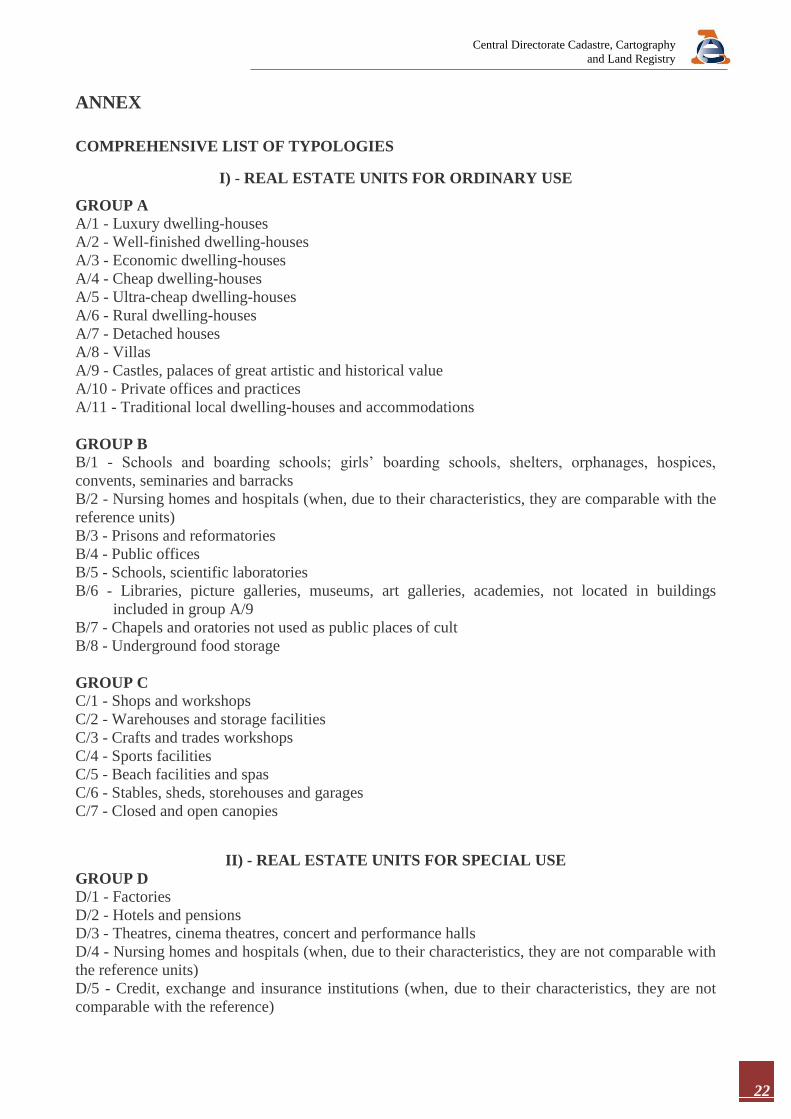
COMPREHENSIVE LIST OF TYPOLOGIES
I) - REAL ESTATE UNITS FOR ORDINARY USE
GROUP A
A/1 - Luxury dwelling-houses
A/2 - Well-finished dwelling-houses
A/3 - Economic dwelling-houses
A/4 - Cheap dwelling-houses
A/5 - Ultra-cheap dwelling-houses
A/6 - Rural dwelling-houses
A/7 - Detached houses
A/8 - Villas
A/9 - Castles, palaces of great artistic and historical value
A/10 - Private offices and practices
A/11 - Traditional local dwelling-houses and accommodations
GROUP B
B/1 - Schools and boarding schools; girls’ boarding schools, shelters, orphanages, hospices,
convents, seminaries and barracks
B/2 - Nursing homes and hospitals (when, due to their characteristics, they are comparable with the
reference units)
B/3 - Prisons and reformatories
B/4 - Public offices
B/5 - Schools, scientific laboratories
B/6 - Libraries, picture galleries, museums, art galleries, academies, not located in buildings
included in group A/9
B/7 - Chapels and oratories not used as public places of cult
B/8 - Underground food storage
GROUP C
C/1 - Shops and workshops
C/2 - Warehouses and storage facilities
C/3 - Crafts and trades workshops
C/4 - Sports facilities
C/5 - Beach facilities and spas
C/6 - Stables, sheds, storehouses and garages
C/7 - Closed and open canopies
II) - REAL ESTATE UNITS FOR SPECIAL USE
GROUP D
D/1 - Factories
D/2 - Hotels and pensions
D/3 - Theatres, cinema theatres, concert and performance halls
D/4 - Nursing homes and hospitals (when, due to their characteristics, they are not comparable with
the reference units)
D/5 - Credit, exchange and insurance institutions (when, due to their characteristics, they are not
comparable with the reference)

Central Directorate Cadastre, Cartography
and Land Registry
23
D/6 - Sports facilities (when, due to their characteristics, they are not comparable with the reference
units)
D/7 - Buildings constructed for or adjusted to meet special industrial needs and not liable to be
destined for a different use without radical transformations
D/8 - Buildings constructed for or adjusted to meet special commercial needs and not liable to be
destined for a different use without radical transformations
D/9 - Floating or pile buildings, tethered to fixed points on the ground; private toll bridges
D/10 - Buildings for productive functions connected to agricultural activities
III) - REAL ESTATE UNITS FOR SPECIFIC USE
GROUP E
E/1 - Land, sea and air transport service stations
E/2 - Municipal and provincial toll bridges
E/3 - Constructions and buildings for special public use
E/4 - Fenced enclosures for special public use
E/5 - Buildings enclosed within fortifications and outhouses
E/6 - Lighthouses, traffic lights, municipal clock towers
E/7 - Buildings used as public places of cult
E/8 - Buildings and constructions in cemeteries, excluding burial niches, tombs and family graves
E/9 - Special-use buildings not included in the foregoing Group E typologies
FICTITIOUS TYPOLOGIES
GROUP F
F/1 - Unbuilt urban areas
F/2 - Units in a state of collapse
F/3 - Units under construction
F/4 - Units transitorily without a well-defined use
F/5 - Paved roof
F/6 - Buildings still to be declared for cadastral registration