Embed Size (px)
Citation preview

The industrial archaeology of Cheshire. An overview
Nevell, MD
Title The industrial archaeology of Cheshire. An overview
Authors Nevell, MD
Type Article
URL This version is available at: http://usir.salford.ac.uk/37519/
Published Date 2015
USIR is a digital collection of the research output of the University of Salford. Where copyright permits, full text material held in the repository is made freely available online and can be read, downloaded and copied for noncommercial private study or research purposes. Please check the manuscript for any further copyright restrictions.
For more information, including our policy and submission procedure, pleasecontact the Repository Team at: [email protected].

Journal of the Chester Archaeological Society Volume 85 for 2015, pages 39‐82 IV: The Industrial Archaeology of Cheshire An Overview by Michael Nevell [final peer‐reviewed text] Study of the industrial period in Cheshire (1750–1900) has been patchy. This thematic overview attempts to redress the balance and especially to highlight the contribution made over the last quarter‐century by archaeological fieldwork. Of set purpose it is descriptive rather than analytical. Nevertheless, it is set within the framework of recent developments in methodology and theory, and suggestions are made of possible future research themes. Introduction Cheshire contains some of the major saltworks and the earliest purpose‐built mecha ‐nised textile mills and industrial canals in Britain. Yet the physical remains of the Industrial Revolution within the county, beyond those of corn mills and the textile industry, have only been studied fitfully; the remains of many of its chief industries are poorly recorded; and their wider significance is often not fully appreciated. Furthermore, much of the post‐1990 developer‐funded archaeological evidence has not been published or synthesised. This paper is an attempt to remedy some of these failings. After a brief review of the history of research on the subject in Cheshire, it offers an archaeological overview of the county’s chief industries, based upon fieldwork undertaken since 1990 and a survey of the surviving remains undertaken by the author between 2011 and 2014 (Nevell & George 2014). It sets this within the context of recent developments in the methodology and theoretical framework of industrial archaeology in the United Kingdom (Palmer et al 2012, 9–21). The paper does not attempt to explain the origins and varying distribution of industrialisation within the county, nor does it look at the social consequences of the Industrial Revolution in terms of urbanisation, housing and sanitation (Nevell 2014). Rather, it is an attempt to characterise the development of the main industries through the surviving physical remains and the results of recent excavation. However, the paper does conclude by suggesting how these and other research topics might be pursued. Before embarking on this overview, it is necessary to define its scope geographically, chronologically and thematically. The paper takes as its geographical limits the boundaries of Cheshire as set in 1974, with the addition of the Wirral peninsula. This is a largely geographically coherent area, defined by the Welsh mountains to the west, the Mersey estuary and lower Bollin valley to the north and the western Pennines to the east. It excludes

those parts of Cheshire now within Greater Manchester, but includes the town of Warrington, which straddles the historic northern border of the county and dominates the middle reaches of the Mersey valley, and the Wirral peninsula which is geographically part of western Cheshire. The period covered is from c 1700 to 2000, although the study focuses primarily on the years 1750–1900, the classic era of industrialisation. Finally, the paper is divided thematically by industries. These categories cover the main manufacturing sectors of Cheshire during the eighteenth to twentieth centuries: salt and chemicals; corn milling; textiles, both cotton and silk; quarrying, mining, engineering; and transport. Industrial archaeology: theory and methodology Industrial archaeology emerged as a term in the mid‐1950s; Michael Rix is generally agreed to have been the first to use the phrase in print in 1955. Over the next decade it developed as a sub‐discipline of archaeology with the support and promotion of the Council for British Archaeology (Palmer 2010, 5–9). In 1958 the CBA organised a conference on the subject and the next year formed a Research Committee on Industrial Archaeology to campaign for it. A critical point in the development of the sub‐discipline was the state‐approved demolition in 1962 of the Doric‐style Euston Arch that formed the entrance to that station, the first London main line railway terminus. This act of cultural vandalism focused attention upon the conservation of the buildings of the British Industrial Revolution and the recording of such sites before they were lost to mid‐twentieth‐century redevelopment. This pioneering phase, which saw the founding of industrial museums and the listing and scheduling of many sites, concluded with the publication of Angus Buchanan’s hugely influential book Industrial archaeology in Britain in 1972 and the foundation of the Association for Industrial Archaeology in 1973. The next phase in the development of industrial archaeology, which lasted until the mid‐1990s, covered the rise of specialists in the subject in national heritage bodies and the emerging commercial archaeology units, and in a very few cases its teaching at universities. It also saw the expansion of a distinctive methodological approach, combining landscape analysis, buildings archaeology and historical documentation in the study of building types such as textile mills and workshop dwellings (Nevell 2006, 9–13). Marilyn Palmer and Peter Neaverson’s influential work Industrial archaeology: principles and practice, published in 1998, marked the beginning of the development of the current generation of theoretically informed and socially aware industrial archaeologists. It also coincided with the emergence of developer‐funded excavation work specifically focused on industrial sites and with an increasing emphasis on the archaeology of industrialisation. One of the chief problems faced by any archaeologist studying the industrial period is the mass of new data available, partly because of the considerable survival of evidence from the post‐1550 era but also because of the increasing amount of developer‐funded work undertaken on such sites. For instance, the Cheshire Historic Environment Record (encom ‐passing West and East Cheshire, Halton and Warrington) had, in April 2015, 17,786 entries (pers comm Rob Edwards, Cheshire Archaeology Planning Advisory Service). This included 5632 listed structures, 2240 local buildings of special architectural or historic interest, 241 scheduled monuments, 198 conservation areas, 25 areas of archaeological potential, 24
registered parks and gardens, 2 registered battlefields, 2 areas of special archaeological potential and 1 area of archaeological importance (Chester city). The majority of the below‐ground monuments, buildings and listed structures (c 10,000) were from the period after 1550 and represent more than half the entries on the Cheshire HER. Furthermore, at the height of the recent recession, in the year 2010, according to the English Heritage‐funded Archaeological Investigations Project undertaken by Bournemouth University, of the 62 pieces of developer‐funded fieldwork in Cheshire more than half involved post‐1550 landscapes and buildings. This work could be broken down into 23 watching briefs; 14 excavations; 7 desk‐based assessments; 6 historic building records; and 12 other heritage investigations (such as conservation studies and geophysical surveys). How such a mass of data can be used to aid our understanding of the process of industrialisation has been the subject of study by industrial archaeologists since the 1990s. In that time two research methods have emerged that are starting to help our understanding both of the landscape and the social archaeology of the period. Firstly, the ‘Manchester Methodology’ was developed in the late 1990s and early 2000s in the Manchester city region as a research tool to aid understanding of the rate at which the new industrial‐period monument types were introduced into any given area, their relationship to the contemporary social structure and their impact on local communities (Nevell & Walker 2004). Two adjacent Pennine parishes, Ashton‐under‐Lyne and Mottram‐in‐Longdendale (the old ‘panhandle’ of the historic county of Cheshire), were chosen for the pilot study area and a broad date range for the project established, from 1348 to 1870. The rate of archaeological change in these two parishes was studied through the temporal occurrence of sites as defined in the Thesaurus of monument types (first published by RCHM (E) 1995). The decade during which each monument type was first attested was noted and a cumulative graph produced of the 101 monument types identified. The shape of the resultant graph was then studied to assess how and when the new monument types were introduced. The analysis of this data was taken a step further by putting each of the monument types in their social context through assigning their ownership or authorship to one of three contemporary social groupings: lords, freeholders, or tenants. The types of site associated with each social group were then studied. By this means the chronology, nature and causes of the phenomenon of industrialisation can be traced archaeologically in the new hamlets, villages and towns of the industrial transition. The validity of the method has been tested elsewhere in north‐west England and in northern Wales and southern Ireland (Nevell 2005). Unsurprisingly each area produced slightly different results, but in each case the method of charting the growth of new monument types was shown to work, whilst the different social backgrounds in each area produced radically different results — which themselves emphasised the localised nature of the social context of industrialisation. Secondly, the technique of historic landscape characterisation (HLC) is increasingly being used to study how the landscape was changed by industrialisation at a county or regional level. This technique was developed by English Heritage in the early 1990s primarily as a conservation and planning tool (Rippon 2004). The HLC methodology embraces a series of approaches that focus upon how rural and urban landscapes came into being, integrating a wide range of source material in order to understand the processes of landscape change. A combination of five elements distinguish this approach: the use of the physical remains of the historic

landscape as a data source; the inclusion of all the historic elements of a given zone, from modern and ancient features to semi‐natural; a focus on the period depth of the surviving elements of the landscape; a county or regional approach in order to observe landscape changes on the macro‐level; and the grouping of land‐form elements into a series of generic types based on their morphology and/or character. In practice the large amount of information thus generated has to be recorded on a Geographical Infor‐mation System (GIS) as a series of polygonal datasets which can be assigned one of many different characteristics. The recent Cheshire HLC project, for instance (Edwards 2008, Appendix A), produced data relating to landscape groups including industry (1371 entries), communications (182), post‐medieval fieldscapes (2566), twentieth‐century fieldscapes (1948) and military sites (38). The HLC methodology provides archaeologists with a powerful landscape research tool that can be used to study the time‐depth of the industrial transition and the nature of post‐1550 urbanisation. When allied to the Manchester Method ‐ology it should be possible to chart the physical changes of the industrialisation process in immense detail and on a highly local basis, whilst setting them in their social context. These overtly theoretical landscape archaeology methodologies provide possibly the most useful route into studying the industrialisation process from an archaeological viewpoint at a regional level, although they are by no means the only ones available. The early twenty‐first century has seen the development of a variety of approaches that now provide a research toolkit (Palmer et al 2012, 9–21) — a set of archaeological methodologies and theoretical approaches that can be applied to the archaeology of industrialisation across four broad areas of study: • technological and economic understanding • social and landscape approaches • industry‐specific studies • site‐specific surveys Some of these approaches concentrate wholly upon the recording of technology and manufacturing processes (activity analysis, material and residue studies, and structural building recording); others upon the landscape changes and social context (access analysis, the Manchester Methodology and Historic Landscape Characterisation). All seek to explore and understand from an archaeological perspective the reasons, course and consequences of industrialisation. None is exclusive of the other; indeed, they work best when these issues are considered together. In practice this requires the student of the industrial period to be familiar not only with the usual archaeological techniques of landscape surveying, artefact recognition, measured survey and excavation but also with the technology and science of the period (Palmer & Neaverson 1998, 3–8). Discovering Cheshire’s industrial archaeology Whilst the archaeological study of Cheshire’s industrial remains may be patchy and uneven, its origins go back to the 1930s. The first industrial site in the county to be consciously treated as heritage and thus saved for future generations was Quarry Bank Mill. In 1939, together with

the surrounding estate, it was donated by Alexander Carlton Greg to the National Trust, although the textile mill itself remained in production until 1959 (Hartwell et al 2011, 614). Nether Alderley Mill followed a few years later. This quaint water‐powered corn mill with fabric from the sixteenth century had closed in 1939, but in 1950 it too was given to the National Trust by the landowner, Major J A Shelmerdine. Working around this time on the economic history of Cheshire was the noted economic historian, Crewe‐born William Henry Chaloner. He published a number of articles and monographs on Cheshire industrial subjects, including a monograph on the early industrial history of Crewe (Chaloner 1950) and two articles on Cheshire’s ironmasters during the late seventeenth and early eighteenth centuries (Chaloner 1951; 1992). However, proper study of Cheshire’s industrial archaeology had to await the 1960s. The first generation of north‐west industrial archaeologists included J Harold Norris, a champion of Cheshire’s industrial remains. A surveyor, auctioneer and valuer with a family firm in Manchester, he joined the Lancashire and Cheshire Antiquarian Society in 1961 and served on its council alongside two other significant local pioneers of the discipline, Owen Ashmore and Victor Tomlinson. Norris was also a founder member of the Manchester Region Industrial Archaeology Society in 1965. He was the first to study the remains of the county’s extensive water‐powered corn mills, and the article he published on the subject in the Transactions of the Lancashire and Cheshire Antiquarian Society (Norris 1966) is the first serious archaeological study of Cheshire’s industrial remains. The first extensive list of industrial archaeology sites within Cheshire was compiled by Rhys Williams, county archaeologist, and Oliver Bott, conservation officer, in the 1970s (Bott & Williams 1975). The 1980s saw an upsurge in interest in the subject, beginning with the publication in 1982 of Owen Ashmore’s guide to the industrial archaeology of the North‐West (Ashmore 1982). Further awareness of the importance of the county’s industrial archaeology was raised by the closure of the Anderton Boat Lift because of corrosion in 1983. More positive was the purchase by Vale Royal Borough Council in 1986 of the Lion Salt Works, which had just closed, thus avoiding its demolition, whilst in 1989 the Anson Engine Museum opened in Poynton. Also undertaken during the 1980s was the East Cheshire textile mill survey, one of a series of regional textile mill surveys important for their methodological approach, although the results would not be published until 1993 (Calladine & Fricker 1993). The 1990s saw the emergence of developer‐funded archaeological work and a gradual increase in the excavation and recording of industrial sites and buildings within the county. The detailed survey and excavation of the water‐ and steam‐power systems at Quarry Bank Mill for the National Trust marked the first time such features had been systematically investigated in Cheshire (Milln 1995; OA North 2014). They thus presaged the focus of developer‐funded work on industrial sites in the North‐West during the early twenty‐first century (Nevell 2010). In the mid‐ to late 1990s Grosvenor Museum archaeologists excavated workers’ housing in Chester, the first time this had happened in Cheshire and again a foretaste of the way in which such houses would be dealt with in later years (Matthews 1999; 2003). The Chester Archaeological Society also undertook the excavation, over several seasons, of the cheese warehouse on Sealand Road in Chester, highlighting the importance of Chester’s port archaeology during the industrial period (Matthews 2003). Another pioneering survey was the Cheshire Historic Towns Survey, undertaken between 1997 and 2002 by the Cheshire County Council archaeology service. This included studies of the chief industrial towns of the

eighteenth to twentieth centuries in the county and thus their industrial archaeology. This material is now available online at http://www.cheshirewest andchester.gov.uk/residents/leisure,_parks_and_events/history_and_heritage/archaeology/ archaeology_planning_advisory/historic_towns_survey/historic_towns_survey_reports.aspx. Volume 5 of the Victoria County History also has several good overviews of the develop ‐ment of post‐medieval industry in Chester, although these are written from a documentary perspective (Lewis & Thacker eds 2003, 171–99; Thacker & Lewis eds 2005, 73–94). Despite these positive steps, Cheshire’s industrial archaeology is under threat, epitomised by the contrasting stories of two textile mills. Quarry Bank Mill, a rural factory built in 1784 and the oldest working water‐powered Arkwright‐style mill in Britain, was donated to the National Trust as a working mill along with its associated buildings, thus retaining the integrity of the site, and is now a working museum. By contrast, the Old Mill in the heart of Congleton, completed in 1753 and one of the oldest mechanised textile mills in Britain, was partially demolished in 1939 after a fire. The remaining two storeys, heavily altered but including an intact 1830s beam engine house and the original wheelhouse, remained in use. An attempt to list the site proved unsuccessful and in 2003 planning permission was granted to demolish the remaining structures. The archaeological excavation associated with this redevelopment recorded the wheelpit and water system built to the designs of James Brindley, in the process emphasising the national archaeological impor‐tance of the site (Fletcher 2008). However, this did not stop apartments being built on the mill remains. The different fates of the two mills, each in their own way of national importance, reflect the varying pressures on rural and urban industrial archaeology sites. Another measure of the continuing pressures on the industrial archaeology of the county can be gauged from an analysis of the survival rate of the sites listed by Owen Ashmore in his 1982 Cheshire gazetteer (Ashmore 1982). Between 2011 and 2014 the current author revisited all of these sites as part of a wider study of the industrial remains of the county for the 2014 Association for Industrial Archaeology (AIA) annual conference, held at the University of Chester in September of that year. Of the 427 entries Ashmore recorded, 90 had been demolished, a loss rate of 20% (Nevell & George 2014). This is much lower than the heavily urbanised area of Greater Manchester, studied by the author in 2000 for that year’s AIA annual conference in Manchester (McNeil & Nevell 2000), where the rate was 40%. It is also better than the 30% loss rate in Lancashire, also studied by the current author for the 2007 AIA annual conference in Preston (Nevell & George 2007). In general the physical remains of some of Cheshire’s historic industries survive well. More than 90% of the canal and railway infrastructure recorded by Ashmore has survived into the second decade of the twenty‐first century (the major losses being amongst railway stations and warehouses), and over 80% of the corn mills and over 70% of the textile mills recorded by Ashmore also survive. However, there are some high areas of loss, the worst being in Warrington, where 55% of the sites recorded by Ashmore have gone. The industrial towns of Congleton, Crewe, and Macclesfield also have high loss rates, of 30%, 36% and 31% respectively. It is thus tempting to see the overall low loss rate, when compared to other areas of the North‐West, as a reflection of the continuing rural character of the county as a whole. One of the most significant recent losses was the fine late eighteenth‐century Park Green Mill (also known as Frost’s Mill) in Macclesfield, burnt down in 2011.
This is perhaps to be too gloomy in outlook. The study of Cheshire’s surviving industrial archaeological remains published in 2014 listed 307 sites, which was just a selection of the sites identified in the 2011–14 survey as having standing remains. Furthermore, since 1990 manufacturing and industrial‐period sites have increasingly been the subject of archaeological planning conditions ahead of redevelopment (Palmer et al 2012, 29). Whilst in Cheshire much of the information thus gained remains as unpublished ‘grey literature’ and technical reports, the increasing volume of the evidence nevertheless constitutes an enormous resource for understanding the industrialisation process in the region. Salt and the chemical industry Salt Cheshire’s oldest industry is salt production, salt being used in the preservation of food ‐stuffs, the curing of leather and later in the chemical industry. It is associated with the ‘wich’ settlements: Leftwich, Middlewich, Nantwich and Northwich. Wic is an early English placename element, which means a settlement with craft activity and no doubt captures the importance of salt production in the later Saxon period in these Cheshire settlements. Historically salt was produced by the evaporation of either sea water or naturally occurring brine from springs (Fielding & Fielding 2006). The production of salt from sea water is known to have been carried out since the Bronze Age in a relatively small number of regions on the English coast. In the immediate post‐medieval period these included Tyne and Wear, Lincolnshire, Lymington in Hampshire, and Essex. In the North‐West, sea salt‐making was carried out in Cumbria in the Middle Ages and later; there were also contemporary operations in west Lancashire, and there is evidence for a saltern at Puddington on the Dee estuary in the sixteenth century (Annakin‐Smith 2012). The Cheshire salt industry owes the origins of its importance to the brine springs of the Weaver valley. These were exploited in the Iron Age, Roman and medieval periods (Nevell & Fielding eds 2005). In the south‐east of the county the Lawton family of Church Lawton, near Kidsgrove, had a salt works in the township from 1694 and were using a waterwheel to pump the brine from a natural well in the 1720s (Lawton ed 2013, xxxix–xlv). However, the mass production that started in the early eighteenth century relied on the discovery of rock salt (about 1690), the introduction of large iron pans for evaporation, the use of coal rather than charcoal as a fuel, and the development of the Weaver Navigation from 1720: these changes secured the county’s position as the major salt‐producing area in Britain. The Cheshire rock salt deposits are very extensive, running continuously beneath Nantwich, Middlewich and Northwich and forming the largest inland salt field in Britain. The River Weaver had always provided a convenient transport route, but once the Navigation was developed it allowed the bulk import of the coal needed to heat the new iron pans and the bulk export of the finished salt. The focus of the industry moved from its medieval heart at Nantwich (McNeil 1983; Dodd 2014), where the number of salt houses fell from 108 in 1624 to just two in 1778, to Northwich. In the 1680s the latter was already producing three times more salt than Nantwich, perhaps because of its easier access to transport along the lower Weaver, and by the 1780s, thanks to improved connectivity, the town accounted for 80% of
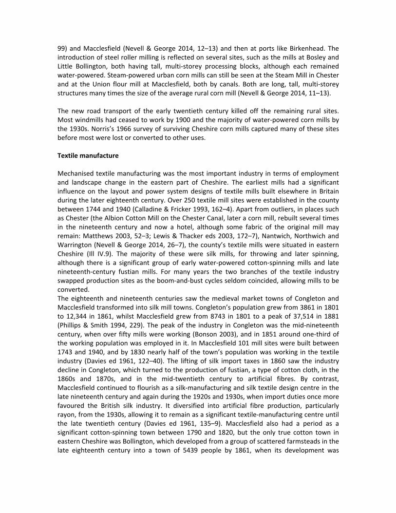
Cheshire’s output (Phillips & Phillips 2002). In the early nineteenth century salt became one of the principal raw materials for the soap, glass and alkali industries of Merseyside, Runcorn, Warrington and Wirral and was thus central to the development of the British chemical industry (Hardie & Pratt 1966). Production soared: in the years 1759 to 1761, 42,113 tons of salt were carried along the Weaver Navigation and 13,533 tons of coal. During the years 1843–5 558,506 tons of salt and 154,699 tons of coal were carried (Phillips & Phillips 2002, 72) — a thirteen‐fold increase from the mid‐eighteenth to the mid‐nineteenth century. The only surviving example of the production of salt in open iron pans over coal‐fired furnaces is now the Lion Salt Works at Marston, north of Northwich, which closed in 1981. Bought by Vale Royal Borough Council and run from 1993 by the Lion Salt Works Trust, during the years 2008 to 2015 it was restored as a museum thanks to a grant from the Heritage Lottery Fund (Fielding & Fielding 2000; http://closedprogrammes.hlf.org.uk /news/Pages/Lionsaltworks.aspx#.VPMV4U1ya70) (Ill IV.1). Several ranges of timber buildings on brick foundations that housed the salt pans and stores survive on the site, as well as a brine well which supplied the site with its raw material. The use of timber in the buildings was aimed at lessening the corrosive impact of the salt‐laden atmosphere. In 2013 and 2014 extensive excavations ahead of the rebuilding of Stove House Number 5 revealed the flue system beneath the iron pan (http://lionsaltworks.blogspot.co.uk accessed 23 June 20015). Besides the Lion Salt Works the only other structure to survive above ground from an open‐pan salt works is Murgatroyd’s Brine Pump House Number 1 at Middlewich. Once part of a salt works founded by George Lomas in 1889, this single‐storey brick structure is dominated by its steel and timber gantry tower and still contains three pumping engines. Part of an eighteenth‐ and early nineteenth‐century salt works at Frodsham was excavated in 1990 (Hawkin 1992). Winsford emerged as the centre of the salt industry in the late nineteenth century, when artificial brine pumping replaced mining and natural wells. Water was circulated through boreholes sunk into the salt deposits and brought it back to the surface as a brine solution from which the salt could be evaporated or used directly in the chemical industry (Fielding & Fielding 2006, 39–40; Phillips & Phillips 2002, 72). British Salt at Middlewich, which is the only works left in the town, uses a vacuum process developed in the early twentieth century to boil the brine at low pressure, whilst Meadowbank Mine in Winsford continues to mine salt. Chemicals Salt became a vital ingredient of the chemical industry. The Leblanc process, developed in 1791, used salt, coal, calcium carbonate and sulphuric acid to make soda ash (sodium carbonate) and potash (potassium carbonate), both alkalis vital to the glass, paper, soap and textile industries (Hardie & Pratt 1966). The easy availability of salt in Cheshire meant that alkali, glass and soap production sites grew up along the Mersey valley in Liverpool, Runcorn, St Helens, Warrington and Widnes, as well as at Northwich. This became one of the chief areas of the British chemical industry during the twentieth century, the alkali towers, ovens and furnaces dominating the valley landscape around Northwich and Winnington, and the estuary coast from Ellesmere Port to Runcorn. Yet only a few thousand people were ever employed in the salt industry, unlike the textile or engineering sectors. Although the first alkali works was in Liverpool, the St Helens, Warrington and Widnes area became the focus of the industry in the nineteenth century. The initial demand came from the

textile industries of Cheshire and Lancashire, which needed large quantities of soap for the finishing processes. A soap‐manufacturing plant was built at Bank Quay in Warrington by Joseph Crosfield in 1815, and there is still a chemical works on the site (Nevell & George 2014, 44–5). Much later the most famous of the north‐west soap works was established at Port Sunlight on Wirral by William Hesketh Lever in 1888. From 1822 St Helens and Widnes had large alkali manufactories, aided by the availability of coal via the Sankey Canal and the River Mersey. Spike Island at Widnes, now the home of Catalyst, the chemical museum, has remains of this industry including the 1860 process building erected by John Hutchinson, the remains of pyrites kilns, the bases of acid towers and the canal basin. The Solvay process developed by Ernest Solvay in 1863 replaced the Leblanc method. It used towers in which carbon dioxide was blown through a solution of common salt saturated with ammonia. The resultant sodium bicarbonate was heated in furnaces to produce soda. Works using this process were established at Widnes and Winnington by J T Brunner and Ludwig Mond. In 1897 the Castner‐Kellner Company began production at Runcorn using an electrolysis production method for creating soda. All the Cheshire alkali production sites became part of Imperial Chemical Industries in the early twentieth century, and by the early twenty‐first century the industry was focused in just a few areas. North of Northwich the Tata Works at Marston and Winnington survive in production (Ashmore 1982; Nevell & George 2014, 36–7). The legacy of the salt industry lies not just in the few sites still working in the early twenty‐first century nor in the Lion Salt Works, the last open‐pan salt works in Britain, but also and perhaps primarily in the landscape changes it brought about. The Weaver valley north of Northwich has been altered by brine and salt extraction. A number of flashes, large areas of water resulting from subsidence brought about by rock mining and pumping, still occupy the valley floor in Marston (Ill IV.2). Even in urban areas the effects of brine extraction can be seen. In Northwich the technique of timber‐framed building with brick infilling was revived in the late nineteenth century in order to offset the effects of subsidence, and many examples can still be seen across the town. Corn‐milling sites Mechanised corn milling is as old as the mass production of salt in Cheshire. The county has over 350 corn‐milling sites, of which around 150 were built between 1700 and 1850 (Ill IV.3). Eighteen water‐powered corn mills are listed in the Domesday Survey of 1086, and Burdett’s map, published in 1777, shows 140 water‐ and wind‐powered milling sites in the historic county (Bott 1984). These early sites are important in the story of the industrialisation of Cheshire as many of them were reused by other industries during the eighteenth and nineteenth centuries, such as metalworking as at Lymm and textiles as at Mobberley. Many have been converted to homes since Norris’s pioneering study (1966), but few have been completely lost. Amongst the earliest surviving examples is a group of three seventeenth‐century water‐powered corn mills. The oldest of these is probably Nether Alderley Mill, now run as a museum by the National Trust (Ill IV.4). Some of its fabric goes back to the sixteenth century. The mill was expanded and rebuilt in eighteenth and nineteenth centuries, a reminder that these were functional buildings that were frequently rebuilt and their machinery and equipment modernised. The stone three‐storey structure is terraced into the dam
embankment and has a long single‐pitched roof, giving it an appearance unique in the county. The upper storey is partially timber‐framed. The two working waterwheels sit one above the other and there is a third redundant wheelpit. This mill also has a surviving brick‐built drying kiln of the eighteenth century adjoining to the south. Stretton Mill dates from the seventeenth and eighteenth centuries and was originally thatched. The stone‐built first storey contains the millstones and carries an upper timber floor, rising above the dam. It has two water ‐wheels in timber and iron: an external overshot wheel and a low‐breast shot internal wheel. Each drives two sets of stones. It is now run as a museum by Cheshire West and Chester Council. The final timber‐framed mill in Cheshire is at Higher Huxley. Now converted into a residence on a farm, it retains a timber‐framed upper storey (the sack floor), and below that wooden and iron machinery on the stone floor (the floor housing the millstones). Of the 100 or so water‐powered milling sites that still retain significant standing remains most date from the eighteenth and nineteenth centuries. This can perhaps be attributed to the blockades of the Napoleonic Wars of the 1790s and 1800s, which brought about a boom in the demand for home‐grown grain, and to the growth of Cheshire’s new industrial towns. As a result many corn‐mill sites were rebuilt to meet the increasing output of the large Cheshire estates that were cashing in on the new markets (Barnwell & Giles 1998, 122–5). Bunbury Mill, now maintained and run by a local trust, was rebuilt around 1850 and is typical of the development of mill technology at that time (Ills IV.5–.6). The three‐storey brick structure, which rises above the mill dam, retains its gearing and line shafting run from a single iron overshot waterwheel and an iron wallower wheel. This now runs a roller mill, whilst to the east is a drying kiln with the drying floor composed of perforated tiles. Another important survival is Park Mill at Brereton. This site has medieval origins but was rebuilt in 1833 as a four‐storey brick structure (Ill IV.7). Though now a residence it still retains its iron suspension waterwheel built by the noted mill engineer William Fairbairn, along with some contemporary line shafting and a small horizontal steam engine built by Fodens of Sandbach and installed in 1890 as a supplementary power source. Windmills were once a prominent feature of the Cheshire landscape, and Bott (1984) records several dozen, mostly concentrated in western Cheshire and Wirral although such sites were found across the county as far east as Macclesfield. The demand for home‐grown grain noted above was also responsible for the introduction of the new technology of the tower windmill. A few towers survive in west Cheshire, although these have either been converted to residences or are ruinous. Ravensmoor Windmill at Burland, west of Nantwich, has a fine tapering early nineteenth‐century brick‐built four‐storey tower. The three‐storey brick tower windmill at Bidston, close to Birkenhead, dating to c 1800, still retains its sails. The best preserved Cheshire windmill, however, is Gibbet Windmill at Saughall, north‐west of Chester (Ill IV.8), although there is no surviving internal machinery. This brick‐built four‐storey tower structure was erected in 1784 and retains its boat‐shaped cap and has restored sails, the cap echoing the windmill designs of south‐west Lancashire and the Fylde (Nevell & George 2007). The removal of the preferential taxes known as the Corn Laws in 1846, the growth of a network of rural railways and the increasing demand for dairy produce from the new industrial towns (Barnwell & Giles 1998, 124–5), coincided with the arrival of cheap grain from overseas and the invention of roller milling. Many rural water‐powered corn mills closed in favour of larger mills at major urban centres such as Chester (Lewis & Thacker eds 2003, 177–
99) and Macclesfield (Nevell & George 2014, 12–13) and then at ports like Birkenhead. The introduction of steel roller milling is reflected on several sites, such as the mills at Bosley and Little Bollington, both having tall, multi‐storey processing blocks, although each remained water‐powered. Steam‐powered urban corn mills can still be seen at the Steam Mill in Chester and at the Union flour mill at Macclesfield, both by canals. Both are long, tall, multi‐storey structures many times the size of the average rural corn mill (Nevell & George 2014, 11–13). The new road transport of the early twentieth century killed off the remaining rural sites. Most windmills had ceased to work by 1900 and the majority of water‐powered corn mills by the 1930s. Norris’s 1966 survey of surviving Cheshire corn mills captured many of these sites before most were lost or converted to other uses. Textile manufacture Mechanised textile manufacturing was the most important industry in terms of employment and landscape change in the eastern part of Cheshire. The earliest mills had a significant influence on the layout and power system designs of textile mills built elsewhere in Britain during the later eighteenth century. Over 250 textile mill sites were established in the county between 1744 and 1940 (Calladine & Fricker 1993, 162–4). Apart from outliers, in places such as Chester (the Albion Cotton Mill on the Chester Canal, later a corn mill, rebuilt several times in the nineteenth century and now a hotel, although some fabric of the original mill may remain: Matthews 2003, 52–3; Lewis & Thacker eds 2003, 172–7), Nantwich, Northwich and Warrington (Nevell & George 2014, 26–7), the county’s textile mills were situated in eastern Cheshire (Ill IV.9). The majority of these were silk mills, for throwing and later spinning, although there is a significant group of early water‐powered cotton‐spinning mills and late nineteenth‐century fustian mills. For many years the two branches of the textile industry swapped production sites as the boom‐and‐bust cycles seldom coincided, allowing mills to be converted. The eighteenth and nineteenth centuries saw the medieval market towns of Congleton and Macclesfield transformed into silk mill towns. Congleton’s population grew from 3861 in 1801 to 12,344 in 1861, whilst Macclesfield grew from 8743 in 1801 to a peak of 37,514 in 1881 (Phillips & Smith 1994, 229). The peak of the industry in Congleton was the mid‐nineteenth century, when over fifty mills were working (Bonson 2003), and in 1851 around one‐third of the working population was employed in it. In Macclesfield 101 mill sites were built between 1743 and 1940, and by 1830 nearly half of the town’s population was working in the textile industry (Davies ed 1961, 122–40). The lifting of silk import taxes in 1860 saw the industry decline in Congleton, which turned to the production of fustian, a type of cotton cloth, in the 1860s and 1870s, and in the mid‐twentieth century to artificial fibres. By contrast, Macclesfield continued to flourish as a silk‐manufacturing and silk textile design centre in the late nineteenth century and again during the 1920s and 1930s, when import duties once more favoured the British silk industry. It diversified into artificial fibre production, particularly rayon, from the 1930s, allowing it to remain as a significant textile‐manufacturing centre until the late twentieth century (Davies ed 1961, 135–9). Macclesfield also had a period as a significant cotton‐spinning town between 1790 and 1820, but the only true cotton town in eastern Cheshire was Bollington, which developed from a group of scattered farmsteads in the late eighteenth century into a town of 5439 people by 1861, when its development was

arrested by the ‘cotton famine’ caused by the American Civil War (Calladine & Fricker 1993, 106–8). Silk mills Eastern Cheshire, along with Leek in north‐eastern Staffordshire, Derby and the Derwent valley, formed a silk‐manufacturing belt that supplied the textile merchants of London (Calladine & Fricker 1993, 16–26). This was somewhat extraordinary since raw silk had to be imported from the eastern Mediterranean and China via Italy and France (Bush 2000). Commercial and family links with the silk hosiery industry of the east Midlands and the market of London, as well as freedom from the restrictions of the London guilds, appear to have been the key factors in establishing the industry in the north Midlands. For thousands of years ‘throwing’ was the process by which raw silk thread was wound to form a skein, then twisted, doubled and twisted again. The thrown silk could be wound onto cones or made into hanks for dyeing. Silk spinning involved continuous drawing, twisting and winding actions (Bush 2000). All these processes required machinery now only to be found in museums such as those in Macclesfield and structures to house them: initially converted domestic spaces but later purpose‐built garret workshops and finally stand‐alone mill structures. Fully mechanised silk spinning was not introduced until the early nineteenth century and used short fibres or sometimes waste silk; the machinery was based on the throstle frame used in the cotton‐spinning industry (Collins 2000, 10–25). The manufacture of silk‐covered buttons can be traced as far back as the mid‐sixteenth century in Macclesfield (Davies ed 1961, 122–3) and in Congleton to the seventeenth century. Initially, the silk cloth was supplied to the home‐based makers by the Congleton and Macclesfield button merchants, who sourced it from the markets in London and Flanders (Belgium and Holland). However, by the mid‐seventeenth century yarn preparation, hand silk throwing and hand silk weaving were all taking place in Congleton and Macclesfield (Davies ed 1961, 122–4). The big change in production came with the establishment of mechanised silk‐throwing techniques. Italian methods of winding and throwing organzine (yarn with a greater twist and therefore stronger and more suitable for the warp) were introduced into Britain by John Lombe in 1718 (by espionage) and successfully demon ‐strated at his water‐powered silk mill in Derby in 1721 (Bush 2000). When his patent expired in 1732 Lombe’s designs were used to build a number of silk mills across the north Midlands, including Cheshire (Calladine & Fricker 1993, 26–7). The earliest water‐powered silk‐throwing mill in Cheshire was built in 1743 (Boon 2013, 5–10). This was the small water‐powered Button Mill erected in Macclesfield at the top of Pickford Street by Charles Roe, a button and silk merchant. Roe was an entrepreneur with wide‐ranging business interests in mining and metals which took him to Buxton, Cumbria and north Wales. His commercial networks spread to London and his family links to Derby and Leek. His evangelical Christian beliefs played a significant role in his business and private lives (Smith 2005). He was one of several dynamic Georgian businessmen, Richard Arkwright being the best known, who helped shape industry at a regional level in this period. The first silk mill in Congleton was established in 1755, with water‐powered systems designed and installed by James Brindley. The last standing remains of this nationally important mill were demolished as recently as 2003 (Fletcher 2008). A reduction in the duty on Chinese raw silk in 1749
encouraged the construction of further mills, and by 1765 seven mills had been built in England using Lombe’s designs: four of these were in Cheshire (including Stockport). None of these early mills survive, although since the building form was influenced by the processes it housed their early design, of long, narrow, multi‐storey manufacturing blocks, had a significant impact on later textile mill design throughout Britain, such as at Cromford in Derbyshire, Ancoats in Manchester and New Lanark near Glasgow. There are good surviving examples from the building boom in silk‐throwing mills in the late eighteenth century and the 1820s, although only one of them has been excavated (the Old Mill at Congleton). These mills showed limited classical influences such as shallow projecting central bays topped by a pediment and a clock, as at Dane Mill in Congleton and Regency Mill in Macclesfield (Hartwell et al 2011, 304, 467). Internally the designs were highly functional and plain, often with cast‐iron columns supporting wooden beams and floors; their power source was water. The early‐ to mid‐nineteenth‐century mills were often four or five storeys high and built in brick, as at Stonehouse Mill in Congleton or Victoria Mill in Macclesfield, although they still used cast‐iron columns to support wooden beams and floors. Most remained water‐powered, but steam power became common as a supplementary source in the Congleton and Macclesfield mills from the 1800s, and all of the new mills built in those towns after 1828 had steam power, the last purpose‐built water‐powered silk factory being Primrose Vale Mill (Calladine & Fricker 1993, 99). In Macclesfield small local coal pits probably supplied the earliest steam‐powered mills of the 1800s before the arrival of the canal in 1831. Increasingly, these mill complexes added other processes such as weaving and finishing, as at the George Street Mills site in Macclesfield (Calladine & Fricker 1993, 88–90; Nevell & George 2014, 26–8). Silk weaving was not mechanised until the early nineteenth century, and even then specialist fabrics remained woven by hand until the twentieth century. Thus, the workshop dwellings known locally as silk weavers’ cottages, or garret houses, were once numerous in many of the industrial towns and villages of eastern Cheshire (Calladine & Fricker 1993, 54–5). Their main period of construction was from the introduction of mechanised silk throwing into Cheshire in the 1730s to the mid‐nineteenth century, when mechanised silk weaving became common. Examples survive in Knutsford, Lymm, Sandbach and Wilmslow, and sometimes attached to isolated mills as at Langley, but the largest concen ‐trations are to be found in Congleton and Macclesfield, where the surviving examples run into their hundreds (Nevell & George 2014, 17–18). From the 1790s firms in these towns began broad‐loom silk weaving in workers’ garrets built by the manufacturers. Usually these were erected in rows of three or four dwellings, but sometimes as pairs or long rows (as at Paradise Street in Macclesfield: Hartwell et al 2011, 467 and pl 72) (Ill IV.10). Occasionally the top‐floor garret ran across three or more cottages, as in Townley Street (Nevell & George 2014, 25). From 1820 the Jacquard loom was introduced to weave complex patterns (Calladine & Fricker 1993, 77–9), and attics and mill floors were heightened to cope with these new tall looms. This coincided with the application of steam power to weaving, housed in a ground floor space because of the high vibration from the new machinery, so that during the 1830s to 1850s many mills in the two towns added single‐storey weaving ranges to their complexes. The British silk industry declined after the 1860 Cobden Treaty with France removed trade barriers, thereby allowing the import of cheaper goods (Bush 2000). In Congleton this brought
an end to mass production, so that by 1886 the number of working silk mills was down to twenty‐two and in 1910 just seven were left. However, the textile industry in the town survived by moving to fustian production. The later shift to artificial silk fibres such as rayon, after 1920, helped Congleton’s textile industry to survive into the later twentieth century, and many silk mills went over to artificial fibre production (Calladine & Fricker 1993, 14–15). By contrast, silk manufacture in Macclesfield revived, with a number of earlier complexes expanding in the late nineteenth and early twentieth centuries, such as Little Street Mill (Nevell & George 2014, 22). Wood Street Mill shows the transition to twentieth‐century building materials, with the extension of 1900 being traditionally built in brick with wooden floors supported by cast‐iron columns but the 1909 extension being steel‐framed to a design by Stott & Sons. Silk mills continued to be built into the 1930s such as the steel‐framed Art Deco‐style Bridge Street New Mill (Hartwell et al 2011, 467) (Ill IV.11). Some silk production can still be found in eastern Cheshire beyond the confines of the museum. Thus, Berisfords, founded in 1858 as specialists in ribbon production, continued making silk labels in Congleton into the twenty‐first century. Cotton and fustian mills Cotton manufacturing was introduced into eastern Cheshire during the mid‐eighteenth century through the domestic production of yarn and cloth, although in the historic pan ‐handle of north‐eastern Cheshire (the parish of Longdendale), which is closer to Manchester, probate records indicate domestic production from the late seventeenth century. The mechanisation of cotton spinning reached Cheshire in the 1780s with water‐powered mills being built especially but not exclusively in the upland valleys in the east of the county, in areas such as Kettleshulme, Rainow and Wildboarclough. Here there were plentiful streams where the best sites, and more importantly the water rights, were not readily occupied by watermills; others were built at Bollington, Bosley, Chester, Congleton, Disley, Holmes Chapel, Nantwich, Northwich, Rainow, Sandbach, Sutton, Warrington and in and around Wilmslow (Calladine & Fricker 1993, 37–40). This first generation of cotton‐factory building saw thirty‐nine Arkwright‐style water‐powered spinning mills established by 1800. This compares with around twenty‐six silk mills by the same date (Nevell 2008, 98). Of these the best preserved is Quarry Bank Mill, established in 1784 by Samuel Gregg, an Irish linen merchant, working in the family business in Belfast and Manchester (Milln 1995). Other early rural survivals include Dane in Shaw (near Congleton) from 1784 and Gin Clough Mill, built in 1794 and extended in 1827 (Nevell & George 2014, 28, 30). The long, narrow, multi‐storey plan of the silk mill is repeated at these sites and some, like Dane in Shaw and Quarry Bank, also have shallow projecting bays topped with a pediment (Ill IV.12). In the nineteenth century cotton production in eastern Cheshire became focused on three urban areas — Bollington, Congleton and Macclesfield — encouraged by the proximity of the cotton mills of Manchester and Stockport to the north and the Derwent Valley mills to the east (Palmer et al 2012, 189–90). Bollington became the chief cotton town of eastern Cheshire, with twenty‐one mill sites by the mid‐nineteenth century (Nevell & George 2014, 28). The town developed along the Harrop Brook and River Dean, where there are a number of late eighteenth‐century cotton‐spinning mill sites. Some of these sites provided yarn for the Nottingham lace industry. The arrival of the Macclesfield Canal in 1831 led to a boom in the building of steam‐powered mills, led by the chief mill‐owning family, the Swindells, with
several large mills erected on the banks of the canal at Adelphi and Clarence. The town’s population also boomed in this period. Ingersley Vale Mill was converted to textile finishing in the mid‐nineteenth century and is a notable, but rare, survival of this branch of the textile industry in Cheshire (Taylor 2009, 3–4). In general few cotton mills were built in Cheshire after the cotton famine of 1861–5, but a notable exception was Congleton. Between 1860 and 1950 fustian cutting was the town’s dominant industry, and many firms took over the empty silk‐spinning and throwing mills (Nevell & George 2014, 28). The fustian process involved cutting through the loops of various types of fabric, usually cotton, with a razor‐sharp blade to create the distinctive ‘high pile’ required to produce velvet, moleskin and corduroy. Small‐scale factory production started in the mid‐nineteenth century with the introduction of larger cutting machines, although the hand‐cutting of fustian cloth (also known as velvet) continued until full mech ‐anisation of the industry in the mid‐twentieth century. Over ten fustian mills were built in Congleton between the 1870s and the 1900s (Calladine & Fricker 1993, 102–5). These were typically long, narrow structures of two or three storeys with wooden beams and floors such as Meadow and Riverside mills. Fustian factories were also built in the late nineteenth century in Middlewich, Sandbach, Warrington, Wilmslow and Winsford, but all have now gone except for single examples at the two last‐named towns (Nevell & George 2014, 28, 35). Quarrying, mining and metalworking Quarrying Quarrying, mineral mining and metalworking can be traced back thousands of years in Cheshire, but the major period of exploitation, like that for salt, was during the eighteenth and nineteenth centuries (Ill IV.13). The earliest quarry working remains can be found in Chester, where the existence of a Roman quarry at the southern end of the Dee Bridge in Handbridge is suggested by the presence of a rock‐cut shrine. During the medieval period quarries along the central Cheshire ridge at Manley Knoll and King’s Chair in Delamere Forest supplied building material for Vale Royal Abbey and Chester Castle. In the post‐medieval period small quarries supplied stone foundations for local building in villages as far apart as Frodsham, Lymm, Malpas and Tarporley. Indeed, throughout the seventeenth to nineteenth centuries, wherever Cheshire’s solid geology outcropped, quarries sprang up to extract stone for farm buildings and field boundaries (Nevell & George 2014, 37). The largest quarries of the industrial period, and the most prominent quarrying remains in the county, can be found in two areas of Cheshire: along the mid‐Cheshire ridge and to the east of Bollington, at Kerridge. In the nineteenth century the Helsby quarries supplied stone for public buildings including the Liverpool Customs House and docks buildings in both Birkenhead and Liverpool (Hartwell et al 2011, 4–6; 142–4). In the early twenty‐first century quarry working faces can still be found at Alvanley near Helsby, Overton near Frodsham and Manley Knoll, although there are no surface process buildings, roadways or tramways. The quarries at Kerridge, south of Bollington, are still worked, and activity on this site can be traced to the seventeenth century. The quarry face runs for c 2km south of the town and dominates the landscape to the north‐east of Macclesfield (Nevell & George 2014, 40–1) (Ill IV.14). The Macclesfield Canal enabled these quarries to supply building materials to many of the mills and public buildings of Manchester and its satellite cotton towns during the nineteenth century. A tramway, built in the years 1830–4, connected the quarries with a quay on the

Macclesfield Canal. The line is now obliterated but the inclined plane at the top of the tram route survives as a rock‐cut feature where it passes beneath Windmill Lane (Ill IV.15). It was powered by a stationary steam engine on the eastern side of the road, although the engine house has long since gone. Along the foot of the quarry face can be found twentieth‐century steel‐framed process buildings and spoil heaps (Nevell & George 2014, 41). Mining The earliest mineral mine in the Cheshire region is at Alderley Edge, where the discovery of early Bronze Age trench mining for copper at Engine Vein has helped to change ideas about the prevalence of such mines in Great Britain (O’Brien 2014, 150–2; Timberlake 2010, 292). The prehistoric activity was succeeded by extensive Roman mining for lead and copper. Rediscovered in 1995, this Roman activity took the form of a vertical mine shaft and horizontal gallery. It is not clear whether the mines at Alderley were exploited during the medieval period, but from the 1690s until 1919 the site was extensively exploited for the copper, lead and cobalt ores present in the local Bunter and Keuper sandstones. Extensive surface remains cover a square kilometre of the sandstone ridge, whilst the underground galleries run for several kilometres (Carlon & Dibben 2012) (Ill IV.16). The principal sites west of Macclesfield Road are the copper West Mine where there was opencast working, now filled in, and a cobalt ore‐treatment works, and Wood Mine. East of the road can be found earthworks associated with the copper Pillar Mine and Doc Mine near Stormy Point, where entrances to the mines are visible, and Church Quarry behind the ‘Wizard’ pub. Here there is a stone‐built powder house, the remains of firing channels on the quarry walls, and a short gallery that is accessible from the quarry. Engine Vein Mine, which is where the prehistoric activity began, has four capped shafts and two adit entrances from a long cleft in the rock leading into the mine galleries (Timberlake & Prag 2005, 6–19). The Macclesfield silk mill owner Charles Roe operated on the Edge from c 1758 until 1771, probably around Engine Vein, and ore from here and his mine at Ecton in Staffordshire was processed in Macclesfield and supplied his rolling mills in Bosley and Havannah, just north of Congleton. He transferred his ore mining interests to Parys Mountain on Anglesey in 1764, having already acquired another copper mine, at Coniston, in 1756. James Mitchell and the Alderley Edge Mining Company exploited West and Wood mines between 1857 and 1878, when the peak output reached 15,000 tons of copper per annum (Hartwell et al 2011, 90, 451; Smith 2005, 219–21). The final phase of activity was in the early twentieth century when working to extract cobalt ore took place around West Mine (Timberlake & Prag 2005, 18–19) Roe’s copper works in Macclesfield closed in 1801 and only the street names (Copper Street, Calamine Street) and the occasional block of waste slag in a wall hint at its presence. Nor does anything remain of the smelting works that he established at Liverpool in 1767 or of the rolling mills (Smith 2005, 310–15, 535). The only other copper mine in the county can be found at Bickerton Hall. A vein of copper occurs along the eastern edge of the hills. Mining started in 1697 and the deposits were last worked by Edmund Spargo & Sons of Liverpool in 1906 (Ashmore 1982, 29). All that can be seen at surface level, though, is a stone, square‐section engine house chimney at Gallantry Bank and a nearby entrance to an adit. The Chester Leadworks was established alongside the canal in 1800, drawing its raw materials from Flintshire (where from 1837 it owned the Dee Bank smelting works: Williams 2012, 39)
and Spain, and sending its finished products (red and white lead, shot, sheet and pipes) to the Midlands and the North‐West (Lewis & Thacker eds 2003, 173, 181,188); its shot tower is still a prominent landmark (Ill IV.17). Cheshire enjoyed a short period in the seventeenth and eighteenth centuries as a centre of iron‐processing and production. Iron ore was quarried, processed and used for nail‐making, manufacturing iron plates for salt pans, and wire‐making (Awty 1957; Chaloner 1992, 89–90). This activity was localised along the Cheshire/Staffordshire border, where six charcoal blast furnaces were built during the mid‐seventeenth and early eighteenth centuries. The earliest were at Doddington and Lawton, both established around 1658, and the latest was at Oulton, established around 1719; all had closed by 1780. Five water‐powered forges were also established at Acton, Cranage, Lea, Tib Green and Warmingham (Bonson 2003). All of these sites only survive in placenames or as low earthworks. The sole surviving site of the first stage of metalworking is the Lymm slitting mill. Built on the site of an earlier corn mill, this site processed iron bars into the blanks for knifes using water‐powered machin ‐ery. Excavations in 2008–9 have been used to display the foundations of two wheelpits. Much later, in 1896 John Summers and Sons Ltd established the Hawarden Bridge Steelworks to produce steel sheet, having run out of space to expand their existing works at Stalybridge. The works were situated on marshland on the north side of the Dee estuary, at the junction of the Manchester, Sheffield & Lincolnshire Railway branches from Chester to Wrexham and Birkenhead (Redhead & Goodie 1987). Significant archaeological remains associated with coal mining survive in eastern Cheshire, where an extension of the Lancashire coalfield runs from Poynton through Bollington to south of Macclesfield. Possibly the first steam engine in Cheshire was a Newcomen atmospheric engine installed at Church Lawton in 1741 to pump water from the coal mines of the Lawton family; their precise location is lost (Lawton ed 2013, xlii–xliii). Further north the collieries around Poynton were exploited by the local tenants in the seventeenth century (Shercliff et al 1983). In 1707 the local landowner, Edward Warren, leased a coal pit at Norbury, and a Newcomen‐type atmospheric steam pumping engine was advertised for sale there in 1764. However, the main expansion came after 1791, when George Warren bought the township of Worth. From 1832 onwards the Poynton collieries were directly managed by Lord Vernon. These produced 250,000 tons of coal annually at their peak, and when the mines closed in 1935 115 miners were still employed. Houses for mine workers were built by the Vernons, including Petre Bank in 1815 and Worth Clough and New Town cottages in 1873–4 (Nevell & George 2014, 42–3). There was a network of tramways serving these pits, with early nineteenth‐century lines from Lord and Lady Pits along Black Road, and from Quarry Pit eastwards to Nelson Pit and the Macclesfield Canal. A larger network of standard‐gauge colliery railways was built after the opening of the Manchester & Birmingham Railway through the township in 1845. Many of these lines now survive as footpaths, such as the Lady’s Incline and the Prince’s Incline; the colliery offices also remain standing, now converted into a residence, whilst a pumping engine house can be found at Lady Pit and a winding engine house at Reform Pit. This colliery landscape is one of the few to survive in north‐west England, and the combination of tram ‐ways, pumping buildings and cottages makes it of national importance (Ill IV.18).
There were also two small collieries at Neston on the western coast of Wirral, exploiting an outlier of the north‐east Wales coalfield by driving tunnels under the Dee estuary (Annakin‐Smith 2008). The larger and longer‐lived colliery, operated by the Stanley family, was in use from 1759 until 1855 and then intermittently from 1874 to 1927; in the 1770s and 1780s almost 180 men worked there. It was innovative or unusual in a number of ways: a Newcomen pumping engine was possibly in use there as early as 1763, and between 1791 and the 1820s underground canals were used to transport coal from distant mining faces to the pithead shaft, as was the case at Worsley. Most of the coal was exported from two quays adjacent to the collieries, with much of it going to Ireland, and it seems that it was continued silting of the estuary that caused their closure. Other complementary activities on the site included the production of coke, lime and bricks for local use. Nothing now remains of the collieries except for the shorter of the two quays. Engineering In the late nineteenth and twentieth centuries engineering became a significant feature of Cheshire, although the surviving remains are less dramatic than those of earlier industries, being dominated by single‐storey brick and later steel sheds (Palmer et al 2012, 162–5). The increasing use of such flexible working spaces presents its own challenges in recording the industrial archaeology of the twentieth century (Belford 2014). Warrington was an eighteenth‐ and nineteenth‐century centre for wire production and machine manu facture, but virtually nothing remains now of this industry (Ashmore 1982, 65–8; Nevell & George 2014, 40). In Chester a variety of small engineering works flourished in the middle of the nineteenth century in Newtown and especially in Saltney, where the Shrewsbury and Chester Railway established a wharf in 1846 (Lewis & Thacker eds 2003, 184–9). Notable were the Hydraulic Engineering Company and Henry Woods’ chain works. Crewe emerged as a completely new railway maintenance and locomotive manufac turing town after 1840 (Greville 1973, 20–1). In the twentieth century motor manufacturing became a significant employer in the county. Factories were established at Crewe by Rolls‐Royce, Ellesmere Port by Vauxhall and at Sandbach by Foden (Ward ed 1988; Thacker 2010). Although the Foden’s engine and tractor manufacturing site in Sandbach has been recently completely demolished, the other two survive in production. Water transport River improvements The archaeology of transport in Cheshire is as important as that of the textile industry, with extensive standing remains of its pioneering achievements (Nevell & George 2014). Chester had been a port since Roman times and maintained this role until the nineteenth century (Reid 2008). As the Dee started to silt, harbour facilities were developed along the Wirral coast to the north‐west of the city: Shotwick, Burton, Neston and Parkgate were all short‐lived answers to this long‐term problem. The New Cut, opened in 1737, attempted to improve access to the estuary by diverting the course of the Dee west of the city to the Welsh bank but silting continued to be a problem and the result was simply the development of new ports downstream on the western bank, at Connah’s Quay and Mostyn; the latter is now the only active part of the port of Chester. Ultimately, Chester could not compete with the geographical advantages of Liverpool on the northern side of the Mersey estuary; the River
Dee Company could undoubtedly have done more to further improve navigation but seemed more interested in profiting from the reclaimed land along the estuary (Herson 1996, 20–1). The river frontage of Chester saw a number of excavations during the building boom of the 1990s and 2000s. The published research includes studies of the river deposits before the building of the defensive banks known as the ‘the Cop’, and port installations such as cranes and warehouses, making it the best studied port in the region (Dodd 2008; Hewitson & Scruby 2008; Nash et al 2008; Poole 2008). By contrast, two other schemes were successful and helped to promote industry in the county (Nevell & George 2014, 51–2). The Weaver Navigation improved the course of that river between Winsford Bridge and Frodsham Bridge under an act of 1721. The first phase had twelve sets of wooden locks (Hadfield & Biddle 1970, 1, 40–1; Vale 2004, 51–3). After 1760 these were deepened, widened and rebuilt in brick and stone, with further improvements in the mid‐nineteenth and again in the late nineteenth century, when hydraulic swing bridges were installed between Frodsham and Nantwich; the latter survive and still function, as do the Navigation’s Georgian offices and associated boat yards at Northwich. These improvements played a major part in the development of Northwich as the commercial centre of the salt industry, although they also contributed to the decay of the port of Chester by channelling traffic towards the Mersey. The Act for the Mersey and Irwell Navigation was passed in 1721 (Hadfield & Biddle 1970, 1, 15–16). Eight sets of locks were built between Warrington and Manchester, with quays in both towns. The improvements were completed by 1736, and the navigation was further improved in the 1790s with new cuttings and locks. This helped Warrington to develop as a major port and industrial centre in the nineteenth century. Unlike the Weaver Navigation, though, little of this infrastructure survives except for a few abandoned locks to the south of Warrington, the later construction of the Manchester Ship Canal having destroyed much of the route. Canals The desire to export goods through the Mersey estuary led to the construction of an extensive canal network across the county between the 1750s and the 1830s (Hadfield & Biddle 1970, 1, 15–59). Indeed, canal‐building in Britain is marked at its beginning and at its end by two major engineering works which both travel across northern Cheshire: the Bridgewater Canal, opened to Runcorn in 1773, and the Manchester Ship Canal, opened in 1894 from Salford to Eastham Locks north‐west of Ellesmere Port. However, the primary aim of these two canals, and of the Trent and Mersey Canal, was to benefit the Manchester area and the potteries of Stoke on Trent respectively, and any benefits they brought to Cheshire were secondary. The Bridgewater Canal was the first arterial industrial canal in Britain. The initial stretch, built between 1759 and 1761 by the Duke of Bridgewater, enabled coal to be transported cheaply from the Duke’s mines at Worsley to the growing industrial town of Manchester (Nevell & Wyke eds 2012). The branch to Runcorn (c 48km) opened in 1773 gave access to the sea and stimulated the development of agriculture along its route with wharves at Heatley, Lymm, Preston Brook and Stockton Heath. As a contour canal the main structural features along its length are embankments and aqueducts over river valleys and roads, most of which survive in northern Cheshire. Little remains at the various quays, the canal warehouses at Heatley and Preston Brook being notable exceptions (Nevell 2003). The canal port at Runcorn was largely

demolished in the 1970s, with the two lines of locks being filled in (Ill IV.19). However, the original 1773 lock flight with its side pounds can still be traced as earthworks and a footpath, and the canal offices on the quay — Bridgewater House, dating from 1771–3 — also still stand (Nevell 2012). The Trent and Mersey Canal was built between 1766 and 1777 by James Brindley and Hugh Henshall and linked the Staffordshire potteries with the navigations of Cheshire and thus the Mersey (Hadfield & Biddle 1970, 1, 30–6). It met the Bridgewater Canal north of the Preston Brook tunnel, east of Runcorn, and at Northwich it was linked by coal and salt shuts with the Weaver Navigation, 15m below. In 1875 these shuts were replaced by the most famous canal monument in Cheshire — the Anderton Boat Lift (Ill IV.20). This hydraulic lift was converted to electric power in 1906–8. Some of the earlier shuts were excavated in the early 1990s ahead of the restoration of the lift (Collens & Penney 1991). The Chester Canal was opened in 1779 and ran from the River Dee in the city towards Middlewich, with the aim of connecting with the Trent and Mersey and thus diverting traffic from the Mersey to the Dee. From a tidal basin linked to the Dee north of Crane Wharf the canal climbed a staircase of five wide locks, the largest in Britain when built, beneath the north walls of the city. The engineer was William Jessop. However, powerful interests prevented the necessary link at Middlewich and the canal was a financial disaster. By contrast, the Wirral Line, opened by the Ellesmere Canal Company in 1795 and linking Chester with the Mersey estuary at what became known as Ellesmere Port (Aspinall & Hudson 1982, 5–10), was a great success, although it marked the beginning of the end for Chester’s river port. It made an end‐on junction with the Chester Canal at Tower Wharf, and a western spur ended in a new tidal lock on the River Dee. A dry dock and boatyard were constructed at the junction. A northern canal basin was added in 1802; this was excavated in the 1990s, along with the remains of several canal boats (Matthews 2003, 55). Adjacent was a warehouse designed by Thomas Telford, now a public house, and the Ellesmere Canal Company offices. In 1805 the Ellesmere Canal at last opened its main network linking Shropshire and north‐east Wales (especially the Denbighshire coal mines) with the Mersey, albeit by a circuitous route via a junction with the Chester Canal at Hurleston near Nantwich. In 1833 the link between the Middlewich branch and the Trent and Mersey was finally completed. The stretch of canal south‐east of Chester includes the cast‐iron lock and gates at Beeston built to a design by Telford, later wharf buildings from c 1880 at Bunbury and the remains of the Tattenhall Road Boneworks in Tattenhall built by William Rigby Smith & Sons to produce glues, gelatin and fats (Lewis & Thacker eds 2003, 174; Thacker & Lewis eds 2005, 83–90). The Macclesfield Canal was one of the last narrow canals to be built, opening in 1831. It was intended to serve the mills and mines of eastern Cheshire and linked the Peak Forest Canal in the north, at Marple, with the Trent and Mersey in the south (Shercliff 1985). Thomas Telford was employed to survey the route, 42km long, which includes an impressive series of locks and pounds at Bosley. The Kidsgrove junction with the Trent and Mersey Canal is one of the hidden gems of the Cheshire canal network, for here is a flyover junction. Crossing the Trent and Mersey on a fine aqueduct close to Red Bull Wharf (Ill IV.21), it then follows the line of that canal for nearly 1km before meeting it after passing under a stone footbridge. Telford needed to design three sets of new locks on the Trent and Mersey in order to make the two

canal levels meet; the whole complex survives in working order as an elegant solution to a topographical problem. The Manchester Ship Canal crosses northern Cheshire and was opened in 1894. It canalised the course of the River Mersey from Warrington to Carrington, and then the River Irwell to Manchester (Farnie 1980). Its line includes some dramatic industrial structures, including hydraulic swing bridges, high‐level railway viaducts and high‐level road suspension bridges. West of Runcorn the ship canal is divided from the Mersey estuary by a long embankment to its sea exit at Eastham Locks on Wirral. The opening of the canal brought about the decline of the ports at the Runcorn terminus of the Bridgewater Canal and at Warrington and also cut off Ellesmere Port’s direct access to the estuary. The Ship Canal thus marked a radical change in the way the waterways of Cheshire functioned in the early twentieth century. The decline of canal trade and the conversion of these waterways to leisure use in the mid‐twentieth century completed this change, preserving most of this infrastructure and creating in the process the tourist attraction of the ‘Cheshire Ring’ — the circular canal route covering central and eastern Cheshire. Birkenhead The port and manufacturing town of Birkenhead, on the eastern side of Wirral, developed entirely in the nineteenth century and still retains a large number of docks and warehouse structures. The establishment in 1817 of a steam ferry service across the River Mersey between Liverpool and Woodside encouraged merchants to build their houses on the more salubrious, Wirral, side of the river and to travel from there to their offices, ware houses and docks on the Liverpool side. By the 1840s a planned new town was growing, including the handsome Georgian‐style Hamilton Square, which may have been modelled on Edinburgh’s New Town (Phillips & Phillips 2002, 82). Dock construction began in 1821 when William Laird purchased land to establish the Birkenhead Ironworks. In time these were to develop into the world‐famous shipbuilding yards of Cammell Laird & Co. The Laird family were anxious to construct docks at Birkenhead but their schemes were frustrated by vested interests in Liverpool. In 1843, however, the Birkenhead Improvement Commissioners proposed a parliamentary bill for the conversion of Wallasey Pool, a creek off the Mersey and opposite Liverpool, into a floating dock and sought the advice of James Meadows Rendel, one of the foremost Victorian civil engineers. He drew up plans which even today are famous in the annals of civil engineering for both the approval and condemnation which they drew from the various interested parties. After fierce opposition the Docks Bill received the Royal Assent, and the foundation stone was laid by Sir Philip Egerton on 23 October 1844. By 1847 the ‘Lord’ Morpeth Dock was completed and lay adjacent to the Woodside Basin, built in 1844. To the north of this dock both the London and North Western and Great Western railways built warehouses and stables. In 1872 it was remodelled for the Pacific Steam Navigation Company and the lock from the river was blocked (Collard 2001, 110–11; Hartwell et al 2011, 131–3, 142–4). The Mersey Docks & Harbour Board was established by an Act of Parliament in 1857 to take over the docks on both sides of the river. Following this, with plans put forward by both J B Hartley, the son of the famous Jesse Hartley, and G F Lyster (not to be confused with his son, A

G Lyster, who later replaced his father) the Great Float, a linear series of linked docks, was opened in 1861. Alfred Dock followed in 1866 with a new river entrance, and the old Woodside Basin was converted between 1866 and 1868 into a branch dock with transit sheds for the Mersey ‘Flats’. These sailing barges, which plied the estuary, the Mersey Navigation and the broad canals of the hinterland, were as much a part of the Mersey scene as the Thames sailing barges were of the southern river. A central hydraulic tower was built on Tower Road in 1863 to the designs of J B Hartley to power all the dock gates and bridges. It was castellated and stone faced, with a brick engine house. Another hydraulic accumulator tower was built at the Alfred Dock river entrance, where six lock gates are situated. Ranks, Spillers and Vernons all established steam‐roller flour mills in the surrounding docks, and over the years Birkenhead also developed a considerable import trade in cattle and other livestock, requiring a vast lairage to be provided in the 1870s near the ‘Foreign Animals Wharf’: there were pens for cattle, sheep and pigs, reached by an elevated walkway from Wallasey Dock, over which the drovers and their charges had to scramble. Slaughterhouses, meat stores and chill rooms were adjacent, and in 1906 an office block was built with twenty‐three separate dealing rooms for merchants on two decks. This latter feature, now partly refurbished and in the Business Park, is all that survives of a vast enterprise that once employed thousands of workers (Collard 2007, 5–9). Road and rail transport Roads The road and rail archaeology of Cheshire reflects its role as a geographical crossroads. The earliest bridge in Cheshire still in use is the medieval Dee Bridge in Chester, whilst late medieval salt routes radiate from the Weaver valley, although these only survive as placenames (Crosby 1996, 57). These include ‘Saltersford’, found near Macclesfield, near Middlewich and widely in the Pennines. A variation of this is the placename ‘Saltersbrook’ found at the eastern end of the Longdendale valley. However, it was not until the eighteenth century that the road network was substantially improved. The earliest turnpike trust in Cheshire was set up to manage a short length of the Chester to Whitchurch Road in 1705. This was followed by the Buxton to Manchester road through Disley in 1724, Church Lawton to Cranage in 1734 and Nantwich to Chester in 1743. By 1820 the network was mostly complete, with two major types of route. Firstly, there were through routes from London to North Wales, Manchester and Preston, Chester acting as a transport hub (Stobart 2004, 50–2). Secondly there were regional and local routes that enabled carriers, merchants and passengers to access the market‐ and manufacturing centres at Congleton, Macclesfield, Middlewich, Nantwich, Northwich and Warrington (Phillips & Phillips 2002, 76–7). In other words, the emerging eighteenth‐century industrial centres of Cheshire were a major driver of these transport developments. The physical remains of this network are limited by constant rebuilding in the late nineteenth and twentieth centuries (Nevell & George 2014, 67–9). The most common survivals are bridges and roadside waymarkers. Very few tollbooths survive, those at Delamere and Sutton being rare examples; cuttings and embankments also survive infrequently, a result of the county’s continuing role as a transport crossroads which has led to the constant rebuilding and widening of routes throughout the twentieth century. Bridges survive in some numbers,

such as the single‐span Grosvenor Bridge over the Dee west of Chester Castle — completed in 1833 and for many years the longest single‐span stone bridge in the world –, the stone bridge over the Weaver at Winnington, and the cast‐iron road bridge over the Mersey in Warrington. A fine set of 1890s road bridges and swing bridges are still in use along the line of the Manchester Ship Canal, and Crosfield’s transporter bridge at Warrington, built in 1914–15 to link the chemical works on either bank of the river Mersey, is a fortunate and breath‐taking survival — unlike its lost bigger brother at Runcorn (Ill IV.22). The long steel arch of the mid‐twentieth‐century Widnes to Runcorn road bridge is, though, a reminder of the grandeur of this river crossing. More than one hundred stone and cast‐iron distance markers, such as mileposts, milestones and fingerpost signs form the most common industrial monument along the road network. Railways The railway network, built between the 1830s and the 1890s, was extensive, and most of the lines survive in use (Greville 1973). A notable exception is the line of the Macclesfield, Bollington and Marple Railway, opened in 1869 and closed in 1970; the trackbed through Poynton and Macclesfield is now a footpath known as the Middlewood Way. Initially, in the 1830s and 1840s the railways merely traversed Cheshire, rather like the major turnpike routes. However, later in the nineteenth century the county developed commuter zones for Liverpool to the north‐west and Manchester to the north‐east. Ignoring the Liverpool to Manchester Railway, which only brushes the northern edge of the county, admittedly on the impressive Sankey Viaduct, the earliest railway through the area was the Grand Junction Railway (GJR). This was built to link Birmingham with the Liverpool to Manchester Railway north of Warrington and was opened in 1837. Its north–south route through Cheshire took it through Crewe, which was developed by the company as a railway town. It became an important junction where four railways met: the Grand Junction Railway, the Chester & Crewe Railway (C&CR, 1840), the Manchester & Birmingham Railway (M&BR, 1842), and the North Staffordshire Railway (NSR, 1858). The London & North Western Railway (LNWR) formed in 1846 took over the GJR, M&BR and the C&CR, amongst others, turning the line from Crewe to Warrington into part of the main west coast route from London to Glasgow. The GJR engineering works were established in 1843 between the Liverpool and Chester lines (the ‘Old Works’) and later extended further along the latter (the ‘Deviation Works’); the company also erected workers’ housing, some of which can still be seen along Gresty Road. By 1881 the newly created borough of Crewe had a population of 24,385 and in 1901 this had nearly doubled to 42,071 (Harris ed 1979, 213). Although it was never as big as Swindon, the town nevertheless retains a significant amount of railway‐built housing. The Deviation Works are largely demolished but the Gresty Road Works remain in use for railway maintenance. Chester likewise soon became a major junction, being connected to Birkenhead by 1840 and to Warrington, Shrewsbury and Holyhead by 1850 by a number of small companies soon absorbed into the Great Western and London and North Western railways. Two wagon works were established south of Chester (General) Station by the LNWR and the Birmingham Wagon Company, while the Shrewsbury and Chester Railway established a carriage works at Saltney (Lewis & Thacker eds 2003, 184).

The development of a commuter network of railways began in the late 1840s. Lines linked Altrincham and Stockport with Manchester in the 1840s and 1850s, whilst the main east–west route through the county was the Altrincham to Chester line, built by the Cheshire Lines Committee and terminating at the Chester Northgate Station, opened in 1875. The Cheshire Lines Committee was a joint undertaking of the Manchester, Sheffield & Lincolnshire (MS&LR), Great Northern and Midland railways. In 1890 the MS&LR extended the line from Chester to Birkenhead on Wirral and across the River Dee to Wrexham in north‐east Wales; in 1896 John Summers Steelworks was established at Hawarden Bridge on the banks of the Dee estuary at the junction between these two branches. The great river valleys of the Bollin, Dee, Gowy, Mersey, and Weaver all had to be crossed by long embankments and tall viaducts. Thus, the county had some spectacular early railway bridges from the 1830s and 1840s in both stone and brick. It also has a group of later railway viaducts of the early 1890s when the building of the Manchester Ship Canal led to major rebuilding work on the lines crossing the new canal, particularly to the south of Warrington. Yet, since Cheshire was a transport crossroads there are no termini and few grand station buildings. The notable exceptions are Chester, built in 1848 with a long Venetian‐style façade, and Crewe, rebuilt in 1895–1906 with two multi‐storey platform blocks with bay windows in a vernacular style, although these buildings are now masked by twentieth‐century changes. Elsewhere the best station architecture is to be found along the rural railway lines, such as the vernacular‐style waiting rooms and station master’s houses at Ashley, Mouldsworth and Plumley on the Altrincham to Chester line. Several signal boxes also survive along the county’s railway network (Nevell & George 2014, 65–6; 70–1). Conclusion: Cheshire and industrialisation Cheshire’s role in the industrialisation of Britain, that is, the shift from a rural, agrarian society to an urban‐based manufacturing one, was very significant (Foster 2004, 313–24). In technological terms, firstly, the availability of rock salt meant that the county became the home of the British chemical industry in the nineteenth and twentieth centuries. Secondly, the success of the Bridgewater Canal in the 1760s and 1770s drove the building of the canal network, with Cheshire emerging as an important transport hub. Finally, it was one of the earliest places in the country to build silk mills, with four of the seven silk mills built in England by 1765 in the modern county and the earliest of these going back to 1743; only Park Mill in Stockport (formerly part of Cheshire), built in 1732, and Lombe’s silk mill in Derby, opened in 1721 were earlier. In terms of employment the most important industry was textile manufacture, at least until the second half of the nineteenth century. The coal mining landscape around Poynton and the salt‐making and salt‐subsidence landscape in the Weaver valley between Northwich and Winnington are both industrial landscapes of national importance (Instone & Cranstone 1994, 14; Barford et al 1998, 57–8). However, the biggest impact of the industrial transition on the Cheshire landscape was urbanisation — both the growth of new settlements and the expansion of existing market towns. In the nineteenth century the new towns of Birkenhead, Bollington, Crewe, Ellesmere Port, Runcorn and Winsford emerged as significant centres for a variety of industries. Crewe was once a small village, but when it was adopted as the company town for the Grand Junction Railway, its population rocketed. The railway companies responsible for the engineering works also

provided housing, schools and churches. Ellesmere Port developed initially as a small town through its role as the port for the Shropshire Union Canal. The canal port was well used throughout the nineteenth century, despite competition from the railways. Later, Ellesmere Port became an important interchange with the Manchester Ship Canal, which was opened in 1894. There are also some significant industrial villages across the county, at Langley, Poynton, Styal, and Winnington. Port Sunlight now lies just over the border in Wirral. However, its development as a garden village from the 1890s to 1930s by the Lever brothers influenced national housing design in the first half of the twentieth century. Chester had once been the chief manufacturing centre in the county. Its port status in the sixteenth to eighteenth centuries encouraged shipbuilding and sailmaking, but, as in other towns, there were bellfounders, brickmakers, clay pipe manufacturers, ironmongers, glovers, potters, shoemakers, tailors and weavers. There were also many people involved in agricultural processing, such as brewers, skinners and tanners. However, in the late eighteenth and early nineteenth centuries the city was eclipsed by the new industrial manufacturing centres at Congleton, Macclesfield and Warrington, and its role as a port was overtaken by the rise of Liverpool. Chester’s population may have doubled between 1801 and 1861, from 15,052 to 31,110, but by that date Birkenhead, Macclesfield and Stockport were all larger (Harris ed 1979, 206, 210, 221 and 232). The new industrial towns came to dominate the Cheshire landscape, and this is still reflected in the size of the chief urban areas in the twenty‐first century. Nevertheless, Chester developed a significant industrial suburb beyond the eastern walls between Foregate Street and the canal, and hundreds of workers’ houses were crammed amongst the breweries, cotton mills, corn milling and metalworking both within and without the walls. The city came to share the social problems of other industrial towns, with poor build‐quality, overcrowding and lack of sanitation paralleling better known examples in Glasgow, London, Manchester and Salford (Nevell 2014). Some of this nineteenth‐century back‐to‐back and terraced housing was excavated in the mid‐1990s (Hamilton Place and Herbert’s Court: Matthews 1999) and again in the 2000s (The Bars: Brennand ed 2006, 177). Industrial archaeology as a discipline has changed greatly since Norris’s, Bott’s and Ashmore’s pioneering Cheshire studies of the 1960s and 1970s. Many new sites have been identified, well known sites lost to redevelopment, and a few have been excavated and conserved. However, understanding Cheshire’s place in the Industrial Revolution is still by no means complete. Archaeology offers one of the best ways of further exploring the nationally important remains of the county’s contribution to industrialisation. Many research themes are possible from the mass of data now available for the archaeology of Cheshire’s industrialisation. The following list is therefore not comprehensive, although all the subjects have been suggested by the author’s own studies over the last five years. They are areas of research which would greatly enhance our understanding of the progress and impact of the Industrial Revolution in the county.
Firstly, detailed fieldwork studies remain to be carried out for particular manufacturing sites, processes and industrial landscapes. The chemical, coal and engineering industries would benefit from the detailed study accorded to the textile industry. Even so, only a handful of textile mills have been excavated within the county, and only one site, the Old Mill in Congleton, has been the subject of detailed publication.

Archaeological studies of the impact of canal and railway communications also remains to be done for several towns, including Chester, Crewe, Macclesfield, Northwich and Warrington. Amongst the surviving industrial landscapes yet to be the subject of detailed archae ‐ological study are the quarry landscapes of Kerridge and the central Cheshire ridge, the port landscapes of Ellesmere, Frodsham Bridge and Runcorn, the railway town of Crewe and the salt landscapes of the Weaver valley.
Secondly, the integration of data from the Cheshire Historic Towns Survey (CHTS) and the Cheshire Historic Landscape Characterisation survey (HLC), which cover urban and rural landscapes respectively, would help to clarify the level of industrial integration across the county during the eighteenth to twentieth centuries.
Thirdly, the application in Cheshire of ‘Manchester Methodology’ and Closure Theory to clarify the social origins of industrialisation or lack of it (Nevell & Walker 2004). Contrasting studies between the rural townships of eastern and western Cheshire might be very revealing in this regard. Furthermore, these techniques are applicable to urban centres. Herson strongly argued as long ago as 1996 that Chester’s failure to industrialise was the result of the ‘landed interest’ (Herson 1996). Archaeology now has the method ‐ological and theoretical tools with which to test this theory.
Finally, a study of the spatial and social archaeology of towns using not only the CHTS and HLC data but also the methodology proposed by Trinder (2002). This would help to refine the ‘zoning’ seen in the Cheshire urban surveys, complementing the ‘human’ results achieved through documentary study by researchers such as Hargreaves (1982) in Chester, for instance.
Acknowledgements The author and editor are indebted to the anonymous referees for their comments on the first draft of this article. Most of the fieldwork for this volume was undertaken between 2011 and 2014 with David George, formerly of Manchester Polytechnic and one of the pioneers of industrial archaeology in north‐west England. His vast experience, spanning four decades, wise guidance in gaining permission to enter properties and unerring ability to find suitable watering holes, was invaluable. Mike Redfern freely provided copious information on the watermills and early ironworks of Cheshire, including details from his own fieldwork. Chris Hewitson of Cheshire West and Chester Council provided details of and access to the newly restored Lion Salt Works. Andrew Fielding provided much guidance on the surviving remains of the salt industry in Cheshire. The author would also like to thank all the landowners and building owners who allowed access to their properties.

Bibliography Annakin‐Smith, A, 2008, The Neston collieries — birthplace of the industrial revolution in
Wirral and west Cheshire. Cheshire Hist 47 for 2007–8, 96–111. Annakin‐Smith, A 2012, Cheshire’s forgotten salt makers: sea salt production on the Wirral.
Cheshire Hist 47 for 2011–12, 27–45 Ashmore, O 1982 The industrial archaeology of north‐west England. Manchester: Manchester
University Press. Aspinall, l P & Hudson, D 1982, Ellesmere Port: the making of an industrial borough. Ellesmere
Port: Ellesmere Port & Neston Borough Council. Awty, B 1957, The charcoal ironmasters of Lancashire and Cheshire. Trans Hist Soc Lancashire
Cheshire 109, 71–124 Barford, P, Fielding, A & Penney, S 1998, Monuments protection programme: the salt industry.
Step 1 report. London: English Heritage. Barnwell, P S & Giles, C 1998, English farmsteads, 1750–1914. London: Royal Commission on
the Historical Monuments of England. Belford, P 2014 Contemporary and recent archaeology in practice. Ind Archaeol Rev 36 (1), 3–
14. Bonson, T 2003, Driven by the Dane. Nine centuries of water power in south Cheshire and
north Staffordshire. Midland Wind and Watermills Group. Boon, P 2013, The silk industry in Congleton. Congleton: Congleton Museum. Bott, O J P 1984, Cornmill sites in Cheshire 1066–1850, part 4. Cheshire Hist 14, 26–33. Bott, O J P & Williams, S R 1975, Man’s imprint on Cheshire. Chester: Cheshire County Council. Brennand, M ed 2006 The archaeology of north‐west England. An archaeological research
framework for north‐west England 1: resource assessment. (Archaeology North‐West 8 for 2006). Council for British Archaeology North‐West Regional Group.
Buchanan, R A, 1972, Industrial archaeology in Britain. Harmondsworth: Penguin. Bush, S 2000, The silk industry. Ed 2. Princes Risborough: Shire. Calladine, A & Fricker, J 1993, East Cheshire textile mills. London: Royal Commission on the
Historical Monuments of England. Carlon, C J & Dibben, N 2012, The Alderley Edge mines. Rev ed. Altrincham: Dibben. Chaloner, W H 1950, Social and economic development of Crewe, 1780–1923. Manchester:
Manchester University Press. Chaloner, W H 1951, The Cheshire activities of Mathew Boulton and James Watt, of Soho near
Birmingham 1776–1817. Trans Lancashire Cheshire Antiq Soc 61, 121–36. Chaloner, W H 1992, Palatinate studies: chapters in the social and industrial history of
Lancashire and Cheshire. (Remains Historical and Literary Connected with the Palatine Counties of Lancaster and Chester ser 3, 36). Manchester: Chetham Society.
Collard, I 2001, Mersey ports, Liverpool and Birkenhead. Stroud: Tempus. Collard, I 2007, Birkenhead Docks. Stroud: Tempus. Collens, J & Penney, S 1991, Excavation at Anderton Basin. Archaeology North West 1. Council
for British Archaeology North‐West Regional Group,11–13. Collins, L 2000, Macclesfield silk museums: a look at the collections. Macclesfield: Macclesfield
Museums Trust Crosby, A 1996, A history of Cheshire. Chichester: Phillimore. Davies, C S ed 1961, A history of Macclesfield. Manchester: Manchester University Press.

Dodd, L 2008, V: Investigating crane bases at Crane Wharf, Chester. J Chester Archaeol Soc new ser 82 for 2007–8, 109–13.
Dodd, L 2014, IV: Second Wood Street, Nantwich, 2003–4: excavation of a medieval and early post‐medieval salt works. J Chester Archaeol Soc new ser 84 for 2010–14, 39–110.
Edwards, R 2008, The Cheshire historic landscape characterisation. Chester: Cheshire County Council. http://archaeology‐gov‐uk.temp.connectedcheshire.org.uk/wp‐content/uploads/2013/06/CheshireHLCFinalReportWeb.pdf. Accessed 04‐03‐2015
Farnie, D A 1980, Manchester ship canal and the rise of the port of Manchester. Manchester: Manchester University Press
Fielding, A P & Fielding, A M 2000, Open‐pan salt‐making in Cheshire: a memoir by Tom Lightfoot. (Lion Salt Works Trust Res Rep 1). Northwich: Lion Salt Works Trust.
Fielding, A P & Fielding, A M 2006, The salt industry. Princes Risborough: Shire. Fletcher, M 2008 Old Mill, Congleton, Cheshire: Brindley’s grand design? Ind Archaeol Rev 30
(1), 49–70. Foster, C F 2004, Capital and innovation: how Britain became the first industrial modern
nation. A study of the Warrington, Knutsford, Northwich and Frodsham area 1500–1780. Arley Hall Press.
Greville, M D 1973, Chronology of the railways of Cheshire: dates of incorporation, opening and amalgamation, etc of all lines in the county. Caterham: Railway & Canal Historical Society.
Hadfield, C & Biddle, G 197, The canals of north‐west England. 2 vols. Newton Abbot: David &
Charles. Hardie, D W F & Pratt, J D 1966, A history of the modern British chemical industry. Oxford:
Pergamon. Hargreaves, C 1982, Social areas within the walls of Chester, 1861. J Chester Archaeol Soc new
ser 65, 67–76 Harris, B E ed 1979, A history of the county of Chester 2. (Victoria History of the Counties of
England). Oxford: Oxford University Press for Institute of Historical Research. Hartwell, C, Hyde, M, Hubbard, E & Pevsner, N 2011, The buildings of England: Cheshire.
London & New York: Yale University Press. Hawkin, W R 1992, Excavations at Frodsham salt works. Cheshire Past 1, 22. Herson, J 1996, Victorian Chester: a city of change and ambiguity. In: Swift, R ed. Victorian
Chester: essays in social history 1830–1900. Liverpool: Liverpool University Press,13–51. Hewitson, C & Scruby, A 2008, II: The development of the waterfront on the River Dee:
excavations at New Crane Street, Chester. J Chester Archaeol Soc new ser 82 for 2007–8, 21–66.
Instone, E & Cranstone, D 1994 Monuments protection programme: the coal industry. Introduction to the step 3 site assessments. London: English Heritage.
Lawton, G ed 2013, Church Lawton manor court rolls, 1631–1860. (Rec Soc Lancashire Cheshire 147). Record Society of Lancashire and Cheshire.
Lewis, C P & Thacker, A T eds 2003, A history of the county of Chester 5 (1): the city of Chester: general history and topography. (Victoria History of the Counties of England). Woodbridge: Boydell & Brewer for Institute of Historical Research.
McNeil, R 1983, Two 12th‐century wich houses in Nantwich, Cheshire. Medieval Archaeol 28, 40–88.
McNeil, R & Nevell, M 2000, A guide to the industrial archaeology of Greater Manchester. Redruth: Association for Industrial Archaeology.
Matthews, K J 1999, Familiarity and contempt: the archaeology of the ‘modern’. In: Tarlow, S & West, S eds. The familiar past? Archaeologies of later historic Britain. London & New York: Routledge, 155–79.
Matthews, K J 2003, An archaeology of work. The example of 19th‐ and 20th‐century Chester. In: Nevell, M ed. From farmer to factory owner: models, methodology and industrialisation. Archaeological approaches to the industrial revolution in north‐west England. (Archaeology North‐West 6 for 2001–3). Council for British Archaeology North‐West Regional Group, 51–66.
Milln, J 1995, Power development at the northern end of Quarry Bank Mill, Styal, Cheshire. Ind Archaeol Rev 18 (1), 8–28.
Nash, G, Owen, P & Martin, G 2008, III: Archaeological investigations at Tilston’s Yard, New Crane Street, Chester. J Chester Archaeol Soc new ser 82 for 2007–8, 67–83.
Nevell, M 2003, The archaeology of the canal warehouse in north‐west England and the social archaeology of industrialisation. Ind Archaeol Rev 25 (1), 43–58.
Nevell, M 2005, Industrialisation, ownership, and the Manchester Methodology: the role of the contemporary social structure during industrialisation, 1600–1900. Ind Archaeol Rev 27 (1), 87–96.
Nevell, M 2006, The 2005 Rolt memorial lecture. Industrial archaeology or the archaeology of the industrial period? Models, methodology and the future of industrial archaeology. Ind Archaeol Rev 28 (1), 3–16.
Nevell, M, 2008, The archaeology of industrialisation and the textile industry: the example of Manchester and the south‐western Pennine uplands during the 18th century (part 2). Ind Archaeol Rev 30 (2), 97–100.
Nevell, M 2010, Excavating the cotton mill: towards a research framework for the below‐ground remains of the textile industry. In: Belford, P, Palmer, M & White, R eds. Footprints of industry: papers from the 300th anniversary conference at Coalbrookdale, 3–7 June 2009. (BAR Brit Ser 523). Oxford: Archaeopress, 153–68.
Nevell, M 2012, The Bridgewater in Cheshire: recent archaeological investigations. In: Nevell & Wyke eds, 93–104.
Nevell, M 2014, Legislation and reality: the archaeological evidence for sanitation and housing quality in urban workers’ housing in the Ancoats area of Manchester between 1800 and 1950. Ind Archaeol Rev 36 (1), 48–74.
Nevell, M & Fielding, A P eds 2005, Brine in Britannia: recent archaeological work on the Roman salt industry in Cheshire. (Archaeology North‐West 7 for 2004–5). Council for British Archaeology North‐West Regional Group.
Nevell, M & George, D 2007, A guide to the industrial archaeology of Lancashire. Hayle: Association for Industrial Archaeology.
Nevell M & George, D 2014, A guide to the industrial archaeology of Cheshire. Penryn: Association for Industrial Archaeology.
Nevell, M & Walker, J 2004, Lands and lordships: the role of the landlord, freeholder and tenant in the industrialisation of the Manchester area, 1600–1900. In: Barker, D & Cranstone, D eds. The Archaeology of industrialisation. Leeds: Maney for Association for Industrial Archaeology and Society for Post‐Medieval Archaeology, 53–78.
Nevell, M & Wyke, T eds 2012, Bridgewater 250: the archaeology of the world’s first industrial canal. Salford: Salford University.

Norris, H J 1966, The water‐powered cornmills of Cheshire. Trans Lancashire Cheshire Antiq Soc 75–6 for 1965–6, 33–71.
OA North 2014, Quarry Bank Mill, Styal, Cheshire: archaeological survey. (Unpublished client report for the National Trust). Oxford Archaeology North.
O’Brien, W 2014, Prehistoric mining in Europe. 5500–500BC. Oxford: Oxford University Press. Palmer, M 2010, Industrial archaeology and the archaeological community: fifty years on: the
Beatrice de Cardi Lecture. Ind Archaeol Rev 32 (1), 5–20. Palmer, M & Neaverson, P 1998, Industrial archaeology: principles and practice. London:
Routledge. Palmer, M, Nevell, M & Sissons, M 2012, Industrial archaeology: a handbook. York: Council for
British Archaeology. Phillips, A D M & Phillips, C B 2002, A new historical atlas of Cheshire. Chester: Cheshire
County Council and Cheshire Community Council. Phillips, C B & Smith, J H 1994, Lancashire and Cheshire from AD 1540. London: Longmans. Poole, B 2008, IV: The River Dee, Roodee Cop and the workhouse: recent excavations. J
Chester Archaeol Soc new ser 82 for 2007–8, 85–107. Reid, M 2008, I: The early modern port of Chester. J Chester Archaeol Soc new ser 82 for
2007–8, 1–19. Redhead, B & Gooddie, S 1987, The Summers of Shotton. London: Hodder & Stoughton. Rippon, S 2004, Historic landscape analysis: deciphering the countryside. (CBA Practical
Handbooks in Archaeology 16). York: Council for British Archaeology. Rix, M 1955, Industrial archaeology. The Amateur Historian 2 (8), 228. RCHM (E) 1995, Royal Commission on the Historical Monuments of England with English
Heritage. Thesaurus of archaeological monument types. London: English Heritage. Now available
http://thesaurus. historicengland.org.uk/thesaurus.asp?thes_no=1&thes_name=FISH% 20Thesaurus%20of%20Monument%20Types. Accessed 27‐04‐15
Shercliff, W H 1985, The Macclesfield canal: its economic importance to north‐east Cheshire. Trans Lancashire Cheshire Antiq Soc 83, 86–124
Shercliff, W H, Kitching, D A & Ryan, J M 1983, Poynton, a coalmining village: social history, transport and industry 1700–1939. Stockport: Shercliff
Smith, D B 2005, A Georgian gent and co: the life and times of Charles Roe. Ashbourne: Landmark Publishing.
Stobart, J 2004, The first industrial region: north‐west England, c 1700–1760. Manchester: Manchester University Press
Taylor, R 2009, Pioneers of calico printing on the Cheshire–Derbyshire border. New Mills: New Mills Local History Society
Thacker, A T & Lewis, C P eds 2005, A history of the county of Chester 5 (2): the city of Chester: culture, buildings, institutions. (Victoria History of the Counties of England). Woodbridge: Boydell & Brewer for Institute of Historical Research
Thacker, W 2010, Vauxhalls come to ‘The Port’: the story of the development of Hooton Park, Cheshire into the Vauxhall Motors Ltd, Ellesmere Port Plant. [Catrine]: Stenlake.
Timberlake, S 2010, Geological, mineralogical, and environmental controls on the extraction of
copper ores in the British Bronze Age. In: Anreiter, P, Goldenberg, G, Hanke, K, Krause, R, Leitner, W, Mathis, F, Nicolussi, K, Oeggl, K, Pernicka, E, Prast, M, Schibler, J, Schneider, L,

Stadler, H, Stollner,T,Tomedi, G & Tropper, P eds. Mining in European history and its impact on environment and human societies: proceedings of the 2009 SFB‐HiMAT conference. Innsbruck: University of Innsbruck, 289–95
Timberlake, S & Prag, A J N W 2005, The archaeology of Alderley Edge: survey, excavation and experiment in an ancient mining landscape. (BAR Brit Ser 396). Oxford: Archaeopress
Trinder, B 2002, 18th‐ and 19th‐century market town industry: an analytical model. Ind Archaeol Rev 24 (2), 75–90
Vale, D 2004, Connecting Manchester to the sea: the origins and early years of the Mersey and Irwell Navigation. Trans Lancashire Cheshire Antiq Soc 100, 51–68
Ward, P ed 1988, 50 years at Crewe: golden anniversary of the Rolls‐Royce factory at Crewe. Crewe: Rolls‐Royce Motors.
Williams, R A 2012, Hidden bullion: silver production in north‐east Wales. In: Linton, D J ed. Towards a better understanding: new research on old mines. Proceedings of the Welsh Mines Society Conference 2010. (Welsh Mines and Mining 2). Llanaber (Gwynedd): Welsh Mines Society, 33–43