Embed Size (px)
Citation preview

Jean-Louis Fellous Executive Director
COSPAR, Paris
22 July 2013 1 IAPSO, Göteborg, Sweden
From to

The Committee on Space Research (COSPAR) was established by the International Council for Science (ICSU) in 1958 to continue and deepen the cooperation begun during the International Geophysical Year (IGY)
From its inception COSPAR’s primary goal was to “provide the world scientific community with the means whereby it may exploit the possibilities of satellites and space probes of all kinds for scientific purposes, and exchange the resulting data on a cooperative basis.”
COSPAR has 46 members (countries), 8,000 Associates (scientists), organizes Scientific Assemblies, Symposia, Capacity Building workshops, and publishes a scientific Journals (Advances in Space Research)
22 July 2013 2 IAPSO, Göteborg, Sweden

22 July 2013 IAPSO, Göteborg, Sweden 3
2 to 10 August 2014
SAVE THE DATE!

22 July 2013 IAPSO, Göteborg, Sweden 4
First maps of ocean currents, 1780
First oceanography campaign,
Challenger, 1873-76

A small number of costly ship cruises, sparse, evenly distributed Mostly northern Hemisphere, along commercial ship routes Little knowledge of energetic zones Large campaigns every 20 years or so in Atlantic Ocean
Low quality of measurements Frequent erroneous geographical location (ships, buoys) Inaccurate measurements of ocean currents by Lagrangian drifters Small number of fixed moorings
Data processed manually, off-line No data quality control Difficult access to disseminated data
Lack of global ocean models
22 July 2013 5 IAPSO, Göteborg, Sweden
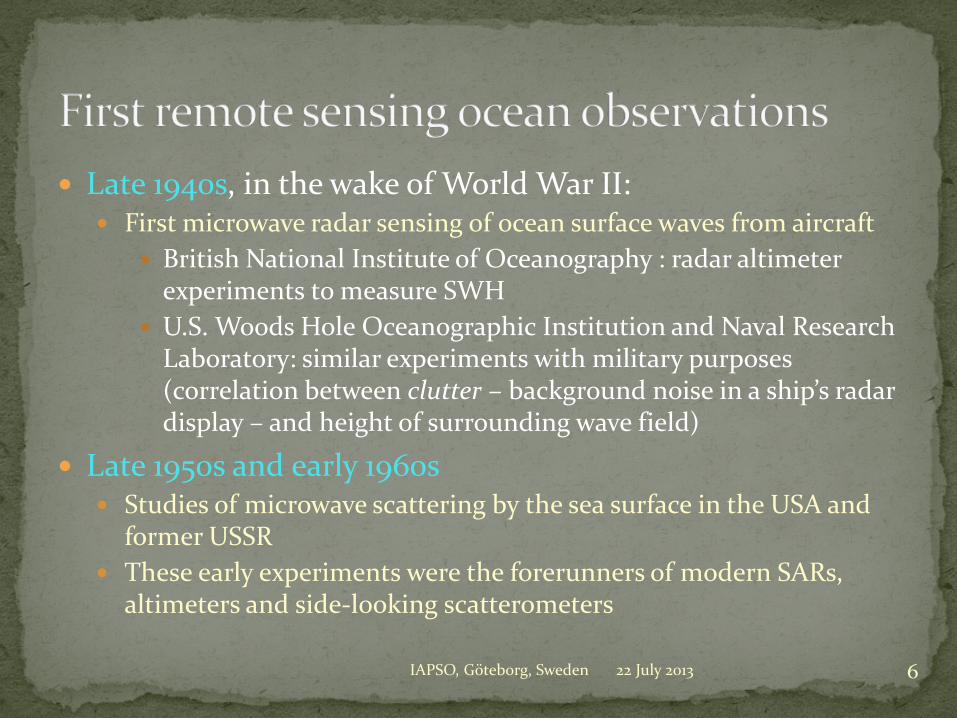
Late 1940s, in the wake of World War II: First microwave radar sensing of ocean surface waves from aircraft
British National Institute of Oceanography : radar altimeter experiments to measure SWH
U.S. Woods Hole Oceanographic Institution and Naval Research Laboratory: similar experiments with military purposes (correlation between clutter – background noise in a ship’s radar display – and height of surrounding wave field)
Late 1950s and early 1960s Studies of microwave scattering by the sea surface in the USA and
former USSR These early experiments were the forerunners of modern SARs,
altimeters and side-looking scatterometers
22 July 2013 6 IAPSO, Göteborg, Sweden

22 July 2013 7
4 October 1957: USSR launches the first artificial satellite of the Earth, a passive sphere of 80 kg
1st April 1960: the USA launches the first meteorological satellite TIROS-1, a B&W TV camera designed to track cloud motions, but also able to provide blurred SST images
IAPSO, Göteborg, Sweden

22 July 2013 IAPSO, Göteborg, Sweden 8
Cameras were taken into orbit by cosmonauts in the Vostok, Voskhod, Soyuz and Salyut and astronauts in the Mercury, Gemini and Apollo vehicles
Collected images showed the possibility to detect chlorophyll, sediments, internal waves and eddies from space, as shown here.
Color photo of the North Carolina barrier islands taken during the U.S./U.S.S.R. Apollo-Soyuz
mission in July 1975 (Courtesy of NASA)

1960s: Back in the U.S.S.R. First passive microwave radiometers carried into space by the U.S.S.R.
Kosmos-243 (1968) and Kosmos-384 (1970) satellites Radiometers operating at 8.5, 3.4, 1.35 and 0.8 cm demonstrated the
possibility of retrieving SST, near-surface winds, total atmospheric water vapour and cloud liquid water content, sea ice parameters, etc.
USA 1964
NASA-sponsored Conference at WHOI, where the concept of Oceanography from Space was developed by Gifford C. Ewing
August 1969 The Williamstown Conference made plans for a space-based
geodesy mission using Doppler and laser satellite tracking and a nadir-looking radar altimeter
1972 NOAA, NASA and U.S. Navy Conference in Miami on data
requirements for sea surface topography
22 July 2013 9 IAPSO, Göteborg, Sweden

10 IAPSO, Göteborg, Sweden 22 July 2013
Skylab (1973): first active microwave sensors
GEOS-3 (1975): dual-pulse altimeter for marine geoid

Seasat was the first Earth-orbiting satellite designed for remote sensing of the Earth's oceans. SEASAT was launched on June 28 1978 into a nearly circular 800 km orbit with an inclination of 108 degrees.
Seasat carried five complementary innovative ocean sensors: Radar altimeter to measure spacecraft height above the ocean surface Microwave scatterometer to measure wind speed and direction Scanning multichannel microwave radiometer to measure surface temperature Visible and infrared radiometer to identify cloud, land and water features Synthetic Aperture Radar (SAR) L-band, HH polarization, fixed look angle to monitor the global
surface wave field and polar sea ice conditions
The Seasat SAR operated for 105 days (only 42 hrs of data ) until October 10, 1978, when a massive short circuit in the electrical system ended the mission.
Seasat was designed by NASA/JPL using techniques experimented in planetary exploration
A Seasat User Research Group in Europe (SURGE) was formed.
22 July 2013 11 IAPSO, Göteborg, Sweden

12 IAPSO, Göteborg, Sweden 22 July 2013
Seasat Altimeter Collinear Overpasses of the Gulf Stream
Seasat Scatterometer Observed an Intense Tropical Cyclone
QE II
22 July 2013 IAPSO, Göteborg, Sweden 13
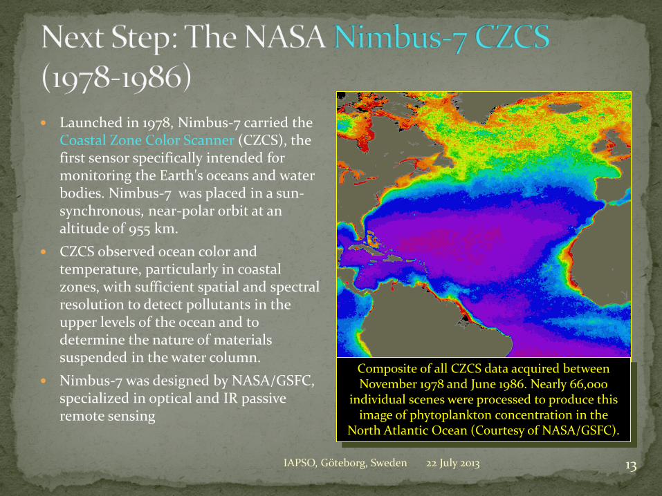
Launched in 1978, Nimbus-7 carried the Coastal Zone Color Scanner (CZCS), the first sensor specifically intended for monitoring the Earth's oceans and water bodies. Nimbus-7 was placed in a sun-synchronous, near-polar orbit at an altitude of 955 km.
CZCS observed ocean color and temperature, particularly in coastal zones, with sufficient spatial and spectral resolution to detect pollutants in the upper levels of the ocean and to determine the nature of materials suspended in the water column.
Nimbus-7 was designed by NASA/GSFC, specialized in optical and IR passive remote sensing
Composite of all CZCS data acquired between November 1978 and June 1986. Nearly 66,000
individual scenes were processed to produce this image of phytoplankton concentration in the
North Atlantic Ocean (Courtesy of NASA/GSFC).

14 IAPSO, Göteborg, Sweden 22 July 2013
CZCS (Chl, left) vs. AVHRR (SST, right), 8 July 1981
Kosmos-1500 SAR (wind, left) vs. Visible (clouds, right), 20 Dec 1984

The ARGOS Data Collection and Positioning System has flown on the NOAA series of polar-orbiting operational satellites continuously since 1978
Such systems have been seminal to develop the in situ ocean component, such as the ARGO profiling floats 22 July 2013 IAPSO, Göteborg, Sweden 15
ARGO monthly map, June 2013: 3525 active floats 20 countries + 7 donor
countries (Credit: JCOMMOPS)

“Satellite altimetry and acoustic thermometry combined can give a very accurate measure of the heat storage in an ocean basin. The two methods are nicely complementary.” Satellite altimetry has good horizontal resolution, fair time
resolution, and essentially no depth resolution. Acoustic thermometry has poor horizontal resolution (limited
number of receiver stations), good time resolution, and fair depth resolution.
“The combined measurements give more than the sum of the two separate measurements.”
22 July 2013 16 IAPSO, Göteborg, Sweden

The first European Remote Sensing Satellite ERS-1 was launched on 17 July 1991, and operated in a sun-synchronous, near-polar orbit at an altitude of 785 km and an inclination of 98.5 degrees.
ERS-1 used advanced microwave techniques to collect global measurements and images independent of time or weather conditions: The Active Microwave Instrument (AMI), combining a Synthetic Aperture
Radar (C-band) operating in image or wave mode and a Wind Scatterometer The Radar Altimeter (RA), the Precise Range and Range-rate Equipment
(PRARE) and Laser reflectors (LRR) The Along-Track Scanning Radiometer and Microwave Sounder (ATSR/M)
The primary objectives of the ERS-1 mission were the surveillance of the oceans and sea ice.
The ERS-1 mission was terminated in March 2000. ERS-2 followed in 1995, and stopped operating in 2012.
22 July 2013 17 IAPSO, Göteborg, Sweden

High-resolution map of the Greenland ice sheet topography from altimeter data collected during the ERS-1 geodetic mission (336 day-repeat orbit)
(Courtesy: Rémy et al., 1999)
ERS-1 Greenland Ice Sheet Mapping
22 July 2013 18 IAPSO, Göteborg, Sweden

22 July 2013 IAPSO, Göteborg, Sweden 19
Topex-Poseidon was launched on August 10, 1992.
The satellite payload (two altimeters, microwave radiometer, several tracking systems for precise orbit determination), and its orbit parameters (1336 km, 66°) were optimized to achieve the highest possible accuracy in determining the ocean dynamic topography, and retrieving ocean large-scale currents and their variations.
Topex-Poseidon precision goal was only 13.7 cm. It actually achieved an accuracy of 2 cm at basin scale!
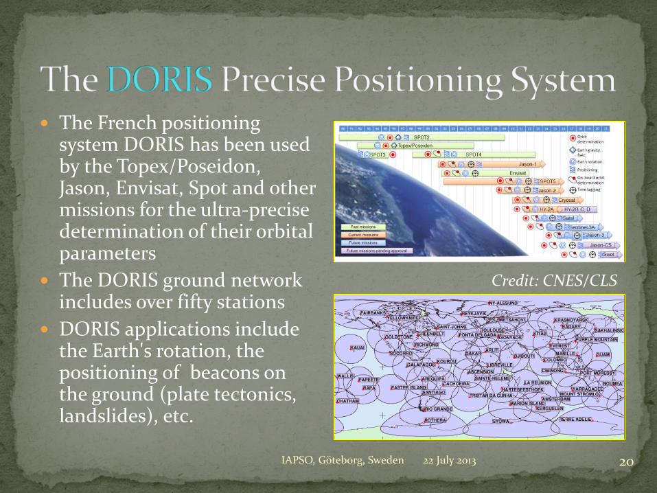
The French positioning system DORIS has been used by the Topex/Poseidon, Jason, Envisat, Spot and other missions for the ultra-precise determination of their orbital parameters
The DORIS ground network includes over fifty stations
DORIS applications include the Earth's rotation, the positioning of beacons on the ground (plate tectonics, landslides), etc.
22 July 2013 IAPSO, Göteborg, Sweden 20
Credit: CNES/CLS

22 July 2013 IAPSO, Göteborg, Sweden 21
The Topex-Poseidon 2-cm accuracy represented the culmination of more than a quarter of a century of steady incremental progress in the succession of altimetric satellites, thanks to its: Dual-frequency altimeter, High-altitude, low
inclination orbit Better orbit determination

22 July 2013 IAPSO, Göteborg, Sweden 22
With 17 years of continuous operation, Radarsat-1 has outperformed by 12 years its nominal lifetime.
This first ‘commercial’ radar mission “provided 625,848 images to more than 600 clients and partners in Canada and 60 countries worldwide.” High-resolution (25m) map made up from a
mosaic of over 4,500 individual scenes acquired in September 1997 (Courtesy of K. Jezek)

On August 17, 1996, ADEOS-1 was launched into a sun-synchronous orbit at an altitude of 830 km. It carried: Two core sensors developed by NASDA, among which:
the Ocean Color and Temperature Sensor (OCTS) Six Announcement of Opportunity sensors, among which:
the POLDER radiometer provided by CNES the NSCAT scatterometer provided by NASA
Both ADEOS-1 and 2 failed after nine months!
22 July 2013 23 IAPSO, Göteborg, Sweden
Novembre 1996
Global biosphere
0. 0.2 0.4 0.6 0.8NDVI
0.03 0.3 3.00.1 1.0 10.Chlorophyll (mg m -3)
CESBIOCESBIOCESBIOCESBIOCESBIOCESBIOCESBIOCESBIOCESBIO
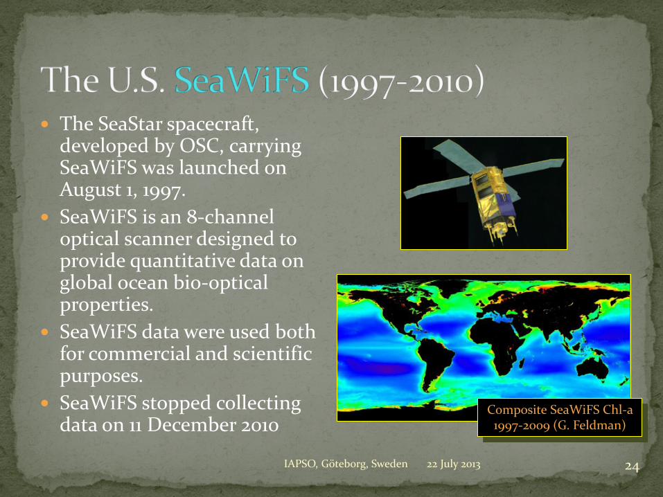
The SeaStar spacecraft, developed by OSC, carrying SeaWiFS was launched on August 1, 1997.
SeaWiFS is an 8-channel optical scanner designed to provide quantitative data on global ocean bio-optical properties.
SeaWiFS data were used both for commercial and scientific purposes.
SeaWiFS stopped collecting data on 11 December 2010
22 July 2013 IAPSO, Göteborg, Sweden 24
Composite SeaWiFS Chl-a 1997-2009 (G. Feldman)
22 July 2013 IAPSO, Göteborg, Sweden 25
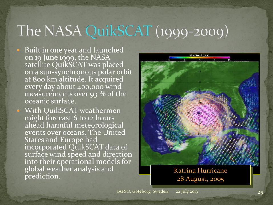
Built in one year and launched on 19 June 1999, the NASA satellite QuikSCAT was placed on a sun-synchronous polar orbit at 800 km altitude. It acquired every day about 400,000 wind measurements over 93 % of the oceanic surface.
With QuikSCAT weathermen might forecast 6 to 12 hours ahead harmful meteorological events over oceans. The United States and Europe had incorporated QuikSCAT data of surface wind speed and direction into their operational models for global weather analysis and prediction.
Katrina Hurricane 28 August, 2005

JASON-1 was launched on December 7, 2001, from Vandenberg, on the same orbit as TOPEX/Poseidon. It carries an altimetry payload : Dual-frequency altimeter
(Poseidon-2) DORIS tracking system receiver Microwave radiometer GPS receiver Laser retro-reflectors
The satellite weight is only 500 kg (TOPEX/Poseidon weighed over 2.5 tons)
Jason Operational Sensor Data Records are delivered within 3 hours.
22 July 2013 IAPSO, Göteborg, Sweden 26

22 July 2013 27 IAPSO, Göteborg, Sweden

22 July 2013 IAPSO, Göteborg, Sweden 28

ENVISAT, the most powerful European Earth observation satellite, was launched from Kourou on February 28, 2002.
ENVISAT carried 10 sensors, 7 of which were of ocean interest: An Advanced Synthetic Aperture
Radar (ASAR) A Radar Altimeter (RA-2), a
Microwave Radiometer (MWR), a DORIS tracking system receiver, and laser retro-reflectors (LRR)
The Advanced Along-Track Scanning Radiometer (AATSR)
A Medium Resolution Imaging Spectrometer (MERIS)
22 July 2013 29 IAPSO, Göteborg, Sweden
ENVISAT observed the dispersion of oil from the
Prestige wreck in November 2002 off the
Spanish West coast
ENVISAT was launched just in time to observe
the break-up of Larsen B in Antarctica

Merged Chlorophyll product derived from observations collected by MERIS (on-board ESA’s ENVISAT) and MODIS (on-board NASA’s Aqua from June 20 to July 4 2004 in the Gulf of Mexico.
(Courtesy: O. Fanton d’Andon, ACRI)
ESA’s ENVISAT MERIS and NASA’s Aqua MODIS
22 July 2013 30 IAPSO, Göteborg, Sweden

Launched in 2009, the GOCE mission will end in November
Using the GOCE independent geoid, global currents can be extracted, for the first time, directly from satellite altimetry data.
22 July 2013 IAPSO, Göteborg, Sweden 31

Launched on November 2009, SMOS carries an L-band microwave interferometer aimed at measuring soil moisture and ocean surface salinity
22 July 2013 IAPSO, Göteborg, Sweden 32
First merged global maps of soil moisture (August 2011) and sea surface salinity (August
2010), morning orbits. © CESBIO, IFREMER, CATDS
Estimates of surface wind speeds (km/hr) from SMOS data along the track of Hurricane Sandy (October 2012)

Mixed with altimetry data SMOS salinity observations allow to monitor the interaction between warm, salty water carried north by the Gulf Stream and the colder, less-salty waters transported southward by the Labrador Current
Combining SMOS and Jason observations
22 July 2013 33 IAPSO, Göteborg, Sweden

22 July 2013 IAPSO, Göteborg, Sweden 34
CryoSat-2 (launched 2009) primary mission goals: Determination of regional
and basin-scale trends in perennial Arctic sea ice thickness and mass
Determination of regional and total contributions to global sea-level of the Antarctic and Greenland ice sheets
The first-ever map of Arctic sea ice thickness was released in June 2011

SMOS data have also been used to monitor Arctic sea ice. The radiation emitted by the ice allows SMOS to penetrate the surface, yielding ice-thickness measurements down to 50 cm – mainly the thinner and younger ice at the edge of the Arctic Ocean.
(Credit: L. Kaleschke, IFM, Hamburg)
Sea Ice Thickness from... SMOS
22 July 2013 35 IAPSO, Göteborg, Sweden

22 July 2013 IAPSO, Göteborg, Sweden 36
The first day image of Oceansat-2 (Northwest India) was made available (in pdf format) within hours of its launch on 23 September 2009
Oceansat-2 carries an Ocean Color Monitor, a wind Scatterometer and a radio-occultation sounder provided by the Italian Space Agency

22 July 2013 IAPSO, Göteborg, Sweden 37
ISRO and CNES have collaborated on this innovative mission using a Ka-band altimeter, a DORIS receiver, and an ARGOS-3
SARAL was aimed at ensuring the continuity of altimetry observation from high-inclination orbit. It was launched on 25 February 2013 and its performance has just been successfully assessed.

22 July 2013 IAPSO, Göteborg, Sweden 38
Aquarius is a focused effort to measure Sea Surface Salinity and provide the global view of salinity variability needed for climate studies.
The mission (launched 10 June 2011) is a collaboration between NASA and the Space Agency of Argentina (CONAE).

The objective of the HY-2 satellite series is to monitor the dynamic ocean environment with microwave sensors to detect sea surface wind field, sea surface height and sea surface temperature.
The instrument suit consists of an altimeter (dual-frequency in Ku and C-bands), a scatterometer and a microwave imager, and a CNES-provided DORIS receiver for precise orbit determination
HY-2A was launched on 15 August 2011 (SS orbit at 971 km altitude. Altimeter and scatterometer data are not yet distributed, but compare well with Jason-2 and buoy data.
HY-2B is due for launch in 2013.
22 July 2013 IAPSO, Göteborg, Sweden 39

22 July 2013 IAPSO, Göteborg, Sweden 40
COMS, the first Korea meteorological satellite carries an ocean color sensor GOCI on a geostationary orbit for the first time ever
Credit: KOSC/KARI

22 July 2013 IAPSO, Göteborg, Sweden 41

22 July 2013 IAPSO, Göteborg, Sweden 42
2001–2013

Sentinel 1 – Synthetic Aperture Radar (SAR) All weather imagery, interferometry, polar regions
Sentinel 2 – Super-spectral optical imagery
Continuity of Landsat, Spot & Vegetation data
Sentinel 3 – Ocean monitoring Ocean color, sea surface temperature and sea surface
topography
Sentinel 4 – Atmospheric Monitoring from GEO Atmospheric composition, transboundary pollution
Sentinel 5 – Atmospheric Monitoring from LEO
Atmospheric composition
22 July 2013 43 IAPSO, Göteborg, Sweden

22 July 2013 IAPSO, Göteborg, Sweden 44
Jason-CS will ensure continuity with Jason-3 with a first launch early enough to guarantee adequate overlap with Jason-3. Two satellites with a 7 years lifetime each are planned.
Jason-CS should ensure the same (or better) level of performance as earlier Jason series. It will extend the existing partnership between the U.S. and Europe (NOAA, NASA, EUMETSAT, ESA, CNES and industry).

22 July 2013 IAPSO, Göteborg, Sweden 45
(Credit: EUMETSAT)

22 July 2013 IAPSO, Göteborg, Sweden 46
The Surface Water Ocean Topography (SWOT) mission will make the first global survey of Earth's surface water, observe the fine details of the ocean's surface topography, and measure how water bodies change over time.
With its wide-swath altimetry technology, it is a means of completely covering the world's oceans and freshwater bodies with repeated high-resolution elevation measurements. Credit: K. Rodriguez/JPL)

22 July 2013 IAPSO, Göteborg, Sweden 47
Nadir Altimeter Wide-Swath Altimeter

22 July 2013 IAPSO, Göteborg, Sweden 48

In the 1980s, it was nearly impossible in the U.S. to justify a mission based on its contribution to ocean science International cooperation
and other non-science -related arguments made it possible to set up the joint NASA-CNES Topex-Poseidon
22 July 2013 IAPSO, Göteborg, Sweden 49
Top: four French engineers in July 1983 after a exhausting “collaborative” meeting at JPL Bottom: over 200 scientists at the OSTST
meeting in Lisbon, October 2010

ALCATEL – March 18, 2005
Signature of the letters exchanged by CNES and EUMETSAT with NASA and NOAA on the Ocean
Surface Topography Mission, Kyoto, 7 November, 2001
From back to front side:
D. WILLIAMS (EUMETSAT)
B. SMITH (NOAA)
J.L. FELLOUS (then with
CNES)
From back to front side:
T. MOHR (EUMETSAT)
G. WITHEE (NOAA)
G. ASRAR and A. CONDES
(NASA)

22 July 2013 IAPSO, Göteborg, Sweden 51
ERS-1 was decided on the assumption that it would help develop a commercial sector. ERS-2 was decided on the basis on the need for continued SAR monitoring of land surface. ENVISAT was initiated as part of the ISS
ESA’s Living Planet Program (conceived by the former COSPAR President, Roger Bonnet, an astronomer!) was only initiated in 1999
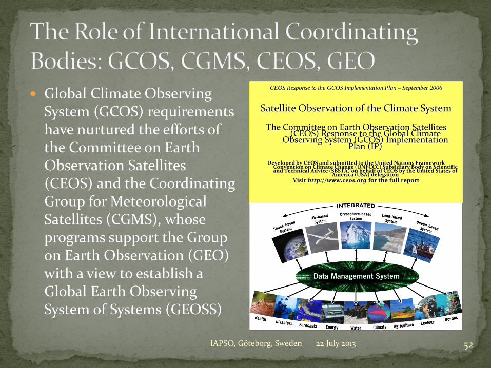
Global Climate Observing System (GCOS) requirements have nurtured the efforts of the Committee on Earth Observation Satellites (CEOS) and the Coordinating Group for Meteorological Satellites (CGMS), whose programs support the Group on Earth Observation (GEO) with a view to establish a Global Earth Observing System of Systems (GEOSS)
22 July 2013 IAPSO, Göteborg, Sweden 52
CEOS Response to the GCOS Implementation Plan – September 2006
Satellite Observation of the Climate System
The Committee on Earth Observation Satellites (CEOS) Response to the Global Climate
Observing System (GCOS) Implementation Plan (IP)
Developed by CEOS and submitted to the United Nations Framework
Convention on Climate Change (UNFCCC) Subsidiary Body on Scientific and Technical Advice (SBSTA) on behalf of CEOS by the United States of
America (USA) delegation Visit http://www.ceos.org for the full report

Ocean Essential Climate Variables accessible to satellite measurement include: Sea Surface Temperature Sea Surface Height (ocean topography): currents, marine geoid Sea State
Surface wind field (speed and direction) Wave field (speed and direction)
Sea Surface Reflectance (ocean colour): surface concentration in chlorophyll pigments, sedimentary plumes, coastal currents, algae blooms
Sea ice concentration and thickness Sea Surface Salinity
22 July 2013 53 IAPSO, Göteborg, Sweden

Nowadays, several ocean surface parameters are measured operationally from space, with increased spatial and temporal resolution and accuracy Sea Surface Temperature Sea State ( surface winds and
waves – speed and direction) Sea Surface Height Ocean Color
However there are still limitations (spectral bands, risk of data gaps)
22 July 2013 IAPSO, Göteborg, Sweden 54
MetOp-A
GCOM-W1

19th UN-IAF Workshop on “Integrated Space Technologies and Space-based Information for
Analysis and Prediction of Climate Change” – Daejeon, Korea, 9-11 October 2009
10 11 12 13 14 15 16 17 18 19 20 21 22
Ocean Surface Topography Constellation Roadmap
Jason-1 Fr./USA
ENVISAT ESA
High accuracy SSH from mid-inclination orbit
CRYOSAT-2 ESA
GFO US
Medium accuracy SSH from high-inclination sun-synchronous orbit
Jason-2 Europe/USA
Jason-3 Europe/USA
Jason-Continuity Series Europe/USA
Swath altimetry from high-inclination orbit (several orbit options)
SWOT/WaTER-HM USA/Europe
Saral/AltiKa India/France
In orbit Approved Planned/Pending approval Needed
-3C, -3D Sentinels-3A / 3B Europe
HY-2B, -2C, -2D HY-2A China
ERS-2 ESA
09 08
Jason-CS successor Europe
22 July 2013 IAPSO, Göteborg, Sweden 56
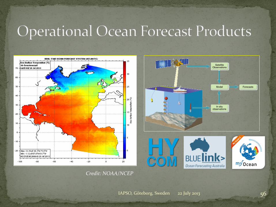
Credit: NOAA/NCEP

The missions discussed above showed a mix of data policies, evolving from the PI-type to full and open access to data without any period of exclusive use (Topex-Poseidon, Jason, QuikSCAT), along with a variety of intermediate cases (e.g. ERS, ALOS, ENVISAT) and involving in some cases commercial distribution (e.g. RADARSAT, real-time SeaWiFS for non-research purposes)
Full and open access is the preferred route from a scientific perspective, and it has allowed to achieve the full potential of the missions and to lay the foundation for an ocean observing operational system
22 July 2013 57 IAPSO, Göteborg, Sweden
Policy Relevance and Demonstrated Usefulness Climate Change and IPCC UNFCCC Conference of the Parties request for Continuous Space-
Based Observations Availability of Integrated Products
Space-based and in situ Data assimilation and improved ocean modeling
A Good Balance of Continuity and Innovation Continuity of data products Improvement of observing techniques and accuracy
The Involvement of Operational and R&D Agencies Need for 24/7 operation Need for quality assurance, calibration and validation
22 July 2013 58 IAPSO, Göteborg, Sweden

22 July 2013 IAPSO, Göteborg, Sweden 59