Embed Size (px)
Citation preview

UNIVERSIDADE DE LISBOA FACULDADE DE CIÊNCIAS
2018
The impact of tropical cyclone Hayan in the Philippines: Contribution of spatial planning to enhance adaptation in
the city of Tacloban
Doutoramento em Alterações Climáticas e Políticas de Desenvolvimento Sustentável Especialidade em Ciências do Ambiente
Carlos Tito Santos
Tese orientada por: Professor Doutor Filipe Duarte Santos
Professor Doutor João Ferrão
Documento especialmente elaborado para a obtenção do grau de Doutor
Faculdade de Ciências Faculdade de Letras
Instituto de Ciências Sociais Instituto Superior de Agronomia
Instituto Superior Técnico
Faculdade de Ciências Sociais e Humanas Faculdade de Ciências e Tecnologia

UNIVERSIDADE DE LISBOA FACULDADE DE CIÊNCIAS
2018
The impact of tropical cyclone Haiyan in the Philippines: Contribution of spatial planning to enhance adaptation in
the city of Tacloban
Doutoramento em Alterações Climáticas e Políticas de Desenvolvimento Sustentável Especialidade em Ciências do Ambiente
Carlos Tito Santos
Júri: Presidente: Doutor Rui Manuel dos Santos Malhó; Professor Catedrático
Faculdade de Ciências da Universidade de Lisboa
Vogais: Doutor Carlos Daniel Borges Coelho; Professor Auxiliar
Departamento de Engenharia Civil da Universidade de Aveiro
Doutor Vítor Manuel Marques Campos; Investigador Auxiliar Laboratório Nacional de Engenharia Civil(LNEC)
Doutor João Manuel Machado Ferrão; Investigador Coordenador Instituto de Ciências Sociais da Universidade de Lisboa, Orientador
Doutor João Pedro Teixeira de Abreu Costa; Professor Auxiliar com Agregação Faculdade de Arquitetura da Universidade de Lisboa
Doutor André Filipe Fernandes; Bolseiro Pós-doutoramento Faculdade de Ciências Sociais e Humanas da Universidade Nova de Lisboa, na qualidade de especialista de reconhecido mérito
Doutor Gil Pessanha Penha-Lopes; Investigador Faculdade de Ciências da Universidade de Lisboa
Documento especialmente elaborado para a obtenção do grau de Doutor
Faculdade de Ciências Faculdade de Letras
Instituto de Ciências Sociais Instituto Superior de Agronomia
Instituto Superior Técnico
Faculdade de Ciências Sociais e Humanas Faculdade de Ciências e Tecnologia

i
Resumo
Desde o primeiro relatório de avaliação do Painel Intergovernamental sobre as Alterações Climáticas,
que se têm estudado e procurado determinar uma possível influência das alterações climáticas na
frequência e intensidade dos ciclones tropicais. Esta ligação potencial foi difícil de comprovar
inicialmente, devido ao facto de os efeitos do aquecimento global não se fazerem sentir tão
acentuadamente. Posteriormente, com os crescentes impactos dos ciclones tropicais a afectarem
globalmente cada vez mais as populações locais e infraestruturas, mais estudos foram efectuados para
perceber se existia uma influência das alterações climáticas na actividade dos ciclones tropicais.
Apesar de existirem algumas incertezas científicas sobre a forma como as alterações climáticas afectam
os ciclones tropicais, a variabilidade do clima e as alterações climáticas estão definitivamente a
influenciar estes fenómenos climáticos extremos que se estão a tornar mais intensos e devastadores.
Este estudo analisará a discussão científica sobre a influência das alterações climáticas nos ciclones
tropicais.
O Quinto Relatório de Avaliação do Painel Intergovernamental para as Alterações Climáticas de 2013
concluiu que o aquecimento do clima era inequívoco. Estudos mais recentes concluíram ainda que este
facto contribuiu para que a temperatura da superfície do mar esteja a aumentar, o que faz com que
mais água evapore para a atmosfera e contribua para a intensificação dos ciclones tropicais. O
aquecimento global estará também a causar a subida do nível do mar, o que agravará o impacto das
inundações resultantes da sobrelevação marítima dos ciclones tropicais em zonas costeiras baixas.
Em 2013, foi ultrapassada pela primeira vez a média global de concentração de dióxido de carbono
(CO2) na atmosfera em 400 partes por milhão, sendo que o valor máximo recomendado de
concentração de CO2 é de 450 partes por milhão, de forma a limitar o aumento das temperaturas
globais em 2°C. O Acordo de Paris de 2015, têm como objectivo manter o aumento da temperatura da
atmosfera bastante abaixo dos 2°C e desenvolver esforços para reduzir o aumento da temperatura para
ii
1.5°C. O ano de 2015 foi considerado como ano mais quente de que há registo, alcançando pela primeira
vez 1°C acima da temperatura da era pré-industrial.
Consequentemente, o Acordo de Paris representa um apelo à acção no que diz respeito ao aumento
das emissões dos gases com efeito estufa e através deste acordo a comunidade internacional iniciou
medidas importantes com vista à sua redução.
Nas regiões afectadas pela passagem de ciclones tropicais, as zonas costeiras estão cada vez mais
expostas à intensidade destes fenómenos extremos, influenciados por factores naturais e
antropogénicos. Os impactos têm sido devastadores, não só em termos de números de vítimas bem
como de prejuízos avultados, afectando cidades que frequentemente levam anos a recuperar
economicamente. Estes desastres naturais afectam em especial os mais pobres, que normalmente são
os que sofrem mais vítimas e danos materiais.
Comunidades, ecossistemas e infraestruturas são particularmente vulneráveis aos impactos destes
fenómenos climáticos extremos, por se encontrarem em zonas sujeitas a riscos. As cidades afectadas
por ciclones tropicais demoram frequentemente tempo a recuperar, por não terem podido antecipar e
investir em medidas preventivas e por terem falta de planos de adaptação e de medidas resilientes ao
clima, não só para as infraestruturas bem como para os diferentes sectores e serviços.
Muitas das cidades costeiras densamente povoadas, necessitam antecipar e adaptar regularmente o
ordenamento do território de forma a poderem reduzir as vulnerabilidades aos ciclones tropicais. Como
tal, o ordenamento do território pode desempenhar um papel fundamental através da integração das
medidas de adaptação às alterações climáticas e redução do risco de catástrofes, nomeadamente
através de instrumentos de política de ordenamento de território, como o zonamento e os códigos de
construção. Incentivos financeiros para a redução de risco, tais como incentivos fiscais e desincentivos
ou seguros, podem também ser ferramentas muito eficazes para reduzir os riscos e melhorar a
resiliência das pessoas e infraestruturas. Neste contexto, o ordenamento do território deve ser
determinante na protecção das comunidades e do ambiente, ao evitar o desenvolvimento em zonas
vulneráveis. Os impactos das alterações climáticas representam novos desafios para reforçar a

iii
capacidade de adaptação, através da integração de novas abordagens tecnológicas e arquitectónicas
mais integradas com o ecossistema.
O ordenamento do território tem um papel importante na redução dos impactos da variabilidade do
clima e as alterações climáticas, promovendo o desenvolvimento sustentável e alinhando-se com o
Quadro de Acção de Sendai, para a Redução do Risco de Catástrofes e os Objectivos de
Desenvolvimento Sustentável das Nações Unidas.
Neste século XXI, uma série de ciclones tropicais extremamente intensos como o Katrina e o Sandy, nos
Estados Unidos, o Haiyan nas Filipinas e o Morakot em Taiwan tiveram consequências devastadoras,
que causaram perdas humanas e danos significativos às infraestruturas. Os países em vias de
desenvolvimento são particularmente afectados por estes fenómenos climáticos extremos e têm
bastantes dificuldades em lidar com os seus impactos.
A intensidade destes desastres climáticos tem demonstrado uma falta de preparação da parte dos
governos, das comunidades e do sector privado em lidar com os impactos. Nos Estados Unidos, a
inadequação de muitas infraestruturas e o planeamento desactualizado contribuiu para agravar os
impactos dos ciclones tropicais Katrina e Sandy. Neste contexto, este estudo examina os papéis e
responsabilidades dos governos central e local na realização de investimentos e estratégias necessárias
à melhoria das infraestruturas resistentes ao clima.
Este estudo analisa a dimensão do impacto do ciclone tropical Haiyan e da sua sobrelevação marítima,
que representou um ponto de viragem nas Filipinas devido à potencial influência das alterações
climáticas nos ciclones tropicais, tendo revelado até que ponto as populações costeiras estão expostas
aos riscos destes fenómenos climáticos e de como as suas vulnerabilidades podem ser diminuidas
através do ordenamento do território.
O ciclone tropical Haiyan foi responsável por um elevado número de vítimas e avultados prejuízos, em
particular na cidade costeira de Tacloban. O Haiyan veio também mostrar a grande vulnerabilidade aos
impactos destes fenómenos climáticos extremos numa região que está habituada à passagem anual de
ciclones tropicais. Como consequência destes impactos, eram necessárias medidas de redução de riscos

iv
integradas no ordenamento do território, bem como zonamento baseado na análise de risco, códigos
de construção resilientes ao clima e modernização de infraestruturas. O processo de reconstrução das
infraestruturas públicas, nas áreas afectadas pelo Haiyan, seria feito através do principio de “reconstruir
melhor” que teria de ter em consideração cartas de risco e normas de resiliência às alterações
climáticas.
Em Tacloban, logo após o impacto do Haiyan, foi implementada a política de zonas de construção
interdita numa faixa de 40 metros a partir da linha da água, o que consequentemente originou um
processo de realojamento forçado dos ocupantes ilegais que viviam nas zonas sujeitas a riscos, para a
zona norte desta cidade para os proteger do impacto de futuros ciclones tropicais. O estudo examinará
o quadro legal das Filipinas no âmbito da adaptação às alterações climáticas e as medidas de gestão de
risco de catástrofes e de como estão a ser integradas nos planos do governo local, através de políticas
de utilização do solo. Neste contexto, também será analisado o nível de participação pública nos
debates relativos ao ordenamento do território, e à integração da adaptação às alterações climáticas e
à redução do risco de catástrofes. O impacto do Haiyan foi determinante para impulsionar novas leis,
políticas e planos nas Filipinas tendo captado recursos financeiros e humanos para apoiar o processo
de recuperação e reabilitação das zonas afectadas por este cyclone tropical.
Com os últimos três anos a registarem consecutivamente as temperaturas médias mais altas, a
comunidade internacional precisa urgentemente de tomar medidas que reduzam os impactos das
alterações climáticas.
Palavras-chave: Alterações climáticas ∙ ciclones tropicais ∙ ordenamento do território ∙ Haiyan ∙
redução do risco de catástrofes

v
Abstract
The 2013 International Panel on Climate Change, Fifth Assessment Report concluded that the warming
of the climate was unequivocal. This has contributed to make the oceans warmer and the sea surface
temperature to increase, which causes more water to evaporate into the atmosphere and contribute
to the intensification of tropical cyclones. Global warming can also cause sea level to rise which will
further exacerbate the impact of tropical cyclone storm surges flooding in low-lying coastal zones.
In spite of some scientific uncertainties on how climate change affects tropical cyclones, the climate
variability and change is definitely influencing these extreme weather events. In this context, this study
will analyse the scientific discussion on the influence of climate change on tropical cyclones.
Coastal areas around the world are becoming increasingly more exposed to the intensity of tropical
cyclones which have been influenced by natural and anthropogenic factors. Communities, ecosystems
and infrastructure in low lying-coastal areas are particularly vulnerable to the impacts of these extreme
weather events, especially populations who live in hazard-prone areas. Cities that have been affected
by tropical cyclones, often take a long time to recover, because of not being able to anticipate and invest
in preventive measures such as adaptation plans and increase the climate resilience of infrastructures,
sectors and services.
Many densely populated coastal cities need to regularly anticipate and adapt their spatial planning to
be able to reduce their increasing vulnerabilities to these extreme events. As such, spatial planning can
play an important role through the integration of climate change adaptation and disaster risk reduction.
measures. Policy instruments, like zoning and building codes can reduce the risk of natural hazards and
vulnerabilities. Financial incentives for risk reduction such as tax incentives and disincentives or
insurance can also be very effective tools and improve the resilience of people and infrastructure.
Spatial planning has an important role in reducing the impacts of climate variability and change while
promoting sustainable development by aligning itself with the Sendai framework for Disaster Risk
Reduction and the United Nations Sustainable Development Goals.

vi
In this century, a number of extremely intense tropical cyclones like Katrina and Sandy in the United
States, Haiyan in the Philippines, and Morakot in Taiwan had devastating consequences, causing loss of
lives and immense damages to infrastructure. Developing countries are particularly affected by these
extreme weather events and often struggle to cope with their impacts. The intensity of these climate
disasters showed a number of vulnerabilities and left a degree of uncertainty about the impact of future
tropical cyclones. In this context, this thesis examines the roles and responsibilities of central and local
governments in making the necessary investments and strategies towards the improvement of climate
resilient infrastructures.
This study analyses the scale of the impact of tropical cyclone Haiyan storm surge in the Philippines
which was responsible for a high number of victims and extensive damage, in particular to the coastal
city of Tacloban. Hayan has shown a high vulnerability to the impacts of these extreme weather events
in a region that is used to the tropical cyclones. As a consequence of Haiyan, zoning regulations were
applied and an involuntary resettlement process took place of the informal settlers that were living in
the hazard-prone areas.
The thesis will examine the country’s legal framework and how climate change adaptation and disaster
risk management measures are being mainstreamed into local government plans through land use
planning. It will also analyse the level of public participation in the discussions relating to land use
planning and on the integration of Climate Change Adaptation and Disaster Risk Reduction.Haiyan was
determinant to set in motion new legislation, policies and plans in the Philippines and it brought
additional financial and human resources to support the rehabilitation and recovery process.
With the last three consecutive years being on record for the highest registered temperatures, there is
an urgent need by the international community and their respective countries to step up measures to
reduce the impacts of climate change.
Keywords: Climate change ∙ tropical cyclones ∙ spatial planning ∙ Haiyan ∙ disaster risk reduction

vii
Acknowledgements
These last 4 years, I had valuable contributions and support from a number of people who have helped
me through this enriching journey of writing the dissertation.
First of all, I would like to thank both my supervisors Prof. Filipe Duarte Santos and Prof. João Ferrão for
their continued support throughout the research and writing process, invaluable guidance and very
constructive inputs which helped me to improve this dissertation.
I am indebted to the Oscar M. Lopez (OML) Centre for Climate Change and Disaster Risk Reduction in
the Philippines especially to its Scientific Director Dr. Rodel Lasco. I am grateful to have had the
opportunity to collaborate with the Centre, which provided me support to conduct the research for the
case study of Typhoon Haiyan included in this dissertation. I am also thankful to all the colleagues from
the OML Centre and in particular: Rafaela Jane Delfino, Luigi Toda, Justine Ravi Orduña, Perlyn Pulhin,
Carlo Carlos and Kristoffer Kendrick Co for our numerous debates and their insightful comments which
contributed to this dissertation.
I thank my family, my parents, my brother Pedro and my son Gui for their patience, continued support
and encouragement throughout the writing of this thesis.
I could not have completed this work without benefitting the beautiful environment in Ubud Bali at the
welcoming home of Cat Wheeler, with Wayan Manis, Hamish and Tika for company.
I would like to express my gratitude to my wife Su Chin, whose invaluable support, patience and
encouragement throughout these years allowed me to achieve this objective.
I particularly thank my dear old friend Pedro Cortesão Casimiro whose wisdom persuaded me to
combine my professional experience with this PhD program and encouraged me to start this important
journey of my life.
And to all my dear friends who always had words of encouragement.

viii
Dedication
To my dear friend and mentor, Angela Cropper (1946-2012), who first set me on the path of finding
solutions to a more sustainable development. You are a daily source of inspiration in my life.

ix
Table of contents
Resumo ....................................................................................................................................... i
Abstract ......................................................................................................................................v
Acknowledgements .................................................................................................................. vii
Dedication ............................................................................................................................... viii
Table of contents ....................................................................................................................... ix
List of figures ........................................................................................................................... xiii
List of tables ............................................................................................................................ xiii
Abbreviations .......................................................................................................................... xiv
Chapter 1. Introduction ............................................................................................................. 1
Background ............................................................................................................................. 2
Setting the scene..................................................................................................................... 2
Relevance of the theme of research ...................................................................................... 3
Purpose and research questions ............................................................................................ 5
Research methodology and presentation structure .............................................................. 6
Chapter 2. Tropical cyclones and climate change ................................................................... 11
Objective ............................................................................................................................... 12
Impacts of recent severe tropical cyclones in different geographic basins ......................... 13
Formation and characteristics of tropical cyclones .............................................................. 14

x
The potential influence of climate change on tropical cyclones .......................................... 20
The IPCC and the scientific basis of the potential influence of climate change on tropical
cyclones ................................................................................................................................ 21
The IPCC First Assessment Report ........................................................................................ 22
The Kyoto Protocol ............................................................................................................... 23
The IPCC Second Assessment Report ................................................................................... 24
The IPCC Third Assessment Report ...................................................................................... 25
The IPCC Fourth Assessment Report .................................................................................... 28
The IPCC Special Report on Managing the Risks of Extreme Events and Disasters to
Advance Climate Change Adaptation ................................................................................... 30
The IPCC Fifth Assessment Report ....................................................................................... 32
Recent studies on climate change and tropical cyclones ..................................................... 34
The UNFCCC Paris Agreement .............................................................................................. 35
Conclusion ............................................................................................................................ 41
Chapter 3. Spatial planning as an adaptation option to the impacts of Climate Change and
Tropical Cyclones .................................................................................................. 44
Objective ............................................................................................................................... 45
The importance of spatial planning ...................................................................................... 46
Implementing spatial planning ............................................................................................. 47
Urbanization and vulnerability ............................................................................................. 50

xi
Spatial planning and climate change .................................................................................... 54
Spatial planning to enhance adaptation to climate variability and change ......................... 54
Spatial planning and disaster risk reduction ........................................................................ 59
The Sendai Framework for Disaster Risk Reduction ............................................................ 61
Differences between climate change adaptation and disaster risk reduction .................... 64
Spatial planning policy instruments ..................................................................................... 65
a. Regulatory instruments: zoning and building codes to improve climate change
adaption and disaster risk reduction ................................................................................ 65
b. The importance of climate proofing and retrofitting to enhance climate change
adaption and disaster risk reduction ................................................................................ 67
c. Incentive instruments: the role of financial incentives in spatial planning .................. 68
Innovative design solutions: Defend-Retreat-Attack ........................................................... 70
Conclusion ............................................................................................................................ 72
Chapter 4. Spatial planning responses to the impact of tropical cyclones in the United States
of America and Taiwan ......................................................................................... 76
Objective ............................................................................................................................... 77
Impacts of tropical cyclones in the United States of America ............................................. 78
Hurricane Katrina .................................................................................................................. 79
Hurricane Sandy.................................................................................................................... 84
Spatial planning responses: Lessons learned from Katrina and Sandy ................................ 91

xii
Impacts of tropical cyclones in Taiwan ................................................................................. 93
Typhoon Morakot ................................................................................................................. 95
Spatial planning responses: Lessons learned from Morakot ............................................. 100
Conclusion .......................................................................................................................... 102
Chapter 5. Case study - The impacts of typhoon Haiyan in the Philippines: Implications to
land use planning ............................................................................................... 106
Abstract............................................................................................................................... 107
Introduction ........................................................................................................................ 107
Methodology ...................................................................................................................... 111
Climate trends in the Philippines........................................................................................ 111
Study area ........................................................................................................................... 114
Government planning before typhoon Haiyan .................................................................. 114
Government planning after typhoon Haiyan ..................................................................... 116
Discussion ........................................................................................................................... 121
Conclusion and recommendations ..................................................................................... 124
Chapter 6. Conclusions .......................................................................................................... 127
Bibliography........................................................................................................................... 137
ANNEXES................................................................................................................................ 171

xiii
List of figures
1. Figure 1. Structure of a tropical cyclone
2. Figure 2. Map of the cumulative tracks of all tropical cyclones during the 1985-2005 period
3. Figure 3. The seven tropical cyclone basins
4. Figure 4. Tropical cyclone regions around the world
5. Figure 5. Storm surge
6. Figure 6. Annual number of intense hurricane over the Atlantic for the period reliable record
from 1944 to 1996
7. Figure 7. Atmospheric CO2 levels in recent years
8. Figure 8. Tropical cyclone Katrina on the left and tropical cyclone Sandy on the right
9. Figure 9. Tropical cyclone Morakot
10. Figure 10. Super typhoon Haiyan lashing the Philippines
11. Figure 11. Typhoon Haiyan impacts in the city of Tacloban
12. Figure 12. Structures affected by typhoon Haiyan
13. Figure 13. Observed mean temperature anomalies in the Philippines (1951-2010). Departures
from 1971-2000 normal values
14. Figure 14. Five-year frequency of tropical cyclones in Luzon, Vizayas and Mindanao Period:
1949-2013
15. Figure 15. Annual number of tropical cyclones in the PAR Period: 1948-2013
16. Figure 16. Storm surge hazard map – Tacloban city
17. Figure 17. Enforcement of the no build zone after Haiyan
18. Figure 18. Temporary shelters in Tacloban
19. Figure 19. New resettlement area in the north of Tacloban
List of tables
1. Table 1. Saffir-Simpson Hurricane Wind Scale

xiv
Abbreviations
ADB Asian Development Bank
BPDPP Basic Plan of Disaster Prevention and Protection
CC Climate Change
CCA Climate Change Adaptation
CLUP Comprehensive Land Use Plan
CZO Comprehensive Zoning Ordinance
CMIP5 Coupled Model Intercomparison Project 5
CEPD Council for Economic Planning and Development
DEFRA Department for Environment Food and Rural Affairs
DUHD Department of Urban and Housing Development
DRR Disaster Risk Reduction
EPA Environmental Protection Administration
ESPON European Spatial Planning Observation Network
FEMA Federal Emergency Management Agency
FIRM Preliminary Flood Insurance Rate Maps
HLURB Housing and Land Use Regulatory Board
IDNDR International Decade for Natural Disaster Reduction
IPCC Intergovernmental Panel on Climate Change
KP Kyoto Protocol
MoMA Museum of Modern Art
NASA National Aeronautics and Space Administration
NBCP National Building Code of the Philippines
NDRRMC National Disaster Risk Reduction and Management Council
NEDA National Economic and Development Authority

xv
NHC National Hurricane Centre
NOAA National Oceanic and Atmospheric Administration
NYC New York City
NWS National Weather System
OPARR Office of the Presidential Assistant for Rehabilitation and Recovery
PAGASA Philippine Atmospheric and Astronomical Services Administration
RPDPP Regional Plan of Disaster Prevention and Protection
SST Sea Surface Temperature
WB World Bank
UN United Nations
UNCED United Nations Conference on Environment and Development
UNCBD United Nations Convention on Biological Diversity
UNCHE United Nations Conference on Human Environment
UNDP United Nations Development Program
UNISDR United Nations International Strategy for Disaster Reduction
UNFCCC United Nations Framework Convention on Climate Change
UNOCHA United Nations Office for the Coordination of Humanitarian Affairs
UNECE United Nations Economic Commission for Europe
UNHABITAT United Nations Human Settlements Program
U.S.A. United States of America
WMO World Meteorological Organization

1
Chapter 1. Introduction
2
Background
Setting the scene
The scientific community has been studying how climate change affects tropical cyclones and although
there is still no full agreement on this relationship, it is certain that tropical cyclones are being influenced
by climate variability and change. They are becoming more intense and their impacts more destructive.
The risks and consequences of these powerful storms have been affecting communities and leaving
behind a trail of damage, coastal erosion and destruction of ecosystems.
Densely populated coastal cities are increasingly being affected by the impacts of extreme tropical
cyclones and have to constantly adapt through spatial planning measures that help them in reducing
their growing vulnerabilities. Consequently, there is a need for disaster risk reduction (DRR) and climate
change adaptation (CCA) measures to be incorporated into spatial planning in order to reduce and
anticipate the risk of hazards associated with tropical cyclones such as storm surges and extreme
rainfall.
These extreme weather events were responsible for some of the most destructive impacts in recent
years, such as tropical cyclones Katrina in 2005 and Sandy in 2012 in the United States of America,
Morakot in Taiwan in 2009, and super typhoon Haiyan in the Philippines in 2013. The impacts of these
extreme tropical cyclones were such that urgent adaptation actions had to be undertaken to ensure
that their effects would be minimized and at the same time promote innovative solutions that would
enable communities and cities to become more resilient.
The intensity of the impact of tropical cyclone Haiyan and its storm surge was a tipping point in the
Philippines, and to some extent in the rest of the world, in terms of what possibly is yet to come due to
the potential influence of climate change. It demonstrated the extent to which coastal populations are
exposed to the risks of these extreme weather events and the importance of spatial planning in reducing

3
their vulnerabilities. These issues will be discussed by this thesis and will be put into context through
the effect of Haiyan in the city of Tacloban.
Relevance of the theme of research
Scientists reported that 2015 and 2016 were the warmest years on historical record, breaking what it
had been achieved in 2014 (Gillis, 2016). Since the Intergovernmental Panel on Climate Change (IPCC)
Third Assessment Report, and due to the possible impacts of climate change, “confidence has increased
that some weather events and extremes will become more frequent, more widespread or more intense
during the 21st century” (IPCC, 2007b, p. 64). “It is likely that future tropical cyclones (typhoons and
hurricanes) will become more intense, with larger peak wind speeds and more heavy precipitation
associated with ongoing increases of tropical sea-surface temperatures” (IPCC, 2007a, p.15). With rising
temperatures, there is the possibility of an increase of the costs caused by the impact of storms and
floods (Stern, 2007).
The consequences of tropical cyclones have been overwhelming in terms of human lives, ecosystems
and infrastructure, affecting economies and cities in a way which takes many years to recover. According
to the German insurer Munich Re (2011), frequent weather events are responsible for billions of dollars
in losses. “Estimates of annual losses have ranged since 1980 from a few billion to above 200 billion USD
(in 2010 dollars) with the highest value for 2005 (the year of Hurricane Katrina)” (IPCC, 2012, p.9).
The climate change projections for sea-level rise, tropical storm intensity and drought are anticipated
to have a disproportionate impact in developing countries situated in the regions around the equator
relative to other countries located at higher latitudes (WB, 2013). Asia and the Pacific is the geographical
area of the planet that is more affected by the impact of extreme weather events, coupled with a high
level of exposure to the impacts by exceedingly vulnerable populations, who are extremely poor and
marginalized (ADB, 2012).

4
The poor are the most affected by these events and who suffer the largest share of casualties,
displacement and damages. Due to poverty, people often have no alternatives but to live in the low-
lying coastal areas, riverbanks, flood plains, dangerous slopes and degraded urban environments where
the impacts of extreme weather events are more severe (ADB, 2012).
Population, migration, and poverty, accompanied by poor land use development and planning,
contribute to the increasing number of people who are more exposed to hazards (UNDP, 2012). Cities
concentrate the risk to disasters through high population density, inadequate urban planning, and poor
infrastructure (Oxfam, 2013). Risks to disasters increase if the exposure of the population and assets to
natural hazards grows faster than the ability of countries to improve their risk reduction capacity (UNDP,
2012).
The Philippines is considered the second most exposed country to natural disasters and climate change
due to its proximity to the sea and the exposure to tropical cyclones, flooding and sea level rise (UNU-
EHS, 2014). This country is hit an average of 20 typhoons per year (PAGASA, 2014) and this century
alone it has been affected by some of the deadliest and most destructive on record, including typhoons
Ketsana in 2009, Washi in 2011, Bopha in 2012 (NDRRMC, 2012) and most recently Haiyan. The losses
caused by these extreme weather events represent 0.8% of the GDP, which could be used in
development and poverty reduction efforts of the Philippines (UNISDR, 2012, ADB, 2013). Local
communities, ecosystems and water resources are also vulnerable to the passage of tropical cyclones
(ICRAF and UNISDR, 2010). Communities suffer a reduction in their livelihoods and often lose
agricultural land, worsening their living conditions.
Tropical cyclone Haiyan, made landfall in the Philippines on November 8, 2013 and it was considered as
one of most powerful to ever be recorded on the planet (UNOCHA, 2013). This category 5 tropical
cyclone was responsible for damages estimated at around a billion USD in agriculture and infrastructure
(NDRRMC, 2014). The Haiyan storm surge had a devastating impact on the city of Tacloban, where the
majority of the casualties and damage occurred. The impact was worsened by the fact that a lot of
5
Tacloban coastal area lies below sea level where key public infrastructures had been constructed such
as schools, hospitals and private residences (Ranada, 2013). This city, which in the last 50 years was
affected by an annual average of 2.3 tropical cyclones, is deemed as one of the most vulnerable cities
in the Philippines to climate change (WWF & BPI foundation, 2014).
Purpose and research questions
This thesis will look beyond the cycle of “disaster – rehabilitation – disaster” and the perceived
accomplished changes through “quick-wins" (Button et al., 2013). At the same time while recognizing
that climate change should be a policy concern beyond typhoon risk management (Pelling and Manuel-
Navarrete, 2011) call to “build long term resilience, reduce disaster risk and avoid unmanageable future
costs” (World Bank, 2013 para. 6).
Given Tacloban’s vulnerability to the impacts of climate variability and change, the study will consider
long-term spatial planning strategies that can reduce the effects of tropical cyclones and “determine
the potential for climate adaptation” (Kreimer et al., 2003 cited in Roggema et al., 2012, p. 32) which
contribute to anticipate climate change impacts and will only be evident in a “mid to long-term range”
(Roggema et al., 2012, p.34). An example of such long term measures is mainstreaming climate and DRR
into planning through “climate change-oriented zoning ordinance that takes into account risks and
hazards” (Button et al., 2013, p.714).
In this context, the key hypothesis of this PhD research is that if CCA and DRR had been fully integrated
in the land use planning strategy of Tacloban before Haiyan, the impacts of this tropical cyclone would
have been reduced. Consequently, the future resilience of this city should be based on the
mainstreaming of CCA and DRR into its land use plans and its proper implementation.
In order to shed light into this hypothesis in terms of how to reduce the impact of these tropical cyclones
through spatial planning, this research will also look into the following questions as a starting point:

6
1) What are the key vulnerabilities to tropical cyclones in the city of Tacloban and the responses that
have been given in terms of future urban resilience?
2) What is the progress in the implementation of the spatial planning strategies that have been put
into place after typhoon Haiyan with the objective to reduce exposure and strengthen resilience of
the city of Tacloban?
3) Why is it important to undertake social vulnerability assessments in the context of spatial planning
in Tacloban and to the communities living in coastal hazard areas?
4) How to mainstream CCA and DRR effectively as policy goals in the land use planning of the city of
Tacloban?
This study uses a comprehensive, strategic, participatory and interdisciplinary concept of spatial
planning that contributes to increase the adaptive capacity and resilience of urban areas to the impacts
of climate variability and change. In the Philippines, the term commonly used is land use planning and
it is seen as an approach that could be effective in anticipating and coping with the risks of natural
hazards. This is important given the considerable costs of unplanned spatial development structural
actions. It also assists in providing a framework to mainstream CCA and DRR at local government level
development plans (HLURB, 2015).
Research methodology and presentation structure
In the 1st chapter, titled Introduction, summary information will be provided to set the scene for this
research in terms of the significance of the topics to be studied such as the scientific aspects of climate
change and its potential influence on tropical cyclones, the role of spatial planning in reducing hazard
risks, the impacts of extreme tropical cyclones Katrina and Sandy in the United States of America and
Morakot in Taiwan. Likewise, the importance and implications of the impact of tropical cyclone Haiyan
in the Philippines, which will be the case study of this research and whose impacts will be put in
perspective with the other extreme tropical cyclones. This chapter will also introduce the research

7
questions that will be contextualized with the study and with what it expects to achieve. Lastly it will
provide a justification of the structure of this thesis and its methodology.
The 2nd chapter, titled Tropical cyclones and climate change, will look into the formation of these extreme
events around the world and the potential influence of climate change in tropical cyclone activity. This
issue became an area of concern that has been widely debated and analysed by the scientific community
and has been reflected by the International Panel on Climate Change. This is particularly relevant when
recent extreme tropical cyclones such as Katrina, Sandy, Morakot and Hayan have exposed a number
of vulnerabilities and left a degree of uncertainty about the intensity of future tropical cyclones. The
study will also contextualize the impacts of climate change with the Paris Agreement as a commitment
from the international community towards reduction of carbon emissions and a climate resilient world.
This chapter will examine the scientific explanation of tropical cyclones, the evolution of the scientific
discussion on the influence of anthropogenic climate change in tropical cyclones, and the way forward
to address the impacts of climate change.
The 3rd chapter, entitled Spatial planning as an adaptation option to climate change and tropical cyclones,
will consider the growing vulnerability of cities located in coastal areas to the effects of climate
variability and change. Even though it is not yet possible to fully understand the influence of climate
change on tropical cyclone activity, the risks and impacts of these extreme weather events are such that
it is necessary to look into spatial planning adaptation measures to reduce and anticipate these impacts.
This is particularly relevant to developing countries, because people often move to hazard prone areas
due to factors linked to lack of available and affordable land and also due to the inefficacy of local
authorities to undertake multi-hazard assessments and zone these areas to prevent communities from
settling there.
For Godshalk (2003, p.137) “(…) resilient cities would be built on principles that derive from past
experiences with disasters in urban areas”. Bearing this in mind, this chapter will discuss the importance
of spatial planning in influencing the separation of hazard-prone zones and the development areas, it

8
will also study the urban vulnerability to climate related disasters, specifically tropical cyclones, and how
spatial planning has been addressing and integrating CCA and DRR. In this context, it will analyse the
importance of spatial planning policy instruments, such as zoning and building codes. This chapter will
also review the role of financial incentives in increasing resilience of people and assets and how
innovative design solutions are being used to improve the integration of the cities with nature and the
oceans.
In the 4th chapter, titled Spatial planning responses to the impact of tropical cyclones in the United States
of America and Taiwan, will look at these extreme events and their growing impact in terms of human
lives, environment and infrastructure, which leave a profound impact on the economies of both
developed and developing countries. In this context, it is important to assess the cities and places
affected by tropical cyclones Katrina, Sandy and Morakot and their pre-existing vulnerabilities that have
contributed to the massive infrastructure damage and casualties. The objective is to analyse the poor
climate adaptation planning from central and local governments in making the necessary investments
and strategies towards climate resilient infrastructures that could have minimized and anticipated the
impacts of these tropical cyclones.
Due to the different technological capacities as well as financial and human resources in the United
States, Taiwan and the Philippines, it is important compare to their capacity to adapt to the
vulnerabilities in terms of planning responses to become more resilient. The analysis will also include
the relocation strategies undertaken by Taiwan and the Philippines as post-disaster reconstruction and
their impact on communities.
This chapter will study the different effects of tropical cyclones Katrina, Sandy and Morakot and the
vulnerability of populations that were living in the hazard-prone areas. It will also review the spatial
planning measures that these extreme events have triggered and their limitations in terms of recovery.
Lastly it will take into consideration the role and participation of local communities in the planning
process.

9
The 5th chapter, titled The impacts of typhoon Haiyan in the Philippines: Implications to land use planning
will discuss the case study1 of this thesis which will analyse the impact of the extreme tropical cyclone
Haiyan and its storm surge that was responsible for a high number of casualties and devastated the city
of Tacloban in the Philippines. Since this place is often battered by tropical cyclones, the study will look
into policy gaps that may have contributed to its weak planning given the unpreparedness of this city.
Furthermore, the case study will review the city’s Comprehensive Land Use Plan (CLUP) which had been
adopted in May 2013, but had not been implemented when Haiyan hit Tacloban, to understand what
type of adaptation measures for storm surges, floods and sea level rise had been planned and if they
had been put in place would they have made any difference. Although mainstreaming climate is a policy
decision, the CLUPs seldom integrate DRR and CCA which are often seen as a requirement instead of a
planning instrument. This raises some questions regarding possible implications to the city of Tacloban,
such as lack of capacity to integrate CCA and DRR in the land use planning and political commitment.
One aspect that will be taken into consideration in this research is the analysis of governments’ capacity
and their ability to legislate and implement effectively. Another issue is poverty and people moving to
and living in hazard prone areas, such as river banks and coastal areas. It is important to analyse the
current policies both at central and local level that contribute to develop in hazard-prone areas.
This case study will review the climate trends in the Philippines and will analyse planning by the local
governments before and after Haiyan. In addition, it will review the legal and institutional framework to
address climate change and disaster risk reduction and management, the national building codes, the
Comprehensive Land Use Plans, the process of recovery and reconstruction, zoning for hazards and the
resettlement after Haiyan. This case study will also be part of a vulnerability assessment of selected
typhoon affected areas.
1 This case study/paper was published online on the 2nd of January 2016 in the Climate, Disaster and Development Journal
(https://www.cddjournal.org/article/view/vol01-iss01-006)

10
In the 6th chapter, named Conclusion, this thesis will provide concluding remarks as well as suggestions
for possible issues to be studied in the future.
All in all, this study intends to contribute towards the discussion on more effective ways to include
climate change adaptation and disaster risk reduction into spatial planning. In particular, reducing the
risks of future extreme tropical cyclones in coastal areas and to provide recommendations that can be
applied to Tacloban in terms of medium and long term climate resilient communities and infrastructure
that are based on the exposure of other nations and lessons learned from the impact of tropical
cyclones.

11
Chapter 2. Tropical cyclones and climate change

12
Objective
Tropical cyclones and their adverse impacts have been known to mankind in areas closer to the equator
and as a result of climate variability. These extreme weather events originate in seven basins around
the world and are particularly active in the Atlantic and Northwest Pacific.
With the advent of anthropogenic warming last century, tropical cyclones became an area of study to
determine if there was a potential influence of climate change in their frequency and intensity. Since
the first assessment report of the IPCC, scientific evidence has been sought to support this possibility.
Initially and due to the effects of global warming not being strong enough to be noticed, it was difficult
to substantiate the potential link. With a growing population and infrastructure being increasingly more
affected by the impacts of powerful tropical cyclones globally, more studies were undertaken to
understand if there was an influence of climate change on tropical cyclone activity.
Although it is difficult to say that the impacts of tropical cyclones are uniquely attributed to effects of
global warming, these are being influenced by climate variability and change. This century alone a
number of extremely powerful tropical cyclones such as Haiyan in the Philippines, Katrina and Sandy in
the United States as well as Morakot in Taiwan have affected countries and territories devastating
people’s lives and assets.
The projected increase in sea surface temperature as a result of climate change will contribute to
intensify tropical cyclones, which combined with the anticipated sea level rise will further aggravate the
impact of storm surges in low-lying coastal areas. This is particularly worrisome as the planet is getting
warmer when we take in consideration the record breaking temperatures in 2014, 2015 and 2016.
Recent studies foresee a slight decrease in the frequency of tropical cyclones but with an increase in
their intensity and producing more rainfall (Knutson et al, 2015).

13
Efforts by the international community such as the Paris Agreement2 are an attempt to maintain the
increase in temperature to below 2°C and limit the temperature rise to 1.5°C, which can contribute to
reduce the effects of climate change.
In this context, this chapter will address i) the scientific explanation of tropical cyclones; ii) the evolution
of the scientific discussion on the influence of anthropogenic climate change in tropical cyclones, and;
iii) the way forward of the international community to address the impacts of climate change.
Impacts of recent severe tropical cyclones in different geographic basins
Every year between 80 to 100 tropical cyclones develop worldwide and many make landfall causing
casualties, economic losses and infrastructure damage and destruction (Met Office, 2016b). According
to the IPCC (2012) report on “Managing the Risks of Extreme Events and Disasters to Advance Climate
Change Adaptation” (SREX, p.16), the “increases in exposure will result in higher direct economic losses
from tropical cyclones. Losses will also depend on future changes in tropical cyclone frequency and
intensity (high confidence)”
Some notable examples of recent category 5 tropical cyclones worldwide include tropical cyclone
Winston which made landfall in the Islands of Fiji in February 2016 and which was the strongest on
record in the southern hemisphere with estimated sustained winds of 289 kph (Erdman, 2016). This
category 5 tropical cyclone was responsible in this island country for 42 casualties and an estimated $1,
42 billion in damages and losses (Asian Development Bank, 2016; Cullinane & Ap, 2016). It was the
second consecutive year that a category 5 tropical cyclone hit this South Pacific region, after tropical
cyclone Pam hit the islands of Vanuatu in March 2015 with sustained winds of 265 kph (Erdman, 2016).
2 Paris Agreement under the United Nations Framework Convention on Climate Change.

14
Patricia was one of the most severe tropical cyclones that made landfall in Mexico in October 2015 and
it was the strongest ever recorded in the Western Hemisphere with 322 kph winds, but given the low
population density in the area closer to the tropical cyclone landing, the casualties and damage were
reduced. In 2013 Typhoon Haiyan struck the Philippines and was considered as one of the strongest
ever to make landfall in the planet with winds reaching 315 kph (UNOCHA, 2013; Mullen, 2013). This
category 5 super-typhoon was responsible for a high number of casualties as well as economic and
infrastructure damages.
Hurricane Katrina was another noteworthy category 5 tropical cyclone. It struck the New Orleans area
in the United States in August 2005 and had a major impact in terms of human lives, ecosystem services
and infrastructure as well as with the fishing and agricultural industry (Richard et al., 2005). Katrina was
responsible for the death of more than 1800 people and the economic costs amounted to about 100
billion dollars, thousands of homes and businesses were destroyed and damaged as well as government
infrastructure, sites of cultural and historical interest and oil refineries (Richard et al., 2005). Katrina also
had an impact on the loss of coastal marshes, damage to dikes and reduction of island areas (Barras,
2007).
Formation and characteristics of tropical cyclones
A tropical cyclone is an intense circular storm. It is the broad term used for “low-pressure storm systems
that form in tropical latitudes on either side of the Equator. Cyclones are characterized by
thunderstorms, large waves, and powerful winds that rotate around a centre of upwelling air” (NOAA,
2010, para. 1). Several elements are needed to fuel tropical cyclones engine such as warm ocean waters
and moist air (NASA, 2016a).
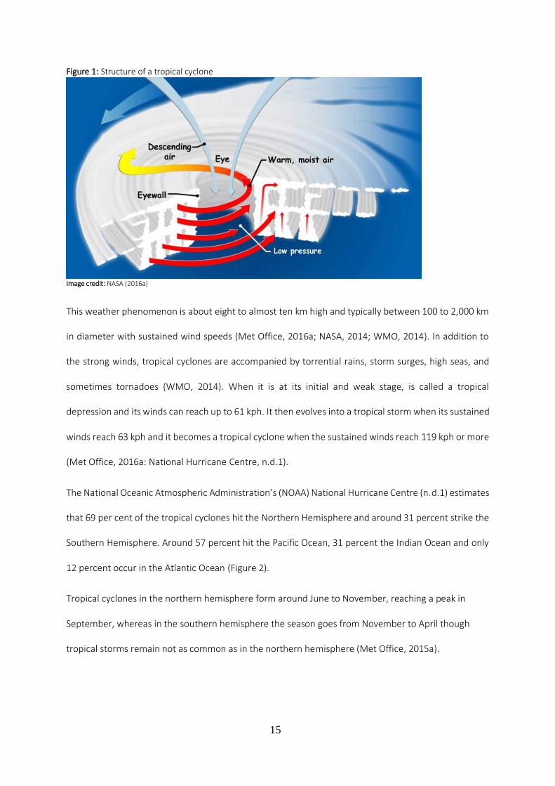
There is an eye in the centre of tropical cyclones (Figure 1). It is characterized by weak winds (normally
below 24 kph and 32 to 64 kph across) and mild weather and with almost no rainfall (Landsea, 2011;
NOAA, n.d.) The eye is the most tranquil area of the storm and it is generated once wind speeds exceed
119 kph (NOAA, n.d.).
15
Figure 1: Structure of a tropical cyclone
Image credit: NASA (2016a)
This weather phenomenon is about eight to almost ten km high and typically between 100 to 2,000 km
in diameter with sustained wind speeds (Met Office, 2016a; NASA, 2014; WMO, 2014). In addition to
the strong winds, tropical cyclones are accompanied by torrential rains, storm surges, high seas, and
sometimes tornadoes (WMO, 2014). When it is at its initial and weak stage, is called a tropical
depression and its winds can reach up to 61 kph. It then evolves into a tropical storm when its sustained
winds reach 63 kph and it becomes a tropical cyclone when the sustained winds reach 119 kph or more
(Met Office, 2016a: National Hurricane Centre, n.d.1).
The National Oceanic Atmospheric Administration’s (NOAA) National Hurricane Centre (n.d.1) estimates
that 69 per cent of the tropical cyclones hit the Northern Hemisphere and around 31 percent strike the
Southern Hemisphere. Around 57 percent hit the Pacific Ocean, 31 percent the Indian Ocean and only
12 percent occur in the Atlantic Ocean (Figure 2).
Tropical cyclones in the northern hemisphere form around June to November, reaching a peak in
September, whereas in the southern hemisphere the season goes from November to April though
tropical storms remain not as common as in the northern hemisphere (Met Office, 2015a).

16
Figure 2: Map of the cumulative tracks of all tropical cyclones during the 1985-2005 period
Source: NASA, (2009a).
Tropical cyclones usually form in seven ocean basins at different times of the year and are occasionally
referred to as seasons (Met Office, 2015a). The following are the seven basins (Figure 3): 1 - The Atlantic
basin which include the North Atlantic Ocean, the Gulf of Mexico and the Caribbean Sea - the season
occurs from June to November. 2 - Northeast Pacific basin comprising of Mexico to approximately the
international Date Line - the season occurs from late May to early June and from late October to early
November. 3 - Northwest Pacific basin starting from the international Date Line to Asia and the South
China Sea - the season occurs all year round but the main season is from July to November. 4 - North
Indian basin, which includes the Bay of Bengal and the Arabian Sea - the season occurs from April to
December. 5 - Southwest India basin, from Africa to almost 100E - the season occurs from late October
to early November and until May; 6. Southeast Indian/Australian basin, from 100E to 142E - the season
occurs from late October to early November and until May, and lastly 7 - Australian/Southwest Pacific
basin, from 142E to about 120W - the season occurs from late October to early November and until
May (Met Office, 2015a; AOML/NOAA, n.d.).
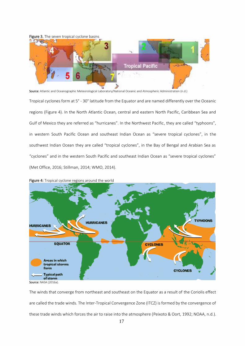
17
Figure 3. The seven tropical cyclone basins
Source: Atlantic and Oceanographic Meteorological Laboratory/National Oceanic and Atmospheric Administration (n.d.)
Tropical cyclones form at 5° - 30° latitude from the Equator and are named differently over the Oceanic
regions (Figure 4). In the North Atlantic Ocean, central and eastern North Pacific, Caribbean Sea and
Gulf of Mexico they are referred as “hurricanes”. In the Northwest Pacific, they are called “typhoons”,
in western South Pacific Ocean and southeast Indian Ocean as “severe tropical cyclones”, in the
southwest Indian Ocean they are called “tropical cyclones”, in the Bay of Bengal and Arabian Sea as
“cyclones” and in the western South Pacific and southeast Indian Ocean as “severe tropical cyclones”
(Met Office, 2016; Stillman, 2014; WMO, 2014).
Figure 4: Tropical cyclone regions around the world
Source: NASA (2016a).
The winds that converge from northeast and southeast on the Equator as a result of the Coriolis effect
are called the trade winds. The Inter-Tropical Convergence Zone (ITCZ) is formed by the convergence of
these trade winds which forces the air to raise into the atmosphere (Peixoto & Oort, 1992; NOAA, n.d.).

18
The ITCZ results from the higher solar radiative received per unit area at the surface of the Earth in the
equatorial area. The resulting air uplift in this region generates high precipitation and the trade winds
(National Weather System, 2010). The ITCZ corresponds to the ascending sections near the Equator of
the two Hadley cells. It moves North and South of the Equator following the movement of the sun's
annual cycle, producing a band of intense rain and thunderstorms (Santos, F.D., 2012a). The
convergence of the trade winds also triggers tropical cyclones (Graham & Riebeek, 2006).
The energy source of tropical cyclones arises from the in-situ evaporation of ocean water (Emanuel,
1987). Tropical cyclones originate in tropical warm waters with moist air, where the ocean surface and
air temperature is above 26⁰C. Another important factor is the development of storm clouds which are
a result of the winds that converge close to the sea surface causing the air to ascend (Landsea, 2004;
Met Office 2016).
Figure 5: Storm surge
Image credit: NOAA/The COMET program (NOAA, n.d.)
When the air flows upwards, 90% of the energy that is stored is freed by condensation ascending to the
towering cumulus clouds and rain (Met Office, 2016). This process let the storm clouds to climb straight
up to high levels. The Coriolis force is extremely important in this process because the Earth’s rotation
facilitates to spin of the column of ascending air. Lastly and in order to be able to spin or twist tropical
cyclones need enough distance from the Equator (NOAA, 2014; PAGASA, 2014; Met Office 2016).
When these powerful weather systems path strike land, they usually generate a storm surge (figure 5)

19
which is an uncommon rise in sea level different from the normal tides, that, when combined with heavy
rain can cause massive floods. (Met Office, 2014; Stillman, 2014; NOAA, 2016a).
When tropical cyclones reach land, they decline because their power supply is reduced and the friction
with the terrestrial surface changes the air stream causing the tropical cyclone to dissipate (Met Office,
2016).
In order to measure the intensity of tropical cyclones, they are ranked according to the Saffir-Simpson
Wind Scale. This Scale is rated from 1 to 5 (table 1) and it is based on the sustained wind speed of a
tropical cyclone.
Table 1: Saffir-Simpson Hurricane Wind Scale
Category Wind Speed Damage
1 119–153 kph Very dangerous winds will produce some damage
2 154–177 kph Extremely dangerous winds will cause extensive damage
3 178–208 kph Devastating damage will occur
4 209–251 kph Catastrophic damage will occur
5 ≥ 252 kph Catastrophic damage will occur
Source: NHC/NOAA ( n.d.1).
Though it was developed in the U.S. it is also used in other regions of the globe. According to the NOAA’s
National Hurricane Centre (NHC) (n.d.1) storms that are ranked 1 and 2 are considered to be dangerous
and will need precautionary measures but once they reach Category 3 or above they will be regarded
as major tropical cyclones given their potential for considerable casualties and property damage.
Tropical cyclones with sustained winds higher than 241.4 kph are designated as “Super Typhoons” in
the western North Pacific basin (National Hurricane Centre/National Oceanic and Atmospheric
Administration, n.d.1).
According to NOAA’s National Weather System (2012) the Saffir-Simpson scale only uses peak winds
and does not consider “storm surge ranges, flooding impact and central pressure statements”.

20
Given the progress in weather prediction models, the forecast of early occurrence of tropical cyclones
has improved significantly in recent times. Regional centres like the NHC are responsible for the forecast
of the tropical cyclones in the affected zones (Met Office, 2016).
The names of tropical cyclones are chosen to help improve communication among weather forecasters
and to make it simpler for the media to report activity of tropical cyclones as well as for the public to
improve its awareness and to remember tropical cyclones in their region, thus facilitating early warning
and community preparedness (Met Office, 2016; WMO, n.d.). Given that storms can frequently
continue for more than a week and also more than one tropical storm can be happening in the same
area during the same period, providing names to tropical storms helps reduce misunderstandings about
which one is being designated (Met Office, 2016; WMO, n.d.). Names are given using a predetermined
list arranged alphabetically with alternate male and female names, in the north-west Pacific Basin the
system uses a combination of personal names, flowers, animals, birds, trees, foods or adjectives and
are given not in alphabetic sequential preference but according to the contributing naming country
(Met Office, 2016; WMO, n.d.).
The potential influence of climate change on tropical cyclones
As a result of global warming the temperature of the planet oceans have been increasing, causing water
to expand and glaciers and ice sheets to melt, triggering sea level rise. This has an effect on tropical
cyclone storm surges which inundate much further inland than before, becoming more extreme and
harmful to populations in coastal areas (NOAA, 2016b).
According to observations dating back to 1961, the ocean has absorbed over 80% of the existing heat
in the climate system. This overall increase in the average temperature has led to an increase in sea
surface temperature (SST) (IPCC, 2007a). The increase in sea surface temperature and the consequent
water evaporation into the atmosphere contribute to the intensification of tropical cyclones (Trenberth,
2007). Globally, estimates of the potential destruction of tropical cyclones show a significant upward

21
trend since 1970, and this trend is correlated with SST (Elsner et al., 2008; IPCC, 2007a; Kossin &
Camargo, 2009; Trenberth, 2007).
The IPCC and the scientific basis of the potential influence of climate change on tropical cyclones
Climate change may be one of the largest challenges of the 21st century (Deryugina 2012; IPCC 2007).
However, it only became a concern of the general public in 1988 after the United States of America
(USA) experienced a year earlier, the hottest year on record (Deryugina 2012). The IPCC was created in
that year with the aim of providing “the world with a clear scientific view on the current state of
knowledge in climate change and its potential environmental and socio-economic impacts” (IPCC, n.d.).
The IPCC is the biggest scientific network of human history, concentrating its work on the exchange and
validation of worldwide information about the climate (Soromenho-Marques, 2009).
In order to address some of the world’s global environmental problems (Soromenho-Marques, 2005),
the international community, through the United Nations (UN), promoted two key international
conferences that would be crucial and would become a turning point in environmental diplomacy,
notably the United Nations Conference on Human Environment (UNCHE) in 1972 and the United
Nations Conference on Environment and Development (UNCED) in 1992 (Soromenho-Marques, 1998).
The UNCED conference, also called the Earth Summit, was responsible for two important outcomes, the
United Nations Framework Convention on Climate Change (UNFCCC), which provides a platform for
international cooperation on climate change and the United Nations Convention on Biological Diversity
(UNCBD) that aims at conserving the biodiversity on the planet (UNCED, 1992; UNEP, 1992).
As part of the global efforts to raise the profile and awareness on climate change, two significant works
were released in 2006 with large media interest and coverage, namely “The Economics of Climate
Change” by Nicholas Stern (2007) and “An Inconvenient Truth” a documentary by the former Vice
President of the US, Al Gore. Both were influential in shaping public policy with an invigorated drive to
the urgency to fight climate change (Soromenho-Marques, 2011). In his report, Stern (2007, p. iv) stated

22
that “the scientific evidence is now overwhelming: climate change is a serious global threat, and it
demands an urgent global response”.
There is, today, a broad scientific consensus that anthropogenic global warming is a threat which
justifies action (IPCC 2007; Rosenberg et al. 2010; Deryugina 2012). According to Rosenzweig et al.,
(2011) in the short and medium term cities will experience the effects of climate change through an
increased variability and change of extreme weather events frequency and intensity.
In this context, the IPCC have played an important role through the assessment reports which have been
published every five years since 1991 and have contributed to the scientific debate on climate change
and its potential influence on tropical cyclones.
The IPCC First Assessment Report
The potential influence of climate change on tropical cyclones has been an object of study since the
IPCC First Assessment Report (FAR) in 1990. The IPCC FAR, questioned if, in the last century there had
been an increase in the frequency and intensity of the tropical cyclones due to global warming, and
concluded that “current evidence does not support this idea perhaps because the warming is not yet
large enough to make its impact felt” (IPCC, 1990, p.232).
This conclusion was supported by the fact that since 1970 the frequency of tropical storms had
decreased in the North Indian Ocean whilst the SST had risen in this region more than in other places.
It further added that in spite of the increase of tropical cyclone frequency registered since 1950 in the
eastern North Pacific, the southwest Indian Ocean and in the Australian region, this increase was
probably due to improved monitoring measures. According to this report, in the North Atlantic and
western Pacific Oceans the availability of information of wind speed did not indicate a change in the
intensity of tropical cyclones (IPCC, 1990).
23
The Kyoto Protocol
In order to limit greenhouse gas emissions (GHG), and its associated risks, the UNFCCC negotiated, in
1992, the basis for the Kyoto Protocol (Daskalakis et al. 2009; Teixeira et al. 2008/2009). On the 11th of
December 1997, the Kyoto Protocol was adopted but it only entered into force on February 2005 as a
result of the complexity of the ratification process (UNFCCC, 2014). The Kyoto Protocol was meant to
operationalize the Convention on Climate Change and established binding emission targets for 37
industrialized countries and the European Union (UNFCCC, 2014a).
It was a voluntary agreement where parties of the Annex I (industrialized countries) of the Protocol
agreed to reduce their overall GHG emissions by 5% below 1990 levels, over the first commitment
period of 2008 to 2012 (UN, 1998; Teixeira et al. 2008/2009; UNFCCC, 2013; UNFCCC, 2014a). The Kyoto
Protocol was only binding for developed countries given the fact that it acknowledged their
responsibility for the existing levels of GHG emissions, which are a consequence of more than 150 years
of industrial activities. The Kyoto Protocol has put a stronger responsibility on developed countries
under the principle of “common but differentiated responsibility” (UNFCCC, 2014a para. 4).
The Kyoto Protocol established four mechanisms that parties use in order to comply with their GHG
reduction goals: (i) carbon-trading schemes, (ii) the Clean Development Mechanism (CDM), (iii) the Joint
Implementation system (JI) and (iv) investments in funds managed by independent third parties
(Teixeira, 2010). The EU-ETS is one such mechanism (Haar & Haar, 2006; Schwaiger et al, 2012).
The EU-ETS is a cap-and-trade system involving over 25 nations and 9,000 installations across the
European Union (EU) and is designed to achieve emission reduction targets in an effective and efficient
manner by recognizing that abatement costs are not uniform and that compliance costs are met at a
minimum cost by trading allowances, (EC, 2006; Haar & Haar, 2006; Daskalakis, 2013). In fact, it was
expected that the EU-ETS would allow the EU to achieve its emission reduction target at a cost below
0.1% of GDP (EC, 2006).

24
The EU-ETS is composed of three phases: (i) phase 1, which ran from January 2005 to 31 December
2007, was a pilot phase in order to allow participants to prepare for phase 2; (ii) phase 2, ran from 1
January 2008 to 31 December 2012 refers to the first commitment period of the Kyoto Protocol; and
(iii) phase 3 which begun in 1 January 2013 and will go on until 31 December 2020 which plays a central
role in allowing the EU to achieve the goals of its climate and energy targets by 2020 (EC, 2006;
Schwaiger et al, 2012). Although only businesses who are obliged to participate in the EU-ETS are given
allowances, the market allows for any agent (e.g., individuals, institutions, etc.) to buy and sell in the
market (EC, 2006).
The second commitment period from the first of January 2013 to 2020 was adopted in Doha, Qatar on
8th December 2012, in what was designated as the Doha Amendment (UNFCCC, 2014b). For this period,
it is expected that from 2013-2020 there would be a reduction of 18 per cent in the GHG emissions
bellow 1990 levels by the Parties (UNFCCC, 2014b).
The IPCC Second Assessment Report
When the IPCC Second Assessment Report (SAR) was published in 1996, it acknowledged that there was
still not enough information to determine if there would be changes in the occurrence or geographical
distribution of tropical cyclones (Houghton et al. 1996). According to Gray (1990), cited in the SAR
(1996), the hurricane (tropical cyclone) activity in the Atlantic was more intense from 1947 to 1969,
when compared with the period of 1970 and 1987. The western North Pacific registered during the
same period of time an identical decline in the number of intense of tropical cyclones (IPCC, 1995). This
difference in the intensity of tropical cyclones in the Atlantic and North Pacific was due to a change in
the wind speed measurement methodology in 1970 and the consideration of the correlation with sea
surface temperature (Bouchard, 1990; Black, 1992; Landsea, 1993 cited in IPCC 1996).
The weaker tropical cyclone activity periods could also be a result of the El Niño events (Houghton et al.
1996). Nevertheless, the IPCC (Houghton et al. 1996, p.170) cautioned, “doubts about the quality and

25
consistency of the data on maximum wind speeds in most cyclone basins preclude convincing analysis
of how peak cyclone intensity might have changed in recent decades. Only in the Atlantic do the data
seem of sufficient quality to allow such an analysis”.
For the SAR (Houghton et al. 1996), it was not easy to predict tropical cyclone changes due to global
warming. The Global Circulation Models (GCMs) of that time could not satisfactorily simulate the
tropical cyclones, or some aspects of the El Niño Southern Oscillation (ENSO), as well as the large-scale
changes in the atmospheric general circulation that could potentially influence the tropical cyclones. In
addition, the fact that the tropical storms have such a considerable natural variability that any small
trends could easily be missed (Houghton et al. 1996). The IPCC (Houghton et al. 1996, p.290) added that
“the formation of tropical cyclones depends not only on sea surface temperature (SST), but also on a
number of atmospheric factors. Although some models now represent tropical storms with some
realism for present day climate, the state of the science does not allow assessment of future changes”.
A study undertaken by Holland (1995) and cited by the IPCC SAR (1996) suggested that in present
climate conditions, it was doubtful that there would be tropical cyclones more intense than the ones
experienced so far. However, in regions where the SST was between 26⁰ and 29⁰C, there was potential
for change in the intensity of tropical cyclones. The IPCC SAR (Houghton et al. 1996, p.334) concluded
that “it is not possible to say whether the frequency, area of occurrence, mean intensity or maximum
intensity of tropical cyclones will change”.
The IPCC Third Assessment Report
The IPCC Third Assessment Report (TAR) (Folland et al, 2001) was released in 2001 and reviewed the
changes related to intensity and frequency of weather events. However, it emphasized the fact that
intense tropical cyclones are rare and therefore the study of large zones as well as extensive consistent
records of tropical cyclones are needed to evaluate possible changes. Nevertheless, the TAR concluded
that this data combination was not yet available. The TAR assessed the confidence in the observation
and expected changes in extreme weather and climate events. It concluded that regarding the “increase

26
in tropical cyclone peak wind intensities” the “confidence in observed changes (latter half of the 20th
century)” indicates “not observed in few analyses available” (p. 15). Whereas the “confidence in
projected changes (during the 21st century)” it is likely over some areas. In terms of the “increase in
tropical cyclone mean and peak precipitation intensities”, the TAR concluded that in terms of
“confidence in observed changes (latter half of the 20th century)” there is “insufficient data for
assessment” as for “confidence in projected changes (during the 21st century)” it is “likely over some
areas” (Folland et al, 2001, p. 15).
The TAR explained that given the fact that the data is limited, the observed differences in terms of
tropical cyclones intensity and frequency as well as local strong storms, demonstrate that there are no
distinct trends in the last half of the 20th century. Even though multi-decadal fluctuations are
occasionally noticeable (Folland et al, 2001). According to the TAR, since the SAR the coupled models
have progressed and perfected considerably, however the “analysis of and confidence in extreme
events simulated within climate models are still emerging, particularly for storm tracks and storm
frequency” (Folland et al, 2001, p. 54).
The evidence showing the projected changes in tropical cyclone frequency and zones of formation is
not sufficiently consistent. Nevertheless, certain measures of intensities showed anticipated increases
and some theoretical and modelling analyses, indicated an increase in the high limit for these intensities.
The TAR also alerted that mean and peak intense rainfall from tropical cyclones was likely to increase
significantly (Folland et al, 2001). The TAR (p. 585) concluded that “there is some evidence that regional
frequencies of tropical cyclones may change but none that their locations will change. There is also
evidence that the peak intensity may increase by 5% to 10% and precipitation rates may increase by
20% to 30%. There is a need for much more work in this area to provide robust results.”
In terms of tropical cyclone occurrence, the TAR updated the SAR information relative to changes in
tropical cyclones in the different ocean basins and the ones that affect the neighbouring continents.

27
Nicholls et al., (1998) cited in the TAR, indicated that the tropical cyclone activity in the Australian region
registered from the beginning of satellite surveillance in 1969/1970 to 1995/1996 had showed a decline
in terms of weak and moderate cyclones and the intense tropical cyclones showing a slight increase.
The change in the techniques of analysis and access to satellite data may have been responsible for
these conclusions (Nicholls et al., 1998).
The authors concluded that this decline in moderate tropical cyclones could be caused by El Niño
occurrences in the 1980s and 1990s (Nicholls et al., 1998). Nevertheless, the TAR (2001) emphasized
the fact that a weak trend in tropical cyclone intensity suggested that although the ENSO modulated
the overall frequency of tropical cyclones in the region, other factors must be significant in regulating
cyclone intensity.
Another study undertaken by Chan and Shi (1996) and cited in the TAR, concluded that unlike in the
Atlantic basin where the number of intense tropical cyclones had declined (according to Landsea et al.,
1996) in the western North Pacific the tropical cyclone activity had shown more variability and an
upward trend since 1980. For Chan and Shi (1996) it was difficult to conclude that this increase in
tropical cyclones was due to global warming since in the Atlantic basin there had been a decrease. The
authors also emphasized that in the western north Pacific apart from long term trends of the tropical
cyclone activity, there are short-term fluctuations such as the ENSO and any variation of tropical cyclone
activity connected to natural or anthropogenic climate change need to consider these oscillations.
In the Atlantic basin, where reliable data for tropical cyclones for the United States is available since
1899, the incidence of intense hurricanes had been decreasing, in part due to the removal of an
overestimation bias of intense hurricane occurrence from 1940s until 1960s (Landsea, 1993 cited in the
TAR). According to Landsea (1996) cited in the TAR, no major change had occurred each year in the peak
intensity achieved by the strongest hurricane.
A study undertaken by Landsea et al. (1996) to look into possible changes in tropical cyclone frequency
and intensity as a result of climate change in the Atlantic basin concluded that there were less intense

28
hurricanes and weaker tropical cyclones and there was no change in the yearly maximum hurricane
intensity. The intense hurricane occurrences had gone through multi-decadal changes, active between
1940s and 1960s followed by a calmer period during the 1970s to the beginning of the 1990s and an
active period starting in 1994 (figure 6) that showed the return to the same type of high levels of activity
as seen in the previous decades (Landsea et al., 1996; Landsea et al., 1999). In the other tropical cyclone
basins, i.e. the north Indian, south-west Indian and south-west Pacific the number of registered cyclones
was below normal (Lander and Guard, 1998).
Figure 6. Annual number of intense hurricane over the Atlantic for the period reliable record from 1944 to 1996
Source: Landsea et al. (1999).
The IPCC TAR (Folland et al, 2001) concluded that there was no conclusive confirmation that showed a
change in tropical cyclone characteristics, it further added “there is little sign of long term changes in
tropical storm intensity and frequency, but inter-decadal variations are pronounced” (p. 163). For the
TAR changes in tropical cyclone intensity and frequency were subject to inter-decadal to multi-decadal
differences, without any evident significant trends throughout the 20th century. In addition, inconsistent
analyses made it hard to obtain decisive conclusions regarding potential changes in tropical cyclone
activity. One of the key priority recommendations from the TAR (Folland et al, 2001) was the need for
a bigger choice of models and techniques for a complete assessment of future tropical cyclone activity.
The IPCC Fourth Assessment Report
The IPCC Fourth Assessment Report (AR4) was published in 2007 and found that “most of the observed
increase in global average temperatures since the mid-20th century is very likely due to the observed

29
increase in anthropogenic greenhouse gas concentrations” (p. 9). It also concluded that “confidence has
increased that some weather events and extremes will become more frequent, more widespread or
more intense during the 21st century (IPCC, 2007)” (p. 17). In addition, the IPCC also concluded that “it
is likely that future tropical cyclones (typhoons and hurricanes) will become more intense, with larger
peak wind speeds and more heavy precipitation associated with ongoing increases of tropical sea-
surface temperatures (IPCC, 2007)” (p.15). In 2006, the WMO declared that in the last decades there
had been an increase in temperature of 0.25 to 0.5 degree Celsius on the surfaces of the majority of the
tropical seas (WMO, 2006).
With climate change, extreme events such as droughts, heat waves, storms and floods were expected
to become more frequent and intense and the distribution these impacts could be different in the future
(IPCC, 2007; WB 2013). However, the IPCC AR4 Synthesis Report (2007) noted that it was not possible
to solely and precisely attribute human induced climate change to single extreme weather events, given
the fact that there was always a possibility that the extreme event may have happen naturally. The IPCC
(2007a) defined an extreme weather event as an occurrence that is rare (i.e. which is as rare or rarer
than the 10th or 90th percentile of a probability density function) at a certain place at a certain time of
year. In addition, the perception of the features of extreme weather could differ from place to place
(IPCC, 2007a).
The IPCC also reported that there was an increase in the number of intense tropical cyclones even when
the total number of cyclones and their duration demonstrated a slight decrease in most basins (IPCC,
2007a). According to the IPCC (2007a) this was especially valid by taking into consideration the fact that
the number of Category 4 and 5 hurricanes increased by about 75% since 1970. Regarding extra tropical
cyclones, the IPCC stated that there had been an observed increase in their number and intensity (IPCC,
2007a).
The projections made by various models suggested a likely increase in the intensity of tropical storms in
terms of wind and precipitation, which was consistent with the link between the temperature increase

30
in sea surface and the intensity of hurricanes and typhoons (IPCC, 2007a). As reported by the IPCC
(2007b), the potential drivers of climate change in coastal areas related to extreme weather events,
indicating a trend of increasing SST and consequent coral bleaching and coral mortality.
While there is a correlation between SST and the increased intensity of cyclones (Elsner et al, 2008), it
is known that these changes are also influenced by the natural variability of the climate system (e.g.,
SST anomalies associated with El Niño) (De’ath et al., 2012). Therefore, it is difficult to establish a direct
connection to anthropogenic climate change, and project these potential changes (Grossmann &
Morgan, 2011; IPCC, 2007a; IPCC, 2012; Nott, 2010).
It is difficult to attribute the causes of the observed changes because of: i) fluctuations in the amplitude
of the frequency and intensity of cyclones that make it difficult to detect long term trends and their
relation to the increase of GHG in the atmosphere; ii) substantial limitations on the availability and
quality of historical data concerning cyclones; iii) historical lack of uniformity for the allocation of the
cyclone intensity in different regions of the globe; and iv) limitation of current models to project changes
in intensity and frequency of tropical cyclones (IPCC, 2007a; Nigam & Guan 2011; Nott, 2011; Walsh et
al., 2012).
In 2007, the IPCC AR4 concluded that it was more likely than not that the increase in cyclone intensity
is due to human activity and it is likely that their intensity will increase in the future (IPCC, 2007a).
The IPCC Special Report on Managing the Risks of Extreme Events and Disasters to Advance
Climate Change Adaptation
The IPCC Special Report on Managing the Risks of Extreme Events and Disasters to Advance Climate
Change Adaptation (SREX) (2012), indicated that due to the fact that there were ambiguities in the
history of tropical cyclone records, the partial understanding of the physical mechanisms associating
tropical cyclone metrics to climate change as well as the level of the variability of tropical cyclones,
presented only a low confidence in the attribution of anthropogenic climate change to changes in

31
tropical cyclone activity. Therefore, the SREX concluded that attributing specific extreme weather
events to human-induced climate change was difficult.
The SREX (IPCC, 2012) alerted that the quantification of tropical cyclones takes frequency, duration and
tracks into consideration, making strong physical links among all these metrics with natural and
anthropogenic changes in climate variability a big challenge. Though significant improvement had taken
place, considerable uncertainties persisted mostly because of data quality issues as well as theoretical
and modelling frameworks that were not perfect (IPCC, 2012).
As reported by the SREX, uncertainty mixed with natural variability in the historical data was a challenge
in terms of identifying tropical cyclone activity trends and therefore provided only low confidence in
attributing evident changes in the activity of tropical cyclones to anthropogenic influences on climate
(IPCC, 2012). This report further added that there was low confidence in projecting tropical cyclone
changes in terms of origin, place, paths, length of time or zones of impact.
In spite of the fact that there were studies suggesting a connection between climate change and the
observed intensity of tropical cyclones, the SREX noted that these were essentially limited to a period
of approximately 30 years of observations made through satellite and not able to give strong evidence
for a long term trend (IPCC, 2012).
The SREX (IPCC, 2012) observed that there was ”low confidence that any observed long term (i.e. 40
years or more) increases in tropical cyclone activity are robust, after accounting for past change in
observing capabilities” (p. 8). The same source projected that it was likely that the frequency of tropical
cyclones would be reduced or remained basically unchanged, it still considered likely that the average
wind speed of tropical cyclones would increase, although the effect may not occur in all basins (IPCC,
2012). In addition, and given the degree of reliability among climate models it was likely that intense
precipitation associated with tropical cyclones would increase with climate change (IPCC, 2012).
According to the SREX (IPCC, 2012) while it is likely that the total worldwide frequency of tropical
cyclones would either reduce or would continue unchanged “it is more likely than not that the frequency

32
of the most intense storms will increase substantially in some ocean basins” (p. 163). This assessment
would be reconfirmed later with the IPCC AR5.
The SREX also projected an increase in high water levels in coastal areas due to a very likely influence of
global average sea level rise, associated with the likely intensification of extreme wind speed of tropical
cyclones, which is of particular concern for small island states in tropical regions (IPCC, 2012).
As stated in the SREX, the observations showed a robust connection between SST and the potential
intensity and this correlation indicated that the increase in SST would potentially lead to an increase in
intensity and subsequently would lead to stronger tropical cyclones (Emanuel, 2000; Wing et al., 2007
cited in the IPCC, 2012). In view of the fact that SST increase due to climate change is not projected to
show constantly increase in the SST gradients, the latest studies suggested that rising SST as a result of
climate change does not yet have a give a complete understanding of the physical to progressively more
intense tropical cyclones (IPCC, 2012)
The IPCC Fifth Assessment Report
The 2013 IPCC Fifth Assessment Report (AR5), Working Group I (WGI) (2013b, p. 4) concluded that the
“warming of the climate system is unequivocal” and that “human influence has been detected in
warming of the atmosphere and the ocean, in changes in the global water cycle, in reductions in snow
and ice, in global mean sea level rise, and in changes in some climate extremes” (p.17).
The IPCC (2013a) further informs in this context that there is high confidence that 75 per cent of the
observed global mean sea level rise is due to the thermal expansion caused by warming of the oceans
and the mass loss of glaciers. It projects that sea level rise will continue to augment through the 21st
century and beyond. In addition, the projections also indicate that the continued warming of the oceans
and mass loss from glaciers and ice sheets will contribute to global mean sea level rise that will very
likely surpass the one observed from 1971 to 2010 (IPCC, 2013a).

33
The IPCC (Bindoff et al, 2013, p.73) also reported that “globally, there is low confidence in attribution of
changes in tropical cyclone activity to human influence”. This is due to scarce observational data,
inadequate understanding of the connection between the anthropogenic drivers of climate and the
activity of tropical cyclones, as well as little agreement among studies on the relevance of the internal
variability and the anthropogenic and natural radiative forcing (Bindoff et al, 2013). The AR5 also adds
a “low confidence in basin-scale projections of changes in intensity and frequency of tropical cyclones
in all basins to the mid-21st century” (Kirtman et al, 2013, p. 88). This low confidence reveals that there
is not much research on near future activity of tropical cyclones as well as on the published divergences
on tropical cyclone activity forecasts and on the role of climate variability (Kirtman et al, 2013).
According to the AR5 (Christensen et al, 2013) even though tropical cyclone frequency and intensity is
likely to lessen or not change in 21st century greenhouse warming projections, concomitant with a likely
rise in maximum wind velocity and precipitation rates of global mean tropical cyclones, there is low
confidence in terms of frequency and intensity of tropical cyclone region-specific forecasts. The same
report also acknowledges that it is virtually certain that the frequency and intensity of tropical cyclones
in the North Atlantic has increased since 1970, though the causes are disputed due to low confidence in
attributing it to anthropogenic influence because of inadequate data, insufficient physical
comprehension of the connections between the human induced factors of tropical cyclone activity and
climate as well as a small degree of agreement about the internal variability significance and the natural
and human-induced forcings.
This report alerts for the fact that there is a lack of studies that unequivocally attribute changes in the
activity of tropical cyclones to anthropogenic of GHG emissions (Bindoff et al, 2013). Tropical cyclone
activity can be influenced by several causes, one of which is the increasing tropical SST that can be
imputed to natural (predominately volcanic aerosols) and anthropogenic forcing but more likely to
human induced influences (Gillett et al, 2008 cited in Bindoff et al, 2013).

34
According to the IPCC 5th Synthesis Report (SYR) (2014, p. 6) “impacts from recent climate-related
extremes, such as heat waves, droughts, floods, cyclones, and wildfires reveal significant vulnerability
and exposure of some ecosystems and many human systems to current climate variability (very high
confidence)”. This report emphasizes that “in urban areas, climate change is projected to increase risks
for people, assets, economies and ecosystems, including risks from heat stress, storms and extreme
precipitation, inland and coastal flooding, landslides, air pollution, drought, water scarcity, sea-level rise,
and storm surges (very high confidence)” (p. 15).
Recent studies on climate change and tropical cyclones
A study by Emanuel (2013, p. 5) using a downscaling technique based on the six Coupled Model
Intercomparison Project 5 (CMIP5) global climate models, by projecting an increase in tropical cyclone
activity globally in the 21st century which is “most evident in the North Pacific region but also noticeable
in the North Atlantic and South Indian Oceans. In these regions, both the frequency and intensity of
tropical cyclones are projected to increase”. These projections contrast with other studies that have
used CMIP3 models as well as other models and different methods that forecast little reduction to no
changes in frequency of tropical cyclones in the North Atlantic and globally for the 21st century
(Emanuel, 2013).
According to Camargo (2013) downscaling can potentially improve the assessment of future track and
frequency projections of tropical cyclones. Nevertheless, Emanuel (2013, p. 6) cautions “projections of
the response of tropical cyclones to projected climate change will remain uncertain for some time to
come”.
Recent research concluded that later this century there will be less tropical cyclones worldwide but they
will likely be more intense (category 4 and 5) and with higher levels of rainfall due to the effects of global
warming (Knutson et al, 2015; GFDL/NOAA, 2016).
According to Emanuel (2015) the increase in precipitation in tropical cyclones projection is because of
the additional humidity in the tropical atmosphere. This factor is relevant given the extreme rainfall and

35
flooding resulting from the devastating intense storms and storm surges. Raising sea levels will influence
the possible intensity of flooding from storm surges, which is anticipated to contribute to the
vulnerability of coastal areas (Knutson et al, 2015; Thompson, 2016; GFDL/NOAA, 2016).
A study by DeConto and Pollard (2016) indicated that if carbon emissions remain unchanged, by 2100,
melting of the Antarctica could potentially contribute to sea level rise over a meter and in 2500 by over
fifteen meters. As such and according to the authors, a warmer atmosphere would soon be the main
cause for the loss in ice and it would take thousands of years to recover after the emissions are reduced
due to the continued warming of the oceans.
For Woodruff et al (2013) the uncertainties of the potential effects of climate change on tropical cyclone
must not divert from the fact that sea level rise will potentially contribute to severe flooding from
tropical cyclones and that future storm surge impacts will significantly be increased not by high tropical
cyclone activity but by changes in topography and densely populated coastal areas.
The UNFCCC Paris Agreement
In March 2015, NOAA (2015) reported that the monthly global average of carbon dioxide (CO2)
concentration had exceeded 400 parts per million (ppm) in Mauna Loa Observatory, Hawai (Figure 7).
According to this observatory this level was crossed for the first time in 2013.
Figure 7. Atmospheric CO2 levels in recent years
Image credit: NOAA, 2017.

36
In December 2016, the measurement levels were at 405.25 ppm (NASA, 2017). The concentration of
CO2 in the atmosphere had oscillated between 200 and 280 ppm over the last 400,000 years before the
industrial revolution (Feely et al. 2004; Sabine et al. 2004).
The maximum recommended value of CO2 atmospheric concentration is 450 ppm, so as to not exceed
an increase over 2ºC which is considered to be the maximum level at which adaptation to climate
change is possible to most human systems at acceptable economic, social and environmental global
costs (IPCC, 2007a; IPCC, 2007b; IPCC, 2014; EU EG Science, 2008). The recent IPCC (2013) mentions
the discussions to curb the increase of global temperature comparative to pre-industrial era to below
2°C but notes that other targets have also been recommended such as reverting to below 1.5°C global
warming comparative to pre-industrial times or even to an atmospheric CO2 concentration of 350 ppm
(Stocker et al, 2013).
After the failed attempt in Copenhagen in 2009 to reach a global climate change agreement, 195
countries successfully agreed in December 2015 at the twenty-first session of the Conference of the
Parties (COP21) to the UNFCCC in Paris, to maintain temperature increase well below 2°C and engage
in efforts to curb the rise in temperature to 1.5°C, which can contribute to lessen the impacts of climate
change (Nuttall, 2015; UNFCCC, 2016). The Paris Agreement was ratified by enough Parties (55 countries
that represented 55 percent of the global GHG emissions) to enter into force on the 4th of November
2016.
One of the goals of this agreement is to improve the capacity of countries to address the effects of
climate change (UNFCCC, 2016). In order to achieve these objectives, it is necessary that capacity of
developing countries and vulnerable countries is strengthened through a new technology framework
and an improved capacity building framework that takes into consideration their national objectives
(UNFCCC, 2016).
Another important aspect of this agreement is the recognition by countries of the importance of
addressing the “loss and damage” issue linked to the adverse impacts of climate change which include

37
extreme weather events. It was also the first time that this concept was included as a separate matter
in an agreement of this nature in climate change (Mogelgaard & McGray, 2015; UNFCC COP21, 2015).
According to Mogelgaard & McGray (2015) this concept originates from the recognition that it is difficult
to adapt to some climate change impacts such as the ones from extreme weather events, in particular
how tropical cyclones affect lives and infrastructures.
Article 8 of the agreement on loss and damage and on increasing the capacity to recover from climate
impacts, suggests areas in which countries should cooperate to increase understanding, action and
support, such as early warning systems, preparedness, risk assessment, insurance or improving the
resilience of communities, livelihoods and ecosystems (Nuttall, 2015). The importance of including this
concept for the first time in a climate change agreement is significant because it acknowledges the
differences of adapting and coping to the loss and damage as a result of climate change, however it
ensures that there is no ground for liability nor for any compensation (Mogelgaard & McGray, 2015).
An interesting aspect of this agreement (under adaptation) is the request to the United Nations agencies
and to the financial institutions to report on how they will incorporate climate-proofing and climate
resilience initiatives in their development assistance and climate financing initiatives (UNFCC COP21,
2015).
This Paris Agreement happened right before the end of 2015, which was considered as the hottest year
on record, reaching for the first time 1°C above pre-industrial3 temperatures (NOAA, 2015; Met Office,
2016a; NASA, 2016b; WMO, 2016). This fact led the WMO (2016a) Secretary-General Petteri Taalas to
declare “it is a sobering moment in the history of our planet” (para. 6). According to WMO4 (2016a) the
temperature in 2015 shattered earlier global surface temperature records by a large margin “at 0.76 ±
3 The UK Met Office uses 1850 as pre-industrial baseline year whereas NASA and NOAA use 1880 as a reference period.
4 WMO uses a combination of 3 international recognized observational datasets.

38
0.1°Celsius above the 1961-1990 average” (para.1). In December 2015, NOAA (2016) reported that the
global temperature was at 1.11°C above last century temperature average of 12.2°C, which was the
highest ever for any month since pre-industrial era beating the former top record established in October
of 2015 by 0.12°C. The 21st century has already seen 15 of the 16 warmest years on record. With the
2015 record breaking temperature, which beat the previous 2014 mark, the five-year period 2011-15 is
the hottest on record (WMO, 2016).
Scientists had foreseen months in advance that the temperature would reach a world record partly due
to the El Niño impact which is considered as one of the strongest in a century and was responsible for
the release of an enormous amount of heat originating from the Pacific Ocean to the atmosphere (Gillis,
2015; Met Office, 2016). However, the largest part of the record temperature is due to the long term
effects of global warming as a result of anthropogenic GHG emissions (Gillis, 2015). Interestingly and as
NOAA (2016) noted, an equally strong El Niño was also taking place in December 1997 and when
compared with December 2015 the years’ global average temperature was 0.49°C higher.
With another El Niño year, the Met Office (2015; 2016a) predicted that 2016 would also be as hot or
even hotter than the two previous years, which meant breaking global temperature records for three
consecutive years. The impact of tropical cyclone Winston in the Fiji Islands also raised some questions
about the potential influence of El Niño, because of the SST and the warmer than normal waters in the
South Pacific Hemisphere which could have helped to power tropical cyclone Winston (Erdman, 2016).
The WMO “Provisional Statement on the Status of Global Climate in 2011-2015” (2016b), showed that
according to scientific assessments several extreme weather events – especially heatwaves – which
occurred in this five-year period, particularly the ones related to acute high temperatures, have had
their possibilities considerably increased due to human induced climate change “by a factor of 10 or
more in some cases – with more than half the events scientifically assessed showing an anthropogenic
climate change signal of some description in their risk” (p.1).

39
According to this five-year study this period experienced numerous extreme weather and climate events
such heat and cold waves, tropical cyclones, severe storms, floods and droughts (WMO, 2016b).
Devastating floods affected northern India in June 2013 and September 2014 and Pakistan in 2011 and
2012 and 2014. In southeast Asia, seasonal rainfall about 35% above average concentrated in the
northern areas of Thailand resulted in the worst flooding since records in this country. These floods
resulted in hundreds of deaths and a huge socio economic impact in the agriculture sector affecting rice
production as well as industry and tourism sectors. According to the World Bank, the total cost stood
approximately around US$45.7 billion, affecting the economic growth forecasts of the country (World
Bank, 2011). In January 2011, In Rio de Janeiro, Brazil, flash floods caused 900 casualties. Other parts of
the world also were affected by flooding, such as the Danube and Elbe basins in May and June 2013 and
eastern Australia at the beginning of 2011, both reporting huge economic losses but low numbers of
casualties.
From May to June 2015 significant heatwaves during pre-monsoon periods in Pakistan and India in
coastal areas which are not used to extreme temperatures and that can reach 45°C together with high
humidity contributed for large numbers of deaths in these countries (WMO, 2016b). Other parts of the
world also experienced extreme heat and record temperatures, such as Germany which recorded for
the first time 40.3°C in 2015. Spain, Switzerland and Austria also broke all national records in July of the
same year. National records were also broken in Japan, Republic of Korea, parts of eastern China,
Australia, Sao Paulo, Brasilia and northern Argentina (WMO, 2016b). Despite these high temperatures
this study also reported that in 2013-2014 and 2014-2015 several central and eastern parts of the U.S
and southern Canada the winters were considerably colder than usual.
The WMO (2016b) also indicated that drought spells were recorded in Brazil, which was severely
affected during the period of 2011-2015 with the state of Amazonas experiencing rainfall 58% below
average in June-October 2015, accompanied by several record level fires due to the dry conditions
followed by temperatures which are normally 2 to 3°C above average. The same report informed that
the United States and contiguous northern Mexico also faced substantial drought over 2011-2015 in
40
particular in July 2012 when 64% of the continental United States was categorized as being under
drought which was the worst since the 1930s years of the Dust Bowl.
California also suffered on of the worst droughts on record with massive economic losses. Australia and
southern Africa have also experienced long term droughts with parts of Australia seeing below average
rainfall since mid-2012 and areas of southern Africa impacted by drought since late 2013.
Some of the most devastating tropical cyclones also took place in this period such as hurricane Patricia
in Mexico in 2015, in the Philippines both typhoon Haiyan in November 2013 and typhoon Bopha in
November-December 2012 and hurricane Sandy in 2012 which strongly affected the east coast of the
United States and the Caribbean. These tropical cyclones were responsible for a high number of
casualties and dramatic economic losses, in particular Haiyan5 which was considered as one of the most
powerful storms to make landfall in the globe and hurricane Sandy which caused a staggering $40 billion
in economic losses (WMO, 2016b).
Tropical cyclone Phailin in India in October 2013 had very low casualties due to effective early warning
and evacuations. Tropical cyclone Pam which crossed Vanuatu in March 2015 was considered as the
worst natural disaster in the history of this country.
Emanuel (2015) concluded that even though we cannot solely attribute global warming to the adverse
impacts of tropical cyclones Haiyan and Pam and also on the more recent ones, it is undoubtable that
climate variability and change have induced these storms which are a reminder of how much vulnerable
we are to them. The same author alerts for the fact that the consequences of these extreme tropical
cyclones tend to be forgotten by the collective memory which leads communities to ignore risk and
build in hazard prone coastal areas.
5 Detailed information about the impacts of tropical cyclone Haiyan will be given in Chapter 5
41
In the Philippines, a study by Cinco et al, (2016) on the “observed trends and impacts of tropical
cyclones” concluded that in this country, extreme tropical cyclones (wind speeds equal or greater than
150 km) had shown a slight increase in their frequency between 1971 to 2013.
More than half of 79 scientific studies published between 2011-2014 in the Bulletin of the American
Meteorological Society observed that human induced climate change “contributed to the extreme
event under consideration either directly or through its influence on large-scale drivers (e.g. changes in
atmospheric circulation influenced by abnormally warm sea-surface temperatures in key areas)” (WMO,
2016b).
According to Santos, F.D. (2012b) coastal zones are vulnerable due to the combined effects from climate
change as well as population pressure that resulted from land use and land use change and demographic
density. Although the time period of the influence of climate change on tropical cyclones may be
different from the time of the adaptation efforts which tend to be lengthier, it will undoubtedly bring a
lot social effects (Emanuel, 2015).
Until the end of this century it is not feasible to prevent totally anthropogenic climate change, therefore
and in order to avoid the aggravation of climate change, it is necessary to rapidly put in place mitigation
actions (Santos, F.D., 2012c). It is also important to reduce the impacts of climate change through
adaptation measures and maximizing opportunities which arise in this context and given that developing
countries are more vulnerable it is key that they are assisted by developed nations (Santos, F.D., 2012c).
Conclusion
The potential effect of global warming on tropical cyclone activity has been the object of scientific
studies since last century and in particular after the establishment of the IPCC. This international
scientific body has dedicated a lot of analysis to the potential influence of climate change in the intensity
and frequency of tropical cyclones. The initial studies were inconclusive in most of the tropical cyclone
basins due to the uncertainties on data quality and because the effects of global warming were still not
evident. However, with the evolution and improvement of modelling, the IPCC reports projected that
42
during the 21st century it was possible that tropical cyclones would become more intense with stronger
winds and rainfall.
As such the IPCC AR4 projected that there was more than 50 per cent of probability of an increase in
the intensity of tropical cyclones due to human caused climate change and in the future their intensity
was likely to increase. Even though the IPCC AR5 reported low confidence in influence of anthropogenic
climate change on tropical cyclones it also considered that there was a 50 percent probability that in
some ocean basins the frequency of extreme tropical cyclones will increase substantially.
Since the AR5, new scientific studies have projected that due to the effects of climate change, tropical
cyclones globally would be less frequent but likely more extreme and with heavy precipitation. In
addition, they also forecast that a rise in the sea level will contribute to intensify coastal flooding from
storm surges following tropical cyclones.
These effects will be frequently experienced in cities located in low lying coastal areas. This is particularly
worrisome when the temperatures of the oceans, which are the engines of the tropical cyclones, have
risen in the last decades. The increasing exposure to extreme tropical cyclones is already affecting a
growing population and infrastructure located in hazard prone areas.
In recent years, tropical cyclones have been breaking global records for their intensity, leaving
communities and governments with a sense of uncertainty about when these extreme storms will strike
again. This is especially true in places where these events had longer return periods or where people
were not prepared for the destructiveness of its storm surges and wind gusts.
In developing countries, the consequences of extreme tropical cyclones can be disastrous for both the
governments and communities. Furthermore, it is important to strengthen the capacity of developing
countries and assist them with the necessary technological support.
In spite of the efforts by the international community to reduce GHG emissions through mitigation
measures, its implementation will take time and effort and its effect will not be immediate as some
GHGs will remain in the atmosphere for a long period of time. Meanwhile, the combination of

43
adaptation and disaster risk reduction measures should be put in place by governments and
communities in order to reduce the impacts of sea level rise and tropical cyclones and their storm surges
in coastal areas.
Lastly, the Paris Agreement was a call for action given what was happening globally in terms of the
increase in atmospheric concentrations of anthropogenic GHG emissions, melting of glaciers and ice
sheets and uncommon extreme weather events such as heatwaves, extreme tropical cyclones and
severe inundations (WMO, 2016c). Through this agreement, the international community has initiated
encouraging steps to collectively reduce GHG emissions and hopefully it will be able to stop and
reverse global warming and its adverse effects.

44
Chapter 3. Spatial planning as an adaptation option to the impacts of
Climate Change and Tropical Cyclones

45
Objective
With an increasing urban population, the planet’s coastal areas are gradually becoming more exposed
and vulnerable to the impacts of extreme weather events like tropical storms. While it is not possible to
establish a direct link between intense tropical cyclones and global warming, there seems to be a
consensus on the effect of climate change in their intensity, especially in tropical areas. The risks and
consequences of tropical cyclones have shown devastating impacts, affecting people’s lives and
infrastructures and often representing a financial burden to governments who did not invest in
preventive adaptation measures. Hence, it is crucial to develop anticipatory adaptation strategies in the
face of an uncertain future.
Given the impacts of these extreme weather events, spatial planning can play an important role in
reducing vulnerabilities and avoiding or minimizing the accumulation of risk. One way to do this is by
integrating climate change adaptation (CCA) and disaster risk reduction (DRR) measures in local spatial
plans.
This chapter examines the importance of spatial planning and its key differences with land use planning.
It analyses urban vulnerability to climate related disasters, specifically tropical cyclones, and how spatial
planning has been addressing and integrating CCA and DRR, including the relevance of the Sendai
Framework in the disaster risk reduction process. The differences between climate change adaptation
and disaster risk reduction and their varying temporal challenges are also considered. In addition, it
contextualizes the importance of spatial planning policy instruments, such as zoning and building codes
which can be effective tools to reduce the risk of hazards and vulnerabilities if properly applied and
updated. Financial incentives can also play an important role in improving resilience of people and assets
in reducing the costs of the impacts of climate variability and change. Another important aspect that
will be discussed in this chapter is the role of innovative solutions in reducing the impact of storm surges.

46
The importance of spatial planning
Over the years, various terms from different parts of the world were used to define spatial planning as
the professional and bureaucratic processes that went into the design of specific areas both urban and
rural, in order to manage their development and protect the environment where they were integrated
(Bristow, 2010). According to Hurlimann & March (2013) contemporary planning was primarily a
response to the problems caused by the fast-growing urbanization and development, based on finding
ways to address health protection and safety, sewage systems, limit growth and locate industry.
There has been a different evolution of the planning process approach on both sides of the Atlantic.
While in North America the practice has focused on comprehensive planning, Europe adopted in the
last decades the concept of spatial planning as an alternative to the traditional land use planning or
town and country planning (Bristow, 2010). Land use planning suggests a perception that regulating
land use and transformation was its main purpose. It is manifested through government executive and
physical actions based on a command and control approach as well as on the expert community views
(Ferrão, 2011).
In the 1980s, the concept of land use planning and management conflicted with the liberal ideas of
property rights and with the growing privatization of the provision of welfare services (Healey, 2007).
On the other hand, the concept of spatial planning reflects a more comprehensive approach that is
integrated and strategic and is centred on the interaction and cooperation between actors and on the
coordination of different sectoral and territorial policies and on a territorial agenda (Ferrão, 2011).
Albrechts (2004) adds that in the spatial planning process it is important to create strategic visions
involving common futures, including the progress and promotion of shared resources.
Spatial planning is a competence of the public sector and has the objective to shape the distribution of
activities focusing on future opportunities (Wilson, 2009; UNECE, 2008). It goes beyond the traditional
land use planning, in particular when it deals with the tensions and inconsistencies posed by sectoral

47
policies such as economic, environment and social development and its main function is to stimulate
balanced planning activities and resolve conflicting policy objectives (UNECE, 2008). Another important
aspect is the key role that spatial planning plays in assisting policy consistency and integration through
territorial plans.
In spite of the fact that it was often seen as an obstacle to generate wealth and individual initiative,
spatial planning was considered essential to manage - in an integrated way - the challenging balance
between economic, social and environmental issues of specific areas in countries that were highly
urbanized (Healey, 2007).
Spatial planning enables the preparation of land use plans that are intended to facilitate and direct
development over a period of time (World Bank, 2012). Healey (2007 p. 23) describes spatial planning
as “self-conscious collective efforts to re-imagine a city, urban region or wider territory and to translate
the result into priorities for area investment, conservation measures, strategic infrastructures
investments and principles of land use regulation”. This approach is supported by the Royal Institute
Town Planning Institute (RTPI, 2003 apud Davoudi et al., 2009), for whom the term spatial planning is
centred on “critical thinking about space and place” (p.14).
Implementing spatial planning
The integration of the different areas of government can facilitate the creation of policies and activities
that are able to complement and that are mutually supporting. This process is promoted by spatial
strategies which help in translating the national spatial priorities for a specific area, allowing the
cooperation on the preparation of policies by the local governments (UNECE, 2008).
This collaboration among different levels of government activities is crucial for territorial governance
(ESPON, 2015), which, according to Böhme et al. (2015), has several components and builds on the
concepts of multi-level governance and place-based approach. It also assumes an improved sectoral
and territorial policy coordination an also collaboration between players (Ferrão, 2010).

48
Territorial governance is also critical in terms of coordinating different actors to create social, scholarly,
political and material capital and development of territory centered on the establishment of sustainable
territorial cohesion at various levels. Its activities are the result of a complex arranged procedure in
which assets are traded and fairly shared, goals are characterized, and agreement is pursued (Farinós,
2006).
For the European Spatial Planning Observatory Network (ESPON, 2014, p. 5), territorial governance can
be described through five elements: “coordinating actions of actors and institutions”, ”integrating policy
sectors”, ”mobilizing stakeholder participation, ”being adaptive to changing contexts” and ”realizing
place-based/territorial specificities and impacts”. In this context, no single actor can choose all the
activities, and every actor must know that his/her own behaviour cause changes in the whole structure
(Böhme et al., 2015). Another important aspect of territorial governance is the importance that is placed
on long term objectives with the purpose to achieve collective goals (Böhme et al., 2015).
For Hurlimann & March (2013) spatial planning can be performed through a number of institutional
arrangements which are different from country to country and from jurisdiction to jurisdiction. It
comprises legislative and regulatory frameworks for land use and development, which are
implemented, questioned and changed through institutional and social means. The procedures include
alternatives for how locations are foreseen, evaluated, negotiated, approved and articulated in terms
of policies, regulations and financing (Davoudi et al., 2009). It also enables the preparation of land use
plans that are intended to facilitate and direct development over a period of time (World Bank, 2013b).
But most importantly it is crucial to have the capacity to formulate plans and implement them
(Hurlimann & March, 2013). At the municipal level the framework and regulatory plans constitute the
main spatial planning tools (UNECE, 2008)
According to United Nations Economic Commission for Europe (UNECE) (2008), spatial planning has a
regulatory role, in which the government authorizes activities, and also a development responsibility

49
through which the government, delivers assistance and infrastructures, provides guidelines for the
development of urban areas, protects assets and promotes investment incentives.
Spatial planning has a significant role in providing economic, social and environmental benefits by
establishing conditions that are both secure and reliable for investing and developing and at the same
time securing benefits to the community from the development while encouraging careful utilization of
land and natural resources (UNECE, 2008). Although sustainable development programs and practices
are seldom taken into consideration in terms of urban development, spatial planning can be very
important not only in the promotion of sustainable development but also in terms of improvement of
quality of life (UNECE, 2008).
Cities and regions are being affected by a set of new developments, among them climate change, which
need to be addressed with transformative practices to better cope with the process of change forced
by concerns and new challenges (Albrechts, 2010). For Roggema et al. (2012b) spatial planning is
struggling to integrate the issue of climate change since it influences a transformation in the spatial
system and most of the spatial planning paths aim for a minimal change or non-altered spatial plan. As
such, spatial planning is facing the pressure of on one hand having to change due to impacts of climate
change and on the other hand keeping the essential features of its layout (Roggema et al., 2012b).
UNECE (2008) has identified six essential principles that outline the scope of spatial planning. The first
one is the democratic principle that states that due to the important role of government in spatial
planning, it is fundamental that its decisions are done by democratically accountable authorities. The
second is the subsidiarity principle, which admits that when the dimension of the matter or objective
cannot be tackled locally, decisions may be necessary to be taken at higher levels of government. The
third is the participation principle, that acknowledges that due to the comprehensive and impact
implications of the decision-making process of spatial planning, the opportunities to be involved should
go further than the regular democratic procedures. The forth is the integration principle, which
addresses the issue of the need to deal with the costs generated by the lack of coordination of operating

50
both sectorally and geographically by the governments. The fifth is the proportionality principle, which
defends that instead of playing an excessive rigid role of unsuccessful actions, spatial planning should
focus on encouraging activity and instinct.
The last one is the precautionary principle, which according to Trouwborst (2002, apud IPCC, 2012)
scientific doubt cannot justify procrastination concerning the risks to the environment. Wherever the
possible damage is triggered by any development action that is severe and permanent, the uncertainty
concerning the impacts cannot be used as a motive for incorrect policy decisions or for failing to take
appropriate action (UNECE, 2008). An illustration of the precautionary principle is demonstrated by the
international responsibilities that recognize that climate change is a risk for the environment (UNECE,
2008). Even if there is no full agreement among scientists on the future severity of climate change, they
concur that the risks are serious and that it is prudent to reduce the impacts of climate change by taking
decisions earlier to restrict development in zones that are vulnerable (UNECE, 2008). Where
development can potentially have an environmental impact but it cannot be determined due to
insufficient information or uncertainty, the precautionary approach must be applied in order to redirect
development somewhere else (UNECE, 2008).
Fundamentally, the question is “how our spatial layout can be adjusted in a way that it can become
more adjustable, anticipative and prepared for unexpected change.” (Roggema, et al., 2012b, p. 2527).
Urbanization and vulnerability
UNHABITAT (2015) is projecting that the world’s urban areas will increase to 1.2 million km2 in 2030.
The same organization estimates that around 54 per cent of the population of the planet is now living
in cities. Factors such as the excessive concentration of population, poor planning, weak local authorities
and deficient infrastructure contribute to the increase of hazard risk in urban areas (Chugthai, 2013;
Bendimerad, 2000).

51
Often, due to poverty people have no alternatives but to live in low-lying coastal areas, riverbanks, flood
plains, dangerous slopes and degraded urban environments where the impacts of extreme weather are
more severe (ADB, 2012). Populations situated near the coast and other major bodies of water are at
particularly high risk to inundation resulting from storm surges, urban flooding, and riverine flooding.
Being located in these areas needs an understanding of the risk and vulnerabilities involved. Flooding of
coastal areas is considered as highly hazardous and destructive and it is one of the worst natural
disasters (Douben, 2006 apud Balica et al., 2012).
It is very likely that vulnerabilities from flood and storm surge will rise in coastal cities in the future due
to socio-economic, political and biophysical factors. The population exposed to flooding by storm surges
will increase over the 21st century, especially in South, Southeast and East Asia (IPCC, 2007a).
The Asia and the Pacific region is very vulnerable to the high level of exposure to environmental risks,
population density and growth in coastal areas which contributes on the one hand to increase the socio-
economic vulnerability and on the other to reduce the resilience of coastal systems (IPCC, 2007b; ADB,
2012). Conversely, people are driven to settle on marginal lands due to non-climatic factors such as
population growth, unequal distribution of income and government policies (Brown, 2008).
The projections for sea-level rise, tropical cyclone intensity and drought due to global warming are
anticipated to have a disproportionate impact in developing countries situated in the regions around
the equator compared to countries located at higher latitudes (WB, 2013). In most developing countries,
the risk for urban areas mainly derives from the potential change in frequency and intensity of extreme
weather events such as extreme precipitation and tropical cyclones (Satterthwaite, 2008).
It is important to note that the impacts of climate change vary in different parts of the globe. This is due
not only to the level of exposure but also because of the unequal adaptive capacity of communities and
places (Davoudi et al., 2009). The fact that there is an uneven effect of climate change in developing
countries and their poor population indicates that the vulnerability to climate change manifests both
natural and social elements (Davoudi et al., 2009). These factors may influence the incorporation of

52
climate change risks in the decisions of urban development, which can be affected by the deficient
institutional and governance capacity of developing countries (Davoudi et al. 2009).
There is evidence that the frequency and intensity of the impact of climate-related disasters are the
result of the nature of the risks, increasing exposure and vulnerability of populations of a large number
of countries (ADB, 2012). The way risk is understood and integrated in decisions by planners and
property developers can influence the vulnerability of urban areas (UNHABITAT, 2015). In reducing the
risk of urbanization in coastal areas it is important to take into consideration the resilience and capacity
of adaptation regarding climate vulnerability in terms of objectives, policies and management. This
approach enhances the capacity of prevention and disaster preparedness and encourages the
development of adaptation strategies to climate change (Klein et al., 2003).
Vulnerability to climate change is higher in coastal areas of developing countries than in developed
countries because of economic inequalities and differing capacity to respond to the impacts of extreme
weather events (e.g. floods and tropical cyclones) and climate change (Defra, 2004). The social and
economic consequences of these events are generally higher and take longer to recover when
compared to the costs and benefits of adaptation.
Vulnerability is defined as the characteristics and circumstances of a community, system or asset that
make it susceptible to the damaging effects of a hazard (UNISDR, 2009). Vulnerability is linked to lack of
access to resources, limited access to political power and representation, social capital, beliefs and
customs, building stock and age, frail and physically limited individuals, and type and density of
infrastructure and lifelines (Cutter, Boruff & Shirley, 2003). The temporal aspect of vulnerability is also
imperative as it characterizes the different vulnerabilities that occur in the phases of disaster risk
reduction, namely anticipation, resistance and coping and recovery and reconstruction (Kuhlicke et al.,
2011).

53
In the context of climate change, vulnerability is the degree to which a system is susceptible to, or unable
to cope with, the negative impacts of climate variability and extremes (IPCC, 2011; Cutter et al., 2009).
As stated by the IPCC (2007a, p. 89), “vulnerability is a function of the character, magnitude and rate of
climate change and variation to which a system is exposed.” It is further defined by the IPCC (2007a) in
three components: exposure, sensitivity and adaptive capacity. When these dimensions meet, a specific
likelihood of climate risk occurs (Preston & Stafford-Smith, 2009 apud Fellmann, 2012).
The SREX (IPCC, 2012, p. 5) concluded that “vulnerability and exposure are dynamic, varying across
temporal and spatial scales, and depend on economic, social, geographic, demographic, cultural,
institutional, governance, and environmental factors (high confidence)”. Vulnerability is associated with
susceptibility, fragilities, weaknesses or lack of capacities that encourage harmful impacts on the
exposed elements (IPCC, 2012). The IPCC AR5 WGII Summary for Policymakers (IPCC, 2014a) supported
the idea that vulnerability is seldom caused by a particular cause, being the result from the convergence
of social processes that culminate in disparities in socio-economic status and income and in exposure.
Vulnerability and exposure can be considerably decreased in urban areas by minimizing the deficits in
basic services, upgrading accommodation and investing in infrastructure that is climate resilient (IPCC,
2014a). There is medium confidence that suitable institutional and financial development, collaboration
with the private sector, increased adaptation capacity of communities and local governments,
alignment of policies and incentives and a multi-level efficient urban risk governance furthers urban
adaptation (IPCC, 2014a).
Assessing the vulnerabilities of the populations, especially those located in coastal areas, is crucial to
study the people exposed or affected by potential impacts of typhoon-induced hazards, such as storm
surges, flooding and strong winds. The assessment of increasing vulnerability is necessary in order to
incorporate the range of possible changes within urban and land use planning (Lugeri et al., 2010). It is
also important to invest in infrastructure that it is sustainable and use vulnerability mapping to help

54
guiding in planning future settlements as well as provide support to communities in constructing houses
that are storm resistant (ADB, 2012).
Spatial planning and climate change
Cities and municipalities mostly from Europe and North America started to address the issue of climate
change in the 1990s, helped by the United Nations Conference on Environment and Development in
Rio which led to the creation of the transnational municipal networks such as the International Council
for Local Initiatives (ICLEI) and the Climate Alliance and Energy-cites (Bulkeley, 2010).
Given the interest for global environment governance issues, global cities have become more involved
in urban climate governance and in developing response strategies to address climate change impacts,
ensuring secure urbanization and an infrastructure that is resilient (Bulkeley, 2010; Hodson & Marvin,
2010). Also, as a result of this responsiveness and positive political attitude towards this matter, these
networks of cites often challenge national governments on issues related to climate change (Hodson,
2009 apud Bulkeley, 2010).
For capital cities and large urban areas, climate change has become a policy concern (Hodson, 2009
apud Bulkeley, 2010) and they recognize that vulnerability and adaptation issues are as important as
mitigation. Studies indicate that frequently, adaptation actions are taken more as a reaction to the
impact of local and regional natural disasters and these are not always connected to climate change
(Bulkeley, 2010).
Spatial planning to enhance adaptation to climate variability and change
For the IPCC AR5 WGII (2014b, p. 78), “many global risks of climate change are concentrated in urban
areas (medium confidence). Steps that build resilience and enable sustainable development can
accelerate successful climate-change adaptation globally”.

55
The IPCC SREX (2012) explains adaptation in both human and natural systems. In the case of human
systems, it defines it as a process of change to actual or anticipated climate and its consequences, with
the purpose of lessening injury or abuse favorable opportunities. In the case of natural systems, it is the
adjustment process to climate and its consequences, an alteration to the anticipated climate may be
facilitated by the human action.
The IPCC Fourth Assessment Report (2007a) concluded that it was likely that future tropical cyclones
would come to be more intense in terms of wind speed and intense rainfall. With climate change,
extreme events such as droughts, heat waves, storms and floods were expected to become more
frequent and intense and the spatial distribution of these impacts could be different (IPCC, 2007a; WB
2013).
However, in 2012 the IPCC (SREX) observed a reduced confidence in the attribution of anthropogenic
climate change to changes in tropical cyclone activity. The same source projected that it was likely that
the frequency would be reduced or remain unchanged while it still considered likely that the average
wind speed of tropical cyclones would increase, although the effect would not occur in all basins (IPCC,
2012). This was further confirmed by the IPCC AR5 (2013, p. 50), which concluded that “confidence
remains low for long term (centennial) changes in tropical cyclone activity, after accounting for past
changes in observing capabilities”.
For the IPCC 5th Synthesis Report (2014a), the impacts from extreme weather events like heat waves,
droughts, floods, tropical cyclones and wildfires showed considerable vulnerability and exposure of
certain ecosystems as well as human systems to climate variability. The IPCC AR5 SYR (2014a, p. 15)
concluded that “in urban areas, climate change is projected to increase risks for people, assets,
economies and ecosystems, including risks from heat stress, storms and extreme precipitation, inland
and coastal flooding, landslides, air pollution, drought, water scarcity, sea-level rise, and storm surges
(very high confidence)”.
56
As stated by Grossmann & Morgan (2011), whether or not climate change affect the activity of tropical
cyclones, there is an urgent need for action to reduce the vulnerability to these extreme weather events.
As such, it is necessary to plan the future even in the face of uncertainty associated with the intensity
and frequency of these phenomena. Uncertainty regarding future climate variability and change is a
major challenge for planning strategies, particularly the actions to adapt to climate change (Greiving &
Fleischhauer, 2012).
A study undertaken by Greiving & Fleischhauer (2012) in nine EU countries found that climate change
adaptation actions are disaster driven, due to the fact that the impact of extreme weather events
induces the perception of climate change, whereas slow changes are not often taken into consideration
by people. This biased perception can affect adaptation to climate variability and change initiatives like
minimizing the effect of natural hazards which became less of a priority when compared with other
issues until the next extreme weather event (Greiving & Fleischhauer, 2012).
Regarding climate change adaptation, Greiving & Fleischhauer (2012) also found that these countries
had foreseen similar spatial planning actions, in particular by adapting to extreme weather events
through avoiding development in disaster-prone areas that could be exposed in the future or, if not
possible, then adapting developments to future climate related risks. Another measure is to develop
building code regulations to reduce climate change impacts (Greiving & Fleischhauer, 2012). An
additional important finding of this study was that regulatory spatial planning is not the most
appropriated to enforce adaptation in existing urbanized zones because of the issues with property
rights and compulsory compensation payments for public land utilization (Greiving & Fleischhauer,
2012). In this context, financial incentives and communication are considered important measures by
strategies due to the necessity to obtain support by property owners to implement climate change
plans.
For Albers & Deppisch (2013), the fact that spatial planning has an effect on the spatial layout, type and
level of development of construction and land use, landscapes and green areas, indicates that it has a

57
critical role to play in the adaptation to the impacts of climate change. Baker et al. (2013) believe that
spatial planning could be an essential policy tool to protect and adapt people to the impacts of climate
change.
Hurlimann & March (2012) consider that in the perspective of climate change adaptation, spatial
planning should be anticipatory and at the same time be able to coordinate players’ actions with the
objective to accomplish lasting benefits, both functionally and spatially. Another fundamental aspect
for the authors is the fact that spatial planning comes from the government and it represents the public
interest over the long haul and through a future that is uncertain with consequential results.
Baker et al. (2013) discussed the potential complexity of land use planning strategies in climate change
adaptation that can bring internal conflicts concerning policy when it involves incompatible social,
economic and environmental policy objectives and implementation frameworks in terms of time
frames, spatial scales, governance or resources.
According to Davoudi et al. (2009) energy consumption, development and climate change have directed
the attention of the analysis of planning and policy to the intricacy and uncertainty of the socio-
economic and environment systems. This new focus is making planners review the way they used to see
development planning, as well as the scope and assessment of the spatial planning interventions. In this
context, the integration of climate change into spatial planning creates some new professional,
technical and ethical challenges to planners (Davoudi et al., 2009). These need, to be addressed in terms
of awareness and capacity building of the planners about climate change adaptation, which has been
recognized as occasionally lacking (Hurlimann & March, 2013).
The impacts of climate change represent a challenge to spatial planning in terms of the many risks to
human settlements and the effects that these will also have on climate change (Hurlimann & March,
2013). One of the roles of spatial planning in adaptation is to ensure that buildings are located away
from hazard-prone zones. According to Greiving et al. (2016), the initial step to achieve a resilient area,

58
starts by staying away from hazard-prone zones. However, this is not an easy task in particular in areas
where the demand for development is not matched with the availability of land (Davoudi et al., 2009).
Fleischhauer (2008) emphasized that through an influence in urban structures, spatial planning can play
an important role in reducing the vulnerability to multi-hazard risks and also contribute to increase
urban resilience. The author identifies urban structure in three ways: (i) the physical and environment
which comprises buildings, infrastructures, and the system of green spaces such as parks and rivers; (ii)
the social structure, which is characterized by the level of economic and social consistence, the social
groups and the income distribution; and lastly (iii) the institutional structure, which involves issues such
as the degree of institutional coordination and collaboration, the degree of accountability, size and
quality of human resources, trust of the population in institutions, legitimacy of the institutional choices
and the institutional hierarchy.
The discursive change that is taking place from sustainability to climate change, according to Davoudi
et al. (2009), is becoming gradually more evident and can act like an incentive to refocus the planning
agenda on environmental concerns and help to determine what represents “good places” by persuading
spatial planners to reconsider their procedures, methods, aptitude and assessments.
Davidse et al. (2015) discussed and differentiated avoidance and minimization as two adaptation
strategies proposed by Roggema (2009), one focused on avoiding vulnerabilities to the impacts of
climate change and the other minimizing the vulnerabilities by changing the urban environment.
In terms of the avoidance approach, the way to adapt to climate change is the selection of the location
for the different types of land use. An example from Roggema (2009 apud Davidse et al., 2015) that can
prevent the risk of flooding is locating land uses with a likelihood of damage such as new houses on
elevated grounds. Avoidance may also indicate that certain zones will not be deliberately developed,
such as in flood prone areas, to prevent potential vulnerabilities (Davidse et al., 2015).

59
In the case of the minimization strategy, Roggema (2009 apud Davidse et al., 2015), indicates that the
options for the location for new buildings are made taking into consideration criteria other than climate
change, such as economic development, connections and appeal. According to the same author, in
order to adapt to the impacts of climate change, the construction design has to be enhanced to reduce
the sensitivity to the impacts of climate change.
However, Davoudi et al. (2009) still questioned to what level climate change has been capable to initiate
a systematic change in spatial planning towards environmental priorities. These issues are even more
relevant considering the possibility of a scenario of increased temperature in the 21st century, which
could have devastating repercussions in terms of the impact of flooding of coastal cities, increased
frequency and intensity of tropical cyclones and biodiversity loss (World Bank, 2012).
Spatial planning and disaster risk reduction
Natural hazard is the natural process that may cause loss of life and socio-economic, physical and
environmental impacts (UNISDR, 2009). It becomes a disaster when the impacts to the people and to
the assets are susceptible to its damaging effects (Reyes, 2007). Increasing population density in disaster
prone areas may occur due to fast economic and urban growth. There is an increase in risk when the
population and assets exposure to natural disasters grow more rapidly than the capacity of the countries
to enhance their risk reduction (UNDP, 2013). It is estimated that half of the planet's megacities are
located near tropical cyclone paths and seismic belts (Bendimerad, 2000). It is foreseen that by the year
2020, 13 of the world’s 25 megacities will be located in Asia and the Pacific and most of them will be
situated in low-lying areas (ADB, 2012).
Extreme weather events can induce significant changes in the affected communities, which may
represent damage to infrastructures, interruption in the production and supply of products and services
as well as an increase in the number of affected citizens (Kreps, 1984; Linnenluecke et al., 2012). In
addition to the economic and social impacts associated with these events, they also represent an
60
additional challenge to decision makers responsible for developing and managing medium to long term
investments, land planning and developing and implementing emergency plans (Grossmann & Morgan,
2011).
The annual number of people exposed to the risks and impacts of tropical storms is around 120 million
(IPCC, 2007b; UNDP, 2004). From the social, economic and environmental standpoints, the
consequences of these tropical storms imply severe stress for coastal areas populations from the
household point of view and in terms of the impact on houses, making it difficult to account for the total
cost of the impacts of extreme weather events (Nicholls et al., 2007).
It is estimated that about 50-70% of the world population lives in coastal areas (IPCC, 2007b) and that
ten out of the fifteen biggest cities on the planet are located in coastal zones which are vulnerable to
sea level rise and storm surges (Bergdoll, 2011). On one hand, population growth in coastal areas
contributes to increase socio-economic vulnerability. On the other, it reduces the resilience of coastal
systems (IPCC, 2007b).
There has been a significant increase in the use of coastal areas by communities, with the consequent
growth of economic activities, population centers and creation of tourist destinations. Human activities
such as the conversion of ecosystems to agricultural land, drainage of wetlands, deforestation or
construction of infrastructures had an impact on coastal areas, which is enhanced with the added
pressure of anthropogenic climate change (IPCC, 2007b).
Given that a high percentage of the world population lives in cities and that the majority of these towns
are found in vulnerable coastal zones (United Nations, 2008; Kreimer et al., 2003 apud Roggema et,
2012a), provides a motive to spatial planning to look into ways on how to reduce the impacts of extreme
weather events and also on seeking ways to foresee the effects of climate change (Roggema et al.,
2012a).

61
The need for adaptation to natural disasters has influenced the morphology of cities, segregating the
areas prone to hazards and the areas intended for development. Consequently, it should be proactive
and not reactive by estimating in advance vulnerability to natural disasters and taking into consideration
actions to reduce the risk and exposure (Godshalk, 2003).
Disaster risk reduction and management and climate change adaptation are coordinated at local,
regional and national levels by government authorities and officials, the civil society and the private
sector in what is mentioned as disaster risk governance (UNDP, 2013). Land use planning, building
codes, disaster risk assessment instruments, assisting governments with institutional obligations in
disaster risk management and recovery, and planning and participation of communities at risk in
community based programmes planning and execution are also part of disaster risk governance (UNDP,
2013). In order to be effective, it is important that risk assessments be adopted in local coping strategies
(Greiving et al., 2016).
In order to “build long term resilience, reduce disaster risk and avoid unmanageable future costs”
(World Bank, 2013a, para. 6), it is important to consider long term spatial planning strategies that can
reduce the impacts of natural disasters and climate change. This has to be followed by strengthening
disaster risk governance to ensure that the necessary levels of capacity and resources are made
available for disaster prevention, preparedness, response and recovery. Communities should be
involved in this process in order to express their interests and perform their legal rights and
responsibilities (UNDP, 2013).
The Sendai Framework for Disaster Risk Reduction
A rise in human losses and asset destruction by disasters during the 1980s prompted the United Nations
General Assembly in 1989 to proclaim the International Decade for Natural Disaster Reduction (IDNDR)
in 1990. The objective was to focus on disaster prevention in connection with hazards such as
earthquakes, tsunamis, flooding, landslides, windstorms, eruptions of volcanos, wildfires, desertification

62
and drought and locusts plague (IISD, 2015). To aggravate matters, weak planning, poverty and other
intrinsic causes generate vulnerability situations that result in lack of capabilities to deal with hazards
and disasters. Consequently, taking action to reduce disaster risk has been increasing in the agenda of
the international community as it is seen as fundamental to protect the efforts on sustainable
development, the Millennium Development Goals and hence a vital element of the United Nations post-
2015 development agenda, which included the Sustainable Development Goals 2030 (IISD, 2015).
As a result of the IDNDR, the Yokohama Strategy for a Safer World and its Plan of Action was approved
in 1994 at the first World Conference on Natural Disaster Reduction that took place in Yokohama, Japan
(IISD, 2015). This strategy established guidelines with the objective to act on disaster risk prevention,
preparedness and reduction. The guidelines emphasized the significance of disaster risk assessment,
prevention and preparedness, the capability to prevent, decrease and lessen the impact of disasters, as
well as early warning (IISD, 2015). It was also indicated on the principles of the guidelines that countries
should contribute with technology to prevent and reduce disasters whilst showing political will with
disaster risk reduction.
In 2005, a second World Conference on Disaster Reduction was held in Kobe, Japan with the objective
to raise the international awareness of Disaster Risk Reduction, to foster mainstreaming with
development planning and practice and improve national and local capabilities to address the reasons
for which disasters are hindering development (IISD, 2015). This conference also approved the Hyogo
Framework for Action 2005-2015: Building the Resilience of Nations and Communities to Disasters and
the Hyogo declaration which committed participating countries (IISD, 2015) to “five priorities for action:
1. Ensure that DRR is a national and local priority, with a strong institutional basis for implementation;
2. Identify, assess and monitor disaster risks and enhance early warning; 3. Use knowledge, innovation
and education to build a culture of safety and resilience at all levels; 4. Reduce the underlying risk
factors; and 5. Strengthen disaster preparedness for effective response at all levels” (WCDR, 2005, pp.
5, 6).

63
The 2015 third United Nations World Conference on Disaster Risk Reduction that took place in Japan
adopted the Sendai Framework for Disaster Risk Reduction 2015-2030 that succeeded the Hyogo
Framework for Action (IISD, 2015). The Sendai Framework (2015) is a nonbinding agreement and
acknowledges that the government has the main responsibility in reducing the risk of disasters.
However, this obligation has to be shared with local authorities, communities, private sector and other
stakeholders.
According to the Sendai Framework (2015), there is a need to improve the efforts to decrease exposure
and vulnerability and therefore contributing to avoid the impact of future disaster risks as well as the
responsibility for the creation of disaster risk. In order to address the main drivers of disaster risk, more
committed action is required focusing on poverty and inequality effects, climate variability and change,
unplanned and fast urbanization, or deficient land use management, among others.
For the Sendai Framework (2015), in order for disaster risk management to be effective, it needs to be
undertaken in the context of disaster risk governance at national, regional and global levels. One way
to address it both at local and national level is by promoting the creation of instruments and incentives
that guarantee conformity with the legislation and regulations with an emphasis on disaster risk
management, not only on safety but also on spatial planning, building codes, environmental
management, health and security.
Another aspect that constitutes a priority for the Sendai Framework (2015) is the investment by the
public and private sectors in efforts to prevent and reduce disaster risk through actions that are both
structural and non-structural and fundamental to improve the socio-economic, health and cultural
resilience of people, communities, countries as well as their resources and nature.
It is also important to build better right from the beginning in order to endure disasters through the
right building design, which includes the utilization of the universal design standards and the consistency
with the utilization of building materials. Other essential measures include retrofitting and

64
reconstructing, cultivating the need for maintenance and ensuring that all the necessary impact
assessments are undertaken (Sendai Framework for Disaster Risk Reduction, 2015).
According to this framework it is important to encourage disaster risk assessments and then to
mainstream them into policy development of land use planning as well as urban planning, land
degradation analyses and informal and temporary homes, application of guidelines and follow-up
instruments that take into consideration expected changes in demography and environment (Sendai
Framework for Disaster Risk Reduction, 2015).
It is also important to encourage the development of information at national and local levels, with the
objective of improving disaster reconstruction preparedness, on the enhancement of land use planning
and structural norms as well as through lessons learned from recovery and rehabilitation programs
(Sendai Framework for Disaster Risk Reduction, 2015).
Differences between climate change adaptation and disaster risk reduction
Disaster risk reduction and climate change adaptation have challenges in different temporal scales. In
the first case, it is more of a short period where there is a focus on relief and reconstruction response
operations, whereas in the case of CCA is more of a long term process involving projections that can go
from decades to centuries (IPCC,2012; UNISDR, 2009 apud IPCC, 2012).
Another difference between DRR and CCA is that while the main attention of DRR is on multi-hazard risk
reduction, natural and anthropogenic, CCA just focuses on the impact of climate associated risks
(Doswald & Estrella, 2015). To illustrate this difference, in the case of DRR, the associated disasters to
natural hazards are frequently seen as part of the periodic or cyclic events, such as monsoon rainfall,
tropical cyclones, volcanic eruptions and earthquakes. CCA by contrast is regarded more as a long term
process associated with a degree of uncertainty connected to the effects of climate change.
This is problematic when the tendency normally is to plan using short periods of time. To address this
issue of time scale difference between DRR and CCA, more institutional collaboration is needed,

65
recognizing the climate related disaster risks in CCA and combining this recognition with the long term
risk aspects of climate change into DRR (IPCC, 2012).
Spatial planning policy instruments
“Climate change and natural disasters call for risk reduction measures that decrease the vulnerability
through spatial planning, hazard-based zoning, climate resilient building codes and retrofitting as well
as innovative financial incentives" (Santos et al., 2016).
The number of casualties and damage caused by natural disasters can be decreased, if disaster risk is
taken into consideration right from the beginning by institutions and individuals (UNDP, 2013). By
integrating disaster risk reduction and climate change adaptation strategies into spatial planning future
impacts of changes in climate can be anticipated and minimized (Sutanta et al., 2010; Roggema et al.,
2012a).
It is important that governments adopt policies and commit funding towards social protection and
livelihoods improvement, and invest in development of urban infrastructures, and disaster risk
management to strengthen the resilience of communities who are at risk (ADB, 2012).
a. Regulatory instruments: zoning and building codes to improve climate change
adaption and disaster risk reduction
The IPCC SREX (2012, p. 293) considered that “sustainable land management is an effective disaster risk
reduction tool (high agreement, robust evidence)” which consists of land use planning, zoning,
conservation areas, buffer zones or purchases of land. However, and given the different economic and
political pressure that exist in order to develop, it is challenging for local governments to implement
these types of actions (IPCC, 2012). According to King et al. (2016), hazard risk and vulnerability can be
reduced by planners through zoning, by which land use categories and constructions are determined by
permitted development rules and building codes, as well as hazard mapping, information, urban design
and infrastructures.

66
Zoning can be defined as “the control of land use by only allowing land development in fixed areas or
zones” (UNECE, 2008, p. 46). Zoning for disaster prone areas and climate change can be done by maps
of high risk areas and regulations in terms of the uses that are allowed and the ones that are illegal, as
well as policy frameworks with the regulatory requisites for the building construction and
infrastructures and enforcement through strategies for construction standards (Cabrido, 2013).
The efforts of climate change adaptation can limit the impact of extreme weather events through
disaster risk reduction measures, which include safe infrastructures, building codes and “build back
better” (IPCC, 2012). This has to be followed by policies, fostering legislation and regulation responses
to climate change and a continuous update to minimize the effects of weather events.
In spite of the fact that planners are not directly responsible for building codes, these are very important
in enhancing the resilience of communities by reducing the risk of damage caused by tropical cyclones
to houses and infrastructures (King et al., 2016). In this context, the same authors highlight that it is
essential to systematically reassess and update the existing building codes.
People who lack essential infrastructures and services and live in poor quality housing are more exposed
to risks (IPCC, 2014c). Governments need to have an integrated approach in ensuring that public
infrastructures are adapted and resilient to the impacts of extreme weather conditions (Gledhill & Low,
2010). Sound policy frameworks such as regulation on stricter building codes ensure that climate change
impacts are considered in sustainable infrastructure design and construction, while encouraging action
to reduce risk (Stern, 2007) and at the same time promote climate proofing investments. It is also
necessary to ensure that decisions on public infrastructures procurement policies include the best
practices on adaptation (Stern, 2007).
67
b. The importance of climate proofing and retrofitting to enhance climate change
adaption and disaster risk reduction
The IPCC AR5 SYR (2014a, p. 112) emphasizes that “building resilient infrastructure systems can reduce
vulnerability of urban settlements and cities to coastal flooding, sea-level rise and other climate-induced
stresses.”
Kabat et al. (2005, apud Greiving & Fleischhauer, 2012) explained that the objective of climate proofing
is not to completely reduce the impacts of climate change, which may be impossible to achieve, but to
use infrastructure to decrease the risk to a calculated level which is acceptable to the people and the
country’s economy. The risk can also be prevented through other type of approaches like insurance or
plans for evacuation.
The United Nations Office for Disaster Risk Reduction (UNISDR) (2009) defines retrofitting as the
“reinforcement or upgrading of existing structures to become more resistant and resilient to the
damaging effects of hazards” (retrofitting terminology, para. 1).
The reaction of cities to the effects of climate change, as well as to the wider sustainability plans, has
differed worldwide to the challenge of urban retrofitting (Dixon & Eames, 2013). On one hand, there is
an urgent demand in the South to retrofit informal developments in response to the challenges in
poverty and accommodation, development, climate change and uncertainties in the energy sector. On
the other hand, in several places in both Europe and the U.S., especially those with a long history of
urbanization, it is particularly challenging to deal with old infrastructure standards as well as urban
buildings.
Even though DRR’s objective in disaster prone-zones is to undertake an infrastructure retrofit, it is
hampered by resource constraints when it is compared to what is needed by the people and economy.
Climate proofing measures normally need a lot of time to execute (King et al., 2016).

68
According to a World Bank (2012), projections of climate change damage costs often only evaluate
impact costs of settlements without bearing in mind the adjacent infrastructures. This is particularly
important given the reliance on infrastructures to deliver goods and the fact that disruption in sea ports
operations can generate impacts along the distribution chain. This needs to be taken in consideration
when planning for infrastructure development (World Bank, 2012).
According to a study undertaken by the Federal Emergency Management Agency (FEMA) of the United
States Department of Homeland Security (2011) USD 1 spent on disaster prevention saves USD 4 in
costs of replacement. Most likely, the funds required to climate-proof infrastructure are probably
smaller in comparison to what governments will have to pay to reverse the destruction caused in what
is known as the costs of inaction.
c. Incentive instruments: the role of financial incentives in spatial planning
It is estimated that in 40 years, infrastructures and built environment will require an amount of
investment that is unprecedented in history. By 2020, the growth in construction and real estate sectors
will be of 70% (Wahlstöm, 2014).
Policy instruments to reduce exposure to hazards, such as financial incentives (e.g. tax incentives and
disincentives, insurance programs), land use regulation, development controls and public participation
are important tools for risk reduction (IPCC, 2012; Sudmeier-Rieux et al., 2012). Public participation in
risk reduction is particularly important in terms of partnerships between NGOs and local governments
to enhance planning, disaster risk public awareness and education, and accountability mechanisms in
countries with insufficient regulatory and financial incentives (IPCC, 2012; Sudmeier-Rieux et al., 2012).
Tax and insurance incentives can promote risk-sensitive planning, instead of contributing to risk-prone
development (Sudmeier-Rieux et al., 2012). Tax incentives (e.g. tax rebates or tax holidays) can play a
role in decreasing development in hazard-prone areas and at the same time promote investment in safe
69
areas as well as retrofitting buildings that are extremely vulnerable (Sudmeier-Rieux et al., 2012; HLURB,
2015).
Insurance tools also have an important role in improving resilience by requiring property insurance
and/or structural retrofitting, increasing insurance rates or by not insuring homeowners located in
hazard zones. Insurance policies can also be an instrument for risk reduction, promoting incentives for
building codes, hazard proofing (i.e. elevating residences) and retrofitting buildings (HLURB, 2015; IPCC,
2012; Sudmeier-Rieux et al., 2012). These incentives can encourage the implementation of risk
mitigation measures (HLURB, 2015). Building codes can be extremely effective if they are properly
enforced and when retrofitting is done, it can combine both regulatory and financial incentives (IPCC,
2012; Sudmeier-Rieux et al., 2012).
The probability of climate change contributing to the intensification of extreme events and the
consequent impacts on infrastructures, which are becoming more costly, will cause an increase in the
insurances premiums (Stern, 2007). This gives both the Governments and insurance companies
incentives to work together to better climate-proof infrastructures and avoid the raising costs of
extreme weather events. As such, there is a need to work with insurance companies to develop
insurance products tailored for public infrastructures exposed and affected by extreme weather events,
as the example of Mexico setting up a catastrophe reserve fund for property risks (Munich re, 2011).
In the Philippines, the immense losses from Typhoon Haiyan led to an innovative proposal on
catastrophe insurance called the Philippines Risk and Insurance Scheme for Municipalities (PRISM) that
was put together by Willis Re and Munich Re in collaboration with the UNISDR. Instead of the actual
damages, municipalities and cities will be compensated under this insurance scheme when the agreed
values for precipitation and speed of wind have been exceeded. Another important aspect of this
insurance is the possibility of modifying its cover so that local governments can be compensated for
their work in strengthening disaster risk reduction (Wahlstöm, 2014; UNISDR, 2014).

70
Innovative design solutions: Defend-Retreat-Attack
For Michael Oppenheimer6 (apud Bergdoll, 2011), “the city and the water remain one organism” (p. 17)
and with sea level rise and the intensification of tropical cyclones, water will repeatedly breach the
limits, which leads to the question on whether people should continue building tougher defences or
look for ways to merge with the water. Hence, and in order to improve risk resilience, new and
multidisciplinary innovative solutions are being sought and applied to ease the interaction between
urban land and the ocean and to change it into a serene transition zone (Bergdoll, 2011).
Other innovative solutions to reduce the impact of storm surges include the creation of a network of
nodal points (artificial islands) with a system of barriers that are underwater barriers that are inflatable
and can be used as an urban form in which it the city expands to the ocean and the ocean come into
the city (Bergdoll, 2011).
In view of the complexity of climate change and its impacts, it is important to reassess how societies
should live, including the need to change the design of infrastructures to address the extreme weather
patterns faced by cities in the future, that requires systems to be flexible, creative and robust which will
continue operating even when they are under pressure and bounce back quickly after they are affected
(Bergdoll, 2011).
In order to minimize the impacts of tropical cyclones and reduce the vulnerability of the populations
from coastal areas, there are other opportunities that should be explored to improve the adaptive
capacity to the effects of climate change through the incorporation of new technological and
architectural approaches. In this context, Yeang (2009) advocates new architectural solutions which are
more integrated with the ecosystem to change the response to the impact of extreme weather events.
6 IPCC lead author

71
Globally, 90% of natural disasters are associated to water and the majority of climate change impacts is
experienced through water (Evans, 2015; UN-Water, 2012). In the context of the development in the
coastal zones and the growing flood risks due to impacts of climate change, there are potential design
and technological solutions that can lead to innovative opportunities in terms of living with water
(Evans, 2015).
One of the spatial planning adaptation measures to reduce the impacts of extreme weather events in
coastal areas is “Defend-Retreat-Attack”. When it comes to “Defend”, this adaptation response to
climate variability and change consists in major investments to make sure that water is kept out of the
developed areas, which will require the construction of defences to guarantee a protection from
flooding (Evans, 2015; Wescott, 2010) such as seawalls and levees (King et al., 2016).
The “Retreat” strategy is to withdraw from the problem in order to prevent a disastrous setback from
sea level rise or storm surges, therefore is preferable to relocate essential buildings to safe areas and to
let the water to come into the urban areas to ease the risk of flooding (Evans, 2015; Wescott, 2010).
Schmidt-Thome & Klein (2011) discuss the pre-and post-disaster retreat concepts and the tendency for
disasters that have occurred in the past to be forgotten by human memory. In the first case the retreat
happens before the impact takes place and when it is recognized the possible consequences that the
hazard may trigger. In the second case and as a protecting action the affected areas are abandoned
before the rebuilding takes place. Often it is not a complete retreat (Schmidt-Thome & Klein, 2011). It
may also involve community relocation from a hazard prone area to a safer zone, which sometimes is
not well accepted (King et al., 2016).
Lastly the “Attack” is a situation that is characterized by engaging and advancing into the seashore by
expanding new buildings into the water, which can represent an immense development to be extended
to urban coastal areas and change the connection with the water by constructing in the water. Another
option is through floating homes, piers and discontinued oil platforms that are adapted for housing and
can reduce the impact of flooding (Bergdoll, 2011; Evans, 2015; Wescott, 2010).

72
Conclusion
The comprehensive approach of spatial planning with its inter sectorial collaboration and role in
fostering economic, social and environment sustainability, can deliver multiple benefits for local
communities. It is critical that this process is undertaken by democratically accountable governments
that take into consideration and promote informed public participation, while providing opportunities
for the communities’ involvement in the decision-making process. It is also important to consider a
precautionary approach that ensures that there are no adverse impacts of development in vulnerable
areas.
The combination of a growing population, which is becoming more urbanized, and an expansion of
infrastructures contributes to the increase in exposure of cities to the impacts of climate related
disasters. The potential effect of global warming on future catastrophes contributes to change people’s
perception for the need of adaptation actions to extreme weather events.
Vulnerability can be reduced by promoting climate-resilient infrastructures and enhancing basic social
services. This can be done by undertaking vulnerability mapping and assessing the vulnerability of
coastal communities that live in hazard-prone areas. This is particularly important to take into
consideration in planning in poorer vulnerable coastal settlements living in low lying areas, given the
climate change projections and its probable effect on sea-level rise and intense tropical cyclones. The
integration of social concerns with spatial planning supported by an enabling policy framework and
resilient infrastructures can contribute to long term solutions in reducing the impact of storm surges. It
is important that vulnerability assessments and disaster risk management are integrated into risk-
sensitive land use planning, in order to provide options and opportunities to reduce human, economic
and physical damages and losses due to natural disasters.
The impacts of tropical cyclones also require different approaches to address several vulnerabilities and
integrate them in spatial planning. This represents a challenge for planners in terms of reviewing their
practices, acquiring additional technical and professional skills and also balancing the characteristics and

73
the design of cities with adequate climate change adaptation and disaster risk reduction planning
strategies. These should be flexible and anticipatory in light of the uncertainty. One of the
responsibilities of spatial planning is to avoid development in hazard-prone areas, but sometimes this is
a difficult task to accomplish due to the demand for land.
The integration of climate change adaptation into spatial planning may be a complex task that can
potentially lead to conflicting socio-economic and environment policies and implementation plans with
regards to timescales, planning, resources and governance.
The increasing concentration of people in coastal areas makes them exceptionally vulnerable to sea
level rise and storm surges. Spatial planning can be particularly important in reducing the vulnerability
of communities and assets to multi-hazards, and in enhancing the resilience of urban areas through
strong policies, legislation and regulations that are responsive and can anticipate the impacts of climate
variability and change. However, they need to be periodically updated to avoid becoming too rigid,
outdated and irrelevant.
Spatial planning can have a proactive role in the separation of hazard prone areas and the zones meant
for development. Measures include hazard mapping, determining, planning and managing land uses,
zoning and preventing development in hazard prone areas, ensuring safe infrastructures, and adapting
them to become more climate resilient. Climate proofing infrastructures is a measure that requires time
to be put into place.
It is important to apply, enforce and monitor realistic risk-compliant building regulations to withstand
the impacts of tropical cyclones, in particular infrastructures located in hazard-prone areas. This will
contribute to decrease the vulnerability of urban zones, particularly coastal settlements. Another
important implication in terms of policies for urban areas is the link to risk management of extreme
weather events in the development plans.
Though policy regulatory instruments are important in reducing vulnerability, implementation is often
problematic, particularly in developing countries that frequently lack the necessary resources at the

74
local level and face governance failure issues. In this context, it is essential to improve disaster risk
governance to capacitate and support governments and local authorities. At the same time, it is crucial
to involve and promote the participation of the communities at risk in contributing in the planning and
implementation of disaster risk reduction and management and climate change adaptation initiatives,
e.g. validation of hazard-mapping by the community. In this respect, the Sendai Framework for Disaster
Risk reduction emphasizes the need to work with national and local authorities to improve land use
planning, preparedness, response and recovery. Disaster risk reduction and climate change adaptation
take place in diverse time scales and have different implications to spatial planning in terms of
immediate response and long term planning.
Financial incentives, such as insurance and taxes, that discourage development in hazard-prone zones,
stimulate investment in good areas and retrofit vulnerable infrastructures, can play an important role
to reduce risk. Both governments and insurance companies have a common interest to adapt and
climate proof infrastructures to reduce the raising costs of the impacts of weather extremes and climate
change.
Governments have the responsibility to anticipate, plan and allocate financing in coordination with
other actors, to ensure the climate change adaptation and resilience of public structures, such as roads,
energy and water supply, sewage, public transportation and hospitals and historic sites, and fulfil the
services needed by the communities. The funds needed to climate-proof these infrastructures are
probably smaller in comparison to what governments will have to pay to recover from the destruction.
In other words, the cost of action is probably smaller than the cost of inaction.
The impacts of climate change represent a game changer that may require new and innovative
strategies that go beyond the traditional defence mechanisms which probably are no longer sufficient
to protect communities and assets. This is all the more true if we take into consideration the possible
lower return periods of the most intense tropical cyclones and flooding and what it may represent for
infrastructures and zoning. Therefore, other approaches, like retreating from hazard-prone areas and

75
locating essential infrastructures and settlements in safer zones, can be fundamental given that the
tendency for the collective memory of the impacts of these events tend to disappear over time. In the
case of impacts of flooding and sea level rise, governments need to look into alternatives to connect
communities and future developments in cities that expand into the sea.

76
Chapter 4. Spatial planning responses to the impact of tropical cyclones in
the United States of America and Taiwan

77
Objective
Since the beginning of this century, a number of powerful tropical cyclones were responsible for a high
number of casualties, damage to infrastructure, erosion in coastal and mountainous areas and
destruction of ecosystems in both developed and developing countries, stretching the limits of their
capacities and resources. In spite of their different aptitudes and resilience they seem to struggle with
similar physical, social economic and environmental vulnerabilities.
In recent years, tropical cyclones have caused some of the most destructive impacts on record, such as
the cases of typhoon Haiyan in the Philippines in 2013, hurricanes Katrina in 2005 and Sandy in 2012 in
the United States of America (U.S.A.), and typhoon Morakot in 2009 in Taiwan7. In the U.S.A. and the
Philippines, the catastrophic effects of these extreme weather events and their storm surges occurred
in coastal areas, whereas in Taiwan they were felt particularly in the mountains through record rainfall.
However, these countries and territory have different resources and approaches to disaster risk
reduction and climate change adaptation. Due to its technological capacity, the U.S.A. is not as
vulnerable and it is more adapted to the impact of tropical cyclones (Mendelsohn et al, 2012)
The planet’s coastal areas are increasingly more exposed and vulnerable to the intensity of tropical
cyclones and climate change associated impacts such as sea level rise. Although an increase in intensity
cannot be completely attributed to global warming “(…) they have no doubt been influenced by natural
and anthropogenic climate change and they do remind us of our continuing vulnerability to such
storms” (Emanuel 2015, pa.12).
The consequences of these extreme weather events also affect the economy of the cities they hit, which
normally take years to recover. This is often due to weak adaptation plans and lack of climate resilient
7 This study uses the same United Nations and European Union “One China” policy and therefore does not refer to Taiwan as a “country”.

78
interventions in critical infrastructures, sectors and services that were not able to anticipate and invest
in preventive adaptation measures.
This chapter will (i) analyse the impact of tropical cyclones Katrina, Sandy and Morakot, originating in
two different geographical basins and affecting two distinct areas, (ii) review the spatial planning
answers they induced and its limitations in the context of natural disaster recovery, and (iii) the role of
communities in this process.
Impacts of tropical cyclones in the United States of America
The impacts of tropical cyclones Katrina in 2005 and Sandy in 2012 (Figure 8), called hurricanes in the
U.S.A., were responsible for casualties and significant damages in infrastructure. They affected two
different Atlantic areas, Katrina in the south and Sandy in the north of the U.S.A. Hurricane Katrina was
one of the worst natural disasters in the history of the U.S.A. in terms of the number of casualties,
displaced people and infrastructure damage.
The year 2005 was marked for having a record of three category 5 tropical cyclones, Katrina, Rita and
Wilma in the same season in the Atlantic basin (NOAA, 2006). New climate resilient approaches and
strategies had to be taken by the different levels of government, communities and the private sector,
given (i) the increasing number of casualties, (ii) the extent to which people’s lives were adversely
affected and (iii) the scale of damages in infrastructure.
The year of Sandy’s impact saw an Artic warming which contributed to the decrease in ice cover and
this difference in temperature influenced the jet stream. The sea level rise and anomalous high sea
surface temperature (SSTs) may have potentially contributed to the intensity of tropical cyclone Sandy
and its storm surge (Thompson, 2013; Trenberth et al, 2015). According to Trenberth et al (2015) the
large and powerful tropical cyclone, the heavy rainfall and strong winds were caused by the detected
high SSTs.

79
The Hurricane Sandy Rebuilding Strategy stated that “(...) it is important not just to rebuild but to better
prepare the region for the existing and future threats exacerbated by climate change” (Hurricane Sandy
Rebuilding Task Force, 2013 p. 3). This strategy also indicated that is essential to plan for a resilient
country that addresses the issues of extreme tropical cyclones, sea level rise and heat waves.
According to Cheatham et al. (2015) the process of learning lessons from the impact of past natural
catastrophes is still at its early stages, even while an increasing number of countries, as well as the
different levels of government in the U.S.A., have to deal with them and are challenged by the
implementation of recovery measures.
Figure 8: Tropical cyclone Katrina on the left and tropical cyclone Sandy on the right
Source: NASA Earth Observatory, 2005 and NASA Earth Observatory, 2012.
Hurricane Katrina
Katrina became a category 5 tropical cyclone (NOAA, 2006) and hit the Gulf Coast of the U.S.A. in August
2005 (FEMA, 2009). This tropical cyclone was responsible for the death of 1833 people (CNN, 2016) and
with an estimated cost of $108 billion in damages, considered to be the costliest ever in the U.S.A. (Blake
et al., 2011). Most of the victims were elderly people who were either reluctant or not able to evacuate
(Associated Press, 2005).
80
Thousands of homes and businesses were destroyed and damaged, including government structures,
sites of cultural and historical interest, the refineries and oil production as well as the fishing and
agricultural industry (Richard et al., 2005). With an estimated $34 billion in insurance costs, Katrina is
considered as the costliest catastrophe for this sector (CNN, 2016).
It affected roughly 233,098.93 square kilometers (Cutter & Gall, 2007) and had an impact on the loss of
coastal marshes, reduction of island areas and damaged dikes (Barras, 2007). This powerful tropical
cyclone generated a storm surge estimated to be between 7.6 and 8.5 meters high (National Hurricane
Centre/National Oceanic and Atmospheric Administration, n.d.2), which together with powerful winds,
very intense rainfall and the levee system failure contributed to the massive flooding of New Orleans
(Cutter & Gall, 2007; Pesce, 2010).
The Gulf of Mexico region is used to the impact of these storms as it is located in the tropical cyclone
Atlantic basin (National Hurricane Centre/National Oceanic and Atmospheric Administration, n.d.3) and
New Orleans is considered as one of the most vulnerable cites in the U.S.A. to tropical cyclones (Climate
Central, 2012), with a 40% chance of being hit by a hurricane per year (Landsea, n.d.).
In spite of the early warnings that were put out in advance by the authorities, local communities did not
evacuate due to multiple factors that involved downplaying the risks of hurricane Katrina, miscalculating
how much their houses could withstand this storm, not wanting to abandon their domestic animals or
unfamiliarity with the location of the evacuation centers (Cutter & Gall, 2007),
According to the International Organization for Migration (Brown, 2008), the impact of hurricane
Katrina demonstrated that its damage was a consequence of weak disaster risk planning, the lack of
investment in the protective levees of the city, and the destruction of the Mississippi delta wetlands.
These wetlands should have been preserved since they act like natural buffer areas to the impact of
tropical cyclones, however local government authorities decided to develop them for housing and
commercial purposes (Cutter & Gall, 2007; Uberti, 2015). Around 50 per cent of the city sank below sea-

81
level throughout last century, due to the drainage and development of the back swamps of New Orleans
(Uberti, 2015).
Given the consequences of Katrina, the effectiveness of adaptation measures like planning, building
codes and insurance cover was debated nationwide (Cutter & Gall, 2007). According to Burby (2006,
apud Cutter & Gall, 2007), different States in the U.S.A. diverge in the enforcement of these
instruments: Alabama, Louisiana and Mississippi where there is no need for comprehensive planning
and local building codes, had higher costs of damage associated with flooding than coastal states like
Florida, where those instruments are required.
For Cutter & Gall (2007) the destruction of the storm surge in the Gulf Coast would have not be possible
to avoid through raised houses and building codes. Flood-prone areas need to be delimitated and
assessed together with climate proofing infrastructure, insurance cover and disaster risk reduction
management.
Collins (2015) found that New Orleans did not have a robust land use planning tradition prior to Katrina
and was regulated by an antiquated Comprehensive Zoning Process. According to the author, before
this hurricane the decisions on land use planning and zoning process instead of being done by
competent urban planners they were frequently political and decided by politicians, which meant that
land use planning was unpredictable and discretionary.
In 1997, this city approved a Strategic Land Use Plan which was meant to review New Orleans zoning
ordinance and was based on a plan called the New Century New Orleans Master Policy
Recommendations (Foley & Lauria, 1999). This plan had originally been seen as a chance for public
involvement in the definition of the city, however it did not live up to the expectations and questions
were raised about the public’s participation in the process (Foley & Lauria, 1999). There was no
consensus and communities were apprehensive about the development pressures in their areas and
the city limited ability in restraining development. There were community calls for a Master Plan which
was thought that would give more opportunities to participate in the vision of the city, however the

82
local government officials decided instead to give priority to the revision of the zoning ordinance (Foley
& Lauria, 1999).
The planning that followed Katrina was deemed very lengthy and costly, with endless community
meetings and few outcomes to show, generating “planning fatigue” from a slow recovery that lasted a
great deal of time (Collins, 2015). However, there were some positive changes to the people from New
Orleans. One of them was that the recovery plan from the city of New Orleans met the requirements
by the Federal government to access grant funds for infrastructure construction, funding would have
been delayed if there was no plan. Another positive change was that the Master plan was deemed of
very good quality and was based on studying and learning from past positive and negative experiences
and incorporating the best practices (Collins, 2015).
This city had never used this type of holistic perspective before. The comprehensive nature of this plan
not only includes land use planning and zoning but also looks into possibilities of the city living with
water and be more integrated with the ecosystem (Collins, 2015).
Another positive result was that this time communities were more involved in the process than before.
Interestingly, fear was what drove community participation after-Katrina, because they were afraid that
their neighbourhood might disappear if they did not express their views during community
consultations (Collins, 2015). The other substantial result was that the city had become more
competitive and business friendly as a result of more stability and certainty of its zoning and land use
(Collins, 2015).
With the approval of the Master Plan, recovery was shifted to the Comprehensive Zoning Ordinance
(CZO) process which took 5 years to complete with many community hearings and subsequent
comments. The CZO took more time to be approved due to old contentious issues between two
opposing views: on one side the associations of homeowners and the groups defending historic
preservation and on the other, the business development and entertainment industry (Collins, 2015).

83
The CZO contains some innovative elements seeking more community involvement that include a
neighbourhood participation program for land use actions.
This program contains a new instrument called “Notice Me” which notifies people when the
neighbourhood land use alteration proposal is being registered as well as all the procedures regarding
the related process of public consultation (Collins, 2015). Another feature of the CZO is an adjustment
and review procedure to deal with problems that arise with its implementation. Ultimately, the
educational and learning process of this exercise transformed the population of New Orleans into one
of the more involved resident planners in the country (Collins, 2015). For Collins (2013, p. 5), full
understanding in “achieving absolute perfection in city planning is not possible” because of the
complexity. Therefore, in order to deliver the outcomes, at a given time it is necessary to move from
planning to construction.
The low-lying areas and the existing social vulnerabilities of New Orleans contributed to the damaging
impact of tropical cyclone Katrina and later the slow recovery process aggravated some of the pre-
existing vulnerabilities. As consequence of this catastrophe, federal government agencies had to
reconsider their policies for the management of flood risks as well as the responsibilities in terms of
prevention and risk reduction (Pirani & Tolkoff, 2014).
Robert Sinkler8, who was involved in Katrina’s recovery process, stated in an Asian Development Bank
(ADB) regional knowledge forum on post-disaster recovery (2015) that a lot of planning work could be
saved if a recovery plan for people living in hazard-prone zones already existed prior to the impact of
8 Water Infrastructure Director for The Nature Conservancy’s (TNC) North America Water Program; Retired Colonel in the US Army Corps of
Engineers, United States

84
this extreme event, because unlike in response operations, recovery is centered on building assets
(Sinkler, 2015).
Hurricane Sandy
When hurricane Sandy struck north eastern U.S.A. in October 2012, it was already a post-tropical
cyclone with massive proportions that was responsible for a storm surge that hit the coast of New York
and New Jersey (Blake et al., 2013). This storm with 1609.34 km in diameter not only was one of the
biggest to ever be recorded but it was also considered to be the second most costly tropical cyclone in
the history of the U.S.A. (NOAA, 2013; Blake et al., 2013).
The arrival of Sandy was predicted days before the event and thousands of residents in coastal zones
were evacuated and local populations were alerted to be ready for the impact of this storm (Freedman,
2013; Sobel, 2013; Santora, 2012). Across the region preparations took place for the arrival of Sandy,
for example, in NYC, the underground system and the regional train lines were closed in advance fearing
a possible storm surge and in New Jersey the population were forewarned to be prepared without
power for a week or more (Santora, 2012). In spite of the alerts, hurricane Sandy was responsible for
the death of over 90 people in the U.S.A. (Schlossberg, 2015). Almost half of Sandy’s victims were elderly
people who drowned or suffered injuries from the storm surge (Keller, 2012; Parry, 2013).
This hurricane was responsible for the closure of hospitals, nursing homes, adult care services, schools,
failure of telecommunications, disrupted public transport services and cuts of energy and water in New
Jersey and the New York metropolitan area (New York Times, 2012; New York City Government, 2014;
FEMA, 2016). The hospitals and healthcare services in this region had to close down with significant
losses because of the storm flooding. Due to the severe damage inflicted by Sandy and the repairs that
needed to be done, schools had to be closed for at least one week and in many cases for even more
time (Hurricane Sandy Rebuilding Task Force, 2013; New York City Government, 2014).
85
Sandy also affected vulnerable groups such as the poor, disabled and the elderly who needed special
attention due to the fact that they would either have problems in evacuating or did not want to leave
their homes (Hurricane Sandy Rebuilding Task Force, 2013).
The telecommunications service interruption following Sandy affected not only people and businesses
but also immobilized the economy of the New York metropolitan region (Hurricane Sandy Rebuilding
Task Force, 2013).
The storm surge and the resulting coastal inundation caused shoreline erosion by shifting huge
quantities of sand, affected natural coastal defences, provoked dune erosion and wetlands flooding and
destroyed coastal lakes (Hurricane Sandy Rebuilding Task Force, 2013; New York City Government,
2014).
While 24 states were affected by tropical cyclone Sandy, the catastrophic effects of the big storm surge
and flooding were predominantly felt in Connecticut, New York and New Jersey, in particular in New
York City metropolitan area (NOAA, 2013). In New Jersey, the small and medium residential seaside
areas suffered the bulk of the damage (Hurricane Sandy Rebuilding Task Force, 2013).
Both economies of the New York metropolitan area and New Jersey which are important at a global
scale, include business activities and industrial landscapes of all sizes. Many of the region’s small scale
commercial activities were situated in the coastal areas that were flooded by Sandy, resulting in
significant losses, such as in equipment and supplies. As a consequence, they had to close their activity
for some time (Hurricane Sandy Rebuilding Task Force, 2013).
The impact of this natural catastrophe was considered to be the severest and the costliest, that has ever
struck the city of New York (New York City Government, 2014).
Climate scientist Michael Oppenheimer had written eight months before Sandy, that New York "is now
highly vulnerable to extreme hurricane-surge flooding" (Wagner, 2013, para. 6). Hurricane Sandy hit
NYC and New Jersey with devastating human, infrastructure and economic impacts, leaving an
estimated damage of around $71 billion (Newman, 2012). A press release by the reinsurer Munich re
86
(2013) noted that the extent of infrastructure damage demonstrated that they were particularly
vulnerable to the impacts of hurricane Sandy.
The Metropolitan Transportation Authority of the state of New York was forced to close the subway due
to major flooding of the accesses and transportation tunnels, which resulted in damages estimated at
$5 billion (New York City Government, 2014). Parts of the city were flooded for days preventing the
circulation of people, and the bus service was suspended due to floods (New York Times, 2012). This
storm also disrupted air travel and was responsible for shutting down the three airports in New York as
well as the one in northern New Jersey (Freedman, 2013). The connecting subway tunnel between New
Jersey and Manhattan as well as the ones linking Brooklyn and Queens with Manhattan were completely
inundated (Freedman, 2013).
The train lines were also affected by the storm, the AMTRAK northeast corridor portion between New
Jersey and New York had to be interrupted and it took some time until it was completely operational,
because sections of the train track were flooded (Hurricane Sandy Rebuilding Task Force, 2013; Pirani
& Tolkoff, 2014). Power stations and transmissions lines were damaged, affecting the electricity supply
to 8.5 million people, and hospitals had to evacuate its patients due to lack of energy (New York Times,
2012; Pirani & Tolkoff, 2014). Sandy also forced the closure of the refineries, causing the lack of supply
of liquid fuels such as diesel and gasoline to both New Jersey and NYC (New York City Government,
2014; Hurricane Sandy Rebuilding Task Force, 2013).
The aquatic ecosystems and people’s health were also affected by the storm surge flooding of the
wastewater treatment plants which, combined with strong winds and loss of power, provoked the
discharge of a huge amount of both raw and partly treated sewage into the watercourses (Hurricane
Sandy Rebuilding Task Force, 2013; New York City Government, 2014).
The lack of preparedness of NYC was because the existing measures did not anticipate an event of such
a scale, and also failing to invest to upgrade aging infrastructure (e.g. subway, energy transformers,
power supply for hospitals, roads and coastal defences) (Ascher, 2012).

87
The lack of investment in climate-proofing the subway system, because it was deemed too costly,
showed how vulnerable it was to flooding (Sobel, 2013). The South Ferry station that had been
renovated for half a billion dollars in 2009 in a flood prone area was completely destroyed by Sandy
(Sobel, 2013). The new station will be climate proof (Rivoli, 2015). Investments that should have been
made never happened due to different priorities therefore financial resources needed to upgrade
infrastructure were neglected (Ascher, 2012).
The power shortages that resulted from Sandy in the affected region also demonstrated how the
electricity system is vulnerable to the potential climate change impacts (Pirani & Tolkoff, 2014).
Curiously, lessons learned from the big snow blizzard in 1888 in NYC forced the electric wires to be
buried underground which proved to be a crucial decision (Ascher, 2012).
In coastal areas, much of the structural damage resulting from Sandy took place in old seasonal one-
floor houses. In the case of tall buildings, the inundation did not cause much structural damage as it
affected mostly the building systems and electrical equipment that are situated in the ground floors and
basements (New York City Government, 2014).
The impact on the houses located in hazard-prone areas whose development had been supported by
federal government flood insurance9 programs and regulations that unintentionally contributed to
endanger people had to be reassessed (Freedman, 2013). Interestingly, in the Sandy affected areas and,
in spite of the vulnerabilities to inundation in this region there was a very low insurance coverage for
flood risk (Hurricane Sandy Rebuilding Task Force, 2013).
In NYC, the building codes did not integrate protection against flooding for houses that had been built
before 1983 and as a consequence many of these buildings were the ones that were the most affected
by Sandy. The fact that newer houses were not as much affected as the older ones has to do with the
9 Flood insurance is compulsory in areas of high flood risk for homeowners with financial support by federal government, but not required in
medium to low risk zones (FEMA, 2014)

88
application over time of more rigorous construction and zoning standards (New York City Government,
2014).
Preliminary Flood Insurance Rate Maps (FIRM)10 and interim Advisory Flood Elevations were made
available11 by the Federal Emergency Management Agency (FEMA) to the population of NYC after the
impact of Sandy so that they would become more aware of the flood hazards (the existing FIRM which
existed at the time of Sandy were outdated already for 25 years). The lack of solid information before
Sandy also made it challenging for planners to reflect and include climate variability and change risks
into planning. The tropical cyclones evacuation areas were improved by NYC to take into consideration
the hurricanes’ approximate directions (New York City Government, 2014).
The flood protection design standards of NYC building codes were reviewed to ensure that they would
be at the same level as the ones of the state of New York. This improvement integrates the latest data
that is included in the Preliminary FIRM in terms of flood proofing construction (New York City
Government, 2014). According to the reviewed building code, in the “100-year flood plain”
constructions that are recent and improved should be protected with an elevation from 0.3048 to
0.6096 meters, which is more than the requirements for inundation height by FEMA (New York City
Government, 2014).
In New York, the devastation left by Sandy was met with a recovery process that was supported by
federal and local government and volunteer help to ensure that communities and cities would recover
quickly from the disaster within a short period of time, though in some cases this would take much
longer. As such, public transportation services were restored, the subway was completely operational
10 “The official map of a community for which FEMA has designated food zones – geographic areas classified according to levels of flood
risk, with each zone reflecting a different severity and/or type of flooding – and the insurance risk premium zones applicable to the
community” (New York City Government, 2014, p. 535).
11 These updated maps indicated that the N.Y.C floodplain was 51% bigger than before (Klein, 2015)

89
in some routes but not in others, airports were reopened progressively, roads unblocked and water was
removed from flooded tunnels. Nevertheless, in some cases the salt water inundation caused corrosion
damages to the subway system and that was going to take much more time to repair (New York City
Government, 2014).
In NYC, communities were supported by the municipality through the Housing and Recovery Operations
(HRO) to undertake sustainable house reconstruction and restoration, and with FEMA to help restoring
utilities. Flood risk management structures and coastal areas that had been damaged and affected by
erosion were recovered by the United States Army Corps of Engineers (New York City Government,
2014).
In order to assist with the process of rebuilding and infrastructure retrofitting and in fostering
construction that is resilient and safe in inundation areas, new zoning laws were adopted for flood prone
areas (New York City Government, 2014).
In 2010, an initiative called “Raising Currents: Projects for New York’s Waterfront” involving the NYC
Museum of Modern Art (MoMA) in cooperation with PS1 Contemporary Art Centre put together a team
of architects, artists, ecologists, engineers and land scape architects. The objective was to come up with
new thinking and solutions to address the effects and challenges of human induced global warming,
specifically sea level rise in New York city. Under this project, five areas were assigned to architecture
offices to find innovative approaches on how to better reduce the impacts of sea level rise in New York
city and some portions of New Jersey using eco-friendly soft infrastructure (MoMA, 2010; Bergdoll,
2011; Adler, 2012).
The suggested solutions resulted in an exhibition that showed several innovative options. One of them
proposed a concept that reflected a better integration of the ecosystem with the infrastructure, in
which streets would be surfaced with sponge type elements that would absorb and lessen storm surges
and drain inundation waters. Under this sidewalk, there would be a system of waterproofed vaults that

90
would contain a dry area for telecommunications and electricity, and another wet area for gas, water
and sewage (Architizer, 2010).
Another proposal, which included an old oil refinery in New Jersey, envisioned giant recycled glass
interlocking building structures that would form artificial reefs to be placed in coastal areas to reduce
storm surges. In addition, this team suggested that the old oil tanks be transformed into biofuel facilities.
One other solution suggested the creation of a system of man-made islands with connecting suspended
housing that are linked to storm surge barriers that are inflatable and immersed. In this type of
urbanism, the water moves into the city and vice versa (Cilento, 2010; Ouroussoff, 2010; Bergdoll,
2011).
The catastrophic impact of the storm surge from Hurricane Sandy two years after what it had been
proposed at the “Rising Currents” exhibit was, as Adler (2012) puts it somehow prophetic. If some of
the suggested solutions had been in place before Sandy perhaps some of the impacts could have been
reduced, such as the massive problems resulting from the storm surge resulting inundation, the
electricity cuts, the sewage overflows or the telecommunications failure.
Sandy also provided the participating “Rising Currents” teams an opportunity to reflect over “hard”
versus “soft” infrastructure interventions, and to confirm some of the principles of their innovative
proposals, in other cases modify them. As such, they were in an agreement that their recommendations
which had suggested “soft” measures that mirror nature i.e. cohabitation are probably more effective
than “hard” infrastructure prescribed by engineering such as dikes, dams or embankments (Adler 2012;
Monchaux, 2013). Or, as Eric Bunge (cited by Monchaux, 2013 para.12) from one of the “Rising
Currents” participating architecture firms would put it “we imagine that the city will and should get
wet”, “and that designing for a dry city is maybe madness”.

91
Spatial planning responses: Lessons learned from Katrina and Sandy
In October 2015, the Asian Development Bank (ADB) organized a meeting between countries who had
been affected from natural disasters, to exchange views, knowledge and learn from their experiences
in a regional knowledge forum on post-disaster recovery (ADB, 2015). This meeting was expected to be
beneficial to the participants from the Philippines, taking into consideration the devastating impacts of
tropical cyclone Haiyan. The participants realized that they had faced many common challenges with
the impact of the natural disaster and during response and recovery in their countries, and what
differentiated them were perhaps the level of resources. The comparison between the lessons learned
from tropical cyclones Katrina and Sandy and the ones from Haiyan in the Philippines demonstrated this
point.
At this venue, Scott Davis visiting Fellow RAND Corporation U.S.A. (S. Davis, personal communication,
November 6, 2015) shared the most important lessons from tropical cyclones Katrina and Sandy that
are useful to other countries for an effective recovery and which were characterized as follows:
coordination, capacity at local level and managing expectations. In the last decade, the three levels of
government in the U.S.A. – federal, state and local -, and areas such as education, hospitals, transport,
water and sewerage coordination mechanisms have progressed considerably.
Another critical lesson learnt following these extreme weather events was that in order for the local
governments to fulfil the expectations of the communities, their capacity needs to be strengthened
through technical assistance. Given the extensive amounts that are presented and the responsibility
that comes with them, their capacity to manage resources needs to be improved.
Communicating better and transparently is essential when managing expectations of people in recovery
and rebuilding. For example, it is important to disclose information to the communities about the
decisions that are made, both in the short and long term, what will be the outcome of the recovery
planning process and by when. In the framework of a community, it is important that personal recovery
decisions are made by managing their expectations according to a timeframe. It is also very essential to

92
convey to the people information about the time that the process will take and demonstrate that the
monitoring and accountability are taking place in terms of establishing goals and meeting realistic
timeframes.
Another issue that was raised is the importance of looking beyond assessing costs to take into
consideration the impact to places with vulnerable groups, such as people on low income, elderly and
people with disabilities, because they require a different type of help and assistance. Therefore, the
challenge is to look at damages from the vulnerability perspective, be they social, economic and
environmental, and how vulnerable groups have been impacted.
In building back better12 it is essential that governments and organizations provide the knowledge, make
funds available and allow for enough time and flexibility for communities to execute it. Rebuilding
should not be based on past risks, instead, it should be done and funded taking into consideration the
climate projections for 2050-2100 and the implications of climate change and rising sea levels. Also,
based on the experiences from both Katrina and Sandy, it is important to have the flexibility to use the
resources to reconstruct with a forward-looking perspective and to respond to the needs of the future.
The conclusion is that although just building back is cheaper, a higher cost of building back better now
will be compensated with fewer costs in the future. Essentially, it is a unique chance of using recovery
funds as a leverage to integrated climate resilient measures such as improving and enforcing building
standards and codes and zoning regulations.
12 UNISDR (2017) defines build back better as: “The use of the recovery, rehabilitation and reconstruction phases after a disaster to increase
the resilience of nations and communities through integrating disaster risk reduction measures into the restoration of physical infrastructure
and societal systems, and into the revitalization of livelihoods, economies and the environment.”

93
Impacts of tropical cyclones in Taiwan
With a population of 23 million people for an area of 35,980 km², and 70% of the people living in less
than 20% of the territory, Taiwan is one of the most densely populated territories in the world (642/km²)
(Telegraph, 2009; Lin, 2015; World Population Review, 2015). A study in 2005 by the World Bank and
the Earth Institute at University of Colombia on Natural Disaster Hotspots found that Taiwan was
perhaps the area in the world that was more vulnerable to natural disasters, with a majority of its
territory and population exposed to multiple hazards (Dilley et al., 2005; Earth Institute at Columbia
University, 2005). These include typhoons, earthquakes, flooding and landslides.
This mountainous nation is located in the western north Pacific tropical cyclone basin and it is affected
by an average of three to four typhoons per year, which produce heavy rains, strong winds, storm
surges, landslides, flooding and mudflows, causing disasters and economic losses (Council for Economic
Planning and Development, 2012; Environmental Protection Administration, 2011). Taiwan is also
located in the earthquake belt, which makes it highly vulnerable to these natural hazards
(Environmental Protection Administration, 2011).
The Second National Communication13 of Taiwan to the UNFCCC informs that in recent years the
number of tropical cyclones increased from 3.3 to 4.2 times per year (Environmental Protection
Administration, 2011). Hsu et al. (2011) explained that after 1980 there has been a rise in the proportion
of typhoons that reached strong intensity. In addition, there has been an increase in the frequency of
floods, droughts and intense precipitation (Environmental Protection Administration, 2011). The
13 Although Taiwan is not a signatory of the United Nations Framework Convention on Climate Change, it prepared a Second National
Communication to demonstrate its efforts to contribute to addressing global climate change (Environmental Protection Administration,
2011).

94
Second National Communication of Taiwan to the UNFCCC also indicated that sea level rose 2.4 mm per
year from 1961 to 2003.
To Hsu et al. (2011) climate change is a big source of concern not only to the government but also to
the population. A survey undertaken by the Taiwan Institute for Sustainable Energy (2014) found that
90.7 per cent of the people interviewed believed that climate change was happening and 65.3%
considered that the government was not giving adequate consideration to climate change.
According to the Environmental Protection Administration (2009), the government will use the latest
IPCC climate model results and statistical downscale methods to produce climate change scenarios of
Taiwan. These scenarios will be used to generate hazard and risk mapping that will input into studies on
risk management policies in order to encourage policy making authorities to adapt the preparation and
execution of plans to reduce the impacts of climate change.
Climate change and inadequate land use constitute a big challenge for Taiwan (Department of Urban
and Housing Development, 2010). A study undertaken by the World Bank and the University of
Colombia on Natural Disaster Hotspots concluded that urban areas in Taiwan were highly exposed to
the impact of tropical cyclones and earthquakes (Dilley et al., 2005), in particular when they are located
in hazard-prone zones (Tso & McEntire, 2011). Tropical cyclones, which are becoming more common,
bring intense rains which cause floods and debris flow, in turn bringing about the destruction of land,
soil erosion and affecting water resources and the degradation of the environment (Department of
Urban and Housing Development, 2010).
Although land use policies and zoning regulations have been put in place to reduce development in
disaster-prone zones, these have proved to be ineffective because a lot of individuals cannot leave these
areas and move to a safer place due to financial constraints (Tso & McEntire, 2011).
For Huang & Lee (2016) climate change is influencing extreme weather events, which have an effect on
slope-land. This triggers loss of soil, flooding and [increases] sedimentation hazards in Taiwan. Due to
the impact of climate change and socioeconomic elements, the preservation of the sustainability of

95
slope-land and the well-being of the environment becomes a fundamental concern (Huang & Lee,
2016).
In spite of the fact that Taiwan has invested in disaster prevention and related technology, tropical
cyclones Kalmaegi and Sinlaku in 2008 and Morakot in 2009 were responsible for immense damages
and numerous casualties (Environmental Protection Administration, 2009). The extreme impact of
these tropical cyclones raised concerns that the influence of climate change may possibly change future
precipitation and contribute to the occurrence of more extreme and record rainfall (Environmental
Protection Administration, 2009).
In Taiwan, disaster prevention is executed in different pieces of legislation such as laws, regulations,
acts or decrees and that can be classified under land use planning and zoning, disaster management
and natural resource management (Lin & Chen 2010). One of the major objectives of the 2010 urban
planning law is disaster prevention. Therefore a Disaster Response and Prevention Plan was prepared
by the Government in 1994, indicating the need for taking into consideration escape routes, open areas
as well as evacuation zones. The urban planning process that took place later also integrated these
considerations. Taiwan’s Building Code and the Building Technical Regulations have been adjusted a few
times to ensure that buildings are strengthened in order to withstand stronger earthquakes and that
they take into consideration the building assessments that are done after these catastrophes. The
Spatial Planning Act (2015) has included requirements on different zoning as a disaster prevention
measure.
Typhoon Morakot
In 2009, Typhoon Morakot (figure 9) hit Taiwan with devastating consequences, leaving 681 people
dead, 400 of the casualties alone from the Hsiao-lin village which was completely buried by a mudslide
(The Guardian, 2009). This typhoon was responsible for damaging 1,766 houses and as a result more
than 160 resident areas were considered unsecure (Chern, 2011). The landslides, debris and mudflows
caused by the extreme rainfall generated by typhoon Morakot, were attributed to the changes in land

96
use and vegetation cover in the mountainous areas, which are extremely vulnerable and
environmentally sensitive (Chen & Huang, 2013; Hsu et al., 2011). Morakot was also responsible for
significant flooding that affected almost half a million people (Chang, 2014).
Tropical cyclone Morakot caused unprecedented record levels of rainfall and was considered as the
most destructive in Taiwan’s history (Environmental Protection Administration, 2011; Chang, 2014). The
total economic cost of the damages from this typhoon was estimated at $3 billion (CNN, 2013).
Insurance coverage against floods in areas affected by this storm was very low, in particular in rural
areas where insurance premiums represent a financial burden for local communities (Taiwan today,
2009). According to this publication, insurances against natural hazards such as tropical cyclones and
flooding in Taiwan are not compulsory. It further adds that the insurance sector was unsuccessful in risk
sharing and damage control and that there was a reliance on the Taiwanese government to deal with
the costs of the impact of natural hazards.
According to Shadwick (2013), the need for support from governments resulting from the impact of
natural disasters can be decreased when insurance for natural catastrophes is mandatory because it
allows the insurers to a bigger diversification of risk. This author also emphasises that countries sustain
less losses in their GDP from the impact of catastrophes when governments have a big insurance
coverage.
Figure 9: Tropical cyclone Morakot
Source: NASA Earth Observatory, 2009b.

97
When Typhoon Morakot hit the island of Taiwan, the scale of destruction and casualties compelled the
Government of Taiwan to approve Post-Typhoon Morakot Disaster Reconstruction Special Act to
address “in a safe, effective and prompt manner” (article. 1) the reconstruction issues which would be
implemented by a Post-Disaster Reconstruction Council (Executive Yuan, 2009). In addition, Special
Reconstruction Regulations for Typhoon Morakot were put in place to support the reconstruction of
homes, facilities, industries, health insurances and livelihoods in the affected areas (Wen et al., 2014).
The magnitude of this disaster made the Government realize that it was more important to focus on
disaster prevention rather than on post-disaster management, consequently institutional changes took
place and the Fire Agency, that used to be responsible for disaster management, was replaced by a
National Disaster Prevention and Protection Agency (Chin-chiang, 2009; Wen et al., 2014). The impact
of this typhoon also showed lack of coordination between the different government agencies as well as
a highly bureaucratic system, which greatly affected the emergency response (Tsai, & Chi, 2010).
The Disaster Prevention and Relief Act was amended in 2010 as the Disaster Prevention and Protection
Act and included relevant regulations guiding reconstruction (Wen et al., 2014; Ministry of Interior,
2010). This Act, which did not include any climate change mainstreaming measures, established a
Disaster Prevention and Protection Council to be chaired by the Premier of Taiwan, envisaging better
government coordination and active support of the military in disaster rescue operations (Ministry of
Interior, 2010).
In 2013, a Basic Plan of Disaster Prevention and Protection (BPDPP) was developed as provided in the
Act. In addition, it includes the concept of sustainability associated with climate change, because it is
considered as one of Taiwan’s biggest challenges (Saunders et al., 2015). This Act also provided for the
creation of the Regional Plan of Disaster Prevention and Protection (RPDPP) (Ministry of Interior, 2010).
The BPDPP was conceived with more progressive thinking than the Act, including issues like land use
planning, global warming, disaster financial assistance and sustainability (Saunders et al., 2015).
However, it was a challenge for local authorities to integrate the concepts of climate change and
98
sustainability in their RPDPPs because they found it a bit too conceptual. In addition, local governments
do not have many instruments to support them in the implementation of these concepts.
The BPDPP highlights the need for risk assessment, including the estimation of probable loss of
important buildings and the adaptive capacity assessment of risk zones14. It also emphasizes that in
Taiwan, the risk of hazards is linked with urbanization, climate change and catastrophic earthquakes
(Saunders et al., 2015). In Taiwan, apart from the BPDPP climate change and coastal erosion concerns
were not integrated in the majority of plans that deal with management of disasters. In spite of the fact
that the Urban Planning Law addresses those issues, it has still not been able to be locally implemented
and undertake climate change and coastal erosion strategies (Saunders et al., 2015). The Spatial Plan
Act (2015) calls for the national spatial plan to incorporate strategies to address disaster prevention and
climate change adaptation.
In Taiwan, the increased mortality and property damages associated with the impacts of typhoons,
which produce heavy rainfall and flooding, are connected with the rise in uncontrolled land
development and destruction of the environment (Wang et al., 2012).
Even back in 2004, the public was demanding improvements in the land use planning policies after
numerous floods and mudslides caused by frequent typhoons (Yu-Tzu, 2004). There had been calls for
the change of land use policies in agriculture and forest management, that were blamed for aggravating
the impact of typhoons in ecosystems in particular in the mountains (Yu-Tzu, 2004). As a result of
Typhoon Morakot, Taiwan had to be more proactive in terms of land use policies and plans that could
reduce hazard risks.
14 According to Saunders et al. (2015), the expression risk reduction is not used in both the Urban Planning Law and its Enforcement Rules.

99
The government used a compulsory relocation strategy for post-disaster reconstruction, which had a
big impact on the communities that were affected by Morakot (Chern, 2011). The process of collective
relocation after this typhoon had severe consequences because the majority of the people that had to
be relocated were from ethnic groups who had lived in their ancestral lands for generations. To these
indigenous groups, who respect nature and have a strong connection to their land, the process of
collective relocation would force upon them a change of interpersonal relationship as well as their social
identity. Not to mention that it would force a change in their income generating activities as most of
them depend on agriculture and forestry for a living. The areas where the indigenous people lived in
the mountain area had been seriously affected by the typhoon and were deemed unsafe to live (Fu et
al., 2013).
After Morakot, public opinion believed that it would be better to allow nature to recover and heal itself
and therefore it shouldn’t be permitted to reconstruct buildings and infrastructure in the previous
typhoon affected places in the mountain. The post-disaster recovery strategy advocated removing
people from the affected areas to new places (Fu et al., 2013). Since the government wanted to reduce
the use of shelters, it decided to move the process straight into providing permanent homes (Chern,
2011).
The NGOs manifested their availability to be responsible for the construction of the permanent homes
for the relocated people and were able to raise public donations for this initiative. The government in
cooperation with the NGOs initiated the action of relocation after the national Parliament passed the
necessary legislation. In addition, the government established relocation principles and declared
restricted zones or high-risk areas for non-habitation (Fu et al., 2013).
The people who managed to survive the impact of the typhoon were distributed into three communities
with permanent homes: the first being located close to their original houses and the other two closer
to town. As a consequence, the village became divided and the social network broke down. In spite of

100
the fact that aboriginal people had already experienced migration, this was done mostly from their
homeland to find jobs in the cities (Fu et al., 2013).
The criteria for building selection were safety and livelihoods, which for the communities meant that
they wanted to be as close as possible to their original houses. It was not always possible to find suitable
places near to the original homes of the communities, which led to relocation to distant places, and
consequently they had to develop new social networks. There were also reports of tensions between
landowners and the new residents, when the selected building sites were privately owned and the
owners wanted to keep the land as a safe haven in case of disasters. Other cases where the construction
site was not big enough to accommodate the entire aboriginal tribe from the same affected area
resulted in their relocation to different places (Fu et al., 2013).
A lot of people lost all their belongings and assets, hence it was important to find resources and support
to help them in starting their lives. Resources from the government and society were crucial to build
the permanent housing for the affected people not only because of the financial investment that was
required to acquire the land but also to construct the buildings and infrastructures. The private sector
also played a critical role in providing assistance with the relocation efforts, providing job opportunities
for the communities where organic farming, ecotourism and enterprise development initiatives are
supported through an industry recovery plan (Chern, 2011; Fu et al., 2013).
Spatial planning responses: Lessons learned from Morakot
After the impact of typhoon Morakot, the affected communities had raised their concerns through
demonstrations against the government (Chang, 2014) as they had no clarity on their recovery
prospects. In the recovery process of typhoon Morakot and given its impacts, it was fundamental to
ensure the creation of income generating activities, address land management and the protection of
the environment (Chang, 2014). It was also important that people’s participation was ensured, cultural
values were safeguarded and that the reconstruction be grounded on humanitarian values. These

101
aspects were taken into consideration in the Post-Typhoon Morakot Disaster Reconstruction Special Act
(Chang, 2014).
A lesson from the process of relocation was that temporary accommodations should be reduced and
people should be moved into permanent homes as soon as possible. In this context, communities need
to participate in the hazard assessments and consensus on the findings must be reached with the ethnic
groups, then a special area is declared and dwellings are restricted. When relocating people, the first
priority should be given within their village, if not possible then in the same municipality (Chang, 2014).
For Hui-min (2011) the participation and involvement of communities has to always be at the core of
the reconstruction. During Morakot’s relocation process, the communities were often confronted with
complex issues which were deemed as simple technical problems and driven by a top down agenda. As
such, the massive bureaucracy and engineering plans overwhelmed communities and left them
incapable to express their concerns. The urgency to rebuild the physical environment also left out the
attention to the psychological, social and cultural aspects of the communities. Consequently, and in
order to address the divergences that oppose government and the communities, there is a need to put
in place a reconstruction policy that is inclusive and participatory (Hui-min, 2011).
For the Council for Economic Planning and Development (2012), the scale of destruction of tropical
cyclone Morakot was seen as a sign of future disasters that would be caused by climate change. An
increase in the number and intensity of tropical cyclones in Taiwan will become a challenge to disaster
prevention and recovery capacity, which needs to adapt and develop disaster risk reduction strategies
to address climate variability and change (Hsu et al., 2011; Council for Economic Planning and
Development, 2012). It is also anticipated that spatial planning will play an essential part in resource
management, which has also led the government to place more importance to the protection and
recovery of land (Lin, 2015).
As such, the need to assure that the future impacts of tropical cyclones will be reduced through
adequate spatial planning measures, has put pressure on the government of Taiwan to approve the

102
Spatial Planning Act (2015), which includes provisions to address climate change and disaster risk
reduction and powers to enforce them adequately.
Conclusion
In these two cases (U.S.A. and Taiwan), the impacts and the resulting damages from the tropical
cyclones revealed that past strategies, policies and plans were incapable to lessen the impact of these
powerful storms and were aggravated by neglecting and not investing in climate resilient
infrastructures. They also demonstrated some unpreparedness from the part of the authorities, citizens
and private sector to deal with this type of extreme events and foreseeably with other climate change
impacts, such as sea level rise.
With Katrina, Sandy and Morakot, a tipping point was reached and as a result, not only planning and
legislation had to be reviewed and updated but also institutional gaps had to be addressed. New
approaches and strategies had to be taken to address the impacts of climate variability and change.
Even though some of the issues are common to both U.S.A. and Taiwan, there are also some differences
in relation to the approaches taken due to the different means and capacities.
The process of recovery is intrinsically connected to spatial planning, because it is an opportunity to
redefine a city and improve its climate resilience. The spatial planning element is important here
because it has to be reviewed and readjusted together with zoning and the building codes and standards
to address the impacts of climate variability and change. The effects of these natural disasters also
demonstrated that there was an opportunity during recovery and through “building back better” to
revisit the city plans to make it more climate-resilient.
With Katrina and Sandy, the recovery processes placed importance on the need to learn from past
lessons, both positive and negative, and integrate best practices into planning. In this context, a very
important and useful lesson is the great opportunity given by the funds for the recovery process that

103
can be leveraged to influence and improve land use planning, zoning ordinances and building codes and
standards to make them more climate resilient.
In the U.S.A., infrastructure inadequacy and outdated planning also contributed to the impacts of the
storm surges from both Katrina and Sandy. Several sectors and services were quite vulnerable and
lacked investment in precautionary measures which would have reduced their vulnerability to the
effects of the storm surge and resulting flooding.
These events also revealed how much environmental degradation can aggravate the effects of tropical
cyclones. The destruction of natural defences such as wetlands and dunes in coastal areas contributed
to eliminate the natural buffers that could have attenuated the impact of both Katrina and Sandy storm
surges. In Taiwan, the process of deforestation and land use changes in the mountains aggravated the
massive landslides caused by Morakot’s record rainfall.
The existence of the FIRM in the U.S.A. reflects the responsibility of national government in informing
and providing the tools to municipalities and populations. Though they require timely update, they are
very useful in terms of awareness of flood hazards and integration of flood prevention in building
standards and construction. At the same time, they contribute to incorporate climate variability and
change into planning. Taiwan is one the most vulnerable places on earth to natural disasters and in
particular its mountains, requires mapping of the hazard prone areas for these environmentally
sensitive zones which are home to the mountainous indigenous communities.
In the U. S. A., Katrina and Sandy provided useful lessons in terms of the importance of doing impact
assessments that go beyond the damage costs, such as the assessment of socio-economic and
environmental vulnerabilities. These include vulnerable groups like the elderly, disabled and the poor.
In Taiwan, the forced relocation of the affected ethnic groups generated a lot of discontent against the
government because of the lack of attention to their socio-economic concerns, as well as to the
environment. The government learned from this process that hazard assessments needed to be

104
undertaken in collaboration with these communities and that they needed to agree on its outcomes
and on future zoning restrictions.
These examples reflect the importance of community participation in the process of planning and
recovery. In New Orleans after Katrina, the government sought opportunities for people to be engaged
in the planning process. This was an important aspect that assumed relevance in the recovery planning,
even if this was lengthy. In this context, it was important to better communicate and be transparent in
managing peoples’ expectations. Innovative instruments were developed and included in the planning
to improve community participation and public consultation for land use actions. Another positive
outcome of this planning process was the stability and certainty given by the land use plan and zoning,
which made New Orleans more competitive to attract investment in the city.
By contrast, in Taiwan, the reconstruction process was not as participatory as in the U.S.A. Communities
were not as engaged in the relocation and their concerns were dealt within a top down policy program.
Given the controversy that involved the process of relocation, this could have been better dealt with by
the respective authorities, Fu et al. (2013) suggest that community resettlement would gain from
improved and timely consultation and planning with the communities, to give people enough time to
get used to the idea of moving.
Although measures such as elevated houses and building codes could not have completely prevented
the effects of Katrina and its flooding, the fact that comprehensive land use planning, local building
codes and insurance cover were able to reduce the costs in areas where they are enforced is indicative
of the utility of such instruments in risk reduction. With Sandy, most of the damage to buildings occurred
in older structures without flood resistant building codes and standards, whereas the most recent ones
that had already incorporated more rigorous measures suffered the least. Despite their vulnerabilities
to flooding, Sandy affected areas had an extremely small coverage of flood protection insurance.
In Taiwan, the role of the insurance industry seemed to be different from the U.S.A. in terms of
influencing sustainable land use practices, due to the poor involvement of this sector to reduce

105
exposure to hazards, damage control and risk sharing of the impacts of tropical cyclones and flooding.
The dependence on the support of the government of this territory could be reduced if the insurance
coverage was increased.
The flooding triggered an update of flood hazard maps by the Government, not only to raise the
awareness of the population but also to contribute to incorporate climate variability and change into
planning. In NYC, Sandy also prompted a review of the design standards and local building codes in order
to integrate the most recent information in terms of flood resilient construction. Another important
lesson with both storms in the U.S.A. was that the recovery and reconstruction process should be data
driven and not a political decision.
The impacts of both Katrina and Sandy led the recovery process effort to look at new and alternative
solutions in terms of design and materials and be more integrated with nature and with the sea. Before
Sandy, innovative proposals had been put forward through an initiative that wanted to address the
impacts of climate change, more specifically sea level rise. Some of these solutions which advocate soft
infrastructure as opposed to hard infrastructure could have perhaps lessened some of the impacts of
the storm surge and flooding, and are worth exploring further.
In Taiwan, the consequences of Morakot led to the realization that institutional changes had to take
place to focus on preventing disasters instead of management and under the responsibility of a different
agency. The approval of the Spatial Planning Act and the inclusion of the impacts of climate change and
disaster risk reduction measures and the authority to enforce it, was a major step of this territory
towards reducing its vulnerabilities. This would help strengthen the plans and legislation to prevent
people from living in hazard prone areas and its enforcement.

106
Chapter 5. Case study - The impacts of typhoon Haiyan in the Philippines:
Implications to land use planning

107
Abstract
Recent extreme weather events have brought devastating impacts on people’s lives and infrastructures
in many parts of the world. The scale of the impact of Typhoon Haiyan in the Philippines revealed a high
degree of vulnerability and exposure of coastal communities to extreme events in a region that is
regularly hit by tropical cyclones. This case study is based on initial assessment of the immediate impacts
of Typhoon Haiyan. It was conducted in the cities of Tacloban and Ormoc and in the municipality of Palo,
which were heavily affected by the impacts of Haiyan. Vulnerability to typhoon-related hazards and
impacts of climate change is considered to be one of the major issues affecting land use in these areas.
This study analysed existing legal framework and how climate change adaptation (CCA) and disaster risk
reduction (DRR) can be incorporated in policies and plans such as the Comprehensive Land Use Plan
(CLUP). It also examined the roles and responsibilities of both central and local governments in the
Philippines in terms of land use planning and disaster mitigation strategies and their implications
towards the future development of climate resilient communities, particularly in the context of a
contentious resettlement process as a result of the application of a hazard-based zoning process. The
vulnerability of the Philippines to climate change and natural disasters calls for risk reduction measures
that decrease the vulnerability through land use planning, hazard-based zoning, climate resilient
building codes and retrofitting as well as innovative financial incentives. These CCA and DRR measures
should be mainstreamed into the local government plans through the CLUP and followed by an effective
implementation. However, a key challenge to local decision-makers in these Typhoon Haiyan-affected
areas is how to incorporate a range of possible vulnerabilities driven by changing landscape,
infrastructures, and socioeconomic conditions in land use planning.
Introduction
The Fifth Assessment Report of the Intergovernmental Panel on Climate Change (IPCC) concluded that
“impacts from recent climate-related extremes, such as heat waves, droughts, floods, cyclones, and
wildfires reveal significant vulnerability and exposure of some ecosystems and many human systems to

108
current climate variability (very high confidence)” (IPCC, 2014b, p. 53). The same report emphasizes
that “in urban areas, climate change is projected to increase risks for people, assets, economies and
ecosystems, including risks from heat stress, storms and extreme precipitation, inland and coastal
flooding, landslides, air pollution, drought, water scarcity, sea-level rise, and storm surges (very high
confidence)” (IPCC, 2014b, p. 69).
Recent extreme weather events were responsible for some of the most destructive impacts in years
such as Hurricane Katrina in 2005, Cyclone Nargis in 2008, Hurricane Sandy in 2012, and Typhoon Haiyan
in 2013. In the U.S.A., tropical cyclones pose a significant threat to coastal population, mostly not due
to extreme winds but to the associated storm surge most often combined with fresh water flooding due
to extreme rainfall (Rappaport, 2000).
Asia and the Pacific is the region more affected by the impact of extreme weather events, coupled with
high level of exposure to the impacts by exceedingly vulnerable populations who are extremely poor
and marginalized (Asian Development Bank [ADB], 2012). The disaster risk in cities increases through
high population density, deficient urban planning, and poor infrastructures (Chughtai, 2013). Due to
poverty, people often have no alternatives but to live in the low-lying coastal areas, riverbanks, flood
plains, dangerous slopes, and degraded urban environments where the impacts of extreme weather are
more severe (ADB, 2012).
In the Philippines, the consequences of extreme weather events have been overwhelming in terms of
human lives, ecosystems, and infrastructure destruction, with the national economy and local
governments often taking many years to recover.
Planners are being faced with the challenges of growing population, limited appropriate space, and the
risks from natural disasters (Sutanta et al., 2010). It is important to prepare cities and municipalities to
deal with cyclic natural hazards to enable them to address the transformations that result from climate
variability and change while developing innovative solutions in spatial planning (Costa, 2013).

109
This study analysed the issues facing central and local governments in the Philippines in terms of the
impacts of climate variability and change in the context of the impact of tropical cyclone Haiyan and the
implications for long term land use planning, zoning, and building regulations in the overall climate
change adaptation (CCA) and disaster risk reduction and management (DRRM) process.
Typhoon Haiyan, also known as “Yolanda” in the Philippines (Figure 10), made landfall over Guiuan
(Figure 11), Eastern Samar in the Visayas region on the morning of November 8, 2013 (National Disaster
Risk Reduction and Management Council [NDRRMC], 2014b). It brought maximum sustained winds of
315 kph with gusts reaching 380 kph with heavy rains (Mullen, 2013) and caused a 5-meter storm surge.
This category 5 typhoon is considered as one of the strongest tropical cyclones ever recorded globally
(United Nations Office for the Coordination of Humanitarian Affairs [UNOCHA], 2013). Haiyan left 6,300
dead, 1,061 missing, and 28,689 injured and affected 12,139 barangays (villages), 44 provinces, 591
municipalities, and 57 cities (NDRRMC, 2014b, 2014c). According to Delfino et al., (2015), Haiyan also
caused damages to the different ecosystems found in the region (e.g., mangroves), affecting the
delivery of important ecosystem services such as livelihood and coastal protection.
Figure 10. Super typhoon Haiyan lashing the Philippines
Source: NASA Goddard MODIS Rapid Response Team (2013).

110
Figure 11. Typhoon Haiyan impacts in the city of Tacloban
Credits: www.radyo-filipino-canberra.com/charity-support-news.html. Not included in the published paper.
It was reported that approximately 12.2 million people were affected by this catastrophe, leaving
489,613 houses completely destroyed and 595,149 that are partially damaged (Figure 12)(NDRRMC,
2014a; National Economic Development Authority [NEDA], 2013). Typhoon Haiyan caused an overall
estimated cost “of damaged physical assets—both public and private—at PhP424 billion (3.7 percent
of GDP)” (NEDA, 2014 cited by the World Bank, 2014, p. 37).
Figure 12. Structures affected by typhoon Haiyan
Source: Photo by the author (2014). Not included in the published paper.
111
Methodology
This study was based on desk reviews with household surveys (annex 11) and key informant interviews
and expert consultations, focusing on land use-related factors of vulnerability. To assess the conditions
and the situation on the concerned local government units (LGUs), key informant interviews with their
mayors, city or municipal planning and development officers, city and municipal engineer’s office, local
social welfare and development officers, local DRRM officers, Department of the Interior and Local
Government (DILG) officers, and barangay chairpersons were conducted. Experts on the field of land
use planning and policy interpretation (the Commissioner of Housing and Land Use Regulatory Board,
and the Dean of Ateneo School of Government) were also consulted.
The household surveys were conducted to assess infrastructure guidance and services, land tenure
status, public infrastructure conditions, and housing materials, indicators that influence land use
planning. This assessment also considered the risk factors associated with the tropical cyclones.
Documents such as the revised Comprehensive Land Use Plan (CLUP) Guidebooks, the CLUPs of
Tacloban, Palo, Ormoc and its Master Plan, the National Building Code, the National Disaster Risk
Reduction and Management Plan, the Climate Change Act, and Typhoon Haiyan government reports
were reviewed.
Land use planning records in Leyte only date back from 1990s, limiting the study in terms of analysis of
past land use planning DRR measures and how coastal communities sought to adapt to the impacts of
extreme weather events.
Climate trends in the Philippines
The Philippines is extremely vulnerable to the impacts of climate change and natural hazards (Lasco et
al., 2009). An analysis of the climate trend done by the Philippine Atmospheric, Geophysical and
Astronomical Services Administration (PAGASA, 2011) revealed that from 1951 to 2010, there has been
an increase of 0.65°C in annual mean temperature (Figure 13) in the Philippines.

112
Figure 13. Observed mean temperature anomalies in the Philippines (1951-2010). Departures from 1971-2000 normal values
A study by Cinco et al. (2014) indicated that “the climate in the Philippines, like much of the rest of the
region and the globe, is warming” and potentially contribute to extreme weather events. The same
study also reported that weather stations showed an increase in the frequency and intensity of extreme
daily rainfall. This fact could be helpful in investigating possible links between global warming and
tropical cyclones (Cinco et al., 2014).
A review by Cinco et al. (2014) indicated that every year, an average of 19.4 tropical cyclones go through
the Philippine Area of Responsibility (PAR). PAGASA (2014) analysed the tropical cyclones that entered
or were formed in the PAR from 1949 to 2013 (Figure 14) and Cinco (2014a) concluded that the tropical
cyclone variability in the last 66 years is still constant. Cinco (2014a) said that “there is a trend of
increasing number of typhoons hitting Mindanao: the highest frequency of typhoons hitting Mindanao
in the past 66 years was recorded in the last 5 years. Luzon is seeing a decreasing trend in the frequency
of typhoons but it still gets the highest number of typhoons in the Philippines.”

113
Figure 14. Five-year frequency of tropical cyclones in Luzon, Vizayas and Mindanao period: 1949-2013
Source: Cinco (2014b).
Nevertheless, the trend in tropical storms (Figure 15) indicates that over the decades, there has been a
high inter-annual variability even though there is no indication that there is an increase in frequency
(PAGASA, 2014).
Figure 15. Annual number of tropical cyclones in the PAR period: 1948-2013
Source: Cinco (2014b).
The Commissioner of the Philippines’ Climate Change Commission estimated in 2013 that the impact of
each tropical cyclone season cost 2% of the country’s gross domestic product (GDP) and another 2% in
reconstruction costs. This represents a loss of approximately 5% of the economy every year to tropical

114
storms (Vidal, 2013), which could be used instead in development and poverty reduction efforts (Asian
Development Bank [ADB], 2012; UNISDR, 2012).
Study area
The study sites are located along the coasts of Leyte, which over the years have experienced several
climate-related disasters. Population in these areas have been increasing, potentially enhancing the
degree of exposure to hazards every year. The 2010 census data showed that the population densities
of Tacloban, Palo, and Ormoc were higher than the average population density of the Philippines, with
Tacloban’s population density reaching as much as five times the national average.
The province of Leyte is considered a hazard prone area and 35.60% of its total population is exposed
and vulnerable to weather-related hazards and seismic hazards since the area is “traversed by the
Philippine Fault Zone (PFZ) and is within the vicinity of the Philippine Deep,” as well as volcanic hazards
(Province of Leyte, 2011, p. 41).
Government planning before typhoon Haiyan
Legal and institutional framework to address climate change and disaster risk reduction and management.
The enactment of the Climate Change Act of 2009 (Republic Act 9729) initiated a process aimed at
mainstreaming the planning for adverse impacts of climate change into government policy formulation,
development plans, strategies targeting poverty reduction, as well as other development tools and
techniques.
The approval of the National Disaster Risk Reduction and Management Act of 2010 (Republic Act 10121)
provided an opportunity to mainstream DRRM into development plans through the institutionalization
of the National Disaster Risk Reduction and Management Plan.
The latest CLUP guidelines have been revised to comply to the mandate to mainstream CCA and DRR,
with the release of the Supplemental Guidelines on Mainstreaming Climate and Disaster Risk in the
CLUP (Housing and Land Use Regulatory Board, 2013, 2015).

115
The National Building Code. The National Building Code of the Philippines (NBCP) was approved in 1977
through the Presidential Decree 1096 (P.D. 1096). The purpose of this Code was to provide “a
framework of minimum standards and requirements to regulate and control their location, site, design
quality of materials, construction, use, occupancy, and maintenance” (National Building Code of the
Philippines, 1977). Government agencies, including LGUs, have the authority to exceed the NBCP and
promulgate stricter and more stringent standards through local laws, like zoning ordinances (National
Building Code of the Philippines - NBCP, 2014).
Comprehensive Land Use Plans. In the case of the Tacloban City Government, its CLUP 2013-2022 had
integrated the potential impacts of typhoons and storm surges. The CLUP referred to the susceptibility
of low areas along the coast to the impact of storm surges, identifying which ones were more at risk
(Tacloban City Government, 2013). However, there was probably no time to implement these measures.
Given the impact of the Haiyan’s storm surge, this CLUP and its accompanying zoning ordinance need
to be reviewed and updated to further mainstream CCA and DRR into the planning process.
The municipality of Palo had a CLUP for the period of 2001-2010, which was due for updating
(Municipality of Palo, Province of Leyte, 2001). Like Tacloban, Palo was also strongly affected by the
storm surge and strong winds brought by Haiyan. The 2014 Post-Disaster Redevelopment Plan will be
used to initiate the update of this CLUP, which will integrate the impacts of Typhoon Haiyan as well as
environment and climate change issues (Municipality of Palo, Province of Leyte, 2014).
The City of Ormoc had a CLUP (and zoning ordinance) integrated in the Master Development Plan (MDP)
that ended in 2014. The MDP discussed the risks of flash floods and included geo-hazards, indicating
the flood and earthquake-prone areas, as well as a rain-induced landslide hazard map and a tsunami
hazard map (Ormoc City Government, 1998). Given that its CLUP would expire in 2014, the city initiated
a process after Haiyan to review and mainstream DRR and CCA measures in the new CLUP to ensure
that it would be better prepared for future extreme weather events.

116
Compliance with building codes. An assessment of government buildings (schools, hospitals, municipal
and barangay halls as well as different public buildings) by the Department of Public Works and
Highways (DPWH) found that the requirements from the building code were not rigorously followed at
the local level (Office of the Presidential Assistant for Rehabilitation and Recovery [OPARR], 2014c).
The key informant interviews that were conducted in the study areas provided some information about
the enforcement of the building codes in these affected zones. In Tacloban, it was recognized that
building codes were not enforced before Haiyan. In the municipality of Palo, a local official said that
before any building construction, a location clearance must be obtained. In the City of Ormoc, local
officials stated that they undertake monitoring of the structural analysis of all buildings two storeys and
above.
Due to the nature of the impact of Typhoon Haiyan, the DPWH subsequently issued the Minimum
Performance Standards and Specifications for public buildings, which updated “the minimum
requirements in the design of structural elements including the increase of the wind load from 220 kph
to 250 kph. (OPARR, 2014c, p. 13).
Government planning after typhoon Haiyan
Reconstruction Assistance on (Haiyan) Yolanda. Immediately after Typhoon Haiyan, the Government of
the Philippines started the planning process to respond to the impacts of this natural disaster by putting
together the Reconstruction Assistance on Yolanda (RAY), which incorporated some of the lessons
learned from the 2004 Indian Ocean tsunami.
The government would ensure that under the “Build Back Better” principle, rebuilding of public
infrastructures and government buildings would consider hazard maps and would comply with resilient
designs and standards. Building plans would also address hydro-meteorological risks, taking into
consideration storm surges height and wind force of 250 kph, as well as ground shaking, liquefaction,
and other hazards (OPARR, 2014a, 2014b, 2014c).

117
In the areas that were badly affected, there was a need to completely reformulate the land use plans.
The process of recovery and rehabilitation is an opportunity to promote CLUPs as an instrument that
“will not only provide a framework for zoning of areas for new housing but also clarify hazard zones,
and areas suitable for commercial and industrial use” (NEDA, 2014).
The Post Disaster Needs Assessment. In December 2013, a Post Disaster Needs Assessment (PDNA) was
undertaken to determine the costs of the damages, losses, and infrastructure needs in infrastructures
across sectors in the Typhoon Haiyan affected areas (OPARR, 2014a). It also discussed the need to
consider several important issues in sound DRRM practices, such as the demarcation of safe locations
and hazard zones as well as strengthening of engineering standards and designs especially for critical
infrastructures.
Some policy issues were identified, like the urgent review of the National Building Code or strict
monitoring and regular inspection to ensure compliance with building standards and designs (NDRRMC,
2014a; OPARR, 2014a).
The Comprehensive Rehabilitation and Recovery Plan. Zoning restrictions were imposed after Typhoon
Haiyan through the application of a 40-meter “no-build zone” policy (figure 16) which was based in the
Presidential Decree 1067 (The Water Code of the Philippines, 1976), whose Article 51 states that “the
banks of rivers and streams and the shores of the seas and lakes throughout their entire length and
within a zone of three (3) meters in urban areas, twenty (20) meters in agricultural areas and forty (40)
meters in forest areas, along their margins are subject to the easement of public use in the interest of
recreation, navigation, floatage, fishing and salvage.”

118
Figure 16. Enforcement of the no build zone after Haiyan
Source: Photo by the author (2014). Not included in the published paper.
Atty. Linda Malenab-Hornilla, Commissioner of the Housing and Land Use Regulatory Board (HLURB)
said in an interview that as a result of the Typhoon Haiyan storm surge, the immediate reaction was to
move people away from the hazard-prone areas and prevent them from coming back and rebuilding
their homes (L. Malenab-Hornilla, personal communication, September 29, 2014). This also led to an
involuntary resettlement process of informal settlers to protect them from the impact of similar future
events (figure 17).
Figure 17. Temporary shelters in Tacloban
Source: Photo by the author (2014). Not included in the published paper.

119
However, the OPARR deemed the application of the 40-meter “no-build zone” policy in the affected
areas impractical, because it would not allow for the construction of any infrastructures and it would
not address exceptional circumstances such as “fishing industries and tourism-oriented businesses that
still need to build structures within 40 meters from the coastline” (Official Gazette of the Republic of
the Philippines, 2014).
Consequently, OPARR recommended the adoption of “safe zones,” “unsafe zones,” and the
identification of “no dwelling zones,” which would be based on mapping the areas to determine the risk
for each of them such as flooding or landslides. according to the OPARR proposal, under the “no dwelling
zones,” only structures considered for livelihoods and commercial purposes would be allowed (Official
Gazette of the Republic of the Philippines, 2014).
The Comprehensive Rehabilitation and Recovery Plan (CRRP) also recommended the establishment of
“safe zones,” “unsafe zones,” and “controlled zones” that would be based on multi-hazard risk
assessments undertaken by the Department of Science and Technology (DOST) and Department of
Environment and Natural Resources (DENR) together with the LGUs (OPARR, 2014e). However, it did
not provide any specification in terms of the hazard zone classification and the recommended actions.
To bring more clarity into the hazard zone classification issue and to the institutional mandates as well
as provide better guidance to the LGUs, a joint memorandum circular was agreed among five
government agencies (DENR, DOST, DPWH, DILG, and the Department of National Defence). This joint
memorandum provides guidelines for hazard zone classification and recommended activities. These are
divided into hazards (floods, landslides and storm surges) and hazard zones (low, moderate and high),
which would be identified according to hazards maps (DENR-DILG-DND-DPWH-DOST, 2014).
The Typhoon Haiyan CRRP was articulated into a strategic vision and included short, medium, and long
term plans and programs for the 171 cities and municipalities affected by the typhoon (OPARR, 2014e).
In terms of the shelter and land use planning sectors, the CRRP identified the following objectives:
“address shelter needs including affected indigenous communities with totally damaged houses

120
through disaster-resilient designed housing located in safe areas” as well as “strengthen disaster
preparedness and mitigation by assisting local governments develop Comprehensive Land Use Plans
(CLUP) with integrated disaster resiliency” (OPARR, 2014b, p. 12).
The Tacloban recovery and rehabilitation plan. The Tacloban Recovery and Rehabilitation Plan was one
of the provincial plans of the CRRP and it envisaged risk-sensitive land use planning, urban design, and
construction as fundamental in the recovery process that would contribute towards the reduction of
the impact of future disasters in this city. In the case of its land use, the update would incorporate CCA
and DRR considerations in the distribution of zones of specific land uses, which will encourage
development in safer areas of the city (figure 18) (OPARR, 2014d).
Figure 18. Storm surge hazard map – Tacloban city
Resettlement after Haiyan. Many of the affected LGUs do not own or have available land and they do
not have the titles to the land that they had identified as suitable for resettlement, but only have the
tax declaration. Many municipalities also have large areas that are considered prone to geo-hazards,
further constraining on the availability of land for resettlement (OPARR, 2014e).
One of the biggest challenges of this process was the identification and acquisition of available and safe
land for relocation and resettlement of low-income population located in hazard-prone areas (figure
19). Another aspect was the willingness of the communities to move to new areas as well as the need

121
to meet their expectations to keep their livelihoods and stay together as a community. In addition, there
was always the possibility that people would return and rebuild their homes in the unsafe areas where
they used to live.
Figure 19. New resettlement area in the north of Tacloban.
Source: Photo by the author (2014). Not included in the published paper.
Discussion
Vulnerability to typhoon-related hazards and impacts of climate change is considered to be one of the
major issues affecting land use in Tacloban, Palo and Ormoc. Factors relating to vulnerability (e.g., socio-
demographic characteristics, increasing poverty incidence, high population density and growth,
uncontrolled development, location of informal settlements and infrastructures) could strongly
influence the land use planning in these municipalities as they can drive and affect land use policies,
zoning ordinances, and building regulations.
One area of concern in these study areas was the exposure of public infrastructures to the impact of
Typhoon Haiyan, specifically schools because they were poorly maintained and in need of repairs. This
is particularly important because of the role of public schools as evacuation centres during calamities

122
and one of the issues raised by the respondents was the need for the government to provide safe
evacuation centres.
Study respondents considered that it was fundamental to enhance the resiliency of public
infrastructures to better cope with disasters especially given the poor enforcement of the building
codes, which contributed to the severity of the damages by Typhoon Haiyan.
Given that one way to measure the vulnerability to natural disasters is to assess the type of housing
materials and housing conditions, the people from the study areas were asked on the resilience of the
building materials. Their perceptions were compared to the local officials’ statement on the matter.
These local government officials claimed that they provide assistance and guidance on the construction
of houses. In Ormoc, structural analysis and monitoring of buildings two storeys and above is conducted
to ensure that they are safe to live in. However, the majority of the respondents from Ormoc considered
that the structural design of their houses was poor and needed to be improved to cope with disasters.
The same was applicable to Tacloban and Palo. In addition, the majority of respondents stated that they
did not receive any suggestions on the type of materials that they should use for their houses.
At the time of the survey, the application of the “no-build zone” process was extremely contentious
because many of the respondents were not aware that they were living within this zoning restriction
and were told that they had to relocate.
Common trends that contribute to make the study areas more vulnerable are increasing population
densities and growth rates, uncontrolled development, and increased number of informal settlements
due to poverty incidence.
It is also essential to consider the importance of the bio-protection and the ecosystems services
provided by the mangroves in the studied areas. These have a role to decrease vulnerability of coastal
areas by potentially reducing the impact of the storm surge and protecting communities and
infrastructures (Delfino et al., 2015; IPCC, 2012).

123
Like in the case of the 2004 Indian Ocean tsunami, the impact of Typhoon Haiyan pointed to the need
to undertake hazard-based zoning. According to an interview with Atty. Antonio La Viña, Dean of Ateneo
School of Government of the Ateneo de Manila University, the application of the Water Code provision
of a 40-meter “no-build zone” was an after the fact justification with the intention to protect and
prevent communities from being affected by similar future hazard events (A. La Viña, personal
communication, Oct. 3, 2014). Nonetheless, the applicability of the 40-meter “no-build zone” should
have been restricted to forest areas, in accordance with the Water Code, and yet was enforced outside
them. In addition, this application could have been interpreted as confiscatory with potential intention
to expropriate and also as an encroachment into private property rights (L. Malenab- Hornilla, personal
communication, September 29, 2014).
This decision should be done based on local risk analysis followed by a vulnerability assessment, which
should then lead to policy recommendations (A. La Viña, personal communication, October 3, 2014). It
is also important from an institutional point of view to understand who would be responsible for its
implementation both at central and local level and to have more guidance on its implementation (e.g.,
the CLUP). Nevertheless, according to Atty. Malenab-Hornilla, in terms of performance-based zoning,
structures and activities should be allowed as long as they follow the safety building standards set by
the national government. These standards may be set higher by LGUs but not lower.
However, the OPARR/CRRP recommendation, the subsequent joint memorandum on hazard zone
classification, and the recent CLUP guidelines on the zoning policy can potentially be confusing and
daunting for the local planners in terms of the correct zoning to plan and apply.
Even though the zoning for hazards classification approach is similar, it would be useful for LGUs to have
just one set of zoning for hazards classification (i.e. CLUP guidelines) not only for typhoon affected areas
but also nationally. Some of the suggested guidance may require a level of capacity that LGUs may lack,
which could potentially delay the designation of hazard prone areas and zoning ordinances.
Nevertheless, this issue could be addressed through partnerships to help address any capacity

124
limitations. Despite these issues, land use planning, implementation of building codes, and retrofitting
can be very effective to enhance CCA and DRR and therefore should not be ignored.
In 2014, a plan was approved to build a dike that will be 4 meters high above sea level to protect
Tacloban, Palo, and Tanauan from storm surges. Building a 27-kilometer dike right after Haiyan to
defend coastal areas from storm surge with flood return periods of 50 years could potentially be seen
as a costly defence mechanism if no other options were discussed and experiences from other countries
taken into consideration.
Conclusion and recommendations
In the wake of Typhoon Haiyan, one key learning point is that it is imperative to reduce the potential
risks of extreme weather events and ensure long term resilience of people and infrastructures by
seriously investing on and implementing risk-sensitive land use planning and instruments like zoning,
building codes, and retrofitting of vulnerable buildings. However, these measures need to be properly
implemented and supported by strong political commitment. Additionally, risk reduction actions in the
context of land use planning should combine regulatory measures with innovative financial incentives.
Local governments should actively anticipate the impacts of extreme climate events and seek
opportunities to enhance the planning process in terms of DRR and CCA. In addition, local decision
making should incorporate risk assessment and the identification of hazards, and how it affects land use
and physical framework planning.
Another policy for risk reduction that should be taken into consideration by LGUs, particularly when
defining the zones in their CLUPs, is designating mangrove conservation, preservation, and
rehabilitation areas to protect the coastline. These natural buffer areas should be increased to enhance
the resilience of coastal communities to tropical cyclones and storm surges.

125
One essential lesson to take is the need for LGUs to avoid implementing no build zones as a reactive
measure to the impact of tropical cyclones without undertaking vulnerability and risk assessments in
support of their hazard zone classification.
It is also important to undertake monitoring and evaluation to assess the impacts of the rehabilitation
and recovery process in the resilience of communities in the Typhoon Haiyan affected areas.
The social vulnerability assessment is one way to mainstream CCA and DRR issues into local policies and
plans. The CLUP process should take this aspect into consideration in the identification of sensitivities,
exposures, and adaptive capacities into development planning.
An issue that should be taken into consideration is ensuring the use of technical knowledge such as the
national and regional climate projections and geo-hazards information in local decision making. Given
the adaptation capacity needs of local governments, generating partnerships with the scientific
community, non-governmental organizations, and the private sector to address knowledge gaps in land
use planning is critical.
To enable the LGUs approaches promoting community resilience, planning processes should encourage
public participation and should take place before disasters hit. This has to be followed by making hazard,
vulnerability, and risk information readily available to the public (e.g., maps). LGUs should also exceed
the standards set by the national government, such as the building code, based on their particular
climate and hazard conditions. As such, LGUs should apply, enforce, and monitor realistic risk-compliant
building regulations.
To further advance this matter, LGUs should consider improving the information dissemination to the
communities on the services that they can provide regarding guidance on the structural design and
construction of houses. LGUs should also take into account approaches such as resilient housing design
that follow safety-building standards strictly enforced, and based on geo-hazard maps. The same is
applicable to recommendations on the adequate type of materials that should be used to resist the
impacts from typhoon-induced hazards such as storm surges, flooding, and strong winds. To address

126
potential capacity gaps, LGUs could partner with professional organizations such as the Philippines
Institute of Civil Engineering or the Association of Structural Engineers of the Philippines.
Lessons learned from the Haiyan experience should be integrated not only in Haiyan-affected areas but
also in CLUPs in other areas of the country, particularly when contextualizing with the updated CLUP
guidelines. These can be effective long term planning instruments to improve climate resilience by
mainstreaming DRR and CCA measures in development planning, particularly at local level and duly
implemented.
Lastly, future research should be undertaken in these typhoon-affected areas to study the reasons for
poor compliance of building standards and designs of both public and private infrastructures in hazard
prone areas.

127
Chapter 6. Conclusions

128
For the IPCC AR5 SYR (2014) it is undisputable that the climate system is warming. This report concludes
that both the atmosphere and the oceans have become warmer and that there has been a reduction in
the quantities of snow and ice and that there has been a rise in the sea level.
Against this background, this research has covered the scientific debate and the uncertainties about
climate change influence in the different tropical cyclone basins. Throughout its assessment reports,
the IPCC has also analysed this potential effect and some reports projected a possibility that tropical
cyclones would became more intense and with stronger winds and precipitation in the 21st century. In
spite of some uncertainties, the IPCC AR5 has concluded that in certain ocean basins, there is more than
50 per cent probability that the frequency of the most intense tropical cyclones will rise considerably.
Subsequent scientific studies have projected less likelihood of an increase in frequency of tropical
cyclones, but stressing that they would be more intense and with extreme rainfall. Which is due to more
moisture and energy in the atmosphere produced by the increase in sea surface temperature. Another
important factor is sea level rise that will contribute to exacerbate tropical cyclones storm surges
flooding, which is particularly worrisome for communities, infrastructure, services and businesses
located in coastal areas.
This is the current scientific narrative, however there are also positions from climate change deniers but
it was not the objective of this thesis to analyse those views.
The intensity of extreme tropical cyclones and the vulnerability of coastal zones of developed and
developing countries demonstrate the need to seek resources, strengthen infrastructures, improve
their adaptive capacity and also invest in research to better understand the compatibility of
development with adaptation and the health of ecosystems.
The role of education and awareness of the risks and vulnerabilities of tropical cyclones is crucial.
Governments and coastal communities must be continuously conscious of the value of coastal
ecosystem functions in the protection and reduction of vulnerability to these extreme weather events.

129
Furthermore, the importance of developing risk reduction strategies with civil society and governments
is important to contribute to increase the resilience of coastal populations.
The growing exposure of coastal cities to extreme tropical cyclones and associated storm surges puts
communities and infrastructures situated in hazard-prone areas at risk. Recent occurrences of very
intense tropical cyclones in the United States of America (U.S.A.) and Asia and the Pacific have left
populations and governments uncertain about their future and what are the most effective ways to
reduce their vulnerabilities. This is of particular concern to developing countries due to their lack of
resources and capacities.
Even though the international community is making efforts to collectively stop and reverse global
warming, such as the ratification of the Paris Agreement in 2016, the effects will not be immediate. In
the meantime, through climate adaptation and disaster risk reduction measures, both governments and
communities can reduce the impact from climate variability and change such as sea level rise and
tropical cyclones and their associated storm surges.
In this context, this study addressed the role and significance of spatial planning in promoting
sustainable development and its comprehensive approach that can increase resilience and benefit
populations, protect the environment and avoid development in vulnerable areas, which often is not
easy due to demand for land. It has also discussed the importance of government accountability in this
process and the significance of promoting informed public participation in decision making.
Another important aspect discussed by this research was the effect of a growing urban population
combined with an expansion of infrastructure, which contributes to an increase in exposure of cities
and coastal areas to climate related disasters. In this context, vulnerability can be decreased through
climate and disaster resilient infrastructure and improving basic social services. This can be determined
through the vulnerability mapping of the communities living in hazard prone areas such as tropical
cyclones and the associated storm surges, intense rainfall and high winds.

130
This study has also discussed the relevance of risk-sensitive land use planning integrating vulnerability
assessments and disaster risk reduction in terms of alternatives and opportunities to reduce losses to
climate related disasters. In this context, spatial planning can be key in decreasing the vulnerability of
populations and infrastructure to multi-hazards while improving the resilience of urban areas supported
by policies, legislation and effective territorial governance that can help anticipate the impacts of
extreme tropical cyclones.
This represents a new approach to planning and a challenge to planners in terms of their practices and
the need to obtain new technical and generic (relational) skills to ensure that there is the right balance
of climate change adaptation and disaster risk reduction strategies while designing cities. In face of
uncertainty these need to be anticipatory. Integrating adaptation in spatial planning is not always an
easy task due to the potentially conflicting policies and plans in terms of options, interests at stake,
timeframes, resources and governance.
Through proactive measures such as hazard-mapping and zoning, spatial planning can influence the
design of urban areas and segregate risk-prone areas from the areas intended for development. It is
also necessary that infrastructure is climate resilient ensuring that the risk-compliant building
regulations are duly applied, enforced and monitored. These actions will reduce the vulnerability of
urban areas and specifically coastal populations.
Although vulnerability can be decreased through building regulatory tools, they are often challenging
to implement, especially in developing countries that are subject to governance capacity issues both at
central and local levels and lack adequate resources. It is therefore essential to capacitate and increase
disaster risk governance of central and local authorities followed by actions which encourage the
participation of communities who are at risk in planning initiatives focusing on disaster risk reduction
and climate change adaptation. The Sendai framework highlights the necessity to work with
governments to enhance land use planning, preparedness, response and recovery which are particularly
important in the context of disaster risk reduction and climate change adaptation.

131
This study also analysed the importance of financial incentives such as insurances and taxes which could
be key to avoid development in hazard prone zones, encourage investment in risk free areas and
promote retrofitting of vulnerable infrastructure to reduce disaster risk and adapt to climate change.
Although moving communities and infrastructures away from hazard-prone areas into safer zones is
particularly important when the collective memory tends to forget the impacts of previous events. The
findings of this study suggest that the effects of climate change and the potential lower return periods
of the occurrence of extreme tropical cyclones merit new and innovative approaches to protect
populations and infrastructures. With sea level rise and flooding, either stronger defences will need to
be built or strategies in which cities expand to the sea and the sea will come into the cities will be seen
as a future solution.
The effects of tropical cyclones Katrina (2005) and Sandy (2012) in the U.S.A. and Morakot (2009) in
Taiwan demonstrated not only the unpreparedness by the authorities, communities and private sector
but also a neglect in climate-proofing infrastructures and the ineffectiveness and outdatedness of
instruments and policies that were incapable of reducing their impacts. Therefore, plans and legislation
had to be assessed and updated and new strategies had to be developed to reduce vulnerabilities to
climate variability and change.
Environmental degradation and destruction can exacerbate the effects of extreme weather events. The
elimination of the natural buffers might have worsened the exposure to impacts of tropical cyclones
Katrina and Sandy, their storm surges and consequent flooding. In this respect and in spite of the
existence of U.S.A. federal government Preliminary Flood Insurance Rate Maps, they were outdated at
the time of Sandy. When updated regularly, these tools can be important not only for local authorities
and communities to be more aware of flood hazards integration of flood prevention in building
standards and construction but also to guide planners to include climate variability and change into
planning.

132
In Taiwan deforestation and changes in land use contributed to the mountain landslides, debris and
mudflows caused by Morakot’s heavy precipitation. The vulnerability of mountain communities to
tropical cyclones showed the need for adequate mapping of the hazard-prone zones for environmental
sensitive areas which could have prevented human losses.
With the process of disaster recovery, spatial planning has an opportunity to redesign the urban areas
by building back better and increasing their resilience, which can be done by reassessing and readjusting
zoning and building codes.
Tropical cyclones Katrina and Sandy provided lessons in terms of the need to assess environmental and
socio-economic vulnerabilities. In this regard, it is important to identify vulnerable groups such as the
elderly, people with disabilities and the poor. The effects of these two tropical cyclones, also
demonstrated the importance of communication and transparency in managing community
expectations as well as engaging their participation in the planning and recovery processes, supported
by new tools to increase involvement and consultation on land use measures.
In Taiwan, the relocation process was addressed as a government policy program that lacked
community involvement and gave weak attention to socio-economic and environmental issues. This
relocation, which was contentious, would have received less criticism if people had the opportunity to
be consulted and had participated in a timely fashion in the moving plan. The government also learned
that in the future it would need to do risk assessments in collaboration with local communities to
determine future hazard zoning.
It is worth noting that in Katrina affected coastal areas where risk reduction instruments like
comprehensive planning and building codes were required and enforced, they were able to decrease
the costs associated with the impact of this tropical cyclone as opposed to what happened in areas
where these instruments were not necessary. In the case of Sandy, the most recent buildings were not

133
damaged as the older structures because they had already integrated the flood resistant building codes
and standards.
The importance of insurance in reducing flood risk has been demonstrated in the U.S.A. The fact that in
some of the Sandy affected areas the flood protection insurance coverage was low, it had recovery
implications in terms of high repair and rebuilding costs for homeowners and businesses who were not
covered. The involvement of the insurance sector in sustainable land use in Taiwan contrasts from the
U.S.A. because it lacks the participation in tropical cyclones’ exposure and risk reduction, damage
control and risk sharing. If the insurance coverage was improved there would be a reduced dependency
of the governments’ support for these incidents.
In the U.S.A. Sandy’s flooding prompted the government to update their hazard maps in order to
increase the populations knowledge as well as to support the integration into planning of climate
variability and change. In addition, design standards and building codes were assessed and updated with
the revised information about flood resilient construction.
Innovative design solutions and alternative materials that would be more connected with nature and
the sea were taken into consideration in the recovery process of Katrina and Sandy. The effects of storm
surges and flooding can perhaps be reduced with the proposed alternatives of using soft infrastructures
that mimic nature instead of hard infrastructures such as seawalls.
The impact of Morakot was also responsible for institutional changes which would assign the
responsibility for disaster prevention to a different government agency. In addition, climate change and
disaster risk reduction strategies and enforcement were included in the Spatial Planning Act which
would be critical to discourage communities from moving into hazard-prone zones through legislation
and plans.
In the Philippines, tropical cyclone Haiyan in 2013, was a tipping point of what constitutes the total
unpreparedness for the impact of these weather events. Several key lessons were learned in order to

134
decrease risks of future tropical cyclones in the Philippines and particularly for the city of Tacloban to
become more resilient.
As such, it is imperative to adopt risk-sensitive spatial planning and measures such as zoning, building
codes and standards and retrofitting. To be more effective, risk reduction measures should integrate
regulatory actions and also be supported by financial incentives. This study also found that these
measures will only succeed with a determined political commitment.
The effects of extreme tropical cyclones should be anticipated by local governments by ensuring that
disaster risk reduction and climate change adaptation is duly integrated and enhanced in their planning
process. In this regard, risk assessment and hazard identification and assessment should be taken into
consideration in terms of how it affects land use planning.
The conservation and rehabilitation of mangroves and the enhancement of their areas is an important
risk reduction measure that should be integrated into planning because it can act like a buffer to protect
coastlines from future storm surge inundation.
Another key lesson was that the no-build zones, imposed as a result of tropical cyclone Haiyan, should
have not been defined without previous vulnerability and risk assessments to validate the classification
of hazards areas. Regional and national climate projections as well as information on geo-hazards should
be used in this context. Often municipalities lack the technical capacity and knowledge to interpret and
integrate these projections and information in the decision-making process. However, this can be offset
through place-based governance arrangements by entering into partnerships with private and public
entities such as non-governmental organizations, scientific institutions and the private sector that can
assist in improving knowledge and strengthening capacities.
Encouraging community participation in the planning process can help enhancing their resilience to
tropical cyclones. However, it is necessary to make available to the community information on hazards
vulnerability and risks.

135
To be effective, risk compliant building codes and standards should be enforced and monitored by the
local authorities. In this regard, municipalities should improve and increase the dissemination of their
guidance service on structural design and building construction. Likewise, they should also encourage
resilient buildings design according to criteria for safety building standards and take into consideration
geo-hazard maps.
In this context, local governments should consider the integration of social vulnerability assessments
into their Comprehensive Land Use Plan to determine sensitivities, exposure and adaptive capacities.
After the completion of this case study, a revised Comprehensive Land Use Plan (2017-2025) was in the
process of being approved by the city of Tacloban in 2018. Aside from the sectoral studies, this plan has
also included new areas such as ecosystem analysis, forestry, biodiversity and coastal ecosystems,
climate change adaptation and disaster risk reduction, as well as green growth urban development,
heritage conservation and ancestral domains (Tacloban City Government, 2016). Another important
strategy approved in 2017 with the objective to address the city of Tacloban vulnerabilities, was the
Local Climate Change Action Plan (2017-2025).
The Disaster Risk Reduction and Management Plan (2016-2020) has also been completed in 2016 with
community participation reflecting their ownership of the process (B. Bernades, personal
communication, July 14, 2016).
The Tacloban Comprehensive Land Use Plan has been participatory and both the civil society and the
private sector were involved in the formulation process. Communities have also been engaged in the
vulnerability assessments and validation of the information on the hazard-prone areas. In this
Comprehensive Land Use Plan, the previously prescribed “no-build zone” has been replaced by a “non-
dwelling zone” which allows for limited activity (e.g. fishing, recreation) but not for residential buildings
(R. Hidalgo, personal communication, July 14, 2016).
With a focus on building back better, the process of relocation of communities out of the hazard-prone
areas led to a resettlement into safer zones to the northern part of Tacloban. However, this process has

136
been slow due to problems related to the availability of permanent housing as well as water supply and
livelihoods in this new settlement area. The local government expects to have the relocation process
completed in 2017.
Hopefully the combination of the relocation of the coastal communities and CLUP measures supported
by legislation, regulations and political willingness will make Tacloban more resilient to the impacts of
future tropical cyclones. However, communities and local authorities need to understand its long term
implications with regard to resilience becoming part of their way of life and not just as a piecemeal
response every time a tropical cyclone strikes. As such, new and innovative tools and strategies should
be studied and discussed about better understanding, measuring and improving the resilience of
municipalities and communities in a context of extreme tropical cyclone activity.

137
Bibliography
Adler, B. (2012). Looking Back at 'Rising Currents' at the Museum of Modern Art. Retrieved from
http://www.architectmagazine.com/design/looking-back-at-rising-currents-at-the-museum-
of-modern-art_o
Albrechts, L. (2004). Strategic (spatial) planning re-examined. Environment and Planning B: Planning and
Design, volume 3, pages 743-758.
Albrechts, L. (2010). More of the same is not enough! How could strategic spatial planning be
instrumental in dealing with the challenges ahead? Environment and Planning B: Planning and
Design, volume 37, pages 1115-1127. Retrieved from
https://www.researchgate.net/profile/Louis_Albrechts/publications.
Asian Development Bank. (2012). Addressing Climate Change and Migration in Asia and the Pacific. Asian
Development Bank. Retrieved from http://www.adb.org/ publications/addressing-climate-
change-and-migration- asia-and-pacific
Asian Development Bank. (2015). Proceedings of the Regional Knowledge Forum on Post-Disaster
Recovery. Asian Development Bank. Retrieved from
http://www.adb.org/publications/proceedings-regional-knowledge-forum-post-disaster-
recovery
Asian Development Bank (2016). ADB Provides $50 Million For Fiji Cyclone Relief. Retrieved from
https://www.adb.org/news/adb-provides-50-million-fiji-cyclone-relief
Architizer. (2010). MoMA Rising Currents: Projects for New York's Waterfront. Retrieved from
http://architizer.com/projects/moma-rising-currents-projects-for-new-yorks-waterfront/
Ascher, K. (2012, November 3). New York’s neglected Infrastructure fails. Cable News Network (CNN).
Retrieved from http://edition.cnn.com/2012/11/02/opinion/ascher-new-york-infrastructure/

138
Associated Press. (2005, November 23). Rich or poor, most Katrina victims were seniors. NBCNews.
Retrieved 2016, from http://www.nbcnews.com/id/9797302/ns/us_news-
katrina_the_long_road_back/t/rich-or-poor-most-katrina-victims-were-seniors/#.V-lLNDKZP-Y
Atlantic and Oceanographic Meteorological Laboratory/National Oceanic and Atmospheric
Administration. (n.d.). Seven Basins. Retrieved from
http://www.aoml.noaa.gov/phod/cyclone/data/seven.html
Baker, D., Marston, G., and McClure L., (2013). Synergies and Goal Conflicts for Climate Change Policy
and Spatial Planning. In Schrenk, Manfred, Popovich, Vasily, Zeile, Peter, & Elisei , Pietro (Eds.)
Rome, Italy, pp. 871-877.
Balica, S. F., Wright, N. G., & Meulen, F. van der. (2012). A flood vulnerability index for coastal cities and
its use in assessing climate change impacts. Natural Hazards, 64(1), 73–105. Retrieved from
http://doi.org/10.1007/s11069- 012-0234-1
Bendimerad, F. (2000). “Megacities, Megarisk.“ Comprehensive Disaster Risk Management Framework.
World Bank, Washington, D.C Retrieved from
http://worldbank.mrooms.net/file.php/351/1530/Megacitie_Read_Fouad_edited_english.pdf
Bergdoll, B. (2011). Rising Currents: Projects for New York’s Waterfront. New York, NY: The Museum of
Modern Art.
Bindoff, N.L., Stott, P.A., AchutaRao, K.M., Allen, M.R., Gillett, N., Gutzler, D., Hansingo, K., Hegerl, G.,
Hu, Y., Jain, S., Mokhov, I.I., Overland, J., Perlwitz, J., Sebbari, R., and Zhang, X. (2013). Detection
and Attribution of Climate Change: from Global to Regional. In: Climate Change 2013: The
Physical Science Basis. Contribution of Working Group I to the Fifth Assessment Report of the
Intergovernmental Panel on Climate Change [Stocker, T.F., D. Qin, G.-K. Plattner, M. Tignor, S.K.
Allen, J. Boschung, A. Nauels, Y. Xia, V. Bex and P.M. Midgley (eds.)]. Cambridge University Press,
Cambridge, United Kingdom and New York, NY, USA.
139
Black, P.G. (1992). Evolution of maximum wind estimates in typhoons. ICSU/WMO International
Symposium on Tropical Cyclone Disasters, October 12-16, 1992, Beijing.
Blake, E. S., Lansea, C. W., & Gibney, E. J. (2011). Deadliest, Costliest, and Most Intense United States
Tropical Cyclones from 1851 to 2010 (and other frequently requested hurricane facts). NOAA
Technical Memorandum NWS NHC-6.
Blake, E. S., Kimberlain, T. B., Berg, R. J., Cangialosi, J. P., & Beven II, J. L. (2013). Tropical Cyclone Report
Hurricane Sandy (Rep.). National Hurricane Centre.
Böhme, K., Zillmer, S., Toptsidou, M., & Holstein, F. (2015). Territorial Governance and Cohesion Policy
– study. European Parliament, Directorate-General for internal policies, Policy Department B
Structural and Cohesion Policies. Regional Development.
Bouchard, R.H. (1990). A climatology of very intense typhoons; or where have all the super typhoons
gone? In; 1990 Annual Tropical Cyclone Report, Joint Typhoon Warning Centre, Guam, pp 266-
269.
Bristow, R. (ed.). (2010). Planning in Taiwan: Spatial Planning in the Twenty-First Century. London and
New York: Routledge, 2010. xvi + 303pp.
Brown, O. (2008). Migration and Climate Change. International Organization for Migration. Research
series, Geneva.
Bulkeley, H. (2010). Cities and the Governing of Climate Change, Annual Review of Environment and
Resources, 35, pp. 229-253.
Button, C., Mias-Mamonong, M. A., Barth, B., & Rigg, J. (2013). Vulnerability and resilience to climate
change in Sorsogon City, the Philippines: Learning from an ordinary city? Local Environment,
18(6), 705-722. doi:10.1080/13549839.2013.798632.
CNN. (2016, August, 23). Hurricane Katrina Statistics Fast Facts. CNN. Retrieved from
http://edition.cnn.com/2013/08/23/us/hurricane-katrina-statistics-fast-facts/

140
Cabrido, C. A. (2013). Training Design, Modules and Program: Mainstreaming of Disaster Risk
Management and Climate change Adaptation in the Provincial Development and Physical Plan.
Chang, H.Y. (2014). Morakot Post-disaster Reconstruction its experience and lessons (Powerpoint
slides). National Development Council, Morakot Post-disaster Reconstruction Council, Executive
Yuan. Taiwan.
Cheatham, B., Healy, A., & Kuusinen, B. O. (2015). Improving disaster recovery: Lessons learned in the
United States. Retrieved from http://www.mckinsey.com/~/media/mckinsey/business
functions/risk/our insights/improving disaster
recovery/improving_disaster_recovery_280615_final.ashx
Chen, C. Y., & Huang, W. L. (2013). Land use change and landslide characteristics analysis for community-
based disaster mitigation. Environmental Monitoring and Assessment, 185(5), 2013, 4125-
4139.
Chern, J.C., (2011). Morakot Post-disaster Reconstruction in Taiwan (Powerpoint slides). Retrieved from
http://start.org/download/2015/irdr/Jenn-Chuan-Chern-Typhoon-Morakot-Post-Disaster-
Reconstruction.pdf
Chin-chiang. S. (2009, September 27). Improving our disaster response. Taipe Times. Retrieved from
http://www.taipeitimes.com/News/editorials/print/2009/09/27/2003454574
Christensen, J.H., Krishna Kumar, K., Aldrian, E., An, S.-I., Cavalcanti, I.F.A., de Castro, M., Dong, W.,
Goswami, P., Hall, A., Kanyanga, J.K., Kitoh, A., Kossin, J., Lau, N.-C., Renwick, J., Stephenson,
D.B., Xie, S.-P., and Zhou, T. (2013). Climate Phenomena and their Relevance for Future Regional
Climate Change. In: Climate Change, 2013: The Physical Science Basis. Contribution of Working
Group I to the Fifth Assessment Report of the Intergovernmental Panel on Climate Change
[Stocker, T.F., D. Qin, G.-K. Plattner, M. Tignor, S.K. Allen, J. Boschung, A. Nauels, Y. Xia, V. Bex
and P.M. Midgley (eds.)]. Cambridge University Press, Cambridge, United Kingdom and New
York, NY, USA.

141
Chughtai, S. (2013). Typhoon Haiyan, The response so far and vital lessons for the Philippines Recovery
(Oxfam Briefing Note). UK: Oxfam International. Retrieved from
https://www.oxfam.org/sites/www.oxfam.org/ files/bn-typhoon-haiyan-philippines-response-
071213- en.pdf
Cilento, K. (2010). Rising Currents at MoMA. Retrieved from http://www.archdaily.com/53736/rising-
currents-at-moma
Cinco, T. A., de Guzman, R. G., Hilario, F. D., Ortiz, A. M. D., & Lasco, R. D. (2014). Climatology of Tropical
Cyclones in the Philippines.
Cinco, T. A., de Guzman, R. G., Hilario, F. D., & Wilson, D. M. (2014). Long-term trends and extremes in
observed daily precipitation and near surface air temperature in the Philippines for the period
1951–2010. Atmospheric Research, 145-146, 12–26. http://doi.org/doi:10.1016/j.
atmosres.2014.03.025
Cinco, T. A. (2014a). Severe Risk Modelling. Presented at the Technical Workshop on Holistic Response
to the Need for Resilient Low-Cost Housing, Oracle Hotel, Quezon City. Retrieved from
http://essc.org.ph/content/wp-content/uploads/2014/04/Report_
TechnicalWorkshop_2_3April2014.pdf
Cinco, T. A. (2014b). Understanding Past and Future Climate (Climate Change Scenario for the
Philippines). Presented at the OML Centre Workshop on Translating Climate and Disaster
Information for Effective Decision-Making, Richmonde Hotel, Ortigas Centre, Pasig City.
Philippines.
Cinco, T. A., Guzman, R. G., Ortiz, A. M., Delfino, R. J., Lasco, R. D., Hilario, F. D., Juanillo, E.L., Barba, E.,
Ares, E. D. (2016). Observed trends and impacts of tropical cyclones in the Philippines.
International Journal of Climatology Int. J. Climatol. doi:10.1002/joc.4659
Climate Central. (2012). Top 5 Most Vulnerable U.S. Cities to Hurricanes. Retrieved from
http://www.climatecentral.org/news/top-5-most-vulnerable-us-cities-to-hurricanes

142
Climate Change Act of 2009, Republic Act 9729 (2009).
Collins, R. A. (2015). No More "Planning by Surprise": City Planning in New Orleans Ten Years after
Katrina. The New Orleans index at Ten.
Costa, J. P. (2013). Urbanismo e a Adaptação às Alterações Climáticas - As Frentes de Água. Lisboa, Livros
Horizonte.
Council for Economic Planning and Development. (2012). Adaptation Strategy to Climate Change in
Taiwan. ISBN: 978-986-03-3755-6. No. 3 Baocing Rd., Taipe City, Taiwan (R.O.C).
Cullinane, S., & Ap, T. (2016, February 24). 42 dead from 'monster' Cyclone Winston in Fiji. Retrieved
from http://edition.cnn.com/2016/02/22/asia/fiji-tropical-cyclone-winston/
Cutter, S. L., Boruff, B. J., & Shirley, W. L. (2003). Social vulnerability to environmental hazards. Social
Science Quarterly, 84(2), 242–261. http://doi. org/10.1111/1540-6237.8402002
Cutter, S. L., & Gall, M. (2007). Hurricane Katrina: A Failure of Planning or Planned Failure? in C.
Felgentreff and T. Glade, (eds.), Naturrisiken and Sozialkatastrophen. Heidelberg: Spektrum
Akademischer Verlag, pp. 353-366.
Cutter, S. L., Emrich, C. T., Webb, J. J., & Morath, D. (2009). Social vulnerability to climate variability
hazards: A review of the literature. Final Report to Oxfam America, 5. Retrieved from
http://www.mfpp.org/Climate_Solutions_University/pluginfile.php/171/mod_resource/
content/0/Literature_Review.pdf
Daskalakis, G., Psychoyios, D. and Markellos R. N., (2009). Modeling CO2 emission allowance prices and
derivatives: Evidence from the European trading Scheme. Journal of Banking & Finance, 33, pp.
1230-1241.
Davidse, B. J., Othengrafen, M., & Deppisch, S. (2015). Spatial planning practices of adapting to climate
change. Refereed Article No. 57, April 2015, European Journal of Spatial Development. retrieved
from URL: http://www.nordregio.se/Global/EJSD/Refereed articles/refereed57.pdf
143
Davoudi, S., Crawford, J., & Mehmood, A. (2009). Climate Change and Spatial Planning Responses. In S.
Davoudi, J. Crawford, and A. Mehmood, (Eds.), Planning for Climate Change. Strategies for
Mitigation and Adaptation for Spatial Planners (pp 7-18). London. Sterling, VA: Earthscan.
DeConto, R., & Pollard, D. (2016). Contribution of Antarctica to past and future sea-level rise. Retrieved
from
http://www.bing.com/cr?IG=5E0AF27B726D44D2BDD8FAA98862ECAC&CID=0E3C60A7217E6
798039C6A8D204F669B&rd=1&h=kz7Ygo6hfMHuV8c7mqYeRZQ25L5pgTwZ-
4Uj5TH7vaU&v=1&r=http%3a%2f%2fwww.nature.com%2fnature%2fjournal%2fv531%2fn759
6%2ffull%2fnature17145.html&p=DevEx,5066.1
Department for Environment Food and Rural Affairs. (2004). Scientific and Technical Aspects of Climate
Change, including Impacts and Adaptation and Associated Costs. Department for Environment,
Food and Rural Affairs (Defra), London, 19 pp.
Delfino, R. J. P., Carlos, C. M., David, L. T., Lasco, R. D., & Juanico, D. E. (2015). Perceptions of Typhoon
Haiyan affected communities about the resilience and storm protection function of mangrove
ecosystems in Leyte and Eastern Samar, Philippines. Climate, Disaster and Development
Journal, 1(1), 1-8.
Department of Urban and Housing Development. (2010). Strategic plan for national spatial
development: Summary. (2nd ed., pp. 1-65). Taipei: Council for Economic Planning and
Development of the Executive Yuan.
Dilley, M., Chen, R. S., Deichmann, U., Lerner-Lam, A. L., Arnold, M., Agwe, J., Buys, P., Kjevstad, O., Lyon,
B., and Yetman, G. (2005). Natural disaster hotspots: A global risk analysis, World Bank,
Washington, D.C. Retrieved from
http://documents.worldbank.org/curated/en/2005/04/6433734/natural‐disaster‐hotspots‐
global‐risk‐analysis.

144
Doswald, N., & Estrella, M. (2015). Promoting ecosystems for disaster risk reduction and climate change
adaptation (Rep.). Retrieved from
http://www.unep.org/disastersandconflicts/portals/155/publications/EcoDRR_Discussion_pap
er_web.pdf
Earth Institute at Columbia University. (2005, September 3). News Archive - The Earth Institute -
Columbia University. Retrieved from http://www.earth.columbia.edu/news/2005/story03-29-
05.html
Elsner, J.B., Kossin, J.P., Jagger, T.H. (2008). The increasing intensity of the strongest tropical cyclones.
Nature 455: 9295.
Emanuel, K. (1987). "The dependence of hurricane intensity on climate" Nature, 326, pp.483-485.
Emanuel, K. (2006). Position Paper. Retrieved from
http://eaps4.mit.edu/faculty/Emanuel/publications/position_paper
Emanuel, K. (2013). Downscaling CMIP5 climate models shows increased tropical cyclone activity over
the 21st century. Proceedings of the National Academy of Sciences, 110(30), 12219-12224.
doi:10.1073/pnas.1301293110
Emanuel, K. (2015). Severe Tropical Cyclone Pam and Climate Change. Retrieved from
http://www.realclimate.org/index.php/archives/2015/03/severe-tropical-cyclone-pam-and-
climate-change/
Environmental Protection Administration. (2009). Extreme Events and Disasters are the Biggest Threat
to Taiwan. Typhoon Morakot. Environmental Protection Administration. Executive Yuan. R.O.C
(Taiwan).
Environmental Protection Administration. (2011). Second National Communication of the Republic of
China (Taiwan) under the United Nations Framework Convention on Climate Change. Executive
Summary. R.O.C (Taiwan): Environment Protection Administration.

145
Erdman, J. (2016, February 21). Tropical Cyclone Winston Makes Category 5 Landfall; Strongest on
Record in Fiji. The Weather Channel. Retrieved from
https://weather.com/storms/hurricane/news/tropical-cyclone-winston-fiji-strongest-landfall
European Spatial Planning Observation Network. (2014). Towards Better Territorial Governance in
Europe. A guide for practitioners, policy and decision makers based on contributions from the
ESPON TANGO Project.
Evans, G. (2015). Architectural Responses to the Defend‐ Retreat‐Attack scenario. Retrieved from
http://eprints.mdx.ac.uk/18612/1/Evans, Design Retreat Attack SMC.pdf
Executive Yuan. (2009, August 28). Special Act for Post-Typhoon Morakot Disaster Reconstruction.
Retrieved from
http://morakotdatabase.nstm.gov.tw/88flood.www.gov.tw/eng/Operational_Rules.html
Farinós, J. (2006). Governance of territorial and urban policies. Retrieved from
http://www.espon.eu/main/Menu_Projects/Menu_ESPON2006Projects/Menu_PolicyImpactP
rojects/governance.html
Federal Emergency Management Agency. (2009). Post Katrina Disaster Response and Recovery:
Evaluating FEMA’s Continuing Efforts in the Gulf Coast and Response to Recent D isasters.
Federal Emergency Management Agency, Department of Homeland Security.
Federal Emergency Management Agency. (2011). Mitigation value to society - FEMA.gov. Retrieved
from https://www.fema.gov/pdf/media/factsheets/2011/mit_value.pdf
Federal Emergency Management Agency. (2014). Flood Insurance Requirement. Retrieved from
https://www.fema.gov/faq-details/Flood-Insurance-Requirement.
Federal Emergency Management Agency. (2016). Sandy Recovery Office. Retrieved from
http://www.fema.gov/sandy-recovery-office

146
Fellmann, T. (2012). “The assessment of climate change-related vulnerability in the agricultural sector:
reviewing conceptual frameworks”, in Meybeck, A., Lankoski, J., Redfern, S., Azzu, N. and V. Gitz
(eds.) Building resilience for adaptation to climate change in the agriculture sector –
Proceedings of a Joint FAO/OECD Workshop, Rome, 23-24 April, 2012.
Ferrão, J. (2010). Governança e ordenamento do território: reflexões para uma governança territorial
eficiente, justa e democrática. Prospectiva e planeamento, 17, 129-139.
Ferrão, J. (2011). O ordenamento do território como política pública. Lisboa: Fundação Calouste
Gulbenkian
Fleischhauer, M. (2008). The Role of Spatial Planning in Strengthening Urban Resilience. In: H. J.
PASMAN, A. I. A. K. (ed.) Resilience of Cities to Terrorist and other Threats. Springer, 273-297.
Foley, J., & Lauria, M. (1999). "Plans, planning and tragic choices" College of Urban and Public Affairs
(CUPA) Working Papers, 1991-2000. Paper 12. Retrieved from
http://scholarworks.uno.edu/cupa_wp/12
Folland, C.K., Karl, T.R., Christy, J.R., Clarke, R.A., Gruza, G.V., Jouzel, J., Mann, M.E., Oerlemans, J.,
Salinger, M.J., and Wang S.W. (2001). Observed Climate Variability and Change, In: Climate
Change 2001: The Scientific Basis. Contribution of Working Group I to the Third Assessment
Report of the Intergovernmental Panel on Climate Change [Houghton, J.T., Y. Ding, D.J. Griggs,
M. Noguer, P.J. van der Linden, X. Dai, K. Maskell, and C.A. Johnson (eds.)]. Cambridge University
Press, Cambridge, United Kingdom and New York, NY, USA, 881pp.
Freedman, A. (2013). Heeding Sandy’s Lessons, Before the Next Big Storm. Retrieved from
http://www.climatecentral.org/news/four-key-lessons-learned-from-hurricane-sandy-15928
Fu, T., Lin, W., & Shieh, J. (2013). The Impact of Post-Disaster Relocation on Community Solidarity: The
Case of Post-Disaster Reconstruction after Typhoon Morakot in Taiwan. 1964-1967. Retrieved
from http://www.taiwan921.lib.ntu.edu.tw/mypdf/mypaper-30A.pdf

147
Geller, A., & Barr, M. (2012, November 1). Hurricane Sandy-crippled NYC subway creaks back to life,
neighbouring New Jersey stunned by destruction. National Post. Retrieved from
http://news.nationalpost.com/news/hurricane-sandy-crippled-nyc-subway-creaks-back-to-
life-neighbouring-new-jersey-stunned-by-destruction
Geophysical Fluid Dynamics Laboratory/National Oceanic and Atmospheric Administration. (2016).
GFDL - Geophysical Fluid Dynamics Laboratory. Retrieved from
https://www.gfdl.noaa.gov/global-warming-and-hurricanes/
Gillett, N. P., Stott, P. A., and Santer, B. D. (2008). Attribution of cyclogenesis region sea surface
temperature change to anthropogenic influence, Geophys. Res. Lett., 35, L09707,
doi:10.1029/2008GL033670.
Gillis, J. (2016, January 20). 2015 Was Hottest Year in Historical Record, Scientists Say. New York Times.
New York Times. Retrieved from http://www.nytimes.com/2016/01/21/science/earth/2015-
hottest-year-global-warming.html?_r=0
Gledhill, R. & Low, L.P. (2010). Adapting to climate change in the infrastructure sectors maintaining
robust and resilient infrastructure systems in the energy, transport, water and ICT sectors.
PricewaterhouseCoopers LLP UK.
Godshalk, D., (2003). Urban hazard mitigation: Creating resilient cities. Natural Hazards Review 4, 3:
136-43.
Graham, S., & Riebeek, H. (2006). Hurricanes: The Greatest Storms on Earth. Retrieved from
http://earthobservatory.nasa.gov/Features/Hurricanes/
Gray, W. M. (1990). Strong association between West African rainfall and U.S. landfall of intense
hurricanes. Science, 249, 1251-1256

148
Greiving, S., & Fleischhauer, M. (2012). National Climate Change Adaptation Strategies of European
States from a Spatial Planning and Development Perspective, European Planning Studies, 20:1,
27-48.
Greiving, S., Ubaura, M., & Tesliar, J. (2016). Spatial planning and resilience following disasters.
Place of publication not identified: Policy Press.
Grossmann, I., & Morgan, M. (2011). Tropical cyclones, climate change, and scientific uncertainty: What
do we know, what does it mean, and what should be done? Climatic Change 108: 543-579.
Haar, L. & Haar, L. (2006). Policy-making under uncertainty: Commentary upon the European Union
Emissions Trading Scheme. Energy Policy, 34, pp. 2615-2629.
Healey, P. (2007). Urban complexity and spatial strategies: Towards a relational planning for our times,
London, Routledge.
Hodson, M., & Marvin, S. (2010). “Can cities shape socio-technical transitions and how would we know
if they were?” Research Policy, 39: 477-85.
Holland, G.J. (1995). The maximum potential intensity of tropical cyclones. J. Atmos. ScL
Housing and Land Use Regulatory Board. (2013). A Guide to Land Use Plan Preparation. Volume 1. The
Planning Process. Republic of the Philippines.
Housing and Land Use Regulatory Board. (2015). Supplemental Guidelines on Mainstreaming Climate
and Disaster Risks in the Comprehensive Land Use Plan. Republic of the Philippines.
Hsu, H.H., Chou, C., Wu, Y.C., Lu, M.M., Chen, C.T., Chen, Y.M. (2011). Climate Change in Taiwan:
Scientific Report 2011 (Summary). National Science Council, Taipei, Taiwan, ROC, 67pp.
Huang, Wen-Cheng., & Lee, Yi-Ying. (2016, January 8). Strategic Planning for Land Use under Extreme
Climate Changes: A Case Study in Taiwan. Retrieved from http://www.mdpi.com/2071-
1050/8/1/53

149
Hui-min, C. (2011). Community Reconstruction in Chiayi after Typhoon Morakot- Some Observations.
Retrieved from http://sixstar.moc.gov.tw/eng-2011/caseStudyAction.do?method=doDetail
Hurlimann, A., and March, A. (2012). The Role of Spatial Planning in Adapting to Climate Change. WIREs
Climate Change, 3:477–488. doi: 10.1002/wcc.183
Hurricane Sandy Rebuilding Task Force. (2013). Hurricane Sandy rebuilding strategy: Stronger
communities, a resilient region. Washington, D.C.: Department of Housing and Urban
Development
Hurricanes: Science and Society. (n.d.). Hurricanes: Science and Society: 1502- Columbus' First
Hurricane. Retrieved from http://www.hurricanescience.org/history/storms/pre1900s/1502/
ICRAF and UNISDR, (2010). Institutional and policy landscapes of disaster reduction and climate change
adaptation in Asia and the Pacific [final report].
Intergovernmental Panel on Climate Change. (n.d.). Organization. Retrieved from
https://www.ipcc.ch/organization/organization.shtml
Intergovernmental Panel on Climate Change. (1990). Climate Change: The IPCC Scientific Assessment,
J.T. Houghton, G.J, Jenkins and J. J. Ephraums (eds.), Cambridge University Press, Cambridge,
UK, 365 pp.
Intergovernmental Panel on Climate Change. (1995). IPCC 2nd Assessment Report (2AR) - Climate
Change 1995. Retrieved from https://www.ipcc.ch/pdf/climate-changes-1995/ipcc-2nd-
assessment/2nd-assessment-en.pdf
Intergovernmental Panel on Climate Change. (2001). Climate Change 2001: The Scientific Basis.
Contribution of Working Group I to the Third Assessment Report of the Intergovernmental Panel
on Climate Change [Houghton, J.T., Y. Ding, D.J. Griggs, M. Noguer, P.J. van der Linden, X. Dai,
K. Maskell, and C.A. Johnson (eds.)]. Cambridge University Press, Cambridge, United Kingdom
and New York, NY, USA, 881pp.

150
Intergovernmental Panel on Climate Change. (2007). Climate Change 2007: Synthesis Report.
Contribution of Working Groups I, II and III to the Fourth Assessment Report of the
Intergovernmental Panel on Climate Change [Core Writing Team, Pachauri, R.K and Reisinger,
A. (eds.)]. IPCC, Geneva, Switzerland, 104 pp.
Intergovernmental Panel on Climate Change. (2007a). Summary for Policymakers. In: Climate Change
2007: The Physical Science Basis. Contribution of Working Group I to the Fourth Assessment
Report of the Intergovernmental Panel on Climate Change [Solomon, S., D. Qin, M. Manning, Z.
Chen, M. Marquis, K.B. Averyt, M. Tignor and H.L. Miller (eds.)]. Cambridge University Press,
Cambridge, United Kingdom and New York, NY, USA.
Intergovernmental Panel on Climate Change. (2007b). Climate Change 2007: Impacts, Adaptation and
Vulnerability. Contribution of Working Group II to the Fourth Assessment Report of the
Intergovernmental Panel on Climate Change, M.L. Parry, O.F. Canziani, J.P. Palutikof, P.J. van
der Linden and C.E. Hanson, Eds., Cambridge University Press, Cambridge, UK, 976pp.
Intergovernmental Panel on Climate Change. (2012). Managing the Risks of Extreme Events and
Disasters to Advance Climate Change Adaptation. A Special Report of Working Groups I and II
of the Intergovernmental Panel on Climate Change [Field, C.B., V. Barros, T.F. Stocker, D. Qin,
D.J. Dokken, K.L. Ebi, M.D. Mastrandrea, K.J. Mach, G.-K. Plattner, S.K. Allen, M. Tignor, and P.M.
Midgley (eds.)]. Cambridge University Press, Cambridge, UK, and New York, NY, USA, 582 pp.
Intergovernmental Panel on Climate Change. (2013a). Climate Change 2013: The Physical Science Basis.
Contribution of Working Group I to the Fifth Assessment Report of the Intergovernmental Panel
on Climate Change [Stocker, T.F., D. Qin, G.-K. Plattner, M. Tignor, S.K. Allen, J. Boschung, A.
Nauels, Y. Xia, V. Bex and P.M. Midgley (eds.)]. Cambridge University Press, Cambridge, United
Kingdom and New York, NY, USA, 1535 pp
Intergovernmental Panel on Climate Change. (2013b). Summary for Policymakers. In: Climate Change
2013: The Physical Science Basis. Contribution of Working Group I to the Fifth Assessment

151
Report of the Intergovernmental Panel on Climate Change [Stocker, T.F., D. Qin, G.-K. Plattner,
M. Tignor, S.K. Allen, J. Boschung, A. Nauels, Y. Xia, V. Bex and P.M. Midgley (eds.)]. Cambridge
University Press, Cambridge, United Kingdom and New York, NY, USA.
Intergovernmental Panel on Climate Change. (2014a). Summary for policymakers. In: Climate Change
: Impacts, Adaptation, and Vulnerability. 2014 Part A: Global and Sectoral Aspects. Contribution
of Working Group II to the Fifth Assessment Report of the Intergovernmental Panel on Climate
Change [Field, C.B., V.R. Barros, D.J. Dokken, K.J. Mach, M.D. Mastrandrea, T.E. Bilir, M.
Chatterjee, K.L. Ebi, Y.O. Estrada, R.C. Genova, B. Girma, E.S. Kissel, A.N. Levy, S. MacCracken,
P.R. Mastrandrea, and L.L. White (eds.)]. Cambridge University Press, Cambridge, United
Kingdom and New York, NY, USA, pp.1-32
Intergovernmental Panel on Climate Change. (2014b). Climate Change 2014: Impacts, Adaptation, and
Vulnerability. Part A: Global and Sectoral Aspects. Contribution of Working Group II to the Fifth
Assessment Report of the Intergovernmental Panel on Climate Change. (C. B. Field, V. R. Barros,
D. J. Dokken, K. J. Mach, M. D. Mastrandrea, T. E. Bilir, ... L. L. White, Eds.). Cambridge, United
Kingdom and New York, NY, USA: Cambridge University Press.
Intergovernmental Panel on Climate Change. (2014c). Summary for Policymakers. In: Climate Change
2014: Mitigation of Climate Change. Contribution of Working Group III to the Fifth Assessment
Report of the Intergovernmental Panel on Climate Change [Edenhofer, O., R. Pichs-Madruga, Y.
Sokona, E. Farahani, S. Kadner, K. Seyboth, A. Adler, I. Baum, S. Brunner, P. Eickemeier, B.
Kriemann, J. Savolainen, S. Schlömer, C. von Stechow, T. Zwickel and J.C. Minx (eds.)]. Cambridge
University Press, Cambridge, United Kingdom and New York, NY, USA.
International Institute for Sustainable Development. (2015, March 21). International Institute for
Sustainable Development/Earth Negotiations Bulletin, Summary of the Third World Conference
on Disaster Risk Reduction, 14–18 March 2015 - Sendai, Japan, IISD Reporting Services.
Retrieved from http://www.iisd.ca/vol26/enb2615e.html

152
Joint DENR-DILG-DND-DPWH-DOST Memorandum Circular (2014). Adoption of hazard zone
classification in areas affected by Typhoon Yolanda (Haiyan) and providing guidelines for
activities therein.
Keller, J. (2012, November 17). Mapping Hurricane Sandy’s Deadly Toll. New York Times. Retrieved from
http://www.nytimes.com/interactive/2012/11/17/nyregion/hurricane-sandy-map.html?_r=0
King, D., Gurtner, Y., Firdaus, A., Harwood, S., & Cottrell, A. (2016). Land use planning for disaster risk
reduction and climate change adaptation. International Journal of Disaster Resilience in the
Built Environment, 7(2), 158-172. doi:10.1108/ijdrbe-03-2015-0009
Kirtman, B., Power S. B., Adedoyin J.A., Boer G.J., Bojariu R., Camilloni I., Doblas-Reyes F.J., Fiore, A.M.,
Kimoto, M., Meehl, G. A., Prather, M., Sarr, A., Schar, C., Sutton, R., van Oldenborgh, G.J., Vecchi
G., Wang H.J. (2013). Near-term Climate Change: Projections and Predictability. In: Climate
Change 2013: The Physical Science Basis. Contribution of Working Group I to the Fifth
Assessment Report of the Intergovernmental Panel on Climate Change [Stocker TF, Qin D,
Plattner G-K, Tignor M, Allen Sk, Boschung J, Nauels A, Xia Y, Bex V, Midgley PM (eds.)].
Cambridge University Press, Cambridge, United Kingdom and New York, NY, USA.
Klein, R.J.T., R.J. Nicholls and F. Thomalla, (2003). Resilience to natural hazards: How useful is this
concept? Environmental Hazards 5(1-2): 35-45.
Klein, R. (2015). Executive Summary: Flood Insurance in NYC. Retrieved from
https://www.slideshare.net/rosiebeeme/20150323-cbo-briefing-f
Knutson, T. R., Sirutis, J. J., Zhao, M., Tuleya, R. E., Bender, M., Vecchi, G. A., Chavas, D. (2015). Global
Projections of Intense Tropical Cyclone Activity for the Late Twenty-First Century from
Dynamical Downscaling of CMIP5/RCP4.5 Scenarios. Journal of Climate J. Climate, 28(18), 7203-
7224. doi:10.1175/jcli-d-15-0129.1
Kossin, J.P., Camargo, S.J. (2009). “Hurricane tracks variability and secular potential intensity trends”.
Climatic Change 97: 329-337.

153
Kreps, G.A., (1984) Sociological Inquiry and disaster research. Annual Review of Sociology 10: 309-330.
Lasco, R. D., Pulhin, F. B., Jaranilla-Sanchez, P. A., Delfino, R. J. P., Gerpacio, R., & Garcia, K. (2009).
Mainstreaming adaptation in developing countries: The case of the Philippines. Climate and
Development, 1(2), 130–146. http://doi.org/10.3763/cdev.2009.0009
Landsea, C. W. (1993). A climatology of intense (or major) Atlantic hurricanes. Monthly Weather Review,
121, 1703-1713. Retrieved from http://www.aoml.noaa.gov/hrd/Landsea/climo/
Landsea, C. W., Nicholls, N., Gray, W. M., & Avila, L. A. (1996). Downward trends in the frequency of
intense at Atlantic Hurricanes during the past five decades. Geophysical Research
Letters,23(13), 1697-1700. doi:10.1029/96gl01029
Landsea, C. W., Pielke, R. A., Mestas-Nuñez, A. M., & Knaff, J. A. (1999). Atlantic Basin Hurricanes: Indices
of Climatic Changes. Weather and Climate Extremes, 89-129. doi:10.1007/978-94-015-9265-
9_9
Landsea, C. (2004). Why do tropical cyclones require 80°F (26.5°C) ocean temperatures to form?
Retrieved from http://www.aoml.noaa.gov/hrd/tcfaq/A16.html
Landsea, C. (2011). What is the 'eye'? How is it formed and maintained? What. Retrieved from
http://www.aoml.noaa.gov/hrd/tcfaq/A11.html
Landsea, C. (n.d.). Subject: G11) What is my chance of being struck by a tropical storm or Hurricane? .
Retrieved from http://www.aoml.noaa.gov/hrd/tcfaq/G11.html
Linnenluecke, M. K., Griffiths, A., Winn, M. (2012). Extreme Weather Events and the Critical Importance
of Anticipatory Adaptation and Organizational Resilience in Responding to Impacts. Business
Strategy and the Environment 21: 17-32.
Lin, F., & Chen, L. (2010). Planning for natural disasters. In R. Bristow (Ed.), Planning in Taiwan: Spatial
Planning in the Twenty-First Century (pp. 260-274). Abingdon: Routledge.

154
Lin, Y. (2015). The Gap of Climate Adaptation Development of the Spatial Planning System in Taiwan:
How the Multilevel Planning Agencies Respond to Climate Risk. Retrieved from
http://repository.tudelft.nl/view/ir/uuid:b2506cec-bbba-4d4a-88cd-04298dd5dc0a/
Meike Albers & Sonja Deppisch. (2013). Resilience in the Light of Climate Change: Useful Approach or
Empty Phrase for Spatial Planning? European Planning Studies, 21:10, 1598-1610, DOI:
10.1080/09654313.2012.722961
Mendelsohn, R., Emanuel, K., Chonabayashi, S., & Bakkensen, L. (2012). The impact of climate change
on global tropical cyclone damage. Nature Climate Change, 2(3), 205-209.
doi:10.1038/nclimate1357
Met Office. (2014). Storm surge. Retrieved from http://www.metoffice.gov.uk/learning/learn-about-
the-weather/weather-phenomena/storm-surge
Met Office. (2015a, June 8). Location of tropical cyclones. Retrieved from
http://www.metoffice.gov.uk/learning/learn-about-the-weather/weather-
phenomena/tropical-cyclones/location
Met Office. (2015b, December 17). 2016 global mean temperature forecast. Retrieved from
http://www.metoffice.gov.uk/news/releases/archive/2015/global-temperature
Met Office. (2016). Tropical cyclone facts. Retrieved from
http://www.metoffice.gov.uk/weather/tropicalcyclone/facts
Ministry of Interior, Taiwan. (2010). Disaster Prevention and Protection Act. Laws and regulations.
Retrieved from http://www.moi.gov.tw/english/english_law/law_detail.aspx?sn=23
Mogelgaard, K., & McGray, H. (2015, December 24). When Adaptation Is Not Enough: Paris Agreement
Recognizes “Loss and Damage”. Retrieved from http://www.wri.org/blog/2015/12/when-
adaptation-not-enough-paris-agreement-recognizes-“loss-and-damage”

155
Monchaux, T. D. (2013, January 15). Save New York by Making It "Soft". The New Yorker. Retrieved from
http://www.newyorker.com/culture/culture-desk/save-new-york-by-making-it-soft
Mullen, J. (2013, November 8). Super Typhoon Haiyan, one of strongest storms ever, hits central
Philippines. CNN. Retrieved from http://edition.cnn.com/2013/11/07/world/asia/philippines-
typhoon-haiyan/index.html
Municipality of Palo, Province of Leyte. (2001). Comprehensive Land Use Plan 2001-2010.
Municipality of Palo, Province of Leyte. (2014). Redevelopment Plan. Grandt Planners, Inc. Munich Re.
(2011). Group Annual Report. Retrieved from
http://www.munichre.com/site/corporate/get/documents/mr/assetpool.shared/Documents/
0_Corporate Website/_Publications/302-07342_en.pdf
Munich Re. (2013). Natural catastrophe statistics for 2012 dominated by weather extremes in the USA.
Retrieved from https://www.munichre.com/en/media-relations/publications/press-
releases/2013/2013-01-03-press-release/index.html
Museum of Modern Art. (2010). Rising currents Projects for New York's Waterfront. Retrieved from
http://www.moma.org/explore/inside_out/category/rising-currents#description
National Aeronautics and Space Administration. (2005). NASA Earth Observatory. Retrieved from
http://earthobservatory.nasa.gov/NaturalHazards/view.php?id=15395
National Aeronautics and Space Administration. (2009a). There’s Always Something Brewing All Year
Round. SatMagazine, 50-53. Retrieved from
https://www.nasa.gov/mission_pages/hurricanes/features/hurricane_brew.html
National Aeronautics and Space Administration. (2009b). NASA Earth Observatory. Retrieved from
http://earthobservatory.nasa.gov/IOTD/view.php?id=39720
National Aeronautics and Space Administration. (2012). NASA Earth Observatory. Retrieved from
http://earthobservatory.nasa.gov/NaturalHazards/view.php?id=79550

156
National Aeronautics and Space Administration. (2013). Nov. 07, 2013 - NASA Satellites See Super-
Typhoon Haiyan Lashing the Philippines. Retrieved from
https://www.nasa.gov/content/goddard/haiyan-northwestern-pacific-ocean/
National Aeronautics and Space Administration. (2016a). Retrieved from
http://spaceplace.nasa.gov/hurricanes/en/
National Aeronautics and Space Administration. (2016b). NASA, NOAA Analyses Reveal Record-
Shattering Global Warm Temperatures in 2015. Retrieved from http://www.nasa.gov/press-
release/nasa-noaa-analyses-reveal-record-shattering-global-warm-temperatures-in-2015
National Aeronautics and Space Administration. (2017). Retrieved from http://climate.nasa.gov/vital-
signs/carbon-dioxide/
National Building Code of the Philippines, Presidential Decree 1096 (1977).
National Building Code of the Philippines. (2014, November 9). National Building Code of the Philippines
- NBCP. Facebook. Retrieved from https://www.facebook.com/BuildingCode.Ph/
posts/943239319020308
National Disaster Risk Reduction and Management Act of 2010, Republic Act 10121 (2010).
National Disaster Risk Reduction and Management Council. (2012). Information and Communication
Technology Unit, Operations Division, Office of Civil Defence, Quezon City The Philippines.
Retrieved from http://www.ndrrmc.gov.ph/
National Disaster Risk Reduction and Management Council. (2014). Information and Communication
Technology Unit, Operations Division, Office of Civil Defence, Quezon City, The Philippines.
Retrieved from http://www.ndrrmc.gov.ph/
National Disaster Risk Reduction and Management Council. (2014a). Post Disaster Needs Assessment in
TY Yolanda Affected Areas. Quezon City, Philippines: National Disaster Risk Reduction and
Management Council.

157
National Disaster Risk Reduction and Management Council. (2014b). SitRep No. 108, Effect of Typhoon
“Yolanda” (Haiyan) (NDRRMC Update). Quezon City, Philippines: National Disaster Risk
Reduction and Management Council. Retrieved from http://
www.ndrrmc.gov.ph/attachments/article/1329/
Effects_of_Typhoon_YOLANDA_(HAIYAN)_SitRep_ No_108_03APR2014.pdf
National Disaster Risk Reduction and Management Council. (2014c). Updates, Situation Report, the
Effects of Typhoon “Yolanda” (Haiyan) (NDRRMC Update). Quezon City, Philippines: National
Disaster Risk Reduction and Management Council. Retrieved from
http://www.ndrrmc.gov.ph/attachments/article/1329/
Update_on_Effects_Typhoon_YOLANDA_ (Haiyan)_17APR2014.pdf
National Economic and Development Authority. (2013). Reconstruction Assistance on Yolanda: Build-
Back-Better (p. 21). National Economic and Development Authority. Retrieved from
http://yolanda. neda.gov.ph/reconstruction-assistance-on-yolanda-ray- build-back-better/
National Economic and Development Authority. (2014). Reconstruction Assistance on Yolanda:
Implementation for Results (p. 43). National Economic and Development Authority. Retrieved
from http:// yolanda.neda.gov.ph/reconstruction-assistance-on- yolanda-ray-implementation-
for-results/
National Hurricane Centre/National Oceanic and Atmospheric Administration. (n.d.1). Saffir-Simpson
Hurricane Wind Scale. Retrieved from http://www.nhc.noaa.gov/aboutsshws.php
National Hurricane Centre/National Oceanic and Atmospheric Administration. (n.d.2). Storm Surge
Overview. Retrieved from http://www.nhc.noaa.gov/surge/
National Hurricane Centre/National Oceanic and Atmospheric Administration. (n.d.3). Tropical Cyclone
Climatology. Retrieved from http://www.nhc.noaa.gov/climo/

158
National Oceanic and Atmospheric Administration. (2006). State of the Climate: Hurricanes and Tropical
Storms for Annual 2005. Retrieved, from https://www.ncdc.noaa.gov/sotc/tropical-
cyclones/200513
National Oceanic and Atmospheric Administration. (2010). Tropical Cyclone Tracks. Retrieved from
https://www.climate.gov/news-features/understanding-climate/tropical-cyclone-tracks
National Oceanic and Atmospheric Administration. (2013). Hurricane/post-tropical cyclone Sandy:
October 22-29, 2012. Silver Spring, MD: Dept. of Commerce, National Oceanic and Atmospheric
Administration, National Weather Service.
National Oceanic and Atmospheric Administration. (2015, May 6). Greenhouse gas benchmark reached.
Retrieved from
http://research.noaa.gov/News/NewsArchive/LatestNews/TabId/684/ArtMID/1768/ArticleID/
11153/Greenhouse-gas-benchmark-reached-.aspx
National Oceanic and Atmospheric Administration, National Centres for Environmental Information.
(2015). State of the Climate: Global Climate Report for December 2015. Retrieved from
https://www.ncdc.noaa.gov/sotc/global/201512.
National Oceanic and Atmospheric Administration. (2016a). What is storm surge? Retrieved from
http://oceanservice.noaa.gov/facts/stormsurge-stormtide.html
National Oceanic and Atmospheric Administration. (2016b). Is Sea Level Rising? Yes, sea level is rising at
an increasing rate. Retrieved from http://oceanservice.noaa.gov/facts/sealevel.html
National Oceanic and Atmospheric Administration. (n.d.). Tropical Cyclone Hazards. Retrieved from
http://www.srh.noaa.gov/jetstream/tropics/tc_hazards.html
National Oceanic and Atmospheric Administration. (n.d.1). Tropical Cyclone Structure. Retrieved from
http://www.srh.noaa.gov/srh/jetstream/tropics/tc_structure.html

159
National Weather System. (2012). Tropical Cyclone Classification. Retrieved from
http://www.srh.noaa.gov/jetstream/tropics/tc_classification.htm
New York City Government. (2014). 2014 New York City Hazard Mitigation Plan. Hazard Mitigation Unit,
New York City Office of Emergency Management, East Brooklyn, NY: U.S.
Nicholls, N., C.W. Landsea and J. Gill, 1998: Recent trends in Australian region tropical cyclone activity.
Met. Atmos. Phys., 65, 197-205.
Nicholls, R.J., Wong, P.P., Burkett, V.R., Codignotto, J.O., Hay, J.E., McLean, R.F., Ragoonaden, S. and
Woodroffe, C.D. (2007) Coastal Systems and Low-Lying Areas. In: Parry, M.L., Canziani, O.F.,
Palutikof, J.P., van der Linden, P.J. and Hanson, C.E., Eds., Climate Change 2007: Impacts,
Adaptation and Vulnerability. Contribution of Working Group II to the Fourth Assessment
Report of the Intergovernmental Panel on Climate Change, Cambridge University Press,
Cambridge, 315-356.
Nuttall, N. (2015, December 12). Historic Paris Agreement on Climate Change 195 Nations Set Path to
Keep Temperature Rise Well Below 2 Degrees Celsius. Retrieved from
http://newsroom.unfccc.int/unfccc-newsroom/finale-cop21/
Office of the Presidential Assistant for Rehabilitation and Recovery. (2014a). Comprehensive
Rehabilitation and Recovery Plan.
Office of the Presidential Assistant for Rehabilitation and Recovery. (2014b). Comprehensive
Rehabilitation and Recovery Plan. Annex A: Social Services Plan.
Office of the Presidential Assistant for Rehabilitation and Recovery. (2014c). Comprehensive
Rehabilitation and Recovery Plan. Annex B: Infrastructure Cluster Plan.
Office of the Presidential Assistant for Rehabilitation and Recovery. (2014d). Comprehensive
Rehabilitation and Recovery Plan. Annex E: Provincial Plans.

160
Office of the Presidential Assistant for Rehabilitation and Recovery. (2014e). Yolanda Rehabilitation
Recovery Efforts [Brochure].
Official Gazette of the Republic of the Philippines. (2014, March 14). PARR: “No Build Zone” Policy not
recommended in Yolanda-affected areas. Retrieved from http://www.
gov.ph/2014/03/14/parr-no-build-zone-policy-not- recommended-in-yolanda-affected-areas/
Ormoc City Government. (1998). Ormoc City Master Development Plan/Comprehensive Land Use Plan,
Final Report.
Ouroussoff, N. (2010, March 26). Imagining a More Watery New York. The New York Times. Retrieved
from http://www.nytimes.com/2010/03/26/arts/design/26rising.html
Parry, W. (2013). Why Disasters Like Sandy Hit the Elderly Hard. Retrieved from
http://www.livescience.com/27752-natural-disasters-hit-elderly-hard.html
Peixoto, J. P., & Oort, A. H. (1992). Physics of climate. New York: American Institute of Physics.
Pelling, M., and D. Manuel-Navarrete, (2011) From resilience to transformation: the adaptive cycle in
two Mexican urban centres. Ecology and Society 16(2): 11
Pesce, K. (2010). Damage - Levee Breaches. Retrieved from
http://web.mit.edu/12.000/www/m2010/finalwebsite/katrina/damage/damage-
leveebreach.html
Perez, R., Gotangco K. C. (2013) Climate, Integrating, Change Adaptation, and Disaster Risk Reduction.
Companion Resource Book to the HLURB Guidebook on Comprehensive Land Use Planning
(CLUP). Manila, Philippines.
Philippine Atmospheric, Geophysical and Astronomical Services Administration (2014). Current Climate
and Observed Trends. Retrieved from http://www.pagasa.dost.gov.ph/climate-
agromet/climate-change-in-the-philippines/116-climate-change-in-the-philippines/594-
current-climate-and-observed-trends.

161
Philippine Atmospheric, Geophysical and Astronomical Services Administration. (2011). Climate Change
in the Philippines. Philippine Atmospheric, Geophysical and Astronomical Services
Administration. Retrieved from http://kidlat.pagasa.dost.gov.ph/cab/climate_change/
Climate%20change%20in%20the%20Philippines%20 -%20August%2025%202011.pdf
Philippine Atmospheric, Geophysical and Astronomical Services Administration. (2014). Current Climate
and Observed Trends. Retrieved from http://www.pagasa.dost.gov.ph/climate-
agromet/climate-change-in-the-philippines/116- climate-change-in-the-philippines/594-
current-climate- and-observed-trends
Pirani, R., & Tolkoff, L. (2014). Lessons from Sandy: Federal policies to build climate-resilient coastal
regions. Cambridge, MA: Lincoln Institute of Land Policy.
Province of Leyte. (2011). Disaster Risk Reduction Climate Change Adaptation-Enhanced Provincial
Development and Physical Framework Plan 2011-2016. Provincial Planning and Development
Office, Province of Leyte.
Ranada, P. (2013, November 15). What made Tacloban so vulnerable to Haiyan? Rappler. Retrieved
from http://www.rappler.com/move-ph/issues/disasters/typhoon-yolanda/43712-tacloban-
assessment
Rappaport, E. N. (2000). Loss of Life in the United States Associated with Recent Atlantic Tropical
Cyclones. Bulletin of the American Meteorological Society, 81 (9), 2065–2073.
http://doi.org/10.1175/1520- 0477(2000)081<2065:LOLITU>2.3.CO;2
Rivoli, D. (2015, October 29). South Ferry station entrance to close for more than 9 months. Daily News.
Retrieved from http://www.nydailynews.com/new-york/south-ferry-station-entrance-close-
months-article-1.2417265
Roggema, R., Kabat, P., & Dobbelsteen, A. V. (2012a). Towards a spatial planning framework for climate
adaptation. Smart and Sustainable Built Environment. SASBE 1 (1):29-
58doi:10.1108/20466091211227043.

162
Roggema, R., Vermeend, T., & van den Dobbelsteen, A. (2012b). Incremental Change, Transition or
Transformation? Optimising Change Pathways for Climate Adaptation in Spatial Planning, 4,
2525-2549.
Rosenzweig, C., W.D. Solecki, S.A. Hammer, and S. Mehrotra, 2011: Urban climate change in context. In
Climate Change and Cities: First Assessment Report of the Urban Climate Change Research
Network.
Santos, C. T., Toda, L., Orduña, J. R., Santos, F. D., & Ferrão, J. (2016). The impacts of Typhoon Haiyan in
the Philippines: Implications to land use planning. Climate, Disaster and Development
Journal, 1, 57-66.
Santos, F. D. (2012a, September 20). Ciência das Alterações Climáticas. Lecture presented at Programa
Doutoral em Alterações Climáticas e Políticas de Desenvolvimento Sustentável in Instituto de
Ciencias Sociais, Lisbon.
Santos, F. D. (2012b). Humans on earth: From origins to possible futures. Heidelberg: Springer
Santos, F.D. (2012c). Alterações Globais: os desafios e os riscos presentes e futuros. Fundação Francisco
Manuel dos Santos. Lisboa.
Santora, M. (2012, December 28). Urgent Warnings as Hurricane Sandy Heads to Northeast. The New
York Times. Retrieved from http://www.nytimes.com/2012/10/28/us/hurricane-sandy-on-
collision-course-with-winter-storm.html
Saunders, W. S., De Bruin, K., Ruiz Rivera, N., & Lee, H. C. (2015). A comparative study of natural hazard
policy in Taiwan, Mexico, New Zealand and Norway. GNS Science Report 2015/005. 94 p.
Satterthwaite, D. (2008). Climate change and urbanization: effects and implications for urban
governance. Presented at UN Expert Group Meet. Popul. Distrib., Urban., Intern. Migr. Dev.,
New York. UN/POP/EGM-URB/2008/16

163
Schlossberg, T. (2015, November 29). New York Today: In Hurricane Sandy’s Wake. The New York Times.
Retrieved from http://www.nytimes.com/2015/10/29/nyregion/new-york-today-in-hurricane-
sandys-wake.html
Schmidt-Thome, P., Klein, J. (2011). Applying Climate Change Adaptation in Spatial Planning Processes.
In: Schernewski, G., Hofstede, J., Neumann, T. (eds): Global Change and Baltic Coastal Zones,
Coastal Research Library-Series, Springer, Dordrecht, Vol. 1, pp 177-192
Schwaiger, H. et al. (2012). The future European Emission Trading Scheme and its impact on biomass
use. Biomass and Bioenergy, 38, pp. 102-108.
Sendai Framework for Disaster Risk Reduction 2015 - 2030 (Publication). (2015). Retrieved from
http://www.unisdr.org/files/43291_sendaiframeworkfordrren.pdf
Shadwick, M. (2013). Managing the Costs of Natural Disasters. Retrieved from
http://www.apectyphoon.org/sdt175/img/img/3867/PDFs/5.Beyond%20Story%20---p.11-
15.pdf
Sinkler, R. (2015). Beyond Business as Usual: Overcoming the Implementation Challenges of Post-
Disaster Recovery. Reconstructing New Orleans: Results a Decade later (Powerpoint slides).
Retrieved from https://www.scribd.com/document/288585729/Regional-Knowledge-Forum-
on-Post-disaster-Recovery
Sobel, A. (2013, November 26). What we didn't learn from Superstorm Sandy. CNN. Retrieved from
http://www.cnn.com/2013/10/26/opinion/sobel-superstorm-sandy/index.html
Soergel, A. (2015, August 28). From resilience to resurgence after Hurricane Katrina. U.S. News.
Retrieved from http://www.usnews.com/news/articles/2015/08/28/new-orleans-economic-
resurgence-after-hurricane-katrina

164
Soromenho-Marques, V., (1998) “Crise do Ambiente e Politica Internacional”, O Futuro Frágil. Os
Desafios da Crise Global do Ambiente, Mem Martins, Publicações Europa-América, pp. 185-
212.
Soromenho-Marques, V., (2005). “Política Internacional de Ambiente e Desenvolvimento Sustentável.
Balanço e Perspectivas”, Metarmofoses. Entre o Colapso e o Desenvolvimento Sustentável,
Mem Martins, Publicações Europa-América, pp 37-62.
Soromenho-Marques, V., (2009) In Broteria: “Entre a crise e o colapso. O desafio ontológico das
Alterações Climáticas, Dezembro
Soromenho-Marques, V., (2011). Desenvolvimento Sustentável, correntes e polémicas em tempos
difíceis, Revista Dirigir.
Stern, N., (2007) The Economics of Climate Change: The Stern Review. Cambridge University Press,
Cambridge, 692 pp.
Stillman, D. (2014, September 3). What Are Hurricanes? Retrieved from
http://www.nasa.gov/audience/forstudents/k-4/stories/nasa-knows/what-are-hurricanes-
k4.html
Stocker, T.F., Qin, D., Plattner, G.-K., Alexander, L.V., Allen, S.K., Bindoff, N.L., Breon, F.- M., Church, J.A.,
Cubasch, U., Emori, S., Forster, P., Friedlingstein, P., Gillett, N., Gregory, J.M., Hartmann, D.L.,
Jansen, E., Kirtman, B., Knutti, R., Krishna Kumar, K., Lemke, P., Marotzke, J., Masson-Delmotte,
V., Meehl, G.A., Mokhov, I.I., Piao, S., Ramaswamy, V., Randall, D., Rhein, M., Rojas, M., Sabine,
C., Shindell, D., Talley, L.D., Vaughan, D.G., & Xie, S.-P. (2013). Technical Summary. In: Climate
Change 2013: The Physical Science Basis. Contribution of Working Group I to the Fifth
Assessment Report of the Intergovernmental Panel on Climate Change [Stocker, T.F., Qin, D.,
Plattner, G.-K., Tignor, M., Allen, S.K., Boschung, J., Nauels, A., Xia, Y., Bex, V. & Midgley, P.M.
(eds.)]. Cambridge University Press, Cambridge, United Kingdom and New York, NY, USA.

165
Sutanta, H., Rajabifard, A., & Bishop, I. (2010). Integrating spatial planning and disaster risk reduction at
the local level in the context of spatially enabled government. Retrieved from https://minerva-
access.unimelb.edu.au/ handle/11343/28949
Tacloban City Government. (2013). The Comprehensive Land Use Plan for 2013-2022.
Tacloban City Government (2016). The Comprehensive Land Use Planning for 2017-2025.
Taiwan Institute for Sustainable Energy. (2014). Opinion survey assessing Taiwan public attitudes on
climate change, 65% feel the government does not pay climate change enough attention.
Retrieved from http://taiseen.org.tw/en/active_areashow.php?cid=283
Taiwan today. (2009, August 24). Morakot exposes lack of natural disaster insurance. Taiwan Today.
Retrieved from http://www.taiwantoday.tw/ct.asp?xItem=60148&ctNode=2182
Teixeira, R., Domingos, T., Craveira, P., Avelar, T., Basch, G., Belos, C. C., Calouro, M. F., Crespo, D.,
Ferreira, V. G. and Martins, J. C., (2008/2009). Balanço de Carbono em Pastagens Semeadas
Biodiversas. Pastagens e Forragens, 29/30, pp. 41-58.
Teixeira, R. (2010). Sustainable Land Uses and Carbon Sequestration: The Case of Sown Biodiverse
Permanent Pastures Rich in Legumes. PhD dissertation thesis in Environmental Engineering,
Instituto Superior Técnico, Universidade Técnica de Lisboa, Lisbon.
The New York Times. (2012, October 28). Tracking the Storm. The New York Times. Retrieved from
http://cityroom.blogs.nytimes.com/2012/10/28/hurricane-sandy-live-updates/
The Water Code of the Philippines, Presidential Decree No. 1067 (1976). Retrieved from
http://www.gov. ph/1976/12/31/presidential-decree-no-1067-s-1976/
Thompson, A. (2013). How Arctic Ice May Have Influenced Superstorm Sandy. Retrieved from
http://www.livescience.com/27765-arctic-ice-superstorm-sandy.html
Thompson, A. (2016). NOAA: Near-Normal Hurricane Season Expected. Retrieved from
http://www.climatecentral.org/news/near-normal-hurricane-season-expected-20389

166
Tim Dixon & Malcolm Eames (2013). Scaling up: the challenges of urban retrofit, Building Research &
Information, 41:5, 499-503, DOI: 10.1080/09613218.2013.812432
Trenberth, K. E. (2007). Warmer Oceans, Stronger Hurricanes. Scientific American, 297(1), 44-51.
doi:10.1038/scientificamerican0707-44.
Trenberth, K. E., Fasullo, J. T., & Shepherd, T. G. (2015). Attribution of climate extreme events. Nature
Climate Change Nature Climate Change, 5(8), 725-730. doi:10.1038/nclimate2657
Tsai, J.S., & Chi, C. S. F. (2010). Dysfunction of the governmental emergency system for natural disaster
management - A Taiwanese case study. Working Paper Proceedings. Engineering Project
Organization Conference, South Lake Tahoe, C.A. November 4-7.
Tso, Y.E, & McEntire, D. (2011). Emergency Management in Taiwan: Learning from past and current
experiences. FEMA training paper (electronic version). Retrieved from:
http://training.fema.gov/EMIWeb/edu/Comparative%20EM%20Book%20-%20EM%20in
%20Taiwan.pdf
Uberti, D. (2015, August 24). Is New Orleans in danger of turning into a modern-day Atlantis? The
Guardian. Retrieved from https://www.theguardian.com/cities/2015/aug/24/new-orleans-
hurricane-katrina-louisiana-wetlands-modern-atlantis
United Nations. (1998). Kyoto Protocol to the United Nations Framework Convention on Climate
Change. UN Doc FCCC/CP/1997/7/Add.1, Dec. 10, 1997; 37 ILM 22 (1998).
United Nations Development Programme (UNDP). (2004). Reducing disaster risk: A challenge for
development, Disaster Reduction Unit, Bureau for Crisis Prevention and Recovery.
United Nations Development Programme (UNDP). (2013). Issue brief: Disaster risk governance. NY:
UNDP Bureau for Crisis Prevention and Recovery.

167
UN Economic Commission for Europe. (2008). Spatial Planning: Key Instrument for Development and
Effective Governance with Special Reference to Countries in Transition. United Nations, New
York and Geneva.
UN HABITAT. (2015). 17 – Cities and climate change and disaster risk management. Retrieved from
http://unhabitat.org/wp-content/uploads/2015/04/Habitat-III-Issue-Paper-17_Cities-and-
Climate-Change-and-Disaster-Risk-Management-2.0.pdf
United Nations International Strategy for Disaster Reduction. (2009). Terminology. Retrieved from
https://www.unisdr.org/we/inform/terminology#letter-r
United Nations International Strategy for Disaster Reduction. (2012, December 5). Philippines early
warning system saves lives as thousands flee Typhoon Bopha. UNDISDR. Retrieved from
http://www.unisdr.org/archive/29954
United Nations International Strategy for Disaster Reduction. (2014, January 20). Typhoon Haiyan losses
trigger major new proposal on catastrophe insurance for the Philippines. UNISDR. Retrieved
from http://www.unisdr.org/archive/36205
United Nations Framework Convention on Climate Change. (2014a). Making those first steps count: An
Introduction to the Kyoto Protocol. Retrieved from
http://unfccc.int/essential_background/kyoto_protocol/items/6034.php
United Nations Framework Convention on Climate Change. (2014b). Kyoto Protocol. Retrieved from
http://unfccc.int/kyoto_protocol/items/2830.php
United Nations Framework Convention on Climate Change. (2015). Conference of the Parties Twenty-
first session. Adoption of the Paris Agreement, Draft decision -/CP.21. Retrieved from
https://unfccc.int/resource/docs/2015/cop21/eng/l09r01.pdf
United Nations Framework Convention on Climate Change. (2016). Status of ratification. Retrieved from
http://unfccc.int/paris_agreement/items/9485.php

168
UN Office for the Coordination of Humanitarian Affairs. (2013). Philippines: Typhoon Haiyan Action Plan
– November 2013. Retrieved from http://www.unocha.org/cap/appeals/philippines-typhoon-
haiyan-action-plan-november-2013
United States Senate. (2006). Hurricane Katrina: A Nation Still Unprepared. Retrieved from
http://www.gpo.gov/fdsys/search/pagedetails.action?granuleId=CRPT-
109srpt322&packageId=CRPT-109srpt322
Vidal, J. (2013, November 8). Typhoon Haiyan: what really alarms Filipinos is the rich world ignoring
climate change. The Guardian. Retrieved from http://www.
theguardian.com/commentisfree/2013/nov/08/typhoon- haiyan-rich-ignore-climate-change
Wahlstöm, M. (2014, November 10). Including the Private Sector in Disaster Risk Management. Willis
Towers Watson. Retrieved from http://www.willis.com/Articles/storypage/Climate2/
Wang, S.H., Huang, S.L., Budd, W.W. (2012). Resilience analysis of the interaction between typhoons
and land use change, Landscape and Urban Planning, Vol. 106: 303-315.
Wen, J., Huang, S., Lin, C., Hsu, C., & Chen, W. (2014). Disaster Recovery Used or Misused Development
Opportunity (1st ed., 2196-4106). Japan: Springer.
Wescott, A. (2010, July 20). Facing Up to Rising Sea-Levels. Retrieved from
https://www.ice.org.uk/media-and-policy/policy/facing-up-to-rising-sea-levels
Wilson, E. (2009). Use of Scenarios for Climate Change Adaptation in Spatial Planning. Planning for
Climate Change: Strategies for Mitigation and Adaptation for Spatial Planners, 223-235
Woodruff, J. D., Irish, J. L., & Camargo, S. J. (2013). Coastal flooding by tropical cyclones and sea-level
rise. Nature, 504(7478), 44-52. doi:10.1038/nature12855
World Bank. (2012). Turn Down the Heat: Climate Extremes, Regional Impacts, and the Case for
Resilience. A report for the World Bank by the Potsdam Institute for Climate Impact Research
and Climate Analytics. Washington, DC.

169
World Bank. (2013a, November 18). Damages from Extreme Weather Mount As Climate Warms.
Retrieved from http://www.worldbank.org/en/news/press-release/2013/11/18/damages-
extreme-weather-mount-climate-warms
World Bank. (2013b). Building Resilience: Integrating climate and disaster risk into development.
Lessons from World Bank Group experience. The World Bank, Washington DC.
World Conference on Disaster Reduction. (2005). Hyogo Framework for Action 2005-2015: Building the
Resilience of Nations and Communities to Disasters (pp. 1-20). Retrieved from
http://www.unisdr.org/2005/wcdr/intergover/official-doc/L-docs/Hyogo-framework-for-
action-english.pdf
World Meteorological Organization. (n.d.). Tropical Cyclone Naming. Retrieved from
http://www.wmo.int/pages/prog/www/tcp/Storm-naming.html
World Meteorological Organization. (2006). Statement on Tropical Cyclones and Climate Change.
Retrieved from https://www.wmo.int/pages/prog/arep/tmrp/documents/iwtc_statement.pdf
World Meteorological Organization. (2016a). 2015 is hottest year on record [press release]. Retrieved
from https://www.wmo.int/media/content/2015-hottest-year-record
World Meteorological Organization. (2016b). Provisional Statement on the Status of Global Climate in
2011-2015. (WMO Technical Report). Geneva, Switzerland.
World Meteorological Organization. (2016c). Conference on health and climate focuses on Paris
Agreement. Retrieved from http://public.wmo.int/en/media/news/conference-health-and-
climate-focuses-paris-agreement
World Wildlife Fund & Bank of the Philippines Islands foundation. (2014). Business Risk Assessment and
the Management of Climate Change Impacts. Retrieved from
http://www.wwf..org.ph/sites/default/files/BPI_BRAM_CC.pdf

170
Yeang, K. (2009). Ecomasterplaning, John Wiley & Sons, Ltd. The Atrium, Southern Gate, Chichester,
West Sussex, United Kingdom.
Yu-Tzu, C. (2004). Better land use planning urged. Taipei Times. Retrieved from
http://www.taipeitimes.com/News/taiwan/archives/2004/10/18/2003207365/1

171
ANNEXES

172
List of Publications
1. Santos, C.T., Toda, L., Orduña, J.R., Santos, F.D., & Ferrão, J. (2016). The impacts of Typhoon
Haiyan in the Philippines: Implications to land use planning. Climate, Disaster and Development
Journal, 1 (1), 57-66
2. Toda, L., Orduña, J.R., Lasco R., Santos, C.T. (2016). Assessing and mapping barangay level
social vulnerability of Tacloban City and Ormoc City to climate-related hazards. Climate,
Disaster and Development Journal, 1 (1), 26-41
3. Toda, L., Orduña, J.R., Lasco R., Santos, C.T. (2016). Assessing social vulnerability to climate-
related hazards among Haiyan-affected areas in Leyte, Philippines Climate, Disaster and
Development Journal, 1 (1) 42-57
Poster
4. Toda, L., Orduña, J.R., Lasco R., Pulhin, P., Santos, C.T. (2015, June) Mapping social vulnerability
in Haiyan-affected areas. Poster session presented at the ICLEI Resilient Cities, 6th Global
Forum on Urban Resilience and Adaptation, Bonn, Germany.
Science-policy briefs
5. Santos, C. T., Toda, L. T., Orduña, J. R., Lasco, R. D., and Pulhin, P. M. (2015). Land Use Planning
as an Approach to Climate-Disaster Resiliency in Yolanda-affected Areas. Science-Policy Brief
Special Issue. The Oscar M. Lopez Centre for Climate Change Adaption and Disaster Risk
Management Foundation Inc. Pasig City, Philippines, 2 pp.
6. Toda, L. T., Orduña, J. R ., Santos, C. T., Lasco, R. D., and Pulhin, P. M. (2015). Social vulnerability:
Way forward after typhoon Yolanda (Haiyan). Science-Policy Brief Special Issue. The Oscar M.
Lopez Centre for Climate Change Adaption and Disaster Risk Management Foundation Inc.
Pasig City, Philippines, 2 pp.

173
Declarations
7. Declaration of conformity of this PhD thesis from Professor Filipe Duarte Santos.
8. Declaration of conformity of this PhD thesis from Professor João Ferrão
Curriculum Vitae
9. Updated CV
Copyright permission
10. Letter for permission to use OML Centre copyrighted publications in Carlos Tito Santos PhD
dissertation
Household survey
11. Household survey questionnaire