Embed Size (px)
Citation preview
THE HISTORICAL TRANSFORMATION OF MELBOURNE’S CITYCENTRE
Yina SimaThe University of Melbourne, Victoria, Australia
ABSTRACT
The urban space in Melbourne’s city centre has obviously evolved into a sustainable urban form in theprocess of historical transformation, under various agents of supervision over years. It is noticed the spatialgrowth has been consistently and intentionally directed towards sustainable development. A compact patternof the city centre is modelled to accomplish a good city form in the modern term. This paper is dedicated todiscover the process of the urban development in the context of Melbourne’s city centre, by illustrating thephysical transformation in a set of figure-ground maps. An investigation into the spatial structure within theHoddle Grid – a schematic street plan dated to 1837 with alternative wide and narrow streets laid out byRobert Hoddle – is held to implement the research inquiry. Three significant morphological components,namely street, block and building form, are tracked as systematic measurement of the spatial transformation.In addition, the evolution of block subdivision has also been monitored for its continuous adaption andadjustment to the environmental disturbances. Influenced by external factors, the city blocks have beenwitnessed subdivision and consolidation alternatively, in response to the vibrant economic and politicalforces in different stages. Arising from nothing in a flat ground since 1837, the original Hoddle Grid has beenproved to be the most resilient and sustainable element in the urban structure. Nowadays the city centre hasbeen pictured as an urban entity developing in mass and volume.
INTRODUCTION
City is a complex entity that harbours the lives of people in the long term of urban evolution. In a definedarea it contains the most concrete components that address the fact of contemporary reality. In the processof urban development, the physical environments transformed as a result of changing demographic profileand increasing demands in social products. As one of the most liveable city in the world, Melbourne’s citycentre exhibits its capacity and viability of accommodating the increasing population and providing publicamenities in a delimited geographic area. In the process of rapid urban growth, the city of Melbournepreserved its architectural heritage and cultural identity under intense economic impacts. It also successfullyfound a self-adapted solution in dealing with the contradiction between the urban conservation and economicdevelopment. While preserving the vintage street vision inherited from the Victorian time, the city itselfaccommodated the profitable commercial building in the same loci. Vision and scale, the most importantconcerns highlighted in Melbourne’s urban design, are swiftly applied in controlling the pattern of sustainabledevelopment. Therefore, this paper intends to disclose the trajectory of Melbourne’s growth in terms ofbuilding and space. Through investigation on the spatial structure in the Hoddle Grid, it is found the citycentre is modelled to a compact paradigm with high density developmental orientation. Under a tightlyprescribed street system, buildings and blocks are contained and varied only within the strict framework. Inthe process of urban transformation, many conflicts are certainly raised regarding the instinct discordancebetween historical sustainability and economic sustainability. In one hand, the city’s historical features needsto be preserved in spite of the economic inefficiency in the modern time; in the other hand, the urban blocksand buildings are in needs of upgrading for the future development. Facing the dilemma, planning authoritiestake the social responsibility to make a solution in both preserving the historical and cultural identity andmaintaining the economic sustainability. The paper is then dedicated to explore the design principle behindin guiding the urban development and its practice on the city of Melbourne, the oldest city core and the mostvaluable historical area..
Within a one by half miles square primitively reserved as a town centre, street system in the city ofMelbourne is organized in an orthogonal network where it spans a gently sloping valley between hills androughly parallel to the course of the Yarra River. The street system, originally known as Hoddle Grid, isinherited from a colonial precedent. This spatial arrangement is eventually proved as being endowed asurprisingly resilience to various social changes. Although the unplanned street pattern emerged long beforethe sustainable issue was proposed in the late twentieth century, it is undoubtable that this kind of planningand design thinking practiced in the Melbourne city are definitely in conformity with the philosophy ofsustainable development. In this paper, the evidence of urban form developing is depicted in a three-tiermorphological system: street, block and building form. These three basic elements were first proposed in
M.R.G. Conzen’s work (1960) to explore the developmental cycle of urban growth in terms of urbanmorphology. By analysing the trajectory of historical process of urban growth in line with Conzen’sexplanation on morphological structure, it is argued that Melbourne’s growth is consistently following theprinciple of sustainable development and modelled towards a compact city centre. Although historicalsustainability and economical sustainability sometimes conflict with each other, the compromise is reachedby deliberately distributed urban space, controlled visual axis and stratified urban structure in the study area.
Primarily concerning on the geographic representation of historical spatial structure in the scope ofMelbourne city centre, this paper made a series of anatomical drawing in a chronological order. It is intendedto regenerate the track of historical transformation in the morphological process, by interpreting the evolutionof streets, blocks and building form in the set of figure-ground map. The feasibility is credited to Melbourne’senormous valued historical images and maps. Regretfully those materials have never been wisely organizedand analysed. These graphic records are precious for tracking the way of urban consolidation.
THE CONTINUITY OF STREET STRUCTURE
The street history began with the imprint of a slightly skewed gridiron plan under British regime. Theorthogonal grid is usually known as Hoddle Grid which was named after its designer. The space delineatedby Hoddle Grid is the most representative area which can be taken as a convincible example to understandthe historical evolution of urban space, especially when Melbourne is still young as cities go. The foundationplan of Hoddle Grid in 1837 itself has no signs of any inclination of spatial preference, but simply an evenlydivided rectangular with three rows of squares by eight. It is the natural landscape and design intents later onwhich are either coming from governmental guidelines or market powers, give Hoddle Grid properties ofhierarchy and function. These properties have been reflected in a tangible form of layout, spaces, buildings,and sometimes to physical details such as materials, signs, pavement and etc. These forms are directedtowards the achievement of particular design intents and cultural conditions that are distinctive at differenteras. In the sense of size, scale and displacement, the characteristic of Melbourne’s city grid is unique to anyurban counterparts elsewhere. Before reading the physical changes and continuities of urban texture inoverall, it is noticed the pattern of street grid has been remarkably respected and followed as a fundamentalstructure of the city and a point of reference throughout the sequential planning stages.
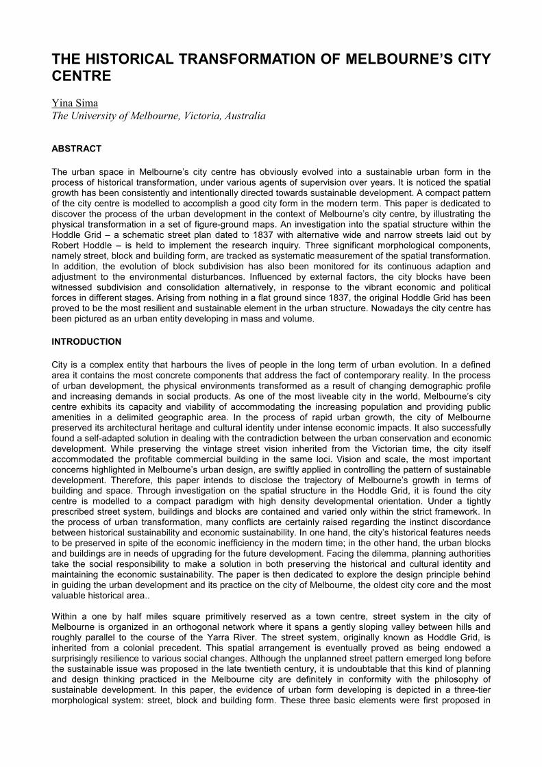
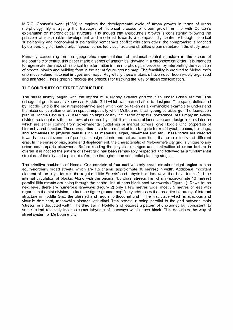
The primitive backbone of Hoddle Grid consists of four east-westerly broad streets at right angles to ninesouth-northerly broad streets, which are 1.5 chains (approximate 30 metres) in width. Additional importantelement of the city’s form is the regular ‘Little Streets’ and labyrinth of laneways that have intensified theinternal circulation of blocks. Along with the original 1.5 chain streets, half chain (approximate 10 metres)parallel little streets are going through the central line of each block east-westwards (Figure 1). Down to thenext level, there are numerous laneways (Figure 2) only a few metres wide, mostly 5 metres or less withregards to the plot division, In fact, the figure-ground map finely addresses the three-tier hierarchy of internalstructure in Hoddle Grid: the planned and regular orthogonal grid in the first place which is spacious andvisually dominant, meanwhile planned latitudinal ‘little streets’ running parallel to the grid between main‘streets’ in a deducted width. The third tier in Hoddle Grid features a pattern of unplanned but consistent, tosome extent relatively inconspicuous labyrinth of laneways within each block. This describes the way ofstreet system of Melbourne city.
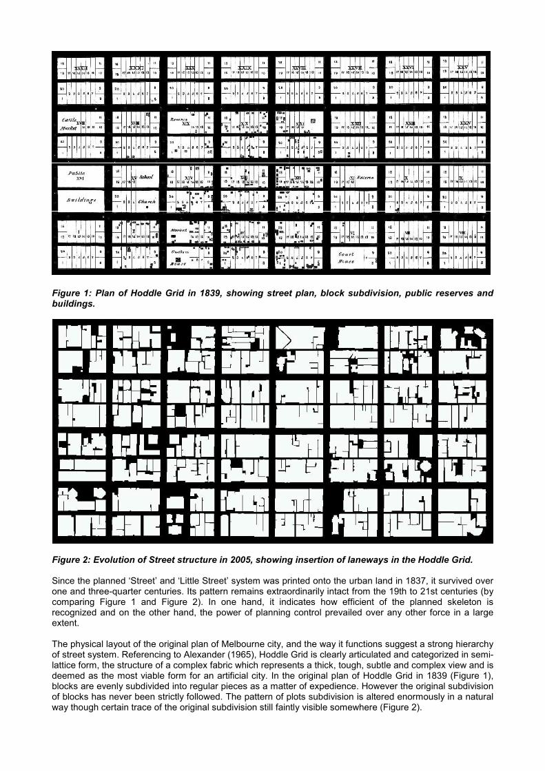
Figure 1: Plan of Hoddle Grid in 1839, showing street plan, block subdivision, public reserves andbuildings.
Figure 2: Evolution of Street structure in 2005, showing insertion of laneways in the Hoddle Grid.
Since the planned ‘Street’ and ‘Little Street’ system was printed onto the urban land in 1837, it survived overone and three-quarter centuries. Its pattern remains extraordinarily intact from the 19th to 21st centuries (bycomparing Figure 1 and Figure 2). In one hand, it indicates how efficient of the planned skeleton isrecognized and on the other hand, the power of planning control prevailed over any other force in a largeextent.
The physical layout of the original plan of Melbourne city, and the way it functions suggest a strong hierarchyof street system. Referencing to Alexander (1965), Hoddle Grid is clearly articulated and categorized in semi-lattice form, the structure of a complex fabric which represents a thick, tough, subtle and complex view and isdeemed as the most viable form for an artificial city. In the original plan of Hoddle Grid in 1839 (Figure 1),blocks are evenly subdivided into regular pieces as a matter of expedience. However the original subdivisionof blocks has never been strictly followed. The pattern of plots subdivision is altered enormously in a naturalway though certain trace of the original subdivision still faintly visible somewhere (Figure 2).
Laneways emerged as a consequence of this natural process of plots subdivision. The formations oflaneways are unplanned. It spontaneously evolved in the actual need of accessing buildings. The formerlaneway was known as ‘Right of Way’ not open to the public. Then as the influx of city population anddevelopment of building cycles, ‘Right of Ways’ were requisitioned and gradually shaped to the famousMelbourne ‘Laneways’ supplementary to the double tiers of ‘Street’ and ‘Little Street’ System. Even thoughunplanned beforehand, Melbourne’s laneways are perfectly consistent with the texture of main grid system infour typologies (Figure 3): Cul-de-sac, L-shape, U-shape and Through laneways.
Figure 3: Four typologies of laneway (left); Hybrid pattern in actual block form 2005 (right).
BLOCK SUBDIVISION AND CONSOLIDATION
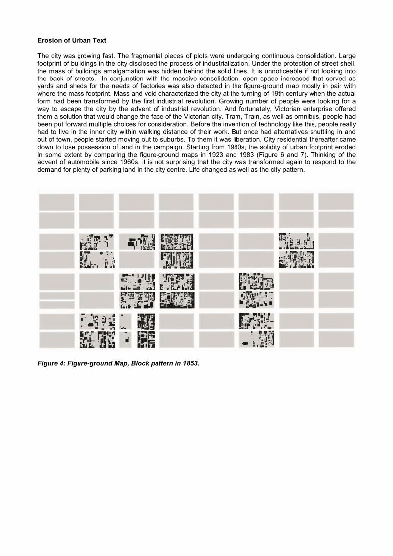
In fact the block pattern failed to retain its earlier identity as the street skeleton did. It was planned in goodintention but altered over years of development. Original typology of city blocks was divided into regularpattern (Figure 4) for the convenience of quick plan and sale. Each block was further subdivided into 20allotments each 76 perches in area. In 1839 land allotments of each block for sale were to be produced asquickly as possible to deliver to the market. Large plots for public use were reserved from beginning inHoddle Grid mostly in elevated area. Remaining blocks were repetition of standard plots subdivision.
The development of blocks underwent a steady process of consolidation since each block had beensubdivided into 20 allotments in 1837. Continuous efforts of plots consolidation have been noticed by landdeveloper. As a consequence of recurrent amalgamation of neighbouring allotments, the block pattern inMelbourne city has been growing from scattered and fragmentary pieces to a centralized and solid mass,despite of the flow of crucial traffic routes strikes a slightly discordant note. The disruptive space for trafficflow has been squeezed up to the utmost limits of endurance to maximize the economic profits of landdevelopment. The tendency is obviously observed that city blocks started to be filled in blanks and graduallyran to solid in the process of urban evolution (Figure 5 and 6). In little more than one and half centuries, thetendency of plots consolidation to spread, from economic centre of Melbourne (instead of geometric centre)to urban fringe, crept over the whole of blocks in the city of Melbourne (Figure 7 and 8).
Enveloping Expansion
Viewing the wide streets along the periphery of streets block without expedition into the back of blocks, astunning street vision from the outside would be very likely beyond your imagination even dated back to theearly days. The images of street vision in the nineteenth century obviously indicated a continuous block shellhad been enclosed the blocks. As early as in 1853, the surveyed block plans had suggested the sequentialmovements of buildings were starting from the front of street blocks. A strong linear sight of street lines wasconceived. Buildings did not proceed to the back of allotments in each block before street lines had beenfilled up and blocks were well-enclosed. In the rare case that buildings set back, like cathedral did in theearly days, a fence (or plinth-and-fence) would mark the street edge in front. The block plans in the period of1839 to 1888 clearly addressed the progression of invasion of buildings into blocks and the transformation ofHoddle Grid from a bare surface to a well-covered groun. In1888, with the reinforced street frontage, for thefirst time, we see the complete picture of Melbourne city in Mahlstedt’s block plan. Until then the Hoddle Gridfulfilled the primary phase of development as an established city centre and stepped into a prolonged periodof self-improvement. Chronologically the evolution of the blocks typology is a constant movement of block(plot) enclosing in the units that divided by the boundary of traffic roads.
Cul-de-sac Through
U-shapeL-shape
Erosion of Urban Text
The city was growing fast. The fragmental pieces of plots were undergoing continuous consolidation. Largefootprint of buildings in the city disclosed the process of industrialization. Under the protection of street shell,the mass of buildings amalgamation was hidden behind the solid lines. It is unnoticeable if not looking intothe back of streets. In conjunction with the massive consolidation, open space increased that served asyards and sheds for the needs of factories was also detected in the figure-ground map mostly in pair withwhere the mass footprint. Mass and void characterized the city at the turning of 19th century when the actualform had been transformed by the first industrial revolution. Growing number of people were looking for away to escape the city by the advent of industrial revolution. And fortunately, Victorian enterprise offeredthem a solution that would change the face of the Victorian city. Tram, Train, as well as omnibus, people hadbeen put forward multiple choices for consideration. Before the invention of technology like this, people reallyhad to live in the inner city within walking distance of their work. But once had alternatives shuttling in andout of town, people started moving out to suburbs. To them it was liberation. City residential thereafter camedown to lose possession of land in the campaign. Starting from 1980s, the solidity of urban footprint erodedin some extent by comparing the figure-ground maps in 1923 and 1983 (Figure 6 and 7). Thinking of theadvent of automobile since 1960s, it is not surprising that the city was transformed again to respond to thedemand for plenty of parking land in the city centre. Life changed as well as the city pattern.
Figure 4: Figure-ground Map, Block pattern in 1853.
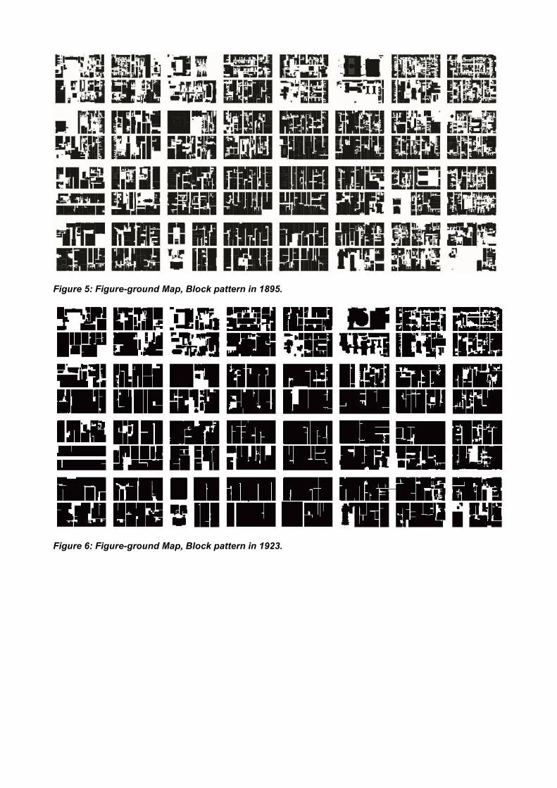
Figure 5: Figure-ground Map, Block pattern in 1895.
Figure 6: Figure-ground Map, Block pattern in 1923.
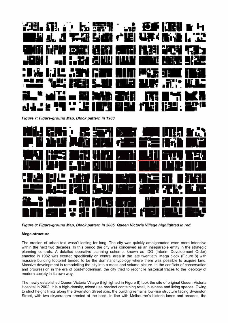
Figure 7: Figure-ground Map, Block pattern in 1983.
Figure 8: Figure-ground Map, Block pattern in 2005, Queen Victoria Village highlighted in red.
Mega-structure
The erosion of urban text wasn’t lasting for long. The city was quickly amalgamated even more intensivewithin the next two decades. In this period the city was conceived as an inseparable entity in the strategicplanning controls. A detailed operative planning scheme, known as IDO (Interim Development Order)enacted in 1982 was exerted specifically on central area in the late twentieth. Mega block (Figure 8) withmassive building footprint tended to be the dominant typology where there was possible to acquire land.Massive development is remodelling the city into a mass and volume picture. In the conflicts of conservationand progression in the era of post-modernism, the city tried to reconcile historical traces to the ideology ofmodern society in its own way.
The newly established Queen Victoria Village (highlighted in Figure 8) took the site of original Queen VictoriaHospital in 2002. It is a high-density, mixed use precinct containing retail, business and living spaces. Owingto strict height limits along the Swanston Street axis, the building remains low-rise structure facing SwanstonStreet, with two skyscrapers erected at the back. In line with Melbourne’s historic lanes and arcades, the
ground level space was specifically designed as shop-filled laneways named after the figures in medicine asa memorial to the past hospital. Obedience to the landform, vertical entrances in difference levels throughSwanston and Russell Streets increase the permeability and diversity to the complexes. Multi-level designstarted to a new direction for city buildings. The concern of design is no long solely for buildings, but all-around considerations between building and space, to conceive an environmental friendly community forpeople to stay and play.
BUILDING FORM
Civic Monumentality
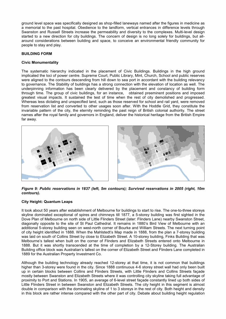
The systematic hierarchy indicated in the placement of Civic Buildings. Buildings in the high groundimplicated the loci of power centre. Supreme Court, Public Library, Mint, Church, School and public reserveswere aligned to the contours descending from hill down to sea port in accordant with the building relevancyto governance. The Stability of buildings has a strong connection with the elevation of location as well. Theunderpinning information has been clearly delivered by the placement and constancy of building formthrough time. The group of civic buildings, for an instance, obtained preeminent positions and imposedgreatest visual impacts. It sustained the test of time when the rest of city demolished and progressed.Whereas less dictating and unspecified land, such as those reserved for school and rail yard, were removedfrom reservation list and converted to other usages soon after. With the Hoddle Grid, they constitute theinvariable pattern of the city, the eternity reminding the past reign of British colonial authority. The streetnames after the royal family and governors in England, deliver the historical heritage from the British Empirefar away.
Figure 9: Public reservations in 1837 (left, 5m contours); Survived reservations in 2005 (right, 10mcontours).
City Height: Quantum Leaps
It took about 50 years after establishment of Melbourne for buildings to start to rise. The one-to-three storeysskyline dominated exceptional of spires and chimneys till 1877, a 5-storey building was first sighted in theDove Plan of Melbourne on north side of Little Flinders Street (later: Flinders Lane) nearby Swanston Street,diagonally opposite to the site of St Paul Cathedral. It remains in 1880’s Bird View of Melbourne with anadditional 5-storey building seen on west-north corner of Bourke and William Streets. The next turning pointof city height identified in 1888. When the Mahlstedt’s Map made in 1888, from the plan a 7-storey buildingwas laid on south of Collins Street by close to Elizabeth Street. A 10-storey building, Finks Building that wasMelbourne’s tallest when built on the corner of Flinders and Elizabeth Streets entered onto Melbourne in1888. But it was shortly transcended at the time of completion by a 12-Storey building. The AustralianBuilding office block was Australian’s tallest on the corner of Elizabeth Street and Flinders Lane completed in1889 for the Australian Property Investment Co.
Although the building technology already reached 12-storey at that time, it is not common that buildingshigher than 3-storey were found in the city. Since 1888 continuous 4-6 storey street wall had only been builtup in certain blocks between Collins and Flinders Streets, with Little Flinders and Collins Streets façademostly between Swanston and Elizabeth Streets where it was controlling city skyline taking full advantage ofproximity to Port and Stations. In 1905, an average of 6-level street façade constantly lined up both sides ofLittle Flinders Street in between Swanston and Elizabeth Streets. The city height in this segment is almostdouble in comparison with the dominating skyline of 1 to 3 storeys in the rest of city. Both height and densityin this block are rather intense compared with the other part of city. Debate about building height regulation
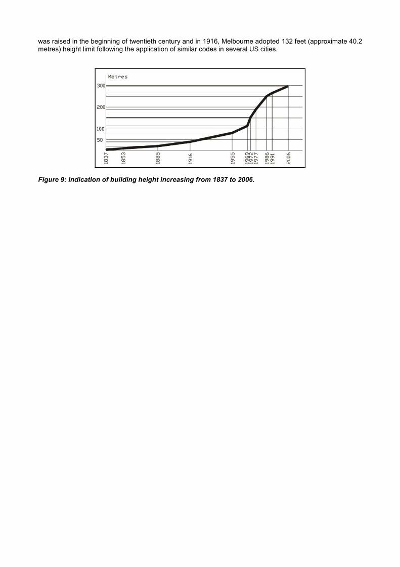
was raised in the beginning of twentieth century and in 1916, Melbourne adopted 132 feet (approximate 40.2metres) height limit following the application of similar codes in several US cities.
Figure 9: Indication of building height increasing from 1837 to 2006.
CONCLUSION
By the detailed spatial analysis on street, block and building form, it is evident that the logic of spatialarrangement in the history of Melbourne is following the steps of sustainable planning. Attributed to theregime of British Empire, colonial power imposed on the form of Melbourne city in the early of the nineteenthcentury and produced a force of clarity and order through the implement of Hoddle Grid that has been keptintact till today in more than one and half centuries. To some extent, Hoddle Grid was founded as theoriginality of Melbourne and without doubt, constitutes a key element of the urban tissue in the city centre.Under the dictated framework, Hoddle Grid implicates a highly recognised structure of street network withstrict and legible hierarchy. This hierarchical articulation subsequently configured the scale and disposition ofblocks at the street level, where buildings positioned and rearranged in groups through time to time. Thelogic of building arrangement surrendered to the rules played by power and economy. High land along theelevated contours has been reserved in the first year of settlement for Civic Buildings and these monumentalreservations formed as part of the eternity of the structure of the city together with the supreme Hoddle Grid.With the variation of buildings, the changing face of building arrangement led to a derivative of Buildings andlaneways, making up two variable elements in the urban tissue.
With the purpose of establishing a sustainable environment in various stages, the city is built upon intentionsof human beings and always reflecting the aspiration of people who live in it. With the interim development oftechnologies and design theories, the city proceeded to fit emergent ideas and immutable regulationsthrough which authorities manipulate the face of city in effective. Although the confliction existing betweenhistorical sustainability and economic sustainability, the guideline of city design in the late 20th and early 21st
centuries dedicated to seek for solutions. By strictly controlled visual axis and layered historical element invertical dimension. Consistently with the aim of sustainable development, the current city centre is goingtowards a paradigm of balancing the different requirement to preserve the social sustainability. Certaintyinstead of accident, the shaping of city is a true expression of contemporary social values under the controlof mind. The urban form is determined by the multiplicity of political, economic and cultural recognition. It isdefinitely possible to manage the space by urban coding.
REFERENCES
Alexander, C., (1965), A city is not a tree, Architectural Forum, 1, 58-61.Bacon, E.N., (1975), Design of Cities, Thames and Hudson, London.Conzen, M.R.G., (1960), Alnwick, Northumberland: A study in town-plan analysis, Transactions and Papers
(Institute of British Geographers Publication), 27.Mahlstedt., (1923), Melbourne Plans, 1 Atlas (24 leaves), 56cm, Mahlstedt’s Vic. Pty Ltd, Melbourne.MMBW., (1895), Melbourne Detail Plan: scale 40 feet to 1 inch, Melbourne and Metropolitan Board of Works,
Melbourne.