Embed Size (px)
Citation preview

The Greater Antilles Outer Ridge: development of a distal sedimentary drift bydeposition of fine-grained contourites
BRIAN E. TUCHOLKEWoods Hole Oceanographic Institution, Woods Hole, Massachusetts 02543, USA (e-mail: [email protected])
Abstract: The Greater Antilles Outer Ridge, located north and northwest of the Puerto Rico Trench, is a deep (>5100 m),distal sediment drift more than 900 km long and up to 1 km thick. It has been isolated from sources of downslope sedimen-tation throughout its history and is formed of clay- to fine silt-size terrigenous sediments that have been deposited fromsuspended load carried in the Western Boundary Undercurrent, together with 0-30% pelagic foraminiferal carbonate.Because of the fine, relatively uniform grain size of the sediments, the outer ridge consists of sediments that are seismicallytransparent in low-frequency reflection profiles. Sediment tracers (chlorite in sediments and suspended particulate matter,reddish clays in cores) indicate that at least a portion of the ridge sediments has been transported more than 2000 km fromthe eastern margin of North America north of 40°N. The outer ridge began to develop as early as the beginning of Oligocenetime when strong, deep thermohaline circulation developed in the North Atlantic and the trough initiating the present PuertoRico Trench had cut off downslope sedimentation from the Greater Antilles. The fastest growth of the outer ridge probablyoccurred beginning in the early Miocene, about the same time that large drifts such as the Blake Outer Ridge were initiatedalong the North American margin. Since that time, the most rapid sedimentation has been along the crest of the northwest-ern outer ridge where suspended load is deposited in a shear zone between opposing currents on the two ridge flanks.
Many contourite deposits occur on continental margins or in closeproximity to sources of clay- to sand-size sediment fed downslopein gravity flows. In these environments it can be difficult toquantify and differentiate the geological effects of downslopeprocesses from the effects of bottom current processes, whichgenerally act along slope. In contrast, sediment drifts that arephysiographically isolated from downslope sources do not exhibitthese complications. Aside from a pelagic component settlingfrom the overlying water column, they are pure contouritesediments, and they exhibit structures and characteristicsdeveloped solely from current-controlled sedimentation.
The Greater Antilles Outer Ridge (GAOR) north of the PuertoRico Trench in the western North Atlantic (Fig. 1) is a welldeveloped example of a distal and isolated contourite drift. It is alarge sedimentary feature that has been totally disconnected fromdownslope sediment sources since middle to late Eocene time. Itlies at depths greater than about 5100 m and thus is mostly belowthe calcite lysocline. Consequently the outer ridge consists domi-nantly of fine-grained sediments that have been deposited fromsuspended load carried in abyssal currents, with only a minorcomponent of pelagic sedimentation. Although the GreaterAntilles Outer Ridge was studied in detail in the early 1970s(Tucholke et al. 1973; Tucholke & Ewing 1974; Tucholke 1975),there has been almost no subsequent research in this region. Inthis synthesis I review the modern geological and oceanographicsetting of the outer ridge together with its depositional historysince middle Eocene time, based largely on this earlier work.
Geological setting and physiography
The Greater Antilles Outer Ridge overlies middle Cretaceousocean crust north of the easternmost Bahama Banks and thePuerto Rico Trench. It is bounded to the northwest by thesouthern Hatteras Abyssal Plain at depths of c. 5520 m and to thenortheast by the deep (>5800 m) Nares Abyssal Plain (Fig. 1).Vema Gap, which is a conduit for turbidity currents flowing fromthe Hatteras to Nares abyssal plain, lies along part of the northernmargin of the ridge. To the west, the Silver Abyssal Plain isolatesthe outer ridge from downslope deposition of sediments derivedfrom the Bahama Banks. A small sedimentary drift, the CaicosOuter Ridge, lies near the base of the Bahama Banks. A slightlyelevated sedimentary sill extends east from Caicos Outer Ridge toconnect with the northwesternmost GAOR. An elevated sill
(Navidad sill) also connects the southeasternmost Bahama Banksto the central part of the GAOR; this elevation is largely due to abasement bulge that has been created as ocean crust is deformedand obliquely subducted in the Puerto Rico Trench. The trenchitself bounds the southern side of the GAOR, isolating it fromsediments moving in gravity flows from the Greater Antilles.
The GAOR can be divided into two provinces, each withsomewhat different geological characteristics and depositionalhistory. East of about 67°W the ridge parallels the Puerto RicoTrench for more than 450 km and is 5300-5400 m deep along itsaxis. Much of the ridge's physiographic elevation is due to the factthat it overlies the crustal outer-high seaward of the trench. Thebathymetry is irregular, partly because high-amplitude basementpeaks interrupt the sedimentary sequence and partly becausecurrent-controlled deposition is uneven around these obstacles(Figs 2 & 3). Drift deposits that define the ridge thin markedlyeast of about 62.5°W, but the actual eastward extent of thesedeposits is uncertain.
The GAOR west of 67°W trends north and northwest for about450 km and has minimum depths of 5100-5200 m. Here the phys-iographic expression of the ridge is due entirely to accumulationof drift deposits. There is no underlying bulge in basement topog-raphy and basement interruptions of the sedimentary sequenceare rare (Figs 4-7).
Finer-scale morphology of the ridge varies between relativelysmooth seafloor and sediment waves. The sediment waves in someplaces are regular (Fig. 7), but more commonly they have variableform, wavelength and amplitude. Small flat ponds occasionallyoccur in depressions between sediment waves, and they appear tohave formed from local mass wasting and turbidity currents. Thebest developed of these is in relatively complex topography on thenortheast flank of the ridge near 22.5°N, 67.5°W (Fig. 1). Therethe sediment waves have been modified into a dendritic drainagesystem extending toward the Nares Abyssal Plain, forming anetwork of 'layered valleys' (Tucholke 1975). This kind ofponding and layering is restricted entirely to the western sector ofthe GAOR (see Fig. 13).
Outer ridge sediments
Sediments forming the GAOR are homogeneous, terrigenous,brown, gray and reddish clays (<2 um) and fine silts that arelocally enriched in carbonate (Figs 8 & 9). They exhibit little
From: STOW, D. A. V., PUDSEY, C. J., HOWE, J. A., FAUGERES, J.-C. & VIANA, A. R. (eds)Deep-Water Contourite Systems: Modern Drifts and Ancient Series, Seismic and Sedimentary Characteristics.Geological Society, London, Memoirs, 22, 39-55. 0435-4052/02/$15.00 © The Geological Society of London 2002. 39

Fig. 1. Bathymetry of the Greater Antilles Outer Ridge and vicinity (from Tucholke et al. 1973). The outer ridge extends east-west north of the Puerto Rico Trench and to the NW between Silver Abyssal Plainand Vema Gap. Contours are in corrected metres.

Fig. 2. Seismic reflection profile extending north-south across the Greater Antilles Outer Ridge to the southernmost Nares Abyssal Plain along 62°52'W, between 20°13'N and 22°04'N (R/V Conrad Cruise 8).The top of the middle to upper Eocene Horizon A complex is labeled where it is observed under the edge of Nares Abyssal Plain. At this far-eastern end of the GAOR, seismically transparent outer ridgesediments directly overlie oceanic basement. Figure from Tucholke & Ewing (1974).

Fig. 3. Seismic reflection profile across the Greater Antilles Outer Ridge and southern Nares Abyssal Plain near 64°W (R/V Conrad Cruise 10). Location in Figure 8. The Horizon A complex extends beneaththe outer ridge but is interrupted by numerous basement peaks. Note that seismically transparent sediments have accumulated faster than the abyssal plain sediments and the outer ridge has prograded onto theabyssal plain. Figure from Tucholke & Ewing (1974).

Fig. 4. Seismic reflection profile extending from the base of the Bahama Banks across the Caicos Outer Ridge, Silver Abyssal Plain, and northwestern Greater Antilles Outer Ridge to Vema Gap (R/V ConradCruise 10). Location in Figure 8. Seismically transparent sediments forming the core of the GAOR appear above the flat-lying Horizon A complex and the ridge subsequently expanded outward, interfingeringwith abyssal plain sediments. Note that the Horizon A complex beneath the Caicos Outer Ridge is truncated in an angular unconformity (Horizon Au) that was eroded by abyssal currents in late Eocene toOligocene time. Figure from Tucholke & Ewing (1974).

44 BRIAN E. TUCHOLKE
Fig. 5. Tracing of a seismic reflection profile across the southern Hatteras Abyssal Plain and along the axis of the northwestern Greater Antilles OuterRidge (R/V Vema Cruise 22). Location in Figure 8. Sediments of the Horizon A complex and deeper beds completely cover basement beneath this sectionof the outer ridge. Seismically transparent outer-ridge sediments have prograded northwestward, interfingering with turbidites of the Hatteras AbyssalPlain. Weak, stacked reflections within the transparent sediments mark the locations of layered valleys developed between sediment waves. Figure fromTucholke & Ewing (1974).
textural stratification except where carbonates occur, althoughcolour contacts between units are often distinct. Layers ofsediment coarser than clay size are rare, and where present theyare thin (<1 cm) and contain concentrations of ash derived fromthe Antilles, carbonate, or manganese micronodules. Coredsediments show extensive reworking by burrowing organisms.This is apparent from color mottling and in carbonate-enrichedpatches worked downward from higher-carbonate zones intounderlying clay-rich intervals.
Grain size is very uniform, averaging 80% clay (<2 um) and20% silt (2-62 um) with a variation of 10%. Sand content (>62um) rarely exceeds 5% and the sand consists entirely of biogenicand authigenic components (foraminifera, manganese micronod-ules, fish teeth, siliceous sponge spicules, and rare radiolaria anddiatoms, in order of decreasing abundance). None of the silt orsand components in cores are organized into identifiable struc-tures that might be attributed to current-controlled deposition.The fine grain size of the dominant clay component also precludesmegascopic identification of current-produced bedforms.
Distinct silt layers occur only in local turbidite ponds betweensediment waves, as for example in the layered valleys notedabove. The silts form micaceous laminae 1-2 mm thick, interbed-ded with clays. Individual turbidites in these areas, identified fromtextural and colour criteria, are usually less than 10 cm thick.
Total carbonate content of the outer-ridge sediments normallyranges from 0-30%, averages 10-15%, and is dominated byforaminifera with usually minor amounts of coccoliths andunidentified detrital carbonate. Carbonate concentrations varycyclically downcore, and the variations are interpreted to be con-trolled by a combination of changes in surface-water productivityand seafloor dissolution, with the latter probably related tochanges in flux or temperature of bottom water flowing aroundthe outer ridge. The surface-water productivity and bottom-waterdissolution effects appear not to be correlated in phase (Tucholke1975).
The clay-fraction mineralogy is comprised of the clay mineralsmontmorillonite, illite, chlorite and kaolinite. It is notable thatchlorite concentrations in outer ridge sediments are richer thanexpected (Fig. 10); weathering in sediment source areas at thesetropical to sub-tropical latitudes tends to produce kaolinite- andmontmorillonite-rich sediments (Biscaye 1965; Hathaway 1972).The chlorite enrichment has been attributed to southwardtransport of higher-latitude, mechanically weathered sediments byabyssal currents (Tucholke 1975). Taking into account the miner-alogy and average concentration of the silt fraction, bulk mineral-ogy of the terrigenous component in outer ridge sediments is 89%layered silicates, 7% quartz, and 4% plagioclase.
Sediment accumulation rates on the GAOR have been deter-mined both from radiocarbon dating and from foraminiferalzonations (Tucholke 1975). The fastest accumulating sedimentsare along the crest of the outer ridge west of 67°W, where ratesrange from about 6 cm ka-1 up to more than 30 cm ka-1. Lowerrates of 3–4 cm ka–1 prevail on the adjacent ridge flanks. Compa-rably low rates also occur on the eastern ridge crest and northflank. On the south flank of the eastern GAOR and along thenorth wall of the Puerto Rico Trench, unfossiliferous to sparselyfossiliferous, ash-rich sediments of lower Eocene to upperMiocene age have been piston-cored. The very low sedimentationrates indicated by these data probably result from a combinationof sediments being displaced into the trench by gravity flows andisolation of the south flank from deep currents with significantsediment load (Tucholke & Eittreim 1974).
Hydrography and abyssal currents
Data from hydrographic sections show that the bottom water overthe GAOR has temperatures colder than 1.7°C (mostly colderthan 1.6°C) and salinities less than 34.875 %o (Tucholke et al. 1973)(all temperatures given here are potential temperatures). Waterwith these characteristics is Antarctic Bottom Water (AABW)and has an ultimate source in the circum-Antarctic (Wright &Worthington 1970). Isotherms and isohalines both are spacedmore closely between about 1.6°C and 1.8°C than in the rest of thedeep-water column, and this gradient marks the transition withoverlying North Atlantic Deep Water (NADW).
Water masses over the GAOR are part of the deep currentsystem, classically termed the Western Boundary Undercurrent(WBUC), that flows from north to south along the continentalmargin of eastern North America (Fig. 10). Shallower currents inthis system (c. 3000 to 4900 m depths) move NADW derivedlargely from the Norwegian Sea, but deeper currents contain anincreasing component of AABW. The AABW is thought to beincorporated from flows entering the western North Atlanticalong the west flank of the Mid-Atlantic Ridge; the AABW circu-lates clockwise around the Bermuda Rise and also reaches north-westward as far as the Newfoundland-Nova Scotia continental risewhere it is recirculated southward at the base of the WBUC(McCave & Tucholke 1986).
Dynamic calculations based on hydrographic measurementsover the GAOR indicate that the bottom water enters the regionin a southeast-directed flow along the base of the Bahama Banks,circulates clockwise around the northwestern part of the outerridge, and flows east along the north flank of the eastern outer

Fig. 6. Seismic reflection profile extending from the base of the Bahama Banks across the southern Silver Abyssal Plain and onto the central Greater Antilles Outer Ridge (R/V Conrad Cruise 10). Location inFigure 8. Irregular sediment waves and local, stacked reflections marking layered valleys appear in the seismically transparent outer ridge sediments. A small current-deposited drift (arrow) flanks the seamountin the southern Silver Abyssal Plain. Figure from Tucholke & Ewing (1974).
46 BRIAN E. TUCHOLKE
Fig. 7. Tracing of a seismic reflection profile across the central Greater Antilles Outer Ridge (R/V Conrad Cruise 10). Location in Figure 8. Basementpeaks locally interrupt the Horizon A complex. Migrating sediment waves and reflections from intervening layered valleys appear in the seismicallytransparent outer-ridge sediments. Figure from Tucholke & Ewing (1974).
Fig. 8. Simplified bathymetric map showing locations of seismic reflection profiles in Figures 2 to 7, locations of cores illustrated in Figure 9, and locationsof suspended particulate matter sampling stations and nephelometer profiles in Figure 12. DSDP Site 28 (Bader et al. 1970) recovered two cores of brownclay from the outer ridge at subbottom depths of 59-78 m, and six cores from deeper, stratified sequences below 169 m subbottom. Contours are incorrected metres, with depths less than 5000 m shaded. The axes of the Greater Antilles Outer Ridge and Caicos Outer Ridge are indicated by dashed lines.

GREATER ANTILLES OUTER RIDGE 47
Fig. 9. Lithological summary of cores taken from the Greater Antilles Outer Ridge, arranged from west (left) to east and contrasted against one corecontaining fine-grained turbidites from the Nares Abyssal Plain (far right). Core locations in Figure 8. The outer-ridge cores are dominantly bioturbatedclay (lutite) with varying admixtures of foraminiferal carbonate, usually 0–30%. GC, gravity core; GGC, giant gravity core; PC, piston core; GPC, giantpiston core; HP, heat-probe gravity core. Figure from Tucholke (1975).
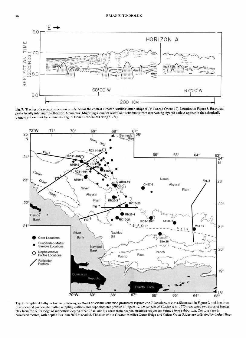
ridge (Fig. 11). Part of this circulation passes southeastward overNavidad sill and then flows east along the south wall of the PuertoRico Trench. A northwesterly flow of AABW on the northernside of Vema Gap (southern margin of the Bermuda Rise)opposes southeasterly flow on the north flank of the northwesternouter ridge; it appears to divert some of the outer ridge flow to thenorth along the eastern edge of the Hatteras Abyssal Plain as partof the clockwise AABW circulation around the Bermuda Rise.
Direct current measurements and interpretations of bottomcurrents from seafloor photographs support the directionalpatterns of abyssal circulation around the GAOR derived fromhydrographic calculations (Fig. 11). Measured currents on thenorth flank of the eastern outer ridge show dominantly easterlyflow at <2 to 10 cm s–1 with short-term reversals (Fig. 11, location2), while currents farther north on the southern Nares AbyssalPlain show both westerly and easterly currents at about the samespeeds (location 1). The westerly flow in the Nares measurementsmay be part of the AABW circulation that courses around theBermuda Rise. The boundary between this and the easterly flowon the northern ridge flank may shift episodically, thus accountingfor flow reversals in both areas.
Measured currents on the southwest flank of the western outerridge are strongly unidirectional to the northwest over a measure-ment period of about six months, while currents on the northeastflank flow in the opposite direction, to the southeast, over thesame period (Fig. 11). Current speeds in both locations rangefrom 2-17 cm s–1, with maximum three-day-average speeds of13-15 cm s–1. Current-direction indicators from bottom photo-graphs are available mostly from camera stations over the western
outer ridge. They confirm a contour-parallel flow that circulatesclockwise around the western outer ridge and then eastward alongthe north flank of the eastern outer ridge.
Suspended sediment
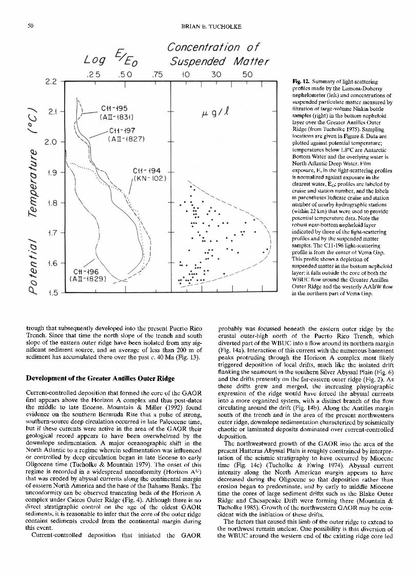
The character and distribution of the suspended sediment load inabyssal currents over the GAOR are known from a limitednumber of light-scattering (nephelometer) profiles and from fil-tration of bottom-water samples collected in large-volume Niskinbottles (Figs 8 & 12) (Tucholke & Eittreim 1974, Tucholke 1975).The nephelometer profiles show a near-bottom nepheloid layerthat is concentrated in the AABW (colder than 1.8°C) but thatalso extends into overlying NADW up to about 1.9°C (Fig. 12).Concentrations of suspended matter in the nepheloid layer rangefrom <10 ug 1–1 up to 63 ug 1–1. The concentrations do not followa smooth pattern with depth as suggested by the nephelometerprofiles but instead indicate that there may be considerable small-scale patchiness in sediment distribution within the nepheloidlayer. Nonetheless, both maximum concentrations and depth-averaged concentrations follow the contour of the light-scatteringprofiles and suggest a core of enhanced sediment load in AABWat about 1.6°-1.7°C, i.e. at depths of c. 5050–5400 m.
AABW flow that passes over Navidad sill (Fig. 11) is accompa-nied by a nepheloid layer that appears as a mid-water maximumat about 1.5°-1.9°C in the southern part of the Puerto Rico Trench(Tucholke & Eittreim 1974). Maximum suspended matter concen-trations, based on in situ calibration of the nephelometer (Biscaye

48 BRIAN E. TUCHOLKE
Fig. 10. Chlorite abundance in the clay-size(<2 um) fraction of surface and near-surfacesediments in the western North Atlantic,determined from X-ray diffraction (fromTucholke 1975). Compositions (weightedpeak-area percentage) were determined usingpeak areas and weighting factors of Biscaye(1965). The chlorite-enriched tongueextending southward along the continentalmargin of North America and to the GreaterAntilles Outer Ridge is interpreted to indicatelong-distance sediment transport by theWestern Boundary Undercurrent (WBUC).
& Eittreim 1974), are up to 30 ug 1–1 over the western part of thetrench and decrease down current to the east. A weak flow ofAABW appears to circulate westward into the trench and alongits north wall (south wall of the eastern outer ridge). This flow isaccompanied by a poorly developed bottom nepheloid layer(Tucholke & Eittreim 1974), and it is not likely to be a significantsource of sediment for the outer ridge.
Mean grain size of suspended matter sampled over the GAORas determined in scanning electron microscope (SEM) samples isin the order of 3–4 um, slightly coarser than that of the underlyingouter-ridge sediments. However, the SEM technique probablyunderestimates the very fine-grained component (<0.2 urn), sothis apparent difference may be artificial (Tucholke 1975).
Composition of the <2 um fraction is more than 90% claymineral platelets, with feldspar, quartz, and fragments of calcare-ous nannoplankton and biogenic silica constituting the remainder.The same components make up the silt-size fraction, but only30-50% of this fraction is layered silicates. X-ray diffraction ofbulk suspended-matter samples shows that chlorite is enriched inthe samples (about 2 parts in 10), much as is observed in theunderlying sediment. Unlike the seafloor sediment, however, illiteappears to be strongly enriched and montmorillonite depleted. Itis possible, though not certain, that this may be an artifact causedby incomplete development of the montmorillonite minerallattice, and thus poor X-ray detection, in the very small-volumesuspended matter samples analysed (Tucholke 1974).
Seismic stratigraphy and sediment distribution
As would be expected from the fine, uniform grain size and lackof coarse beds, impedance contrasts in GAOR sediments aresmall. Consequently, the sediments mostly are seismically trans-parent in conventional reflection profiles obtained at frequenciesin the range of 10's-100's Hz (Figs 2-7). Weak internal reflectionslocally suggest migration of sediment waves as the outer ridge wasconstructed (Figs 5 & 7); most of these reflection packets aresimilar to the layered valleys noted earlier, and they probablyexist because gravity flows locally remobilized sediments andredeposited them in sorted or graded beds.
The transparent layer that forms the GAOR overlies amarkedly different seismic reflection sequence that consists of flat,reflective beds (Figs 3-7). These beds are part of the 'Horizon Acomplex' that is widespread in the western North Atlantic andconsists of upper lower to lower middle Eocene biosiliceoussediments and cherts (Horizon Ac), as well as middle to possiblyupper Eocene turbidites (Horizon AT) (Tucholke & Mountain1979). Sediments within and below this complex are thickestbeneath the western outer ridge, where they bury most of thebasement topography (Figs 4–7). Beneath the outer ridge east of67°W this sequence thins and is commonly interrupted bybasement peaks (Fig. 3), and east of about 63°W it is absentexcept under the Nares Abyssal Plain (Fig. 2). Cores recoveredfrom the stratified sequence at DSDP Site 28 near 66°W (Fig. 8)contain clays, silts, chalk and chert (Bader et al. 1970).
GREATER ANTILLES OUTER RIDGE 49
Fig. 11. Summary of abyssal current patterns in the region of the Greater Antilles Outer Ridge, based on all available data including hydrographiccalculations (Tucholke et al. 1973; Tucholke & Eittreim 1974). Base map as in Figure 8. The shaded arrows show generalized circulation of the WesternBoundary Undercurrent and of Antarctic Bottom Water entering from the South Atlantic. Current-metre measurements (circled numbers) are summarizedas progressive vector diagrams with the starting point at the measurement location; durations of measurements in days and average current speed for thedurations are indicated in parentheses. Measurements were made 15 m above the seafloor at locations 1 and 2, and 100 m above the seafloor at locations 3and 4.
The transition from seismically laminated pre-Horizon Asediments to seismically transparent post-A sediments differsbeneath the eastern and the western GAOR. Under the centraland eastern outer ridge the change is abrupt (Figs 3, 6 & 7); overtime the transparent layer accumulated more rapidly thansediments in the Nares Abyssal Plain and it has slowly progradedseveral tens of kilometres northward into the abyssal plain (Fig.3). Under the northwest end of the outer ridge, deposition oflaminated sediments persisted for 100-200 m above the HorizonA complex, interfingering with a small lens of transparentsediment that was probably the nascent core of this limb of theouter ridge (Fig. 4). As the ridge here was constructed, the zoneof interfingering expanded outward in all directions from the ridgecore, and the ridge has prograded more than 100 km to thenorthwest (Fig. 5).
Isopachs of sediment thickness above the Horizon A complex(Fig. 13) clearly reflect the physiographic form of the GAOR.Maximum sediment thickness is up to 0.9-1.0 km beneath the axisof the western outer ridge but only about 0.5 km beneath theeastern outer ridge. The adjacent Nares Abyssal Plain, which
accumulates sediments from very distal turbidity currents passingthrough Vema Gap, has an average thickness of only 0.3-0.4 kmof post-Eocene sediments. The Silver Abyssal Plain west of theouter ridge has slightly thicker post-Eocene sediments because itis proximal to a sediment source in the southeast Bahama Banks.At the extreme northwest end of the GAOR, isopachs show thatthe outer-ridge trend of thickened sediments extends into strati-fied sediments at the southern end of Hatteras Abyssal Plain (Fig.13). This pattern suggests that sediment accumulation there is notentirely from turbidity currents but is enhanced by an additionalcomponent of current-controlled deposition. Because the seafloorin this area is flat, a slight regional depression of underlyingbasement is required to accommodate the thickening.
The reflective, flat-lying character of sediments within andbelow the Horizon A complex indicates that they were depositedfrom downslope gravity flows, and the source area is thought to bethe northeastern Antilles arc (Tucholke & Ewing 1974). Theabrupt upward change from these reflective sediments to seismi-cally transparent sediments beneath the eastern GAOR is inter-preted to coincide with middle to late Eocene initiation of the
50 BRIAN E. TUCHOLKE
Fig. 12. Summary of light-scatteringprofiles made by the Lamont-Dohertynephelometer (left) and concentrations ofsuspended particulate matter measured byfiltration of large-volume Niskin bottlesamples (right) in the bottom nepheloidlayer over the Greater Antilles OuterRidge (from Tucholke 1975). Samplinglocations are given in Figure 8. Data areplotted against potential temperature;temperatures below 1.8°C are AntarcticBottom Water and the overlying water isNorth Atlantic Deep Water. Filmexposure, E, in the light-scattering profilesis normalized against exposure in theclearest water, Eo; profiles are labeled bycruise and station number, and the labelsin parentheses indicate cruise and stationnumber of nearby hydrographic stations(within 22 km) that were used to providepotential temperature data. Note therobust near-bottom nepheloid layerindicated by three of the light-scatteringprofiles and by the suspended mattersamples. The C11-196 light-scatteringprofile is from the center of Vema Gap.This profile shows a depletion ofsuspended matter in the bottom nepheloidlayer; it falls outside the core of both theWBUC flow around the Greater AntillesOuter Ridge and the westerly AABW flowin the northern part of Vema Gap.
trough that subsequently developed into the present Puerto RicoTrench. Since that time the north slope of the trench and southslope of the eastern outer ridge have been isolated from any sig-nificant sediment source, and an average of less than 200 m ofsediment has accumulated there over the past c. 40 Ma (Fig. 13).
Development of the Greater Antilles Outer Ridge
Current-controlled deposition that formed the core of the GAORfirst appears above the Horizon A complex and thus post-datesthe middle to late Eocene. Mountain & Miller (1992) foundevidence on the southern Bermuda Rise that a pulse of strong,southern-source deep circulation occurred in late Paleocene time,but if these currents were active in the area of the GAOR theirgeological record appears to have been overwhelmed by thedownslope sedimentation. A major oceanographic shift in theNorth Atlantic to a regime wherein sedimentation was influencedor controlled by deep circulation began in late Eocene to earlyOligocene time (Tucholke & Mountain 1979). The onset of thisregime is recorded in a widespread unconformity (Horizon Au)that was eroded by abyssal currents along the continental marginof eastern North America and the base of the Bahama Banks. Theunconformity can be observed truncating beds of the Horizon Acomplex under Caicos Outer Ridge (Fig. 4). Although there is nodirect stratigraphic control on the age of the oldest GAORsediments, it is reasonable to infer that the core of the outer ridgecontains sediments eroded from the continental margin duringthis event.
Current-controlled deposition that initiated the GAOR
probably was focussed beneath the eastern outer ridge by thecrustal outer-high north of the Puerto Rico Trench, whichdiverted part of the WBUC into a flow around its northern margin(Fig. 14a). Interaction of this current with the numerous basementpeaks protruding through the Horizon A complex most likelytriggered deposition of local drifts, much like the isolated driftflanking the seamount in the southern Silver Abyssal Plain (Fig. 6)and the drifts presently on the far-eastern outer ridge (Fig. 2). Asthese drifts grew and merged, the increasing physiographicexpression of the ridge would have forced the abyssal currentsinto a more organized system, with a distinct branch of the flowcirculating around the drift (Fig. 14b). Along the Antilles marginsouth of the trench and in the area of the present northwesternouter ridge, downslope sedimentation characterized by seismicallychaotic or laminated deposits dominated over current-controlleddeposition.
The northwestward growth of the GAOR into the area of thepresent Hatteras Abyssal Plain is roughly constrained by interpre-tation of the seismic stratigraphy to have occurred by Miocenetime (Fig. 14c) (Tucholke & Ewing 1974). Abyssal currentintensity along the North American margin appears to havedecreased during the Oligocene so that deposition rather thanerosion began to predominate, and by early to middle Miocenetime the cores of large sediment drifts such as the Blake OuterRidge and Chesapeake Drift were forming there (Mountain &Tucholke 1985). Growth of the northwestern GAOR may be coin-cident with the initiation of these drifts.
The factors that caused this limb of the outer ridge to extend tothe northwest remain unclear. One possibility is that diversion ofthe WBUC around the western end of the existing ridge core led

GREATER ANTILLES OUTER RIDGE 51
Fig. 13. Mapped sediment thickness above the stratified Horizon A complex (contours in seconds two-way travel time) and above basement peaks thatinterrupt Horizon A (see code at lower left). Control provided by seismic reflection profiles is shown by light dotted lines. The star shows the location ofDSDP Site 28. Shaded areas show where sediments in the mapped interval are seismically stratified; these are mostly restricted to the abyssal plains. Thesouthern limit of mapped thicknesses is the 7000 m contour along the north wall of the Puerto Rico Trench. The Horizon A complex crops out in threesmall areas at the base of the Bahama Banks and at the southern end of the Silver Abyssal Plain (crosshatch pattern) where abyssal currents eroded thecomplex and have prevented deposition since early Oligocene time. Note that sediment thickness patterns correlate closely with the physiographic form ofthe Greater Antilles Outer Ridge. Layered valleys within the transparent layer are restricted entirely to the western outer ridge. Figure from Tucholke &Ewing (1974).
to a zone of current shear between northwest- and southeast-directed currents (Fig. 14b, c), and rapid deposition of suspendedload beneath the shear zone formed the northwestern outer ridge(Fig. 15). In an alternate scenario, depositional patterns may havebeen affected by interaction of the WBUC and AABW enteringthe area from the southeast. Ice volume increased substantially inthe middle Miocene (e.g. Miller et al. 1991), and it may have ledto increased flux of AABW into the western North Atlantic.Amplified westward flow of AABW through Vema Gap wouldhave opposed the eastward-flowing WBUC, and it could eitherhave diverted the WBUC or created a shear zone against thiscurrent that triggered deposition to form the northwesternGAOR.
Discussion and conclusions
Most sedimentary drifts in continental-margin settings have director nearly direct downslope sources of sediment; bottom currentshave reworked and transported these sediments to varyingdegrees, depending primarily on grain-size distribution andcurrent intensity. The resulting drifts are complex aggregations of
beds with mixed signatures of cross-slope and along-slope sedi-mentary processes. In contrast, the Greater Antilles Outer Ridgehas been deposited entirely from suspended load carried inabyssal currents. Thus its characteristics can provide importantinsights into purely current-controlled sedimentary processes overlong time and spatial scales.
The enrichment of chlorite in GAOR sediments (Fig. 10)provides strong evidence that a significant fraction of the sedimenthas been transported for great distances, up to 2000 km or more,from the North American continental margin north of CapeHatteras. Hollister (1967) used the reddish colour of sedimentsderived from Permian-Carboniferous red beds in the CanadianMaritime Provinces as a tracer of northern-source sedimentscarried by bottom currents along the US continental rise, and thereddish brown and reddish gray clays on the GAOR (Fig. 9) mayalso reflect a continuation of this dispersal pattern. In thedominant, non-biogenic portion of GAOR sediment, grain sizeaverages more than 80% clay (<2 um), with the remainder con-sisting of very fine silt. These sediments were sampled only to10-20 sub-bottom in piston cores but their seismic signature is thesame as deeper, seismically transparent sediments that form theOligocene(?)-Miocene core of the outer ridge, and it is likely that

52 BRIAN E. TUCHOLKE

GREATER ANTILLES OUTER RIDGE 53
Fig. 14. Schematic summary interpreting the evolution of the Greater Antilles Outer Ridge (view to the southwest, covering the approximate area ofFigure 1). (a) Late Eocene to early Oligocene: The developing Puerto Rico Trench cut off downslope sedimentation (black arrows) from the GreaterAntilles and created a crustal outer-high that diverted part of the newly developed Western Boundary Undercurrent. Current-controlled deposition alongthe irregular topography of this bulge formed the core of the eastern outer ridge. Downslope gravity flows from the Bahama Banks continued to depositstratified sediments in the area of the western outer ridge and on the surrounding abyssal plains. (b) Late Oligocene: Growth of the GAOR may havediverted WBUC flow enough that a shear zone developed between opposing currents at the western end of the ridge, stimulating ridge growthnorthwestward into the abyssal plain. (c) Miocene to Recent: By this time the western extension of the GAOR was well established, and ridge-crestsediments accumulated rapidly between opposing flows that followed the ridge flanks. The Caicos Outer Ridge also was deposited along the margin of theBahama Banks, blocking downslope sediment supply to the Hatteras and Nares abyssal plains and diverting it to the Silver Abyssal Plain. Figure adaptedfrom Tucholke & Ewing (1974).
most of the ridge has similar grain-size characteristics. From allthese considerations, we infer that on a time scale of at leastc. 20 Ma. the Western Boundary Undercurrent has beencompetent to transport very fine silt and clay-size sediments forthousands of kilometres. Composition and grain-size distributionin modem particulate-matter samples from bottom water over theGAOR are very similar to those in the seafloor sediments, sopresent-day dynamic conditions of sedimentation appear to besimilar to average conditions over the longer-term construction ofthe outer ridge.
From observations in bottom photographs, current-producedbedforms seem to be neither well nor widely developed in GAORsediments. Because of their fine grain size the sediments have highcohesion once deposited, and they are not easily eroded byambient currents that have maximum speeds of only 15-17 cm s–1.The lack of significant bedload transport probably hinders theproduction of pronounced bedforms. The only distinct lenses ofcoarse (silt-size) sediment known on the outer ridge occur in'layered valleys' between sediment waves. These appear to bedeposited from small turbidity currents generated by failure ofrapidly deposited sediments on the adjacent sediment waves.Thus, unlike the conditions at sedimentary drifts along continen-tal margins, sediments are moved in gravity flows as a result of,rather than as a prelude to, current-controlled sedimentation. Thelarge-scale abyssal sediment waves on the GAOR are widespreadbut they do not seem often to develop in regular wave trains.However, this observation is not robust because there is relatively
sparse echosounding and seismic reflection coverage, and denserdata sets (e.g. multibeam bathymetry) could well reveal extensivedevelopment of coherent sediment waves. In some placessediment waves clearly do show both regular patterns and a longhistory of growth, dating well back into the Miocene (Fig. 7).
Abyssal current directions around the GAOR closely parallelbathymetric contours (Fig. 11), within certain limits. Directcurrent measurements over periods of months reflect the signifi-cant influence that even small topographic gradients have inorganizing the flow. Currents along the flanks of the GAOR atlocations 2-4 (Fig. 11), for example, follow the local contours(with short-term excursions) even though the seafloor slope isonly c. 0.5°-1.0°. At location 1 on the Nares Abyssal Plain,however, the seafloor slope is less than 0.05° and there is no con-sistent direction in measured currents. Current directions deter-mined from bedforms, tool marks, and other sedimentary featuresin bottom photographs are the most consistently contour-parallel.As already noted, current erosion or molding of the cohesiveouter ridge sediments is difficult, so short-term flow variability isunlikely to modify the bed significantly. The bedforms probablyrepresent average flow over periods of at least months to perhapsmany years, and they come closer to characterizing flow that haslong-term geological effects than do direct current measurements.
In the area of the Greater Antilles Outer Ridge, the primarycontrols on position and growth of sedimentary drifts have beencurrent interaction with varying seafloor topography (whichcontrols current vectors) and suspended particulate load.

54 BRIAN E. TUCHOLKE
Fig. 15. Simple model for current-controlled deposition along a section extending northeast from the Bahama Banks to the southernmost Bermuda Rise,adapted from Tucholke & Ewing (1974) (compare with the seismic section in Figure 4). The top panel shows idealized flow of the WBUC along theBahama Banks and around the Greater Antilles Outer Ridge, and flow of AABW in the northern part of Vema Gap (dote represent flows out of the page,X's are flows into the page). At bottom right is schematic current speed with superimposed concentrations of suspended matter. The current-speed versusdeposition-rate curve at lower left assumes rapid sediment fallout over a small speed range, but the shape of the curve is not critical. Rapid sedimentdeposition from currents requires both significant suspended load and low current speeds. Thus, although suspended-matter concentration is high in theWBUC close to the Bahama Banks, high current speeds prevent deposition at the base of the banks (open arrow) while decreasing speeds away from thebanks allow deposition on Caicos Outer Ridge (filled arrow). Over the GAOR, a combination of high suspended load and lower current speeds in the shearzone between opposing flows allows rapid deposition on the ridge crest (filled arrow); higher speeds with approximately the same suspended load attenuatedeposition on the ridge flanks. Deposition from abyssal currents is minimal over the Silver Abyssal Plain and in Vema Gap where both current speeds andsuspended load are low (open arrows).
Interaction of the WBUC with irregular topography formed theinitial core of the GAOR on the outer high north of the PuertoRico Trench probably in the Oligocene (Fig. 14). The decelerationand interactions of threads of currents over this confused topog-raphy most likely initiated deposition from a substantialsuspended load. As the ridge grew, opposing NW- and SE-directed currents developed on its western end; lower currentspeeds in the shear zone between these flows allowed rapid depo-sition of suspended load to form the northwestern limb of theouter ridge as it exists today (Figs 14c & 15). To the southwest, inthe WBUC along the Bahama Banks, suspended load may be highbut currents are topographically intensified against the steepbanks, so an erosional/non-depositional zone exists at the base ofthe banks inboard of the Caicos Outer Ridge. Shear zones withlow current speeds between opposing flows exist over the SilverAbyssal Plain and in Vema Gap, but no coherent drift depositshave accumulated in these locations. This is probably explainedby the fact that the shear zones are not stabilized by topographyand thus are migratory, and by the absence of significant particu-late suspended load away from the cores of the main currents.
My studies of current-controlled deposition in the region of the GreaterAntilles Outer Ridge extend back to my PhD thesis research, undertakenunder the tutelage of Charles D. Hollister. Charley was a constant sourceof enthusiasm, as well as personal and scientific inspiration, both in those
early days and over the many intervening years of our continuing friend-ship. I hope that this brief synthesis reflects at least some small insight intothe broad research questions of abyssal sedimentation that he inspired andpromoted throughout his career. Geological and geophysical studies of theGreater Antilles Outer Ridge were funded by the US National ScienceFoundation and the Office of Naval Research. This overview was preparedwith support from the Henry Bryant Bigelow Chair in Oceanography atWoods Hole Oceanographic Institution. Woods Hole OceanographicInstitution Contribution No. 10392.
References
BADER, R. G, GERARD, R. D., BENSON, W. E. ET AL. 1970. Site 28. In:BADER, R. G. ET AL. Initial Reports of the Deep Sea Drilling Project.US Government Printing Office, Washington, DC, 125-143.
BISCAYE, P. E. 1965. Mineralogy and sedimentation of Recent deep-seaclay in the Atlantic Ocean and adjacent seas and oceans. GeologicalSociety of America Bulletin, 76, 803–832.
BISCAYE, P. E. & EITTREIM, S. L. 1974. Variations in benthic boundarylayer phenomena: Nepheloid layer in the North American Basin. In:GIBBS, R. J. (ed.) Suspended Solids in Water. Plenum Press, NewYork, 227-260.
HATHAWAY, J. C. 1972. Regional clay mineral facies in estuaries and conti-nental margin of the United States East Coast. Geological Society ofAmerica Memoir, 133, 293–316.
GREATER ANTILLES OUTER RIDGE 55
HOLLISTER, C. D. 1967. Sediment distribution and deep circulation in thewestern North Atlantic. PhD thesis, Columbia University.
McCAVE, I. N. & TUCHOLKE, B. E. 1986. Deep current-controlled sedimen-tation in the western North Atlantic. In: VOGT, P. R. & TUCHOLKE, B.E. (eds) The Geology of North America, Volume M, The WesternNorth Atlantic Region. Geological Society of America, Boulder, Co.,451-468.
MILLER, K. G, WRIGHT, J. D. & FAIRBANKS, R. G. 1991. Unlocking the icehouse: Oligocene-Miocene oxygen isotopes, eustasy, and marginerosion. Journal of Geophysical Research, 96, 6829-6848.
MOUNTAIN, G. S. & MILLER, K. G. 1992. Seismic and geologic evidence forearly Paleogene deepwater circulation in the western North Atlantic.Paleoceanography, 7, 423–439.
MOUNTAIN, G. S. & TUCHOLKE, B. E. 1985. Mesozoic and Cenozoicgeology of the US Atlantic continental slope and rise. In: POAG, C. W.(ed.) Geologic Evolution of the United States Atlantic Margin. VanNostrand Reinhold, New York, 293–341.
TUCHOLKE, B. E. 1974. Determination of montmorillonite in small samplesand implications for suspended-matter studies. Journal of Sedi-mentary Petrology, 44, 254-258.
TUCHOLKE, B. E. 1975. Sediment distribution and deposition by the
western Boundary Undercurrent: The Greater Antilles Outer Ridge.Journal of Geology, 83, 177–207.
TUCHOLKE, B. E. & EITTREIM, S. 1974. The Western Boundary Undercur-rent as a turbidity maximum over the Puerto Rico Trench. Journal ofGeophysical Research, 79, 4115-4118.
TUCHOLKE, B. E. & EWING, J. I.1974. Bathymetry and sediment geometryof the Greater Antilles Outer Ridge and vicinity. Geological Societyof America Bulletin, 85, 1789-1802.
TUCHOLKE, B. E. & MOUNTAIN, G. S. 1979. Seismic stratigraphy, lithos-tratigraphy and paleosedimentation patterns in the North AmericanBasin. In: TALWANI, M., HAY, W. & RYAN, W. B. F. (eds) Deep Drillingin the Atlantic Ocean: Continental Margins and Paleoenvironment.Maurice Ewing Series 3, American Geophysical Union, Washington,DC, 58-86.
TUCHOLKE, B. E., WRIGHT, W. R. & HOLLISTER, C. D. 1973. Abyssal circu-lation over the Greater Antilles Outer Ridge. Deep-Sea Research, 20,973-995.
WRIGHT, W. R. & WORTHINGTON, L. V. 1970. The water masses of the NorthAtlantic Ocean: A volumetric census of temperature and salinity. SerialAtlas of the Marine Environment Folio 19. American GeographicalSociety, New York.