Embed Size (px)
Citation preview
PDF generated using the open source mwlib toolkit. See http://code.pediapress.com/ for more information.PDF generated at: Mon, 09 Jan 2012 05:29:19 UTC
The Geometry of the Earth

ContentsArticles
Cartesian coordinate system 1Dot product 10Cross product 16Spherical coordinate system 30Spherical trigonometry 37Spherical law of cosines 41Circle of a sphere 43Great circle 44Great-circle distance 47Horizontal coordinate system 50Earth's energy budget 53Declination 55Solar elevation angle 58Solar azimuth angle 59Sun path 60Sun chart 62Irradiance 63Sunlight 65Effect of sun angle on climate 72Insolation 74Atmospheric refraction 82Axial tilt 85
ReferencesArticle Sources and Contributors 90Image Sources, Licenses and Contributors 92
Article LicensesLicense 94

Cartesian coordinate system 1
Cartesian coordinate system
Illustration of a Cartesian coordinate plane. Four points are markedand labeled with their coordinates: (2, 3) in green, (−3, 1) in red,
(−1.5, −2.5) in blue, and the origin (0, 0) in purple.
A Cartesian coordinate system specifies each pointuniquely in a plane by a pair of numerical coordinates,which are the signed distances from the point to twofixed perpendicular directed lines, measured in thesame unit of length. Each reference line is called acoordinate axis or just axis of the system, and the pointwhere they meet is its origin, usually at ordered pair(0,0). The coordinates can also be defined as thepositions of the perpendicular projections of the pointonto the two axes, expressed as signed distances fromthe origin.
One can use the same principle to specify the positionof any point in three-dimensional space by threeCartesian coordinates, its signed distances to threemutually perpendicular planes (or, equivalently, by itsperpendicular projection onto three mutuallyperpendicular lines). In general, one can specify a pointin a space of any dimension n by use of n Cartesiancoordinates, the signed distances from n mutuallyperpendicular hyperplanes.
Cartesian coordinate system with a circle of radius 2 centered at theorigin marked in red. The equation of a circle is (x - a)2 + (y - b)2 = r2
where a and b are the coordinates of the center (a, b) and r is theradius.
The invention of Cartesian coordinates in the 17thcentury by René Descartes (Latinized name: Cartesius)revolutionized mathematics by providing the firstsystematic link between Euclidean geometry andalgebra. Using the Cartesian coordinate system,geometric shapes (such as curves) can be described byCartesian equations: algebraic equations involving thecoordinates of the points lying on the shape. Forexample, a circle of radius 2 may be described as theset of all points whose coordinates x and y satisfy theequation x2 + y2 = 4.
Cartesian coordinates are the foundation of analyticgeometry, and provide enlightening geometricinterpretations for many other branches ofmathematics, such as linear algebra, complex analysis,differential geometry, multivariate calculus, grouptheory, and more. A familiar example is the concept ofthe graph of a function. Cartesian coordinates are alsoessential tools for most applied disciplines that dealwith geometry, including astronomy, physics,engineering, and many more. They are the most common coordinate system used in computer graphics,computer-aided geometric design, and other geometry-related data processing.
Cartesian coordinate system 2
HistoryThe adjective Cartesian refers to the French mathematician and philosopher René Descartes (who used the nameCartesius in Latin).The idea of this system was developed in 1637 in writings by Descartes and independently by Pierre de Fermat,although Fermat also worked in three dimensions, and did not publish the discovery.[1] Both authors used a singleaxis in their treatments and have a variable length measured in reference to this axis. The concept of using a pair ofaxes was introduced in later work by commentators who were trying to clarify the ideas contained in Descartes' LaGéométrie.The development of the Cartesian coordinate system would play an intrinsic role in the development of the calculusby Isaac Newton and Gottfried Wilhelm Leibniz.[2]
Nicole Oresme, a French cleric and friend of the dauphin (later to become King Charles V) of the 14th Century, usedconstructions similar to Cartesian coordinates well before the time of Descartes and Fermat.Many other coordinate systems have been developed since Descartes, such as the polar coordinates for the plane, andthe spherical and cylindrical coordinates for three-dimensional space.
Definitions
Number lineChoosing a Cartesian coordinate system for a one-dimensional space—that is, for a straight line—means choosing apoint O of the line (the origin), a unit of length, and an orientation for the line. An orientation chooses which of thetwo half-lines determined by O is the positive, and which is negative; we then say that the line "is oriented" (or"points") from the negative half towards the positive half. Then each point p of the line can be specified by itsdistance from O, taken with a + or − sign depending on which half-line contains p.A line with a chosen Cartesian system is called a number line. Every real number, whether integer, rational, orirrational, has a unique location on the line. Conversely, every point on the line can be interpreted as a number in anordered continuum which includes the real numbers.
Cartesian coordinates in two dimensionsThe modern Cartesian coordinate system in two dimensions (also called a rectangular coordinate system) is definedby an ordered pair of perpendicular lines (axes), a single unit of length for both axes, and an orientation for eachaxis. (Early systems allowed "oblique" axes, that is, axes that did not meet at right angles.) The lines are commonlyreferred to as the x and y-axes where the x-axis is taken to be horizontal and the y-axis is taken to be vertical. Thepoint where the axes meet is taken as the origin for both, thus turning each axis into a number line. For a given pointP, a line is drawn through P perpendicular to the x-axis to meet it at X and second line is drawn through Pperpendicular to the y-axis to meet it at Y. The coordinates of P are then X and Y interpreted as numbers x and y onthe corresponding number lines. The coordinates are written as an ordered pair (x, y).The point where the axes meet is the common origin of the two number lines and is simply called the origin. It isoften labeled O and if so then the axes are called Ox and Oy. A plane with x and y-axes defined is often referred to asthe Cartesian plane or xy plane. The value of x is called the x-coordinate or abscissa and the value of y is called they-coordinate or ordinate.The choices of letters come from the original convention, which is to use the latter part of the alphabet to indicateunknown values. The first part of the alphabet was used to designate known values.

Cartesian coordinate system 3
Cartesian coordinates in three dimensions
A three dimensional Cartesian coordinate system, with origin Oand axis lines X, Y and Z, oriented as shown by the arrows. Thetick marks on the axes are one length unit apart. The black dot
shows the point with coordinates X = 2, Y = 3, and Z = 4, or(2,3,4).
Choosing a Cartesian coordinate system for athree-dimensional space means choosing an orderedtriplet of lines (axes), any two of them beingperpendicular; a single unit of length for all three axes;and an orientation for each axis. As in thetwo-dimensional case, each axis becomes a number line.The coordinates of a point p are obtained by drawing aline through p perpendicular to each coordinate axis, andreading the points where these lines meet the axes asthree numbers of these number lines.
Alternatively, the coordinates of a point p can also betaken as the (signed) distances from p to the three planesdefined by the three axes. If the axes are named x, y, andz, then the x coordinate is the distance from the planedefined by the y and z axes. The distance is to be takenwith the + or − sign, depending on which of the twohalf-spaces separated by that plane contains p. The y andz coordinates can be obtained in the same way from the(x,z) and (x,y) planes, respectively.
The coordinate surfaces of the Cartesian coordinates (x, y, z). Thez-axis is vertical and the x-axis is highlighted in green. Thus, the
red plane shows the points with x=1, the blue plane shows thepoints with z=1, and the yellow plane shows the points with y=-1.
The three surfaces intersect at the point P (shown as a blacksphere) with the Cartesian coordinates (1, -1, 1).
Generalizations
One can generalize the concept of Cartesian coordinatesto allow axes that are not perpendicular to each other,and/or different units along each axis. In that case, eachcoordinate is obtained by projecting the point onto oneaxis along a direction that is parallel to the other axis (or,in general, to the hyperplane defined by all the otheraxes). In those oblique coordinate systems thecomputations of distances and angles is more complicatedthan in standard Cartesian systems, and many standardformulas (such as the Pythagorean formula for thedistance) do not hold.
Notations and conventions
The Cartesian coordinates of a point are usually written inparentheses and separated by commas, as in (10,5) or(3,5,7). The origin is often labelled with the capital letterO. In analytic geometry, unknown or generic coordinatesare often denoted by the letters x and y on the plane, andx, y, and z in three-dimensional space. w is often used for four-dimensional space, but the rarity of such usageprecludes concrete convention here. This custom comes from an old convention of algebra, to use letters near the endof the alphabet for unknown values (such as were the coordinates of points in many geometric problems), and lettersnear the beginning for given quantities.

Cartesian coordinate system 4
These conventional names are often used in other domains, such as physics and engineering. However, other lettersmay be used too. For example, in a graph showing how a pressure varies with time, the graph coordinates may bedenoted t and P. Each axis is usually named after the coordinate which is measured along it; so one says the x-axis,the y-axis, the t-axis, etc.Another common convention for coordinate naming is to use subscripts, as in x1, x2, ... xn for the n coordinates in ann-dimensional space; especially when n is greater than 3, or variable. Some authors (and many programmers) preferthe numbering x0, x1, ... xn−1. These notations are especially advantageous in computer programming: by storing thecoordinates of a point as an array, instead of a record, one can use iterative commands or procedure parametersinstead of repeating the same commands for each coordinate.In mathematical illustrations of two-dimensional Cartesian systems, the first coordinate (traditionally called theabscissa) is measured along a horizontal axis, oriented from left to right. The second coordinate (the ordinate) is thenmeasured along a vertical axis, usually oriented from bottom to top.However, in computer graphics and image processing one often uses a coordinate system with the y axis pointingdown (as displayed on the computer's screen). This convention developed in the 1960s (or earlier) from the way thatimages were originally stored in display buffers.For three-dimensional systems, the z axis is often shown vertical and pointing up (positive up), so that the x and yaxes lie on a horizontal plane. If a diagram (3D projection or 2D perspective drawing) shows the x and y axishorizontally and vertically, respectively, then the z axis should be shown pointing "out of the page" towards theviewer or camera. In such a 2D diagram of a 3D coordinate system, the z axis would appear as a line or ray pointingdown and to the left or down and to the right, depending on the presumed viewer or camera perspective. In anydiagram or display, the orientation of the three axes, as a whole, is arbitrary. However, the orientation of the axesrelative to each other should always comply with the right-hand rule, unless specifically stated otherwise. All laws ofphysics and math assume this right-handedness, which ensures consistency. For 3D diagrams, the names "abscissa"and "ordinate" are rarely used for x and y, respectively. When they are, the z-coordinate is sometimes called theapplicate.The words abscissa, ordinate and applicate are sometimes used to refer to coordinate axes rather than values.[3]
Quadrants and octants
The four quadrants of a Cartesian coordinate system.
The axes of a two-dimensional Cartesian system dividethe plane into four infinite regions, called quadrants,each bounded by two half-axes. These are oftennumbered from 1st to 4th and denoted by Romannumerals: I (where the signs of the two coordinates are I(+,+), II (−,+), III (−,−), and IV (+,−). When the axes aredrawn according to the mathematical custom, thenumbering goes counter-clockwise starting from theupper right ("northeast") quadrant.
Similarly, a three-dimensional Cartesian system defines adivision of space into eight regions or octants, accordingto the signs of the coordinates of the points. The octantwhere all three coordinates are positive is sometimescalled the first octant; however, there is no establishednomenclature for the other octants. The n-dimensionalgeneralization of the quadrant and octant is the orthant.

Cartesian coordinate system 5
Cartesian spaceA Euclidean plane with a chosen Cartesian system is called a Cartesian plane. Since Cartesian coordinates areunique and non-ambiguous, the points of a Cartesian plane can be identified with all possible pairs of real numbers;that is with the Cartesian product , where is the set of all reals. In the same way one defines aCartesian space of any dimension n, whose points can be identified with the tuples (lists) of n real numbers, that is,with .
Cartesian formulas for the plane
Distance between two points
The Euclidean distance between two points of the plane with Cartesian coordinates and is
This is the Cartesian version of Pythagoras' theorem. In three-dimensional space, the distance between pointsand is
which can be obtained by two consecutive applications of Pythagoras' theorem.
Euclidean transformationsThe Euclidean transformations or Euclidean motions are the (bijective) mappings of points of the Euclidean planeto themselves which preserve distances between points. There are four types of these mappings (also calledisometries): translations, rotations, reflections and glide reflections.[4]
Translation
Translating a set of points of the plane, preserving the distances and directions between them, is equivalent to addinga fixed pair of numbers (a,b) to the Cartesian coordinates of every point in the set. That is, if the original coordinatesof a point are (x,y), after the translation they will be
Rotation
To rotate a figure counterclockwise around the origin by some angle is equivalent to replacing every point withcoordinates (x,y) by the point with coordinates (x',y'), where
Thus:

Cartesian coordinate system 6
Reflection
If (x, y) are the Cartesian coordinates of a point, then (−x, y) are the coordinates of its reflection across the secondcoordinate axis (the Y axis), as if that line were a mirror. Likewise, (x, −y) are the coordinates of its reflection acrossthe first coordinate axis (the X axis). In more generality, reflection across a line through the origin making an angle
with the x-axis, is equivalent to replacing every point with coordinates (x,y) by the point with coordinates (x',y'),where
Thus:
Glide reflection
A glide reflection is the composition of a reflection across a line followed by a translation in the direction of thatline. It can be seen that the order of these operations does not matter (the translation can come first, followed by thereflection).
General matrix form of the transformations
These Euclidean transformations of the plane can all be described in a uniform way by using matrices. The resultof applying a Euclidean transformation to a point is given by the formula
where A is a 2×2 orthogonal matrix and b = (b1, b2) is an arbitrary ordered pair of numbers;[5] that is,
where
[Note the use of row vectors for point coordinates and that the matrix is written
on the right.]To be orthogonal, the matrix A must have orthogonal rows with same Euclidean length of one, that is,
and
This is equivalent to saying that A times its transpose must be the identity matrix. If these conditions do not hold, theformula describes a more general affine transformation of the plane provided that the determinant of A is not zero.The formula defines a translation if and only if A is the identity matrix. The transformation is a rotation around somepoint if and only if A is a rotation matrix, meaning that
A reflection or glide reflection is obtained when,

Cartesian coordinate system 7
Scaling
An example of an affine transformation which is not a Euclidean motion is given by scaling. To make a figure largeror smaller is equivalent to multiplying the Cartesian coordinates of every point by the same positive number m. If(x,y) are the coordinates of a point on the original figure, the corresponding point on the scaled figure has coordinates
If m is greater than 1, the figure becomes larger; if m is between 0 and 1, it becomes smaller.
Orientation and handedness
In two dimensions
The right hand rule.
Fixing or choosing the x-axis determines the y-axis up to direction.Namely, the y-axis is necessarily the perpendicular to the x-axisthrough the point marked 0 on the x-axis. But there is a choice ofwhich of the two half lines on the perpendicular to designate aspositive and which as negative. Each of these two choices determines adifferent orientation (also called handedness) of the Cartesian plane.
The usual way of orienting the axes, with the positive x-axis pointingright and the positive y-axis pointing up (and the x-axis being the"first" and the y-axis the "second" axis) is considered the positive orstandard orientation, also called the right-handed orientation.
A commonly used mnemonic for defining the positive orientation is the right hand rule. Placing a somewhat closedright hand on the plane with the thumb pointing up, the fingers point from the x-axis to the y-axis, in a positivelyoriented coordinate system.
The other way of orienting the axes is following the left hand rule, placing the left hand on the plane with the thumbpointing up.When pointing the thumb away from the origin along an axis, the curvature of the fingers indicates a positiverotation along that axis.Regardless of the rule used to orient the axes, rotating the coordinate system will preserve the orientation. Switchingany two axes will reverse the orientation.
In three dimensions
Fig. 7 – The left-handed orientation is shown on the left, and theright-handed on the right.
Once the x- and y-axes are specified, they determine theline along which the z-axis should lie, but there are twopossible directions on this line. The two possiblecoordinate systems which result are called'right-handed' and 'left-handed'. The standardorientation, where the xy-plane is horizontal and thez-axis points up (and the x- and the y-axis form apositively oriented two-dimensional coordinate systemin the xy-plane if observed from above the xy-plane) iscalled right-handed or positive.

Cartesian coordinate system 8
Fig. 8 – The right-handed Cartesian coordinate system indicating thecoordinate planes.
The name derives from the right-hand rule. If the indexfinger of the right hand is pointed forward, the middlefinger bent inward at a right angle to it, and the thumbplaced at a right angle to both, the three fingers indicatethe relative directions of the x-, y-, and z-axes in aright-handed system. The thumb indicates the x-axis,the index finger the y-axis and the middle finger thez-axis. Conversely, if the same is done with the lefthand, a left-handed system results.
Figure 7 depicts a left and a right-handed coordinatesystem. Because a three-dimensional object isrepresented on the two-dimensional screen, distortionand ambiguity result. The axis pointing downward (andto the right) is also meant to point towards theobserver, whereas the "middle" axis is meant to pointaway from the observer. The red circle is parallel to the horizontal xy-plane and indicates rotation from the x-axis tothe y-axis (in both cases). Hence the red arrow passes in front of the z-axis.
Figure 8 is another attempt at depicting a right-handed coordinate system. Again, there is an ambiguity caused byprojecting the three-dimensional coordinate system into the plane. Many observers see Figure 8 as "flipping in andout" between a convex cube and a concave "corner". This corresponds to the two possible orientations of thecoordinate system. Seeing the figure as convex gives a left-handed coordinate system. Thus the "correct" way toview Figure 8 is to imagine the x-axis as pointing towards the observer and thus seeing a concave corner.
Representing a vector in the standard basisA point in space in a Cartesian coordinate system may also be represented by a position vector, which can be thoughtof as an arrow pointing from the origin of the coordinate system to the point.[6] If the coordinates represent spatialpositions (displacements), it is common to represent the vector from the origin to the point of interest as . In twodimensions, the vector from the origin to the point with Cartesian coordinates (x, y) can be written as:
where , and are unit vectors in the direction of the x-axis and y-axis respectively, generallyreferred to as the standard basis (in some application areas these may also be referred to as versors). Similarly, inthree dimensions, the vector from the origin to the point with Cartesian coordinates can be written as:[7]
where is the unit vector in the direction of the z-axis.There is no natural interpretation of multiplying vectors to obtain another vector that works in all dimensions,however there is a way to use complex numbers to provide such a multiplication. In a two dimensional cartesianplane, identify the point with coordinates (x, y) with the complex number z = x + iy. Here, i is the complex numberwhose square is the real number -1 and is identified with the point with coordinates (0,1), so it is not the unit vectorin the direction of the x-axis (this confusion is just an unfortunate historical accident). Since the complex numberscan be multiplied giving another complex number, this identification provides a means to "multiply" vectors. In athree dimensional cartesian space a similar identification can be made with a subset of the quaternions.

Cartesian coordinate system 9
ApplicationsEach axis may have different units of measurement associated with it (such as kilograms, seconds, pounds, etc.).Although four- and higher-dimensional spaces are difficult to visualize, the algebra of Cartesian coordinates can beextended relatively easily to four or more variables, so that certain calculations involving many variables can bedone. (This sort of algebraic extension is what is used to define the geometry of higher-dimensional spaces.)Conversely, it is often helpful to use the geometry of Cartesian coordinates in two or three dimensions to visualizealgebraic relationships between two or three of many non-spatial variables.The graph of a function or relation is the set of all points satisfying that function or relation. For a function of onevariable, f, the set of all points (x,y) where y = f(x) is the graph of the function f. For a function of two variables, g,the set of all points (x,y,z) where z = g(x,y) is the graph of the function g. A sketch of the graph of such a function orrelation would consist of all the salient parts of the function or relation which would include its relative extrema, itsconcavity and points of inflection, any points of discontinuity and its end behavior. All of these terms are more fullydefined in calculus. Such graphs are useful in calculus to understand the nature and behavior of a function orrelation.
Notes[1] "analytic geometry". Encyclopædia Britannica (Encyclopædia Britannica Online ed.). 2008.[2] A Tour of the Calculus, David Brezinsky[3] Springer online reference Encyclopedia of Mathematics (http:/ / www. encyclopediaofmath. org/ index. php/
Cartesian_orthogonal_coordinate_system)[4] Smart 1998, Chap. 2[5] Brannan, Esplen & Gray 1998, pg. 49[6] Brannan, Esplen & Gray 1998, Appendix 2, pp. 377-382[7] David J. Griffith (1999). Introduction to Electromagnetics. Prentice Hall. ISBN 0-13-805326-X.
References• Brennan, David A.; Esplen, Matthew F.; Gray, Jeremy J. (1998), Geometry, Cambridge: Cambridge University
Press, ISBN 0-521-59787-0• Smart, James R. (1998), Modern Geometries (5th Ed), Pacific Grove: Brooks/Cole, ISBN 0-534-35188-3
Further reading• Descartes, René, Oscamp, Paul J. (trans) (2001). Discourse on Method, Optics, Geometry, and Meteorology.• Morse PM, Feshbach H (1953). Methods of Theoretical Physics, Part I. New York: McGraw-Hill. pp. 656.
ISBN 0-07-043316-X. LCCN 52-11515.• Margenau H, Murphy GM (1956). The Mathematics of Physics and Chemistry. New York: D. van Nostrand.
pp. 177. LCCN 55-10911.• Korn GA, Korn TM (1961). Mathematical Handbook for Scientists and Engineers. New York: McGraw-Hill.
pp. 55–79. ASIN B0000CKZX7. LCCN 59-14456.• Sauer R, Szabó I (1967). Mathematische Hilfsmittel des Ingenieurs. New York: Springer Verlag. pp. 94.
LCCN 67-25285.• Moon P, Spencer DE (1988). "Rectangular Coordinates (x, y, z)". Field Theory Handbook, Including Coordinate
Systems, Differential Equations, and Their Solutions (corrected 2nd ed., 3rd print ed. ed.). New York:Springer-Verlag. pp. 9–11 (Table 1.01). ISBN 978-0387184302.

Cartesian coordinate system 10
External links• Cartesian Coordinate System (http:/ / www. cut-the-knot. org/ Curriculum/ Calculus/ Coordinates. shtml)• Printable Cartesian Coordinates (http:/ / www. printfreegraphpaper. com/ )• Cartesian coordinates (http:/ / planetmath. org/ ?op=getobj& amp;from=objects& amp;id=6016) on PlanetMath• MathWorld description of Cartesian coordinates (http:/ / mathworld. wolfram. com/ CartesianCoordinates. html)• Coordinate Converter – converts between polar, Cartesian and spherical coordinates (http:/ / www.
random-science-tools. com/ maths/ coordinate-converter. htm)• Coordinates of a point (http:/ / www. mathopenref. com/ coordpoint. html) Interactive tool to explore coordinates
of a point
Dot productIn mathematics, the dot product or scalar product is an algebraic operation that takes two equal-length sequencesof numbers (usually coordinate vectors) and returns a single number obtained by multiplying corresponding entriesand then summing those products. The name "dot product" is derived from the centered dot " " that is often usedto designate this operation; the alternative name "scalar product" emphasizes the scalar (rather than vector) nature ofthe result. At a basic level, the dot product is used to obtain the cosine of the angle between two vectors.In a Euclidean vector space, the inner product is equivalent to a dot product: when two Euclidean vectors areexpressed on an orthonormal basis, their inner product is equal to their dot product. This is true only for Euclideanspace, in which scalars are real numbers; while both the inner and the dot product can be defined in differentcontexts (for instance with complex numbers as scalars) their definitions in these contexts would not coincide. Inthree dimensional space, the dot product contrasts with the cross product, which produces a vector as result.
DefinitionThe dot product of two vectors a = [a1, a2, ... , an] and b = [b1, b2, ... , bn] is defined as:
where Σ denotes summation notation and n is the dimension of the vector space.In dimension 2, the dot product of vectors [a,b] and [c,d] is ac + bd. Similarly, in a dimension 3, the dot product ofvectors [a,b,c] and [d,e,f] is ad + be + cf. For example, the dot product of two three-dimensional vectors [1, 3, −5]and [4, −2, −1] is
Given two column vectors, their dot product can also be obtained by multiplying the transpose of one vector with theother vector and extracting the unique coefficient of the resulting 1 × 1 matrix. The operation of extracting thecoefficient of such a matrix can be written as taking its determinant or its trace (which is the same thing for 1 × 1matrices); since in general tr(AB) = tr(BA) whenever AB or equivalently BA is a square matrix, one may write
More generally the coefficient (i,j) of a product of matrices is the dot product of the transpose of row i of the firstmatrix and column j of the second matrix.
Dot product 11
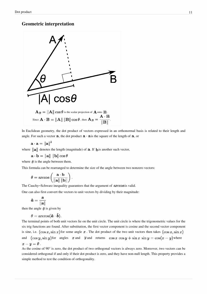
Geometric interpretation
is the scalar projection of onto .
Since , then .
In Euclidean geometry, the dot product of vectors expressed in an orthonormal basis is related to their length andangle. For such a vector , the dot product is the square of the length of , or
where denotes the length (magnitude) of . If is another such vector,
where is the angle between them.This formula can be rearranged to determine the size of the angle between two nonzero vectors:
The Cauchy–Schwarz inequality guarantees that the argument of is valid.One can also first convert the vectors to unit vectors by dividing by their magnitude:
then the angle is given by
The terminal points of both unit vectors lie on the unit circle. The unit circle is where the trigonometric values for thesix trig functions are found. After substitution, the first vector component is cosine and the second vector componentis sine, i.e. for some angle . The dot product of the two unit vectors then takes and for angles and and returns where
.As the cosine of 90° is zero, the dot product of two orthogonal vectors is always zero. Moreover, two vectors can beconsidered orthogonal if and only if their dot product is zero, and they have non-null length. This property provides asimple method to test the condition of orthogonality.

Dot product 12
Sometimes these properties are also used for "defining" the dot product, especially in 2 and 3 dimensions; thisdefinition is equivalent to the above one. For higher dimensions the formula can be used to define the concept ofangle.The geometric properties rely on the basis being orthonormal, i.e. composed of pairwise perpendicular vectors withunit length.
Scalar projectionIf both and have length one (i.e., they are unit vectors), their dot product simply gives the cosine of the anglebetween them.
If only is a unit vector, then the dot product gives , i.e., the magnitude of the projection of inthe direction of , with a minus sign if the direction is opposite. This is called the scalar projection of onto ,or scalar component of in the direction of (see figure). This property of the dot product has several usefulapplications (for instance, see next section).
If neither nor is a unit vector, then the magnitude of the projection of in the direction of is , as
the unit vector in the direction of is .
RotationWhen an orthonormal basis that the vector is represented in terms of is rotated, 's matrix in the new basis isobtained through multiplying by a rotation matrix . This matrix multiplication is just a compact representationof a sequence of dot products.For instance, let
• and be two different orthonormal bases of the same space , with obtained by just rotating ,
• represent vector in terms of ,• represent the same vector in terms of the rotated basis ,• , , , be the rotated basis vectors , , represented in terms of .Then the rotation from to is performed as follows:
Notice that the rotation matrix is assembled by using the rotated basis vectors , , as its rows, andthese vectors are unit vectors. By definition, consists of a sequence of dot products between each of the threerows of and vector . Each of these dot products determines a scalar component of in the direction of arotated basis vector (see previous section).If is a row vector, rather than a column vector, then must contain the rotated basis vectors in its columns, andmust post-multiply :
Dot product 13
PhysicsIn physics, vector magnitude is a scalar in the physical sense, i.e. a physical quantity independent of the coordinatesystem, expressed as the product of a numerical value and a physical unit, not just a number. The dot product is alsoa scalar in this sense, given by the formula, independent of the coordinate system. Example:• Mechanical work is the dot product of force and displacement vectors.• Magnetic flux is the dot product of the magnetic field and the area vectors.
PropertiesThe following properties hold if a, b, and c are real vectors and r is a scalar.The dot product is commutative:
The dot product is distributive over vector addition:
The dot product is bilinear:
When multiplied by a scalar value, dot product satisfies:
(these last two properties follow from the first two).Two non-zero vectors a and b are orthogonal if and only if a • b = 0.Unlike multiplication of ordinary numbers, where if ab = ac, then b always equals c unless a is zero, the dot productdoes not obey the cancellation law:
If a • b = a • c and a ≠ 0, then we can write: a • (b − c) = 0 by the distributive law; the result above says thisjust means that a is perpendicular to (b − c), which still allows (b − c) ≠ 0, and therefore b ≠ c.
Provided that the basis is orthonormal, the dot product is invariant under isometric changes of the basis: rotations,reflections, and combinations, keeping the origin fixed. The above mentioned geometric interpretation relies on thisproperty. In other words, for an orthonormal space with any number of dimensions, the dot product is invariant undera coordinate transformation based on an orthogonal matrix. This corresponds to the following two conditions:• The new basis is again orthonormal (i.e., it is orthonormal expressed in the old one).• The new base vectors have the same length as the old ones (i.e., unit length in terms of the old basis).If a and b are functions, then the derivative of a • b is a' • b + a • b'

Dot product 14
Triple product expansionThis is a very useful identity (also known as Lagrange's formula) involving the dot- and cross-products. It iswritten as
which is easier to remember as "BAC minus CAB", keeping in mind which vectors are dotted together. This formulais commonly used to simplify vector calculations in physics.
Proof of the geometric interpretationConsider the element of Rn
Repeated application of the Pythagorean theorem yields for its length |v|
But this is the same as
so we conclude that taking the dot product of a vector v with itself yields the squared length of the vector.Lemma 1
Now consider two vectors a and b extending from the origin, separated by an angle θ. A third vector c may bedefined as
creating a triangle with sides a, b, and c. According to the law of cosines, we have
Substituting dot products for the squared lengths according to Lemma 1, we get
(1)
But as c ≡ a − b, we also have
,which, according to the distributive law, expands to
(2)
Merging the two c • c equations, (1) and (2), we obtain
Subtracting a • a + b • b from both sides and dividing by −2 leaves
Q.E.D.

Dot product 15
Generalization
Real vector spacesThe inner product generalizes the dot product to abstract vector spaces over the real numbers and is usually denotedby . Due to the geometric interpretation of the dot product the norm ||a|| of a vector a in such an innerproduct space is defined as
such that it generalizes length, and the angle θ between two vectors a and b by
In particular, two vectors are considered orthogonal if their inner product is zero
Complex vectorsFor vectors with complex entries, using the given definition of the dot product would lead to quite differentgeometric properties. For instance the dot product of a vector with itself can be an arbitrary complex number, andcan be zero without the vector being the zero vector; this in turn would have severe consequences for notions likelength and angle. Many geometric properties can be salvaged, at the cost of giving up the symmetric and bilinearproperties of the scalar product, by alternatively defining
where bi is the complex conjugate of bi. Then the scalar product of any vector with itself is a non-negative realnumber, and it is nonzero except for the zero vector. However this scalar product is not linear in b (but ratherconjugate linear), and the scalar product is not symmetric either, since
The angle between two complex vectors is then given by
This type of scalar product is nevertheless quite useful, and leads to the notions of Hermitian form and of generalinner product spaces.The Frobenius inner product generalizes the dot product to matrices. It is defined as the sum of the products of thecorresponding components of two matrices having the same size.
Generalization to tensorsThe dot product between a tensor of order n and a tensor of order m is a tensor of order n+m-2. The dot product iscalculated by multiplying and summing across a single index in both tensors. If and are two tensors withelement representation and the elements of the dot product are given by
This definition naturally reduces to the standard vector dot product when applied to vectors, and matrixmultiplication when applied to matrices .Occasionally, a double dot product is used to represent multiplying and summing across two indices. The double dotproduct between two 2nd order tensors is a scalar quantity.
Dot product 16
External links• Weisstein, Eric W., "Dot product [1]" from MathWorld.• A quick geometrical derivation and interpretation of dot product [2]
• Interactive GeoGebra Applet [3]
• Java demonstration of dot product [4]
• Another Java demonstration of dot product [5]
• Explanation of dot product including with complex vectors [6]
• "Dot Product" [7] by Bruce Torrence, Wolfram Demonstrations Project, 2007.
References[1] http:/ / mathworld. wolfram. com/ DotProduct. html[2] http:/ / behindtheguesses. blogspot. com/ 2009/ 04/ dot-and-cross-products. html[3] http:/ / xahlee. org/ SpecialPlaneCurves_dir/ ggb/ Vector_Dot_Product. html[4] http:/ / www. falstad. com/ dotproduct/[5] http:/ / www. cs. brown. edu/ exploratories/ freeSoftware/ repository/ edu/ brown/ cs/ exploratories/ applets/ dotProduct/ dot_product_guide.
html[6] http:/ / www. mathreference. com/ la,dot. html[7] http:/ / demonstrations. wolfram. com/ DotProduct/
Cross productIn mathematics, the cross product, vector product, or Gibbs vector product is a binary operation on two vectorsin three-dimensional space. It results in a vector which is perpendicular to both of the vectors being multiplied andnormal to the plane containing them. The name "cross product" is derived from the cross symbol "×" that is oftenused to designate this operation; the alternative name "vector product" emphasizes the vector (rather than scalar)nature of the result. It has many applications in mathematics, engineering and physics.If either of the vectors being multiplied is zero or the vectors are parallel then their cross product is zero. Moregenerally, the magnitude of the product equals the area of a parallelogram with the vectors for sides; in particular forperpendicular vectors this is a rectangle and the magnitude of the product is the product of their lengths. The crossproduct is anticommutative, distributive over addition and satisfies the Jacobi identity. The space and product forman algebra over a field, which is neither commutative nor associative, but is a Lie algebra with the cross productbeing the Lie bracket.Like the dot product, it depends on the metric of Euclidean space, but unlike the dot product, it also depends on thechoice of orientation or "handedness". The product can be generalized in various ways; it can be made independentof orientation by changing the result to pseudovector, or in arbitrary dimensions the exterior product of vectors canbe used with a bivector or two-form result. Also, using the orientation and metric structure just as for the traditional3-dimensional cross product, one can in n dimensions take the product of n − 1 vectors to produce a vectorperpendicular to all of them. But if the product is limited to non-trivial binary products with vector results, it existsonly in three and seven dimensions.[1]

Cross product 17
The cross-product in respect to a right-handedcoordinate system
Definition
Finding the direction of the cross product by theright-hand rule
The cross product of two vectors a and b is denoted by a × b. Inphysics, sometimes the notation a ∧ b is used,[2] though this is avoidedin mathematics to avoid confusion with the exterior product.
The cross product a × b is defined as a vector c that is perpendicular toboth a and b, with a direction given by the right-hand rule and amagnitude equal to the area of the parallelogram that the vectors span.
The cross product is defined by the formula[3] [4]
where θ is the measure of the smaller angle between a and b (0° ≤ θ ≤ 180°), a and b are the magnitudes of vectors aand b (i.e., a = |a| and b = |b|), and n is a unit vector perpendicular to the plane containing a and b in the directiongiven by the right-hand rule as illustrated. If the vectors a and b are parallel (i.e., the angle θ between them is either0° or 180°), by the above formula, the cross product of a and b is the zero vector 0.The direction of the vector n is given by the right-hand rule, where one simply points the forefinger of the right handin the direction of a and the middle finger in the direction of b. Then, the vector n is coming out of the thumb (seethe picture on the right). Using this rule implies that the cross-product is anti-commutative, i.e., b × a = −(a × b). Bypointing the forefinger toward b first, and then pointing the middle finger toward a, the thumb will be forced in theopposite direction, reversing the sign of the product vector.Using the cross product requires the handedness of the coordinate system to be taken into account (as explicit in the definition above). If a left-handed coordinate system is used, the direction of the vector n is given by the left-hand

Cross product 18
rule and points in the opposite direction.This, however, creates a problem because transforming from one arbitrary reference system to another (e.g., a mirrorimage transformation from a right-handed to a left-handed coordinate system), should not change the direction of n.The problem is clarified by realizing that the cross-product of two vectors is not a (true) vector, but rather apseudovector. See cross product and handedness for more detail.
Computing the cross product
Coordinate notationThe standard basis vectors i, j, and k satisfy the following equalities:
Together with the skew-symmetry and bilinearity of the product, these three identities are sufficient to determine thecross product of any two vectors. In particular, the following identities can be established:
(the zero vector)These can be used to compute the product of two general vectors, a = a1i + a2j + a3k and b = b1i + b2j + b3k, byexpanding the product using distributivity then collecting similar terms:
Or written as column vectors:
Matrix notationThe definition of the cross product can also be represented by the determinant of a formal matrix:
This determinant can be computed using Sarrus' rule or Cofactor expansion.Using Sarrus' Rule, it expands to
Using Cofactor expansion along the first row instead, it expands to[5]
which gives the components of the resulting vector directly.An elegant, alternative derivation is based on an isometric sketch of (x,y,z) axes with the (x,y,z) components of eachvector (A,B) drawn parallel to the corresponding axes. The resulting formula for the constituents of the cross product
Cross product 19
(C = A x B) then appears by inspection, provided we are careful to take all orthogonal cross products in the orderA:B (such as Az x Bx). For example, this method yields the magnitude (Cz = AxBy - AyBx) for the vectorcomponent along the z-axis and unit vector (k).
Properties
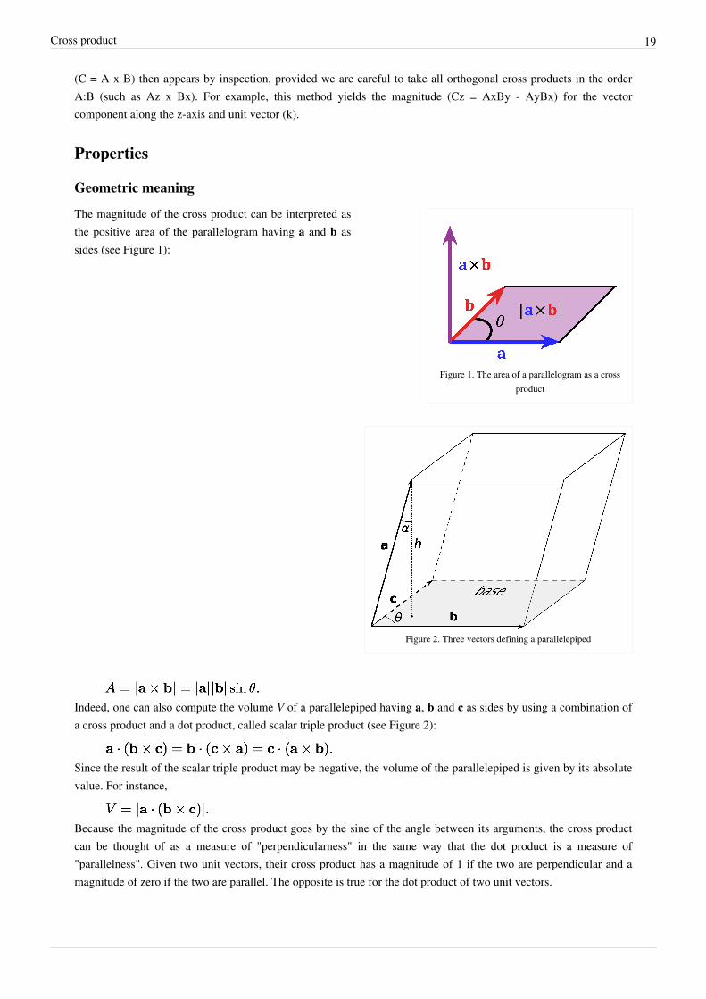
Geometric meaning
Figure 1. The area of a parallelogram as a crossproduct
Figure 2. Three vectors defining a parallelepiped
The magnitude of the cross product can be interpreted asthe positive area of the parallelogram having a and b assides (see Figure 1):
Indeed, one can also compute the volume V of a parallelepiped having a, b and c as sides by using a combination ofa cross product and a dot product, called scalar triple product (see Figure 2):
Since the result of the scalar triple product may be negative, the volume of the parallelepiped is given by its absolutevalue. For instance,
Because the magnitude of the cross product goes by the sine of the angle between its arguments, the cross productcan be thought of as a measure of "perpendicularness" in the same way that the dot product is a measure of"parallelness". Given two unit vectors, their cross product has a magnitude of 1 if the two are perpendicular and amagnitude of zero if the two are parallel. The opposite is true for the dot product of two unit vectors.
Cross product 20
Unit vectors enable two convenient identities: the dot product of two unit vectors yields the cosine (which may bepositive or negative) of the angle between the two unit vectors. The magnitude of the cross product of the two unitvectors yields the sine (which will always be positive).
Algebraic propertiesThe cross product is anticommutative,
distributive over addition,
and compatible with scalar multiplication so that
It is not associative, but satisfies the Jacobi identity:
Distributivity, linearity and Jacobi identity show that R3 together with vector addition and the cross product forms aLie algebra, the Lie algebra of the real orthogonal group in 3 dimensions, SO(3).The cross product does not obey the cancellation law: a × b = a × c with non-zero a does not imply that b = c.Instead if a × b = a × c:
If neither a nor b - c is zero then from the definition of the cross product the angle between them must be zero andthey must be parallel. They are related by a scale factor, so one of b or c can be expressed in terms of the other, forexample
for some scalar t.If a · b = a · c and a × b = a × c, for non-zero vector a, then b = c, as
and
so b − c is both parallel and perpendicular to the non-zero vector a, something that is only possible if b − c = 0 sothey are identical.From the geometrical definition the cross product is invariant under rotations about the axis defined by a × b. Moregenerally the cross product obeys the following identity under matrix transformations:
where is a 3 by 3 matrix and is the transpose of the inverseThe cross product of two vectors in 3-D always lies in the null space of the matrix with the vectors as rows:
For the sum of two cross products, the following identity holds:
Cross product 21
DifferentiationThe product rule applies to the cross product in a similar manner:
This identity can be easily proved using the matrix multiplication representation.
Triple product expansionThe cross product is used in both forms of the triple product. The scalar triple product of three vectors is defined as
It is the signed volume of the parallelepiped with edges a, b and c and as such the vectors can be used in any orderthat's an even permutation of the above ordering. The following therefore are equal:
The vector triple product is the cross product of a vector with the result of another cross product, and is related to thedot product by the following formula
The mnemonic "BAC minus CAB" is used to remember the order of the vectors in the right hand member. Thisformula is used in physics to simplify vector calculations. A special case, regarding gradients and useful in vectorcalculus, is
where ∇2 is the vector Laplacian operator.Another identity relates the cross product to the scalar triple product:
Alternative formulationThe cross product and the dot product are related by:
The right-hand side is the Gram determinant of a and b, the square of the area of the parallelogram defined by thevectors. This condition determines the magnitude of the cross product. Namely, since the dot product is defined, interms of the angle θ between the two vectors, as:
the above given relationship can be rewritten as follows:
Invoking the Pythagorean trigonometric identity one obtains:
which is the magnitude of the cross product expressed in terms of θ, equal to the area of the parallelogram defined bya and b (see definition above).The combination of this requirement and the property that the cross product be orthogonal to its constituents a and bprovides an alternative definition of the cross product.[6]
Cross product 22
Lagrange's identityThe relation:
can be compared with another relation involving the right-hand side, namely Lagrange's identity expressed as:[7]
where a and b may be n-dimensional vectors. In the case n=3, combining these two equations results in theexpression for the magnitude of the cross product in terms of its components:[8]
The same result is found directly using the components of the cross-product found from:
In R3 Lagrange's equation is a special case of the multiplicativity |vw| = |v||w| of the norm in the quaternion algebra.It is a special case of another formula, also sometimes called Lagrange's identity, which is the three dimensional caseof the Binet-Cauchy identity:[9] [10]
If a = c and b = d this simplifies to the formula above.
Alternative ways to compute the cross product
Conversion to matrix multiplicationThe vector cross product also can be expressed as the product of a skew-symmetric matrix and a vector:[9]
where superscript T refers to the Transpose matrix, and [a]× is defined by:
Also, if a is itself a cross product:
then
This result can be generalized to higher dimensions using geometric algebra. In particular in any dimension bivectors can be identified with skew-symmetric matrices, so the product between a skew-symmetric matrix and vector is equivalent to the grade-1 part of the product of a bivector and vector. In three dimensions bivectors are dual to vectors so the product is equivalent to the cross product, with the bivector instead of its vector dual. In higher dimensions the product can still be calculated but bivectors have more degrees of freedom and are not equivalent to

Cross product 23
vectors.This notation is also often much easier to work with, for example, in epipolar geometry.From the general properties of the cross product follows immediately that
and and from fact that [a]× is skew-symmetric it follows that
The above-mentioned triple product expansion (bac-cab rule) can be easily proven using this notation.The above definition of [a]× means that there is a one-to-one mapping between the set of 3×3 skew-symmetricmatrices, also known as the Lie algebra of SO(3), and the operation of taking the cross product with some vector a.
Index notationThe cross product can alternatively be defined in terms of the Levi-Civita symbol, εijk:
where the indices correspond, as in the previous section, to orthogonal vector components. Thischaracterization of the cross product is often expressed more compactly using the Einstein summation convention as
in which repeated indices are summed from 1 to 3. Note that this representation is another form of theskew-symmetric representation of the cross product:
In classical mechanics: representing the cross-product with the Levi-Civita symbol can causemechanical-symmetries to be obvious when physical-systems are isotropic in space. (Quick example: consider aparticle in a Hooke's Law potential in three-space, free to oscillate in three dimensions; none of these dimensions are"special" in any sense, so symmetries lie in the cross-product-represented angular-momentum which are made clearby the abovementioned Levi-Civita representation).
MnemonicThe word "xyzzy" can be used to remember the definition of the cross product.If
where:
then:
The second and third equations can be obtained from the first by simply vertically rotating the subscripts, x → y → z→ x. The problem, of course, is how to remember the first equation, and two options are available for this purpose:either to remember the relevant two diagonals of Sarrus's scheme (those containing i), or to remember the xyzzysequence.

Cross product 24
Since the first diagonal in Sarrus's scheme is just the main diagonal of the above-mentioned matrix, the firstthree letters of the word xyzzy can be very easily remembered.
Cross VisualizationSimilarly to the mnemonic device above, a "cross" or X can be visualized between the two vectors in the equation.This may help you to remember the correct cross product formula.If
then:
If we want to obtain the formula for we simply drop the and from the formula, and take the next twocomponents down -
It should be noted that when doing this for the next two elements down should "wrap around" the matrix so thatafter the z component comes the x component. For clarity, when performing this operation for , the next twocomponents should be z and x (in that order). While for the next two components should be taken as x and y.
For then, if we visualize the cross operator as pointing from an element on the left to an element on the right, wecan take the first element on the left and simply multiply by the element that the cross points to in the right handmatrix. We then subtract the next element down on the left, multiplied by the element that the cross points to here aswell. This results in our formula -
We can do this in the same way for and to construct their associated formulas.
Applications
Computational geometryThe cross product can be used to calculate the normal for a triangle or polygon, an operation frequently performed incomputer graphics. For example, the winding of polygon (clockwise or anticlockwise) about a point within thepolygon (i.e. the centroid or mid-point) can be calculated by triangulating the polygon (like spoking a wheel) andsumming the angles (between the spokes) using the cross product to keep track of the sign of each angle.In computational geometry of the plane, the cross product is used to determine the sign of the acute angle defined bythree points , and . It corresponds to the direction of the cross product of the twocoplanar vectors defined by the pairs of points and , i.e., by the sign of the expression
. In the "right-handed" coordinate system, if the result is 0, the points arecollinear; if it is positive, the three points constitute a negative angle of rotation around from to , otherwisea positive angle. From another point of view, the sign of tells whether lies to the left or to the right of line .

Cross product 25
MechanicsMoment of a force applied at point B around point A is given as:
OtherThe cross product occurs in the formula for the vector operator curl. It is also used to describe the Lorentz forceexperienced by a moving electrical charge in a magnetic field. The definitions of torque and angular momentum alsoinvolve the cross product.The trick of rewriting a cross product in terms of a matrix multiplication appears frequently in epipolar andmulti-view geometry, in particular when deriving matching constraints.
Cross product as an exterior product
The cross product in relation to the exteriorproduct. In red are the orthogonal unit vector, and
the "parallel" unit bivector.
The cross product can be viewed in terms of the exterior product. Thisview allows for a natural geometric interpretation of the cross product.In exterior calculus the exterior product (or wedge product) of twovectors is a bivector. A bivector is an oriented plane element, in muchthe same way that a vector is an oriented line element. Given twovectors a and b, one can view the bivector a∧b as the orientedparallelogram spanned by a and b. The cross product is then obtainedby taking the Hodge dual of the bivector a∧b, identifying 2-vectorswith vectors:
This can be thought of as the oriented multi-dimensional element "perpendicular" to the bivector. Only in threedimensions is the result an oriented line element – a vector – whereas, for example, in 4 dimensions the Hodge dualof a bivector is two-dimensional – another oriented plane element. So, only in three dimensions is the cross productof a and b the vector dual to the bivector a∧b: it is perpendicular to the bivector, with orientation dependent on thecoordinate system's handedness, and has the same magnitude relative to the unit normal vector as a∧b has relative tothe unit bivector; precisely the properties described above.
Cross product and handednessWhen measurable quantities involve cross products, the handedness of the coordinate systems used cannot bearbitrary. However, when physics laws are written as equations, it should be possible to make an arbitrary choice ofthe coordinate system (including handedness). To avoid problems, one should be careful to never write down anequation where the two sides do not behave equally under all transformations that need to be considered. Forexample, if one side of the equation is a cross product of two vectors, one must take into account that when thehandedness of the coordinate system is not fixed a priori, the result is not a (true) vector but a pseudovector.Therefore, for consistency, the other side must also be a pseudovector.More generally, the result of a cross product may be either a vector or a pseudovector, depending on the type of itsoperands (vectors or pseudovectors). Namely, vectors and pseudovectors are interrelated in the following ways under
Cross product 26
application of the cross product:• vector × vector = pseudovector• pseudovector × pseudovector = pseudovector• vector × pseudovector = vector• pseudovector × vector = vector.So by the above relationships, the unit basis vectors i, j and k of an orthonormal, right-handed (Cartesian) coordinateframe must all be pseudovectors (if a basis of mixed vector types is disallowed, as it normally is) since i × j = k, j ×k = i and k × i = j.Because the cross product may also be a (true) vector, it may not change direction with a mirror imagetransformation. This happens, according to the above relationships, if one of the operands is a (true) vector and theother one is a pseudovector (e.g., the cross product of two vectors). For instance, a vector triple product involvingthree (true) vectors is a (true) vector.A handedness-free approach is possible using exterior algebra.
GeneralizationsThere are several ways to generalize the cross product to the higher dimensions.
Lie algebraThe cross product can be seen as one of the simplest Lie products, and is thus generalized by Lie algebras, which areaxiomatized as binary products satisfying the axioms of multilinearity, skew-symmetry, and the Jacobi identity.Many Lie algebras exist, and their study is a major field of mathematics, called Lie theory.For example, the Heisenberg algebra gives another Lie algebra structure on In the basis the product is
QuaternionsFurther information: quaternions and spatial rotationThe cross product can also be described in terms of quaternions, and this is why the letters i, j, k are a convention forthe standard basis on . The unit vectors i, j, k correspond to "binary" (180 deg) rotations about their respectiveaxes (Altmann, S. L., 1986, Ch. 12), said rotations being represented by "pure" quaternions (zero scalar part) withunit norms.For instance, the above given cross product relations among i, j, and k agree with the multiplicative relations amongthe quaternions i, j, and k. In general, if a vector [a1, a2, a3] is represented as the quaternion a1i + a2j + a3k, the crossproduct of two vectors can be obtained by taking their product as quaternions and deleting the real part of the result.The real part will be the negative of the dot product of the two vectors.Alternatively and more straightforwardly, using the above identification of the 'purely imaginary' quaternions with
, the cross product may be thought of as half of the commutator of two quaternions.

Cross product 27
OctonionsA cross product for 7-dimensional vectors can be obtained in the same way by using the octonions instead of thequaternions. The nonexistence of such cross products of two vectors in other dimensions is related to the result thatthe only normed division algebras are the ones with dimension 1, 2, 4, and 8; Hurwitz's theorem.
Wedge productIn general dimension, there is no direct analogue of the binary cross product. There is however the wedge product,which has similar properties, except that the wedge product of two vectors is now a 2-vector instead of an ordinaryvector. As mentioned above, the cross product can be interpreted as the wedge product in three dimensions afterusing Hodge duality to identify 2-vectors with vectors.The wedge product and dot product can be combined to form the Clifford product.
Multilinear algebraIn the context of multilinear algebra, the cross product can be seen as the (1,2)-tensor (a mixed tensor, specifically abilinear map) obtained from the 3-dimensional volume form,[11] a (0,3)-tensor, by raising an index.In detail, the 3-dimensional volume form defines a product by taking the determinant of the matrixgiven by these 3 vectors. By duality, this is equivalent to a function (fixing any two inputs gives afunction by evaluating on the third input) and in the presence of an inner product (such as the dot product;more generally, a non-degenerate bilinear form), we have an isomorphism and thus this yields a map
which is the cross product: a (0,3)-tensor (3 vector inputs, scalar output) has been transformed into a(1,2)-tensor (2 vector inputs, 1 vector output) by "raising an index".Translating the above algebra into geometry, the function "volume of the parallelepiped defined by " (wherethe first two vectors are fixed and the last is an input), which defines a function , can be represented uniquelyas the dot product with a vector: this vector is the cross product From this perspective, the cross product isdefined by the scalar triple product, In the same way, in higher dimensions one may define generalized cross products by raising indices of then-dimensional volume form, which is a -tensor. The most direct generalizations of the cross product are todefine either:• a -tensor, which takes as input vectors, and gives as output 1 vector – an -ary vector-valued
product, or• a -tensor, which takes as input 2 vectors and gives as output skew-symmetric tensor of rank n−2 – a
binary product with rank n−2 tensor values. One can also define -tensors for other k.
These products are all multilinear and skew-symmetric, and can be defined in terms of the determinant and parity.The -ary product can be described as follows: given vectors in define their generalizedcross product as:• perpendicular to the hyperplane defined by the • magnitude is the volume of the parallelotope defined by the which can be computed as the Gram determinant
of the • oriented so that is positively oriented.This is the unique multilinear, alternating product which evaluates to , and so forthfor cyclic permutations of indices.In coordinates, one can give a formula for this -ary analogue of the cross product in Rn by:

Cross product 28
This formula is identical in structure to the determinant formula for the normal cross product in R3 except that therow of basis vectors is the last row in the determinant rather than the first. The reason for this is to ensure that theordered vectors (v1,...,vn-1,Λ(v1,...,vn-1)) have a positive orientation with respect to (e1,...,en). If n is odd, thismodification leaves the value unchanged, so this convention agrees with the normal definition of the binary product.In the case that n is even, however, the distinction must be kept. This -ary form enjoys many of the sameproperties as the vector cross product: it is alternating and linear in its arguments, it is perpendicular to eachargument, and its magnitude gives the hypervolume of the region bounded by the arguments. And just like the vectorcross product, it can be defined in a coordinate independent way as the Hodge dual of the wedge product of thearguments.
HistoryIn 1773, Joseph Louis Lagrange introduced the component form of both the dot and cross products in order to studythe tetrahedron in three dimensions.[12] In 1843 the Irish mathematical physicist Sir William Rowan Hamiltonintroduced the quaternion product, and with it the terms "vector" and "scalar". Given two quaternions [0, u] and [0,v], where u and v are vectors in R3, their quaternion product can be summarized as [−u·v, u×v]. James ClerkMaxwell used Hamilton's quaternion tools to develop his famous electromagnetism equations, and for this and otherreasons quaternions for a time were an essential part of physics education.In 1878 William Kingdon Clifford published his Elements of Dynamic which was an advanced text for its time. Hedefined the product of two vectors[13] to have magnitude equal to the area of the parallelogram of which they are twosides, and direction perpendicular to their plane.Oliver Heaviside in England and Josiah Willard Gibbs, a professor at Yale University in Connecticut, also felt thatquaternion methods were too cumbersome, often requiring the scalar or vector part of a result to be extracted. Thus,about forty years after the quaternion product, the dot product and cross product were introduced—to heatedopposition. Pivotal to (eventual) acceptance was the efficiency of the new approach, allowing Heaviside to reducethe equations of electromagnetism from Maxwell's original 20 to the four commonly seen today.[14]
Largely independent of this development, and largely unappreciated at the time, Hermann Grassmann created ageometric algebra not tied to dimension two or three, with the exterior product playing a central role. WilliamKingdon Clifford combined the algebras of Hamilton and Grassmann to produce Clifford algebra, where in the caseof three-dimensional vectors the bivector produced from two vectors dualizes to a vector, thus reproducing the crossproduct.The cross notation, which began with Gibbs, inspired the name "cross product". Originally it appeared in privatelypublished notes for his students in 1881 as Elements of Vector Analysis. The utility for mechanics was noted byAleksandr Kotelnikov. Gibbs's notation —and the name— later reached a wide audience through Vector Analysis, atextbook by Edwin Bidwell Wilson, a former student. Wilson rearranged material from Gibbs's lectures, togetherwith material from publications by Heaviside, Föpps, and Hamilton. He divided vector analysis into three parts:
First, that which concerns addition and the scalar and vector products of vectors. Second, that which concernsthe differential and integral calculus in its relations to scalar and vector functions. Third, that which containsthe theory of the linear vector function.
Two main kinds of vector multiplications were defined, and they were called as follows:• The direct, scalar, or dot product of two vectors• The skew, vector, or cross product of two vectors
Cross product 29
Several kinds of triple products and products of more than three vectors were also examined. The above mentionedtriple product expansion was also included.
Notes[1] WS Massey (1983). "Cross products of vectors in higher dimensional Euclidean spaces". The American Mathematical Monthly 90 (10):
697–701. doi:10.2307/2323537. JSTOR 2323537. "If one requires only three basic properties of the cross product ... it turns out that a crossproduct of vectors exists only in 3-dimensional and 7-dimensional Euclidean space."
[2] Jeffreys, H and Jeffreys, BS (1999). Methods of mathematical physics (http:/ / worldcat. org/ oclc/ 41158050?tab=details). CambridgeUniversity Press. .
[3] Wilson 1901, p. 60–61[4] Dennis G. Zill, Michael R. Cullen (2006). "Definition 7.4: Cross product of two vectors" (http:/ / books. google. com/
?id=x7uWk8lxVNYC& pg=PA324). Advanced engineering mathematics (3rd ed.). Jones & Bartlett Learning. p. 324. ISBN 076374591X. .[5] Dennis G. Zill, Michael R. Cullen (2006). "Equation 7: a × b as sum of determinants" (http:/ / books. google. com/ ?id=x7uWk8lxVNYC&
pg=PA321). cited work. Jones & Bartlett Learning. p. 321. ISBN 076374591X. .[6] WS Massey (Dec. 1983). "Cross products of vectors in higher dimensional Euclidean spaces". The American Mathematical Monthly (The
American Mathematical Monthly, Vol. 90, No. 10) 90 (10): 697–701. doi:10.2307/2323537. JSTOR 2323537.[7] Vladimir A. Boichenko, Gennadiĭ Alekseevich Leonov, Volker Reitmann (2005). Dimension theory for ordinary differential equations (http:/
/ books. google. com/ ?id=9bN1-b_dSYsC& pg=PA26). Vieweg+Teubner Verlag. p. 26. ISBN 3519004372. .[8] Pertti Lounesto (2001). Clifford algebras and spinors (http:/ / books. google. com/ ?id=kOsybQWDK4oC& pg=PA94& dq="which+ in+
coordinate+ form+ means+ Lagrange's+ identity"& cd=1#v=onepage& q="which in coordinate form means Lagrange's identity") (2nd ed.).Cambridge University Press. p. 94. ISBN 0521005515. .
[9] Shuangzhe Liu and Gõtz Trenkler (2008). "Hadamard, Khatri-Rao, Kronecker and other matrix products" (http:/ / www. math. ualberta. ca/ijiss/ SS-Volume-4-2008/ No-1-08/ SS-08-01-17. pdf). Int J Information and systems sciences (Institute for scientific computing andeducation) 4 (1): 160–177. .
[10] by Eric W. Weisstein (2003). "Binet-Cauchy identity" (http:/ / books. google. com/ ?id=8LmCzWQYh_UC& pg=PA228). CRC conciseencyclopedia of mathematics (2nd ed.). CRC Press. p. 228. ISBN 1584883472. .
[11] By a volume form one means a function that takes in n vectors and gives out a scalar, the volume of the parallelotope defined by the vectors:This is an n-ary multilinear skew-symmetric form. In the presence of a basis, such as on this is given by the
determinant, but in an abstract vector space, this is added structure. In terms of G-structures, a volume form is an -structure.[12] Lagrange, JL (1773). "Solutions analytiques de quelques problèmes sur les pyramides triangulaires". Oeuvres. vol 3.[13] William Kingdon Clifford (1878) Elements of Dynamic (http:/ / dlxs2. library. cornell. edu/ cgi/ t/ text/
text-idx?c=math;cc=math;view=toc;subview=short;idno=04370002), Part I, page 95, London: MacMillan & Co; online presentation byCornell University Historical Mathematical Monographs
[14] Nahin, Paul J. (2000). Oliver Heaviside: the life, work, and times of an electrical genius of the Victorian age. JHU Press. pp. 108–109.ISBN 0-801-86909-9.
References• Cajori, Florian (1929). A History Of Mathematical Notations Volume II (http:/ / www. archive. org/ details/
historyofmathema027671mbp). Open Court Publishing. p. 134. ISBN 978-0-486-67766-8• E. A. Milne (1948) Vectorial Mechanics, Chapter 2: Vector Product, pp 11 –31, London: Methuen Publishing.• Wilson, Edwin Bidwell (1901). Vector Analysis: A text-book for the use of students of mathematics and physics,
founded upon the lectures of J. Willard Gibbs (http:/ / www. archive. org/ details/ 117714283). Yale UniversityPress

Cross product 30
External links• Weisstein, Eric W., " Cross Product (http:/ / mathworld. wolfram. com/ CrossProduct. html)" from MathWorld.• A quick geometrical derivation and interpretation of cross products (http:/ / behindtheguesses. blogspot. com/
2009/ 04/ dot-and-cross-products. html)• Z.K. Silagadze (2002). Multi-dimensional vector product. Journal of Physics. A35, 4949 (http:/ / uk. arxiv. org/
abs/ math. la/ 0204357) (it is only possible in 7-D space)• Real and Complex Products of Complex Numbers (http:/ / www. cut-the-knot. org/ arithmetic/ algebra/
RealComplexProducts. shtml)• An interactive tutorial (http:/ / physics. syr. edu/ courses/ java-suite/ crosspro. html) created at Syracuse
University - (requires java)• W. Kahan (2007). Cross-Products and Rotations in Euclidean 2- and 3-Space. University of California, Berkeley
(PDF). (http:/ / www. cs. berkeley. edu/ ~wkahan/ MathH110/ Cross. pdf)
Spherical coordinate system
A spherical coordinate system with origin O, zenith direction Zand azimuth axis A. The point has radius r = 4, inclination θ = 70°,
and azimuth φ = 130°.
In mathematics, a spherical coordinate system is acoordinate system for three-dimensional space where theposition of a point is specified by three numbers: theradial distance of that point from a fixed origin, itsinclination angle measured from a fixed zenith direction,and the azimuth angle of its orthogonal projection on areference plane that passes through the origin and isorthogonal to the zenith, measured from a fixed referencedirection on that plane. The inclination angle is oftenreplaced by the elevation angle measured from thereference plane.
The radial distance is also called the radius or radialcoordinate, and the inclination may be called colatitude,zenith angle, normal angle, or polar angle.
In geography and astronomy, the elevation and azimuth(or quantities very close to them) are called the latitudeand longitude for geography and "declination" and "rightascension" for astronomy, respectively; and the radial distance is usually replaced by an altitude (measured from acentral point or from a sea level surface).
The concept of spherical coordinates can be extended to higher dimensional spaces and are then referred to ashyperspherical coordinates.
Spherical coordinate system 31
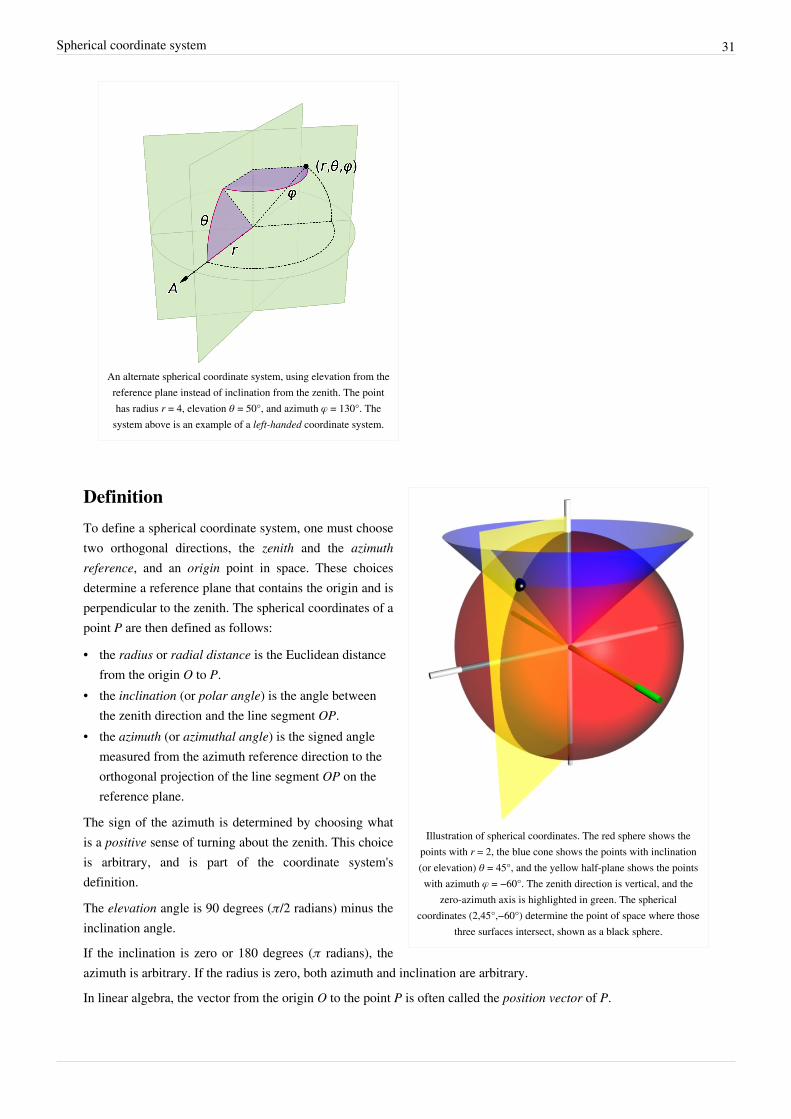
An alternate spherical coordinate system, using elevation from thereference plane instead of inclination from the zenith. The pointhas radius r = 4, elevation θ = 50°, and azimuth φ = 130°. The
system above is an example of a left-handed coordinate system.
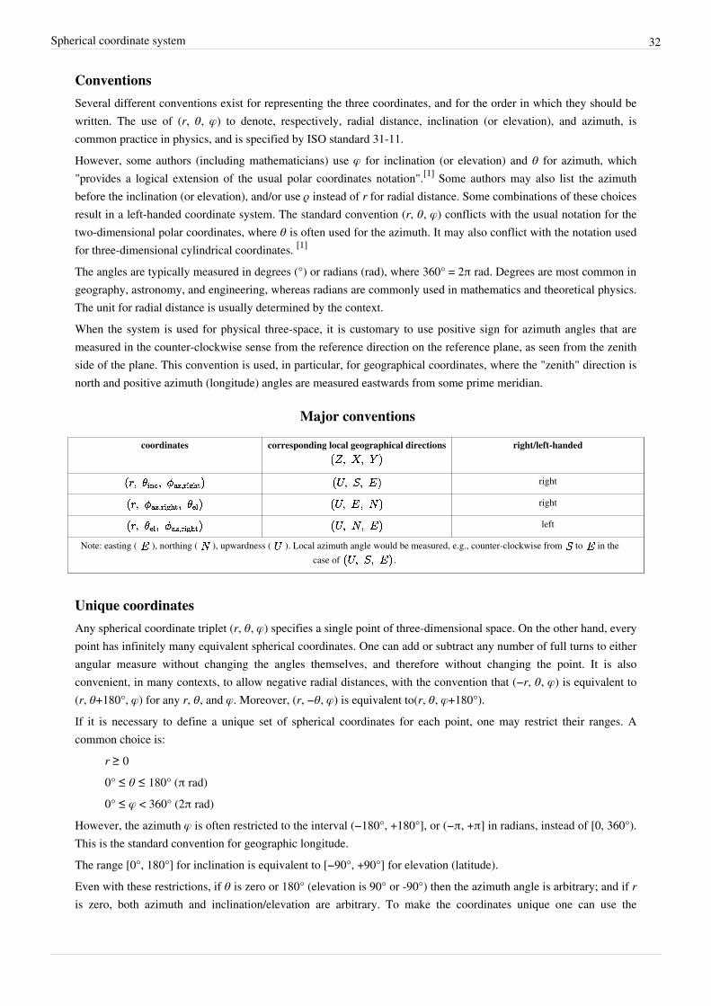
Illustration of spherical coordinates. The red sphere shows thepoints with r = 2, the blue cone shows the points with inclination(or elevation) θ = 45°, and the yellow half-plane shows the pointswith azimuth φ = −60°. The zenith direction is vertical, and the
zero-azimuth axis is highlighted in green. The sphericalcoordinates (2,45°,−60°) determine the point of space where those
three surfaces intersect, shown as a black sphere.
Definition
To define a spherical coordinate system, one must choosetwo orthogonal directions, the zenith and the azimuthreference, and an origin point in space. These choicesdetermine a reference plane that contains the origin and isperpendicular to the zenith. The spherical coordinates of apoint P are then defined as follows:
• the radius or radial distance is the Euclidean distancefrom the origin O to P.
• the inclination (or polar angle) is the angle betweenthe zenith direction and the line segment OP.
• the azimuth (or azimuthal angle) is the signed anglemeasured from the azimuth reference direction to theorthogonal projection of the line segment OP on thereference plane.
The sign of the azimuth is determined by choosing whatis a positive sense of turning about the zenith. This choiceis arbitrary, and is part of the coordinate system'sdefinition.
The elevation angle is 90 degrees (π/2 radians) minus theinclination angle.
If the inclination is zero or 180 degrees (π radians), theazimuth is arbitrary. If the radius is zero, both azimuth and inclination are arbitrary.
In linear algebra, the vector from the origin O to the point P is often called the position vector of P.
Spherical coordinate system 32
ConventionsSeveral different conventions exist for representing the three coordinates, and for the order in which they should bewritten. The use of (r, θ, φ) to denote, respectively, radial distance, inclination (or elevation), and azimuth, iscommon practice in physics, and is specified by ISO standard 31-11.However, some authors (including mathematicians) use φ for inclination (or elevation) and θ for azimuth, which"provides a logical extension of the usual polar coordinates notation".[1] Some authors may also list the azimuthbefore the inclination (or elevation), and/or use ρ instead of r for radial distance. Some combinations of these choicesresult in a left-handed coordinate system. The standard convention (r, θ, φ) conflicts with the usual notation for thetwo-dimensional polar coordinates, where θ is often used for the azimuth. It may also conflict with the notation usedfor three-dimensional cylindrical coordinates. [1]
The angles are typically measured in degrees (°) or radians (rad), where 360° = 2π rad. Degrees are most common ingeography, astronomy, and engineering, whereas radians are commonly used in mathematics and theoretical physics.The unit for radial distance is usually determined by the context.When the system is used for physical three-space, it is customary to use positive sign for azimuth angles that aremeasured in the counter-clockwise sense from the reference direction on the reference plane, as seen from the zenithside of the plane. This convention is used, in particular, for geographical coordinates, where the "zenith" direction isnorth and positive azimuth (longitude) angles are measured eastwards from some prime meridian.
Major conventions
coordinates corresponding local geographical directions right/left-handed
right
right
left
Note: easting ( ), northing ( ), upwardness ( ). Local azimuth angle would be measured, e.g., counter-clockwise from to in thecase of .
Unique coordinatesAny spherical coordinate triplet (r, θ, φ) specifies a single point of three-dimensional space. On the other hand, everypoint has infinitely many equivalent spherical coordinates. One can add or subtract any number of full turns to eitherangular measure without changing the angles themselves, and therefore without changing the point. It is alsoconvenient, in many contexts, to allow negative radial distances, with the convention that (−r, θ, φ) is equivalent to(r, θ+180°, φ) for any r, θ, and φ. Moreover, (r, −θ, φ) is equivalent to(r, θ, φ+180°).If it is necessary to define a unique set of spherical coordinates for each point, one may restrict their ranges. Acommon choice is:
r ≥ 00° ≤ θ ≤ 180° (π rad)0° ≤ φ < 360° (2π rad)
However, the azimuth φ is often restricted to the interval (−180°, +180°], or (−π, +π] in radians, instead of [0, 360°).This is the standard convention for geographic longitude.The range [0°, 180°] for inclination is equivalent to [−90°, +90°] for elevation (latitude).Even with these restrictions, if θ is zero or 180° (elevation is 90° or -90°) then the azimuth angle is arbitrary; and if r is zero, both azimuth and inclination/elevation are arbitrary. To make the coordinates unique one can use the

Spherical coordinate system 33
convention that in these cases the arbitrary coordinates are zero.
PlottingTo plot a point from its spherical coordinates (r, θ, φ), where θ is inclination, move r units from the origin in thezenith direction, rotate by θ about the origin towards the azimuth reference direction, and rotate by φ about thezenith in the proper direction.
ApplicationsThe geographic coordinate system uses the azimuth and elevation of the spherical coordinate system to expresslocations on Earth, calling them respectively longitude and latitude. Just as the two-dimensional Cartesian coordinatesystem is useful on the plane, a two-dimensional spherical coordinate system is useful on the surface of a sphere. Inthis system, the sphere is taken as a unit sphere, so the radius is unity and can generally be ignored. Thissimplification can also be very useful when dealing with objects such as rotational matrices.Spherical coordinates are useful in analyzing systems that have some degree of symmetry about a point, such asvolume integrals inside a sphere, the potential energy field surrounding a concentrated mass or charge, or globalweather simulation in a planet's atmosphere. A sphere that has the Cartesian equation x2 + y2 + z2 = c2 has the simpleequation r = c in spherical coordinates.Two important partial differential equations that arise in many physical problems, Laplace's equation and theHelmholtz equation, allow a separation of variables in spherical coordinates. The angular portions of the solutions tosuch equations take the form of spherical harmonics.Another application is ergonomic design, where r is the arm length of a stationary person and the angles describe thedirection of the arm as it reaches out.
The output pattern of an industrial loudspeakershown using spherical polar plots taken at six
frequencies
Three dimensional modeling of loudspeaker output patterns can beused to predict their performance. A number of polar plots arerequired, taken at a wide selection of frequencies, as the patternchanges greatly with frequency. Polar plots help to show that manyloudspeakers tend toward omnidirectionality at lower frequencies.
The spherical coordinate system is also commonly used in 3D gamedevelopment to rotate the camera around the player's position.
Coordinate system conversions
As the spherical coordinate system is only one of manythree-dimensional coordinate systems, there exist equations forconverting coordinates between the spherical coordinate system andothers.
Cartesian coordinates
The spherical coordinates (ρ, φ, θ) of a point can be obtained from itsCartesian coordinates (x, y, z) by the formulae
Spherical coordinate system 34
The inverse tangent denoted in φ = arctan(y/x) must be suitably defined, taking into account the correct quadrant of(x,y). See article atan2.Alternatively, the conversion can be considered as two sequential rectangular to polar conversions: the first in theCartesian x−y plane from (x,y) to (R,φ), where R is the projection of r onto the x−y plane, and the second in theCartesian z-R plane from (z,R) to (r,θ). The correct quadrants for φ and θ are implied by the correctness of the planarrectangular to polar conversions.These formulae assume that the two systems have the same origin, that the spherical reference plane is the Cartesianx−y plane, that θ is inclination from the z direction, and that the azimuth angles are measured from the Cartesian xaxis (so that the y axis has φ=+90°). If θ measures elevation from the reference plane instead of inclination from thezenith the arccos above becomes an arcsin, and the cos θ and sin θ below become switched.Conversely, the Cartesian coordinates may be retrieved from the spherical coordinates (r, φ, θ), where r ∈ [0, ∞ ), φ∈ [0, 2π ), θ ∈ [0, π ], by:
Geographic coordinatesTo a first approximation, the geographic coordinate system uses elevation angle (latitude), usually denoted by δ or θ,in degrees north of the equator plane, in the range −90° ≤ δ ≤ 90°, instead of inclination. The azimuth angle(longitude) is measured in degrees east or west from some conventional reference meridian (most commonly that ofthe Greenwich Observatory), so its domain is −180° ≤ φ ≤ 180°. For positions on the Earth or other solid celestialbody, the reference plane is usually taken to be the plane perpendicular to the axis of rotation. In astronomy one maymeasure latitude either from the celestial equator (defined by the Earth's rotation) or the plane of the ecliptic (definedby Earth's orbit around the sun) or, sometimes, the galactic equator (defined by the rotation of the galaxy).The zenith angle or inclination, which is 90° minus the latitude and ranges from 0 to 180°, is called colatitude ingeography.Instead of the radial distance, geographers commonly use altitude above some reference surface, which may be thesea level or "mean" surface level for planets without liquid oceans. The radial distance r can be computed from thealtitude by adding the mean radius of the planet's reference surface, which is approximately 6,360±11 km for Earth.However, modern geographical coordinate systems are quite complex, and the positions implied by these simpleformulae may be wrong by several kilometers. The precise standard meanings of latitude, longitude and altitude arecurrently defined by the World Geodetic System (WGS), and take into account the flattening of the Earth at the poles(about 21 km) and many other details.

Spherical coordinate system 35
Cylindrical coordinatesCylindrical coordinates (r, φ, z) may be converted into spherical coordinates (ρ, θ, φ), by the formulas
Conversely, the spherical coordinates may be converted into cylindrical coordinates by the formulae
These formulae assume that the two systems have the same origin and same reference plane, measure the azimuthangle φ in the same sense from the same axis, and that the spherical angle θ is inclination from the cylindrical z axis.
Integration and differentiation in spherical coordinatesThe following equations assume that θ is inclination from the normal axis:
The line element for an infinitesimal displacement from to is
where are the local orthogonal unit vectors in the directions of increasing , respectively.The surface element spanning from to and to on a spherical surface at (constant) radius is
Thus the differential solid angle is
The surface element in a surface of polar angle constant (a cone with vertex the origin) is
The surface element in a surface of azimuth constant (a vertical half-plane) is
The volume element spanning from to , to , and to is
Therefore every point in R3 can be integrated by the triple integral
The del operator in this system is not defined, and so the gradient, divergence and curl must be defined explicitly:

Spherical coordinate system 36
KinematicsIn spherical coordinates the position of a point is written,
its velocity is then,
and its acceleration is,
In the case of a constant φ this reduces to vector calculus in polar coordinates.
Notes[1] Eric W. Weisstein (2005-10-26). "Spherical Coordinates" (http:/ / mathworld. wolfram. com/ SphericalCoordinates. html). MathWorld. .
Retrieved 2010-01-15.
Bibliography• Morse PM, Feshbach H (1953). Methods of Theoretical Physics, Part I. New York: McGraw-Hill. pp. 658.
ISBN 0-07-043316-X. LCCN 52-11515.• Margenau H, Murphy GM (1956). The Mathematics of Physics and Chemistry. New York: D. van Nostrand.
pp. 177–178. LCCN 55-10911.• Korn GA, Korn TM (1961). Mathematical Handbook for Scientists and Engineers. New York: McGraw-Hill.
pp. 174–175. LCCN 59-14456, ASIN B0000CKZX7.• Sauer R, Szabó I (1967). Mathematische Hilfsmittel des Ingenieurs. New York: Springer Verlag. pp. 95–96.
LCCN 67-25285.• Moon P, Spencer DE (1988). "Spherical Coordinates (r, θ, ψ)". Field Theory Handbook, Including Coordinate
Systems, Differential Equations, and Their Solutions (corrected 2nd ed., 3rd print ed. ed.). New York:Springer-Verlag. pp. 24–27 (Table 1.05). ISBN 978-0387184302.
External links• MathWorld description of spherical coordinates (http:/ / mathworld. wolfram. com/ SphericalCoordinates. html)• Coordinate Converter - converts between polar, Cartesian and spherical coordinates (http:/ / www.
random-science-tools. com/ maths/ coordinate-converter. htm)• Spherical Coordinates (http:/ / www. math. montana. edu/ frankw/ ccp/ multiworld/ multipleIVP/ spherical/ body.
htm) Animations illustrating spherical coordinates by Frank Wattenberg• Conventions for Spherical Coordinates (http:/ / www. physics. oregonstate. edu/ bridge/ papers/ spherical. pdf)
Description of the different conventions in use for naming components of spherical coordinates, along with aproposal for standardizing this.

Spherical trigonometry 37
Spherical trigonometry
Spherical triangle
Spherical trigonometry is a branch of spherical geometry which dealswith polygons (especially triangles) on the sphere and the relationshipsbetween the sides and the angles. This is of great importance forcalculations in astronomy and earth-surface, orbital and spacenavigation.
History
Spherical triangles were studied by early Greek mathematicians suchas Menelaus of Alexandria, who wrote a book on spherical trianglescalled Sphaerica and developed Menelaus' theorem.[1] E. S. Kennedy,however, points out that while it was possible in ancient mathematicsto compute the magnitudes of a spherical figure, in principle, by use ofthe table of chords and Menelaus' theorem, the application of thetheorem to spherical problems was very difficult in practice.[2]
Tycho Brahe remarks [3] that the nature of understanding spherical triangles is so divine and elevated that it is notappropriate to extend its mysteries to everyone. (Diuinior et excellentior sit Triangulorum sphæricorum cognitio,quam fas sit eius mysteria omnibus propalare.)
Islamic worldFurther advances were made in the Islamic world. In order to observe holy days on the Islamic calendar in whichtimings were determined by phases of the moon, the astronomers initially used Menalaus' method to calculate theplace of the moon and stars, though this method proved to be clumsy and difficult. It involved setting up twointersecting right triangles; by applying Menelaus' theorem it was possible to solve one of the six sides, but only ifthe other five sides were known. To tell the time from the sun's altitude, for instance, repeated applications ofMenelaus' theorem were required. For medieval Islamic astronomers, there was an obvious challenge to find asimpler trigonometric method.[4]
In the early 9th century, Muhammad ibn Mūsā al-Khwārizmī, a Persian Mathematician, was an early pioneer inspherical trigonometry and wrote a treatise on the subject.[5] In the 10th century, another Persian Mathematician Abūal-Wafā' al-Būzjānī established the angle addition formulas, e.g., sin(a + b), and discovered the sine formula forspherical trigonometry:[6]
Here, a, b, and c are the angles at the centre of the sphere subtended by the three sides of the triangle, and α, β, and γare the angles between the sides, where angle α is opposite the side which subtends angle a, etc.Al-Jayyani (989-1079), an Arabic mathematician in Islamic Iberian Peninsula, wrote what some consider the firsttreatise on spherical trigonometry, circa 1060, entitled The book of unknown arcs of a sphere,[7] in which sphericaltrigonometry was brought into its modern form. Al-Jayyani's book "contains formulae for right-angle triangles, thegeneral law of sines and the solution of a spherical triangle by means of the polar triangle". This treatise later had a"strong influence on European mathematics", and his "definition of ratios as numbers" and "method of solving aspherical triangle when all sides are unknown" are likely to have influenced Regiomontanus.[7]
In the 13th century, Persian mathematician Nasīr al-Dīn al-Tūsī was the first to treat trigonometry as a mathematical discipline independent from astronomy, and he further developed spherical trigonometry, bringing it to its present

Spherical trigonometry 38
form.[8] He listed the six distinct cases of a right-angled triangle in spherical trigonometry. In his On the SectorFigure, he also stated the law of sines for plane and spherical triangles, and discovered the law of tangents forspherical triangles.[9]
Lines and angles on a sphereOn the surface of a sphere, the closest analogue to straight lines are great circles, i.e. circles whose centers coincidewith the center of the sphere. For example, simplifying the shape of the Earth (the geoid) to a sphere, the meridiansand the equator are great circles on its surface, while non-equatorial lines of latitude are small circles. As with a linesegment in a plane, an arc of a great circle (subtending less than 180°) on a sphere is the shortest path lying on thesphere between its two endpoints. Great circles are special cases of the concept of a geodesic.An area on the sphere bounded by arcs of great circles is called a spherical polygon. Note that, unlike the case on aplane, spherical "biangles" (two-sided analogs to triangle) are possible (such as a slice cut out of an orange). Such apolygon is also called a lune.The sides of these polygons are specified not by their lengths, but by the angles at the sphere's center subtended tothe endpoints of the sides. Note that this arc angle, measured in radians, when multiplied by the sphere's radiusequals the arc length. (In the special case of polygons on the surface of a sphere of radius one, the arc length of anyside equals its subtended angle.)Hence, a spherical triangle is specified as usual by its corner angles and its sides, but the sides are given not by theirlength, but by their arc angle.The sum of the vertex angles of spherical triangles is always larger than the sum of the angles of plane triangles,which is exactly 180°. The amount E by which the sum of the angles exceeds 180° is called spherical excess:
where α, β and γ denote the angles in degrees. Girard's theorem, named after the 16th century Frenchmathematician Albert Girard (earlier discovered but not published by the English mathematician Thomas Harriot),states that this surplus determines the surface area of any spherical triangle:
where R is the radius of the sphere. From this and the area formula for a sphere it follows that the sum of the anglesof a spherical triangle is .
The analogous result holds for hyperbolic triangles, with "excess" replaced by "defect"; these are both special casesof the Gauss-Bonnet theorem.It follows from here that there are no non-trivial similar triangles (triangles with equal angles but different sidelengths and area) on a sphere. In the special case of a sphere of radius 1, the area simply equals the excess angle: A =E. One can also use Girard's formula to obtain the discrete Gauss-Bonnet theorem.To solve a geometric problem on the sphere, one dissects the relevant figure into right spherical triangles (i.e.: oneof the triangle's corner angles is 90°) because one can then use Napier's pentagon.

Spherical trigonometry 39
Napier's Pentagon
Napier's Circle shows the relations of parts of a right sphericaltriangle
Napier's pentagon (also known as Napier's circle) is amnemonic aid that helps to find all relations betweenthe angles in a right spherical triangle.
Write the six angles of the triangle (three vertex angles,three arc angles) in the form of a circle, sticking to theorder as they appear in the triangle (i.e.: start with acorner angle, write the arc angle of an attached sidenext to it, proceed with the next corner angle, etc. andclose the circle). Then cross out the 90° corner angleand replace all angles non-adjacent to it by theircomplement to 90° (i.e. replace, say, B by 90° − B).The five numbers that you now have on your paperform Napier's Pentagon (or Napier's Circle). For any
choice of three angles, one (the middle angle) will be either adjacent to or opposite the other two angles. ThenNapier's Rules hold that the sine of the middle angle is equal to:
• the product of the tangents of the adjacent angles• the product of the cosines of the opposite anglesThe mnemonic for remembering the trigonometric function to use is that the first vowel of the adjective describingeach angle (e.g., i for middle) is the first vowel of the name of the function. As an example, starting with the angle
, we can obtain the formula:
Using the identities for complementary angles, this becomes:
See also the Haversine formula, which relates the lengths of sides and angles in spherical triangles in a numericallystable form for navigation.
Congruent triangles on a sphereAs with plane triangles, on a sphere two triangles sharing the same sequence of angle, side, angle (ASA) arenecessarily congruent (that is, they have three identical sides and three identical angles). This can be seen as follows:One can situate one of the vertices with a given angle at the south pole and run the side with given length up theprime meridian. Knowing both angles at either end of the segment of fixed length ensures that the other two sidesemanate with a uniquely determined trajectory, and thus will meet each other at a uniquely determined point; thusASA is valid.On the other hand, a like sequence of side, side, side (SSS) does not ensure congruence: For example, with sidelengths of , and one has a continuous family of non-congruent triangles.
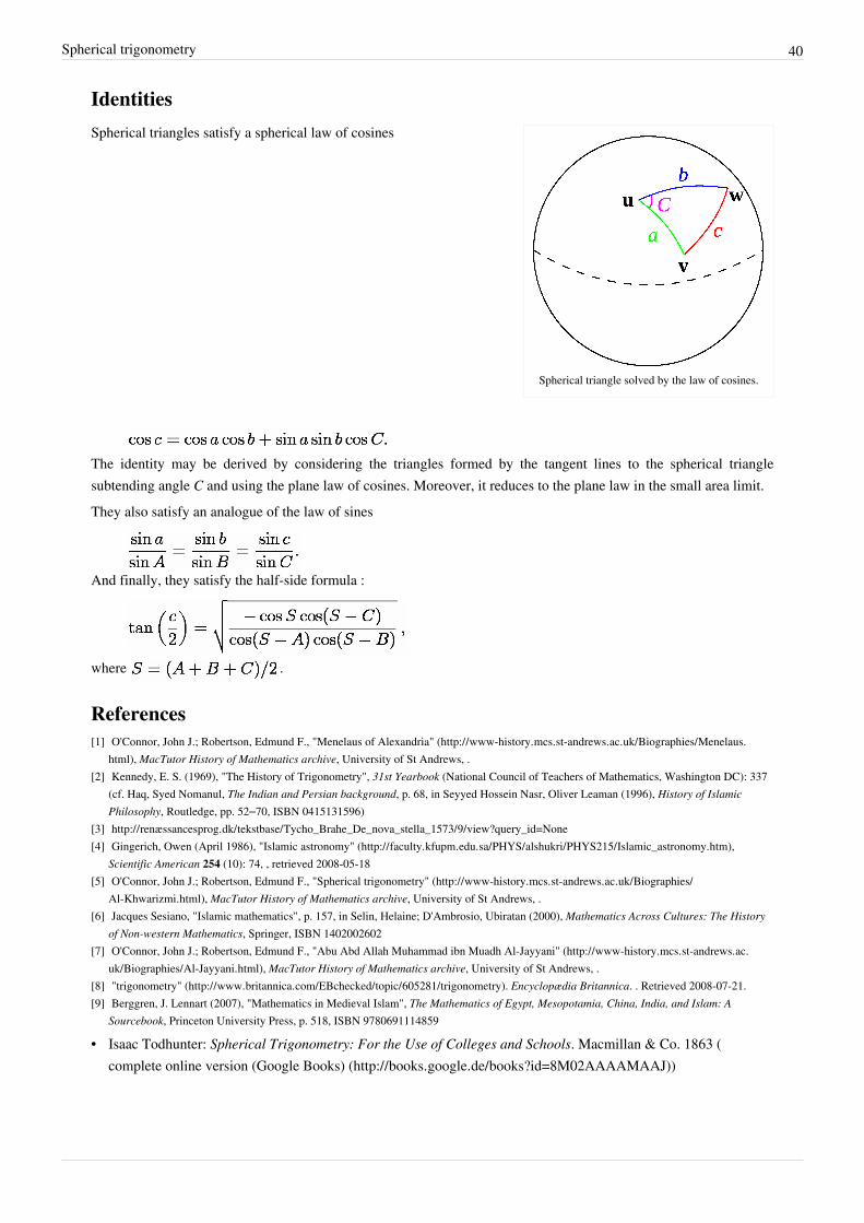
Spherical trigonometry 40
Identities
Spherical triangle solved by the law of cosines.
Spherical triangles satisfy a spherical law of cosines
The identity may be derived by considering the triangles formed by the tangent lines to the spherical trianglesubtending angle C and using the plane law of cosines. Moreover, it reduces to the plane law in the small area limit.They also satisfy an analogue of the law of sines
And finally, they satisfy the half-side formula :
where .
References[1] O'Connor, John J.; Robertson, Edmund F., "Menelaus of Alexandria" (http:/ / www-history. mcs. st-andrews. ac. uk/ Biographies/ Menelaus.
html), MacTutor History of Mathematics archive, University of St Andrews, .[2] Kennedy, E. S. (1969), "The History of Trigonometry", 31st Yearbook (National Council of Teachers of Mathematics, Washington DC): 337
(cf. Haq, Syed Nomanul, The Indian and Persian background, p. 68, in Seyyed Hossein Nasr, Oliver Leaman (1996), History of IslamicPhilosophy, Routledge, pp. 52–70, ISBN 0415131596)
[3] http:/ / renæssancesprog. dk/ tekstbase/ Tycho_Brahe_De_nova_stella_1573/ 9/ view?query_id=None[4] Gingerich, Owen (April 1986), "Islamic astronomy" (http:/ / faculty. kfupm. edu. sa/ PHYS/ alshukri/ PHYS215/ Islamic_astronomy. htm),
Scientific American 254 (10): 74, , retrieved 2008-05-18[5] O'Connor, John J.; Robertson, Edmund F., "Spherical trigonometry" (http:/ / www-history. mcs. st-andrews. ac. uk/ Biographies/
Al-Khwarizmi. html), MacTutor History of Mathematics archive, University of St Andrews, .[6] Jacques Sesiano, "Islamic mathematics", p. 157, in Selin, Helaine; D'Ambrosio, Ubiratan (2000), Mathematics Across Cultures: The History
of Non-western Mathematics, Springer, ISBN 1402002602[7] O'Connor, John J.; Robertson, Edmund F., "Abu Abd Allah Muhammad ibn Muadh Al-Jayyani" (http:/ / www-history. mcs. st-andrews. ac.
uk/ Biographies/ Al-Jayyani. html), MacTutor History of Mathematics archive, University of St Andrews, .[8] "trigonometry" (http:/ / www. britannica. com/ EBchecked/ topic/ 605281/ trigonometry). Encyclopædia Britannica. . Retrieved 2008-07-21.[9] Berggren, J. Lennart (2007), "Mathematics in Medieval Islam", The Mathematics of Egypt, Mesopotamia, China, India, and Islam: A
Sourcebook, Princeton University Press, p. 518, ISBN 9780691114859
• Isaac Todhunter: Spherical Trigonometry: For the Use of Colleges and Schools. Macmillan & Co. 1863 (complete online version (Google Books) (http:/ / books. google. de/ books?id=8M02AAAAMAAJ))

Spherical trigonometry 41
External links• Wolfram's mathworld: Spherical Trigonometry (http:/ / mathworld. wolfram. com/ SphericalTrigonometry. html)
a more thorough list of identities, with some derivation• Wolfram's mathworld: Spherical Triangle (http:/ / mathworld. wolfram. com/ SphericalTriangle. html) nice applet• Intro to Spherical Trig. (http:/ / www. rwgrayprojects. com/ rbfnotes/ trig/ strig/ strig. html) Includes discussion of
The Napier circle and Napier's rules• Spherical Trigonometry — for the use of colleges and schools (http:/ / historical. library. cornell. edu/ cgi-bin/
cul. math/ docviewer?did=00640001& seq=5& frames=0& view=50) by I. Todhunter, M.A., F.R.S. HistoricalMath Monograph posted by Cornell University Library (http:/ / historical. library. cornell. edu/ math/ index.html).
• A Visual Proof of Girard's Theorem (http:/ / demonstrations. wolfram. com/ AVisualProofOfGirardsTheorem/ )by Okay Arik, the Wolfram Demonstrations Project.
Spherical law of cosinesIn spherical trigonometry, the law of cosines (also called the cosine rule for sides[1] ) is a theorem relating the sidesand angles of spherical triangles, analogous to the ordinary law of cosines from plane trigonometry.
Spherical triangle solved by the law of cosines.
Given a unit sphere, a "spherical triangle" on the surface of the sphereis defined by the great circles connecting three points u, v, and w onthe sphere (shown at right). If the lengths of these three sides are a(from u to v), b (from u to w), and c (from v to w), and the angle of thecorner opposite c is C, then the (first) spherical law of cosines states:[2]
[1]
Since this is a unit sphere, the lengths a, b, and c are simply equal to the angles (in radians) subtended by those sidesfrom the center of the sphere (for a non-unit sphere, they are the distances divided by the radius). As a special case,for , then and one obtains the spherical analogue of the Pythagorean theorem:
A variation on the law of cosines, the second spherical law of cosines,[3] (also called the cosine rule for angles[1] )states:
where A and B are the angles of the corners opposite to sides a and b, respectively. It can be obtained fromconsideration of a spherical triangle dual to the given one.If the law of cosines is used to solve for c, the necessity of inverting the cosine magnifies rounding errors when c issmall. In this case, the alternative formulation of the law of haversines is preferable.[4]

Spherical law of cosines 42
For small spherical triangles, i.e. for small a, b, and c, the spherical law of cosines is approximately the same as theordinary planar law of cosines,
The error in this approximation, which can be obtained from the Maclaurin series for the cosine and sine functions, isof order
ProofA proof of the law of cosines can be constructed as follows.[2] Let u, v, and w denote the unit vectors from the centerof the sphere to those corners of the triangle. Then, the lengths (angles) of the sides are given by the dot products:
To get the angle C, we need the tangent vectors ta and tb at u along the directions of sides a and b, respectively. Forexample, the tangent vector ta is the unit vector perpendicular to u in the u-v plane, whose direction is given by thecomponent of v perpendicular to u. This means:
where for the denominator we have used the Pythagorean identity sin2(a) = 1 − cos2(a). Similarly,
Then, the angle C is given by:
from which the law of cosines immediately follows.
Proof without vectorsTo the diagram above, add a plane tangent to the sphere at u, and extend radii from the center of the sphere O tomeet the plane at points y and z. We then have two plane triangles with a side in common: the triangle containing u,y and z and the one containing O, y and z. Sides of the first triangle are tan a and tan b, with angle C between them;sides of the second triangle are sec a and sec b, with angle c between them. By the law of cosines for plane triangles(and remembering that of any angle is ),
So
Multiply both sides by and rearrange.
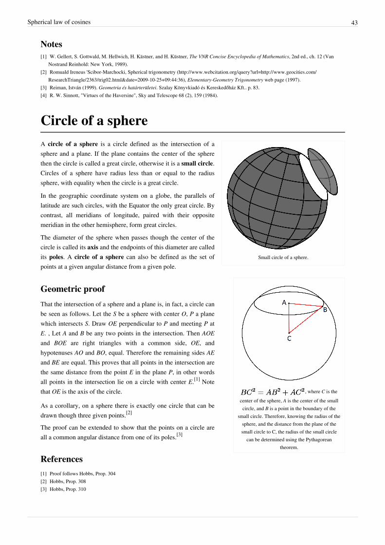
Spherical law of cosines 43
Notes[1] W. Gellert, S. Gottwald, M. Hellwich, H. Kästner, and H. Küstner, The VNR Concise Encyclopedia of Mathematics, 2nd ed., ch. 12 (Van
Nostrand Reinhold: New York, 1989).[2] Romuald Ireneus 'Scibor-Marchocki, Spherical trigonometry (http:/ / www. webcitation. org/ query?url=http:/ / www. geocities. com/
ResearchTriangle/ 2363/ trig02. html& date=2009-10-25+ 09:44:36), Elementary-Geometry Trigonometry web page (1997).[3] Reiman, István (1999). Geometria és határterületei. Szalay Könyvkiadó és Kereskedőház Kft.. p. 83.[4] R. W. Sinnott, "Virtues of the Haversine", Sky and Telescope 68 (2), 159 (1984).
Circle of a sphere
Small circle of a sphere.
, where C is thecenter of the sphere, A is the center of the smallcircle, and B is a point in the boundary of the
small circle. Therefore, knowing the radius of thesphere, and the distance from the plane of thesmall circle to C, the radius of the small circle
can be determined using the Pythagoreantheorem.
A circle of a sphere is a circle defined as the intersection of asphere and a plane. If the plane contains the center of the spherethen the circle is called a great circle, otherwise it is a small circle.Circles of a sphere have radius less than or equal to the radiussphere, with equality when the circle is a great circle.
In the geographic coordinate system on a globe, the parallels oflatitude are such circles, with the Equator the only great circle. Bycontrast, all meridians of longitude, paired with their oppositemeridian in the other hemisphere, form great circles.
The diameter of the sphere when passes though the center of thecircle is called its axis and the endpoints of this diameter are calledits poles. A circle of a sphere can also be defined as the set ofpoints at a given angular distance from a given pole.
Geometric proof
That the intersection of a sphere and a plane is, in fact, a circle canbe seen as follows. Let the S be a sphere with center O, P a planewhich intersects S. Draw OE perpendicular to P and meeting P atE. , Let A and B be any two points in the intersection. Then AOEand BOE are right triangles with a common side, OE, andhypotenuses AO and BO, equal. Therefore the remaining sides AEand BE are equal. This proves that all points in the intersection arethe same distance from the point E in the plane P, in other wordsall points in the intersection lie on a circle with center E.[1] Notethat OE is the axis of the circle.
As a corollary, on a sphere there is exactly one circle that can bedrawn though three given points.[2]
The proof can be extended to show that the points on a circle areall a common angular distance from one of its poles.[3]
References[1] Proof follows Hobbs, Prop. 304[2] Hobbs, Prop. 308[3] Hobbs, Prop. 310

Circle of a sphere 44
• Hobbs, C.A. (1921). Solid Geometry. G.H. Kent. pp. 397 ff..• Sykes, M.; Comstock, C.E. (1922). Solid Geometry. Rand McNally. pp. 81 ff..
Great circle
A great circle divides the sphere in two equalhemispheres
A great circle, also known as a Riemannian circle, of a sphere is theintersection of the sphere and a plane which passes through the centerpoint of the sphere, as opposed to a general circle of a sphere where theplane is not required to pass through the center. (A small circle is theintersection of the sphere and a plane which does not pass through thecenter.) Any diameter of any great circle coincides with a diameter ofthe sphere, and therefore all great circles have the same circumferenceas each other, and have the same center as the sphere. A great circle isthe largest circle that can be drawn on any given sphere. Every circle inEuclidean space is a great circle of exactly one sphere.
For any two points on the surface of a sphere there is a great circlethrough the two points. The minor arc of a great circle between twopoints is the shortest surface-path between them. In this sense theminor arc is analogous to “straight lines” in spherical geometry. The length of the minor arc of a great circle is takenas the distance between two points on a surface of a sphere, namely the great-circle distance. The great circles are thegeodesics of the sphere.
In higher dimensions, the great circles on the n-sphere are the intersection of the n-sphere with two-planes that passthrough the origin in the Euclidean space Rn+1.
Earth geodesics
An oblate spheroid
Strictly speaking the Earth is not a perfect sphere (it is an oblatespheroid or ellipsoid – i.e., slightly compressed at the poles), whichmeans that the shortest distance between two points (a geodesic) is notquite a great circle. The equatorial radius of the earth is about 6378.137kilometers. The polar radius of the earth is about 6356.752 kilometers(about 21.4 kilometers less). Nevertheless, the sphere model can beconsidered a first approximation.
When long distance aviation or nautical routes are drawn on a flat map(for instance, the Mercator projection), they often look curved. This isbecause they lie on great circles. A route that would appear as astraight line on the map would actually be longer. An exception is the
gnomonic projection, in which all straight lines represent great circles.
On a spherical Earth, the meridians (or lines of longitude) are great circles, as is the equator. Lines of latitude are notgreat circles, because they are smaller than the equator; their centers are not at the center of the Earth -- they aresmall circles instead. Since Earth is not a perfect sphere, the equator (which is generally considered a spherical greatcircle) is about 40,075 km, while a north-south meridian line (which is an ellipse) is almost 40,008 km. Thequadratic mean or root mean square of these extremes provides a decent approximation of the average great-circlecircumference, about 40041.5 km.[1]

Great circle 45
Great-circle route from China to Canada
Some examples of great circles on the celestial sphere include thecelestial horizon, the celestial equator, and the ecliptic.
Great circle routes are used by ships and aircraft where currents andwinds are not a significant factor. Flight lengths can therefore often beapproximated to the great-circle distance between two airports. Foraircraft travelling west between continents in the northern hemispherethese paths will extend northward near or into the Arctic region,however easterly flights will often fly a more southerly track to takeadvantage of the jet stream.
For navigational convenience, Great Circle routes are often broken into a series of shorter rhumb lines which allowthe use of constant headings between waypoints along the Great Circle.
Derivation of shortest paths
Airline routes between San Francisco and Tokyofollowing the most direct great circle (top), butfollowing the jet stream (bottom) when heading
eastwards
To prove that the minor arc of great circle is the shortest pathconnecting two points on the surface of a sphere, one has to applycalculus of variations to it.
Consider the class of all regular paths from a point p to another point q.Introduce spherical coordinates so that p coincides with the north pole.Any curve on the sphere that does not intersect either pole, exceptpossibly at the endpoints, can be parametrized by
provided we allow φ to take on arbitrary real values. The infinitesimal arc length in these coordinates is
So the length of a curve γ from p to q is a functional of the curve given by
Note that S[γ] does not exceed the length of the meridian from p to q:
Since the starting point and ending point are fixed, S is minimized if and only if φ' = 0, so the curve must lie on ameridian of the sphere φ = φ0 = constant. In Cartesian coordinates, this is
which is a plane through the origin, i.e., the center of the sphere.

Great circle 46
References[1] Elliptical great-circle radius average (http:/ / math. wikia. com/ index. php?title=Elliptical_great-circle_radius_average)
External links• Great Circle – from MathWorld (http:/ / mathworld. wolfram. com/ GreatCircle. html) Great Circle description,
figures, and equations. Mathworld, Wolfram Research, Inc. c1999• Great Circle Mapper (http:/ / www. gcmap. com/ ) Interactive tool for plotting great circle routes.• Blue Marble Mapper (http:/ / v-flyer. com/ the-toolbox/ blue-marble-mapper) Draws Great Circle routes between
airports using the NASA Blue Marble as the base map.• Air Route Calculator and Maps (http:/ / www. aircalculator. com) See Great Circle routes between most airports
using Google Maps. See closest and furthest airports from origin and destination.• Great Circle Calculator (http:/ / williams. best. vwh. net/ gccalc. htm) deriving (initial) course and distance
between two points.• Great Circle Distance (http:/ / www. acscdg. com/ ) Graphical tool for drawing great circles over maps. Also
shows distance and azimuth in a table.• Great Circles on Mercator's Chart (http:/ / demonstrations. wolfram. com/ GreatCirclesOnMercatorsChart/ ) by
John Snyder with additional contributions by Jeff Bryant, Pratik Desai, and Carl Woll, Wolfram DemonstrationsProject.
• 3D First Problem (Italian)[[Category:Articles with Italian language external links (http:/ / www. spigolo.altervista. org/ ortho/ OrthoFirstProblem. html)]] 3D javascript interactive tool (Google Chrome, Firefox, Safari(web browser)).
• 3D Second Problem (Italian)[[Category:Articles with Italian language external links (http:/ / www. spigolo.altervista. org/ ortho/ OrthoSecondProblem. html)]] 3D javascript interactive tool (Google Chrome, Firefox,Safari (web browser)).

Great-circle distance 47
Great-circle distance
Great-circle route from China to Canada
The great-circle distance or orthodromic distance is the shortestdistance between any two points on the surface of a sphere measuredalong a path on the surface of the sphere (as opposed to going throughthe sphere's interior). Because spherical geometry is rather differentfrom ordinary Euclidean geometry, the equations for distance taken ona different form. The distance between two points in Euclidean space isthe length of a straight line from one point to the other. On the sphere,however, there are no straight lines. In non-Euclidean geometry,straight lines are replaced with geodesics. Geodesics on the sphere are the great circles (circles on the sphere whosecenters are coincident with the center of the sphere).
Between any two different points on a sphere which are not directly opposite each other, there is a unique greatcircle. The two points separate the great circle into two arcs. The length of the shorter arc is the great-circle distancebetween the points. A great circle endowed with such a distance is the Riemannian circle.Between two points which are directly opposite each other, called antipodal points, there are infinitely many greatcircles, but all great circle arcs between antipodal points have the same length, i.e. half the circumference of thecircle, or , where r is the radius of the sphere.Because the Earth is nearly spherical (see Earth radius) equations for great-circle distance can be used to roughlycalculate the shortest distance between points on the surface of the Earth (as the crow flies), and so have applicationsin navigation.
FormulasLet be the geographical latitude and longitude of two points (a base "standpoint" and thedestination "forepoint"), respectively, and their differences; then , the central angle between them, isgiven by the spherical law of cosines:
The distance d, i.e. the arc length, for a sphere of radius r and given in radians, is then:
This arccosine formula above can have large rounding errors if the distance is small (if the two points are a kilometerapart the cosine of the central angle comes out 0.99999999). An equation known as the haversine formula isnumerically better-conditioned for small distances:[1]
Historically, the use of this formula was simplified by the availability of tables for the haversine function:hav(θ) = sin2 (θ/2).Although this formula is accurate for most distances on a sphere, it too suffers from rounding errors for the special(and somewhat unusual) case of antipodal points (on opposite ends of the sphere). A more complicated formula thatis accurate for all distances is the following special case (a sphere, which is an ellipsoid with equal major and minoraxes) of the Vincenty formula (which more generally is a method to compute distances on ellipsoids):[2]

Great-circle distance 48
When programming a computer, one should use the atan2() function rather than the ordinary arctangent function(atan()), in order to simplify handling of the case where the denominator is zero, and to compute unambiguously in all quadrants.If r is the great-circle radius of the sphere, then the great-circle distance is .
Vector versionAnother representation of similar formulas, but using n-vector instead of latitude/longitude to describe the positions,is found by means of 3D vector algebra, i.e. utilizing the dot product, cross product, or a combination:[3]
where and are the n-vectors representing the two positions s and f. Similarly to the equations above basedon latitude and longitude, the expression based on arctan is the only one that is well-conditioned for all angles. If thetwo positions are originally given as latitudes and longitudes, a conversion to n-vectors must first be performed.
From chord lengthA line through three-dimensional space between points of interest on a spherical Earth is the chord of the great circlebetween the points. The central angle between the two points can be determined from the chord length. The greatcircle distance is proportional to the central angle.The great circle chord length may be calculated as follows for the corresponding unit sphere, by means of Cartesiansubtraction[4] :
The central angle is:
The great circle distance is:

Great-circle distance 49
Spherical cosine for sides derivationBy using Cartesian products rather than differences, the origin of the spherical cosine for sides becomes apparent:
Radius for spherical EarthThe shape of the Earth closely resembles a flattened sphere (a spheroid) with equatorial radius of 6,378.137 km;distance from the center of the spheroid to each pole is 6356.752 km. When calculating the length of a shortnorth-south line at the equator, the sphere that best approximates that part of the spheroid has a radius of , or6,335.439 km, while the spheroid at the poles is best approximated by a sphere of radius , or 6,399.594 km, a1% difference. So as long as we're assuming a spherical Earth, any single formula for distance on the Earth is onlyguaranteed correct within 0.5% (though we can do better if our formula is only intended to apply to a limited area).The average radius for a spherical approximation of the figure of the Earth with respect to surface is approximately6371.01 km, while the quadratic mean or root mean square approximation of the average great-circle circumferencederives a radius of about 6372.8 km.[5]
Worked exampleFor an example of the formula in practice, take the latitude and longitude of two airports:
• Nashville International Airport (BNA) in Nashville, TN, USA: N 36°7.2', W 86°40.2'• Los Angeles International Airport (LAX) in Los Angeles, CA, USA: N 33°56.4', W 118°24.0'First convert the co-ordinates to decimal degrees
• BNA: • LAX: Plug these values into the spherical law of cosines:
comes out to be 25.958 degrees, or 0.45306 radians, and the great-circle distance is the assumed radius timesthat angle:
So assuming a spherical earth, distance between LAX and BNA is about 2887 km or 1794 statute miles (× 0.621371)or 1559 nautical miles (× 0.539957). Geodesic distance between the given coordinates on the GRS 80/WGS 84spheroid is 2892.777 km.

Great-circle distance 50
References[1] R.W. Sinnott, "Virtues of the Haversine", Sky and Telescope, vol. 68, no. 2, 1984, p. 159[2] Vincenty, Thaddeus (1975-04-01). "Direct and Inverse Solutions of Geodesics on the Ellipsoid with Application of Nested Equations" (http:/
/ www. ngs. noaa. gov/ PUBS_LIB/ inverse. pdf) (PDF). Survey Review (Kingston Road, Tolworth, Surrey: Directorate of Overseas Surveys)23 (176): 88–93. . Retrieved 2008-07-21.
[3] Gade, Kenneth (2010). "A non-singular horizontal position representation" (http:/ / www. navlab. net/ Publications/A_Nonsingular_Horizontal_Position_Representation. pdf) (PDF). The Journal of Navigation (Cambridge University Press) 63 (3): 395–417.doi:10.1017/S0373463309990415. .
[4] http:/ / mathcentral. uregina. ca/ QQ/ database/ QQ. 09. 09/ h/ dave2. html[5] Elliptical great-circle radius average (http:/ / math. wikia. com/ index. php?title=Elliptical_great-circle_radius_average)
External links• GreatCircle (http:/ / mathworld. wolfram. com/ GreatCircle. html) at MathWorld• Global Distance Calculator (http:/ / www. infoplease. com/ atlas/ calculate-distance. html) at Infoplease
(Warning: website uses pop-under ads).• Haversine formula in JavaScript (http:/ / www. movable-type. co. uk/ scripts/ LatLong. html) Haversine and other
formulae for calculating distances, bearings, etc.• Distance Between Two Cities (http:/ / www. distance-calculator. co. uk/ ) Site uses Haversine Formulae and
integrates Road distances too• Distance Between Two Cities Places On Map. (http:/ / www. distancefromto. net/ )• Distance Between Cities Calculator (http:/ / www. distancebetweencities. us/ )• 3D First and Second Problem (Italian)[[Category:Articles with Italian language external links (http:/ / www.
spigolo. altervista. org/ ortho/ )]] 3D javascript interactive tool (Google Chrome, Firefox).
Horizontal coordinate system
HORIZONTAL COORDINATES. Azimuth,from the North point (red) -also from the Southpoint toward the West (blue). Altitude, green.
The horizontal coordinate system is a celestial coordinate system thatuses the observer's local horizon as the fundamental plane. Thiscoordinate system divides the sky into the upper hemisphere whereobjects are visible, and the lower hemisphere where objects cannot beseen since the earth is in the way. The pole of the upper hemisphere iscalled the zenith. The pole of the lower hemisphere is called the nadir.[1]
The horizontal coordinates are:• Altitude (Alt), sometimes referred to as elevation, is the angle
between the object and the observer's local horizon. It is expressedas an angle between 0 degrees to 90 degrees.
• Azimuth (Az), that is the angle of the object around the horizon, usually measured from the north increasingtowards the east.
• Zenith distance, the distance from directly overhead (i.e. the zenith) is sometimes used instead of altitude insome calculations using these coordinates. The zenith distance is the complement of altitude (i.e. 90°-altitude).
The horizontal coordinate system is sometimes also called the az/el[2] or Alt/Az coordinate system.
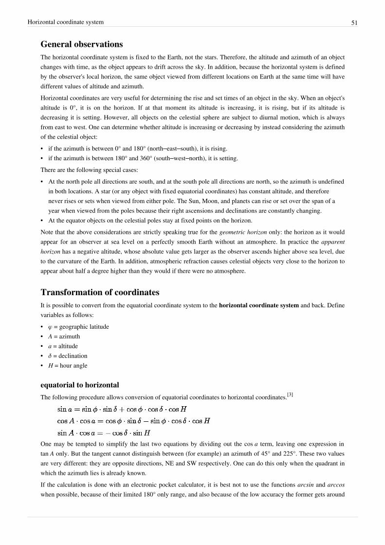
Horizontal coordinate system 51
General observationsThe horizontal coordinate system is fixed to the Earth, not the stars. Therefore, the altitude and azimuth of an objectchanges with time, as the object appears to drift across the sky. In addition, because the horizontal system is definedby the observer's local horizon, the same object viewed from different locations on Earth at the same time will havedifferent values of altitude and azimuth.Horizontal coordinates are very useful for determining the rise and set times of an object in the sky. When an object'saltitude is 0°, it is on the horizon. If at that moment its altitude is increasing, it is rising, but if its altitude isdecreasing it is setting. However, all objects on the celestial sphere are subject to diurnal motion, which is alwaysfrom east to west. One can determine whether altitude is increasing or decreasing by instead considering the azimuthof the celestial object:• if the azimuth is between 0° and 180° (north–east–south), it is rising.• if the azimuth is between 180° and 360° (south–west–north), it is setting.There are the following special cases:• At the north pole all directions are south, and at the south pole all directions are north, so the azimuth is undefined
in both locations. A star (or any object with fixed equatorial coordinates) has constant altitude, and thereforenever rises or sets when viewed from either pole. The Sun, Moon, and planets can rise or set over the span of ayear when viewed from the poles because their right ascensions and declinations are constantly changing.
• At the equator objects on the celestial poles stay at fixed points on the horizon.Note that the above considerations are strictly speaking true for the geometric horizon only: the horizon as it wouldappear for an observer at sea level on a perfectly smooth Earth without an atmosphere. In practice the apparenthorizon has a negative altitude, whose absolute value gets larger as the observer ascends higher above sea level, dueto the curvature of the Earth. In addition, atmospheric refraction causes celestial objects very close to the horizon toappear about half a degree higher than they would if there were no atmosphere.
Transformation of coordinatesIt is possible to convert from the equatorial coordinate system to the horizontal coordinate system and back. Definevariables as follows:• φ = geographic latitude• A = azimuth• a = altitude• δ = declination• H = hour angle
equatorial to horizontalThe following procedure allows conversion of equatorial coordinates to horizontal coordinates.[3]
One may be tempted to simplify the last two equations by dividing out the cos a term, leaving one expression intan A only. But the tangent cannot distinguish between (for example) an azimuth of 45° and 225°. These two valuesare very different: they are opposite directions, NE and SW respectively. One can do this only when the quadrant inwhich the azimuth lies is already known.If the calculation is done with an electronic pocket calculator, it is best not to use the functions arcsin and arccos when possible, because of their limited 180° only range, and also because of the low accuracy the former gets around

Horizontal coordinate system 52
±90° and the latter around 0° and 180°. Most scientific calculators have a rectangular to polar (R→P) and polar torectangular (P→R) function, which avoids that problem and gives us an extra sanity check as well.The algorithm then becomes as follows.• Calculate the right hand side of the three equations given above.• Apply a R→P conversion taking X = cos A cos a, and Y = sin A cos a.• The angle part of the answer is the azimuth.• Apply a second R→P conversion taking the radius part of the last answer as the X and the sin a of the first
equation as the Y value.• The angle part of the answer is the altitude, an angle between −90° and +90°.• The radius part of the answer must be 1 exactly, or you have made an error.
horizontal to equatorial
The same quadrant considerations from the first set of formulas also hold for this set.
The position of the SunThere are several ways to compute the apparent position of the Sun in horizontal coordinates.Complete and accurate algorithms to obtain precise values can be found in Jean Meeus's book AstronomicalAlgorithms.Instead a simple approximate algorithm is the following:Given:• the date of the year and the time of the day• the observer's latitude, longitude and time zoneYou have to compute:• The Sun declination of the corresponding day of the year, which is given by the following formula which has less
than 2 degrees of error:
where is the number of days spent since January 1.• The true hour angle that is the angle which the earth should rotate to take the observer's location directly under the
sun.• Let hh:mm be the time the observer reads on the clock.• Merge the hours and the minutes in one variable = hh + mm/60 measured in hours.• hh:mm is the official time of the time zone, but it is different from the true local time of the observer's location.
has to be corrected adding the quantity + (Longitude/15 – Time Zone), which is measured in hours andrepresents the difference of time between the true local time of the observer's location and the official time ofthe time zone.
• If it is summer and Daylight Saving Time is used, you have to subtract one hour in order to get Standard Time.• The value of the Equation of Time in that day has to be added. Since is measured in hours, the Equation of
Time must be divided by 60 before being added.• The hour angle can be now computed. In fact the angle which the earth should rotate to take the observer's
location directly under the sun is given by the following expression: = (12 – ) * 15. Since is
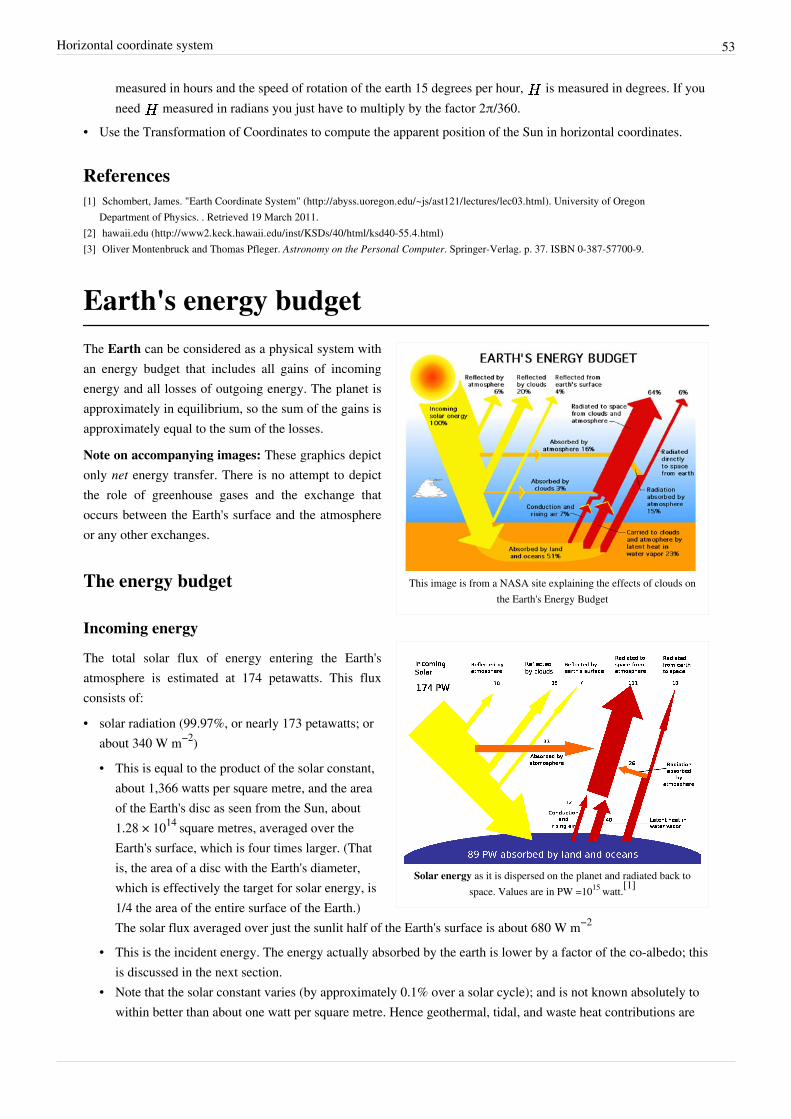
Horizontal coordinate system 53
measured in hours and the speed of rotation of the earth 15 degrees per hour, is measured in degrees. If youneed measured in radians you just have to multiply by the factor 2π/360.
• Use the Transformation of Coordinates to compute the apparent position of the Sun in horizontal coordinates.
References[1] Schombert, James. "Earth Coordinate System" (http:/ / abyss. uoregon. edu/ ~js/ ast121/ lectures/ lec03. html). University of Oregon
Department of Physics. . Retrieved 19 March 2011.[2] hawaii.edu (http:/ / www2. keck. hawaii. edu/ inst/ KSDs/ 40/ html/ ksd40-55. 4. html)[3] Oliver Montenbruck and Thomas Pfleger. Astronomy on the Personal Computer. Springer-Verlag. p. 37. ISBN 0-387-57700-9.
Earth's energy budget
This image is from a NASA site explaining the effects of clouds onthe Earth's Energy Budget
Solar energy as it is dispersed on the planet and radiated back tospace. Values are in PW =1015 watt.[1]
The Earth can be considered as a physical system withan energy budget that includes all gains of incomingenergy and all losses of outgoing energy. The planet isapproximately in equilibrium, so the sum of the gains isapproximately equal to the sum of the losses.
Note on accompanying images: These graphics depictonly net energy transfer. There is no attempt to depictthe role of greenhouse gases and the exchange thatoccurs between the Earth's surface and the atmosphereor any other exchanges.
The energy budget
Incoming energy
The total solar flux of energy entering the Earth'satmosphere is estimated at 174 petawatts. This fluxconsists of:
• solar radiation (99.97%, or nearly 173 petawatts; orabout 340 W m−2)
• This is equal to the product of the solar constant,about 1,366 watts per square metre, and the areaof the Earth's disc as seen from the Sun, about1.28 × 1014 square metres, averaged over theEarth's surface, which is four times larger. (Thatis, the area of a disc with the Earth's diameter,which is effectively the target for solar energy, is1/4 the area of the entire surface of the Earth.)The solar flux averaged over just the sunlit half of the Earth's surface is about 680 W m−2
• This is the incident energy. The energy actually absorbed by the earth is lower by a factor of the co-albedo; thisis discussed in the next section.
• Note that the solar constant varies (by approximately 0.1% over a solar cycle); and is not known absolutely towithin better than about one watt per square metre. Hence geothermal, tidal, and waste heat contributions are
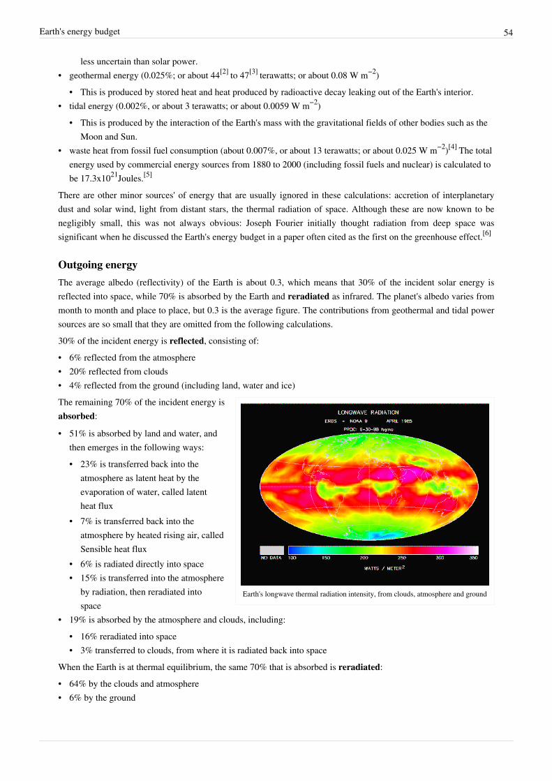
Earth's energy budget 54
less uncertain than solar power.• geothermal energy (0.025%; or about 44[2] to 47[3] terawatts; or about 0.08 W m−2)
• This is produced by stored heat and heat produced by radioactive decay leaking out of the Earth's interior.• tidal energy (0.002%, or about 3 terawatts; or about 0.0059 W m−2)
• This is produced by the interaction of the Earth's mass with the gravitational fields of other bodies such as theMoon and Sun.
• waste heat from fossil fuel consumption (about 0.007%, or about 13 terawatts; or about 0.025 W m−2)[4] The totalenergy used by commercial energy sources from 1880 to 2000 (including fossil fuels and nuclear) is calculated tobe 17.3x10²¹Joules.[5]
There are other minor sources' of energy that are usually ignored in these calculations: accretion of interplanetarydust and solar wind, light from distant stars, the thermal radiation of space. Although these are now known to benegligibly small, this was not always obvious: Joseph Fourier initially thought radiation from deep space wassignificant when he discussed the Earth's energy budget in a paper often cited as the first on the greenhouse effect.[6]
Outgoing energyThe average albedo (reflectivity) of the Earth is about 0.3, which means that 30% of the incident solar energy isreflected into space, while 70% is absorbed by the Earth and reradiated as infrared. The planet's albedo varies frommonth to month and place to place, but 0.3 is the average figure. The contributions from geothermal and tidal powersources are so small that they are omitted from the following calculations.30% of the incident energy is reflected, consisting of:• 6% reflected from the atmosphere• 20% reflected from clouds• 4% reflected from the ground (including land, water and ice)
Earth's longwave thermal radiation intensity, from clouds, atmosphere and ground
The remaining 70% of the incident energy isabsorbed:
• 51% is absorbed by land and water, andthen emerges in the following ways:• 23% is transferred back into the
atmosphere as latent heat by theevaporation of water, called latentheat flux
• 7% is transferred back into theatmosphere by heated rising air, calledSensible heat flux
• 6% is radiated directly into space• 15% is transferred into the atmosphere
by radiation, then reradiated intospace
• 19% is absorbed by the atmosphere and clouds, including:• 16% reradiated into space• 3% transferred to clouds, from where it is radiated back into space
When the Earth is at thermal equilibrium, the same 70% that is absorbed is reradiated:• 64% by the clouds and atmosphere• 6% by the ground

Earth's energy budget 55
.
References[1] Data to produce this graphic was taken from a NASA publication.[2] Pollack, H.N.; S. J. Hurter, and J. R. Johnson (1993). "Heat Flow from the Earth's Interior: Analysis of the Global Data Set" (http:/ / www.
agu. org/ pubs/ crossref/ 1993/ 93RG01249. shtml). Rev. Geophys. 30 (3): pp. 267–280.[3] J. H. Davies and D. R. Davies, "Earth’s Surface heat flux," Solid Earth, 1, 5–24 (2010), available in pdf form (http:/ / www. solid-earth. net/
1/ 5/ 2010/ se-1-5-2010. pdf) here (accessed 8 October 2010)[4] http:/ / mustelid. blogspot. com/ 2005/ 04/ global-warming-is-not-from-waste-heat. html[5] Nordell, Bo; Bruno Gervet. Global energy accumulation and net heat emission (http:/ / www. ltu. se/ polopoly_fs/ 1. 5035!nordell-gervet
ijgw. pdf). . Retrieved 2009-12-23.[6] Connolley, William M. (18 May 2003). "William M. Connolley's page about Fourier 1827: MEMOIRE sur les temperatures du globe terrestre
et des espaces planetaires" (http:/ / www. wmconnolley. org. uk/ sci/ fourier_1827/ ). William M. Connolley. . Retrieved 5 July 2010.
• "Earth's Energy Budget", Oklahoma Climatological Survey (http:/ / okfirst. ocs. ou. edu/ train/ meteorology/EnergyBudget2. html)
• "Earth's Energy Budget" graphic, NASA (http:/ / asd-www. larc. nasa. gov/ erbe/ components2. gif)• "Understanding the Heat Budget", cricketmx.com (http:/ / www. cricketmx. com/ articles/ read/
understanding-the-heat-budget/ )
DeclinationIn astronomy, declination (abbrev. dec or δ) is one of the twocoordinates of the equatorial coordinate system, the other beingeither right ascension or hour angle. Declination in astronomy iscomparable to geographic latitude, but projected onto the celestialsphere. Declination is measured in degrees north and south of thecelestial equator. Points north of the celestial equator have positivedeclinations, while those to the south have negative declinations.
• An object on the celestial equator has a declination of 0°.• An object at the celestial north pole has a declination of +90°.• An object at the celestial south pole has a declination of −90°.The sign is customarily included even if it is positive. Any unit ofangle can be used for declination, but it is often expressed indegrees, minutes, and seconds of arc.
As seen from locations in the Earth's Northern Hemisphere,celestial objects with declinations greater than 90° − φ (φ = observer's latitude) are always above the horizon. Thissimilarly occurs in the Southern Hemisphere for objects with declinations less than, i.e. more negative than,-90° − φ. Such stars appear to circle daily around the celestial pole without dipping below the horizon, and aretherefore called circumpolar stars. An extreme example is the pole star which has a declination near to +90°, so it iscircumpolar as seen from anywhere in the Northern Hemisphere except very close to the equator. The Sun'sdeclination varies with the seasons (see below). As seen from arctic or antarctic latitudes, the Sun is circumpolarnear the local summer solstice, leading to the phenomenon of it being above the horizon at midnight, which is calledmidnight sun.
When an object is directly overhead its declination is almost always within 0.01 degree of the observer's latitude; it would be exactly equal except for two complications. The first complication applies to all celestial objects: the object's declination equals the observer's astronomic latitude, but the term "latitude" ordinarily means geodetic

Declination 56
latitude, which is the latitude on maps and GPS devices. The difference (the vertical deflection) usually doesn'texceed a few thousandths of a degree. For practical purposes the second complication only applies to solar systemobjects: "declination" is ordinarily measured at the center of the earth, which isn't quite spherical, so a line from thecenter of the earth to the object is not quite perpendicular to the Earth's surface. It turns out that when the moon isdirectly overhead its geocentric declination can differ from the observer's astronomic latitude by up to 0.005 degree.The importance of this complication is inversely proportional to the object's distance from the earth, so for mostpurposes it's not a concern for the sun and planets.
StarsA star lies in a nearly constant direction as viewed from Earth, with its declination roughly constant from year toyear, but right ascension and declination do both change gradually due to precession of the equinoxes, propermotion, and annual parallax.The declinations of all solar system objects change much more quickly than those of stars.
Declination of the Sun as seen from EarthThe declination of the Sun, δ, is the angle between the rays of the Sun and the plane of the Earth's equator. TheEarth's axial tilt (called the obliquity of the ecliptic by astronomers) is the angle between the Earth's axis and a lineperpendicular to the Earth's orbit. The Earth's axial tilt changes gradually over thousands of years, but its currentvalue is about ε = 23°26'. Because this axial tilt is nearly constant, solar declination (δ) varies with the seasons andits period is one year.At the solstices, the angle between the rays of the Sun and the plane of the Earth's equator reaches its maximumvalue of 23°26'. Therefore δ = +23°26' at the northern summer solstice and δ = −23°26' at the southern summersolstice.At the moment of each equinox, the center of the Sun appears to pass through the celestial equator, and δ is 0°.The Sun's declination at any given moment is calculated by:
Where EL is the ecliptic longitude. (On some calculator keyboards, and elsewhere, arcsin is written as sin−1.) Sincethe Earth's orbital eccentricity is small, its orbit can be approximated as a circle which causes up to 1 degree of error.The circle approximation means the EL would be 90 degrees ahead of the solstices in Earth's orbit (at the equinoxes),so that sin(EL) can be written as sin(90+NDS)=cos(NDS) where NDS is the number of days after the Decembersolstice. By also using the approximation that arcsin[sin(d)*cos(NDS)] is close to d*cos(NDS), the followingfrequently used formula is obtained:
where N is the day of the year beginning with N=0 at midnight Coordinated Universal Time as January 1st begins(i.e. the days part of the ordinal date -1). The number 10, in (N+10), is the approximate number of days after theDecember solstice to January 1st. This equation overestimates the declination near the September equinox by up to+1.5 degrees. The sine function approximation by itself leads to an error of up to 0.26 degrees and has beendiscouraged for use in solar energy applications. The 1971 Spencer formula[1] (based on a fourier series) is alsodiscouraged for having an error of up to 0.28 degrees.[2] An additional error of up to 0.5 degrees can occur in allequations around the equinoxes if not using a decimal place when selecting N to adjust for the time after CoordinatedUniversal Time midnight for the beginning of that day. So the above equation can have up to 2.0 degrees of error,about 4 times the Sun's angular width, depending on how it's used.The declination can be more accurately calculated by not making the two approximations, using the parameters ofthe Earth's orbit to more accurately estimate EL:[3]
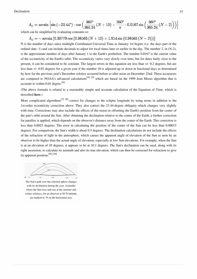
Declination 57
which can be simplified by evaluating constants to:
N is the number of days since midnight Coordinated Universal Time as January 1st begins (i.e. the days part of theordinal date -1) and can include decimals to adjust for local times later or earlier in the day. The number 2, in (N-2),is the approximate number of days after January 1 to the Earth's perihelion. The number 0.0167 is the current valueof the eccentricity of the Earth's orbit. The eccentricity varies very slowly over time, but for dates fairly close to thepresent, it can be considered to be constant. The largest errors in this equation are less than +/- 0.2 degrees, but areless than +/- 0.03 degrees for a given year if the number 10 is adjusted up or down in fractional days as determinedby how far the previous year's December solstice occurred before or after noon on December 22nd. These accuraciesare compared to NOAA's advanced calculations[4] [5] which are based on the 1999 Jean Meeus algorithm that isaccurate to within 0.01 degree.[6]
(The above formula is related to a reasonably simple and accurate calculation of the Equation of Time, which isdescribed here.)More complicated algorithms[7] [8] correct for changes to the ecliptic longitude by using terms in addition to the1st-order eccentricity correction above. They also correct the 23.44-degree obliquity which changes very slightlywith time. Corrections may also include the effects of the moon in offsetting the Earth's position from the center ofthe pair's orbit around the Sun. After obtaining the declination relative to the center of the Earth, a further correctionfor parallax is applied, which depends on the observer's distance away from the center of the Earth. This correction isless than 0.0025 degrees. The error in calculating the position of the center of the Sun can be less than 0.00015degrees. For comparison, the Sun's width is about 0.5 degrees. The declination calculations do not include the effectsof the refraction of light in the atmosphere, which causes the apparent angle of elevation of the Sun as seen by anobserver to be higher than the actual angle of elevation, especially at low Sun elevations. For example, when the Sunis at an elevation of 10 degrees, it appears to be at 10.1 degrees. The Sun's declination can be used, along with itsright ascension, to calculate its azimuth and also its true elevation, which can then be corrected for refraction to giveits apparent position.[9] [10]
The Sun's path over the celestial sphere changeswith its declination during the year. Azimuthswhere the Sun rises and sets at the summer and
winter solstices, for an observer at 56°N latitude,are marked in °N on the horizontal axis.

Declination 58
References[1] J. W. Spencer (1971). Fourier series representation of the position of the sun (http:/ / www. mail-archive. com/ sundial@uni-koeln. de/
msg01050. html). .[2] http:/ / www. physics. arizona. edu/ ~cronin/ Solar/ References/ Irradiance%20Models%20and%20Data/ SPR07. pdf[3] http:/ / www. green-life-innovators. org/ tiki-index. php?page=Sunalign[4] http:/ / www. esrl. noaa. gov/ gmd/ grad/ solcalc[5] http:/ / www. esrl. noaa. gov/ gmd/ grad/ solcalc/ calcdetails. html[6] http:/ / www. jgiesen. de/ elevaz/ basics/ meeus. htm[7] http:/ / www. assembla. com/ spaces/ sun_follower/ documents/ d0PIA0oe0r347_eJe5avMc/ download/ 10022519534118276. pdf[8] http:/ / www. nrel. gov/ docs/ fy08osti/ 34302. pdf[9] http:/ / www. srrb. noaa. gov/ highlights/ sunrise/ atmosrefr. gif[10] http:/ / www. esrl. noaa. gov/ gmd/ grad/ solcalc/ calcdetails. html
External links• NOAA's very accurate declination and sun position calculator (code can be viewed in the Javascript) (http:/ /
www. srrb. noaa. gov/ highlights/ sunrise/ azel. html)• Table of the Declination of the Sun: Mean Value for the Four Years of a Leap-Year Cycle (source unknown)
(http:/ / www. wsanford. com/ ~wsanford/ exo/ sundials/ DEC_Sun. html)• Declination function for Excel, CAD or your other programs. (http:/ / www. sunlit-design. com/ products/
thesunapi/ documentation/ sdxDecl. php) The Sun API is free and extremely accurate. For Windows computers.• How to compute planetary positions (http:/ / www. stjarnhimlen. se/ comp/ ppcomp. html) by Paul Schlyter.
Solar elevation angleThe solar elevation angle is the elevation angle of the sun. That is, the angle between the direction of the geometriccenter of the sun's apparent disk and the (idealized) horizon. It can be calculated, to a good approximation,[1] usingthe following formula:
where• is the solar elevation angle• is the hour angle, in the local solar time.• is the current Sun declination• is the local latitude[2]
Note[1] The formula neglects the effect of atmospheric refraction.[2] The formula is based on geocentric latitude, which differs from geographic latitude by less than 12 minutes of arc.
Solar azimuth angle 59
Solar azimuth angleThe solar azimuth angle is the azimuth angle of the sun. It is most often defined as the angle from due north in aclockwise direction.It can be calculated in various way. In different times, it has been explained in different ways. It can be calculated, toa good approximation, using the following formula, however angles should be interpreted with care due to theinverse sine, i.e. x = sin−1(y) has more than one solution, only one of which will be correct.
The following two formulas can also be used to approximate the solar azimuth angle, however because theseformulas utilize cosine, the azimuth angle will always be positive, and therefore, should be interpreted as the angleless than 180 degrees when the hour angle, h, is negative (morning) and the angle greater than 180 degrees when thehour angle, h, is positive (afternoon).
The previous formulas use the following terminology:
• is the solar azimuth angle• is the solar elevation angle• is the hour angle of the present time• is the current sun declination• is the local latitude[1]
Solar elevation angleSun height, height angle, solar altitude angle or elevation (gS) is the angle between a line that points from the sitetowards the centre of the sun, and the horizon. The zenith angle is the opposite angle to the sun height (90° – gS). Ata sun height of 90°, the sun is at the zenith and the zenith angle is therefore zero.[2]
References[1] The formula is based on geocentric latitude, which differs from geographic latitude by less than 12 minutes of arc.[2] http:/ / www. volker-quaschning. de/ articles/ fundamentals1/ index_e. html
External links• Solar Position Calculators by National Renewable Energy Laboratory (NREL) (http:/ / www. nrel. gov/ midc/
solpos/ )• An Excel workbook (http:/ / www. ecy. wa. gov/ programs/ eap/ models/ twilight. zip) with VBA functions for
solar azimuth, solar elevation, dawn, sunrise, solar noon, sunset, and dusk, by Greg Pelletier (http:/ / www. ecy.wa. gov/ programs/ eap/ models. html), translated from NOAA's online calculators for solar position (http:/ /www. srrb. noaa. gov/ highlights/ sunrise/ azel. html) and sunrise/sunset (http:/ / www. srrb. noaa. gov/ highlights/sunrise/ sunrise. html)
• An Excel workbook (http:/ / www. ecy. wa. gov/ programs/ eap/ models/ solrad. zip) with a solar position andsolar radiation time-series calculator, by Greg Pelletier (http:/ / www. ecy. wa. gov/ programs/ eap/ models. html)
• Free on-line tool to estimate the position of the sun with three different algorithms (http:/ / www.volker-quaschning. de/ datserv/ sunpos/ index_e. html).
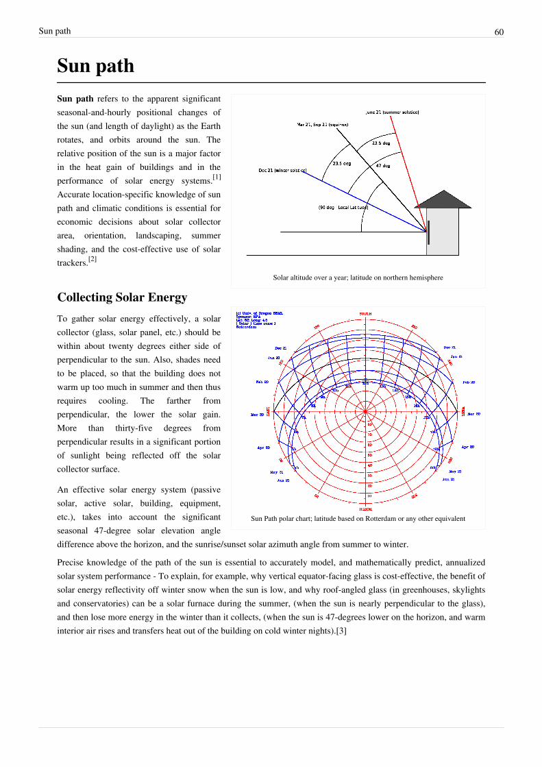
Sun path 60
Sun path
Solar altitude over a year; latitude on northern hemisphere
Sun Path polar chart; latitude based on Rotterdam or any other equivalent
Sun path refers to the apparent significantseasonal-and-hourly positional changes ofthe sun (and length of daylight) as the Earthrotates, and orbits around the sun. Therelative position of the sun is a major factorin the heat gain of buildings and in theperformance of solar energy systems.[1]
Accurate location-specific knowledge of sunpath and climatic conditions is essential foreconomic decisions about solar collectorarea, orientation, landscaping, summershading, and the cost-effective use of solartrackers.[2]
Collecting Solar Energy
To gather solar energy effectively, a solarcollector (glass, solar panel, etc.) should bewithin about twenty degrees either side ofperpendicular to the sun. Also, shades needto be placed, so that the building does notwarm up too much in summer and then thusrequires cooling. The farther fromperpendicular, the lower the solar gain.More than thirty-five degrees fromperpendicular results in a significant portionof sunlight being reflected off the solarcollector surface.
An effective solar energy system (passivesolar, active solar, building, equipment,etc.), takes into account the significantseasonal 47-degree solar elevation angledifference above the horizon, and the sunrise/sunset solar azimuth angle from summer to winter.
Precise knowledge of the path of the sun is essential to accurately model, and mathematically predict, annualizedsolar system performance - To explain, for example, why vertical equator-facing glass is cost-effective, the benefit ofsolar energy reflectivity off winter snow when the sun is low, and why roof-angled glass (in greenhouses, skylightsand conservatories) can be a solar furnace during the summer, (when the sun is nearly perpendicular to the glass),and then lose more energy in the winter than it collects, (when the sun is 47-degrees lower on the horizon, and warminterior air rises and transfers heat out of the building on cold winter nights).[3]
Sun path 61
Tilt of the EarthEarth's rotation tilts about 23.5 degrees on its pole-to-pole axis, relative to the plane of Earth's solar system orbitaround our sun. As the Earth orbits the sun, this creates the 47-degree peak solar altitude angle difference, and thehemisphere-specific difference between summer and winter.In the northern hemisphere, the winter sun rises in the southeast, peaks out at a low angle above the southernhorizon, and then sets in the southwest. It is on the south (equator) side of the house all day long. Verticalsouth-facing (equator side) glass is excellent for capturing solar thermal energy.In the northern hemisphere in summer (June, July, August), the sun rises in the northeast, peaks out nearly straightoverhead (depending on latitude), and then sets in the northwest. A simple latitude-dependent equator-side overhangcan easily be designed to block 100% of the direct solar gain from entering vertical equator-facing windows on thehottest days of the year. Roll-down exterior shade screens, interior translucent-or-opaque Window Quilts, drapes,shutters, movable trellises, etc. can be used for hourly, daily or seasonal sun and heat transfer control (without anyactive electrical air conditioning).The latitude (and hemisphere)-specific solar path differences are critical to effective passive solar building design.They are essential data for optimal window and overhang seasonal design. Solar designers must know the precisesolar path angles for each location they design for, and how they compare to place-based seasonal heating andcooling requirements.In the U.S., the precise location-specific altitude-and-azimuth seasonal solar path numbers are available from NOAA- The "equator side" of a building is south in the northern hemisphere, and north in the Southern hemisphere, wherethe peak summer solstice solar altitude occurs on December 21. The sun rises roughly in the east and sets in the westeverywhere on Earth, except in high latitudes in summer- and winter-time.On the Equator, the sun will be straight overhead and a vertical stick will cast no shadow at noon (solar time) onMarch 21 and September 23, the equinox. 23.5 degrees north of the equator on the Tropic of Cancer, a vertical stickwill cast no shadow on June 21, the summer solstice for the northern hemisphere. The rest of the year, the noonshadow will point to the North pole. 23.5 degrees south of the equator on the Tropic of Capricorn, a vertical stickwill cast no shadow on December 21, the summer solstice for the southern hemisphere, and the rest of the year itsnoon shadow will point to the South pole. North of the Tropic of Cancer, the noon shadow will always point north,and conversely, south of the Tropic of Capricorn, the noon shadow will always point south. North of the Arcticcircle, and south of the Antarctic circle there will be at least one day a year when the sun is not above the horizon for24 hours, and at least one day (six months later) when the sun is above the horizon for 24 hours.In the moderate latitudes (between the circles and tropics, where most humans live), the length of the day, solaraltitude and azimuth vary from one day to the next, and from season to season. The difference between the length ofa long summer day, versus a short winter day increases as you move farther away from the equator.[2]
Solar path building design simulationBefore the days of modern, inexpensive, 3D computer graphics, a heliodon (precisely-movable light source) wasused to show the angle of the sun on a physical model of a proposed building. Today, mathematical computer modelscalculate location-specific solar gain (shading) and seasonal thermal performance, with the ability to rotate andanimate a 3D color graphic model of a proposed building design.Passive solar building design heating and cooling issues can be counterintuitive (like roof-angled glass). Preciseperformance calculations and simulations are essential to help avoid reinventing the wheel and duplicatingpreviously-made expensive experimental construction errors (like a summer solar furnace).

Sun path 62
References[1] "Solar Resource Information" (http:/ / www. nrel. gov/ rredc/ solar_resource. html). National Renewable Energy Laboratory. . Retrieved
2009-03-28.[2] Khavrus, V.; Shelevytsky, I. (2010). "Introduction to solar motion geometry on the basis of a simple model" (http:/ / sites. google. com/ site/
khavrus/ public-activities/ SolarEng). Physics Education 45 (6): 641. doi:10.1088/0031-9120/45/6/010. .[3] http:/ / www. passivesolarenergy. info/ #S1
External links• U.S. Naval Observatory Sun or Moon Altitude/Azimuth Table (http:/ / www. usno. navy. mil/ USNO/
astronomical-applications/ data-services/ alt-az-us)• Sun path by location and date (http:/ / sunposition. info/ sunposition/ spc/ locations. php)• Sun positions, diagram and paths around the world by location and date (http:/ / www. date-and-time. net)• Seasonal and Hourly Sun Path Design Issue Tutorial (http:/ / www. passivesolarenergy. info/ #c111)• "Three Decades of Passive Solar Heating and Cooling Lessons Learned" (http:/ / www. ornl. gov/ sci/ buildings/
Workshops_07. html#14)
Sun chart
Sun chart for Berlin
A Sun chart is a graph of the ecliptic of the Sun through the skythroughout the year at a particular latitude.
Most sun charts plot azimuth versus altitude throughout the days of thewinter solstice and summer solstice, as well as a number of interveningdays. Since the movement of the Sun is symmetrical about the solstice,it is only necessary to plot dates for one half of the year.
The graph may show the entire horizon or only that half of the horizonclosest to the equator. Sky view obstructions can be superimposed upon a Sun chart to obtain the insolation of alocation.
External links• A free Sun chart calculator [1]
• A Sun chart generator [2]
References[1] http:/ / www. eclim. de/ index5. htm[2] http:/ / www. sunearthtools. com/ dp/ tools/ pos_sun. php
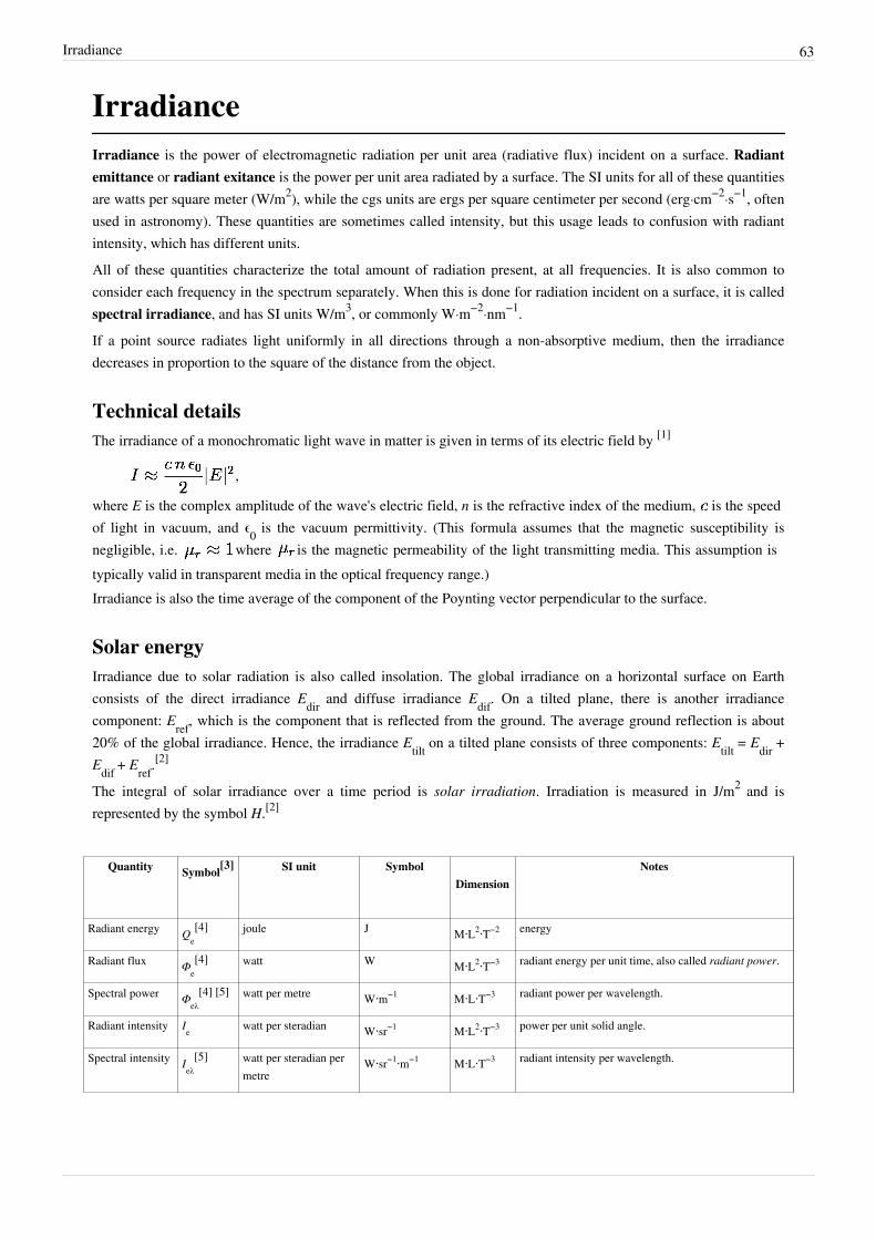
Irradiance 63
IrradianceIrradiance is the power of electromagnetic radiation per unit area (radiative flux) incident on a surface. Radiantemittance or radiant exitance is the power per unit area radiated by a surface. The SI units for all of these quantitiesare watts per square meter (W/m2), while the cgs units are ergs per square centimeter per second (erg·cm−2·s−1, oftenused in astronomy). These quantities are sometimes called intensity, but this usage leads to confusion with radiantintensity, which has different units.All of these quantities characterize the total amount of radiation present, at all frequencies. It is also common toconsider each frequency in the spectrum separately. When this is done for radiation incident on a surface, it is calledspectral irradiance, and has SI units W/m3, or commonly W·m−2·nm−1.If a point source radiates light uniformly in all directions through a non-absorptive medium, then the irradiancedecreases in proportion to the square of the distance from the object.
Technical detailsThe irradiance of a monochromatic light wave in matter is given in terms of its electric field by [1]
,
where E is the complex amplitude of the wave's electric field, n is the refractive index of the medium, is the speedof light in vacuum, and ϵ0 is the vacuum permittivity. (This formula assumes that the magnetic susceptibility isnegligible, i.e. where is the magnetic permeability of the light transmitting media. This assumption istypically valid in transparent media in the optical frequency range.)Irradiance is also the time average of the component of the Poynting vector perpendicular to the surface.
Solar energyIrradiance due to solar radiation is also called insolation. The global irradiance on a horizontal surface on Earthconsists of the direct irradiance Edir and diffuse irradiance Edif. On a tilted plane, there is another irradiancecomponent: Eref, which is the component that is reflected from the ground. The average ground reflection is about20% of the global irradiance. Hence, the irradiance Etilt on a tilted plane consists of three components: Etilt = Edir +Edif + Eref.
[2]
The integral of solar irradiance over a time period is solar irradiation. Irradiation is measured in J/m2 and isrepresented by the symbol H.[2]
Quantity Symbol[3] SI unit Symbol
Dimension Notes
Radiant energy Qe[4] joule J M⋅L2⋅T−2 energy
Radiant flux Φe[4] watt W M⋅L2⋅T−3 radiant energy per unit time, also called radiant power.
Spectral power Φeλ[4] [5] watt per metre W⋅m−1 M⋅L⋅T−3 radiant power per wavelength.
Radiant intensity Ie watt per steradian W⋅sr−1 M⋅L2⋅T−3 power per unit solid angle.
Spectral intensity Ieλ[5] watt per steradian per
metreW⋅sr−1⋅m−1 M⋅L⋅T−3 radiant intensity per wavelength.
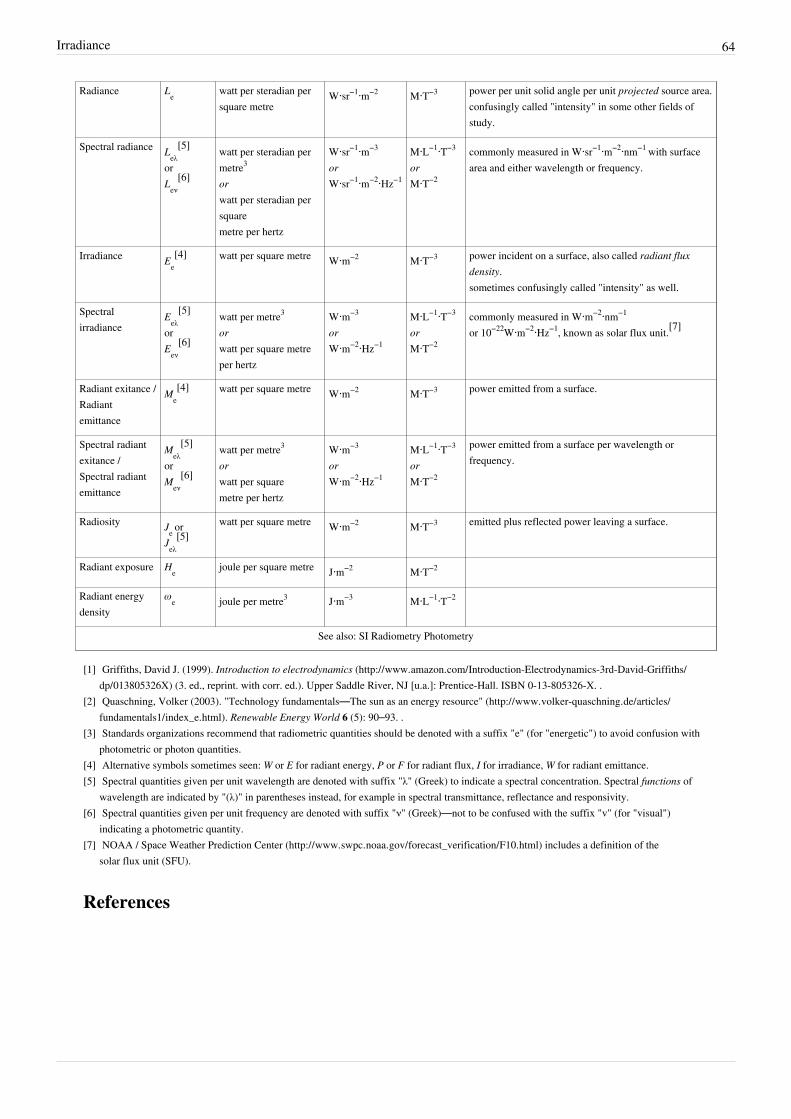
Irradiance 64
Radiance Le watt per steradian persquare metre
W⋅sr−1⋅m−2 M⋅T−3 power per unit solid angle per unit projected source area.confusingly called "intensity" in some other fields ofstudy.
Spectral radiance Leλ[5]
orLeν
[6]
watt per steradian permetre3
orwatt per steradian persquaremetre per hertz
W⋅sr−1⋅m−3
orW⋅sr−1⋅m−2⋅Hz−1
M⋅L−1⋅T−3
orM⋅T−2
commonly measured in W⋅sr−1⋅m−2⋅nm−1 with surfacearea and either wavelength or frequency.
Irradiance Ee[4] watt per square metre W⋅m−2 M⋅T−3 power incident on a surface, also called radiant flux
density.sometimes confusingly called "intensity" as well.
Spectralirradiance
Eeλ[5]
orEeν
[6]
watt per metre3
orwatt per square metreper hertz
W⋅m−3
orW⋅m−2⋅Hz−1
M⋅L−1⋅T−3
orM⋅T−2
commonly measured in W⋅m−2⋅nm−1
or 10−22W⋅m−2⋅Hz−1, known as solar flux unit.[7]
Radiant exitance /Radiantemittance
Me[4] watt per square metre W⋅m−2 M⋅T−3 power emitted from a surface.
Spectral radiantexitance /Spectral radiantemittance
Meλ[5]
orMeν
[6]
watt per metre3
orwatt per squaremetre per hertz
W⋅m−3
orW⋅m−2⋅Hz−1
M⋅L−1⋅T−3
orM⋅T−2
power emitted from a surface per wavelength orfrequency.
Radiosity Je orJeλ
[5]watt per square metre W⋅m−2 M⋅T−3 emitted plus reflected power leaving a surface.
Radiant exposure He joule per square metre J⋅m−2 M⋅T−2
Radiant energydensity
ωe joule per metre3 J⋅m−3 M⋅L−1⋅T−2
See also: SI Radiometry Photometry
[1] Griffiths, David J. (1999). Introduction to electrodynamics (http:/ / www. amazon. com/ Introduction-Electrodynamics-3rd-David-Griffiths/dp/ 013805326X) (3. ed., reprint. with corr. ed.). Upper Saddle River, NJ [u.a.]: Prentice-Hall. ISBN 0-13-805326-X. .
[2] Quaschning, Volker (2003). "Technology fundamentals—The sun as an energy resource" (http:/ / www. volker-quaschning. de/ articles/fundamentals1/ index_e. html). Renewable Energy World 6 (5): 90–93. .
[3] Standards organizations recommend that radiometric quantities should be denoted with a suffix "e" (for "energetic") to avoid confusion withphotometric or photon quantities.
[4] Alternative symbols sometimes seen: W or E for radiant energy, P or F for radiant flux, I for irradiance, W for radiant emittance.[5] Spectral quantities given per unit wavelength are denoted with suffix "λ" (Greek) to indicate a spectral concentration. Spectral functions of
wavelength are indicated by "(λ)" in parentheses instead, for example in spectral transmittance, reflectance and responsivity.[6] Spectral quantities given per unit frequency are denoted with suffix "ν" (Greek)—not to be confused with the suffix "v" (for "visual")
indicating a photometric quantity.[7] NOAA / Space Weather Prediction Center (http:/ / www. swpc. noaa. gov/ forecast_verification/ F10. html) includes a definition of the
solar flux unit (SFU).
References

Sunlight 65
Sunlight
Sunlight shining through clouds, giving rise to crepuscular rays.
Sunlight, in the broad sense, is the total frequencyspectrum of electromagnetic radiation given off by theSun. On Earth, sunlight is filtered through the Earth'satmosphere, and solar radiation is obvious as daylightwhen the Sun is above the horizon.
When the direct solar radiation is not blocked by clouds,it is experienced as sunshine, a combination of brightlight and radiant heat. When it is blocked by the clouds orreflects off of other objects, it is experienced as diffusedlight.
The World Meteorological Organization uses the term"sunshine duration" to mean the cumulative time duringwhich an area receives direct irradiance from the Sun ofat least 120 watts per square meter.[1]
Sunlight may be recorded using a sunshine recorder,pyranometer or pyrheliometer. Sunlight takes about 8.3minutes to reach the Earth.
Direct sunlight has a luminous efficacy of about 93lumens per watt of radiant flux, which includes infrared,visible, and ultraviolet light. Bright sunlight providesilluminance of approximately 100,000 lux or lumens persquare meter at the Earth's surface.
Sunlight is a key factor in photosynthesis, a process vital for life on Earth.
CalculationTo calculate the amount of sunlight reaching the ground, both the elliptical orbit of the Earth and the attenuation bythe Earth's atmosphere have to be taken into account. The extraterrestrial solar illuminance (Eext), corrected for theelliptical orbit by using the day number of the year (dn), is given by[2]
where dn=1 on January 1; dn=2 on January 2; dn=32 on February 1, etc. In this formula dn-3 is used, because inmodern times Earth's perihelion, the closest approach to the Sun and therefore the maximum Eext occurs aroundJanuary 3 each year. The value of 0.033412 is determined knowing that the ratio between the perihelion (0.98328989AU) squared and the aphelion (1.01671033 AU) squared should be approximately 0.935338.The solar illuminance constant (Esc), is equal to 128×103 lx. The direct normal illuminance (Edn), corrected for theattenuating effects of the atmosphere is given by:
where c is the atmospheric extinction coefficient and m is the relative optical airmass.

Sunlight 66
Solar constantThe solar constant, a measure of flux density, is the amount of incoming solar electromagnetic radiation per unitarea that would be incident on a plane perpendicular to the rays, at a distance of one astronomical unit (AU) (roughlythe mean distance from the Sun to the Earth). The "solar constant" includes all types of solar radiation, not just thevisible light. Its average value was thought to be approximately 1.366 kW/m²,[3] varying slightly with solar activity,but recent recalibrations of the relevant satellite observations indicate a value closer to 1.361 kW/m² is morerealistic.[4]
Total (TSI) and spectral solar irradiance (SSI) upon EarthTotal Solar Irradiance upon Earth (TSI) was earlier measured by satellite to be roughly 1.366 kilowatts per squaremeter (kW/m²),[3] [5] [6] but most recently NASA cites TSI as "1361 W/m² as compared to ~1366 W/m² from earlierobservations [Kopp et al., 2005]", based on regular readings from NASA's Solar Radiation and ClimateExperiment(SORCE) satellite, active since 2003,[7] noting that this "discovery is critical in examining the energybudget of the planet Earth and isolating the climate change due to human activities." Furthermore the SpectralIrradiance Monitor (SIM) has found in the same period that spectral solar irradiance (SSI) at UV (ultraviolet)wavelength corresponds in a less clear, and probably more complicated fashion, with earth's climate responses thanearlier assumed, fueling broad avenues of new research in "the connection of the Sun and stratosphere, troposphere,biosphere, ocean, and Earth’s climate".[7]
Intensity in the Solar SystemDifferent bodies of the Solar System receive light of an intensity inversely proportional to the square of theirdistance from Sun. A rough table comparing the amount of solar radiation received by each planet in the SolarSystem follows (from data in [8]):
Planet Perihelion -Aphelion
distance (AU)
Solar radiationmaximum and
minimum(W/m²)
Mercury 0.3075 – 0.4667 14,446 – 6,272
Venus 0.7184 – 0.7282 2,647 – 2,576
Earth 0.9833 – 1.017 1,413 – 1,321
Mars 1.382 – 1.666 715 – 492
Jupiter 4.950 – 5.458 55.8 – 45.9
Saturn 9.048 – 10.12 16.7 – 13.4
Uranus 18.38 – 20.08 4.04 – 3.39
Neptune 29.77 – 30.44 1.54 – 1.47
The actual brightness of sunlight that would be observed at the surface depends also on the presence andcomposition of an atmosphere. For example Venus' thick atmosphere reflects more than 60% of the solar light itreceives. The actual illumination of the surface is about 14,000 lux, comparable to that on Earth "in the daytime withovercast clouds".[9]
Sunlight on Mars would be more or less like daylight on Earth wearing sunglasses, and as can be seen in the picturestaken by the rovers, there is enough diffuse sky radiation that shadows would not seem particularly dark. Thus itwould give perceptions and "feel" very much like Earth daylight.
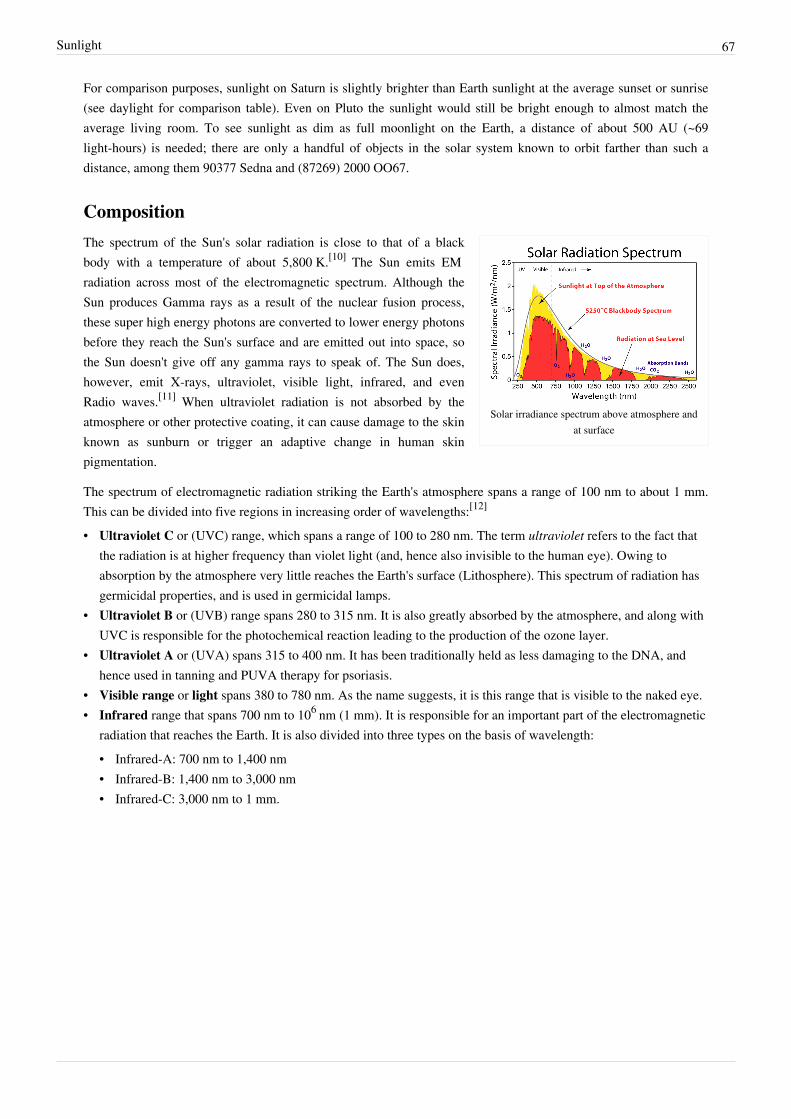
Sunlight 67
For comparison purposes, sunlight on Saturn is slightly brighter than Earth sunlight at the average sunset or sunrise(see daylight for comparison table). Even on Pluto the sunlight would still be bright enough to almost match theaverage living room. To see sunlight as dim as full moonlight on the Earth, a distance of about 500 AU (~69light-hours) is needed; there are only a handful of objects in the solar system known to orbit farther than such adistance, among them 90377 Sedna and (87269) 2000 OO67.
Composition
Solar irradiance spectrum above atmosphere andat surface
The spectrum of the Sun's solar radiation is close to that of a blackbody with a temperature of about 5,800 K.[10] The Sun emits EMradiation across most of the electromagnetic spectrum. Although theSun produces Gamma rays as a result of the nuclear fusion process,these super high energy photons are converted to lower energy photonsbefore they reach the Sun's surface and are emitted out into space, sothe Sun doesn't give off any gamma rays to speak of. The Sun does,however, emit X-rays, ultraviolet, visible light, infrared, and evenRadio waves.[11] When ultraviolet radiation is not absorbed by theatmosphere or other protective coating, it can cause damage to the skinknown as sunburn or trigger an adaptive change in human skinpigmentation.
The spectrum of electromagnetic radiation striking the Earth's atmosphere spans a range of 100 nm to about 1 mm.This can be divided into five regions in increasing order of wavelengths:[12]
• Ultraviolet C or (UVC) range, which spans a range of 100 to 280 nm. The term ultraviolet refers to the fact thatthe radiation is at higher frequency than violet light (and, hence also invisible to the human eye). Owing toabsorption by the atmosphere very little reaches the Earth's surface (Lithosphere). This spectrum of radiation hasgermicidal properties, and is used in germicidal lamps.
• Ultraviolet B or (UVB) range spans 280 to 315 nm. It is also greatly absorbed by the atmosphere, and along withUVC is responsible for the photochemical reaction leading to the production of the ozone layer.
• Ultraviolet A or (UVA) spans 315 to 400 nm. It has been traditionally held as less damaging to the DNA, andhence used in tanning and PUVA therapy for psoriasis.
• Visible range or light spans 380 to 780 nm. As the name suggests, it is this range that is visible to the naked eye.• Infrared range that spans 700 nm to 106 nm (1 mm). It is responsible for an important part of the electromagnetic
radiation that reaches the Earth. It is also divided into three types on the basis of wavelength:• Infrared-A: 700 nm to 1,400 nm• Infrared-B: 1,400 nm to 3,000 nm• Infrared-C: 3,000 nm to 1 mm.

Sunlight 68
Surface illuminationThe spectrum of surface illumination depends upon solar elevation due to atmospheric effects, with the blue spectralcomponent from atmospheric scatter dominating during twilight before and after sunrise and sunset, respectively,and red dominating during sunrise and sunset. These effects are apparent in natural light photography where theprincipal source of illumination is sunlight as mediated by the atmosphere.According to Craig Bohren, "preferential absorption of sunlight by ozone over long horizon paths gives the zenithsky its blueness when the sun is near the horizon".[13]
See diffuse sky radiation for more details.
Climate effectsFurther information: Solar dimming and InsolationOn Earth, solar radiation is obvious as daylight when the sun is above the horizon. This is during daytime, and alsoin summer near the poles at night, but not at all in winter near the poles. When the direct radiation is not blocked byclouds, it is experienced as sunshine, combining the perception of bright white light (sunlight in the strict sense) andwarming. The warming on the body, the ground and other objects depends on the absorption (electromagneticradiation) of the electromagnetic radiation in the form of heat.The amount of radiation intercepted by a planetary body varies inversely with the square of the distance between thestar and the planet. The Earth's orbit and obliquity change with time (over thousands of years), sometimes forming anearly perfect circle, and at other times stretching out to an orbital eccentricity of 5% (currently 1.67%). The totalinsolation remains almost constant due to Kepler's second law,
where is the "areal velocity" invariant. That is, the integration over the orbital period (also invariant) is aconstant.
If we assume the solar radiation power as a constant over time and the solar irradiation given by theinverse-square law, we obtain also the average insolation as a constant.But the seasonal and latitudinal distribution and intensity of solar radiation received at the Earth's surface alsovaries.[14] For example, at latitudes of 65 degrees the change in solar energy in summer & winter can vary by morethan 25% as a result of the Earth's orbital variation. Because changes in winter and summer tend to offset, the changein the annual average insolation at any given location is near zero, but the redistribution of energy between summerand winter does strongly affect the intensity of seasonal cycles. Such changes associated with the redistribution ofsolar energy are considered a likely cause for the coming and going of recent ice ages (see: Milankovitch cycles).
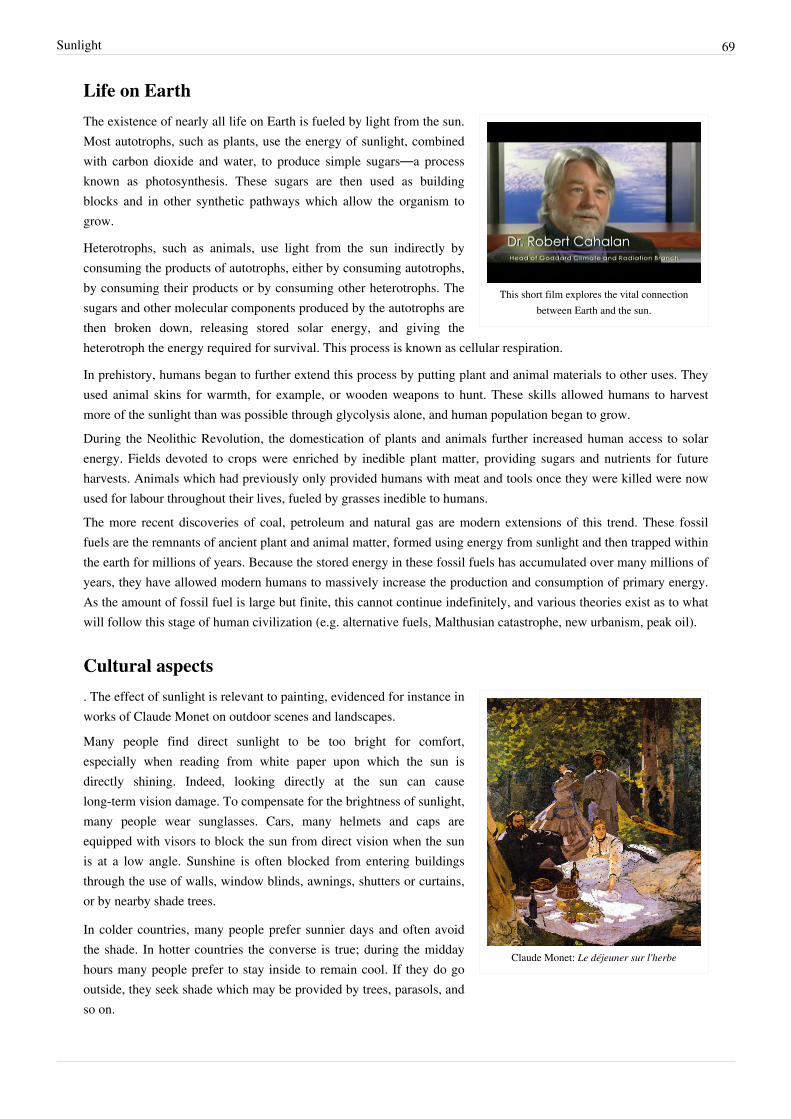
Sunlight 69
Life on Earth
This short film explores the vital connectionbetween Earth and the sun.
The existence of nearly all life on Earth is fueled by light from the sun.Most autotrophs, such as plants, use the energy of sunlight, combinedwith carbon dioxide and water, to produce simple sugars—a processknown as photosynthesis. These sugars are then used as buildingblocks and in other synthetic pathways which allow the organism togrow.
Heterotrophs, such as animals, use light from the sun indirectly byconsuming the products of autotrophs, either by consuming autotrophs,by consuming their products or by consuming other heterotrophs. Thesugars and other molecular components produced by the autotrophs arethen broken down, releasing stored solar energy, and giving theheterotroph the energy required for survival. This process is known as cellular respiration.
In prehistory, humans began to further extend this process by putting plant and animal materials to other uses. Theyused animal skins for warmth, for example, or wooden weapons to hunt. These skills allowed humans to harvestmore of the sunlight than was possible through glycolysis alone, and human population began to grow.During the Neolithic Revolution, the domestication of plants and animals further increased human access to solarenergy. Fields devoted to crops were enriched by inedible plant matter, providing sugars and nutrients for futureharvests. Animals which had previously only provided humans with meat and tools once they were killed were nowused for labour throughout their lives, fueled by grasses inedible to humans.The more recent discoveries of coal, petroleum and natural gas are modern extensions of this trend. These fossilfuels are the remnants of ancient plant and animal matter, formed using energy from sunlight and then trapped withinthe earth for millions of years. Because the stored energy in these fossil fuels has accumulated over many millions ofyears, they have allowed modern humans to massively increase the production and consumption of primary energy.As the amount of fossil fuel is large but finite, this cannot continue indefinitely, and various theories exist as to whatwill follow this stage of human civilization (e.g. alternative fuels, Malthusian catastrophe, new urbanism, peak oil).
Cultural aspects
Claude Monet: Le déjeuner sur l'herbe
. The effect of sunlight is relevant to painting, evidenced for instance inworks of Claude Monet on outdoor scenes and landscapes.
Many people find direct sunlight to be too bright for comfort,especially when reading from white paper upon which the sun isdirectly shining. Indeed, looking directly at the sun can causelong-term vision damage. To compensate for the brightness of sunlight,many people wear sunglasses. Cars, many helmets and caps areequipped with visors to block the sun from direct vision when the sunis at a low angle. Sunshine is often blocked from entering buildingsthrough the use of walls, window blinds, awnings, shutters or curtains,or by nearby shade trees.
In colder countries, many people prefer sunnier days and often avoidthe shade. In hotter countries the converse is true; during the middayhours many people prefer to stay inside to remain cool. If they do gooutside, they seek shade which may be provided by trees, parasols, andso on.
Sunlight 70
In Hinduism the sun is considered to be a god as it is the source of life and energy on earth.
SunbathingSunbathing is a popular leisure activity in which a person sits or lies in direct sunshine. People often sunbathe incomfortable places where there is ample sunlight. Some common places for sunbathing include beaches, open airswimming pools, parks, gardens, and sidewalk cafés. Sunbathers typically wear limited amounts of clothing or somesimply go nude. For some, an alternative to sunbathing is the use of a sunbed that generates ultraviolet light and canbe used indoors regardless of outdoor weather conditions and amount of sunlight.For many people with pale or brownish skin, one purpose for sunbathing is to darken one's skin color (get a sun tan)as this is considered in some cultures to be beautiful, associated with outdoor activity, vacations/holidays, and health.Some people prefer naked sunbathing so that an "all-over" or "even" tan can be obtained, sometimes as part of aspecific lifestyle.For people suffering from psoriasis, sunbathing is an effective way of healing the symptoms.Skin tanning is achieved by an increase in the dark pigment inside skin cells called melanocytes and it is actually anautomatic response mechanism of the body to sufficient exposure to ultraviolet radiation from the sun or fromartificial sunlamps. Thus, the tan gradually disappears with time, when one is no longer exposed to these sources.
Effects on human healthThe body produces vitamin D from sunlight (specifically from the UVB band of ultraviolet light), and excessiveseclusion from the sun can lead to deficiency unless adequate amounts are obtained through diet.Sunburn can have mild to severe inflammation effects on skin; this can be avoided by using a proper sunscreencream or lotion or by gradually building up melanocytes with increasing exposure. Another detrimental effect of UVexposure is accelerated skin aging (also called skin photodamage), which produces a difficult to treat cosmeticeffect. Some people are concerned that ozone depletion is increasing the incidence of such health hazards. A 10%decrease in ozone could cause a 25% increase in skin cancer.[15]
A lack of sunlight, on the other hand, is considered one of the primary causes of seasonal affective disorder (SAD), aserious form of the "winter blues". SAD occurrence is more prevalent in locations further from the tropics, and mostof the treatments (other than prescription drugs) involve light therapy, replicating sunlight via lamps tuned to specific(visible, not ultra-violet) wavelengths of light or full-spectrum bulbs.A recent study indicates that more exposure to sunshine early in a person’s life relates to less risk from multiplesclerosis (MS) later in life.[16]
References[1] "Chapter 8 – Measurement of sunshine duration" (http:/ / www. wmo. int/ pages/ prog/ www/ IMOP/ publications/ CIMO-Guide/ CIMO
Guide 7th Edition, 2008/ Part I/ Chapter 8. pdf) (PDF). CIMO Guide. World Meteorological Organization. . Retrieved 2008-12-01.[2] C. KANDILLI and K. ULGEN. "Solar Illumination and Estimating Daylight Availability of Global Solar Irradiance". Energy Sources.[3] Satellite observations of total solar irradiance (http:/ / acrim. com/ TSI Monitoring. htm)[4] G. Kopp; J. Lean (2011). "A new, lower value of total solar irradiance: Evidence and climate significance". Geophys. Res. Lett.: L01706.
Bibcode 2011GeoRL..3801706K. doi:10.1029/2010GL045777.[5] Willson, R. C., and A. V. Mordvinov (2003), Secular total solar irradiance trend during solar cycles 21–23, Geophys. Res. Lett., 30(5), 1199,
doi:10.1029/2002GL016038 ACR (http:/ / www. acrim. com/ Reference Files/ Secular total solar irradiance trend during solar cycles 21â23.pdf)
[6] "Construction of a Composite Total Solar Irradiance (TSI) Time Series from 1978 to present" (http:/ / www. pmodwrc. ch/ pmod.php?topic=tsi/ composite/ SolarConstant). . Retrieved 2005-10-05.
[7] NASA Goddard Space Flight Center: Solar Radiation (http:/ / atmospheres. gsfc. nasa. gov/ climate/ index. php?section=136)[8] http:/ / starhop. com/ library/ pdf/ studyguide/ high/ SolInt-19. pdf[9] "The Unveiling of Venus: Hot and Stifling". Science News 109 (25): 388. 1976-06-19. JSTOR 3960800. "100 watts per square meter ...
14,000 lux ... corresponds to ... daytime with overcast clouds"

Sunlight 71
[10] NASA Solar System Exploration - Sun: Facts & Figures (http:/ / solarsystem. nasa. gov/ planets/ profile. cfm?Display=Facts& Object=Sun)retrieved 27 April 2011 "Effective Temperature ... 5777 K"
[11] (http:/ / www. windows2universe. org/ sun/ spectrum/ multispectral_sun_overview. html)[12] Naylor, Mark; Kevin C. Farmer (1995). "Sun damage and prevention" (http:/ / www. telemedicine. org/ sundam/ sundam2. 4. 1. html).
Electronic Textbook of Dermatology. The Internet Dermatology Society. . Retrieved 2008-06-02.[13] Craig F. Bohren. "Atmospheric Optics" (http:/ / homepages. wmich. edu/ ~korista/ atmospheric_optics. pdf). .[14] Graph of variation of seasonal and latitudinal distribution of solar radiation (http:/ / www. museum. state. il. us/ exhibits/ ice_ages/
insolation_graph. html)[15] Ozone Hole Consequences (http:/ / www. theozonehole. com/ consequences. htm) retrieved 30 October 2008[16] NEUROLOGY 2007;69:381-388 (http:/ / www. neurology. org/ cgi/ content/ abstract/ 69/ 4/ 381?etoc)
Further reading• Hartmann, Thom (1998). The Last Hours of Ancient Sunlight. London: Hodder and Stoughton. ISBN
0-340-82243-0.
External links• Solar radiation - Encyclopedia of Earth (http:/ / www. eoearth. org/ article/ Solar_radiation)• Total Solar Irradiance (TSI) Daily mean data (http:/ / www. ngdc. noaa. gov/ stp/ solar/ solarirrad. html) at the
website of the National Geophysical Data Center• Construction of a Composite Total Solar Irradiance (TSI) Time Series from 1978 to present (http:/ / www.
pmodwrc. ch/ pmod. php?topic=tsi/ composite/ SolarConstant) by World Radiation Center,Physikalisch-Meteorologisches Observatorium Davos (pmod wrc)
• A Comparison of Methods for Providing Solar Radiation Data to Crop Models and Decision Support Systems(http:/ / www. macaulay. ac. uk/ LADSS/ papers. html?2002), Rivington et al.
• Evaluation of three model estimations of solar radiation at 24 UK stations (http:/ / www. macaulay. ac. uk/LADSS/ papers. html?2005), Rivington et al.
• High resolution spectrum of solar radiation (http:/ / bass2000. obspm. fr/ solar_spect. php) from Observatoire deParis
• Measuring Solar Radiation (http:/ / avc. comm. nsdlib. org/ cgi-bin/ wiki_grade_interface.pl?Measuring_Solar_Radiation) : A lesson plan from the National Science Digital Library.
• Websurf astronomical information (http:/ / websurf. nao. rl. ac. uk/ surfbin/ first. cgi): Online tools for calculatingRising and setting times of Sun, Moon or planet, Azimuth of Sun, Moon or planet at rising and setting, Altitudeand azimuth of Sun, Moon or planet for a given date or range of dates, and more.
• An Excel workbook (http:/ / www. ecy. wa. gov/ programs/ eap/ models/ solrad. zip) with a solar position andsolar radiation time-series calculator; by Greg Pelletier (http:/ / www. ecy. wa. gov/ programs/ eap/ models. html)
• DOE information (http:/ / rredc. nrel. gov/ solar/ spectra/ am1. 5/ ) about the ASTM standard solar spectrum forPV evaluation.
• ASTM Standard (http:/ / www. astm. org/ Standards/ G173. htm) for solar spectrum at ground level in the US(latitude ~ 37 degrees).
• Detailed spectrum of the sun (http:/ / apod. nasa. gov/ apod/ ap100627. html) at Astronomy Picture of the Day(http:/ / apod. nasa. gov/ apod/ archivepix. html).

Effect of sun angle on climate 72
Effect of sun angle on climate
Figure 1This diagram illustrates how sunlight is spread over a greater area in
the polar regions. In addition to the density of incident light, thedissipation of light in the atmosphere is greater when it falls at a
shallow angle.
The amount of heat energy received at any location onthe globe is a direct effect of sun angle on climate, asthe angle at which sunlight strikes the Earth varies bylocation, time of day, and season due to the Earth'sorbit around the sun and the Earth's rotation around itstilted axis. Seasonal change in the angle of sunlight,caused by the tilt of the Earth's axis, is the basicmechanism that results in warmer weather in summerthan in winter.[1] [2] Change in day length is anotherfactor.[2] (See also season.)
Geometry of sun angle
Figure 2One sunbeam one mile wide shines on the ground at a 90° angle, and another at a30° angle. The one at a shallower angle covers twice as much area with the same
amount of light energy.
When sunlight shines on the earth at a lowerangle (sun closer to the horizon), the energyof the sunlight is spread over a larger area,and is therefore weaker than if the sun ishigher overhead and the energy isconcentrated on a smaller area. (See Figure1.)
Figure 2 depicts a sunbeam one mile (1.6km) wide falling on the ground fromdirectly overhead, and another hitting theground at a 30° angle. Trigonometry tells usthat the sine of a 30° angle is 1/2, whereasthe sine of a 90° angle is 1. Therefore, thesunbeam hitting the ground at a 30° anglespreads the same amount of light over twiceas much area (if we imagine the sun shiningfrom the south at noon, the north-southwidth doubles; the east-west width doesnot). Consequently, the amount of light falling on each square mile is only half as much.

Effect of sun angle on climate 73
Figure 3This is a diagram of the seasons. Regardless of the time of day (i.e.the Earth's rotation on its axis), the North Pole will be dark, and the
South Pole will be illuminated; see also arctic winter.
The sunbeam entering at the shallower angle must alsotravel twice as far through the Earth's atmosphere,which reflects some of the energy back into space.
Figure 3 shows the angle of sunlight striking the earthin the Northern and Southern hemispheres when theEarth's northern axis is tilted away from the sun, whenit is winter in the north and summer in the south.
Technical note
Heat energy is not received from the Sun. Radiantenergy is received and this results in change in energylevel of receiving bodies in Earth's domain. Differentmaterials have different properties for transmitting backreceived energy in the form of heat energy at differentrates. Concrete and tar for example are slow releasers. Most metals are fast releasers.
References[1] Windows to the Universe. Earth's Tilt Is the Reason for the Seasons! (http:/ / www. windows. ucar. edu/ tour/ link=/ earth/ climate/
cli_seasons. html) Retrieved on 2008-06-28.[2] Khavrus, V.; Shelevytsky, I. (2010). "Introduction to solar motion geometry on the basis of a simple model" (http:/ / sites. google. com/ site/
khavrus/ public-activities/ SolarEng). Physics Education 45 (6): 641. Bibcode 2010PhyEd..45..641K. doi:10.1088/0031-9120/45/6/010. .

Insolation 74
Insolation
Annual mean insolation, at the top of Earth's atmosphere (top) and at the planet'ssurface.
US annual average solar energy received by a latitude tilt photovoltaic cell(modeled).
Insolation is a measure of solar radiationenergy received on a given surface area in agiven time. It is commonly expressed asaverage irradiance in watts per square meter(W/m2) or kilowatt-hours per square meterper day (kW·h/(m2·day)) (or hours/day). Inthe case of photovoltaics it is commonlymeasured as kWh/(kWp·y) (kilowatt hoursper year per kilowatt peak rating).
The object or surface that solar radiationstrikes may be a planet, a terrestrial objectinside the atmosphere of a planet, or anyobject exposed to solar rays outside of anatmosphere, including spacecraft. Some ofthe solar radiation will be absorbed, whilethe remainder will be reflected. Usually theabsorbed solar radiation is converted tothermal energy, causing an increasing in theobject's temperature. Some systems,however, may store or convert a portion ofthe solar energy into another form of energy,as in the case of photovoltaics or plants. Theproportion of radiation reflected or absorbeddepends on the object's reflectivity oralbedo.
Projection effect
The insolation into a surface is largest whenthe surface directly faces the Sun. As theangle increases between the direction at aright angle to the surface and the directionof the rays of sunlight, the insolation isreduced in proportion to the cosine of theangle; see effect of sun angle on climate.

Insolation 75
Average insolation in Europe
Figure 2One sunbeam one mile wide shines on the ground at a 90° angle, and another at a
30° angle. The one at a shallower angle distributes the same amount of light energyover twice as much area.
In this illustration, the angle shown isbetween the ground and the sunbeam ratherthan between the vertical direction and thesunbeam; hence the sine rather than thecosine is appropriate. A sunbeam one mile(1.6 km) wide falls on the ground fromdirectly overhead, and another hits theground at a 30° angle to the horizontal.Trigonometry tells us that the sine of a 30°angle is 1/2, whereas the sine of a 90° angleis 1. Therefore, the sunbeam hitting theground at a 30° angle spreads the sameamount of light over twice as much area (ifwe imagine the sun shining from the southat noon, the north-south width doubles; theeast-west width does not). Consequently, theamount of light falling on each square mileis only half as much.
This 'projection effect' is the main reason why the polar regions are much colder than equatorial regions on Earth. Onan annual average the poles receive less insolation than does the equator, because at the poles the Earth's surface areangled away from the Sun.
Solar Radiation Map of Africa and Middle East
Earth's insolation
Direct insolation is the solar irradiance measured at a given location onEarth with a surface element perpendicular to the Sun's rays, excludingdiffuse insolation (the solar radiation that is scattered or reflected byatmospheric components in the sky). Direct insolation is equal to thesolar constant minus the atmospheric losses due to absorption andscattering. While the solar constant varies with the Earth-Sun distanceand solar cycles, the losses depend on the time of day (length of light'spath through the atmosphere depending on the Solar elevation angle),cloud cover, moisture content, and other impurities. Insolation is afundamental abiotic factor[1] affecting the metabolism of plants and thebehavior of animals.
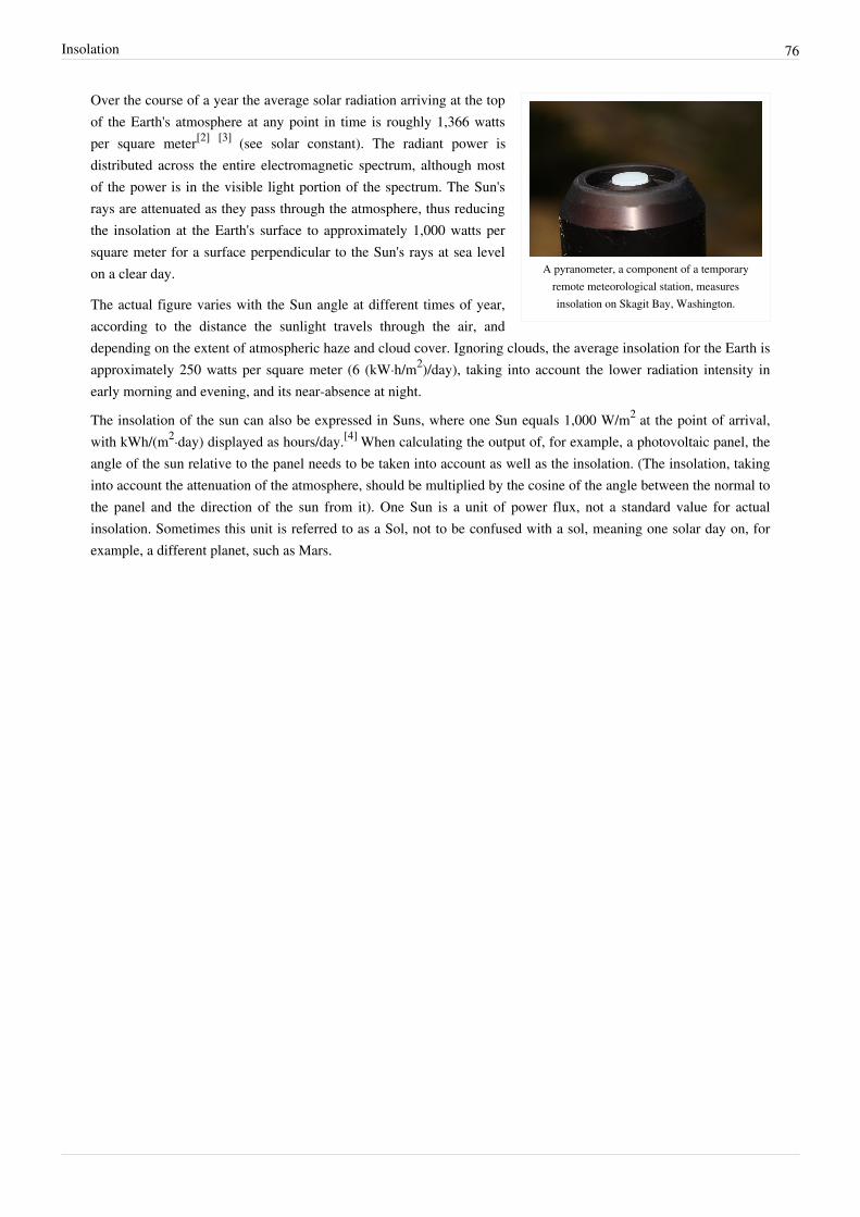
Insolation 76
A pyranometer, a component of a temporaryremote meteorological station, measuresinsolation on Skagit Bay, Washington.
Over the course of a year the average solar radiation arriving at the topof the Earth's atmosphere at any point in time is roughly 1,366 wattsper square meter[2] [3] (see solar constant). The radiant power isdistributed across the entire electromagnetic spectrum, although mostof the power is in the visible light portion of the spectrum. The Sun'srays are attenuated as they pass through the atmosphere, thus reducingthe insolation at the Earth's surface to approximately 1,000 watts persquare meter for a surface perpendicular to the Sun's rays at sea levelon a clear day.
The actual figure varies with the Sun angle at different times of year,according to the distance the sunlight travels through the air, anddepending on the extent of atmospheric haze and cloud cover. Ignoring clouds, the average insolation for the Earth isapproximately 250 watts per square meter (6 (kW·h/m2)/day), taking into account the lower radiation intensity inearly morning and evening, and its near-absence at night.
The insolation of the sun can also be expressed in Suns, where one Sun equals 1,000 W/m2 at the point of arrival,with kWh/(m2·day) displayed as hours/day.[4] When calculating the output of, for example, a photovoltaic panel, theangle of the sun relative to the panel needs to be taken into account as well as the insolation. (The insolation, takinginto account the attenuation of the atmosphere, should be multiplied by the cosine of the angle between the normal tothe panel and the direction of the sun from it). One Sun is a unit of power flux, not a standard value for actualinsolation. Sometimes this unit is referred to as a Sol, not to be confused with a sol, meaning one solar day on, forexample, a different planet, such as Mars.

Insolation 77
Distribution of insolation at the top of the atmosphere
Spherical triangle for application of the spherical law of cosines for the calculation thesolar zenith angle Θ for observer at latitude φ and longitude λ from knowledge of thehour angle h and solar declination δ. (δ is latitude of subsolar point, and h is relative
longitude of subsolar point).
The theory for the distribution ofsolar radiation at the top of theatmosphere concerns how the solarirradiance (the power of solar radiationper unit area) at the top of theatmosphere is determined by thesphericity and orbital parameters ofEarth. The theory could be applied toany monodirectional beam of radiationincident onto a rotating sphere, but ismost usually applied to sunlight, and inparticular for application in numericalweather prediction, and theory for theseasons and the ice ages. The lastapplication is known as Milankovitchcycles.
The derivation of distribution is basedon a fundamental identity fromspherical trigonometry, the sphericallaw of cosines:
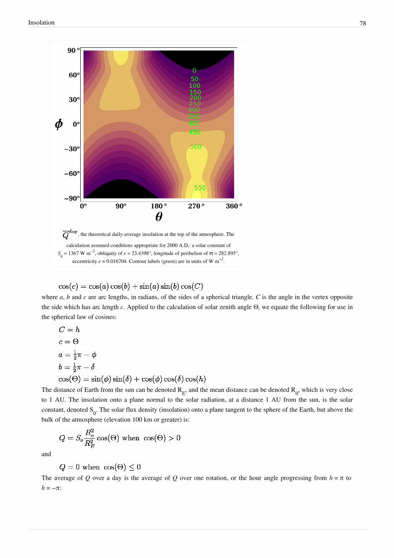
Insolation 78
, the theoretical daily-average insolation at the top of the atmosphere. The
calculation assumed conditions appropriate for 2000 A.D.: a solar constant ofS0 = 1367 W m−2, obliquity of ε = 23.4398°, longitude of perihelion of ϖ = 282.895°,
eccentricity e = 0.016704. Contour labels (green) are in units of W m−2.
where a, b and c are arc lengths, in radians, of the sides of a spherical triangle. C is the angle in the vertex oppositethe side which has arc length c. Applied to the calculation of solar zenith angle Θ, we equate the following for use inthe spherical law of cosines:
The distance of Earth from the sun can be denoted RE, and the mean distance can be denoted R0, which is very closeto 1 AU. The insolation onto a plane normal to the solar radiation, at a distance 1 AU from the sun, is the solarconstant, denoted S0. The solar flux density (insolation) onto a plane tangent to the sphere of the Earth, but above thebulk of the atmosphere (elevation 100 km or greater) is:
and
The average of Q over a day is the average of Q over one rotation, or the hour angle progressing from h = π toh = −π:
Insolation 79
Let h0 be the hour angle when Q becomes positive. This could occur at sunrise when , or for h0 as asolution of
or
If tan(φ)tan(δ) > 1, then the sun does not set and the sun is already risen at h = π, so ho = π. If tan(φ)tan(δ) < −1, thesun does not rise and .
is nearly constant over the course of a day, and can be taken outside the integral
Let θ be the conventional polar angle describing a planetary orbit. For convenience, let θ = 0 at the vernal equinox.The declination δ as a function of orbital position is
where ε is the obliquity. The conventional longitude of perihelion ϖ is defined relative to the vernal equinox, so forthe elliptical orbit:
or
With knowledge of ϖ, ε and e from astrodynamical calculations [5] and So from a consensus of observations ortheory, can be calculated for any latitude φ and θ. Note that because of the elliptical orbit, and as a simple
consequence of Kepler's second law, θ does not progress exactly uniformly with time. Nevertheless, θ = 0° is exactlythe time of the vernal equinox, θ = 90° is exactly the time of the summer solstice, θ = 180° is exactly the time of theautumnal equinox and θ = 270° is exactly the time of the winter solstice.

Insolation 80
Application to Milankovitch cycles
Obtaining a time series for a for a particular time of year, and particular latitude, is a useful application in the
theory of Milankovitch cycles. For example, at the summer solstice, the declination δ is simply equal to the obliquityε. The distance from the sun is
Past and future of daily average insolation at top of the atmosphere on the day of thesummer solstice, at 65 N latitude. The green curve is with eccentricity e hypothetically setto 0. The red curve uses the actual (predicted) value of e. Blue dot is current conditions, at
2 ky A.D.
For this summer solstice calculation,the role of the elliptical orbit is entirelycontained within the important product
, which is known as theprecession index, the variation ofwhich dominates the variations ininsolation at 65 N when eccentricity islarge. For the next 100,000 years, withvariations in eccentricity beingrelatively small, variations in obliquitywill be dominant.
ApplicationsIn spacecraft design and planetology, it is the primary variable affecting equilibrium temperature.In construction, insolation is an important consideration when designing a building for a particular climate. It is oneof the most important climate variables for human comfort and building energy efficiency.[6]
The projection effect can be used in architecture to design buildings that are cool in summer and warm in winter, byproviding large vertical windows on the equator-facing side of the building (the south face in the northernhemisphere, or the north face in the southern hemisphere): this maximizes insolation in the winter months when theSun is low in the sky, and minimizes it in the summer when the noonday Sun is high in the sky. (The Sun'snorth/south path through the sky spans 47 degrees through the year).Insolation figures are used as an input to worksheets to size solar power systems for the location where they will beinstalled.[7] This can be misleading since insolation figures assume the panels are parallel with the ground, when infact they are almost always mounted at an angle[8] to face towards the sun. This gives inaccurately low estimates forwinter.[9] The figures can be obtained from an insolation map or by city or region from insolation tables that weregenerated with historical data over the last 30–50 years. Photovoltaic panels are rated under standard conditions todetermine the Wp rating (watts peak),[10] which can then be used with the insolation of a region to determine theexpected output, along with other factors such as tilt, tracking and shading (which can be included to create theinstalled Wp rating).[11] Insolation values range from 800 to 950 kWh/(kWp·y) in Norway to up to 2,900 inAustralia.In the fields of civil engineering and hydrology, numerical models of snowmelt runoff use observations of insolation.This permits estimation of the rate at which water is released from a melting snowpack. Field measurement isaccomplished using a pyranometer.
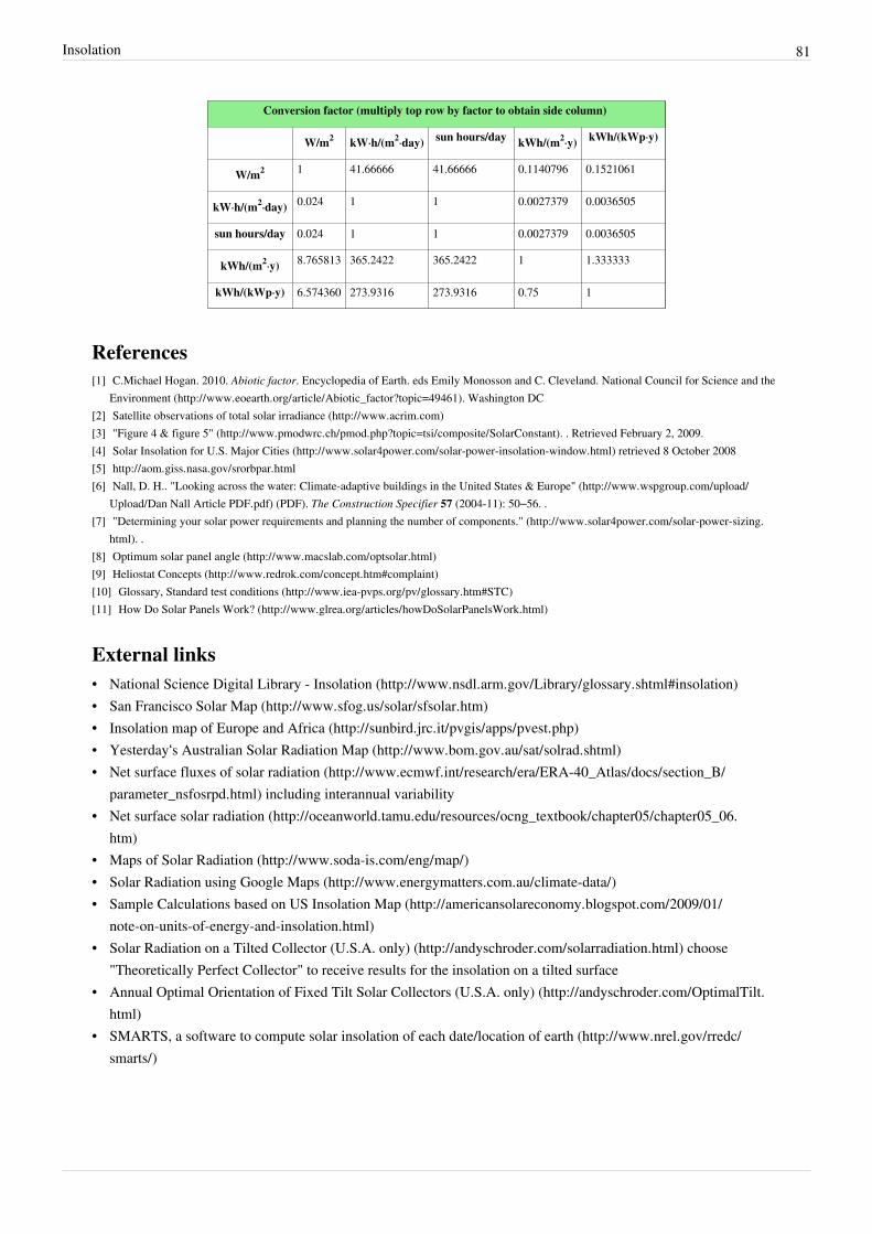
Insolation 81
Conversion factor (multiply top row by factor to obtain side column)
W/m2 kW·h/(m2·day) sun hours/day kWh/(m2·y) kWh/(kWp·y)
W/m2 1 41.66666 41.66666 0.1140796 0.1521061
kW·h/(m2·day) 0.024 1 1 0.0027379 0.0036505
sun hours/day 0.024 1 1 0.0027379 0.0036505
kWh/(m2·y) 8.765813 365.2422 365.2422 1 1.333333
kWh/(kWp·y) 6.574360 273.9316 273.9316 0.75 1
References[1] C.Michael Hogan. 2010. Abiotic factor. Encyclopedia of Earth. eds Emily Monosson and C. Cleveland. National Council for Science and the
Environment (http:/ / www. eoearth. org/ article/ Abiotic_factor?topic=49461). Washington DC[2] Satellite observations of total solar irradiance (http:/ / www. acrim. com)[3] "Figure 4 & figure 5" (http:/ / www. pmodwrc. ch/ pmod. php?topic=tsi/ composite/ SolarConstant). . Retrieved February 2, 2009.[4] Solar Insolation for U.S. Major Cities (http:/ / www. solar4power. com/ solar-power-insolation-window. html) retrieved 8 October 2008[5] http:/ / aom. giss. nasa. gov/ srorbpar. html[6] Nall, D. H.. "Looking across the water: Climate-adaptive buildings in the United States & Europe" (http:/ / www. wspgroup. com/ upload/
Upload/ Dan Nall Article PDF. pdf) (PDF). The Construction Specifier 57 (2004-11): 50–56. .[7] "Determining your solar power requirements and planning the number of components." (http:/ / www. solar4power. com/ solar-power-sizing.
html). .[8] Optimum solar panel angle (http:/ / www. macslab. com/ optsolar. html)[9] Heliostat Concepts (http:/ / www. redrok. com/ concept. htm#complaint)[10] Glossary, Standard test conditions (http:/ / www. iea-pvps. org/ pv/ glossary. htm#STC)[11] How Do Solar Panels Work? (http:/ / www. glrea. org/ articles/ howDoSolarPanelsWork. html)
External links• National Science Digital Library - Insolation (http:/ / www. nsdl. arm. gov/ Library/ glossary. shtml#insolation)• San Francisco Solar Map (http:/ / www. sfog. us/ solar/ sfsolar. htm)• Insolation map of Europe and Africa (http:/ / sunbird. jrc. it/ pvgis/ apps/ pvest. php)• Yesterday‘s Australian Solar Radiation Map (http:/ / www. bom. gov. au/ sat/ solrad. shtml)• Net surface fluxes of solar radiation (http:/ / www. ecmwf. int/ research/ era/ ERA-40_Atlas/ docs/ section_B/
parameter_nsfosrpd. html) including interannual variability• Net surface solar radiation (http:/ / oceanworld. tamu. edu/ resources/ ocng_textbook/ chapter05/ chapter05_06.
htm)• Maps of Solar Radiation (http:/ / www. soda-is. com/ eng/ map/ )• Solar Radiation using Google Maps (http:/ / www. energymatters. com. au/ climate-data/ )• Sample Calculations based on US Insolation Map (http:/ / americansolareconomy. blogspot. com/ 2009/ 01/
note-on-units-of-energy-and-insolation. html)• Solar Radiation on a Tilted Collector (U.S.A. only) (http:/ / andyschroder. com/ solarradiation. html) choose
"Theoretically Perfect Collector" to receive results for the insolation on a tilted surface• Annual Optimal Orientation of Fixed Tilt Solar Collectors (U.S.A. only) (http:/ / andyschroder. com/ OptimalTilt.
html)• SMARTS, a software to compute solar insolation of each date/location of earth (http:/ / www. nrel. gov/ rredc/
smarts/ )

Atmospheric refraction 82
Atmospheric refraction
Photograph of the full Moon partly obscured byEarth's atmosphere. Note the deviation fromcircular in the Moon's lower edge, caused by
refraction.
Diagram showing displacement of the Sun'simage at sunrise and sunset
Atmospheric refraction is the deviation of light or otherelectromagnetic wave from a straight line as it passes through theatmosphere due to the variation in air density as a function of altitude.Atmospheric refraction near the ground produces mirages and canmake distant objects appear to shimmer or ripple, elevated or lowered,stretched or shortened with no mirage involved. The term also appliesto the refraction of sound.
Atmospheric refraction causes astronomical objects to appear higher inthe sky than they are in reality. It affects not only lightrays but allelectromagnetic radiation, although in varying degrees (see dispersionin optics). For example in visible light, blue is more affected than red.This may cause astronomical objects to be spread out into a spectrumin high-resolution images.
Whenever possible, astronomers will schedule their observationsaround the time of culmination of an object when it is highest in thesky. Likewise sailors will never shoot a star which is not at least 20° ormore above the horizon. If observations close to the horizon cannot beavoided, it is possible to equip a telescope with control systems tocompensate for the shift caused by the refraction. If the dispersion is aproblem too, (in case of broadband high-resolution observations) atmospheric refraction correctors can be employedas well (made from pairs of rotating glass prisms). But as the amount of atmospheric refraction is a function oftemperature and pressure as well as humidity (the amount of water vapour is especially important at mid-infraredwavelengths) the amount of effort needed for a successful compensation can be prohibitive.
Atmospheric refraction becomes more severe when the atmospheric refraction is not homogenous, when there isturbulence in the air for example. This is the cause of twinkling of the stars and deformation of the shape of the sunat sunset and sunrise.
ValuesAtmospheric refraction is zero in the zenith, less than 1′ (one arcminute) at 45° apparent altitude, and still only 5.3′at 10° altitude; it quickly increases as altitude decreases, reaching 9.9′ at 5° altitude, 18.4′ at 2° altitude, and 35.4′ atthe horizon (Allen 1976, 125); all values are for 10 °C and 101.3 kPa.On the horizon, refraction is slightly greater than the apparent diameter of the Sun. Therefore when it appears thatthe full disc of the sun is just above the horizon, if it weren't for the atmosphere, no part of the sun's disc would bevisible. By convention, sunrise and sunset refer to times at which the Sun’s upper limb appears on or disappears fromthe horizon; the standard value for the Sun’s true altitude is −50′: −34′ for the refraction and −16′ for the Sun’ssemidiameter (the altitude of a celestial body is normally given for the centre of the body’s disc). In the case of theMoon, additional corrections are needed for the Moon’s horizontal parallax and its apparent semidiameter; both varywith the Earth–Moon distance.Day-to-day variations in the weather will affect the exact times of sunrise and sunset (Schaefer and Liller 1990) aswell as moonrise and moonset, and for that reason it generally is not meaningful to give rise and set times to greaterprecision than the nearest minute (Meeus 1991, 103). More precise calculations can be useful for determiningday-to-day changes in rise and set times that would occur with the standard value for refraction (for example Meeus
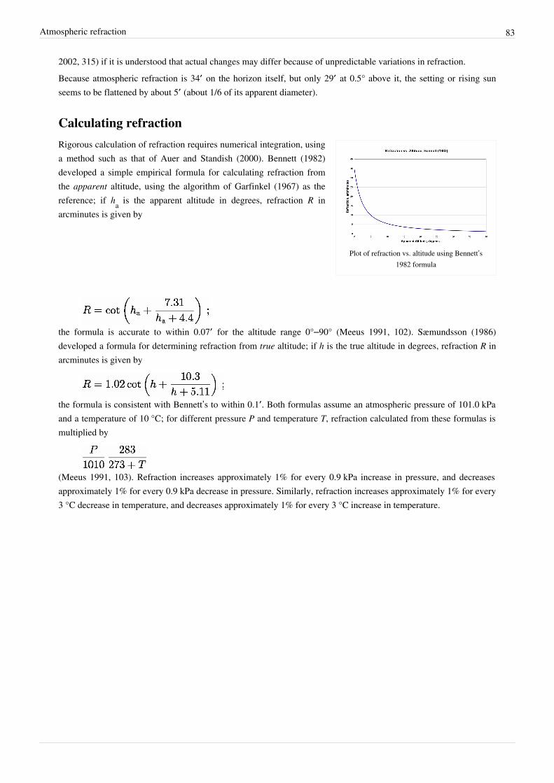
Atmospheric refraction 83
2002, 315) if it is understood that actual changes may differ because of unpredictable variations in refraction.Because atmospheric refraction is 34′ on the horizon itself, but only 29′ at 0.5° above it, the setting or rising sunseems to be flattened by about 5′ (about 1/6 of its apparent diameter).
Calculating refraction
Plot of refraction vs. altitude using Bennett’s1982 formula
Rigorous calculation of refraction requires numerical integration, usinga method such as that of Auer and Standish (2000). Bennett (1982)developed a simple empirical formula for calculating refraction fromthe apparent altitude, using the algorithm of Garfinkel (1967) as thereference; if ha is the apparent altitude in degrees, refraction R inarcminutes is given by
the formula is accurate to within 0.07′ for the altitude range 0°–90° (Meeus 1991, 102). Sæmundsson (1986)developed a formula for determining refraction from true altitude; if h is the true altitude in degrees, refraction R inarcminutes is given by
the formula is consistent with Bennett’s to within 0.1′. Both formulas assume an atmospheric pressure of 101.0 kPaand a temperature of 10 °C; for different pressure P and temperature T, refraction calculated from these formulas ismultiplied by
(Meeus 1991, 103). Refraction increases approximately 1% for every 0.9 kPa increase in pressure, and decreasesapproximately 1% for every 0.9 kPa decrease in pressure. Similarly, refraction increases approximately 1% for every3 °C decrease in temperature, and decreases approximately 1% for every 3 °C increase in temperature.

Atmospheric refraction 84
Random refraction effects
An animated image of the Moon's surfaceshowing the effects of Earth's atmosphere on
the view
Turbulence in the atmosphere magnifies and de-magnifies star images,making them appear brighter and fainter on a time-scale of milliseconds.The slowest components of these fluctuations are visible to the eye astwinkling (also called “scintillation”).
Turbulence also causes small random motions of the star image, andproduces rapid changes in its structure. These effects are not visible to thenaked eye, but are easily seen even in small telescopes. They are called“seeing” by astronomers.
References
• Allen, C. W. 1976. Astrophysical Quantities, 3rd ed. 1973, reprintedwith corrections, 1976. London: Athlone. ISBN 0-485-11150-0
• Auer, Lawrence H., and E. Myles Standish. 2000. AstronomicalRefraction: Computation for All Zenith Angles [1]. Astronomical Journal 119, no. 5 (May):2472–2474.
• Bennett, G.G. 1982. The Calculation of Astronomical Refraction in Marine Navigation. Journal of Navigation35:255–259. DOI (payment required)
• Garfinkel, B. 1967. Astronomical Refraction in a Polytropic Atmosphere [2]. Astronomical Journal 72:235–254.• Meeus, Jean. 1991. Astronomical Algorithms. Richmond, Virginia: Willmann-Bell, Inc. ISBN 0-943396-35-2• Meeus, Jean. 2002. More Mathematical Astronomy Morsels. Richmond, Virginia: Willmann-Bell, Inc. ISBN
0-943396-74-3• Sæmundsson, Þorsteinn. 1986. Astronomical Refraction. Sky and Telescope 72 (July):70.• Schaefer, Bradley E., and William Liller. 1990. Refraction near the horizon [3]. Publications of the Astronomical
Society of the Pacific 102: 796–805, July 1990.
Further reading• Wang, Yu (20 March 1998), Very High-Resolution Space Telescope Using the Earth Atmosphere as the Objective
Lens [4], Jet Propulsion Laboratory, doi:2014/19082
External links• Astronomical Refraction [5]—Andrew T. Young• Java Programming1 [6]
• Java Programming2 [7]
• JavaScript calculator [8]
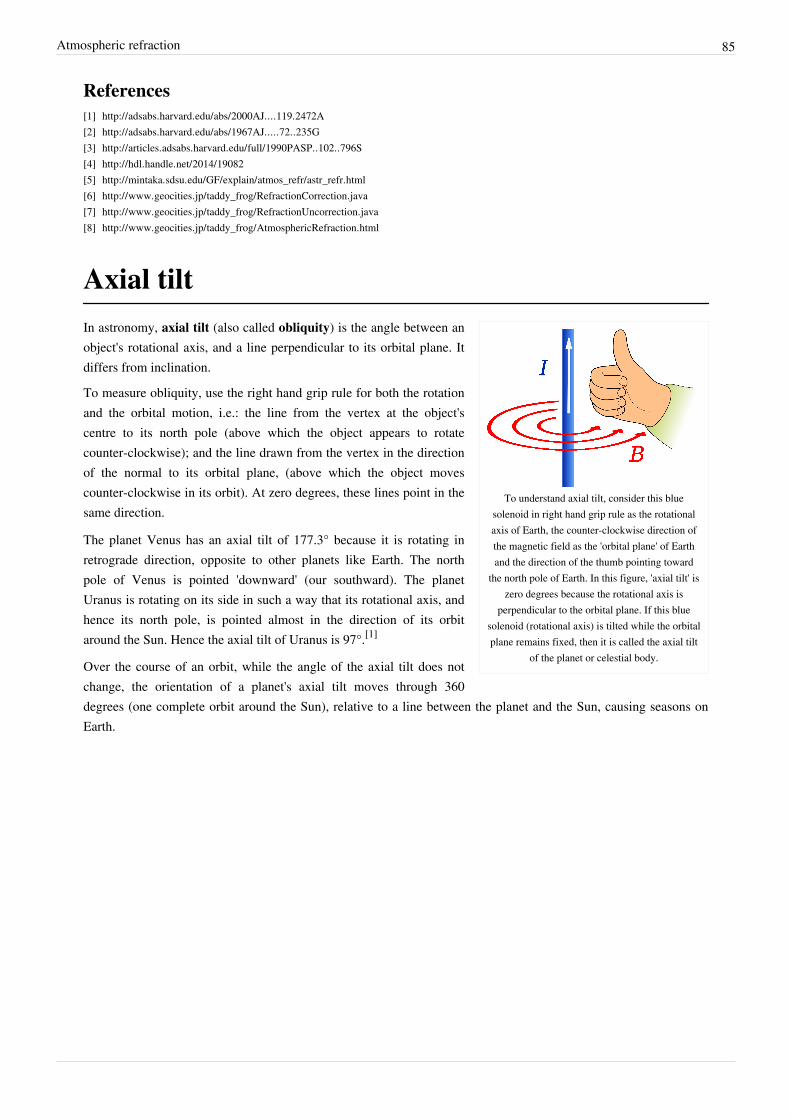
Atmospheric refraction 85
References[1] http:/ / adsabs. harvard. edu/ abs/ 2000AJ. . . . 119. 2472A[2] http:/ / adsabs. harvard. edu/ abs/ 1967AJ. . . . . 72. . 235G[3] http:/ / articles. adsabs. harvard. edu/ full/ 1990PASP. . 102. . 796S[4] http:/ / hdl. handle. net/ 2014/ 19082[5] http:/ / mintaka. sdsu. edu/ GF/ explain/ atmos_refr/ astr_refr. html[6] http:/ / www. geocities. jp/ taddy_frog/ RefractionCorrection. java[7] http:/ / www. geocities. jp/ taddy_frog/ RefractionUncorrection. java[8] http:/ / www. geocities. jp/ taddy_frog/ AtmosphericRefraction. html
Axial tilt
To understand axial tilt, consider this bluesolenoid in right hand grip rule as the rotationalaxis of Earth, the counter-clockwise direction ofthe magnetic field as the 'orbital plane' of Earthand the direction of the thumb pointing toward
the north pole of Earth. In this figure, 'axial tilt' iszero degrees because the rotational axis is
perpendicular to the orbital plane. If this bluesolenoid (rotational axis) is tilted while the orbitalplane remains fixed, then it is called the axial tilt
of the planet or celestial body.
In astronomy, axial tilt (also called obliquity) is the angle between anobject's rotational axis, and a line perpendicular to its orbital plane. Itdiffers from inclination.
To measure obliquity, use the right hand grip rule for both the rotationand the orbital motion, i.e.: the line from the vertex at the object'scentre to its north pole (above which the object appears to rotatecounter-clockwise); and the line drawn from the vertex in the directionof the normal to its orbital plane, (above which the object movescounter-clockwise in its orbit). At zero degrees, these lines point in thesame direction.
The planet Venus has an axial tilt of 177.3° because it is rotating inretrograde direction, opposite to other planets like Earth. The northpole of Venus is pointed 'downward' (our southward). The planetUranus is rotating on its side in such a way that its rotational axis, andhence its north pole, is pointed almost in the direction of its orbitaround the Sun. Hence the axial tilt of Uranus is 97°.[1]
Over the course of an orbit, while the angle of the axial tilt does notchange, the orientation of a planet's axial tilt moves through 360degrees (one complete orbit around the Sun), relative to a line between the planet and the Sun, causing seasons onEarth.

Axial tilt 86
Obliquity
Earth's axial tilt is 23.44°.[2]
In the solar system, the Earth's orbitalplane is known as the ecliptic plane,and so the Earth's axial tilt is officiallycalled the obliquity of the ecliptic. Itis denoted by the Greek letter ε.
The Earth currently has an axial tilt ofabout 23.5°.[2] The axis remains tiltedin the same direction towards the starsthroughout a year and this means thatwhen a hemisphere (a northern orsouthern half of the earth) is pointingaway from the Sun at one point in theorbit then half an orbit later (half ayear later) this hemisphere will bepointing towards the Sun. This effect isthe main cause of the seasons (seeeffect of sun angle on climate).Whichever hemisphere is currently tilted toward the Sun experiences more hours of sunlight each day, and thesunlight at midday also strikes the ground at an angle nearer the vertical and thus delivers more energy per unitsurface area.
Lower obliquity causes polar regions to receive less seasonally contrasting solar radiation, producing conditionsmore favorable to glaciation. Like changes in precession and eccentricity, changes in tilt influence the relativestrength of the seasons, but the effects of the tilt cycle are particularly pronounced in the high latitudes where thegreat ice ages began.[3] Obliquity is a major factor in glacial/interglacial fluctuations (see Milankovitch cycles).The obliquity of the ecliptic is not a fixed quantity but changing over time in a cycle with a period of 41,000 years(see below). Note that the obliquity and the precession of the equinoxes are calculated from the same theory and arethus related to each other. A smaller ε means a larger p (precession in longitude) and vice versa. Yet the twomovements act independent from each other, going in mutually perpendicular directions.
MeasurementKnowledge of the obliquity of the ecliptic (ε) is critical for astronomical calculations and observations from thesurface of the Earth (Earth-based, positional astronomy).To quickly grasp an idea of its numerical value one can look at how the Sun's angle above the horizon varies with theseasons. The measured difference between the angles of the Sun above the horizon at noon on the longest andshortest days of the year gives twice the obliquity.To an observer on the equator standing all year long looking above, the sun will be directly overhead at noon on theMarch Equinox, then swing north until it is over the Tropic of Cancer, 23° 26’ away from the equator on theNorthern Solstice. On the September Equinox it will be back overhead, then swing south until it is over the Tropic ofCapricorn, 23° 26’ away from the equator on the Southern Solstice.Example: an observer at 50° latitude (either north or south) will see the Sun 63° 26’ above the horizon at noon on thelongest day of the year, but only 16° 34’ on the shortest day. The difference is 2ε = 46° 52’, and so ε = 23° 26’.(90° - 50°) + 23.4394° = 63.4394° when measuring angles from the horizon (90° - 50°) − 23.4394° = 16.5606°

Axial tilt 87
At the Equator, this would be 90° + 23.4394° = 113.4394° and 90° − 23.4394° = 66.5606° (measuring always fromthe southern horizon).Abu-Mahmud Khojandi measured the Earth's axial tilt in the 10th century using this principle with a giant sextantand noted that his value was lower than those of earlier astronomers, thus discovering that the axial tilt is notconstant.[4]
ValuesThe Earth's axial tilt varies between 22.1° and 24.5° (but see below), with a 41,000 year period, and at present, thetilt is decreasing. In addition to this steady decrease there are much smaller short term (18.6 years) variations, knownas nutation, mainly due to the changing plane of the moon's orbit. This can shift the Earth's axial tilt by plus or minus0.005 degree.Simon Newcomb's calculation at the end of the nineteenth century for the obliquity of the ecliptic gave a value of23° 27’ 8.26” (epoch of 1900), and this was generally accepted until improved telescopes allowed more accurateobservations, and electronic computers permitted more elaborate models to be calculated. Lieske developed anupdated model in 1976 with ε equal to 23° 26’ 21.448” (epoch of 2000), which is part of the approximation formularecommended by the International Astronomical Union in 2000:ε = 84381.448 − 46.84024T − (59 × 10−5)T2 + (1.813 × 10⁻³)T3, measured in seconds of arc, with T being the timein Julian centuries (that is, 36,525 days) since the ephemeris epoch of 2000 (which occurred on Julian day2,451,545.0). A straight application of this formula to 1900 (T=-1) returns 23° 27’ 8.29”, which is very close toNewcomb's value.With the linear term in T being negative, at present the obliquity is slowly decreasing. It is implicit that thisexpression gives only an approximate value for ε and is only valid for a certain range of values of T. If not, ε wouldapproach infinity as T approaches infinity. Computations based on a numerical model of the solar system show that εhas a period of about 41,000 years, the same as the constants of the precession p of the equinoxes (although not ofthe precession itself).Other theoretical models may come with values for ε expressed with higher powers of T, but since no (finite)polynomial can ever represent a periodic function, they all go to either positive or negative infinity for large enoughT. In that respect one can understand the decision of the International Astronomical Union to choose the simplestequation which agrees with most models. For up to 5,000 years in the past and the future all formulas agree, and upto 9,000 years in the past and the future, most agree to reasonable accuracy. For eras farther out discrepancies get toolarge.
Long period variationsSee also: Orbit of the Moon (Tidal evolution of the lunar orbit)Nevertheless extrapolation of the average polynomials gives a fit to a sine curve with a period of 41,013 years,which, according to Wittmann, is equal to:ε = A + B sin(C(T + D)); with A = 23.496932° ± 0.001200°, B = − 0.860° ± 0.005°, C = 0.01532 ± 0.0009radian/Julian century, D = 4.40 ± 0.10 Julian centuries, and T, the time in centuries from the epoch of 2000 as above.This means a range of the obliquity from 22° 38’ to 24° 21’, the last maximum was reached in 8700 BC, the meanvalue occurred around 1550 and the next minimum will be in 11800. This formula should give a reasonableapproximation for the previous and next million years or so. Yet it remains an approximation in which the amplitudeof the wave remains the same, while in reality, as seen from the results of the Milankovitch cycles, irregularvariations occur. The quoted range for the obliquity is from 21° 30’ to 24° 30’, but the low value may have been aone-time overshot of the normal 22° 30’.
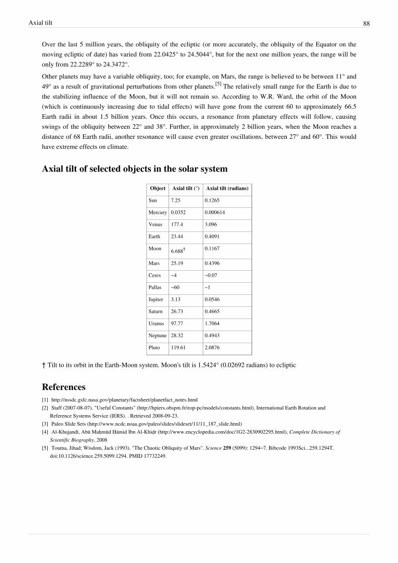
Axial tilt 88
Over the last 5 million years, the obliquity of the ecliptic (or more accurately, the obliquity of the Equator on themoving ecliptic of date) has varied from 22.0425° to 24.5044°, but for the next one million years, the range will beonly from 22.2289° to 24.3472°.Other planets may have a variable obliquity, too; for example, on Mars, the range is believed to be between 11° and49° as a result of gravitational perturbations from other planets.[5] The relatively small range for the Earth is due tothe stabilizing influence of the Moon, but it will not remain so. According to W.R. Ward, the orbit of the Moon(which is continuously increasing due to tidal effects) will have gone from the current 60 to approximately 66.5Earth radii in about 1.5 billion years. Once this occurs, a resonance from planetary effects will follow, causingswings of the obliquity between 22° and 38°. Further, in approximately 2 billion years, when the Moon reaches adistance of 68 Earth radii, another resonance will cause even greater oscillations, between 27° and 60°. This wouldhave extreme effects on climate.
Axial tilt of selected objects in the solar system
Object Axial tilt (°) Axial tilt (radians)
Sun 7.25 0.1265
Mercury 0.0352 0.000614
Venus 177.4 3.096
Earth 23.44 0.4091
Moon 6.688† 0.1167
Mars 25.19 0.4396
Ceres ~4 ~0.07
Pallas ~60 ~1
Jupiter 3.13 0.0546
Saturn 26.73 0.4665
Uranus 97.77 1.7064
Neptune 28.32 0.4943
Pluto 119.61 2.0876
† Tilt to its orbit in the Earth-Moon system. Moon's tilt is 1.5424° (0.02692 radians) to ecliptic
References[1] http:/ / nssdc. gsfc. nasa. gov/ planetary/ factsheet/ planetfact_notes. html[2] Staff (2007-08-07). "Useful Constants" (http:/ / hpiers. obspm. fr/ eop-pc/ models/ constants. html). International Earth Rotation and
Reference Systems Service (IERS). . Retrieved 2008-09-23.[3] Paleo Slide Sets (http:/ / www. ncdc. noaa. gov/ paleo/ slides/ slideset/ 11/ 11_187_slide. html)[4] Al-Khujandī, Abū Maḥmūd Ḥāmid Ibn Al-Khiḍr (http:/ / www. encyclopedia. com/ doc/ 1G2-2830902295. html), Complete Dictionary of
Scientific Biography, 2008[5] Touma, Jihad; Wisdom, Jack (1993). "The Chaotic Obliquity of Mars". Science 259 (5099): 1294–7. Bibcode 1993Sci...259.1294T.
doi:10.1126/science.259.5099.1294. PMID 17732249.

Axial tilt 89
External links• Explanatory supplement to "the Astronomical ephemeris" and the American Ephemeris and Nautical Almanac• A comparison of values predicted by different theories (http:/ / www. tenspheres. com/ researches/ precession.
htm) at tenspheres.com• Berger, A. L. "Obliquity & precession for the last 5 million years". Astronomy & Astrophysics 51, 127 (1976)• Wittmann, A. "The obliquity of the ecliptic". Astronomy & Astrophysics 73, 129-131 (1979)• Ward, W. R. "Comments on the long-term stability of the Earth's obliquity". Icarus 1982, 50, 444• National Space Science Data Center (http:/ / nssdc. gsfc. nasa. gov/ planetary/ )• Bryant, Jeff. Axial Tilts of Planets (http:/ / demonstrations. wolfram. com/ AxialTiltsOfPlanets/ ), Wolfram
Demonstrations Project

Article Sources and Contributors 90
Article Sources and ContributorsCartesian coordinate system Source: http://en.wikipedia.org/w/index.php?oldid=470239547 Contributors: 041744, 345Kai, Abrech, Acather96, Adamcscott, Adashiel, Alanfeynman,Alansohn, Aleenf1, Allliam, Andeggs, Andre Engels, Andrei Stroe, Anonymous Dissident, Antonrojo, Anypodetos, Appropo, AugPi, Basalisk, Bevo, Binary TSO, Bjankuloski06en,Blindman.rms, Brighterorange, Bryan Derksen, Bucketsofg, Byj2000, C4, Cameron Nedland, Can't sleep, clown will eat me, CanonLawJunkie, CaptainVideo890, CardinalDan, Catslash,CattleGirl, Charles Matthews, Chausx, Che090572, Cheeser1, Chuck Smith, Chuunen Baka, Cmbrannon, Colin Cochrane, Colipon, Connormah, Conversion script, Cpiral, Cronholm144, DVD RW, Damian Yerrick, Dast, Dasteve, Davecrosby uk, David Eppstein, Dbfirs, Dbtfz, Dcljr, DeadEyeArrow, DeclinedShadow, Delldot, DerHexer, Dhollm, Dionoea, Domitius, Downtown danseattle, Drz, Dysprosia, Edgerck, Edinburgh Wanderer, Edwinstearns, Elwikipedista, Emperorbma, Enochlau, Epbr123, Escape Orbit, Euryalus, Excirial, Fabrictramp, Falcorian, Federhalter,Fieldday-sunday, Firefishy, Fordan, Fresheneesz, Gesslein, Giftlite, Gioto, Graham87, Gustavb, Headbomb, Hede2000, Helios, Henrygb, HereToHelp, Heron, Hobartimus, Hongooi,Hyperweb79, J.delanoy, JForget, JHunterJ, JLaTondre, JWSchmidt, Jackzhp, Jason Quinn, Jeffwang, Jleedev, Jncraton, Jobnikon, JohnBlackburne, Johnuniq, Jorge Stolfi, Joseph Myers, Jsjunkie,Juansempere, Junelvillejo, Jurlinga, Katieh5584, Katzmik, Kbolino, KillerOfThem, Kjkolb, KlappCK, Knight1993, Kurykh, LOL, Lambiam, Lanepierce, Lantonov, Larry V, Leszek Jańczuk,Linas, Logan, Lotje, LouisBB, MJSkia1, Maelor, Majopius, Man It's So Loud In Here, Maniwar, Manuel Anastácio, MarSch, Mark Ryan, Martin451, Materialscientist, MathsIsFun,Mattreedywiki, Mavhc, Maxal, Maximus Rex, Meegs, Mel Etitis, Memming, Mets501, Mhaitham.shammaa, Michael Hardy, Michael Snow, Mild Bill Hiccup, Miquonranger03, Modulatum,Montrealais, Mpatel, MrMambo, MrOllie, Mun206, NameIsRon, Nbarth, Nbrothers, Nekura, NewEnglandYankee, NickW557, Nihiltres, Nikola Smolenski, Nobono9, NorbDigiBeaver, Numbo3,OGoncho, Octahedron80, Oftopladb, Oleg Alexandrov, OneWeirdDude, Oxymoron83, PAR, Paolo.dL, Papadim.G, ParlorGames, Patrick, Paul August, PhilKnight, Phl.jns, Piano non troppo,Pip2andahalf, Pizza Puzzle, Pmokeefe, Popsh, Prara, Questionefisica, RDBury, RJASE1, RabidDeity, Rajmathi mehta, Randomblue, Rausch, RedHillian, Rettetast, Rgdboer, Rhino bucket, RichFarmbrough, Rjwilmsi, Rogiemac, Romanm, Ruziklan, ST47, Sadi Carnot, Salix alba, Samtheboy, Sasajid, Silly rabbit, Skyfaller, Slant, Slawekb, Slon02, Smack, SnowFire, Snozzer, SoWhy,SockPuppetForTomruen, Srice13, Srleffler, Staffwaterboy, Stan J Klimas, Steven J. Anderson, Stwalkerster, Suffusion of Yellow, Sverdrup, Svick, TJ09, Tarquin, Tempodivalse, The Thing ThatShould Not Be, TheFreeloader, Thingg, Tide rolls, Timh3221, Timwi, Titoxd, Tony Liao, Tony1849, Topherjasmin09, Ulric1313, Uncaringgunner, Vanostran, Vltava 68, Voyagerfan5761,WMC, Waffleman12, Wavelength, Wcherowi, WillowW, Wireless Keyboard, Wizard191, Wmplayer, Woohookitty, Wwannsda, Ygrek, Yossiea, Zundark, Þjóðólfr, Александър, Վազգեն, کاشفanonymous edits 497 ,عقیل
Dot product Source: http://en.wikipedia.org/w/index.php?oldid=468596469 Contributors: Ahmedo15, Akulaalfa, Alksub, Amadib, Andros 1337, Anonymous Dissident, Aptronotus,ArbiterOne, Audriusa, Bdesham, BenFrantzDale, Charles Matthews, Chezz444, Crispin.cheddarcock, Crunchy Numbers, Cybercobra, DIG, Dan, Dan Granahan, Daniel Brockman, Danshil,Daviis, Davor, Dfan, Dmawxc, Dr.K., Dysprosia, Econotechie, Ecov, Ehaussecker, Elockid, Emote, Epbr123, Ezrakilty, Fflanner, Flip619, Frau Hitt, Fredrik, Fresheneesz, GBL, Gandalf61,Gbleem, Ghazer, Giftlite, GoldenGoose100, GregorB, Hairy Dude, Harleymeyer, Harold f, Heptazane, HereToHelp, Hillman, Humanengr, Hypnosifl, Icairns, Icep, Interchange88, Isnow, JVz,Jersey Devil, JohnBlackburne, Josemanimala, KDesk, KSmrq, Karlmeerbergen, Kborer, Khashishi, Kk, Kpufferfish, Kri, LOL, LRG, Landroni, LeadSongDog, Limited Atonement, LizardJr8,Locador, Lockeownzj00, LokiClock, Luokehao, M samadi, MSGJ, Marc van Leeuwen, MarkSweep, Markus Schmaus, Marozols, MathMartin, Matt Crypto, Matt Kovacs, Matthew.p.korte,Mazin07, Mcherm, Melchoir, Michael Hardy, Michael Slone, Mortees, MrHumperdink, Mrwojo, Msm, Muhandes, Naddy, NanoTy, Narayansg, Naught101, NeoUrfahraner, Neparis,Nguoiviet979, O18, Octahedron80, Oleg Alexandrov, Omegatron, Ospalh, Oxymoron83, Paolo.dL, Patrick, PaulTanenbaum, Pfalstad, PhilKnight, Pleasantville, PsiEpsilon, Quentar, Rausch,Redbaron486, Rich Farmbrough, Rightisright4250, Romanm, Rosenlind, Ryansca, SGBailey, Samuel Huang, Sanchom, Sangwine, Savidan, SebastianHelm, Selfworm, Shirulashem, Slaunger,Slawekb, Slicky, Smartyepp, Smoo222, Sreyan, StradivariusTV, Sławomir Biały, Tarquin, TeH nOmInAtOr, Template namespace initialisation script, Tim Starling, Timwi, Tlevine, TonySidaway, Tosha, Tristanreid, VACowboy41, Voidxor, WaysToEscape, Wereon, WhiteHatLurker, Windchaser, Wwoods, Yamamoto Ichiro, Zath42, 242 anonymous edits
Cross product Source: http://en.wikipedia.org/w/index.php?oldid=469516201 Contributors: 21655, 9258fahsflkh917fas, Aaron D. Ball, Acdx, Ajl772, Albmont, Aliotra, Altenmann, Andres,Andros 1337, Anonauthor, Anonymous Dissident, Antixt, Arthur Rubin, Astronautics, AxelBoldt, BD2412, Balcer, Ben pcc, BenFrantzDale, Bender2k14, Bobo192, Booyabazooka,BrainMagMo, Brews ohare, Bth, Can't sleep, clown will eat me, CasualVisitor, Charles Matthews, Chinju, Chris the speller, Chrismurf, Christian List, Chzz, Clarahamster, Conny, Conrad.Irwin,Coolkid70, Cortiver, CrazyChemGuy, Crunchy Numbers, D, DVdm, Dan Granahan, David Tombe, Decumanus, Discospinster, Doshell, Dougthebug, Dude1818, Dysprosia, Edgerck, El C,Emersoni, Empro2, Emschorsch, Enviroboy, Eraserhead1, Esseye, Eulerianpath, FDT, FoC400, Foobaz, Fresheneesz, FyzixFighter, Fzix info, Fæ, Gaelen S., Gandalf61, Gauge, Giftlite,Hanshuo, Henrygb, Hu12, HurukanLightWarrior, Iamnoah, Ino5hiro, Iorsh, Iridescent, Isaac Dupree, Isnow, Ivokabel, J. Philip Barnes, J7KY35P21OK, JEBrown87544, Jaredwf, Jimduck,JohnBlackburne, KHamsun, KSmrq, KYN, Kevmitch, Kisielk, KlappCK, Kmhkmh, Kri, LOL, Lambiam, Lantonov, Leland McInnes, Lethe, Lockeownzj00, Loodog, M simin, MFNickster,Magnesium, Mal, MarcusMaximus, Mark A Oakley, Mark Foskey, MathKnight, Mckaysalisbury, Mcnallod, Melchoir, Michael Hardy, Michael Ross, Mikejulietvictor, Monguin61, Mrahner,Mycroft IV4, Nbarth, Neparis, Nikola Smolenski, Octahedron80, Oleg Alexandrov, Onco p53, Oneirist, Paolo.dL, Patrick, Paul August, Paul Breeuwsma, Pi.1415926535, Pingveno,Pip2andahalf, Plugwash, Pouchkidium, PraShree, Quietly, Quondum, Qwfp, R'n'B, Rainwarrior, Raiontov, RaulMiller, Rausch, Rbgros754, Reddevyl, Reindra, ReinisFMF, Rgdboer, RichFarmbrough, Robinh, Romanm, SCEhardt, SDC, Salix alba, SeventyThree, Silly rabbit, Simskoarl, Slawekb, Spinningspark, Sreyan, Ssafarik, Stefano85, Svick, Sławomir Biały, T-rex, Tadeu,TakuyaMurata, Tarquin, TeH nOmInAtOr, Template namespace initialisation script, Teorth, Tesseran, Tetracube, The Thing That Should Not Be, TheSolomon, Thinking of England,Thoreaulylazy, Tim Starling, Timrem, Timwi, Tobias Bergemann, Tomruen, Uberjivy, Vkpd11, Voorlandt, WISo, WVhybrid, Wars, WhiteCrane, Whitepaw, WikHead, Wilfordbrimley,Willking1979, Windchaser, Wolfkeeper, Wolfrock, Wshun, Wwoods, X42bn6, Xaos, Yellowdesk, Ysangkok, ZamorakO o, ZeroOne, Zundark, 395 anonymous edits
Spherical coordinate system Source: http://en.wikipedia.org/w/index.php?oldid=466533836 Contributors: 123abcwtf, AGBenoit, AManWithNoPlan, Abel Cavaşi, Alansohn, Amtiss, Andeggs,Andonic, Answeryoung, Ap, AugPi, Austinmohr, Bgamari, Braindrain0000, Brian Hopkins, Bsorbom, Chymicus, Ciphers, Conversion script, Cronholm144, Cyp, Danius353, DemonThing,DemonicInfluence, Donarreiskoffer, Dpb2104, Dr Hudson, Ed Poor, Ekura, Escapepea, Evaluist, Fackt0r, Falcon8765, Forthommel, Freireib, Funnyfarmofdoom, Gaius Cornelius, Gerbrant,Giftlite, Glane23, Gonfer, GraVix202, Hankwang, Hawklord, Hazel77, HereToHelp, Heron, Hyperspaced, JJ Harrison, Jason Quinn, JohnBlackburne, Jorge Stolfi, Joseph Myers, Juansempere,Karada, King Lopez, Kjetil1001, Kkddkkdd, Knuckles, LOL, Lambiam, Lantonov, Laurens-af, Lavaka, LilHelpa, Looxix, MER-C, Minesweeper, Miturian, MuDavid, Naturalnumber, Nbarth,NeilN, Netheril96, Nitromaster101, Obradovic Goran, Olathe, OnePt618, PAR, Papadim.G, Patrick, Paul August, Paul G, Petter Strandmark, Pomte, RDBury, Reconsider the static, RichFarmbrough, Rjwilmsi, RyanC., Saeed.Veradi, Salgueiro, Salix alba, Shadowjams, Shin-Kitsune, Sixequalszero, Spherical.voxel, Spoon!, Stephentown, Synethos, Takanoha, Taliswolf, TheAnome, Thurth, Toolnut, Troponin, Unimath, User A1, Vashchacho, Velocidex, Vinograd19, Vishahu, Wick renner, WillowW, Yeungchunk, Ysyoon, Yurell, Zundark, 299 anonymous edits
Spherical trigonometry Source: http://en.wikipedia.org/w/index.php?oldid=465564374 Contributors: 790, Al-Andalusi, Altenmann, Amorrow, AnOddName, AndyZ, Anonymous Dissident,Arif Zaman, Aucheukyin, AugPi, Benjaminb, BillFlis, BlackShift, Bo Jacoby, BokicaK, Boud, Brad7777, Buggy793, Catamorphism, CiaPan, Dcoetzee, Doshell, Duoduoduo, Edemaine, Egg,ElfMage, Emdrgreg, Equendil, Fropuff, Fwilliams14, Giftlite, Hakeem.gadi, Hgilbert, Isnow, Jagged 85, Jeandré du Toit, JimD, JohnBlackburne, JohnECrider, Jrvz, JuanFox, Kmhkmh,Knight1993, KryssTal, Lethe, Loren.wilton, Ma'ame Michu, Marco Polo, Mhym, Michael Hardy, Mike Dillon, Minkovskij, Mosher, MrOllie, Mukerjee, Nadav1, Nbarth, Nekura, Ntmatter,Orionus, PancakesMan, Pleasantville, Renatops, Rich Farmbrough, Robofish, RockRichard, Sanders muc, Selfworm, Skippy le Grand Gourou, Some1new4ya, Spireguy, Stannered, Steelpillow,Stevenj, Stewartadcock, Sverdrup, Syncategoremata, TimBentley, Tobby72, Tomruen, UnitedStatesian, Urhixidur, Vaughan Pratt, Vigormaster, Wcherowi, Wikkrockiana, Zhaonach, МиланЈелисавчић, 72 anonymous edits
Spherical law of cosines Source: http://en.wikipedia.org/w/index.php?oldid=457010353 Contributors: Aburov, Addihockey10, EmilJ, Giftlite, KSmrq, Mhym, Michael Hardy, Roadrunner,Sodin, Stevenj, Sławomir Biały, TheOtherJesse, Tim Zukas, Xaosflux, 16 anonymous edits
Circle of a sphere Source: http://en.wikipedia.org/w/index.php?oldid=468655630 Contributors: 3signmain, Arjayay, Bazonka, Bkell, BoH, CBM, Cronholm144, EikwaR, Equendil,Jonathan.s.kt, Lenschulwitz, Merlion444, Michael Hardy, Michaelbarreto, R'n'B, RDBury, Ratarsed, Reuben, Rogper, Secretlondon, SimonP, Squeaky201, Stotr, Tabletop, Vinícius MachadoVogt, Woseph, Zdtrlik, 7 anonymous edits
Great circle Source: http://en.wikipedia.org/w/index.php?oldid=463930834 Contributors: 3signmain, A-giau, ALE!, Alanfeynman, Alexbatko, Alfio, Badmonkey, Brion VIBBER, Bwefler,Byrial, CBM, Chris the speller, Chrome89, Ciphergoth, Coneslayer, Cpq29gpl, Crisco 1492, Crusoe8181, Curps, Dan100, Dawnseeker2000, Deville, Dino, Doradus, Dysprosia, Dzordzm,EEPiccolo, Ed Poor, Edward1977 nl, Engelec, Eouw0o83hf, Erusse estelinya, FaustX, FayssalF, Flish2400, GCW50, Geboy, Giftlite, Graham87, Guentherwagner, Haakon, Hairy poker monster,Harry Wood, Henrygb, Hibernian, Inkowik, Isnow, JeR, JeremyCole, Jerzy, Jhbdel, JoeDeRose, John Fader, Jonathan.s.kt, Jonkerz, Joriki, Jpp42, Juansempere, Katzmik, Kazubon, Kbh3rd,Kieff, KnightRider, Kosebamse, Ksanyi, LC, Lee Carre, Leonard G., Linas, MC10, MSGJ, Mashford, Mathieumcguire, Mav, Mcsee, Mdbest, Mejor Los Indios, Menphrad, Michael Hardy, MikeDillon, Mike18xx, Mike4ty4, Mikespedia, Modify, MorganHaggis, MrOllie, Netheril96, Nsaa, OGoncho, OfficeGirl, Oleg Alexandrov, Ospalh, PV=nRT, Patrick, Patstuart, PhilHibbs,Pinethicket, Pixuk, Pleasantville, Pthompson, Qmwne235, RDBury, RandomStringOfCharacters, Reedy, Rgdboer, Rob Hooft, RockerTimmy, Rogper, RoySmith, Sammo, Sanders muc,Shantavira, Stevenj, StuartF, Svick, Sławomir Biały, Tarquin, Tedder, Thesevenseas, Tim Zukas, Tktktk, Tobias Hoevekamp, Tosha, Trengarasu, Trgn, Undead Herle King, Vaughan Pratt,VeryVerily, Vhorvat, Waltpohl, Waylonparker, WikiMaster64, XJamRastafire, 118 anonymous edits
Great-circle distance Source: http://en.wikipedia.org/w/index.php?oldid=469924692 Contributors: A1feeds, Ac44ck, Admiralh, Alanfeynman, Anonymous Dissident, Apetresc, Arb, BIL, Benpcc, Bondolo, Brian0918, Btyner, CDV, Cffk, Charles Matthews, Chiptonius, Dardasavta, Dbenbenn, Denelson83, Dolphin51, Equendil, Favignano, Flib0, Fraser Chapman, Fropuff, FuzzyLogic, Gaianauta, Giftlite, Henning Makholm, Huzzahmaster018, Isaac Euler, JahJah, Jannej, JeremyCole, JohnWheater, Joost 99, Kaimbridge, Karhukoti, Katzmik, Kdebisschop, Komischn,Kosebamse, LAW, Loren.wilton, Mark Renier, Martinstoeckli, Mathpichhi, Michael Hardy, MorganHaggis, MrOllie, Murray Langton, Musiphil, Myearwood, NawlinWiki, Oosoom, Patrick,PetrLezak, QuantumEngineer, QuentinUK, R27182818, Revipm, Reyk, Rich Farmbrough, Richardson208, Robert G Chamberlain, SarekOfVulcan, Sohale, Stevenj, Taemyr, Tedder,Thomasrwilson, Tim Zukas, Unomano, Verbatim9, Vevillgo, Vtcondo, We hope, Wshun, Zgystardst, 120 anonymous edits

Article Sources and Contributors 91
Horizontal coordinate system Source: http://en.wikipedia.org/w/index.php?oldid=467868779 Contributors: A4, Alberto Orlandini, Anoko moonlight, Bruce89, Chester Markel, Copyeditor42,CosineKitty, Crystallina, Danim, Deville, Flex, FocalPoint, Fredcondo, Garglebutt, GreatWhiteNortherner, Isnow, Jaydec, Jbass, JeffConrad, Junglecat, Karol Langner, Kostmo, Loupeter, MichelBUZE, Nnh, Orionus, Osjatkrukan, Patrick, PlaidKraken, Qetuth, Quibik, Res2216firestar, Rlupsa, Rursus, Sailsbystars, Sfridman, Sigmanexus6, Sverdrup, Tauʻolunga, Tobias Hoevekamp, VítorDassie, Ywaz, 27 anonymous edits
Earth's energy budget Source: http://en.wikipedia.org/w/index.php?oldid=465521977 Contributors: AdmiralHood, Amikake3, Andycjp, Art LaPella, Battye, Berkut, Blouis79, Bob Stein -VisiBone, Bobblewik, Bryan Derksen, C.Fred, Chris the speller, Coppertwig, CrossoverManiac, Daniel C, DarkPhoenix, Dragons flight, Duae Quartunciae, Frietjes, Geoffrey.landis, Heracles31,Heron, Hibernian, Huw Powell, Jason Patton, Josh Parris, Kr-val, Mandarax, Marknutley, Materialscientist, Menwith, Mierlo, N p holmes, Nathan Johnson, Neutrality, NuclearWarfare,Ohnoitsjamie, Peruvianllama, Plumbago, Poodleboy, RDBrown, RIS cody, Res2216firestar, RexNL, Rich Farmbrough, Slow entrophyy, Stillnotelf, Thincat, Tideflat, Tomtheman5, Ultramarine,Veteran0101, Virtual Cowboy, Vsmith, Wavelength, William M. Connolley, Wwoods, Zoicon5, 76 anonymous edits
Declination Source: http://en.wikipedia.org/w/index.php?oldid=466210547 Contributors: Ac44ck, Alberto Orlandini, Alfio, AlwaysWrite, Anddrrew, Andre Engels, Anton Gutsunaev,Antzervos, Archer7, Arthena, Astrologist, Avjoska, B.d.mills, Bebenko, Bender235, Berserkerus, Bjankuloski06en, Bronger, CALR, Chris Dybala, Chromosome, Conversion script, CosineKitty,DMG413, DOwenWilliams, Dhaluza, Dkreisst, Drilnoth, Dungodung, Eco751, Epbr123, Evil Monkey, Fuper, Geof, Hurricane111, Icairns, JMK, Ja 62, Janneok, Jc3s5h, Jerzy, Jimp, Julesd,Katymeehan, Kbarox, Kesuari, KnightRider, Kristaga, Kwamikagami, Kwekubo, Laurascudder, Lerdsuwa, Lir, Lismoreboy, Looxix, Mejor Los Indios, Michael Hardy, Minna Sora no Shita,Mishuletz, MistySpock, Modeha, Njk92, Numbo3, Patrick, Pizza Puzzle, Ponder, RJHall, RedWolf, Rigadoun, Roland Longbow, Rpresser, Sam Hocevar, Saros136, ScAvenger lv, Scriber,Shijualex, Smartech, SteveMcCluskey, Sverdrup, Telanis, TheObtuseAngleOfDoom, Tim Zukas, Vinay Jha, Vsmith, White Trillium, Wiki-Ed, Yahia.barie, Ywaz, کاشف عقیل, आशीष भटनागर, 72anonymous edits
Solar elevation angle Source: http://en.wikipedia.org/w/index.php?oldid=441555065 Contributors: Ac44ck, Grutness, Hankwang, JeffConrad, Karol Langner, Mesosphere, Miyu, RJHall, RichFarmbrough, Sampo Smolander, 4 anonymous edits
Solar azimuth angle Source: http://en.wikipedia.org/w/index.php?oldid=460301778 Contributors: Ac44ck, Alexander.mitsos, Fr33ke, Grutness, Hankwang, Jbass, Karol Langner, Mesosphere,Mikofski, Miyu, RJHall, Sampo Smolander, Tadorne, Theogra, 25 anonymous edits
Sun path Source: http://en.wikipedia.org/w/index.php?oldid=465035398 Contributors: Ac44ck, Agentilini, Anastrophe, Anticipation of a New Lover's Arrival, The, Apc3n, Barrylb, Cosmo0,DOwenWilliams, Dymonite, Energyauditor, Escientist, GGByte, Gmfreak, Hankwang, HarryAlffa, Hartz, Jdpipe, Jeffz1, Jojalozzo, MikeLynch, Nelsnelson, Pwrsc, R'n'B, Redrose64, Rjwilmsi,Robsavoie, Ruslik0, Some jerk on the Internet, Tardis, The Tom, Tirkfl, V.Khavrus, 凌雲, 26 anonymous edits
Sun chart Source: http://en.wikipedia.org/w/index.php?oldid=454520967 Contributors: Absolutegandalf, Alexhangartner, Anthony717, Atlant, Bearcat, Colonies Chris, Confused monk, CraigPemberton, Grutness, Keilana, LrdChaos, Malcolma, Metropolitan90, RobJ1981, Traveler100, 3 anonymous edits
Irradiance Source: http://en.wikipedia.org/w/index.php?oldid=456777615 Contributors: Bob K31416, Char Truth, Cookie4869, Dave3457, David Battle, Dikstr, Dysprosia, GabrielVelasquez,Greg L, Headbomb, I Like Cheeseburgers, Ian Pitchford, Icairns, Jdpipe, Keflavich, Kgrr, Kisiel1mk, KnightRider, Larryisgood, Llorenzi, Mahlum, Matthiaspaul, PiratePi, Ram einstein,SEWilco, Salsb, Sohale, Srleffler, TerokNor, The High Fin Sperm Whale, Tlroche, Tomchiukc, Unusual Cheese, Wendell, Шуфель, 43 anonymous edits
Sunlight Source: http://en.wikipedia.org/w/index.php?oldid=468224807 Contributors: 1000Faces, 2D, 2over0, 7, 84user, A little insignificant, A930913, Abqwildcat, Acroterion, Actcls,Adoniscik, Ahoerstemeier, Alansohn, Alexdarmos3, Amcbride, Anarchyson, Anders Torlind, AndyTheGrump, Andycjp, Anetode, Anlace, Anmclarke, Anna Lincoln, Antandrus, Art LaPella,Asenine, Asfarer, Avenue, Awickert, AzaToth, Bart133, Batchelor, Beano, Beland, BenFrantzDale, Benbread, Bergsten, Biscuittin, Blanchardb, Boat123, Bomac, Bongwarrior, Bradv,Brandon101323, Bruce1ee, Bryan Derksen, Bucephalus, Bunser, Burzmali, CMG, CambridgeBayWeather, CanisRufus, Capricorn42, Carioca, Cburnett, Cheerios327, ChemNerd,Chillingsworth09, Chris 73, Chris Howard, Cmdrjameson, Cnguyen, Colonies Chris, CommonsDelinker, Conversion script, Cosmospup, Courcelles, Cquan, Credema, Curps, Cutygirlyaya,Cyclopia, DC, DMacks, DOwenWilliams, Dan Gluck, Dan aka jack, Danchristofi, Dandelion1, DanielCWebb1949, Danielsavoiu, Darkside2010, Darkwind, David R. Ingham, David Shay,DavidH, DeadEyeArrow, Deglr6328, Dekimasu, Dennislee2727, Dias11334, Dikstr, Dillio411, Dkroll2, Donarreiskoffer, Doulos Christos, Downwards, DrBob, Dragons flight, Eeky, Efe, Elf,Empyrius, Emustonen, Enviroboy, Epbr123, Eric Kvaalen, Erictj, Excirial, Farnshon, Finell, Firetrap9254, Fotaun, Fvw, Gabriel Kielland, Gail, Ghgrtrynosrvi;oeznt, Giftlite, Gilliam, Glenn,GodShiru, Gogo Dodo, Gollumgrr, GraemeL, Grahammorehead, Gtdp, Gunmetal Angel, Gunstar hero, Gurch, Hadal, HamburgerRadio, Hamburgerscum, Hamiltondaniel, Hammersoft,Hankwang, Hasanisawi, Headbomb, Heron, Hertz1888, Hibernian, Hohum, HotQuantum3000, Hugh Hudson, IGeMiNix, IRP, Incredio, Ineffable0ne, Inferno, Lord of Penguins, Invisiblebug590,Itselectric, J.delanoy, J04n, JForget, JNW, JTN, Jaganath, Jean-Louis Dufresne, Jemocri, Jfclemay, Jfdwolff, Jlascar, Jonah Saltzman, Joosteto, Jordan117, Josh Parris, Jujutacular, Juliancolton,Just plain Bill, Jwanders, KC Panchal, Katieh5584, Kbdank71, Kernow, Khoikhoi, Kramer14, Krrish23, Kubigula, KyraVixen, L Kensington, La Pianista, Laguna CA, Liastnir, Lightmouse,Lumos3, MCCartneyfo, MER-C, Maddie!, Maddox, Magnoliasltd, Mailseth, Makeemlighter, Makloto, Marcika, Mark Foskey, Markj99, Martial75, MaxEnt, Maxis ftw, Mayalld, Meno25, Mhiji,Michael Hardy, MichaelBillington, Michi zh, Mikael Häggström, MikeX, Mipadi, Miranda, Mmarre, Mmcknight4, Monedula, Mrkeaster, Msrt10, N5iln, NCurse, Neutrality,NewEnglandYankee, NiftySwifty, Nihaokeisha, Nk, Nono64, Numberonebroseph, Omegatron, Omgitsjerry, Originalwana, Ospalh, Owen, PMDrive1061, Pandelver, Papercutbiology, Patrick,Petri Krohn, PhilKnight, Phirtle, Picapica, Pip2andahalf, Popnose, Prashanthns, Quantumor, Quest for Truth, R'n'B, RJaguar3, Radagast83, Radon210, Rainbowkey, Randomnameftw2, Raomap,Remember the dot, RestChem, Rettetast, Revth, Rgdboer, Rich Farmbrough, Rip;sunshine, Ritabetta, Rjwilmsi, Robert P. O'Shea, RockMFR, RoyBoy, Rror, Rsabbatini, Ruislick0, Ruslik0,S19991002, SFC9394, Saros136, SchfiftyThree, Scoops, Sdogi, Sectori, Serendipodous, Shenme, Shirt58, Simetrical, SimonP, Sionus, Smappy, Smashedupps2, Smaug123, Snigbrook, Solipsist,SpaceFlight89, SparrowsWing, Spiel496, Srleffler, Staffordkendall, Staffwaterboy, Stemonitis, Stevage, Super-Magician, Superm401, Supersunshine420, Tatterfly, Tbhotch, Template namespaceinitialisation script, TenOfAllTrades, That Which Lurks1, The Anome, The Article Creator, The Thing That Should Not Be, TheBoldBuck, TheStig118, Think outside the box, Thu, Tide rolls,Timbo68, TobiasTC, Tom.k, Tomdo08, Tomer T, Tommy2010, Tony Sidaway, Topazg, Trevor MacInnis, Trusilver, Turnip444, Twynholm, Ukexpat, Vaceituno, Verdatum, Versus22, Vivismm,Vranak, Vrenator, Vsmith, Wavelength, Wda, Wereon, White Trillium, William M. Connolley, Willsmith, Wnissen, Xenonice, Xezbeth, YellowFives, Ykhwong, 505 ,05ترجمان anonymous edits
Effect of sun angle on climate Source: http://en.wikipedia.org/w/index.php?oldid=445685307 Contributors: Ancheta Wis, Anonymous Dissident, Autocracy, BD2412, Blainster, Cronholm144,Daven200520, DavidH, Dhaluza, Dreadstar, Dysmorodrepanis, Glen, Holme053, I dream of horses, JMK, Jay, Mejor Los Indios, Mew2468, Michael Hardy, MilesAgain, Pflatau, Redset,Robsavoie, Stux, The Thing That Should Not Be, Thegreatdr, Thorwald, Tjjyhghjkghkjghjghjghj, V.Khavrus, William M. Connolley, 32 anonymous edits
Insolation Source: http://en.wikipedia.org/w/index.php?oldid=464789604 Contributors: 16@r, 21655, AcidHelmNun, Aitias, Ancheta Wis, Andrewrp, Anikingos, Anthony717, Argo Navis,ArnoldReinhold, Ayla, Berberisb, Bergsten, Bryan Derksen, CLandau, CWii, CaliforniaAliBaba, CiaPan, Colonies Chris, Corsaa, DavidH, Dbfirs, DeathByBattleaxe, Diannaa, Dikstr,DivineAlpha, Doc richard, Dudshan, Eequor, EoGuy, Euchiasmus, Foobarian, GabrielVelasquez, Gaius Cornelius, Gene Nygaard, Geneharris, Greglocock, HEL, Hallenrm, Heron, Hertz1888,Hibernian, IcedNut, Immunize, Incredio, J.delanoy, JForget, Jarakaki, Jauhienij, JethroElfman, Jonathan Rabbitt, Julleras, Kgrr, Klaus, Linas, LlywelynII, Manchot, Marek69, Mark Eliassen,Metric america, Michael Hardy, Mikiemike, Mrshaba, Nddstudent, Nivix, Ojmesa, Paddles, Pascal666, Patrick, PhiLiP, Pietdesomere, Plasticup, R'n'B, Rhysmarsh, Rjwilmsi, Rkwiki, Rorro,Rracecarr, Sbmehta, Shadowjams, Shuipzv3, Slawekb, SolarBozo, SolarSoft, Some jerk on the Internet, Srleffler, Stephen B Streater, Sumo su, Surajt88, Svick, Sławomir Biały, Terraflorin,Thaimoss, TonyW, Uncle Milty, Vaughan Pratt, Vespristiano, Vsmith, William M. Connolley, Willsmith, Wsiegmund, XJamRastafire, Xenonice, YOKOTA Kuniteru, Zowie, 127 anonymousedits
Atmospheric refraction Source: http://en.wikipedia.org/w/index.php?oldid=467429471 Contributors: Argo Navis, Bryan Derksen, DLMcN, Dfrg.msc, Efa, FreeLance FoX, Gazpacho, GeneNygaard, Goudzovski, Gurch, Jbergquist, JeffConrad, Joe Kress, Joseph Solis in Australia, Kropotkine 113, Lunokhod, Master Thief Garrett, Mbz1, McZusatz, Mejor Los Indios, Melchoir,Mindspillage, Orionus, PericlesofAthens, Rnt20, Rodneysmall, Rror, Serpent's Choice, Sjakkalle, Srleffler, StaticGull, Tauʻolunga, Terry0051, Thunderbird2, Veron, Vystrix Nexoth, Wereon,Yonatan, रामा, 46 anonymous edits
Axial tilt Source: http://en.wikipedia.org/w/index.php?oldid=470194766 Contributors: 1ForTheMoney, 84user, Ac44ck, Adi, Alexandria ML W, Alexandrov, Amarande, Argo Navis,ArnoldReinhold, AshishG, Ashmoo, Asoltys, Attilios, AxelBoldt, Bizzybody, Blake-, Blaxthos, Blechnic, Breatheasier87, Britney1973, Bryan Derksen, Cdc, Closedmouth, Count Truthstein,Curps, DavidH, Discospinster, Dna-webmaster, Dragons flight, Dwight Kjartanson, Egg, Eleven even, Epbr123, Erik J, Ewlyahoocom, Excirial, F. Mignard, Feinoha, Firth m,FlieGerFaUstMe262, Galoubet, Gob Lofa, GoingBatty, GorillaWarfare, GraemeL, Graft, GregBenson, Gscshoyru, Gurch, Hadal, HansHermans, Haoie, Harold f, Herbee, Hmains, HolaPussycat,Icairns, InvisibleK, Iridescent, ItsZippy, J04n, JForget, Jcbtoast, Jecowa, JohnOwens, Jwoodger, KING SHALMANESER II, Kanakislostworld, Karol Langner, Kate Phaye, Kdawg,KerryVeenstra, Kfitzgib, Khunglongcon, Kievbutcher, Kingd1533, Kingpin13, KnowledgeOfSelf, Knuckles, Kristaga, Lambiam, Lasunncty, Leia, Lir, Looxix, Luokehao, MSGJ, Malevole,Marskell, Mav, Mboverload, Michael Hardy, Michel M Verstraete, Mike s, Mondorescue, MrRedwood, Msablic, MyNameIsNotBob, Mysid, Mårten Berglund, NHRHS2010, Nathanael Bar-AurL., Neelix, Noloop, NormStephens, Okloster, Orange Suede Sofa, Outriggr, Patrick, Pdcook, Phantomsteve, Pingveno, Piperh, Pleasantville, Protargol, Psychonaut, Pyrrhon8, RCollins1849,RJHall, RadicalPi, Ramymorsy njitwill, Rdsmith4, Reinoutr, Richandler86, RingtailedFox, Roadrunner, Robma, Rominandreu, Rsed, Røed, Rāmā, Sax Russell, Scientus, Scwlong, Seldon,Shadowjams, Shouriki, SidP, Skatebiker, Slightsmile, Smartech, Snoyes, Spitfire, Street20, THEN WHO WAS PHONE?, TPIRFanSteve, Tauʻolunga, TenOfAllTrades, The way, the truth, andthe light, TheSuave, Thesevenseas, Tide rolls, Tim1357, Timwi, TomS TDotO, Trekphiler, Venny85, Vsmith, WarrenPlatts, Websterwebfoot, Wetman, Whale plane, Whosasking, Wiki alf,Wikibob, Wsiegmund, Zbayz, โอเวน, 278 anonymous edits

Image Sources, Licenses and Contributors 92
Image Sources, Licenses and ContributorsImage:Cartesian-coordinate-system.svg Source: http://en.wikipedia.org/w/index.php?title=File:Cartesian-coordinate-system.svg License: GNU Free Documentation License Contributors: K.BolinoImage:Cartesian-coordinate-system-with-circle.svg Source: http://en.wikipedia.org/w/index.php?title=File:Cartesian-coordinate-system-with-circle.svg License: GNU Free DocumentationLicense Contributors: User 345Kai on en.wikipediaImage:Coord system CA 0.svg Source: http://en.wikipedia.org/w/index.php?title=File:Coord_system_CA_0.svg License: Public Domain Contributors: Jorge StolfiImage:Cartesian coordinate surfaces.png Source: http://en.wikipedia.org/w/index.php?title=File:Cartesian_coordinate_surfaces.png License: Creative Commons Attribution 3.0 Contributors:WillowWImage:Cartesian coordinates 2D.svg Source: http://en.wikipedia.org/w/index.php?title=File:Cartesian_coordinates_2D.svg License: GNU Free Documentation License Contributors:Bjankuloski06en, Darapti, GustavbImage:Rechte-hand-regel.jpg Source: http://en.wikipedia.org/w/index.php?title=File:Rechte-hand-regel.jpg License: Creative Commons Attribution-ShareAlike 3.0 Unported Contributors:AbdullImage:Cartesian coordinate system handedness.svg Source: http://en.wikipedia.org/w/index.php?title=File:Cartesian_coordinate_system_handedness.svg License: GNU Free DocumentationLicense Contributors: Darapti, Gustavb, 2 anonymous editsImage:Right hand cartesian.svg Source: http://en.wikipedia.org/w/index.php?title=File:Right_hand_cartesian.svg License: GNU Free Documentation License Contributors: Darapti, Nagy,TJ09, 1 anonymous editsFile:Dot Product.svg Source: http://en.wikipedia.org/w/index.php?title=File:Dot_Product.svg License: Public Domain Contributors: Bobmath, Limited Atonement, Mazin07, 1 anonymouseditsImage:Cross product vector.svg Source: http://en.wikipedia.org/w/index.php?title=File:Cross_product_vector.svg License: Public Domain Contributors: User:AcdxImage:Right hand rule cross product.svg Source: http://en.wikipedia.org/w/index.php?title=File:Right_hand_rule_cross_product.svg License: GNU Free Documentation License Contributors: User:AcdxImage:Cross product parallelogram.svg Source: http://en.wikipedia.org/w/index.php?title=File:Cross_product_parallelogram.svg License: Public Domain Contributors: User:AcdxImage:Parallelepiped volume.svg Source: http://en.wikipedia.org/w/index.php?title=File:Parallelepiped_volume.svg License: Public Domain Contributors: Jitse NiesenImage:Exterior calc cross product.png Source: http://en.wikipedia.org/w/index.php?title=File:Exterior_calc_cross_product.png License: Public Domain Contributors: Original uploader wasLeland McInnes at en.wikipediaImage:Coord system SZ 0.svg Source: http://en.wikipedia.org/w/index.php?title=File:Coord_system_SZ_0.svg License: Public Domain Contributors: Jorge StolfiImage:Coord system SE 0.svg Source: http://en.wikipedia.org/w/index.php?title=File:Coord_system_SE_0.svg License: Public Domain Contributors: Jorge StolfiImage:Spherical coordinate surfaces.png Source: http://en.wikipedia.org/w/index.php?title=File:Spherical_coordinate_surfaces.png License: Creative Commons Attribution 3.0 Contributors:WillowWImage:Bosch 36W column loudspeaker polar pattern.png Source: http://en.wikipedia.org/w/index.php?title=File:Bosch_36W_column_loudspeaker_polar_pattern.png License: PublicDomain Contributors: Binksternet (talk)Image:RechtwKugeldreieck.svg Source: http://en.wikipedia.org/w/index.php?title=File:RechtwKugeldreieck.svg License: Public Domain Contributors: Traced by User:Stannered from a PNGby en:User:Rt66ltImage:Napier's circle of parts.svg Source: http://en.wikipedia.org/w/index.php?title=File:Napier's_circle_of_parts.svg License: Creative Commons Attribution 3.0 Contributors: Ted SweetserImage:Law-of-haversines.svg Source: http://en.wikipedia.org/w/index.php?title=File:Law-of-haversines.svg License: Creative Commons Attribution-ShareAlike 3.0 Unported Contributors:TheOtherJesse (SVG version), Steven G. Johnson (PNG original)Image:Small_circle.svg Source: http://en.wikipedia.org/w/index.php?title=File:Small_circle.svg License: Creative Commons Attribution-Sharealike 3.0,2.5,2.0,1.0 Contributors: Cronholm144Image:Esfera-raio-circulomenor.png Source: http://en.wikipedia.org/w/index.php?title=File:Esfera-raio-circulomenor.png License: Creative Commons Attribution-Sharealike 3.0 Contributors: User:Vinicius.314File:Great circle hemispheres.png Source: http://en.wikipedia.org/w/index.php?title=File:Great_circle_hemispheres.png License: Creative Commons Attribution-Sharealike 3.0 Contributors:Jhbdel at en.wikipediaImage:OblateSpheroid.PNG Source: http://en.wikipedia.org/w/index.php?title=File:OblateSpheroid.PNG License: GNU Free Documentation License Contributors: Anarkman, Cdw1952,Svens Welt, 2 anonymous editsFile:Great-circle route.jpg Source: http://en.wikipedia.org/w/index.php?title=File:Great-circle_route.jpg License: Creative Commons Attribution-Sharealike 3.0 Contributors: User:KristoferbFile:Greatcircle Jetstream routes.svg Source: http://en.wikipedia.org/w/index.php?title=File:Greatcircle_Jetstream_routes.svg License: Public Domain Contributors: ChaosNilImage:Horizontal coordinate system 2.png Source: http://en.wikipedia.org/w/index.php?title=File:Horizontal_coordinate_system_2.png License: Creative Commons Attribution-ShareAlike3.0 Unported Contributors: Perhelion, Quibik, Sigmanexus6, Tano4595Image:57911main Earth Energy Budget.jpg Source: http://en.wikipedia.org/w/index.php?title=File:57911main_Earth_Energy_Budget.jpg License: Public Domain Contributors: NASAImage:Breakdown of the incoming solar energy.svg Source: http://en.wikipedia.org/w/index.php?title=File:Breakdown_of_the_incoming_solar_energy.svg License: Creative CommonsAttribution-Sharealike 3.0 Contributors: Original uploader was User A1 at en.wikipediaImage:Erbe.gif Source: http://en.wikipedia.org/w/index.php?title=File:Erbe.gif License: Public Domain Contributors: Bob Stein - VisiBoneImage:Equatorial_coordinate_system_(celestial).svg Source: http://en.wikipedia.org/w/index.php?title=File:Equatorial_coordinate_system_(celestial).svg License: Creative CommonsAttribution 3.0 Contributors: Joshua CesaImage:Sun-declination.png Source: http://en.wikipedia.org/w/index.php?title=File:Sun-declination.png License: GNU Free Documentation License Contributors: Original uploader wasSverdrup at en.wikipediaFile:Solar altitude.svg Source: http://en.wikipedia.org/w/index.php?title=File:Solar_altitude.svg License: GNU Free Documentation License Contributors: HartzFile:Sun-path-polar-chart.svg Source: http://en.wikipedia.org/w/index.php?title=File:Sun-path-polar-chart.svg License: GNU General Public License Contributors: Nelsnelson, Tetris LFile:Sonnenstandsdiagramm Berlin.png Source: http://en.wikipedia.org/w/index.php?title=File:Sonnenstandsdiagramm_Berlin.png License: GNU Free Documentation License Contributors:Sch Original uploader was Sch at de.wikipediaFile:Sunshine at Dunstanburgh.JPG Source: http://en.wikipedia.org/w/index.php?title=File:Sunshine_at_Dunstanburgh.JPG License: unknown Contributors: Chris Down, Mikael Häggström,Neurolysis, Sebman81File:Solar Spectrum.png Source: http://en.wikipedia.org/w/index.php?title=File:Solar_Spectrum.png License: unknown Contributors: Adoniscik, Bender235, Dragons flight, Josette, Nick84,Pieter Kuiper, Trijnstel, Túrelio, 5 anonymous editsFile:Striking a Solar Balance.OGG Source: http://en.wikipedia.org/w/index.php?title=File:Striking_a_Solar_Balance.OGG License: Public Domain Contributors: NASAFile:Monet dejeunersurlherbe.jpg Source: http://en.wikipedia.org/w/index.php?title=File:Monet_dejeunersurlherbe.jpg License: Public Domain Contributors: Croberto68, Docu, Elegant's,Fabos, Gveret Tered, Javierme, Olivier2, Sumanch, Zolo, 1 anonymous editsImage:Oblique rays 04 Pengo.svg Source: http://en.wikipedia.org/w/index.php?title=File:Oblique_rays_04_Pengo.svg License: unknown Contributors: Pengo, Pymouss, 1 anonymous editsImage:seasons.too.png Source: http://en.wikipedia.org/w/index.php?title=File:Seasons.too.png License: Public Domain Contributors: Michael Hardy, 1 anonymous editsImage:seasons.svg Source: http://en.wikipedia.org/w/index.php?title=File:Seasons.svg License: Public Domain Contributors: RhcastilhosImage:Insolation.png Source: http://en.wikipedia.org/w/index.php?title=File:Insolation.png License: GNU Free Documentation License Contributors: William M. Connolley using HadCM3data.Image:Us pv annual may2004.jpg Source: http://en.wikipedia.org/w/index.php?title=File:Us_pv_annual_may2004.jpg License: Public Domain Contributors: NRELFile:SolarGIS-Solar-map-Europe-en.png Source: http://en.wikipedia.org/w/index.php?title=File:SolarGIS-Solar-map-Europe-en.png License: Creative Commons Attribution-Sharealike 3.0 Contributors: Rillke, SolarSoft, Tetris L

Image Sources, Licenses and Contributors 93
File:SolarGIS-Solar-map-Africa-and-Middle-East-en.png Source: http://en.wikipedia.org/w/index.php?title=File:SolarGIS-Solar-map-Africa-and-Middle-East-en.png License: CreativeCommons Attribution-Sharealike 3.0 Contributors: Adrignola, Lymantria, Martin H., Rillke, SolarSoftFile:Pyranometer 2740.JPG Source: http://en.wikipedia.org/w/index.php?title=File:Pyranometer_2740.JPG License: Creative Commons Attribution-Sharealike 3.0,2.5,2.0,1.0 Contributors:Walter Siegmund (talk)Image:SolarZenithAngleCalc.png Source: http://en.wikipedia.org/w/index.php?title=File:SolarZenithAngleCalc.png License: Creative Commons Attribution 3.0 Contributors: IncredioImage:InsolationTopOfAtmosphere.png Source: http://en.wikipedia.org/w/index.php?title=File:InsolationTopOfAtmosphere.png License: Creative Commons Attribution 3.0 Contributors:IncredioImage:InsolationSummerSolstice65N.png Source: http://en.wikipedia.org/w/index.php?title=File:InsolationSummerSolstice65N.png License: Public Domain Contributors: IncredioImage:Full moon partially obscured by atmosphere.jpg Source: http://en.wikipedia.org/w/index.php?title=File:Full_moon_partially_obscured_by_atmosphere.jpg License: Public Domain Contributors: NASAImage:Refracción.png Source: http://en.wikipedia.org/w/index.php?title=File:Refracción.png License: Creative Commons Attribution-ShareAlike 3.0 Unported Contributors: EugeneZelenko,Sigmanexus6, W!B:Image:BennettAtmRefractVsAlt.png Source: http://en.wikipedia.org/w/index.php?title=File:BennettAtmRefractVsAlt.png License: Creative Commons Attribution 3.0 Contributors:JeffConradImage:Seeing Moon.gif Source: http://en.wikipedia.org/w/index.php?title=File:Seeing_Moon.gif License: Creative Commons Attribution-Sharealike 2.0 Contributors: Philipp SalzgeberImage:Manoderecha.svg Source: http://en.wikipedia.org/w/index.php?title=File:Manoderecha.svg License: GNU Free Documentation License Contributors: JfmeleroImage:AxialTiltObliquity.png Source: http://en.wikipedia.org/w/index.php?title=File:AxialTiltObliquity.png License: Creative Commons Attribution 3.0 Contributors: Dna-webmaster

License 94
LicenseCreative Commons Attribution-Share Alike 3.0 Unported//creativecommons.org/licenses/by-sa/3.0/