Embed Size (px)
Citation preview

The following document is not readable via Optical Character Recognition. For more information or if you require the document to be
read aloud please call: 304-399-5353

APPROVED JURISDICTIONAL DETERMINATION FORM U.S. Army Corps of Engineers
This fonn should be completed by following the instructions provided in Section IV ofthe JD Perm Insliuctional Guidebook.
SF,CTlON 1: BACKGROUND INFORMATION A. REPORT COMPLETION DATE FOR APPROVED JURISDICTIONAL DETERMlNATION (.JD): February 15, 2008
B. DISTRICT OFFICE, FILE NAME, AND NUMBER:Huntington District, Columbus Field,Offije, LRH-200~~il~reek TNW from mollth a't Ohio River to 3.8 miles above the mouth. . . mtM.k tJ '-../' 7 /A..-; . I C. PROJECT LOCATION AND BACKGROUND INJ.'ORMATION: ilzlf08
State: Ohio County/parish/borough: Hamilton City: Cincinnati Center coordinates of site (lat!long in degree decimal format): Lat. 39.1 ° N, Long. 84.544• W.
·universal Transverse Mercator: Name ofnearest waterbody: MU! Creek
Name ofnearest Traditional Navigable Water (TNW) into which the aquatic resource flows: Mill Creek flows to the Ohio River, also TNW. Name of watershed or Ilydrologic Unit Code (HUC): 05090203 t8J Check if map/diagram of review are.a and/or potential jurisdictional areas is/arc available upon .rcquc~'t.t8J Check if other sites (e.g., offsite mitigation sites, disposal sites, etc...) arc associated with this action and are recorded on a
different JD torm. ·
D. REVIEW PERFORMED FOR SITE EVALUATION (CHECK ALL THAT APPLY): t8J Office (Desk) Determination. Date: February 15, 2008 D f'icld Determin~tion. Date(s):
SECTION U: SUMMARY OF FINDINGS A. RUA SECTION 10 DETERMINATION OF JURISDICTION.
There Are ·'navigable waters ofthe US" within Rivers and Harbors Act (RHA) jurisdiction (as d(:fined by 33 a:R part 329) in the review area. [Required]
0 Waters subject to the ebb and flow of the tide. t8J Waters are presently used, or have been used in the past, or may be susceptible for usc 10 transport interstate or foreign commerce.
Explain: Mill Creek is documented in USACE Louisville District Public Notice Number 83-LD-016 dated July 28. 1989. without expiration as a Section I0 waterway from the mouth at the Ohio River to 3.8 miles above the mouth.
B. CWA SECTION 404 DETERI\'UNATIO~ OF JURISDICTION.
There Pick List"waters ofthe US." within Clean Water Act (CWA) jurisdiction (as defin~d by 33 CFR part 328) in the review area.. [Required]
L Waters ofthe U.S. a. Indicate·presence ofwaters of U.S. in review area (check all that apply): 1
0 1NWs. including territorial seas D Wetlands adjacent to TNWs D Relatively permanent watcrs2 (RPWs) that flow directly or indirectly into TNWs 0 Non-RPWs that flow direCtly or indirectly info TNWs 0 Wetlands directly abutting RPWs that flow directly or indirectly into TNWs D Wetlands adjacent to but not directly abutting RPWs that flow directly or indirectly into TNWs 0 Wetlands adjacent to non-RPWs that flow directly or indirectly into TNWs D Impoundments of jurisdictional waters 0 Isolated (interstate or intrastate) waters. including isolated wetlands.
b. Identify (estimate) siz:e of waters of the U.S. in the review area: Non-wetland waters: linear feet: width (ft) and!or acres. Wct·lands: acres.
c. Limits (boundaries) ofjurisdiction based on: Pick List Elevation ofestablished OHWM (if known):
2. Non-regulated waters/wetlands (check ifapplicable):3
1 Boxes checked below shall be supported by completing the appropriate scetions inSection mbelow. ' ·For purposes of this fom1, an RPWis defined as a tributary tllat .is not a 'fNW and that typically Oows: ycar-rouQq or has continuous flow at least ''seasonally" (c. g. , typically 3 months). I Supponing documentation is presented in Section m.F.
I

SECTION Ill; CWA ANALYSIS
A. TNWs AND WETI,ANDS ADJACENT TO TNWs
The agencies will assert jurisdiction over TNWs and wetlands adjacent to TNWs. lfthe aquatic resource Is a TNW, complete Section m.A.I and Section Ill.D.l. only; if the aquatic resource is a wetland adjacent to a Tl'li'W, complete Sections III.A.I and 2 end Section III.D.l.; otherwise, see Section lll.B below.
1. TNW Identify TNW: Mill Creek.
Sumrnarizt rationale supporting determination: Mill Creek is documented in USACE Louisville Di~trict Public Notice Number R3LD-OJ 6 dated July 28, 1989, without expiration as a Section 10 watcr.vay from the mouth at the Ohio River t(}3.8 miles above the mouth.
2. Wetland adjacent to TIII"W Summari;.:c rationale supporting conclusion that wetland is "adjacent":
B. CHARACTERISTICS 0}' TRJBUTARY {THAT IS NOT A TNW) AND ITS ADJACENT WETLANDS (lF ANY):
This section summarizes information regarding characteristics oft he tributary and its adjacent wetlands, if any, and it helps determine whether or not the standards for jurisdiction established under Rapanos have been met.
The agencies will assert jurisdiction over non-navigable tributaries ofTNWs where the tributaries are "relatively permanent waters" (RPWs), i.e. tributaries that typically flow year-round or have continuous flow at least seasonally (e.g., typically 3 months). A wetland that directly abuts :\n RPW is also jurisdictional. If the aquatic resource is not a TNW, but has year-round (perennial) flow, skip to Section 111.0.2. If the aquatic resource is a wetland directly abutting a tributary with perennial flow, skip to Section III.D.4.
A wetland that is adjacent to but that does not directly abut an RPW requires a significant nexus evaluation. Corps districts and "EPA regions will include in the record any available information that documents the existence of a significant nexus between a relatively permanent tributary that is not perennial (and its adjacent wetlands if any) and a t radit ional navigable water. even though a signilicant nexus finding is not required as a matter of law.
If the watcrbody4 is not an RPW, or a wetland directly obuttlng an RPW, a JD will requireaddition:tl data to determine if the waterbody bas a significant nexus with a TNW. H the tributary has adjacent wetlands, the significant nexus evaluation must consider the tributary in combination with all of its adjnccnt wetlnnds. This significant nexus ev::~luation that combines, for analytical purposes, the tributary and all ofits adjacent wetlands is used whether the r eview a rea identified in the JD request i~ the tributary, or its adjacent wetlands, or both. Ifthe JD covers a tributary with adj acent wetlands, complete Section lli.B.l for the tributary, Section 111.8.2 for any onsite wetlands, and Section 111.8.3 for all wetlands adjacent to that tributary, both onsite and offsite. The determination whether a significant nexus exists is determined in Section IJI.C below.
1. Characteristics of non-TNWs that flow directly or indirectly into TNW
(i) General Area Conditions: Watershed size: Pick List Drainage area: Pick List Average annual rainfall: mchcs Averdge annual snowfall: inches
(ii) Physical Characteristics: (a) Relationship with TNW: .
0 Tributary flows directly into TNW. 0 Tributary flows through Pick List tributaries before entering TNW.
Project waters arc Pick List river miles from TNW. Project waters arc Pick List river miles from RPW. Project waters arc Pick List aerial (~1raight) miles from TNW. Project waters arc Pick List aerial (straight) miles from RPW. Project waters cross or serve as state boundaries. Explain:
'Notethat the Instructional Guidebook cont-dins additional information regarding swalc:s, ditches, washes. and erosional features generally and in the arid West.

Provide estimates for jurisdictional waters in the review area (~heck all that apply):D Tributary waters: linear feet width (fi).D Other non-wetland waters: acres.
Identify type(s) of water:~:
0 Wetlands: acres.
F. NON-JURISDICTIONAL WATERS, INCLUDING WETLANDS (CHECK ALL THAT APPLY): 0 If potential wetlands were assessed within the review area, these areas did not meet the criteria in the 1987 Corps of Engineers
Wetland Delineation Manual and/or appropriate Regional Supplements.0 Review area included isolated waters with no substantial nexus to interstate (or foreign) commerce.
0 Prior to the Jan 200I Supreme Collrt decision in "SWANCC,'' the review area would have been regulah:d based~ on the "Migratory Bird Rule" (MBR).
0 Waters do not meet the "Significant Nexus" standard, where such a finding is required for jurisdiction. Explain: 0 Other: (explain, ifnot covered above):
Provide acreage estimates for non-jurisdictional waters in the review area, where the~ potential bas1s ofjurisdiction is the MBR factors (i.e., presence ofmigratory birds, presence ofendangered species, usc ofwater for irrigated agriculture). using be:it profc:;siooal judgment (check all that apply):D Non-wetland waters (i c., rivers, streams): linear feet width (ft). 0 Lakes/ponds: acres. 0 Other non-wetland waters: acres. List type ofaquatic resource: 0 Wetlands: acres.
Provide acreage estimates for non-jurisdictional waters in the review area thatdo not meet the "Significant Nexus" standard, where such a finding is required for jurisdiction (check a ll that apply):0 Non-wedand waters (i.e., rivers, streams): linear feet, width (ft). 0 Lakes/ponds: acres. 0 Other non-wetland waters: acres. List type ofaquatic resource: 0 Wetlands: acres.
SECTION IV: DATA SOURCES.
A. SUPPORTING DATA. Data reviewed for J D (ch~ck oil that apply - checked items shall be included in ca.~c file and, where checked and requested, appropriately reference sources below): 0 Maps, plans, plots or plat submitted by or on behalf ofthe applieanUconsultant: 0 Data :;heels prepared/submitted by or on behalf ofthe applieantlconsultanL
0 Office concurs with data sheets/delineation report.0 Office does not concur \vith data sheets/delineation report.
D Data sheets prepared by the Corps:0 Corps navigable waters' study:0 U.S. Geological Survey I lydrologic Atlas:
0 USGS Nl 10 data. 0 USGS 8 and 12 digit HUC maps.
0 U.S. Geological Survey map(s). Cite se8le & quad nan1c: 0 USDA Natural Resources Conservation Service Soil Survey. Citation: 0 National wetlands inventory map(s). Cite name: 0 Sr.atc!Locol wetland inventory map(s):0 FF.MAIFIRM maps:0 100-ycar f loodplain Elevation is: (National Gcodectic Vcnical Datum of 1929) 0 Photographs: 0 Aerial (Name & Date):
or 0 Other (Name & Date):0 Previous dctermination(s). File no. and date ofresponse letter: D Applicable/supporting case law: D Applicable/supporting scientific literature: ~ Other information (please specify): USACJ-: Louisville District Public Notice Number 83-LD-016 dated July 28, 1989, without expiration.
B. ADDITIONAL COMMENTS TO SUPPORT JD: Mill Creek is documented io USAGE Louisville District Public Notice Number 83LD-016 dated July 28, 1989, without expiration as a Section 10 waterway from the mouth at the Ohio River to 3.8 miles above the mouth. Upstream Coordinates 39.1003659327649. -84.5337755307896, Downstream Coordinates 39.15165414t17657, -84.5443129303432.
3

For each well and, specifY the following:
Directly abuts? (YIN) Size (in acres) Directly abuts? CY/N} Size (in acres)
Summarize overall biological. chemical and physical functions being performed:
C. SIGNIFICANT ~"'EXUS DETER.'IINATLON
A signifkant nexus analysis will assess the flow characteristics and functions ofthe tributary itself and the functions performed by any wetlands adjacent to the tributary to determine if they significantly affect the chemical, physical, and biological integrity ofa TNW. For each of the following ~ituations, a significant nexus exists if the tributary, in combination with all of its adjacent wetlands, has more than a speculative or insubstantial effect on the chemical, physical and/or biological integrity ofa TNW. Considerations when evaluatingsignificant nexus include, but are not limited to the volume, duration, and frequency of the flow ofwater in the tributary and its proximity to a TNW, and the functions performed by the tdbutary and all its adjacent wetlands. It Is not appropriate to determine significant nexus based solely on any specific threshold ofdistance (e.g. between Jl
tributary and its adjacent wedand or between a tributary and the T.\'W). Similarly, the fact an adjacent wetland lies within oT outside of a floodplain is not solely determinative of significant nexus.
Draw connections between the features documented and the effects on the Tl'o'W, as identified in the Rapa110.~ Guidance and discussed in the Instructional Guidebook. Factors to consider include, for example: • Docs the tributary, in combination with its adjacent wetlands (ifany), have the capacity to cany pollutants or flood waters to
TNW~. or to reduce the amount ofpollutants or fi<)od waters reaching a 'INW? • Docs the tributary, in combination with its adjacent wetlands (if any). provide habitat and lifecycle support functions for fish and
other species, such as f'Ceding, nesting, spawning, or rearing young for species that are present in the 'lNW? • Docs the tributary, in combination with its adjacent wetlands (ifany), have the c-.tpacity to transfer nutrients and organic carbon that
support downstream foodwebs? • Docs the tributary, in combination with its adjacent wetlands (ifony), have other relationships to the physical, chemical. or
biological integrity of the TNW?
~ote: the above list of considerations is not inclusive and other functions observed or known to occur should be documented below:
1. Significant nexus findings for non-RPW th:~t bas no adjacent wetla'nds and flows directly or indirectly into TNWs. Explain tindings of presence or absence ofsignificant nexus below, based on the tributary itself, then go to Section m .D:
l. Signific:~nt nexus findings for non-RPW and its adjacent wetlands, where the non-RPW flows directly or indirectty into TNWs. t-:xplain '(indings ofpresence or absence of significant nexus below, ba5ed on the tributary in combination with all of its adjacent wetlands, then go to Section Ill.D:
3. Significant nexus findings for wetlands adjacent to an RPW but that do not directly abut the RPW. Explain findings of presence or absence ofsignificant nexus below. based on the tributary in combination with all oftL~ adjacent wetlands, then go t<l
Section liLD:
D. DETERMLNATJONS OF JURISDICTIONAL Fll\l>INGS. THE SUBJECT WATERS/WETLANDS ARE (CHECK ALL TilAT APPLY):
1. TNWs and Adjacent Wetlands. Chcolc all that apply and provide size estimates in review area: ~ "INWs: 3.8 miles linear feet width (ft). Or, acres. 0 Wetlands adjacent to TNWs: acres.
2. RPWs that flow directly or indirectly into TNWs. 0 Tributaries ofTNWs where tributaries typically flow year-round are jurisdictional. Provide data :~nd rationale indicating that
tributary is perennial: . 0 Tributaries ofTNW where tributaries have continuous flow -seasonally" (e.g., typically three months each year) are
jurisdictional. Data supporting this conclusion is provided at Section III.B. Provide rational~ indicatir\g that tributary flows seasonally:

I>rovide estimates for jurisdictional waters in the review area (check all that apply):0 Tributary waters: linear feet width (ft).0 Other non-wetland waters: acres.
Identify type(s) ofwaters: 0 Wetlands: acres.
F. NON-JURISDICTIONAL WATERS, INCLUDING WETLANDS (CHECK ALL TIIAT APPLY): 0 If potential wetlands were a$scsscd within the review area, these areas did not meet the criteria in the 1987 Corps ofEngineers
Wetland Delineation Manual and/or appropriate Reg1onal Supplements. 0 Review area included isolated waters with no substantial nexus to interstate (or foreign) commerce.
0 Prior to the Jan 200 I Supreme Collrt decision in "SWANCC,'' the review area would have been regulated based ~lJ<h: on the "Migr.ltory Bird Rule" (MGR).
0 Waters do not meet the "Significant Nexus" standard, where such a finding is required for jurisdiction. Explain:0 Other: (explain, if not covered above):
Provide acreage estimates for non-jurisdictional waters in the review area, where the~ potential basis ofjurisdiction is the MBR factors (i.e., presence of migratory birds. presence of endangered species. use ofwater for irrigated agriculture). using be.st professional judgment (check all that apply): 0 Non-wetland waters (i.e., rivers, streams): linear feet width (ft). 0 Lakes/ponds: acres. 0 Other non-wetland waters· acres. List type of aquatic resource: 0 Wetlands: acres.
Provioe acreage estimates for non-juri~dictional water.~ in the review area that do not meet the "Significant Nexus" standard, where such a finding is required for jurisdiction (check all that apply):0 Non-wetland waters (i.e., rivers, streams): linear feet, width (ft).0 Lakes/ponds: acres. 0 Other non-wetland waters: acres. List type ofaquatic resource: 0 Wetlands: acres.
SF,C'TION IV: DATA SOURCF.S.
A. SUPPORTING DATA. Data reviewed for JD (check all that apply- checked items shall be included in case file and. where checked and requested. appropriately reference sources below); 0 Maps. plans, plots or plat submitted by or on behalfofthe applicant/consultant: 0 Data sheets prepared/submitted by or on behalf of the applicant/consultant
0 Office concurs with data sheets/delineation report0 Office docs not concur with data sheets/delineation report.
0 Data sheets prepared by the Corps: 0 Corps navigable waters' study:0 U.S. Geological Survey Hydrologic Atlas:
0 USGS NHD data. 0 USGS 8 and 12 digit HUC maps.
0 U.S. Geological Survey map(s). C1t0 scale & qu11d name: 0 USDA Natural Resources Conservation Service Soil Survey. Citation: D National wetlands inventory map(s). Cite name: D State/Local wetland inventory map(s): 0 FEMNFIRM maps:0 I00-ycar Floodplain Elevation is: (National Geodcctic Vertical Dalum of 1929)0 Photographs: 0 Aerial (Name & Date)~
or 0 Other (Name & Date): 0 l'rc"ious dcterrmnation(s). File no. and date ofresponse letter: 0 Applicnble/supponing case law: 0 Applicable/supporting scientiftc literature: l8l Other information (please specify): USACE Louisville District Public Notice Number 83-LD-016 dated July 28, 1989. without expiration.
B. ADDITIONAL COMMENTS TO SUPPORT JD: Mill Creek is documented in USACE Louisville District Public Notice Number 83LD-016 dated July 28, 1989, without expiration a.c; a Section 10 waterway from the mouth at the Ohio River to 3.8 miles above the mouth. Upstream Coordinates 39.1003659327649, -84.5337755307896. Downstream Coordinates 39_!516541447657. -84.5443129303432.
5
--- -
--
-- -
II
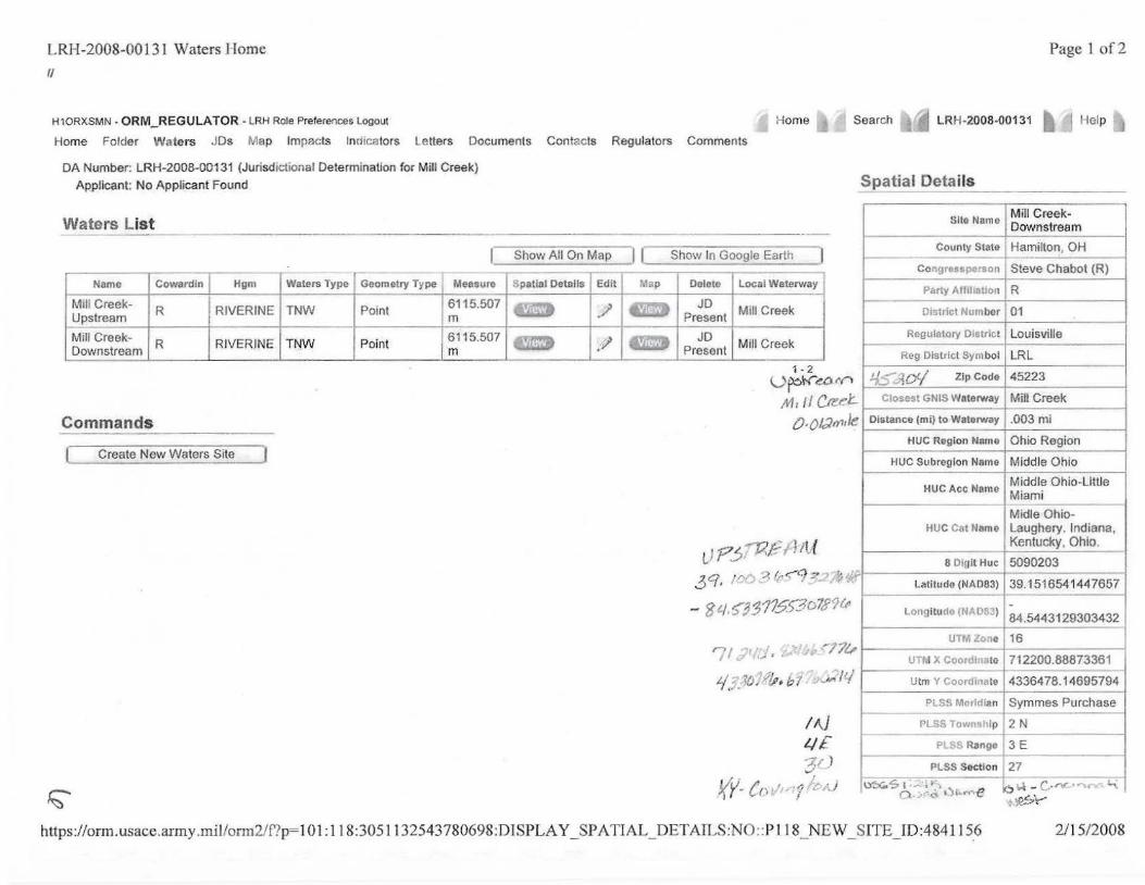
LRH-2008-00131 Waters Home Page 1 of2
/ . H10RXSMN - ORM_REGULA TOR - LRH Role Preferences logout Home Search LRH-2008-00131 j llelp
Home Folder Waters JDs Map Impac ts lnd1c~tors Letters Documents Contacts Regulators Comments
DA Number: LRH-2008-00131 (Jurisdictional Determination for Mill Creek) Applicant: No Applicant Found
Waters List -----·-----Show All On Map I I Show In Google Earth
---r-
Name Cowar dln Hgm
Mill CreekUpstream R
Waters Type !Geometry Type Meesuro
161 15.50-7 +- - - +-----1--RIVERINE I TNW Point
Mill Creek- I R Downstream RIVERINE I TNW Point
Delete I Local Waterway
JD Present ' Mill Creek
JD Present I Mill Creek
1-2 u~w-~o IV"'
,M, '' ea~t.. Commands 0 , OI:Jffi,Je•
1 createNew Waters Site - ,
tl Pj~~Altf
3q / '"""~ ~ ~r~CJ ::? ' ;, ,J;I .- . - ~7(j
- 8 ,/,53 JJ115.)3D7J<JU.
';I :;r ',";.1 , ~1-='lft/, -; 7t,
'-/,; _?(): 1,h b 1' ;;~ /fi
IN LIE "'j/ )
X"Y· Co ~~-,··I1 ~~-'-'r;;
Spatial Details -
Site Name
-County State
Congress("!r~on
Party Affiliat ion
District Number
Regulatory District
Reg District Symbol
4.5 =iOrj Zip Code
Closest GNIS Waterway
Distance (mi) to Waterway
HUC Region Name
HUC Subregion Name
HUC Ace Name
HUC Cat Name
8 Digit Hue
latitude (NAD83)
l ongitucfo (N<" D'i3)
UTtl .· ·'19
UTI\! X Coor II: ate
Utm Y Coor<Ji'late
PlSS Meridian -
PLSS Tow lp
pr S0 Range
PLSS Section
-Mill Creek-Downstream
Hamilton, OH -Steve Chabot (R)
R
01
Louisville
LRL
45223
Mill Creek
.003mi
Ohio Region
Middle Ohio
Middle Ohio-Little Miami -Midle Ohio-Laughery. Indiana, Kentucky, Ohio,
5090203
39.1516541447657
-84.5443129303432
16
712200.88873361
43364 78.14695794 -Symmes Purchase
2 N
3E
27 - -; . o . Y·6.. •) •-""e
:-l:e..-s.Y
https://orm,usace.army.millorm2/f ?p=101 :118:3051132543780698:DISPLAY SPATIAL DETAILS:NO::Pl18 NEW SITE 10:4841 J56 2/15/2008 - - - - - .

-<
Page 1 of 1
o o.3 o .~ o. '.l 1.2 "'i
https://orm.usace.anny .miVcgi-bin/mapserv?mode=map&map= . ./maps/onn.map&mapext=-84.6411569802... 2/15/2008 I