Embed Size (px)
Citation preview

i
State of California Alfred E. Alquist
Seismic Safety Commission
The Field Act and its Relative Effectiveness in Reducing Earthquake Damage in
California Public Schools Appendices
October 2009
1755 Creekside Oaks Drive, #100
Sacramento, California 95833 (916) 263-5506
www.seismic.ca.gov CSSC 09-02
ii
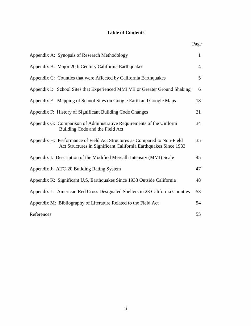
Table of Contents Page Appendix A: Synopsis of Research Methodology 1 Appendix B: Major 20th Century California Earthquakes 4 Appendix C: Counties that were Affected by California Earthquakes 5 Appendix D: School Sites that Experienced MMI VII or Greater Ground Shaking 6 Appendix E: Mapping of School Sites on Google Earth and Google Maps 18 Appendix F: History of Significant Building Code Changes 21 Appendix G: Comparison of Administrative Requirements of the Uniform 34 Building Code and the Field Act Appendix H: Performance of Field Act Structures as Compared to Non-Field 35 Act Structures in Significant California Earthquakes Since 1933 Appendix I: Description of the Modified Mercalli Intensity (MMI) Scale 45 Appendix J: ATC-20 Building Rating System 47 Appendix K: Significant U.S. Earthquakes Since 1933 Outside California 48 Appendix L: American Red Cross Designated Shelters in 23 California Counties 53 Appendix M: Bibliography of Literature Related to the Field Act 54 References 55
1
Appendix A: Synopsis of Research Methodology The objective of this study was to determine if the Field Act has been effective in reducing structural damage in public school buildings, including community colleges, as compared to comparable buildings constructed to non-Field Act standards. This effort was based on literature that has already been published; no primary data collection was intended to be part of this study. A benefit-cost analysis of the Field Act was beyond the scope of this project. The results were to be compiled in the form of a report that would be suitable for communicating the findings to policy makers in the executive and legislative branches and appropriate local jurisdictions such as school districts. A.1 Earthquakes Studied The California earthquakes that were investigated were:
San Simeon (2003) Northridge (1994) Landers/Big Bear (1992) Petrolia/Cape Mendocino (1992) Loma Prieta (1989) Whittier Narrows (1987) Coalinga (1983) Mammoth Lakes (1980) Imperial County (1979) Santa Barbara (1978) San Fernando (1971) Daly City (1957) Kern County (1952) Imperial Valley (1940)
For each of the earthquakes identified above, characteristics including the MMI distributions were obtained and compiled. These are contained in Appendix B. The counties that were affected by these earthquakes, and experienced ground shaking greater than MMI VII, entirely or partially, were identified and are listed in Appendix I. Earthquakes that have occurred outside California, notably the 2001 Nisqually Earthquake, Washington, were also investigated. A.2 History of the Field Act The origins of the Field Act and subsequent legislation that has affected its implementation were researched and documented.
2
A.3 The Field Act and the Building Code The similarities and differences in design, construction and inspection requirements for Field Act and non-Field Act buildings were researched and documented. A.4 Identification of School Sites Experiencing MMI>VII Ground Shaking A list of all schools and community colleges in California was obtained. The counties affected by the earthquakes listed in A.1 above were identified, and the latitude and longitude for each school site in these counties was determined from the street address. For each earthquake listed in A.1 above, the school sites, both public and private, and community college sites experiencing MMI>VII ground shaking were identified, and their latitude and longitude were determined. The number of schools in each county that experienced MMI VII or greater ground shaking, and the type of school (elementary, middle, high) were identified. The details are listed in Appendix J. The school locations were then mapped on Google Earth and Google Maps, as described in Appendix L. To distinguish between public schools and private schools, different icons were used. This effort also assisted in determining if non-school buildings experienced similar ground shaking to the school buildings. From this task a detailed list of school sites that have experienced MMI>VII ground shaking was developed. A.5 Use of Schools as Post-Disaster Relief Centers A list of American Red Cross designated shelters, for those counties where these data were available, was obtained. These data were analyzed to determine the extent to which the American Red Cross has designated public schools as shelters. Further details of this analysis are contained in Appendix K. A.6 Existing Information on Performance of Field Act Buildings during past California
Earthquakes A significant amount of information on the seismic performance of Field Act buildings during past earthquakes already exists. Under this task, every effort was made to obtain as much of that information as possible. Sources of information accessed included the following.
A.4.1 Repositories:
- Association of Bay Area Governments - ATC-20 inspection and tagging records, where available and relevant - California Division of the State Architect - City of Los Angeles Building Department - Earthquake Engineering Research Institute, Oakland - Library of Congress - Local and State newspapers published within 10 days of the occurrence of each of
the earthquakes - National Information Center for Earthquake Engineering, University of California,
Berkeley

3
- Quakeline online data base
A.4.2 FEMA Stafford Act payment records via the California Governor’s Office of Emergency Services (California Emergency Management Agency).
A.4.3 Transcripts of testimony given by individuals who testified during the Seismic
Safety Commission Hearings on this topic in 2006. A.4.4 Other knowledgeable individuals/experts from the earthquake engineering and
emergency preparedness community, including members of the Structural Engineers Association of California (SEAOC) and the Earthquake Engineering Research Institute (EERI).
A.7 Development of a Bibliography Documents identified and obtained during the course of this study were cataloged and a searchable electronic database was created. One purpose for the development of the bibliography was to collect in one location as much of the available literature as possible to assist future researchers. The database has been set up so that it can be constantly updated with other documents as they become available. Further details on the database are contained in Appendix M. A.8 Identification of Target Schools for Further Investigation Representative schools for each earthquake were identified for further study. The selection was based on a combination of the MMI experienced by that school site and the extent of information available regarding the effect of the earthquake on that particular school and other buildings in the vicinity, experiencing similar ground shaking. A.9 In-depth Investigation of the Effect of Earthquakes on Field Act and Non-Field Act
Structures The overall effect of each earthquake investigated, where data were available, on Field Act buildings and the general building stock was identified. The only earthquake where school sites were specifically surveyed for damage, and data were available, was the Northridge Earthquake. This region was investigated in depth. Post-earthquake tagging data, based on ATC-20, were obtained from the City of Los Angeles and the Division of the State Architect’s Los Angeles Office, and analyzed. Significant earthquakes that have occurred outside California were also reviewed for their effects on school buildings. This is described further in Appendix K.

Appendix B: Major 20th Century California Earthquakes
Earthquake Date Time Magnitude Max Intensity
Damage (in normalized
2005 US$)* Injuries Fatalities
San Simeon Dec 22, 2003 11:15 AM 6.5 VIII $335 million 40 2 Northridge Jan 17, 1994 4:30 AM 6.7 IX $73 billion 7000-9000 60
Landers Jun 28, 1992 4:57 AM 7.3 X $230 million 400 - Big Bear Jun 28, 1992 8:05 AM 6.5 IX see Landers see Landers see Landers Petrolia Apr 25, 1992 11:06 AM 7.2 X $122 million 95 -
Loma Prieta Oct 17, 1989 5:04 PM 6.9 IX $25 billion 3500-3700 65 Whittier Narrows Oct 1, 1987 7:42 AM 5.9 VIII $964 million several hundred 8
Coalinga May 2, 1983 4:43 PM 6.4 VIII $120 million 94-164 - Mammoth Lakes May 25, 1980 9:33 AM 6.2 X $6 million 9 - Imperial County Oct 15, 1979 4:16 PM 6.5 IX $169 million 91 - Santa Barbara Aug 13, 1978 3:54 PM 5.1 VII $76 million 65 None San Fernando Feb 9, 1971 6:00 AM 6.6 XI $6.6 billion 5500 65
Daly City Mar 22, 1957 11:44 AM 5.3 VII $27 million 40 1 Kern County Jul 21, 1952 4:52 PM 7.3 VIII $2.8 billion 35 11
Imperial Valley May 18, 1940 8:36 PM 7.0 X $752 million 20 9 Long Beach Mar 10, 1933 7:54 PM 6.4 VIII $16 billion ? 115
Santa Barbara Jun 29, 1925 6:44 AM 6.8 N/A $3 billion 65 13
San Francisco Apr 18, 1906 5:12 AM 7.8 IX $284 billion no data found for injuries 3000
*In 2005 dollars after adjusting for inflation, increases in wealth, and changes in population.
5
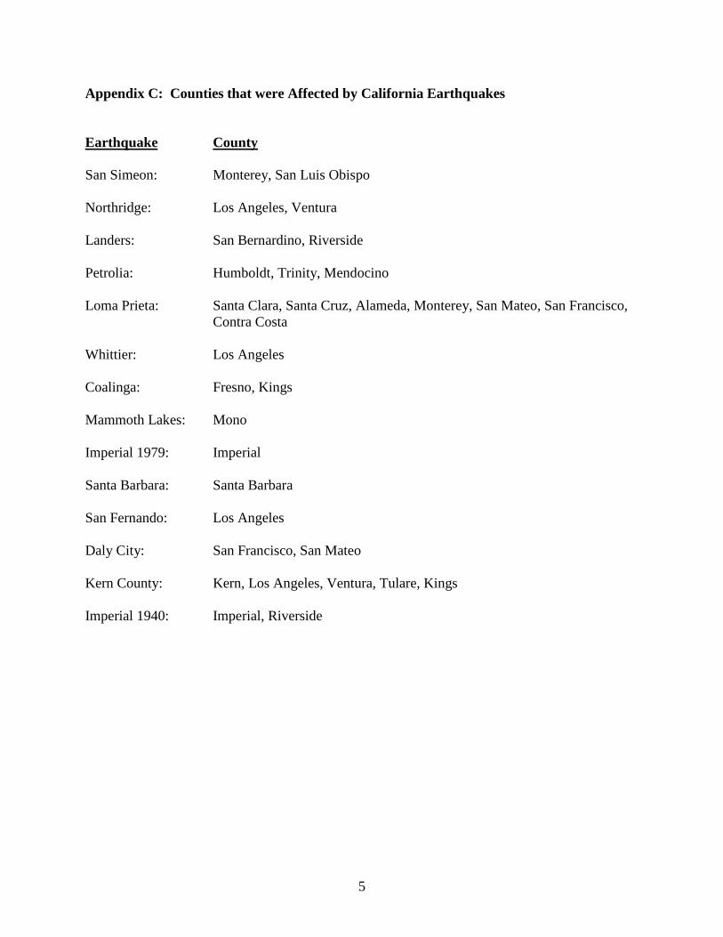
Appendix C: Counties that were Affected by California Earthquakes Earthquake County San Simeon: Monterey, San Luis Obispo Northridge: Los Angeles, Ventura Landers: San Bernardino, Riverside Petrolia: Humboldt, Trinity, Mendocino Loma Prieta: Santa Clara, Santa Cruz, Alameda, Monterey, San Mateo, San Francisco,
Contra Costa Whittier: Los Angeles Coalinga: Fresno, Kings Mammoth Lakes: Mono Imperial 1979: Imperial Santa Barbara: Santa Barbara San Fernando: Los Angeles Daly City: San Francisco, San Mateo Kern County: Kern, Los Angeles, Ventura, Tulare, Kings Imperial 1940: Imperial, Riverside

6
Appendix D: School Sites that Experienced MMI VII or Greater Ground Shaking Table D-1: Public School Sites
Earthquake No. of Schools County School Type
San Simeon 28 San Luis Obispo: 27 Elementary: 18 Middle: 5 High: 4
Monterey: 1 Elementary: 1
Northridge 664
Los Angeles: 615
Elementary:448 Middle: 79 High: 79 Community College: 9
Ventura: 49 Elementary: 32 Middle: 10 High: 7
Landers 101
Riverside: 44
Elementary: 26 Middle: 10 High: 6 Community College: 2
San Bernardino: 57
Elementary: 38 Middle: 12 High: 6 Community College: 1
Petrolia 80
Humboldt: 75
Elementary: 54 Middle: 12 High: 8 Community College: 1
Trinity: 1 Elementary: 1
Mendocino: 4 Elementary: 2 High: 2
Loma Prieta
899
Alameda: 191
Elementary: 125 Middle: 35 High: 28 Community College: 3
Marin: 2 Elementary: 2
Monterey: 50
Elementary: 37 Middle: 7 High: 5 Community College: 1
San Benito: 14
Elementary: 10 Middle: 2 High: 2
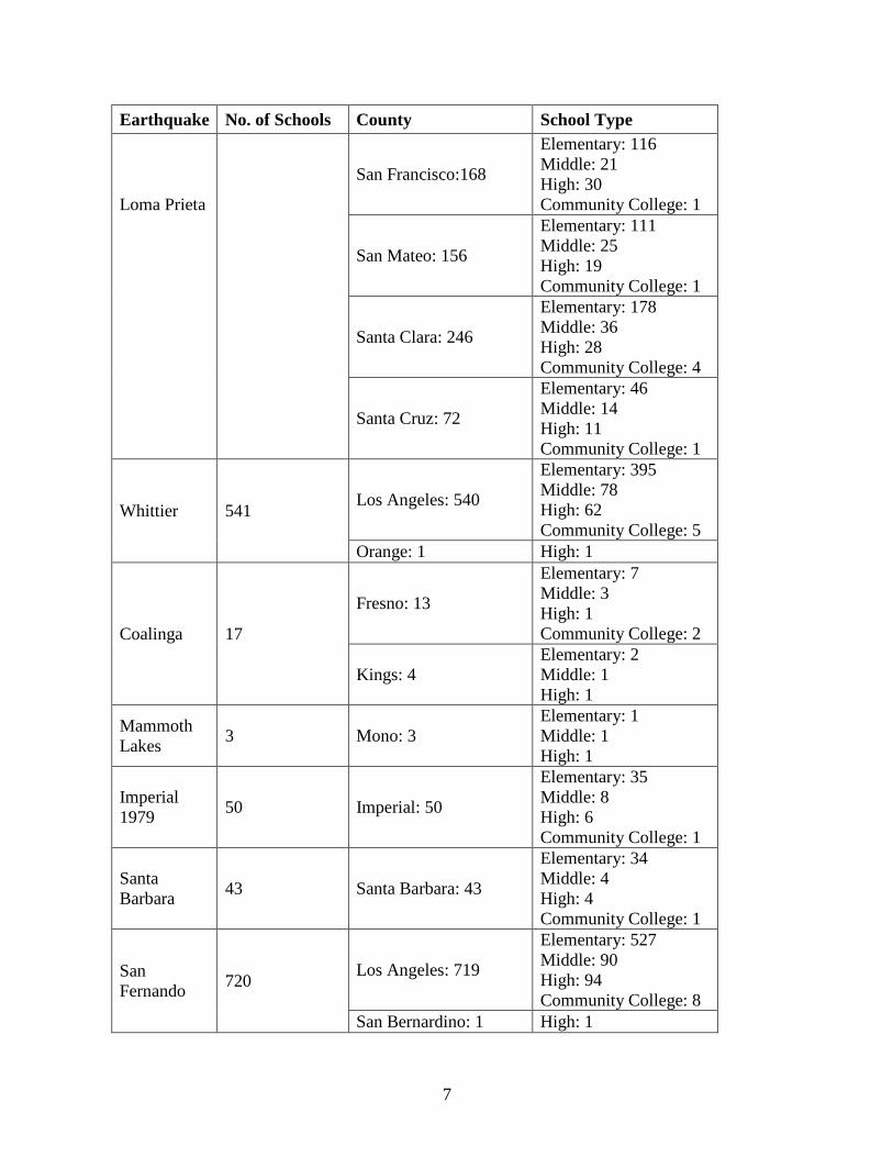
7
Earthquake No. of Schools County School Type Loma Prieta
San Francisco:168
Elementary: 116 Middle: 21 High: 30 Community College: 1
San Mateo: 156
Elementary: 111 Middle: 25 High: 19 Community College: 1
Santa Clara: 246
Elementary: 178 Middle: 36 High: 28 Community College: 4
Santa Cruz: 72
Elementary: 46 Middle: 14 High: 11 Community College: 1
Whittier 541 Los Angeles: 540
Elementary: 395 Middle: 78 High: 62 Community College: 5
Orange: 1 High: 1
Coalinga 17
Fresno: 13
Elementary: 7 Middle: 3 High: 1 Community College: 2
Kings: 4 Elementary: 2 Middle: 1 High: 1
Mammoth Lakes 3 Mono: 3
Elementary: 1 Middle: 1 High: 1
Imperial 1979 50 Imperial: 50
Elementary: 35 Middle: 8 High: 6 Community College: 1
Santa Barbara 43 Santa Barbara: 43
Elementary: 34 Middle: 4 High: 4 Community College: 1
San Fernando 720 Los Angeles: 719
Elementary: 527 Middle: 90 High: 94 Community College: 8
San Bernardino: 1 High: 1
8
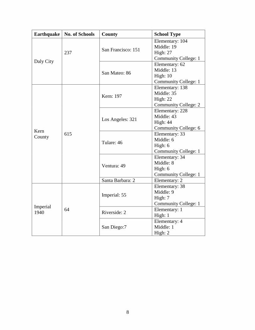
Earthquake No. of Schools County School Type
Daly City
237
San Francisco: 151
Elementary: 104 Middle: 19 High: 27 Community College: 1
San Mateo: 86
Elementary: 62 Middle: 13 High: 10 Community College: 1
Kern County 615
Kern: 197
Elementary: 138 Middle: 35 High: 22 Community College: 2
Los Angeles: 321
Elementary: 228 Middle: 43 High: 44 Community College: 6
Tulare: 46
Elementary: 33 Middle: 6 High: 6 Community College: 1
Ventura: 49
Elementary: 34 Middle: 8 High: 6 Community College: 1
Santa Barbara: 2 Elementary: 2
Imperial 1940 64
Imperial: 55
Elementary: 38 Middle: 9 High: 7 Community College: 1
Riverside: 2 Elementary: 1 High: 1
San Diego:7 Elementary: 4 Middle: 1 High: 2

9
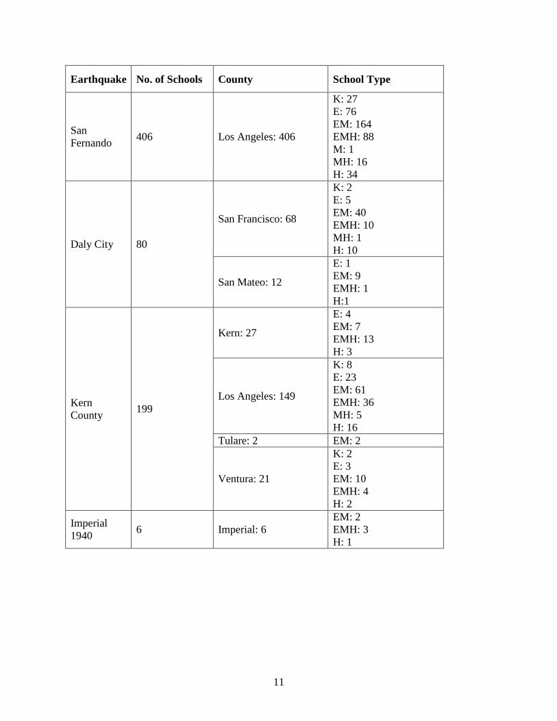
Table D-2: Private School Sites Note: Several schools were found to have mixed grade levels. In the table below E indicates "elementary", M indicates "middle" and H indicates "high". An EM indicates that that particular school had both elementary and middle school grades; similarly an EMH indicates elementary, middle and high school grades, and MH indicates middle and high school grades only.
Earthquake No. of Schools County School Type
San Simeon 10 San Luis Obispo: 10 EM: 3 EMH: 7
Northridge 340
Los Angeles: 330
K: 18 E: 64 EM: 131 EMH: 74 M: 1 MH: 11 H: 31
Ventura: 10
E: 2 EM: 5 EMH: 2 MH: 1
Landers 23 Riverside: 15
E: 1 EM: 7 EMH: 6 H: 1
San Bernardino: 8 EM: 4 EMH: 4
Petrolia 8 Humboldt: 8 E: 1 EM: 3 EMH: 4
Loma Prieta
316
Alameda: 50
K: 2 E: 7 EM: 27 EMH: 7 MH: 2 H: 5
Monterey: 6
EM: 3 EMH: 1 MH: 1 H: 1
San Benito: 5
EM: 3 EMH: 2

10
Earthquake No. of Schools County School Type
Loma Prieta
San Francisco:85
K: 3 E: 5 EM: 49 EMH: 14 MH: 1 H: 13
San Mateo: 63
K: 2 E: 9 EM: 33 EMH: 10 M: 1 MH: 3 H: 5
Santa Clara: 87
E: 19 EM: 40 EMH: 16 M: 4 MH: 2 H: 6
Santa Cruz: 20
E: 4 EM: 8 EMH: 7 H: 1
Whittier 210 Los Angeles: 209
K: 14 E: 36 EM: 96 EMH: 43 M: 2 MH: 2 H: 16
Orange: 1 EMH: 1 Coalinga 0 Mammoth Lakes 0
Imperial 1979 6 Imperial: 6
EM: 2 EMH: 3 H: 1
Santa Barbara 9 Santa Barbara: 9
E: 1 EM: 4 EMH: 2 MH: 1 H: 1
11
Earthquake No. of Schools County School Type
San Fernando 406 Los Angeles: 406
K: 27 E: 76 EM: 164 EMH: 88 M: 1 MH: 16 H: 34
Daly City 80
San Francisco: 68
K: 2 E: 5 EM: 40 EMH: 10 MH: 1 H: 10
San Mateo: 12
E: 1 EM: 9 EMH: 1 H:1
Kern County 199
Kern: 27
E: 4 EM: 7 EMH: 13 H: 3
Los Angeles: 149
K: 8 E: 23 EM: 61 EMH: 36 MH: 5 H: 16
Tulare: 2 EM: 2
Ventura: 21
K: 2 E: 3 EM: 10 EMH: 4 H: 2
Imperial 1940 6 Imperial: 6
EM: 2 EMH: 3 H: 1

12
Table D-3: Charter School Sites in Counties that Experienced Ground Shaking of MMI VII or Greater Note: "Open" and "Closed" status was as of August, 2008. Only charter schools that experienced MMI VII or greater ground shaking are included in this table; there may be other charter schools in these counties, but because they did not experience >MMI VII ground shaking, they are not included in this table.
County Status School Name Alameda CLOSED Meroe International Academy Charter
San Leandro Charter Academy West Oakland Community Charter OPEN American Indian Public Charter School II East Bay Conservation Corps Charter KIPP Bridge Charter Lighthouse Community Charter Lighthouse Community Charter High North Oakland Community Charter Oakland Charter Academy Oakland Charter High Youth Employment Partnership Charter
Alameda County Total: 12 Fresno CLOSED Osagie International Academy Charter
Rosalyn Charter
Fresno County Total: 2
Humboldt OPEN Alder Grove Charter Mattole Valley Charter (#159) Pacific View Charter
Humboldt County Total: 3 Kern CLOSED Mountain Community Charter
OPEN Valley Oaks Charter
Kern County Total: 2 Los Angeles CLOSED Camino Nuevo Charter Middle
CityLife Downtown Charter
Discovery Charter
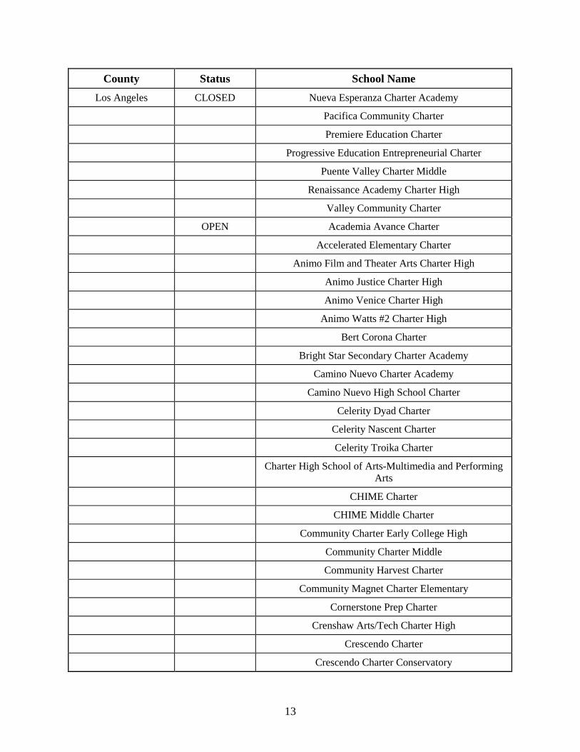
13
County Status School Name Los Angeles CLOSED Nueva Esperanza Charter Academy
Pacifica Community Charter Premiere Education Charter Progressive Education Entrepreneurial Charter Puente Valley Charter Middle Renaissance Academy Charter High Valley Community Charter OPEN Academia Avance Charter Accelerated Elementary Charter Animo Film and Theater Arts Charter High Animo Justice Charter High Animo Venice Charter High Animo Watts #2 Charter High Bert Corona Charter Bright Star Secondary Charter Academy Camino Nuevo Charter Academy Camino Nuevo High School Charter Celerity Dyad Charter Celerity Nascent Charter Celerity Troika Charter
Charter High School of Arts-Multimedia and Performing Arts
CHIME Charter CHIME Middle Charter Community Charter Early College High Community Charter Middle Community Harvest Charter Community Magnet Charter Elementary Cornerstone Prep Charter Crenshaw Arts/Tech Charter High Crescendo Charter Crescendo Charter Conservatory
14
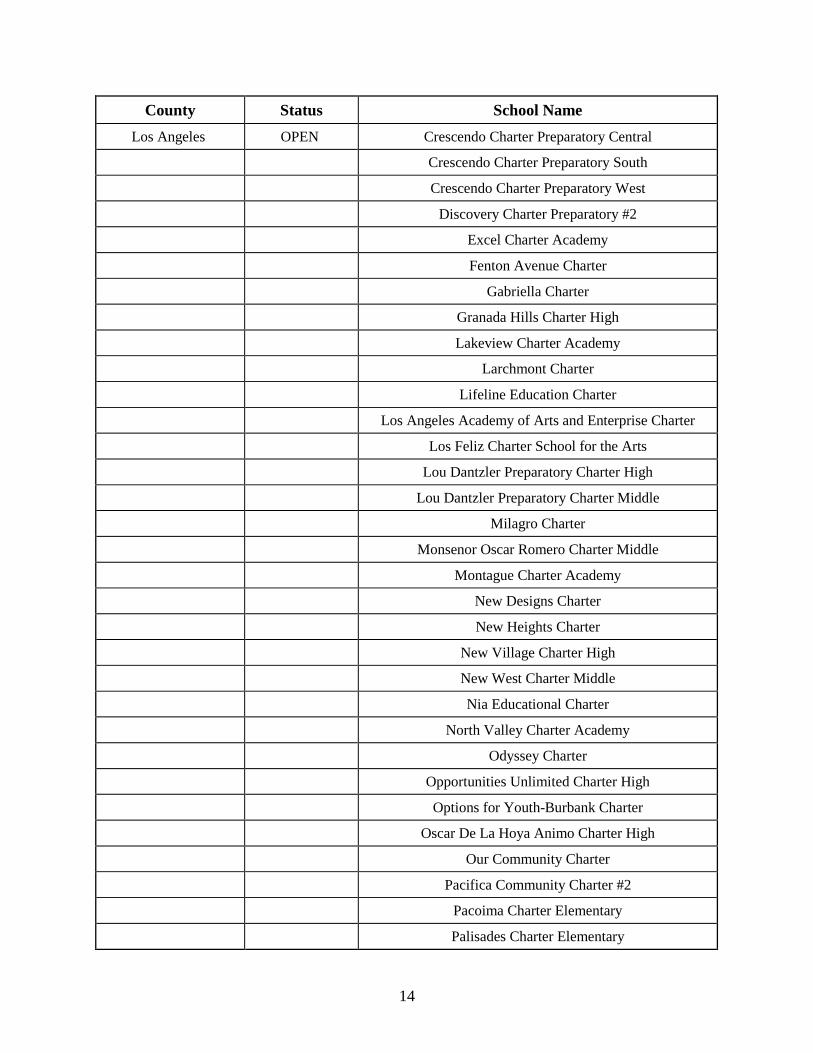
County Status School Name Los Angeles OPEN Crescendo Charter Preparatory Central
Crescendo Charter Preparatory South Crescendo Charter Preparatory West Discovery Charter Preparatory #2 Excel Charter Academy Fenton Avenue Charter Gabriella Charter Granada Hills Charter High Lakeview Charter Academy Larchmont Charter Lifeline Education Charter Los Angeles Academy of Arts and Enterprise Charter Los Feliz Charter School for the Arts Lou Dantzler Preparatory Charter High Lou Dantzler Preparatory Charter Middle Milagro Charter Monsenor Oscar Romero Charter Middle Montague Charter Academy New Designs Charter New Heights Charter New Village Charter High New West Charter Middle Nia Educational Charter North Valley Charter Academy Odyssey Charter Opportunities Unlimited Charter High Options for Youth-Burbank Charter Oscar De La Hoya Animo Charter High Our Community Charter Pacifica Community Charter #2 Pacoima Charter Elementary Palisades Charter Elementary
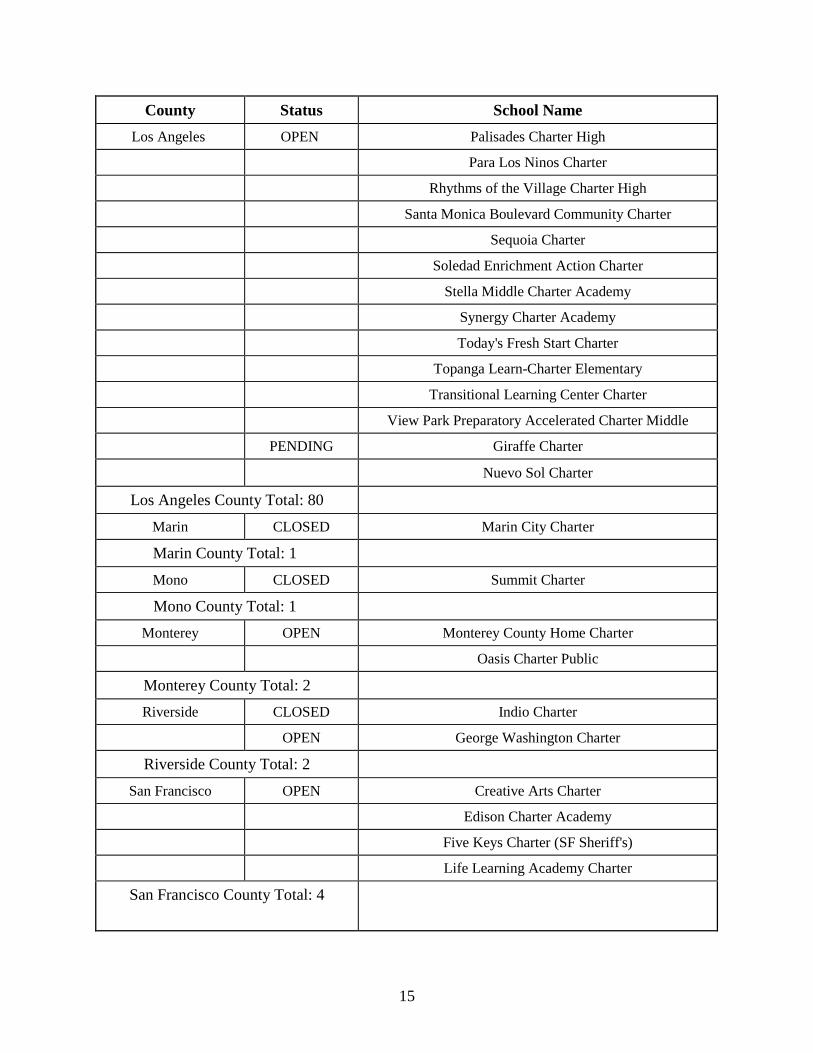
15
County Status School Name Los Angeles OPEN Palisades Charter High
Para Los Ninos Charter Rhythms of the Village Charter High Santa Monica Boulevard Community Charter Sequoia Charter Soledad Enrichment Action Charter Stella Middle Charter Academy Synergy Charter Academy Today's Fresh Start Charter Topanga Learn-Charter Elementary Transitional Learning Center Charter View Park Preparatory Accelerated Charter Middle PENDING Giraffe Charter
Nuevo Sol Charter
Los Angeles County Total: 80
Marin CLOSED Marin City Charter
Marin County Total: 1
Mono CLOSED Summit Charter
Mono County Total: 1 Monterey OPEN Monterey County Home Charter
Oasis Charter Public
Monterey County Total: 2 Riverside CLOSED Indio Charter
OPEN George Washington Charter
Riverside County Total: 2
San Francisco OPEN Creative Arts Charter Edison Charter Academy Five Keys Charter (SF Sheriff's) Life Learning Academy Charter
San Francisco County Total: 4
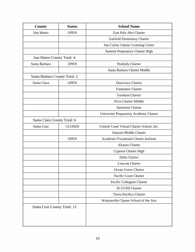
16
County Status School Name San Mateo OPEN East Palo Alto Charter
Garfield Elementary Charter San Carlos Charter Learning Center Summit Preparatory Charter High
San Mateo County Total: 4 Santa Barbara OPEN Peabody Charter
Santa Barbara Charter Middle
Santa Barbara County Total: 2 Santa Clara OPEN Discovery Charter
Fammatre Charter Farnham Charter Price Charter Middle Sartorette Charter University Preparatory Academy Charter
Santa Clara County Total: 6 Santa Cruz CLOSED Central Coast Virtual Charter School, Inc.
Sojourn Middle Charter OPEN Academic/Vocational Charter Institute Alianza Charter Cypress Charter High Delta Charter Linscott Charter Ocean Grove Charter Pacific Coast Charter Pacific Collegiate Charter SLVUSD Charter Tierra Pacifica Charter Watsonville Charter School of the Arts
Santa Cruz County Total: 13

17
County Status School Name Tulare OPEN Alpaugh Achievement Academy Charter
Summit Charter Academy
Tulare County Total: 2 Ventura OPEN Golden Valley Charter
Vista Real Charter High
Ventura County Total: 2
Grand Total: 138
18
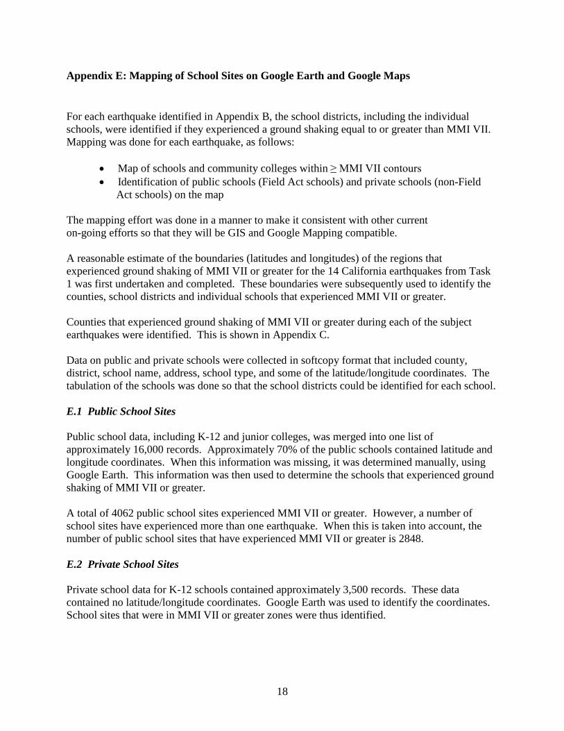
Appendix E: Mapping of School Sites on Google Earth and Google Maps
For each earthquake identified in Appendix B, the school districts, including the individual schools, were identified if they experienced a ground shaking equal to or greater than MMI VII. Mapping was done for each earthquake, as follows:
• Map of schools and community colleges within ≥ MMI VII contours • Identification of public schools (Field Act schools) and private schools (non-Field
Act schools) on the map
The mapping effort was done in a manner to make it consistent with other current on-going efforts so that they will be GIS and Google Mapping compatible. A reasonable estimate of the boundaries (latitudes and longitudes) of the regions that experienced ground shaking of MMI VII or greater for the 14 California earthquakes from Task 1 was first undertaken and completed. These boundaries were subsequently used to identify the counties, school districts and individual schools that experienced MMI VII or greater. Counties that experienced ground shaking of MMI VII or greater during each of the subject earthquakes were identified. This is shown in Appendix C. Data on public and private schools were collected in softcopy format that included county, district, school name, address, school type, and some of the latitude/longitude coordinates. The tabulation of the schools was done so that the school districts could be identified for each school. E.1 Public School Sites Public school data, including K-12 and junior colleges, was merged into one list of approximately 16,000 records. Approximately 70% of the public schools contained latitude and longitude coordinates. When this information was missing, it was determined manually, using Google Earth. This information was then used to determine the schools that experienced ground shaking of MMI VII or greater. A total of 4062 public school sites experienced MMI VII or greater. However, a number of school sites have experienced more than one earthquake. When this is taken into account, the number of public school sites that have experienced MMI VII or greater is 2848. E.2 Private School Sites Private school data for K-12 schools contained approximately 3,500 records. These data contained no latitude/longitude coordinates. Google Earth was used to identify the coordinates. School sites that were in MMI VII or greater zones were thus identified.
19
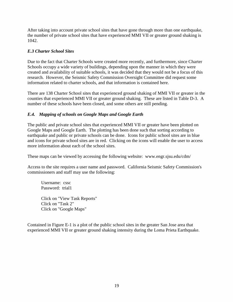
After taking into account private school sites that have gone through more than one earthquake, the number of private school sites that have experienced MMI VII or greater ground shaking is 1042. E.3 Charter School Sites Due to the fact that Charter Schools were created more recently, and furthermore, since Charter Schools occupy a wide variety of buildings, depending upon the manner in which they were created and availability of suitable schools, it was decided that they would not be a focus of this research. However, the Seismic Safety Commission Oversight Committee did request some information related to charter schools, and that information is contained here. There are 138 Charter School sites that experienced ground shaking of MMI VII or greater in the counties that experienced MMI VII or greater ground shaking. These are listed in Table D-3. A number of these schools have been closed, and some others are still pending.
E.4. Mapping of schools on Google Maps and Google Earth
The public and private school sites that experienced MMI VII or greater have been plotted on Google Maps and Google Earth. The plotting has been done such that sorting according to earthquake and public or private schools can be done. Icons for public school sites are in blue and icons for private school sites are in red. Clicking on the icons will enable the user to access more information about each of the school sites. These maps can be viewed by accessing the following website: www.engr.sjsu.edu/cdm/ Access to the site requires a user name and password. California Seismic Safety Commission's commissioners and staff may use the following: Username: cssc Password: trial1 Click on "View Task Reports" Click on "Task 2" Click on "Google Maps" Contained in Figure E-1 is a plot of the public school sites in the greater San Jose area that experienced MMI VII or greater ground shaking intensity during the Loma Prieta Earthquake.
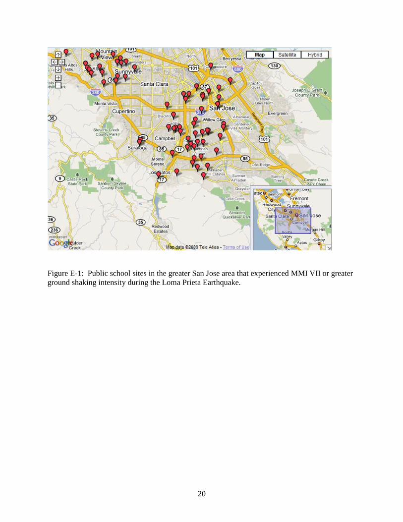
20
Figure E-1: Public school sites in the greater San Jose area that experienced MMI VII or greater ground shaking intensity during the Loma Prieta Earthquake.
21
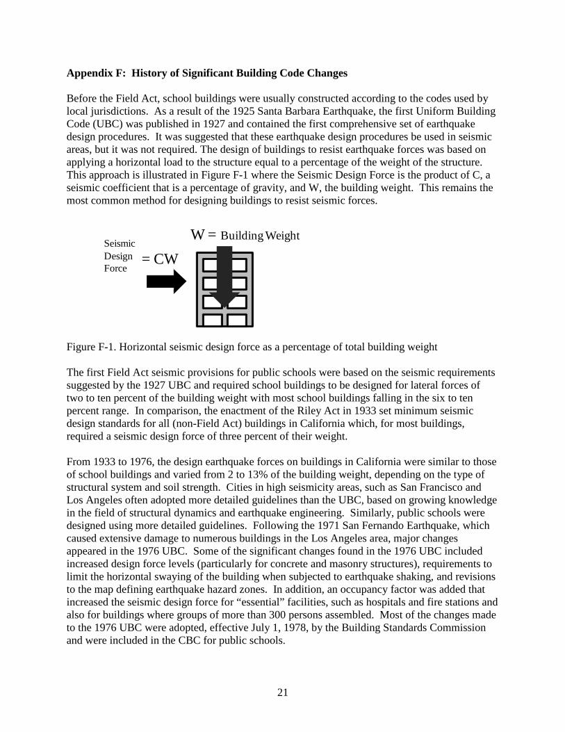
Appendix F: History of Significant Building Code Changes Before the Field Act, school buildings were usually constructed according to the codes used by local jurisdictions. As a result of the 1925 Santa Barbara Earthquake, the first Uniform Building Code (UBC) was published in 1927 and contained the first comprehensive set of earthquake design procedures. It was suggested that these earthquake design procedures be used in seismic areas, but it was not required. The design of buildings to resist earthquake forces was based on applying a horizontal load to the structure equal to a percentage of the weight of the structure. This approach is illustrated in Figure F-1 where the Seismic Design Force is the product of C, a seismic coefficient that is a percentage of gravity, and W, the building weight. This remains the most common method for designing buildings to resist seismic forces.
W = Building WeightSeismicDesignForce
= CW
Figure F-1. Horizontal seismic design force as a percentage of total building weight The first Field Act seismic provisions for public schools were based on the seismic requirements suggested by the 1927 UBC and required school buildings to be designed for lateral forces of two to ten percent of the building weight with most school buildings falling in the six to ten percent range. In comparison, the enactment of the Riley Act in 1933 set minimum seismic design standards for all (non-Field Act) buildings in California which, for most buildings, required a seismic design force of three percent of their weight. From 1933 to 1976, the design earthquake forces on buildings in California were similar to those of school buildings and varied from 2 to 13% of the building weight, depending on the type of structural system and soil strength. Cities in high seismicity areas, such as San Francisco and Los Angeles often adopted more detailed guidelines than the UBC, based on growing knowledge in the field of structural dynamics and earthquake engineering. Similarly, public schools were designed using more detailed guidelines. Following the 1971 San Fernando Earthquake, which caused extensive damage to numerous buildings in the Los Angeles area, major changes appeared in the 1976 UBC. Some of the significant changes found in the 1976 UBC included increased design force levels (particularly for concrete and masonry structures), requirements to limit the horizontal swaying of the building when subjected to earthquake shaking, and revisions to the map defining earthquake hazard zones. In addition, an occupancy factor was added that increased the seismic design force for “essential” facilities, such as hospitals and fire stations and also for buildings where groups of more than 300 persons assembled. Most of the changes made to the 1976 UBC were adopted, effective July 1, 1978, by the Building Standards Commission and were included in the CBC for public schools.

22
Since 1933, the UBC (and subsequently the CBC) has gone through many revisions based on the growing body of knowledge in the field of earthquake engineering. The Structural Engineers Association of California (SEAOC) has been the primary non-profit organization making recommendations to improve seismic design procedures. The SEAOC Seismology Committee recommendations, commonly known as the SEAOC Blue Book, were first published in 1959. Following publication of the first Blue Book, an unofficial relationship developed whereby the Blue Book recommendations were incorporated in subsequent editions of the UBC. In 1973, the non-profit Applied Technology Council (ATC) was established to act as a research body and is used by SEAOC and other organizations to help develop seismic design recommendations. After the 1994 Northridge Earthquake, the structural engineering profession began to move toward establishing a code based on Performance-Based Seismic Engineering (PBE). The first guidelines for PBE were published in Appendix B of the 1996 Blue Book. It should be noted that certain levels of performance have always been implied by building codes and regulations. Building codes have generally focused on the primary goal of life safety, with a secondary goal of controlling property damage and maintaining function in more moderate but frequent events. PBE seeks to provide a framework where earthquake hazards and design levels are defined in conjunction with structural and nonstructural performance levels. Performance objectives are defined based on structural and nonstructural performance under defined seismic ground motions. The performance objectives of school buildings constructed under the Field Act is stated in Title 24, Part 1 of the California Building Standards Administrative Code:
“School buildings constructed pursuant to these regulations are expected to resist earthquake forces generated by major earthquakes of the intensity and severity of the strongest experienced without catastrophic collapse, but may experience some repairable architectural or structural damage.”
The corresponding performance objectives of buildings built under UBC standards were first written in the commentary of the 1967 Blue Book. The Commentary stated that the requirements contained in the code are intended to safeguard against major failures and loss of life. The Commentary further states that “… with regard to earthquakes, structures designed in conformance with the provisions and principles set forth therein should be able to:
1. Resist minor earthquakes without damage; 2. Resist moderate earthquakes without structural damage, but with some nonstructural
damage; 3. Resist major earthquakes, of the intensity of severity of the strongest experienced in
California, without collapse, but with some structural as well as nonstructural damage”. The performance objectives for structures designed based on the CBC and the UBC indicate that the performance objectives for public school buildings are slightly higher than for buildings built under the UBC, particularly with regard to nonstructural damage control. Building code requirements originally focused on the design of the structural elements of buildings and these requirements have improved over time. Similarly, the realization that
23
damage to nonstructural elements and their connections posed a significant safety risk highlighted the need for engineering guidelines to secure nonstructural elements. In 1961 the first detailed engineering guidelines for nonstructural elements were included in the UBC and after the Northridge Earthquake significant revision to nonstructural guidelines were made in the 1997 UBC. The design force for securing nonstructural and architectural elements to the building is similar to that previously illustrated in Figure F-1, i.e., for the seismic force to the entire building. The design force for securing a particular nonstructural element is based on applying a force to the element that is equal to a percentage of the weight of the element. Table F-1 is a timeline of milestone events, building code changes and legislation that have affected the design of buildings in California and Table F-2 is a similar timeline specific to nonstructural and architectural requirements (Bellet 1989, Mahaney and Freeman 1996, Porush and Zacher 1987, Strand 1984, Ewing and Herd 1956, CSSC 2004, EERI 1995).

24
Table F-1: Milestone Events, Building Code Changes and Legislation Affecting the Design of Buildings in California Year Code/Event/Legislation Seismic
Coefficient(C) Notes
1927 UBC F = C W
suggested in Appendix A
(C = 10%)
Lateral force requirements were not required. W based on weight of building and contents
1933 Long Beach Earthquake 1933 Field Act F = C W
(C = 6-10%) for all public school buildings in California (including Junior Colleges)
In addition to lateral force requirements, administrative regulations on qualified design professionals, peer review of plans and specifications, and construction, observation and verification were added for public schools and are still in place
1933 Riley Act F = C W (C= 2%-10%)
Applied to all non-Field Act buildings in California
1933 City of Los Angeles F = C W (C = 8%)
1935 UBC F = C W (C= 8% in Zone 3)
Seismic zones 1-3 defined, C for limited nonstructural elements prescribed
1939 Garrison Act Pre-1933 public school buildings reported as being unsafe by a structural engineer must be upgraded Time limit for evaluation was not specified.
1943 City of Los Angeles F = C W (C=3.4-13%, depending on number of stories; 13 stories maximum)
W primarily based on weight of building
1952 Kern County Earthquake

25
Year Code/Event/Legislation Seismic Coefficient(C)
Notes
1952 UBC F = C W (C=3.4-13%)
Until this point most seismic codes were developed by cities such as Los Angeles and San Francisco via modifications to the model UBC codes. Lateral loads for multistory buildings vary inversely with the height of the building. Deflection limits established.
1959 City of Los Angeles Height limit removed
1959 SEAOC “Blue Book” V = (KC) W recommended. (KC = 2-13%) Symbol V used for base shear rather than F. K and C considered building’s lateral force resisting system and fundamental period of vibration.
Publication of recommended lateral force requirements by the Structural Engineers Association of California (SEAOC). Represented efforts of the SEAOC Seismology Committee to develop a uniform seismic code.
1960 City of Los Angeles V = (KC) W (KC = 2-13%) depending on building period (T) and structural system (K factor).
Ductile frame required when >13 stories.
1961 UBC F = ZCpWp appears for nonstructural elements
First separate section to address nonstructural elements
1967 Greene Act (I) All public school buildings not constructed under the Field Act to be examined before January 1, 1970

26
Year Code/Event/Legislation Seismic Coefficient(C)
Notes
1967 1968
UBC CBC
V= (KC) W (KC = 2-13%) depending on building period (T) and structural system (K factor).
Adopted 1966 SEAOC Blue Book recommendations
1967 SEAOC “Blue Book” Commentary described building three-tiered performance expectations. Commentary also discussed issues such as damping, deformation, and inelastic action.
1968 Greene Act (II) All school buildings considered unsafe to be abandoned or retrofitted by June 30, 1975. This deadline was extended to June 30, 1977.
1970 UBC V= (ZKC) W (ZKC = 2-13%)
Seismic zone factor (Z) was introduced
1971 San Fernando Earthquake 1972 Hospital Act Administrative regulations
almost identical to the Field Act were adopted for hospitals.
1972 Alquist-Priolo Special Studies Zone Act
Required geologic studies for fault rupture hazards.
1976 UBC Major revision. V= (ZIKCS) W (ZIKCS=2-18%)
F = ZICpWp for nonstructural elements
Significant increase in base shear for short and mid-height buildings. Site soil factor (S) and occupancy importance factor (I) were introduced. (I) was similar for Field Act and non-Field Act.
1978 ATC 3-06 by the Applied Technology Council
ATC 3-06 developed seismic design provisions as part of a cooperative program in building practices for disaster mitigation between NSF
27
Year Code/Event/Legislation Seismic Coefficient(C)
Notes
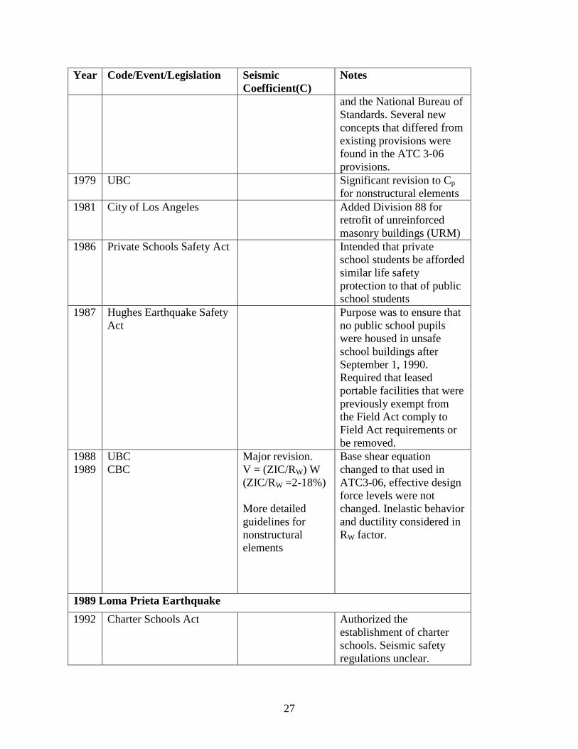
and the National Bureau of Standards. Several new concepts that differed from existing provisions were found in the ATC 3-06 provisions.
1979 UBC Significant revision to Cp for nonstructural elements
1981 City of Los Angeles Added Division 88 for retrofit of unreinforced masonry buildings (URM)
1986 Private Schools Safety Act Intended that private school students be afforded similar life safety protection to that of public school students
1987 Hughes Earthquake Safety Act
Purpose was to ensure that no public school pupils were housed in unsafe school buildings after September 1, 1990. Required that leased portable facilities that were previously exempt from the Field Act comply to Field Act requirements or be removed.
1988 1989
UBC CBC
Major revision. V = (ZIC/RW) W (ZIC/RW =2-18%)
More detailed guidelines for nonstructural elements
Base shear equation changed to that used in ATC3-06, effective design force levels were not changed. Inelastic behavior and ductility considered in RW factor.
1989 Loma Prieta Earthquake 1992 Charter Schools Act Authorized the
establishment of charter schools. Seismic safety regulations unclear.
28
Year Code/Event/Legislation Seismic Coefficient(C)
Notes
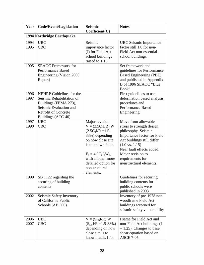
1994 Northridge Earthquake 1994 1995
UBC CBC
Seismic importance factor (I) for Field Act school buildings raised to 1.15
UBC Seismic Importance factor still 1.0 for non-Field Act non-essential school buildings.
1995
SEAOC Framework for Performance Based Engineering (Vision 2000 Report)
Set framework and guidelines for Performance Based Engineering (PBE) and published in Appendix B of 1996 SEAOC “Blue Book”
1996 1997
NEHRP Guidelines for the Seismic Rehabilitation of Buildings (FEMA 273), Seismic Evaluation and Retrofit of Concrete Buildings (ATC-40)
First guidelines to use deformation based analysis procedures and Performance Based Engineering.
1997 1998
UBC CBC
Major revision. V = (2.5CaI/R) W (2.5CaI/R =1.5-33%) depending on how close site is to known fault. Fp = 4.0CaIpWp, with another more detailed option for nonstructural elements.
Move from allowable stress to strength design philosophy. Seismic Importance factor for Field Act buildings still differ (1.0 vs. 1.15) Near fault effects added. Major revision to requirements for nonstructural elements.
1999 SB 1122 regarding the securing of building contents
Guidelines for securing building contents for public schools were published in 2003
2002 Seismic Safety Inventory of California Public Schools (AB 300)
Inventory of pre-1978 non woodframe Field Act buildings screened for seismic safety vulnerability
2006 2007
UBC CBC
V = (SDSI/R) W (SDSI/R =1.5-33%) depending on how close site is to known fault. I for
I same for Field Act and non-Field Act buildings (I = 1.25). Changes to base shear equation based on ASCE 7-05.

29
Year Code/Event/Legislation Seismic Coefficient(C)
Notes
most school buildings changed to 1.25. Entire section devoted to nonstructural elements
30
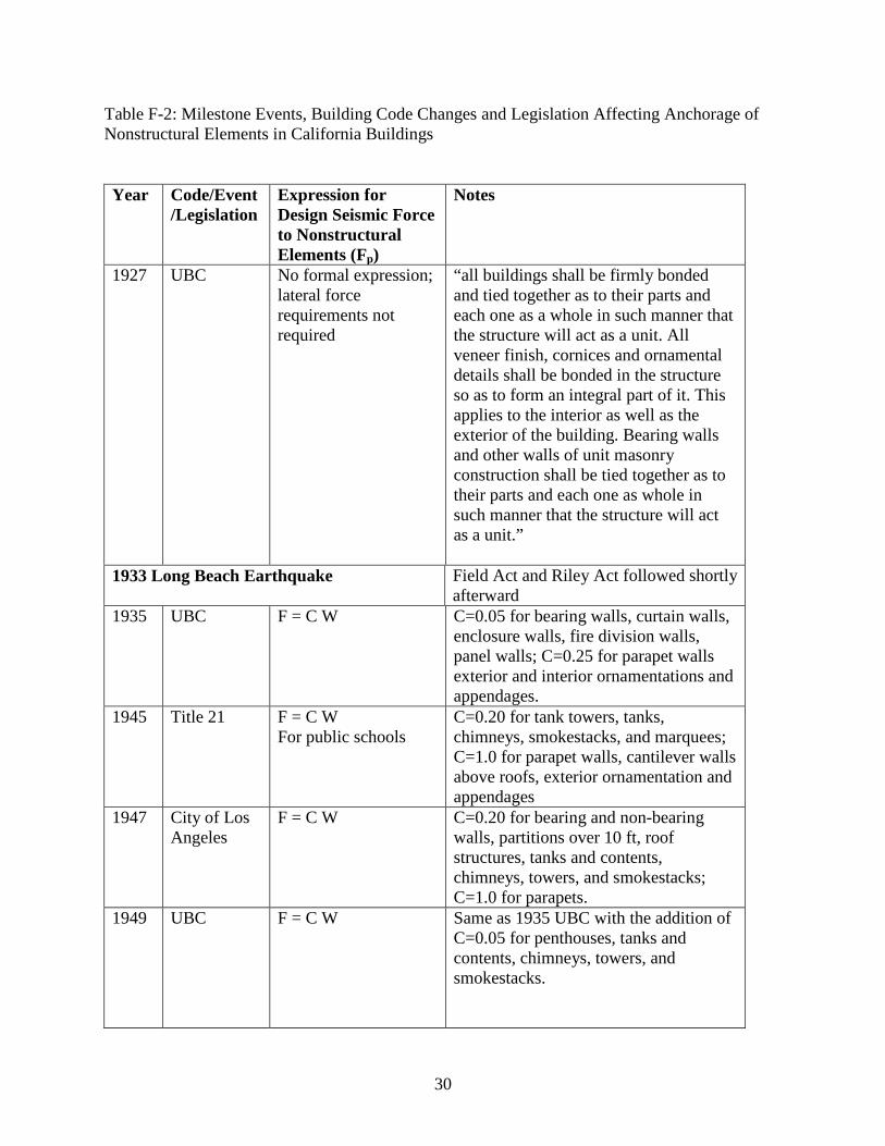
Table F-2: Milestone Events, Building Code Changes and Legislation Affecting Anchorage of Nonstructural Elements in California Buildings Year Code/Event
/Legislation Expression for Design Seismic Force to Nonstructural Elements (Fp)
Notes
1927 UBC No formal expression; lateral force requirements not required
“all buildings shall be firmly bonded and tied together as to their parts and each one as a whole in such manner that the structure will act as a unit. All veneer finish, cornices and ornamental details shall be bonded in the structure so as to form an integral part of it. This applies to the interior as well as the exterior of the building. Bearing walls and other walls of unit masonry construction shall be tied together as to their parts and each one as whole in such manner that the structure will act as a unit.”
1933 Long Beach Earthquake Field Act and Riley Act followed shortly afterward
1935 UBC F = C W C=0.05 for bearing walls, curtain walls, enclosure walls, fire division walls, panel walls; C=0.25 for parapet walls exterior and interior ornamentations and appendages.
1945 Title 21 F = C W For public schools
C=0.20 for tank towers, tanks, chimneys, smokestacks, and marquees; C=1.0 for parapet walls, cantilever walls above roofs, exterior ornamentation and appendages
1947 City of Los Angeles
F = C W C=0.20 for bearing and non-bearing walls, partitions over 10 ft, roof structures, tanks and contents, chimneys, towers, and smokestacks; C=1.0 for parapets.
1949 UBC F = C W Same as 1935 UBC with the addition of C=0.05 for penthouses, tanks and contents, chimneys, towers, and smokestacks.
31
Year Code/Event/Legislation
Expression for Design Seismic Force to Nonstructural Elements (Fp)
Notes
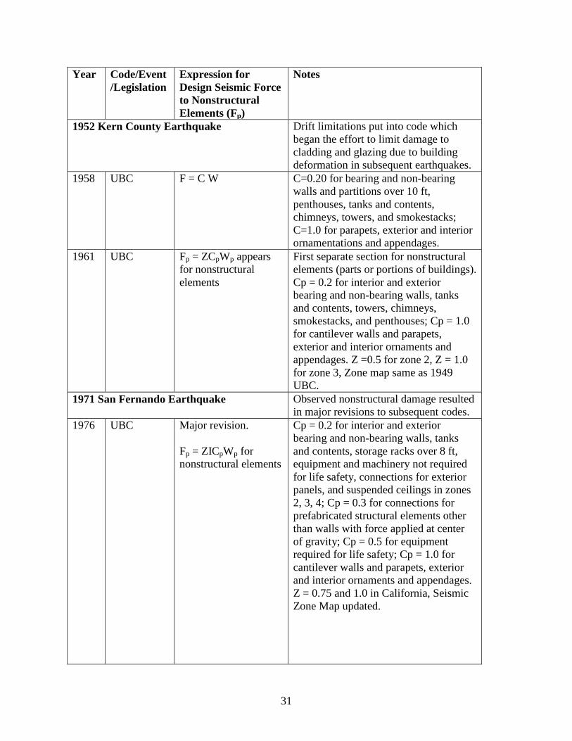
1952 Kern County Earthquake Drift limitations put into code which began the effort to limit damage to cladding and glazing due to building deformation in subsequent earthquakes.
1958 UBC F = C W C=0.20 for bearing and non-bearing walls and partitions over 10 ft, penthouses, tanks and contents, chimneys, towers, and smokestacks; C=1.0 for parapets, exterior and interior ornamentations and appendages.
1961 UBC Fp = ZCpWp appears for nonstructural elements
First separate section for nonstructural elements (parts or portions of buildings). Cp = 0.2 for interior and exterior bearing and non-bearing walls, tanks and contents, towers, chimneys, smokestacks, and penthouses; Cp = 1.0 for cantilever walls and parapets, exterior and interior ornaments and appendages. Z =0.5 for zone 2, Z = 1.0 for zone 3, Zone map same as 1949 UBC.
1971 San Fernando Earthquake Observed nonstructural damage resulted in major revisions to subsequent codes.
1976 UBC Major revision. Fp = ZICpWp for nonstructural elements
Cp = 0.2 for interior and exterior bearing and non-bearing walls, tanks and contents, storage racks over 8 ft, equipment and machinery not required for life safety, connections for exterior panels, and suspended ceilings in zones 2, 3, 4; Cp = 0.3 for connections for prefabricated structural elements other than walls with force applied at center of gravity; Cp = 0.5 for equipment required for life safety; Cp = 1.0 for cantilever walls and parapets, exterior and interior ornaments and appendages. Z = 0.75 and 1.0 in California, Seismic Zone Map updated.
32
Year Code/Event/Legislation
Expression for Design Seismic Force to Nonstructural Elements (Fp)
Notes
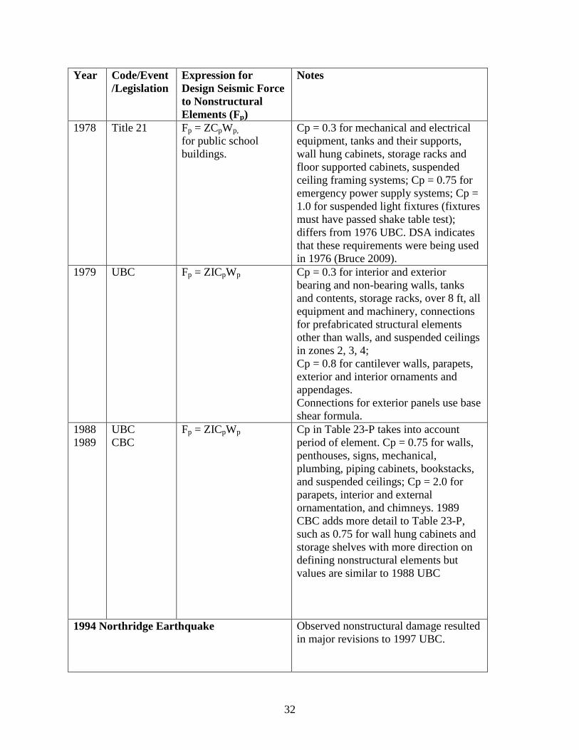
1978 Title 21 Fp = ZCpWp, for public school buildings.
Cp = 0.3 for mechanical and electrical equipment, tanks and their supports, wall hung cabinets, storage racks and floor supported cabinets, suspended ceiling framing systems; Cp = 0.75 for emergency power supply systems; Cp = 1.0 for suspended light fixtures (fixtures must have passed shake table test); differs from 1976 UBC. DSA indicates that these requirements were being used in 1976 (Bruce 2009).
1979 UBC Fp = ZICpWp Cp = 0.3 for interior and exterior bearing and non-bearing walls, tanks and contents, storage racks, over 8 ft, all equipment and machinery, connections for prefabricated structural elements other than walls, and suspended ceilings in zones 2, 3, 4; Cp = 0.8 for cantilever walls, parapets, exterior and interior ornaments and appendages. Connections for exterior panels use base shear formula.
1988 1989
UBC CBC
Fp = ZICpWp Cp in Table 23-P takes into account period of element. Cp = 0.75 for walls, penthouses, signs, mechanical, plumbing, piping cabinets, bookstacks, and suspended ceilings; Cp = 2.0 for parapets, interior and external ornamentation, and chimneys. 1989 CBC adds more detail to Table 23-P, such as 0.75 for wall hung cabinets and storage shelves with more direction on defining nonstructural elements but values are similar to 1988 UBC
1994 Northridge Earthquake Observed nonstructural damage resulted in major revisions to 1997 UBC.

33
Year Code/Event/Legislation
Expression for Design Seismic Force to Nonstructural Elements (Fp)
Notes
1994 1995
UBC CBC
Fp = ZIpCpWp UBC Seismic Importance factor still 1.0 for non-Field Act buildings. CBC uses same Table 16-O, values are similar to 1988 UBC, but Ip=1.15 for schools, Ip =1.0 for special occupancy in UBC
1997 1998
UBC CBC
Fp = 4.0CaIpWp, or Fp = [(ap/Rp)(1+3hx/hr)]* CaIpWp where ap and Rp are horizontal force factors
ap and Rp given in Table 16-O in UBC. Comparable Table 16A-O in CBC gives more detail and guidelines for ap and Rp with similar values.
1999 SB 1122 Guidelines for securing building contents for public schools were published in 2003
2006 2007
UBC CBC
Fp = (0.4apSDSIp/Rp) *(1+2z/h)Wp
Entire section (based on Chapter 13 of ASCE-7) on nonstructural elements was introduced.
34
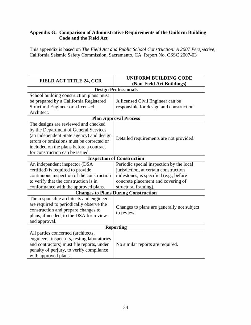
Appendix G: Comparison of Administrative Requirements of the Uniform Building Code and the Field Act This appendix is based on The Field Act and Public School Construction: A 2007 Perspective, California Seismic Safety Commission, Sacramento, CA. Report No. CSSC 2007-03
FIELD ACT TITLE 24, CCR UNIFORM BUILDING CODE (Non-Field Act Buildings)
Design Professionals School building construction plans must be prepared by a California Registered Structural Engineer or a licensed Architect.
A licensed Civil Engineer can be responsible for design and construction
Plan Approval Process The designs are reviewed and checked by the Department of General Services (an independent State agency) and design errors or omissions must be corrected or included on the plans before a contract for construction can be issued.
Detailed requirements are not provided.
Inspection of Construction An independent inspector (DSA certified) is required to provide continuous inspection of the construction to verify that the construction is in conformance with the approved plans.
Periodic special inspection by the local jurisdiction, at certain construction milestones, is specified (e.g., before concrete placement and covering of structural framing).
Changes to Plans During Construction The responsible architects and engineers are required to periodically observe the construction and prepare changes to plans, if needed, to the DSA for review and approval.
Changes to plans are generally not subject to review.
Reporting All parties concerned (architects, engineers, inspectors, testing laboratories and contractors) must file reports, under penalty of perjury, to verify compliance with approved plans.
No similar reports are required.
35
Appendix H: Performance of Field Act Structures as Compared to Non-Field Act Structures in Significant California Earthquakes Since 1933 The performance objectives of Field Act and non-Field Act buildings are similar, but the quality control of public school buildings is more rigorous. In this section summaries of the performance of public schools, during major California earthquakes that have occurred since the Field Act went into effect, are presented. A common comparative measure of building damage in earthquakes is to express loss as a percentage of the cost of repairs or reconstruction, compared to the replacement value of the buildings at the time of the earthquake. Unless noted otherwise, this is the comparative measure used in this report when losses are expressed as a percentage. It should be noted that for the earthquakes occurring prior to the Greene Act (II) deadline of 1977, some public school campuses still had pre-Field Act buildings that, in most cases, were not designed to resist earthquake forces. This accounts for the large gap in damage percentages between FA and non-FA buildings in these pre-1977 earthquakes. H.1 1940 Imperial Valley The 1940 Imperial Valley Earthquake was the first significant test of the effectiveness of the Field Act. Although this Magnitude 7 earthquake was significantly larger than the 6.3 Magnitude 1933 Long Beach Earthquake, the 16 school buildings that had been built according to Field Act standards between 1933 and 1940, suffered no significant damage. In contrast, there were pre-Field Act school buildings in the area that suffered significantly more damage. A study performed by the United States Department of Commerce found that the Field Act buildings suffered a loss of less than 1% while the pre-Field Act school buildings suffered a loss of 29% (Crumlish and Wirth 1967, Jephcott 1986, Barclay 2003). H.2 1952 Kern County The 1952 Magnitude 7.3 Kern County Earthquake (also referred to as the Tehachapi Earthquake) provided another significant test of the performance of school buildings designed under Field Act regulations. The U.S. Department of Commerce studied 37 schools, which represented about three-quarters of the school damage in the area. The 37 schools selected were subjected to shaking of at least MMI VIII. The losses suffered by Field Act school buildings were found to be less than 1% while the pre-Field Act school buildings suffered a loss of 50% (Crumlish and Wirth 1967, Jephcott 1986, Barclay 2003). Another study reported that of the 58 schools constructed of masonry in the region, 18 had been constructed to Field Act standards. Of these, one suffered moderate damage (approximately one percent). Of the 40 non-Field Act schools, one collapsed, 15 suffered severe damage, and 14 suffered moderate damage. In addition, most schools suffered considerable nonstructural damage to ceilings and light fixtures (National Clearinghouse for Educational Facilities 2004).

36
H.3 1957 Daly City
The Magnitude 5.3 Daly City Earthquake resulted in maximum MMI intensities of VI and VII in the affected areas of San Francisco, San Mateo, Marin, Alameda, and Contra Costa counties. Most of the structural damage was to single-family dwellings and the total damage was estimated to be about $1 million dollars. A study from the California Division of Mines reported that of the 125 school sites inspected in San Francisco only 11 suffered appreciable damage. Of these 11 damaged public schools, 2 suffered significant structural damage and both had been built before the Field Act went into effect. The study stated that no structural damage was found in any Field Act schools in the affected areas (Gordon 1959). H.4 1971 San Fernando The Magnitude 6.6 1971 San Fernando Earthquake was similar in size to the 1933 Long Beach Earthquake and was the first to occur in a large metropolitan area after the Field Act had been enacted. By this time nearly all of the buildings in the Los Angeles Unified School District, where most of the shaking occurred, were built in compliance with the Field Act or had been retrofitted. A study of losses incurred in 636 school sites within the 25-mile radius of the epicenter was performed. The 8,600 public school buildings in this study were valued at over one billion dollars and suffered damages totaling $2.7 million (less than one percent). In addition, nearly all the damage was nonstructural, which at that time was hardly addressed by the codes. By contrast, other publicly owned structures that were not built to Field Act standards, particularly hospitals and highway structures, suffered extensive damage. In particular, the Olive View Hospital, constructed according to the 1965 Los Angeles County building code and dedicated in November 1970, partially collapsed and suffered $31 million in damage. The poor performance of hospitals in the San Fernando Earthquake led to the 1972 Hospital Act which set rules and regulations covering hospital design and construction that were nearly identical to the Field Act (Jephcott and Hudson 1974, Bellet 1989, Barclay 2003). Another study of a smaller sample of schools was performed based on MMI shaking intensity. Ten school sites in the MMI X shaking intensity zone yielded a median loss of 4.0%. For 12 school sites located in the MMI IX zone the median loss was less than 2%, and the 11 sites in the MMI VIII area suffered median losses of less than 1% (Jephcott 1986). There were no injuries and no schools collapsed; however, the earthquake caused $13.2 million in damages (in 1971 dollars), and 100 pre-Field Act schools were demolished within one and one and a half years after the earthquake (National Clearinghouse for Educational Facilities 2004). A study funded by the National Science Foundation (NSF) compared loss estimates reported by the Los Angeles Unified School District (LAUSD) to the U.S. Department of Health, Education and Welfare to the market value of all of the school properties in the LAUSD. In this study, the market value was estimated to be four times the assessed value of the school properties in the 1970-1971 LAUSD financial report. The study found the total percentage of LAUSD losses was 0.04% of the market value or 0.16% of the assessed value. In comparison, data from the U.S.

37
Department of Commerce on building damage incurred in Los Angeles County yields losses of about 1.8% of the 1971 assessed value of county properties (Lew et al. 1971, ATC 1993, Cuenca 2009). There were over 9,200 individual buildings in the LAUSD at the time of the San Fernando Earthquake with 572 pre-Field Act buildings still in use. The pre-Field Act buildings consisted of 110 masonry, 53 woodframe, and 409 portable buildings. The NSF report cited in the previous paragraph stated that over 80% of the total LAUSD losses were due to these 572 pre-Field Act buildings. As a result of the San Fernando Earthquake and the Greene Act legislation all pre-Field Act school buildings in California, with some rare exceptions, were either replaced or retrofitted to substantially comply with the Field Act by 1977 (Meehan 1971, ATC 1993). Ten public school sites were subjected to MMI X shaking and experienced extensive ground ruptures at nearly all of the sites as these schools were very near the zone of surface faulting. One pre-Field Act building at Morningside School was severely damaged and destroyed. All of the other sites were built between 1952 and 1971 and contained Field Act buildings. These sites generally suffered repairable structural damage due to differential ground settlement and were occupied soon after the earthquake. A noteworthy example in this area of MMI X shaking intensity is the Los Angeles County Juvenile Facility, Sylmar that was constructed in 1965. Since this was both an educational and correctional facility, both Field Act and non-Field Act buildings were present. The school buildings at the site survived the earthquake very well whereas other (non-Field Act) buildings at the same site suffered major damage. A quote from a Department of Commerce report compares the performance of Field Act versus non-Field Act buildings:
“The better behavior of the school buildings can be attributed to the more restrictive rules and regulations of the Field Act since the other factors (Architects, Engineers, Contractors and Inspectors) were the same for both types of buildings. The school buildings could be economically repaired; however, the entire facility has been vacated and may be abandoned.” (Lew et al. 1971).
H.5 1979 Imperial County
This Magnitude 6.5 earthquake shook approximately the same areas as the 1940 Imperial Valley Earthquake. One report stated that the shaking did not result in extensive structural damage with the exception of some unreinforced masonry structures and the newly constructed six-story Imperial County Services Building which was severely damaged and subsequently razed. The 52 school sites that were inspected in this report suffered little damage. Five school sites contained pre-Field Act buildings that had been retrofitted. All of the retrofitted buildings performed as well as the other school buildings (EERI 1980). H.6 1980 Mammoth Lakes The Magnitude 6.2 Mammoth Lakes Earthquake subjected two school sites to shaking that was estimated to be in the range of MMI VIII at one site and IX to X at the other. Ground fractures appeared at the site subjected to the highest shaking intensity. While there was extensive nonstructural damage, no structural damage was found. The elementary school located near the

38
epicenter was subsequently closed, but the reason for the closure was apparently not related to earthquake damage (Jephcott 1986, Selvaduray 2008a). H.7 1983 Coalinga
A maximum MMI intensity of VIII was assigned to the Magnitude 6.5 Coalinga Earthquake. According to a report by one structural engineer, most schools were constructed of concrete walls with wood floors and roofs and, in general, the damage was cosmetic. A report by the Office of the State Architect stated that all buildings on school sites that were constructed under the provisions of the Field Act performed well. There were three pre-Field Act buildings on two school sites that were heavily damaged and demolished soon after the earthquake. Most notably, at Coalinga High School, an unretrofitted pre-Field Act maintenance building suffered severe damage and was subsequently razed (EERI 1984, Rymer and Ellsworth 1990, Paquette 2008). A study of 9 school sites that contained 77 Field Act buildings estimated that the damage to these buildings was about 3%. In contrast, private buildings averaged a loss in the range of 18%; however most were unreinforced masonry, which tend to perform poorly in earthquakes (Jephcott 1986, Barclay 2003). H.8 1987 Whittier Narrows California State University, Los Angeles was built in 1958, and not subject to Field Act standards. Earthquake damage from the moderate Whittier Narrows Earthquake in 1987 caused $20.5 million in damage. At the time, this damage total was greater than the total of all damage to California public schools since 1933 combined (Barclay 2003). According to the DSA, damage to Field Act buildings was negligible in this earthquake (Gillengerten 2009). H.9 1989 Loma Prieta The Magnitude 6.9 Loma Prieta Earthquake was the largest earthquake to occur in Northern California since the 1906 San Francisco Earthquake. Damage was widespread in the epicentral area near Watsonville and Santa Cruz, and major damage occurred in Oakland and San Francisco, about 60 miles from the epicenter. Estimates from the Office of Emergency Services (OES) indicated private property damage of $1.8 billion and total losses of $5.9 billion (McNutt and Sydnor 1990). A survey of 1,544 public school buildings showed that only four school buildings sustained severe damage as a result of the Loma Prieta Earthquake: A portable classroom near Santa Cruz, Loma Prieta Elementary School near Los Gatos, a San Francisco High School building that was built in 1920 and upgraded in 1947, and a Watsonville High School building built in 1917 and strengthened in 1935 (Bellet 1989, National Clearinghouse for Educational Facilities 2004). The total losses of the San Francisco School District were reported to be about $45 million. Approximately one third ($15 million) of this total is attributed to damage to the district’s administrative offices that were not required to be designed according to Field Act standards (EERI 1990).
39
Significant building damage in the Loma Prieta Earthquake occurred in the Marina District of San Francisco which was subjected to an MMI of IX. Most of the damage was to woodframe apartment buildings with corner apartment buildings suffering the worst damage. The soil conditions in the Marina District contributed greatly to the observed building damage. In particular, most of the damage was concentrated in the area north of Lombard Street between Baker and Fillmore Streets where the soil conditions were particularly poor. Winfield Scott School, built in 1930 and retrofitted to Field Act standards in the 1970s under the state school strengthening program, is located directly in the area of the Marina District with the poorest soil. The school suffered only minor damage and incurred losses of about $100,000 and is an example of the value of retrofitting older schools. The Marina Middle School served the Marina District as a shelter and a disaster center immediately following the earthquake (EERI 1990, Harris and Egan 1990, Meehan 1990). H.10 1992 Petrolia, Cape Mendocino
The Magnitude 7.2 Cape Mendocino Earthquake resulted in MMI X levels of shaking in some areas. Interviews with local officials in the Cape Mendocino area revealed that Mattole Elementary School experienced ground shaking of MMI X with no structural damage and some minor nonstructural damage. This elementary school was used as the initial shelter and disaster assistance center, for approximately one week (Selvaduray 2008b). H.11 1992 Landers, Big Bear The Magnitude 7.3 Landers and the Magnitude 6.5 Big Bear Earthquake series occurred in relatively sparsely populated regions of San Bernadino County, within hours of each other. Measured ground accelerations indicated that areas of MMI X were present in the Landers area and MMI IX in the Big Bear area. All five schools in the Big Bear area suffered little damage and no structural damage was found in the schools in the Landers area, including Landers Elementary School, which was 0.4 miles from surface faulting and was subjected to severe shaking. The Landers Elementary School experienced only minor nonstructural damage and was used as an emergency shelter for local residents whose homes suffered heavy damage (ATC 1993, California Seismic Safety Commission 2007). H.12 1994 Northridge The Magnitude 6.7 Northridge Earthquake was the largest earthquake in the urban Southern California area since the 1971 San Fernando Earthquake. One hundred and fourteen thousand residential and commercial structures were damaged and the damaged area that extended 2,192 square miles affected Los Angeles, Orange, and Ventura counties. Structural damage in the City of Los Angeles alone was estimated to be $1.9 billion in total ($1.4 billion residential, $0.5 billion commercial) (Deppe 1994). The more than $40 billion in total property losses and nearly $7 billion in Federal Emergency Management Agency funding makes the Northridge Earthquake the most costly earthquake disaster, and the second most costly natural disaster, in the nation’s history.

40
The Northridge Earthquake was the first strong earthquake in which the Applied Technology Council Rapid Evaluation procedures (ATC-20), described in Appendix J, was employed to assess the safety of a large number of damaged buildings.1
Trained volunteer inspectors (typically engineers, architects, and building inspectors) determined the condition and appropriate limitations on use of damaged buildings based on the framework and classifications contained in ATC-20 and described in Appendix J. Table H-1 presents a summary of some of the ATC-20 data that was collected. Unsafe (red-tagged), Limited entry (yellow-tagged), and Inspected (green-tagged) public school buildings are compared with private school buildings and with buildings of similar construction to schools (commercial buildings, 1-2 stories in height). As well, damage to public school buildings is compared with damage to both commercial and residential buildings. Note that the number of green-tagged buildings does not represent the total number of undamaged buildings but only those inspected.
Table H-1: ATC-20 Tagging data for the Northridge Earthquake
Type of building Red (Unsafe)
Yellow (Limited Entry)
Green (Inspected)
% Red Tagged
% Yellow Tagged
Private school buildings (City of Los Angeles 2003)
6 21 141 3.6 %(c) 12.5%(c)
Public school (Field Act) buildings (DSA ATC-20 Reports 1994)
17(a) 89(a) 1500(b) 1.1 % 5.5 %
One- and two-story commercial buildings (non-Field Act) in Los Angeles of similar construction to schools (City of Los Angeles 2003)
100 322 1746 4.6 %(c) 14.9 %(c)
Residential and commercial buildings in the City of Los Angeles (Deppe 1994)
1900 8800 82,500 2.0 %(c) 9.4 %(c)
Residential and commercial buildings in Los Angeles, Ventura, and Orange Counties (Governor's Office of Emergency Services 1999)
3000 11,500 90,400 2.9 %(c) 11.0 %(c)
Notes: (a) Of the 17 red tags; 5 are permanent buildings, 4 relocatable buildings, and 8 other structures (arcades, walkways, lunch shelters, pavilions, bridges between buildings). Of the 89 yellow tags; 62 are
permanent buildings, 14 relocatable buildings, and 13 other structures. Originally reported as 24 red tags, 82 yellow tags (DSA 1994)
(b) Approximate, based on an average of 13 buildings per school campus. (Jephcott 1974) (c) The percentages contained in these columns are based on the number of buildings that were inspected,
and NOT the total number of buildings.
1 The ATC-20 damage evaluation process was developed shortly before the Loma Prieta Earthquake, and first used after the Loma Prieta Earthquake (Applied Technology Council (ATC) 1989). Based on this experience the evaluation process was revised significantly and the revised evaluation process was employed more comprehensively after the Northridge Earthquake.

41
The damage results for the public school buildings reported in Table H-1 represent surveys of 127 school campuses in 45 school districts. According to a report by the Division of the State Architect with the exception of portable buildings and some lunch shelters, most structures rated unsafe were not in reasonable danger of collapse. Only a few permanent buildings suffered structural damage. There were no cases of collapse or partial collapse nor did any structural member fall to the floor in any public school building. Most of the public school buildings that suffered structural damage were constructed to pre-1971 building regulations (DSA 1994). Nonstructural damage was commonly found in many public school buildings. The most threatening nonstructural hazard was pendant-mounted light fixtures that fell to the floor in approximately 100 classrooms. Nonstructural damage could have caused injuries if the earthquake had occurred during school hours. After the Northridge Earthquake, legislation was passed for public schools to address the safety risk posed by the movement of building contents. In 2003, detailed guidelines and a checklist were published to aid public schools in identifying and correcting hazards from building contents, particularly those added after construction (DSA 1994, CSSC 2007). A public school that suffered significant structural damage was John F. Kennedy (JFK) High School in Granada Hills. The three-story infill concrete frame administration building suffered some degree of damage to all shear walls with most of the damage being at the first floor walls near window openings. In addition, structural damage to a two-story classroom building and concrete crushing at the base of gymnasium walls was observed. Other than JFK High School, schools performed well in areas of strong shaking. Examples include Hamilton High School (built in 1931 and retrofitted after the 1971 San Fernando Earthquake) which suffered minor damage to exterior ornaments, and a public school located several blocks from the Interstate 10 collapse suffered only minor nonstructural damage (CSSC 1994, EERI 1995). An approximate damage comparison for the Northridge Earthquake can be found by dividing the claim of the Los Angeles Unified School District (LAUSD) for FEMA disaster assistance funds by the 1994 assessed value of the LAUSD school properties which yields a ratio of about 0.11% (LAUSD 1994, FEMA 2009).2
The equivalent loss ratio for the general building stock, based on FEMA claims and 1994 assessed value, for Los Angeles County, is approximately 1.3% (County of Los Angeles 1994-1995, FEMA 2009). Since FEMA claims are relevant only for public and non-profit sector structures, and not the for-profit sector, the actual loss ratio for the general building stock would have been much higher than 1.3%.
Unreinforced masonry buildings (URM) are widely recognized as the most dangerous type of construction in earthquakes. Damage data from the City of Los Angeles Department of Building and Safety indicates that at least 5 private schools are located in URM buildings. A report by the California Seismic Safety Commission states that 40 private schools were in URM buildings in 1995, but there are no unretrofitted URM public school buildings by 2007 (CSSC 2007). An unretrofitted URM classroom building, built in 1930, at a private elementary school in Santa
2 Based on data received from California Office of Emergency Services (currently CalEMA) regarding post Northridge Earthquake claims paid by FEMA.

42
Monica suffered severe damage and partial collapse of a second story exterior wall (CSSC 2007, CSSC 1994). H.12.1 Study of Damage in Northridge Epicentral Area Due to the large extent of the area of damage in the Northridge Earthquake (over 2,000 square miles) and the amount of data available, an area defined by 8 zip codes (approximately 8 miles in the east-west direction by 13 miles in the north-south direction) near the epicenter of the earthquake was selected for detailed study. This area was chosen for the following reasons (OES 1995, ATC 2000, City of Los Angeles 2003,):
• The area was subjected to significant ground shaking of MMI VIII and IX, and had significant damage;
• Public school performance could be reasonably compared to the performance of the general building stock in this area since the urban growth was from South to North and the public schools and buildings nearby were built at approximately the same time.
The epicentral area contains the most significantly damaged public school building in the Northridge Earthquake, the JFK High School administration building that sustained shear wall damage described previously. The administration building, subjected to MMI IX shaking intensity, was designed using the Field Act provisions in the CBC, based on the 1967 edition of the UBC. Many other pre-1976 reinforced concrete buildings in the epicentral area did not perform well. In particular, a non-Field Act department store building in the Northridge Fashion Center, of similar height, lateral force resisting system, and designed to the same model building code as the JFK High School administration building, suffered punching shear failure and collapse of a significant portion of the second and third floors. The department store building is located 4.5 miles southeast of JFK High School and was also subjected to MMI IX shaking intensity (CSSC 1994, EERI 1995). A private Catholic high school with an enrollment of about half that of JFK High School, located 1.4 miles east of the JFK campus, built in 1956, and subjected to MMI VIII shaking suffered damage to 12 buildings and had to be rebuilt. Danube Elementary, built in 1960 and located 0.8 miles west of the Catholic high school, in MMI VIII, suffered moderate damage, mostly to the covered walkway structures. Haskell Elementary built in 1956 and located 1.1 miles west of the Catholic high school, also in MMI VIII, suffered only minor damage (McGavin 1994, City of Los Angeles 2003). A study of the ATC-20 damage reports from 39 public schools in the epicentral area shows that nearly all of the schools performed well (DSA ATC-20 Reports 1994). All of the public schools in this area, except for John F. Kennedy High School, were capable of receiving students after post-earthquake debris was cleared. In some schools, portions of the campus and certain structures needed to be closed to students until further evaluations could be performed but the schools were able to open (McGavin 1994). Table H-2 is a summary of the damage data by ZIP code area.

43
Table H-2. Summary of ATC-20 tagging data in the Northridge epicentral area by ZIP code (DSA ATC-20 Reports 1994, OES 1995, ATC 2000, City of Los Angeles 2003) Zip Code
Building Type Red Yellow Green MMI Average age of buildings
91324 Public School 0 0 39(b) 8 and 9 1960-1970 Private School 0 0 0 Similar Buildings 18 42 101 All Buildings 34 143 1456
91325 Public School 1 6 58(b) Mostly 9 1960-1970 Private School 0 1 6 Similar Buildings 1 8 49 All Buildings 68 230 1814
91344 Public School 5 13 138(b) 8 and 9 1960-1970 Private School 1 0 3 Similar Buildings 2 11 62 All Buildings 81 446 3580
91345 Public School No data 8 1960-1970 Private School 2 7 3 Similar Buildings 1 9 32 All Buildings 7 23 687
91402 Public School 0 0 13(b) 8 1950-1960 Private School 0 0 2 Similar Buildings 1 7 27 All Buildings 1 8 479
91326 Public School 0 0 26(b) 8 1960-1970 Private School 0 0 0 Similar Buildings 0 0 10 All Buildings 26 219 2047
91343 Public School 0 12 53(b) 8 1950-1960 Private School 1 2 5 Similar Buildings 3 14 42 All Buildings 26 168 2114
91335 Public School 1 6 136(b) 8 1950-1960 Private School 0 2 7 Similar Buildings 2 5 19 All Buildings 24 164 2128
Totals Public School 7(a) 37(a) 463(b) Private School 4 12 26 Similar Buildings 28 96 342 All Buildings 267 1401 14,305
44
Notes: (a) Of the 7 red tags; 3 are permanent buildings and 4 other structures (arcades, walkways, lunch shelters, pavilions, bridges between buildings). Of the 37 yellow tags; 17 are permanent buildings, 11 relocatable buildings, and 9 other structures. (b) Approximate, based on an average of 13 buildings per school campus (Jephcott and Hudson 1974). Three post secondary educational institutions, of similar age and construction, are located within the epicentral area: California State University (CSU) Northridge, which is not subject to the Field Act, and two community colleges, constructed under the Field Act, Mission and Pierce Colleges. CSU Northridge suffered an estimated $400 million in damage, Pierce College suffered $5 million in damage, and Mission College suffered no damage (CSSC 2007). H.13 2003 San Simeon The Magnitude 6.5 San Simeon Earthquake primarily caused damage in San Luis Obispo County with the cities of Paso Robles, Templeton, Atascadero, and San Miguel being the most affected. The downtown area of Paso Robles experienced the most severe structural damage including the collapse of a two-story unreinforced masonry building. Unreinforced masonry buildings were damaged in Atascadero, San Luis Obispo and Templeton. In Atascadero, a number of single story residential buildings were severely damaged (EERI 2005). DSA inspectors did not observe any structural damage to any school buildings that they visited. Significant non-structural damage was observed by DSA inspectors to wall finishes, ceilings, roof tiles, light fixtures, concrete slabs on grade and asphalt paving (DSA 2004). The most publicized damage to school buildings occurred at Flamson Middle School in Paso Robles. The two-story classroom building was originally constructed in 1924 and retrofitted in 1959. The campus was subjected to MMI IX shaking, and the classroom buildings suffered plaster cracking that was repaired. Flamson Middle School’s Main Building was later determined to be damaged beyond reasonable repair and in 2005 a decision was made to demolish and rebuild the Main Building. (SLO Tribune 2005). Templeton Middle School was also subjected to MMI IX shaking and suffered very little damage (DSA 2004, EERI 2005).

45
Appendix I: Description of the Modified Mercalli Intensity (MMI) Scale This description of the Modified Mercalli Intensity scale is based on the website of the United States Geological Survey (United States Geological Survey 2009). The effect of an earthquake on the Earth's surface is called the intensity. It is different from the Richter Magnitude which represents the total amount of energy released by the earthquake. The intensity scale consists of a series of certain key responses, such as people awakening, movement of furniture, damage to chimneys, and finally - total destruction. Although numerous intensity scales have been developed over the last several hundred years to evaluate the effects of earthquakes, the one currently used in the United States is the Modified Mercalli (MM) Intensity Scale. It was developed in 1931 by the American seismologists Harry Wood and Frank Neumann. This scale, composed of 12 increasing levels of intensity that range from imperceptible shaking to catastrophic destruction, is designated by Roman numerals. It does not have a mathematical basis; instead, it is an arbitrary ranking based on observed effects. The Modified Mercalli Intensity value assigned to a specific site after an earthquake has a more meaningful measure of severity to the nonscientist than the magnitude because intensity refers to the effects actually experienced at that place. The lower numbers of the intensity scale generally deal with the manner in which the earthquake is felt by people. The higher numbers of the scale are based on observed structural damage. Structural engineers usually contribute information for assigning intensity values of VIII or above. Table I-1 contains an abbreviated description of the 12 levels of Modified Mercalli Intensity.
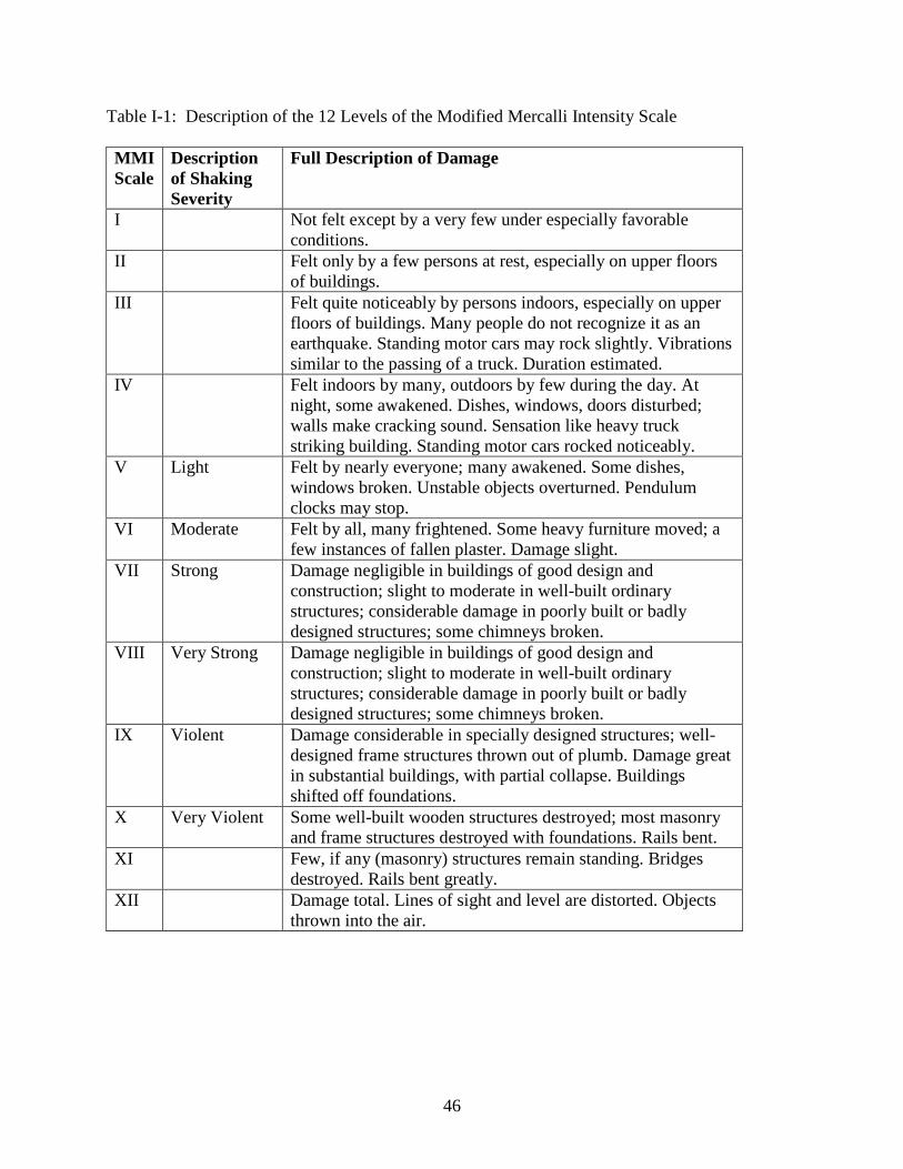
46
Table I-1: Description of the 12 Levels of the Modified Mercalli Intensity Scale MMI Scale
Description of Shaking Severity
Full Description of Damage
I Not felt except by a very few under especially favorable conditions.
II Felt only by a few persons at rest, especially on upper floors of buildings.
III Felt quite noticeably by persons indoors, especially on upper floors of buildings. Many people do not recognize it as an earthquake. Standing motor cars may rock slightly. Vibrations similar to the passing of a truck. Duration estimated.
IV Felt indoors by many, outdoors by few during the day. At night, some awakened. Dishes, windows, doors disturbed; walls make cracking sound. Sensation like heavy truck striking building. Standing motor cars rocked noticeably.
V Light Felt by nearly everyone; many awakened. Some dishes, windows broken. Unstable objects overturned. Pendulum clocks may stop.
VI Moderate Felt by all, many frightened. Some heavy furniture moved; a few instances of fallen plaster. Damage slight.
VII Strong Damage negligible in buildings of good design and construction; slight to moderate in well-built ordinary structures; considerable damage in poorly built or badly designed structures; some chimneys broken.
VIII Very Strong Damage negligible in buildings of good design and construction; slight to moderate in well-built ordinary structures; considerable damage in poorly built or badly designed structures; some chimneys broken.
IX Violent Damage considerable in specially designed structures; well-designed frame structures thrown out of plumb. Damage great in substantial buildings, with partial collapse. Buildings shifted off foundations.
X Very Violent Some well-built wooden structures destroyed; most masonry and frame structures destroyed with foundations. Rails bent.
XI Few, if any (masonry) structures remain standing. Bridges destroyed. Rails bent greatly.
XII Damage total. Lines of sight and level are distorted. Objects thrown into the air.
47
Appendix J: ATC-20 Building Rating System Standardized procedures for assessing the safety of buildings, after an earthquake, were originally developed by the Applied Technology Council (ATC), and completed shortly before the 1989 Loma Prieta Earthquake. The specific ATC document that contained the description of the assessment procedure is referred to by its number, i.e., ATC-20. Along with the ATC-20 document, procedures were also developed for the training of individuals for post-earthquake building safety assessment. This safety assessment method was developed with the specific intention of evaluating the extent of damage a building might have incurred, relatively rapidly, so that the life safety of the community can be protected to the maximum extent possible while enabling reoccupation of buildings, thus permitting communities to return to normal as soon as possible. In brief, buildings are categorized into three major groups, as described below. Unsafe (red tag) Extreme hazard, may collapse. Imminent danger of collapse from an aftershock. Unsafe for occupancy or entry, except by authorities. Limited Entry (yellow tag) Dangerous conditions believed to be present for portions of a building. Entry by owner for emergency purposes at own risk. No usage on continuous basis. Entry by public not permitted. Possible major aftershock hazard. Subsequent inspection and evaluation by a licensed professional engineer or architect is generally required. Inspected (green tag) No apparent hazard found, although repairs may be required. Original lateral load capacity has not been significantly decreased. No restriction on use or occupancy. The inspector fills out an evaluation sheet (report) and also posts a tag, based on the evaluation, on the main entry door to the building.

48
Appendix K: Significant U.S. Earthquakes Since 1933 Outside California Below are some significant U.S. earthquakes that have occurred since 1933 outside of California. These earthquakes are significant because outside California, there is no legislation similar to the Field Act. Public school buildings in other states are, in most cases, designed according to the same regulations as the general building stock. K.1 1935 Helena Earthquake, Montana This earthquake is significant in that it occurred shortly after the passing of the Field Act in California and caused significant damage to several schools. The amount of damage was considerable considering the earthquake had a modest Richter magnitude of 6.25 and a maximum MMI of VIII. A report by the Board of Fire Underwriters for the Pacific notes that the newly constructed New Helena High School suffered major damage with the total collapse of one classroom wing. The report states that “the failure of the high school is directly attributable to deficiencies in design” and comments that it is regrettable that the architects and engineers involved “did not have that spark of foresight which might have made them heed and profit by the experience of Long Beach, California, in the shock of March 10, 1933” (Engle 1936). K.2 1949 Olympia Earthquake, Washington The 1949 Olympia Earthquake caused severe damage to several URM schools, resulting in one fatality, in Seattle. At Puyallup High School, three boys on the stage just managed to escape when the roof collapsed. Widespread damage to furniture and contents also occurred (National Clearinghouse for Educational Facilities 2004). K.3 1964 Anchorage Earthquake, Alaska In the Anchorage Alaska Earthquake of 1964, which registered 8.4 on the Richter scale, a number of public schools were damaged, but there were no collapses. The earthquake occurred on Good Friday at 5:36 p.m., when the schools were unoccupied. At West Anchorage High School, a two-story nonductile concrete frame classroom wing suffered severe structural damage and near total failure in a number of columns (National Clearinghouse for Educational Facilities 2004). Conclusions from a report by the National Board of Fire Underwriters points to one or more of the following factors being responsible for most of the individual building failures that were observed (National Board of Fire Underwriters 1964):
• Lack of adequate plan checking; • Inadequate field inspection; • Faulty construction techniques; • Inadequate soil analysis.
49
K.4 2001 Nisqually Earthquake, Washington On February 28, 2001, at 10:54 a.m. the magnitude 6.8 Nisqually Earthquake occurred in the State of Washington. Its epicenter was 17.6 km northeast of Olympia, the state capital, and 57.5 km south-southwest of Seattle, Washington's largest metropolis. The depth of the epicenter was 52 km. The maximum shaking intensity was MMI VII in regions in and around Olympia and in parts of Seattle (Pacific Northwest Seismic Network 2009). The State of Washington follows the Uniform Building Code. The cities of Seattle and Washington both have their own building codes which are based on the UBC. This section is based on damage reported in the Olympia and Seattle area newspapers and site visits to the Olympia School District and the Seattle School District. While there was relatively little structural damage, nonstructural damage was reported at several school sites. Damage to ceiling tiles and light fixtures was the most common. Other damage patterns included gas leaks, water line breaks, cracks in walls and/or plaster, cracked windows, books falling off shelves, and damage to facades with bricks falling off in some cases. The cost of painting, repairing windows, doors, heating-ventilation systems, airconditioning and other problems at the North Thurston School District was estimated at $1 million. More detailed reports on the damage to Olympia School District school buildings and Seattle Public School District school buildings are presented below. K.4.1 Olympia Information related to the damage experienced by Olympia School District buildings was provided by the school district (Byrne 2009). In the Olympia area there was structural damage to some school buildings. Some sections of Capital High School had cracks in the beams and the school was initially red-tagged (Olympian 2004). Olympia High School was initially yellow-tagged. Structural damage was found at the east end of Lincoln Elementary School and the Avanti Alternative High School which also houses the Knox Administrative Center. The shelter that was opened by the American Red Cross was located at the Gloria Dei Lutheran Church. Within the Olympia School District, the Lincoln Elementary School building suffered the most damage of any of the school district’s facilities. The building was originally constructed in 1923, and had received substantial seismic improvements in 1994 as a historic building. Redundant wood frame walls were built along the inside of the exterior clay tile masonry walls. While the structure performed well, there was significant cracking of the exterior clay tile masonry units and spalling of the exterior finish stucco. In some areas the masonry was dislodged and fell to the ground. The exterior east elevation and a portion of the north elevation incurred extensive damage, resulting in the east entrance being closed; portions of the exterior wall were re-engineered to include injection of steel rods into the masonry units to hold them in place. Part of the school was evacuated and classes were transferred to St. John's Episcopal Church (Olympian 2001).
50
The Knox Administrative Center which is located in the Avanti Alternative High School was also originally constructed in 1924, with the construction type being similar to that of Lincoln Elementary School: unreinforced clay tile masonry units with little or no lateral bracing. In 1937 a three-story building was added on the east end of the building. The new addition had reinforced concrete walls and floors. During the earthquake there was significant displacement of the masonry units in the front stairwell area. The north wall of this stairwell was fairly high, spanning two floor levels, and was unsupported. The earthquake caused severe damage to the structural integrity of the wall due to the displacement of a large number of the masonry units, causing several deep cracks in the walls. A wood-frame redundant wall was constructed inside the stairway and plywood sheathing was installed across the ceiling of the stair well to impart shear strength. The exterior stucco finish and interior plaster finish were then repaired to historic standards and repainted. At McLane Elementary School the following repairs were carried out: repairs to existing caulking, wall crack repairs, replacement of existing floor tiles, replacement of a broken skylight, patching of existing concrete slab. At Olympia High School the earthquake caused damage to the stage walls and rigging systems in the new performing arts center. Repairs to the rigging system included repositioning pulleys and a light ladder and reinstalling two fluorescent light fixtures that dropped from the ceiling. Damage to the stage walls included spalling of concrete masonry units due to the movement of the steel beams supporting the stage rigging and lighting systems. Masonry debris fell to the floor. Repair of interior sheetrock cracks and floor tiles, as well as caulking and repainting were also necessary. At the McKenny Elementary School repairs included replacement of a floor mounted urinal in the boy’s restroom, replacement of several cracked floor tiles and repairs to the concrete floor under the floor tiles, repairs to an extensive number of wall cracks including caulking, plastering and repainting. At Washington Middle School there was damage to the ceilings in the Band Room and the Auxiliary Gymnasium. In the Band Room ceiling tiles that were adhered to gypsum wallboard backing became dislodged and either fell to the ground or were hanging precariously from the ceiling. Two light fixtures also became dislodged as the ceiling panels separated from the gypsum substrate. In the Auxiliary Gymnasium the suspended ceiling grid system failed along the east and south walls, causing several ceiling tile panels to fall to the ground. A joint in the water line serving a water heater failed, causing water damage. The building, constructed in 1969, also suffered a large number of wall cracks. The ceramic tiles in the student restrooms, brick veneer located in the front wall of the building, and a brick wall surrounding the outside courtyard of the staff break area also had damage; these were determined to be cosmetic in nature. There was a large number of wall cracks at Jefferson Middle School that required caulking, plastering, texturing and repainting.
51
At Centennial Elementary School a play equipment structure was severely damaged and had to be replaced. In the main building the existing suspended tile ceilings in the cafeteria, gymnasium and some classrooms were damaged. The metal grid support system failed at several locations, resulting in ceiling tiles falling to the floor. One light fixture and one speaker fell from the Cafeteria ceiling. At Capital High School the metal grid support system of the suspended ceiling failed in the main gymnasium and in a hallway adjacent to the student cafeteria. At Boston Harbor, Hansen, and Madison Elementary Schools there were sheetrock wall cracks. At Madison a small floor area suffered damage to the vinyl floor tiles. At Hansen there were cracks in the concrete mason columns at one of the classroom pods. At Roosevelt Elementary School and Marshall Middle School there was damage to caulking and there were also wall cracks. One door at Marshall became inoperable as a result of the earthquake. K.4.2 Seattle Information on damage to Seattle Public School buildings was provided by the school district (Pamonag 2009). Of the 105 buildings that the Seattle Public School District owned, 74 buildings had damage. Only three buildings sustained significant damage. Damage in the other 71 buildings was nonstructural, including ceilings, cracks in walls, electrical systems, HVAC, etc. The three buildings were:
1. West Seattle High School 2. Lincoln High School 3. The Old USPS Building
West Seattle High School: This was a brand new facility still under construction. A “Fly Tower” of 4~5 stories high that was between two buildings was declared unsafe by the general contractor because it had moved. It had to be demolished because it was unsafe and construction was held up. The school district’s damage estimate was $2 million. FEMA denied this claim and eventually paid only $90 k. Lincoln High School: There was a crack on a huge concrete façade on the front of the main building. Damage was estimated at $110 k. Old USPS Building: Seattle Public Schools had bought this building and was about to begin remodeling before moving in when the earthquake occurred. The building is of reinforced concrete, built around 1953. Four of the columns had severe damage. There was also damage to water pipes, ceilings, and unreinforced concrete block walls. The vehicle maintenance facility was also heavily damaged. The total damage estimate for this building was approximately $2 million, although FEMA eventually paid only $500 k. The columns and the vehicle maintenance facility were repaired.

52
K.5 2006 Kiholo Bay and Hawaii Earthquakes On October 15, 2006, two earthquakes occurred in the northwestern region of the island of Hawaii. The first earthquake, the Kiholo Bay Earthquake, occurred at 7:07 a.m. and had a magnitude of 6.7. The second earthquake, the Hawaii Earthquake, occurred at 7:14 a.m., and had a magnitude of 6.0 (Robertson et al. 2006). Due most probably to the depth of the epicenters, the maximum ground shaking intensity was MMI VII. It was reported that while there was non-structural damage such as fallen ceilings and light fixtures, there was “virtually no structural damage” to the schools in Waikaloa, Waimea and Honokaa (RMS 2006). According to a structural engineer involved in the writing of the next edition of the Hawaii Building Code (based on the 2006 IBC), the nonstructural elements in the schools damaged by the Kiholo Bay Earthquake were allowed to be replaced based on the code provisions at the time of the construction of the school and not per the 2006 Hawaii Building Code standards at the time of the earthquake (Chock 2009).

53
Appendix L: American Red Cross Designated Shelters in 23 California Counties
County Total # of Shelters
# of Shelters at School Sites
Public Schools
Private Schools
Alameda 210 188 186 2 Contra Costa 162 132 132 0
Fresno 67 43 43 0 Imperial 2 2 2 0
Kern 47 39 39 0 Los Angeles 986 553 521 32
Marin 125 57 52 5 Mendocino 6 4 3 1
Mono 9 0 0 0 Monterey 127 74 72 2 Orange 144 82 81 1
Riverside 183 112 111 1 Santa Barbara 87 50 49 1
San Benito 8 3 2 1 San Bernardino 295 157 154 3
Santa Clara 166 133 130 3
Santa Cruz 63 36 35 1 San Diego 407 298 296 2
San Francisco 81 22 14 8 San Luis Obispo 45 35 35 0
San Mateo 156 146 146 0 Trinity 7 7 7 0 Ventura 65 31 31 0 Totals 3448 2204 2141 63

54
Appendix M: Bibliography of Literature Related to the Field Act This project was taken as an opportunity to create a bibliography and searchable data base of the published literature related to the Field Act. As literature was identified and became available, it was entered in the data base. In addition to the complete citation, the full text was included when available. Most of the published papers were available in pdf format. In the case of reports, some of which are several hundred pages, scanning the entire report was not possible. Also, in some cases, the entire report was not relevant to the topic of the Field Act. A typical citation includes the following fields. - Author(s) - Last names and first initials - Title of article, report, book chapter - Source - journal name, volume number, pages, date, etc., as appropriate - Publisher of journal, book, report, etc. - Keywords, if provided in original document - Abstract, if provided in original document - CDM Index: CDM-internal tracking number - Document availability: whether soft copy and/or hard copies are available A number of entries included in the bibliography were not available as documents. In these cases, the full citation was included in the data base; however, the document was not. Indications of whether a pdf version soft copy is included in the data base is shown with each citation. The availability of a hard copy in the CDM library is also indicated. As of the writing of this report (September 8, 2009) there were a total of 444 entries in this data base. The data base can be accessed at: www.engr.sjsu.edu/cdm/ Access to the site requires a user name and password. California Seismic Safety Commission's commissioners and staff may use the following: Username: cssc Password: trial1 Click on "Perform Bibliography Search"
55
References: Applied Technology Council (ATC), 1989. Procedures for Postearthquake Safety Evaluation of
Buildings (ATC-20), Applied Technology Council, Redwood City, CA. Applied Technology Council (ATC), 1993. NSF/ATC-59 Task 4 Report, Applied Technology
Council, Redwood City, CA, unpublished. Applied Technology Council (ATC), 2000. Database on the Performance of Structures Near
Strong-Motion Recordings: 1994 Northridge, California, Earthquake (ATC-38), Applied Technology Council, Redwood City, CA.
Barclay, D., 2003. The Field Act: History and issues of California schools, Seismological
Research Letters, Volume 74, No. 1, 27-33. Barclay, D., 2004. Assessing seismic safety policy, MIT Undergraduate Research Journal
(MURJ), Volume 10, 17-23. Bellet, D. E., 1989. Impact of Seismic Safety Legislation on Schools, Hospitals, and Essential
Services Buildings, Office of the State Architect, Sacramento, CA, 14 pages. Bruce, J., 2009. Personal Communication, July 8. Byrne, T., 2009. Personal Communication, Capital Planning and Construction Supervisor,
Olympia School District, August 7. California Seismic Safety Commission (CSSC), 1994. 1994 Northridge Earthquake Buildings
Case Studies Project: Proposition 122: Product 3.2, California Seismic Safety Commission, Sacramento, CA. Report No. CSSC 94-06.
California Seismic Safety Commission (CSSC), 2004. Seismic Safety in California’s Schools:
Findings and Recommendations on Seismic Safety Policies and Requirements for Public, Private, and Charter Schools, California Seismic Safety Commission, Sacramento, CA. Report No. CSSC 2004-04.
California Seismic Safety Commission (CSSC), 2007. The Field Act and Public School
Construction: A 2007 Perspective, California Seismic Safety Commission, Sacramento, CA. Report No. CSSC 2007-03.
Chock, G., 2009. Personal Communication, July 9. City of Los Angeles, 2003. Database of Northridge Earthquake Information (EQ1-94),
Department of Building and Safety. County of Los Angeles, 1995. Assessor’s Roll Release, 1994-1995.

56
Crumlish, D. C., and Wirth, G. W., 1967. A Preliminary Study of Engineering Seismology
Benefits, U.S. Department of Commerce, Washington, D.C., 46 pages. Cuenca, Ventura, 2009. Email Communication, Data courtesy of the Los Angeles County Office
of the Assessor, Department of IT Financial and Property Data Sales, July 15. Deppe, K., 1994. “Northridge Earthquake overall damage review,” Proceedings of the 63rd
Annual Convention of the Structural Engineers Association of California, Lake Tahoe, CA, pp. 51-67.
Division of the State Architect (DSA), 1994. Northridge Earthquake: Public school buildings
preliminary report, The Inspector, Volume 6, No. 2. Division of the State Architect (DSA), 1994. ATC-20 Reports. Reviewed by Steven Vukazich on
July 8, 2009. Division of the State Architect (DSA), 2004. San Simeon Earthquake December 22, 2003:
Report on the Performance of Public Schools, Sacramento, CA. Earthquake Engineering Research Institute (EERI), 1980. Imperial County, California,
Earthquake, EERI, Berkeley, CA. Earthquake Engineering Research Institute (EERI), 1984. Coalinga, California, Earthquake of
May 2, 1983, EERI, Report No. 84-03, Berkeley, CA. Earthquake Engineering Research Institute (EERI), 1990. Loma Prieta Earthquake
Reconnaissance Report, EERI, Berkeley, CA. Earthquake Engineering Research Institute (EERI), 1995. Northridge Earthquake
Reconnaissance Reports, Vol I and Vol 2, EERI, Berkeley, CA. Earthquake Engineering Research Institute (EERI), 2005. The San Simeon, California,
Earthquake, December 22, 2003, EERI Publication Series 2005-01, Oakland, CA. Engle, H. M., 1936. The Montana Earthquake of October, 1935: Structural Lessons, Bulletin of
the Seismological Society of America, Volume 26, No. 2, 99-109. Ewing, M. A., and Herd, C. M., 1956. “Criteria for Structural Design in California Schools,”
Proceedings of the World Conference on Earthquake Engineering, Berkeley, CA. Federal Emergency Management Agency (FEMA), 2009. Email Communication, Data provided
by Johanna Fenton, August 3. Gillengerten, J., 2009. Review comment written on draft of Field Act Study Final Report on
April 17.
57
Gordon, B. O., 1959. San Francisco Earthquake of March 1957, California Division of Mines
Special Report 57, San Francisco. Governor's Office of Emergency Services, 1999. Five-Year Anniversary Northridge Earthquake:
Anniversary Recap, Office of Emergency Services News. Harris, S. K., and Egan, J. A., 1990. Effects of Ground Conditions on the Damage to Four-Story
Corner Apartment Buildings (Marina District), U.S. Geological Survey Paper 1551-F, Department of Mines and Geology, F181-F194.
Jephcott, D. K., and Hudson, D. E., 1974. The Performance of Public School Plants during the
San Fernando Earthquake, California Institute of Technology, Pasadena, CA. Jephcott, D. K., 1986. Fifty-Year Record of Field Act Seismic Building Standards for California
Schools, Earthquake Spectra, Volume 2, No. 3, 621-629. Lew, H. S., Leyendecker, E. V., and Dikkers, R. D., 1971. Engineering Aspects of the 1971 San
Fernando Earthquake, U.S. Department of Commerce, Building Science Series 40, Washington, D.C.
Los Angeles Unified School District (LAUSD), 1994. Financial Report. Mahaney, J. A., and Freeman, S. A., 1996. “Evolution of performance-based design: A historical
perspective,” Proceedings of the 65th Annual Convention of the Structural Engineers Association of California, Maui, HI.
McGavin, G., 1994. Observations of Public Educational Facilities within the Epicentral Area of
the January 17, 1994, Northridge, California Earthquake, HMC Group. McGavin, G., 2009. Personal Communication, February 27. McNutt, S. R, and Sydnor, R. H., 1990. Summary of Damage and Losses Caused by the Loma
Prieta Earthquake, Division of Mines and Geology, Sacramento, CA, Special Publication 104.
Meehan, J. F., 1971. “San Fernando, California Earthquake of 9 February 1971” in Performance
of Public School Buildings, Division of Mines and Geology, Sacramento, CA, Bulletin 196. Meehan, J. F., 1990. Performance of Public Schools in the Loma Prieta Earthquake of October
17, 1989, Office of the State Architect, Sacramento, CA, 19 pages. National Board of Fire Underwriters and Pacific Fire Rating Bureau, 1964. The Alaska
Earthquake, March 27, 1964.

58
National Clearinghouse for Educational Facilities, 2004. “Earthquakes and Schools,” adapted from Design Guide for School Safety Against Earthquakes, Floods, and High Winds, FEMA Publication 424, January 2004.
Office of Emergency Services (OES), 1995. The Northridge Earthquake of January 17, 1994:
Report of Data Collection and Analysis, Prepared by EQE International, Inc. and the Geographic Information Systems Group of the Governor’s Office of Emergency Services, State of California, May.
Olympian, 2001. Part of Lincoln Elementary closed following the quake, p. C1, March 1. Pacific Northwest Seismic Network, 2009. Web site accessed September 3, 2009:
http://www.pnsn.org/SEIS/EQ_Special/WEBDIR_01022818543p/ Pamonag, A., 2009. Personal Communication, Manager, Work Management Systems, Seattle
Public Schools, August 6. Paquette, J. A., 2008. Coalinga Earthquake, damage report provided by D. Bellet, Division of
the State Architect, December 3, unpublished. Risk Management Solutions (RMS), 2006. Event Report, Kiholo Bay, Hawaii Earthquake, Risk
Management Solutions, Inc., Newark, CA. Robertson, I. N., Nicholson P. G., and Brandes H. G., 2006. Reconnaissance Following the
October 15th, 2006 Earthquakes on the Island of Hawaii, University Of Hawaii, College Of Engineering, Department Of Civil And Environmental Engineering Research Report UHM/CEE/06-07, October 26.
Rymer, M. J., and Ellsworth, W. L., 1990. The Coalinga, California, Earthquake of May 2, 1983,
U.S. Geological Survey Professional Paper 1487, Washington, D.C. San Luis Obispo Tribune, 2005. “Flamson goes down as man finishes what nature started,” June
25. Selvaduray, G., 2008a. Mammoth Lakes Trip Report, August, unpublished. Selvaduray, G., 2008b. Petrolia Cape Mendocino Earthquakes Trip Report, August 15,
unpublished. Strand, D., 1984. “Code development between 1927 and 1980,” Proceedings of the Convention
of the Structural Engineers Association of California. United States Geological Survey, 2009. Web site accessed July 19, 2009:
http://earthquake.usgs.gov/learning/topics/mercalli.php