Embed Size (px)
Citation preview

–17.9%
forests
–4.7%
grasslands
–10.1%
cities/built-up areas
–1.3%
water bodies1.0%
shrublands & woodlands
1.4%
bare soils
12.3%
agriculturalland
57
The Environmental Resources of
the Nile Basin
Chapter 3

58 STATE OF THE RIVER NILE BASIN 2012
KEY MESSAGES• The Nile Basin has many unique aquatic and
terrestrial ecosystems, and is home to thousandsof species of plants and animals, many of themendemictothebasin.
• The basin’s water and related environmentalresources provide a wide range of societal goodsandservices,contributingbetween40and60percent of the gross domestic product of the Nileripariancountries.
• The Nile’s system of waterways and wetlandsconstitutesanimportantflightpathformigratorybirds and also a destination for migratory birdsfrom other regions of Africa. Seventeen aquaticand wetland ecosystems within the basin havebeendesignatedasinternationalRamsarsites.
• Natural resources of the Nile Basin are underincreasingpressure fromamultiplicityofsources,mainly agriculture, livestock, invasive species,bushfires, mining, urbanization, climate change,andnaturaldisasters.
• Many protected areas (national parks and game,wildlife,andforestreserves)havebeenestablished
to conserve the basin’s unique ecosystems, withmixedconservationsuccess.
• The root causes of the rapid degradation of thebasin’s environmental resources are populationgrowth, poverty, civil insecurity, and weak policy,legal, and institutional frameworks in the Nileripariancountries.
• The Lake Victoria Basin Commission (LVBC), theIntergovernmental Authority on Development(IGAD), and the Nile Basin Initiative (NBI) areexamples of a growing number of regionalframeworksestablishedinrecentyearstoaddressenvironmentaldegradationwithintheNileBasin.
• Key recommendations for regional-level actionsby the Nile riparian countries include therestorationofdegradedwatercatchmentscriticalforsustainingtheflowofthemajorNiletributaries,restoring badly degraded lands that export largequantitiesofsedimentsandcauseserioussiltationofreservoirs,andestablishingaregionalnetworkformonitoringchangesinwaterqualityandland-usewithinthebasin.
Clearingwaterhyacinth,aninvasivespeciesthathashadanadverseimpactonmanypartsoftheNileBasin,includingpartsofLakeVictoria.

ENDEMIC SPECIESNumber of endemic mammals, birds, and amphibians in each of the Nile riparian countries2010
(Source of data: IUCN Red List Ver. 2010.4)
0 250 500 km
N
Burundi
2
Rwanda
2
Uganda
2
Egypt
6
Kenya
34
Eritrea1
DR Congo
79
Sudan
10
Ethiopia
71
Tanzania
118
ENVIRONMENTAL RESOURCES
59
THE NILE – A BASIN RICHLY ENDOWEDThe Nile Basin is richly endowed by nature. Its water resources are an integral part of a complex and highly varied landscape that includes small and large lakes; massive riverine floodplains; a broad Mediterranean delta; forests, woodlands, and extensive savannah plains; semi-arid drylands and deserts; low-lying plains; and snow-capped mountains. The basin has a rich bird life, some of the world’s largest congregations of large mammals, and several centres of endemism (i.e. areas with a high occurrence of endemic species such as the Ethiopian Highlands, the Sudd, Mts Elgon and Rwenzori, and Lake Victoria). A number of habitats, such as the Albertine Rift and Ethiopian Highlands, are part of the globally significant Eastern Afromontane biodiversity hotspot.
The great biological diversity of the Nile Basin arises from the remarkable variability of its geophysical features and the vast expanse of its watershed, which spans 35 degrees of latitude. The considerable environmental resources provide the riparian communities with diverse goods and services, and support the livelihoods of a large proportion of the basin population.
A good understanding of the environment, of which water is a vital component, is essential for its proper management. Wise use and rational utilization of environmental resources are, in turn, critical for sustaining water resources – crucial for sustaining Nile flows.
This chapter builds upon the preceding chapter on water resources by providing an overview of the state of the basin’s biophysical resources, their economic importance, the various threats they are facing, the root causes of the threats, and the measures needed to slow down or reverse the decline of the environmental assets. More detailed descriptions of the Nile ecosystem can be found in publications such as Rzóska (1976) and Dumont (2009). Only brief accounts of the environmental systems are presented below.

!
!
!
!
!
!
!
!
!
!
!
!
!
!!
!
THE SUDAN
KENYADR CONGO
RWANDA
BURUNDI
TANZANIA
EGYPT
ERITREA
UGANDA
ETHIOPIA
SOUTH SUDAN
Cairo
AsmaraKhartoum
Addis Ababa
Bur Sudan
Wadi Halfa
Aswan
Suez
Alexandria
Nairobi
Bujumbura
Kigoma
Juba
El Obeid
Kampala
Kigali
Main Nile
Main N
ile
Whit
e N
ile
Blue Nile (Abay)
Atbara (Tekezze)
Dinder
Rahad
Albe
rt N
ile
Bahr e
l
Ghazal
Bahr el Arab
SobatRaga
Sopo
Kuru
Jur
Num
atinna
Suo
Bahr
el Z
eraf
Bahr el Jebel
Pibor
Akobo
Baro
Aswa
Migori
Ruwana
M
oame
Re d S e a
LakeVictoria
LAND COVER IN THE NILE BASIN2009
The NBI is not an authority on international boundaries.
irrigated croplands
bare areas
grassland
mosaic croplands and vegetation
rainfed croplands
evergreen broadleaf forest
mosaic forest-shrubland/grassland
shrubland
sparse vegetation
wetland
urban areas
water bodies
(Map prepared by the NBI; source of data ESA Globcover Project 2009)
!
0 250 500 km
N
60 STATE OF THE RIVER NILE BASIN 2012
KEY ENVIRONMENTAL RESOURCESRiversThe Nile drainage network, which is described in Chapter 2, comprises many rivers, small and large. Among the bigger rivers are the Kagera, Nzoia, Victoria Nile, Semliki, Albert Nile, Bahr el Jabal, Bahr el Ghazal, Sobat, Blue Nile (Abay), Atbara (Tekezze) and Main Nile. The rivers are commonly fringed by gallery forests and herbaceous littoral vegetation. The latter is dominated by papyrus, common reed (Phragmites australis), water lily, Nile cabbage (Pistia stratiotes), and occasionally water hyacinth. The rivers are inhabited by numerous species of vertebrates, including the hippopotamus, Nile crocodile, Nile monitor, rock python, spotted-necked otter, and numerous cobras. They also support many species of birds, amphibians, and fish. Fish species of greatest economic importance include the cichlids (mainly Oreochromis, Tilapia, and Haplochromis species), cyprinids (mainly Barbus and Labeo species), catfish (Bagrus sp.), lungfish (Protopterus sp.), and freshwater eels (Anguilla sp.).

ENVIRONMENTAL RESOURCES
61
Many species of molluscs (freshwater snails and slugs), oligochaetes (worms), and insects are associated with the Nile and its tributaries. The groups of aquatic insects include odonates (dragonflies and damselflies), mayflies, stoneflies, caddisflies, blackflies, midge flies, water beetles, and water scorpions. There are also decapods (freshwater crabs, shrimps, and prawn) that make up an important part of the food chain.
LakesAn estimated 3 per cent (95,926 km2) of the Nile’s open water is in the form of lakes. Notable large lakes include Victoria, Kyoga, Albert, George, Edward, and Tana. The lakes are primarily located in the Equatorial Lakes Plateau region. The only major lake in the desert biome is Lake Nasser/Nubia, which resulted from the damming of the Nile at Aswan. The lakes in the basin have various functions, including acting as a habitat for aquatic plant and animal species, buffering the discharge of outflowing rivers against seasonal extremes, and acting as a trap for sediments from the headwater areas.
The lakes in the equatorial region are at different stages of eutrophication, and experience frequent algal blooms, low transparency, hypolimnetic anoxia (i.e. oxygen limitation in bottom waters), and occasional fish kills.
Lake Victoria is the world’s second-largest freshwater lake by surface area, and acts as a natural reservoir for the White Nile. It has a convoluted shoreline dotted with large papyrus, Loudetia, and Phragmites wetlands. The lake contains over 500 fish species, and supports the largest inland fisheries in the world, with annual fish catches in the region of 500,000 metric tonnes. Commercial catches are dominated by: the Nile perch, Nile tilapia, and silver cyprinid. The lake is also used for hydropower generation, recreation, drinking water, and as a recipient of municipal and industrial wastewater.
Lake Victoria
has a surface area of
68,000 km2
and drainage area of
184,000 km2
DaybreakovertheVictoriaNileatJinja,Uganda.

62 STATE OF THE RIVER NILE BASIN 2012
Lake Tana, the source of the Blue Nile (Abay), is located at the top of the eastern Nile watershed, and has alkaline water due to intensive evaporation. Its shores are mainly rocky but at the mouth of affluent rivers there are clusters of papyrus-dominated littoral vegetation. The lake has a significant commercial fishery based on tilapia, barbels, and catfish. Its endemic fish are prevented from spreading downstream by the Blue Nile (Tis Issat) Falls. Perhaps more important is the lake’s cultural value. Some of its many islands hold monasteries dating from the 14th century that house remains of ancient Ethiopian emperors and treasures of the Ethiopian church. Water birds are quite abundant and otters have been recorded in the lake.
Of the smaller lakes in the basin, the most notable are the Rweru, Cyohoha, Mugesera, Ihema, Ruhondo, and Bulera in Kagera sub-basin; lakes No, Shambe, Dapiu, and Ambadi in the Sudd region; Lake Nasser/Nubia at The Sudan–Egypt border, and Lake Manzala in the Nile Delta.
Lake Nasser/Nubia, like the Equatorial Lakes, is hypereutrophic, and supports a thriving fishing industry based on tilapia, Nile perch, tiger fish, and cat fish. Annual fish catches are in excess of 20,000 metric tonnes.
WetlandsWetlands represent 1.1 per cent of the total basin area, and include montane bogs, lowland herbaceous swamps, seasonally flooded grasslands, swamp forests, riverine wetlands, and lake-fringe wetlands. The basin wetlands are concentrated in two areas: the Equatorial Lakes region and the Sudd area in South Sudan. The Nile Delta north of Egypt, once an area of lush natural wetlands, has now been almost entirely converted into agricultural land.
The Nile Equatorial Lakes region is characterized by hilly terrain, large swamp-filled valleys, and lakeshore wetlands. The rivers in the region have sections of their courses partially or completely covered by swamp vegetation. Papyrus, reeds, cattails, water lilies, hippo grass, and other aquatic grasses are the dominant herbaceous plants, while palms (mainly Phoenix reclinata and Rafia farranifera), trees of the genus Ficus, Sezygium, Mitragyna, Macaranga, and Acacia are among the dominant woody species in the wetlands. The greatest concentration of wetlands in the basin is found in Uganda, while the most extensive wetland system is the Sudd in South Sudan.
The Nile Valley and Nile Delta in Egypt have scatterings of wetland communities. The common aquatic plants growing along the banks of the Nile and its delta include the common hornwort, Canadian
ManfishingonLakeTana.
Papyrusswamp,Uganda.

ENVIRONMENTAL RESOURCES
63
pondweed, curly-leaf pondweed, Egyptian lotus, and Eurasian watermilfoil. Floating plants include the water fern, water hyacinth, duckweed, and broad-leaf pondweed; and among emergent plants there are the foxtail flatsedge, jointed flatsedge, common reed, Spanish reed, and common cattail. Papyrus, once abundant along the banks of the Nile, and closely intertwined with Egyptian history, is now confined to small clusters in the extreme south of the country, on islands near Cairo, and in the Damietta branch of the delta.
SoilsThe Nile is covered by a variety of soil types that differ in their physical and chemical properties and hence their ability to support vegetation, wildlife, and agricultural production. The dominant soil types include vertisols (soils with a high clay content that cover large parts of South Sudan and the areas south and east of Khartoum), arenosols and leptosols (mainly composed of quartz and having a high gravel content) cover the semi-arid and arid drylands in The Sudan and Egypt), nitisols (grey nutrient rich soil found in the Ethiopian Highlands), ferralsols (red and yellow weathered soils rich in iron and aluminium oxides common in the Nile Equatorial Lakes region), and calcisols (fertile soils that have a high amount of lime found in Egypt and the Nile Equatorial Lakes region). Soil maps, and a further discussion on soils, can be found in Chapter 5.
The Fayoum oasis, located in a natural depressionsouthwestofCairo,probablyhasthelargestconcentrationofplantandanimallifeinthedesertecoregionoftheNileBasin.WateredbyachanneloftheNile,theBahrYossef,thedepressionincludestwoman-madelakes–WadielRayanandBirketQarun–formedbydrainagewaterfromagriculturallands,whichsupportarichandvarieddesertbioticcommunityandhavebeendeclaredprotectedareas.
WadielRayanhasanareaof1,740km2,ofwhich16km2iswetlandsandtherestdesert.VegetationintheRayanvalleyisconfinedtointer-duneareasandthebaseoflargesanddunes.Avisitortothesedunesislikelytoencounter13speciesofperennialplants, includingindividualsofArta(Colligonum comosum)andBawwal(Zygophyllum album). Animals found in the valley include theendangeredslender-hornedgazelle(Gazella leptoceros),Dorcasgazelle,Fennecfox,andRuppell’sfox,11speciesofreptile,and40speciesofresidentandmigrantbirds.
BirketQarunislargerinsize(openwaterareais230km2)but more saline. Vegetation within this ecosystem ismainlycomprisedofTamarix nilotica, Nitraria retusa, Alhagi maurorumaandseveralspeciesofsalt-marshplants.Non-
avianspeciesarerare,butincludetheEgyptianhyena,redfox,kudu,gnu,beaver,Egyptiancobra,red-spottedsnake,andcoralsnake.Thousandsofbirds,comprisingnearly90species,visitthelakeeachyear,dominantamongwhicharegrebes,coots,ducks,swans,falcons,hornbills,macaws,gulls,terns,andcattleegret.Thelargebirdpopulationissupportedinpartbytherichfishstocks,mainlygarfish,eel,muskie,halibut,andstripedbass.
THE FAYOUM LAKES: A BIODIVERSITY HOTSPOT IN THE SAHARA
Fennecfox,oneoftheanimalsfoundinWadielRayan.

64 STATE OF THE RIVER NILE BASIN 2012
TheSuddislocatedattheconfluenceoftheWhiteNile tributaries (seeChapter2)andcomprises of the Bahr el Ghazal wetlandsin the west, the Bahr el Jebel wetlands inthecentre,theSobat–Baro–PiborwetlandstotheeastandtheMacharmarshestothenortheast.With an area of approximately57,000km2,theSuddisthelargesttropicalwetland system in Africa and, possibly,the world.The Sudd wetlands hold greateconomic potential for the Nile Basin ingeneral, and the young nation of SouthSudaninparticular.
The Sudd is comprised of severalecosystems,rangingfromopenwaterswithsubmerged vegetation; to emergent andsurface-floatingfringevegetation;river-fedseasonallyfloodedgrassland (toic); rainfed, seasonallyfloodedgrassland;seasonallyinundatedwoodland;andfloodplain scrubland. Permanent swamp vegetationis dominated by Cyperus papyrus, Typha domingensis, Phragmites karka,andVossia cuspidata.Over350plantspecies, 100 mammalian species, 470 bird species,100fishspecies,anunknownnumberof reptilianandamphibian species, and 120 species of insects inhabittheSudd.Threeprotectedareas–ShambeNationalPark,FanyikangGameReserve,andZerafGameReserve–arelocatedwithintheSudd.
TheSuddisastopoverandwinteringgroundforbirdsof international conservation importance, such as thewhite pelican (Pelecanus onocrotalus), black-crownedcrane (Balearica pavonina), white stork(Ciconia ciconia), and white-winged blacktern(Chlidonias nigra).Thesite isbelievedtoholdover80%oftheworld’spopulationoftheshoebillstork(Balaeniceps rex)andisprobablyalsoimportantfortheferruginousduck (Aythya nyroca) and passing lesserkestrel(Falco naumanni).Birdsthatvisitthewetlandsinlargenumbers(fromhundredsofthousandstooveramillionindividuals)include the glossy ibis, marabou stork,African open bill, cattle egret, and spur-wingedgoose.
Severalspeciesofmigratorymammalsalsodepend on the Sudd for their dry-seasongrazing, including the white-eared kob,
tiang, elephant, mongalla gazelle, and zebra. Othermammalsofimportantconservationstatusthatinhabitthe Sudd include the Nile lechwe,Thomson’s gazelle,sitatunga,waterbuck,andreedbuck.
TheSuddisinhabitedprincipallybytheNuer,Dinka,andShillukethnicgroups,whoengageinpastoralism,fishing,game hunting, and agriculture for livelihood. About 1millionlivestock(cattle,sheep,andgoats)arekeptwithinthearea,grazingmainlyonthetoic.TheSuddisbelievedtohavethepotentialtoprovideupto300,000tonnesoffishannuallyonasustainablebasis.
Saddle-billedstorks,membersofanestimatedpopulationofmorethan4,000thatover-winterintheSudd.
Spur-wingedgeese,intheSudd.
THE SUDD: THE WORLD’S LARGEST TROPICAL WETLAND

N
0 1,700 km 3,400 km(Source of data: BirdLife International)
FLYWAYS For selected migratory birdsdependent on habitats in the Nile Basinfor a stop-over or for over-wintering
Caspian tern (Sterna caspia)
Caspian tern (Sterna caspia)
greater spotted eagle (Aquila clanga)
greater spotted eagle (Aquila clanga)
saker falcon(Falco cherrug)
saker falcon(Falco cherrug)
northern wheatear(Oenanthe oenanthe)
northern wheatear(Oenanthe oenanthe)
barn swallow(Hirundo
rustica rustica)
barn swallow(Hirundo rustica rustica)
barn swallow(Hirundo rustica rustica)
common crane(Grus grus)
common crane(Grus grus)
white stork(Ciconia ciconia)
white stork(Ciconia ciconia)
white stork(Ciconia ciconia)
ENVIRONMENTAL RESOURCES
65

66 STATE OF THE RIVER NILE BASIN 2012
ECOREGIONS IN THE NILE BASINThe Nile Basin is subdivided into sixteen terrestrial ecoregions, reflecting the great expanse of the basin. Moving through the basin from south to north, there is a gradual change in elevation and climatic conditions, producing a striking latitudinal gradation in vegetation and fauna. This south to north (upstream to downstream) gradation in ecoregions is accompanied by a marked decrease in the diversity of plant and animal species.
Victoria Basin forest-savannah mosaic: Lying to the west and north of Lake Victoria, this is most notable for its high endemism and the diversity of its plant and animal species, resulting from the large range of habitats, and the presence of species from west and east Africa. It has a tropical moist climate with two rainy seasons (March–May and October–November). Annual rainfall ranges from more than 2,000 millimetres (mm) over Lake Victoria to 1,000 mm on the border with the Sudanian savannah ecoregion. Dominant forest trees are from the genera Celtis, Diospyros, Uvariopsis, and Holoptelea, while the woodlands are dominated by Terminalia, Albizia, Combretum, Grewia, and Lonchocarpus species. The grasslands are dominated by Hyperrhenia, Themeda, Vetiveria, Pennisetum, Loudetia, Imperata, Adropogon, Setaria, and Cynodon species. This ecoregion has a number of protected areas, with large populations of African savannah mammals.
Miombo woodlands: The miombo woodlands, which stretch from the southwestern shoreline of Lake Victoria to the southwestern boundaries of the basin, are dominated by trees of the genera Brachystegia (mainly B. floribunda, B. glaberrima, B. taxifolia, B. wangermeeana, and B. longifolia), Julbernardia, Isoberlinia, and Protocarpus. The name of the ecoregion comes from the Bantu word ‘muombo’ for the tree Brachystegia longifolia. The miombo woodlands typically comprise of an upper canopy of umbrella-shaped trees, an irregular layer of sub-canopy trees, a discontinuous understorey of shrubs and saplings, and a patchy layer of grasses, forbs and suffructices. The ecoregion has a seasonal tropical climate. There is one wet season from December to April followed by a prolonged dry season. The area receives 1,000 to 1,200 mm rainfall annually but droughts are frequent and inter-year variability in rainfall high. Fires, started naturally by thunderstorms and by man, are a strong ecological factor. The ecoregion in Tanzania has extensive areas of near wilderness and four protected areas (Biharamulo, Burigi, Rumanyika-Orugundu, and Ibanda Game Reserves). Common large mammals include the elephant, common reedbuck, steinbuck, zebra, topi, sable, dikdik, sitatunga, hippo, lion, cheetah, hyena, and jackal. Bird life is rich in species but low in endemism.
Acacia-Commiphora bushlands and thickets: This stretches from the southeastern corner of South Sudan, through northeast Uganda, to the eastern and southern parts of the Lake Victoria catchment
Ecoregion/ecological regionA geographically distinct assemblageof plants and animals that share similarenvironmental conditions and interact insuch ways as to enhance their collectivelong-termsurvival.
ZebrainBiharamuloGameReserve.
ENVIRONMENTAL RESOURCES
67
in Kenya and Tanzania. It is largely comprised of semi-arid and dry sub-humid lands that have a tropical and strongly seasonal climate. Mean annual rainfall ranges from 600 to 1,200 mm, but the timing and amount of rainfall varies greatly from year to year. The ecoregion is comprised of a mixture of woodlands, scrublands, and grasslands. Woody vegetation is dominated by Acacia, Commiphora, Boswellia, and Crotalaria species, while grasses are dominated by Themeda, Setaria, Panicum, Aristida, Andropogon, Eragrostis, Stipagrostis, and Chloris species. There are many different species of mammal, though few are endemic. The ecoregion supports large mammal populations both in general lands and conservation areas such as the Masai Mara National Reserve, Serengeti National Park, Maswa Game Reserve, and Kidepo National Park.
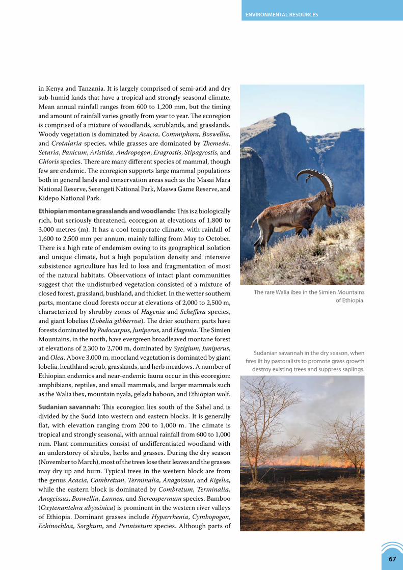
Ethiopian montane grasslands and woodlands: This is a biologically rich, but seriously threatened, ecoregion at elevations of 1,800 to 3,000 metres (m). It has a cool temperate climate, with rainfall of 1,600 to 2,500 mm per annum, mainly falling from May to October. There is a high rate of endemism owing to its geographical isolation and unique climate, but a high population density and intensive subsistence agriculture has led to loss and fragmentation of most of the natural habitats. Observations of intact plant communities suggest that the undisturbed vegetation consisted of a mixture of closed forest, grassland, bushland, and thicket. In the wetter southern parts, montane cloud forests occur at elevations of 2,000 to 2,500 m, characterized by shrubby zones of Hagenia and Scheffera species, and giant lobelias (Lobelia gibberroa). The drier southern parts have forests dominated by Podocarpus, Juniperus, and Hagenia. The Simien Mountains, in the north, have evergreen broadleaved montane forest at elevations of 2,300 to 2,700 m, dominated by Syzigium, Juniperus, and Olea. Above 3,000 m, moorland vegetation is dominated by giant lobelia, heathland scrub, grasslands, and herb meadows. A number of Ethiopian endemics and near-endemic fauna occur in this ecoregion: amphibians, reptiles, and small mammals, and larger mammals such as the Walia ibex, mountain nyala, gelada baboon, and Ethiopian wolf.
Sudanian savannah: This ecoregion lies south of the Sahel and is divided by the Sudd into western and eastern blocks. It is generally flat, with elevation ranging from 200 to 1,000 m. The climate is tropical and strongly seasonal, with annual rainfall from 600 to 1,000 mm. Plant communities consist of undifferentiated woodland with an understorey of shrubs, herbs and grasses. During the dry season (November to March), most of the trees lose their leaves and the grasses may dry up and burn. Typical trees in the western block are from the genus Acacia, Combretum, Terminalia, Anagoissus, and Kigelia, while the eastern block is dominated by Combretum, Terminalia, Anogeissus, Boswellia, Lannea, and Stereospermum species. Bamboo (Oxytenantehra abyssinica) is prominent in the western river valleys of Ethiopia. Dominant grasses include Hyparrhenia, Cymbopogon, Echinochloa, Sorghum, and Pennisetum species. Although parts of
TherareWaliaibexintheSimienMountainsofEthiopia.
Sudaniansavannahinthedryseason,whenfireslitbypastoraliststopromotegrassgrowth
destroyexistingtreesandsuppresssaplings.

!
!
!
!
!
!
!
!
!!
!
THE SUDAN
KENYADR CONGO
RWANDA
BURUNDITANZANIA
EGYPT
ERITREA
UGANDA
ETHIOPIA
SOUTH SUDAN
Cairo
AsmaraKhartoum
Addis Ababa
Alexandria
Nairobi
Bujumbura
Juba
El Obeid
Kampala
Kigali
Whi
te N
ile
LakeVictoria
Re d S e a
Main Nile
Main N
ile
Blue Nile (Abay)
The NBI is not an authority on international boundaries.
ECOREGIONS IN THE NILE BASIN
coastal desert
�ooded savannah
Sahara desert
Sahelian acacia savannah
montane xeric woodlands
woodlands and steppe
grasslands and woodlands
montane moorlands
montane forests
grasslands
Sudanian savannah
bushlands and thickets
lowland forests
forest-savannah mosaic
miombo woodlands
water bodies
(Map prepared by the NBI; source of data: Terrestrial Ecoregions GIS database)
0 250 500 km
N
68 STATE OF THE RIVER NILE BASIN 2012

ENVIRONMENTAL RESOURCES
69
this habitat have been adversely affected by agriculture, fire, and timbering, some relatively undisturbed locations harbour healthy populations of large mammals.
Sahelian acacia savannah: The largest ecoregion in the Nile Basin, this forms a transition zone between the true Sahara desert and the wooded savannah biomes. It has low-lying, flat topography and a hot tropical climate characterized by strong seasonality. Annual rainfall, which mostly falls in the months of May to September, ranges from 600 to 2,000 mm. During the dry season, hot dry winds blow from the north, often bringing with them dust and sand from the Sahara. The vegetation is characterized as Sahel acacia wooded grassland and deciduous bushland. The most common tree is Acacia tortilis. Others are from the genus Acacia, Commiphora, Balanites, and Boscia. Grass cover is dominated by Cenchrus biflorus, Schoenefeldia gracilis, and Aristida stipoides. Away from permanent water bodies, the dominant form of land-use is pastoral nomadism, with cattle as the main livestock. Near permanent water bodies, irrigated agriculture is practised, especially along the banks of the Blue Nile (Abay). The Gezira Irrigation Scheme, one of the world’s largest irrigation projects, is located in this ecoregion.
Sahara desert: The Nile Basin has 1.34 million square kilometres of arid and hyper-arid lands located between latitudes 11o30’N and 31o30’N. The arid belt is comprised of three ecoregions: the south Saharan steppe and woodland, the Sahara desert ecoregion, and the north Saharan steppe and woodlands. The Sahara desert ecoregion covers parts of the northern area of The Sudan and nearly all of Egypt. In the hottest months, temperatures may exceed 50oC, while in the coldest months they may fall below freezing. The region is characterized by hot, dust-filled winds that blow for much of the year. Annual rainfall is below 25 mm but multi-year droughts are common. The region is underlain by vast groundwater aquifers that penetrate the surface in a few places, giving rise to oases. Prominent land forms in the desert include sand dunes, stony plateaux (hamadas), gravel plains (reg), dry valleys and riverbeds (wadis), salt flats and non-salty depressions (dayas). Vegetation in the desert is extremely rare, with most areas covered by bare soil or rock. Scanty and stunted vegetation dominated by Acacia, Tamarix, and Calotropis species can be found along some wadis and dayas. In places with sufficient groundwater, hamadas are covered by Anrthirrnum ramosissimuma and Onomis angustissima. A few desert antelopes such as the slender-horned gazelle and redfronted gazelle may be found in small numbers in a few places.
AcaciatreeindesertofBayuda,northofKhartoum,TheSudan

70 STATE OF THE RIVER NILE BASIN 2012
Saharan woodlands and steppe: The Sahara desert is bound to the north and south by steppe and woodland ecoregions. The South Saharan woodlands and steppe ecoregion covers a broad belt extending from the western to northeastern areas of The Sudan, while the North Saharan woodlands and steppe ecoregion covers the Nile Delta and the Mediterranean coastline in Egypt. Mean annual rainfall in the two ecoregions ranges from 50 to 200 mm but years with no rain are common. Vegetation is scant and mainly found along wadis and dayas. Plant species that can be commonly observed include thorn acacia, creosote bush, sage bush, desert milkweed, desert willows, Capparis shrubs, date palms, doum palms, desert tobacco, and a number of annual grasses (mainly Aristida, Ephedra, Panicum, Zygophyllum, Eragrostis, and Stipagrostis species).
The woodlands and steppe are inhabited by a number of animals that have adapted to the harsh desert conditions. They include the Fennec fox, striped hyena, hares, ground squirrels, rock hyrax, dorcas gazelle, slender-horned gazelle, desert lynx, weasel, Saharan horned viper, Saharan sand viper, shrews, gerbils, jirds, jerboas, lizards, geckos, rats, and bats. The steppes and woodlands are economically important as pasturelands, and are used to keep herds of sheep, goats, and camels. Rainfall is insufficient to support rainfed agriculture, but irrigated agriculture is practised in oases, along wadis, and near major water bodies such as the Nile River.
CamelsinSouthernKordofan,TheSudan.

!
!
!
!
!
KENYA
TANZANIA
DR CONGO
RWANDA
BURUNDI
UGANDA
Nairobi
Bujumbura
Kampala
Kigali
Virunga National Park
Albe
rtine
Rift
LakeVictoria
0 250 500 km
ENVIRONMENTAL RESOURCES
71
TheAlbertineRiftregionisoneofAfrica’stopbiodiversityhotspots. Approximately 150 km wide, it runs fromthe northern tip of Lake Albert to the southern tip ofLakeTanganyika,andcomprisesthe low-lyingflatbedof the rift valley and steep escarpments on the sidesofthetrough.It islocatedattheintersectionofAfrica’smajorecoregions,borderedtothewestbytheGuinean-Congolian rainforest, to the south and southwestby the Cameroon and Angola forests and woodlands,to the east by the Eastern Arc Mountains and to thenorthbytheKenyanhighlands.Thisisoneofthereasonsfortheoutstandingspeciesdiversityandendemism.
TheAlbertineRiftishometoapproximately40%ofthemammals,50%ofthebirds,14%ofthereptiles,and19%oftheamphibiansofAfrica.ThespeciesthatareendemictotheNileBasinpartoftheriftaremainlysmallmammalssuchasshrews,rats,andbats,aswellasfrogsandtoads,chameleons, butterflies, and dragonflies. Some of thelarger endemic animals include the mountain gorilla,Rwenzoriduiker,owl-facedmonkey,L’Hoest’smonkey,andtheRwenzorituraco.
The Albertine Rift also contains 5,793 plant species,whichisabout14.5%oftheplantspeciesofmainlandAfrica.About567areendemictotherift,withthehighestconcentration of plant species and endemics locatedinVirungaNationalParkintheDemocraticRepublicofCongo,followedbyBwindiImpenetrableNationalParkin Uganda. The endemic plants include Thunbergia kamatembica, Bothriocline ruwenzoriensis, Senecio johnstonii, Impatiens burtonii,andIpomea hildebrandtii.
FAUNAThe varied floristic and climatic conditions of the Nile Basin support an equally diverse assemblage of fauna. On the African continent, the Nile and its system of lakes, rivers, and wetlands is second only to the Congo basin in the number of fish species it supports. The large terrestrial fauna, now mostly concentrated in protected areas, are remnants of large populations that once roamed the African plains.
There are more than 15 national parks in the Nile Basin, which provide protection to many animals that are endemic, vulnerable, or critically endangered. There is a larger number of other types of protected areas - game reserves, game control areas, animal sanctuaries, nature conservatories, forest reservations, Ramsar sites, and World Heritage Sites – in the basin.
AforestofgiantgroundselontheslopesoftheVirungaRange,northernRwanda.
THE ALBERTINE RIFT REGION

(Map prepared by the NBI; source of data: IUCN-WCMC 2010; www.ramsar.org)
national park
national reserve
forest reserve
game reserve
hunting reserve
protected area
the Sudd
river
lake
country boundary
The Nile Basin boundary
MAJOR PROTECTED AREAS IN THE NILE BASIN2012
N
The NBI is not an authority on international boundaries.
0 250 500 km
Wadi el Alaqi Elba
Southern
Jikao
Serengeti
Akobo
Virunga
North Karamoja
Gambella
Omo
South Karamoja
Tedo
Maswa
Garamba
Yata-Ngaya
Zemongo
Sebei
Bili-Uere
Katonga
Mizan-Teferi
Pian UpeMurchison Falls
Shire
Shambe
Tama
Lipan
East Madi
Dabus Valley
Gangala-na Bodio
Masai Mara
Omo West
Matheniko
Wadi el Rayan
Awash West
Akagera
Bokora Corridor
Mondo Missa
North Teso
Kidepo Valley
Nyungwe
Toro
Rwenzori Mts
Biharamulo
Karuma
Rutshuru
Semliki
Gash-Setit
Lake Mburo
Qarun Lake (Quaron)
Ruvubu
West Madi
Ibanda
Bugungu
Kigezi
Volcans
Ajai
Andre Felix
Gishwati
Kibira
Northern Kahama
Simien Mountains
Ruma
Mount Kei White Rhino
Lake NakuruKibale Forest Corridor
Kaiso Tonya
Rusizi
Rubondo (Luwondo)
Mount Elgon
Wadi Degla
Mukura
KakamegaJinja AnimalKerio Valley
Entebbe Animal & Bird
Buhuka
Wadi el Assuity or Wadi el Assuti
Bururi Forest
Lac Rwihinda Saanane
Saluga and Ghazal Nile Islands
Dinder Natiobal Park
Sudd
LakeVictoria
Re d S e a
TANZANIA
THE SUDAN
KENYA
DR CONGO
RWANDA
BURUNDI
EGYPT
ERITREA
UGANDA
ETHIOPIA
SOUTH SUDAN
Aswa
Dinder
Rahad
Sobat
Bahr el Arab
Raga
Sopo
Kuru Jur
Num
atinna
Suo
Bahr
el Z
eraf
Bahr el Jebel
Pibor
Akobo
Baro
Bahr e
l
Ghazal
Main Nile
Whit
e N
ile
Main N
ile
Blue Nile (Abay)
Atbara (Tekezze)
Lake Burullus
72 STATE OF THE RIVER NILE BASIN 2012
The Serengeti and Masaai Mara National Parks feature the world-famous annual migration of wildebeest, zebra and buffalo. The Sudd in South Sudan features equally impressive mass migrations of large mammals.
Other transboundary conservation areas of considerable significance are the three connected national parks of the Virunga Mountain chain (Virunga National Park, Karisimbi National Park, and Bwindi Impenetrable National Park), home to the world’s only remaining population of mountain gorilla (Gorilla baringei baringei).

!
!
!
!
!
!
!
!
!
!
!
!
!!
!
1
2
3
4
5
78
910
11
12
13
14
15
16
17
6
THE SUDAN
KENYADR CONGO
RWANDA
BURUNDI TANZANIA
EGYPT
ERITREA
UGANDA
ETHIOPIA
SOUTH SUDAN
Cairo
AsmaraKhartoum
Addis Ababa
Bur Sudan
Wadi Halfa
Aswan
Suez
Alexandria
Nairobi
Bujumbura
Juba
El Obeid
Kampala
Kigali
Whit
e N
ile
LakeVictoria
Re d S e a
Dindar
Sobat
Bahr el Arab
Raga
Sopo
Kuru
Jur
Num
atinna
Suo
Bahr el Jebel
Aswa
Migori
Pibor
Akobo
Baro
Ruwana
Moame
Main Nile
Main N
ile
Atbara (Tekezze)
Blue Nile (Abay)
WETLANDS AND RAMSAR SITES IN THE NILE BASIN 2011
The NBI is not an authority on international boundaries.
Virunga National Park
Rugezi–Bulera–Ruhondo
Lake Bisina System
Lake George
Lake Mburo–Nakivali System
Lake Nabugabo System
Lake Nakuwa System
Lake Opeta System
Lutembe Bay
Mabamba Bay
Murchison Falls–Albert Delta
Nabajjuzi System
Rwenzori Mountains
Sango Bay–Musambwa Island
Sudd
Dinder National Park
Lake Burullus(Map prepared by the NBI; source of data: AFCover and www.ramsar.org)
1
2
3
4
5
6
7
8
9
10
11
12
13
14
15
16
17
permanent wetland
seasonal wetland
Wetlands designated of internationalimportance under the Ramsar Convention
N
0 250 500 km
ENVIRONMENTAL RESOURCES
73
Ashoebillstork,oneofthemanyspeciesofbirdthatdependontheregion’swetlands
andlakeshores.

74 STATE OF THE RIVER NILE BASIN 2012
USE OF THE BASIN’S RESOURCESAbout 232 million people live in the Nile Basin, and use and depend on its varied natural resources and ecosystems in many ways. Indeed, the human development in the region is closely linked to the ability of the environment to provide a variety of goods and services and to sustain these into the future.
The environmental sector contributes an estimated 40 to 60 per cent of the gross domestic product of the Nile riparian countries. The beautiful natural scenery and wide diversity of plants and animals make the basin a popular tourist destination and thus a major source of revenue.
The environment is also a source of water for drinking and agricultural irrigation, and of firewood, charcoal, building materials, natural dyes, industrial raw materials, medicines, fodder, food (including fish, game meat, fruits, wild fruits, and honey), and of hydroelectric power to basin communities.
Environmental resources also play a key role in maintaining climate stability, protecting water catchments, controlling flooding, maintaining dry season flow in perennial rivers, enhancing groundwater recharge, controlling soil erosion, maintaining soil fertility, and purifying wastewater.
HUMAN PRESSURESDespite their great importance, the environmental resources of the basin are under increasing pressure from a combination of both natural and man-made factors. Agricultural and grazing lands are being degraded; water quality is declining; wetlands and forests are being lost; natural resource are being exploited at rates beyond their natural recovery rates; pollution from urban, industrial, and agricultural sources is increasing; waterborne diseases are spreading; and the harmful impacts of floods and droughts are intensifying .
Many of these threats have a direct impact on human health and welfare, while others undermine people‘s ability to secure their livelihoods, with poorer people being most affected. The main anthropogenic pressures are further discussed below.
Agriculture: The agricultural sector places pressure on environmental systems through land clearance and wetland reclamation for crop production, exposure of soil to erosion, sediment export, excessive water abstraction for irrigation, soil salinization, salt-water intrusion, and water-quality pollution from farm wastes, pesticides, and
TouristsviewingKabalegaFalls,Uganda.

ENVIRONMENTAL RESOURCES
75
fertilizers. Pressures from indiscriminate land clearance, wetland drainage, soil erosion, eutrophication, and sedimentation are discussed under Chapter 2: The Water Resources of the Nile Basin.
Wetland drainage for agriculture is widespread in the Nile Equatorial Lakes region. In Rwanda, close to 60 per cent of the 162,000 hectares of wetland are used for agriculture. The result has been the drying up of springs, reduced water outflow from wetlands, low groundwater recharge, and disruption in ecological function of wetlands.
Agricultural drainage water from irrigation schemes is a significant point source of water pollution. In The Sudan and Egypt, where there are large areas of land under irrigation, drainage water from agricultural fields is contaminated with fertilizers and pesticide residues and causes serious pollution of receiving waters. Fish in Lake Nubia at the border of The Sudan and Egypt have been found to have high concentrations of pesticide residues from contaminated drainage water coming from the Gezira scheme.
The Nile Delta downstream of the Delta Barrage is an area of intensive irrigated agriculture. Return flow from the farms pollutes drainage canals and branches of the Nile with fertilizer and pesticide residues. The common pesticide residues in the agricultural drainage water, in order of decreasing frequency of occurrence, are endrin, total beta-hexachlorocyclohexane (BHC), total dichlorodiphenyltrichloroethane (DDT), endosulfan, heptachlor epoxid, and heptachlor. The most polluted area with respect to pesticide residues is Kafr el Zayat city. Of the two Nile Delta distributaries, the Rosetta branch is more contaminated with pesticide residues than the Dimietta branch. Pesticide residues are also much higher in Lake Manzala than the River Nile due to direct discharge of irrigation drainage water. Pollution-control efforts by the Egyptian government from the early 1980s have resulted in considerable improvements in water quality and prevented the problem from getting out of hand. Generally, the concentrations of pesticide residues and heavy metals in the River Nile have been falling over the last two decades, and in most locations are within the levels permissible for human consumption. Notwithstanding, water pollution remains a major issue in Egypt.
Environmental degradation from agriculture, industry, and urbanization in the Nile Valley and Delta in Egypt has led to the disappearance of many native plants and animals. The delta vegetation has become so impoverished that it can no longer support healthy populations of fauna except in a few protected areas. Among the notable large animals eliminated by human pressure are the Nile crocodile, hippo, and the most famous of the birds of ancient Egypt – the sacred ibis.
SacredIbis,foundintheNilecountries,butnolongerinEgypt.
ANilecrocodile,nearlyhuntedtoextinctiononLakeVictoria.

76 STATE OF THE RIVER NILE BASIN 2012
Livestock production and fisheries: Over-exploitation of rangelands through overgrazing is a serious problem in parts of the basin such as the toic grasslands of South Sudan, Ethiopian Highlands, northern Rwanda, northern Tanzania, and the cattle belt in Uganda. In these areas, stocking rates, influenced by cultural tendencies, are far in excess of the carrying capacity of the rangelands. Among other things, the high stocking levels lead to disappearance of palatable pasture grasses and to increased runoff and soil erosion from the rangelands. During droughts, pastoralists in the neighbourhood of protected areas such as the Gambella, Shambe, Queen Elizabeth, Akegera, and Biharamulo drive their herds in the protected areas, thereby bringing livestock in direct competition with wildlife for water and pasture, and increasing the risk of disease transmission from livestock to wildlife and vice versa.
High fishing pressure and the use of illegal fishing gear has led to a marked decline in fish stocks in the Nile Equatorial Lakes. Attempts to boost fish production through introduction of exotic species (such as the Nile tilapia and Nile perch) has upset the ecological balance in the lakes and led to the extinction of some of the endemic fish species.
Bushfires: Each year wildfires are lit by farmers and pastoralists in parts of the basin to prepare land for cultivation and allow for regrowth of pasture grasses. These fires cause serious destruction and bring about marked changes in the species composition of plants and animals.
Poaching: Up to the late 1980s, poaching was rampant in the protected areas in the basin. Wildlife were killed or trapped for bush meat, animal parts (such as ivory, horns, and hides) or for illegal trade in live animals (biopiracy). Poaching led to drastic decline in wildlife numbers in the protected areas and extinction of some species. Professional hunting and a booming trade in crocodile skins in the 1960s brought the Nile crocodile to near extinction on Lake Victoria. Although poaching has been largely brought under control, the animal populations have not recovered to their 1960s levels.
Urbanization: Although urbanization may alleviate pressure on the rural environment by offering alternative income and livelihoods, it brings with it a different set of challenges. Rapidly growing and unplanned urban centres often lack the infrastructure and institutions needed to protect human and environmental health, to supply adequate water and sanitation, or provide affordable housing and transportation. Most of the large urban areas in the basin have conventional municipal wastewater treatment systems. However, the systems were built many decades ago, and their capacity has not grown in tandem with population growth. Therefore, many large urban centres in the basin do not possess proper treatment systems for domestic wastewater, which ends up eventually contaminating the environment with organic matter, plant nutrients, suspended solids, and pathogenic organisms.
Lightweightplasticbagsareaproblemacrosstheregion,causingseriousfloodingiftheyblock
drainagesystems,whichisonereasonwhyseveralcountriesinEastAfricaareleadingthe
worldinbanningthem.
Open-airburningisthemostcommonmethodofwastedisposalinsettlementssuchasthisoneonthesouthernfringeofKhartoum,TheSudan.

(Source of data: Forum for Environment 2010)
SOLID WASTE GENERATIONAND COLLECTION IN ADDIS ABABACubic metres1997/8, 2003/4 – 2007/8
generated
collected
1997/8 2003/4 2004/5 2005/6 2006/7 2007/8
787,305760,244
789,134819,121
538,387
850,247
1,176,743
576,760 615,336
517,356544,689540,266
ENVIRONMENTAL RESOURCES
77
Solid-waste management in the urban areas is also generally poor. Commonly, uncollected garbage accumulates in large heaps in the backstreets, which in turn can find its way into the Nile tributaries through stormwater runoff.
The construction sector, which is concentrated in urban areas and experiencing a boom across the region, requires building poles, timber, stones, sand, clay, and limestone for
AlargeproportionofgarbageinAddisAbabaremainsuncollected.Asimilarsituationexistsinotherlargeurbanareasinthebasin.
RubbishstrewnacrosswastelandontheoutskirtsofCairo.Severalthousandhectaresof
agriculturallandinEgyptarelosteachyeartosuchexpansionofhumansettlements.
Polesthathavebeentransported300milesfromRenkinUpperNilestatetobesoldinKhartoum.

78 STATE OF THE RIVER NILE BASIN 2012
cement. Uncontrolled extraction of these materials contributes to alteration, fragmentation, and destruction of the natural habitats of the Nile Basin. The demand for commercially valuable tree species is so high that it is driving some species towards extinction.
Industry: Pollution from untreated industrial effluents in the major urban areas is another serious environmental problem. The large urban areas in the basin have many mainly agro-processing industries (such as coffee hullers, grain milling, sugarcane milling, fish processing, milk processing, soap manufacture, edible oil processing, breweries, soft drink manufacture, meat packing, and confectioneries). These produce wastes high in organic matter, suspended solids, and plant nutrients. There are also a number of factories with more toxic wastes, such as tanneries, paint mixing, drug and battery manufacture. The Ethiopian part of the basin is notable for the number of tanneries in operation.
Cities located on the shores of Lake Victoria discharge treated and untreated effluent into the lake. Inflow of untreated domestic effluent and contaminated runoff from the city of Kisumu and its surroundings has been a major contributor to the acute eutrophication and severe water hyacinth infestation of Lake Victoria’s Winam Gulf.
In Egypt, which is the most industrialized country in the Nile Basin, water pollution from industrial, municipal, and agricultural sources is a serious issue that exacerbates the already grave water scarcity problem of the country. Egypt’s many industries include agro-based (such as sugar mills, manufacture of edible oil, fruit processing, and confectionery), chemical, electroplating, petroleum refineries, pesticide manufacturing, plastics and rubber manufacturing, and heavy engineering. These industries are mainly concentrated in greater Cairo and the Nile Delta region, and only partially treat their effluent prior to discharging it into the Nile, irrigation canals, public sewers, and into the ground. The discharge of partially treated wastes causes many problems, including oil and heavy-metal pollution.
Pollution from the industries in the basin is not limited to water pollution, but includes air, soil, and sound pollution.
Mining: The Nile riparian states have a diversity of mineral resources that include gold, silver, chromium, copper, iron, tin, tungsten, tantalum, phosphates, limestone, natural gas, and petroleum. Production for most minerals is at low level, but the few mining activities are having deleterious impacts on the environment. Artisanal gold mining, perhaps the most widespread mining activity in the basin (which occurs in many parts of Tanzania, Uganda, DR Congo, The Sudan, and Ethiopia), poses a threat to the
UntreatedeffluentfromasugarfactoryinTheSudanflowsintotheWhiteNile,2007.

ENVIRONMENTAL RESOURCES
79
environment through indiscriminate clearing of land, as does the use of mercury during the amalgamation stage of gold production. Petroleum production, which is at commercial scale in the two Sudans, exerts considerable pressure on the environment.
Domestic energy: In most Nile Basin countries, 80 per cent of households rely on biomass to meet energy needs. But even in urban areas, where there is greater access to electricity, many households use wood fuels – mainly charcoal – for cooking. Rampant logging has left a large proportion of the basin land exposed to wind and water erosion. This has in turn led to increased sediment loading, siltation, and eutrophication of water bodies. The loss of fertile topsoil layers is also escalating the destruction of upland habitats and reduction of their ability to support livelihoods.
Majorreservesofnaturalgasandpetroleumhavebeendiscovered in several locations within the Nile Basin,including the Albertine Rift Region and the WhiteNile floodplains. The natural gas and oil reserves, bycoincidence,are locatedinbiodiversityhotspots.Theirexploration and development, if not well managed,couldcausespeciesextinctionandgrossenvironmentaldamage.ThesituationinSouthSudanprovidesagoodoverviewontheenvironmentalchallengesposedbythepetroleumindustrytothebasin.
Onlyasmallpartoftheoil-bearingareasofSouthSudanhave been fully explored. The current oil fields arelocatedatBentiuandTharJathinUnityState;andatAdarandMallutinUpperNileState.Productioninthefutureisexpectedtodoubleortreblethepresentpeakcapacityof260,000barrelsperday.Oilrevenuestodayaccountforover98%oftheannualbudgetofthegovernmentofSouthSudan.
The areas targeted for oil exploration are particularlyvulnerabletoenvironmentaldamageastheyhavefewroads,are relativelywell forested,havesoft soils,andflood for several months a year. The concession areaBlock5AthatencompassestheBentiuandTharJathoilfieldsissandwichedbetweentheBahrelGhazalandBahrelJebelrivers.Thisarea–partofthegreaterSudd,toic,andWhiteNilereticulationsystem–lieswestoftheZefahGameReserveandsupportsmanyuniqueassemblagesoffloraandfauna.Theareaisalsohometomultipleagro-pastoralcommunities,whopractiserecessionagriculture,andmigrateseasonallywithlargelivestockherds.
Manynegativeenvironmentalandsocial impactshaveoccurred from petroleum exploration and production
inSouthSudan.Theseincludelarge-scaleintrusionintopreviouslyundisturbedareas;damagetopastorallandsand dwellings from road construction; disruption ofdrainagepatternsbyroadconstructionleadingtodryingofstreams;interferencewithrecessionagriculture;andhindranceofwildlifeaccesstowater.
At the oil production sites, multiple hazards occur,including the discharge into the environment ofuntreatedorpartiallytreatedwater;needlessemissionsofgreenhousegasesfromflaringofproducedgas;andsecondary development impacts resulting from theattractionofpopulationsseekingemploymentandotherbenefitsfromtheoilindustry.
SOUTH SUDAN: ENVIRONMENTAL CHALLENGES OF THE PETROLEUM SECTOR
Ablack-crownedcrane,aspeciesalreadyconsideredvulnerablethatwouldbeputatgreaterriskifitshabitatin
SouthSudanweredisruptedbyoilexploration.

80 STATE OF THE RIVER NILE BASIN 2012
Invasive species: Invasive species are plants, animals, and microorganisms that occur outside their natural range. They are introduced intentionally for economic or agricultural purposes, or accidentally, through tourism, travel, or trade. Invasive species may originate from foreign lands or from a different part of the same country or region. Once introduced, invasive species may spread very fast and threaten the survival of native species. The invasive species are able to proliferate quickly as a result of having little, if any, form of natural control (such as competitors, predators, parasites, or pathogens) in their new host environment. Within the aquatic ecosystems of the basin, the most widely distributed invasive alien species include the water hyacinth, purple nutsedge, common carp, and Mozambique tilapia. Water hyacinth affects the entire Nile system but has had the greatest impact on the headwaters of the White Nile, especially on the Kagera River, Lake Victoria, and the Sudd. Water hyacinth infestations block waterways, interfering with their use for transport, fishing, and swimming.
Water hyacinth mats also prevent sunlight and oxygen from penetrating the water column and reaching submerged plants and animals, thus reducing biological activity. Furthermore, the hyacinth mats provide breeding grounds for snails carrying schistosomes (bilharzias) and malaria mosquitoes, thereby causing public health problems in irrigation schemes and along infested waterways. In Egypt it is difficult to find a canal, stream, or drain not infested by water hyacinth, particularly in the Fayoum and the Nile Delta.
The purple nutsedge is one of the basin’s worst crop weeds, and affects both rainfed and irrigated agricultural areas. The common carp, which is used in the basin for angling and as an ornamental fish, feeds in a manner that alters aquatic habitats, thereby affecting the survival of native species. The Mozambique tilapia, which eats almost anything from algae to insects, is used for aquaculture and control of mosquitoes. However, populations of the Mozambique tilapia in the wild have become established within the basin from intentional release or escape from fish farms. The Mozambique tilapia can harm native fish populations through competition for food and nesting space, as well as by directly consuming small fish.
The terrestrial ecosystems of the basin are also affected by invasive plant and animal species. Common among the terrestrial invasive plants are crop weeds such as speargrass and bristly foxtail; and pasture invasives such as lantana, lemon guava, catclaw, and weeping wattle. The pasture invasives are unpalatable, toxic, or have low
Asmallwaterhyacinthmatsuchasthiscanquicklyspreadtobecomeamajorproblem.

ENVIRONMENTAL RESOURCES
81
nutrient value. They commonly displace good pasture grasses and shrubs, thereby reducing the ability of pastures to support livestock and wildlife. In the toic savannah grasslands of South Sudan, frequent bush fires are helping fire-resistant but unpalatable invasive species such as speargrass (Imperata cylindrical) to increase their cover at the expense of more desirable fodder grasses. Invasive terrestrial animal species are also present and include the speckled mousebird and ring-necked pheasant.
As well as invasive species from other regions of Africa or the world, the basin contains invasive species that are native but have spread to areas beyond their natural range, for example, the Nile tilapia, Nile perch, Ngege (Tilapia zillii), domestic donkey, and the cattle egret. These species can interfere with the ecosystems in a similar way to that of the non-native species. Intentional and accidental introductions by humans have been responsible for the spread of many of the native species.
Civil insecurity: This term is used to describe situations where there is insurgency, lawlessness, rebellion, armed conflict, or civil strife. Civil war has been responsible for the decline of biodiversity in many parts of the basin, notably in Burundi, eastern DR Congo, Rwanda, Uganda, South Sudan, and Ethiopia. It is generally the case that areas suffering from civil insecurity are associated with depressed economies and unsustainable exploitation of environmental resources. In such areas, there is a breakdown in government structures and increase in uncontrolled lumbering and poaching of wildlife. Sprawling camps of displaced persons emerge within or near the conflict zone. The lands in the immediate neighbourhood of such camps become badly degraded as the displaced population cut surrounding trees for firewood and construction of temporary shelters.
In some instances, the displacement of populations by civil insecurity helps to protect plants and animals from human exploitation. This has been the case in parts of South Sudan, where aerial surveys conducted by the Wildlife Conservation Society in 2007 found stocks of wild animals in numbers that rival those in the Serengeti. The survey estimated 800,000 white-eared kob, 250,000 mongalla gazelle, 160,000 tiang, 13,000 reedbuck, 8,900 buffalo, 8,000 elephants, and 2,800 ostrich to be occurring in the areas around Jonglei, Boma, and Madingilo National Parks.
White-earedkobinSouthSudan.
Lantana camara,acommoninvasiveplantspeciesintheNileBasin.

82 STATE OF THE RIVER NILE BASIN 2012
NATURAL PRESSURESClimate change: Climate change is predicted to become the largest single driver of biodiversity loss over the next 100 years and threatens the survival of the plants and animals through a shift in temperature to a range in which the species are not well adapted. To survive, species will be compelled to shift habitat ranges or migration patterns. Climate change further affects plants and animals through emergence and increasing range and virulence of diseases. Species not able to evolve or shift their habitat ranges quickly enough will be at risk of extinction or suffer drastic loss of individuals.
Different parts of the basin are expected to be affected to different degrees by climate change, with the most sensitive areas being the Nile Delta in Egypt, the Sahel ecoregion in Sudan, the montane forest ecosystems in the headwater areas, and the freshwater lakes of the Equatorial Lakes region. Large areas of the Nile Delta are expected to be affected by sea-level rise and salt-water intrusion. The Sahel ecoregion is expected to experience the highest level of temperature rise, accompanied by an increase in aridity and rate of desertification. This will pile pressure on the already fragile ecosystems, and intensify competition and conflicts for environmental resources among pastoralist communities. The montane forest ecosystems of the Nile Basin are among the most sensitive and vulnerable to the impacts of climate change. They have been, and continue to be, affected through the retreat of glaciers, reduction of frost, shift in tree lines, and change in species composition. The habitable areas for many endemic species such as the mountain gorilla and walia ibex is fast shrinking. Between 25 and 42 per cent of the plant species in Africa are predicted to completely lose their habitat in 2085, while between 10 and 40 per cent of the animals are expected to become critically endangered or extinct by the same period. Climate change is driving marked ecosystem changes in the Equatorial Lakes through stronger and more prolonged seasonal thermal stratification, and acute dissolved oxygen limitation in bottom waters (hypolimnetic anoxia).
Desertification: This term refers to the degradation of semi-arid and sub-humid drylands located at the margins of true deserts. Desertification results from a complex interplay between natural climatic and human-induced processes, with the latter, probably, as the main driver of the process in recent years. Communities living at the edge of deserts accelerate the process of desertification through overgrazing and removal of woody vegetation, and through poor agricultural practices and unsustainable groundwater exploitation. The decline in vegetation cover associated with natural and
Amemberoftheremnantpopulationoftherareandendangeredmountaingorillainthe
montaneforestsofRwanda.
EncroachingsanddunesinArji,NorthernState,Sudan,2007.

ENVIRONMENTAL RESOURCES
83
anthropogenic activities leads to increased soil erosion, remobilization of sand dunes, increased aridity, deterioration of pastures, failing crops, increased civil conflicts, and further displacement of people. In the Nile Basin, the country most affected by desertification is The Sudan, particularly the northern states such as Northern Kordofan, Northern State, North Dafur, West Dafur, and Nile State.
Natural disasters: These occur frequently in the Nile Basin, and lead to the stress and death of wildlife or stagnation in their populations. The common natural disasters in the region arise from drought, flooding, storms and hailstones, disease epidemics, and landslides. Drought, the most widespread of the natural disasters, occurs frequently, causing loss of pasture and drinking water for wildlife, and occasionally resulting in wildlife die-offs. Drought affects all of the national parks in the basin, right from the Masai-Mara-Serengeti and Akagera National Parks in the equatorial headwater areas, through Queen Elizabeth, Lake Mburo, and other National Parks in Uganda, to the wildlife reserves in South Sudan and southwestern Ethiopia.
Unusual flooding of the Mara River, another natural disaster, is known to cause drowning of large numbers of animals during the great annual migration of the wildebeest and zebras in the Mara watershed. Flooding in the Sudd area leads to expansion of the wetlands and reduction in grazing area for wildlife and livestock. A natural outbreak of anthrax in Queen Elizabeth National Park in 2005 caused the death of over 300 hippos.
WildebeestcrossingtheMaraRiver.

LAND-USE CHANGES In the Nile Basin2005–09(Source of data: MERIS)
–17.9%
forests
–4.7%
grasslands
–10.1%
cities/built-up areas
–1.3%
water bodies1.0%
shrublands & woodlands
1.4%
bare soils
12.3%
agriculturalland
Num
ber o
f ele
phan
t
Num
ber o
f zeb
ra a
nd b
lack
rhin
o
20,000
0
40,000
60,000
80,000
100,000
120,000
140,000
160,000
180,000
1968 1972 1976 1980 1984 1988 1992 1996 2000 2004 2008 2012
5,000
0
10,000
15,000
20,000
25,000
WILDLIFE DECLINEDecline in populations ofblack rhino, elephant, Grey’s zebra1970–2010
black rhino
elephant
Grey’s zebra
(Source of data: NEMA (Kenya) 2011)
84 STATE OF THE RIVER NILE BASIN 2012
IMPACT OF PRESSURESLandcover changes: One of the impacts of increasing human activity in the basin has been changing land cover. Satellite images of the basin for the years 2005 and 2009 show substantial changes in the area of certain habitats. These changes are considered to reflect natural expansion and contraction in the area of vegetation types, as well as human-induced land-use changes.

THREATENED SPECIESNumber classi�ed by IUCN as extinct, critically endangered, endangered or vulnerable in Nile riparian countries2010
(Source of data: IUCN Red List Ver. 2010.4)
Tanzania
299
26
Ethiopia
4
Rwanda
83
DR Congo
18
Sudan
41
Uganda
129
Kenya
Burundi
2
2Egypt
Eritrea
3
N
0 250 500 km
ENVIRONMENTAL RESOURCES
85
Destruction of critical watersheds and ecosystems: Many of the watersheds critical for sustaining the Nile flows have been badly degraded. One such ecosystem is the Mau Forests Complex – the largest water tower in Kenya. The Mau Complex feeds major rivers draining into lakes Victoria, Turkana, and Natron, and supports critical economic activities, including hydropower generation, tourism, and agriculture. About 100,000 ha of the Mau Forests Complex (about one quarter of the total ecosystem) was destroyed by human encroachment between the mid 1990s and 2010, thereby severely affecting the flow of rivers originating in the forests and thus hydropower generation. The forest area in a nearby ecosystem – Kakamega Forest – was reduced by 50 per cent between 1965 and 1991 by human encroachment. Kakamega Forest is the only surviving rainforest in Kenya, and home to several endemic animals and plant species. Other critical watersheds affected are the montane ecosystems of Mt Elgon, Mt Rwenzori, and the Ethiopian Highlands.
Loss of biodiversity: An increasing trend arising from the combined impact of numerous human activities such as habitat fragmentation by agriculture, overharvesting of environmental resources, poaching, and encroachment in protected areas, is a sharp decline in biodiversity. Populations of wild animals in the national parks have fallen drastically, many are threatened or critically endangered, and some have gone extinct.
Miscellaneous impacts: Other impacts arising mainly through the activities of humans include loss of soil fertility, soil salinization, saltwater intrusion (in the Nile Delta), surface and groundwater pollution, and reservoir sedimentation.
ADorcasgazelle,oneofEgypt’srarestmammals.

86 STATE OF THE RIVER NILE BASIN 2012
Population growth
Political instability
Poverty
Thepopulationwithinthebasinisprojectedtoincreaseto312millionby2025.Althoughthe rise in population will be accompaniedbyanincreaseinrural–urbanmigration,thebulk of the population will continue livinginruralareasanddependonenvironmentaland natural resources for subsistence andlivelihood(seechapter4).Meetingtheneedsof the rising population will, among otherthings,necessitatemorevirginlandtobeputunder cultivation or converted to pastures;
moretreescutforfirewood,charcoal,timber,or poles; more water supplied for humanandlivestockconsumption,morefishcaughtfor consumption and sale; and more landcleared for erecting human settlements,improvingtransportinfrastructure,etc.Thus,therapidriseinpopulationisexpectedtobeaccompaniedbyescalationinanthropogenicpressure on the environmental and naturalresourcesofthebasin.
Politicalinstability,whichisoftenaccompaniedbybreakdowninlawandorder,isathreattoendangered species such as the mountaingorilla, African rhino, and chimpanzees.Protractedcivilwarsextendingoverdecadeshave affected Nile Basin countries such asBurundi, Democratic Republic of Congo,Ethiopia, Rwanda, South Sudan,The Sudan,and Uganda. Protected areas and nationalparksarefavouredrefugesformilitantgroupsduetotheirremoteness,naturalcamouflage,difficultterrain,pooraccessibility,andreadysupplyoffood.Sometimesenvironmentalandnatural resources (game,firewood/charcoal,
timber,hidesandskins,ivory,horns,minerals,etc)areharvestedandsoldtofinancethesegroups.Civilianpopulationsdisplacedbytheconflictplacefurtherstrainontheecosystemstheyareforcedtooccupyastheyarelefttodependalmostentirelyontheenvironmentforsubsistenceandsurvival.Duringcounter-insurgency operations by the ripariangovernments, the bushes are frequentlyburnttodenymilitantgroupscover, leadingto decimation or permanent out-migrationof important wildlife species. Other speciesgetstressedandfleefromthenoiseofheavyartilleryfire.
Thepresentlanddegradationintheheadwaterparts of the basin has its roots in poverty.ManyoftheNileBasincountriesareamongthepoorestintheworld.Theirpopulationsareheavilydependentupontheenvironmentalresources for their daily subsistence andlivelihoods. In situations of poverty andsocial insecurity,short-termsurvivalprevailsover medium- and long-term conservationgoals.Theunregulateduseoftheseresourcescreates an unsustainable situation, leadingto deforestation, soil erosion, and land
degradation,whichinturnleadtodecreasesin land productivity, wildlife populationdecimations, and loss of biodiversity. Thedestructionofthenaturalresourcebaseleadstogreaterimpoverishmentofthepopulation,andperpetuatesaviciouscycleofpovertyandenvironmentaldegradation.Itisimportanttopointoutthat,sometimes,provisionofgoodsandservicesforconsumptionbythewealthyand non-poor cause greater environmentaldamagethanthoseattributabletothepoor.
UNDERLYING FACTORS
Addressing the sustainability of environmental resources necessitates developing a clear understanding of theunderlyingcausesofthepressuresandthreatstothebasin’swaterandrelatednaturalresources.
ENVIRONMENTAL DEGRADATION:UNDERLYING FACTORS AND POTENTIAL REMEDIES

ENVIRONMENTAL RESOURCES
87
Political action
Environment resources management
Preventive measures
Outreach
Environmental monitoring
Curative measures
Weak policy, legal, and institutional frameworks
Mobilizing and sustaining strong politicalcommitment to wise use of environmental
resources at local, national, and regionallevels.
Identifying and restoring degraded criticalhabitats and watersheds; expanding re-forestation and afforestation programmes;
stepping up conservation efforts in criticalhabitats;promotingwetlandswise-use.
Strengthening frameworks for,andcarryingout, cooperative basin assessments (CBA),environmentalandsocialimpactassessments(ESIA); strategic social and environmentalassessments (SSEA);carryingout integrated
waste management; greening sectorsof national development; consolidatingmacro-policy frameworks for sustainabledevelopment.
Strengthening and expanding publicawarenessandeducationprogrammesontheNileenvironment;enhancingconsultationandstakeholder participation and involvement,e.g.throughNileDaycelebrations.
Developing suites of environmentalsustainability indicators; strengtheningenvironmental monitor ing systems;
strengtheningmonitoringandevaluationinenvironmentalprogrammes.
Promoting integrated waste management;promotingcleanerproductionintheindustrialsector; constructing new wastewater
treatment plants and expanding existing;providing extension services to promoteappropriatepesticideandfertilizeruse.
In a number of Nile riparian countries,environment and sustainable developmentare still not sufficiently integrated intobroadersectorssuchasagriculture,fisheries,transport,trade,energy,mining,andindustry.Policy making is mostly not proactivebut a reaction to unfolding or impendingenvironmental crisis. Laws are sometimesenactedthatarebeyondthecapacityofthe
responsiblegovernmentagenciestoenforce.The agencies suffer from low budgetaryallocations, inadequate manpower, poortransportfacilities,andinadequatetechnicalfacilitiessuchasenvironmental laboratoriesand monitoring equipment. Corruption(occurring at varying levels in the ripariancountries)furtherweakenstheenforcementofenvironmentallaws.
POTENTIAL REMEDIES
UNDERLYING FACTORS
Coordinatedinterventionsareneededindiversesectorsandatlocal,district,national,andregionallevelstoaddressthecurrentpressuresandthreatstotheenvironmentinthebasin.Keymeasuresinclude:
RegionalNileDayCelebrationsinJinjaUganda.

88 STATE OF THE RIVER NILE BASIN 2012
NATIONAL ENVIRONMENTAL GOVERNANCE FRAMEWORKSCommon strengths and weaknessesThe policy, legal, and institutional frameworks for environmental governance in the Nile Basin vary in scope and strength from country to country. There are strengths and weaknesses that are common to all countries and strengths and weaknesses that are specific to countries.
The countries, in common, have moderate to comprehensive arrays of national policies, laws, strategies, and plans in sectors such as environment, water, forestry, agriculture, energy, wildlife, tourism, fisheries, mining, climate change, cultural heritage, resettlement, gender, and HIV/AIDS. Except in a few countries, there is a clear national lead agency for the environment. Systems for environmental and social impact assessments (ESIAs) and environmental audit (AU) have been established, and there are national programmes to address different environmental threats.
Weaknesses are more numerous than strengths, and include inadequate human capacity (in the public and private sectors); inadequate budgets (that cripple the operational capacity of national agencies); weak implementation, monitoring, supervision, and enforcement of polices and laws, in particular, weak post-ESIA follow-up on development projects; little synergy, and weak framework for inter-agency and cross-sectoral coordination; lack of regulations and standards needed for implementation of laws; ill-equipped facilities such as environmental laboratories; lack of technology for pollution abatement and waste purification; poorly developed environmental monitoring systems; some outdated laws (especially in the agriculture and mining sectors); lack of accreditation systems for resettlement action plan (RAP) professionals, and in a few countries, for environmental impact assessment (EIA) professionals as well; and low level of integration of social issues such as poverty reduction, gender, HIV/AIDS, and resettlement in environmental management programmes.
In general, Burundi, DR Congo, and South Sudan have relatively weaker policy, legal, and institutional frameworks for environmental governance as compared to other Nile riparian countries.
Country-specific weaknessesWeaknesses specific to countries are summarised below.
Burundi: Has no semi-autonomous lead agency for environmental management matters; has not established the Commission responsible for resettlement provided for in the Land Code (1986); the laws do not provide for use of tools such as Resettlement Action Plan (RAP).
DR Congo: Has no central agency responsible for overall coordination of environmental matters; has no EIA guidelines; some laws such as the Water Act are still in draft form; marginalized people are not recognized under the constitution; and state control of some mining areas is weak.
AgaugingstationrecentlyinstalledaspartoftheNBIMaraRiverBasinManagementProject.

ENVIRONMENTAL RESOURCES
89
Egypt: Has inadequate human resources for decentralized water resources management; resettlement planning is initiated late in the project cycle; mining laws are outdated; marginalized people are not legally recognized; and the country’s HIV/AIDS policies provide for denial of working permits to people with HIV, which is against international standards for employment rights.
Ethiopia: Many sectoral agencies are not able to execute the functions delegated to them by Federal Environmental Protection Agency (FEPA); the law on land tenure does not protect the land rights of marginalized people.
Kenya: Most laws still need to be aligned with the 2010 constitution; the numerous land laws have not provided a mechanism for land re-distribution to ease the widespread land scarcity; there is limited public participation in EIA processes; and climate-change adaptation is poorly mainstreamed in other sectors.
Rwanda: Many stakeholders are not sufficiently sensitized on the importance of the EIA process; many provisions in the water policy are yet to be implemented; the agricultural policy does not adequately address needs of poor farmers.
South Sudan: Has a weak policy, legal, and institutional framework for environmental governance: the Environmental Bill has not been signed; environmental standards and regulations are not in place; institutional roles and responsibilities amongst key sectoral agencies are unclear; the laws and regulations for implementation of the water policy are not yet in place; decentralized structures for water resources and environmental management have not yet been established; there is no policy or law dealing with wild fires devastating protected areas; a number of laws such as the Forests Act (1989) were inherited from the North and are not in line with the policies of the new state; some policies such as the Wildlife Forces Act (2003) were inherited from the SPLM and need to be replaced; most protected areas do not have updated management plans; and current laws do not provide for community participation in natural resources management.
Tanzania: Has no system for accreditation of EIA and RAP practitioners; has no specific policy or law on resettlement and compensation; resettlement action planning is not provided for in power and mining sectoral laws; the procedures for identification of marginalized people are prohibitively lengthy.
The Sudan: Has no ministry solely dedicated to environmental management; the national land law conflicts with customary land-tenure systems; the EIA process does not start at project conception but at later stages of project preparation; discriminatory laws against women still exist; and there is no system for accreditation of EIA and RAP practitioners.
Uganda: About 75 per cent of the country’s land is unregistered, which hinders its access for development; has no EIA guidelines for

90 STATE OF THE RIVER NILE BASIN 2012
the forestry sector; resettlement and compensation have not been mainstreamed in environmental laws and regulations; and the legal provisions for protection of cultural heritage are weak.
REGIONAL ENVIRONMENTAL GOVERNANCE FRAMEWORKSNile Basin Initiative (NBI)There is no legal framework for regional environmental management covering all ten Nile riparian countries. In the Nile Equatorial Lakes region, with the exception of DR Congo and South Sudan, the riparian states are members of a regional block, the East African Community (EAC). The Eastern Nile region has no comparable grouping of countries.
The NBI, which is the only regional body that brings together all the Nile riparian countries, is best placed to provide a unifying framework for transboundary environmental governance, albeit on a temporary basis until a more robust arrangement is put in place by the Nile Basin States. Activities to prepare the NBI for a possible future role in environmental governance have been undertaken, and include the definition of the environmental management function of the future Nile River Basin Commission, and drafting of an NBI environmental and social policy and guidelines.
East African Community (EAC)The East African Community is a regional economic community (REC) with five member states (Kenya, Tanzania, Uganda, Rwanda, and Burundi) who are all Nile Riparian countries. The EAC was established by a regional treaty (the EAC Treaty of 1999) which, among other things, calls on partner states to cooperate on all areas of environmental and natural resources management. The partner states in 2006 concluded the protocol on Environment and Natural Resources Management to facilitate cooperation in environmental and natural resources management. This protocol is not yet ratified. Other EAC legal instruments of relevance to environmental governance include the Protocol for Sustainable Development of the Lake Victoria Basin, and the EAC Climate Change Policy.
The EAC Protocol on Environment and Natural Resources Management is intended to be the overarching instrument governing rational utilization and conservation of environmental and natural resources in the community. Through the protocol, partner states will seek to address issues such as biodiversity conservation, hazardous waste management, pollution control, ecological justice, climate-change adaptation, environmental education, capacity building, and public participation.
A principal point of focus under the protocol is the management of shared transboundary ecosystems such as the Lake Victoria and Lake Tanganyika basins; the Mount Elgon forest systems; the Minziro-

ENVIRONMENTAL RESOURCES
91
Sango Bay swamp forests; the Virunga and Kibira national parks; the Masai-Mara and Serengeti wildlife ecosystem, and the Amboseli-Monduli wildlife ecosystem. Most of the above ecosystems are part of the Nile ecosystem
Lake Victoria Basin Commission (LVBC)Within the EAC, the Lake Victoria region was designated as a special economic growth zone. The lake’s catchment area is shared by all five of the EAC partner states. Starting from the beginning of the 20th century, the lake’s drainage basin has been suffering degradation from a multiplicity of anthropogenic activities, but mainly from clearing of forests and savannahs, bush burning, and drainage of wetlands for expansion of agriculture and human settlements.
In an effort to reverse the degradation of the lake, the EAC member states adopted a protocol for the sustainable management and development of the lake, and established the Lake Victoria Basin Commission to oversee the management and development of the lake region. The countries are implementing an action programme to address the degradation of the basin. The first phase of the programme (LVEMP I) established a framework for cooperative management of the lake and its catchments; provided baseline information on the lake; introduced best practices in sustainable utilization of environmental resources; and built capacity for water and ecosystem management. The second phase of the programme (LVEMP II) seeks to further strengthen collaborative arrangements for management of the lake basin and reduce pollution from targeted hotspots and degraded sub-catchments.
Intergovernmental Authority on Development (IGAD)Countries in Eastern Africa are also cooperating under the auspices of the Intergovernmental Authority on Development (IGAD) to address issues related to regional security, infrastructure development, drought, food security, and environment protection. IGAD was created in 1996 to supersede the Intergovernmental Authority on Drought and Development (IGADD). Its member countries are Djibouti, Eritrea, Ethiopia, Kenya, Somalia, South Sudan, The Sudan, and Uganda. The 1996 revitalization sought to develop IGAD into a fully fledged regional political, economic, development, trade, and security entity similar to SADC and ECOWAS.
DelegatesattheLakeVictoriaCommissionInvestmentForum2010.

Eritrea EthiopiaRwanda Egypt
DR CongoBurundi Uganda KenyaSudanTanzania
–39.2%
–33.4%
–17.5%
–8.5%–3.5%
30.5%
–5.9%
56.4%
n/a n/a
(Source of data: UNDP 2011)
CHANGE IN FOREST AREAAs a percentage of land area1990–2008
92 STATE OF THE RIVER NILE BASIN 2012
RESPONSE UNDER NATIONAL FRAMEWORKSThere are wide-ranging activities being undertaken by the Nile riparian countries to respond to the pressures being exerted on the Nile environment. However, the magnitude of threats greatly outstrips the response measures at national and regional levels. Although there are many cases where remedial measures have been successfully applied, greater efforts will be required to control the widespread degradation and rapid deterioration in the environment.
Tree planting is one of the response actions that has been widely embraced across the basin but, so far, has managed to reverse the decline in forest cover in only two countries. Examples of other response actions are shown below.
Greening national economies: A green economy is defined as one that results in improved human well-being and social equity while significantly reducing environmental risks and ecological scarcities. Potential greening interventions for the Nile countries include greening rural agriculture through integrated pest management, integrated nutrient management, low-tillage farming, agro-forestry, aquaculture, water harvesting, livestock integration, and planting nitrogen fixing crops; greening commercial agriculture through efficient water use; greening power production by investing in renewable energy such as wind, solar, and biofuels; greening tourism to increase local community participation; and greening trade by improving access to domestic and international markets for the poor.

ENVIRONMENTAL RESOURCES
93
Ethiopia recently formulated a green economy strategy which encompasses strategic actions based on four pillars, namely improving crop and livestock productivity; afforestation and protection of forests; expansion of investments in renewable energy production; and introduction of energy-efficient technology in the transport, industrial, and housing sectors. As part of its effort to implement the strategy, Ethiopia is seeking US$2.6 million from the African Development Bank (AfDB) for construction of a wind farm at Assela, and implementation of Phase II of the Langano Geothermal Project. In total, Ethiopia expects to receive US$22.6 million from AfDB to finance numerous projects under its Scaling up Renewable Energy Program (SREP) . Kenya and Tanzania are the other Nile riparian countries due to receive funding from AfDB for climate-related investments. South Sudan is receiving support from the European Union to construct a 50-MW power station that will use biogas and biomass as a source of energy. Other Nile states are also slowly making efforts to green various sectors of their national economies.
Ethiopia – pursuing integrated environmental management: Integrated approaches spanning several sectors are being introduced to deal with the issue of land and environmental degradation in Ethiopia. Notable among these are the preparation of integrated river-basin development plans for the country’s main drainage basins; preparation and implementation of integrated land-use plans at village, regional, and national levels; and promotion of indigenous and foreign soil- and land-conservation technologies such as lynchets, stone bunds, checkdams, contour trash lines/grass strips, level and graded bunds, and level and graded fanya juu terracing.
Changes in agricultural systems are also taking place, such as haymaking. A new law – the Ethiopia Rural Land Administration and Land Use Proclamation (2005) – decentralizes the management of land resources to regional and lower levels, and enhances tenure security, thereby encouraging farmers to invest in land-improvement practices. The Federal Government in 1994 classified 58 threatened highland forests as National Forest Priority Areas.
Rwanda – restoration of Rugezi–Ruhondo–Bulera wetland: The Rugezi–Bulera–Ruhondo wetland is an international Ramsar site located in northern Rwanda. Years of clearing and draining the wetland for agriculture and pasture led to dwindling water outflows, and caused a drop in electricity generation from downstream power stations. The government of Rwanda intervened to restore the wetlands and encouraged local farmers to return to their abandoned farms on the hill slopes above the wetlands. The government undertook to improve the productivity of farmlands by supporting local communities in constructing terraces and allowing re-growth of trees and shrubs. The wetland has recovered significantly, and water flows and power generation have since stabilized. In October 2010, Rwanda received a Green Globe Award for its restoration.
WorkersopenthevalvesofadamnearMekelle,Ethiopia.
HaybeingtransportedbytruckinEthiopia.
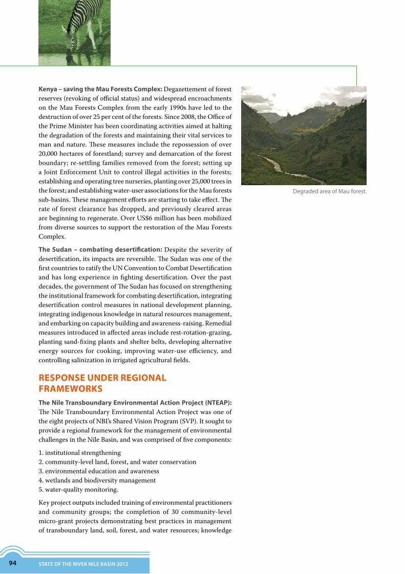
94 STATE OF THE RIVER NILE BASIN 2012
Kenya – saving the Mau Forests Complex: Degazettement of forest reserves (revoking of official status) and widespread encroachments on the Mau Forests Complex from the early 1990s have led to the destruction of over 25 per cent of the forests. Since 2008, the Office of the Prime Minister has been coordinating activities aimed at halting the degradation of the forests and maintaining their vital services to man and nature. These measures include the repossession of over 20,000 hectares of forestland; survey and demarcation of the forest boundary; re-settling families removed from the forest; setting up a Joint Enforcement Unit to control illegal activities in the forests; establishing and operating tree nurseries, planting over 25,000 trees in the forest; and establishing water-user associations for the Mau forests sub-basins. These management efforts are starting to take effect. The rate of forest clearance has dropped, and previously cleared areas are beginning to regenerate. Over US$6 million has been mobilized from diverse sources to support the restoration of the Mau Forests Complex.
The Sudan – combating desertification: Despite the severity of desertification, its impacts are reversible. The Sudan was one of the first countries to ratify the UN Convention to Combat Desertification and has long experience in fighting desertification. Over the past decades, the government of The Sudan has focused on strengthening the institutional framework for combating desertification, integrating desertification control measures in national development planning, integrating indigenous knowledge in natural resources management, and embarking on capacity building and awareness-raising. Remedial measures introduced in affected areas include rest-rotation-grazing, planting sand-fixing plants and shelter belts, developing alternative energy sources for cooking, improving water-use efficiency, and controlling salinization in irrigated agricultural fields.
RESPONSE UNDER REGIONAL FRAMEWORKSThe Nile Transboundary Environmental Action Project (NTEAP): The Nile Transboundary Environmental Action Project was one of the eight projects of NBI’s Shared Vision Program (SVP). It sought to provide a regional framework for the management of environmental challenges in the Nile Basin, and was comprised of five components:
1. institutional strengthening2. community-level land, forest, and water conservation3. environmental education and awareness4. wetlands and biodiversity management5. water-quality monitoring.
Key project outputs included training of environmental practitioners and community groups; the completion of 30 community-level micro-grant projects demonstrating best practices in management of transboundary land, soil, forest, and water resources; knowledge
DegradedareaofMauforest.

Jema
Beles
Dabus
Beshlo
Derma
Guder
Anger
Upper Didessa
Muger
TisAbbay
SuhaLower Abbay
Lower Didessa
Middle Abbay
(Map prepared by the NBI; source of data ENTRO)
VULNERABILITY TO EROSION In Blue Nile (Abay) Basin, Ethiopia
upper Blue Nile rivers
sub-watersheds
lakes
> 3
3 – 10
10 – 15
15 – 20
20 – 40
40 – 50
50 – 100
100 – 175
Estimated average soil losstonne/Ha per year
N
0 50 100 km
ENVIRONMENTAL RESOURCES
95
WATERSHED MANAGEMENT UNDER ENSAP
Withatotalpopulationof110million,theEasternNilewatershed covers an area of 1.7 million km2. Parts ofthewatershed intheEthiopianhighlandsareseverelydegraded due to poverty-driven overexploitation ofnaturalresources.Withoutrestorationofthedegradedwatersheds, future water resources infrastructuredevelopments in Egypt, Ethiopia, or Sudan will havelimitedlifespanandeconomicbenefits.
TheNBI’sEasternNileSubsidiaryActionProgram(ENSAP)includedaproject–theEasternNileWatershedSustainableManagementProject–designedtoaddressthisproblem.AmongthekeyoutputsoftheprojectwasthecompletionofaComprehensiveRegionalAssessment(CRA).
ApartfromprovidingadeliberativeconsultationplatformfortheeasternNilecountries,theCRAprocesshasalsobeenavaluableasamechanismforbuildingconfidenceandcapacity.
Anotherkeyoutcomeofthewatershedmanagementprojectwasthedesignofalong-termwatershedprogrammefortheEasternNile,throughwhichhotspotsforwatersheddegradationand13investmentprojectsforwatershedmanagementwereprepared.Thefollowingnationalwatershedmanagementprojectsidentifiedthroughthisprocessareunderimplementation:UpperRib,UpperGumera,andJemma(Ethiopia);Dinder,Ingasena,Lower
Atbara(Tekezze),Lau(TheSudan);andLakeNasser/Nubia(Egypt).
products for environmental education and awareness; national baseline reports for water quality, and wetlands and biodiversity; a manual for water-quality sampling and analysis; draft Nile Basin wetlands management strategy, draft environmental management function of the future Nile River Basin Commission, and draft transboundary environmental and social management guidelines.

96 STATE OF THE RIVER NILE BASIN 2012
CONCLUSIONS AND RECOMMENDATIONSThe Nile has a large drainage basin spanning 35 degrees of latitude and traversing three major climatic zones. The basin is divisible into two broad areas: a semi-arid to arid northern half (in The Sudan and Egypt) that has little plant and animal life, and a wet and humid southern half (South Sudan, Democratic Republic of Congo, Uganda, Ethiopia, Kenya, Tanzania, Burundi, and Rwanda) with high biological diversity. Overall, the basin has many remarkable environmental features, among which are large rivers and waterfalls, extensive river floodplains, small and great lakes, wetlands, tropical low-land forests, montane forests, woodlands, and savannahs. The basin has many national parks, wildlife reserves, and nature conservation areas that abound with plant and animal life, some of which are endemic and endangered.
The environmental resources of the basin are critical for socioeconomic development, and are heavily depended upon by the basin population for subsistence and livelihoods. Despite their great importance, the environmental resources are in a state of decline and are coming under increasing pressure from a number of sources, both natural and human-induced. The key pressures arise from alteration, fragmentation, and destruction of natural habitats; over-exploitation and unsustainable utilization of environmental resources; pollution; invasive species; civil insecurity; climate change; desertification; and natural disasters. Weak institutional frameworks and poor enforcement of environmental regulations in the countries allows the problems to persist and worsen with time.
Many actions are required to address the threats to the Nile Basin environment, most of which have to be taken at national level. It is of great importance that the countries make the necessary interventions in a timely manner otherwise damage to the environment could become permanent or irreversible. The interventions mainly relate to pollution control and integrated watershed management.
At the regional level, there are a number of actions worth considering that could complement national efforts and improve the overall management of the Nile Basin environment. These include:
• Identifying major ecosystems of a transboundary nature that are critical in sustaining the flow of the main tributaries of the Nile, and developing and implementing joint programmes for their conservation and management.
• Identifying watersheds that are critically degraded and exporting large quantities of sediments that cause siltation of hydraulic structures and waterways outside the country of origin; and developing and implementing programmes for the restoration and sustainable utilization of such badly degraded watersheds.
• Setting up and operating regional monitoring networks that supplement national monitoring frameworks with information on basin-wide land-use, and water quality and pollution trends.
TheNileriverbanknearAswan,Egypt.

TANZANIA
Kagera Mara
SMM
LakeVictoria
KENYA
RWANDA
DRCONGO
BURUNDI
UGANDA
0 90 180 km
(Map prepared by the NBI)
Kagera Basin
Mara Basin
NELSAP PROJECT AREAS
riversstreamslakes
Sio–Malaba–Malakisi Basinboundary of Lake Victoria basins
N
ENVIRONMENTAL RESOURCES
97
• Supporting the strengthening of national capacity for environmental management in targeted areas, such as policy analysis, standards development and enforcement, environmental monitoring, and environmental education.
A number of Nile riparian countries are economically weak and may first need support from the international community to improve their levels of economic development and frameworks for environmental management before they can become effective partners in efforts to protect and conserve the Nile River Basin and its environmental resources.
The Nile Equatorial Lakes region is an area of about650,000 km2 stretching from the highlands of centralBurundi to the Sudd flats of South Sudan. This area,like the rest of the basin, has suffered from decadesof degradation. Under NBI’s Nile Equatorial LakesSubsidiaryActionProgram(NELSAP),pre-feasibilityandfeasibilitystudieshavebeenconductedforintroducingtransboundary integrated river-basin managementapproachesincriticallyaffectedwatersheds.
ThefirstsetofstudieswasconductedinthewatershedsoftheKagera,Mara,Sio-MalabaandMalakisiriversandlakesEdward and Albert.The studies focused on preparingtransboundaryprojectsforsoilandwaterconservation,catchment afforestation, wetland restoration, fisheriesmanagement,water-qualitymonitoring,andbiodiversityconservation.Similarinterventionsarebeingconsideredforotherwatersheds,suchastheAswariverbasin.
WATERSHED MANAGEMENT UNDER NELSAP

98 STATE OF THE RIVER NILE BASIN 2012