Embed Size (px)
Citation preview

The Envira Amazonia Project A Tropical Forest Conservation Project in Acre, Brazil
Prepared by Brian McFarland from:
3 Bethesda Metro Center, Suite 700
Bethesda, Maryland 20814
(240) 247-0630
With significant contributions from:
James Eaton and Rebecca Dickson, TerraCarbon
JR Agropecuária e Empreendimentos EIRELI
Pedro Freitas, Carbon Securities
Ayri Rando, Independent Community Specialist

Page 1 of 32
A Climate, Community and Biodiversity Standard Project Design Document
TABLE OF CONTENTS
COVER PAGE .................................................................................................................... Page 2
INTRODUCTION ………………………………………………………………..………. Page 3
GENERAL SECTION G1. Project Goals, Design and Long-Term Viability ……………………………….……. Page 4
A. Project Overview 1. Project Proponents
2. Project’s Climate, Community and Biodiversity Objectives
3. Project Location and Parameters
B. Project Design and Boundaries 4. Project Area and Project Zone
5. Stakeholder Identification and Analysis
6. Communities, Community Groups and Other Stakeholders
7. Map Identifying Locations of Communities and Project
8. Project Activities, Outputs, Outcomes and Impacts
9. Project Start Date, Lifetime and GHG Accounting Period
GL1. Climate Change Adaptation Benefits ……………………………………...……… Page 22
GL2. Exceptional Community Benefits ………………………………………………….. Page 26 1. Demonstrate Project Zone’s Communities Below National Poverty Line
2. Demonstrate Short- and Long-Term Net Positive Community Benefits
3. Identify Risks for Community Members Participation
4. Identify Marginalized and/or Vulnerable Community Groups
5. Demonstrate Project Generates Net Positive Impacts for Women
6. Describe Design and Implementation of Benefit Sharing Mechanism
7. Explain Communication of Benefits, Costs and Risks
8. Describe Project’s Governance and Implementation Structures
9. Demonstrate Project is Developing Local Capacity
GL3. Exceptional Biodiversity Benefits …………………………………………………. Page 28 1. Demonstrate Project Zone’s High Biodiversity Conservation Priority
2. Describe Recent Population Trends of Each Trigger Species
3. Describe Measures to Maintain or Enhance Population of Trigger Species
4. Indications of Trigger Species’ Population Trend

Page 2 of 32
COVER PAGE
I. Project Name: The Envira Amazonia Project
II. Project Location: Near city of Feijó, State of Acre, Brazil
III. Project Proponent: CarbonCo, LLC is the lead Project Proponent, along with Carbon
Securities and JR Agropecuária e Empreendimentos EIRELI. CarbonCo’s contact and address is:
Brian McFarland, Director
CarbonCo, LLC
3 Bethesda Metro Center, Suite 700, Bethesda, Maryland, United States of America
Phone: +1-(240) 595-6883 Email: [email protected]
IV. Auditor: Environmental, Services Inc. (ESI) is the auditor. ESI’s contact and address is:
Matthew Perkowski, Forestry, Carbon, and GHG Services – Lead Auditor
Environmental Services, Inc.
7220 Financial Way, Suite 100, Jacksonville, Florida, 32256
Phone: +1 (904) 470-2200 Email: [email protected]
V. Project State Date, GHG Accounting Period, and Project Lifetime: The Project Start Date
is August 2, 2012 with a 10 year GHG Accounting Period and the Project Lifetime is 60 years.
VI. Full or Gap Validation: This Summary Document of the CCBS Project Design Document
relates to full validation.
VII. History of CCB Status: This is the initial Summary Document of CCBS Project Design
Document submitted for validation.
VIII. Edition of CCB Standard Being Used: Third Edition
IX. Summary of Expected Climate, Community and Biodiversity Benefits: The Envira
Amazonia Project shall reduce deforestation and mitigate the associated greenhouse gas
emissions, directly benefit local communities through various projects and programs such as
commercializing the collection of medicinal plants and granting land tenure, and the Project shall
conserve the Project Area’s rich tropical biodiversity.
X. Gold Level Criteria Being Used and Summary of Gold Level Attributes: The Envira
Amazonia Project is seeking Gold Level for climate adaptation, along with Gold Level for
exceptional community and biodiversity benefits. The Project shall incorporate climate
adaptation measures, promote a pro-poor initiative, and conserve several vulnerable tree species
and numerous endemic bird species.
XI. Date of Completion of this Version and Version Number: This version, Version 1.0, was
completed on October 14, 2014.

Page 3 of 32
XII. Expected Schedule for Verification: The Envira Amazonia Project will likely be verified
on an annual or biennial basis starting in 2015.
INTRODUCTION
The Envira Amazonia Project (“Project”) is a payment for ecosystem services forest
conservation project, otherwise known as a Reducing Emissions from Deforestation and forest
Degradation (REDD+) project, on 39,300.6 hectares or approximately 97,072.5 acres of
privately-owned land in Acre, Brazil.1 The total property is 200,000 hectares or approximately
494,000 acres and the Project shall seek to conserve the entire property, but the Project activities
will specifically focus on the subset Project Area of 39,300.6 hectares.
The three main Project Proponents are CarbonCo, LLC (“CarbonCo”), Freitas International
Group, LLC (“Freitas International Group or Carbon Securities”), and JR Agropecuária e
Empreendimentos EIRELI. CarbonCo, the wholly-owned subsidiary of Carbonfund.org, is
responsible for getting the Project certified and for early-stage Project finance. Carbon
Securities acts as a liaison between CarbonCo and JR Agropecuária e Empreendimentos EIRELI,
along with acting as a translator and assisting with logistics for site visits. JR Agropecuária e
Empreendimentos EIRELI, which translates into JR Agriculture-Livestock and Ventures, is an
Acre, Brazil-based company and is primarily responsible for day-to-day management of the
Project and the implementation of activities to mitigate deforestation.
The ultimate project activities are to undertake a forest carbon inventory, model regional
deforestation and land-use patterns, and mitigate deforestation pressures by utilizing payments
for the Project’s ecosystem services, along with ongoing monitoring of the climate, community
and biodiversity impacts of the Project. In addition to voluntarily foregoing plans to convert the
forests to a large-scale cattle ranch, JR Agropecuária e Empreendimentos EIRELI will also
implement numerous activities to assist local communities and mitigate deforestation pressures
such as: offering agricultural extension training courses; beginning patrols of potential
deforestation sites in the early stages of the Project; granting land tenure to local communities;
and establishing alternative economic activities including commercializing the collection of
medicinal plants and açaí.
The Project is being developed and registered under the Climate, Community and Biodiversity
Standard (CCBS, Third Edition) and the Verified Carbon Standard (VCS, Version 3.4).
Furthermore, the Project is aligned with the REDD+ Social and Environmental Standards and the
State of Acre’s Payment for Ecosystem Services (Law # 2.308/2010).
Please contact Brian McFarland of CarbonCo, LLC with any questions, comments or concerns
regarding the Envira Amazonia Project 1-240-595-6883 or via email at
1 The Term REDD and REDD+ will be used interchangeably. REDD+ includes REDD along with forest
conservation, sustainable forest management and the enhancement of carbon stocks. Thus, the Russas Project
includes elements of forest conservation, sustainable forest management and reforestation.

Page 4 of 32
GENERAL SECTION
G1. Project Goals, Design and Long-Term Viability The Envira Amazonia Project has clearly-defined objectives to generate net positive climate,
community and biodiversity benefits throughout the Project Zone and over the Project Lifetime.
Potential project risks, including natural, anthropogenic and project-level risks, have been
identified and shall be both monitored and managed to ensure ongoing net positive benefits.
Project Overview
Project Proponents
The three main Project Proponents are CarbonCo, LLC (“CarbonCo”), Freitas International
Group, LLC (“Freitas International Group or Carbon Securities”), and JR Agropecuária e
Empreendimentos EIRELI. CarbonCo, the wholly-owned subsidiary of Carbonfund.org, is
responsible for getting the Project certified and for early-stage Project finance. Carbon
Securities acts as a liaison between CarbonCo and JR Agropecuária e Empreendimentos EIRELI,
along with acting as a translator and assisting with logistics for site visits. JR Agropecuária e
Empreendimentos EIRELI is an Acre, Brazil-based company and is primarily responsible for
day-to-day management of the Project and the implementation of activities to mitigate
deforestation.
The Primary Project Proponent is CarbonCo and CarbonCo’s contact information is as follows:
Brian McFarland
Director, CarbonCo, LLC
3 Bethesda Metro Center, Suite 700, Bethesda, Maryland, United States of America
Phone: +1 (240) 595-6883 Email: [email protected]
Project’s Climate, Community and Biodiversity Objectives
The overarching objective of the Project is to generate sustainable economic opportunities for the
local communities and to implement social projects, while mitigating deforestation (i.e., which
results in less greenhouse gas emissions) and preserving the tropical rainforest habitat for the
Project’s rich biodiversity.
By voluntarily foregoing plans to convert the forests to a large-scale cattle ranch and by
mitigating local deforestation pressures, payments for ecosystem services will be generated
which will enable the implementation of on-the-ground social projects and the creation of
economic opportunities for the local communities. Similarly, by improving local livelihoods and
creating alternative economic opportunities, there will be less pressure on the forests and a
reduction in deforestation. Improving local livelihoods and reducing deforestation are key
mechanisms, in addition to the JR Agropecuária e Empreendimentos EIRELI’s willingness to
forego forest conversion, to preserve the Project’s tropical rainforest habitat and biodiversity.
Project Location and Parameters
The Amazon Basin is approximately 1.4 to 2.3 million square miles and its extensive watersheds
– consisting of nearly 363 to 596 million hectares – cover the eight countries of Brazil, Bolivia,

Page 5 of 32
Peru, Ecuador, Columbia, Venezuela, Guyana, and Suriname; 60% of which is considered
Brazilian territory. The Legal Amazon of Brazil covers the states of Acre, Amapá, Amazonas,
Maranhão, Mato Grosso, Pará, Rondônia, Roraima and Tocantins.
The following political map is the State of Acre which borders the Brazilian state of Amazonas
along with the countries of Peru and Bolivia:2
More specifically, the Project is located in the State of Acre, Brazil and approximately 40
kilometers (“as the crow flies”) from the city of Feijó. The entire 200,000 hectare property is
located from the Envira River, crosses over the Jurupari River, and stops at the Purus River. To
reach the Project Area along with Jurupari River (pictured below), one would drive South from
Feijó to Rio Branco for approximately 82 kilometers, then turn right off of the BR-364 Highway,
and there is an Ramal approximately 5 kilometers long to the Project Area.
2 V-Brazil.com, “Map of Acre, Brazil,” Available: http://www.v-brazil.com/tourism/acre/map-acre.html

Page 6 of 32
Basic Physical Parameters
The following section will provide the basic soil, topography, climate, temperature, and
precipitation, along with the vegetation and forest types of the Envira Amazonia Project.
Soil and Topography
The region around the Envira Amazonia Project is dominated by eutrophic Cambisols. These
moderately drained soils are generally shallow and highly susceptible to erosion. The
topography of the Project Zone is relatively flat, with no elevation over 500 meters.
Climate, Temperature and Precipitation
According to the State Government of Acre, the average annual temperatures in Acre range
between 24.5°C and 32°C (i.e., approximately 76° - 90°F), with a pronounced dry and rainy
season. The dry season lasts from May through October, while the rainy season lasts from
November until April. In addition, the relative “humidity reaches 90%, a rate very high,
compared to other Brazilian regions,” and the annual rainfall ranges from 1,600 – 2,750
millimeters (i.e., approximately 63 – 108 inches).3 Furthermore, the Köppen classification for
Acre and particularly for the Envira Amazonia Project is tropical.4
Types and Condition of Vegetation and Forest
As one of the world’s most biologically diverse places on earth, the Amazon Basin has
ecosystems ranging from dense, tropical lowland rainforests and the slopes of the Andes
Mountains, to open savannahs and mangrove swamps.
The five main forest classifications in Acre – which cover nearly 72% of the State – are:
Open forest with bamboo + open forest with palms (40,546 km2 or 24.69% of State)
Open forest with palms + open forest with bamboo (22,416 km2 or 13.65%)
Open forest with palms + open forests with bamboo + dense forest (21,579 km2 or
13.14%)
Open forest with palms + dense forest (16,964 km2 or 10.33%)
Open forest with bamboo (16,455 km2 or 10.02%)
With respect to these five forest classifications, it is important to note that “the order of typology
determines that the first typology is more predominant than the following ones.”5
Similarly, the Envira Amazonia Project consists of the following four vegetative strata:
3 State Government of Acre Portal, “Geographic Data,” 4 Peel MC, Finlayson BL & McMahon TA (2007), Updated world map of the Köppen-Geiger climate classification,
Hydrol. Earth Syst. Sci., 11, 1633-1644. 5 State of Acre and GCF, “Acre GCF Database,” Available: http://www.gcftaskforce.org/documents/
Final_db_versions/GCF%20Acre%20Database%20(November%202010).pdf, Page 1

Page 7 of 32
Map 1: Vegetation Strata of Envira Amazonia Project (Credit: TerraCarbon)
The forests within the Project Area are primary, tropical forests.
Basic Social Parameters
The families living within the Project Zone, along with the Other Stakeholders on the Envira
River, are riverine communities and the majority of the families are former extractivists (i.e.,
rubber tappers). The Project Zone includes a balance of men and women, with generations of
children, parents, and grandparents. All of the families within the Project Zone practice
subsistence agriculture, most of the families raise cattle, and many families also raise small
animals such as pigs, chickens and ducks. While no communities reported selling timber, many
communities utilize charcoal or propane gas for cooking. Many of the families fish in the
Jurupari River or in nearby oxbow lakes, and many also hunt within the forests of the Project
Zone. Boats, and especially wooden canoes, are a very important mode of transportation for
families living throughout the Project Zone. In addition to being former rubber tappers, the local
community’s ethnicity is further characterized by their Brazilian nationality and a common
language (Portuguese), along with shared religious beliefs (Christianity) and customs such as
playing soccer, hunting, and agriculture.
Page 8 of 32
Project Design and Boundaries
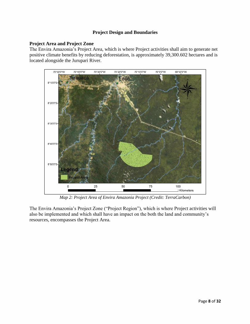
Project Area and Project Zone
The Envira Amazonia’s Project Area, which is where Project activities shall aim to generate net
positive climate benefits by reducing deforestation, is approximately 39,300.602 hectares and is
located alongside the Jurupari River.
Map 2: Project Area of Envira Amazonia Project (Credit: TerraCarbon)
The Envira Amazonia’s Project Zone (“Project Region”), which is where Project activities will
also be implemented and which shall have an impact on the both the land and community’s
resources, encompasses the Project Area.

Page 9 of 32
Map 3: Project Area and Project Zone (“Project Region”) (Credit: TerraCarbon)
Although outside the Project Zone, the Project Proponents shall also implement Project activities
throughout the remaining 200,000 hectares and especially with the Other Stakeholders on the
Envira River.
Stakeholder Identification and Analysis
The Project Proponents conducted an extensive stakeholder identification and stakeholder
engagement or involvement process. For a comprehensive list of the Envira Amazonia Project’s
stakeholders, please refer to Appendix C, Stakeholder Identification.
Stakeholders were primarily analyzed based off their influence and importance, along with their
rights, interests and relevance to the Project.6 Stakeholders were then categorized according to:
Project Proponents, Community and Primary Stakeholders; Secondary Stakeholders; and Other
Stakeholders.
Communities, Community Groups and Other Stakeholders
The following stakeholders, considered primary and secondary stakeholders, were identified and
were involved in project design to optimize climate, community and biodiversity benefits while
ensuring the Envira Amazonia Project was properly aligned with the State of Acre.
Consultations with all stakeholders, but especially these following stakeholders, shall continue
throughout the Project Lifetime:
JR Agropecuária e Empreendimentos EIRELI
6 CARE (2002), Annex XIV contains guidance on stakeholder analysis in project design:
http://www.proventionconsortium.org/themes/default/pdfs/CRA/HLSA2002_meth.pdf

Page 10 of 32
Families living within the Envira Amazonia Project Area
Carbonfund.org Foundation, Inc. and CarbonCo, LLC
Freitas Group International LLC and Carbon Securities
TerraCarbon
TECMAN LTDA
Professor Antonio Willian Flores de Melo of UFAC
Ayri Saraiva Rando
Landowners and families living around the Envira Amazonia Project
State of Acre, particularly the Climate Change Institute of Acre (IMC)
State of California, including the California Air Resources Board (ARB) and REDD
Offset Working Group (ROW), along with the Governors’ Climate and Forest Task Force
Environmental Services, Inc. (ESI), the Project Auditor
Verified Carbon Standard Association
Climate, Community and Biodiversity Alliance
It is important to note that the Project Proponents used socially and culturally appropriate
methods for stakeholder consultations and these stakeholder consultations were inclusive of
gender, inter-generations, and language. High Conservation Values were also respected, along
with local customs and values. In addition, meetings often took place at the most convenient
locations (for example, at the families’ homes instead of in Rio Branco) for stakeholders.
A brief summary of project meetings and stakeholder comments have been provided below.
Additional information on these meetings can be found in the document “Envira Amazonia
Project Meeting Notes” as found in the project database.
March 9-18, 2011 - CarbonCo, Carbon Securities and TerraCarbon traveled to Acre, Brazil to
better understand how to implement REDD+ projects in Acre, Brazil. A few key milestones
included:
CarbonCo, Carbon Securities and TerraCarbon held initial meetings with PESACRE
(Grupo de Pesquisa e Extensão em Sistemas Agroflorestais do Acre), IPAM (Instituto de
Pesquisa Ambiental da Amazônia), FUNTAC (Fundacao de Tecnologia do Estado do
Acre), and SISA (System of Incentives for Environmental Services) to gain an
understanding of the agents and drivers of deforestation in Acre state, how forest biomass
stocks vary across the state, and local REDD+ and forest conservation initiatives;
Carbon Securities and TerraCarbon met with Acre State Officials, including Monica
Julissa De Los Rios de Leal and Eufran Amaral, on Friday, March 18th.
The Purus Project’s design, which would later influence how the Envira Amazonia
Project was designed, was revised based off this initial site visit in March 2011. For
example, the Project Proponents: began to design the Project around the identified drivers
and agents of deforestation (i.e., selection of appropriate VCS methodology); chose the
source of satellite imagery (i.e., FUNTAC/Climate Change Institute); and began a close,
consultative relationship with the State of Acre.
August 9-18, 2011 - CarbonCo, Carbon Securities, and TerraCarbon visited Rio Branco. A few
key milestones included:

Page 11 of 32
TerraCarbon led a classroom forest carbon inventory training for TECMAN field crew
for the Purus Project. TECMAN would later be hired for the Envira Amazonia Project.
CarbonCo, Carbon Securities, TerraCarbon, and TECMAN met with Acre State officials,
including Monica Julissa De Los Rios de Leal and Lucio Flavio, to discuss how to best
design the forest carbon inventory to align with the State of Acre’s goals and future forest
inventory plans. The Project’s forest carbon inventory design (e.g., the size of each plot
and the plot design) was revised based off the State of Acre and TECMAN’s input;
CarbonCo, Carbon Securities, and TerraCarbon visited the Purus Project to train
TECMAN’s field crew in forest inventory practices and standard operating procedures,
which would later be used during the Envira Amazonia Project’s forest carbon inventory.
CarbonCo, Carbon Securities, and TerraCarbon met with Willian Flores to discuss the
VCS methodology, VM0007 REDD Methodology Modules, applicable to modeling
regional deforestation. Willian Flores was also used for the Envira Amazonia Project.
CarbonCo, Carbon Securities, TerraCarbon, and Willian Flores met with Acre State
officials, including Monica Julissa De Los Rios de Leal, Eufran Amaral and Lucio Flavio
on Tuesday, August 9th to discuss how to best develop the project-level baseline; how
private projects will nest with a forthcoming state-level baseline; and the type of GIS data
available from the State of Acre.
November 21, 2011 – CarbonCo spoke with Shaina Brown, Project Director at the Green
Technology Leadership Group and Tony Brunello, the REDD Offset Working (ROW) Group’s
facilitator to better understand the developments in the State of California and how they relate to
the State of Acre.
February 10, 2012 – CarbonCo spoke with Natalie Unterstell, the focal point for REDD+ at
Brazil’s Federal Ministry of Environment. Discussions were based around:
The role of Brazil’s Federal Government in the REDD+ context; Progress of the Amazon
Fund; How States, particularly Acre, might nest into the National Government; How
Brazil’s domestic cap-and-trade market is shaping up; Market mechanisms and REDD+
as potentially eligible offsets; Where to go for REDD+ information on Federal
government updates and how to inform the Government of our Project.
August 2, 2012 – CarbonCo, Carbon Securities and JR Agropecuária e Empreendimentos
EIRELI signed Tri-Party Agreement
April 5, 2013 - CarbonCo, Carbon Securities, and Ilderlei Souza Rodrigues Cordeiro (owner of
Russas Project) met again with Eufran Amaral from the Climate Change Institute to give an
update on all the Projects, including informing about moving forward with the Envira Amazonia
Project, and received updates on the work of the Climate Change Institute.
April 30, 2013 – CarbonCo held another call with Natalie Unterstell of Brazil’s Ministry of
Environment to update her that the Purus Project became the first dual VCS-CCBS validated
REDD+ Project in Acre and that the Envira Amazonia Project would undergo VCS-CCBS
validation later in 2014.

Page 12 of 32
January 31, 2014 – Brian McFarland of CarbonCo presented at the Forests as Capital
Conference hosted by the Yale School of Forestry & Environmental Studies’ Chapter of the
International Society of Tropical Foresters. Brian’s presentation gave an introduction to
CarbonCo, described CarbonCo’s Acre REDD+ Projects, and discussed REDD+ and other
conservation financing instruments.
May 7-9, 2014 – CarbonCo, Carbon Securities and TerraCarbon met JR Agropecuária e
Empreendimentos EIRELI (particularly Duarte Jose do Couto Neto, Fredis C. Vasques and Jose
Elves Araruna Sousa) to discuss the VCS Project Description and CCBS Project Design
Document. The conversations focused on identifying proxy sites and further refining the
proposed project activities.
May 8, 2014 – CarbonCo, Carbon Securities and TerraCarbon met with the Climate Change
Institute to give an update on all Acre REDD+ projects, including the Envira Amazonia Project,
and received updates on the latest developments at the Climate Change Institute. More
specifically, this meeting was with Monica Julissa De Los Rios de Leal and Magaly Medeiros,
the new director of the Climate Change Institute.
May 9, 2014 – CarbonCo, Carbon Securities, JR Agropecuária e Empreendimentos EIRELI
(particularly Fredis C. Vasques) and TerraCarbon met TECMAN for a classroom training
refresher on the Envira Amazonia Project’s forest carbon inventory and standard operating
procedures.
May 10, 2014 - CarbonCo, Carbon Securities, JR Agropecuária e Empreendimentos EIRELI
(particularly Fredis C. Vasques) and TerraCarbon met TECMAN in the field to further refine
field techniques for the Envira Amazonia Project’s forest carbon inventory and further reviewed
the standard operating procedures.
May 13, 2014 – CarbonCo and Carbon Securities met Ayri Saraiva Rando to review community
surveys and discuss logistics to visit the Envira Amazonia Project.
May 13, 2014 – CarbonCo and Carbon Securities met Fronika de Wit to introduce the Project
Proponents, gave an overview of all Acre REDD+ projects underway (particularly the Envira
Amazonia Project), and discussed how Fronika de Wit might be able to participate in the Project.
May 19, 2014 – Carbon Securities met with Rodrigo Fernandes das Neves, the State Prosecutor,
to discuss the Acre REDD+ Projects including the Envira Amazonia Project, and to get an update
on the state-level baseline.
May 20-21, 2014 – CarbonCo, Carbon Securities, and JR Agropecuária e Empreendimentos
EIRELI met Maron Greenleaf to introduce the Project Proponents, give an overview of all Acre
REDD+ projects underway (particularly the Envira Amazonia Project), and discussed Maron
Greenleaf’s anthropological research in Acre for her PhD at Stanford University.
May 20 – June 11, 2014 – Ayri Rando met with a total of 10 families in the Project Zone and 31
families along the Envira River (i.e., outside the Project Zone) to: explain what is REDD+,
Page 13 of 32
explain the landowners’ proposed activities and explain the overall Project design; discuss the
benefits of the Project and listen to the concerns of the local families and listen to the families’
anticipated results; inform the families about another visit in October or November to notify
them about the CCBS Public Comment Period and another visit in December with an
independent auditor; and to conduct research on basic necessities, agricultural needs, and
participatory rural appraisals. The Project was significantly revised based off the families’ input.
For example, the Project was revised by incorporating specific agricultural extension courses,
restructuring the Project’s implementation schedule, and targeting the needs of women.
June 24, 2014 – Brian McFarland of CarbonCo presented at Ecosystem Marketplace’s State of
the Voluntary Carbon Market and gave an overview of CarbonCo’s work in Acre, Brazil.
August 10-31, 2014: CarbonCo and Carbon Securities contacted several potential contractors to
assist the Project Proponents in 2015 with a rapid assessment of endemic and vulnerable bird
species throughout the Project Zone. This includes Brazilian biologists Guilherme Serpa, Luiz
Henrique Medeiros Borges, Fernando Pacheco, and Tomaz Nascimento de Melo.
September 3, 2014: CarbonCo and TerraCarbon held a call with the VCSA to give an update on
the Acre REDD+ Projects, including the Envira Amazonia Project, and discussed the future
developments necessary to best position the Acre REDD+ Projects for their potential inclusion in
a California compliance carbon market.
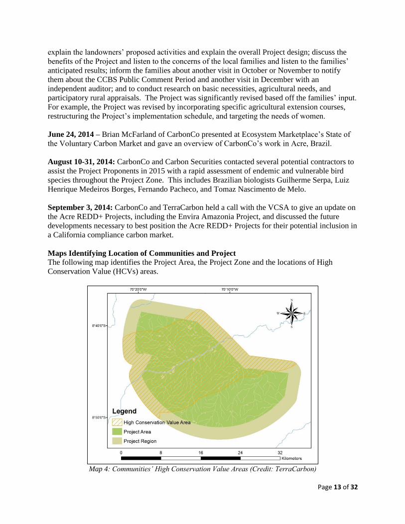
Maps Identifying Location of Communities and Project
The following map identifies the Project Area, the Project Zone and the locations of High
Conservation Value (HCVs) areas.
Map 4: Communities’ High Conservation Value Areas (Credit: TerraCarbon)

Page 14 of 32
The communities’ HCVs were mapped using a participatory approach. Essentially, a distance of
8 kilometers from the banks of the Jurupari River was determined to be the location of the HCVs
where communities primarily collect food, water, and wood.
Project Activities, Outputs, Outcomes and Impacts
The following section will briefly describe each of the project activities and will explain how the
activities shall achieve the project’s net positive climate, community and biodiversity benefits by
using the Theory of Change causal model.
As noted in the Social Impact Assessment Toolbox, “in simple terms, {the Theory of Change} is
a roadmap drawn up by the Project Proponents and stakeholders of how the project plans to get
from Point A (project strategy and activities) to Point Z (project impacts).”7 Likewise, the
Envira Amazonia Project’s overall strategies and on-the-ground activities will directly lead to
outputs, followed by outcomes, and ultimately by net positive climate, community and
biodiversity impacts.8
To clearly define activities, outputs, outcomes and impacts, the following definitions were
utilized:
“Project activities are the physical or implemented activities of the projects.
Project outputs are the tangible short-term results of project activities and normally take the form
of products or services provided during the project lifetime and as a direct result of project
funding.
Project outcomes are the direct intended results stemming from the outputs. They are short- and
medium term changes experienced by project stakeholders and/or by the physical environment,
and are less tangible and easy to measure than outputs.
Project impacts are the end results sought by the project, especially as regards net social changes.
They may occur as a direct or indirect result of project outcomes.”9
Climate Project Activities
To achieve the major climate objective of mitigating deforestation and the subsequent release of
GHG emissions, the Project Proponents undertook a forest carbon inventory, developed a
regional land-use and deforestation model, and are addressing the underlying deforestation
drivers to mitigate the release of GHGs with a plan for ongoing monitoring.
7 Richards, M. and Panfil, S.N. 2011. Social and Biodiversity Impact Assessment (SBIA) Manual for REDD+
Projects: Part 1 – Core Guidance for Project Proponents. Climate, Community & Biodiversity Alliance, Forest
Trends, Fauna & Flora International, and Rainforest Alliance. Washington, DC., Page 13. 8 The linkages between the Envira Amazonia Project’s Strategies and Activities, Outputs, Outcomes, and Impacts
were conceptualized with assistance from Brigitta Jozan, Independent Advisor 9 Sources: Based on GEF Evaluation Office and Conservation Development Centre 2009; Schreckenberg et al. 2010.

Page 15 of 32
It is also important to note an additional climate project activity is that JR Agropecuária e
Empreendimentos EIRELI has voluntarily foregone plans to convert the forests to a large-scale
cattle ranch.
Forest Carbon Inventory
The forest carbon inventory was an important project activity to undertake because it is difficult
to manage an objective that is not measured. The forest carbon inventory generated a
scientifically robust and statistically accurate representation of the carbon stocks throughout the
Project Area of the Envira Amazonia Project. Furthermore, the forest carbon inventory was
conducted by the renowned local forestry company TECMAN which is the same firm that
conducted the forest carbon inventories at the Russas, Valparaiso and Purus Projects on behalf of
CarbonCo. TECMAN’s work was overseen by both CarbonCo and the international experts at
TerraCarbon. For a more detailed discussion, please see the VCS Project Description.
Regional Land-use and Deforestation Modeling
Similar to the need for a measurement of carbon stocks, there was a need to develop a regional
land-use and deforestation model to determine a performance baseline for the Project
Proponents. Using proxy sites, satellite imagery, and through consultations with the local
communities, the Project Proponents can now predict where (i.e., location), when, and how much
deforestation is expected, along with where to assist with leakage mitigation and primarily where
to monitor. This regional land-use and deforestation modeling was conducted by TerraCarbon
and reviewed by Professor Antonio Flores from the Federal University of Acre. Professor
Antonio Flores has provided assistance to CarbonCo’s other REDD+ Projects in Acre. Again for
a more detailed discussion, please see the VCS Project Description.
Address Underlying Deforestation Drivers to Mitigate Release of GHGs
While understanding the Envira Amazonia Project’s carbon stocks and deforestation scenario,
the Project Proponents are now beginning to address the underlying deforestation drivers to
mitigate the release of GHGs. In addition to JR Agropecuária e Empreendimentos EIRELI
willingly foregoing the conversion of the Project Area’s forests to cattle pastures, the Project
Proponents will also work with local families to mitigate any unplanned deforestation.
Addressing the underlying deforestation drivers - for example, committing JR Agropecuária e
Empreendimentos EIRELI to voluntarily forego conversion of their property’ forests and
providing agricultural extension trainings to the local communities – is relevant to achieving the
climate objective of reducing net GHG reductions by: reducing the communities’ dependence on
forest resources through intensification of agricultural and livestock practices; by providing
alternative income to both the landowners and the communities; and by providing education
about the effects of deforestation and benefits of protecting forest resources.
Develop Climate Monitoring Plan and Monitor Deforestation
The Project Proponents will constantly monitor deforestation by boat along the Envira, Jurupari
and Purus Rivers as well as from the State of Acre’s satellite imagery.
Developing a climate monitoring plan and monitoring deforestation will assist the Project
Proponents with achieving the climate, community and biodiversity objectives. Thus, the
climate monitoring plan and monitoring of deforestation will result in net GHG emission

Page 16 of 32
reductions because such activities will provide an early detection of deforestation, while enabling
the Project Proponents to identify the specific drivers and agents of deforestation and to
implement the appropriate actions to mitigate such deforestation and subsequent release of GHG
emissions. By mitigating deforestation, the Project shall raise carbon finance that will be utilized
to assist local communities and to preserve the biodiversity.
Community Project Activities
To generate sustainable economic opportunities and to implement local social projects for
communities living in and around the Envira Amazonia Project, the Project Proponents have
undertaken, or began to plan for, the following project activities: Project Awareness, Meet
Community, and Discuss Project; Design Social Projects and Programs for Community;
Implement Social Projects and Programs for Community; Develop Community Monitoring Plan
and Monitor Community Impacts.
Project Awareness, Meet Community and Discuss Project
The communities are an essential component of the Envira Amazonia Project and throughout
2014, the Envira Amazonia Project was discussed in greater detail with the local families to
ensure they were fully aware of the Project, were able to contribute to the Project design, able to
openly express desired outcomes and concerns, understood the third-party grievance procedure,
and were able to voluntarily give Free, Prior and Informed Consent (FPIC).
More specifically, Ayri Saraiva Rando was hired as an independent community specialist and
visited a total of 41 families between May 20th and June 11th, 2014. Local families who wanted
to join the Envira Amazonia Project either verbally agreed to join the Project and/or signed an
“ata” between May 20th and June 11th, 2014. As of June 2014, all of the community members
interviewed within the Envira Amazonia Project Area have either signed the “ata” or verbally
agreed to join the Project.
Through meeting with the local families, the Project Proponents have been able to gain the
community’s insights about project design and to better incorporate the communities into the
Project. As a result, the community objective of generating sustainable economic opportunities
and implementing social projects and programs will be best achieved with active, on-going
participation and input from the local families.
Design and Implementation of Social Projects and Programs for Community
Social projects and programs for the local families, will not only generate sustainable economic
opportunities, but will also result in: less pressure on the local forests; a reduction in
deforestation; mitigation of greenhouse gas emissions; and the preservation of biodiversity.
Over the Project Lifetime, JR Agropecuária e Empreendimentos EIRELI would like to further
design and implement the following project activities:
Hire Project Manager
Initiate Patrols of Deforestation by Boat
Create Structure for Collection, Processing and Sales of Açaí
Create Structure for Collection, Processing and Sales of Medicinal Plants
Reestablish Rubber Tree Collection

Page 17 of 32
Offer Agriculture Extension Courses
Help Communities Obtain Land Tenure
Establish a Headquarters
Improve and Build Health Center with Dental Clinic
Hire Project Manager
Jose Aurimar Tavares Carneiro (Jose’s nickname is “Mazinho”) will be the local project
manager of the Envira Amazonia Project. Mazinho will help with monitoring for deforestation,
along with helping visitors at the Project by providing logistics. Mazinho was born on the
property and has good rapport with the local families. Mazinho currently splits his time between
staying at his house in Feijó and staying at his house along the Envira River.
In addition to Mazinho’s assistance, Francisco Circlandio (“Francisco”) will also assist with the
project as Francisco lives along with Jurupari River. Francisco is the son of Cazuza Circlandio;
Cazuza lives in Feijó and Cazuza’s house along the Jurupari River is temporarily serving as the
Envira Amazonia Project’s informal headquarters.
Hiring a local project manager helps to achieve the climate, community and biodiversity
objectives by enabling the Project Proponents to rapidly address deforestation while conserving
biodiversity and increasing economic opportunities (both via employment and via carbon finance
to implement social projects and programs).
Initiate Patrols of Deforestation
In addition to serving as local project managers, Mazinho and Francisco will both be paid to
monitor for deforestation. Mazinho was originally hired back in 2003 to informally monitor the
property. Mazinho and Francisco will now officially monitor for deforestation along the
Jurupari, Purus and Envira Rivers by boat approximately every 60 days.
JR Agropecuária e Empreendimentos EIRELI ordered a boat with 15 seats and a boat engine in
May 2014 which will be used to access the property and for deforestation monitoring. The first
formal monitoring will start in June or July 2014.
If and when deforestation is identified, JR Agropecuária e Empreendimentos EIRELI will
immediately document and transfer this information to Carbon Securities and CarbonCo.
Collectively, CarbonCo and JR Agropecuária e Empreendimentos will discuss the appropriate
actions to undertake to counteract any reported deforestation.
The monitors will write down observations in a notebook, document the community meetings,
input this data into the monitoring template, and upload the document onto a shared DropBox
account among the Project Proponents. The monitoring template includes:
Name of Monitor
Date of Monitor
Communities Visited
Meeting Notes with Community
Grievances and Concerns of Community

Page 18 of 32
Location and Date of Deforestation
Responsible Actor for Deforestation
Observations Pertaining to Deforestation
Biodiversity Observed
Other Notes Related to the Project
The monitoring of deforestation will help the Project Proponents achieve both the climate and
community objective. Thus monitoring will result in net GHG emission reductions because such
activities will provide an early detection of deforestation, while enabling the Project Proponents
to identify the specific drivers and agents of deforestation and to implement the appropriate
actions to mitigate such deforestation and the subsequent release of GHG emissions.
Create Structure for Collection, Processing and Sales of Açaí
JR Agropecuária e Empreendimentos EIRELI will develop a structure for the collection,
processing, transportation and eventual sales of açaí.
This structure will involve the creation of decentralized units throughout the Project Area, with
each unit managed by a local community member. Each unit will collect locally produced açaí
berries, the raw berries will be transported to a processing plant, the açaí berries will be
processed into açaí juice, and then the finished products will be sold to end consumers.
The collection, processing, and sales of açaí will help the Envira Amazonia Project achieve the
climate, community and biodiversity objectives. Thus by diversifying JR Agropecuária e
Empreendimentos EIRELI and the local communities’ incomes, there will be less pressure on
forest resources and shall help preserve the area’s biodiversity.
Create Structure for Collection, Processing and Sales of Medicinal Plants
JR Agropecuária e Empreendimentos EIRELI would also like to create a management and sales
structure that would enable the local communities to collect and dry medicinal plants.
Duarte Jose do Couto Neto (“Duarte”) will eventually apply to the Government for approval to
sell a specific quantity of medicinal plants. Collecting and selling medicinal plants will provide
alternative economic opportunities for both local communities and JR Agropecuária e
Empreendimentos EIRELI. For example, there is a factory called Dr. Roots in Rio Branco, that
sells medicinal roots and there is also a cosmetic factory in Tarauacá which sells to national
markets. In the past, Duarte was working with a French company about medicinal plants.
According to the local families, some of the most important medicinal plants found in the region
include:
Amburana
Andiroba
Balso
Copaiba
Espra ai
Jatoba
Mastruz

Page 19 of 32
Quina-Quina
Collecting, drying and selling medicinal plants will enable the Project Proponents to achieve the
climate, community and biodiversity objectives. By diversifying and increasing community and
JR Agropecuária e Empreendimentos EIRELI revenue, there will be less deforestation pressure
on the tropical forests while simultaneously reducing GHG emissions.
Reestablish Rubber Tree Collection
JR Agropecuária e Empreendimentos EIRELI will reestablish a rubber trees project. The region
is very rich in rubber, but the local families do not know how to sell the rubber because of the
crash in rubber prices. Although rubber prices have recovered, the local families do not have the
management and sales structure. JR Agropecuária e Empreendimentos EIRELI will also reforest
approximately 1,000 hectares of deforested land with rubber trees.
Essentially, rubber throughout the Project Area will be collected and transferred to Feijó. The
rubber will then be primarily sold to São Paulo for use in the soles of shoes.
Collecting rubber, reforesting deforested areas with rubber trees, and selling rubber will enable
the Project Proponents to achieve the climate, community and biodiversity objectives. By
diversifying and increasing community and JR Agropecuária e Empreendimentos EIRELI
revenue, there will be less deforestation pressure on the tropical forests while simultaneously
reducing GHG emissions.
Offer Agriculture Extension Courses
Based off feedback from the local families, JR Agropecuária e Empreendimentos EIRELI will
offer several agricultural extension courses. Such agricultural extension courses shall include:
Alternatives to the use of fire in land preparation
Improved pasture management, including rotational cattle pastures and vaccinations
Extraction and processing of medicinal plants for commercial purposes
Production of açaí
Raising chickens, including how to diagnose and cure diseases that appear in them
Agricultural extension trainings will assist the Project Proponents achieve both the climate and
community objectives of the Envira Amazonia Project. These activities will result in both net
GHG emission reductions by reducing the communities’ dependence on forest resources through
intensifying agriculture and livestock, while also providing the communities with alternative
incomes.
Help Communities Obtain Land Tenure
Community members that have been living on the land and who made the land productive (e.g.,
by growing agriculture or raising animals) for ten years have the right to be titled to land. JR
Agropecuária e Empreendimentos EIRELI will voluntarily recognize whatever area is currently
deforested and under productive use by each family and up to the recommended size that a
family in the municipality of Feijó needs for a sustainable livelihood according to State and
Federal laws. All communities, whether they join the Envira Amazonia Project or not, will be
titled the land they have put under productive use.

Page 20 of 32
Helping families obtain land tenure will assist the Project Proponents with facilitating the
community’ sustainable economic opportunities. This formal recognition of the community’s
land tenure and the ability of families to access credit (i.e., due to their property collateral) will
reduce GHG emissions as families will have greater responsibility and ownership over their land.
Establish a Headquarters
In the past, JR Agropecuária e Empreendimentos EIRELI had a headquarters established along
the Envira River and the headquarters was called the “Casarao Antigo do Seringal Canada.” In
the future, this headquarters will be reactivated and an official headquarters will be established
inside the Project Area along the Jurupari River. In the short term, Cazuza’s house will be
temporarily used as the informal headquarters of the Envira Amazonia Project.
The future headquarters will provide: a place for visitors to sleep and eat; a place for community
meetings and teaching courses; provide storage for project items; and supply education materials
such as the onsite Project Documents.
Building a headquarters contributes to the community objective because the office will serve as a
centralized headquarters and will facilitate JR Agropecuária e Empreendimentos EIRELI’s social
projects and programs.
Improve and Build Health Center and Dental Clinic
JR Agropecuária e Empreendimentos EIRELI plans to improve the health center along the
Envira River and to build a health center in the Project Area along the Jurupari River. These
health centers will provide local families with preventive and curative medicine, including
dental. JR Agropecuária e Empreendimentos EIRELI will also facilitate the increased frequency
of visits from the doctor in Feijó via the boat being purchased. JR Agropecuária e
Empreendimentos EIRELI would like to donate dental hygiene kits with toothbrush and
toothpaste and would also like to distribute medicine including malaria pills.
The health center and dental clinic is also relevant to the community objective because this is
another main social project that JR Agropecuária e Empreendimentos EIRELI would like to
facilitate. The health centers will ultimately improve life quality and increase life expectancies,
which will result in healthier, more productive community members.
Develop Community Monitoring Plan and Monitor Community Impacts
The community monitoring plan will essentially help the Project Proponents better understand if
the social projects and programs for the community were able to generate sustainable economic
opportunities and overall positive outputs, outcomes and impacts. The community monitoring
plans include the Basic Necessity Survey (BNS) and the Participatory Rural Assessment /
Household Survey (PRA). Developing a community monitoring plan and ongoing monitoring of
community impacts will assist the Project Proponents with achieving the community objective.
Major Biodiversity Objective
To preserve the Project’s rich biodiversity, the Project Proponents will generate sustainable
economic opportunities for the local community and implement local social projects with the
goal of addressing the underlying causes of deforestation and reducing the release of GHGs. In

Page 21 of 32
addition, the Project Proponents will rapidly assess biodiversity on the Project and develop a
biodiversity monitoring plan.
Rapidly Assess Biodiversity on Project
A rapid assessment of the Project Zone’s biodiversity was conducted from March to August
2014. This included background research on the region’s biodiversity and a review of the
Integrated Biodiversity Assessment Tool (IBAT), along with an assessment of vulnerable tree
species and endemic bird species throughout the Project Area.
This rapid assessment of biodiversity will contribute to the objective of preserving the Project’s
rich biodiversity by providing an understanding of what flora and fauna exist within the Project.
Furthermore, in addition to helping local communities and reducing tropical deforestation, many
voluntary carbon market donors appreciate seeing pictures of rare and threatened species.
A rapid biodiversity assessment will help achieve the climate, community and biodiversity
objectives by providing an alternative economic opportunity for a couple local community
members to assist with the future biodiversity monitoring plan. In addition, the generation of
carbon finance from the reduction of deforestation will be enhanced through the understanding
and preservation of the Project’s biodiversity.
Develop Biodiversity Monitoring Plan and Monitor Biodiversity Impacts
The biodiversity monitoring plan will essentially help the Project Proponents better understand if
the climate and community objectives are aligned with preserving the Project’s rich biodiversity.
Designing and implementing the Project’s biodiversity monitoring plan will help achieve the
climate, community and biodiversity objectives by providing an alternative economic
opportunity for a couple local community members to assist with the biodiversity monitoring
plan. In addition, the generation of carbon finance from the reduction of deforestation will be
enhanced through monitoring and preserving the Project’s biodiversity.
Project Start Date, Lifetime, and GHG Accounting Period
The following shall outline the Envira Amazonia Project’s key dates, implementation schedule
and milestones.
Project Start Date, Lifetime, and GHG Accounting Period
The Envira Amazonia Project’s Start Date is August 2, 2012 based off the signing date of the
Tri-Party Agreement between the three Project Proponents. The Project Lifetime is 60 years.
The Project’s GHG Accounting Period is 10 years. The biodiversity and community benefits
assessment period shall be done on an annual or biennial basis, while the Basic Necessity Survey
(BNS) and Participatory Rural Assessment (PRA) shall be conducted every 4 years.
Implementation Schedule
The approximate implementation schedule for the Envira Amazonia Project is as follows:

Page 22 of 32
Pre- and Post-Validation: Years 1 and 2 (2014-2015)
Signing and Authentication of Tri-Party Agreement between Project Proponents
Stakeholder Consultations and Community Visits
Forest Carbon Inventory
Land-use and Deforestation Modeling
Project Design Documents Written
Hire Project Manager
Initiate Patrols of Deforestation
Biodiversity and Community Impact Monitoring Plans Developed
Project Validated to CCBS and VCS Standards
Carbon Finance Generated, Pending Verification to the CCBS and VCS Standards
Establish Initial Headquarters
Post-Validation: Years 3 to 5 (2016-2018)
Renovate Headquarters and Create New Headquarters
Help Communities Obtain Land Tenure
Create Structure for Açaí, Medicinal Plants, and Rubber Trees
Offer Agricultural Extension Courses
Improve Health Center and Dental Clinic
Post-Validation: Years 6 to 10 (2019-2023)
Reassessment of Land-use and Deforestation Modeling Baseline
Ongoing Activities
Monitoring of Climate, Community and Biodiversity Impacts
o Basic Necessities Survey to take place every 4 years
o Participatory Rural Appraisal to take place every 4 years
o Illegal Logging Assessment to take place every 4 years
o Deforestation Monitoring, Periodic Review of Satellite Imagery
o Biodiversity Monitoring every 5 years
Engaging Stakeholders and Community Consultations
GL1. Climate Change Adaptation Benefits The Envira Amazonia Project shall incorporate climate change adaptation benefits.
Likely Regional Climate Change, Climate Variability Scenarios, and Impacts
The Project Proponents studied the CREAS Project (Regional Climate Change Scenarios for
South America in English) to better understand the regional climate change and climate
variability scenarios for Acre, Brazil.
As forecasted by the CREAS Project, “intense rainfall events in western Amazonia, losses in
natural ecosystems, rain forest and biodiversity” are the primary risks, along with the potential

Page 23 of 32
for “low river levels affecting transportation and commerce” and “more favorable conditions for
spread of forest fires.” 10
These intense rainfall events in western Amazonia, in conjunction with the absence of the
Project, would likely increase the rate of top soil erosion and more quickly deplete soil nutrients
which in turn would likely increase the conversion of primary forests to agriculture and pasture
lands by the local community.
Significant flooding throughout the Project Zone would likely result from the Project’s
deforestation, along with the increase in both localized rainfall as well as increased rainfall and
continuing deforestation in neighboring Peru. Such flooding could impact local land-use
scenarios due to: local crops destroyed which leads to communities planting more hectares to
maintain historic harvest levels; fishing grounds could be disrupted due to faster moving currents
and oxbow lakes could be altered; increased mosquito-borne illnesses due to greater pools of
water; and game could move further into the forests to escape raising water levels.
Climate Changes’ Impact on Communities and/or Biodiversity
The State of Acre and neighboring state of Rondônia are already experiencing increased rainfalls
and severe flooding. In March and April 2014, the flooding of the Madeira River led Acre to
declare a state of emergency due to the trade of vital resources (e.g., food, health supplies, fuel,
etc.) being disrupted.11 If State and Federal governmental scarce resources are used to repair
roads, bridges, and other infrastructure due to climate change and its impacts, then there will be
fewer resources available to help riverine communities.
The families throughout the Project Zone and along the Envira River are already feeling the local
impact of global climate change. The following are ten excerpts from the conversations Ayri
Rando had with community members:
1. “The temperature is higher, causing farmers to be unable to work more because they are
directly exposed to the sun.” (João Nazário Rodrigues)
2. “Previously, the Amazon winter ended in May, but lately you never know when it ends, it will
be in May, June, or even in July. Another change perceived is that the weather is warmer.”
(Antônio Francisco Lopes da Silva)
3. “The sun is getting stronger and deforestation is one of the causes.” Manoel Pereira do
Nascimento)
4. Before I “could work all day and be exposed to direct sun, but now I cannot due to the fact the
sun is stronger. Moreover, at the time of the Amazonian summer it is difficult to travel by river
because of smoke from forest fires.” (Francisco Chagas Silva de Araújo)
10 Jose A. Marengo, “Regional Climate Change Scenarios for South America - The CREAS,” Available:
projecthttp://unstats.un.org/unsd/climate_change/docs/papers/Session3_CCPapers_Marengo_1.pdf. 11 Travel and Tour World, “Brazil state Acre declared a state of flood calamity,” Available:
http://www.travelandtourworld.com/news/article/brazil-state-acre-declared-a-state-of-flood-calamity/

Page 24 of 32
5. I “notice a lot of smoke at the time of the Amazonian summer, which makes breathing
difficult.” (Joaquim de Oliveira da Silva)
6. “The temperature is getting higher, before it was not so hot.” (Antônio Geovan de Sousa
Rodrigues)
7. “The temperature {has} increased, it seems that the "haze" is greater.” (José Bento de Paula)
8. “The temperature is getting warmer and the river is shallower with each passing year.
Furthermore, {the} Envira River fills and empties very quickly.” (Espedito da Silva Menezes)
9. “The sun is warmer due to forest destruction.” (Jeandro Castro de Araújo)
10. “Time has changed a lot, the temperature is higher and suddenly it rains and {then} it's cold,
it’s changing very fast.” (Manoel Joaquim Gomes da Silva)
Adaptation Measures to Assist Communities and/or Biodiversity
The Project Proponents will incorporate climate change adaptation activities and the Theory of
Change causal models demonstrate how the project activities intend on achieving the Project’s
predicted climate change adaptation benefits.
These climate change adaptation benefits include, but are not limited to: building the community
health center to mitigate potential increases in mosquito-borne illnesses; ensuring agricultural
extension courses incorporate climate change adaptation techniques; assisting local families with
access to markets for their products to overcome increased difficulty in transportation networks;
and locating facilities such as the headquarters and health centers further away from river banks
to minimize risk of flooding.
Thus, localized flooding and increased rainfall will likely increase the difficulty of road
transportation along highways in western Amazonia, including BR-364, which will likely
increase the loss of agricultural products due to spoilage and result in less money for local
families. In addition, the resulting lower river levels will increase the difficulty transportation
along rivers such as the Envira and Jurupari Rivers.
Indicators for Adaptation Benefits to Communities
CarbonCo, and its parent company Carbonfund.org, are both climate change organizations and
will continuously monitor the latest developments in climate change science and climate change
impacts.
The Project Proponents will incorporate adaptation activities into the Envira Amazonia Project
and have incorporated the following indicators to demonstrate the Project activities are assisting
local families to adapt to the probable impacts of climate change:
Mitigate Increase in Mosquito-Borne Illnesses
The Project Proponents shall monitor the following indicators to assess whether the Project is
effectively mitigating an increase in mosquito-borne illnesses:

Page 25 of 32
Number of Health Centers Established
Number of Mosquito Nets Distributed
Number of Local Communities Attending Health Center
Trend of Mosquito-Borne Illnesses in Project Zone
Climate Change Adaptation Incorporated into Agricultural Extension Courses
The Project Proponents shall monitor the following indicators to assess whether the Project
effectively incorporated climate change adaptation into the agricultural extension courses and
whether the lessons are being practiced by the local communities:
Number of Families Surveyed About Desired Agricultural Extension Courses
Number of Agricultural Extension Courses Taught
Number of Agricultural Extensions Courses Taught Which Incorporated Climate Change
Adaptation Measures
Number of Lessons Learned (Related to Climate Change Adaptation) and Incorporated
by Local Families in Project Zone
Improving with Transportation Networks
The Project Proponents shall monitor the following indicators to assess whether the Project is
effectively improving transportation networks that would otherwise be hindered by climate
change:
Number of Boats Purchased by JR Agropecuária e Empreendimentos EIRELI to Assist
with Transportation of Community Goods (e.g., Açaí, Rubber, and Medicinal Plants)
Number of Shipments Via JR Agropecuária e Empreendimentos EIRELI’s Road
Transportation Network
Number of Shipments Disrupted Due to Impact of Increased Flooding, Heavy Rainfalls,
and Lower River Levels
Establishing Facilities Far from River Banks
The Project Proponents shall monitor the following indicators to assess whether the Project is
effectively establishing facilities far from river banks:
Number of Facilities Built Along Envira River
Number of Facilities Built Along Jurupari River
Number of Flooding Events and Heavy Rainfall Damaging Health Centers
Number of Flooding Events and Heavy Rainfall Damaging Headquarters
GL2. Exceptional Community Benefits The Envira Amazonia Project shall target both short-term and long-term benefits to globally poor
communities located throughout the Project Zone. Such benefits will be shared equitably,
including amongst the more marginalized or vulnerable households, and local governance
structures will be developed to maximize the benefits.

Page 26 of 32
Demonstrate Project Zone’s Communities Below National Poverty Line
According to the United Nations Development Programme’s International Human Development
Index (HDI), Brazil is considered a high human development country.12 However, it can be
demonstrated that at least 50% of the population in the Project Zone are below the national
poverty line. According to a World Bank study13, the national poverty line per capita per month
in Brazil is 180.14 (2005 PPP$) while the “nominal value of the median monthly income per
capita of rural, permanent households” in the municipality of Feijó is R$28.00.14
Demonstrate Short- and Long-Term Net Positive Community Benefits
The Envira Amazonia Project has both short-term and long-term net positive benefits for local
families throughout the Project Zone. Short-term activities which shall be implemented shortly
after the Project achieves validation and verification include offering agricultural extension
courses and creating the structure for açaí, medicinal plants, and rubber trees. Activities that will
have long-term net positive benefits for local communities including helping the communities
obtain official land title and to establish a local health center.
Indicators of the well-being impacts from these short-term and long-term activities have been
incorporated into the community impact monitoring plan’s Basic Necessity Survey and
Participatory Rural Assessment.
Identify Risks for Community Members Participation
The most common risk that the families shared with Ayri Rando is their concern about losing
their traditional livelihoods, which involves slash-and-burn agriculture, if they participate in the
Project. In addition, the local families are concerned about potentially being removed since they
do not have title to the land. In contrast, the Project shall grant official land title to the families
to strengthen their land tenure and negate any concerns they have about potentially being
removed. In addition, the Project shall offer agricultural extension training courses that will
demonstrate alternatives to traditional slash-and-burn agriculture.
Identify Marginalized and/or Vulnerable Community Groups
All of the communities in the Project Zone are relatively marginalized and vulnerable due to
having limited health care services, being located relatively far from Feijó, and by not having
official land title. Currently, data from the Participatory Rural Assessment – particularly with
respect to the number of cattle owned by each family – will serve as an approximation for which
families are considered the most marginalized. In the future, the Basic Necessity Survey will be
used to identify the most marginalized families and to monitor whether such families are
receiving net positive impacts. Ultimately, the Project is designed and shall be implemented to
generate net positive impacts for all families living throughout the Project Zone.
12 UNDP, “Table 1: Human Development Index and its components,” Available: https://data.undp.org/dataset/Table-
1-Human-Development-Index-and-its-components/wxub-qc5k 13 Martin Ravallion et al., “Dollar a Day Revisited,” Available: http://www-wds.worldbank.org/servlet/
WDSContentServer/WDSP/IB/2008/09/02/000158349_20080902095754/Rendered/PDF/wps4620.pdf 14 IBGE, “Acre: Feijó,” Available:
http://cidades.ibge.gov.br/xtras/temas.php?lang=&codmun=120030&idtema=16&search=acre|feijo|sintese-das-
informacoes-

Page 27 of 32
Demonstrate Project Generates Net Positive Impacts for Women
As part of the community engagement, Ayri Rando interviewed women and allowed all
community members – including women – to share their insights.
The PRA asked what activities are most important to women and what can be done to increase
the participation of women. Two valuable insights were shared and which will be incorporated
into the Project to help ensure the Project generates net positive impacts for women. The first
insight is that the Project should allow children to attend any courses (assuming children are out
of school) in order to allow women to participate in the courses. The second, related insight is
that the Project should offer to compensate a few women to look after the community’s children
in order to allow women to participate more fully in the courses.
In the future, the PRAs shall inquire about the specific impacts the Project has had on women.
Describe Design and Implementation of Benefit Sharing Mechanism
The Project Proponents, based off their experience in Acre and based off the other REDD+
projects implemented by CarbonCo and Carbon Securities, designed an initial list of activities
aimed at sharing benefits with the local community. CarbonCo then hired Ayri Rando to visit
the communities to explain, among other things, the proposed list of activities and to solicit their
feedback. This process was participatory and resulted in additional activities being incorporated
into the Project and a restructuring of the implementation schedule.
Explain Communication of Benefits, Costs and Risks
Ayri Rando personally visited families throughout the Project Zone to communicate the Project’s
proposed benefits and the potential costs and risks of participation. The community also shared
what benefits they would like to receive and shared their concerns of participating in the Project
(i.e., losing traditional livelihoods or being forced to move). The Project Proponents received the
community’s feedback through Ayri Rando.
The complete project documents, including the Summary Document, will also be made available
to the local community which shall further communicate the Project’s benefits, costs and risks.
In addition, the Project Proponents – or their representatives - will regularly visit the Project and
Duarte intends on recording radio messages containing Project updates for the community.
Describe Project’s Governance and Implementation Structures
During Ayri Rando’s visit, the families were asked if there was a history of collective decision-
making and there is no such tradition of community-wide decisions or community elders making
decisions on behalf of the community.
The Project shall be collectively governed by JR Agropecuária e Empreendimentos EIRELI,
Carbon Securities and CarbonCo. JR Agropecuária e Empreendimentos EIRELI is responsible
for the implementation of the local social projects and programs. To decentralize decision-
making and to empower the local communities, JR Agropecuária e Empreendimentos EIRELI
will establish sub-divisions for the açaí, rubber and medicinal plant projects throughout the
Project Zone.

Page 28 of 32
Demonstrate Project is Developing Local Capacity
The Participatory Rural Assessment asked the local communities whether there were any local
organizations or institutions. The only local institution, which does not visit the Project Zone on
a regular occasion, is STR-Feijó. The Project Proponents shall engage STR-Feijó to inform
about the Envira Amazonia Project and explore whether there are opportunities for collaboration.
In addition to the engaging STR-Feijó, the Project Proponents will directly engage the local
community to develop local capacity in the design, implementation and ongoing management of
the Project. Such local capacity includes, but is not limited to: the participatory process of
designing the Project; developing the structure to collect, process, transport and sell açaí, rubber
and medicinal plants; and learning new techniques via the agricultural extension courses.
It is also important to note the Project will work to build this local capacity with all families,
including women and marginalized families.
GL3. Exceptional Biodiversity Benefits The Envira Amazonia Project is seeking to conserve a globally significant site of biodiversity on
the basis of the Key Biodiversity Area (KBA) framework of vulnerability.
Demonstrate Project Zone’s High Biodiversity Conservation Priority
The Envira Amazonia Project is a site of high biodiversity conservation priority due to the KBA
framework of vulnerability. The two main trigger species are Rinorea longistipulata (known as
Canela de Velho in Portuguese) and Cedrela odorata (known as Spanish Cedar, Cigar-box
Wood, and Red Cedar in English or Cedro rosa in Portuguese).
Furthermore according to the Integrated Biodiversity Assessment Tool (IBAT), the region where
the Envira Amazonia Project is located has also been identified as a KBA due to the endemic and
IUCN Red List bird species.
Describe Recent Population Trends of Each Trigger Species
The following analysis will focus on the nine trigger species which are endemic to the
Southwestern Amazon, along with the four trigger species considered vulnerable or endangered
by the International Union for the Conservation of Nature (IUCN).
Grey Wren
According to research compiled by the IUCN, the population trend of the Grey Wren
(Thryothorus griseus) is decreasing. Furthermore, the IUCN states the Grey Wren:
Has a very large range, and hence does not approach the thresholds for Vulnerable under the range
size criterion (Extent of Occurrence <20,000 km2 combined with a declining or fluctuating range
size, habitat extent/quality, or population size and a small number of locations or severe
fragmentation). Despite the fact that the population trend appears to be decreasing, the decline is
not believed to be sufficiently rapid to approach the thresholds for Vulnerable under the
population trend criterion (>30% decline over ten years or three generations). The population size
has not been quantified, but it is not believed to approach the thresholds for Vulnerable under the
population size criterion (<10,000 mature individuals with a continuing decline estimated to be

Page 29 of 32
>10% in ten years or three generations, or with a specified population structure). For these reasons
the species is evaluated as Least Concern.15
Although the Grey Wren has a large range, the Grey Wren’s population within the Project Zone
would likely further decrease in the without-Project land-use scenario.
White-bellied Parrot
According to research compiled by the IUCN, the White-bellied Parrot is considered Endangered
and the population trend of the White-bellied Parrot (Pionites leucogaster) is decreasing. The
IUCN states that “based on a model of deforestation in the Amazon basin, and the potential
susceptibility of this newly split species to hunting, it is suspected that its population will decline
very rapidly over three generations from 2002, and it is therefore listed as Endangered.”16 If the
Project Zone were to be clear-cut for cattle ranches, it is likely the population of the White-
bellied Parrot would further decrease.
Blue-headed Macaw
According to research compiled by the IUCN, the Blue-headed Macaw (Primolius couloni) is
considered Vulnerable and the Blue-headed Macaws’ population is decreasing. Furthermore, the
population is “estimated at 9,200-46,000 mature individuals (roughly equivalent to 10,000-
70,000 total individuals), based on conservative estimates of range size and density. (…) This
species is listed as Vulnerable because it has a small population which is declining owing to
exploitation for the cagebird trade and deforestation.”17 The population of the Blue-headed
Macaw would likely decrease in the without-Project land-use scenario.
Fine-barred Piculet
According to research compiled by the IUCN, the Fine-barred Piculet (Picumnus subtilis) is
considered stable. The IUCN explains that this is because:
Although this species may have a restricted range, it is not believed to approach the thresholds for
Vulnerable under the range size criterion (Extent of Occurrence <20,000 km2 combined with a
declining or fluctuating range size, habitat extent/quality, or population size and a small number of
locations or severe fragmentation). Despite the fact that the population trend appears to be
decreasing, the decline is not believed to be sufficiently rapid to approach the thresholds for
Vulnerable under the population trend criterion (>30% decline over ten years or three
generations). The population size has not been quantified, but it is not believed to approach the
thresholds for Vulnerable under the population size criterion (<10,000 mature individuals with a
continuing decline estimated to be >10% in ten years or three generations, or with a specified
population structure). For these reasons the species is evaluated as Least Concern.18
The Fine-barred Piculet, due to its restricted range, would possibly decrease in population from
the without-Project land-use scenario.
15 IUCN, “Thryothorus griseus,” Available: http://www.iucnredlist.org/details/22711479/0 16 IUCN, “Pionites leucogaster,” Available: http://www.iucnredlist.org/details/62181308/0 17 IUCN, “Primolius couloni,” Available: http://www.iucnredlist.org/details/22685593/0 18 IUCN, “Picumnus subtilis,” Available: http://www.iucnredlist.org/details/22680771/0

Page 30 of 32
White-lined Antbird
According to research compiled by the IUCN, the White-lined Antbird (Percnostola lophotes)
population is decreasing. The IUCN reasons that “based on a model of future deforestation in
the Amazon basin, and its particular susceptibility to forest fragmentation, it is suspected that the
population of this species will decline by 25-30% over the next three generations, and it has
therefore been uplisted to Near Threatened.”19 The without-Project land-use scenario, which
would result in deforestation and forest fragmentation, would likely further decrease the
population of the White-lined Antbird.
Amazonia Parrotlet
According to research compiled by the IUCN, the population trend of the Amazonia Parrotlet
(Nannopsittaca dachilleae) is decreasing. The IUCN states that:
This species is currently classified as Near Threatened as it is thought to have a moderately small,
declining population of which the majority of individuals are in one subpopulation. If the
population is found to be considerably larger than previously thought it may be downlisted to
Least Concern. (…) The species’ population is suspected to number c.10,000 individuals,
equivalent to c.6,700 mature individuals. This figure is applied here as a preliminary estimate;
however, there are no data available and further research is needed.20
The without-Project land-use scenario would likely further decrease the population of the
Amazonia Parrotlet.
Long-crested Pygmy-tyrant
According to research compiled by the IUCN, the Long-crested Pygmy-tyrant (Lophotriccus
eulophotes) population is decreasing. In addition, the IUCN states that:
This species has a very large range, and hence does not approach the thresholds for Vulnerable
under the range size criterion (Extent of Occurrence <20,000 km2 combined with a declining or
fluctuating range size, habitat extent/quality, or population size and a small number of locations or
severe fragmentation). Despite the fact that the population trend appears to be decreasing, the
decline is not believed to be sufficiently rapid to approach the thresholds for Vulnerable under the
population trend criterion (>30% decline over ten years or three generations). The population size
has not been quantified, but it is not believed to approach the thresholds for Vulnerable under the
population size criterion (<10,000 mature individuals with a continuing decline estimated to be
>10% in ten years or three generations, or with a specified population structure). For these reasons
the species is evaluated as Least Concern.21
Although the Long-crested Pygmy-tyrant has a large range, the Long-crested Pygmy-tyrant’s
population within the Project Zone would likely further decrease in the without project land-use
scenario.
19 IUCN, “Percnostola lophotes,” Available: http://www.iucnredlist.org/details/22701776/0 20 IUCN, “Nannopsittaca dachilleae,” Available: http://www.iucnredlist.org/details/22686000/0 21 IUCN, “Lophotriccus eulophotes,” Available: http://www.iucnredlist.org/details/22699564/0

Page 31 of 32
Goeldi's Antbird, Scarlet-hooded Barbet, and Black-faced Cotinga
According to research compiled by the IUCN, the populations of the Goeldi's Antbird
(Myrmeciza goeldii)22, the Scarlet-hooded Barbet (Eubucco tucinkae)23, and the Black-faced
Cotinga (Conioptilon mcilhennyi)24 are all stable. Each of the species:
Has a very large range, and hence does not approach the thresholds for Vulnerable under the range
size criterion (Extent of Occurrence <20,000 km2 combined with a declining or fluctuating range
size, habitat extent/quality, or population size and a small number of locations or severe
fragmentation). Despite the fact that the population trend appears to be decreasing, the decline is
not believed to be sufficiently rapid to approach the thresholds for Vulnerable under the
population trend criterion (>30% decline over ten years or three generations). The population size
has not been quantified, but it is not believed to approach the thresholds for Vulnerable under the
population size criterion (<10,000 mature individuals with a continuing decline estimated to be
>10% in ten years or three generations, or with a specified population structure). For these reasons
the species is evaluated as Least Concern.
Although the species each have a large range and staple population, the populations within the
Project Zone would likely decrease in the without-Project land-use scenario.
Rufous-fronted Antthrush
According to research compiled by the IUCN, the Rufous-fronted Antthrush (Formicarius
rufifrons) population is decreasing. In addition, “this species is considered Near Threatened as it
is known from only a small range, and is apparently rare and patchily distributed. However, the
range is not yet severely fragmented or restricted to few locations (Collar et al. 1992). For these
reasons, the species is classified as Near Threatened.”25 The without-Project land-use scenario,
would further fragment the Rufous-fronted Antthrush’s range, and thus likely lead to a decrease
in the population.
Canela de Velho
There is no population information on the Canela de Velho (Rinorea longistipulata) via the
IUCN Red List,26 the Encyclopedia of Life,27 or the Global Biodiversity Information Facility.28
However, the species is considered Vulnerable and the without-Project land-use scenario, which
would be the creation of a large cattle-ranch, would likely result in a decrease in population.
Red Cedar
According to research compiled by the IUCN, the Red Cedar (Cedrela odorata) is listed as
Vulnerable and appears to be decreasing in population:
Exploitation has continued on a large scale over the past 200 years and the species is now widely
threatened at the provenance level. Trees are often cut opportunistically while other species, such
22 IUCN, “Myrmeciza goeldii,” Available: http://www.iucnredlist.org/details/22701838/0 23 IUCN, “Eubucco tucinkae,” Available: http://www.iucnredlist.org/details/22681942/0 24 IUCN, “Conioptilon mcilhennyi,” Available: http://www.iucnredlist.org/details/22700913/0 25 IUCN, “Formicarius rufifrons,” Available: http://www.iucnredlist.org/details/22703203/0 26 IUCN, “Rinorea longistipulata,” Available: http://www.iucnredlist.org/details/35985/0 27 Encyclopedia of Life, “Rinorea longistipulata,” Available: http://eol.org/pages/5748360/overview 28 Global Biodiversity Information Facility, “Species: Rinorea longistipulata W.H.A.Hekking, Available:
http://data.gbif.org/species/4074938/

Page 32 of 32
as mahogany, Amburana and Machaerium, are being sought-after. Natural regeneration is
generally good, but there are reports of trees being felled before they reach maturity.29
The without-Project land-use scenario would result in the Red Cedar being logged for
commercial purposes and thus, the population of Red Cedar would surely decrease in the Project
Area.
Describe Measures to Maintain or Enhance Population of Trigger Species
The essential measure needed and taken at the Envira Amazonia Project is forest conservation,
which shall both maintain and enhance the population status of the aforementioned trigger
species. This includes JR Agropecuária e Empreendimentos EIRELI foregoing the creation of a
large cattle ranch, along with several social projects and programs (e.g., hiring local staff,
medicinal plant and rubber tree projects, agricultural extension courses, etc.) aimed at improving
the socio-economic status of local families. Furthermore, the Project has climate, community
and biodiversity impact monitoring plans in place to ensure the activities are leading to the
desired impacts.
The greatest threat to the trigger species – both threatened tree species and endemic bird species -
is deforestation. For birds, deforestation leads to a decrease in overall habitat availability,
fragmented habitats, less food availability, greater chance of predation and hunting, and fewer
potential mates. For trees – particularly Red Cedar – deforestation leads to easier access to the
trees for commercial harvesting and degraded landscapes threaten the survival of trees species
due to a reduced source of seeds and greater exposure to the elements (e.g., more direct sunlight,
drying of soil, etc.).
For example, the IUCN states deforestation as the greatest threat to the white-bellied parrot:
The primary threat to this species is accelerating rates of deforestation in the Amazon basin
(Soares-Filho et al. 2006, Bird et al. 2011). Proposed changes to the Brazilian Forest Code reduce
the percentage of land a private landowner is legally required to maintain as forest (including,
critically, a reduction in the width of forest buffers alongside perennial steams) and include an
amnesty for landowners who deforested before July 2008 (who would subsequently be absolved of
the need to reforest illegally cleared land) (Bird et al. 2011). Despite being common in undisturbed
landscapes, this species is not thought to be tolerant of secondary forest or agropastoral land and
appears restricted to alluvial habitats. It may also be susceptible to hunting (A. Lees in litt.
2011).30
Indications of Trigger Species’ Population Trend
The Project Proponents will monitor the number of individuals identified for threatened tree
species, along with the number of individuals identified for endemic and threatened bird species.
In addition, the greatest threat to these tree species and bird species is deforestation, which will
be regularly monitored via satellite imagery and via forest patrols to help maintain or enhance
their population status.
29 IUCN, “Cedrela odorata,” Available: http://www.iucnredlist.org/details/32292/0 30 IUCN, “Pionites leucogaster,” Available: http://www.iucnredlist.org/details/62181308/0