Embed Size (px)
Citation preview
MODULE - 4 Pressure and Winds
192
Notes
The domain of Air onthe Earth
GEOGRAPHY
We do not ordinarily think of air as having too much weight. But air hasweight and it exerts pressure. Let us take an empty bicycle tube and weightit. Now fill tube with air and weight it again. You will find that the weight ofthe air filled tube is more than when it was empty. If you go on filling air inthe tube a situation comes when the tube bursts. The bursting of the tubeoccurs due to increase in air pressure in the tube. Similarly, the air around usexerts pressure. But we do not feel the weight of the atmosphere because wehave air inside us which exerts an equal outward pressure that balances theinward pressure of the atmosphere. Atmospheric pressure is important to usbecause it is related to winds and it helps to determined, weather conditionsof a place. In this lesson you will study air pressure, its distribution, windsand their types.
OBJECTIVES
After studying this lesson, you will be able to :
give reasons for the decrease of air pressure with increase in altitude;
describe with examples the effect of low air pressure at high altitude onthe daily life of man;
explain the relationship between the spacing of isobar and pressuregradient;
establish relationship between the temperature and the existence ofequatorial low pressure and the polar high pressure;
give reason for the existence of sub-tropical high pressure and sub-polar low pressure belts;
explain the distribution of atmospheric pressure with the help of isobarmaps of the world for the months of January and July;
11
PRESSURE AND WINDS

MODULE - 4
193
Pressure and WindsThe domain of Air onthe Earth
Notes
GEOGRAPHY
establish the relationship between pressure gradient and speed of winds
explain the influence of coriollis effect on the direction of winds ofboth the hemispheres;
draw diagram showing pressure belts and planetary winds;
distinguish between (a) planetary and monsoon winds (b) land and seabreezes (c) valley and mountain breezes and (d) cyclones and anti-cyclones:
describe the characteristics of Important local winds
11.1 MEASUREMENT OF AIR PRESSURE
The atmosphere is held on the earth by the gravitational pull of the earth. Acolumn of air exerts weight in terms of pressure on the surface of the earth.The weight of the column of air at a given place and time is called air pressureor atmospheric pressure. Atmospheric pressure is measured by an instrumentcalled barometer. Now a days Fortin’s barometer and Aneroid barometer Iare commonly used for measuring air pressure.
Atmospheric pressure is measured as force per unit area. The unit used formeasuring pressure is called millibar. Its abbreviation is ‘mb’. One millibaris equal to the force of one gram per square centimetre approximately. Apressure of 1000 millibars is equal to the weight of 1.053 kilograms persquare centimetre at sea level. It is equal to the weight of a column of mercurywhich is 76 centimetre high. The international standard pressure unit is the“pascal”, a force of one Newton per square meter. In practice atmosphericpressure is expressed in kilopascals, (one kpa equals 1000 Pa).
The weight of a column of air at a given place and time is called airpressure.
Barometer is the instrument which measures air or atmosphericpressure.
The unit of measurement of atmospheric pressure is millibar(kilopascals).
One millibar is equal to the force of nearly one gram per squarecentimetre.
The mean atmospheric pressure at sea level is 1013.25 millibars. Howeverthe actual pressure at a given place and at a given time fluctuates and itgenerally ranges between 950 and 1050 millibars
11.2 DISTRIBUTION OF AIR PRESSURE
Distribution of atmospheric pressure on the surface of the earth is not uniform.It varies both vertically and horizontally.

MODULE - 4 Pressure and Winds
194
Notes
The domain of Air onthe Earth
GEOGRAPHY
(a) Vertical DistributionAir is a mixture of various gases. It is highly compressible. As it compresses,its density increases. The higher the density of air, the greater is the air pressureand vice versa. The mass of air above in the column of air compresses the airunder it hence its lower layers are more dense than the upper layers; As aresult, the lower layers of the atmosphere have higher density, hence, exertmore pressure. Conversely, the higher layers are less compressed and, hence,they have low density and low pressure. The columnar distribution ofatmospheric pressure is known as vertical distribution of pressure. Air pressuredecreases with increase in altitude but it does not always decrease at thesame rate. Dense components of atmosphere are found in its lowest partsnear the mean sea level. Temperature of the air, amount of water vapourpresent in the air and gravitational pull of the earth determine the air pressureof a given place and at a given time. Since these factors are variable withchange in height, there is a variation in the rate of decrease in air pressurewith increase in altitude. The normal rate of decrease in air pressure is 34millibars per every 300 metres increase in altitude; (see figure 11.1). Theeffects of low pressure are more clearly experienced by the people living inthe hilly areas as compared to those who live in plains. In high mountainousareas rice takes more time to cook because low pressure reduces the boilingpoint of water. Breathing problem such as faintness and nose bleedings arealso faced by many trekkers from outside in such areas because of low pressureconditions in which the air is thin and it has low amount of oxygen content.
Fig 11.1 Vertical Distribution of Air Pressure
(b) Horizontal Distribution
The distribution of atmospheric pressure over the globe is known as horizontaldistribution of pressure. It is shown on maps with the help of isobars. Anisobar is a line connecting points that have equal values of pressure. Isobarsare analogous to the contour lines on a relief map. The spacing of isobarsexpresses the rate and direction of change in air pressure. This charge in airpressure is referred to pressure gradient. Pressure gradient is the ratio between
MODULE - 4
195
Pressure and WindsThe domain of Air onthe Earth
Notes
GEOGRAPHY
pressure difference and the actual horizontal distance between two points.Close spacing of isobars expresses steep pressure gradient while wide spacingindicates gentle pressure gradient (see fig. 11.5)
The horizontal distribution of atmospheric pressure is not uniform in theworld. It varies from time to time at a given place; it varies from place toplace over short distances. The factors responsible for variation in thehorizontal distribution of pressure are as follows:
(i) Air temperature(ii) The earth’s rotation(iii) Presence of water vapour
(i) Air Temperature: In the previous lesson, we have studied that theearth is not heated uniformly because of unequal distribution ofinsolation, differential heating and cooling of land and water surfaces.Generally there is an inverse relationship between air temperature andair pressure. The higher the air temperature, the lower is the air pressure.The fundamental rule about gases is that when they are heated, theybecome less dense and expand in volume and rise. Hence, air pressureis low in equatorial regions and it is higher in polar regions. Along theequator lies a belt of low pressure known as the “equatorial low ordoldrums”. Low air pressure in equatorial regions is due to the fact thathot air ascends there with gradual decrease in temperatur causingthinness of air on the surface. In polar region, cold air is very densehence it descends and pressure increases. From this we might expect, agradual increase in average temperature thords equator. However, actualreadings taken on the earth’s surface at different places indicate thatpressure does not increase latitudinally in a regular fashion from equatorto the poles. Instead, there are regions of high pressure in subtropicsand regions of low pressure in the subpolar areas.
(ii) The Earth’s Rotation: The earth’s rotation generates centrifugal force.This results in the deflection of air from its original place, causingdecrease of pressure. It is believed that the low pressure belts of the subpolar regions and the high pressure belts of the sub-tropical regions arecreated as a result of the earth’s rotation. The earth’s rotation also causesconvergence and divergence of moving air. Areas of convergenceexperience low pressure while those of divergence have high pressure(see fig. 11.7).
(iii) Pressure of Water Vapour : Air with higher quantity of water vapourhas lower pressure and that with lower quantity of water vapour hashigher pressure. In winter the continents are relatively cool and tend todevelop high pressure centres; in summer they stay warmer than the

MODULE - 4 Pressure and Winds
196
Notes
The domain of Air onthe Earth
GEOGRAPHY
oceans and tend to be dominated by low pressure, conversely, the oceansare associated with low pressure in winter and high pressure in summer.
An isobar is a line connecting points that have equal values of pressure.
Pressure gradient is the ratio between pressure difference and horizontaldistance between two points.
On an average air pressure decreases by 34 millibars per 300 metresincrease in height.
INTEXT QUESTIONS 11.1
1. Name the three factors which influence horizontal distribution of airpressure:
(a)__________________(b)______________(c)________________
2. Name the two instruments used to measure air pressure:
(a)_______________________(b)____________________________
3. What is the mean atmospheric pressure at sea level?
______________________________________________________
4. Select the best alternative for each and mark tick () on it :
(a) A pressure of 1000 millibars is equal to the weight of a column ofmercury having height of
(i) 65 cm; (ii) 70 cm; (iii) 76 cm; (iv) 80cm
(b) Areas where moving air converge have
(i) high pressure. (ii) low pressure; (iii) both high and low pressure(iv) no pressure at all
(c) Air with lower quantity of water vapour has (i) higher pressure (ii)lower pressure; (iii) no pressure (iv) none of the above
11.3 PRESSURE BELT
The horizontal distribution of air pressure across the latitudes is characteriesdby high or low pressure belts. This is however, a theoretical model becausepressure belts .are not always found as such on the earth. We will see it laterhow the real condition departs from the idealized model. and examine whythese differences occur.
These pressure belts are: (i) The Equatorial Low Pressure Belt;. (ii) The Sub

MODULE - 4
197
Pressure and WindsThe domain of Air onthe Earth
Notes
GEOGRAPHY
tropic High Pressure Belts; (iii) The Sub-polar Low Pressure Betts; (iv) ThePolar High Pressure Belts (see fig. 11.2)
Polar HighFig. 11.2 Pressure Belts
(i) The Equatorial Low Pressure Belt
The sun shines almost vertically on the equator throughout the year. As aresult the air gets warm and rises over the equatorial region and produceequatorial low pressure. This belt extends from equator to 100N and 100Slatitudes. Due to excessive heating horizontal movement of air is absent hereand only conventional currents are there. Therefore this belt is called doldrums(the zone of calm) due to virtual absence of surface winds. These are theregions of convergence because the winds flowing from sub tropical highpressure belts converge here. This belt is also known as-Inter TropicalConvergence Zone (ITCZ).(ii) The Sub-tropical High Pressure BeltsThe sub-tropical high pressure belts extend from the tropics to about 350
latitudes in both the Hemispheres. In the northern hemisphere it is called asthe North sub-tropical high pressure belt and in the southern hemisphere it isknown as the South sub-tropical high pressure belt. The existence of thesepressure belts is due to the fact that the up rising air of the equatorial regionis deflected towards poles due to the earth’s rotation. After becoming coldand heavy, it descends in these regions and get piled up. This results in highpressure. Calm conditions with feeble and variable winds are found here. Inolden days vessels with cargo of horses passing through these belts founddifficulty in sailing under these calm conditions. They used to throw thehorses in the sea in order to make the vessels lighter. Henceforth these belts

MODULE - 4 Pressure and Winds
198
Notes
The domain of Air onthe Earth
GEOGRAPHY
or latitudes are also called ‘horse latitudes’. These are the regions ofdivergence because winds from these areas blow towards equatorial and sub-polar low pressure belts.
(iii) The Sub-polar low Pressure Belts
The sub-polar low pressure belts extend between 450N and the Arctic Circlein the northern hemisphere and between 45°S and the Antarctic Circle in thesouthern hemisphere. They are known as the North sub-polar low and theSouth sub-polar low pressure belts respectively. Winds coming from thesub-tropical and the polar high belts converge here to produce cyclonic stormsor low pressure conditions. This zone of convergence is also known as polarfront.
(iv) The Polar High Pressure Belts
In polar regions, sun never shines vertically. Sun rays are always slantinghere resulting in low temperatures. Because of low temperature, aircompresses and its density increases. Hence, high pressure is found here. Innorthern hemisphere the belt is called the North polar high pressure beltwhile it is known as the South polar high pressure belt in the southernhemisphere. Winds from these belts blow towards sub-polar low pressurebelts.
This system of pressure belts that we have just studied is a generalised picture.In reality, the location of these pressure belts is not permanent. They shiftnorthward in July and southward in January, following the changing positionof the sun’s direct rays as they migrate between the Tropics of Cancer andCapricorn. The thermal equator (commonly known as the belt of highesttemperature) also shifts northwards and southwards of the equator. With theshifting of thermal equator northwards in summer and southwards in winter,there is also a slight shift in pressure belts towards north and south of theirannual average location.
Sub-tropical high pressure belts are also called horse latitudes.
Subsidence and piling of air in sub-tropical belts cause high pressure.
Convergence of subtropical and polar winds result in the formation ofcyclones in the sub-polar regions.
High pressure belts are dry while low pressure belts are humid.
With the movement of sun northwards and southwards thermal equatoralso shifts northwards and southwards.
Pressure belts also shift northwards and southwards with the shift ofthermal equator.

MODULE - 4
199
Pressure and WindsThe domain of Air onthe Earth
Notes
GEOGRAPHY
11.4 SEASIONAL DISTRIBUTION OF PRESSURE
The variation of pressure from place to place and from season to season overthe earth plays an important role in affecting the weather and climate.Therefore we study pressure distribution through isobar maps. While drawingisobar maps, the pressures of all places are reduced to sea level to avoid theeffect of altitude on air pressure.
(i) January Conditions
In January, with the south-ward apparent movement of the Sun, the equatoriallow pressure belt shifts a little south of the mean equatorial position (see fig.11.3). Areas of lowest pressure occurs in South America, Southern Africaand Australia. This is because the land tends to get hotter rapidly than water.Sub-tropical high pressure cells are centered over the ocean in the southernhemisphere. The belt of high pressure is interrupted by the continental landmasses where the temperature is much higher. They are well developed ineastern part of the ocean where cold ocean currents dominate.
Fig. 11.3 Distribution of Air Pressure (January)
In the northern hemisphere, ridges of high pressure occur in the sub-tropicallatitudes over the continent. A well developed high pressure cell occurs inthe interior parts of Eurasia. This is due to the fact that land cools morerapidly than oceans. Its temperatures are lower in winter than the surroundingseas. In the southern hemisphere, the sub-polar low pressure belt circles theearth as a real belt of low pressure and is not divided into cells, becausethere is virtually no landmass. In northern hemisphere two cells of lowpressure namely Iceland low and Aleutian low develop over the NorthAtlantic and the North Pacific oceans respectively.
(ii) July Conditions
In July, the equatorial low pressure belt shifts a little north of the mean

MODULE - 4 Pressure and Winds
200
Notes
The domain of Air onthe Earth
GEOGRAPHY
equatorial position because of the northward apparent movement of the Sun.All the pressure belts shift northwards in July. (see fig. 11.4)
Fig. 11.4 Distribution of Air Pressure (July)
The Aleutian and Icelandic lows disappear from the oceans while thelandmasses, which developed high pressure during winter months, haveextensive low pressure cells now. In Asia, a low pressure develops. The sub-tropical hights of the northern hemisphere are more developed over the oceans- Pacific and Atlantic. In the southern hemisphere, the sub-tropical highpressure belt is continuous. Sub-polar low forms a continuous belt in thesouthern hemisphere while in northern hemisphere, there is only a faintoceanic low.
INTEXT QUESTION 11.2
1. Complete each of the following with suitable endings:
(a) The belt of highest temperature is known as____________
(b) In drawing isobar maps the factor eliminated is that of ___________
(c) Higher the density of air, higher is its ________________
(d) Higher the temperature of air, lower is its________________
2. Select the best alternatives for each of the following:
(a) Earth’s rotation causes:
(i) deflection of air from its original direction.(ii) convergence ofair. (iii) both deflection and convergence of air. (iv) none of theabove.

MODULE - 4
201
Pressure and WindsThe domain of Air onthe Earth
Notes
GEOGRAPHY
(b) Equatorial Low Pressure Belt extends between:
(i) 45° N and S Arctic and Antarctic Circles. (ii) 10° N and 10° Slatitudes. (iii) tropics and 35° N and S latitudes. (iv) none of them.
(c) ‘Horse latitudes’ are those latitudes which lie within:
(i) equatorial low pressure belt. (ii) sub- tropical high pressure belts.(iii) sub-polar low pressure belts. (iv) polar high pressure regions.
(d) Belts of high pressure are:
(i) unstable and dry. (ii) unstable and humid. (iii) both of the above.(iv) none of the above.
11.5 WINDS
We have just studied that air pressure is unevenly distributed. Air attemptsto balance the uneven distribution of pressure. Hence, it moves from highpressure areas to low pressure areas. Horizontal movement of air in responseto difference in pressure is termed as wind while vertical or nearly verticalmoving air is called air current. Both winds and air currents form the systemof circulation in the atmosphere.
Fig. 11.5 Relationship between Pressure Gradient and Winds
(i) Pressure Gradient and Winds
There is a close relationship between the pressure and the wind speed. Thegreater the difference in air pressure between the two points, the steeper isthe pressure gradient and greater is the speed of the wind. The gentler thepressure gradient slower is the speed of the wind. (see fig. 11.5).

MODULE - 4 Pressure and Winds
202
Notes
The domain of Air onthe Earth
GEOGRAPHY
(ii) The Coriolis Effect and Wind
Winds do not cross the isobars at right angles as the pressure gradient directsthem. They get deflected from their original paths. One of the most potentinfluences on wind direction is the deflection caused by the earth’s rotationon its axis. Demonstrated by Gaspaved de Coriolis in 1844 and known as theCoriolis effect or coriolis force. Coriolis force tend to deflect the winds fromthere original direction. In northern hemisphere winds are deflected towardstheir right, and in the southern hemisphere towards their left (see fig. 11.6)This is known as Farrel’s law. The Coriolis force is absent along the equatorbut increases progressively towards the poles.
Fig. 11.6 Deflection of Winds by Coriolis Force
11.6 TYPE OF WINDS
For ages man has observed that in some areas of the earth the winds blowpredominantly from one direction throughout the year; in other areas thewind direction changes with the season and in still others the winds are sovariable that no pattern is discernible. Despite these difference, the windsare generalized under three categories.
(a) planetary winds or permanent winds
(b) periodic winds and
(c) local winds
(a) Planetary Winds
Planetary or permanent winds blow from high pressure belts to low pressurebelts in the same direction throughout the year. They blow over vast area of

MODULE - 4
203
Pressure and WindsThe domain of Air onthe Earth
Notes
GEOGRAPHY
continents and oceans. They are easterly and westerlies and polar easterlies.(see fig. 11.7)
Fig 11.7 : Planetary Winds
(i) The Easterlies
The winds that blow from sub-tropical high pressure areas towards equato-rial low pressure areas called trade or easterly winds: The word trade hasbeen derived from the German word ‘trade’ which means track. To blowtrade means ‘to blow steadily and constantly in the same direction’. Becauseof the Coriolis effect the northern trade winds move away from the sub-tropical high in north-east direction. In southern hemisphere the trade windsdiverge out of the sub-tropical high towards the equatorial low from the south-east direction As the trade winds tend to blow mainly from the east, they arealso known as the Tropical easterlies. (see fig. 11.7)
(ii) The Westerlies
The winds that move poleward from the sub-tropical high pressure in thenorthern hemisphere are detected to the right and thus blow from the southwest. These in the southern hemisphere are deflected to the left and blowfrom the north-west. Thus, these winds are called westerlise (see fig. 11.7)
(iii) Polar Easterlies
Polar easterlies blow from polar regions towards sub-polar low pressureregions. Their direction in the northern hemisphere is from north-east to south-west and from south-east to north-west in the southern hemisphere.

MODULE - 4 Pressure and Winds
204
Notes
The domain of Air onthe Earth
GEOGRAPHY
In northern hemisphere winds, are deflected towards their right and inthe southern hemisphere towards their left. This is known as Ferrel’slaw.
INTEXT QUESTIONS 11.3
1. Name Planetary winds:
(a) _______________(b)_________________(c)__________________
2. What is Ferrel’s law?
________________________________________________________
3. Choose the correct alternative for each of the following:
(a) Winds blow from high pressure to
(i) low pressure, (ii) high pressure, (iii) both low and high pressures(iv) none of them.
(b) Winds are deflected from their original path due to
(i) Coriolis effect, (ii) pressure gradient, (iii) their speed, (iv) highpressure
(c) Winds are caused primarily by
(i) Coriolis effect, (ii) pressure difference (iii) rotation of the earth,(iv) humidity difference.
(d) The Coriolis force at the equator is
(i) maximum, (ii) medium, (iii) nil, (iv) none of the above.
(b) Periodic Winds
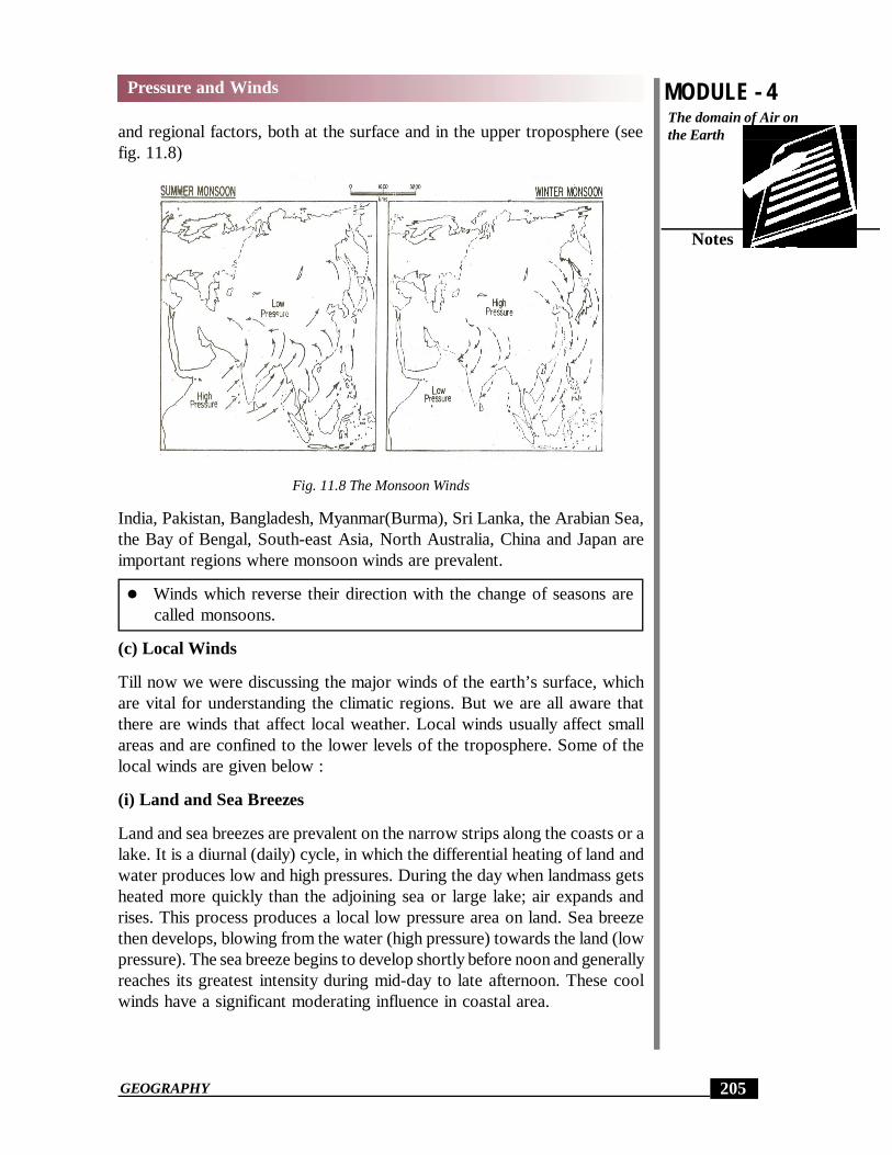
The direction of these winds changes with the change of seasons. Monsoonwinds are the most important periodic winds.
Monsoon Winds
The word ‘Monsoon’ has been derived from the Arabic word ‘Mausim’meaning season. The winds that reverse their direction with the change ofseasons are called monsoon winds. During summer the monsoon winds blowfrom sea towards land and during winter from land towards seas. Traditionallythese winds were explained as land and sea breezes on a large scale. But thisexplanation does not hold good now. Now a days the monsoon is generallyaccepted as seasonal modification of the general planetary wind system. TheAsiatic monsoon is the result of interaction of both planetary wind system
MODULE - 4
205
Pressure and WindsThe domain of Air onthe Earth
Notes
GEOGRAPHY
and regional factors, both at the surface and in the upper troposphere (seefig. 11.8)
Fig. 11.8 The Monsoon Winds
India, Pakistan, Bangladesh, Myanmar(Burma), Sri Lanka, the Arabian Sea,the Bay of Bengal, South-east Asia, North Australia, China and Japan areimportant regions where monsoon winds are prevalent.
Winds which reverse their direction with the change of seasons arecalled monsoons.
(c) Local Winds
Till now we were discussing the major winds of the earth’s surface, whichare vital for understanding the climatic regions. But we are all aware thatthere are winds that affect local weather. Local winds usually affect smallareas and are confined to the lower levels of the troposphere. Some of thelocal winds are given below :
(i) Land and Sea Breezes
Land and sea breezes are prevalent on the narrow strips along the coasts or alake. It is a diurnal (daily) cycle, in which the differential heating of land andwater produces low and high pressures. During the day when landmass getsheated more quickly than the adjoining sea or large lake; air expands andrises. This process produces a local low pressure area on land. Sea breezethen develops, blowing from the water (high pressure) towards the land (lowpressure). The sea breeze begins to develop shortly before noon and generallyreaches its greatest intensity during mid-day to late afternoon. These coolwinds have a significant moderating influence in coastal area.

MODULE - 4 Pressure and Winds
206
Notes
The domain of Air onthe Earth
GEOGRAPHY
Fig 11.9 Sea and Land Breezes
At night, the land and the air above it cools more quickly than the nearbywater body. As a result, land has high pressure while the sea has comparativelya low pressure area. Gentle wind begins to blow from land (high pressure)towards sea (low pressure). This is known as land breeze (see fig. 11.9)
(ii) The Mountain and Valley Breezes
Another combination of local winds that undergoes a daily reversal consistsof the mountain and valley breezes. On a warm sunny day the mountainslopes are heated more than the valley floor.
Hence, the pressure is low over the slopes while it is comparatively high inthe valleys below. As a result gentle wind begins to blow from valley towardsslopes and it assumes the name of valley breeze (see fig. 11.10).
After sunset, the rapid radiation takes place on the mountain slopes. Here,high pressure develops more rapidly than on the valley floor. Cold arid heavyair of mountain slopes starts moving down towards the valley floor. This isknown as the mountain breeze (see fig. 11.10).
Fig. 11.10 : Mountain and Valley Breezes

MODULE - 4
207
Pressure and WindsThe domain of Air onthe Earth
Notes
GEOGRAPHY
The valley and mountain breezes are also named as anabatic and katabaticbreezes respectively.
(iii) Hot Winds
Loo, Foehn and Chinook are important hot winds of local category.
(1) Loo
Loo are hot and dry winds, which blow very strongly over the northern plainsof India and Pakistan in the months of May and June. Their direction is fromwest to east and they are usually experienced in the afternoons. Theirtemperature varies between 45°C to 50°C.
(2) Foehn
Foehn is strong, dusty, dry and warm local wind which develops on theleeward side of the Alps mountain ranges. Regional pressure gradient forcesthe air to ascend and cross the barrier. Ascending air sometimes causesprecipitation on the windward side of the mountains. After crossing themountain crest, the Foehn winds starts descending on the leeward side ornorthern slopes of the mountain as warm and dry wind. The temperature ofthe winds vary from 15°C to 20°C which help in melting snow. Thus makingpasture land ready for animal grazing and help the grapes to ripe early.
(3) Chinook
Chinook is the name of hot and dry local wind which moves down the east-ern slopes of the Rockies in U.S.A. and Canada. The literal meaning ofchinook is ‘snow eater’ as they help in melting the snow earlier. They keepthe grasslands clear of snow. Hence they are very helpful to ranchers.
(iv) Cold Winds
The local cold winds originate in the snow-capped mountains during winterand move down the slopes towards the valleys. They are known by differentnames in different areas.
(1) Mistral
Mistrals are most common local cold winds. They originate on the Alps andmove over France towards the Mediterranean Sea through the Rhone valley.They are very cold, dry and high velocity winds. They bring down temperaturebelow freezing point in areas of their influence. People in these areas protecttheir orchards and gardens by growing thick hedges and build their housesfacing the Mediterranean sea.

MODULE - 4 Pressure and Winds
208
Notes
The domain of Air onthe Earth
GEOGRAPHY
INTEXT QUESTIONS 11.4
1. Choose the correct alternative for each of the following:
(a) Foehn winds are
(i) wet and dry (ii) cold, (iii) both wet and cold, (iv) none of them.
(b) Chinooks are similar to
(i) Foehn, (ii) Mistral, (iii) both of them, (iv) none of them.
2. Where from the Foehn wind originates.
______________________________________________________
3. Name the local wind which originate on the snow capped rockies andmove down the eastern slopes.
4. Write hot or cold against each of the following
(a) Loo ______________
(b) Mistral ______________
(c) Chinok _____________
11.7 TROPICAL AND TEMPERATE CYCLONES
(1) Air MassAn air mass is an extensive portion of the atmosphere having uniformcharacteristics of temperature, pressure and moisture which are relativelyhomogeneous horizontally.An air mass develops when the air over a vast and relatively uniform land orocean surface remains stationary for long time to acquire the temperature ormoisture from the surface. The major source regions of the air masses are thehigh latitude polar or low latitude tropical regions having such homogeneousconditions. Air masses, therefore, are of two kinds-polar and tropical airmasses. Polar air mass is cold and tropical air mass is warm. When cold airmass and warm air mass blow against each other, the boundary line ofconvergence separating the two air masses is termed as front. When the warmair mass, moves upward over the cold air mass the front formed in such asituation is called warm front. On the contrary, when the cold air massadvances faster and undercuts the warm air mass and forces the warm airupwards, the front so formed is called cold front. The frontal surface of coldfront is steeper than that of a warm front (see fig 12.5). A prevailing air massin any region - polar, tropical, maritime or continental largely controls theregions general weather.

MODULE - 4
209
Pressure and WindsThe domain of Air onthe Earth
Notes
GEOGRAPHY
(2) Cyclones
Typical cyclones are elliptical arrangement of isobars having low pressureat the centre with a convergence of winds within them. The wind direction inthe cyclones is anti clockwise in the northern hemisphere and clockwise inthe southern hemisphere. Cyclones are of two types - the temperate or midlatitude cyclones and the tropical or low latitude cyclones (see fig. 11.11)
Fig. 11.11 : Movement of Wind associated with Cyclones and Anticyclone inNorthern and Southern Hemisphere
(a) Temperate Cyclones
Temperate cyclones are formed along a front in mid-latitudes between 35°and 65° N and S. They blow from west to east and are more pronounced inwinter season.
Atlantic Ocean and North West Europe are major regions of temperatecyclones. They are generally extensive having a thickness of 9 to11 kilometersand with 1040-1920 km short and long diametres respectively. Each suchcyclone alternates with a high pressure anticyclone. The weather associatedwith the cyclone is drizzling rain and of cloudy nature for number of days.The anticyclone weather is sunny, calm and of cold waves.
(b) Tropical Cyclones
Tropical cyclones are formed along the zone of confluence of north-east andsouth-east trade winds. This zone is known as the Inter Tropical ConvergenceZone (ITCZ). Cyclones generally occur in Mexico, South-Western and NorthPacific Ocean, North Indian Ocean and South Pacific Ocean. These cyclonesdiffer from temperate cyclones in many ways. There are no clear warm andcold fronts as temperature seldom differs in Inter Tropical Convergence Zone.They do not have well-defined pattern of winds and are energised byconvectional currents within them. Generally, these are shallow depressionsand the velocity of winds is weak. These are not accompanied by anticyclones.The arrangement of isobars is almost circular. These are not extensive andhave the diametres of 160-640km. However, a few of them become veryviolent and cause destruction in the regions of their influence. They are calledhurricanes in the Carribean Sea, typhoons in the China, Japan and phillipines,

MODULE - 4 Pressure and Winds
210
Notes
The domain of Air onthe Earth
GEOGRAPHY
cyclones in the Indian Ocean and willy-willies in Northern Australia (seefig. 11.12)
Fig. 11.12 : Tracks of Temperate and Tropical CyclonesTropical cyclones often cause destruction on the coasts. You would haveheard cyclones striking Indian coasts in summer and autumn months. Theycause heavy loss of life and property in these regions. The steeper pressuregradient causing strong high velocity winds and torrential rainfall burstingupon a restricted area combine to create distructive storms. However about 8to 48 km. area around their centre called the eye of these stormy cyclonesremains calm and rainless. If this eye is detected, it is possible for the modernscience to stop further development of these strong cyclones and thusprotecting us from them. An air mass is a large body of air having uniform temperature and
moisture contents.
The boundary line separating two air masses is termed as front.
Temperate cyclones are prevalent in mid-latitudes while tropicalcyclones develop in tropical regions.
INTEXT QUESTIONS 11.5
1. What is air mass?
_______________________________________________________
MODULE - 4 Pressure and Winds
210
The domain of Air onthe Earth
GEOGRAPHY

MODULE - 4
211
Pressure and WindsThe domain of Air onthe Earth
Notes
GEOGRAPHY
2. Which type of cyclones cause heavy loss to life and property?
_______________________________________________________
3. In which latitudes temperate cyclones develop?
_______________________________________________________
WHAT YOU HAVE LEARNT
Atmospheric pressure is the weight of the column of air at a given place andtime. It is measured by an instrument called barometer. Unit of measure-ment of pressure is millibar. The distribution of atmospheric pressure variesboth vertically and horizontally. It is shown on the maps through isobarswhich are the imaginary lines joining the places having equal air pressure. Inhigh latitudes, atmospheric pressure is more than the pressure at low lati-tudes. The zonal character of horizontal pressure is commonly known aspressure belts. There are four pressure belts spread over the earth. They areequatorial low pressure belt, sub-tropical high pressure belts, sub-polar lowpressure belts and the polar highs. Thermal factor causes difference in pres-sure. Pressure belts are not fixed, they shift northwards in summer and southwards in winter with the apparent movement of the sun. Pressure gradient isthe difference in horizontal pressure between regions of high pressure andregion of low pressure. The difference in air pressure causes movement ofair called wind. There are wind systems that blow regularly on a daily pat-tern. Examples include the land and sea breezes, the mountain and valleybreezes and winds warmed as a result of compression. There is a close rela-tionship between pressure gradient and wind speed. Due to Coriolis force,winds deflect from their original course. In Northern Hemisphere they de-flect towards their right and in Southern Hemisphere towards their left. Thisis known as the Ferrel’s law. Winds are grouped under planetary, Periodicand local winds. Planetary winds blow in the same direction throughout theyear, while the other types of winds get modified due to certain reasons.Monsoon are seasonal winds while local winds below generally on diurnalbasis. Air masses are horizontal large bodies of air which have uniform tem-peratures and moisture contents. The boundary line between two differentair masses is called a front. Air masses and front cause temperate cyclones inmid-latitudes. Another type of cyclones are tropical cyclones which origi-nate on tropical oceans and influence the coastal areas. Sometimes they turnviolent and cause heavy loss to life and property.
TERMINAL QUESTIONS
1. Answer the following questions in about 30 words each.

MODULE - 4 Pressure and Winds
212
Notes
The domain of Air onthe Earth
GEOGRAPHY
(a) What is an atmospheric pressure?
(b) How is atmospheric pressure measured?
(c) What are the following?
(i) Millibars
(ii) Isobars.
(d) What is the effect of altitude on air pressure?
2. Distinguish between the following in 50 words each:
(a) Air current and wind.
(b) Planetary winds and periodic winds.
(c) Foehn and Mistral.
(d) Katabatic and Anabatic Breezes.
3. Give reasons for the following in 100 words:
(a) Low pressure is prevalent in sub-polar regions
(b) Sea breezes blow during day time.
(c) Winds change their direction in both the hemisphere.
4. Define the following:
(a) Air mass (b) front
5. What are temperate cyclones? How do they differ from tropicalcyclones?
6. What is the role of coriolis force in the deflection of winds?
7. Explain the following terms:
(a) Horse latitudes (b) Doldrums
8. On an outline map of the world mark and label the following.
(a) Prominent areas of low pressure in January.
(b) Prominent areas of high pressure in July in Northern Hemisphere
ANSWER TO INTEXT QUESTIONS
11.1
1. (a) Air temperature (b) The earth’s rotation (c) Presence of water vapour
2. (a) Fortin’s barometer (b) Aneriod barometer
3. 1013.25 Millibar
4. (a) 76 cm (b) low pressure (c) Higher pressure

MODULE - 4
213
Pressure and WindsThe domain of Air onthe Earth
Notes
GEOGRAPHY
11.2
1. (a) thermal equator (b) altitude
(c) the air pressure (d) pressure/density
2. (a) (i), (b) (ii), (c) (ii), (d) (iv).
11.3
1. (a) Trade winds (b) Westerlies(c) Polar easterlies
2. Winds or moving bodies turn towards their right in the northernhemisphere and towards their left in the Southern hemisphere. It is knownas Ferrule’s law.
3. (a) (i), (b) (i), (c) (ii), (d) (iii)
11.4
1. (a) (iv) (b) (i)
2. On the leeward side of the Alps Mountains.
3. Chinook
4. (a) Hot, (b) cold, (c) Hot
11.5
1. A large body of air which has uniform temperature and moisture contentsis called air mass.
2. Tropical and polar
3. Mid latitudes
HINTS TO TERMINAL QUESTIONS
1. (a) The weight of the air column at a place at a given time.
(b) Air pressure is measured by an instrument called barometer.
(i) The unit used for measuring air pressure. It is approximatelyequal to the force of one gram per square centimeter.
(ii) Isobars are lines connecting points that have equal valuesPressure.
(d) Pressure decreases with increase in attitude.
2. (a) please refer to para 11.5
(b) please refer to para 11.6 (a) and (b)

MODULE - 4 Pressure and Winds
214
Notes
The domain of Air onthe Earth
GEOGRAPHY
(c) please refer to para 11.6 (c) (iii) (2) and (iv) (1)
(d) please refer to para 11.6 (c) (ii)
3. (a) please refer to para 11.3 (iii)
(b) please refer to para 11.6 (c) (i)
(c) please refer to para 11.5 (ii)
4. (a) Air mass: a large body of air having uniformity of temperature,pressure and moisture.
(b) Front: the boundary line of convergence separating two differentair masses.
5. Please refer to para 11.7 (2) (a) and (b)
6. Please refer to para 11.5 (ii)
7. (a) Horse latitudes is the region of sub-tropical high pressure belts ofNorthern hemisphere.
(b) Doldrums are the regions of calm in equatorial areas where windsare negligible and ascending air current are prominent.
8. Please see maps 11.3 and 11.4