Embed Size (px)
Citation preview

Landform Analysis, Vol. 4: 17-37 (2003)
The development of periglacial sedimentationin the Wolica Valley (SE Poland)
during the Weichselian Upper Pleniglacial
J6zef Superson
Maria Cllrie-Sklodowska UniversityIlIstitute of £arth Sciences,Deparfmem ofGeologyal. Krasnicka le, 20-718 Lublin, Poland
Piolr Zag6rski
Moria Curie-Sklodowska Universitylnstilllle DJ Earth Sciences.Departmenl oJ Geomorphologyal. Kra.fnicka 2e, 20-718 Lublin, Poland
LA---AbstrQct: The development of the Weichselian Upper Plcnislacial pcriglacial scdimenuuion in the Wol itaValley was evaluated by means of gcomorphological. geological and sedimenlological investigation.Scdimcnts of the medium (11) raised terrace. the surface area of which is a dominant clement of thevalley. were examined. The terrace hiS a complex structure comprising deposits of different age,lithology and origin. The basal part of the terrace is formed from terrace remnants from the MiddlePleniglatial and the phase before mnimum cold of the Upper Pleniglacial. The base consists of sandychannel deposits and silty-sandy floodplain deposits. The upper part of tbe terrace is a thick series ofdeposits from the phase after maximum cold. It is built from slope, floodplain and chal'mel deposits,as ",ell as alluvial fans. The complexity of the structure results from the specific character of perigla.cial processcs and their rhythmical course, as well as from the influence of local conditions. The dcpositsof the basal pan of the terrace were shaped in a subpolar climate with maritime features, whereas thesediments of its upper part formed in continental subpolar climate. Local factors, SUth as: lithology ofrocks in the river drainage basin, a dense network of valleys in the basin and alluvial fans. determinedthe suspension type of transport, the shape of the river thanncl and retl:mion of a large amount ofscdimenl in the WoEea drainage basin and on its valley-noor,
Kc}' ,,'ordl'; periglacial sedimentation, the Lublin Upland. terrace deposits, Weiehselian UpperPleniglaeial
Introduction
The Weichsclian Upper P1eniglacial was aperiod of abundant periglacial sedimentation, notonly in the river valleys of the uplands of Southern and Middle Poland and in the CarpathianForeland (Buraczynski, 1980/1981; Gl(bica, 1995;Gl(bica & Starkel, 1987~ Harasimiuk, 1991; Jabn,1956b; Jersak, 1976, 1991; Jcrsak & Sendobry,1991; Jersak et aI., 1992; Manikowska, 1996;tarkel, 1988, 1994, 1995, 1997; Superson, 1979,
1995, 1996a; Turkowska, 1988, 1990), but alsoin many other river valleys in the periglacial zoneof Eurasia and North America (cl Vandenberghe,1985, 1993; Liedtke, 1993; Tornqvist, 1998,Blum et al., 2000; Straffin et al., 2000). Howev·
J Landronn
er, the sedimentation process varied depending onallogenic factors (climatic conditions, sea-leveloscillations and broad-scale neotcctonic movements), as much as on autogenic variables (bothregional and local). Most researchers emphasisethe significance of the impact climatic conditionsexert on the thickness and lithology of fluvialdeposits, yet only a few studies take into accountthe conditions inside a drainage basin, such as:natural obstacles in valleys, the lithology of slopeand hilltop deposits, the size of the river catchment basin and the slope angle, or tectonicmovements on a fault line (see Blum & Tomqvist,2000).
A similar emphasis on climatic conditions isnoticeable in publications on periglacia1 fluvial
17

J6zef Superson, Pialr Zag6rskiThe developmenl of periglacial sedimentation in the Wolica Vat/ey (SE Poland) ...
1
• 2
~ LlplnI 3
St..,'16" 4
Skm
~ 3 . 5 '" _ rigl'oHidoB valey mouth
.....,.1.0 -2.5'" _ 1alI...~mouIlt
o,
temtal t8 - 25 m
....,.14_18m
IIIoTIoCII i . 13 '"
N
i
"'"" tDnl101>i.ttty &
r---'L-'---'_:"-'----- -_..--
Ml 11·21m Ll )-5 ...MU 15·16m Ll1 2,.5.).}1IIM 11I ,. 13 ...
(.... "' 1991)
1>
2.-0 ImuJ·1
""
ng. 2. LongilUdinal profile of the Wolica Valley and pan of lhe longiludinal profile of the "'Krasnystaw Gap of the Wlcpn;" (after
Harasimiuk. 1991)
.1Vaulyu.... Gap
""uflltt\\",q:a'"
m [m a.I.I.) ""S N
'".. "- 200--~..
""_ L.,!
,.. r-=--:= ~.,..... ".
- 2 •-, <.~. '" ~
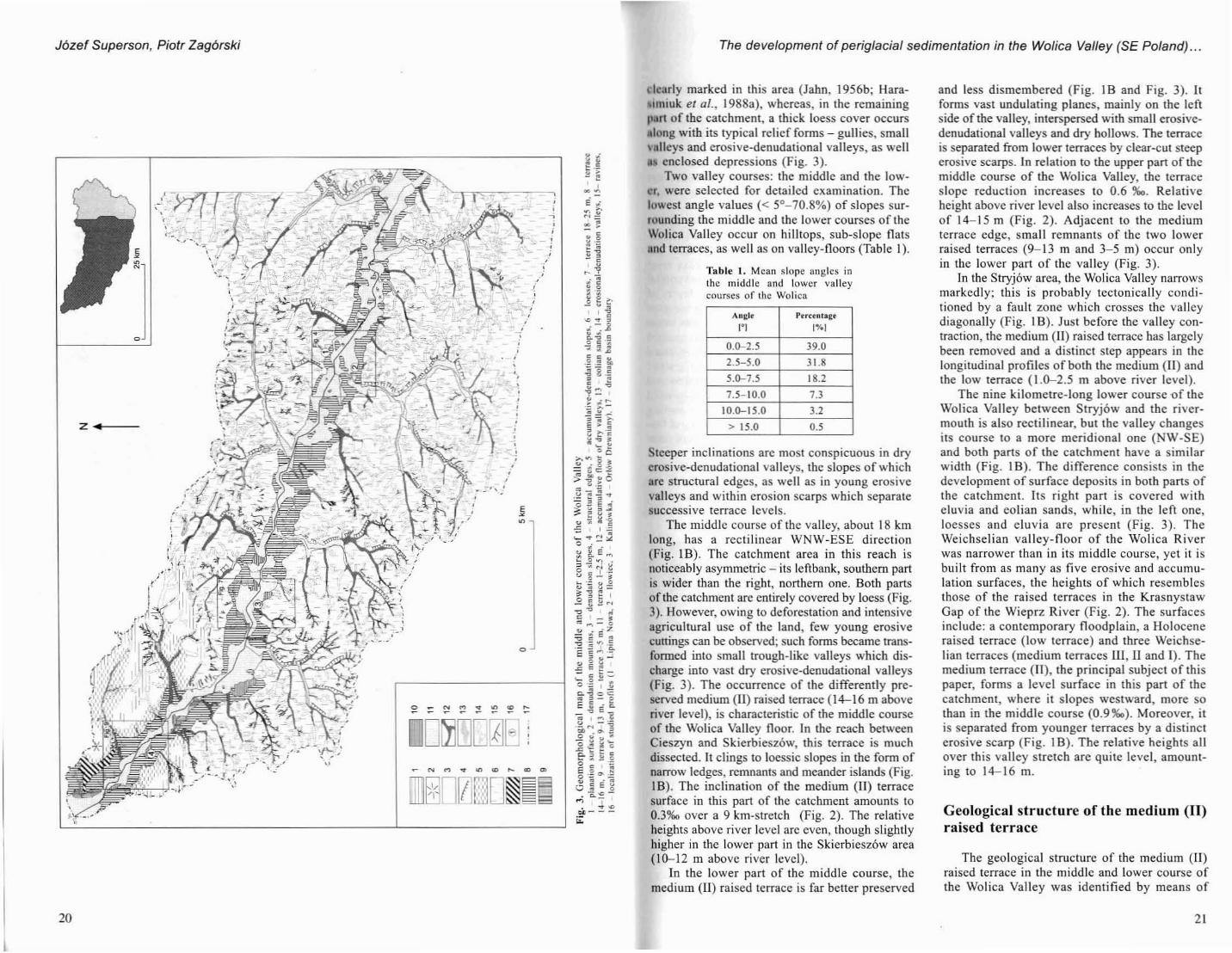
Fig. I. Localization of sludy area and digilal model of relief of the middle and 10lo\'er course o~ the Wolica ValleyA. G~mllrpllologic regIons (after ~af\ts~tal;. 1974): 1 boundary of llle regions. 2 boundary of tile subreglOns. J - state boundary. 4 ,- dnll~ageb~sin of the Wolica K,vcr. ": 1- dramage bhln boundary. 2 _ lerrdCC 14 16 m. 3 - lonliulIon of study profiles. 4 IOC.l1on of lown. quote In
lr1iclc
Characteristics of the Wolica Valleyfloor and its drainage basin
The Wolica Valley cuts through the southernpart of the Grabowiee Heights which form theeastern stretch of a parallel belt of high plains ofthe Lublin Upland (Fig. lA). The valley can bedivided into four sections (the uppennost, theupper, the middle and the lower courses); thesediffer in respect of course direction and in thenumbcr and development of Weichselian raisedterraces and Quaternary deposits (Fig. 2).
The main relief features of the Wolica catchment arc conditioncd by the dircctions of dip andstrike of beds and faulting, and by the lithological properties of the bedrock (Jaho, 1956b;Maruszczak, 1972; Harasimiuk et al., I988a). Theinfluence of bedrock tectonics and lithology isparticularly noticeable in the middle course of thedrainage basin, where wide, dry erosive·denudational valleys occur, characterised by asymmetric sides, which form structural edges. The SubQuaternary foundation (marls, marly limestonesand chalkstone, gaizes) crops out on the surfaceonly in the northern and western parts of thelower stretch of the catchment (Harasimiuk et al.,1988a). Surfaces of denudational planations arc
the aim of the study has now been achieved; thissupplied a great many data rclating to the development of the valleys in the Pleistocene (Zagorski, 1998; Gawrysiak et 01., 1998; Supcrson &Zagorski, 2000). Sediment samples collected inrepresentative profiles were processed, and grainsize distribution was analysed and its parameterswere calculated using Folk and Ward's method(1957). Sedimentation structures and the determinations of grain-size distribution provided a basis for the demarcation of lithostratigraphic complexes and for interpreting sedimcntation environments and their energy (Visher, 1969; Racinowski& Szczypek, 1985; Superson, 1996a). The stratigraphy of analysed sedimcnts was cstablishedconsidering geological and geomorphologicalpositions and TL analyses of ages. It was basedon stratigraphic division of last glaciation usedin elaborations of the West European scientists(c! Vandenberghe, 1985; Liedtke. 1993). Whenconstructing the diagrams, modern methods ofspatial visualisation were applied using Arclnfoand ArcView programs. Studies were supportedby funds for statutory investigations of theDepartment of Geomorphology of UniversityMaria.Curie·Sklodowska in Lublin and by GrantNo 6P04E 03318 from KBN.
deposits in the valleys of the Lublin Upland andthe RozlOcze region (tQe eastern part of the up·lands of southern Polano). The development ofperiglacial sedimentation in those valleys arousedthe interest of researchers as early as in 1950s.Investigations into the problem were initiated bythe eminent expert on the contemporary periglacia I zone and fossil periglacial strucrurcs, after A.Jahn (1952, 1956a, 1956b, 1975). Later studieswere largely based on the material compiledduring the construction of individual sheets of theLarge·Scale Geological Map of Poland I : 50000(Mojski, 1961, 1968; Harasimiuk & Henkiel.1980, 1982; Harasimiuk & Szwajgier, 1984;Harasimiuk et al., 1988a, 1988b; Buraczyilski &Superson, 1996). Lublin Institute of Earth Sciences began systematic studies of periglacial valleysediments early in the 1970s and has continuedthe work up to the prcscnt. This has resulted innumerous publications, mainly concerned withrivcr valleys in the Wieprz drainage basin (Hara·simiuk, 1991; Superson, 1977, 1979, 1987/1988,1995, 1996., 1996b; Superson & Warowoa, 1996),in the Tancw basin (Buraczynski, 1980/1981) andin the Bug basin (Szwajgier, 1998; Superson &Szwajgier, 1999). Only a few of these publications deal with the problem of autogenic factors'influence on valley sedimentation. Harasimiuk(1991) interpreted the floodplain deposits of themedium (I) Weichselian terrace in the Krasnys·taw Gap of the Wieprz River as an effect of"upstream aggradation" produced by alluvial fansofside tributarics and by limited movement of themeander belt on the narrow valley·floor. J. Superson (1996a) attempted to synthesise the dep·osition and erosion history of the valleys of theupland Wieprz basin during the Weichselian. Inthis study, the influence of climatic, regional andlocal conditions on sedimentation and erosionprocesses in valleys of various rank was analysed. The valleys selected were characterised bydifferent catchment sizes, various deposits overlaying the basins and different cutting of catchment surface. However, due to scarce geologicaland geomorphologicaJ data, relatively little atten·tion was paid to the valleys of the Wicprz trib·utaries with their loessic catchment's.
Given the above, the present study was aimedat evaluating the effect of allogenic and autogc~
nic factors on periglacial valley sedimentation ina small catchment basin covered by loess and cutby a dense network of dry valleys. The Wolicacatchment was selected for the study since itfulfilled all the stated conditions.
Following a detailed geomorphologieal description of the Wolica catchment in recent years,
1918 ).
J6zef Supersan, Piatr lag6rski The development of periglacial sedimentation in the Wolica Valley (SE Poland) ...
, -,f- ·r,
o
Z ~.f---
20
J .•,,,?
-',,,,,,,,,
,,
o
,,- ,,
ii
",,,
.'
dcarly marked in this area (Jahn, 1956b; HaraIlniuk er al., 1988a), whereas, in the remaining
pan of the catchment, a thick loess cover occursMlong with its typical relief [oOlls - gullies, small\-llllcys and crosive·denudational valleys, as well• enclosed depressions (Fig. 3).
Two valley courses: the middle and the lower, were selected for detailed examination. Theluwest angle values « 5°-70.8%) of slopes surrounding Lhe middle and the lower courses of theWolica Valley occur on hilltops, sub-slope flatsIInd terraces, as well as on valley~floors (Table I).
Table I. Mean slope angles inthe middle and lower valleycourses of the Wolica
Anl:lr Percenl.gr
'"' 1".1
0.0-2.5 39.0
2.5-5.0 31.8
5.0-7.5 18.2
7.5-10.0 7.3
10.0-15.0 3.2
> 15.0 0.5
teeper inclinations arc most conspicuous in dryerosive-denudational valleys, the slopes of whichare structural edges, as well as in young erosivevalleys and within erosion scarps which separatesuccessive terrace levels.
The middle course of the valley, about 18 kmlong, has a rectilinear WNW·ESE direction(Fig. I B). The calchment area in this reach isnoticeably asymmetric - its leftbank, southern partis wider than the right, northern one. Both partsof the catchment are entirely covered by loess (Fig.3). However, owing 10 deforestation and intensiveagricultural use of the land, few young erosivecUllings can be observed; such forms became transformed into small trough-like valleys which discharge into vast dry erosive-dcnudational valleys(Fig. 3). The occurrence of the differently preserved medium (It) raised terrace (14-16 m aboveriver level), is characteristic of the middle courseof the Wolica Valley floor. In the reach betweenCieszyn and SkierbieszQw, this terrace is muchdissected. It clings to loessic slopes in the form ofnarrow ledges, remnantS and meander islands (Fig.IB). The inclination of the medium (11) terracesurface in this part of the catchment amounts to0.3960 over a 9 km-stretch (Fig. 2). The relativeheights above river level arc even, though slightlyhigher in the lower part in the Skierbiesz6w area(10-12 m above river level).
In the lower pari of the middle course, themedium (Il) raised terrace is far better preserved
and less dismembered (Fig. IB and Fig. 3). Itforms vast undulating planes, mainly on the leftside of the valley, interspersed with small erosivedenudational valleys and dry hollows. The terraceis separated from lower terraces by c1ear·cut steeperosive scarps. In relation to the upper pari of themiddle course of the Wolica Valley, the terraceslope reduction increases to 0.6 %0. Relativeheight above river level also increases to the levelof 14-15 m (Fig. 2). Adjacent to the mediumlerrace edge, small remnants of the two lowerraised terraces (9-13 In and 3-5 m) occur onlyin the lower part of the valley (Fig. 3).
In the Stryj6w area, the Wolica Valley narrowsmarkedly; this is probably tectonically conditioned by a fault zone which crosses the valleydiagonally (Fig. I B). Just before tbe valley contraction, the medium (11) raised terrace has largelybeen removed and a distinct step appears in thelongitudinal profiles of both the medium (H) andthe low terrace (1.0-2.5 m above river level).
The nine kilometre· long lower course 'Of theWolica Valley between Stryj6w and the river·mouth is also rectilinear, but the valley changesits course to a more meridional one (NW-SE)and both parts of the catchment have a similarwidth (Fig. I B). The difference consists in thedevelopment of surface deposits in both parts ofthe catchment. Its right part is covered witheluvia and eolian sands, while, in the left one,loesses and eluvia are present (Fig. 3). TheWeichselian valley·noor of the Wolica Riverwas narrower Ihan in its middle course, yet it isbuilt from as many as five erosive and accumulation surfaces, the heights of which resemblesthose of the raised tcrraces in the KrasnystawGap of the Wieprz River (Fig. 2). The surfacesinclude: a contemporary noodplain, a Holoceneraised terrace (Iow terrace) and three Weichselian terraces (medium terraces U1, 11 and J). Themedium terrace (11), the principal subject of thispaper, fonns a level surface in this part of thecatchment, where it slopes westward, more sothan in the middle course (0.9%0). Moreover, itis separated from younger terraces by a distincterosive scarp (Fig. I B). The relative heights allover this valley stretch arc quite level, amounting to 14-16 m.
Geological structure of the medium (n)raised terrace
The geological structure of the medium (IJ)raised terrace in the middle and lower course ofthe Wolica Valley was identified by means of
2\

J6zef Superson, Piotr Zag6rski The development of periglacial sedimentation in the Wolica Valley (SE Poland) ...
~1 2
.1.",.
1%1'00
;:;::] rolling-dr:ag-transpon
[[] Icmporary suspensiono l.ltIintemJplC~d su.'«lC1IsiOl1
m - m()dmll~
b - big
vb - ,.try big
~
e
d
P:Ic -~~
b~=
r,:V
a
!."
)( Variability of the~ environment
a I ~ energyo
0,51,0 1,5 2,0 () m b vb 0 20 4{) 60 80
M I+lz
123456
SFh~Sh~
FSI~"~
_~llo'
cd ICJI Iks vB m,
" !ill ,I. is
Lithology~0.E
(rnJ c1Jo
3
2
4
S
6
7
6
•'0
with very fine-grained sands. As the sedimentsample was collected using manual boreholes,there are no data on sediment structure. An analysis of grain-size distribution revealed that themean grain diameter (Mz) of sandy·clayey siltswas 5.1-5.2(>, of sandy silts - 5.051), and of veryfine·grained silty sands - 4.8-5.0(>. All sedimentsin complex "a" are characterised by poor sorting(0, = 1.23-1.54).
Lithocomplex "b" is siluated on the erosivcceiling of complex "a" and is built from alternating laminae of very finc-graincd sillY, fine- andmcdium-grained sands (Fig. 5). Whereas mostrhythmite sediments display parallel horizolltallamination (SFII, Sh), only certain Ihin layers ofmedium-grained sands have tabular lamination(Sp). The values of the mean grain diameter rangefrom 3.83 104.72$ in laminae of very fine-grainedsilty sands, from 2.67 to 3.28$ in fine-grainedsands, and from 1.95 102.650 in medium-grainedsands. Medium-grained sands are moderately andpoorly sorted (CfJ = 0.70-1.39), while fine-grainedand very fine-grained sands show poor sorting(a, = 1.16-1.59). The structural and textural features clearly differentiate complex "b" from corn·plcx "a".
Lithocomplex "b" is covered with a thin layer of lithocomplex "c". It also developed in theform of a rhythmite, but unlike in complex "b",the laminae are noticeably inclined towards the
analysing oUlcrop sediments in four exposuresand deposits obtained from manual boreholes(Fig. IB). The exposures are situated within:
I) the outlet of a trough. like valley onto thesurface of the medium (11) raised terrace (thevillage of Lipina Iowa),
2) the contact area between the eastern end ofa large alluvial fan ofa side valley and the floodplain deposits (Itowiec),
3) the surface of the medium (11) raised lerrace (Kalin6wka and Orl6w Drewniany).
In the lithological description ofsediments, thelithofacial code was adapted which is commonlyused in sedimentological papers (vide Gradzinskiet al., 1986, pp. 402--403; Zielinski, 1992, 1993).
Exposure in Lipina Nowa
The walls of the 5.1 m deep Lipina Nowacxposure cut through the terrace deposits bothacross and along thc axis of the trough-like val·ley (Fig. 4). The dceper sediments were elaborated based on drilling. The analysis of grain-sizedistribulion and the type of deposit lamination led10 the recognition of four lithocomplexcs in thevertical profile (Fig. 5). Lithocomplex "a" lies ona rubble of siliceous limestone. It is built fromsandy-clayey silts, which, towards the base, be·come sandy silts and very fine-grained sillysands. In some places, the silts are interbedded
Flg.,5. Lithology and scdimcnlological features of sedimenlary building profile in the Lipina Nowa
LlIh~logy: csl - c.layey sill. si - sill: ,;c,1 - ~andy clayey sill. ssl. - Undy sill. 'le5 ~ silly clayey sand, sls silly sand. "fs _ verJ line-grained...nd. f, ~ fi~~-~ral.ned !'lInd. rns mcdlUm:gramed sand. 1- thylhnll~alJy bedded sedimcnts, 2 _ erOSIonal surfaces. tithofaci.... code (aller Gnub.iilski,,' iJ/:. _198~. ZlcltnS~'. 1998) Sm - mUSIVe Structure ~and. Sll horizontal lamination sand. SI low_.ngle c'Ou-stral,fication sand. Sp plAnarc'O§~-",rallfic'lIon. s.nd. SI - IrOUllh c'Oss-slrallficahun §and. St - hlgll-angle crO§5·slralific.l;on sand, Sfm _ musi,·c §Irucu"e finelJr.incdadm,xture sand. SFII :- hOrllonl.1 I.m,n'lion ~negrain~ .dmi~lurc sand. SF! - 10w....ngl.. Crm;S·Slnlificarion fincgrained admixture sand, SFi _hlgh••n!;).,. c:ms'-lIrallfic'I~OO fineK':"".cd .dm,.xlur.. sand, Fh honzomall.mination fines. Ft low-.ngle crou-stratlfication lines. Fp pl.narcross-§lnuficallon finn. FSh - IIon~.ont.1 I.mlnallon sandy fines. FSI low-anlll.. cr05S-slnIlIfic'llOn sandy fincs
J
I I...• .~···.r I
j . ·'·1 {. 1'. I . V':I.. ·I"T :1,., 1:t. (. ,;.oi I
I··, . I . .o I
o 0.5 kmI 1
.·ig. 4. A: Gcomorphologic.1 map of the area near profiles in the Lipina Nowa and llowicc, Legend, see fig. 3. B: Digilalmodel of the: relief
22
axis of the trough-like valley. Additionally, thelaminae are panly tom and deformed (flaser lammation). In sediments of the complex, thinpseudomorphs of ice-veins were also found.Grain·sizc distribution of the sediments is simi·lar to that of sedimellts in complex "b" (Fig. 5).
Lithocomplex "d" is located on the sedimentational ceiling of complex "c". The thickness ofthe form varies according to the location - at themouth of the trough-like valley it is 1.5 m thick,whereas near the Wolica Valley axis it exceeds 3m, Complex "d" comprises alternating thin lay·crs of very fine-grained, si Ity sands and laminaeof fine- and medium-grained sands (Fig. 5). Incontrast to underlying rhythmites, the layers arethicker and longer. Also, the grain-size distributionof the sediments of this rhythmite varies slightlyfrom the distribution in lower-situated rhythmites.
Medium-grained sands (Mz = 2,19-2.31(\» arewell and moderatcly sorted (a, "" 0.49-1.46).while fine-grained sands have coarser grain(Mz = 2,51-3.18$).
The higher lithocomplex, "e", is a metre-thicklayer of massive sihy sands, very fine-grained,which have been affected by contemporary soil·forming processes.
The origin of sediments in individual litho·complexes was determined on the basis of a detailed sedimentological analysis and the situationof the exposure in relation to the forms of thevalley-floor and slope. The sediments of complex"a" are characterised by a high content of grainsdeposited from permanent suspension (50-60%),and lack of grains transported in the bed· load(Fig. 5). Such features, along with a high vari·ability of water energy, imply that the sediment's
23

J6zef Superson, Piotr Zag6rski The development of periglacial sedimentation in the Wolica Valley (SE Poland) ...
,Ce.,.C ~,,DC, "enE
1
1%160 80 1002<l '0
~ rol1ing-drag-transport(£l] temporary suspension
D uninlerrupted suspension
=:::1 rolling-dr11g-tnnspon
([]] tnnpomy SI.lSpmSionCl uninlCmlplCd susprnsioo
m - moderateb • bigvb- ~ery biK
b - big
vb - "eT)' big
a
b
d
Variabilityx of the~ environmentE energyo{) bvbO
I
I
(
cri
1,0 1,5 2,02,5
TII
I"-
, ,, ,, ,,
l,,, ,i ,
I, ,, ,,, \
I
I
\
I
234567
Variability C0x of the '5~
M z lol>J0- environment C ~
cri E ,,-0
energy [%] -g §i1 2 3 • 5 • 0.51,0 1.5 2,02,5 <) m b "" 0
20 40 6080 HIOOO E
1
I
I I I),
,, ,,, ,, ,, ,, ,,
I
I:,
I,,,
I ,I I,
SFI
SI
SF
cd oql~ ~f$ ~..... r.
2
B~
~0- LithologyE
Iml..en
0
FSrn
2
3
•S
•7
•esl $C11 sin ~flI ms
si $51 ,11 rs
~1 82
A~
"0. LithologyE(ml ..
en0
SFISI
SFI
2 SI
SFI3
Fp
•FI,
•
Fit. 6. Lilhology and sedimentological features of sedimenlary building profile in lIowiecA prol1le lIowicc I (....eslern part). IJ - profile lIowiee 2 (cemral fl&r1I. l.egend. "'" Fil':_ 5
The cxposure in I10wiec is situated in the leftbank, southern part of the Wolica Valley-floor,near the outlet of a large flat-bottom valley(Fig. 4). Il cuts the terrace deposits parallel tothe axis of the Wolica Valley. The ceiling of theexposure is situated at an altitude of 210 m a.s.1.in about 60 m Icngth. The direct observation waspossible to the depth of 5.5 m, but the underlying sediments were recognized using the handauger.
A detailed examination of terrace sedimcntswas carried out in two profiles: in the westernand central parts of the exposure ("Ilowiec I"and "lIowiec 2", respectively). In the "HowiecI" profile, three dislinctive lithocomplcxes wereidentified (Fig. 6A). In the lower part of theexposure and 3.5 m below its floor, a thick se·rics of clayey silts occurs (complex "a"). Theirgrain·size distribution is uniform in the verticalprofile - the mean grain diameter (Mz) rangesfrom 5.0341 to 5.939, and sorting is poor (al =1.45-1.85). In the exposed part of Ihe profilesilts have parallel lamination slightly sloping tothe east (upriver). At a depth of 4.0-4.5 m belowIhe ceiling of the exposure, sills arc clearlyglcyed. A sedimentological analysis of the siltsshows that sediment particles were, for the mostpart (70-75%), deposited from pcrmancnl suspension and water flows were characterised bya large variability of energy (Fig. 6A). Suchfeatures of deposition and the fine granularity ofthe sedimcnt are typical of a floodplain subenvironment.
The middle part of the profile is formed bylilhocomplex "b". This lies on an erosive cciling of complex "a" and its Ihickncss varicsbetween 2.5 m in the western part of the cxpo·sure to > 5 m in its central part. The complexconsists of alternating laminae and thin layers ofpoorly·sorted silty sands (SF/), as well as medium- and fine-grained sands (SI), inclined towards the east. The fine-grained sedimcnt ispoorly sorted, which indicates a large variabil·ity of flow energy (Fig. 6A). The sediment ofcoarser grain is either moderately or poorlysorted, which indicates a smaller variability ofenvironment energy than in the case of thedeposition of fmcr-graincd sediment. Moreover,a sedimentological analysis shows that all rhythmite sediments were deposited by very shallowbut high·cnergy flows. This is indicated by thehigh percentage (90-95%) of grains depositedfrom permanent suspension.
Exposure in lIowiecwere deposited by shallow sheet floods of shortduration. Scdimcnts of complex. "b" were deposited in a similar subenvironmcnt. Rhythmicaldevelopmem of the deposits and rhythmical variability of environment energy and of the deposition processes indicate a seasonal recurrence ofvery shallow flows. In a river valley the flowsmay come from tloodwatcrs (flowing down afloodplain or the surface of the alluvial fan) orfrom a low-energy current of a braided river(Ziclinski, 1993). A channel genesis for the deposits has to be excluded, however, as the content of grains carried by bed-load transport is toosmall (Fig. 5). Instead, Ihe Iilhological featurespoint to high-energy floods.
The features of complex "c" (laminae slopingtowards the side-valley axis, discontinuity oflaminae and their small thickness, as well as arhytbmical pattern of the sediment) testify toslope genesis of the sediment. Also in this case,sediment grains were carried and deposited bysheet floods of deluvial fans.
The upper rhythmite (Iithocomplcx "c") prob·ably consists of dcposits of a side-valley alluvialfan. Il is evidcnt in thc diversity of layer thickness and in the slope of the layers in thc dircc·lion of thc main·valley axis. h is not unlikely,however, that some of the layers werc fonned asa result of a flood in the main valley.
The genesis of dcposits in complex "e" wasnot investigated on account of the changes in itslitho logical features brought about by contemporary soil processes.
Genetic interpretation of sandy·silty rhythmites is extremely difficult since they areformed as a result of periodic action of shcctfloods (McKee et al., 1967; Tunbridge, 1984;Williams, 1971; Zielinski, 1993; Superson,1996a). According to Fairbridge (1968), theterm "sheet floods" should only be used to refer to sediments of large·spaee rain washing thatcan be observed during short but violent stonnsin semi·dry areas. However, Fairbridge pointsout that a lack of vegetation may lead 10 theoccurrencc of similar phenomena in humid climate. Some investigators (e.g. McKnee el al.,1967; Williams, 1971) claim that flows rcsembling sheet floods occur in river channcls witha periodic rhyth,m of water supply. Given that,it seems justifiable to count energetically variedfloods of short duration among sheet floods. Asimilar opinion is exprcssed by Zielillski (1993)who links sandy-silty rhythmites to thc suben·vironmcnt of secondary braided channels or tothe overbank zone of a proglacial braided river.
244 Laodform...
25

J6zef Superson, Piolr Zag6rski The development of periglacial sedimentation in the Wolica Valley (SE Poland) ...
"8'"t'"•+•••c.
~
I%J60 80 100.,.
II ,
00000 ,0
•0
I
,
IIJ
,
1
1 I~ I
II I
IIII
j ,-b - big ~ rolling-dnr.g-cransport
[[]] lemponuy 5U$pcnsionc:::J unimerruptC'd suspension
c
b
•
x Variability~ of the
0" I ~environmento energy
1.01.52.0 U b 02040
The ceiling of the profile of terrace sedimcntsfonns another rhythmite (Iithocomplex "c"), builtfrom thin layers of fine-grained sand mixed withsilts and with laminae of sandy silt. The sediments of the rhythmite arc poorly sorted (Oi =1.10-1.25) and display parallel horizontal lamination (SFh and FSh).
A sedimentological analysis of sedimentsin complex "a" leads to the conclusion thatthe sediment was deposited from two types of
Mz [mm]
It)~~~~~8~ciciciciocicio
I
11 I
1\ I
I
II
I I
s
si ssl sls r,
Lithology
3
2
7
5
iE~(m) (J)
o
8
8
•
B
"
11
"
12
'0
rle· 8. lithology and sedimenlological fealUrcs of sedimemary building profile in the Kalin6wka (after Superson. 1996. somewhatchanged). Legend, sce Fig. 5
In the ceiling of the complex, sediments form arhythmite consisting of ahernating laminae ofyellow and grey sandy silts (FSh) and grey silts(Fh). All sediments in this complex arc poorlysorted (a, ~ 1.1-1.6).
A further lithocomplex "b" is represented bya layer of poorly sorted, medium-grained sandswith small-scale trough skew-Iamination (SI). Themedian of the grains amounts to 1.501), and thesorting index (0'1) to 1.45.
(Fig. 6A,B). The upper part of "Howiec 2" isbuilt from a 3 metre-thick layer of sandy-clayeysilts (lithocomplex "c"). Sediments of the complex are also developed in the form of a rhythmite, except that, in the ceiling of the profile,lamination is invisible owing to later soil-forming processes. Values of the mean grain diameter of c1aycy silts range between 5.0 and 5.5Qand the values of a. = 1.50-1.65 testify to poorsorting of the sediment. The fine-grained natureof the rhythmite and the high percentage (approx. 60%) of grains deposited from suspcnsiontransport indicate that it was fonned in a floodplain subenvironment. However, it could also berepresentative of the subcnvironmcnl of thedistal part of the alluvial fan.
Exposure in Kalinowka
In Kalin6wka, a profile through valley scdiments is present on the left bank of the WolieaValley, within the steep edge of the mediumraised terracc. The walls of the exposure (6 mdeep and 30 m long) cut through the sedimemsperpendicularly to the axis of the Wolica Valley(Fig. 7). The deeper sedimems were elaboratedbased on drilling.
In the studied profile, valley sediments comprise three lithocomplexes (Fig. 8). The lower andmiddle parts of the profile make up lithocomplex"a", which is > 10 m thick. It is built from coarsegrained silts, blended with very fine-grained sand.
>.::--.~.:.:~~' ·'1... .DB.8D9.'0D11~12
r.ccI'4L=J
BJ'5
Fig. 7. A: Gcomorphologi("al map of Ihe area near the profiks in lhe Kalin6wka. legend, sec Fig. 3. B: Digitalmodel of Ihe relief
It is difficuJt to define the genesis of a rhythmite unequivocally. Sandy rhythmites may befonned in the subenvironment of streams of secondary importance in a braided river or on thefloodplain of the river (Zielillski, 1993).11 is alsobelieved that water-flows in the area of thosesubenvironments were hydraulically very similarto shallow sheet noods of short duration (e.g.McKnee et al., 1967; Williams, 1971). As aconsequence, it is possible for sedimems to bedeposited on the surface of the alluvial fan aswell. This hypothesis must be excluded, however, since the sediment development is indicativeof the proximal part of the fan while only thesubcnvironment of the distal pan of the fan maybe present in that place. In conclusion, the rhythmite of complex "b" was probably fonned in thesubenvironment of a shallow river channel. Thehigh variability of water energy indicated by thesediment suggests that it represents deposition inthe channel of a sandy braided river.
The ceiling of complex "b" is erosivelysheared and covered with a thin layer ofcontemporary deluvia (Iithocomplex "d").
In the central part of the exposure ("I1owiec2" profile), lithocomplex "a" does not occur andwas not intersected by manual probing. The lower part of the profile there is represented by asandy rhythmite (Iithocomplex "b"), as alsofound in the "lIowicc I" profile. The structuraland textural features of the rhythmite sedimentsare identical to those in the "Howiec I ,. profile
26 " 27

J6zef Superson, Piotr Zag6rski The development of periglacial sedimentation in the Wolica Valley (SE Poland) ...
o 0,5 kmI I
On the uneven erosive ceiling ofcomplex "d", a thin layer of mediumgrained sands is present; this displayssmall scale trough skew-Iamination (Iithocomplex "e"). The sands are moderately well sorted and their mean gmin diameter is below 2$. These features,along with a small percentage of grainsdeposited from permanent suspension(5-8%) and a moderate variability of environment energy (Fig. II A), indicatethat the sands were deposited by thehigh-energy flows of a dcep rivcr (conditions similar to those of sediment deposition in complex "b").
On account of the transformation of10 the sediment caused by contemporary
soil-forming processes. ceiling lithocomplex 'T' was not examined.
The same lithocomplexes are presentin the vertical "Orlow 2" profiJe of terrace sediments, situated some metres tothe south-cast of the ·'Orlow I" profile(Fig. 10), except that lithocomplex "b"is considerably reduced and is laterallyand vertically adjacent to a layer of silty
sands interbedded with fine-grained sands (Iithocomplex "a").
Silty sands of complcx ·'a" arc characterisedby a rhythmic change of grain-size sorting in thevertical profile - some laminac arc poorly, andsome - very poorly sorted (Fig. 11 B). This indicates a rhythmic variability of flow energy.Moreover, a sedimentological analysis revealedthat the sedimcnts were deposited mainly fromintennittent suspension. In respect of these features, the authors believe they are sediments ofa natural levee. Overbank spilling of floodwatersbrought about a large rhythmical variability ofcnergy flows and a characteristic type of sedimentdeposition (Superson, 1996a).
The development and genesis of other lithocomplexes ("b", "c", "d" and '·c") are similar tothose of profile "Orl6w 1" (cf Fig. IIA and Fig.liB).
To summarise. a synthetic profile of sedimentsin the medium (11) terracc compriscs thc following strata:
I) terrace base: channel and floodplain deposits of older terraces,
2) slope deposits with rhythmical grain-sizedistribution,
3) thick floodplain deposits, or - by the slopesof the valley - deposits of alluvial fans.
4) channel deposits of a sandy braided river.
om 11
fi53 1
D2f- h 13
~.
O.~.
EO'O·
D'
I20 [m]
swono.
Orewniany 2
•
ono.Orewniany 1
,o
21-d,9uBf'
NE
(ma.s.!.1
'"
'90
On the erosive ceiling of complex "b", lithocomplex ··c" is located (Fig. 11 A). This ;s a thinIllyer of medium-grained sands with troughskew-Iamination of mcdium seale (St). Thevalues of the mean grain diameter range between1.06lj) and 2.02$, and sorting of the sediment ispoor (0', = 1.28-1.38). The structural and textural features of sands imply that they were deposited mainly from bed-load and from intennittcntsuspension, and formed large ripples at the bottom of the channel. The depth of the flows wasat least 0.5 m (Zielinski, 1993). Absolute dating of bottom and ceiling sediments of the complex using Tt method (Fig. 10) indicates that thechannel deposits formed 23,000 years ago (thephase before maximum cold of the UpperPleniglacial).
The subsequent complex, "d", consists of thinhorizontally-arranged layers of silry-c1ayey sand,silty sand and medium-grained sand (SFII, 511).Rhythmic changes of the parameters of grain-sizedistribution imply episodic changes of flow encr·gy. It must be emphasised, however, that, in theceiling of the complex, syngenetic pseudomorphsof ice-veins testify to the deposition of sedimentsin pennafrost. Absolute TL age of sediments of thecomplex "d" was estimated at 20 ± 3.7 ka BP(Lub-3343) and 21 ± 3.9 ka BP (Lub-3347).
tic- 10. Synthetic geological profile ofl('IT3.ee scdimenlS in Orl6w Drt:wniany(after Zag6rski. 1998. somewhat changed)1 - 1n.'7.t /UpptT Cretaceous). 2 - silly .sand. J - sandy sill. 4 sohn"","on strue·turef,. j und.6 dlall0l\l.ll>cddlng ~nd. 7 - ons,ein layer and froot fin"",. 8 sand","h gravel. 9 sandy·dly lntetbeddings. 10 Holocene 5011. 11: a npo.un·. bdrilling. Liloophac,al eomple~«; Cr Cmae<:<HIs. EV!v.' - Early Wciebschan and older(Wanan,an'Odn.n,an) .ethment•. a_r _ the eomplneJ e"plamed 10 the ,u,
This exposure is situated near the outlct of theWolica Valley into the Wieprz Valley (Fig. 9). Itcuts through sediments of the medium (11) raisedterrace situated on the left side of the valley.Adjacent slopes and hilltops arc covered by sandycluvia, unlike the remaining part of the drainagebasin, whcre loess predominates.
Terrace sediments in Orlow Drewniany arclocatcd on an erosive ceiling built from Cretaceous rocks and are 10 metTes thick. In thisexposure, several lithologicaHy and geneticallyvaried series crop out (Fig. 10). In the "Orlow 1,.profile, a 5 metre-thick sandy series (Iithocomplex "b") is situated on the erosive ceiling ofCrctaceous rocks. The complex is built of finegrained sands (42-50%) with a considerable admixture of medium-grained (26-33%) andcoarse-grained sands (approx. 16-18%). Thevalues of the mean grain diameter are c. 2Q, whilethe values of 01 index show poor sorting of thesediment (Fig. II A). In the very bottom of thecomplex, a thin layer of silty sands occurs, withmean grain diameter Mz = 4.0$ and very poorsorting «(Tl = 2.05). In the upper part of the complex, the sedimcnt displays tabular skew-lamination (Sp). This type of texture is characteristic ofsandy waves which migrate along the river-bed(Alien, 1983; Zielinski, 1993).
Exposure in Or16\\1 Drewnianytransport: sills - from suspension, and veryfine-grained sands - from intermittent suspension (Fig. 8). That kind of deposition and a largevariability in respect of environment energy suggest that the sediments were deposited in twostages from energetically different flows offlood waters. First, at the higher flow energy,very fine-grained sands were deposited, followed by grains of silt, which were releasedfrom suspension slow-moving or stagnant waters. Grain-size distribution in those sedimentsindicates an increasingly large energy of theflood.
Sedimcnts of lithocomplex <Ob" were formedin the river-bed environment. The following factstestify to it: chute bars (ripples of medium size),coarse grain of the sediment and a small perccntage of grains deposited from permanent suspension transport (approx. 20%). There are notenough data, howcvcr, to dcfine the channel dcvelopmcnt.
The gcncsis of sedimcnts in the sandy roofrhythmite (Iithocomplex "c") is difficult to establish, because the deposits may have been form~d
both in the secondary stream of a periglacialbraid, as well as on a floodplain surface. Considering the relatively small percentage (25-50%) ofgrains deposited from permanent suspensiontransport, the present authors are inclined tosupport the first hypothesis.
Fig. 9. A: Geomorphologieal map of lhe area near the profiles in Orl6w Drewoiaoy: U:gend. sce Fig. 3.B: Digital model of the relief
28 29

J6zef Superson, Piotr Zag6rski The development of perigfacial sedimentation in the Wolica Valley (SE Poland) ...
2" (the ceiling of complex "d"). The surface evidently dates back to the period directly preceding the cold maximum, since in its ceilingpseudomorphs of ice-veins were found (,,Lipina
owa", "Orl6w I" and "Oriow 2"). The conclusion is confirmed by TL analyses of basal deposits in the "Orlow" exposure (Zag6rski, 1998).Consequently, deposits of the medium (I) raisedterrace form the base of the medium (11) terrace.In the "lIowiec" exposure, the basal terrace isbuilt from clayey silts, which are probably olderthan the Weichselian.
The fabric development and sedimentologicalanalysis of the preserved deposits of the medium(I) terrace indicate that, towards the end of theWeichselian Middle Pleniglacial and during thephase before maximum cold of the UpperPleniglacial, a large and deep river channel ex.isted in the Wolica Valley; this had well-developedlevees. In the floor of the channel, transverse barsand large ripples fonned, built from moderatelyand poorly so.ned fine- and medium-grainedsands. Sediments of both subenvironments arewell displayed in the "OrI6w" exposure. Channeland levee deposits also occur in the "Latycz6w"profile in a similar stratigraphic position (Harasimiuk, 1991). Concurrently, a floodplain developed in the valley and sediments of its subenvironment were found in the "Lipina Nowa"profile (Iithocomplexes "a" and "b"). The development of the scdiments points to the growth offlood energy in the course of time. In paleogeographical terms, this is explained by the growthof the permafrost, which gradually amplifiedsurface wash. A similar trend is presented byRotnicki (1996) in a curve of runoff depth in theProsna catchment basin over the last 140,000years. Flood sediments with rhythmic layers originating from the Inter-Pleniglacial period werealso found in the small valleys of Central Poland.They occur along the full width of the valleybottoms (Manikowska, 1996) or are situatedperipherally in relation to the sandy bed zone(Gozdzik & Zieliilski, 1996) as in tbe RiverWolica Valley.
Fluvial deposits from the cold maximum andfrom the beginning of the later part of the UpperPleniglacial have not been identified, either in theexposures analysed or in manual boreholes. Fluvial processes were inhibited most probablyowing to the short duration of soil thaw andtcmperarures which exceeded <rC. On the surfaceof the terrace which bad formed above the overflow land, ice veins and wedges began to develop, while on the terrace edges and on slopes ofsmall side-valleys, slope processes were activat-
Conditions for the developmentof lhe Woliea River valley floorIn Upper Pleniglaeial
The interdependent processes of the periglaI.:lal zone create a morphogenetic system of a highorder. In a subpolar climate, fluvial systems areranked last because other systems: cryogenic,iVavitational, deluvial and eolian, form a zonesupplying the fluvial system with matter andenergy (Superson. I996a). As a consequence, thedevelopment of periglacial sedimentation at thebottom of the Wolica Valley ought to be examIlled in relation 10 the above morphogenetic systems.
Thus, the time framework of sediment depoIlion in the medium (11) raised terrace has to be
considered in two stages:I) sedimentation of the terrace base deposits,2) build-up of the terrace base with deposits
from the waning phase of the cold maximumperiod.
Terrace base deposits date from the MiddlePleniglacial and from the early part of the UpperPleniglacial (apart from the base at 1I0wiec), andthe time framework for the base build-up isconstrained by two events: the end of erosionprocesses occurring in the valley-floor at thebeginning of the Upper Plcniglacial (e. 22,00020,000 BP): the stan of floor-erosion processesin the Wolica channel towards of the Late Weichsc[;an (e. [2,000-[0,000 BP).
Intense floor and lateral river erosion, whichoccurred before the cold maximum the UpperPleniglacial, was widespread and has been identified by Rotnicki and Bor6wka (1989) in theProsna Valley, by Harasimiuk (1991) in theWieprz Valley, by Starkel (1994, 1995) in thevalleys of the Carpathian Foreland and by Superson (1996a) in the valleys of the LublinUpland. This indicates climate as the cause ofthe erosion. There is no unanimity, however, asto which climatic factors contributed to channeldeepening.
Floor and lateral erosion incised the interstadial-anastadial accumulation surface and leftbehind an erosive discontinuity surface_ Theaccumulation surface subsists only in the lowestpart of the valley, at an altitude of 203-205 ma.s.l. Evidence of erosion has also been found inthe Krasnystaw Gap of the Wieprz river (Harasimiuk, 1991; Superson, 1996a) and in the valleys of the Zamosc Basin (Superson, 19963). Thiserosive surface was found in three of the analysed profiles: in "Lipina owa" (the ceiling of lithocomplex "a") and in "Orlaw I" and "Orlow
[%[
60 80 100
,ce."c 0~-
1%) .g ~
60 80 100 Cl) E
20 40
2040
m - modetalC ell rolling-dng-transport
b - big [[] tcmponry suspensionvb • ~cry big D lIIlintcmJpted suspension
m _moderatc ~ rolling-drag-U1lIlSportb _big []IIItcmporary suspension
vb . very big D unintcrruptcd susperu;ion
Variability~ of theCi environment~ energy
m b vb 0
u~•• ~u
c.,d 0-
8~
e
"cc•~"b
f
Variability)( of the! environment5 energytJ mbvbO
<:'I
I.JL
L 1 I
11'I I I
I) I
II
I
Mzl.J 0,1 2 3 4 5 60,51,01,52,02,5
11 I , 1
, ' 1\'/\1 ,
,
I ,
,
_.I
Mz [.1 a,
, 2 3 4 5 6 0,51,01,52,02,53,0
Sp
Srn
S,
Lithology
4
6
5
3
2
~C.E
(ml~
o
B
Fig. 11. Lithology and sedimentologieal features of sedimcnts building the profile in Orl6w DrcwnianyA profile Orlo.... DrUI'1I1:lIlY I. B - profile OrID... Du,,-niillDy 2. Legend. ~ fig. S
A0~
C. LithOlogyE
Iml~
0
,SI
2
3
• S,
5
6
7
6
9 ••cs! !Ut slcs vr~ ms
II ISI ~lj (.
[g'i] 1 2
30 31

J6zef Superson, Piotr Zag6rski The devefopment of perigfacial sedimentation in the Wolica Valley (SE Poland) ...
ed (lithocomplex "c" in the "Lipina Nowa" pro~
file).During the latest phase of the Upper Plenigla~
cial, the valley became filled with floodplain,channel and proluvial deposits. Floodplain depos~
its of this period were identified in prorilcs:"Howiec 1", "Howiec 2" and "Kalin6wka". Thesediments are represented by sandy~silty rhyth~
mites which reflect a rhythmicity of floodwaterenergy. The grain~size distribution of the sedi~
ments indicates a gradual increase in the flooddynamics.
Near the outlets of the small side-valleys, thefloodplain deposits have been replaced by thoseof alluvial fans ("Lipina Nowa" profile). Proluvial sedimentation presumably developed parallel to flood sedimentation and was associated withchannel erosion in the side-valley floors. Thelarge amounts of detrital deposits supplied to themain valley caused rapid aggradation of thevalley-floor. Over a period of about 6,000 years,the valley floor was raised by over 15 m. Intense,latc Pleniglacial deposits were also obscrved inothcr river valleys of the Lublin Upland andRoztocze (Harasimiuk, 1991; Buraczynski &Superson, 1996; Superson, I996a) and in the rivervalleys of the L6dZ Upland (Turkowska, 1988).
The channel deposits which are prcsent closeto the ceilings of the profiles resemble those ofa braided river. The river probably developed intwo phases. In the older phase, it was a wide,high-energy river, in the floor of which sandswith Cretaceous rock gravel were deposited andbars of medium size formed. In the youngerphase, the water energy was evidently muchsmaller, as fine-grained and very fine-grainedsands were deposited in the channel, there to forma plane bed or small ripples. The channel deposits of the small valleys of Central Poland situated in a similar stratigraphic position are dated byManikowska (1996) to the period 20-14.5 ka BP.The aforementioned authors are of thc opinionthat these sediments were deposited in the coldperiod of the continental climate by periodicalstrcams.
The wide-river phase was followcd by floorand lateral erosion in the Wolica Valley-floor.Field investigations reveal three stages of bottom erosion, interspersed by two depositionalphascs. Gcomorphological data (the shape of theerosion remnants in the terrace) indicate that,during the oldest stage, erosion developed in thechannel of a river which had large-radius mean~
ders. A similar phenomenon was observed inriver valleys of the Zamosc Basin (Superson,1977, 1979, 1996a).
32
The development of the River Wolica Valleybottom presented above indicates that individualsediment lithocomplexes of the medium raisedterrace in the Wolica basin formed in variableconditions of water flow and deposit supply froIllthe catchment basin to the floor of tbc valley.Water flow in the catchment is difficult to reconstruct. Attempts have been made to retrodict theWeicbselian water balance in the Prosna catch·ment (Rotnicki, 1996), but, owing to differentclimatic, hypsometric and hydrogeological con~
ditions, these values cannot be applied to theWolica Valley.
When reconstructing the deposit snpply to thevalley~floor, two aspects have to be taken intoconsideration:
I) how much sediment was denuded fromslopcs and hilltops (from a unit of surface overa known period of time),
2) how much sediment was retained at thebottom of the valley.
Of eoursc, Upper Pleniglacial denudation canonly be estimated from comparisons with contemporary denudation. In the northern part of TheMurmansk Upland (the Kola Peninsula, Russia),on slopes covered by tundra, tbe wash is not veryintensive (Superson, 1994) and soil creep andsolifluction, occurring mainly on moist slopes, areof greater importance (P{(kala, 1994; Goliszck &P~kala, 1996). Contemporary research in thctemperate climate zone also indicates the plantcover has a decisive role in protecting the soilfrom wash processes (Gil, 1976,1986). On slopesof Carpathian flysch devoid of vegetation, 74.2tonslha of sediment was supplied during 1969,while, on the same slopes, covered by grasses,only 0.031 tons/ha (Gil, 1976). The possibility ofwater infiltration into non-frozen sediment is alsoimportant, as this determines the amount of slopcwash (Slupik, 1973). On the permafrost slopes ofa periglaeial zone, slow wash was presumably ofgreatest importance during land thaw, when thesurface flow of waters was not yet intense andpart of the sediment was already defrosted. Gil(1976) pointed to similar contemporary phenomena, and emphasised the intensity of wasb dur~
iug winters of continental type, which resultedfrom the deep freezing of the ground. Also,Lanagbein and Schumm (1958) observed theimportance of vcgctation in dcposit supply fromslopes and point out that the influence of plantcover increases with thc growth of climate humidity. The importance of other variablcs wasstressed by Walling and Webb (1983) and Mil1i~
man and Syvitski (1992). These authors claimthat sediment supply from the catchment decreas-
with the growth of catchment surface area and,.., rClIscs with the growth of relative height.
IIlular relationships were proposed in Hovius's"'l""ion (1998):
I ne "" ~0.416InA + 4.26 x 10--<lH + 0.15T ++ O.095T, + O.OOI5R + 3.58
where E is specific sediment yield (t km-2 yr- l),
4 lli drainage basin area (km2), fI is mean height
llf the drainage basin (m), T is mean annual tem~
ptr'llure eC), Tf( is mean annual temperature range1'1'), and R is specific runoff (mm km-2 yr-l
).
The above discussion leads to an inconsisten-l. y: dense tundra cover reduced the deposit supItl)' from slopes, whereas intense dcposition in~.Ilcy·floors of different order (Superson, I996a).uggests the converse. Superson (1996a) tried tol'lCplain this apparent contradiction, asserting that1I1Qrge portion of the detrital sediment was brought111 the valley by eolian transport and could thenhllvc been washed down into the valley-floor fromIlowflakes or plant leaves, rather Ihan through
rrosion. This is a logical conclusion, consideringthllt, between 18,000 and 12,000 BP, thick loess(Maruszczak, 1987, 1995) and sandy covers werelorming on the Lublin Upland (Superson, 1987/1988, 1996a; Buraczynski, 1994). Maruszczak(1995) estimated the mean rate of loess depositlon at 0.8-1.0 mm/year. Loess covers would nothave formed at a similar rate of denudation. It ispossible that the vegetation of the tundra forest.nd grassland which covered the Lublin UplandIt the time (Starkel, 1993) was dense enough toprevent the denudation of the deposited sediments. Intense accumulation of detrital matter onInow (even to 672.8 g/m2
) has been observed onSpitsbergen (Wojtanowicz, 1990).
The ratio of the sediment removed from thecatchment to Ihe tOlal mass of the deposit releasedIn the catchment can be estimated using thedeposit supply index, as defined by Walling(1983). The index value is calculated from theequation: Sd = Sy/ER, where Sy is the deposityield at a given point in the basin and ER corresponds to total erosion above a chosen point inthe basin. Walling's research (1983) indicates thathigh index values are characteristic of very smallcatchment basins, while its small values (of theorder of 0.1-0.2) are obtained for basins largerthan 1,000 km2
• However, owing to the possibility of an error in estimating the size of slopedenudation, a detailed evaluation of the Sd indexfor the lower course of the Wolica Valley is difficult. Presumed values of the index do not exceed 0.2, since the thickness of alluvia in side
, - landform ..
valleys and in the Wolica Valley indicates intensedeposition there conditioned by the alluvial fans,among other things, which are obstacles to flood·water wash.
Approximate values of deposit supply fromthe catchment to the basin floor can be calculated using Hevius's empirical formula (1998).According to this fommla, which involves fivevariables, about 0.133 tons km-2 year-I of sediment were removed from the Wolica catchmentin the beginning phase of the cold maximumperiod, meanwhile about 1.05 tons km-2 year-1 atthe end of this phase. This value was obtainedafter introducing the following data, respectively: catchment area: 367.7 km2
, mean relativeheight in the catchment: 79 m and 88 rn, meanannual air temperature: _5°C and 5°C, annualrange of temperatures: 30°C and 20°C, annualprecipitation total: 300 mm and 500 mm. Smallindex values confirm the above conclusion regarding the retention of a large amounl of denuded sediments in the Woliea Valley.
The shape of the river channel is anotherfactor which contributes to the intensity of deposition and influences thc lithology of the deposits. In the Wolica Valley, a sinuous river with awell developed floodplain and levees probablyexisted during the Upper Pleniglacial. Not beforethe end of that period did a braided river form,as indicated by the sediments, and this was soontransformed into a river of large-radius meanders.The suspension load of the Wolica prevented thedevelopment of a braided river for a long timeand contributed to the prevalence of silty over~
bank deposits in the valley.Until recently, it was commonly believed that
braided rivers arc characteristic of glacial periodsand meandering rivers typify warm interstadialsand interglacials. The latest investigations showthat, on the contrary, depending on local conditions, rivers may be variously developed in thesame period of time (Van Huissteden, 1990;Superson 1996a; Szwajgier, 1998).
The influence of tectonic movements on sedimentation and Upper Pleniglacial erosion is dif~
ficult to evaluate because, as Paola et al. (1992)rightly observe, tectonically determined factorsbave a significant influence on fluvial processesonly in time-scales exceeding 100,000 years.
Conclusions
1. In the Upper Pleniglacial period in theWolica River valley, periglacial sedimentationdeveloped in two phases scparated by a stage of
33
J6zef Superson, Piotr Zag6rski The development of periglacial sedimentation in the Wofica Valley (SE Poland) ...
bottom and side erosion. The earlier phase tookplace during the cooling period in conditions ofa sub-polar, oceanic climate, and the later phaseoccurred during the coldest period and the slowwarming of the sharp continental climate.
2. In the sup-polar, continental climate, themean rate of aggradation of the Wolica Rivervalley was double the rate of aggradation of thevalley bottom during the period of the oceanic subpolar climate. The above fact illustrates the indirect impact of the climate on valley sedimentation.
3. The following have been local influenceson sedimentation in the Wolica Valley:
a) the lithology of basin rocks - loess was anexcellent ground for the development of a plantcover which protected the rock from denudation.Moreover, loess supplied to the river channel wasmainly transported by suspension and the channel was shaped accordingly,
b) the high density of the valley network - thisfactor was responsible for the retention of a largeamount of sediment in the basin,
c) transverse obstacles in valleys, in the formof alluvial fans which ponded floodwaters.
4. Terrace sediments are built from fluvialdeposits (floodplain, channel and levee deposits), as well as proluvial, deluvial and colluvialones. The polygenesis of lerrace deposits resultsfrom the large influence of the cryogenic syslem (permafrost) on the other morphogeneticsystems.
5. Data from the Wolica basin indicate thatsmall index values of deposit supply to sedimentation basins are characteristic of average sizedensely cut drainage basins.
References
Alien, J.R.L., 1983: Studies in fluviatile sedimentation: bars, bar-complexes and sandstonesheets (Iow-sinuosity braided streams) in theBrownstones (L. Devonian), Welsh Borders.Sedimentary Geology 33: 237-293.
Blum, M.D., Guccione. MJ., Wysocki, D.A. &Robnen P.C., 2000: Late Pleistocene evolutionof the Central Mississippi Valley, SouthernMissouri to Arkansas. Geological Society ofAmerica Bullelin 112: 221-235.
Blum, M.D. & Tomqvist, T.E., 2000: Fluvial responses to climate and sea-level change: areview and look forward. SedimenlOlogy 47(Suppl. I): 2-48.
Buraczynski, 1., 1980/1981: Development of valleys in escarpment zone of the Roztocze.Ann.UMCS. sec. 8,35/36: 81-102.
34
Buraezyitski, J., 1994: Zmiennosc procesow eolicznyeh na Roztoczu i w Kotlinie Sandomierskiej podczas pi~tra wisly. Ann. UMCS. sec. B, 49: 51-79.
Buraczynski, J. & Superson. J., 1996: Litologiautworow mezo· i neoplejstocenskich w dolinach gornego Wieprza i Soiokiji (RoztoczeTomaszowskie). I,,: A. Kostrzewski (Ed.) Geneza, lilOlogia i stralygrafia utworow CZlvartorz~dowych. T. 2. Uniwers)'tet im. Adama Mickiewicza. Seria: Geografia 57, Wyd. NaukUAM, Poznan: 47-57.
Fairbrigde, R. W., 1968: Sheet erosion, sheetwash, rainwash, sheet flood. In: R.W. Fairbridge(Ed.) The Encyclopedia ofGeomorphology. E,,cyclopedia of Earth Sciences Series. Vol. 3.New York, Amsterdam, London: 991-993.
Folk, R.L. & Ward, W.C., 1957: Brazos River bar:a study in the significance of grain size parameters. Journal o/Sedimentary Petrology 27, I:3-26.
Gawrysiak, L., Reder, J. & Zagorski, P.• 1998:Rzci:ba i osady czwartorz«dowc dorzecza Wojslawki. A"". UMCS, sec. B, 53 (print 2000):87-106.
Gl(bica, P., 1995: Evolution of Ihe Vistula valleyand of alluvial fans of the Raba and Uszwicarivers between Uscie Solne and Szczurowa inthe Vislulian and Holocenc. I,,: L. Starkel (Ed.)Evolution of the Vistula river valley during thelast 15 000 years. Vol. 5. Geographical SlUdies.Special Issue 8: 31-50.
G~bica, P. & Starkel, L., 1987: The evolution ofthe Vistula river valley at the northern margin ofthe Niepolomice Forest during last 15000 years.Ill: L. Starkcl (Ed.) Evolution of the Vistula rivervalley during the last 15 000 years. Vol. 2.Geographical Studies, Special Issue 4: 71-86.
Gil, E., 1976: Splukiwanie gleby na stokach fliszowych w rejonic Szymbarku. DokumentacjaGeograflcz"a 2: 65 pp.
Gil, E., 1986: Rola uzytkowania ziemi w przebiegu splywu powierzchniowego i sptukiwaniana stokach flislOwych. Przeglqd Geograjicz"y58, z. 1-2: 51-65.
Goliszek, M. & PC(kala, K., 1996: The development of contemporaneous slope process in theDalnye Zelentsy region (Kola Peninsula). In:J. Repelewska-PC(kalowa, K. PC(kala (Eds.)Polar Sessio" "Problems of the Conlempora"eous and PleislOcene Periglacial Zone ". Lublin - Poland. December 1995. WydawnictwoUniwersytctu Marii Curie-Sklodowskiej, Lublin: 147-152.
Gradziilski, R., Kostecka, A., Radomski, A. &Unrug, R., 1986: Zarys sedymentologii. Wydawnictwa Geologiczne, Warszawa: 628 pp.
GOldzik, J. & Zieliilski, T., 1996: Sedymentologia vistulianskich osadow matych dolin srodkowej Polski - przyklady z kopalni Beichat6w.Biuletyn Pat;stwowego InstylU1U Geologicznego 373: 67-77.
Harasimiuk, M.. 1991: Vistulian glacial cycle ofthe fluvial processes development in the valleyof middle Wieprz river (SE Poland). Ann.UMCS, sec. 8,46: 81-109.
Harasimiuk, M. & Henkiel, A., 1980: Objasnienia do Szczegolowej mapy geologiczllej PolskiI: 50 000, arkllsz L~czna (750). WydawnictwaGeologiczne, Warszawa: 72 pp.
Uarasimiuk, M. & Henkiel, A., 1982: Objasnienia do Szczegolowej mapy geologicznej PolskiI : 50000, arkusz Lublin (749). WydawnictwaGeologiczne, Warszawa: 83 pp.
Harasimiuk. M., Henkiel, A. & Kr61, T., 1988a:ObjaSnienia do Szczegolowej mapy geologiczllejPolski I : 50 000. arkllsz Krasl/ystaw (825).Wydawnictwa Geologiczne, Warszawa: 71 pp.
Harasimiuk, M., Henkiel, A. & Krol, T., 1988b:Objasnienia do Szczeg610wej mapy geologicznej Polski I : 50 000, arkusz Piaski (787). Wydawnictwa Geologiczne, Warszawa: 74 pp.
Harasimiuk, M. & Szwajgicr, W., 1984: Profilutworow ezwartorzc;:dowych w Latyczowie.ln:H. Maruszczak (Ed.) Przewodnik Ogolnopolskiego Zjazdll Polskiego Towarzystwa Geograjicz"ego, UMCS, Lublin: 74-81.
Hovius. N., 1998: Controls On sediment supplyby large rivers. 111: K.\V. Shanley and PJ. McCabe (Et/s.) Relalive role of ellslasy. climate,and teelol/ism ill eOnlillelllal rocky. Society ofEconomic Paleofllology alld Mineralogy. Spe·cia I Publication 59: 3-16.
lIuissteden, J. van, 1990: Tundra rivers of the lastglacial sedimentation and geomorphologicalprocesses during the middle Pleniglacial inTwcnte, Eastern Netherlands. MededelingenRijks Geologische DienSl 44, 3: 3-138.
Jahn, A., 1952: Materialy do geologii czwartorzC(du p61nocnej cz«sci arkusza "Zamosc"I : 300000. Billletyn Pat1.mvowego InstytulIIGeologiczl/ego 65: 407-452.
Jahn, A., 1956a: Czwartorz~d. Srodkowa i wschodnia czc;sc wyzyny. In: W. Pozaryski (Ed.) Regiol/alna geologia Polski. 2: Region lubelski.Krakow: 90-123.
Jabn, A., 1956b: WyZyna Lubclska. RzeZba i czwartorzC(d. Prace Geograjiczlle Instytulu Geografii PAN 7: 453 pp.
Jahn, A., 1975: Problems ofthe periglacial zone.PW ,Warszawa: 223 pp.
Jersak, J., 1976: Zwi<lzek akumulacji lessu z rozwojem procesow rzecznych w dolinach przed-
S'
pola Karpat i na wyzynach poludniowej Polski.ACla Geographica Lodziensia 37: 25-52.
Jersak, J., 199 I: Osady rzeczne pelni pi~tra zimnego Wisly w dolinie Wicprza mi~dzy Szczebrzeszynem a Lancuchowem.ln: J. Jersak (Ed.)Less i osady dolinne. Prace Naukowe Uniwersyletu Slqskiego w Katowicach 1107, Katowicc: 51-92.
Jersak, J. & Sendobry, K., 1991: Vistulian deposits in the Bierawka exemplified by the fillingsand mine in Kotlamia. In: 1. Jcrsak (Ed.) Lessi osady doli"ne. Prace Naukowe Uniwers)'lelUSlqskiego w Katowicach 1107: 93-118.
Jersak, 1., Sendobry, K., Snieszko, Z., 1992:Postwarcianska ewolucja wyzyn lessowychw Polsce. Prace Nallkowe Uniwersytelll Slqskiego w Katowicach 1227: 197 pp.
Langbein, L. & Schumm, S.A., 1958: Yield ofsediment in relation to mean annual sediment.Trans. American Geophysical Union 39: 10761084.
Liedtke. H., 1993: Phasen periglaziiir-geomorphologischer Pragung wahrend der Weichseleiszeit im norddeutschen Tienand. ZeilsclJrijlfUr GeomorplJologie N.F., Suppl-Bd. 93: 69-94.
Manikowska, B., 1996: Dwucyklicznosc ewolu·cji srodowiska peryglacjalnego w Polsce srodkowej podczas visrulianu. Biuletyn PalTstwowego II/stytutll Geologicznego 373: 97-106.
Maruszczak, H., 1972: Wyzyny Lubelsko·Wotynskie. I,,: M. Klimaszewski (Ed.) GeomOlfologia Polski. T. 1. Pol.'ika Poludniowa. Goryi wyzYflY. PWN, Warszawa: 340-384.
Maruszczak H., 1987: Loesses in Poland, theirstratigraphy and paleogeographieal interpretation. A"I/. UMCS, sec. S, 41 (1986): 15-54.
Maruszczak, 1-1., 1995: Glacial cycles of loessaccumulation in Poland during the last 400 kaand rhythms of paleogeographical events. Ann.UMCS. sec. 8, 50: 127-156.
McKee, E.D., Crosby, EJ. & Berryhill, H.L.,1967: Flood deposits, Bijou Creek, Colorado,June 1965. Journal of Sedime"tary Petrology37: 829-851.
Millimam, J.D. & Syvitski, J.P.M., 1992: Geomorphie/tectonic control on sediment dischargeto the ocean: the importance of small mountainous streams. Journal ofGeology 100: 525-544.
Mojski, J.E., 1961: Stratigraphy of cryoturbatestructures in the Wiirm-age deposits in thesouthern part of Dorohucza Basin. BiulelynPeryglacjalny 10: 235-256.
Mojski, J.E., 1968: Objasnienia do Szczegolol'.'ejmapy geologicznej Polski I : 50 000. arkllszPawlOw. Wydawnictwa Geologiczne, Warszawa: 46 pp.
35
J6zef Superson, Piotr Zag6rski The development of periglacial sedimentation in the Wolica Valley (SE Poland) ...
Paola C.• Helier P.L., & Angevine c.L., 1992:The large-scale dynamics of grain size variationin alluvial basins. I. Theory. Basic Research 4:73-90.
P/(.kala, K. 1994: Development of relief affectedby contemporary morphogenic processes in theDalnyc Zelentsy region (Kola Peninsula). In:J. Repelewska·Pt(kalowa, K. Pltkala (Eds.)Polar Session "Arctic Natural EnvironmentProblems" Lublil'. Poland-November 1994.Wydawnictwo Uniwcrsytetu Marii Curie·Sklo·dowskiej, Lublin: 87-92.
Racinowski, R. & Szczypck, T., 1985: Prezenta·cja i interpretacja wynik6w badan uziamieniaosad6w ezwartorzt(dowych. Skrypty Uniwersy·tetu Slqskiego 359, Katowicc: 143 pp.
Rotnicki, K., 1996: Mozliwosc retrodykcji skladowych dawncgo bilansu wodnego i jego zmianW ostatnim cyklu intcrglacjalno·glacjalnym napodstawie danych paleobotanicznych. BiuletynPanstwowego Instytutu Geologicznego 373:153-160.
Rotnicki, K. & Bor6wka, R., 1989: Osady g6r·nego plenivistulianu w dolinie dolncj Prosnypod Macewem a wiek maksymalnego zasi((.guostatnicgo zlodowacenia podczas fazy lesz·czynskiej. 8adania Fizjograjiczne nad PolskqZachodniq 40. Seria A: Geograjia Fizyczna.Warszawa-Poznati: 5-20.
Slupik, J .• 1973: Zr6i.nicowanie splywu po·wierzchniowego na fliszowych stokach g6r·skich. Dokllmentacja Geograjiczna 3: 118 pp.
Soltysik, R., 2000: Wplyw czynnika tektonicznegooa fonnowanic zabagnicti w strefach prz,edprzctomowych dolin rzecznych G6r Swit(tokrzyskichi ich obrz,ezenia. In: BJ. Kowalski rEd.) Geologia i geomorfologia Gor SWit;loknyskich - konlrowersje i nowe spojrzenia. Prace InslytutuGeograjii WSP w Kielcach 4 (2000): 209-222.
Starkel, L., 1988: Paleogcography of the periglacial zone in Poland during the maximum advance of the Vistulian ice sheet. GeographiaPolonica 55: 151-163.
Starkel, L., 1993: Paleogeografia polskich Kar·pat w p6i.nym vistulianie i wczesnym holocenie. All. UMCS, sec. S, 48: 253-261.
Starkel. L., 1994: Reflection of the glacial-interglacial cycle in lhe evolution of the Vistulariver Basin, Poland. Terra Nova 6, 5: 486-494.
Starkel, L., 1995: Evolution of the Carpathianvalleys and the Forecarpathian Basins in theVistulian and Holocene. Studia Geomorpholog·ka. Carpatho·Balcanica 29: 5-40.
Starkel, L., 1997: The evolution of fluvial sys·terns in the Upper Vistulian and Holocene in theterritory of Poland. Land/arm Analysis I: 7-18.
36
Straffin, E.C., Blum, M.D., Coils, A. & ThamesJ.B., 2000: Alluvial stratigraphy of the Loireand Arroux Rivers, Burgundy, France. QUalernaire 10: 271-282.
Superson. J., 1977: Gcomorfologia i morfogencz3doliny dolnego Poru. Biulelyn Lubelskiego Towarzystwa Naukowego. Geograjia 19, 2: 63--68.
Superson, l., 1979: Geomorfologia doliny meandrowej dolnego Poru. Ann. UMCS, sec. B, 27:143-158.
Supcrson J., 1987/1988: Obszary alimentacyjncpokrywowych utwor6w piaszczystych Roztocza Tomaszowskiego. Ann. UMCS, sec. B.42/43 (print 1993): 31-47.
Superson, l., 1994: Main elements of relief andQuaternary sediments in Dalnye Zelentsy region (Kola Peninsula). In: l. RepelewskaP((kalowa, K. Pt(kala (Eds.) Polar Session"Arctic Natural Environment Problems" Luhlin. Polalld - November 1994. WydawnictwoUniwcrsytetu Marii Curie·Sklodowskiej, Lublin: 107-111.
Superson, J., 1995: Stratigraphy of valley sediments of the Par and Labunka river drainagebasins (Lublin Upland and Roztocze). Bulletill0/ the Polish Academy 0/ Sciences. Earth Sciences 43, I: 65-72.
Superson, J., 1996a: Funkcjonowanie systemufluwialnego wyzynnej cz~sci dorzecza Wieprzaw zlodowaceniu Wisly. Rozprawy habililacyjne 53, UMCS, Lublin: 280 pp.
Superson, J., 1996b: Poligencza Vislulianskiegorozwoju dol in dorzecza Wieprza (WyzynaLubclska). Acta Geographica Lodziensia 71:219-232.
Superson, J. & Szwajgier, W., 1999: Rozw6jwielkopromiennych meandr6w na poleskim 00cinku Bugu podczas p6i.nego vistulianu i holocenu. Sprawozdm,ia z czynnosci i posiedzeliPAN 63, Krak6w: 172-174.
Superson, J. & Warowna, 1.,1996: Litogeneza osad6w dolinnych zlewni Z6lkiewki (WYZyna Lubelska). In: A. Kostrzewski (Ed.). Geneza. litologiai strarygrajia utworow czwartorzt;dowych. T. 2.Uniwersytet im. Adama Mickiewicza. Seria: Geograjia 57. Wyd. auk. UAM, Poznan: 307-317.
Supcrson, l. & Zag6rski, P., 2000: Rozwoj scdy·mcntacji peryglacjalnej w dolinie Wolicy (Dziaty Grabowicckie) podczas gomego plenivistulianu. If,: L. Andrz,ejewski, P. Molewski, W. Wysota (Eds.) V Zjazd Geomorfologow Polskich"Dorobek i pozycja polskiej geomorfologi;uproguXX1wieku". Wyd. UMK, Tonu\: 124-127.
Szwajgier, W., 1998: Wspolczeslle warunki rozlVOjll doliny Bugll mit;dzy Horodlem a Wloda·wq. Lublin: 135 pp. (maszynopis).
Tomqvist, T.E .• 1998: Longitudinal profile evolution of the Rhine-Meuse system during thelast deglaciation: interplay of climate changeand glacio-eustasy? Terra Nova IQ: 11-15.
Tunbridge, L.P., 1984: Facies model for a sandyephemeral stream and clay playa complex: theM. Devonian Trentishoc Fm of Devon, U.K.Sedimelltology 31: 697-715.
Turkowska. K., 1988: Rozw6j dolin rzecznych naWyzynie L6dzkicj w pOinym czwartorz~dzie.
Acta Geographica Lodziellsia 57: 157 pp.Turkowska, K., 1990: Main fluvial episodes in the
Ner Valley in the last 22 000 years detailedstudy at Lublinek near LOdz, Central Poland.Quaternary SlUdies in Poland 9: 85-99.
Vandenberghe, J., 1985: Paleoenvironmcnt andstratigraphy during the las1 glacial in the Belgian-Ducht bordcr region. QuaterflalY Research24: 23-38.
Vandenbcrghe. J., 1993: Changing fluvial processes under changing periglacial conditions.Zeitschrift fiir Geomorphologie N.F., Suppl-Bd.88: 17-28.
Visher, G.S., 1969: Grain size distributions anddepositional processes. Journal oJ SedimeTllary Petrology 39: 1074-1106.
Walling, D.E., 1983: The sediment delivery problem. Journal Hydrology 65: 209-237.
;
Walling, D.E. & Wcbb B.W., 1983: Patterns ofsediment yield. In: K.J. Gregory rEd.) Background to Palaeohydrology: 69-100.
Williams, G.E., 1971: Flood deposits of the sandbed ephemeral streams of central Australia.Sedimentology 17: 1--40.
Wojtanowicz, 1990: Aeolian processes and theirintensity in the northern part of Wedel JarlsbergLand, Spitsbergcn. In: J. Repclewska-P((kalowa, K. P~kala (Eds.) Polar Session "Perigladal phenomena of Western Spitsbergen ", LIIblin. Poland - April 1990. Uyprawy geograjiczne no Sp;tsbergen. Wydawnictwo UniwcrsytetuMarii Curie-Sklodowskiej, lublin: 33--40.
Zag6rski, P., 1998: Budowa i rozw6j vistulianskiej tcrasy srednicj (14~16 m) Wolicy na podstawie profilu w Orlowie Drewnianym (Wzniesienie Grabowieckie). Ill: K. P~kala (Ed.) IVZjazd Geomorjologow Polskich. T. I. Rejeratyi komunikaly. Wydawnictwo Uniwersyletu Marii Curie-Sklodowskiej, Lublin: 387-391.
Zielitiski, T., 1992: Moreny czolowe Polski polnocno-wschodniej - osady i warunki sedymen·tacji. Prace Naukowe UlliwersytelU Slqskiego1325, Katowice: 95 pp.
Zielinski, T., 1993: Sandry Polski polnocno~
wschodniej - osady i warunki sedymemacji.Prace Naukowe Uniwersytew Slqskiego 1398.Katowice: 95 pp.
37