Embed Size (px)
Citation preview

The Coastal Front Winter 2013 Volume IV-4
NWS Weather Forecast Office in Gray, Maine, presented 13 Length
of Service Awards to individuals and institutions ranging from 10 to
75 years of service across Maine and New Hampshire. We are very
lucky and proud to have Cooperative Weather Observers who
volunteer their time to report daily precipitation and temperatures.
Their dedicated service is important to the NWS daily forecasting
mission and our national climate records.
2013 Length of Service Awards:
10 year: North Stratford, NH and West Hampstead, NH
15 year: Kingfield, ME; Bradford 2, NH; and Wentworth, NH
20 year: Durham, ME and Meredith 3NNE, NH
25 year: York Pond, NH
40 year: Epping, NH
50 year: Hopkinton Everett Lake, NH
75 year: Bristol, NH
Photo by John Jensenius
Inside This Issue:
Staff Profile Page 2
Snow Measurements Page 3
SOO Departure Page 4
Weather Review Page 4
Editor-in-Chief:
Chris Kimble
Editors: Stacie Hanes Margaret Curtis Michael Kistner Meteorologist in Charge (MIC):
Hendricus Lulofs Science and Operations Officer (SOO):
Dan St. Jean Warning Coordination Meteorologist (WCM):
John Jensenius
To subscribe, email:
Observers Recognized for Service By Nikki Becker, Observing Program Leader
Figure 1: Observers from Hopkinton Everett Lake, NH (top); Bristol, NH
(bottom left); and Epping, NH (bottom right) received LOS awards in 2013.

The Coastal Front 2 Fall 2013
NWS Staff Profile
By Margaret Curtis, Meteorologist Intern
By Stacie Hanes, Senior Forecaster
By Stacie Hanes, Lead Forecaster
The staff profile column introduces you to a new NWS staff member every issue. This issue we
introduce you to Lead Forecaster Steve Capriola.
What is your role at the office? Lead Forecaster and Climate Services Program Leader
How long have you worked for the NWS in Gray? 26 years (since November of 1987)
Where else have you worked? I’ve been working as a meteorologist for over 34 years,
beginning my career in February of 1979. I’ve worked as a general forecaster at the NWS in
Charleston, WV, as a weather instructor for the Department of Defense at Chanute AFB in
Rantoul, Illinois, and as a forecaster at Universal
Weather & Aviation (a private weather consulting
firm) in White Plains, NY.
Where did you grow up? Bennington, VT
Where did you get your education? B.S. in
Meteorology at Lyndon State College in
Lyndonville, VT
How did you first get interested in weather?
Always had an interest in various weather events
from snowstorms to tornadoes and hurricanes.
What is the most interesting part of your job?
The challenges of forecasting all the various
weather that impacts Maine and New Hampshire,
from severe weather to snowstorms.
What is the most challenging aspect of your
job? Working rotating shifts, which requires
working nights, weekends and holidays.
What is the most memorable weather event that you have worked? The Ice Storm of
January, 1998. Not only was it challenging to forecast the event but it was also challenging
driving to and from work as the impact from this storm lasted several days.
Figure 2: Steve Capriola works as a Lead
Forecaster and also manages the local Climate
program.
The Coastal Front 3 Fall 2013
Snow Measuring Techniques
By Stacie Hanes, Lead Forecaster
By Stacie Hanes, Senior Forecaster
By Stacie Hanes, Lead Forecaster
Snow measurements done by Community Cooperative Rain, Hail, and Snow (CoCoRaHS)
observers take a little more time than rainfall, but they are well worth it. Scientists are just as
interested in variations of snowfall as they are rain and hail, and the water supply we get from
melting snow is extremely valuable. Observers also get to track the snowfall at their location
and compare it to other values.
To measure the depth of new snowfall, a snowboard is helpful to have. This can be as simple as
a small piece of plywood, about 16” by 16” in size, and painted white. White snowboards are
less likely to experience melting when the sun comes out. You should try to place the board as
far from nearby obstacles as possible. A general rule is to be at least twice as far away from the
nearest obstacle as that obstacle is tall. For example, if your house is 20 feet tall, you should
place the snowboard at least 40 feet away if
possible. The only other piece of equipment you
need is a yardstick to measure the snow.
The most common problems with snowfall
measurements include melting, settling, blowing,
drifting, or evaporation of the snow before you are
able to measure it. Try and measure the snow as
soon as the storm ends to avoid melting and
settling. Avoid areas of drifted snow when taking
measurements. You can also take several
measurements and average them to minimize the
effects of drifting.
For measuring the water content of snow, the 4"
diameter CoCoRaHS precipitation gauge can be
used. The inner tube and funnel should be
removed and brought inside when temperatures
go below freezing. The gauge works well for
moderate snowfall amounts up to about 6 to 8
inches, especially if winds are light. Melt the
snow that has fallen inside the gage and use the
inner cylinder to measure the water as you would
if it had fallen as rain. This is your total precipitation. To speed up the melting process, you can
measure an amount of hot water and pour this into the gage, sloshing it around to accelerate
melting. After you measure the resulting water, remember to subtract the total amount of hot
water that you poured in. The result is the total precipitation that fell.
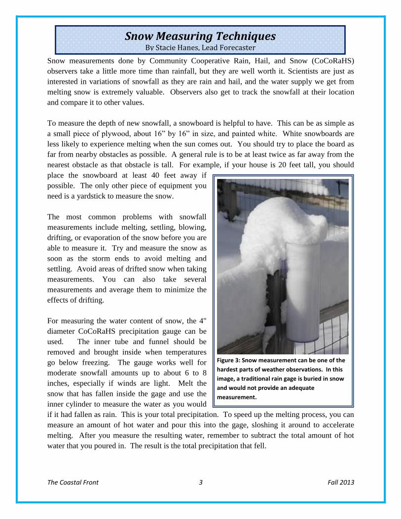
Figure 3: Snow measurement can be one of the
hardest parts of weather observations. In this
image, a traditional rain gage is buried in snow
and would not provide an adequate
measurement.

The Coastal Front 4 Fall 2013
NWS Gray Says Goodbye to Science Officer By Hendricus Lulofs, Meteorologist-In-Charge
By Stacie Hanes, Senior Forecaster
By Stacie Hanes, Lead Forecaster
Fall Weather Review
By Chris Kimble, Forecaster
By Stacie Hanes, Senior Forecaster
By Stacie Hanes, Lead Forecaster
Dan St. Jean recently left the National Weather Service (NWS) Office in Gray to accept a
position working for another NOAA office, the National Environmental Satellite Data and
Information Service (NESDIS). Dan has been at the Gray office serving as Science and
Operations Officer (SOO) since 2004 and has been employed by the NWS for 20 years.
At each of the NWS Offices there is a SOO who is responsible for working with the staff to
ensure proficiency in the latest meteorological techniques and scientific developments. In
addition the SOO evaluates new research and sees how this can be used to improve operational
forecasting. The SOO also works with local universities and colleges on collaborative research
initiatives. While the minimum educational requirement for this position is a Bachelor of
Science in Atmospheric Science, most SOO’s hold advanced degrees all the way up to PhD.
Dan’s new title at NESDIS is that of Physical Scientist bringing meteorological expertise to the
newly-formed Office of Systems Architecture and Advance Planning in Silver Spring, MD. One
of the primary areas of work for Dan (and the team he will be working with) is to determine the
answer to the question, "What will NOAA need for satellite weather observations in the next 10
to 15 years?" Some examples would be temperature and wind data for input into NWS weather
prediction models and improved imagery for real-time use by operational forecasters. He will
also be involved in determining the needs and plans of NOAA's private sector and international
partners -- with whom we will continue to share satellite weather data.
The first part of fall continued the cool trend which had existed for much of the last half of the
summer. This was particularly noticeable on low temperatures which frequently dropped into
the 40s. Heavy rain events on September 2nd
and 12th
-13th
helped make the month well above
normal for rainfall. Despite the cool September, October reversed course and recorded
significantly above normal temperatures along with dry conditions. Freezing temperatures were
not observed in Portland until October 25 which is about two and a half weeks later than normal.
The warm, dry stretch continued through the first few days of November, before a shift to colder
temperatures began. The colder weather continued through the end of the month with only a
brief period of warm up in the middle of the month. The first snow of the season fell just before
Thanksgiving, as the first significant coastal storm of the season brought snow then heavy rain to
the region. Much of
the last week of the
month was spent below
freezing.
HIGH LOW AVE PRECIP SNOW
September 70.3 (+0.3) 49.2 (-1.1) 59.8 (-0.3) 6.72 (+3.03) 0
October 61.3 (+2.6) 40.7 (+1.8) 51.0 (+2.2) 1.08 (-3.79) 0 (-T)
November 46.4 (-1.6) 28.5 (-2.4) 37.5 (-1.9) 3.41 (-1.52) 0.5 (-1.4)
Fall 2013 59.4 (+0.5) 39.5 (-0.5) 49.4 (0.0) 11.21 (-2.28) 0.5 (-1.4)
Table 1: Fall 2013 climate statistics for Portland.
The Coastal Front 5 Fall 2013
Like us on Facebook!
www.facebook.com/US.NationalWeatherService.Gray.gov
For questions, comments, or suggestions contact us at
Photo by John Jensenius
Photo by John Jensenius