Embed Size (px)
Citation preview

Laboratory for Analytic Sciences
U.S. RepresentativeDavid Price
NCSU Data Science Initiative (DSI)
NCSU College of Engineering
NCSU College of Design
NCSU Transportation
NCSU OIT Security
NCSU Science of Security Lablet
NCSU College of Management
NCSU Institute for Advanced Analytics
NCSU College of Humanities and Social Sciences
The City of Raleigh
Beyond Traffic: The Smart City Challenge
The SmartRaleigh Plan
SmartRaleigh i
VISION NARRATIVE
Table of Contents
Executive Summary 1
1.0 The City of Raleigh’s vision 2
2.0 Population characteristics of Raleigh 7
3.0 Other characteristics of Raleigh 8
4.0 Annotated Preliminary Site Map 9
5.0 Vision Elements
1. Urban Automation 11
2. Connected Vehicles 12
3. Intelligent, Sensor-Based Infrastructure 13
4. Urban Analytics 15
5. User-Focused Mobility Services and Choices 18
6. Urban Delivery and Logistics 19
7. Strategic Business Models and Partnering Opportunities 20
8. Smart Grid, Roadway Electrification, and Electric Vehicles 20
9. Connected, Involved Citizens 21
10. Architecture and Standards 21
11. Information and Communications Technology 21
12. Smart Land Use 23
6.0 Key technical, policy, and institutional risks and plans to mitigate 24
7.0 Team partners, key stakeholders, and demonstration governance processes 24
8.0 Existing transportation infrastructure and system features 26
9.0 Data currently collected 26
10.0 Use of existing standards, architectures, and certification processes 28
11.0 Measurable goals and objectives for your vision 29
12.0 Evidence to take on a project of this magnitude 30
13.0 Opportunities to leverage Federal resources 30
Letters of Commitment
US Representative David Price 32
ABB Group 34
Cisco Systems 35
GoTriangle 36
Greater Raleigh Chamber of Commerce 37
IBM 38
Laboratory for Analytic Sciences 39
NC Department of Transportation 40
NC Sustainable Energy Association 41
NetApp 42
Red Hat, Inc. 43
Regional Transportation Alliance 44
Research Triangle Cleantech Cluster 45
SAS Institute 46
Technicon Design Corp 47
TransLoc, Inc. 48
Triangle J Council of Governments 49
SmartRaleigh 1
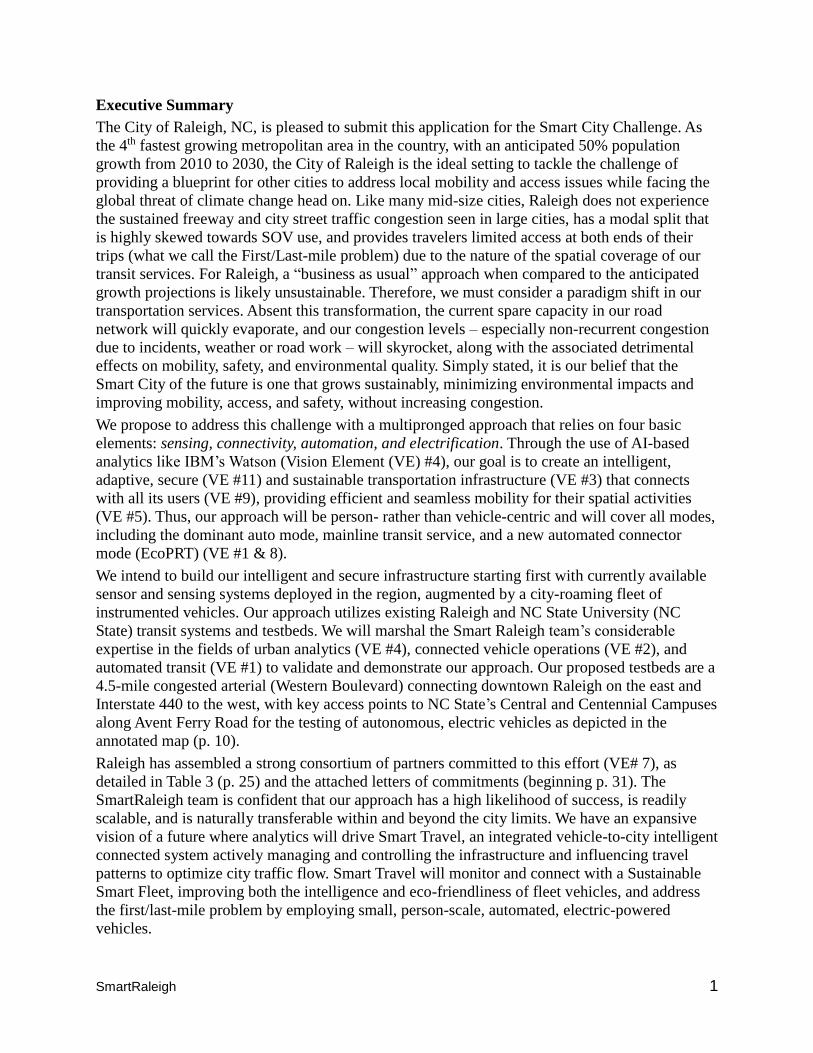
Executive Summary
The City of Raleigh, NC, is pleased to submit this application for the Smart City Challenge. As
the 4th fastest growing metropolitan area in the country, with an anticipated 50% population
growth from 2010 to 2030, the City of Raleigh is the ideal setting to tackle the challenge of
providing a blueprint for other cities to address local mobility and access issues while facing the
global threat of climate change head on. Like many mid-size cities, Raleigh does not experience
the sustained freeway and city street traffic congestion seen in large cities, has a modal split that
is highly skewed towards SOV use, and provides travelers limited access at both ends of their
trips (what we call the First/Last-mile problem) due to the nature of the spatial coverage of our
transit services. For Raleigh, a “business as usual” approach when compared to the anticipated
growth projections is likely unsustainable. Therefore, we must consider a paradigm shift in our
transportation services. Absent this transformation, the current spare capacity in our road
network will quickly evaporate, and our congestion levels – especially non-recurrent congestion
due to incidents, weather or road work – will skyrocket, along with the associated detrimental
effects on mobility, safety, and environmental quality. Simply stated, it is our belief that the
Smart City of the future is one that grows sustainably, minimizing environmental impacts and
improving mobility, access, and safety, without increasing congestion.
We propose to address this challenge with a multipronged approach that relies on four basic
elements: sensing, connectivity, automation, and electrification. Through the use of AI-based
analytics like IBM’s Watson (Vision Element (VE) #4), our goal is to create an intelligent,
adaptive, secure (VE #11) and sustainable transportation infrastructure (VE #3) that connects
with all its users (VE #9), providing efficient and seamless mobility for their spatial activities
(VE #5). Thus, our approach will be person- rather than vehicle-centric and will cover all modes,
including the dominant auto mode, mainline transit service, and a new automated connector
mode (EcoPRT) (VE #1 & 8).
We intend to build our intelligent and secure infrastructure starting first with currently available
sensor and sensing systems deployed in the region, augmented by a city-roaming fleet of
instrumented vehicles. Our approach utilizes existing Raleigh and NC State University (NC
State) transit systems and testbeds. We will marshal the Smart Raleigh team’s considerable
expertise in the fields of urban analytics (VE #4), connected vehicle operations (VE #2), and
automated transit (VE #1) to validate and demonstrate our approach. Our proposed testbeds are a
4.5-mile congested arterial (Western Boulevard) connecting downtown Raleigh on the east and
Interstate 440 to the west, with key access points to NC State’s Central and Centennial Campuses
along Avent Ferry Road for the testing of autonomous, electric vehicles as depicted in the
annotated map (p. 10).
Raleigh has assembled a strong consortium of partners committed to this effort (VE# 7), as
detailed in Table 3 (p. 25) and the attached letters of commitments (beginning p. 31). The
SmartRaleigh team is confident that our approach has a high likelihood of success, is readily
scalable, and is naturally transferable within and beyond the city limits. We have an expansive
vision of a future where analytics will drive Smart Travel, an integrated vehicle-to-city intelligent
connected system actively managing and controlling the infrastructure and influencing travel
patterns to optimize city traffic flow. Smart Travel will monitor and connect with a Sustainable
Smart Fleet, improving both the intelligence and eco-friendliness of fleet vehicles, and address
the first/last-mile problem by employing small, person-scale, automated, electric-powered
vehicles.
SmartRaleigh 2
1.0 Define your vision for your Smart City
Vision Statement: To establish a sustainable transportation system, enabled by information from
a fully integrated spectrum of computing, communications, sensor, and green technologies, to
increase traveler safety, reduce congestion, reduce fuel use and greenhouse gas (GHG)
emissions, and increase inter- and intra-mobility choices, while supporting the economic and
social goals of Raleigh.
Goal: To create an intelligent, adaptive, scalable, and sustainable transportation infrastructure
that connects with all its users, providing efficient and seamless mobility for their spatial
activities and achieving improved air quality in Raleigh.
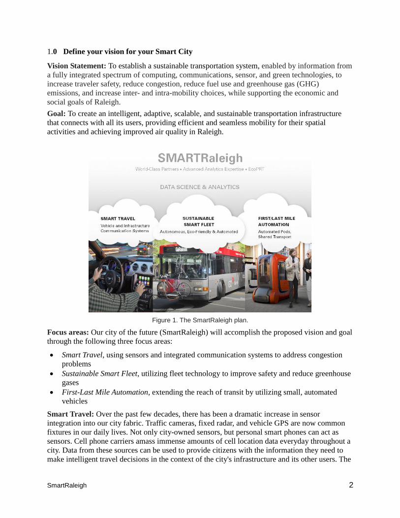
Figure 1. The SmartRaleigh plan.
Focus areas: Our city of the future (SmartRaleigh) will accomplish the proposed vision and goal
through the following three focus areas:
Smart Travel, using sensors and integrated communication systems to address congestion
problems
Sustainable Smart Fleet, utilizing fleet technology to improve safety and reduce greenhouse
gases
First-Last Mile Automation, extending the reach of transit by utilizing small, automated
vehicles
Smart Travel: Over the past few decades, there has been a dramatic increase in sensor
integration into our city fabric. Traffic cameras, fixed radar, and vehicle GPS are now common
fixtures in our daily lives. Not only city-owned sensors, but personal smart phones can act as
sensors. Cell phone carriers amass immense amounts of cell location data everyday throughout a
city. Data from these sources can be used to provide citizens with the information they need to
make intelligent travel decisions in the context of the city's infrastructure and its other users. The
SmartRaleigh 3
global knowledge and control available to travelers will enable them to dynamically calculate the
optimal travel modes and routes in the city, in real time, so that everyone gets the optimal travel
experience possible. For vehicles currently equipped with V2I technology, suites of sensors can
communicate traffic conditions and extract vehicle locations. Data rich vehicles’ transportation
system sensors and user information can be collected and analyzed by means of a connected and
intelligent system that reduces congestion and provides Raleigh with implementable options to
improve its environment. Also, by gathering planning data from many users, SmartRaleigh can
predict future congestion points and adjust recommendations accordingly.
As a demonstration, we will create a pilot connecting SmartRaleigh to available sensor and
database infrastructure for a segment of the city (See annotated map on page 10). Using Avent
Ferry Road and Western Boulevard as demonstration sites, roadside and vehicle-based sensors,
roadside equipment, vehicle probes, cameras, message signs, and other devices will be installed
to feed into an analytics database, which will in turn communicate back to users through cell
phones/dashboard displays. We will also fill in gaps of Raleigh's current suite of city-wide
sensors (see annotated map) by deploying a set of modular smart nodes, in-car sensors, cell
phones distributed over the city to create an integrated view of traffic flow and detect accidents,
dangerous weather events, and other roadway hazards. Using the above approach, we will:
Evaluate an integrated sensor-based analytics approach that will monitor and collect real-time
data sets providing live actionable feedback to affect transportation flow
Develop framework and associate user interfaces (e.g., web, cell phone apps)
Test and evaluate varying V2I or V2V communication approaches to support incident
detection, congestion monitoring, and congestion flow maps for the general public.
Facilitate traffic flows via smart signage, dynamic illuminated guide ways, traffic cams,
social media data, and mobile devices to ease congested bottlenecks as well as saving energy.
Sustainable Smart Fleet: We recognize the importance of continued efforts to integrate
renewable energy and create opportunities for smart grid technologies, as referenced in the City
of Raleigh Renewable Energy Overview (CORREO), prepared in partnership with the NC
Sustainable Energy Association. We have already created targets for City fleet transformation,
and other targets have been identified in our Fuel and Fleet Transformation Plan, Climate Energy
Action Plan, and our City of Raleigh Strategic Plan1. We also recognize the great benefit of tying
together the growing need for efficient, sustainable transportation options with new Smart City
technologies and smart grid applications to answer some of the challenges caused by rapid
population growth, pollution (GHG emissions), and stressors such as extreme weather events. In
fact, we have a roadmap to convert fleet vehicles to CNG and electric power. There will even be
a conversion station in Raleigh that converts locally captured methane to CNG.
Raleigh would welcome the integration of USDOT’s partner Mobileye’s Mobileye Shield+™
technology to our bus fleet, improving pedestrian and bicycle safety. Of particular interest in this
technology is the ability not only to detect potential safety situations and apply that to
infrastructure improvements, but also examine the possibility of collecting bicycle, pedestrian,
and vehicle counts for city planning purposes.
1City of Raleigh, Fuel and Fleet Transformation Plan, 2015; City of Raleigh, A Roadmap to Raleigh’s
Energy Future, 2012
SmartRaleigh 4
In specific, we propose to:
Evaluate converting Raleigh’s growing bus fleet to electric or compressed natural gas fuels
Add MobilEye Shield+ to Raleigh’s bus fleet for collision warning features
Collect sensor data to provide pedestrian/bicycle/vehicle counts and integrate with
SmartRaleigh
Test and evaluate fast charging schemes, including charge-as-you-go infrastructure for
mobile electric vehicle charging
Assess how long-term strategies can benefit from emerging new technologies, such as
autonomous vehicle components, smart visual films, advanced self-powered sensors (NC
State’s ASSIST Center), and augmented reality
Additionally, in conjunction with researchers from NC State and industry partners, Raleigh and
NC State will demonstrate an autonomous bus serving Centennial Campus. By retrofitting self-
driving technology, the bus will navigate autonomously from bus stop to bus stop, picking up
passengers and dropping them off without human intervention. As part of the demonstration
corridor, we will provide the opportunity to evaluate effectiveness of corridor management with
an autonomous transit vehicle. Furthermore, stops at Centennial Campus will be coordinated
with stops for the EcoPRT system to demonstrate the effectiveness of the last-mile solution for a
full end-to-end autonomous connector, as described below.
First/Last-Mile Automation: Raleigh, NC State, and industry partners will design, implement,
and test a completely new and cost-effective solution to the first and last-mile problem. NC State
researchers have conceptualized a new transportation modality, EcoPRT, to fill the corridor.
EcoPRTs are light-weight, electric, automated vehicles serving as a low-cost, fast, first-last mile
connectors with significantly reduced environmental impact compared to any other transit
modality in current wide-scale use. Conversations with a number of key stakeholders in the
Research Triangle Park area have revealed significant interest for such a low-cost system at
many sites. We propose to:
Demonstrate small, autonomous vehicles using Centennial Campus as a testbed and evaluate
the overall system for privacy, security, reliability, and cyber mechanisms
Use a test bed to validate low-impact, last mile electric vehicle solutions via a mobile
circulator: the “Mobile Oval”. Such a test bed could be part of a Centennial Campus vision
project for advanced transportation (Note that this is within Raleigh’s city limits)
Use the “Mobile Oval” as a test track for a host of technologies as part of NC State’s campus
“Proving Ground.” Technologies to be evaluated would include inductive charging and
traction motor drivers using the latest power electronics, collision avoidance cameras,
sensors and software, and state-of-the-art cooling systems
Conduct passenger studies by using the test bed to traverse between buildings. Passengers
can provide input regarding experiences and suggested changes. Data from these social
networking engagements will be assessed via analytic engines
Test and evaluate additional elements of automation, including recharging, obstacle
detection, safety, and reliability
All of these specific demonstrations provide the testing platform and eventual foundation for the
full vision of a SmartRaleigh. The results will be brought to scale to match growth in technology,
such as connected and driverless cars.
SmartRaleigh 5
Why us, Why now? Raleigh is the 4th fastest growing city in the US and, while it does not
experience the sustained traffic congestion of an Atlanta or a Washington, DC, transportation
demand will quickly outstrip capacity if the status quo is maintained. It is our belief that a smart
city is one that grows sustainably without increasing congestion, while minimizing
environmental impact. Using emerging technology, such as autonomous and connected cars and
on-demand electric fleets, can have dramatic effects on our mobility solutions. While significant
adoption of driverless vehicles could be 10 to 20 years out, SmartRaleigh plans to play a
proactive role in testing and demonstrating future technologies that can effectively manage (and
reduce) our traffic congestion, increase traveler safety, and enhance air quality, even with the
anticipated 50% population growth in our city from 2010 to 2030. Raleigh’s 2014 population of
439,896 is a 59% increase from 2000 and a 9% increase from 2010.
Driven by the challenges of rapid growth and associated traffic congestion mentioned above,
Wake County is planning for a half-cent sales tax referendum in November 2016 to support a
new county-wide transit plan with an investment of $2.4 billion over the next 10 years. The plan
includes a significant increase in the number of buses, bus routes, and bus frequencies, along
with a new commuter rail system. The plan establishes a number of high-frequency bus corridors
and a commuter rail corridor. With anticipated bus capital purchases, there is a rare opportunity
to make strategic decisions with upfront investment that can have considerable long-term
benefits by reducing carbon impact and increasing safety. Among the opportunities include CNG
conversion and electrification of buses with fast charging infrastructure through a smart grid.
Further, the addition of obstacle detection technology on fleet vehicles for collision avoidance
and data collection would greatly improve safety and urban planning. In fact, Raleigh has created
targets for City fleet transformation and other strategies that have been identified in our Fuel and
Fleet Transformation Plan, Climate Energy Action Plan, and our City of Raleigh Strategic Plan.
Raleigh is also technology-ready, having been chosen as one of Google's early cities for Google
Fiber installation and already an AT&T GigaPower fiber city. Currently, there are Google and
AT&T construction sites throughout Raleigh, and both companies are partnering with Raleigh to
create novel uses of the connected city. Other factors that make Raleigh an ideal city for this
demonstration project are:
Raleigh is a partner in the open government community and strives to become a worldwide
model for an open source city through the Open Raleigh initiative
Raleigh's Capital Area Metropolitan Planning Organization (CAMPO) is a primary
stakeholder in the development and updating of the Raleigh's strategic plan
Raleigh (along with Indianapolis and Portland, OR) was chosen by the Rocky Mountain
Institute to participate in Project Get Ready, an initiative designed to help prepare for electric
vehicles
Raleigh is an active site for Uber, Zipcar, and Lyft
TransLoc, an NC State start-up head-quartered in the Triangle, has recently announced a
partnership with Uber specific to Raleigh
Raleigh's Regional Transportation Alliance is an active business coalition that provides a
strategic, action-oriented focus and a powerful, collaborative voice to advance regional
transportation solutions
The EPA’s campus in Research Triangle Park houses 15 EPA offices, including EPA's major
center for air pollution research and regulation. As the largest facility ever built by the
agency, the RTP campus covers nearly 1.2 million square feet
SmartRaleigh 6
Raleigh is highly ranked for human capital, as this area has one of the most highly educated
populations in the country, with some of the highest rates of college degrees and PhDs1.
In other words, high growth, combined with major transportation investments, uniquely situates
Raleigh as an accelerated test-bed for novel solutions to managing transportation. High growth
will allow Raleigh to test effectiveness of proposed “smart city” approaches more quickly by
stress-testing the system. With the Wake County Transit Plan2 in full swing, our proposal aims to
look at solutions that augment and facilitate our vision with novel solutions.
Strong partnership base with emphasis on analytics - A natural partner of Raleigh is NC State
University (NC State), located within the heart of the city. For instance, we will partner with NC
State to assess and demonstrate autonomous systems. NC State’s EcoPRT initiative focuses on
small, lightweight electric cars that can run on traditional roadways at grade or on new elevated
guideways, and whose price point is significantly lower than traditional roads and other PRT
systems. EcoPRT will further serve as a proving ground for additional elements of automation.
NC State is also a nationally recognized hub of excellence in data science and analytics and is
home to several core facilities and resources related to analytics (e.g., Institute for Advanced
Analytics, Laboratory of Analytic Sciences, FREEDM and ASSIST NSF Engineering Research
Centers, Center for Geospatial Analytics, Institute of Next generation IT Systems, and
PowerAmerica Institute). NC State is also home to the Institute for Transportation Research and
Education (ITRE). ITRE is an inter-institutional research center which conducts surface, water,
and air transportation research and training.
Similarly, just adjacent to Raleigh is the Research Triangle Park (RTP) area, a global epicenter
and model of technological innovation. RTP houses over 200 high-tech companies and agencies -
giants such as IBM, Cisco, NetApp, EMC, GlaxoSmithKline, and the EPA. We will utilize this
pool of existing resources and expertise to establish a platform for using analytics in developing
innovative and smart solutions to the chronic problem of congestion in Raleigh. For instance, the
Research Triangle Cleantech Cluster (RTCC) is focused on accelerating the growth of the
Research Triangle Region’s cleantech economy. Partner companies include ABB, Cisco, Duke
Energy, SAS, Schneider Electric, RTI International, and the EPA.
Especially notable is the catalyzing impact of NC State’s Centennial Campus, home to over 72
industrial, government, and academic partners. It integrates academic, industry, and government
research partners to yield an award-winning model for an extremely successful collaborative
education, research, and translation environment.
We believe our paradigm of data - knowledge - action will be critical for improving our
transportation system and, in turn, ensuring our economic productivity well into the future.
Therefore, the convergence of NC State and pioneer industry partners, coupled with the strong
commitment of city leadership, makes Raleigh the hotbed of innovation required to be a smart
city.
Impact: As described above, we propose to demonstrate the foundation pieces for the smart city
of the future today. We anticipate our demonstration results will enable individuals to respond to
1 http://www.indyweek.com/news/archives/2015/10/30/raleigh-sixth-most-future-ready-city-says-american-
privately-owned-multinational-computer-technology-company 2 waketransit.com
SmartRaleigh 7
real-time data made available to them and, correspondingly, our city can react in real time to
facilitate an individual's travel. Whether using automobile, bicycle, or bus, our coordinated
ability to dynamically affect routes, speed, and traffic signals will benefit travelers by enabling
more efficient, safer, and affordable travel. Raleigh and other cities adopting our approach will
also benefit through the agglomeration of real-time data to facilitate active control of traffic
volume and mobility. Awareness of the surrounding congestion, roads incidents, etc., will be
facilitated through sensing systems at the user and infrastructure levels and the exchange of data
with connected vehicles (V2V, V2I). Shared, on-demand, autonomous vehicles can significantly
reduce the burden of car ownership and increase user mobility choices, while helping better
serve the underprivileged. Bus automation will offer the potential to significantly enhance air
quality, reduce congestion, increase user mobility, and reduce operating costs. The proposed
approaches will also impact land use planning and will be instrumental in adding strategic data in
planning for a more sustainable city and allowing decisions to be made on current information
and not 10-year-old studies.
Once implemented and proven, Raleigh can expand and other cities will readily be able to
replicate an intelligent, automated transportation solution allowing dozens of congested, carbon-
polluting cities across the US to immediately begin implementing a smart city approach.
2.0 Population characteristics of Raleigh and its alignment with USDOT’s
characteristics
As per Census 2010, Raleigh’s population was 403,892, of which 208,749 (51.7%) were females
and 195,143 (48.3%) were males. Approximately 57.5% of the population was white and 29.3%
African American. Approximately 7.2% of the population in 2010 was under five years of age,
23.1% was under 18 years of age, and 8.2% was 65 years of age or older, as compared to 6.6%,
23.9%, and 12.9%, respectively, in the state of North Carolina. The education levels of Raleigh’s
population were also better that of the state as a whole. Approximately 90% of the population
(age 25+) had a high school diploma or higher, as compared to 84.9% in NC. Raleigh’s average
annual unemployment rate of 7.3% in 2010 was lower than the rates for both North Carolina
(10.5%) and the US (9.6%). The percentage of the population (age 25+) with a bachelor’s degree
or higher was 47.5%, as compared to 27.3% in the state.
In 2010, the total land area was 142.9 square miles, which resulted in a population density of
2,826.3 people per square mile. The current population density is now over 3,000 people per
square mile. Raleigh is classified as an urban area, and its population count is based on the
number of people living within its city limits. Raleigh is part of two other important multi-
jurisdictional urban areas: the Raleigh-Cary Metropolitan Statistical Area (MSA) and the
Raleigh-Durham-Chapel Hill Combined Statistical Area (CSA).
SmartRaleigh 8
3.0 Raleigh’s other characteristics and alignment with USDOT’s characteristics
a. Existing public transportation system: Raleigh currently operates the GoRaleigh transit
system, which has an annual operating budget of $29 million. The system carries approximately
21,000 riders daily on 32 routes across Raleigh with a fleet of 98 buses. GoRaleigh maintains
partnerships with regional transit provider GoTriangle and NC State’s WolfLine transit service to
provide comprehensive transit options to Raleigh’s citizens. Wolfline has 15,000 daily riders
with 13 routes, and GoTriangle has 16 bus routes within Raleigh that serve 2,900 daily riders.
b. Environment that is conducive to demonstrating proposed strategies: Please see Section
1.0 (page 5) “Why us, Why now” for a list of factors and characteristics that uniquely position
Raleigh to demonstrate novel smart city solutions.
c. Continuity of committed leadership and capacity to carry out the demonstration
throughout the period of performance: The current Raleigh City Council took office in
December 2015 and has already given direction to City staff regarding its desire to foster and
encourage innovation. In 2015, Raleigh adopted a new strategic plan with a specific objective to
establish Raleigh as the leader in transportation innovation. This objective was accompanied by
two specific initiatives: 1) Identify and implement pilot projects to test transportation innovations
for widespread use; and 2) Examine and plan for alternative-fuel technologies for transit
services. The Smart City challenge provides Raleigh with the perfect opportunity to act on these
initiatives. Additionally, the combination of the City of Raleigh with NC State provides a wealth
of partnership opportunities (as described in Sections 1 and 7) to provide both the access to
emerging transportation technology and the manpower to advance these new ideas.
d. Commitment to integrating with the sharing economy: Raleigh has a nascent but growing
sharing economy. Our market now features ride or car-sharing companies Uber, Zipcar, and Lyft,
which have provided an additional layer to our transportation system that has complemented our
growing central business district. While not transportation-related, Raleigh has also been
working with Airbnb for the past year to develop a system of regulation that brings these short-
term rentals into line with our existing zoning and regulatory frameworks.
e. Clear commitment to making open, machine-readable data accessible, discoverable, and
usable by the public to fuel entrepreneurship and innovation: Raleigh has a long history of
open data, including an open data portal, an open data program, and an open government council
resolution (2012). Raleigh currently pursues three primary programs under the Open Raleigh
banner: an Open Data Portal, an effort to expand Internet access, and a regional broadband
network initiative. The Open Data Portal lets city residents search and browse data sets and
visualizations covering such areas as budget, building permits, and fire incidents. City employees
can access and analyze the data as well. In the near future, Raleigh plans to expand securely the
Open Data Portal, while preserving the privacy of users and data owners. Raleigh is also working
with other local governments (Cary, Durham) to make the portal a shared resource. Another
Open Raleigh program seeks to expand Internet access in underserved areas. Raleigh and its
partners are also planning to establish the North Carolina Next Generation Network, or NCNGN,
a regional project to develop high-speed broadband services. The project seeks to “create a
gigabit, fiber network to foster innovation, drive job creation, and stimulate economic growth.”
ATT and Google currently are laying massive amounts of fiber to bring gigabit speeds to homes
SmartRaleigh 9
throughout the city of Raleigh. Raleigh is also labeled as the “Open Source” city1, with Red Hat
located in downtown. In an effort to build on this culture of openness and transparency, Raleigh
is committed to carrying on these principles across the full breadth of this project.
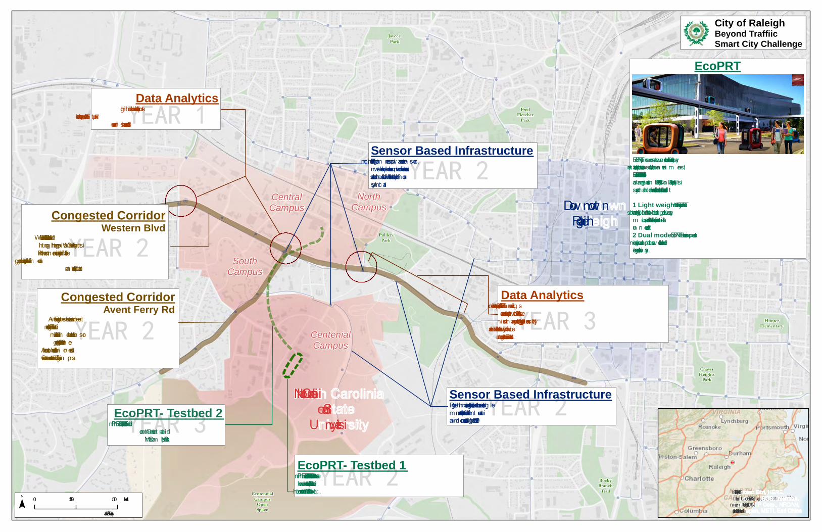
4.0 Provide an Annotated Preliminary Site Map
The following annotated map identifies the specific geographic location for the proposed
demonstration project and includes annotated notes. Western Boulevard and Avent Ferry Road
will serve as demonstration sites to determine the feasibility, effectiveness, and applicability of
Smart Travel and Sustainable Smart Fleet approaches. NC State’s Centennial Campus will serve
as the test-bed for the first/last-mile problem automation approaches. Our goal in Years 2 and 3
will be to extend EcoPRT to connect Centennial Campus and Central Campus at NC State.
Raleigh also has a robust sensor based infrastructure, comprised of traffic monitoring cameras,
microwave radar sensors, network-level probes, and micro weather stations that are augmented
by an Ethernet-based single mode redundant fiber optic network that communicates and manages
over 620 traffic control devices. Traffic counts, speed distributions, and volume readings are
currently collected on all network links. Further instrumenting our city and adding intelligent
analytics will allow Raleigh to better make both tactical and strategic transportation decisions.
1 http://raleighpublicrecord.org/news/city-council/2012/01/25/committee-passes-open-source-city-resolution/
North Carolin iaState
U n iversity
CentralCampus
NorthCampus
SouthCampus
CentenialCampus
Dow n tow nRaleig h
YEAR 2
Congested CorridorAvent Ferry Rd
Aven t Ferry Rd represen ts on e of the m ostactive tran sit corridors in our region . Thiscorridor will be in strum en ted with sen sorbased in frastructure to gain in telligen ce.
Also, an autom ated bus will be dem on stratedrun n in g a fixed route to Cen ten n ial Cam pus.
YEAR 2
Congested CorridorWestern Blvd
Western Blvd is a can didate for BRT serviceth roug h the reg ion al Wake Coun ty Tran sitPlan . In strum en tation will en able efficien cy,
safety, an d accessibility gain s across all m odesof tran sportation in this corridor
EcoPRT represen ts a n ew an d revolution ary way to thin kabout tran sportation in urban an d suburban en viron m en ts.EcoPRT starts with a foun dation that in cludes all of theadvan tages of a n orm al PRT (Person al Rapid Tran sit)system an d then adds two im portan t addition al factors.1 Light weight: Key aspects of the EcoPRTare to sh rin k an d lig hten both vehicles an d guideway asm uch as possible, both to save space an d to elim in ateun n eeded costs.2 Dual mode: EcoPRT veh icles can operateon existin g roads an d path s as well as on dedicatedelevated guideways.
YEAR 3
EcoPRT- Testbed 2In Ph ase 2, EcoPRT will be exten ded
to con n ect Cen ten n ial an dMain Cam pus at NC State
YEAR 2
Sensor Based InfrastructureTraffic m on itorin g cam eras, m icrowave radar sen sors,n etwork-level probes, an d m icro weather station sare som e of the hardware that will h elp in form our sm art city.
YEAR 1
Data AnalyticsHig h crash location data h elps to
prioritize safety as on e of the key outcom efor our sen sor based in frastructure
YEAR 3
Data AnalyticsTraffic coun ts, speed distribution s, an d volum e readin g sare curren tly collected on all n etwork lin ks. Furtherin strum en tin g our city an d addin g in telligen t an alyticswill allow the city to better m ake both tactical an dstrategic tran sportation decision s.
YEAR 2
Sensor Based InfrastructureRaleig h has an existin g robust Ethern et based sin g lem ode redun dan t fiber optic n etwork to com m un icatean d m an g e over 620 traffic con trol devices.
YEAR 2
EcoPRT- Testbed 1In Ph ase 1, EcoPRT will serve as a test bed to validatelow-im pact, last m ile electric vehicle solution s via am obile circulator: the “Mobile Oval”.
EcoPRT
CentennialCampus
OpenSpace
CarnageMiddleSchool
JayceePark
FredFletcher
Park
RockyBranch
Trail
ChavisHeights
Park
HunterElementary
PulllenPark
WalnutCreek
WetlandPark
City of RaleighBeyond TraffiicSmart City Challenge
Sources: Esri, HERE,DeLorm e, U SGS, In term ap,in crem en t P Corp., NRCAN,Esri Japan , METI, Esri Chin a
0 0.25 0.5Miles¯Jan uaury, 2016
SmartRaleigh 11
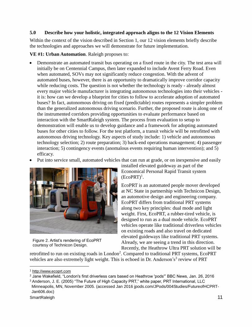
Figure 2. Artist’s rendering of EcoPRT courtesy of Technicon Design.
5.0 Describe how your holistic, integrated approach aligns to the 12 Vision Elements
Within the context of the vision described in Section 1, our 12 vision elements briefly describe
the technologies and approaches we will demonstrate for future implementation.
VE #1: Urban Automation. Raleigh proposes to:
Demonstrate an automated transit bus operating on a fixed route in the city. The test area will
initially be on Centennial Campus, then later expanded to include Avent Ferry Road. Even
when automated, SOVs may not significantly reduce congestion. With the advent of
automated buses, however, there is an opportunity to dramatically improve corridor capacity
while reducing costs. The question is not whether the technology is ready - already almost
every major vehicle manufacturer is integrating autonomous technologies into their vehicles -
it is: how can we develop a blueprint for cities to follow to accelerate adoption of automated
buses? In fact, autonomous driving on fixed (predictable) routes represents a simpler problem
than the generalized autonomous driving scenario. Further, the proposed route is along one of
the instrumented corridors providing opportunities to evaluate performance based on
interaction with the SmartRaleigh system. The process from evaluation to setup to
demonstration will enable us to develop guidance and a framework for adopting automated
buses for other cities to follow. For the test platform, a transit vehicle will be retrofitted with
autonomous driving technology. Key aspects of study include: 1) vehicle and autonomous
technology selection; 2) route preparation; 3) back-end operations management; 4) passenger
interaction; 5) contingency events (anomalous events requiring human intervention); and 5)
efficacy.
Put into service small, automated vehicles that can run at grade, or on inexpensive and easily
installed elevated guideway as part of the
Economical Personal Rapid Transit system
(EcoPRT)1.
EcoPRT is an automated people mover developed
at NC State in partnership with Technicon Design,
an automotive design and engineering company.
EcoPRT differs from traditional PRT systems
along two key principles: dual mode and light
weight. First, EcoPRT, a rubber-tired vehicle, is
designed to run as a dual mode vehicle. EcoPRT
vehicles operate like traditional driverless vehicles
on existing roads and also travel on dedicated
elevated guideways like traditional PRT systems.
Already, we are seeing a trend in this direction.
Recently, the Heathrow Ultra PRT solution will be
retrofitted to run on existing roads in London2. Compared to traditional PRT systems, EcoPRT
vehicles are also extremely light weight. This is echoed in Dr. Anderson’s3 review of PRT
1 http://www.ecoprt.com 2 Jane Wakefield, “London's first driverless cars based on Heathrow 'pods'” BBC News, Jan. 26, 2016 3 Anderson, J. E. (2005) “The Future of High Capacity PRT,” white paper, PRT International, LLC
Minneapolis, MN, November 2005. (accessed Jan 2016 jpods.com/JPods/004Studies/FutureofHCPRT-
Jan606.doc)
SmartRaleigh 12
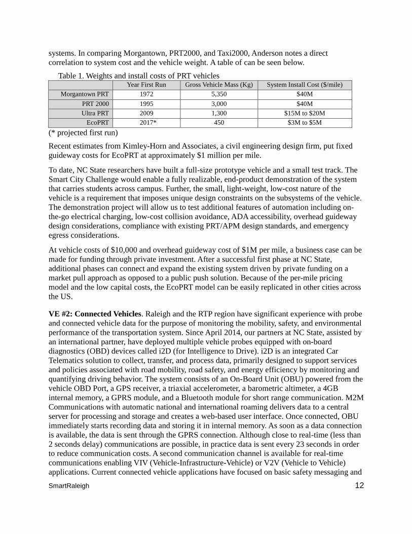
systems. In comparing Morgantown, PRT2000, and Taxi2000, Anderson notes a direct
correlation to system cost and the vehicle weight. A table of can be seen below.
Table 1. Weights and install costs of PRT vehicles Year First Run Gross Vehicle Mass (Kg) System Install Cost ($/mile)
Morgantown PRT 1972 5,350 $40M
PRT 2000 1995 3,000 $40M
Ultra PRT 2009 1,300 $15M to $20M
EcoPRT 2017* 450 $3M to $5M
(* projected first run)
Recent estimates from Kimley-Horn and Associates, a civil engineering design firm, put fixed
guideway costs for EcoPRT at approximately $1 million per mile.
To date, NC State researchers have built a full-size prototype vehicle and a small test track. The
Smart City Challenge would enable a fully realizable, end-product demonstration of the system
that carries students across campus. Further, the small, light-weight, low-cost nature of the
vehicle is a requirement that imposes unique design constraints on the subsystems of the vehicle.
The demonstration project will allow us to test additional features of automation including on-
the-go electrical charging, low-cost collision avoidance, ADA accessibility, overhead guideway
design considerations, compliance with existing PRT/APM design standards, and emergency
egress considerations.
At vehicle costs of $10,000 and overhead guideway cost of $1M per mile, a business case can be
made for funding through private investment. After a successful first phase at NC State,
additional phases can connect and expand the existing system driven by private funding on a
market pull approach as opposed to a public push solution. Because of the per-mile pricing
model and the low capital costs, the EcoPRT model can be easily replicated in other cities across
the US.
VE #2: Connected Vehicles. Raleigh and the RTP region have significant experience with probe
and connected vehicle data for the purpose of monitoring the mobility, safety, and environmental
performance of the transportation system. Since April 2014, our partners at NC State, assisted by
an international partner, have deployed multiple vehicle probes equipped with on-board
diagnostics (OBD) devices called i2D (for Intelligence to Drive). i2D is an integrated Car
Telematics solution to collect, transfer, and process data, primarily designed to support services
and policies associated with road mobility, road safety, and energy efficiency by monitoring and
quantifying driving behavior. The system consists of an On-Board Unit (OBU) powered from the
vehicle OBD Port, a GPS receiver, a triaxial accelerometer, a barometric altimeter, a 4GB
internal memory, a GPRS module, and a Bluetooth module for short range communication. M2M
Communications with automatic national and international roaming delivers data to a central
server for processing and storage and creates a web-based user interface. Once connected, OBU
immediately starts recording data and storing it in internal memory. As soon as a data connection
is available, the data is sent through the GPRS connection. Although close to real-time (less than
2 seconds delay) communications are possible, in practice data is sent every 23 seconds in order
to reduce communication costs. A second communication channel is available for real-time
communications enabling VIV (Vehicle-Infrastructure-Vehicle) or V2V (Vehicle to Vehicle)
applications. Current connected vehicle applications have focused on basic safety messaging and
SmartRaleigh 13
on queue warning in a freeway environment. A trip is the basic unit that is reported. Algorithms
calculate mobility, safety, fuel use, and emissions and are presented on a secure website to the
user in a graphical, easy to understand format.
The system has thus far logged over 30 million data entries of travel, based on the limited fleet of
i2D instrumented vehicles roaming in the Raleigh region. Our approach is to use the proposed
demonstration to expand the instrumented fleet to 1,000-2,000 i2D-equipped connected vehicle
units which will provide broad, high-resolution coverage of the Raleigh city roadway network,
with special focus on the priority congested corridor on Western Boulevard, which connects I-40
from the West and downtown Raleigh and adjoining neighborhoods to the East, and its complex
intersection with the Avent Ferry arterial road on the NC State campus. We will exploit the
collection of high-resolution dynamic data to develop predictive analytics for travel time and
other mobility metrics, crash and near incident events, and trip-based energy use and emissions.
Further analytical work will assess the utility of real-time connected vehicle information by
contrasting the performance of travelers with and without connected vehicle information
capability. A key distinguisher of our proposal is the focus on city arterials, as opposed to
freeways only. The connected vehicle data constitutes just one piece of the entire big data puzzle,
which will need to incorporate other vehicle types in the proposed Raleigh demonstration (e.g.,
Transit buses, EcoPRT, taxis, Uber, UAVs), as well as infrastructure-based sensing. The latter
includes deployed RTMS units, Blue Tooth devices, video surveillance, and third party mobility
data (HERE, INRIX, TomTom) accessible to the Raleigh team. Pieces of this integrated database
system, including i2D data, are currently being collected and are described elsewhere in the
document.
VE #3: Intelligent, Sensor-Based Infrastructure. Proliferation of sensors, actuators, and
“smart” objects in urban settings is accelerating. They range from video, photo, gas, and
magnetic sensors, to geolocation, sound, and cell and wifi detectors. Information provided is
used in a variety of applications that allow monitoring and control of day-to-day operations and
active real-time situation awareness. This may include traffic volume, traffic congestion,
visibility, air pollution, road conditions, and emergency situations. In fact, a smart phone just
affixed to a city vehicle can be a very rich source of information. For example, vibration
measurement coupled with accurate location information may be able to tell us the condition of
the road surface the vehicle is traveling on (and whether the surface may be in need of repair).
When augmented, such platforms could tell us about noise pollution, wireless spectrum
pollution, air pollution, vehicle counts, and so on. These mobile sensor platforms can provide
information complementary to what fixed sensors offer. In addition, the quality and granularity
of the sensor-collected information and the associated analytics is in many situations sufficient to
allow proactive control of some factors. For example, situation-aware control of city signaling
can translate into proactive congestion control, re-direction of traffic in the case of accidents or
maintenance work, and dispatch of emergency vehicles and crews, as well as facilitation of their
transit through city.
Framework. Sensor infrastructure and associated analytics platforms need to be engineered
correctly and be reliable, secure, credible, and trusted. In the case of video cameras and other
identity collection devices (e.g., smart cell phone counters), citizens need to be assured that their
privacy and security will not be endangered. Users need to know that the information collected is
trustworthy, safe, and secure. Only then will both the city and its citizens be comfortable with the
deployment and use of these devices. Essential to this sensor infrastructure are networks that
SmartRaleigh 14
carry the data collected from the sensors analysis applications. Such networks can range from
simple twisted-pair phone lines to fiber-optic links (such as the ones recently installed in the City
of Raleigh) to wireless channels that can range from a city-wide canopy to ad hoc WiFi
transmissions.
Our entire framework is designed to be future-ready, but useful now. We design our approaches
to fit into an overall city infrastructure so that it serves the specific advances we will make
during this demonstration project. While we do not assume the existence of specific emerging
technology during the lifetime of the project, such as very significant adoption of autonomous
cars or automated supply drones, our approach balances the present and the future. It is scalable,
and special attention is paid to its sustainability. We are also very aware of urban planning and
management, particularly transportation management, dimensions of time, space, and
transportation modes, since our initial demonstration applications will focus on transportation
applications.
At the heart of the whole operation is information and data feeding SmartRaleigh analytics and
management algorithms, dashboards and decisions (i.e., an information system that will have an
unprecedented level of intelligence and self-learning). For example, one of the components of
this system will be an IBM Watson1 solution that we will train in Smart City analytics. For many
SmartRaleigh applications, the source will be what could be called “BigData” – terabytes of data
that will need to be aggregated, fused with other sources, and managed.
In order to achieve this, we propose to extend the existing City of Raleigh sensor, actuator, and
smart-node pool, and situation analysis and management analytics environment, with real-time
(reactive and proactive), short-term, and long-term analytics solutions. Data would be collected
from a variety of sources – city-owned static and mobile sensors, vehicles in the city, regional
information systems, and national resources such as Google Maps. Weather and climate data
would come from national and local sources (including satellite derived data), and information
will be collected from specialized platforms and services that collectively may cover much of the
city roads on a daily basis, such as trash collection, city transportation, Uber and taxi services,
county school buses, and potential use of Unmanned Aerial Vehicles (UAVs).
It will be important that the data and interfaces to the data and framework platforms are usability
aware. We plan to leverage NC State’s extensive engineering knowledge and experience in the
Cloud Computing and Data Science and Analytics domain, along with the expertise our
industrial partners have – IBM, Cisco, SAS Institute, NetApp, LexusNexis, etc. – to stand-up the
SmartRaleigh framework as a flexible distributed sensor and cloud computing solution that will
host a variety of applications and tools. NC State has been operating a production-level private
cloud (called VCL) for over a decade. More recently, VCL interoperates with commercial cloud
offerings (e.g., Amazon and IBM). NC State is also in the process of developing an NC-wide
university data science and analytics cloud environment and data-bus (called iRODS). The
SmartRaleigh test platform of production quality will be developed in this context. We also
expect to bring IBM’s Watson solution into the analytics framework (see description in VE# 4 -
Urban Analytics).
1 www.ibm.com/outthink; http://www.ibm.com/smarterplanet/us/en/ibmwatson/;
http://www.ibm.com/cognitive/outthink/
SmartRaleigh 15
While non-Raleigh data sources will abound, Raleigh-based data collection is much more city
specific and, as already mentioned, will consist of sensors (static and mobile), actuators, and
smart-nodes. To complement and enhance the sensors and actuators, we will use a set of smart
nodes distributed over the city. Some of these will be fixed, mounted on either existing civil
structures, such as traffic signs, or new dedicated ones. Others will be mounted on fleet vehicles.
These nodes will embody local computer, networking, and storage capabilities. They will
provide localizing capability for mobile sensors and actuators - when a mobile node comes
within reach of a smart city node, its location will be captured even if the mobile node is not
equipped with GPS.
Smart city nodes can also serve as network connection points for sensors, obviating the need to
make every mobile node a cell client. The compute capability of these nodes forms an edge cloud
for the computing cloud that will form the back-end of the smart city intelligence and analytics.
Specific computing tasks of local importance can be distributed to these nodes dynamically.
Framework architecture will also be enhanced with novel components. For example, the newly
emerged discipline of Software-Define Networking and Software-Defined Systems will allow
seamless integration of computing and networking at many different levels (so called deep
programmability). These nodes can go anywhere on-demand to provide targeted connectivity,
localization, and computing power. NC State has considerable expertise in this space.
Future-Ready: In the future, we expect that smart city innovations will come not just from a city,
but also from private enterprise and members of the public, at various granularities. Our
infrastructure will contain application programmable interfaces, or APIs, to all its capabilities
(such as data contribution and data retrieval), thus private enterprises (say an Uber-like service)
may use the information system easily to build their own proprietary and value-added analytics.
Individual researchers and citizen-scientists may contribute specific ideas. Such ideas will be
first run in a simulation using the historical data we will amass, to check for safety and stability.
If safe, they will be integrated into our smart city on an ongoing basis. Over time, we expect that
more and more cars will become automatic, and our system of APIs will then seamlessly
integrate them into the smart city. Other parts of our architecture will also provide additional
benefit later. We can envision that our drones will be used to deliver first aid to accident
locations in advance of an ambulance. Law enforcement may use the drones to dispatch cameras
to locations where crimes are suspected to be in progress. In summary, our project will not just
create a smart-city system, but provide a public access smart-city platform, for a city that, as it
grows, grows steadily smarter.
VE #4: Urban Analytics. Urban analytics is a broad concept. It covers everything from using
data to design a city and its components, to proactively managing its functions and environments,
protecting its citizens and improving their well-being, and growing its businesses and economic
impact. For example, rapid prototyping may help decide how to deal with congestion and
pollution scenarios and where to deploy resources. Real-time models and controls can be used to
dynamically control signaling and manage traffic situations and emergencies. In the context of
this proposal, we will focus on the data and services relevant to our demonstration projects –
Western Boulevard decongestion, the last-mile access Centennial test-bed, and eco impact and
friendliness.
Open data is at the core of our SmartRaleigh vision. Our sensor infrastructure allows continuous
collection of highly relevant data, our APIs allow contribution of more data by citizen scientists,
SmartRaleigh 16
and our analytics applications utilize the data to improve citizens’ transportation experience in
our city. Several analytics applications are enabled by our data infrastructure, which allows
integration of up-to-the-minute system information and historic data. Initially, analytics will be
driven by established model and current wisdom. Over time, as historical data accumulates, the
system will become smarter, as it learns what works better and what does not. The overall goals
of the project, as we have pointed out before, are to improve transportation access, reliability,
and convenience for citizens.
To make the most effective and efficient use of buses and EcoPRT shuttles, their schedules and
routing must be adapted to those who will use them, which our analytics will do. Beyond access
itself, the phenomenon of congestion impacts the reliability and convenience of all travelers,
whether they use public transport or private, mass transit or single-person cars. A growing mid-
size city like Raleigh suffers from intermittent and unpredictable peak congestion. Experience in
urban development repeatedly shows that, with growth, this develops into consistent congestion
that spreads over time and space. In keeping with our goal of evolving into a smarter city that
pioneers a model for sustainable growth, we will use analytics to ameliorate congestion. We
propose to approach the analytic problem – what to analyze, to what extent, and how to use the
results (in real time, or asynchronously) in two distinct ways.
On one hand, we will use classical analytics engines and approaches. A good deal of theory has
been developed showing that it is possible to ameliorate congestion using analytics1, and many
tools are already available. Some may be more general packages such as GIS software, SAS,
SPSS and R which we would use to display and develop new algorithms and solutions. This
environment would be complemented with mobile apps that would bring into our echo system
not only static, city, and NC DOT-provided sensors, but also dynamically collected information
emanating from participants in cars, pedestrian smartphones, and possibly special UAV flights.
We expect that the amount of raw information will be huge. Full use of that information,
particularly when scaling, will require an additional component – cognition. “Cognitive services
allow apps to learn, reason, and consider context. The more data that one feeds to an app, the
smarter it gets.2” IBM, one of our partners in this project, will provide access to the IBM Watson
platforms and tools. NC State has considerable experience with artificial intelligence “big data”
analytics in a number of domains, and we intend to apply that knowledge and skills to develop
Watson-assisted SmartRaleigh components. We plan to train Watson in reactive and proactive
congestion management and eco assessment. Of course, the plan is to operate both the “classical”
data-driven congestion control mechanisms and the cognition-based solution. The goal is to not
1 Examples include:
K. Barry, The Traffic Lights of Tomorrow will Actively Manage Congestion, CityLab, Sept 11, 2014,
http://www.citylab.com/commute/2014/09/the-traffic-lights-of-tomorrow-will-actively-manage-
congestion/379950/
http://www.cts.virginia.edu/wp-content/uploads/2014/05/Task4._SystemDesign_3_Revised_v.2.pdf Multi-
Modal Intelligent Traffic Signal System (MMITSS)
http://dusp.mit.edu/transportation/project/data-analytics-urban-transportation
Sundar, R., Hebbar, S., Golla, V., Implementing Intelligent Traffic Control System for Congestion Control,
Ambulance Clearance, and Stolen Vehicle Detection, Sensors Journal, IEEE 15(2):1109-1113, 2014.
P. Hemmerle, M. Koller, H. Rehborn, B.S. Kerner, M. Schreckenberg, Fuel consumption in empirical
synchronised flow in urban traffic, IET Intelligent Transport Systems, p8, July 2015 2 http://www.ibm.com/cloud-computing/bluemix/solutions/watson/
SmartRaleigh 17
only understand and control a typical set of city road and other data sets, but also to develop an
intelligent, Watson-based advisor that can enhance decision-making processes by tracking that
information and offering insights we otherwise may not have. While we do not expect to have
Watson control traffic in real-time, the learning aspect of our analytics approach will be most
beneficial. Simply by estimating congestion in the immediate future along various corridors and
providing this information to individuals who are approaching them, or are predicted to approach
them from their driving habits, a good deal of benefit can potentially be obtained.
This strategy is also in line with our focus on people rather than traffic. Further, network models
of roadways can be utilized to provide drivers with alternate route suggestions. Google Maps
already performs most of these functions, but in a city-operated smart system, data is much more
comprehensive and such information can be used to manipulate smart speed limits and traffic
lights in areas leading up to congested corridors. We must be somewhat cautious about applying
such analytics methods, because it has been shown that in some cases such traffic manipulation
(whether by people acting individually or by a coordinated system) can lead to worse rather than
better situations. This is where the learning aspect of our analytics approach will be most
beneficial, and our pilot demonstration projects will provide valuable learning. We will learn
what strategies contribute to what impact on the targeted congestion and people’s commute
experience; for example, whether (or what fraction) of individuals modify their routes upon
receiving congestion information and whether they use suggested routes. This will be an ongoing
process; as motorist behavior changes due to advancing technology or acceptance of alternate
modalities, our smart system will continuously learn the new behaviors. Such changes may be
significant - for example, with the introduction of automatic cars, commuters may well become
more tolerant of a moderate increase in transit time. Thus over time, the system will seamlessly
start improving not just reliability, but convenience and ease of access. There are many other
urban analytics uses that will be enabled by the same system of accumulated historical data,
detailed models, and smart algorithms. Examples include "what-if" simulations for large
projected changes, such as highway construction, new residence construction, or rezoning.
Notably, validation of our overall concept will also be a job of analytics, helping us answer
questions like: “Did air quality improve? Can it be attributed to EcoPRT?” or “Did availability
(access) and reliability (predictability of transit times) improve for underprivileged citizens?”
Another crucial part of such an “introspective” use of the analytics system will be to ensure that
it fails safely - the analytics system can detect its own malfunctions by noting “impossible”
events (defined a priori, e.g., a car cannot be traveling along a roadway in excess of 100 miles
per hour), and reducing trust in corresponding data, or conclusions derived thereof.
For example, data analytics will be used to:
Predict the impact on roads, highways and public transit networks caused by congestion,
planned road-works, or transit maintenance projects, and recommend the optimum change in
transit schedules and communication strategy to deal with the impact
Detect and predict the likely occurrence of everyday unplanned service incidents such as a
traffic accident or vehicle breakdown, and recommend optimum responses
Pinpoint everyday events, such as late-arriving buses, bus breakdowns, or signal outages that
have the highest economic impact/cost to a transit agency and recommend ways to eliminate
the events or mitigate the economic impact
Examine the impact of a major commercial or residential development to take into account
the relationships between transit usage and other relevant factors such as demographics,
SmartRaleigh 18
geospatial data (e.g., number of licensed restaurants and other establishments), and
commerce/residential activities
Model and predict the effect of planned expansion of transportation networks with clear
understanding of the patterns of usage and the impact of land use and development decisions
Examine major events such as the NC State Fair to determine specifically where and when
services should be adjusted or supplemented to better accommodate visitors and avoid
congestion due to additional cars on the road
VE #5: User-Focused Mobility Services and Choices. Individually owned automobiles can be
very expensive to citizens (cost of car, maintenance, insurance, parking, etc., estimated at an
average cost of $8,600 per car per year), businesses (cost of parking and access) and the city
(cost and land consumption of roadways, parking, pollution, runoff, etc.). Yet, at least in
relatively low density population areas, they are currently the only option. To many, automobiles
provide a sense of independence, timely on-demand transportation, and security. Therefore,
assuming that the ultimate goal of a smart city is to provide alternatives to personal automobile
ownership, we need to provide mobility options that compare favorably to these qualities of
timeliness, security and independence. Our proposal addresses these needs in two ways, with: 1)
SmartTravel and 2) EcoPRT.
1) SmartTravel: SmartRaleigh provides the mobility-enabling analytics for the city. SmartTravel
provides citizens with the information they need to make intelligent travel decisions in the
context of the city’s infrastructure and its users. Imagine this scenario. A citizen tells SmartTravel
that she wants to travel from Downtown Raleigh to NC State University. Like Google maps on
steroids, SmartTravel understands every travel option available to her, along with the cost, time
and environmental impact of each. SmartTravel knows that she could ride a bike, take a bus, hail
a cab, request an Uber, or take her personal automobile. SmartTravel presents all of these options
to her, along with its recommendation: given current traffic conditions, available time, and costs
of the different modes, taking the bus is the best option. SmartTravel is discreet and very mindful
of the person’s privacy, security and safety. Her trip data will be kept confidential, but will help
in overall analysis of the city traffic profile. Now, SmartRaleigh takes her travel intention and
confidentially combines it with the intentions of tens of thousands of other citizens. What if
thousands of people are, for some reason, all intending to travel to the university right now?
Then SmartRaleigh may dynamically route more transit buses or feed that knowledge into car
sharing companies like Uber or recommend a ride sharing arrangement.
The global knowledge and control available to SmartRaleigh make it possible to solve global
optimization problems, for example, dynamically calculate the optimal travel modes and routes
for everyone in the city, in real time. Therefore, everyone gets the optimal travel experience
possible. Participation from many users improves overall prediction of the system.
2) EcoPRT: With the introduction of EcoPRT, an alternative to the traditional mobility choices is
presented. Small, autonomous, on-demand, electric vehicles provide convenient, confidential and
personal point-to-point transit for the last mile.
As one example, imagine a typical commuter in downtown Raleigh or RTP today. During rush
hour, buses, cars, and taxis share the same road and therefore are all affected by congestion. The
most significant transit need in any growing city is an inexpensive way to add transit capacity.
Raleigh will therefore demonstrate a new low-cost transit modality called EcoPRT. EcoPRT will
allow the city to easily and inexpensively add new transit capacity in the form of lightweight,
SmartRaleigh 19
narrow, and, where necessary, elevated EcoPRT guideways. The connection between NC State
University’s Central and Centennial Campuses offers a simple example of the problem and
solution. Currently, this corridor is highly congested during peak periods because not only are
commuters driving through the university, but also students and staff themselves are shuttling
across the 34,000 student university. There is no room to add additional lanes in the tight urban
area, nor is it cost effective. Adding an EcoPRT guideway would be a simple solution that could
easily and inexpensively create significant new capacity in the corridor. Now that the new
capacity exists, how can people utilize it? The SmartRaleigh information service will show
Raleigh commuters all of the available transit modalities, the respective travel times of each, and
the environmental impact. The hope is that as the EcoPRT system and other travel options
expand, more and more trips will switch away from cars, until citizens can see a natural path to
eliminating car ownership.
Traditionally, suburban neighborhoods have had little uptake on public transit because transit
stops were too far away to effectively serve the population. As a further pain point, the disabled,
the young, the elderly, and the underprivileged may not have access to a private automobile. As
an alternative, EcoPRT’s small, on-demand, electric, autonomous vehicles could provide an
inexpensive circulator solution within a neighborhood with a connection point at a transit stop.
Individuals could simply call up a vehicle to their house through the cell phone. The vehicles
could pick up one or more people and bring them to the transit stop. As a public transit enabler,
EcoPRT could bring transit to the doorstep of those who do not have reliable access to the private
automobile and at the same time increase adoption of sustainable transit.
VE #6: Urban Delivery and Logistics. While this is not a key component of SmartRaleigh, NC
State has considerable expertise in logistics analysis. Dr. George List (Civil Engineering) has
authored works such as the “The Statewide Logistics Plan,” which aims to “address the State’s
long term economic, mobility, and infrastructure”1. Additional work from ITRE examines
logistics villages as a means for economic development2.
The cost of delivery within a city can be affected by congestion and the inability to park in front
of buildings. Some cities like Boston have contemplated separate traffic lanes for trucks and
automobiles to minimize interference. As previously mentioned, the proposed SmartRaleigh
solution facilitates coordinated movement of vehicles on the road network without the need for
separated lanes. With the ability for logistics companies like UPS and Fedex to interface into
SmartRaleigh, their delivery vehicles could also benefit by optimizing their route to minimize
cost and time.
Intra-city courier services fill a need for on-demand product delivery within a city. Costs can be
relatively high, which provides opportunities for companies like Uber to enter the market with
their shared driver model. One step further, driverless vehicle systems such as EcoPRT could be
leveraged to move not just people but also shipments, creating the foundation for a low-cost
1 George List, PhD, PE, “Statewide Logistics Plan for North Carolina,” North Carolina Office of State
Budget and Management, 2008. 2 Robert Foyle, P.E., “An Investigation of Economic Development in North Carolina through Logistics
Villages,” ITRE, Final Report, Dec. 2011.
SmartRaleigh 20
automated delivery system. Research in NC State’s Industrial Engineering Department is
investigating home delivery logistics using driverless delivery vehicles1.
VE #7: Strategic Business Models and Partnering Opportunities. Raleigh's vision
necessitates the careful orchestration of many leading-edge sub-systems into a cohesive,
innovative, and holistic system. This will require a coalition of numerous multi-disciplined and
innovative entities, with strong visionary leadership. With this in mind, Raleigh is partnering
with NC State to co-lead the Smart City effort via a cooperative agreement and governance
structure to leverage the extensive resources of each. NC State, the flagship university of the 17-
campus UNC System, with 34,000 students, and the 4th largest Engineering College in the US, is
uniquely positioned with its award winning Centennial “Partnership” Campus with extensive
industrial and federal relationships into the mix. It is also one of three Research One universities
(Duke, NC State, and UNC) that comprise the Research Triangle.
Additionally, Raleigh will strategically engage partners to integrate critical technology and
solution elements into the proposed holistic approach. Most of the partners reside in this region’s
high tech corridor and RTP and are in close proximity to facilitate efficient engagement. Another
part of the strategy will be to “pair” these external partners with Raleigh operational units (e.g.,
EMS, Transit, Traffic, IT) and NC State (e.g., Centers, Institutes, Labs, IT). In this respect, the
network of partners will be aligned with the work-scope elements to achieve the functional
objectives. Note that many of these partners have demonstrated a willingness to participate via
support letters. This collaborative structure will bring together a strong coalition of triple helix
partners from industry, other government units, and academia. An executive advisory board
representing the City, University, and principal partners will also be included as part of the
governance model.
The point-of-contact for Raleigh is Eric Lamb, Manager of Transportation Planning, reporting to
Planning Director Ken Bowers. For NC State, the point-of-contact is Dennis Kekas, Associate
Vice Chancellor of Partnerships and Economic Development, reporting to Alan Rebar, the Vice
Chancellor for Research, Innovation, and Economic Development.
VE #8: Smart Grid, Roadway Electrification, and Electric Vehicles. The demonstration
approach to achieve smart grid roadway electrification, including electric vehicles, will be
comprised of two main thrusts. One will focus on rapid dynamic vehicle charging and other
strategies for both large electric vehicles like buses/trucks, and the other on small electric last-
mile pod cars. Both will involve instrumented test beds located on NC State’s Centennial
Campus “proving ground” to leverage a smart DC micro grid planned to be located on Main
Campus Drive of the Centennial Campus in the near future, connecting the NC State-led NSF
FREEDM (smart grid) Systems Center to ABB’s Smart Grid Demonstration Center. This
cooperative effort includes FREEDM, the University Smart Grid Council, RTP Clean Tech
Cluster and campus tenants such as ABB. The DOE/NC State PowerAmerica National
Manufacturing Innovation Institute is also involved in commercializing extraordinarily efficient
wide-band-gap power-electronics to efficiently drive electric motors and connect renewable
sources (wind, solar) to the grid. The NC State-led NSF ASSIST center is focused on self-
powered sensors for many smart applications (medical uses, vehicles, etc.). These leading-edge
resources will facilitate assessment of solution elements for smart city deployment.
1 Michael Kay, “Design and Control of Home Delivery Logistics Networks,” Industrial Engineering
Colloquium at Penn. State, 2015.
SmartRaleigh 21
The test beds will be two-fold and evolutionary, with an objective of tech transfer to spur early
mass adoption. A last mile “Oval Mobile” EcoPRT circulator will be implemented on the
Centennial Campus Engineering Oval. This one-mile test bed will exploit in-motion inductive
charging, V2V and V2I communications, user (students) interactions, energy efficiency, safety,
autonomous controls, etc. Telemetry data will be sent via the existing outdoor Centmesh
programmable test bed in the Centennial Campus. The second test bed will be implemented
along Main Campus Drive with High Voltage rapid charging stations at strategic locations to
assess functionality, reliability, cost structures, and other parameters. The objective would be to
evaluate emerging WBG technologies that will be much smaller, more efficient and cost
effective. These are being developed by FREEDM and PowerAmerica faculty/partners. A major
partner for this test bed will be ABB, located on Centennial Campus with over 500 employees.
VE #9: Connected, Involved Citizens. The benefits of SmartRaleigh solutions must be clear to
the citizens of Raleigh; therefore it is crucial to obtain input and feedback from Raleigh citizens
regarding user preferences, reliability, ease of use, and affordability of the proposed
SmartRaleigh solutions. In addition to hosting on-site public input meetings each quarter,
Raleigh will embrace citizen engagement by providing an online app for citizens to learn more
about the project and provide a mechanism to allow the citizens and Raleigh to have an open
conversation with city officials and planners. This tool will allow Raleigh to get feedback in an
informal way as well provide a mechanism (such as smart phones) to capture digital dialog
around the proposed demonstration project in general. It is important to note that Raleigh
currently publishes 100+ datasets from crime locations to lane closures1. Citizen feedback data
will be published on this website.
VE #10: Architecture and Standards. Development of transportation elements of the Raleigh
Smart vision will be guided by the regional ITS architecture defined in the 2010 update to the
Triangle Region Intelligent Transportation System Strategic Deployment Plan. The Capital Area
Metropolitan Planning Organization (CAMPO) was a primary stakeholder in the development
and updating of the strategic plan. The strategic plan and architecture development effort
included the identification of published ITS standards applicable to the current and planned ITS
user services. Therefore, key architecture features and ITS standards have been identified for
vision elements such as transit signal priority and ramp metering. This update occurred just prior
to the rapid upswing in interest and activity in connected and autonomous vehicles. The USDOT
ITS Joint Programs office and NHTSA are actively sponsoring and overseeing programs to
develop the necessary architecture and standards for connected and autonomous vehicles. As
described in more detail in Section 10 below, the SmartRaleigh team will play an important role
in advancing these architecture and standard development activities.
VE #11: Low-Cost, Efficient, Secure, and Resilient Information and Communications
Technology. The backbone of SmartRaleigh is a distributed infrastructure of computing and
storage capacity, connected by a high-speed network. Fortunately, much of this infrastructure
already exists in the region, and will be enhanced as needed.
Networking. The state of North Carolina, especially the Triangle area (comprising the cities of
Raleigh, Durham and Chapel Hill), was one of those to first adopt a regional optical network,
enabling an information superhighway. The North Carolina Research and Educational Network
1 (http://data.raleighnc.gov/)
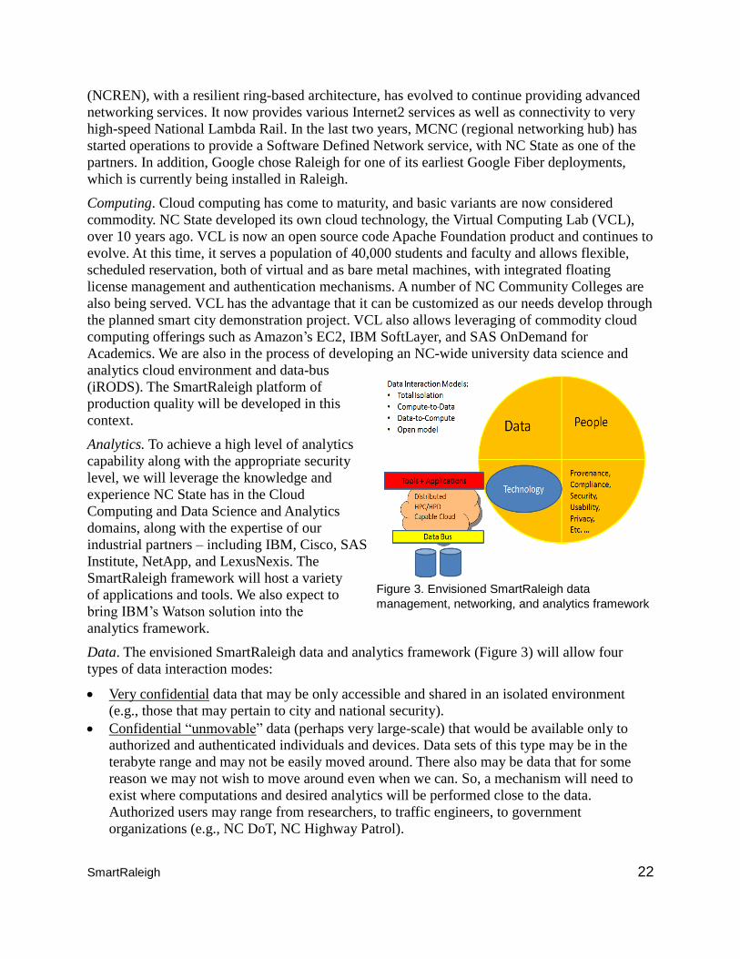
SmartRaleigh 22
(NCREN), with a resilient ring-based architecture, has evolved to continue providing advanced
networking services. It now provides various Internet2 services as well as connectivity to very
high-speed National Lambda Rail. In the last two years, MCNC (regional networking hub) has
started operations to provide a Software Defined Network service, with NC State as one of the
partners. In addition, Google chose Raleigh for one of its earliest Google Fiber deployments,
which is currently being installed in Raleigh.
Computing. Cloud computing has come to maturity, and basic variants are now considered
commodity. NC State developed its own cloud technology, the Virtual Computing Lab (VCL),
over 10 years ago. VCL is now an open source code Apache Foundation product and continues to
evolve. At this time, it serves a population of 40,000 students and faculty and allows flexible,
scheduled reservation, both of virtual and as bare metal machines, with integrated floating
license management and authentication mechanisms. A number of NC Community Colleges are
also being served. VCL has the advantage that it can be customized as our needs develop through
the planned smart city demonstration project. VCL also allows leveraging of commodity cloud
computing offerings such as Amazon’s EC2, IBM SoftLayer, and SAS OnDemand for
Academics. We are also in the process of developing an NC-wide university data science and
analytics cloud environment and data-bus
(iRODS). The SmartRaleigh platform of
production quality will be developed in this
context.
Analytics. To achieve a high level of analytics
capability along with the appropriate security
level, we will leverage the knowledge and
experience NC State has in the Cloud
Computing and Data Science and Analytics
domains, along with the expertise of our
industrial partners – including IBM, Cisco, SAS
Institute, NetApp, and LexusNexis. The
SmartRaleigh framework will host a variety
of applications and tools. We also expect to
bring IBM’s Watson solution into the
analytics framework.
Data. The envisioned SmartRaleigh data and analytics framework (Figure 3) will allow four
types of data interaction modes:
Very confidential data that may be only accessible and shared in an isolated environment
(e.g., those that may pertain to city and national security).
Confidential “unmovable” data (perhaps very large-scale) that would be available only to
authorized and authenticated individuals and devices. Data sets of this type may be in the
terabyte range and may not be easily moved around. There also may be data that for some
reason we may not wish to move around even when we can. So, a mechanism will need to
exist where computations and desired analytics will be performed close to the data.
Authorized users may range from researchers, to traffic engineers, to government
organizations (e.g., NC DoT, NC Highway Patrol).
Figure 3. Envisioned SmartRaleigh data
management, networking, and analytics framework
SmartRaleigh 23
Confidential “movable” data (often low-volume data from variety of sources; e.g., processed
road vibration data and locations that may indicate where pot-holes and road imperfections
are) that can be moved if so desired. This data would also be accessed only by authorized and
authenticated users, but could be moved to the place of computation (e.g., desktop, another
cloud).
Open data that are made available to the broader public as well as the general SmartRaleigh
community (e.g., Google Map information). Different levels of expertise and training will be
needed for the users of the data. It is important to note that in order to be reliable,
trustworthy, secure, and safe, the SmartRaleigh framework will collect provenance
information about the data sources, transactions on the data, users, and so on.
The framework will also be concerned with compliance issues (e.g., privacy and protection of
personally identifiable information) and security (e.g., some or all of the data may need to be
collected and moved over encrypted channels, and in some cases encryption at rest will be a
must).
VE #12: Smart Land Use. For many years, Raleigh has utilized a comprehensive plan to guide
the growth and development of the community. Updated in 2009, the 2030 Raleigh
Comprehensive Plan establishes a vision for the City that demonstrates a strong synthesis
between land use and transportation. Shortly after that update was completed, Raleigh embarked
on developing a Unified Development Ordinance (UDO) that provides the tools for new
development to build at a more urban scale. While Raleigh was established as a compact,
walkable state capital city in 1792, the majority of its development pattern has been
characterized as very low density suburban-scale, most of which occurred post-World War II.
With a footprint of 143 square miles, much of Raleigh’s development landscape has been
dominated by single family homes on quarter-acre lots. The recent trend has been to develop at a
more compact urban scale, with renewed interest in developing within our central business
district and in our burgeoning Midtown area. Raleigh’s UDO is facilitating this development
scale and providing for complementary infill development opportunities to help to create more
walkable, bikeable, and transit-friendly environments. To accomplish this, the Raleigh UDO has
several hallmarks which include prescriptive setbacks/set-to boundaries, new multimodal street
cross-sections that promote Complete Streets, and new street grid requirements that scale to
development intensity. The end result will be a city that grows responsibly with a complementary
transportation system. Raleigh recently partnered with Wake County to complete a new
countywide transit plan. In addition to planning for regional rail service, it proposes a substantial
expansion of our traditional bus services and introduces Bus Rapid Transit options. In order to be
successful, transit operations require sufficient density along major corridors, which Raleigh’s
UDO facilitates. Gathering multi-modal traffic information for city planning purposes is
essential. In addition, individual rezoning/small area plans to more accurately project
transportation patterns for various buildout scenarios will be assessed.
SmartRaleigh 24
6.0 Identify and rate key technical, policy, and institutional risks and discuss plans for
mitigating them
Table 2. Project risks and mitigation strategies
Issue Risk Plans to mitigate
Involvement The right people are not included,
invited, or available to participate
Outline project team roles
Identify key partners and stakeholders
Governance and
Support
Executive governance and
sponsorship is not properly
implemented to support the entirety
of the project
Define structure, document role, and develop
Scope creep One of the more ubiquitous risk in
project management, especially
applicable to projects involving
emerging technology
Provide good project lockdown requirement
mechanisms
Implement simple but rigorous change
management process
Unrealistic schedule Low or unrealistic work estimates as
well as scheduling for non-optimal
conditions can lead to project falling
behind original schedule
Create realistic schedule, use three-point effort
estimates, have teams responsible for work
estimate, use actuals from similar past projects
Staff turnover Continuity of key staff involvement Develop staffing contingency plans, develop
cross training and communication plans
Specification
breakdown
Incorrect coordination and
communication of technical
specifications
With large technology/construction projects,
coordination and agreement around specification
is very important
Technology and
uncertainty
Challenges with functionality
/capabilities of emerging technology
Every technology demonstration project has some
level of risk just because of the nature of
emerging technology
7.0 Outline team partners, key stakeholders, and demonstration governance processes
Partners: A natural partner of Raleigh is NC State, located within the heart of the city. NC State
is a nationally recognized hub of excellence in data science and analytics and is home to several
core facilities and resources related to analytics (e.g., Institute or Advanced Analytics,
Laboratory for Analytical Sciences, FREEDM and ASSIST Engineering Research Centers,
Center for Geospatial Analytics, Next Generation IT Systems Institute, and PowerAmerica
Manufacturing Innovation Institute). Especially notable is the catalyzing impact of NC State’s
Centennial Campus, home to over 72 industrial, government, and academic partners. Centennial
Campus integrates academic, industry, and government research partners to yield an award-
winning model for an extremely successful collaborative education, research, and translation
environment. NC State’s Institution for Transportation Research and Education (ITRE) is also a
partner in two University Transportation Centers, a member of the National Center for Strategic
Transportation Policies, Investments, and Decisions housed at the University of Maryland, and a
partner in STRIDE (Southeastern Transportation Research, Innovation and Development and
Education) housed at the University of Florida. These consortia include seven and eight other
universities, respectively, and have enabled joint research projects in areas that are germane to
the demonstration project in Raleigh. ITRE has also cultivated international partnerships with
universities and transportation research entities in Portugal, Sweden, Germany, Korea, and
Australia. ITRE is currently partnering with Live Drive, a sustainable mobility enterprise housed
in Lisbon, Portugal, which originally conceived the i2D system described in Section 5.b.

SmartRaleigh 25
Research Triangle Park: located northwest of Raleigh is the Research Triangle Park (RTP) area, a
global epicenter and model of technological innovation. RTP houses over 200 high-tech
companies and agencies. Therefore, the convergence of NC State and pioneer industry partners,
coupled with the strong commitment of city leadership, makes Raleigh the hotbed of innovation
required to be a smart city.
Governance: The Raleigh City Council will serve as the Governing Body for the proposed
demonstration project. We believe that there is no one route to becoming a smart city. Different
approaches should be adopted to address different circumstances. However, three general
principles will guide the SmartRaleigh agenda: 1) integration with social and economic
development policies and public service delivery plans; 2) pragmatic focus on approaches that
are practical, achievable, and financially viable, and 3) participation of community
representatives, local businesses, and citizens to ensure projects are relevant to the city’s
opportunities and challenges. To achieve these aims, the City Council will use information and
communication technologies (ICTs) and data to improve citizen participation, implement public
policies, and provide public services. A Project Director, jointly identified by the City and NC
State, will ensure active participation of citizens and partners to create a sense of ownership and
commitment, local-level coordination to ensure integration of SmartRaleigh solutions across the
portfolio of city and county initiatives, and participation of city and county departments and
partners in implementation of the proposed project.
Existing and future public and/or private partnerships: The following table outlines public
and private partners the City of Raleigh would look to engage as needs arise during the
demonstration project.
Table 3. Internal and External Partners. External Partners shown in bold have submitted letters of commitment included in this proposal.
Vision Elements Institutional Partners External Partners VE 1: Urban Automation MAE, ECE, CS, ITRE, EcoPRT,
NCDOT, WolfLine
Red Hat, IBM, Cisco, NCSEA
VE 2: Connected Vehicles NCDOT, ITRE, EcoPRT Technicon, Transloc,
GoTriangle, Live Drive
VE 3: Intelligent, Sensor-based
Infrastructure
ASSIST, ITRE, NGAT, ECE Cisco, TransLoc, IBM, NetApp,
NCSEA, Sensus, Wavetronics
VE 4: Urban Analytics IAA, DSI, ITRE, NCDOT IBM, SAS, LAS, NetApp, Red
Hat, Cisco
VE 5: User-Focused Mobility,
service choices
COD, Social Network Analysis at
Carolina (part of UNC-CH)
TransLoc, Technicon Design,
IBM, Cisco, NetApp, Red Hat
VE 6:Urban Delivery and Logistics CHASS, COD, COM, NCDOT IBM, Red Hat, TJCoG
VE 7: Strategic Business Models &
Partnering Opportunities
CHASS, COD, COM, NCDOT IBM, Red Hat, TJCoG, RTA
VE 8: Smart Grid, Roadway
Electrification, Electric
Vehicles
PA, FREEDM, ECE, NCSU Clean
Energy Technology Center
ABB, IBM, Technicon, RTCC,
NCSEA
VE 9: Connected, Involved Citizens CHASS, COD, COM, NCDOT IBM, Red Hat, TJCoG, NCSEA
VE 10: Architecture & Standards ITng, NCDOT, ITRE RTCC
VE 11: Information &
Communications Technology
ITng, CS, SoSL, OIT Security IBM, Red Hat, NetApp, Cisco
VE 12: Smart Land Use COD, UNC-CH Urban Land Institute
Definitions of Institutional units: ASSIST: Advanced Self-powered Systems of Integrated Sensors
SmartRaleigh 26
& Technology Engineering Research Center (ERC) (NSF Sponsored); CHASS: College of
Humanities & Social Sciences (human factors, etc.); COD: College of Design (Industrial Design
& City planning); COM: College of Management; CS: Computer Science; DSI: Data Sciences
Initiative; ECE: Electrical and Computer Engineering; FREEDM: Future Renewable Electric
Energy Delivery & Management ERC (NSF Sponsored); IAA: Institute for Advanced Analytics;
ITRE: Institute for Transportation Research and Education; ITng: Next Generation IT Systems
Institute; MAE: Mechanical and Aerospace Engineering; NCSEA: NC Sustainable Energy
Association; PA: PowerAmerica (DOE NMI for Power Electronics); SoSL: Science of Security
Lablet (NSA Sponsored)
Other Definitions: LAS: Lab for Analytical Sciences (NSA Sponsored); NCDOT: NC Department
of Transportation; RTA: Regional Transportation Alliance; RTCC: Research Triangle Cleantech
Cluster; TJCoG: Triangle J Council of Governments.
8.0 Raleigh’s existing transportation infrastructure and system features
a. Arterial miles, freeway miles, transit services, and shared-use mobility services: The street
network within Raleigh’s planning jurisdiction features 54 miles of freeways and over 200 miles
of major arterial streets. On this street system, the City’s GoRaleigh service operates 98 buses on
32 routes across the City. Two of these routes currently operate with 15-minute headways and
cover 14 miles. Under the proposed Wake County Transit Plan, 15-minute services would be
dramatically expanded across Raleigh to provide 83 miles of high-frequency routes. In addition
to fixed route services, Raleigh also offers a premium paratransit service to people with
disabilities. The Accessible Raleigh Transit (ART) program provides subsidized door-to-door
transportation service from participating taxi companies to Raleigh’s citizens.
Information and communication technology (ICT): Raleigh has recently completed
construction of an Ethernet based single mode redundant fiber optic network to communicate
and mange over 620 Traffic Control devices. This scalable communication network was
designed for resiliency and continuity and now is the primary operational communication
network for Raleigh’s signal system and traffic CCTVs.
Intelligent Transportation Systems (ITS) including transportation management centers and
field equipment: Along with the fiber network mentioned above, Raleigh is in the process of
converting its analog-based cameras (which require encoders and decoders) to a digital-based
camera system. This camera system will take advantage of our fiber infrastructure as well as
power over Ethernet technology to enable plug and play capabilities. The completion of this fiber
infrastructure has allowed Raleigh to take on a signal coordination and optimization project. This
is approximately 75% complete and has already resulted in: 17.6% reduction in travel times, 2.7
million less pounds of CO2, and cost savings of ~$41 million in fuel savings and lost time.
Smart Grid Infrastructure including electric vehicle charging infrastructure: Raleigh has
installed roughly 30 EV charging stations since 2009 to help drive the local EV market and
encourage the local economy to invest in EV vehicles and charging stations (citizens and public
and private organizations). There are currently approximately 250 EV charging stations
connecting Raleigh to all of the Triangle and major highway systems in the region.
9.0 Data Raleigh currently collects
Members of the SmartRaleigh team at NC State have already begun collecting historical data
from state-wide data providers that can be integrated with transportation data in the North

SmartRaleigh 27
Carolina Transportation Data Warehouse (NCTDW). Each dataset includes data from 2009 to
present and covers all or part of the proposed pilot study region. Archived METARS reports,
weather reports based on atmospheric monitoring stations, are available at hourly or more
frequent intervals depending on changes in weather conditions. Incident and crash data are
available when reported to city or state operators with information on location, type of incident,
as well as number of lanes impacted. Side-fire microwave radar sensors are placed on all
freeways in and around Raleigh and provide speed, volume, and occupancy data for each travel
lane at one minute intervals. Probe-based data available in Raleigh include i2D trajectory and
vehicle data from instrumented vehicles, as well as link-based data on speeds and travel times
from HERE and INRIX for each major roadway in Raleigh including the entirety of the pilot
corridor. Additionally, members of the Raleigh Smart Cities team have extensive experience
deploying Bluetooth sensors for temporary traffic studies to analyze origin-destination choices
and travel times. Each of these datasets is georeferenced, and relationships between datasets have
been established to allow for data fusion techniques to be utilized for a unified analysis of traffic
operations, safety, and environmental impacts.
Raleigh has a long history of open data including an open data portal, an open data program, and
an open government council resolution (2012). In an effort to build on this culture of openness
and transparency, we envision carrying on many of these principles across the full breadth of this
project.
Open Data: We will proactively release data, while appropriately safeguarding sensitive
information, collected via the vast sensor network required for this project. This data will be
published in a variety of formats including modern technology to enable real-time data
consumption (websockets, streaming services, etc.). In addition to this data, suitable processed
data (see analytics section) will be published through this platform as well. This aggregated
processed data will be published in a standard and with appropriate licensing so that it can be
seamlessly integrated with existing/future best of breed consumer routing and trip planning
applications (Google maps, GTFS, etc.). This data will be published alongside existing and
future city data such as current bus locations, bus stop locations, next bus predictions, road race
locations, road closure information, Capital Projects, Parking meter status, and Parking deck
current capacities. Raleigh has a vibrant and active community of civic hackers and civic
entrepreneurs. These communities can leverage this real-time data as a platform for innovation
for both civic and consumer-grade products and services
Crowdsourcing: As more and more of Raleigh is instrumented, both through assets as well as
civic scientists, we will encourage citizens to share this data via citizen to citizen (social media),
citizen to city (311, citizen sensors, and citizen scientists), and develop city to citizen (push
notifications) models. Additionally, the city will pilot publishing a standard and endpoint for new
non-city-based sensors to report a variety of variables (status, condition, speed, temp, etc.), as
outlined below.
Table 4. Data collected by the City of Raleigh
Measure Definition Data Source
% change in public transportation
ridership
Self-explanatory Raleigh Transit
% Change in annual delay per
commuter
Change in amount of time
commuters spent getting from
home to work and back again.
Inrix/Texas Transportation Institute
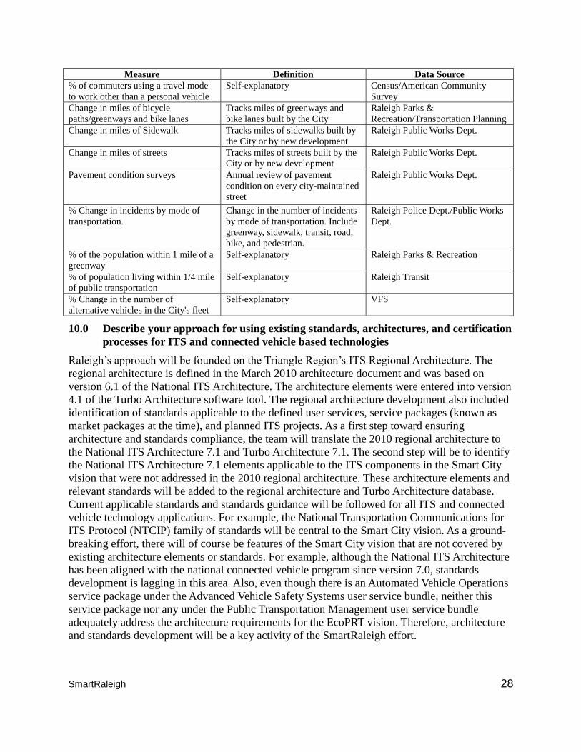
SmartRaleigh 28
Measure Definition Data Source
% of commuters using a travel mode
to work other than a personal vehicle
Self-explanatory Census/American Community
Survey
Change in miles of bicycle
paths/greenways and bike lanes
Tracks miles of greenways and
bike lanes built by the City
Raleigh Parks &
Recreation/Transportation Planning
Change in miles of Sidewalk Tracks miles of sidewalks built by
the City or by new development
Raleigh Public Works Dept.
Change in miles of streets Tracks miles of streets built by the
City or by new development
Raleigh Public Works Dept.
Pavement condition surveys Annual review of pavement
condition on every city-maintained
street
Raleigh Public Works Dept.
% Change in incidents by mode of
transportation.
Change in the number of incidents
by mode of transportation. Include
greenway, sidewalk, transit, road,
bike, and pedestrian.
Raleigh Police Dept./Public Works
Dept.
% of the population within 1 mile of a
greenway
Self-explanatory Raleigh Parks & Recreation
% of population living within 1/4 mile
of public transportation
Self-explanatory Raleigh Transit
% Change in the number of
alternative vehicles in the City's fleet
Self-explanatory VFS
10.0 Describe your approach for using existing standards, architectures, and certification
processes for ITS and connected vehicle based technologies
Raleigh’s approach will be founded on the Triangle Region’s ITS Regional Architecture. The
regional architecture is defined in the March 2010 architecture document and was based on
version 6.1 of the National ITS Architecture. The architecture elements were entered into version
4.1 of the Turbo Architecture software tool. The regional architecture development also included
identification of standards applicable to the defined user services, service packages (known as
market packages at the time), and planned ITS projects. As a first step toward ensuring
architecture and standards compliance, the team will translate the 2010 regional architecture to
the National ITS Architecture 7.1 and Turbo Architecture 7.1. The second step will be to identify
the National ITS Architecture 7.1 elements applicable to the ITS components in the Smart City
vision that were not addressed in the 2010 regional architecture. These architecture elements and
relevant standards will be added to the regional architecture and Turbo Architecture database.
Current applicable standards and standards guidance will be followed for all ITS and connected
vehicle technology applications. For example, the National Transportation Communications for
ITS Protocol (NTCIP) family of standards will be central to the Smart City vision. As a ground-
breaking effort, there will of course be features of the Smart City vision that are not covered by
existing architecture elements or standards. For example, although the National ITS Architecture
has been aligned with the national connected vehicle program since version 7.0, standards
development is lagging in this area. Also, even though there is an Automated Vehicle Operations
service package under the Advanced Vehicle Safety Systems user service bundle, neither this
service package nor any under the Public Transportation Management user service bundle
adequately address the architecture requirements for the EcoPRT vision. Therefore, architecture
and standards development will be a key activity of the SmartRaleigh effort.
SmartRaleigh 29
Plans for documenting experiences and cooperating with architecture and standards
developers to improve quality of these products based on lessons learned in deployment:
Creating new standards requires a comprehensive and inclusive approach. There are many
examples of standards bodies that have well-defined processes for developing, submitting, and
approving standards within the transportation ecosystem. The project will use the appropriate
existing open standards in order to achieve maximum extensibility and application to other
locations and environments. Where existing standards are lacking, we will collaborate with the
existing standards bodies to develop the needed solutions. The SmartRaleigh team has firsthand
experience leading this type of standards development effort. Specifically, members of the team
were part of the leadership team for development of the Digital Interchange for Geotechnical and
Geoenvironmental Specialists (DIGGS, diggs.org) Schema, a new international standard first
released in 2008. The DIGGS Schema is an XML-based, GML-compliant transportation data
transfer standard developed as a collaborative effort under Transportation Pooled Fund Project
TPF-5(111). The process followed known standards development practices by involving DOTs,
Federal transportation groups, universities and industry. The resulting standard was then
transferred to the American Society of Civil Engineers (ASCE). ASCE is the home to a number
of national standards including the ASCE-7 wind standard and has well-defined mechanisms to
maintain and improve standards. As an example of envisioned activities, the Smart City team
will work closely with the Connected Vehicle Reference Implementation Architecture (CVRIA)
project recently established by USDOT’s ITS Joint Programs office. The mission of this project
is to develop the architecture high-lighted in the project’s name along with an accompanying
standards development plan. The Connected Vehicle Reference Implementation Architecture and
the standards that follow will be fully aligned with the National ITS Architecture. The Smart City
team will become an important player in this effort. All activities and collaborations in the area
of architecture and standards development will be carefully documented.
11.0 Provide measurable goals and objectives for your vision
Raleigh will leverage existing and emerging data sources in order to first establish the baseline
conditions of the pilot study corridors. Ongoing data collection will monitor changes in mobility,
reliability, safety, sustainability, and environmental impacts of the transportation system.
Specifically, the following measures can be monitored:
Multimodal Delay: Delay for vehicles, bicycles and pedestrians on the study corridors
Travel Time Reliability: Travel time data will be utilized for monitoring the frequency and
severity of congestion
Transit Ridership and On-Time Performance: These measures are already used to monitor
transit use and performance
Mode and Fleet Shift to Sustainable Transportation: Transportation modes used on the
corridor as well as the composition of the vehicle fleet will be monitored to identify trends
towards more sustainable transportation
Crash Rate: In addition to collecting crash data, shifts to safer transportation modes will be
monitored
Greenhouse Gas Emissions: Using vehicle dynamics data collected from connected vehicles,
changes in emissions can be estimated through emissions modeling
Based on the baseline conditions identified and the technologies to be implemented in the study
corridor, goals for each of these performance measures will be identified.
SmartRaleigh 30
12.0 Provide evidence that establishes your capacity to take on a project of this
magnitude The partnership between Raleigh and NC State brings a powerful duo that can execute highly
innovative solutions to smart cities’ challenges. First and foremost, the two have a longstanding
positive relationship, working closely together for the overall betterment of the broader
community. One historic example is the creation of the master plan in 1987 that led to the
creation of NC State’s Centennial Campus within the City of Raleigh. This entity has withstood
the test of time over the past 32 years and is the gold standard for triple helix partnering on a
large scale. Without the master plan (updated every 5 years) that led to this development, it
would not be the successful model of public-private partnerships that it is today. Also, each entity
has worked on specific major changes on its own, as evidenced by the downtown revitalization
that has been hugely successful. More specifically, from the University standpoint, NC State is
the lead in several major partnership projects with the Federal Government.
NC State is also home to the National Security Agency’s Lab for Analytic Science (LAS) that
includes a certified Secure Compartmentalized Information Facility (SCIF) representing an
investment of over $63 million. In addition, in 2014, NC State was selected by DOE to lead the
2nd National Manufacturing Innovation Institute, PowerAmerica. This $146 million (with 50%
cost share) endeavor is focused on commercialization of emerging wide band gap power
electronics for a sustainable and clean economy. NC State’s College of Engineering is the lead
institution for two NSF Engineering Research Centers (no institution can lead more than two).
One is the Future Renewable Electric Energy Delivery and Management (FREEDM) Systems
Center, focusing on smart grids. The second is the Advanced Self-Powered Systems of Integrated
Solutions (ASSIST) Center. The investment by NSF into both of these is in excess of $75
million. Additionally, ITRE and NC State are part of a multi-university consortium that was one
of the five selected by USDOE’s ARPA-E program to conduct a $4.5M study on energy
optimization using individualized incentives for travelers on an urban, multimodal transportation
network. All of the above entities involve a very large and broad network of coalition
partnerships to execute on their respective units. NC State is one of a few institutions of higher
learning capable of winning and executing on such huge projects.
13.0 Describe any opportunities to leverage Federal resources
The proposed project has the potential to leverage several federal resources:
FREEDM Systems Center, researching smart-grid technology
ASSIST Center, developing wearable, self-powered health monitors
$146 million PowerAmerica Institute, developing an advanced power electronics
manufacturing sector for USDOE
$63 million Laboratory for Analytic Sciences, studying data analytics for the National
Security Agency