Embed Size (px)
Citation preview

1 copyrigt©2012 SciRes.
The Character and the Spatial Concepts of Cakranegara The Historical City of Indonesia as an Alternative Urban Design
Lalu Mulyadi
Department of Achitecture, Faculty of Civil Engineering and Planning National Institute of Technology (ITN Malang)
[email protected] and [email protected] Razak School of Engineering and Advance Technology
Universiti Teknologi Malaysia, International Campus, Kuala Lumpur Malaysia [email protected] and [email protected]
Introduction
Urban designs that currently exist in Indonesia are still focused on the same forms. As a result, little attention is given to urban designs where cultural heritage is neglected. An excellent example of this can be seen in the administrative boundaries among districts which depict as units of the urban designs of which the socio-cultural aspects are then neglected (Samadhi, 2004 vol 9:205.223). Historically the culture of Indonesian people were largely influenced by the Hindus. Their thinking was very ancient as were their religious beliefs. They regarded the spirit as the supernatural power which was identical to their Dewa (God). The Dewa is deemed as real, has orientation, hierarchy and certain functions and is thus symbolized as having a great power in the universe (Alisjahbana, 1966).
Indian culture, which subscribes to Hinduism, had contributed greatly to the development of Indonesian culture especially in the regions of Trowulan-Mojokerto and Tengger in East Java, in Bali and in the western parts of Lombok in East Indonesia (Wiryomartono, 1995). The use of figurines of various shapes to symbolize the Dewa-dewa (the gods) and physical elements whichare predominant in residential areas as can be seen in the countrysides as well as in the cities. These areas display orientation and adherence to hierarchy which include social culture aspect (Munandar, 2005).
Urban areas like Nagari in Padang, Gampong in Aceh, and Desa Adat in Bali which have valuable
social cultures that displays a close relationship
with the sense of place of the area. Therefore, the development of historical cities should consider the character of the place and how they contribute to support valuable social and cultural expectations of the users. Thus, more research should be conducted related to the old historical cities and social because they provide theoretical concepts that caould be used as references to build urban areas (Bondan, 1999).
The main purpose of this study is to provide a new perspective to architectural and urban design theories with regard to the spatial organisation. This will be useful for the local government consultants to use as a reference for planning and formulating the conservation of Cakranegara. For the Indonesian urban designers, the theory will be an inspiration to develop existing cities and become an international reference for grid planning in case of Indonesia. Lastly for further research, the frame of analysis of this study can also be an alternative for the same kind of study either in Indonesia as well as other countries.
Theoretical Background Definition of Spatial
The term ‘spatial’ is used to denote anything that deals with space including size, distance, shape and position. Similar to the term ‘morphology’, the term ‘spatial’ can also be used in economy,
ABSTRACT
The main challenge in Indonesian urban conservation efforts is to determine how changes can meet our current needs without jeopardizing its unique character. Cakranegara, Lombok is one of the towns that have unique character and concept for its spatial organization. This research seeks to define the character o of Cakranegara by outlining the spatial city concepts in relation to the physical character based on the socio-cultural and religious principles using questionnaires, mental mapping, visual survey and interviews. The results indicate that the grid pattern, settlement blocks and the positioning of the east-west temples have become the specific character of the city. Findings suggest that cosmological philosophy that emphasizes on the relationship between humans and nature is used to determine the spatial organizatin. This relationship is observed in the placement of the three temples which symbolizes the spirit, the dwellers as the energy and the settlement territorial as the vessel. The study concludes that the basic principles of socio-cultural and the socio-religious beliefs had created the spatial concept of this historic town. Keywords: Cakranegara City; Socio-culture; Character; Spatial Concept.

2 copyrigt©2012 SciRes.
geography, urban planning, environment study, area study and architecture.
The term ‘spatial’ as used in this study takes on a different definition from the mathematical term Euclide which refers to space as confined to the geometric aspect and is free from values. In this study, ‘space’ is related to the socio cultural values that has significance and value where it is heterogeneous, metaphorical and has relations with social and cultural aspects (Parimin, 1986:ii-iii). ‘Spatial study’ in the order of building mass is very important because it is an essential part of any architecture in relations to their context. The concept of space in the order of building mass for Balinese Hinduism for example depicts a profound, symbolic meaning (Salija, 1975:34-35). It is the core of the people`s social culture cognition that they become part of their life (Eiseman, 1985:29).
Spatial concepts consist of space elements with their ordering where it is seen as a composition and order as well as the model of the relationship among spaces. Discussion relating to spatial comprises characteristics of the space ordering element like the space shapes, function, relationship, orientation and hierarchy (Ching, 1984). The Overview of the Cosmology of Balinese Hinduism
Basically, the religion of the Balinese Hinduism desires relate to the life of man in the universe from his interim life to end of his time (Zahener, 1992:225; Mauro, 1986:33-35; Budihardjo, 1986:22-23). The purpose can be achieved by following the principle of tri warga: dharma, artha, and kama. Dharma is the spiritual aspect, keeping the close relationship between man and his god. Artha is the socio-economic aspect that keeps the interpersonal communication and close relationship between the people. Finally, Kama is the cultural life related to the creation of arts, culture and architecture. Balinese Hinduism stresses on the ritual activities either by individuals, among friends or communities. All the ritualitic activities can be classified into five categories: Panca Yadnya which consists of dewa yadnya – a ritual in the temples, pitra yadnya – a ritual for the spirit of the ancestors, manusa yadnya – a ritual for commemorating the process of life from childhood to adult, rsi yadnya – a ritual related to the inaguration of a priest as a leader of religion, and bhuta yadnya – a ritual for the evils (Pidarta, 2000:16-20; Bagus, 1997: 303).
Finally, the philosophy of Balinese Hinduism is that man`s life should be in harmony with nature. This philosophy is based on the view that man is created from the five elements: ether (akasa), air (bayu), heat (teja), water (apah), and soil (pertiwi) which are called Panca Maha Bhuta (Pidarta,
2000:23). All these play a vital role in the formation of Cakranegara urban form. The Basic Principles of Social and Religious Culture of Balinese Hinduism There are seven principles of social and religious culture of Balinese Hinduism. First: The Principle of Desa Kala Patra
Desa refers to the people`s living area whereas Kala refers to the time when people carry on their life activities. Patra is people who live in an area (Saraswati, 1993). Thus, the emphasis of this principle is that people who practice Balinese Hinduism should be in harmony with the area and the community they are living in. According to Widana (2002:37-38), harmonious living should not deviate from Weda Teaching. Second: The Principle of Rwa Bhinneda
This is based on the belief that the universe is created systematically balanced. The basic principle in this system is the binary concept of coupling. Ruskam (1999:17) says that there would not be any meaningful life if there is just one species occupying the universe and dominating this cosmos. God created human beings and other creatures to live and propagate naturally. It is this concept that makes the universe with its life on earth perfect and beautiful. According to Ruskam (1999:76-81), the first harmonious couple is a man and a woman. The second principle of the ‘couple’ theory is evident through the organs of a body which comes in pairs for example, the eyes, the feet and the hands. The third aspect of this notion is evident in the depiction of life: rich-poor, righteousness-evil, mortality-immortality. Finally, this binary principle is also evident in the natural world: the land-the sea, the highs-the lows, the rain-the heat, the day-the night.
The couple system stated by Ruskam (1999) has the same significance with binary opposition written by Levi-Strauss (1969) in Totemism. He defines the couple of different gender as a method to analyse the social phenomena whose way of thinking comes from the human thought to classify the environmental world. He also shares the same opinion about the classification based on different characteristics.
The Hindus in Bali, for example, think that the couple system in the universe is a consistent order of the cosmos. They are oriented in a balance state that keeps the harmonious relationship between the universe as macro-cosmos and the human beings as micro-cosmos. This order is based on the philosophy of reconciliation of two poles of which have different values but tied in a relationship, either between the objects, man with objects or

3 copyrigt©2012 SciRes.
man with other living things as well as man with his God (Mauro,1989:35-46; Budihardjo, 1991:32-64;)
The philosophy of reconciliation has significance in the life of the people as it relates to the social belief of Bali Hinduism to God, the Almighty (Pidarta, 2000; Sudharta, 2005). Suwena (2003) suggested that the philosophy of reconciliation for the Balinese Hinduism is called the principle of rwa bhinneda. Rwa means two and bhinneda means different which is reflected such as the mountain-the sea, dirty-clean, luan-teben, sekala-niskala, and sacred-profane (Ardi, 1986; Gelebet, 1986; Widana, 2002:91-2).
Ardi (1986), Mantra (1988:18), Budihardjo (1991) and Widana (2002:91-2), suggested that the implementation of the rwa bhineda principles in the spatial orientation is achieved by the way a temple is oriented towards a mountain which is considered a centered-orientation of high value and hygiene. On the other hand aspects which are not sacred are directed towards the sea. The sea comprises bad values and, therefore, it connotes ‘dirty things’. According to Ardi (1986:40-41), Gelebet (1986), Budihardjo (1991:33-34), Samadhi (2001-a 25/4:559-575), Geriya (2004:10-15), and Eiseman (2005:2-5), this binary opposition is applied to the spatial patterns of the city, village, settlement, and house yard. Ardi further argued that both the Puseh temple and Desa temple are oriented towards the mountain while the Dalem temple, which is related to mortality and the graveyard, are both oriented towards the sea. Third: The Principle of Sekala - Niskala
Sekala is a visible object, whereas niskala is an invisible object. Both are supernatural elements where Balinese Hinduism believe that the invisible objects belong to the supernatural which are then realized into real objects in order for man to be able to make contact with (Suparman, 2003; Soeka, 2004). Suparman (2003:133) adds that the temple, which is a place for worship to God, is a sekala that is a reflection of niskala. Eiseman (2005:280-321) also states that dances (sekala), which are performed by Balinese Hinduism, are the symbols of the invisible powers (niskala).
Suparman (2003) and Soeka (2004) however state that the highest power in the universe is just God, who is unseen and untouchable and where his power is clasified into three kinds: the power to create, the power to care for and to return to him.
Balinese Hinduism aspires to be able to contact directly with God in the real appearance (sekala) to make it easy for them to relate their thoughts. Therefore, they reflect God`s character in the form of Dewa (God) where it is believed that dewa was created from light to become God’s envoy (Puja, 1985).
Fourth: The Principle of Tri Hita Kharana
Tri Hita Kharana comes from three words tri means three, hita means righteousness and kharana means source which has the philosopihical teaching about adaptable and harmonious living in all aspects of life. According to Monografi (1985:30), Kaler (1994:14), Putra in Atmaja (2003:119), the three sources form the relationship between man with their God, between man with men and the man with his environment.
Gelebet (1986:15) claims that the three elements of tri hita kharana are atma, khaya, and angga (spirit, energy, and vessel/while). On the other hand, Dharmayudha (1999:7) says that the tri hita kharana are atman, prana, and sarira which is the source of life that is spirit, energy, and body. In this case, if a man’s life is in balance he can assume highly the important role. According to Patra (1992:16), Gorda (1996:79-94), Atmaja (1999:61-66), and Samadhi (2001-a 25/4:559-575) spatial pattern adopting the principle of tri hita kharana can be seen in the form of parahyangan that is the site of worship for the spirit where Pawongan (the people living in the area) is the energy, and palemahan (settlement) is the vessel (Table 1).
Fifth: The Principle of Tri Angga, Tri Mandala and Sanga Mandala
Tri Angga is an order in which the basic cultural and religious belief become the source with three levels of values in an object, which is expressed by the Balinese Hinduism with the terms utama, madya and nista (top, middle and bottom). In a human being, tri angga bould be represented by the head, body and legs. In a building, it is the roof, wall and the floor whereas in the environment, they are the mountain, land and sea. In the universe, they are the space (atmosfear), the land (litosfear) and the sea (hidrosfear). If the
Container SPIRIT (atma)
ENERGY (prana)
VESSEL (sarira)
Universe
Paraatman
Power to move the universe, e.g. planetary
movement
Panca maha
bhuta elements
City/village/
desa adat
Tri Kahyangan
or Parahyangan
Sima karma or Pawongan or
dwellers/ villagers and
their activities
Palemahan or
settlement/ village territory
House House temple
House dwellers Dwelling unit with its yards
Human being Soul/spirit Energy Body
Table 1: The Elements of Tri Hita Kharana (Source: Gelebet, 1986; Dharmayudha, 1991; Patra, 1992; Gorda, 1996; Atmaja, 1999; Samadhi, 2001-a)

4 copyrigt©2012 SciRes.
N
S
E W
Sunset
Sunrise
Uta
ma
Mad
ya
Nista
Utama
Madya
Nista
Mountain
Sea
Utama
Madya
Nista
TRI ANGGA
+
UU UM UN
MN MM MU
NN NM NU
Legenda: UU : Utamaning Utama UM : Utamaning Madia MU : Madianing Utama UN : Utamaning Nista NU : Nistaning Utama
MM : Madianing Madia MN : Madianing Nista NM : Nistaning Madia NN : Nistaning Nista
Wisnu
Brahma
Iswara Mahadewa
Sambu
Siwa
Rudra Maheswara
Sangkara
N
S
E W
terms utama, madya, nista are used in an area, there will be three values of the space called the tri mandala. Tri means ‘three’, mandala means square or space (Atmaja, 2003) where the principle of Tri Mandala is the development of rwa bhinneda i.e. the existence of east – west, sunrise-sunset, and ‘mountain – sea’ and the north – south (Ardi, Sixth: The Principle of Nawa Sanga
Nawa means the throne of dewa, whereas Sanga means nine positions. Nawa Sanga means the nine positions of dewa`s thrones (Covarrubias, 1972:298). Dewa Syiwa`s position is in the centre whereas the other eight is in the direction of the compass (Pott, 1966:133; Soekmono, 1986:284-5; Munandar, 2005:169; Eiseman, 2005:4-5). From dewa Syiwa`s aspect, the north is dewa Wisnu, the northeast is dewa Sambu, the east is dewa Iswara, the southeast is dewa Maheswara, the south is dewa Brahma, the southwest is dewa Rudra, the west is dewa Mahadewa and the northwest is dewa Sangkara (Suwena, 2003:55) (Fig. 2).
1986; Budihardjo, 1991). If the two powers are exposed, there will be a value in-between called madya. If the value of space is exposed from the (mountain-sea) and the direction of east – west (sunrise-Sunset), there will be nine space values called the principle of Sanga Mandala as shown in (Fig. 1).
Figure 1. The Principle of Tri Angga, Tri Mandala, Sanga Mandala (Source: Ardi, 1986; Gelebet, 1986; Megananda, 1990; Budihardjo, 1991; Samadhi, 2001-b; Samadhi, 2004-a; Suwena, 2003; Eiseman, 2005)
Figure 2. The Position of Dewa-Dewa Nawa Sanga in Point of the Compass (Source: Pott, 1966; Covarrubias, 1972; Soekmono, 1986; Suwena, 2003; Munandar, 2005; Eiseman, 2005)

5 copyrigt©2012 SciRes.
Kumera
Isana/ Candra
Indra
Agni
Yama
Nirtti/ Surya
Waruna
Wayu
Gunung Maha meru
N
S
E W
Seventh: The Principle of Asta Dikpalaka
This principle finds its source from Indian Hinduism which describes the form of the universe like a circle. The area of the universe is believed to be centered at Mt Mahameru (where a throne of gods named Asta Dikpalaka is located) which has four other peaks higher than its surrounding. The sun, the moon and the stars are believed to revolve around the Mahameru peak. Mahameru stands upright in the centre of a continent called Jambhudwipa in which human beings and other living things exist. There is also a mountain range called Cakrawala. The eight directions of mountain Mahameru are guarded by Asta Dikpalaka as the universe protector against the evil creatures (Stutley, 1977:190-1; Dumarcay, 1986:89-91).
Asta Dikpalaka are the gods of the eight directions of the compass which in the myth, is said to surround the Mahameru mountain (Munandar, 2005:170). From the aspect of Mt Mahameru, the north is dewa Kumera, the northeast is dewa Isana/Candra, the east is dewa Indra, the southeast is dewa Agni, the south is dewa Yama, the southwest is dewa Nirtti/Surya, the west is dewa Waruma and the northwest is dewa Wayu (Fig. 3).
Methodology
According to Shuhana (1997) there are two main types of methodology used in conducting a research on historical urban areas i.e. qualitative and quantitative methodologies. Quantitative methodology uses the questionnaire method whereas qualitative methodology is based on a field study. According to Festinger and Katz (1953), the difference in both methodologies is in the evaluation where the questionnaire method is broader whereas the field study method is more complete. Thus, the use of both methodologies will provide a complete explanation of the phenomenon. Shuhana (1997) adds that the study
of a historical urban area cannot be conducted using just one method due to their specific characteristics. Bell (1990) did this but also used the triangulation method in order to get accurate results. Both methodologies are adopted in the study of Cakranegara where the use of the quantitative method involves the people in the surrounding area to evaluate the environment of the city using a questionnaire (Mahbob, 1992; Shuhana, 1997). The qualitative methodology is used to obtain information about the social and physical character recorded from the field study as suggested by Shuhana (1997).
The distribution of the questionnaires is done by simple random sampling where they are distributed to the blocks of the homogeneous settlement dwellers as suggested by Sugiyono (2009). The sample size is 330 respondents with a sampling error of 5.5% at 95% confidence level as stated by De Vaus (1991). Data collection using mental mapping is carried out through indepth interview with 30 respondents where they are classified according to their levels of education, values, norms, custom rules and their roles in the community such as priests and leaders. This method is based on earlier research by Shuhana (1997), Shuhana and Ahmad Bashri (1999). The 30 respondents consist of the residents in the area being studied. The respondents were interviewed relating to the elements and events they could recall about Cakranegara city which are considered important because they have specific values, therefore significant and outstanding as compared to the other elements. A systematic field observation to record the physical elements and structure of the city was conducted as a means for comparison with the social data. According to Spreiregen (1965), a visual observation activity is an excellent method to know the composition, the shape of the city and to evaluate their potentials and shortcomings. Shuhana and Ahmad Bashri (1992) suggested that the use of technical observation to conduct a research of an historical city area is advantageous especially in the effectiveness to describe the city or the town thoroughly. In addition, a thorough evaluation of the physical character of a city can be obtained by a visual observation and recording of the physical elements of the city (Shuhana and Ahmad Bashri, 2002). The results of the observation are collected and then analysed to ascertain the significant physical elements, the spatial qualities such as the structure and urban pattern.
The Case Study: Cakranegara
Cakranegara which was previously known as
Singasari is an historical city in Lombok, East Indonesia. It has a unique spatial quality that
Figure 3. The Position of Dewa Asta Dikpalaka inrelation to Point of the Compass (Source: Liebert, 1976; Daniclou, 1964; Van Lohuizen-De Leeuw, 1955 in Munandar, 2005)

6 copyrigt©2012 SciRes.
Jalan Pejanggik
Jala
n B
eo
Jala
n S
ub
ak I
Jalan Kebudayaan
Jala
n B
ala
m
Jala
n M
era
k
Jala
n C
end
raw
asi
h
27m 27m 27m 27m 27m 27m 27m 27m 27m 27m9m 9m 9m
27m
270m
27m
0m 50m 100m 150m
Figure 5: Blocks of Karang (Source: Funo, 1995)
Nort
Temple
Vacant Land The Muslim community
reflects a special social cultural setting. Cakra means circle in Sanskrit whilst negara means city, settlement or country so Cakranegara suggest a settlement city in a rounded shape (Agung, 1992). It is suggested that the historical city of Cakranegara is designed based on the Balinese Hindu philosophy of cosmology.
According to Funo (1995), Cakranegara has a grid pattern which is built in the form of settlement blocks called Karang. It is also an example of an old city that was planned based on the cosmology (Handinoto, 2000). Suardana (2005) further suggested that Cakranegara is a city of a thousand crossroads where according to Atmaja (2003) the crossroad is called Catuspatha. The paper revolves around the question “What is the character of the spatial concept of the historical city of Cakranegara Indonesia?”
Historically, Cakranegara was founded in Bali during the of Gel-Gel kingdoms where in the 15th century, the Gel-Gel regime colonized
Findings
The Character and Concepts of Settlement Blocks Figure 4: Cakranegara City Map (Source: Cool, Capt. W., 1896)
The historical city of Cakranegara comprises of square blocks (Fig. 4 and 5) where from the questionnaires it was revealed that these blocks are dwelt by 268 Hindu respondents (81.2 %), 50 Muslim respondents (15.2 %), 4 Buddhist respondents (1.2 %), and 8 Christian respondents (2.4 %). See Table 2. According to Babad Lombok, Sumbawa and Blambangan (East Java) Watu Renggong. After his death, the regime moved
to Karangasem at the northern part of Gel-Gel kingdoms where the height of the regime’s glory ended around 1962 after the 4th King Karangasem, I Gusti Anglurah Ketut Karangasem, expanded his power to the island of Lombok (Cakranegara). De Graaf (1941: 372) stated that the downfall of Gel-Gel coincided with the colony of Karangasem to the island Lombok. The conquer of Karangasem Bali over Lombok was due to the political situation between two powerful kingdoms in Selaparang, East Lombok and Pejanggik in the Central Lombok. With the conquer of the island of Lombok, King Karangasem took the opportunity to control other small kingdoms in West Lombok like Kediri, Senkongo, Pagutan, Pagesangan, Mataram and Singasari.
and these states came under the reign of Dalem Selaparan (manuscript), Babad Lombok (manuscript), Wacana (1988:52), Zakari (1998:17-18), and Djelenga (2001:22-54), the blocks occupied by the Hindu community had been in existence since the seventeenth century (1692), when the area was ruled by the Balinese Hindu kingdom of Karangasem.
7 copyrigt©2012 SciRes.
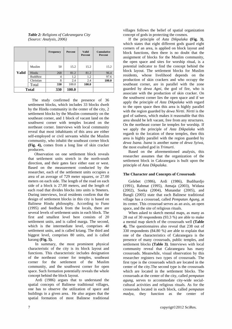
Table 2: Religions of Cakranegara City (Source: Analysis, 2006)
Frequency
Percent
Valid
Percent
Cumulative
Percent
Muslim
50
15.2
15.2
15.2
Hindu 268 81.2 81.2 96.4 Buddhist 4 1.2 1.2 97.6 Christian 8 2.4 2.4 100.0
Valid
Total 330 100.0 100.0
Total 330 100.0
The study confirmed the presence of 36 settlement blocks, which includes 33 blocks dwelt by the Hindu community in the center of the city, 2 settlement blocks by the Muslim community on the southeast corner, and 1 block of vacant land on the southwest corner with temples located on the northeast corner. Interviews with local community reveal that most inhabitants of this area are either self-employed or civil servants whilst the Muslim community, who inhabit the southeast corner block (Fig. 4), comes from a long line of skin cracker producers.
Observation on one settlement block reveals that settlement units stretch in the north-south direction, and their gates face either east or west. Based on the measurement conducted by the researcher, each of the settlement units occupies a area of an average of 729 meter squares, or 27.00 meters on each side. The length of the road on each side of a block is 27.00 meters, and the length of each road that divides blocks into units is 9meters. During interviews, local residents confirm that the design of settlement blocks in this city is based on Balinese Hindu philosophy. According to Funo (1995) and feedback from the locals, there are several levels of settlement units in each block. The first and smallest level here consists of 20 settlement units, and is called marga. The second, which is the intermediate level, comprises 40 settlement units, and is called kriang. The third and biggest level, comprises 80 units, and is called karang (Fig. 5).
In summary, the most prominent physical characteristic of the city is its block layout and functions. This characteristic includes designation of the northeast corner for temples, southeast corner for the settlement of the Muslim community, and the southwest corner for open space. Such formation potentially reveals the whole concept behind the block layout.
Ardi (1986) argues that to understand the spatial concepts of Balinese traditional villages, one has to observe the utilization of space and buildings in a given area. He also argues that the spatial formation of most Balinese traditional
villages follows the belief of spatial organization concept of gods in protecting the cosmos.
If the principle of Asta Dikpalaka (Fig. 3), which states that eight different gods guard eight corners of an area, is applied on block layout and block functions, then there is no doubt that the assignment of blocks for the Muslim community, the open space and sites for worship ritual, is a potential indicator to find the concept behind the block layout. The settlement blocks for Muslim residents, whose livelihood depends on the production of skin crackers and who occupy the southeast corner, are in parallel with the zone guarded by dewa Agni, the god of fire, who is associate with the production of skin cracker. On the southwest corner lies the open space and if we apply the principle of Asta Dikpalaka with regard to the open space then this area is highly parallel with the region guarded by dewa Nirtti. Nirtti is the god of sadness, which makes it reasonable that this area should be left vacant, free from any structures. On the northeast corner lie temples for worship. If we apply the principle of Asta Dikpalaka with regardt to the location of these temples, then this area is highly parallel with the region guarded by dewa Isana. Isana is another name of dewa Syiwa, the most exalted god in Trimurti.
Based on the aforementioned analysis, this researcher assumes that the organization of the settlement block in Cakranegara is built upon the principle of Asta Dikpalaka. The Character and Concepts of Crossroads
Gelebet (1986), Ardi (1986), Budihardjo (1991), Rahmat (1995), Atmaja (2003), Widana (2002), Soeka (2004), Munandar (2005), and Bangli (2005) state that each Balinese traditional village has a crossroad, called Pempatan Agung, at its center. This crossroad serves as an axis, an open space, and the site of religious rituals.
When asked to sketch mental maps, as many as 28 out of 30 respondents (93.3 %) are able to make a mental map sketch of the crossroads well (Table 4). The questionnaires also reveal that 238 out of 330 respondents (84.80 %) are able to explain that one of the characteristics of Cakranegara is the presence of many crossroads, public temples, and settlement blocks (Table 3). Interviews with local community reveal that Cakranegara has many crossroads. Meanwhile, visual observation by this researcher registers two types of crossroads. The first type is the crossroads which are located in the center of the city.The second type is the crossroads which are located in the settlement blocks. The crossroads at the center of the city, called pempatan agung, serves to accommodate city-wide social-cultural activities and religious rituals. As for the crossroads located in each block, called pempatan madya, they function as the center of
8 copyrigt©2012 SciRes.
Legend: 1. Crossroads 2. Temple (Meru, Mayura, and Dalam) 3. Settlement Blocks
4. Others
1, 2, 3dan 4
1, 2 dan 31 dan 31 dan 2
80
60
40
20
0
Per
cen
t
CIRI-CIRI FISIK
1 and 2 1 and 3 1,2 and 3 1,2,3 and 4
Figure 7: The Ritual Conditions of Tawur Agung (Source: Field Study, 2006)
Figure 6: Formation of Spatial Arrangement of Offerings at the Crossroad (Source: Eiseman, 2005:231)
neighborhood-wide social-cultural activities and religious rituals.
Table 3: Respondents Perception of Physical Characteristics Cakranegara City (Source: Analysis, 2006)
Freque
ncy Percent
Valid Percent
Cumulative Percent
1 and 2 37 11.2 11.2 11.2 1 and 3 5 1.5 1.5 12.7 1,2 and 3 238 72.1 72.1 84.8 1,2,3 and 4 50 15.2 15.2 100.0
Valid
Total 330 100.0 100.0 Total 330 100.0
In summary, the big number of crossroads and their functions to accommodate social-cultural activities as well as religious rituals are among the prominent physical characteristics of Cakranegara. The routine religious ritual activities at these crossroads can be regarded as a potential indicator to finding the concept behind the formation of crossroads.
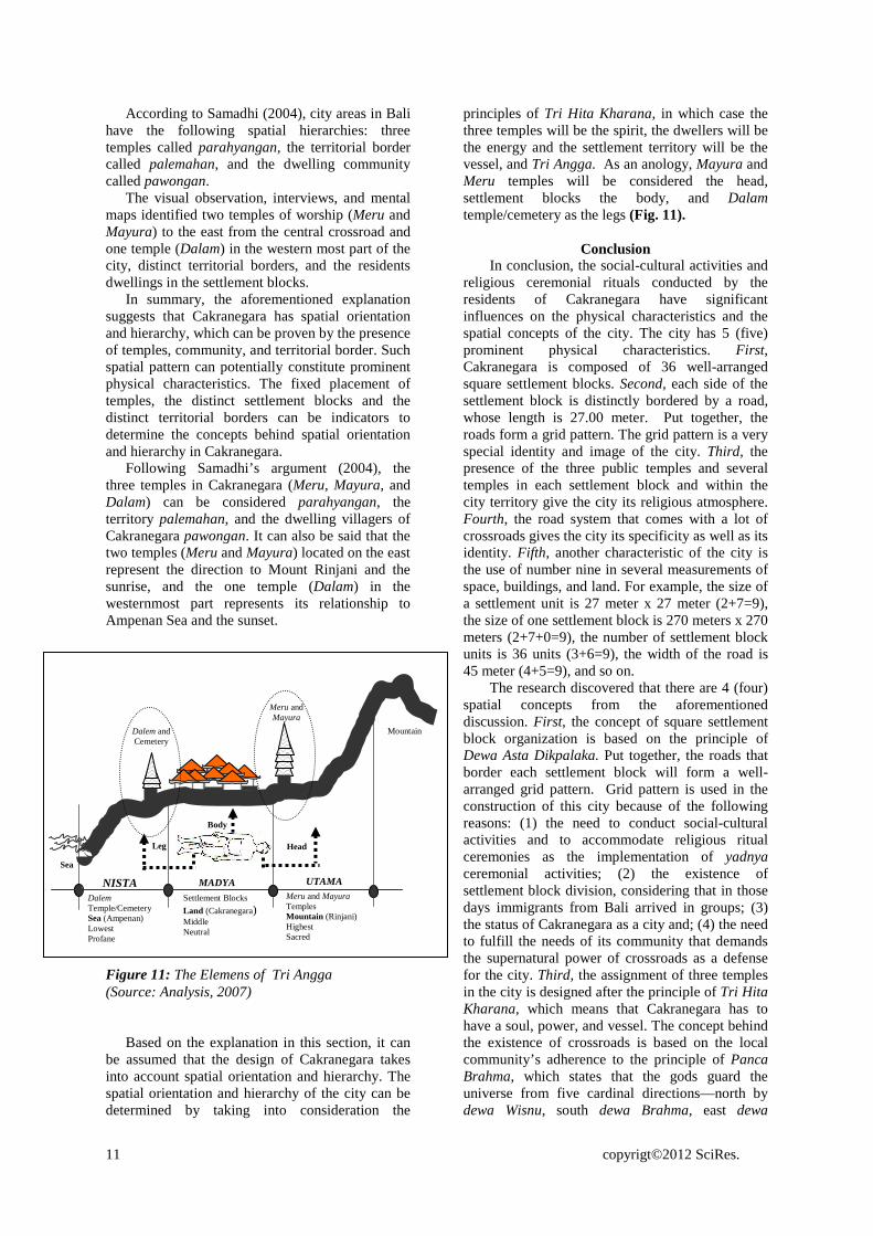
There are two very prominent religious rituals conducted at the crossroads. One is the funeral ceremonies, in which participants make counter clockwise spins called prasavya; the other ritual is the ceremony of tawur agung (a particular ritual dedicated to buthakala for the welfare and preservation of the universe), in which participants make clockwise spins called purwadaksina (Apta, 1979:1091) (Fig. 7).
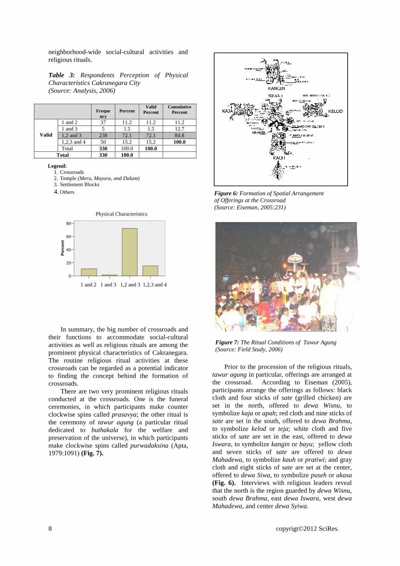
Prior to the procession of the religious rituals,
tawur agung in particular, offerings are arranged at the crossroad. According to Eiseman (2005), participants arrange the offerings as follows: black cloth and four sticks of sate (grilled chicken) are set in the north, offered to dewa Wisnu, to symbolize kaja or apah; red cloth and nine sticks of sate are set in the south, offered to dewa Brahma, to symbolize kelod or teja; white cloth and five sticks of sate are set in the east, offered to dewa Iswara, to symbolize kangin or bayu; yellow cloth and seven sticks of sate are offered to dewa Mahadewa, to symbolize kauh or pratiwi; and gray cloth and eight sticks of sate are set at the center, offered to dewa Siwa, to symbolize puseh or akasa (Fig. 6). Interviews with religious leaders reveal that the north is the region guarded by dewa Wisnu, south dewa Brahma, east dewa Iswara, west dewa Mahadewa, and center dewa Syiwa.
Physical Characteristics

9 copyrigt©2012 SciRes.
Figure 10: Ceremony atmosphere during Mendak Tirtha (Source: Field Study, 2006)
Figure 9: The atmosphere of Funeral Ceremony (Source: Field Study, 2006)
Based on this analysis, the researcher interprets that all crossroads in Cakranegara use the principle of spatial organization guarded by gods Panca Brahma, that is, dewa Wisnu in the North, dewa Brahma in the South, dewa Iswara in the East, dewa Mahadewa in the west and dewa Syiwa at the center. The Character and Concepts of City Structures
Cakranegara has a well-planned road system with roads of varying widths. The field observation reveals that in terms of width there are four types of road in Cakranegara. First, the East-West roads (Selaparang and Pejanggik streets) are 45.00 meters wide. Second, the North-South roads (Sultan Hasanuddin and Anak Agung Gede Ngurah streets) are 36.00 meters wide. The North-South roads and East-West roads intersect as a crossroad that, according to Funo (1995) and Handinoto (2000), the local community calls Marga Sanga. Third, the roads that divide the settlement blocks into squares are 27.00 meters wide. These roads are called Marga Dasa. Fourth, the roads that divide the settlement blocks into rectangular sub-blocks are 09.00 meters wide. These roads are called Marga (Fig. 8).
Interviews with local community reveal that the roads in this city serve to accommodate social-cultural activities and religious ceremonies, which include marriage, funeral (Fig. 9), and mendak tirtha (Fig. 10) which is a ceremonial ritual for the taking of sacred water.
Figure 8: Street System (Source: Funo. 1995; Handinoto. 2000)
22mMarga SangaTimur-Barat
11.5m11.5m
45m
18mMarga SangaUtara-Selatan
9m
36m
9m
18mMarga Dasa
4.5m
27m
4.5m
9mMarga
0m 5m 10m 15m
0m 5m 10m 15m
0m 5m 10m 15m
0m 5m 10m 15m
M a rg a San g a
M a rg a San g a
M a rg a D asa
M arg a
Pura M ay ura Pu ra M ayu ra
Pura M eru
0m 100m 200m 300m 400m 500m
Nort
Jln. Sultan Hasanuddin
Jln. A.A.Gde Ngurah
Jln. Selaparang
Jln. Pejanggik
Marga Sanga East - West
Marga Sanga North -South

10 copyrigt©2012 SciRes.
The mental maps results show that 29 respondents (69.7%) are able to sketch the 45.00 meter-wide roads, 24 respondents (80.0 %) the 27.00 meter-wide roads, and 14 respondents (46.7 %) the 9.00 meter-wide roads. This result suggests that the roads are easily recollected in their perceptual structure of the city (Table 3). Cakranegara also tend to apply a well-organized grid pattern which is a prominent and special physical characteristic of the city. So what was the philosophical foundation that gave the city its grid pattern?
Stanislawski (1946) in Bondan (1999:32) argue that there are several reasons why a particular city has its current grid pattern. First, the city was constructed as part of a centralized power scheme that aims at gaining a total control of all aspects in a community, including the control of property utilization. Second, the city had been constructed as a new urban entity altogether. Third, the city had been constructed as a colony, such as a main city and urban settlement. Fourth, the area was constructed to prepare the spatial composition of a city that demands spatial sections that were uniform in size and shape.
Table 4: Elements of the Respondents’ Sketches (Source: Analysis, 2006)
According to Funo (1995) the grid pattern is
used because of the need to divide settlement
blocks called Karang (Fig. 5). The researcher’s interviews with the community in general, reveal that the formation of grid pattern was related to the social activities and religious ceremonial rituals. The interviews with religious leaders reveal that the formation of a grid pattern was inevitable with the presence of the crossroads being a necessary feature for the Hindu community in Cakranegara. This is because the community believes that it is through the crossroads that the power to protect an area emerges. This is in accordance with the argument shared by Budihardjo (1991), Bondan (1999) and Eiseman (2005), that the crossroads of Hindu cities in Indonesia are sacred spots.
Based on the above explanation, it appears that the road system that applies a grid pattern as the foundation of Cakranagara has emerged due to several factors: firstly, because of the demand to accommodate the social cultural and religious ceremonial rituals such as the yadnya ceremony city-wide as well as settlement block-wide; secondly, because of the division of the settlement blocks, which is related to the fact that during the birth of the city there were groups of immigrants who arrived from Bali; thirdly, due to Cakranegara’s status as a colony, as argued by Stanislawski (1946), and fourthly, because of the demand to fulfill the need of its community that sees the supernatural power of the crossroads as a defence for the city. The Character and Concepts of Spatial Orientation and Hierarchy
According to Ardi (1986), Robi (1987), and Nindyo (1990), in order to know the orientation and spatial hierarchies of Balinese traditional villages, visual observation should be done according to these steps: first, the position of the three temples (kahyangan tiga) where the inhabitants of a particular area practice their worship ritual; second, the settlement pattern of the community and third, the territory. Suwena (2003) argues that each Balinese traditional village has its own orientation and hierarchy. A researcher can find them by observing the land use and topography of the region to determine whether it is an elevated, plain, or low-lying area.
Furthermore, Ardi (1986), Robi (1987), and Nindyo (1990) state that the orientation and hierarchy of city/village/hamlet areas in Bali can be seen from the presence of two temples, Desa and Puseh at the northernmost part of the city, a temple (Dalem) and a cemetery on the southernmost part, and a residential area in between these two groups. Meanwhile, Parisada Hindu Dharma (1995) argues that the two temples that are on the northernmost part have a good value because they face the mountain directly, and the one temple on the southernmost part is not very good because it faces the sea.
Sketch of elements Frequency Total
Respondents Validity
(%) Meru temple 30 30 100.0 Mayura temple
30 30 100.0
Dalem temple
28 30 93.3
Melanting temple
9 30 30.0
Market of Cakranegara
28 30 93.3
Market of Sindu
7 30 23.3
Mataram Mall
28 30 93.3
MGM Mall 27 30 90.0
Building
Mosque 6 30 20.0 Crossroads 28 30 93.3 45 meters size street
29 30 96.7
27 meters size street
24 30 80.0
Street
09 meters size street
14 30 46.7
Mayura garden
30 30 100.0
Vacant land 16 30 53.3
Land Scape
District territorial
23 30 76.7
District Settlement blocks
25 30 83.3
11 copyrigt©2012 SciRes.
Meru and Mayura
Dalem and Cemetery
Mountain
Sea
Meru and Mayura Temples Mountain (Rinjani) Highest Sacred
Settlement Blocks
Land (Cakranegara) Middle Neutral
Dalem Temple/Cemetery Sea (Ampenan) Lowest Profane
UTAMA MADYA NISTA
Head
Body
Leg
According to Samadhi (2004), city areas in Bali have the following spatial hierarchies: three temples called parahyangan, the territorial border called palemahan, and the dwelling community called pawongan.
The visual observation, interviews, and mental maps identified two temples of worship (Meru and Mayura) to the east from the central crossroad and one temple (Dalam) in the western most part of the city, distinct territorial borders, and the residents dwellings in the settlement blocks.
In summary, the aforementioned explanation suggests that Cakranegara has spatial orientation and hierarchy, which can be proven by the presence of temples, community, and territorial border. Such spatial pattern can potentially constitute prominent physical characteristics. The fixed placement of temples, the distinct settlement blocks and the distinct territorial borders can be indicators to determine the concepts behind spatial orientation and hierarchy in Cakranegara.
Following Samadhi’s argument (2004), the three temples in Cakranegara (Meru, Mayura, and Dalam) can be considered parahyangan, the territory palemahan, and the dwelling villagers of Cakranegara pawongan. It can also be said that the two temples (Meru and Mayura) located on the east represent the direction to Mount Rinjani and the sunrise, and the one temple (Dalam) in the westernmost part represents its relationship to Ampenan Sea and the sunset.
Based on the explanation in this section, it can be assumed that the design of Cakranegara takes into account spatial orientation and hierarchy. The spatial orientation and hierarchy of the city can be determined by taking into consideration the
principles of Tri Hita Kharana, in which case the three temples will be the spirit, the dwellers will be the energy and the settlement territory will be the vessel, and Tri Angga. As an anology, Mayura and Meru temples will be considered the head, settlement blocks the body, and Dalam temple/cemetery as the legs (Fig. 11).
Conclusion
In conclusion, the social-cultural activities and religious ceremonial rituals conducted by the residents of Cakranegara have significant influences on the physical characteristics and the spatial concepts of the city. The city has 5 (five) prominent physical characteristics. First, Cakranegara is composed of 36 well-arranged square settlement blocks. Second, each side of the settlement block is distinctly bordered by a road, whose length is 27.00 meter. Put together, the roads form a grid pattern. The grid pattern is a very special identity and image of the city. Third, the presence of the three public temples and several temples in each settlement block and within the city territory give the city its religious atmosphere. Fourth, the road system that comes with a lot of crossroads gives the city its specificity as well as its identity. Fifth, another characteristic of the city is the use of number nine in several measurements of space, buildings, and land. For example, the size of a settlement unit is 27 meter x 27 meter (2+7=9), the size of one settlement block is 270 meters x 270 meters (2+7+0=9), the number of settlement block units is 36 units (3+6=9), the width of the road is 45 meter (4+5=9), and so on.
The research discovered that there are 4 (four) spatial concepts from the aforementioned discussion. First, the concept of square settlement block organization is based on the principle of Dewa Asta Dikpalaka. Put together, the roads that border each settlement block will form a well-arranged grid pattern. Grid pattern is used in the construction of this city because of the following reasons: (1) the need to conduct social-cultural activities and to accommodate religious ritual ceremonies as the implementation of yadnya ceremonial activities; (2) the existence of settlement block division, considering that in those days immigrants from Bali arrived in groups; (3) the status of Cakranegara as a city and; (4) the need to fulfill the needs of its community that demands the supernatural power of crossroads as a defense for the city. Third, the assignment of three temples in the city is designed after the principle of Tri Hita Kharana, which means that Cakranegara has to have a soul, power, and vessel. The concept behind the existence of crossroads is based on the local community’s adherence to the principle of Panca Brahma, which states that the gods guard the universe from five cardinal directions—north by dewa Wisnu, south dewa Brahma, east dewa
Figure 11: The Elemens of Tri Angga (Source: Analysis, 2007)

12 copyrigt©2012 SciRes.
Iswara, and west dewa Mahadewa, and center by dewa Syiwa. Hence, the research concludes that the socio cultural rituals due to their religious beliefs have a strong influence on the urban pattern of the city observed today. REFERENCES
Agung, Anak Agung Ktut (1992). Kupu-kupu Kuning yang Terbang di Selat Lombok. Denpasar: Penerbit PT Upada Sastra.
Alisjahbana, S.T. (1966). Revolusi Masharakat dan Kebudayaan di Indonesia. Kuala Lumpur: Oxpord University Press.
Apta, Prin. V.S. (1979). Sankrit-English Dictionary, II. Prasad Prakashan, Poona.
Ardi Pardiman Parimin (1986). Fundamental Study on Spatial Formation of Island Village: Environmental Hirarchy of Sacred-profane Concept in Bali. Unpublished PhD Dissertation. Japan: University of Osaka.
Atmaja, Ida Bagus Oka Punia (1999). Bali dan Masa Depannya. Tri Hita Karana. (Wayan Supartha Penyunting). Denpasar: PT Bali Post.
Atmaja, Jiwa (2003). Perempatan Agung. Menguak Konsep Palemahan Ruang dan Waktu Masyarakat Bali. Denpasar: Penerbit Bali Media Adhikarsa.
Bagus, I Gusti Ngurah (1997). Kebudayaan Bali dalam Manusia dan Kebudayaan di Indonesia. Koentjaraningrat (editor) Jakarta: Djambatan.
Banerjee, Tridib and Southworth, Michael (ed). (1990). Sense and City Design – Writings and Project of Kevin Lynch. London and Cambridge: The MIT Press. Massachusetts.
Bangli, Ida Bagus (2005). Mutiara Dalam Budaya Hindu Bali (Pedoman Guide). Surabaya: Penerbit Paramita.
Bell, Baum A, Fischer J & Greene T. (1990). Environmental Psychology. Holt, Rincart and Winston Inc.
Bondan Hermanislamet (1999). Tata Ruang Kota Majapahit, Analisis Keruangan Bekas Pusat Kerajaan Hindu Jawa Abad XIV di Trowulan Jawa Timur. Unpublished PhD Dissertation. Yogyakarta: Unuversitas Gadjah Mada.
Budihardjo, Eko (1991). Architectural Conservation in Bali. Yogyakarta: Gadjah Mada University Press.
Ching, Francis DK. (1984). Architecture: Form, Space and Order. New York: Van Nostrad Reinhold Company.
Cool, Capt. W. 1896. De Lombok Expeditie. Batavia : G. Kolt dan CO.
Covarrubias, Miguel (1972). Island of Bali. Kuala Lumpur, Singapore, Djakarta: Oxford University Press, PT Indira.
De Graaf, H.J. (1941). Lombok in de 17e. eeuw. Djawa. 21, 6.
De Vaus (1991). Surveys in Social Research. Allen and Unwin.
Djelenga, H. L. 2001. Sejarah Lombok Dan
Beberapa Bukti Peninggalannya. Mataram : Mataram Press
Dharmayudha, I Made S., dan Cantika, I Wayan K. (1999). Filsafat Adat Bali. Denpasar: Penerbit PT Upada Sastra.
Dumarcay, Jacques (1986). The Temples of Java. Singapore: Oxpord University Press.
Eiseman, JR., Fred B. (2005). Bali Sekala and Niskala, Volume I: Essay on Religion, Ritual and Art. Singapore: Published by Periplus Editions (HK) Ltd.
Festinger L dan Katz D. (1953). Research Methods in the Behavioural Sciences. Holt, Rinchart and Winston.
Funo, Shuji (1995). Cakranegara, A Unique Hindu City in Lombok (Indonesia) The Grid in the Tradition of Asian City Planning. Surabaya: Makalah yang disampaikan dalam Seminar Arsitektur Nusantara, Keajekan dan Perubahan, World Trade Centre.
Gelebet, I Nyoman dan Tim (1986). Arsitektur Tradisional Daerah Bali. Denpasar: Departemen Pendidikan dan Kebudayaan.
Gorda, I Gusti Ngurah (1996). Etika Hindu dan Perilaku Organisasi. Denpasar: Widya Kriya Gematama.
Goris, R. (1960). Sejarah Bali Kuno. Singaraja, Bali.
Griya, S. Swarsi (2004). Upacara Bayi dalam Kandungan. Surabaya: Penerbit Paramita.
Handinoto (2000). Sistem Jalan di Cakranegara dan Purbolinggo, Sebuah Perbandingan. Jurnal Dimensi. Surabaya: Petra Press.
Kaler, I Gusti Ktut (1994). Butir-Butir Tercecer tentang Adat Bali. Denpasar: Penerbit CV Kayumas Agung.
Levi-Strauss (1969). Totemism. Diterjemahkan daripada Bahasa Perancis oleh R. Needham. Middlesex: Penguin Books.
Mahbob Salim (1992). Aspect of Urban Design With Special Reference to Image and Identity in Built Form-Case Study of Kuala Lumpur. Unpublished PhD Dissertation.
Manley S. dan Guise R. (1998). Conservation in the Environment. In Greed C dan Roberts M. (eds) 198, pp 64-86.
Mantra, Ida Bagus (1988). Masalah Sosial Budaya Khususnya Pembangunan di Bali dan Rangka Menyongsong Era Tinggal

13 copyrigt©2012 SciRes.
Landas. Denpasar: Pusat Penelitian Universitas Udayana.
Mauro Purnomo Rahardjo (1989). Meaning in Balines Traditional Architecture. Unpublished Magister Thesis. Lawrence: University of Kansas.
Monografi (1985). Monografi Daerah Bali. Denpasar: Proyek Pemerintah Daerah Tingkat I Propinsi Bali.
Munandar, A.H. (2005). Istana Dewa Pulau Dewata. Makna Puri Bali Abad Ke 14-19. Jakarta: Penerbit Komunitas Bambu.
Nindyo Soewarno (1990). Transmigration Built Form and Ethnicity. Unpublished PhD Dissertation. University of Newcastle Upon Tyle.
Parisada Hindu Dharma (1995). Upadeca Tentang Ajaran-Ajaran Agama Hindu. Denpasar: Penerbit PT Upada Sastra.
Patra, Made Susila (1992). Hubungan Seni Bangunan Dengan Hiasan dalam Rumah Tinggal Adati Bali. Jakarta: Balai Pustaka.
Pidarta, Made (2000). Hindu Untuk Masyarakat Umum. Surabaya: Penerbit Paramita.
Pott, P.H. (1966). Yoga and Yantra: Their Interrelation and Their Significance for Indian Archeology. The Hague: Martinus Nijhoff.
Rachmat Budiharjo (1995). Perubahan Fungsi dan Tata Ruang Puri-puri di Bali: Suatu kajian sejarah sosial. Unpublished Magister Thesis. Bandung: Institut Teknologi Bandung.
Robi Sularto (1987). Arsitektur Tradisional Bali dan Permasalahannya. Denpasar: BIC.
Ruskam Al Dawamy, Aminuddin (1999). Konsep Kosmologi. Skudai Johor: Pusat Pengajian Islam dan Pembangunan Sosial Universiti Teknologi Malaysia.
Salija Yuswadi (1975). Spatial Concept in Balinese Traditional Architecture its Possible for Further Development, a Descriptive Analysis. Unpublished Magister Thesis. Hawaii University.
Samadhi, T. Nirarta (2001-a). The Urban Design of a Balinese Town. Placemaking Issues in The Balinese Urban Setting. Habitat International., 25/4:559-575.
Samadhi, T. Nirarta (2004). Perilaku dan Pola Ruang. Malang: Penerbit Lembaga Penelitian dan Pengabdian Masyarakat Intitut Teknologi Nasional.
Samadhi, T. Nirarta (2004-b). Man, Culture and Environments: An Antropological Approach to Determining the Balinese Urban Design Unit. Journal of Urban Design: Francis: Carfax Publishing. Vol. 9:205-223.
Saraswati, Sri Chandrasekharendra (1993). Aspek-Aspek Agama Kita. Terj. Nyoman S.
Pendit Direktorat Jendral Bimbingan Masyarakat Beragama Hindu dan Budha Departemen Agama Republik Indonesia.
Shuhana Shamsuddin & Ahmad Bashri Sulaiman (1992). Typology of Urban Form of Old Town Centres in Malaysia. Unpublished Research Report. Skudai, Johor Bahru: Universiti Teknologi Malaysia.
Shuhana Shamsuddin (1997). Identity of Place - A Case Study of Kuantan Town Centre. Unpublished Ph.D Dissertation. University of Nottingham Institute of Urban Planning.
Shuhana Shamsuddin & Ahmad Bashri Sulaiman (1999). Public Perception of Urban Spaces - A Case Study Centre of Bandaraya Johor Bahru. Unpublished Research Report. Skudai, Johor Bahru: Jabatan Seni Bina, Fakulti Alam Bina. Universiti Teknologi Malaysia.
Shuhana Shamsuddin & Ahmad Bashri Sulaiman (2002). Developing A Guideline for Designing Urban Intervention in Places of Historical and Cultural Significance in Malaysia. Unpublished Research Report. Skudai, Johor Bahru: Jabatan Seni Bina, Fakulti Alam Bina. Universiti Teknologi Malaysia.
Soekmono, R. (1986). Local Genius dan Perkembangan Bangunan Sakral di Indonesia, dalam Ayatrohaedi (penyunting). Kepribadian Budaya Bangsa (Local Genius). Jakarta: Pustaka Jaya.
Soeka, I Gde (2004). Tri Murthi Tattwa. Denpasar: Penerbit CV Kayumas Agung.
Spreiregen Paul D. (1965). Urban Design. The Architecture of Town and Cities. New York: McGraw-Hill.
Strauss A., dan Corbin J. (1990). Basic of Qualitative Research: Grounded Theory Procedures and Techniques. Sage Publications.
Stutley, Margareth & James Stuley (1977). A Dictionary of Hinduism: Its Mythology, Folkloreand Development 1500 BC-AD 1500. London & Henley: Rutledge & Kegan Paul.
Suardana, I.N.G. (2005). Arsitektur Bertutur. Denpasar: Yayasan Pustaka Bali.
Sudharta, Tjok Rai dan Atmaja, Ida Bagus Oka Punia (2005). Upadesa. Tentang Ajaran-Ajaran Agama Hindu. Surabaya: Penerbit Paramita.
Sugiyono (2009). Metode Penelitian Kualitatif Kuantitatif dan R&D. Bandung: Penerbit Alfabeta.
Suparman (2003). Tri Hita Karana sebagai Landasan Hidup Masyarakat Bali, (Jiwa

14 copyrigt©2012 SciRes.
Atmaja penyunting). Denpasar: Penerbit CV Bali Media Adhikarsa.
Suwena, I Wayan (2003). Makna Orientasi Arah di Bali dalam Perempatan Agung. Atmaja (editor) Denpasar: Penerbit CV Bali Media Adhikarsa.
Wacana, H. L . 1988. Sejarah Daerah Nusa Tenggara Barat . Departemen Pendidikan dan Kebudayaan. Mataram.
Walker, R. (1985). Applied Qualitative Research. Aldershot: Gower Publishing Co. Ltd.
Widana, I Gusti Ktut (2002). Mengenal Budaya Hindu di Bali. Denpasar: Penerbit PT Pustaka Bali Post.
Wiryomartono, A.B.P. (1995). Seni Bangunan dan Seni Binakota di Indonesia. Kajian mengenai Konsep, Struktur dan Elemen-Elemen Fisik Kota sejak Peradaban Hindu-Budha, Islam hingga Sekarang. Jakarta: Penerbit PT Gramedia Pustaka Utama.
Zaehner, R.C. (1992). Kebijaksanaan dari Timur. Terjemahan A. Sudiarja. Jakarta: Penerbit PT Gramedia.
Zakaria, Fath . 1998. Mozaik Budaya Orang Mataram . Mataram : Yayasan Sumurmas Al Hamdy, Mataram NTB.