Embed Size (px)
Citation preview
Sains Malaysiana 42(11)(2013): 1539–1548
The ‘Black Waters’ of Malaysia: Tracking Water Quality from the Peat Swamp Forest to the Sea
(‘Air Hitam’ di Malaysia: Menyusuri Kualiti Air dari Hutan Paya Gambut ke Laut)
KIM IRVINE*, STEPHEN VERMETTE & FIRUZA BEGHAM MUSTAFA
ABSTRACT
Longitudinal water quality trends were assessed in the Tengi River system, Selangor, Malaysia, as the water moved from a peat swamp forest, through different agricultural land uses and finally through a town and then to the Straits of Malacca. Water draining from the peat swamp forest was dark in color due to its organic content and low in dissolved oxygen, pH, E. coli, calcium, nitrate and ammonia. The normal diurnal pattern for water temperature was observed for the peat swamp forest drainage, but there was no clear diurnal pattern evident in the dissolved oxygen data. The E. coli levels increased monotonically from the peat swamp forest waters (0 colonies/100 mL) through the agricultural areas (100-2000 colonies/100 mL) and town (7100 colonies/100 mL) and similarly pH increased along the same continuum. Dissolved oxygen increased from the peat swamp forest through the agricultural areas, but was lower in the town-impacted reach of the Tengi River.
Keywords: Dissolved oxygen; E. coli; land use; peat swamp forest; Selangor
ABSTRAK
Analisis corak perubahan kualiti air telah dilakukan di Sungai Tengi di Selangor, Malaysia. Perubahan guna tanah berlaku di sepanjang kawasan aliran sungai iaitu bermula dari hutan paya gambut, pelbagai kawasan pertanian dan seterusnya melalui kawasan pekan dan akhirnya mengalir keluar ke Selat Melaka. Air sungai yang mengalir dari kawasan hutan paya gambut berwarna gelap kerana kandungan organik yang tinggi. Air tersebut mempunyai kandungan rendah bagi parameter oksigen terlarut (DO), pH (asid), bakteria E. coli, kalsium (Ca), nitrat (NO3
-) dan amonia (NH3). Hasil kajian mendapati parameter air mempunyai pola diurnal yang normal, tetapi tiada pola diurnal yang jelas bagi parameter oksigen terlarut. Analisis mendapati oksigen terlarut meningkat dari kawasan hutan paya gambut ke kawasan pertanian dan seterusnya berkurangan apabila melalui kawasan pekan dan petempatan di Tanjung Karang. Tahap E. coli meningkat secara selanjar iaitu di hutan paya gambut (0 koloni/100 mL), kawasan pertanian (100-2000 koloni/100 mL) dan pekan (7100 koloni/100 mL). Parameter pH meningkat sepanjang kontinum yang sama.
Kata kunci: E. Coli; guna tanah; hutan paya gambut; kualiti air; oksigen terlarut; Selangor
INTRODUCTION
Tropical peat swamp forests are found in parts of Africa and northeastern South America, but are most extensive in Southeast Asia where they are concentrated on the islands of Borneo and Sumatra, and on Peninsular Malaysia (Figure 1). These forests can be described as areas having a long term accumulation of sediments that remain waterlogged, with the peat forming when plant material is inhibited from decaying by acidic conditions and an absence of microbial activity (United Nations Development Programme (UNDP) 2006). Such systems characteristically are low in nutrients and dissolved oxygen and high in acidity (Rahim et al. 2009; Yule & Gomez 2009). The waters of the peat forests generally have high levels of humus, humic acids and tannins and as a result are dark brown to black in color. This rather harsh set of conditions has led to biotic assemblages that are uniquely adapted to the environment and can actually show remarkable diversity, including the occurrence of
rare fish species (Beamish et al. 2003; Ng et al. 1994). Some regard peat swamp forests as one of the most unusual biomes in the tropics and there has been an increasing effort to document plant and animal species associated with this type of forest (Beamish et al. 2003; Nee & Guan 1993; Ng et al. 1994; UNDP 2006). Peat swamp forests also have a great ability to sequester carbon and the importance of Southeast Asian peat swamp forests in the global carbon cycle has been recognized (UNDP 2006). Despite the multiple ecosystem services provided by peat swamp forests, they face increasing destruction through drainage and conversion to agricultural land. The peat swamp forests of Peninsular Malaysia, for example, were reduced from 0.67 million ha to 0.34 million ha between 1981 and 1991 (UNDP 2006). More than 70% of the existing peat forests in Malaysia are found in the state of Sarawak on Borneo Island, with a small percentage found in the state of Sabah on Borneo Island and the remaining approximately 20% along the west coast and

1540
east coast of Peninsular Malaysia, particularly in the states of Selangor and Pahang. The focus of this paper is the black water peat forest of North Selangor, near Kuala Selangor and its downstream drainage basin. While efforts have been made to preserve the peat forests in the Kuala Selangor district, relatively little data are available on the quality of the ‘black water’. Water discharging from the peat swamp forest flows into rice paddies and subsequently flows through towns and settlements along the coast, before reaching the sea. This continuum of land use change presents an interesting opportunity to investigate the impact of land use on water quality. Furthermore, coastal areas such as this in Southeast Asia may be highly susceptible to sea level rise projected under climate change scenarios, resulting in greater flooding, coastal erosion and saltwater intrusion, with attendant impacts on settlements, agriculture and aquaculture, and natural ecosystems (Asian Development Bank (ADB) 2009). To help address the implications of environmental change, Wagener et al. (2010) suggests we need an increased focus on comparative hydrology, learning from individual places along gradients and across spatial scales. As such, our research presents results of a preliminary sampling program to track water quality change as it travels from the peat forest to the ocean.
STUDY AREA
Kuala Selangor, Malaysia is a district located in northwestern Selangor State, approximately 70 km northwest of Kuala Lumpur (Figure 2). The district remains largely agricultural in nature, with coconut, rice paddy and oil palm being the leading products. In fact, the peat forest examined in this study is directly north of the Integrated Agricultural Development Project (IADP), a rice producing scheme consolidated in 1978 and the single biggest agricultural investment in the state (Kumari 1996) (Figure 2). Covering an area of approximately 750 km2, the North Selangor peat swamp forests had been classified as Stateland Forest and were actively logged for 30 years but a World Bank assessment recognized the peat forests as being vital to the IADP in their role of storing and supplying water and as a result the forests were granted Forest Reserve status in 1990 (Kumari 1996). Forest Reserve status greatly restricts logging activity. The Köppen climate classification of this region is an Af, Tropical Rainforest, with annual rainfall ranging between 1750 mm near the coast and 2750 mm further inland, pronounced rainy and dry seasons and a mean annual temperature of 28°C (Yusop 2002). Peat accumulation in the North Selangor peat swamp forest is around 5 m deep (Yule
FIGURE 1. Distribution of peat swamps in Southeast Asia (from UNDP 2006)

1541
& Gomez 2009). Aside from their ecological value, the peat forests in the Kuala Selangor district of Northern Selangor have been managed to control flooding and as a source for irrigation during the dry season. The peat forests help to regulate the water table, thereby protecting against salinity intrusions (Kumari 1996) and until recently, the peat forests were a source of domestic water for the local people. Peat swamp forests act as a sponge soaking in monsoon rains and thus delaying discharge downstream via the Tengi River. The stored waters are released during the dry season to irrigate crops, especially to the large fields of rice. The construction of a collection canal (Main Canal) running east-west along the edge of the peat forest, earthen berms along natural rivers and sluice gates work as a system to control water level and irrigation discharges, diverting some of the water away from the Tengi River. Ultimately, the principle north-south irrigation canal reconnects to the Tengi River about 5.2 km downstream and the river then meanders through
forest scrub, plantations and the settlement (town) area of Tanjung Karang, before reaching the Malacca Strait.
METHODOLOGY
Water samples were collected at four sites, between 5/21/11 and 5/24/11, during the dry season (Figure 2) and analyzed for a number of water quality parameters. Near-surface (approximately 5-10 cm deep) grab samples using a standard, dipper-type sampler were taken from a black water seep upstream along the Tengi River, within the peat forest (Site A). Near surface grab samples were also taken at three locations downstream from the peat forest. Working downstream, the first site was the Main Canal (Site B). The waters here are co-mingled from the Tengi River and black water from the peat forest. Further downstream, a grab sample was taken from the principle north-south irrigation canal (Site C). These waters had passed through
FIGURE 2. The study area in Selangor State showing general land use and sample locations
1542
extensive rice paddy. The final sample was taken from the Tengi River, within a settlement (town) setting (Site D). Grab samples were analyzed for E. coli using the Coliscan Easygel system (http://www.micrologylabs.com/index, Micrology Labs, Goshen, IN). The Coliscan Easygel method required the collection of 1 mL of sample that was dispensed into the Coliscan Easygel growth medium contained within a screw top bottle. The bottle was placed on ice while in the field. The inoculated growth medium was plated at our field camp and was incubated at room temperature for 48 h. All purple colonies were counted as E. coli. The growth medium is a proprietary formulation that contains a sugar linked to a dye which, when acted on by the Enzyme B-galactosidae (produced by coliforms including E. coli), turns the colony to a pink color. A second sugar linked to a different dye produces a blue-green color when acted on by the enzyme B-glucuronidase. Because E. coli produces both B-galactosidase and B-glucuronidase, E. coli colonies grow with a purple color (pink+blue). The combination of the two dyes makes it possible to differentiate and quantify coliforms and E. coli. In a previous project, a comparison of the Coliscan Easygel results with membrane filtration done by the Erie County Department of Public Health Laboratory (and according to U.S. EPA method 1603) showed a near 1:1 agreement and an r2 statistic of 0.98 for levels in the range of 0-120,000 colonies/100 mL (Irvine et al. 2011a). Given the robustness of results, there are a couple of important advantages of the Coliscan system: It is relatively inexpensive compared to commercial laboratories and it does not require an incubator or autoclave so it can be used easily in the field. Nitrate (NO3
-), ammonia (NH3) and carbonate hardness (Ca) were tested using a kit-based method because a lab was not available in this remote area (http://www.apifishcare.com/Products/ProductCategory.aspx?ProductCategoryID=15, Aquarium Pharmaceuticals, Chalfont, PA). These tests use a colorimetric approach, where nitrate and ammonia values were read from color indexed test strips and calcium was based on a titration determination. Specifically, nitrate was measured from 0 to 200 mg/L in 6 color increments that represent 0, 20, 40, 80, 160 and 200 mg/L, while ammonia was measured from 0 to 6 mg/L in 5 color increments that represent 0, 0.5, 1.0, 3.0 and 6.0 mg/L. The increments for the calcium titration was 17.9 mg/L for each drop of test solution. Although not a standard methods, the strip kits have been employed successfully in other studies (Corvi et al. 2012; Greeley et al. 2012). Total dissolved solids (TDS) were analyzed using a handheld Oakton TDSTestr 11 meter with a range of 0 to 2000 mg/L, a resolution of 1 mg/L and an accuracy of ±1% over the full range of measurements (http://www.4oakton.com/proddetail.asp?prod=346&parent=51&seq=2&TotRec=6, Oakton Instruments, Vernon Hills, IL). A YSI 6920 datasonde (http://www.ysi.com/index.php, Yellow Springs, OH) was installed in a black water seep within the peat swamp forest to continuously record (15 min increments) temperature, dissolved oxygen, pH, conductivity and turbidity between 5/21/2011 and
5/24/2011. The datasonde was mounted on a pole that was driven into the bed of the seep and the sensors were submerged to record at a mean depth of 30 cm below the surface. The YSI was also used to take spot measurements at the different sample sites when grab samples were collected for the other analyses. The measurements were made at a depth of 18-20 cm for Site B (Main Canal) and Site D (Tengi River in the town) and a depth of 5 cm at Site C (irrigation canal), which was shallower than the other sites. The turbidity, conductivity and pH sensors were calibrated prior to installation in the seep and before grab samples were collected, using certified standards and following manufacturer specifications. The dissolved oxygen sensor was calibrated before all deployments using the 100% air saturation method, which is a standard calibration technique. Calibration, cleaning and maintenance of the YSI datasonde was done following the procedures well documented in previous studies (Irvine et al. 2005, 2011a, 2011b; Price et al. 2011; Visoth et al. 2010). All data were maintained in an Excel spreadsheet. Simple summary statistics and Pearson Product Moment Correlation for the data were calculated using Excel.
RESULTS AND DISCUSSION
BLACK WATER SEEP CHEMISTRY
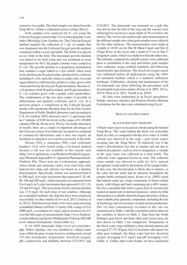
A black water seep was located at a break along the bermed Tengi River. The water behind the berm was noticeably black in color, as compared with the river water. A visible current was observed in the seep – peat forest waters escaping into the Tengi River. To indirectly test if the water’s discoloration was due to tannins and not due to mineral precipitates, such as iron or manganese, a sample of the seep water was collected in a clear bottle. The collected water appeared brown in color. The collected water sample was allowed to settle for 24 h; mineral precipitates would settle to the bottom of the sample bottle. In this case, the discoloration is likely due to tannins, as the color did not settle and its intensity throughout the sample bottle remained intact. Kraus et al. (2003) noted that tannins make up a large component of forest carbon pools, with foliage and bark containing up to 40% tannin, but also concluded that while a great deal of research has looked at tannin role in nutrient dynamics, relatively little information is available about the biogeochemistry of these water-soluble poly-phenolic compounds, including the role of hydrology and soil aeration on plant tannin production. The YSI data continuously recorded at this site are summarized in Table 1 and the correlation matrix between the variables is shown in Table 2. Data from the North Selangor peat forest and from other peat forest areas are also shown in Table 1 for comparison. Temperature in the black water seep exhibited a clear diurnal pattern and averaged 27.3°C (Figure 3(a)). Consistent with reports for other peat wetlands, the black water had low dissolved oxygen (averaging 0.31 mg/L) and pH (averaging 3.63) (Table 1). Unlike other water bodies we have monitored
1543
in Southeast Asia (Irvine et al. 2011b; Price et al. 2011), dissolved oxygen did not exhibit a well-defined diurnal pattern (Figure 3(c) and 3(d)). Although temperature and dissolved oxygen were (significantly, α=0.05) negatively correlated (Table 2), as might be expected due to system metabolism, the relationship is weak which suggests a low rate of photosynthetic activity that is most likely due to low levels of green algae. Yule and Gomez (2009) reported chlorophyll a levels for the North Selangor peat forest as <5 μg/L, which is quite low and is consistent with the idea of limited photosynthetic activity. The slightly elevated levels of dissolved oxygen during the first day of sampling cannot be explained. It should be noted that the elevated levels would be considered insignificant (0.8 versus 0.3 mg/L) at typical scales used for water monitoring. Unlike dissolved oxygen, pH did exhibit a slight diurnal pattern (Figure 3(b)) which was significantly (α=0.05) and strongly correlated with water temperature (r=0.587). Water temperature and pH commonly increase during daylight hours in
response to increased air temperature and photosynthesis, respectively. However, the poorly-defined daily pattern for dissolved oxygen in the black water seep suggests another explanation for the pH diurnal pattern. A likely mechanism is anaerobic digestion, where the production of acid forming acetogens is favored during periods of low temperatures (night hours), thus slightly reducing the water’s nightly pH. The increase in turbidity (Figure 3(e)) may have been the result of fish activity resuspending sediment or a localized rain event that occurred in the area. Thunder was heard and dark clouds were observed in the area during the sample period, but no local rain gauge data were available to confirm rainfall. In general, however, turbidity was quite low (averaging 1.2 NTU) and is consistent with values reported in Table 1. Conductivity was relatively low and certainly did not indicate any presence of salinity. The low conductivity (Figure 3(f)) is consistent with the low Ca concentrations (<18 ppm), indicating that the black water had no buffering capacity.
FIGURE 3. YSI results recorded at 15 min intervals, in a black water seep of the peat forest: (a) temperature, C; (b) pH; (c) dissolved oxygen, mg/L; (d) dissolved oxygen, % saturation; (e) turbidity, NTU and (f) conductivity, mS/cm
Time steps Time steps
Time steps
Time stepsTime steps
Time steps
Tem
pera
ture
, C
pH
Dis
solv
ed O
xyge
n, m
g/L
Dis
solv
ed O
xyge
n, %
Sat
.
Turb
idity
, NTU
Con
duct
ivity
, mS/
cm
(a) (b)
(c) (d)
(e) (f)
Peat Forest, Black Water, Kuala Selangor, Malaysia
Peat Forest, Black Water, Kuala Selangor, Malaysia
Peat Forest, Black Water, Kuala Selangor, Malaysia
Peat Forest, Black Water, Kuala Selangor, Malaysia
Peat Forest, Black Water, Kuala Selangor, Malaysia
Peat Forest, Black Water, Kuala Selangor, Malaysia

1544
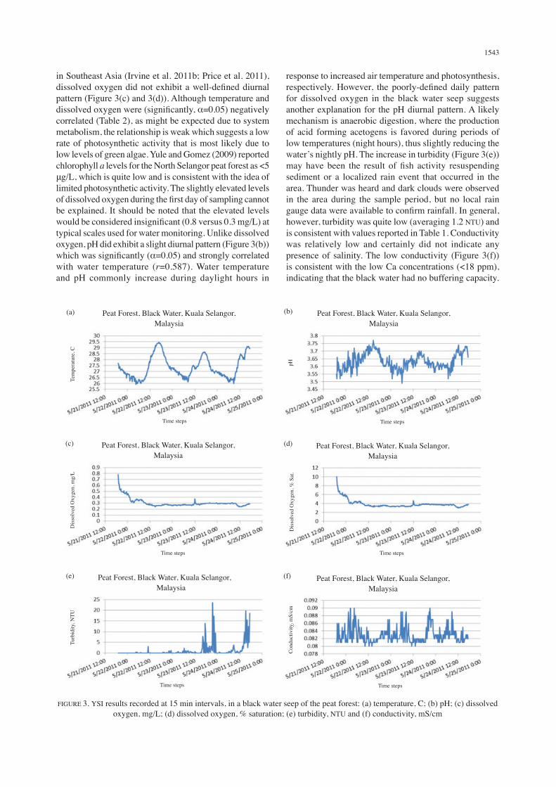
E. coli was absent from samples collected from the seep (Figure 4). This finding reinforces local knowledge which describes the black water as safe to drink with respect to bacterial contamination. On each trip to the black water, our boat pilot took the opportunity to drink the water directly from the seep. However, there still seems to be some uncertainty with respect to tannin impacts on health, as Chung et al. (1998) concluded a small quantity of certain tannins can be beneficial to human health while consumption of large quantities may be detrimental
to human health. Nitrate and ammonia measurements consistently read zero, indicating the levels in the samples were less than the method detect limit of 20 mg/L (nitrate) and 0.5 mg/L (ammonia). Yule and Gomez (2009) reported nitrate levels from their samples as <0.1-0.2 mg/L (ppm), while ammonia levels reported in other studies (Table 1) also were quite low. Colorimetric kits with lower detection limits (nitrate, 0.25 mg/L; ammonia, 0.05 mg/L) are available on the market and in retrospect these might have been tried for this study.
TABLE 1. Selected water quality values for black water locations in Malaysia
Study Turbidity, NTU
pH Dissolved Oxygen, mg/L
Conductivity, mS/cm
Temperature, °C
Ammonia, mg/L
Beamish et al. (2003)1 1.0-53.4 3.4-5.5 2.2-6.1 0.022-0.168 26-28 0-0.29Yule & Gomez (2009)2 Not determined 2.6-3.8 1.8-16 Not determined 25-32 Not determinedRahim et al. (2009)3 Not determined 4.55 1.15 0.021 26.6 0.81Gasim et al. (2007)4 1.5-17.2 3.53-4.55 0.5-1.76 0.053-0.062 26.2-28.9 Not determinedThis Study5 1.2 (3.2) 3.63 (0.05) 0.31 (0.07) 0.083 (0.002) 27.3 (0.9) <0.5
1multiple sites, North Selangor peat forest, including an irrigation ditch2multiple sites, North Selangor peat forest3black water habitats, Batang Kerang floodplain, Balai Ringin, Serian, Sarawak4multiple sites, Bebar River, Pahang 5Sample Site A, black water seep, North Selangor peat forest, mean value with standard deviation in brackets
TABLE 2. Pearson product moment correlation between YSI variables, 15 min intervals (n=282), black water seep, 5/21/2011-5/24/2011
Temperature, °C Conductivity, mS/cm Dissolved Oxygen, mg/L pH Turbidity, NTU
Temperature, C 1Conductivity, mS/cm -0.4231 1Dissolved Oxygen, mg/L -0.279 0.123 1pH 0.587 -0.108 -0.356 1Turbidity, NTU 0.263 0.072 -0.110 0.201 1
1bold values are significantly greater than 0 (α=0.05)
(a) (b)
FIGURE 4. Incubated plates for the black water seep on sample dates: (a) 5/21/11; and (b) 5/24/11. No E. coli were found on either plate. Other (non-E. coli) bacteria show for 5/24/11

1545
DOWNSTREAM WATER CHEMISTRY
An examination of the downstream sites showed a consistent pattern of change with E. coli counts, pH, dissolved oxygen and turbidity reflecting the influence of the agriculture and town development on the water quality parameters. Other parameters, such as carbonate hardness, nitrate and ammonia remained unchanged from measurements taken in the black water seep (measurements were not taken at Site D due to the water’s high salt content). E. coli levels (Figure 5) showed a slight increase in the Main Canal (Site B), increasing five-fold as the water passed through the rice paddies and increasing to levels of 7100 colonies/100 mL in the Tengi River at the town-impacted location (Site D). The black water seep pH was low, but the pH levels increased (Figure 6), although there is little buffering
capacity (Ca <18 ppm), as the water flowed to the sea. The low dissolved oxygen (DO) levels associated with the black water seep increased as the water passed from the Main Canal, downstream through paddy fields (Figure 7). The DO levels dropped off downstream in the Tengi River likely due, in part, to settlement (town) water pollution. Interestingly, turbidity was much higher in the downstream sites as compared with the black water seep (Figure 8). Visually, we observed that the water in the Tengi River (Site D) was flowing ‘upstream’ at the time of sampling and we suspected a tidal influence. This was confirmed by the conductivity measurement, which was 3.978 mS/cm, indicative of slightly saline conditions. The TDS values at Sites A to C were low (corresponding to the low conductivity values), between 20 and 60 mg/L. Dissolved solids in freshwater usually consist of various
Sampling Sites
pH
FIGURE 6. Acidity (pH). Both the ‘black water’ and ‘main canal’ values represent an average taken of two grab samples collected on 5/21/11 and 5/24/11. The remaining site values are
for a single grab sample collected on 5/24/11
pH
Sampling Sites
Cou
nts/
100
mL
FIGURE 5. E. coli counts. Both the ‘black water’ and ‘main canal’ counts represent an average taken of two grab samples collected on 5/21/11 and 5/24/11. The remaining sites represent a single grab sample
collected on 5/24/11. The plate shows bacteria from the Tengi River
E-coli

1546
ions, typically calcium, nitrate, phosphorus, iron, sulfate, potassium and other ions from organic and inorganic sources. Given the low pH greater dissolution might be expected too. The TDS (and conductivity) provide an indicator of a broad array of chemicals in the water, many of which we did not measure individually. So, the TDS values provide us an aggregate measure showing a low level of dissolved pollutants, even at Site C. These TDS values reinforce our below detection nitrate and ammonia measurements.
CONCLUSION
Longitudinal patterns in water quality parameters were observed at the sample sites, moving from upstream peat forest black water to agricultural-impacted canals and finally to the town-impacted Tengi River. The black water had low pH, dissolved oxygen, turbidity and nutrients, which was consistent with studies done in other areas of Malaysia as well as the North Selangor peat forest. Dissolved oxygen level increased in the canals in the downstream direction but was lower at the town-impacted
Sampling Sites
Dis
solv
ed O
xyge
n (m
g/L)
Dissolved Oxygen
FIGURE 7. Dissolved Oxygen (DO). Both the ‘black water’ and ‘main canal’ values represent an average taken of two grab samples collected on 5/21/11 and 5/24/11.
The remaining site values are for a single grab sample collected on 5/24/11
Sampling Sites
Turb
idity
(NTU
)
Turbidity
FIGURE 8. Turbidity. Both the ‘black water’ and ‘main canal’ values represent an average taken of two grab samples collected on 5/21/11 and 5/24/11. The remaining site values are
for a single grab sample collected on 5/24/11
1547
site, while E. coli levels exhibited a monotonic increase from upstream to downstream, with the town-impacted site exhibiting considerably elevated levels. Conventional water quality parameters were effectively and continuously monitored by a YSI datasonde; studies from other areas (Irvine et al. 2005, 2011b; Price et al. 2011; Visoth 2010) have shown that continuous data can be valuable in helping to better understand system dynamics. While some interesting spatial trends have emerged from this study, it would be useful to conduct additional sampling that spanned the rainy and dry seasons and include analysis for nitrate and ammonia with lower detect limits.
ACKNOWLEDGEMENTS
We would like to thank the undergraduate students from the University of Malaya and Buffalo, NY, who helped with some of the sampling as part of a collaborative field course between the two universities. Mary Perrelli, Jennifer O’Neill and Rachel O’Neill produced the map in Figure 2. The original concept for this collaboration was developed at an Association of American Geographers Center for Global Geography Education workshop in Singapore (2010). We would like to thank the Geography Department at the University of Malaya for logistical support. This manuscript was completed while Kim Irvine was on sabbatical at the National Institute of Education, Nanyang Technological University, Singapore.
REFERENCES
ADB. 2009. The Economics of Climate Change in Southeast Asia: A Regional Review. ADB Report RPT090153, Manila, Philippines.
Beamish, F.W.H., Beamish, R.B. & Lim, S.L-H. 2003. Fish assemblages and habitat in a Malaysian blackwater peat swamp. Environmental Biology of Fishes 68: 1-13.
Chung, K-T., Wei, C-I. & Johnson, M.G. 1998. Are tannins a double-edged sword in biology and health? Trends in Food Science & Technology 9: 169-175.
Corvi, M.M., Stanley, K.A., Peterson, T.S., Kent, M.L., Feist, S.W., La Du, J.K., Volz, D.C., Hosmer, A.J. & Tanguay, R.L. 2012. Investigating the impact of chronic atrazine exposure on sexual development in zebrafish. Birth Defects Research Part B: Developmental and Reproductive Toxicology 95: 276-288.
Gasim, M.B., Toriman, B.S.I., Mir, S.I. & Chek, T.C. 2007. A physico-chemical assessment of the Bebar River, Pahang, Malaysia. Global Journal of Environmental Research 1(1): 7-11.
Greeley, M.S., Elmore, L.R. & McCracken, M.K. 2012. Evaluating the Effects of Fly Ash Exposure on Fish Early Life Stages: Fathead Minnow Embryo-Larval Tests. Environmental Sciences Division, Oak Ridge National Laboratory, Oak Ridge, TN, Report ORNL/TM-2012/149.
Irvine, K.N., McCorkhill, G. & Caruso, J. 2005. Continuous monitoring of conventional parameters to assess receiving water quality in support of CSO abatement plans. Water Environment Research 77(5): 543-552.
Irvine, K., Rossi, M.C., Vermette, S., Bakert, J. & Kleinfelder, K. 2011a. Illicit discharge detection and elimination: Low cost options for source identification and trackdown in stormwater systems. Urban Water Journal 8(6): 379-395.
Irvine, K.N., Richey, J.E., Holtgrieve, G.W., Sarkkula, J. & Sampson, M. 2011b. Spatial and temporal variability of turbidity, dissolved oxygen, conductivity, temperature, and fluorescence in the lower Mekong River-Tonle Sap system identified using continuous monitoring. International Journal of River Basin Management 9(2): 151-168.
Kraus, T.E.C., Dahlgren, R.A. & Zasoski, R.J. 2003. Tannins in nutrient dynamics of forest ecosystems – a review. Plant and Soil 256: 41-66.
Kumari, K. 1996. An Application of the Incremental Cost Framework to Biodiversity Conservation: A Wetland Case Study in Malaysia. Centre for Social and Economic Research on the Global Environment Working Paper GEC 96-15.
Ng, P.K.L., Tay, J.B. & Lim, K.K.P. 1994. Diversity and conservation of blackwater fishes in Peninsular Malaysia, particularly in the North Selangor peat swamp forest. Hydrobiology 285(1-3): 203-218.
Nee, K. & Guan, L.P. 1993. The avifauna of the North Selangor peat-swamp forest, west Malaysia. Bird Conservation International 3: 169-179.
Price, J., Chaosakul, T., Surinkul, N., Bowles, J., Rattanakul, S., Pradhan, N., Simphan, W., Ghimire, A., Wilaingam, K., Truong, L.M., Nguyen, T.V., Pussayanavin, T., Proysurin, N., Singjan, S., Longaphai, V., Kalaimathy, S.N., Koottatep, T. & Irvine, K.N. 2011. Surface water quality and risk analysis in a peri-urban area, Thailand. Proceedings, 9th International Symposium on Southeast Asia Water Environment.
Rahim, K.A.A., Daud, S.K., Siraj, S.S., Arshad, A., Esa, Y. & Ibrahim, E.R. 2009. Freshwater fish diversity and composition in Batang Kerang floodplain, Balai Ringin, Sarawak. Pertanika J. Trop. Agric. Sci. 32(1): 7-16.
UNDP. 2006. Malaysia`s Peat Swamp Forests Conservation and Sustainable Use. UNDP Malaysia.
Visoth, T., Yim, M., Vathna, S., Irvine, K. & Koottatep, T. 2010. Efficiency of Phnom Penh’s natural wetlands in treating wastewater discharges. Asian Journal of Water, Environment and Pollution 7(3): 39-48.
Yule, C.M. & Gomez, L.N. 2009. Leaf litter decomposition in a tropical peat swamp forest in Peninsular Malaysia. Wetlands Ecol. Manage. 17: 231-241.
Yusop, Z. 2002. Hydrological attributes of a disturbed peat swamp forest. In Prevention and Control of Fire in Peatlands, Proceedings of a Workshop at Forestry Training Unit, Kuala Lumpur, 19th – 21st March, 2002.
Wagener, T., Sivapalan, M., Troch, P.A., McGlynn, B.L., Harman, C.J., Gupta, H.V., Kumar, P., Rao, P.S.C., Basu, N.B. & Wilson, J.S. 2010. The future of hydrology: An evolving science for a changing world. Water Resources Research 46: 1-10.
Kim Irvine* & Stephen Vermette Department of Geography and Planning; and Center for Southeast Asia Environment and Sustainable DevelopmentBuffalo State, State University of New YorkBuffalo, 1300 Elmwood Ave. Buffalo, NY, 14222USA

1548
Firuza Begham MustafaDepartment of Geography, Faculty of Social ScienceUniversity of Malaya50603 Kuala LumpurMalaysia
*Corresponding author; email: [email protected]
Received: 19 July 2012Accepted: 8 May 2013