Embed Size (px)
DESCRIPTION
A circular walk from Lescun
Citation preview

The Belvédère - overview
This is a route for the whole family. Never is it too physically demanding; navigation is simple and there are good paths throughout. It starts and finishes in the village but, despite its apparent tameness, it provides jaw-dropping views of both the village and “the cirque”. For those whose interests lie in flora and fauna the route offers a relaxed introduction to what the area has to offer and, for others who aspire to venture further and higher, the Belvédère represents an excellent “warm up” excursion as well as a valuable opportunity to get to grips with the geography of the mountains beyond the “plateau”.After leaving the village, the route takes a gently rising line at the eastern end of the Crète D’Ourtasse – the ridge which fills the skyline to the north of the village. It then spends some time in the shady Bois de Barlatte before re-emerging on the crète to commence an, initially, steep descent to Lescun.
The village of Lescun and, beyond, a large part of “the cirque” as seen from the Belvédère.

The Belvédère – the routeStart Timing Denivelation Terrain Season
The village square.
2 – 2.5h 322m Tarmac. Good mountain and forest path.
April to December (depending on snow cover)
• Waypoint 1 (N42°56'1.71 W0°38'5.8; alt.900m) – From outside the hotel walk up past the shop to the Marie and turn right. Take the next turning on the right just past the house selling cheese. After a few metres take the street on the left (signposted Belvédère) rather than continuing to the church. Follow the road round past the building with the cut stone façade. (This is reckoned to be the oldest house in the village.)Continue straight on, ignoring an turnings to the left, following more signs until the final few houses are past and the road turns into a footpath.
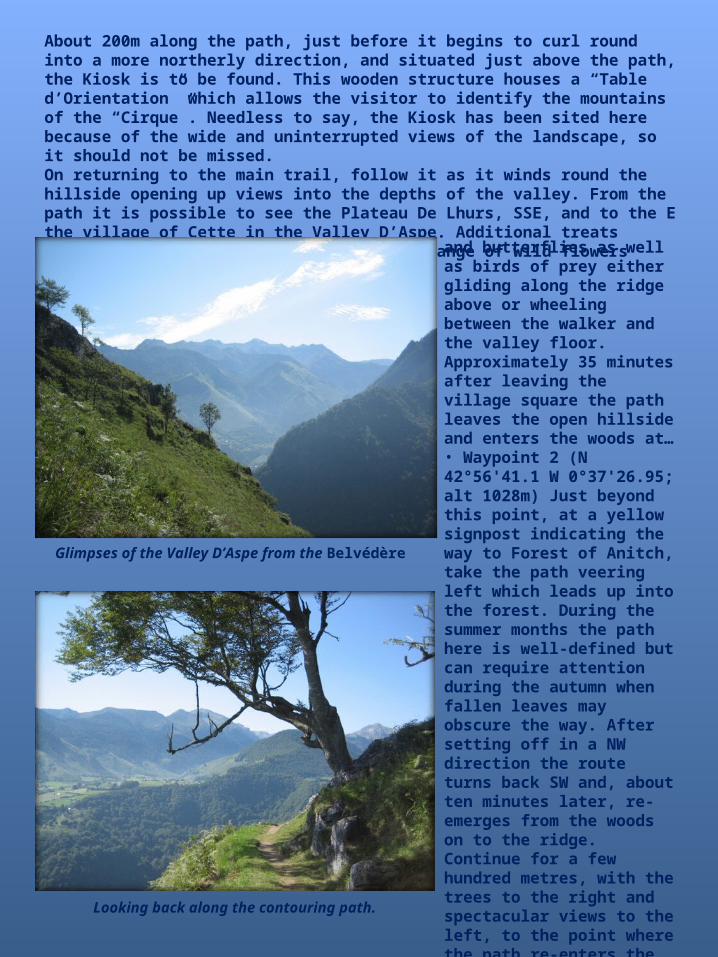
About 200m along the path, just before it begins to curl round into a more northerly direction, and situated just above the path, the Kiosk is to be found. This wooden structure houses a “Table d’Orientation” which allows the visitor to identify the mountains of the “Cirque”. Needless to say, the Kiosk has been sited here because of the wide and uninterrupted views of the landscape, so it should not be missed.On returning to the main trail, follow it as it winds round the hillside opening up views into the depths of the valley. From the path it is possible to see the Plateau De Lhurs, SSE, and to the E the village of Cette in the Valley D’Aspe. Additional treats during the summer months include a wide range of wild flowers
Glimpses of the Valley D’Aspe from the Belvédère
and butterflies as well as birds of prey either gliding along the ridge above or wheeling between the walker and the valley floor.Approximately 35 minutes after leaving the village square the path leaves the open hillside and enters the woods at…• Waypoint 2 (N 42°56'41.1 W 0°37'26.95; alt 1028m) Just beyond this point, at a yellow signpost indicating the way to Forest of Anitch, take the path veering left which leads up into the forest. During the summer months the path here is well-defined but can require attention during the autumn when fallen leaves may obscure the way. After setting off in a NW direction the route turns back SW and, about ten minutes later, re-emerges from the woods on to the ridge.Continue for a few hundred metres, with the trees to the right and spectacular views to the left, to the point where the path re-enters the forest. Stay with it as it zigzags its way uphill
Looking back along the contouring path.
in a generally SW direction. About an hour after leaving the village square the route quits the forest for the last time. At this point, ignore the path leading straight on and turn right, as indicated by the yellow sign. In summer there should be a broad path cleared through the bracken which leads to another signpost marking the beginning of the descent to the village.
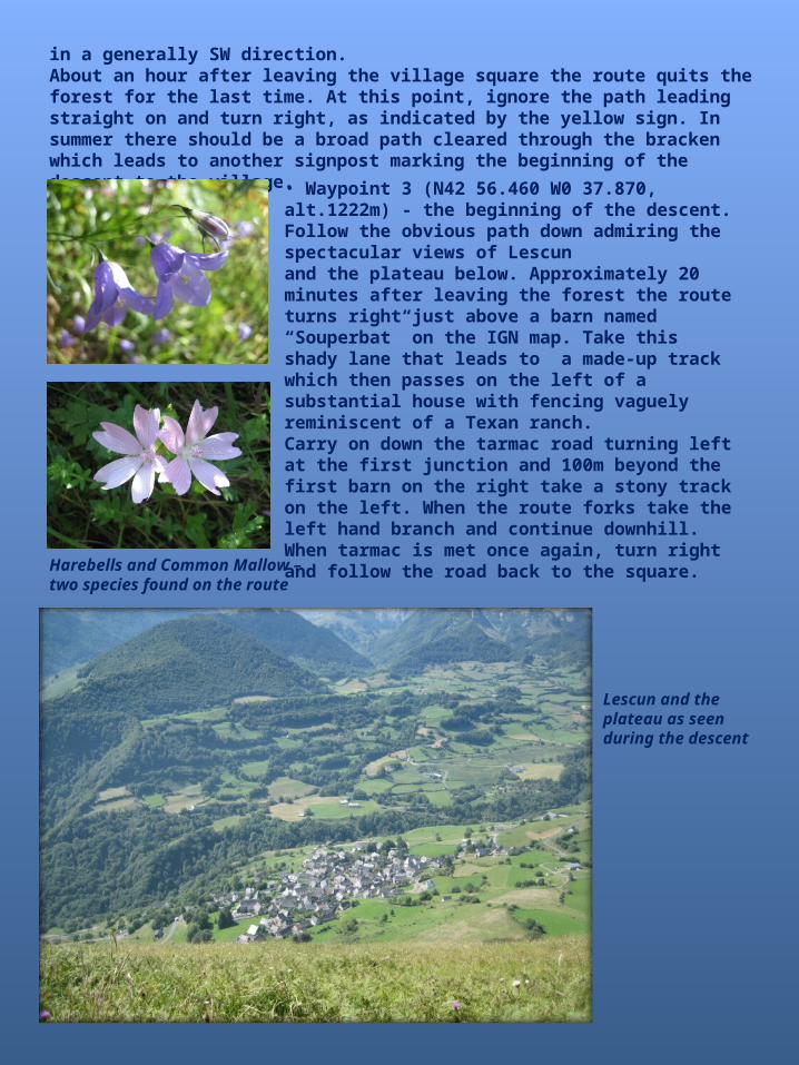
Harebells and Common Mallow – two species found on the route
• Waypoint 3 (N42 56.460 W0 37.870, alt.1222m) - the beginning of the descent. Follow the obvious path down admiring the spectacular views of Lescun and the plateau below. Approximately 20 minutes after leaving the forest the route turns right just above a barn named “Souperbat” on the IGN map. Take this shady lane that leads to a made-up track which then passes on the left of a substantial house with fencing vaguely reminiscent of a Texan ranch.Carry on down the tarmac road turning left at the first junction and 100m beyond the first barn on the right take a stony track on the left. When the route forks take the left hand branch and continue downhill. When tarmac is met once again, turn right and follow the road back to the square.
Lescun and the plateau as seen during the descent


![Lay-out binnenwerk proefdruk 2[Belvédère Maastricht: Waardecreatie in gebiedsontwikkeling] Ir. Jos Severijns van RO groep neemt ons mee naar het project Belvédère en de gezamenlijke](https://img.dokumen.tips/doc/110x75/5f0969a67e708231d426b770/lay-out-binnenwerk-proefdruk-2-belvdre-maastricht-waardecreatie-in-gebiedsontwikkeling.jpg)