Embed Size (px)
Citation preview

10.n
ovem
ber.
2011
| 09
h20
- 0
9h40
The Beja Public Geological Trail – Geology in the garden Page 59
The Beja Public Geological Trail – Geology in the garden
J.X. MATOS – [email protected] (LNEG, Unidade Investigação. Recursos Minerais e Geofísica, Beja, Portugal)
J. PIÇARRA – [email protected] (LNEG, Unidade Investigação. Geologia e Cartografia Geológica, Beja; Centro de
Geociências da Univ. de Coimbra, Portugal)
Z. PEREIRA – [email protected] (LNEG, Unidade Investigação. Geologia e Cartografia Geológica, S. Mamede de
Infesta, Portugal)
R. DIAS – [email protected] (LNEG, Unid. Investigação.Geologia e Cartografia Geológica, Alfragide, Portugal)
S. PRETESEILLE – [email protected] (Geological Survey of Ireland, Dublin, Ireland)
ABSTRACT: A Geological Time trail is being developed by LNEG in the Beja Public Garden. Along a 200 m linear path, 1000 Ma are considered, from Precambrian to Quaternary. Fourteen rock samples from South Portugal geological units show igneous, sedimentary and metamorphic rocks, ores and fossils from the South Portuguese and Ossa Morena Zones, Santiago Cacém Mesozoic and Alvalade Neogenic basins. A special jump through time is dedicated to children (1 m = 5 Ma, the time scale). With this project, LNEG and the Beja Municipality aim at promoting the visit of the city and improving culture in geosciences.
KEYWORDS: Geological time trails, Beja Garden, geological and mining heritage.
1. INTRODUCTION TO THE GEOLOGICAL TIME TRAILTime in geosciences is a basic principle commonly used by geologists to understand the Earth
History and the evolution of life. Each rock class (sedimentary, igneous, metamorphic), each crust
process, each tectonic event, each deformation phase, each ore deposit present different time scales,
intensely investigated in geosciences. By nature, the geological time is complex and continuous,
considering the different aspects of stability and evolution process of each rock. Detailed research
allows a better understanding of each geological formation. Academic discussions help to
understand the origin and evolution of each geological unit, and their stratigraphic correlation.
Geological time however is a very complex theme for the general public. The lay person has
difficulties understanding the fourth dimension concept and complex models, like discordances,
faults, intrusions, marine transgressive/regressive sequences, complex folding phases, etc. The
valorisation and promotion of geological heritage to the public is an important work; recently
developed by Geological Surveys, Universities and geologists using and applying the same
synergies in a didactic approach. The main goal is to develop a new generation of geoscience
exhibits, serving as dynamic learning laboratories, where visitors can explore the geological
materials, allowing an accurate content, an active inquiry and interpretation that promote a cultural
integration (Karlstrom et al., 2008).Portugal is characterised by a rich geodiversity illustrated in the Palaeozoic Variscan basement, in
the Mesozoic basins and massifs and in the Neogenic basins (see 1/1000000 Portugal geological
map, LNEG 2010 and 1/500000 South Portugal map, SGP 1992). From the Precambrian (the most
ancient rock record) to the present time, the Portuguese territory shows a complex geological
history, characterised by the orogenic cycles, continental drift, ocean openings and closures. The
Beja Garden Geological Time Trail is a project developed by LNEG and the Beja Municipality,
focussing on the geological formations of South Portugal and dedicated to the Earth crust evolution
through time in the Baixo Alentejo district; the Portuguese southern region where Beja City is the
capital and main urban area. The Beja Public Garden Geological Trail is one the first of its kind ever
prepared in Portugal.
10.n
ovem
ber.
2011
| 09
h20
- 0
9h40
Page 60 The Beja Public Geological Trail – Geology in the garden
2. GEOLOGY IN THE BEJA PUBLIC GARDEN, THE PROJECT CONCEPTConsidering best practice examples of the European Atlanterra/Green Mines Space Atlantic Area
Project, LNEG and the Beja Municipality planned a geological time trail for the city main Public
Garden. The Geological Survey of Ireland and the Copper Coast Geopark are collaborating with the
Portuguese team considering their experience in developing a Geological Time Trail in the Irish
village of Bunmahon, where a geological garden was constructed (see Copper Coast Geopark 2011
web site ).The Beja Public Garden was built in 1900s by the municipality in the downtown area, near the
historic city centre. The Beja Public Garden Geological Trail and other recent educational projects
developed in the garden aim at increasing the number of visitors to the city centre and promoting
geosciences to the general public, schools and residents.The Beja Geological Trail will consist of a linear 200 m path, corresponding to a time interval of
1000Ma. The journey goes back in time to the formation of the Earth (4500 Ma in age), and it is
materialised by an outside known urban area, located more than 1km from the garden (i.e. Beja
Hospital). This option allows a better management of the interpretation points, focused in the most
recent periods of the planet Earth history. Fourteen stops are considered (see Table 1) along the
geological timeline and allow valorising the main geological units of the Ossa Morena and South
Portuguese Zones, the Sines Massif, the Santiago do Cacém Mesozoic Basin, and the Alvalade
Neogenic Basin. Each sample is correlated with a clear geographic reference and, when possible,
related with a Baixo Alentejo extractive activity, e.g. the massive sulphide ore of the Neves Corvo
mine (Cu, Zn, Sn), the Barrancos shales and Trigaches marbles used as ornamental rock and house
construction; the Beja gabbros used in road pavement and the Alvalade Basin sandstones used as
aggregates. The trail is mainly an interpretative trail that will be marked with several Trigaches
marble cubes, 28 cm x 28 cm in dimension, which will mark the position of the selected samples (See
table 1). Each cube presents the age of the sample in million years and a short descriptive text label of
the sample. The selected samples have ~1m dimensions, in order to be geologically representative
of the events, units and paleontological contents. Samples include fossils of the Silurian graptolites
of Barrancos (Piçarra, 2000), the Famennian miospores and acritarchs (microfossils) black shales of
the Phyllite-Quartzite Group, the Upper Visean bivalves of the Mértola Formation (Oliveira et al.,
2006; Pereira et al., 2008), the Upper Jurassic marine shells of the Santiago Cacém limestones, the
Miocene ostrae of Alfundão and the calcretes of Beringel. The presence of volcanoes and igneous
massifs is recorded by the Famennian (Upper Devonian) felsic volcanism of the Iberian Pyrite Belt
and the Carboniferous Beja Igneous Complex gabbros. Deformation and orogenic events are shown
by the Precambrian gneisses and the Lower Cambrian marbles of Trigaches. These marbles present a
coarse granoblastic texture and grey colour. They are the main rocks used in construction of modern th
and ancient monuments in Beja City, like the Beja Castle (12 century), museum, city hall, court,
library and main schools.The selected presented samples, some of which are approximately 1 ton in weight, were collected
in the best outcrops: some in quarries and galleries. The LNEG team very much appreciated the
precious help in transport and logistics provided by the Baixo Alentejo extractive companies and
some municipalities.The location of each stop, marked with the cubes, is planned along the timeline trail which sets a
project scale of 1 m per 5 Ma. A special feature: the “jump through time”, illustrating an important
gap through geological time, is being considered mainly for children and students.
http://homepage.eircom.net/~ccgeopark/Everyone.htm

10.n
ovem
ber.
2011
| 09
h20
- 0
9h40
The Beja Public Geological Trail – Geology in the garden Page 61
A series of rocks and exhibits that will include interpretation panels, brochures and a website will
serve to promote the project and explain how South Portugal rocks were formed. Schools guides can
also be considered.
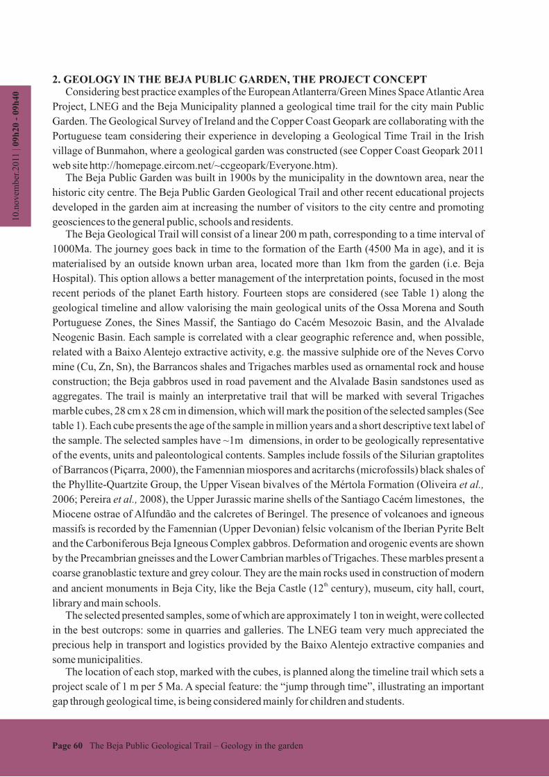
Ma Geological unit Period Geographical reference Fossils
1000 Micaschist Precambrian Vidigueira -
520 Marbles of Trigaches Cambrian Trigaches (Beja) -
470 Shales of Barrancos Ordovician Barrancos Ichnofossils
443 Quartzites of Colorada Ordovician/Silurian Barrancos Ichnofossils
428 Nodules Shales Silurian Barrancos Graptolites
360 Volcano-Sedimentary Comp. Devonian Cercal, Neves Corvo Palynomorphs
330 Flysch of Mértola Carboniferous Mértola Bivalves
310 Beja Igneous Complex Carboniferous Beja -
300 Pedrogão Granite Carboniferous Pedrogão -
230 Silves Sandstone Triassic Santiago do Cacém -
180 Bioclastic Limestone Jurassic Santiago do Cacém Ammonoids
7 Carbonate sandstones Miocene Alfundão Oysters
5 Sandstones Pliocene Melides -
0 Alluvium and Dunes Quaternary Guadiana, S. Torpes -
3. CONCLUSIONS AND PROJECT SUSTAINABLE DEVELOPMENTThe Beja Public Garden Geological Trail prepared for the Beja Garden is one of the first of its
kind ever prepared in Portugal. This is a singular project that allows the presentation and valorisation
of the significant geodiversity of the South Portugal Geological Units. This Geological Trail project is dedicated to the Beja citizens and general public. The trail will be
a valid opportunity to promote Geoscience contents in a didactic way, mainly for local schools. The
design and research results will be developed and applied to cultural exhibits and programs that will
be integrated in the regional network partners dedicated to the geological and mining heritage
(Matos et al., 2008), which involves the Lousal (Relvas et al., 2005) and the Estremoz Life Science
Centres and the Noudar Nature Park (Barrancos) Piçarra, 2009. Exhibitions will be prepared, based
on small collection samples, to promote the concept. As partner of the Atlanterra project, LNEG
team work will discuss the project methodology with European partners. Other networks can be
considered like ProGeo, Iberoamerican networks and National Forum of Geoparks.
AcknowledgmentsThe authors thanks to the Beja Municipality and the Altanterra project (Interreg Space Atlantic Area) the
support of this work. Many thanks for the collaboration of the LNEG colleagues Tomás Oliveira, Rita Silva,
Luísa Duarte, Ricardo Ressurreição and Amilcar Bartolomeu and the extractive companies and
municipalities associated to the project.
Table I. Beja Public Garden Geological Trail – stops and samples:

10.n
ovem
ber.
2011
| 09
h20
- 0
9h40
Page 62 The Beja Public Geological Trail – Geology in the garden
ReferencesKarlstrom, K, Semken, S., Crossey, L., Perry, D., Gyllenhaal, E. D., Dodick, J., Williams, M., Hellmich-Bryan, J., Crow,
R., Bueno Watts, N., Ault, C. (2008) -
Laboratório Nacional de Energia e Geologia (2010) – Carta Geológica de Portugal, escala 1/1000000.Matos, J.X.; Martins, L.P.; Oliveira, J.T.; Pereira, Z.; Batista, M.J.; Quental, L. (2008) - Rota da pirite no sector português
da Faixa Piritosa Ibérica, desafios para um desenvolvimento sustentado do turismo geológico e mineiro. Projecto
RUMYS, programa CYTED, Livro Rutas Minerales en Iberoamérica, Ed. Paul Carrion, Esc. Sup. Politécnica del
Litoral, Guayaquil, Equador, pp 136-155.Oliveira, J.T.; Relvas, J.M.R.S.; Pereira, Z.; Matos, J.X.; Rosa, C.J.; Rosa, D.; Munhá, J.M.; Jorge, R.C.G.S.; Pinto,
A.M.M. (2006) - O Complexo Vulcano-Sedimentar da Faixa Piritosa: estratigrafia, vulcanismo, mineralizações
associadas e evolução tectonoestratigráfica no contexto da Zona Sul Portugesa. in Dias R, Araújo A., Terrinha P, e
Kulberg JC ( eds.), Geologia Portugal na Ibéria, VII Cong. Nac. Geologia, Un. Évora, Portugal, pp. 207-244.Pereira, Z., Matos, J., Fernandes, P. Oliveira J.T. (2008) - Palynostratigraphy and Systematic Palynology of the
Devonian and Carboniferous Successions of the South Portuguese Zone, Portugal. Memória N.º 34 do INETI: 1-
176.Piçarra, J.M. (2000) - Estudo estratigráfico do sector de Estremoz-Barrancos, Zona de Ossa Morena, Portugal. Tese de
doutoramento, Universidade de Évora, 268 pp.Piçarra, J.M. (2009) - Roteiro Geológico do Parque de Natureza de Noudar. In Pedro Florido & Isabel Rábano (Eds.),
Una visión multidisciplinar del Patrimonio Geológico y Minero. X Congreso Internacional sobre Patrimonio
Geológico y Minero, Coria, Resúmenes, 43-44.Relvas, J.M.R.S., Póvoas, L., Costa, T. Matos, J., Varela, T., Lopes, C., Barriga, F.J.A.S. (2005) - Project “Underground
Visit to the Lousal Mine”: a contribution to Geoconservation and Sustainable Development, IV Int. Symposium
ProGEO on the Conservation of Geological Heritage, Braga, Portugal.Serviços Geológicos de Portugal (1992) – Carta Geológica de Portugal, escala 1/500000, Folha Sul.
Informal Geoscience Education on a Grand Scale: The Trail ofTime Exhibition at Grand Canyon. Journal of Geoscience Education, v. 56, 354-361