Embed Size (px)
Citation preview
The Barra Fan and Hebrides Terrace Seamount MPA - Data Confidence Assessment v5.0 July 2014
Scottish MPA Project
Data Confidence Assessments
THE BARRA FAN AND HEBRIDES TERRACE SEAMOUNT NATURE CONSERVATION MPA
JULY 2014
The following documents provide further information about The Barra Fan and Hebrides Terrace Seamount MPA:
Site Summary Document
Assessment against the MPA Selection Guidelines
Management Options Paper
The documents are all available at www.jncc.defra.gov.uk/page-6489

The Barra Fan and Hebrides Terrace Seamount MPA - Data Confidence Assessment v5.0 July 2014
1
Document Distribution List and Version Control
Format Version Issue date Version development and review Issued to
Electronic 1.0 28/11/2012 Internal drafting and creation of version 1.0 for internal review.
Internal JNCC
Electronic 2.0 11/04/2013 Internal drafting and review of pre-version 2.0 drafts by JNCC SMPA team and Grade 7 staff and editorial review prior to release to MPA Sub Group
MPA Sub Group
Electronic 3.0 10/06/2013 Review of document to take into account MPA Sub-Group comments by JNCC SMPA team prior to release to MPA Sub Group for sign-off
MPA Sub Group
Electronic 4.0 12/07/2013 Review of document to take into account MPA Sub-Group comments by JNCC SMPA team and editorial review before release of document for public consultation.
Uploaded to JNCC website
Electronic 5.0 18/07/2014 Document update to align with designation status and text revised in response to consultation and independent review report
Delivery to Marine Scotland to support MPA designation and upload to JNCC website

The Barra Fan and Hebrides Terrace Seamount MPA - Data Confidence Assessment v5.0 July 2014
2
Figure 1 Map showing the location of The Barra Fan and Hebrides Terrace Seamount MPA

The Barra Fan and Hebrides Terrace Seamount MPA - Data Confidence Assessment v5.0 July 2014
3
MPA name The Barra Fan and Hebrides Terrace Seamount
Date of initial assessment
31st July 2012 Assessors ALR, NC, PC, ML, OCA
The Barra Fan and Hebrides Terrace Seamount MPA is designated to protect burrowed-mud habitat, Atlantic-influenced offshore subtidal sands and gravels on the slope, Atlantic-influenced offshore deep-sea mud on the slope, seamount communities, the continental slope, the Hebrides Terrace Seamount, and features representative of two Key Geodiversity Areas – The Barra Fan and The Peaches Slide Complex (Brooks et al., 2012). The MPA was originally selected to coincide with The Orange Roughy Fisheries Restriction Area, considered a suitable other area-based measure (Cunningham et al., 2011). However, the restriction was removed in 2012 so noting that spatial measures are recognised as beneficial to spawning aggregations of orange roughy, JNCC included this species of fish as a protected feature of the MPA. The MPA boundary is defined by the extent of the seamount, the prograding wedge feature which primarily represents The Barra Fan Key Geodiversity Area, and a portion of the adjacent continental slope and shelf to represent the change with depth of the biodiversity of the associated seabed sediments.
Protected features
Biodiversity Atlantic-influenced offshore deep sea muds (ODSM) on the slope
Atlantic-influenced offshore subtidal sands and gravels (OSSG) on the slope
Burrowed mud (BM)
Continental slope (CS)
Orange roughy (OR)
Seamounts (S)
Seamount communities (SC)
Geodiversity Overlaps with Key Geodiversity Areas – The Barra Fan and The Peaches Slide Complex:
Prograding wedge and Iceberg ploughmark fields from the Quaternary of Scotland Block
Continental slope turbidite canyons and Slide deposits from the Submarine Mass Movement Block
Continental slope and the Hebrides Terrace Seamount from the Cenozoic Structures of the Atlantic Margin Block
(Brooks et al., 2013)
Feature exclusions (MPA search features recorded within the MPA but excluded from the assessment with reasons)
Shelf and off-shelf offshore deep-sea mud and offshore subtidal sand and gravel habitats – The priority MPA search features for OSPAR Region V are offshore deep-sea muds and offshore subtidal sands and gravels on the continental slope, not off-shelf or shelf examples. Consequently, they have been excluded as protected features.
Coral gardens – A survey over the Hebrides Terrace Seamount in 2012 provided data showing the presence of species that may be characteristic of coral gardens such as antipatharians (Cross et al. 2014). The methodology JNCC used to verify suspected coral garden records in UK waters (Henry & Roberts, 2014) proved inconclusive on whether the density of characterising features present on The Hebrides Terrace Seamount met the definition for coral gardens. Nevertheless, these data have been considered by the ICES Working Group on Deep-sea Ecology (WGDEC) to represent indicators of vulnerable marine ecosystems.

The Barra Fan and Hebrides Terrace Seamount MPA - Data Confidence Assessment v5.0 July 2014
4
Data used in assessment
Version of GeMS holding feature data used to support site selection
Ver.4 Other datasets used (not in GeMS) [superscripts are used to reference these datasets in the following discussion]
1British Geological Survey (BGS) Marine Particle Size Analysis (PSA) dataset
(February 2012) - data collected between 1967 and 1987 categorise according to the Folk scheme and subsequently to the EUNIS habitat classification by JNCC based on the BGS modified Folk scheme
2Cartopep project multibeam & backscatter data (1995) provided by IFREMER -
collected within the framework of the European program PESCA
3National Oceanography Centre (NOC) seabed substrate map derived by
specialist interpretation of IFREMER multibeam& backscatter data2 developed
under the Memorandum of Agreement between the JNCC, BGS and NOC concerning the processing and interpretation of multibeam and backscatter in Scottish waters for MPA evidence and advice, 2013.
4Deep water habitat map derived by application of a rule-based mapping
approach (Sotheran et al., 2014)
5EuSeaMap predicted habitat map (Cameron and Askew, 2011).
Summary of data confidence assessment (see detailed assessment on following pages)
Confident in underpinning data Yes OSSG ODSM
BM CS S
Partial SC, OR No -
Confident in presence of identified features?
OSSG ODSM
BM SC OR CS S
Data suitable to define extent of individual MPA protected features
Yes Partial No
S CS
OSSG ODSM
BM
SC OR
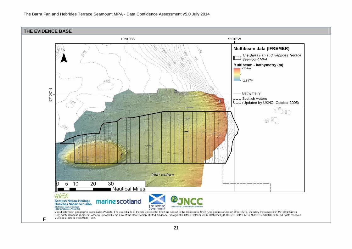
Summary The MPA encompasses the extent of the portion of the Hebrides Terrace seamount in UK waters. JNCC have high confidence in the presence and extent of the Hebrides Terrace Seamount based on full coverage of multibeam data
2 (Map F).
Our confidence in the presence of seamount communities is high on account of data from a survey in 2012 (JC073) that took place across the Hebrides Terrace seamount (Cross et al., 2014). Our confidence in the extent of the feature on the seamount is lower since only three survey transects were completed within the MPA; one across the summit and two down the eastern flank.

The Barra Fan and Hebrides Terrace Seamount MPA - Data Confidence Assessment v5.0 July 2014
5
We are confident in the presence of orange roughy based on multiple records collected in the north-east of the MPA as part of Marine Scotland Science trawl surveys, but have low confidence in the extent of the area likely to be important to the life history of the species. ICES propose that spawning aggregations of orange roughy used to be targeted by fishing at the Hebrides Terrace Seamount, but catches have now significantly declined and the French fishery has been abandoned (ICES 2007, 2010).
JNCC are confident that the burrowed mud habitat is present on the continental slope through the analysis of photographic images, but have little evidence of the feature in the bathyal area of the MPA beyond the base of the slope. By-catch records from trawl surveys from 2008 and 2009 conducted by MSS provide relatively recent evidence of deep-water seapens (Umbellula sp.) in the muddy northern bathyal area indicative of the burrowed-mud habitat.
The maps showing the predicted distribution of habitats produced by the UKSeaMap 2010 (McBreen et al., 2011) and EUSeaMap (Cameron and Askew, 2011). Projects predict that offshore deep-sea muds are present in the central part of the MPA, with offshore subtidal sands and gravels in the north-east and eastern areas of the upper continental slope and on the Hebrides Terrace seamount. We are confident that offshore subtidal sands and gravel habitats and offshore deep-sea mud habitats are present on the continental slope based on Particle Size Analysis
1 and interpretations of ground-truthed still and video images. It is notable that the MPA boundary includes examples of the four
biological zones that characterise the Hebridean slope according to Hughes et al. (2014).
There is general agreement between the predicted substrate from EUSeaMap6 and the more recent National Oceanography Centre‟s (NOC)
interpretation3 of 1995 IFREMER acoustic data
2. The latter is characterised by mud habitat in the bathyal, lower slope areas, on the Barra Fan
and on the southern half of the upper slope, with sands and gravel habitats on the upper slope in the northern half of the site where the gradient is steeper. The seamount has a coarse sediment summit, hard substrata on the flanks and sandy mud and muddy sand around its base. There is however, significant disagreement between these maps in the area to the north of the Barra Fan on the low part of the slope. The EUSeaMap substrate information predicts the area is coarse and mixed sediments whereas the NOC substrate map interprets the area as sandy mud using the available PSA results and photographic data. JNCC have higher confidence in the extent of the recent NOC interpretation, and the resulting habitat map
4 (Map I). Our confidence is borne out by the higher correspondence between survey data records
for sandy mud and the Sotheran et al., 2014 habitat map, compared with that of EUSeaMap (see Figure 2, data coverage section and data maps). These differences with EUSeaMap are most likely due to the scarcity of ground-truthing evidence in the area, which affects the predictive power of the habitat map.
Given the widely predicted distribution of the offshore subtidal sands and gravel habitats, and the offshore deep-sea mud habitat types, and the stable nature of the deep-sea mud habitats, the age of the data for some of these features (12 years) does not reduce our certainty of the feature presence. However, JNCC note that collecting further survey evidence would help establish the relative distributions of the burrowed mud habitat, the offshore subtidal sand and gravel habitat, and the offshore deep-sea mud habitat. New data would also support an assessment of the ecological condition of the features present within the MPA.
JNCC note the MPA contains offshore deep-sea muds in the bathyal zone beyond the base of the continental slope, which are not a protected feature, but are included by association with the prograding wedge geodiversity feature representative of The Barra Fan Key Geodiversity Area (Brooks et al., 2013).
The Barra Fan and Hebrides Terrace Seamount MPA - Data Confidence Assessment v5.0 July 2014
6
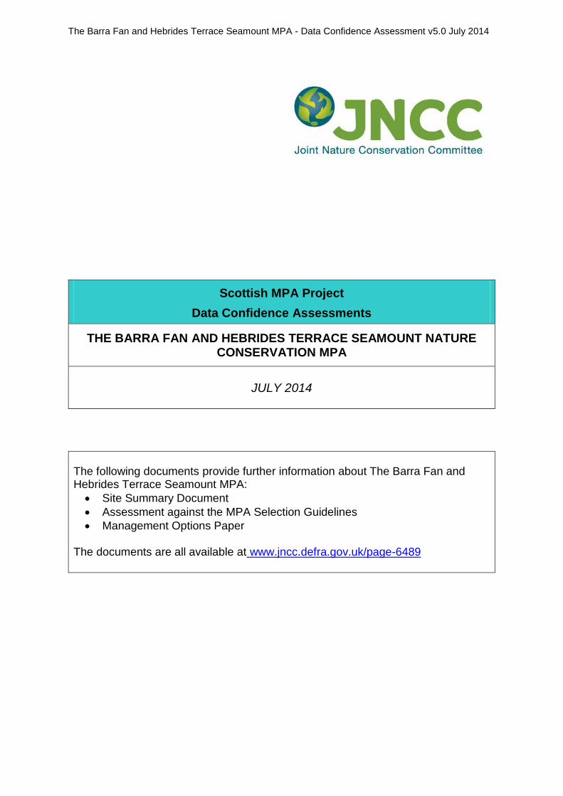
Figure 2a Map of the known distribution of biodiversity protected features within The Barra Fan and Hebrides Terrace Seamount MPA
The Barra Fan and Hebrides Terrace Seamount MPA - Data Confidence Assessment v5.0 July 2014
7
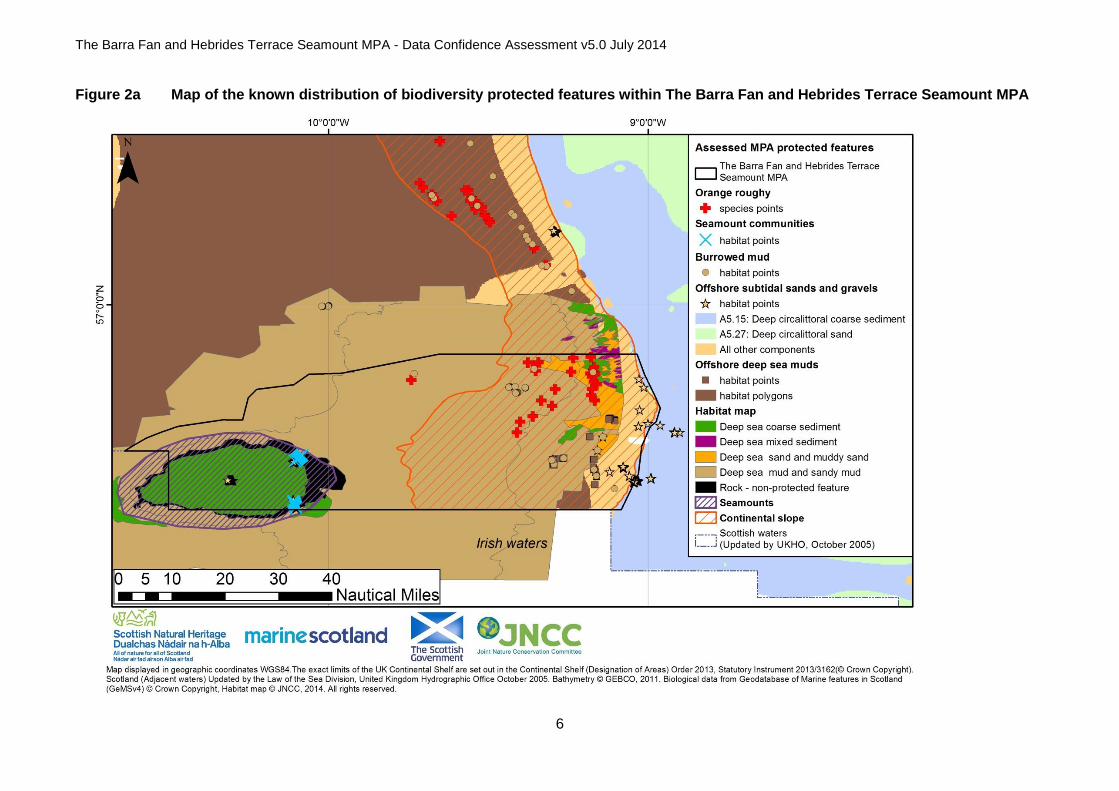
Figure 2b Map of the known distribution of geodiversity protected features within The Barra Fan and Hebrides Terrace Seamount MPA

The Barra Fan and Hebrides Terrace Seamount MPA - Data Confidence Assessment v5.0 July 2014
8
Data confidence assessment JNCC‟s assessment of data confidence considered the age and source of the data, the type of sampling methodologies used and the overall coverage of data across the MPA
Age of data (Map A)
Multiple or majority of records collected post 2000
BM, OSSG, CS, OR, SC Multiple or majority of records collected pre 2000
ODSM, OSSG, S
Comments The majority of data for the biodiversity features were collected between 1995 and 1996, with BGS particle size analysis (PSA) data from 1985
1. More recent data from video surveys conducted between 2000 and 2006 and trawl surveys from 2008 to 2012 provide further feature
evidence. High-definition photographic images collected during the 2012 JC073 survey provide high-quality evidence for the seamount communities.
The polygon for the continental slope was digitised by specialists in 2009, and the area of slope within this MPA was based on 2008 GEBCO data and TOBI sidescan data from 1998 (Jacobs & Porritt, 2009). The seamount polygon used to present the seamount extent was digitised by JNCC in 2014.

The Barra Fan and Hebrides Terrace Seamount MPA - Data Confidence Assessment v5.0 July 2014
9
Source of data (Map B)
Targeted data collection for nature conservation purposes
Statutory monitoring (marine licensing etc.)
- Fisheries survey work
Data collection associated with development proposals (EIA etc.)
- Recreational / volunteer data collection - Other (specify) – BGS PSA data, EUSeaMap
Comments The majority of the records for offshore subtidal sands and gravels, offshore deep-sea muds and burrowed mud habitats come from benthic photographic samples collected during surveys aboard the RRS Challenger and Charles Darwin as part of the NERC-funded Land-Ocean Interaction Study - Shelf Edge Study (LOIS-SES). Records of the protected features were also derived from the assessment of MSS Deepwater Nephrops stock assessment survey video footage. More recent by-catch data were provided by MSS trawl survey records and supplement the data on burrowed mud habitats.
Evidence for the presence and extent of offshore subtidal sands and gravels comes from the predictive seabed modelling project UKSeaMap 2010 (McBreen et al., 2011). JNCC cross-checked this 2010 product against the 2011 EUSeaMap product (Cameron and Askew, 2011) and concluded that the same habitat components and predicted extent of EUNIS Level 3 habitat types remain present within the site boundary. Particle size analysis (PSA) results from sediment sample data were provided by the British Geological Survey
1.
A more recent seabed substrate interpretation3 of 1995 IFREMER acoustic data
2 was commissioned by JNCC through a Memorandum of
Agreement between JNCC, NOC and BGS. A deep water habitat map4 was delivered though a contract commissioned by JNCC using
expertise from ENVISION Ltd (Sotheran et al., 2014).
The continental slope feature was digitised by specialists from the National Oceanography Centre (NOC) as part of work completed for Defra in support of the national MPA projects to further a deep-sea habitat classification scheme (Jacobs & Porritt, 2009). The feature was digitised through the analysis of the GEBCO digital atlas (http://www.gebco.net/) and other acoustic survey datasets (TOBI sidescan, multibeam bathymetry and backscatter). This polygon is part of the physiographic feature dataset that was fed into the SNH-JNCC contract work that aimed to characterise and identify key geodiversity areas in Scottish waters (Brooks et al., 2013).
Multiple records of orange roughy were recorded from trawl surveys led by Marine Scotland Science.
The seamount polygon was digitised by JNCC from the processed multibeam data2 covering the seamount obtained from IFREMER. The
data were collected within the framework of the European program PESCA onboard the research vessel L'Atalante, with aim of mapping part of the Western-Irish and Western-Scottish continental margin.
The 2012 James Cook survey (JC073), led by Herriot-Watt University, collected data on the Hebrides Terrace seamount for the Scottish MPA project (Cross et al., 2014).
The Barra Fan and Hebrides Terrace Seamount MPA - Data Confidence Assessment v5.0 July 2014
10
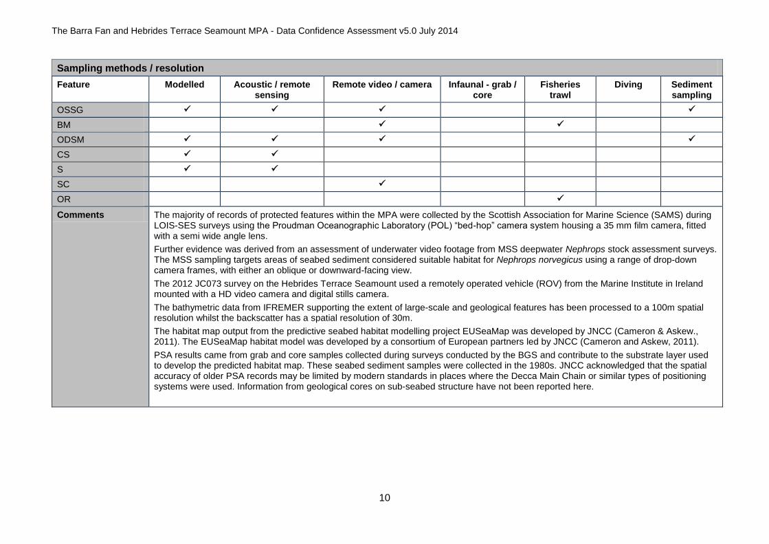
Sampling methods / resolution
Feature Modelled Acoustic / remote sensing
Remote video / camera Infaunal - grab / core
Fisheries trawl
Diving Sediment sampling
OSSG
BM
ODSM
CS
S
SC
OR
Comments The majority of records of protected features within the MPA were collected by the Scottish Association for Marine Science (SAMS) during LOIS-SES surveys using the Proudman Oceanographic Laboratory (POL) “bed-hop” camera system housing a 35 mm film camera, fitted with a semi wide angle lens.
Further evidence was derived from an assessment of underwater video footage from MSS deepwater Nephrops stock assessment surveys. The MSS sampling targets areas of seabed sediment considered suitable habitat for Nephrops norvegicus using a range of drop-down camera frames, with either an oblique or downward-facing view.
The 2012 JC073 survey on the Hebrides Terrace Seamount used a remotely operated vehicle (ROV) from the Marine Institute in Ireland mounted with a HD video camera and digital stills camera.
The bathymetric data from IFREMER supporting the extent of large-scale and geological features has been processed to a 100m spatial resolution whilst the backscatter has a spatial resolution of 30m.
The habitat map output from the predictive seabed habitat modelling project EUSeaMap was developed by JNCC (Cameron & Askew., 2011). The EUSeaMap habitat model was developed by a consortium of European partners led by JNCC (Cameron and Askew, 2011).
PSA results came from grab and core samples collected during surveys conducted by the BGS and contribute to the substrate layer used to develop the predicted habitat map. These seabed sediment samples were collected in the 1980s. JNCC acknowledged that the spatial accuracy of older PSA records may be limited by modern standards in places where the Decca Main Chain or similar types of positioning systems were used. Information from geological cores on sub-seabed structure have not been reported here.

The Barra Fan and Hebrides Terrace Seamount MPA - Data Confidence Assessment v5.0 July 2014
11
Data coverage (Maps A to J)
Across MPA
Numerous protected feature records evenly distributed across MPA?
- Numerous protected feature records scattered across MPA with some clumping?
Few or isolated protected feature records - possibly clumped?
-
For Individual features
Multiple records of individual protected features providing indication of extent and distribution throughout MPA?
-
Few or scattered records of specific protected features making extent and broad distribution assessment difficult?
BM OSSG ODSM
Few or isolated records of specific protected feature records
SC
OR
Are acoustic remote sensing data available to facilitate the development of a full coverage predictive seabed habitat map?
Yes, low resolution multibeam (with backscatter) data obtained from IFREMER covers most of the MPA (Map F, G). These data have been interpreted by NOC to derive a seabed substrate map according to Folk scheme and the modified Folk sediment classes (Map H). This map has been combined with deep water biological zone classes to derive a deep water habitat map (Map I, Sotheran et al., 2014)
Comments Continental Slope (CS)
Major Cenozoic Structures SNH-JNCC contract to characterise and identify key geodiversity areas in Scottish waters (Brooks et al., 2013) - The polygon for the continental slope was digitised by specialists from the National Oceanography Centre (NOC) as part of work completed for DEFRA in support of the national MPA projects to further a deep-sea habitat classification scheme (Jacobs & Porritt, 2010). The feature was digitised through the analysis of the GEBCO digital atlas (http://www.gebco.net/) and other acoustic survey datasets (TOBI sidescan, multibeam bathymetry and backscatter). The upper slope edge of this dataset aligns with the general habitat classification principles (i.e. limit of the deep/offshore circalittoral biological zone) that were used in predictive mapping of the UKSeaMap 2010 and EUSeaMap projects, and therefore provides spatial agreement with the broad-scale habitat data used to predict the extent of features.
Seamounts (S)
Cartopep multibeam data (1995) sourced from IFREMER2 - The multibeam data provides high confidence in the presence and
extent of The Hebrides Terrace Seamount (Map F. These data have been used to digitise the extent of the seamount for the purposes of applying boundary setting principles (labelled as JNCC, 2014 in Map B).
Seamount communities (SC)
2012 JC073 survey on The Hebrides Terrace Seamount – biotope analysis of seabed imagery2 (Cross et al., 2014) (in GeMS v4) –
Three Remotely Operated Vehicle (ROV) transects were surveyed on the Hebrides Terrace Seamount in 2012, one across the summit and two down the eastern slope. High Definition video and photographic images were acquired, which were analysed to

The Barra Fan and Hebrides Terrace Seamount MPA - Data Confidence Assessment v5.0 July 2014
12
Data coverage (Maps A to J)
determine the biological communities present and whether they were characteristic of the seamount communities MPA search feature. From the underwater footage, biological communities attributable to the MPA search feature were identifed from the two eastern transects.
It should be noted that the ICES\NAFO Joint Working Group on Deep-water Ecology (WGDEC), which met in March 2013, recommended a closure to all bottom fishing that encompasses the steep flanks around the whole seamount (i.e. in both UK and Irish waters) (ICES, 2013).This closure would protect the vulnerable marine ecosystems indicated from the species and communities identified by Cross et al. (2014).
Burrowed mud (BM)
Biotope analysis of archived camera still images from the SEA7 region of Scotland‟s seas (Hughes et al., 2014) (in GeMS v4) – There are three clusters of photographic samples from surveys undertaken by SAMS in 1995 and 1996 that record burrowed mud habitat on the slope. Thirty seven of the samples have been assigned to burrowed mud with certainty whilst the remaining 16 (from 3 stations lying mid slope toward the south of the area) have been assigned to the feature with lower certainty. Whilst these latter records have evidence of burrowing activity, the majority of the photographic images from the stations have been assigned to the offshore deep-sea muds feature. The majority of the data points occur in areas predicted by EUSeaMap to be either „sand and muddy sand‟ or „mixed sediment‟ (i.e. offshore subtidal sands and gravels). The NOC substrate map
3 identifies the area as sandy
mud, a conclusion supported by available PSA and photographic data (particularly the cluster in the northern central area). JNCC‟s confidence is lower for the extent of the offshore subtidal sands and gravels predicted by EUSeaMap given the paucity of PSA data that supports the mapping.
MSS Deepwater towed video survey records 2000-2009 (in GeMS v4) – These records are a subset of processed MSS Nephrops stock assessment underwater footage captured on the Hebridean slope, which record the presence of burrows and a judgement of ground type. Three records (from 2000) lie in the south-east of the MPA toward the upper part of the slope close to the predicted boundary between ODSM and OSSG. One data point lies within an area predicted as Atlantic Slope mud and sandy mud, and records the presence of burrows in mud (station DEEP14). The other two data points, lying in an area predicted to be Atlantic Slope sand and muddy sand, record burrows in substrate determined to be sandy mud (station DEEP13) and sand with cobbles (station DEEP11). The DEEP13 data point may be an example of the feature but DEEP11 may not on account of the substrate type not conforming to the expected habitat of the feature. The video footage from stations DEEP13 and DEEP14 were selected to undergo seabed habitat and taxonomic analysis (Allen et al., 2014). Whilst occasional small infaunal burrows were observed, the determination of ground type as fine sand with some surface gravel and the observed epifauna consisting mainly of Spatangus raschi, Echinus acutus, and Paguridae made it more appropriate to assign the data to offshore subtidal sands and gravels (see OSSG data coverage). As such the three records here do not provide evidence of the burrowed mud feature.
MSS Coral bycatch records collated from trawl surveys 2000-2009 (in GeMS v4) - Species indicative of deep-water burrowed mud were identified in 2008 and 2009 in the northern area of the MPA by MSS from bycatch records collated from trawl surveys. These data provide recent confirmation of the presence of deep-water seapens (Umbellula sp) at three stations. These species are characteristic in deep-water soft sediments and in other deep-water areas (e.g. the MAREANO project area in Norwegian waters) populations of these species are considered as the deep-sea equivalent to the shallower biotope “seapens and burrowing megafauna”. As mentioned above there is lower confidence in the predictive mapping given the minimal ground-truthing evidence in
The Barra Fan and Hebrides Terrace Seamount MPA - Data Confidence Assessment v5.0 July 2014
13
Data coverage (Maps A to J)
the large area containing these three records (see above). In-situ survey would verify whether the seapens are present within sandy or muddy habitat, and whether these records would confirm the presence of burrowed mud habitat. The records are recorded in GeMS as „uncertain‟ determination reflecting the level of certainty in assignment to the search feature Burrowed Mud.
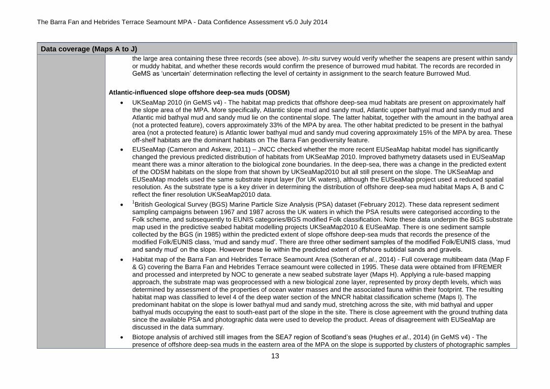
Atlantic-influenced slope offshore deep-sea muds (ODSM)
UKSeaMap 2010 (in GeMS v4) - The habitat map predicts that offshore deep-sea mud habitats are present on approximately half the slope area of the MPA. More specifically, Atlantic slope mud and sandy mud, Atlantic upper bathyal mud and sandy mud and Atlantic mid bathyal mud and sandy mud lie on the continental slope. The latter habitat, together with the amount in the bathyal area (not a protected feature), covers approximately 33% of the MPA by area. The other habitat predicted to be present in the bathyal area (not a protected feature) is Atlantic lower bathyal mud and sandy mud covering approximately 15% of the MPA by area. These off-shelf habitats are the dominant habitats on The Barra Fan geodiversity feature.
EUSeaMap (Cameron and Askew, 2011) – JNCC checked whether the more recent EUSeaMap habitat model has significantly changed the previous predicted distribution of habitats from UKSeaMap 2010. Improved bathymetry datasets used in EUSeaMap meant there was a minor alteration to the biological zone boundaries. In the deep-sea, there was a change in the predicted extent of the ODSM habitats on the slope from that shown by UKSeaMap2010 but all still present on the slope. The UKSeaMap and EUSeaMap models used the same substrate input layer (for UK waters), although the EUSeaMap project used a reduced spatial resolution. As the substrate type is a key driver in determining the distribution of offshore deep-sea mud habitat Maps A, B and C reflect the finer resolution UKSeaMap2010 data.
1British Geological Survey (BGS) Marine Particle Size Analysis (PSA) dataset (February 2012). These data represent sediment
sampling campaigns between 1967 and 1987 across the UK waters in which the PSA results were categorised according to the Folk scheme, and subsequently to EUNIS categories/BGS modified Folk classification. Note these data underpin the BGS substrate map used in the predictive seabed habitat modelling projects UKSeaMap2010 & EUSeaMap. There is one sediment sample collected by the BGS (in 1985) within the predicted extent of slope offshore deep-sea muds that records the presence of the modified Folk/EUNIS class, „mud and sandy mud‟. There are three other sediment samples of the modified Folk/EUNIS class, „mud and sandy mud‟ on the slope. However these lie within the predicted extent of offshore subtidal sands and gravels.
Habitat map of the Barra Fan and Hebrides Terrace Seamount Area (Sotheran et al., 2014) - Full coverage multibeam data (Map F & G) covering the Barra Fan and Hebrides Terrace seamount were collected in 1995. These data were obtained from IFREMER and processed and interpreted by NOC to generate a new seabed substrate layer (Maps H). Applying a rule-based mapping approach, the substrate map was geoprocessed with a new biological zone layer, represented by proxy depth levels, which was determined by assessment of the properties of ocean water masses and the associated fauna within their footprint. The resulting habitat map was classified to level 4 of the deep water section of the MNCR habitat classification scheme (Maps I). The predominant habitat on the slope is lower bathyal mud and sandy mud, stretching across the site, with mid bathyal and upper bathyal muds occupying the east to south-east part of the slope in the site. There is close agreement with the ground truthing data since the available PSA and photographic data were used to develop the product. Areas of disagreement with EUSeaMap are discussed in the data summary.
Biotope analysis of archived still images from the SEA7 region of Scotland‟s seas (Hughes et al., 2014) (in GeMS v4) - The presence of offshore deep-sea muds in the eastern area of the MPA on the slope is supported by clusters of photographic samples

The Barra Fan and Hebrides Terrace Seamount MPA - Data Confidence Assessment v5.0 July 2014
14
Data coverage (Maps A to J)
from surveys in 1995 and 1996, assigned to biotopes by SAMS. These data lie toward the upper part of the slope close to the predicted boundary between ODSM and OSSG. Approximately 50% (48 out of 101) of the still images come from stations lying within the area predicted as Atlantic Slope sand and muddy sand. Only one of the 48 is determined with uncertainty (possibly OSSG). The other 50% of the still images come from stations lying within the areas predicted as Atlantic Slope and Upper bathyal mud and sandy mud. A greater number of these are determined with uncertainty (possibly OSSG). These mismatches reflect two factors that affect levels of certainty, firstly the precise determination of sediment substrate type from camera samples according to a given classification, and secondly the resolution of the predictive modelling where there is a scarcity of underpinning PSA data.
Atlantic influenced slope offshore subtidal sands and gravels (OSSG)
UKSeaMap 2010 (in GeMS v4) – The habitat map predicts that offshore subtidal sands and gravels occur across approximately half the slope area The dominant habitats predicted are Atlantic slope sand and muddy sand, Atlantic upper bathyal sand and muddy sand, Atlantic mid bathyal sand and muddy sand, Atlantic slope coarse sediment, Atlantic upper bathyal coarse sediment and Atlantic mid bathyal coarse sediment. Also there is an area of Atlantic upper bathyal mixed sediment and Atlantic mid bathyal mixed sediment predicted on the slope, which extends into the bathyal area.
EUSeaMap (Cameron and Askew, 2011) – JNCC checked whether the more recent EUSeaMap habitat model has significantly changed the previous predicted distribution of habitats from UKSeaMap 2010. Improved bathymetry datasets used in EUSeaMap meant there was a minor alteration to the biological zone boundaries. In the deep-sea, there was a change in the predicted extent of OSSG habitats identified from UKSeaMap2010 but are all still present on the slope. The UKSeaMap and EUSeaMap models used the same substrate input layer (for UK waters), although the EUSeaMap project used this data at a reduced spatial resolution. As the substrate type is a key driver in determining the distribution of offshore subtidal sand and gravel habitat Maps A, B and C reflect the finer resolution UKSeaMap2010 data.
1British Geological Survey (BGS) Marine Particle Size Analysis (PSA) dataset (February 2012) - These data represent sediment
sampling campaigns between 1967 and 1987 across the UK waters in which the PSA results were categorised according to the Folk scheme and subsequently to EUNIS categories/BGS modified Folk classification. Note these data underpin the BGS substrate map used in the predictive seabed habitat modelling projects UKSeaMap2010 & EUSeaMap. Eight sediment samples collected by the BGS (in 1985) lie within the predicted extent of offshore subtidal sands and gravels on the slope. Four record the presence of „sand and muddy sand‟ and one records the presence of the modified Folk/EUNIS class „coarse sediment‟. The three remaining samples record the presence of the modified Folk/EUNIS class, „mud and sandy mud‟ which do not support this feature.
Habitat map of the Barra Fan and Hebrides Terrace Seamount Area (Sotheran et al., 2014) - Full coverage multibeam data (Map F & G) covering the Barra Fan and Hebrides Terrace seamount were collected in 1995. These data were processed and interpreted by NOC to generate a new seabed substrate layer (Maps H). Applying a rule-based mapping approach, the substrate map was geoprocessed with a new biological zone layer, represented by proxy depth levels, determined by assessment of the properties of ocean water masses and the associated fauna within their footprint. The resulting habitat map was classed to level 4 of the deep water section of the MNCR habitat classification scheme (Maps I). The habitats on the slope are mapped as upper bathyal coarse, mid bathyal sand & muddy sand, mid bathyal mixed, mid bathyal coarse, lower bathyal sand & muddy sand and lower bathyal mixed sediment. Their extent is limited to the north-east of the survey area, with mid bathyal sand & muddy sand modelled as extending across a large part of the site. There is close agreement between the habitat map and the ground truthing data; this is in

The Barra Fan and Hebrides Terrace Seamount MPA - Data Confidence Assessment v5.0 July 2014
15
Data coverage (Maps A to J)
part due to the use of the available PSA and photographic data to develop the product. Areas of disagreement with EUSeaMap are discussed in the data summary after Figure 2.
Biotope analysis of archived stills from the SEA7 region of Scotland‟s seas (Hughes et al., 2014) (in GeMS v4) - The presence of offshore subtidal sands and gravels in the eastern area of the MPA on the slope is supported by photographic samples from surveys in 1995 and 1996, assigned to biotopes by SAMS. Thirty three records are determined as „certain‟ with the remaining six determined as „uncertain‟. The uncertainty concerns whether the substrate type is coarse or mixed, whilst still representative of the feature.
Biotope analysis of Marine Scotland Science underwater footage from the Hebridean Slope (Allen et al., 2014) (in GeMS v4) - The analysis of underwater video footage from six MSS Nephrops stock assessment survey stations confirm the presence of the offshore subtidal sands and gravels. All are situated on the upper part of the slope, four are from 2000, one from 2002 and one from 2006. Three were determined as Atlantic upper slope sand and three determined as Atlantic upper slope coarse sediment after Howell, 2010).
After Hughes et al. (2014) characterised the biological diversity on the Hebridean slope they determined there are five distinct biological zones with associated communities that change with depth present along the Hebridean slope. The MPA contains 4 of these zones; Upper Slope zone, Ophiocten gracialis zone, Xenophyophore zone & Decapod burrowing zone (Map J). The Outer shelf and shelf break zone predominantly occur on the continental shelf that is not part of the site.
Orange roughy (Hoplostethus atlanticus) (OR)
MSS trawl surveys between 2000 and 2012 (in GeMS v4) – There are 38 records of orange roughy in the north-east area of the MPA. All records were determined as „certain‟ in representing the feature.
Geodiversity
The prograding wedge geodiversity feature, which is representative of The Barra Fan Key Geodiversity Area, is fully encompassed by the MPA and has been used to define the northern/north-western extent of the boundary. Other features representative of The Barra Fan Key Geodiversity Area, and to a lesser extent the Peach Slide Complex Key Geodiversity Area are also included (Brooks et al., 2013) (Maps D & E). The IFREMER multibeam data (1995) further illustrates the diversity and extent of geodiversity features present within the MPA (Map F).

The Barra Fan and Hebrides Terrace Seamount MPA - Data Confidence Assessment v5.0 July 2014
16
THE EVIDENCE BASE
A

The Barra Fan and Hebrides Terrace Seamount MPA - Data Confidence Assessment v5.0 July 2014
17
THE EVIDENCE BASE
B

The Barra Fan and Hebrides Terrace Seamount MPA - Data Confidence Assessment v5.0 July 2014
18
THE EVIDENCE BASE
C

The Barra Fan and Hebrides Terrace Seamount MPA - Data Confidence Assessment v5.0 July 2014
19
THE EVIDENCE BASE
D

The Barra Fan and Hebrides Terrace Seamount MPA - Data Confidence Assessment v5.0 July 2014
20
THE EVIDENCE BASE
E
The Barra Fan and Hebrides Terrace Seamount MPA - Data Confidence Assessment v5.0 July 2014
21
THE EVIDENCE BASE
F

The Barra Fan and Hebrides Terrace Seamount MPA - Data Confidence Assessment v5.0 July 2014
22
THE EVIDENCE BASE
G

The Barra Fan and Hebrides Terrace Seamount MPA - Data Confidence Assessment v5.0 July 2014
23
THE EVIDENCE BASE
H

The Barra Fan and Hebrides Terrace Seamount MPA - Data Confidence Assessment v5.0 July 2014
24
THE EVIDENCE BASE
I

The Barra Fan and Hebrides Terrace Seamount MPA - Data Confidence Assessment v5.0 July 2014
25
THE EVIDENCE BASE
J

The Barra Fan and Hebrides Terrace Seamount MPA - Data Confidence Assessment v5.0 July 2014
26
Data sources and bibliography
Year Title Features covered
2014 Allen, C., Dewey, S. and Axelsson, M. (2014) Biotope analysis of Marine Scotland Science underwater footage from the Hebridean Slope. A report for the Joint Nature Conservation Committee. JNCC Report 511.
OSSG
2014 Sotheran, I., A. Benson & Crawford-Avis, O. (2014). Mapping habitats and biotopes to strengthen the information base of Marine Protected Areas in Scottish waters, Phase 2 (Barra Fan and Hebrides Terrace Seamount Area), pp 28. JNCC Report, No. 527
OSSG, ODSM
2014 Cross, T., Howell, K.L., Hughes, E. and Seeley, R. (2014). Analysis of seabed imagery from the Hebrides Terrace Seamount (2013). JNCC Report 510.
SC, OSSG
2014 Geodatabase of Marine features in Scotland (GeMS) Version 4 All features
2014 Henry, L-A and Roberts, M. (2014). Developing an interim technical definition for coral gardens specific for UK waters and its subsequent application to verify suspected records. Report for the Joint Nature Conservation Committee, JNCC Report No. 507.
Coral gardens
2014 Hughes, D.J., Nickell, T, and Gontarek, S. (2014). Biotope analysis of archived stills from the SEA7 region of Scotland‟s seas. A report by the Scottish Association for Marine Science (SAMS) for the Joint Nature Conservation Committee (2011), JNCC Report 502.
ODSM, OSSG,
BM
2013 ICES, 2013. Report of the ICES\NAFO Joint Working Group on Deep-water Ecology (WGDEC), 11-15TH
March 2013, Floedevigen, Norway, ICES CM 2013\ACOM:28. 95pp
-
2013 Brooks, A.J., Kenyon, N.H., Leslie, A., Long., D. and Gordon, J.E. (2013). Characterising Scotland‟s marine environment to define search locations for new Marine Protected Areas. Part 2: The identification of Key Geodiversity Areas in Scottish waters. Scottish Natural Heritage Commissioned Report No. 432.
Geodiversity
2012 British Geological Survey (BGS) Marine Particle Size Analysis (PSA) dataset (February 2012) OSSG
2011 Cunningham, S., Gillham, K., Chaniotis, P.D., Crawford-Avis, O., Linwood, M. and Payne, O. Assessing the contribution of other area-based measures to the ecological coherence of the MPA network in Scotland’s seas. Report produced by Scottish Natural Heritage, the Joint Nature Conservation Committee and Marine Scotland for the Scottish Marine Protected Areas Project. Available from <www.scotland.gov.uk/Resource/Doc/295194/0121831.pdf>
-
The Barra Fan and Hebrides Terrace Seamount MPA - Data Confidence Assessment v5.0 July 2014
27
Data sources and bibliography
Year Title Features covered
2011 Cameron, A. and Askew, N. (eds.). (2011). EUSeaMap - Preparatory Action for development and assessment of a European broad-scale seabed habitat map final report. Available at http://jncc.gov.uk/euseamap
OSSG, ODSM
2010 ICES (2010) Book 9 Widely Distributed and Migratory Stocks. 299 pp.
OR
2010 Howell, K.I. (2010). A benthic classification system to aid in the implementation of marine protected area networks in the deep/high seas of the NE Atlantic. Biological Conservation, 143: 1041–1056
2009 Jacobs, C. and Porritt, L., 2009. Deep Sea Habitats - Contributing Towards Completion Of A Deep-Sea Habitat Classification Scheme. NOCS Research and Consultancy Report No.62, MB0105 Marine Biodiversity R&D Programme.
CS
2007 ICES. Report of the Working Group on the Biology and Assessment of Deep-Sea Fisheries Resources (WGDEEP), 8–15 May 2007, ICES Headquarters. ICES CM 2007/ACFM. 20.
OR
2006 Connor, D.W., Gilliland, P.M., Golding, N, Robinson, P.,Todd, D. and Verling, E. (2006). UKSeaMap: the mapping of seabed and water column features of UK seas. Joint Nature Conservation Committee, Peterborough.
-