Embed Size (px)
Citation preview

Procedia Economics and Finance 18 ( 2014 ) 837 – 848
Available online at www.sciencedirect.com
2212-5671 © 2014 The Authors. Published by Elsevier B.V. This is an open access article under the CC BY-NC-ND license (http://creativecommons.org/licenses/by-nc-nd/3.0/).Selection and/or peer-reviewed under responsibility of the Centre for Disaster Resilience, School of the Built Environment, University of Salford.doi: 10.1016/S2212-5671(14)01009-0
ScienceDirect
4th International Conference on Building Resilience, Building Resilience 2014, 8-10 September 2014, Salford Quays, United kingdom
The ANDROID case study; Venice and its territory: a general overview
Maurizio Indirlia*, Snjezana Knezicb, Ruben P. Borgc, Yamuna Kaluarachchid, Boyko Ranguelove, Francesco Romagnolif, Claudio Rochasf
aENEA Research Centre of Bologna, Italy, bUniversity of Split, Croatia, cUniversity of Malta, Malta, dKingston University, United Kingdom,
eMining and Geology University, Sofia, Bulgaria, fRiga Technical University, Latvia
Abstract
The Work Package 7 (Research Futures & Special Interest Groups) of the ANDROID project, selected Venice and its territory as an emblematic case study of a region that could be affected by cross-border disastrous events. The paper provides a general overview on the topic, trying to organise the large amount of available scientific literature in some strategic cores, identifying undoubted milestones, open questions and future research needs, following a holistic approach to risk assessment. This case study is carried out not only as an engaging exercise, but with the purpose to provide a reference point for scientists and teachers interested to translate multifaceted knowledge into specific solutions. In fact, the paper is strongly linked as a whole to other three ones (presented at the 4th International Conference on Building resilience), which deepen respectively hazard, vulnerability/resilience, and mitigation about the site taken into consideration. Furthermore, the City of Venice takes part to the UNISDR Program “Making Cities Resilient”, and planned a robust intervention, consisting in the realisation of mobile dikes located at the openings of the lagoon (MOSE project, almost terminated), which has been strongly debated since the beginning, due to possible negative consequences on the environment. At last, the paper analyses drawbacks and benefits of the above said intervention, and suggests further proposals for the global safeguard of Venice and its lagoon. © 2014 The Authors. Published by Elsevier B.V. Selection and/or peer-reviewed under responsibility of the Centre for Disaster Resilience, School of the Built Environment, University of Salford.
Keywords: Venice, risk assessment, natural and anthropogenic hazards, safeguard and mitigation
* Corresponding author. Tel.: +39-051-6098727; fax: +39-051-6098544.
E-mail address: [email protected]
© 2014 The Authors. Published by Elsevier B.V. This is an open access article under the CC BY-NC-ND license (http://creativecommons.org/licenses/by-nc-nd/3.0/).Selection and/or peer-reviewed under responsibility of the Centre for Disaster Resilience, School of the Built Environment, University of Salford.
brought to you by COREView metadata, citation and similar papers at core.ac.uk
provided by LSBU Research Open
838 Maurizio Indirli et al. / Procedia Economics and Finance 18 ( 2014 ) 837 – 848
1. Introduction
ANDROID is an Erasmus academic network that aims to promote co-operation and innovation among European Higher Education to increase society’s resilience to disasters of human and natural origin. The ANDROID Work Package 7 (Research Futures), chaired by the corresponding author of this paper, had the following main goals and outputs: to explore aspects of European and global relevance to developing societal resilience to disasters; what resilience is, what it means to society, and how societies might achieve greater resilience in the face of increasing threats from natural and human induced hazards; to identify future research directions in disaster resilience research, and the implications for higher education; to create Special Interest Groups (SIGs), addressing emerging research and teaching concerns. As discussed in the 1st ANDROID Network Board Meeting (Brussels, Belgium, 15-16 May 2011), and then decided during the 1st ANDROID Network Annual Conference (Tallin, Estonia, 17-19 October 2012), the following SIGs have been set up, involving and sharing approximately 40 ANDROID partners: • SIG1, multi-hazard scenarios, devoted to find common languages/tools to identify, profile, quantify and combine
different natural hazards that might affect the community or the territory (from single to multi-hazard scenarios); • SIG2, system overall resilience, finalised to define criteria to quantify the overall resilience of a built/human
environment (how to store/overlay/elaborate knowledge to extract the system’s resilience in an univocal way, including weakness/strength points, for different scenario-based analyses);
• SIG3, integrated mitigation and governance, to evaluate the societal impact of disasters and identify multi-risk methodologies with a global approach (including recommendations for stakeholders’ advice and high education). The further step has been to select a specific case study (2nd ANDROID Annual Conference, Limassol, Cyprus,
23-25 October 2013), in order to face a practical challenging exercise, avoiding unfruitful theoretical debates: it is the Northern Adriatic Sea and the City of Venice.
2. The WP7 case study: Northern Adriatic Sea and Venice
The Venice case study has been selected for the following main reasons: it could be affected by cross-border disastrous events; at least three European countries could be involved (Italy, Slovenia, and Croatia); the territory is potentially interested by a multi-hazard scenario; the target is really complex (population, heritage, environment, industrial facilities, tourism, etc.), including the lagoon, the islands and the mainland. Furthermore, it is the place where a mobile tidal barrier system is going to be concluded soon. The historic city of Venice is an “open-air” museum and its cultural and artistic heritage is of inestimable value. Nowadays, the city defence is not only a matter of protecting lives and economic assets, but also of conserving its relevant world’s patrimony recognised by UNESCO. The conformation of the urban area, characterised by ancient buildings and high density, makes the historic city very vulnerable. Finally, Venice takes part to the UNISDR (The United Nations Office for Disaster Risk Reduction, http://www.unisdr.org/campaign/resilientcities/) campaign “Making Cities Resilient”. This paper is the introductory part of a group of four articles, presented jointly at the “4th International Conference on Building Resilience”; the other three (Knezić et al. 2014; Borg et al. 2014; Kaluarachchi et al. 2014) go into the details carried out in the framework of the above said SIGs. All these papers will constitute a targeted session inside the conference as the final result of the WP7 activities. Also representatives of the Venetian scientific community will participate Campostrini 2014), in order to provide a useful discussion about performed investigations, already adopted protection strategies, and research future needs identification.
3. Hazard identification and profiling
3.1. Generalities
Nowadays, a proper risk assessment must foresee a multidisciplinary approach, implementing interactive digitised databases, collecting a large amount of input data and organising a user-friendly instrument with strong import-export capabilities. The integrated use of several tools (hazard models, building classification and inventory database resources, Remote Sensing-RS and Geographic Information System-GIS mapping, etc.), the identification of analyses procedures and algorithms, the elaboration of reliable outputs are indispensable. The basic steps are
839 Maurizio Indirli et al. / Procedia Economics and Finance 18 ( 2014 ) 837 – 848
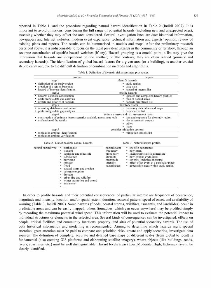
reported in Table 1, and the procedure regarding natural hazard identification in Table 2 (Indirli 2007). It is important to avoid omissions, considering the full range of potential hazards (including new and unexpected ones), assessing whether they may affect the area considered. Several investigation lines are due: historical information, newspapers and Internet websites, modern event experience, technical information and experts’ opinion, review of existing plans and reports. The results can be summarised in models and maps. After the preliminary research described above, it is indispensable to focus on the most prevalent hazards in the community or territory, through an accurate consultation of specific hazard websites (if any). Hazard grouping is a crucial point: a list may give the impression that hazards are independent of one another; on the contrary, they are often related (primary and secondary hazards). The identification of global hazard factors for a given area (or a building), is another crucial step to carry out, due to the difficult definition of combination methods and algorithms.
Table 1. Definition of the main risk assessment procedures. process outputs
step 1 identify hazards • definition of the study region • study region • creation of a region base map • base map • hazard of interest identification • hazard of interest list
step 2 profile hazards • hazards database construction • updated and completed hazard profiles • performing a data gap analysis • map of hazard areas • profile and priority of hazards • hazards prioritized list
step 3 inventory assets • inventory database construction • inventory data tables and maps • performing a data gap analysis • data sources list
step 4 estimate losses and risk assessment tools • construction of estimate losses scenarios and risk assessment tools • loss and exposure for the study region • evaluation of the results • risk assessment outputs
• tables • maps
step 5 consider mitigation options • mitigation options identification • mitigation options list • mitigation options verification
Table 2. List of possible natural hazards. Table 3. Natural hazard profile.
natural hazard type • earthquake hazard event • specific occurrence • tsunami frequency • how often • landslide and mudslide probability • likelihood (statistical measure) • subsidence duration • how long an event lasts • hurricane magnitude • severity (technical measure) • tornado intensity • effect of an event at a particular place • flood hazard areas • geographic areas within study region • coastal storm and erosion • volcanic eruption • drought • urban fire and wildfire • winter storm (ice and snow) • avalanche • …
In order to profile hazards and their potential consequences, of particular interest are frequency of occurrence,
magnitude and intensity, location and/or spatial extent, duration, seasonal pattern, speed of onset, and availability of warning (Table 3, Indirli 2007). Some hazards (floods, coastal storms, wildfires, tsunamis, and landslides) occur in predictable areas and can be easily mapped; others (tornadoes, which can occur anywhere) may be profiled simply by recording the maximum potential wind speed. This information will be used to evaluate the potential impact to individual structures or elements in the selected area. Several kinds of consequences can be investigated: effects on people, critical facilities and community functions, property, and sites of potential secondary hazards. The use of both historical information and modelling is recommended. Aiming to determine which hazards merit special attention, great attention must be paid to compare and prioritise risks, create and apply scenarios, investigate data sources. The definition of complete, accurate and detailed base maps of different scales (from global to local) is fundamental (also creating GIS platforms and elaborating satellite imagery), where objects (like buildings, roads, rivers, coastlines, etc.) must be well distinguishable. Hazard levels areas (Low, Moderate, High, Extreme) have to be clearly identified.

840 Maurizio Indirli et al. / Procedia Economics and Finance 18 ( 2014 ) 837 – 848
3.2. Earthquakes
Nowadays, several studies can provide more accurate tools for the urban environment protection, like neo-deterministic models and earthquake scenarios (to be preferred especially when dealing with objects that should be 100% safe, as strategic facilities, industrial plants, and cultural heritage); they consist in algorithms for the space-time medium terms forecasting and the realistic simulation of ground shaking, including seismic input synthetic time series, calibrated against observations, whenever possible (Panza et al. 2000a, Decanini et al. 2001); thus, the use of methods that showed many shortcomings (Kossobokov et al. 2012), based on acceleration peak values and probabilistic earthquake return periods (Giardini et al. 1999) on which the Italian seismic zonation and building code are based on, can be overcame. An important example of neo-deterministic applications (a complete description is given in Zuccolo et al. 2011, Panza et al. 2012) is the UNESCO-IUGS-IGCP project 414 (Panza et al. 2002) for the seismic microzonation of several towns (e.g. Delhi, Beijing, Rome, Naples, Santiago de Cuba, Bucharest, Sofia). This approach has been extended to Chile (Indirli 2009, Indirli et al. 2011). Neo-deterministic Scenarios for North-Eastern Italy are given in Peresan et al. 2011. Fig. 1 reports respectively maps of PGA (Peak Ground Acceleration, from INGV, Istituto Nazionale di Geofisica e Vulcanologia/Italian National Institute of Geophysics and Volcanology, OPCM 3519, probabilistic) and DGA (Design Ground Acceleration, Peresan et al, 2011, neo-deterministic) in North-East Italy. It has to be stressed that, for the recent Emilia earthquake, neo-deterministic studies provided values of acceleration closer (with respect to probabilistic estimates) to those recorded in May-June 2012 (Marzo et al. 2012), as also happened in the case of the 2009 L’Aquila seismic event (Indirli 2010, Indirli et al. 2013). A correct assessment of the seismic input (through updated procedures and accurate micro-zonation campaigns) is obviously the preliminary basic step for mitigation measures in a territory hit by several earthquakes in the past (Fig. 2, from the earthquake catalogue CPTI04, http://emidius.mi.ingv.it/CPTI04/, in Burrato et al. 2008).
Fig. 1. North-East Italy maps of: Peak Ground Acceleration (PGA), left; Design Ground acceleration (DGA), right.
3.3. Tsunamis
A similar approach is advisable to evaluate the occurrence of tsunamis, together with the development of reliable analytical models of sea waves propagation and accurate recording systems. An example for the city of Valparaiso (Chile) is reported in Indirli (2009) and Indirli et al. (2011). The tsunami phenomenon is mainly detected in oceanic domains, but it can also occur in small basins as the Adriatic Sea. The presence of great waves has been recorded a few times in the past centuries on the Adriatic shorelines, therefore this suggests the idea to evaluate which could be

841 Maurizio Indirli et al. / Procedia Economics and Finance 18 ( 2014 ) 837 – 848
the maximum amplitude reached by a possible future tsunami event. In this framework, several synthetic mareograms have been calculated (Paulatto et al. 2007, the results for Venice and Trieste sites are reported in Tables 4-5) varying those parameters which are the most influencing in tsunami generation, such as magnitude, focal depth, water layer thickness, etc., and applying to the shallow water basin case both the theory of modal summation (Panza et al. 2000b) and the theory of the Green’s function (Yanovskaya et al. 2003). The first is applied to the case of tsunamis generated by an off-shore source, the second to the case of tsunamis generated by an inland source. Both kinds of tsunamigenic events did already occur in the Adriatic domain, as witnessed in many catalogues (Caputo and Faita, 1984; Bedosti and Caputo, 1986; Tinti et al., 1996, 2001, and 2004; Guidoboni et al. 1989). Results obtained with a different scientific approach are reported by Tiberti et al. (2008).
Fig. 2. Map of historic earthquakes in Northern Italy.
Table 4. Maximum amplitudes/travel times for the Venice site for tsunamis due to offshore sources. Scenarios are calculated for 3 values of magnitude, M=6.5, 7.0, 7.5, and 3 values of focal depth, H=10, 15, 25km. Amplitudes are in meters.
M 6.5 7.0 7.5 Travel time (min) H (km) 10 15 25 10 15 25 10 15 25 Venice 0.03 0.02 0.01 0.17 0.09 0.04 0.97 0.53 0.24 188
Table 5. Maximum amplitudes/travel times for Venice/Trieste sites for tsunamis due to inland sources. Scenarios are calculated for 2 values of magnitude, M=6.5, 7.0, 2 values of the inland distance of the source from the coast, d=20km, 40km and 2 values of the dipping angle, dip=45°,
30°. Travel times reported are referred to maximum amplitude peaks. Amplitudes are in meters.
M 6.5 7.0 Travel time (min) d (km) 20 40 20 40
Trieste dip=45° <0.01 <0.01 0.02 0.01 7 Trieste dip=30° <0.01 <0.01 0.05 0.01 8 Venice dip=45° <0.01 <0.01 0.02 0.01 132 Venice dip=30° <0.01 <0.01 0.03 0.01 133
In particular, a tsunami is reported in this area corresponding to the 1511 earthquake (Paulatto et al. 2007). This
event caused severe damage to the buildings because of the strong shocks and also may have generated a tsunami observed in the whole Northern Adriatic area, especially in Trieste, where the docks and the lower city where inundated. The local chronicles report the effects of the shocks and the inundation: “Si sentirono orribilissimi terremoti, uno de’ quali, il 26 marzo (1511), tra le ore due e le tre dopo mezzogiorno, spaventoso, due torri del porto atterrò con molte mura e case... molti villaggi restarono rovinati, e si grande era l’accrescimento del mare, che gli abitanti di Trieste si trasportarono ad alloggiare sotto il castello/Terrible earthquakes were felt, one of them occurred the 26th of March (1511), between two and three o’clock in the afternoon, it knocked down two towers in the docks and many walls and buildings (in Trieste)... many villages were reduced to ravines and the sea level grew so much that the inhabitants of Trieste had to move under the castle” (Kandler, 1863). This event is still cause of

842 Maurizio Indirli et al. / Procedia Economics and Finance 18 ( 2014 ) 837 – 848
debate, since it is not clear whether the inundation was directly caused by the earthquake. The question is deeply discussed in the related paper by Knezić et al. 2014.
The hypothetic kinematic modes about seismic and tsunami early warning systems are developed using the standard methodology of the travel times for seismic S and P waves as well as for the tsunamis travel times. (Ranguelov 2014a). The models covered all seismic active zones in Italy. The travel times of the P, S, and S-P seismic waves to the city of Venice are calculated. These calculations can be used by the local authorities, decision makers and other responsible institutions (like Civil Defence of Venice) for the development of a SEWS providing resilience of Venice infrastructure and population in case of strong earthquake occurring anywhere in Italy. The models of the travel times of tsunamis propagating trough the Adriatic Sea and the calculations of them show relatively high effectiveness of the TEWS regarding Venice lagoon and low surrounding coasts (Ranguelov 2014b).
3.4. Floods
Concepts as flood elevation and flood hazard areas must be very well defined. In the USA, BFE (Base Flood Elevation), is the elevation of the water surface resulting from a flood that has a 1% chance of occurring in any given year; SFHA (Special Flood Hazard Area) is the shaded area that identifies an area that has a 1% chance of being flooded in any given year. Coastal storms, due to typhoons/hurricanes, can cause tidal elevation increase (called storm surge), inland flooding and water force, wind speed, and erosion. Storm surge water levels depend on wind speed and are measured by the five categories (from minimal to catastrophic) of the Saffir-Simpson Scale.
The Venice historic centre is subject to flooding tide events (“acqua alta”), whose frequency and intensity have considerably grown during the last decades (Fig. 3). This phenomenon is caused by meteorological factors (winds, air pressure, storm surges) which enhance the astronomic tide oscillation. The rising of the relative sea level (due to global climate change and to local subsidence), is making flooding tides more frequent and the consequences for the city more serious. The event occurred in 1966 was the highest, in terms of water level in the city, and most frightening, with the risk to lose the city forever. During the twentieth century the frequency of flooding tides has increased about 13 times, up to 18 events registered in 2010. During the period 2000-2010 a number of 6 exceptional events occurred (the same number of events happened from 1960 to 1999). During these events, about 90% of the city surface and 55% of the public space dedicated to pedestrian use are flooded: the consequences for population, economic activities, buildings are considerable. To face flooding, the MOSE project (MOdulo Sperimentale Elettro-meccanico/Experimental Electro-mechanical Module, i.e. a mobile tidal barrier system, with 79 hollow gates at 3 lagoon inlets) has been almost completed. Non-structural measures against floods (i.e. monitoring, forecasting, information and alerting activities) are carried out by the Tidal Forecasting and Early Warning Centre (ICPSM), instituted in 1980 by the Municipality of Venice. Monitoring is realised through different networks. The ICPSM technical staff elaborates, three times a day, the two days long tide forecast and communicates it to the citizens through different means (website, local newspapers, info points, graphic displays, answering service). In case of flooding tides, alerting services are activated (siren alarm, call manager, alerting SMS, phone calls).
Fig. 3. Examples of “acqua alta” flooding in the historic centre of Venice.
843 Maurizio Indirli et al. / Procedia Economics and Finance 18 ( 2014 ) 837 – 848
3.5. Landslides
The best predictor of future landslides is past landslides, because they tend to occur in the same places. This hazard is complex and require geologic expertise. Landslide inventories identify areas that appear to have failed in the past; landslide susceptibility maps depict areas that have the potential for landslides; landslides hazard maps show the real extent of the threat: where landslides have occurred in the past, where they are likely to occur now, and where they can occur in the future. A paradigmatic landslide study about the city of Valparaiso (Chile) is reported in Indirli (2009) and Indirli et al. (2011). The Venice lagoon doesn’t show remarkable landslide hazard. But we want remember here that one of the most catastrophic slope in Italy, the Vajont landslide, occurred in a deep incised valley of the Dolomite mountains approximately 100 km north of Venice, on October 9th, 1963 (Semenza 1965; Semenza et al. 2000).
3.6. Fires
General information about fire hazard can be provided by several EU COST Actions: TUD COST Action TU0904, Integrated Fire Engineering and Response (IFER); TUD COST Action C17, Built Heritage: Fire Loss to Historic Buildings; FPS COST Action FP0701, Post-Fire Forest Management in Southern Europe; FPS COST Action FP1101, Assessment, Reinforcement and Monitoring of Timber Structures. In addition, it is worth noticing to cite again TUD COST Action C26 Urban Habitat Constructions Under Catastrophic Events. The conformation of the Venice urban area, characterised by ancient buildings, high density and the large use of wood in constructions, makes the historic city exposed to an high fire risk. Moreover, fireplaces may result of difficult access to the fire brigade and the fire extension can enlarge very quickly, making dramatically high the risk of involving a cultural asset of inestimable value. One of the most serious event recently occurred was the fire which destroyed completely La Fenice Opera House on 29 January 1996. The fire risk has consistently diminished after the initiatives carried out recently by the Civil Protection of the Venice Municipality. In fact, a new anti-fire system was adopted in 2006. The hydrants’ position ameliorates the accessibility to the fire place and diminishes the intervention time. The updated fire risk assessment has shown that high-risk areas no longer exist in the city centre. Moreover, using fresh and clean water (instead of the salt water of the lagoon) allows a better protection of cultural assets.
3.7. Subsidence, salt wedge intrusion and erosion
Subsidence is the motion of a surface (usually, the Earth's surface) as it shifts downward relative to a datum such as sea-level. For Venice, subsidence (Ghetti 1988) can be hazardous due to the lagoon low water level. Salt wedge intrusion is the movement of saline water into freshwater aquifers, which can lead to contamination of drinking water sources and other consequences.
4. Vulnerability/resilience analysis
4.1. Inventory assets
Inventory assets organize a large amount of data, better if stored on a GIS platform (Table 6, Indirli 2007), about patterns that can be affected by hazardous events. In order to gather building-specific information, the following data must be provided: building size; replacement value to its pre-damaged conditions; content value; function use or value; displacement cost due to hazard; occupancy or capacity. Other data (summarised by Table 7, Indirli 2007) are hazard-specific. It is worth noting that the system can be implemented depending on the features of the countries considered; for Europe, specific categories can be defined for cultural heritage assets and historical centres, which are widespread, critical and precious. As already done in previous projects for historic centres protected by UNESCO (Indirli 2009; Indirli et al. 2011), vulnerability factors can be calculated through quick surveys (Indirli et al. 2013). A remarkable study is the post-earthquake Reconstruction Plan implemented for the town of Arsita (Indirli et al. 2014), hit by the 2009 seismic event (Fig. 4). Finally, a GIS-based application can join hazard and vulnerability data, merging together inputs coming from updated cadastral maps, RS satellites images and in-field

844 Maurizio Indirli et al. / Procedia Economics and Finance 18 ( 2014 ) 837 – 848
DGPS surveys (diagnostics investigations and damage assessment included). Thus, geo-referred risk maps, in which single building structural features are linked to the surrounding environmental and social context, must identify house by house, giving a sharp classification of the danger level in 3D virtual models.
Table 6. Inventory assets. demographics • population, employment, housing building stock • residential, commercial, industrial essential facilities • emergency operations centres, hospitals, schools, shelters, police and fire stations transportation systems • airways, highways, railways, waterways lifeline utility systems • potable water, waste water, oil, gas, electric power, communication systems high potential loss facilities • dams and levees, nuclear facilities, military installations hazardous material facilities • facilities housing industrial/hazardous materials cultural heritage • historical centres, archaeological remains, monuments, museums
4.2. Estimate losses
The information must be provided together with the data of previous steps. Table 8 (Indirli 2007) shows a brief summary of estimate losses. Building damage (structural, content, use, function) is a reliable indicator of risk. The level of building damage can be used to estimate risk from various natural hazards in absolute terms. Human losses can be calculated in a credible way by using adequate procedures obtained for earthquakes. The loss estimate analysis can be concluded calculating the loss to each asset, the damage for each hazard event, and finally creating a composite map showing the most affected areas. It is important to note that the risks to existing structures (i.e. great part of European historical centers), built before the introduction of updated standards, must be accurately evaluated in the risk assessment procedures. Risk assessment must take into account all the data coming from post-earthquake in-situ damage investigations. In addition, Remote Sensing image processing can also provide a damage prompt evaluation for large areas, comparing the situation “before” and “after” the event. The above descripted approach could be adopted on a vast scale for the city of Venice, using also the results obtained by the already carried out 22,000 laser scanner surveys performed in the framework of the RAMSES project (http://www.ramses.it/).
Table 7. Building data requirements by hazard.
building characteristics
flood
eart
hqua
ke
tsun
ami
torn
ado
coas
tal
stor
m
land
slid
e
wild
fire
type/type of foundation X X X X code design level/construction date X X X X X X roof material X X X roof construction X X X vegetation X topography X X X X distance from the hazard zone X X X X X lowest floor elevation X X base floor elevation X X
Table 8. Estimate losses. building types • concrete, pre-cast concrete, reinforced and unreinforced masonry, steel, wood, etc. building occupancies • residential, commercial, industrial, education, agriculture, religion, government, etc. essential facilities • Emergency Operations Centers, hospitals, schools, police and fire stations, shelters, etc. transportation/lifelines • highways, railways, light rail, bus station, ports, ferries, airports, bridges, tunnels, etc. utilities • waste water, potable water, oil, gas, electric power, communication facilities, etc.
5. Mitigation options
5.1. Generalities
In the Tables 9-10 are presented principal mitigation options (Indirli, 2007) for various nations: overview and hazard-targeted respectively. With regard to earthquake, the adoption of revised set of rules by several Government Authorities is a step already achieved in many countries, especially after the Northridge (1994) and Kobe (1995) seismic events.

845 Maurizio Indirli et al. / Procedia Economics and Finance 18 ( 2014 ) 837 – 848
Fig. 4a. Arsita: age of building stock. Fig. 4b. Arsita: masonry quality index. Fig. 4c. Arsita: structural units vulnerability index IV.
Another significant case is given by the hurricane Katrina (FEMA 549 2006a); recommendations (flood and
wind) include the adoption of updated building codes (IBC 2006, IRC 2006, NFPA 5000 2006), incorporating flood load (ASCE 7-05, 2006) and flood-resistant construction standards (ASCE 24-05, 2006), with particular regard to foundations; design wind speeds are provided by ASCE 7 (ASCE 7, 2006); the use of FEMA 550 (FEMA 550 2006b) is mandatory. Other than the natural evolution of coasts, adaptation strategies vary from proactive measures to manage and react to the main climate change impacts. Several measures may be taken into consideration, such as creating soft natural zones between land and sea, restoring dunes ecosystems and sediment input exchange systems between dunes and beaches defending the coastline with soft measures instead of hard ones. The choice of the most suitable adaptation option must be based on an economic assessment of the area concerned (Ministry for the Environment, Land and Sea of Italy, 2007). The defence of the city from high waters also depends on the integration of interventions such as tidal forecasts, early warning, urban maintenance, raising of the city, de-pollution of the lagoon established by the National Special Law for the Safeguard of Venice (1973) and implemented by all the local governments levels. In addition to the main MOSE tidal barriers, banks and public paved areas in the lowest lying zones are being raised to defend the city against the most frequent floods. The level of San Marco square has been raised a number of times and will be defended now without additional raising of pavements. There are plans to raise other low-lying areas to defend against tides up to at least + 110 cm (Walraven et al. 2008).
Table 9. Mitigation options, general overview. regulatory measures • legislation which organizes and distributes responsibilities to protect a
community from hazards • regulations that reduce financial and social impact of hazards through measures
(insurances) • new/updated design and construction codes • new/modified land use and zoning regulations • incentives that provide inducements for implementing mitigation measures
repair and rehabilitation of existing structures • removal or relocation of structures in high hazard areas • repair and strengthening of essential and high-potential-loss facilities
protective and control structures • deflect destructive forces from vulnerable structures and people • erect protective barriers (safe rooms, shelters, protective vegetation belts, etc.)
Table 10. Mitigation options, hazard-targeted. earthquake regulatory measures flood regulatory measures • building codes • master planning regulations
• guide development outside flood-prone areas • new development to address flood hazards • codes to address rehabilitation of older buildings
repair and rehabilitation of existing structures repair and rehabilitation of existing structures • raise earthquake resistance • retrofitting/hardening • strengthen and repair of structural and non-structural
elements
• rehabilitation of older buildings • acquisition/demolition • relocating intact buildings out of floodplain • retrofit of infrastructures
protective and control structures protective and control structures • securing around buildings and critical infrastructures • stabilizing soils and securing hazardous sites before
new construction
• decreasing run-off • increasing discharge capacity • containing, diverting or storing flood water
Together with complementary measures such as coastal reinforcement, raising quaysides and paving, and
improving the lagoon environment, the barriers and the lock will protect the city from extreme events such as floods
846 Maurizio Indirli et al. / Procedia Economics and Finance 18 ( 2014 ) 837 – 848
as well as morphological degradation. Inner canal dredging and hydrodynamic measurements in Venice have also been carried out to address speculations of water flow changes within the canals prompted by relative sea level rise. Previous research on canal hydrodynamics in Venice has provided valuable data on tide levels and water speed and direction (Scully et al., 2011).
5.2. The MOSE infrastructure
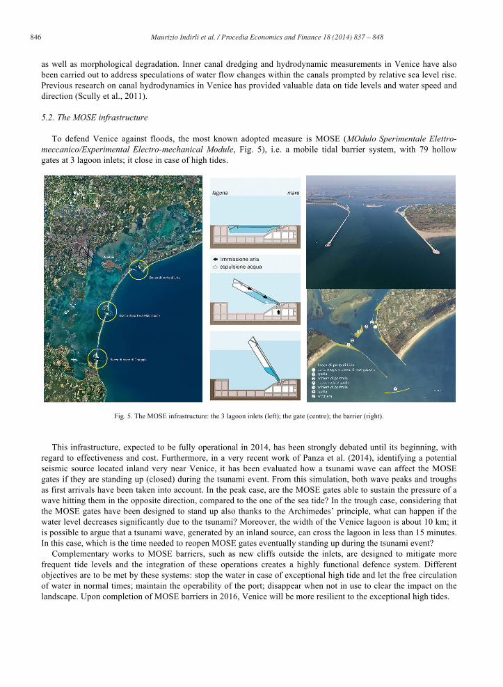
To defend Venice against floods, the most known adopted measure is MOSE (MOdulo Sperimentale Elettro-meccanico/Experimental Electro-mechanical Module, Fig. 5), i.e. a mobile tidal barrier system, with 79 hollow gates at 3 lagoon inlets; it close in case of high tides.
Fig. 5. The MOSE infrastructure: the 3 lagoon inlets (left); the gate (centre); the barrier (right).
This infrastructure, expected to be fully operational in 2014, has been strongly debated until its beginning, with
regard to effectiveness and cost. Furthermore, in a very recent work of Panza et al. (2014), identifying a potential seismic source located inland very near Venice, it has been evaluated how a tsunami wave can affect the MOSE gates if they are standing up (closed) during the tsunami event. From this simulation, both wave peaks and troughs as first arrivals have been taken into account. In the peak case, are the MOSE gates able to sustain the pressure of a wave hitting them in the opposite direction, compared to the one of the sea tide? In the trough case, considering that the MOSE gates have been designed to stand up also thanks to the Archimedes’ principle, what can happen if the water level decreases significantly due to the tsunami? Moreover, the width of the Venice lagoon is about 10 km; it is possible to argue that a tsunami wave, generated by an inland source, can cross the lagoon in less than 15 minutes. In this case, which is the time needed to reopen MOSE gates eventually standing up during the tsunami event?
Complementary works to MOSE barriers, such as new cliffs outside the inlets, are designed to mitigate more frequent tide levels and the integration of these operations creates a highly functional defence system. Different objectives are to be met by these systems: stop the water in case of exceptional high tide and let the free circulation of water in normal times; maintain the operability of the port; disappear when not in use to clear the impact on the landscape. Upon completion of MOSE barriers in 2016, Venice will be more resilient to the exceptional high tides.
847 Maurizio Indirli et al. / Procedia Economics and Finance 18 ( 2014 ) 837 – 848
5.3. The UNISDR Program “Making Cities Resilient” at Venice
Among the non-structural measures of prevention, preparedness and response, Venice can rely on the strong awareness of its citizens and their capacity to adopt adaptation measures in order to protect their assets and, thus, the cultural heritage of the city. Examples of this kind of measures are the protection and improvement of ground floors, the adaptation of electrical systems, the arrangement of steel barriers to be applied at the entrance of the buildings. The City of Venice takes part to the UNISDR Program “Making Cities Resilient: My City is getting ready”. The main results about the implementation of the Hyogo Framework for Action (HFA) and 10 Essentials for Making Cities Resilient (2011-2013) are reported in specific outputs.
6. Conclusions
This paper is the introductory part of a group of four articles, presented jointly at this “4th International Conference on Building Resilience”, 8-11 September 2014, Salford, United Kingdom. The other three papers (Knezić et al. 2014; Borg et al. 2014; Kaluarachchi et al. 2014) go into the details regarding the state-of-the-art about multi-hazard approach and scenarios, evaluation of vulnerability/resilience, discussion of mitigation options. All these papers will constitute a targeted session inside the conference as the final result of the WP7 activities. Also representatives of the Venetian scientific community will participate, in order to provide a useful discussion about performed investigations, already adopted protection strategies, and research future needs identification.
7. References
ASCE 7, 2006. American Society of Civil Engineers, Minimum Design Loads for Buildings and Other Structures. ASCE 7-05, 2006. American Society of Civil Engineers, flood load. ASCE 24-05, 2006. American Society of Civil Engineers, flood -resistant construction standards. Bedosti, B., and Caputo, M., 1986. Primo aggiornamento del catalogo dei maremoti delle coste italiane, Atti della Accademia Nazionale dei
Lincei, Rendiconti Classe Scienze Fisiche, Matematiche, Naturali, s. VIII, 80, 570–584, Roma, 1986. Borg, R.P., Kaluarachchi, Y., Indirli, M., Bach, C., Rochas, C., Kuzņecova, T., F. Romagnoli. 2014. The ANDROID case study; Venice and its
territory: vulnerability and resilience, weaknesses and strengths, Proc. 4th International Conference on Building Resilience, incorporating the “3rd Annual Conference of the ANDROID Disaster Resilience Network”, Special Technical Session “The ANDROID case study: Venice and its territory”, 8-11 September 2014, Salford, United Kingdom.
Burrato, P., and Valensise , G., 2008. Osservazioni geomorfologiche e di sottosuolo in Pianura Padano-Veneta per l’identificazione di thrust attivi della catena Sudalpina: in cerca di indizi della sorgente del Terremoto di Verona del 1117 [in Italian], Conference “Il Terremoto di Verona del 1117 e la sismicità dell’Italia nord orientale”, 11-13 September 2008, Verona, Italy.
Campostrini, P., 2014. The Venice lesson: reduction of disaster risks, coping with cultural heritage and environmental protection, keynote lecture, Proc. 4th International Conference on Building Resilience, incorporating the “3rd Annual Conference of the ANDROID Disaster Resilience Network”, Special Technical Session “The ANDROID case study: Venice and its territory”, 8-11 September 2014, Salford, United Kingdom.
Caputo, M., and Faita, G., 1984. Primo catalogo dei maremoti delle coste italiane, Atti Accademia Nazionale dei Lincei, Memorie Classe Scienze Fisiche, Matematiche, Naturali, s. VIII, 17, 213–356,Roma, 1984.
Decanini L., Mollaioli F., Panza G.F., Romanelli F. & Vaccari F. 2001. Probabilistic vs deterministic evaluation of seismic hazard and damage earthquake scenarios: a general problem, particularly relevant for seismic isolation. Proc. 7th International Post-Smirt Seminar on Seismic Isolation, Passive Energy Dissipation and Active Control of Vibration of Structures, Assisi, Italy, October 2-5, 2001.
FEMA 549, 2006a. Hurricane Katrina in the Gulf Coast, Mitigation Assessment Team Report, Building Performance Observations, Recommendations, and Technical Guidance, FEMA (Federal Emergency Management Agency) Report, 2006.
FEMA 550, 2006b. Recommended Residential Construction for the Gulf Coast: Building on Strong and Safe Foundations, FEMA (Federal Emergency Management Agency) Report, 2006.
Ghetti, A., 1988. Subsidence and sea level fluctuations in the territory of Venice, Landscape and Urban Planning, 16: 13-33. Giardini, D., Grünthal, G., Shedlock, K.M., Zhang, P., 1999. The GSHAP global seismic hazard map, Annali di Geofisica, 42:1225-1230. 1999. Guidoboni, E. and Tinti, S., 1989. The largest historical tsunamis in the Northern Adriatic Sea: a critical review, Science of Tsunami Hazards, 7,
45-54. IBC, 2006. International Building Code, USA. Indirli, M., 2007. Overview on risk assessment approaches for natural hazards, Proc. Workshop of EU Project COST Action C26 Urban Habitat
under Catastrophic Events, Prague, Czech Republic, March 30-31, 2007. Indirli, M., 2009. Organization of a Geographic Information System (GIS) database on natural hazards and structural vulnerability for the
historical centre of San Giuliano di Puglia (Italy) and the City of Valparaiso (Chile). International Journal of Architectural Heritage, 3 (4): 276-315.
Indirli, M., 2010. The 6th April 2009 L’Aquila Earthquake: from ruins to reconstruction, Conference organized by Kamra Tal Periti, La Valletta, Malta, April 26- May 2, 2010; Seismicity and Earthquake Engineering, L’Aquila Earthquake of April 2009, Ed. Ruben Paul Borg, ISBN 978-99932-0-879-2.

848 Maurizio Indirli et al. / Procedia Economics and Finance 18 ( 2014 ) 837 – 848
Indirli, M., Razafindrakoto, H., Romanelli, F., Puglisi, C., Lanzoni, L., Milani, E., Munari, M., and Apablaza, S., 2011. Hazard Evaluation in Valparaiso: the MAR VASTO Project. Pure and Applied Geophysics, 168 (3-4): 543-582.
Indirli, M., Kouris, L.A., Formisano, A., Borg, R.P., Mazzolani, F.M., 2013. Seismic damage assessment of unreinforced masonry structures after the Abruzzi 2009 earthquake: the case study of the historical centres of L’Aquila and Castelvecchio Subequo. International Journal of Architectural Heritage, 7 (5): 536-578.
Indirli, M., Bruni, S., Geremei, F., Marghella, G., Marzo, A., Moretti, L., Formisano, A., Castaldo, C., Esposito, L., Florio, G., Fonti, R., Spacone, E., Biondi, S., Miccadei, E., Vanzi, I., Tralli, A., Vaccaro, C., Gambatesa, T., 2014. The reconstruction plan of the town of Arsita after the 2009 Abruzzo (Italy) seismic event, Accepted paper, Proc. SAHC2014, 9th International Conference on Structural Analysis of Historical Constructions, Mexico City, Mexico, 14–17 October 2014.
IRC, 2006. International Residential Code, USA. Kaluarachchi, Y., Indirli, M., Ranguelov, B., 2014. The ANDROID case study; Venice and its territory: existing mitigation options and
challenges for the future. Proc. 4th International Conference on Building Resilience, incorporating the “3rd Annual Conference of the ANDROID Disaster Resilience Network”, Special Technical Session “The ANDROID case study: Venice and its territory”, 8-11 September 2014, Salford, United Kingdom.
Kandler, P., and Scussa, V., 1863. Storia Cronografica di Trieste dalla sua origine sino all’anno 1695, cogli annali dal 1695 al 1848 del procuratore civico Cav. Pietro Dott. Kandler, a cura di F. Cameroni, prima edizione: Stab. tipografico-litografico di C. Coen editore. Div. XX, p. 104.
Knezić, S., Scudeller, M., Indirli, M., Romagnoli, F., Kuzņecova, T., Perdikou, S., 2014. The ANDROID case study; Venice and its territory: identification of hazards and impact of multi-hazard scenarios. Proc. 4th International Conference on Building Resilience, 8-11 September 2014, Salford, United Kingdom.
Kossobokov, V.G., and Nekrasova, A.K., 2012. Global Seismic Hazard Assessment Program Maps are Erroneous, Seismic Instruments, 48 (2): 162–170.
Marzo, A, Marghella, G., Indirli, M., 2012. The Emilia-Romagna earthquake: damages to precast/prestressed reinforced concrete factories, Ingegneria Sismica, 2-3: 132-147.
NFPA 5000, 2006. Building Construction and Safety Code, published by the National Fire Protection Association. OPCM 3519, 2006. Ordinance n. 3519 of the President of the Council of the Ministers, April 28th, 2006. Criteri Generali per l’individuazione
delle zone sismiche e per la formazione e l’aggiornamento degli elenchi delle medesime zone (General criteria for the seismic zones identification and for compilation/updating of the same zones list) [in Italian], Gazzetta Ufficiale n. 108, May 11st, 2006.
Panza, G.F., Romanelli, F., and Vaccari F., 2000a. Seismic wave propagation in laterally heterogeneous anelastic media: Theory and applications to seismic zonation, Advances in Geophysics, 43, 1-95, Academic Press, San Diego.
Panza G.F., Romanelli F. & Yanovskaya T., 2000b. Synthetic Tsunami mareograms for realistic oceanic models, Geophysical Journal International, 141: 498-508.
Panza, G.F., et al., 2002. Realistic modelling of seismic input for megacities and large urban areas (the UNESCO/IUGS /IGCP project 414). Episodes, 25-3: 160-184.
Panza, G.F., La Mura, C., Peresan, A., Romanelli, F., & Vaccari, F., 2012. Seismic Hazard Scenarios as Preventive Tools for a Disaster Resilient Society. Advances in Geophysics, 53: 93-165.
Panza, G.F., Bisignano, D., and Romanelli, F., 2014. Does MOSE cope with inland tsunamis hazard? Geophysics, submitted on June 11st 2014. Paulatto, M., Pinat, T., and Romanelli, F., 2007. Tsunami hazard scenarios in the Adriatic Sea domain, Natural Hazards Earth System Sciences,
7, 309–325. Peresan, A., Zuccolo, E., Vaccari, F., Gorshkov, A., and Panza, G.F., 2011. Neo-Deterministic Seismic Hazard and Pattern Recognition
Techniques: Time-Dependent Scenarios for North-Eastern Italy, Pure and Applied Geophysics 168 (3-4):, 583–607. Ranguelov B., 2014a. Early warnings – Bulgarian experience in case of time deficit systems (earthquakes and tsunamis), Proc. 5th Intl. Conf.
Cartography and GIS, vol.2. 15-20th June., Riviera, Bulgaria. p. 738-745. Ranguelov B . 2014b. Early warning systems for earthquakes and tsunamis – a global innovation. Bulgarian experience, Proc. 1st Intl. Conf.
“Innovative behavior, entrepreneurship and sustainable development”, Sofia, 28-29 June, Publ. house - ZNANIE, p.257-278. Scully, Brian J., Martinez Luna, Carlos Humberto, Jessica A. DiToro, and Alison M. Corriveau. 2011. "Return to the City of Water --
Quantifying Change in the Venetian Canals." Interactive Qualifying Project, Worcester Polytechnic Institute. Semenza, E., 1965. Sintesi degli studi geologici sulla frana del Vajont dal 1959 al 1964. Memoir di Museo Tridentino di Scienze Naturali, 16: 1-
51. Semenza, E., and Ghirotti, M., 2000. History of the 1963 Vajont slide: the importance of geological factors, Bulletin of Engineering Geology and
the Environment, 59: 87-97. Tiberti, M.M., Lorito, S., Basili, R., Kastelic, V., Piatanesi, A., and Valensise, G., 2008. Scenarios of earthquake-generated tsunamis in the
Adriatic Sea, Pure and Applied Geophysics, 165 (11/12): 2117-2142. Tinti, S., and Maramai, A., 1996. Catalogue of tsunamis generated in Italy and in Cote d’Azur, France: a step towards a unified catalogue of
tsunamis in Europe, Annali di Geofisica, 39, 1253–1299, (Errata Corrige: Ann. Geofis. 40, 781). Tinti, S., Maramai, A., and Graziani, L., 2001. A new version of the European tsunami catalogue: updating and revision, Natural Hazards Earth
System Sciences, 1, 255–262. Tinti, S., Maramai, A., and Graziani, L., 2004. The new catalogue of the Italian tsunamis, Natural Hazards, 33, 439–465. Walraven, A. and Aerts, J., 2008. Impact of Europe's changing climate – 2008 indicator-based assessment, EEA (European Environment
Agency) Report N. 4/2008; ISBN 978-92-9167-372-8. Yanovskaya, T. B., Romanelli, F., and Panza, G. F., 2003. Tsunami excitation by inland/coastal earthquakes: the Green function approach,
Natural Hazards Earth System Sciences, 3, 353–365. Zuccolo, E., Vaccari, F., Peresan, A., and Panza, G.F., 2011. Neo-Deterministic (NDSHA) and Probabilistic (PSHA) Seismic Hazard
Assessments: a Comparison over the Italian Territory, Pure and Applied Geophysics,168 (1-2): 69-83.