Embed Size (px)
Citation preview


THE 3D VIRTUAL CARTOGRAPHIC
MODEL FOR THE CITY OF PRISHTINA
ICA COMMISSIONS JOINT WORKSHOP
ATLASES, COGNITION, USABILITY
April 27-30, 2018
Dept. of Geoinformatics – Palacký University
Olomouc - Czech Republic
Bashkim IDRIZI & Besart HALIMI

Overview:
• Preface
• Use cases of 3d city models
• Target area
• Data collection
• Used software
• Development of geodatabase in ArcGIS Pro
• First step of preliminary modeling in ArcGIS Pro
• Second step of modeling and editing of textures in
Trimble Sketchup Pro
• Third step of modeling by City Engine
• Web application
• Conclusions!

Preface:• 3d modelling and visualization of urban areas
• Spatial planning
• Disaster management
• Security reasons
• Engineering projects
• Cadastre
• Land management, etc.
• Smart cities
• Smart solutions
• Contribution for
Prishtina city
http://www.gudcltd.com/smart-cities
http://www.smart-cities.eu

https://www.citygml.org/applications/
Use cases of 3D city models:
Precondition: 3d model of harmonized,
standardized, and georeferenced spatial data!

Center of the city of PRISHTINA
Reasons
• Concentration of governmental institutions
• Big number of cultural heritage buildings and zones
• Problems in urban planning
• Land use management
• Usurpation of public areas
• Sound - acoustic problems
• Air pollution
• Traffic etc.
Target area:
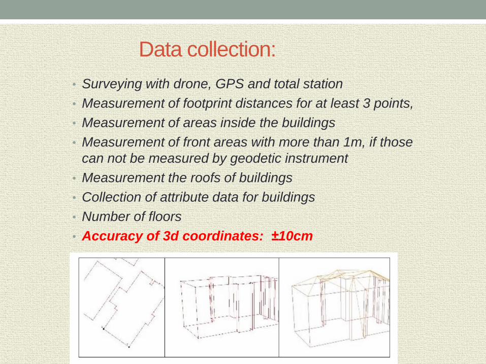
Data collection:
• Surveying with drone, GPS and total station
• Measurement of footprint distances for at least 3 points,
• Measurement of areas inside the buildings
• Measurement of front areas with more than 1m, if those
can not be measured by geodetic instrument
• Measurement the roofs of buildings
• Collection of attribute data for buildings
• Number of floors
• Accuracy of 3d coordinates: ±10cm

Used software:
&
&
&

Why ArcGIS Pro:
• 64bit application with friendly interface
• Easy editing and exchanging 2d and 3d data
• Linking with all ArcGIS applications such ArcMap, ArcCatalog, ArcGlobe etc.
• Use hyperthreading 64bit processor, which give high speed for modeling of
big databases
• Advancet options for 3d modeling and editing.
• Integration of desktop applications, databases, images, web servers, cloud
applications, web applications, and mobile applications.
• Interoprability with other GIS, CAD and BIM platforms, etc.
Why Trimble Sketchup Pro:
• Advanced options for modeling and editing textures
Why ESRI City Engine :
• combines geometric data and textures/facades
• simultaneously using georefenced spatial data as base for modeling
textures and facades
• Usage of the CGA Rules defined from the Python
• obtaining the geotypical model for an area/city.

Development of Geodatabasein ArcGIS Pro
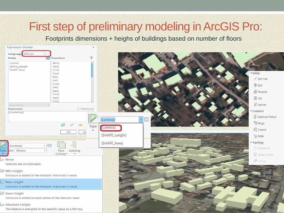
First step of preliminary modeling in ArcGIS Pro:Footprints dimensions + heighs of buildings based on number of floors

Used methods:
Second step of modeling and editing of textures in Trimble Sketchup Pro :
- Photo matching - Multipatch

Photo
Matching
Method

Building of National Radio-Television of Kosova
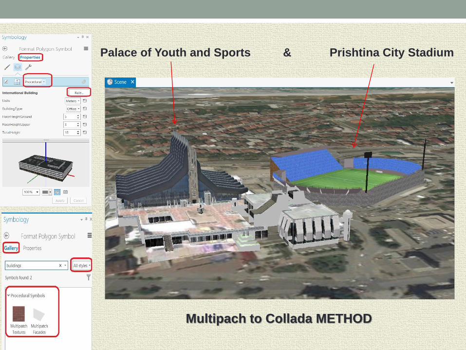
Palace of Youth and Sports & Prishtina City Stadium
Multipach to Collada METHOD

Third step of modeling by City Engine:The algorithm (CGA Rules) is defined with the data for floors, roofs, doors,
windows, by defining the mapping procedure, while in Python programming
language is given the data for the relevant geometry.
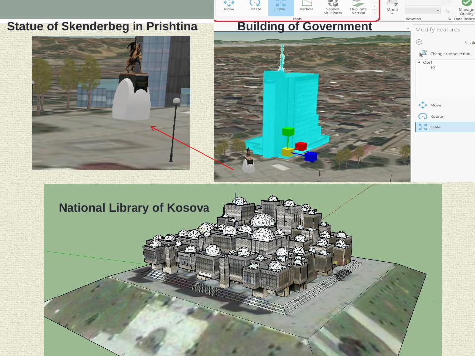
Statue of Skenderbeg in Prishtina Building of Government
National Library of Kosova


Conclusions
- Initiative for establishing base for Prishtina smart city has been performed;
- Students have used several software for 3d modeling
- Web application was developed for representing developed 3d model
- Database is extendable aimed for wider usage by relevant institutions from
central and local level
- 3d coordinates of buildings have high accuracy of 10cm, which correspond
to scale of cadastral maps 1:1000
- All data are georeferenced to national coordinate system of KosovaRef01!

THANK YOU FOR YOUR ATTENTION!!!
www.unt.edu.mk
www.uni-pr.edu
www.geo-see.org
In behalf of both coauthors,
Bashkim IDRIZI & Besart HALIMI


![3D Search Engine · 17. december 2010 [3D SEARCH ENGINE – A 5TH SEMESTER INFORMATICS PROJECT] ii PREFACE The reader of this report should have the knowledge of an Informatics or](https://img.dokumen.tips/doc/110x75/5fbc248c091064601312c44d/3d-search-engine-17-december-2010-3d-search-engine-a-a-5th-semester-informatics.jpg)