Embed Size (px)
Citation preview

Geological Society 0/ Ma/4yJio. - Circum-Pacific Council/or Energy an} Mineral /WOUI'CtJ TtdJJnic Frt1ITIework an} Energy /WOUI'CtJ 0/ tbe WtJtun Margin 0/ tbe Pacific Buin NlJJItITIIJer 27 - Dtamber 4 1994 Ku.aI4 Lump/Uj MaIa)J4io.
Tertiary tectonic evolution of the NW Sabah continental margin
HANs P. HAzEBROEK AND DENIS N.K. TAN
Sabah Shell Petroleum Company Ltd. Locked Bag No.1, 98009 Miri, Sarawak, Malaysia
Abstract: The NW Sabah continental margin can be sub-divided into 6 tectono-stratigraphic provinces on the basis of differences in structural styles and sedimentation histories: (1) Rajang Group Fold-Thrust Belt, (2) Inboard Belt, (3) Baram Delta, (4) Outboard Belt, (5) NW Sabah Trough and (6) NW Sabah Platform.
The Tertiary sedimentary sequence was deposited during two main phases of basin development: (1) A pre-early Middle Miocene phase of generally deep-marine clastic sedimentation. (2) A post-early Middle Miocene phase of clastic she1ti'slope deposition, which prograded northwestward
over the underlying sediment wedge and is separated from the latter by a major regional unconformity.
Evidence for Palaeogene subduction of South China Sea oceanic crust beneath NW Sabah is incomplete. The subduction hypothesis (Haile, 1973; Hamilton, 1979) is based on the following main elements: (1) The Rajang Group Fold-Thrust Belt of turbidites and associated ophiolites, interpreted to represent
an accretionary prism. (2) The sub-linear NW Sabah Trough, interpreted to represent the sea-bed expression of a subduction
trench. A major missing element in this hypothesis is a volcanic arc of the correct age. The NW Sabah Trough can be seen on seismic data to represent the downfaulted SE margin of the
NW Sabah Platform. An additional important element in the morphology of the Trough is the Baram Delta toe thrust zone, bounding the Trough to the SE, which was emplaced post Middle Miocene. Furthermore, the Trough terminates abruptly against the Luconia Block. These factors suggest that the present NW Sabah Trough is a relatively young feature, and that if an older, Palaeogene, trench is present, it would occur landward of, and with a different orientation to the NW Sabah Trough. The Palaeogene trench would no longer have a surface expression.
Hamilton's (1979) geodynamic interpretation is supported with the proposed modification of a Palaeogene subduction system broadly parallel to the structural strike of the Rajang Group Fold-Thrust Belt. The Inboard Belt wrench tectonics trend parallel to the postulated trench (cf. the Semangko fault of the Sumatra subduction system) as a result of oblique subduction. Counter-clockwise rotation of Borneo from Eocene to Middle Miocene resulted in increasingly oblique subduction. The Baram Delta sediment prism masks the Palaeogene trench.
The following three-stage model for the tectonic evolution of the NW Sabah continental margin is proposed: (1) Late Eocene to early Middle Miocene oblique subduction of South China Sea oceanic crust beneath
NW Sabah with deposition and subsequent imbrication of deep-marine sediments into an accretionary prism.
(2) Diachronous collision of the South China Sea attenuated continental crust (NW Sabah Platform) with Sabah, and associated cessation of ocean-floor spreading in the early Middle Miocene, led to regional uplift and erosion of the accretionary prism, resulting in a major regional unconfornlity (the Deep Regional Unconformity). This was followed by northwestward progradation of clastic sediments over the Inboard Belt from Middle Miocene to early Late Miocene.
(3) Resumption of convergent forces between Borneo and the NW Sabah Platform in middle Late Miocene was accompanied by major tectonic activity. The Inboard Belt was subjected to strong compressional deformation associated with major N-S wrench zones, resulting in the formation of a localised to semi-regional unconformity (the Shallow Regional Unconformity). Two new depocentres were formed seaward of the Inboard Belt: the Baram Delta and the Outboard Belt. A thick prograding clastic wedge built out towards NW in both depocentres, whilst the Inboard Belt was continuously eroded. A Late Pliocene/Pleistocene phase of locally developed deformation affected the Inboard Belt, Outboard Belt and Baram Delta.
GeoL. Soc. MaiaYJia, BuLletin 33, NOllemher 1993; pp. 195-210

196 HANS P. HAZEBROEK AND DENNIS N.K. TAN
INTRODUCTION
This present paper represents a revision and update of an earlier paper on the same area (Tan and Lamy, 1990). It comprises newly drawn maps and diagrams. A set of regional composite seismic lines across the NW Sabah continental margin, from the Rajang Group Fold-Thrust Belt to the NW Sabah Trough is also included.
PLATE TECTONIC SETTING (FIG. 1)
The NW Sabah continental margin occupies a central position in the area of the junction between the Eurasian, Indo-Australian, Pacific and Philippines plates. A mosaic of smaller plates, some of which form marginal seas, characterizes this area, the evolution of which is still far from being fully resolved, thus attracting investigation by numerous workers since the early 1970s (Hamilton, 1979; Tapponier et al., 1982; Letouzey et al., 1988; Hutchison, 1989; Rangin et al., 1990a and 1990b).
o·
+ T Inactive] Spl'laadlng'
= Active + .., - inactive
-.,.-- ActIve ] SUbduction trench
-Fault -=+ Direction of relative plate movement
o 500km ,
The NW Sabah continental margin is located at the southeastern boundary of the South China Sea basin, which is one of these marginal seas. Oceanic crust, featuring magnetic lineaments, has been recognised in the centre of this basin, with the oldest and most recent magnetic anomalies being dated as 32 and 17 Ma respectively (Taylor and Hayes, 1980). An extinct spreading ridge is interpreted to trend E-W in the centre of this basin, and an older ridge trends possibly NE-SW in the western part of the basin (Fig. 1). However the elements of submarine geomorphology do not trend E-Wbut rather NE-SW throughout the whole basin (see discussion in Hutchison, 1992a). The remaining part of the South China Sea basin is interpreted to consist of attenuated continental crust (Holloway, 1981, Fig. 1), and in the vicinity of Sabah this is referred to as the NW Sabah Platform.
Large parts of the Eurasian plate and IndoAustralian plate consist of pre-Mesozoic continental crust. On the Eurasian plate this is referred to as 'Sundaland' or the Sunda Shield. The eastern part of Sundaland, which occupies almost the entire
140' E
Basement of Pra-MelOzolc continental crust or mature Island arc
Attenuated continental crust
,......, Oceanic or young Island arc crust, L-..J covered In pisces by Late Cretaceous
or younger sediments
Figure 1. Plate tectonic elements of South East Asia (modified after Hutchison, 1989 and Rangin et al., 1990a).
TERTIARY TECTONIC EVOLUTION OF THE NW SABAH CONTINENTAL MARGIN 197
southern part of Borneo island, is, however, noncratonic and may represent terrain accreted to Sundaland during the late Mesozoic (Hutchison, 1992a). The remaining part of Borneo is interpreted to be largely underlain by oceanic crust (Hutchison, 1989).
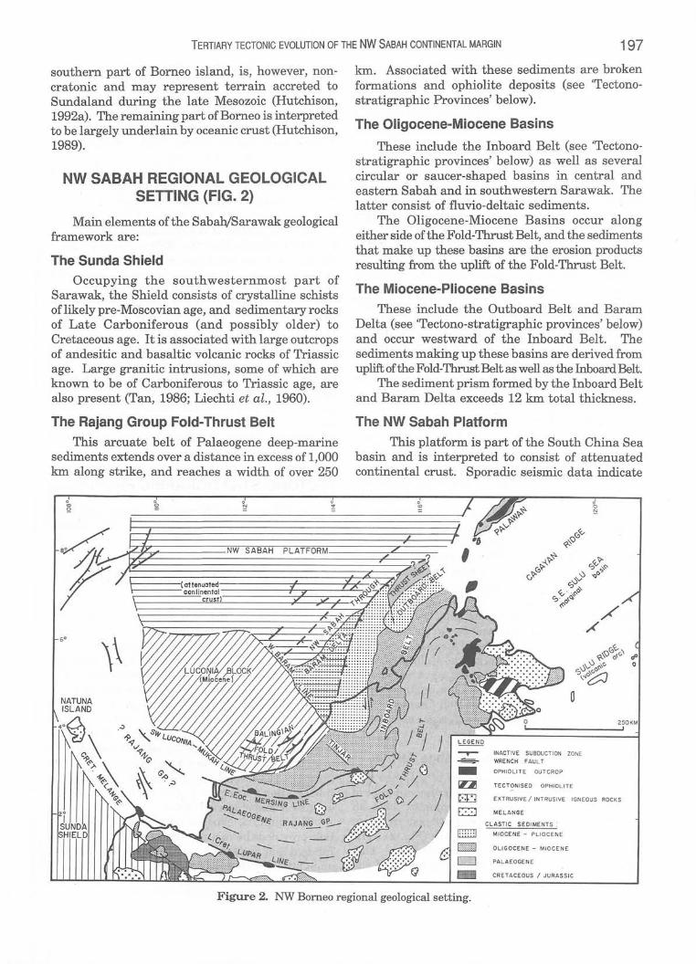
NW SABAH REGIONAL GEOLOGICAL SETTING (FIG. 2)
Main elements of the Sabah/Sarawak geological framework are:
The Sunda Shield
Occupying the southwesternmost part of Sarawak, the Shield consists of crystalline schists of likely pre-Moscovian age, and sedimentary rocks of Late Carboniferous (and possibly older) to Cretaceous age. It is associated with large outcrops of andesitic and basaltic volcanic rocks of Triassic age. Large granitic intrusions, some of which are known to be of Carboniferous to Triassic age, are also present (Tan, 1986; Liechti et al., 1960).
The Rajang Group Fold-Thrust Belt
This arcuate belt of Palaeogene deep-marine sediments extends over a distance in excess of 1,000 km along strike, and reaches a width of over 250
km. Associated with these sediments are broken formations and ophiolite deposits (see 'Tectonostratigraphic Provinces' below).
The Oligocene-Miocene Basins
These include the Inboard Belt (see 'Tectonostratigraphic provinces' below) as well as several circular or saucer-shaped basins in central and eastern Sabah and in southwestern Sarawak. The latter consist of fluvio-deltaic sediments.
The Oligocene-Miocene Basins occur along either side ofthe Fold-Thrust Belt, and the sediments that make up these basins are the erosion products resulting from the uplift of the Fold-Thrust Belt.
The Miocene-Pliocene Basins
These include the Outboard Belt and Baram Delta (see 'Tectono-stratigraphic provinces' below) and occur westward of the Inboard Belt. The sediments making up these basins are derived from uplift of the Fold-Thrust Belt as well as the Inboard Belt.
The sediment prism formed by the Inboard Belt and Baram Delta exceeds 12 km total thickness.
The NW Sabah Platform
This platform is part of the South China Sea basin and is interpreted to consist of attenuated continental crust. Sporadic seismic data indicate
INACTIVE SUBDUCTION ZONE WRENCH FAULT
OPH IOLITE OUTCRO P
TEC T QNISE D OPHIOLI TE
EXTRUSI VE / INT RUSIVE IGNEOUS ROCKS
MELANGE
CLASTIC SEDIMENTS :
E3 MIOCENE - PLIOCENE
E]J OLIGOCENE - MIDC E N E
CJ PALAEOGEN E
~ CR E TA CEOUS / JURASS IC
Figure 2. NW Borneo regional geological setting.

198 HANS P. HAZEBROEKAND DENNIS N.K. TAN
that NE-SW trending horsts and half-grabens characterize the dominant structural style.
The tilted fault blocks are probably Mesozoic (Triassic to Cretaceous) sediments resting on a continental basement, similar to those dredged from the Reed Bank and Dangerous Ground areas (Kudrass et al., 1986). The half-graben fill most probably consists of clastic sediments of early Tertiary age (paleocene to Early Miocene). The end of the main extension and concomitant block rotation phase is marked by a strong reflection which corresponds to relatively thin, shallow water platform carbonates of Late Oligocene-Early Miocene age, as in the Palawan area (Hinz and Schluter, 1985; Kudrass et al., 1986). The carbonate is overlain by well-bedded, hemipelagic to pelagic sediments which have been only mildly deformed by epeirogenic movements. On regional seismic lines this Oligo-Miocene carbonate occurs at depths of ca. 2.5-3.0 seconds in the NW Sabah Platform, plunges beneath the NW Sabah Trough to depths of between 4.5-6.0 seconds and can be traced for some distance beneath the Miocene-Pliocene Basins ..
The Luconia Block
This Block has been interpreted as a continental fragment originally attached to the South China contmental margin, that has been transported by the opening of the South China Sea Basin (Holloway, 1981; James, 1984). This stable platform is characterized by a large number of carbonate reef buildups, some of them containing major gas accumulations (Scherer, 1980). The Luconia Block is bounded by major NW-SE and WNW-ESE trending faults (SW Luconia-Mukah Line, West Baram Line, Fig. 2) which are possibly trans-tensional features related to deep-seated NNE-SSW strike-slip faults (Holloway, 1981). Deformation, characterized by wrench-induced folding and thrusting, is present along the southern margin of the Luconia Block: the Balingian Belt. This Belt has been interpreted as a collisional margin where the Luconia Block has impinged upon the Rajang Group Fold-Thrust Belt (James, 1984). However, many features characteristic of sinistral wrenching are present.
The .East Sabah Ophiolite/Melange Terrain Much of East Sabah consists of melange and
broken formations. Within this terrain, outcrops of a relatively complete ophiolite complex form an arcuate belt from Darvel Bay in southeaStern Sabah to the Kudat Peninsula in the north (Fig. 2). The belt appears to continue into Palawan. This ophiolite belt marks the sharp inflection of the
Rajang Group Fold-Thrust Belt (NW Borneo Trend to Sulu Trend). The ophiolite is considered to form the oceanic basement to the sediments of Sabah (Hutchison, 1989). Chert and other pelagic sediments overlying the ophiolite are Late Cretaceous to Eocene in age (Kirk, 1968), but the oceanic lithosphere itself may be older. Wherever they have been restudied, HF-dissolved out radiolaria in the cherts consistently give a Lower Cretaceous age. Therefore the cherts are older than documented by Kirk (Basir, 1992).
The clay matrix of the melange has been dated as Early to Middle Miocene. Within this matrix are clasts of various lithologies of Late Cretaceous to Palaeogene age. The clasts vary in size from centimetres to hill massifs (Clennell, 1991).
Various models have been proposed to explain the complex geology of East Sabah (Hamilton, 1979; Hutchison, 1989, 1992b; Clennell, 1991). In Hutchison's (1992b) model, East Sabah represents an outcropping extension of the SE Sulu Sea marginal basin. The ophiolitic complex of Sabah is inferred to correlate with the ocean floor of the Early Cretaceous (or older) Sulu sea. A volcanic arc was built upon this ocean floor and subsequently this arc was rifted in the Early Miocene, giving rise to the present Sulu Sea marginal basin.
TECTONO-STRATIGRAPHIC PROVINCES
On the basis of differences in structural style and sedimentation history, the NW Sabah continental margin can be subdivided into six tectono-stratigraphic provinces:
The Rajang Group Fold-Thrust Belt (Figs. 3, 4 and 5b)
In W Sabah, this Belt consists of Eocene to Oligocene turbidites, hemipelagics, and associated broken formations (Crocker, Temburong, Trusmadi and other formations) that have been deformed into a thrusted, steeply-dipping sequence. The sequence becomes younger in a seaward direction (northwestward) but bedding tops face southeastward, indicating that the structure must be intricately imbricate (Hamilton, 1979). On seismic (Fig. 5b) the Fold-Thrust Belt can be seen to extend in the offshore area at least up to the Bunbury-St. Joseph Ridge (that is, beneath the Inboard Belt), where it is sharply bounded to the west by a major wrench zone.
The uplifted, exposed part of the Fold-Thrust Belt provided the main source of sediments for the Inboard Belt and subsequently for the Baram Delta and Outboard Belt depocentres.

EUSTATIC CURVES
i'i: :I:~(I) «ZUJ mUJ(!)
NW SABAH CHRONOSTRATIGRAPHY RAJANG
'" .J .. u,.
EPOCH I~ i=l':H (Haq et 01 1987)
«~~ (1):;::(1) (I)
(SOUTHERN AREA) 1.;[" THRUST
BARAM DELTA :+: INBOARD BELT .. BELT
I
~ W z W 1W u ...J o 0 - 0 :!! -
:!!
~ a: « W
W
W !;t r5 ...J U 0 c.!)
...J o ~
a: « W
100 !IO LOWISLUMPI
OM -!IO SCARS
2
5
4
5
6
7
8
9
10 .. A
DRU
ill
271 ::> n 28
29
50
3'
32
I Figure 3.
Samarang Sabah Ridges
------~
~ ~
Klias Peninsula
UNCONFORMITY (SRU)
-:-:-:-:-:-:-:-:-:-:e': DEEP REGIONAL --:::::::::::::::::::::-~UNCONFORMITY (DRU)
Cffrl~il~~~I~l~w --:::::::::::::::::::::::::::::::::::::::::::r-._---------------
-~::-:-:-:-:-:-:::?-'" . ---------_ . .-.. . =:-:-:~-l-'!JG-... ---.z.------:-:..::-:-:-::;-=
. --::::F;;:;;-=.JJMtumQ~i(ii_ .. _'-_cR"Ot~r<ER~-:~ --:-:-:~p,.~rbldl,eSaii".':'~ORMAflQ.~:":-:; ~.:Labuan) ___ ::-___ -_-_-_-____ -:
---- ------ - - -- - - - - ~----..... - ..... -,---,--ZiiZiiiiiiiiiiiii[: - . 1. _ -----------------:-::-IJ Ii a 1l--:A:J:t:5:ihT • ------------------------_ .. ------------- -- ---QO::b£ -----------------------------------------:'P''P'' i. ----.~.: .. :~ --------
._--------------------._------------------Tectonic/stratigraphic scheme and eustatic curves: NW Sabah.
REGIONAL TECTONIC EVENTS ,'" li!.J
~~ ~.J <nw j::l! 0:, J: . ~~ "zo: OW F~ d« 0 00: lEo ID ::l!LL -0
~o i I~
~~ ~IEPOCH 3i i!
= f/, ffi-.:
1\ NORTH 1'/ : '1 i, SA BAH I .J ,~ ~ 8
~i ~ 1\ 7 15 0 8 ~ ~ SOUTH ~ SABAH 9
~ KINABALU '0
a~JR~~ION " 12
13
14
15
16
17
18
19
20
21
22
23
24
25
28
27
28
29
50
31
52
iPL£)STO -CENE W W Z lei: W ...J U ~ Q a: ~ ~
W
!:t ...J
~IW W ...J U 0 o 0 :E :E
~ a: « W
W
wlt;r Z ...J W U o c.!)
...J 0,>-
...J a: « W
-i m =:j s;: ~ -i
~ is m (§ § 5 Z o "Tl
~ m Z :E
~ :J: (') o ~ Z m
~ :;:: » :D G)
Z
...... CD CD

~-;
v v ,_I
/' _ ...... \.. .' 1 ",/ // /// )" /1 ... -'" /1/// J I /
/ / /1 / ./ , I .. / / I ( / /
~ ",., -_/ / AROASIER I I I ,,/ ,,/ ,.J!- "".. ,/ BANK I I
I I , ... / /-.. __ ..1 I J l I ( I C, #' ",,/ / 1 / , \ -- -- 1,{4"-/ ,/ I
" ...... , _-;/ pt// I /
o .:;,
~
\ I /'" -~- -,' / / I I / //" #//
o ~
A..
~~ ,,0 ....
/. ( 1/ /r / " LOWER TERTIARY / (-:"::> / !
\ NORTHWEST SABAH PLATFORM -;.--:....",J / , / /
\ ( UPPER TERTI ARV COVER 0 6- 08 SEC) _---......... \ -:') ,/ _,,'.( 0# ) /" ,.., //
"W (/1 i ( 1""1 " / '-_, /< \ ... ....-' -",) .. --7 I I L/
YI~
.\ \ it !
/
/
'- .... / '- __ / // /1 ,,;/ /' /
/ t I
" l' \ / \../
<~/ ./
I /
_~I't4l" 1/ //
-J /
/
I I
I
I /
I I
~/ ,..6;.1'
/ /
I
.... ".>
'<I~ O~
v
-- ~ (...:::. II" v·~-..qV
"""'~ ... --.. ,~ .... '<I~
•
! ... e~ ' ii ~j ~~ ...
;:!"'.:!! ~!
1::' or ~
Figure 4. Tectono-stratigraphic provinces of NW Sabah.
S II{ II
" ~1/~",~
S" I
--~ 8ALAaAC / ./
\ BASIN ./
, W,,/'''' \ I ~l'r \ ,~ /J ! \ ~~
\ t' / BA»CAUAN ~ I
( BASIN J
\ /
rv o o
:r: :t> Z en :-0 :r: ~ m CD :0 o m
'" :t> Z o o m z z en z ?;:t z

TERTIARY TECTONIC EVOLUTION OF THE NW SABAH CONTINENTAL MARGIN
Me
BARAM DELTA
SECTION 1 : THRUST SHEET --,
,. N~R~~:~H TOEZ~~~UST -ofo--- --------l OWER TERTIARY THRUST SHEET -----------~+-- C
~A;_--L------~---~m~e----~I~----~I ---------~I ---------i--
L L ...J
1 ... 1
OFFSET BY 3 KM
VXM 4261 14/7/92 I
Figure 5a. Regional seismic section 1 (NW Part). For location, see Figure 4.
OUTBOARD AND INBOARD BELTS
OUTBOARD BELT ------~·II~.------ INBOARD BElT PTiduud Synclin~ Dunbuf ).' - 5 1_ J OSo':'ph Ridg ..
201
- CLAY TECTONICS I DIAPIRISM --\+--- - --- EXTUSIOII .------~I_--- COMPRESSION I WRENCH ING ----. SE
==~~~~~~y~~~~~~~~'
L
AAJANG GP. FOLD-THROST BELT
(OR THRUST SHEET)
o 10 J(M ~' -------"
~------------------------------------------------------------------------------~8 VXM 4 266 14/7192
Figure 5b. Regional seismic section 1 (SE Part). For location, see Figure 4.

202 HANS P. HAZEBROEKAND DENNIS N.K. TAN
The Inboard Belt (Figs. 3, 4, 5b, and 7b)
This Belt trends broadly parallel to the FoldThrust Belt, and extends from offshore NW Sabah on to the onshore in a southward direction.
Structurally, the Belt consists of broadly NNESSW oriented, tight, broken anticlines (Sabah Ridges), separated by wide synclines. The anticlines show a variety of structural features indicative of wrench-related compression, such as flower structures, and reverse faults steepening with depth (Bol and van Hoorn, 1980).
In the northern part of the Inboard Belt, the orientation of the anticlines deviates to NE, E aIid SE. The bending of this trend occurs near the axial plane of the sharp inflection as observed in the Rajang Group Fold-Thrust Belt (NW Borneo Trend to Sulu Trend).
Timing of deformation in the Inboard Belt is based on well and seismic data, indicating a major Late Miocene/Early Pliocene phase and a more locally developed Late PliocenEVPleistocene phase.
An indication for the sense of strike-slip movement and the magnitude of offset has been derived from the offset in the pattern of Middle Miocene shelf margins (dated on pollen; Fig. 9). Sinistral strike-slip movement with a cumulative offset of some 100 km has been estimated for the southern part of the Inboard Belt.
The sedimentation history in the Southern and Central parts of the Belt consists of an early Middle Miocene regression (Stage IVA), a late Middle Miocene transgression (mainly Stage IVB) and a Late Miocene to Pliocene regression (Stages IVC and IVF/G; Stages IVD and IVE are thin or absent). Further to the north, the main difference in sedimentation history is a prolonged Late Miocene to Pliocene regression marked by well-developed Stages IVC, IVD and IVE sediments.
The Outboard Belt (Figs. 4, Sa, 5b and 6b)
This Belt occurs west of the northern part of the Inboard Belt. The Outboard Belt is structurally complex, and shows features indicating both extensional and compressional phases of deformation. The former deformation is marked by large, NE-SW trending down-to-basin normal fault systems, whereas the latter is indicated by wrenchinduced features in the Tembungo and Kinarut areas and by clay diapirism along the western margin of this Belt. The province represents an elongated Late Miocene-Pliocene depocentre comprising Stages IVD, E, F and G sediments prograding northwestward from shallow to deep marine.
The Baram Delta (Figs. 3, 4, 7a, and 7b)
This province is characterised by typical delta tectonics, and can be subdivided into a proximal part, dominated by extensional growth-faulting, a transitional area formed by the delta slope, and a distal part, dominated by overthrusted anticlines representing the toe-thrust zone of the delta.
In the proximal part of the delta large down-tobasin growth-faults and corresponding counterregional faults define the NNE-SSW trending Champion-Padas megastructure. In Sabah, this megastructure is made up of several macrostructures, each bounded by its main growthfault on the landward side. (Timbalai, Samarang and Padas macrostructures). The topsets of the prograding wedge of deltaic sediments are largely conf'med to the Champion-Padas megastructure. These macrostructures merge downdip into a large expanding flank, bounded on the seaward side by an important counter-regional fault system, which trends broadly parallel to the present coastline.
The toe-thrust zone of the delta is 50 to 80 km in width in the main part of the delta, but narrows towards the northern fringe of the delta. Up to six, NE-SW trending elongated, broadly parallel, overthrusted anticlines are present in this zone. The anticlines form ridges on the sea floor, that increase in amplitude towards the delta toe. Between the anticlines are mini-basins, that have been partly or entirely filled with draping hemipelagics, and to a minor extent with onlapping turbidites. The fill of the mini-basins is less complete towards the delta toe. These observations strongly suggest recent tectonic activity of the delta toe. Such toe-thrust features may be regarded as an integral part of gravitational delta tectonics, and are analogous to those observed in the Niger Delta, which has a passive margin setting (Fig. 10).
On the delta slope (as well as closer ashore), older anticlines become associated with clay-diapiric ridges. These clay ridges may represent an advanced stage of development of the thrusted ~ticlines, with the thrust-planes steepening as the delta builds out.
The 'Thru$t Sheet' (Figs. 4, Sa, 6a and 8) Hinz et al. (1989) proposed the term 'Thrust
Sheet' for a block of chaotic seismic facies, which is bounded to the NW and SW by steep thrust faults and to the SE by normal faults, separating it from the Outboard Belt. The .chaotic seismic facies is overlain by gently folded sediments of possibly early Middle Miocene age. Beneath the chaotic seismic facies a coherent reflection can be seen dipping in

TERTIARY TECTONIC EVOLUTION OF THE NW SABAH CONTINENTAL MARGIN 203
SECTION 2 BAR AM DELTA,
. _. - - --. -- _ .. _....,.- -
"" - tROUSH --I . TOE THRUST ZONE • , LOWER TERTIARY THRUST SI o~~~~~============~~~~~~============~======~~~~~~
z
1 EARLY PLIOCENE
L.
....,
DEFORMED TURSrrl)EAHD HfillPEL..,w:fC DEPOSITS
? OLIGO - "'OC --~ ~ EHE CARBONATES?
-- .~ ...J
~----- .... -,.. VXM 4270 14/7/92
Figure 6a. Regional seismic section 2 (NW Part). For location, see Figure 4.
THRUST SHEET AND OUTBOARD BELT
I\ ru
T"~U'" 'HIlT
OFFSET BY 14 KM
OUTBOARD BELT -------___ ,1 -+ INBOARD BELT
L
1: ,10 S tl UI!!
I I
DEFORMED TURBIDITE AHD HEMIPELAGIC DEPoSrTS
10 KM
VXM 4273 14/7/92
Figure 6b. Regional seismic section 2 (SE Part). For location, see Figure 4.
4
..J

204 HANS P. HAZEBROEK AND DENNIS NK TAN
SECTION 3 BARAM DELTA
13 A o------------------~--------------------------------~~~====~~--------------------------
,-
NW HW SABAH I TOE THRUST lONE o.~T~R~OU~GH~======~;=============~~~~~======~==~==========t=====~
3A
MIHIBAS,"S
'r-:;;;;;;;;;;;;;;;~~~~2 ;;;;:---::::: , HI",~eL..WIC ~S ::::""'1 OLIGO - MIOCENE CARIOHA~
L..
~--.... --~..:.~, - -... _- - -J
Figure 7a. Regional seismic section 3 (NW Part). For loation, see Figure 4.
AND INBOARD BELT
MINI B ASINS
DELTA -------------------------- ------. -<-------- INBOARD BELT --
CLAY DIAPIRISM
\ DEFORMEO TURBJDITE AHD HEMIPELAGIC DEPOSrTS 5
o 10 K M
o" ln IV'.' 11M
Figure 7h. Regional seismic section 3 (SE Part). For location, see Figure 4.

TERTIARY TECTONIC EVOLUTION OF THE NW SABAH CONTINENTAL MARGIN 205
a landward direction, which is inferred to correlate to the Oligo-Miocene carbonates dredged from the Dangerous Grounds area (Kudrass et al., 1986).
The tentatively interpreted allochtonous mass making up the 'Thrust Sheet' defines the northeastern margin of the NW Sabah Trough, and exceeds 40 km in width. It protrudes up to 150 km offshore and is located at the axial plane of the sharp inflection of the Fold-Thrust Belt (NW Borneo Trend/Sulu Trend). The 'Thrust Sheet' has a similar seismic response as the deep marine sediments of the Fold-Thrust Belt (Fig. 5a). The 'Thrust Sheet' may therefore represent a nappe, consisting of Rajang Group rocks, that resulted from gravity sliding associated with the uplift of the Fold-Thrust Belt.
The NW Sabah Trough (Fig. 4) This NE-SW linear bathymetic feature with a
water depth of up to 2800 m extends over a length of over 300 km, and reaches an average width of some 80 km. To the SW, the Trough terminates abruptly against the Luconia Block. The Trough becomes less well expressed northwards towards Palawan island, where it is referred to as the Palawan Trough. The Trough is observed on seismic to be a down-faulted part of the NW Sabah Platform which extends beneath the Baram Delta front. An Upper Tertiary fill of some 2 seconds seismic twoway time thickness overlies the Lower Tertiary platform within the Trough. This fill consists largely of pelagic clays with some turbidite intercalations. The Baram Delta toe thrust zone, which is Late Miocene to Recent in age, is an important element in the morphology of the Trough, bounding it to SE. These factors suggest that the present NW Sabah Trough is a relatively young feature, and that if an older, Palaeogene, trench is present, it would occur landward of, and with a different orientation to the NW Sabah Trough. The Palaeogene trench would no longer have a surface expression.
TECTONIC EVOLUTION
Figure 3 combines a simplified stratigraphic scheme for the southern part of the NW Sabah offshore area with eustatic sea-level curves (Haq et al., 1988) and with regional tectonic and magmatic events. It is clear from this scheme that the Tertiary sedimentation history was in this area dominated by tectonic events, whilst eustatic sea-level lowering caused overall regression from the early Middle Miocene onwards. Eustatic low stands can only occasionally be correlated with unconformities (late Middle Miocene and Late Pliocene/Pleistocene unconformities) and shelf-edge slump scars.
The Tertiary sedimentary sequence can be
subdivided into two main components: 1. A pre-early Middle Miocene phase of generally
deep-marine clastic sedimentation (Stages I, II and III). Deformation of this clastic wedge in the offshore area is revealed on seismic in the Inboard Belt and Baram Delta toe thrust zone.
2. A post-early Middle Miocene phase of clastic shelf/slope deposition (Stage IV), which prograded northwestward over the underlying sediment wedge and is separated from the latter by the Deep Regional Unconformity. This sequence is characterised, in the Inboard Belt, by complex tectonics attributable to an overall regime of compressive strike-slip faulting along pre-existing NNE-SSW shear zones. The syndepositional deformation occurred in a series of tectonic pulses, which resulted in repeated periods of uplift and folding. The locus of this deformation progressively shifted basinward, in a NW direction, through time. The result is a series of unconformities which are mappable in the Inboard Belt, but become conformable horizons further W. The unconformities playa principal role in subdividing the post-early Middle Miocene sequence into a series of Stages (IVA to IVG) (Levell and Kasumajaya, 1985 and Levell, 1987). The hypothesis of Palaeogene subduction along
the NW Sabah continental margin was proposed by Haile (1973) and expanded upon by Hamilton (1979).
The main elements of this hypothesis are: 1. The Rajang Group Fold-Thrust Belt, which is
interpreted as an accretionary prism. 2. The NW Sabah Trough, which is interpreted as
the seabed expression of a subduction trench. A major missing element in the hypothesis is
the lack of a magmatic arc of corresponding age. The following key observations bear on the NW
Sabah tectonir/magmatic history (Fig. 3): 1. True sea-floor spreading, from 32 to 17 Ma,
documented in magnetic anomaly patterns in the oceanic crust of the central South China Sea (Taylor and Hayes, 1983).
2. Counter-clockwise rotation of Borneo, over some 45° from Eocene to Middle Miocene and possibly later (Schmidtke et al., 1990). This is accepted by most authorities and based on a series of measurements in various localities and on different rock-types (Hutchison, 1991).
3. Imbrication and thrus~ing of the Crocker Formation (part of the Rajang Group) in Oligocene to Middle Miocene times. Deep marine sedimentation ceased in early Middle Miocene and the Crocker Formation was subsequently uplifted and deformed. This event is represented by the Deep Regional Unconformity.

206 HANS P. HAZEBROEK AND DENNIS N.K. TAN
4. Intrusion of the Mt. Kinabalu batholith. Preliminary potassium-argon ages range from 5 to 12 Ma. Jacobson (1970) considers 9 Ma the most likely age of intrusion. Further work on dating is required.
5. Volcanism is widespread along the strike of the Rajang Group Fold-Thrust Belt, ranging from the Hose mountains and Usun Apau plateau in Sarawak to Kalimantan and Sabah (Semporna volcanic arc). Available ages range from Late Cretaceous to Pliocene (Hutchison, 1989). Most ages are younger than Middle Miocene and hence postdate the uplift of the Rajang Group rocks, which is confirmed by the unconformable relationship between Rajang Group and overlying volcanics (Liechti et al., 1960).
6. Large-scale strike-slip movements are documented in the NW Sabah offshore, and can be traced southward on land (Fig. 9). On seismic, typical wrench-phenomena such as flower-structures, define trends that roughly parallel the strike of the Rajang Group FoldThrust Belt (Fig 4, see Inboard Belt above). If Palaeogene subduction took place, then the
orientation of the trench may have been nonconformable with the present-day NW Sabah trough, as this bathymetric feature is partly made up of an element that postdates Palaeogene
subduction: the Baram Delta toe thrust zone. A possible Palaeogene trench is likely to have been oriented conformable to the strike of the accretionary prism, and to have been continuous along the extent of the prism. The NW Sabah Trough, however, is non-conformable with the strike of the Fold-Thrust Belt, and terminates abruptly against the Luconia Block. Oblique subduction would have resulted in extensive strike-slip movements, also oriented approximately parallel to the strike of the accretionary prism (cf. the Semangko fault of the Sumatra subduction zone).
The data presently available provide insufficient evidence to substantiate the hypothesis of Palaeogene subduction along the NW Sabah continental margin. Nevertheless the following speculative tectonic evolution is proposed, which draws on work from Hamilton (1979), Holloway (1981) and Hutchison (1989), and is shown in Figure II.
Late Cretaceous
Oceanic crust is being subducted beneath the Sunda Shield, possibly driven by counter-clockwise rotation of the shield (Holloway, 1982). The ophiolites exposed along the Lupar line are interpreted as a Late Cretaceous suture. A major river system, possibly the proto-Mekong (Hutchison,
SECTION 4 : LOWER TERTIARY THRUST SHEET
L---------------.:,---------------------;;-~\·)m ln" l f .. :t
Figure 8. Regional seismic section 4. For location, see Figure 4.

[Ma]
o 3
11
14
16
50 km
TERTIARY TECTONIC EVOLUTION OF THE NW SABAH CONTINENTAL MARGIN
. . . . . ~ :
~.... 7 .ll1.... :::J
sE:~
.. '
. . 2/'
»). .. £
1_ .........
-_ .
Figure 9. Interpretation of the offset in the pattern of Middle Miocene shelfmargins as due to sinistral strike slip within a Upper Miocene to Pliocene (mega-) wrench system throughout Northwest Sabah.
207

208 HANS P. HAZEBROEK AND DENNIS N.K. TAN
Figure 10. Niger Delta Toe Thrust.
1989) or proto-Kapuas is feeding abundant clastics from the Sunda Shield onto Borneo's oceanic basement, forming major turbidite fan systems as part of the Rajang Group.
Late Paleocene to Early Eocene
Relative movement of South China Sea oceanic crust towards and beneath the Sunda Shield is now driven by attenuation of continental crust on the NW margin of the South China Sea (Holloway, 1981). The ophiolites along the Bukit Mersing Line in Sarawak are interpreted as a suture welded during this period. Geometric relationships require major transform fault systems to be active along the eastern margin of the Sunda Shield. Deposition of Rajan..g Group turbidites continues.
Late Eocene to Oligocene The evolution of the NW Sabah continental
margin can only be traced back to the Late Eocene. The location of the subduction zone shifts
further towards the location of the present day coast line, as the accretionary turbidite prism builds further out. True seafloor spreading by formation
of new oceanic crust begins in the central part of the South China Sea. Continental fragments, such as the Luconia Block, and attenuated continental crust approach the subduction zone.
Early to Middle Miocene
This is a period in which many events take place. Oblique subduction continues, and collision of continental fragments (Luconia Block) and attenuated continental crust begins from the south, propagating gradually northwestward. Coeval with the collision is the diachronous uplift of the Rajang Group, being earliest in West Sarawak and latest in Sabah. Erosion products of the Rajang Group Fold-Thrust Belt are reworked into the Inboard Belt depocentre, as well as into the proximal parts of the Baram Delta and Outboard Belt areas.
As a result of the gradual locking-up of the oblique subduction zone, major strike-slip zones were initiated, which trend parallel to the strike of the Rajang Group Fold-Thrust Belt and subduction trench (cf. Semangko Fault system, Sumatra, which is parallel to the subduction trench).
During uplift ofthe northern part ofthe Rajang

TERTIARY TECTONIC EVOLUTION OF THE NW SABAH CONTINENTAL MARGIN 209
\
\
/
OCEANIC CRUST (No SpreadIng)
I I \
\ SUNDA \ SHIELD
'" I
OCEANIC CRUST
H 1
EARLY TO AND MIDDLE
EROSION OF CROCKER FM. MIOCENE
LEGEND'
-or -or INACTIVE } " ACTIVE SUBDUCTION TRENCH
====:;> CLASTIC SEDIMENTS DEPOCENTRE
FAULT e Intrusive
-- -- SUTURE <0 Extrusive :;;; ...... === ...... ~ EXTENSIVE WRENCH - INDUCED COMPRESSION
\tNVINIIW COLLISION OF MICROPLATE
_~~ -'-- THRUSTING I FOLDING
@ ./v) LATE • DIRECTION OF RELATIVE PLATE MOVEMENT UU' MIOCENE-t9 (j) HOLOCENE ~ RIVER DRAINAGE LLLULLLLA-________________ 4-______ ~
Figure 11. Tentative Tertiary Evolution of the NW Sabah continental margin (partly based on Hutchison, 1989; Hamilton, 1979; and Holloway, 1981).
Group Crocker Formation, major thrusting and nappe formation may result in emplacement of thrust sheets up to 50 km from the axis of uplift.
Late Miocene-Holocene
Large-scale strike -slip movements with cumulative horizontal displacements of up to 100 km result from resumption of oblique convergent forces along the locked-up subduction zone. Transpression causes uplift and erosion of the Inboard Belt (Shallow Regional Unconformity), feeding new depocentres to the Wand NW: the Baram Delta and Outboard Belt. Intrusion of the Mt. Kinabalu batholith and widespread volcanism take place along the Rajang Group Fold-Thrust
Belt. Local reactivation of transpression occurs during Late Pliocene/Pleistocene.
The NW Sabah margin is at present seismically fairly quiet with a total of 48 minor earthquakes recorded in the northern part of Sabah in the last 94 years. The most severe earthquake was measured as 5.0 on the Richter scale in May, 1991. The epicentre was located some 75 km offshore NW Sabah and may represent movement along the above-mentioned strike-slip zones.
ACKNOWLEDGEMENTS
This paper is based on the results of extensive work over many years by numerous SSBjSSPC

210 HANS P. HAZEBROEK AND DENNIS N.K. TAN
geologists. Permission to' publish this paper was kindly granted by Shell International Petroleum Maatschappij (The Hague), and PETRONAS (Kuala Lumpur).
REFERENCES
BASIR JASIN, 1992. Significance of radiolarian cherts from the Chert-Spilite Formation, Telupid, Sabah. Geol. Soc. Malaysia Bull. 31, 67-83.
BoL, AJ. AND VAN HOORN, B., 1980. Structural Styles in Western Sabah offshore. GeoISoc.MalaysiaBull. 12.,1-16.
CLENNELL, B., 1991. The origin and tectonic significance of melanges in Eastern Sabah, Malaysia. Journal of Southeast Asian Earth Sciences, 6(3/4), 407-429.
HAn.E, N.S., 1973. The recognition of former subduction zones in Southeast Asia. In: Tarling, D.H. and Runcorn, S.K. (Eds.), Implications of Continental Drift to the Earth Sciences, 2. Academic Press, London, 885-92.
HAMILTON, W., 1979. Tectonics of the Indonesian Region. U.S. Geol. Surv. Prof. Paper 1078, 345p.
HAQ, B.U., HARDENBOL, J. AND VAIL, PR, 1988. Mesozoic and Cenozoic Chronostratigraphy and Cycles of Sea-Level change. In: Wilgus e.K. et al. (Eds.), Sea-Level changes - An Integrated Approach. SEPM Spec. Publ. 42, 71-108.
HINz,K.,FRITSCH,J.,I<EMPTER.E.HK.,MoHAMMAD,AM.,MEYER, J., MOHAMED, D., VOSBERG, H., WEBER, J., AND BBNA VIDEZ, J., 1989. Thrust tectonics along the North-western Continental Margin of Sabah/Borneo. Geologische Rundschau, Band 78, Heft 3.
HINz,K.,ANDScHuLTER,H.V.,1985. Geology of the Dangerous Ground, South China Sea and the Continental Margin
. off SW Palawan: Results of SONNE Cruise 50-23 and 50-27. Energy, 10, 297-315.
HOLLOWAY,N.H.,1981. NorthPalawanBlock,Philippines-its relation to Asian mainland and role in evolution of South China Sea. Geol. Soc. Malaysia Bull. 14, 19-58.
HUTClDSON, e.S., 1989. Geological Evolution of South-East Asia. Clarendon Press, Oxford, 368p.
HUTClDSON, e.S., (Ed.), 1991. Studies in East Asian tectonics and resources (SEA TAR), Crustal transect Vll: Jawa-KalimantanSarawak-South China Sea. IOC, Paris, and CCOP, Bankok, CCOP/TP26.
HUTCHISON, e.S., 1992a. The Eocene Unconformity on SoutheastandEastSundaland. Geol. Soc. Malaysia, Bulletin 32,69-88.
HUTClDSON, e.S., 1992b. The Southeast Sulu Sea, a Neogene Marginal basin with outcropping extensions in Sabah. Geol. Soc. Malaysia, Bulletin 32, 89-108.
JACOBSON, G., 1970. Gunung Kinabalu, Sabah, Malaysia. Geol. Surv. Malaysia Rept. 8, 111p.
JAMES, D.M.D. (Ed.), 1984. The geology and hydrocarbon resources ofNegara Brunei Darussalam. Brunei Museum and Brunei Shell Petroleum Co.
Knuc,H.J.e.,1968. The igneous rocks of Sarawak and Sabah. Geol. Survey of Borneo region, Malaysia Bulletin 5.
KUORASSHR., WIEDICKE, M. CEPEK, P.I<REuZER, H. AND MULLER, P., 1986. Mesozoic and Cainozoic rocks dredged from the South China Sea (Reed Bank area) and Sulu Sea and their significance for the plate-tectonic re-constructions. Marine and Petrol Geology, 3, 19-30.
LEroUZEY, J., SAGE, L. AND MULLER, e., 19~8. Geological and Structural Map of Eastern Asia with Introductory Notes. ~m. Assoc. Petrol. Geol. 1988.
LEvELL, B.K., 1987. The nature and significance of regional unconformities in the hydrocarbon-bearing Neogene sequences offshore West Sabah. Geol. Soc. Malaysia Bull. 21,55-90.
LEVELL, B.K. AND I<AsuMAJAYA, A, 1985. Slumping of the Late Miocene shelf edge offshore West Sabah. A review of a turbidite basin edge. Geol. Soc. Malaysia Bull. 18,1-29.
Lmom, P., ROE, F.W. AND HAn.E, N.S., 1960. The geology of Sarawak, Brunei and the western part of North Borneo. Geological Survey Department British Territories in Borneo Bulletin 3.
RANGIN, e., BELLON, H, Bm-ARO, F., LErouZEY, J., MULLER, e. AND SANUDIN, T., 1990a. Neogene arc-continent collision in Sabah, N. Borneo (Malaysia). Tectonophysics 183, 305-319.
RANGIN, e., JOUVET, L., PuBELLIER, M., AND THE TElHYS PACIFIC WORKING GROUP, 1990b. A simple model for the tectonic evolution of Southeast Asia and Indonesia region for the past 43 m.y. Bull. Soc. Geol. France, t. VI, 6, 889-905.
Sci-mRER,F.e.,1980. ExplorationinEastMalaysiaoverthelast decade. In: Halbouty,M.T. (Ed.), Giant oil and gas fields of the decade 1968-1978. Am. Assoc. Petrol. Geol. Mem. 30, 423-440.
SaiMnm<E, E.,FULLER,M.,ANDHAsroN,R., 1990. Paleomagnetic data from Sarawak, Malaysian Borneo and the Late Mesozoic and cenozoic tectonics ofSundaland. Tectonics 9,123-140.
TAN, D.N.K., 1986. Palaeogeographic development of West Sarawak. Geol. Soc. of Malaysia Bulletin 19, 39-49.
TAN, D.N.K. AND lAMY, J.M., 1990. Tectonic evolution of the NW Sabah continental margin since Late Eocene. Geol. Soc. of Malaysia Bulletin 27, 241-260.
TAPPONNIER, P., PELTZER, G., 1E DIAN, AY., ARMIJo, R. AND CoBBOLD, P., 1982. Propagating extrusion tectonics in Asia: new insights from simple experiments with plasticine. Geology, 10, 611-616.
TAYLOR, B. AND HAYES, D.E., 1983. Origin and History of the South China Sea Basin. In: D.E. Hayes (Ed.), The Tectonic and Geologic Evolution of SE Asian Seas and Basins Part 2. AGU Geophysical Monograph 27, 23-56.
--------~.~.-GD-•• ·---------Manuscript received 22 April 1993