Embed Size (px)
Citation preview

Terrestrial Wildlife Analysis Report
1
Terrestrial Wildlife Analysis Report
Clarks Fork Fuels Treatment and Wildlife Habitat Enhancement Project
High Cascades Ranger District, Rogue River-Siskiyou National Forest
/s/ Jeff von Kienast Date: 8/22/2013
Jeff von Kienast
District Wildlife Biologist
/s/ Sheila Colyer Date: 8/22/2013
Sheila Colyer
Wildlife Biologist

Clarks Fork Wildlife Habitat Enhancement and Fuels Treatment Project
2
I. Introduction This report includes discussion on terrestrial species and habitats other than those covered in the
biological evaluation (BE). The Rogue River Land and Resource Management Plan (USDA
Forest Service 1990b) was amended by the Northwest Forest Plan (USDA Forest Service and
USDI Bureau of Land Management 1994b) and is the primary planning document that establishes
procedural requirements for effects from projects to wildlife.
This report discusses and analyzes Forest Plan Management Indicator Species, neo-tropical
migratory birds, and other rare and uncommon species. The fuels treatments considered
under the Clarks Fork Wildlife Habitat Enhancement and Fuels Treatment Project (Clarks Fork
Project) require a BE to be completed (Forest Service Manual (FSM) 2672.4). This report is
designed to complement the Terrestrial Wildlife BE, for other terrestrial wildlife species. Both
reports were prepared for the proposed Clarks Fork Project, which would be authorized, funded,
and conducted on the High Cascades Ranger District of the Rogue River-Siskiyou National
Forest. See the Clarks Fork Wildlife Habitat Enhancement and Fuels Treatment Project Decision
Memo (DM) or the BE for more detail on the actions proposed and analyzed in this report.
This report discusses the species of concern, their listing status and references, species biology,
and other relevant information about the distribution and abundance of these species on the
Rogue River-Siskiyou National Forest and the Clarks Fork project planning area. Also included in
attachment 1 are recommendations for project design criteria and/or mitigation measures, as
appropriate. The scale for effects analyses for all species in this document includes the Clarks
Fork project planning area.
II. Management Indicator Species (MIS) The National Forest Management Act (NFMA) requires that each Forest identify management
indicator species (MIS) in the planning process and that "fish and wildlife habitats will be
managed to maintain and improve habitat of selected management indicator species." By
monitoring the habitat changes or trends of these particular indicator species, the effects of
management activities on the associated animal communities can theoretically be determined.
Since the habitats of these indicator species cover the majority of the vegetative seral stages on
the Forest, it is assumed that meeting the requirements of these species will assure that the needs
of associated species will be met (USDA Forest Service 1990a).
Management indicators representing overall objectives for wildlife, fish, and plants may include
species, groups of species with similar habitat relationships, or habitats that are of high concern
(FSM 2621.1). An indicator species represents all other wildlife species which utilize a similar
habitat type. Indicator species act as a barometer for the health of various habitats and will be
monitored to quantify habitat changes predicted by implementation of the Forest Plan (USDA
Forest Service 1990b). Management Indicator Species and habitats are identified in table 1.
MIS species, habitats, and pre-field and reconnaissance results are summarized in table 1. The
Forest has developed the Rogue River National Forest MIS Forest-Wide Environmental Baseline
and Species Account [RRMBSA (USDA Forest Service 2011)] which this document incorporates
by reference. Please refer to this document for background information that includes a more
exhaustive review of habitat use and ecology, distribution of the species, Forest-level habitat
evaluations, and viability assessments.

Terrestrial Wildlife Analysis Report
3
The terrestrial wildlife analysis area for the Clarks Fork Project is defined as the project planning
area. This area is approximately 14,040 acres and is located within and includes Federally
managed lands in the following subwatersheds within the (5th field) Big Butte Creek watershed:
Clarks Fork Creek-Fourbit Creek, Upper South Fork Big Butte Creek, and Willow Creek
drainages. Only National Forest System Lands (NFSL) would be treated.
The project planning area is within the area analyzed under the 1995 Upper Big Butte Watershed
Analysis (USDA Forest Service 1995). The legal description is Township 35 and 36 South, Range
3 and 4 East, Willamette Meridian, Jackson County, Oregon. Treatments would occur within
several project areas located within the broader Clarks Fork project planning area.
Table 1. Management Indicator Species (MIS) on the Rogue River National Forest and Clarks Fork project planning area
Species Habitat
represented
Habitat present in Clarks Fork project planning
area
Species present in Clarks Fork project
planning area
Spotted owl Older forest habitat
(mature and old-growth forest)
Yes Documented
Pileated woodpecker Mature forest Yes Documented
American marten Mature forest Yes Documented
Primary cavity nesters (downy woodpecker, hairy woodpecker, northern flicker)
Wildlife trees (snags)
Yes
Downy – Documented
Hairy – Documented
N. flicker – Documented
Roosevelt elk Winter range and
thermal cover Yes Documented
Black-tailed deer Winter range,
thermal cover, and non-forested habitat
Yes Documented
A. Habitats for MIS Species
Habitat data for MIS species analyses was derived from the wildlife habitat parameter of the
existing vegetation dataset for the Rogue River-Siskiyou National Forest. This basis for this
dataset used 2006 Geographic Information System (GIS) coverages developed by the Landscape
Ecology, Modeling, Mapping & Analysis (LEMMA) team using a Gradient Nearest Neighbor
(GNN) methodology (http://www.fsl.orst.edu/lemma/splash.php). These datasets were further
refined using information from stand exams where they were available and field verification on a
sample of the units by the District and Assistant Forest Silviculturists.
The analysis is based primarily on satellite imagery. The use of satellite imagery allows large
areas to be assessed on a consistent basis and is considered the “best available” data that maps
and provides consistent vegetation characteristics throughout the analysis areas regardless of
ownership. The LEMMA data set encompasses all lands administered by the Rogue River-
Siskiyou National Forest.
It is important to note some limitations in terms of the satellite imagery used for this analysis. The
imagery was classified over a large area, and as such individual pixels of data may not exactly
match on the ground. Though, when viewed at the landscape or analysis area scale, the imagery
presents a consistent “snapshot” which is useful for design of actions and planning.

Clarks Fork Wildlife Habitat Enhancement and Fuels Treatment Project
4
The GNN dataset was queried by the unit wildlife biologists and the Forest Wildlife Biologist for
habitats known to support the ecology and biology of the MIS species identified on the Rogue
River National Forest. These habitat types were further refined based on specific habitat
requirements and Rogue River Forest Plan direction. Final baseline habitat determinations for
MIS species on the Rogue River National Forest are identified in table 2. Baseline habitat
determinations for MIS species within the Clarks Fork project planning area are identified in table
3.

Terrestrial Wildlife Analysis Report
5
Table 2. MIS species and baseline habitats on the Rogue River National Forest
Deer Acres Elk Acres
American marten
(4,000 to 6,800 feet elev only)
Acres Spotted
owl Acres
Pileated woodpecker
Acres Cavity
nesters Acres
Farm develop Forage 5,827 Forage 5,827 Non hab 760 Non hab 5,827 Non hab 5,827 Non hab 5,827
Grass / shrub
Sparse vegetation Forage 8,837 Forage 8,837 Forage 4,497 Non hab 8,837 Non hab 8,837 Non hab 8,837
Seed / sap / pole
3 to 11”, <40% CC Forage 35,830 Forage 35,830 Forage 14,215 Non hab 35,830 Non hab 35,830 Non hab 35,830
Seed / sap / pole
3 to 11”, >40% CC Hiding 89,844 Hiding 89,844 Forage 43,788 Non hab 89,844 Non hab 89,844 Non hab 89,844
Young 11 to 19.9”
>70% CC, <40% CC Forage 15,728 Forage 15,728 Forage 7,593 Non hab 15,728
Low quality snag hab
15,728 Low
quality snag hab
15,728
Young 11 to 19,9”
40 to 70% CC Hiding 74,979 Hiding 74,979 Forage 31,407 Dispersal 74,979
Low quality snag hab
74,979 Low
quality snag hab
74,979
Young 11 to 19.9”
>70% CC
Thermal / hiding
141,625 Thermal / hiding
141,625 Forage 66,569 Dispersal 141,625 Snag hab 141,625 Snag hab
141,625
Mature, >20”
<40% CC Forage 6,066 Forage 6,066 Den / rest 3,982 Non hab 6,066
Low quality snag hab
6,066 Low
quality snag hab
6,066
Mature, >20”
40 to 60% CC Hiding 29,912 Hiding 29,912 Den / rest 14,954 Dispersal 29,912 Snag hab 29,912
Snag hab
29,912
Mature, >20”
>60% CC
Optimal thermal /
hiding 203,402
Optimal thermal /
hiding 203,402 Den / rest 97,947 NRF 203,402 Snag hab 203,402
Snag hab
203,402
1 Acres reported for American marten in table 2 are for the High Cascades Ranger District only. New information regarding marten habitats are included in the
American marten section below and table 20.

Clarks Fork Wildlife Habitat Enhancement and Fuels Treatment Project
6
Table 3. MIS Species and baseline habitats on the Clarks Fork project planning area
Deer Acres Elk Acres
American marten (4,000 to 6,800 feet
elev only)
Acres Spotted
owl Acres
Pileated woodpecker
Acres Cavity
nesters Acres
Grass / shrub
Sparse vegetation Forage 0 Forage 0 Forage 0 Non hab 0 Non hab 0 Non hab 0
Seed / sap / pole
3 to 11”, <40% CC Forage 101 Forage 101 Forage 0 Non hab 101 Non hab 101 Non hab 101
Seed / sap / pole
3 to 11”, >40% CC Hiding 62 Hiding 62 Forage 18 Non hab 62 Non hab 62 Non hab 62
Young 11 to 19.9”
<40% CC Forage 1024 Forage 1024 Forage 240 Non hab 1024
Low quality snag hab
1024 Low quality snag hab
1024
Young 11 to 19,9”
40 to 70% CC Hiding 77 Hiding 77 Forage 7 Dispersal 77
Low quality snag hab
77 Low quality snag hab
77
Young 11 to 19.9”
>70% CC
Thermal / hiding
3118 Thermal / hiding
3118 Forage 1255 Dispersal 3118 Snag hab 3118 Snag hab 3118
Mature, >20”
<40% CC Forage 4631 Forage 4631 Den/Rest 858 Non hab 4631
Low quality snag hab
4631 Low quality snag hab
4631
Mature, >20”
40 to 60% CC Hiding 104 Hiding 104 Den/Rest 29 Dispersal 104 Snag hab 104 Snag hab 104
Mature, >20”
>60% CC
Optimal thermal /
hiding 253
Optimal thermal /
hiding 253 Den/Rest 3 NRF 253 Snag hab 253 Snag hab 253

Terrestrial Wildlife Analysis Report
7
B. Coarse Woody Debris (CWD) and Snags
Coarse woody debris and snags are critical habitat components for several of the MIS species
found on the Rogue River-Siskiyou National Forest. These habitat components provide
nesting/denning habitats for northern spotted owl, pileated woodpecker, American marten, and
the cavity nesting MIS species. Coarse woody debris and snags also provide resting sites and
prey/foraging habitats for these species.
Site-specific snag and down wood data are collected on the Rogue River-Siskiyou National
Forest by the Southwest Oregon Ecology Group. These data are collected within unmanaged
forest ecology plots that are identified within specific plant series (Hochholter 2010). Tables 4
and 5 identify the mean and standard deviations of these data. The project planning area falls
almost entirely within the white fir plant series in these tables.
Table 4. Coarse woody material Levels (number of pieces/acre and mean length)
Plant series Diameter class mean length (feet) / acre (SD)
10 to 19.9 inches ≥20 inches
Douglas-fir 535 (521) 93 (153)
white fir 663 (534) 239 (334)
Table 5. Snag levels (per acre)
Plant series Diameter class mean (SD)
10 to 19.9 inches ≥20 inches
Douglas-fir 6 (13) 2 (4)
white fir 4 (6) 4 (5)
Coarse woody debris and snag data were collected on some portions of the project planning area
(not within the Big Butte Springs harvest units) by Biologists during field verification of wildlife
habitats. Table 6 provides these data, expressed as the mean across all units measured for both the
10 to 19.9-inch and ≥20-inch size classes, for comparison of CWD and snags in unmanaged
forest stands (tables 4 and 5). Course woody debris and snags fall below the mean for these
PAG’s. The Clarks Fork Project is expected to increase snag habitats initially and coarse woody
debris with 1 to 2 decades after treatment through prescribed burning.
Table 6. Coarse woody material and snag levels on the Clarks Fork project planning area
Plant series CWD length (feet / acre and snags / acre
10 to 19.9 inches ≥20 inches
CWD 42 39
Snag 1.31 1.12
C. Northern Spotted Owl (Strix occidentalis caurina)
The northern spotted owl was selected as an indicator of older forest habitat in the Rogue River
National Forest Land and Resource Management Plan (USDA Forest Service 1990b). For a
complete description of northern spotted owl ecology and biology across its range, within the
Rogue River-Siskiyou National Forest, and within the Clarks Fork project planning area, please
refer to the Terrestrial Biological Evaluation for the Clarks Fork Project.
The Forest has identified 12 known, historic, or suspected spotted owl sites in or adjacent to
(within 2.4 miles of the planning area boundary) the Clarks Fork project planning area from
historical information, protocol surveys, NEPA field evaluations, or incidental observations.
Three activity centers fall within the Clarks Fork project planning area boundary.

Clarks Fork Wildlife Habitat Enhancement and Fuels Treatment Project
8
All of these sites are monitored annually by the Oregon State University Demographic Study
crew. One of the sites has been unoccupied since 2007. One site has been unoccupied since 2004
but had a male detected in 2008. The third site is still occupied by a pair of spotted owls. Barred
owls have been detected at all 3 sites within the last decade. An additional nine spotted owls sites
overlap the project planning area where nest patch, core area, or home ranges overlap. Table 7
provides the history of the three northern spotted owl sites within the Clarks Fork project
planning area for the last decade.
All suitable habitats not already being surveyed by OSU for the demographic study within the
Clarks Fork project planning area were surveyed in 2013.
Direct, indirect, and cumulative effects to northern spotted owl are described for the proposed
action in the Terrestrial Wildlife BE for the Clarks Fork Project.

Terrestrial Wildlife Analysis Report
9
Table 7. Site Status of Northern Spotted Owls within the Clark’s Fork Planning Area (12 Total).
Year Northern Spotted Owl Site Status
#2223A Bowen
Creek (BLM)
#3260O Clementcheria
(BLM) #3307 Sheep Camp
#3308 Juniper
Ridge #3322 Indian Creek #3331 Whiskey Spring
2003 Unoccupied No surveys conducted. Male NSO detected.
Barred owl pair detected.
Male NSO
detected.
NSO Pair. Nesting
status unknown. NSO pair. 2 young.
2004 Unoccupied No surveys conducted. Unoccupied by NSO.
Barred owl pair detected.
Unoccupied by
NSO. Barred owl
(unknown sex)
detected.
Male NSO detected.
Barred owl male
detected.
NSO pair w/young.
2005 Single response. Unoccupied Unoccupied by NSO.
Barred owl male detected Unoccupied Unoccupied
NSO pair. Nesting
failed.
2006 Unoccupied Unoccupied Unoccupied by NSO.
Barred owl male detected
Unoccupied by
NSO. Barred owl
male detected.
Unoccupied by NSO.
Barred owl male
detected.
NSO pair. Nesting
failed. Barred owl
male detected.
2007 Single response. Unoccupied Unoccupied
Unoccupied by
NSO. Barred owl
female detected.
Unoccupied by NSO.
Barred owl female
detected.
Unoccupied by NSO.
Male and juvenile
Barred owls detected.
2008 Unoccupied NSO Pair. Nesting status
unknown. Male NSO detected. Unoccupied
Unoccupied by NSO.
Male Barred owl and
Great horned owl.
Unoccupied by NSO.
Male Barred owl
detected
2009 NSO pair, 2 young
fledged Unoccupied
Barred owl female
detected. Unoccupied
Unoccupied by NSO.
Male Barred owl and
Great horned owl.
Unoccupied
2010 Unoccupied NSO Pair. Nesting status
unknown. Unoccupied Unoccupied
Unoccupied by NSO.
Barred owl male
detected.
Unoccupied by NSO.
Barred owl male
detected.
2011 Unoccupied Unoccupied Unoccupied Female NSO
detected.
Unoccupied by NSO.
Male Barred owl and
Great horned owl.
Unoccupied
2012 Unoccupied No surveys conducted. Unoccupied.by NSO.
Male Barred owl detected. Unoccupied
Unoccupied by NSO.
Barred owl pair.
Unoccupied by NSO.
Barred owl male

Clarks Fork Wildlife Habitat Enhancement and Fuels Treatment Project
10
Table 7. Site Status of Northern Spotted Owls within the Clark’s Fork Planning Area (12 Total) continued.
Year Northern Spotted Owl Site Status
#3332 Sand
Piper #3336 Oak Mountain #3355 Stanley Meadows #3358 Snowshoe Butte #3361 Fechner
#9016 East
Skeeter
Swamp
2003
(historic site)
surveyed in close
proximity
unoccupied?
(historic site)
surveyed in close
proximity
unoccupied?
NSO pair. Non-nesting. NSO pair, 2 young fledged
(historic site) surveyed in
close proximity
unoccupied?
Site not
surveyed.
2004 No survey No survey Unoccupied NSO pair located, no young
detected No survey
NSO pair, 2
young
fledged
2005 No survey No survey
NSO pair. Nesting status
unknown. Barred owl
pair.
NSO pair located, no young
detected No survey
NSO female
detected.
2006 No survey No survey Unoccupied by NSO.
Barred owl pair detected.
NSO pair located, no young
detected. Barred and Great
Horned owls detected at site
No survey
NSO pair
detected,
nest failed.
2007 No survey No survey
Unoccupied by NSO.
Barred owl male
detected.
Unoccupied No survey NSO pair.
Non-nesting.
2008 No survey No survey Unoccupied Unoccupied No survey NSO female
detected.
2009 No survey No survey Unoccupied NSO pair located, no young
detected No survey Unoccupied
2010 No survey No survey Unoccupied NSO pair located, no young
detected. Barred owl detected. No survey Unoccupied
2011 No survey No survey Unoccupied NSO pair, 2 young fledged.
Barred owl detected. No survey Unoccupied
2012 No survey No survey Unoccupied NSO pair. Non-nesting. No survey NSO female
detected.

Terrestrial Wildlife Analysis Report
11
D. Pileated Woodpecker (Dryocopus pileatus)
1. Conservation Status
USDA Forest Service – MIS on all forests
NatureServe
(http://www.natureserve.org/explorer/servlet/NatureServe?searchName=Dryocopus+pileatus)
Global – G5 – Widespread, abundant, secure
Oregon – S4 – Apparently secure
Washington – S4 – Apparently secure
Oregon Department of Fish and Wildlife (ODFW) – Vulnerable (Blue Mountains, Eastern
Cascades Slopes and Foothills, Klamath Mountains)
(http://www.dfw.state.or.us/wildlife/diversity/species/docs/SSL_by_taxon.pdf)
Washington Department of Fish and Wildlife (WDFW) – Priority species
(http://www.wdfw.wa.gov/conservation/phs/list/2008/2008-sept_woodpeckers.pdf), rank
Candidate
USDI Fish and Wildlife Service Birds of Conservation Concern
(http://www.fws.gov/migratorybirds/NewReportsPublications/SpecialTopics/BCC2008/BCC2008
.pdf) – The pileated woodpecker is not listed as a species of concern in any of the Bird
Conservation Regions occurring in Oregon and Washington.
BCR 5 – No
BCR 9 – No
BCR 10 – No
2. Distribution
Global:
NatureServe
(http://www.natureserve.org/explorer/servlet/NatureServe?searchName=Dryocopus+pileatus)
“RESIDENT: from southern and eastern British Columbia and southwestern Mackenzie across
southern Canada to Quebec and Nova Scotia, south in Pacific states to central California, in the
Rocky Mountains to Idaho and western Montana, in the central and eastern U.S. to the eastern
Dakotas, Gulf Coast, and southern Florida, and west in the eastern U.S. to Iowa, Kansas,
Oklahoma, and Texas (AOU 1983).”
Oregon and Washington:
Wide-spread resident in forested areas of Oregon and Washington including the Olympic
Peninsula, Coastal Mountains, Klamath Mountains, Cascade Mountains, Blue Mountains,
Northeast Washington, and forested fringes of the Puget Trough, Willamette, Rogue, and Umpqua
Valleys. Absent from higher and lower elevations due to lack of large trees for nesting, roosting,
and foraging (Marshall et al. 2003).
3. Habitat Use
Pileated woodpeckers use mature and older, closed canopy stands for nesting and roosting, but
may use younger (40 to 70 years), closed-canopy stands for foraging if large snags are available;
large snags and decadent trees are critical habitat components for pileated woodpeckers; down
logs do not appear to be an important foraging substrate for pileated woodpeckers on the west
side of Oregon and Washington (Hartwig et al. 2004; Mellen et al. 1992; Raley and Aubry 2006).
Clarks Fork Wildlife Habitat Enhancement and Fuels Treatment Project
12
In the Coast Range of western Oregon, pileated woodpeckers preferred deciduous riparian
habitats and forest stands greater than 40 years of age for foraging, however, nests and roosts
were located only in forest stands greater than 70 years of age (Mellen et al. 1992).
On the Olympic Peninsula, sites used for foraging had higher densities of large snags [more than
51centimeters (21 inches) DBH and more than 7.5 meters (25 feet) tall]; the average density of
large snags in plots with recent pileated woodpecker foraging activity was 100 percent greater
than in plots with no recent foraging activity (Raley and Aubry 2006). Patches of these large,
relatively hard snags in closed-canopy habitat conditions provide optimal foraging habitat.
On Vancouver Island pileated woodpeckers used mature structural stages for nesting (Hartwig et
al. 2004).
Large snags and decadent trees are used for nesting (tables 8 and 9).
Olympic Peninsula – nest trees were in both decadent live trees and snags; Pacific silver
fir was the preferred species, but many nests were in decadent (dead top) western
hemlock trees; snags with nests were primarily broken topped (Aubry and Raley 2002).
Oregon Coast Range – nests were predominantly in broken topped snags; Douglas-fir
was the primary species used, with a few nests in red alder (Mellen 1987).
Large snags, decadent trees and hollow cedar are used for roosting (tables 8 and 9).
Olympic Peninsula – roost trees were larger than nest trees; typically roosts were in
western hemlock snags or live western redcedar; roost trees contained extensive hollows
created by heartwood decay; pileated woodpeckers used an average of 7 different roost
trees per year (Aubry and Raley 2002).
Oregon Coast Range – roosts were in snags and live trees and significantly larger in DBH
than nest trees; Douglas-fir was the predominant species used, but also red alder, big-leaf
maple, and western redcedar (Mellen 1987).
Large snags are important foraging substrate for pileated woodpeckers (tables 8 and 9).
Olympic Peninsula – foraging snags were primarily more than 51 centimeters (20 inches)
DBH and were sound or moderately decayed (Raley and Aubry 2006).
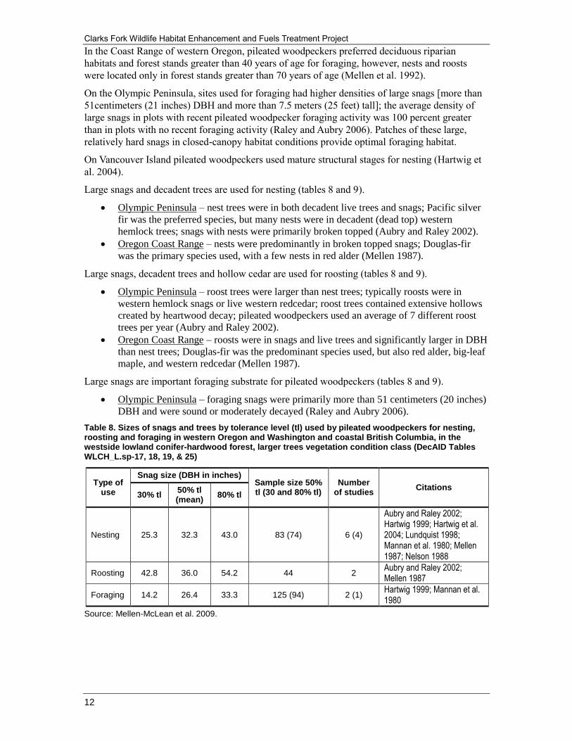
Table 8. Sizes of snags and trees by tolerance level (tl) used by pileated woodpeckers for nesting, roosting and foraging in western Oregon and Washington and coastal British Columbia, in the westside lowland conifer-hardwood forest, larger trees vegetation condition class (DecAID Tables WLCH_L.sp-17, 18, 19, & 25)
Type of use
Snag size (DBH in inches) Sample size 50% tl (30 and 80% tl)
Number of studies
Citations 30% tl
50% tl (mean)
80% tl
Nesting 25.3 32.3 43.0 83 (74) 6 (4)
Aubry and Raley 2002; Hartwig 1999; Hartwig et al. 2004; Lundquist 1998; Mannan et al. 1980; Mellen 1987; Nelson 1988
Roosting 42.8 36.0 54.2 44 2 Aubry and Raley 2002; Mellen 1987
Foraging 14.2 26.4 33.3 125 (94) 2 (1) Hartwig 1999; Mannan et al. 1980
Source: Mellen-McLean et al. 2009.

Terrestrial Wildlife Analysis Report
13
Table 9. Densities Of large snags [more than 50 centimeters (20 inches) DBH] by tolerance level (tl) at pileated woodpecker nesting, roosting, and foraging sites in the westside lowland conifer-hardwood forest, larger trees vegetation condition class (DecAID tables WLCH_ L.sp-22 and WLCH_ S.sp-22)
Type of use
Snag size (DBH in inches) Sample size 50% tl (30 and 80% tl)
Number of studies
Citations 30% tl
50% tl (mean)
80% tl
Nesting and roosting
11.7 (4.7)
17.4 (7.0)
26.0 (10.4)
169 2 Aubry and Raley 2002; Mellen 1987
Foraging 19.0 (7.6)
30.2 (12.1)
47.0 (18.8)
86 1 Raley and Aubry 2006
Source: Mellen-McLean et al. 2009.
Home Range
Table 10. Home range sizes of pileated woodpeckers by geographic area
Geographic area Home range size Citations
Western Oregon Mean = 478 hectares (1,180 acres)
Range = 267 to 1,056 hectares (660 to 2,608 acres)
Mellen (1987); Mellen et al. (1992)
Northeast Oregon
Paired birds
Mean = 407 hectares (1,005 acres)
Range = 321 to 630 hectares (793 to 1,556 acres)
Single birds
Mean = 597 hectares (1,475 acres)
Range = 200 to 1,464 hectares (494 to 3,616 acres)
Bull and Holthausen (1993)
Olympic Peninsula
Females: mean = 960 hectares (2,371 acres)
Males: mean = 894 hectares (2,208 acres)
Pairs: mean = 863 hectares (2,132 acres)
Aubry and Raley (1996)
4. Population Trend and Viability
Rogue River Land and Resource Management Plan (1990)
Habitat for the pileated woodpecker represents over 160 wildlife species which utilize mature
forest habitat. The pileated woodpecker is a primary cavity excavator and dwelling species which
uses large standing dead trees (snags) and mature/old-growth (older forest) habitat for nesting and
roosting.
Three-hundred acres of mature and old-growth timber (trees having diameters of 21 inches DBH
or greater) were considered necessary for a pair of pileated woodpeckers. Areas were located
within 5 miles of each other, center-to-center, and evenly spaced over the Forest to allow
interaction of the pairs between suitable territories. Based on the management requirements for
the Forest, 9 pileated woodpecker areas were established. The SOHAs set aside for northern
spotted owls were also thought to function as habitat for the pileated woodpecker. Therefore,
there were a total of 34 areas managed to provide habitat for pileated woodpeckers outside of
Wilderness and other withdrawn areas. It was expected that the withdrawn areas may be able to
support an additional 150 pairs (USDA Forest Service 1990a).
Under the 1990 Rogue River Forest Plan Forest-wide capability for pileated woodpeckers was
expected to decrease by 8 percent in the first two decades due to harvest of mature and old-
growth forest.

Clarks Fork Wildlife Habitat Enhancement and Fuels Treatment Project
14
Northwest Forest Plan
The selected alternative for the Northwest Forest Plan was determined to meet the NFMA
requirement to provide for a diversity of plant and animal communities (USDA Forest Service
and USDI Bureau of Land Management 1994a). The Northwest Forest Plan amended the Rogue
River Forest Plan, significantly so for spotted owls and old-growth habitat. While the Old Growth
and Spotted Owl Management Strategies (MS-15 and MS-19) were removed from the Rogue
River Forest Plan, five large mapped Late-successional Reserves (LSRs) were identified across
the Forest to provide for clusters of breeding spotted owl pairs; this LSR allocation covered
approximately 238,000 acres and the LSRs contained approximately 60,000 acres of spotted owl
habitat (Mature and Old Growth habitat greater than 40 percent canopy closure) according to
analysis using Pacific Meridian Landsat (PMR) data.
In addition, the direction in the Forest Plan directed that 100-acre core areas were to be identified
around all existing spotted owl pairs and territorial singles to provide for short-term owl
management and long-term dispersal capability for owls and other late-successional associated
species. One hundred and sixty-two 100-acre cores equaling 16,215 acres were identified outside
of LSRs for the Forest.
In 1994, according to PMR data the entire Forest had approximately 154,102 acres of suitable
habitat for spotted owls, over 94,000 acres of that were located in LSR and other reserve lands
such as Congressionally Reserved Lands (Wilderness and Wild and Scenic River), and
Administratively Withdrawn (RNA and Botanical reserves) lands with no programmed timber
harvest (table 11).
At the time the Northwest Forest Plan was adopted, the amount and spatial juxtaposition of
mature and old-growth habitat in reserve land allocations (94,000 acres) far exceeded the amount
identified previously as habitat to be managed for pileated woodpeckers. The potential habitat
capability trend for pileated woodpecker likely increased on the Forest due to adoption of the
Northwest Forest Plan.
The pileated woodpecker was one of 36 birds determined to be closely associated with late-
successional and old-growth forests, with occurrence of large snags necessary for optimal habitat
(USDA Forest Service and USDI Bureau of Land Management 1994a, page 3&4-177). A viability
assessment was completed by the Forest Ecosystem Management Assessment Team (FEMAT)
(1993). The viability outcome for the pileated woodpecker was 100 percent likelihood of
Outcome A – “Habitat is of sufficient quality, distribution, and abundance to allow the species
population to stabilize, well distributed across federal lands” (USDA Forest Service and USDI
Bureau of Land Management 1994a, page 3&4-179). This outcome determination was based on
provisions of: 1) a large system of late-successional reserves; 2) Standards and Guidelines for
Riparian Reserves; and 3) retention of green trees, snags, and coarse woody debris within the
matrix.
The USDA Forest Service has been implementing the Northwest Forest Plan and monitoring late-
successional habitat trends since 1994. The 10-year monitoring report (Haynes et al. 2006) states
“…it appears that the status and trends in abundance, diversity, and ecological functions of older
forests are generally consistent with expectations of the Plan. The total area of late-successional
and old-growth forest (older forests) has increased at a rate that is somewhat higher than
expected, and losses from wildfires are in line with what was anticipated.” As a result, projects
consistent with the Northwest Forest Plan should be expected to maintain viability of late-
successional associated species such as the pileated woodpecker.
There are two long-term Breeding Bird survey routes on the High Cascades Ranger District that
have been surveyed annually for the last 14 years. The Whiskey Springs route shows consistent
observations of up to four species of woodpeckers, including pileated woodpecker (3.33 per
mile). Over the 14 years of survey observations, pileated woodpecker populations have remained
stable.

Terrestrial Wildlife Analysis Report
15
The Prospect route, just west and slightly lower in elevation than the Whiskey Springs route,
shows consistent observations of pileated woodpecker (1.17 per mile). Pileated woodpeckers
show a stable trend. Another long-term survey route on the Forest is in the Applegate Valley.
From 1992 to 2007, the Ruch BBS route shows the pileated woodpecker trends are stable or
slightly increasing on that route.
Table 11. Rogue River National Forest pileated woodpecker high potential habitat 1994
GNN dataset Congressionally Reserved acres
LSR acres Administratively Withdrawn acres
All Forest acres
>70% Medium Mature (20+ DBH)
5,339 16,287 1,144 43,005
>70% Old Growth 11,884 27,210 1,015 63,181
40 to 70% Medium Mature 9,410 9,117 1,951 29,562
40 to 70% Old Growth 4,073 6,414 396 18,354
TOTAL NRF 30,706 59,028 4,506 154,102
5. Existing Condition (2011)
Suitable habitat for pileated woodpeckers, represented by mature and late-successional forest, on
the Forest is approximately 203,402 acres; of that, 133,163 acres (65 percent) are in reserve land
allocations with no programmed timber harvest (table 12). There are still 153 100-acre spotted
owl core areas totaling 15,300 acres identified outside of LSRs on the Forest. These core areas
also provide suitable habitat for pileated woodpecker.
Table 12. Pileated woodpecker habitat 2011
GNN dataset Congressionally Reserved acres
LSR acres Administratively Withdrawn acres
All Forest acres
NRF = >20+ DBH and >60% CC 37,909 75,893 19,361 203,402
Currently, there is far more pileated woodpecker habitat available and more habitat within reserve
land allocations for pileated woodpeckers than was planned for in the original 1990 Rogue River
Forest Plan. Suitable habitats for pileated woodpeckers on the Rogue River National Forest
continues to trend upwards due to implementation of the Northwest Forest Plan and silvicultural
prescriptions designed to maintain late-successional characteristics in nesting, roosting, and
foraging habitats for northern spotted owls.
In addition, RA-32 habitats have been excluded from harvest on the Rogue River National Forest
in recent years. Based on stable or increasing trends identified by Breeding Bird Surveys and the
trend of increasing habitats on the Rogue River National Forest, the Forest believes that viability
would be provided for across the Forest.
Pileated woodpeckers were documented in suitable and dispersal habitats within the Clarks Fork
project planning area during field reconnaissance. There are approximately 203,402 acres of
suitable habitats available to pileated woodpeckers across the Rogue River National Forest.
Approximately 133,163 acres of these habitats are within Congressionally Reserved allocations.
The 203,402 acres of pileated habitats on the Rogue River National Forest would support an
estimated 78 to 308 pairs of home ranges on the Forest (based on the ranges defined for Western
Oregon, table F2-9, for pileated woodpeckers). This is likely an extremely conservative estimate
because this estimate is based on late-successional habitats only and does not incorporate
inclusions of younger stands, such as northern spotted owl dispersal habitats, which is
documented for pileated woodpecker use.
A pileated woodpecker model was developed as part of the ILAP (Integrated Landscape
Assessment Project). The wildlife habitats module was led by Anita Morzillo of Oregon State
University’s College of Forestry (Mellen-McLean 2011). The model was developed for western
Oregon and Washington.

Clarks Fork Wildlife Habitat Enhancement and Fuels Treatment Project
16
The Wildlife Habitat Relationship Model (WHR) was developed by reviewing the literature on
pileated woodpecker habitat to determine vegetation types and structural stages used by the
woodpecker. Each combination of VDDT (Vegetation Dynamics Development Tool) State Class
and PVT (Potential Vegetation Type) was determined to be habitat or non-habitat for each VDDT
modeling zone. The model identified that approximately 20 to 40 percent of the habitat within the
Big Butte Springs Watershed is considered to be pileated woodpecker habitat.
Within the project planning area, there are nearly 5,000 acres (36 percent) of mature habitats (20
inches or greater DBH). This equates to approximately 2 percent of the Forest’s habitat base.
Based on reported home range sizes in Western Oregon (table 10), the Forest estimates that there
are between 2 to 8 pileated woodpecker pair home ranges within the project planning area.
6. Effects of Silvicultural and Fuels Treatments on Pileated Woodpecker
Direct and Indirect Effects
Underburning and fuels reduction units could reduce small woody debris. Burning prescriptions
would be designed to maintain large wood and snags that may be used as nesting/foraging
habitats for pileated woodpeckers. Since prescribed fire has the potential to consume some large
wood and snags even while conducted under prescribed conditions, there is a potential that some
of these structures would be consumed or partially consumed. Under these same conditions,
prescribed fire may create some snags through mortality of live trees. These trees would snag
habitats and eventually provide CWD on the project planning area. Prescribed fire would be used
to reduce Fire Regime Condition Class (FRCC) within the Clarks Fork project planning area to
attain the historic range of variability (HRV) to reduce the risk of stand-replacement fire in the
future. Attainment of HRV is expected to benefit pileated woodpeckers because this species
evolved and persisted under these conditions.
Cumulative Effects
The list of past, present, and reasonably foreseeable future actions was reviewed to determine
potential effects to pileated woodpeckers. Actions that would contribute to potential cumulative
effects are Big Butte Springs Timber Sales because they overlap spatially and temporally.
The Big Butte Springs Timber Sales were designed to maintain forest health and habitat diversity,
reduce risk of insect and disease infestations, reduce fuel loading and the potential effects of
wildfire, and increase the quality of riparian vegetation.
There are approximately 4,095 acres of Big Butte Springs timber sale units within the Clarks Fork
project planning area, in which 681 acres of units are not included in the Clarks Fork Project.
These stands are composed of both commercial and pre-commercial sizes trees. Three Big Butte
Springs timber sale units, totaling 158 acres of treatments, will reduce canopy closures below
60% in stands with larger trees.
Determination of Effect
Since treated stands under the Clarks Fork Project would retain the largest, oldest trees, co-
dominant trees, mid-story canopy and the majority of large snags for nesting and foraging, the
Forest expects these stands to retain the structural attributes necessary to provide for pileated
woodpecker biology and ecology. Treated stands would be interspersed with untreated stands,
some of which are the highest-quality habitats for late-successional species (i.e., owl nest patches,
100 acre cores). These stands will continue to provide nesting, roosting, and foraging sites for
pileated woodpeckers into the future.

Terrestrial Wildlife Analysis Report
17
Since the Big Butte Springs Timber Sale project could reduce canopy closure from 60 percent or
greater to approximately 40 percent on 158 acres of suitable pileated woodpecker habitats, the
cumulative effects would result in a small adverse trend of habitat by reducing canopy closure in
those stands. The effects of the project action on pileated woodpecker habitat would be
insignificant at the scale of the Forest. Therefore, the project actions for the Clarks Fork Project
are consistent with the Forest Plan, and thus continued viability of pileated woodpecker is
expected on the Rogue River portion of the Rogue River-Siskiyou National Forest.
E. American Marten (Martes americana)
1. Conservation Status
USDA Forest Service – MIS on all forests
NatureServe (http://www.natureserve.org/explorer/servlet/NatureServe)
Global – G5 – Widespread, abundant, secure
Oregon – S3S4 – Vulnerable to Apparently secure
Washington – S4 – Apparently secure
Oregon Department of Fish and Wildlife (ODFW) –
Vulnerable (Blue Mountains, Coast Range)
(http://www.dfw.state.or.us/wildlife/diversity/species/docs/SSL_by_taxon.pdf)
Harvested as a furbearer state-wide
(http://www.dfw.state.or.us/resources/hunting/small_game/regulations/docs/2010-
2012_Furbearer_Regs.pdf)
Washington Department of Fish and Wildlife (WDFW) –
Priority species, Criterion 3. Species of Recreational, Commercial, and/or Tribal
Importance: Native and non-native fish and wildlife species of recreational or
commercial importance, and recognized species used for tribal ceremonial and
subsistence purposes, whose biological or ecological characteristics make them
vulnerable to decline in Washington or that are dependent on habitats that are highly
vulnerable or are in limited availability.
(http://www.wdfw.wa.gov/conservation/phs/list/2008/2008-
sept_terrestrial_carnivores.pdf)
Harvested as a furbearer state-wide (http://wdfw.wa.gov/publications/00769/wdfw00769.pdf)
2. Distribution
The current geographic range of the American marten is temperate to arctic and spans the
continent from east to west, including offshore islands. The main portion of the distribution
comprises the boreal and taiga zones of Canada and Alaska. South of this area, the distribution
becomes insularized, with fingers and islands following western mountain ranges southward
(Buskirk and Ruggiero 1994). In Region 6, marten are found in the montane forests of the
southern Oregon Coast Range, Siskiyou Mountains, Cascade Mountains, Blue Mountains,
Olympic Peninsula, and northeast Washington (Marcot et al. 2003). Marten are absent from the
northern Oregon and southern Washington coastal mountains, and are rare in the Olympic
Peninsula (Zielinski et al. 2001). In the southern Oregon Cascades, marten are typically found at
elevations 4,000 feet or greater. Forest carnivore surveys on the Rogue River National Forest
have documented that martens are well-distributed across the High Cascades Ranger District at
elevations 4000 feet or greater. Approximately the eastern 1/5 of the Clarks Fork project planning
area provides habitat for marten.

Clarks Fork Wildlife Habitat Enhancement and Fuels Treatment Project
18
On March 3 2012, a single American Marten (Martes americana) was captured during the course
of a fisher trapping effort ongoing in the Bear Creek watershed. The animal was captured
approximately three miles up Tolman Creek Road at approximately 3,600 feet in elevation 40
meters from the road in a riparian area where several fisher had previously been captured. Due to
its relatively small size, the animal was not tranquilized and processed as a fisher would have
been. Consequently, it is not known what gender the animal was; however due the size and
behavior of the animal, it is suspected to be a male. Photographs of the animal were taken, hair
samples were collected for genetic analysis, and the animal was released.
In July of 2012, another marten was captured by Oregon Department of Fish and Wildlife
personnel on lower Tolman Creek road; this animal was released without any genetic material
being collected.
This is the first confirmed detection of marten in the eastern Siskiyou Mountains that the Forest
has any record of. There are very few anecdotal and unconfirmed records from this area and there
are only three historic records in National USDA Forest Service NRIS database of marten in the
eastern Klamath (upper Sucker Creek in the Illinois and two in the Little Applegate) but these
were sightings not documented by photos, body, hair, or tracks.
3. Habitat Use
Hargis et al. (1999) stated that in North America, American martens are closely associated with
mature conifer stands with complete canopy closure, and small (less than 100 meters), limited,
and interspersed openings that are used as forage areas. Thomas et al. (1993) and Forest
Ecosystem Management Assessment Team [FEMAT (1993)] list marten as “closely associated”
with late-successional and old-growth forests and the old-growth elements of large snags and
down logs. The reports also indicate a strong relationship between marten and riparian areas.
Buskirk (1992) reported that knowledge is almost completely lacking regarding behavioral or
population responses of martens to such landscape attributes as stand size and shape, area of stand
interiors, amount of edge, stand insularity, use of corridors, and connectivity.
Marten use a variety of structures for rest and den sites. Resting and denning sites offer protection
from predation and thermal stress; thus, availability of quality denning sites likely increases the
rates of survival and fecundity in marten (Raphael and Jones 1997).
In the Cascades, marten select sites with higher canopy closure during snow periods than during
snow-free periods (Raphael and Jones 1997). In Washington canopy cover at rest sites averaged
75 percent in snow periods and 67 percent in snow-free periods. In Oregon, canopy closure at rest
sites in lodgepole pine dominated stands averaged 36 percent in snow periods and 27 percent in
snow-free periods.
In the Washington Cascades, Jones and Raphael (1991) found martens resting in live trees (42
percent), snags (23 percent), and slash piles (11 percent). Large diameter trees were used more
often than smaller trees with an average DBH of live trees of 100 centimeters (39 inches) and 81
centimeters (32 inches) for snags. They also located 5 natal dens in large diameter live trees or
snags near water. The predominant species of den tree was western hemlock.

Terrestrial Wildlife Analysis Report
19
Table 13. Structures (percent) used as resting and denning sites by American marten in the Washington Cascade Mountains
Structure Resting sites Den sites Comments
Live tree 46 54
Snag 21 31
Logs 8 4
Slash pile 9 8 More important when snow was present
Rock 4 4
Subnivean 3 0
Other 8 0
Sample size 391 26
Source: From table 1 in Raphael and Jones (1997), comments added.
Raphael and Jones (1997) found that down wood and slash piles were important resting and
denning structures in the eastern Cascades of central Oregon. Forests in their project area were
dominated by lodgepole pine.
Table 14. Structures (percent) used as resting and denning sites by American marten in the lodgepole pine dominated sites in the Oregon Cascade Mountains
Structure Resting sites Den sites Comments
Live tree 7 19
Snag 9 16
Logs 21 32
Slash pile 43 29
Rock 1 0
Subnivean 15 0 During winter, subnivean use for rest sites increased to 76 percent
Other 4 4
Sample size 261 31
Source: From table 1 in Raphael and Jones (1997), comments added.
In the Blue Mountains of northeastern Oregon, Bull et al. (2005) found density of potential rest
sites was significantly higher (P<0.01) in marten home ranges than unoccupied areas, with
average densities of structures (number/hectare) of 2.7 versus 1.0 trees with cavities, 2.7 versus
1.3 hollow logs, and 13.6 versus 7.3 trees with platforms.
Table 15. Structures (percent) used as resting and denning sites by American martens in northeastern Oregon
Structure Resting
sites Den sites
Post-natal dens
Comments
Platforms 43 percent Platforms were in usually in brooms caused by rust fungi or dwarf mistletoes.
Cavities 23 percent 73 percent 21 percent Cavities were mostly in grand fir and western larch with hollows created by Indian paint fungus, brown trunk rot and red ring rot.
Subnivean 23 percent
Martens spent most of their time in subnivean rest sites during winter. These sites were usually associated with accumulation of logs or slash piles, single large logs, or hollow logs.
Hollow log 6 percent 58 percent Majority of hollow logs were grand fir or and western larch.
Underground 3 percent 27 percent 10 percent Tunnels, clusters of rocks or talus, and root wads.
Slash piles 1 percent 10 percent
Sample size 1,184 11 19
Source: From table 1 in Bull and Heater (2000), comments added.

Clarks Fork Wildlife Habitat Enhancement and Fuels Treatment Project
20
In northwestern California, Slauson and Zielinski (2009) found marten rest sites primarily in old-
growth stands, which were used disproportionately to their availability. In serpentine habitats,
rock piles and shrub clumps made up 42 percent of rest sites.
Table 16. Structures (percent) used as resting sites by American martens in northwestern California (Klamath-Siskiyou and Northern California Coastal Forest Ecoregions)
Structure Resting
sites Comments
Snag 37 percent Primarily conifer, DBH range 41 to 140 centimeters (16 to 55 inches)
Log 23 percent All conifer, diameter range 44 to 122 centimeters (17 to 48 inches)
Live tree 17 percent Conifer and hardwood, DBH range 57 to 165 centimeters (22 to 64 inches)
Slash pile 10 percent Used by a single male; composed of some large (>60 centimeters (32 inches) diameter) logs
Rock pile 8 percent Used more commonly in serpentine habitats
Shrub clump 6 percent
Sample size 56
Source: From table 1 in Bull and Heater (2000), comments added.
Food Habits
The diet of American martens is highly diverse. In the western United States in winter, most prey
are captured beneath the snow surface, but squirrels may be caught in trees (Buskirk and
Ruggiero 1994). Snags, downfall, and large woody material provide cover, denning sites, and
access points to forage areas below the snow (subnivean habitat). Zielinski and Duncan (2004)
found that in the southern Sierra Nevada, marten and fisher diets were more diverse than
previously reported for North America. Of the major taxonomic groups, mammals were most
common followed by insects and plants (mostly fruits).
4. Home Range
Marten home ranges are large by mammalian standards, 3 to 4 times larger than predicted for a 1
kilogram terrestrial carnivoran, and about 30 times that predicted for an herbivorous mammal of
that size (Buskirk and Ruggiero 1994). Home ranges for marten in Oregon and Washington have
been reported for two studies (table 17). Home range size is highly variable and is likely
dependent on habitat quality as well as sex, and geographic area. Kirk and Zielinski (2009)
reported that their study in the California Cascades was consistent with previous studies which
concluded that more habitat, larger patch sizes, and larger areas of interior forest were important
predictors of marten occurrence.
Table 17. Reported home range sizes of American marten in the Pacific Northwest
Geographic area
Home range size Citations
Washington Cascades
Males: average 1,745 hectares (4,328 acres) Females: average 1,032 hectares (2,559 acres)
Jones and Raphael (1991)
Blue Mountains
Males: average 2,717 hectares (6,710 acres), range 1,237 to 4,750 hectares (3,055 to 11,732 acres) Females: average 1,416 hectares (3,498 acres), range 393 to 2,738 hectares (971 to 6,763 acres) HR Overlap: female-female 3 percent; male-male 13 percent; female-male 64 percent; male-female 28 percent
Jones and Raphael (1991)
The largest tracts of high-quality habitats for marten in the Clarks Fork project planning area are
located the eastern portion of the project planning area. Older stands in the eastern portion of the
project planning area fall within the elevation range for marten and likely provide resting/denning
habitats. These stands are connected to forested land, which provides connectivity east to
unmanaged stands in the Sky Lakes Wilderness.

Terrestrial Wildlife Analysis Report
21
High-quality habitats along the major drainages are also providing resting/denning habitats.
Nearly all of the suitable marten habitat lies to the east of the Clarks Fork Planning Area. Habitats
west of the planning area are too low in elevation to be suitable for marten. Nearly all of the
project planning area is forested and younger stands that are above 4,000 feet elevation are likely
providing habitat for foraging martens.
5. Population Trend and Viability
Rogue River Land and Resource Management Plan (1990)
The American marten represents those species utilizing mature conifer forests above 4,000 feet in
elevation in the South Cascades. A maximum spacing of habitat areas (to allow interaction with
adjacent animals) was considered to be 3 miles (USDA Forest Service 1990a). Based on
distributional requirements, the management recommendation of managing habitat to maintain
viable populations of wildlife was thought to be met with the establishment of 29 (minimum 160
acre) marten areas above 4,000 feet in elevation. A predictive model based upon habitat seral
stages indicated a capability of supporting over 250 marten on the Forest (USDA Forest Service
1990a). This was based on the combined habitat networks for spotted owl, pileated woodpecker,
and pine marten, along with the intertwined riparian, minimum management, and reserved areas,
which served as an interlocking habitat system for all species utilizing older forest and mature
habitat (USDA Forest Service 1990a). Marten populations and habitat was expected decrease by 1
percent in the first two decades due to timber harvest.
Northwest Forest Plan
The Northwest Forest Plan amended the Rogue River Forest Plan in 1994, significantly so for
spotted owls and old growth habitat. While the Old Growth and Spotted Owl Management
Strategies (MS-15 and MS-19) were removed from the Forest Plan, 5 large mapped Late-
successional Reserves (LSRs) were identified across the Forest to provide for clusters of breeding
spotted owl pairs; this LSR allocation totaled approximately 238,000 acres and the LSRs
contained approximately 60,000 acres of spotted owl habitat (Mature and Old Growth habitat
greater than 40 percent canopy closure) according to analysis using Pacific Meridian Landsat
(PMR) data. In addition, the direction in the Forest Plan directed that 100-acre core areas were to
be identified around all existing spotted owl pairs and territorial singles to provide for short-term
owl management and long-term dispersal capability for owls and other late-successional
associated species.
One hundred and fifty three 100-acre cores totaling 15,300 acres were identified outside of LSRs
for the Forest. In 1994, according to PMR data the entire Forest had approximately 154,102 acres
of suitable habitat for spotted owls, over 94,000 acres of that were located in LSR and other
reserve lands such as Congressionally Reserved lands (Wilderness and Wild and Scenic River),
and Administratively Withdrawn (RNA, Botanical reserves) lands with no programmed timber
harvest. At the time of the Northwest Forest Plan adoption, the amount and spatial juxtaposition
of mature and old growth habitat on the Prospect and Butte Falls Ranger Districts above 4,000
feet in elevation (41,759 acres) far exceeded the amount identified previously as habitat to be
managed for marten (14,880 acres) (table 18).
In addition, American martens are thought to be closely associated with mature conifer stands
with complete canopy closure, and small (less than 100 meters), limited, and interspersed
openings that are used as forage areas.
However, during helicopter surveys conducted for wolverine in the Southern Oregon Cascades,
marten tracks have been detected in openings where they were interspersed among timbered
habitats and above timberline in the Mt. Thielsen and Sky Lakes Wilderness Areas.

Clarks Fork Wildlife Habitat Enhancement and Fuels Treatment Project
22
On the High Cascades Ranger District, marten tracks have also been detected during snowmobile
tracking surveys in openings (meadows and regeneration harvest units) where they were
interspersed with timbered stands along the western edge of both the Sky Lakes Wilderness and
Crater Lake National Park (personal observation).
Canopy closures reported by Raphael and Jones (1997) varied widely between studies in
Washington and east of the Cascade crest in Oregon. This indicates that marten probably use the
largest structures and highest canopy closures that are available in the habitats that can support all
other life-history requirements. Consequently the Forest believes that while mature and old
growth habitat is important denning habitat for marten, most other vegetation types, canopies, and
sizes are suitable for foraging by marten. At the time the Rogue River Forest Plan was written, it
was estimated that the marten had a home range of about 450 acres. A minimum contiguous area
of 160 acres (with a crown closure 50 percent or greater in mature and old-growth seral stage was
considered necessary for denning and resting habitat for marten. The potential habitat capability
trend for marten likely increased on the Forest due the adoption of the Northwest Forest Plan.
The selected alternative for the Northwest Forest Plan was determined to meet the NFMA
requirement to provide for a diversity of plant and animal communities (USDA Forest Service
and USDI Bureau of Land Management 1994a). The American marten was one of 15 mammals
determined to be closely associated with late-successional and old-growth forests (USDA Forest
Service and USDI Bureau of Land Management 1994a, page 3&4-182). A viability assessment
was completed by the Forest Ecosystem Management Assessment Team (1993). The viability
outcome for the American marten was:
67 percent likelihood of Outcome A – “Habitat is of sufficient quality, distribution, and
abundance to allow the species population to stabilize, well distributed across federal
lands”
27 percent likelihood of Outcome B – “Habitat
3 percent likelihood of Outcome C
3 percent likelihood of Outcome D
Additional mitigation measures were implemented to increase the likelihood of Outcome A for
the preferred alternative to be similar to 83 percent likelihood of Option 1 (most restrictive
alternative). The mitigation measures were to increase the amount of “coarse woody debris” in
the Matrix and to implement wider riparian reserves. Implementation of these mitigation
measures “would be sufficient to support a stable, well-distributed population throughout most of
its range. However, marten populations are low in the Olympic Peninsula and the Oregon Coast
Range, and there is some chance that populations may not recover in those provinces” (USDA
Forest Service and USDI Bureau of Land Management 1994a, page J2-473).
The Forest Service has been implementing the Northwest Forest Plan and monitoring late-
successional habitat trends since 1994. The 10-year monitoring report (Haynes et al. 2006) states
“…it appears that the status and trends in abundance, diversity, and ecological functions of older
forests are generally consistent with expectations of the Plan. The total area of late-successional
and old-growth forest (older forests) has increased at a rate that is somewhat higher than
expected, and losses from wildfires are in line with what was anticipated.”
As a result, projects consistent with the Northwest Forest Plan should be expected to maintain
viability of late-successional associated species such as the marten. Projects designed to enhance
late-successional forest should result in a call of improving habitat conditions.
Table 18. Marten potential habitat 1994
PMR dataset Forage Denning
Marten habitat 176,950 acres 41,759 acres

Terrestrial Wildlife Analysis Report
23
6. Existing Condition (2011)
At the current time according to the 2006 Gradient Nearest Neighbor (GNN) dataset
(http://www.fsl.orst.edu/lemma/main.php?project=imap&id=home), suitable habitat for marten
(represented by mature and late-successional forest), on the High Cascades Ranger District is
currently approximately 116,883 acres; of that, 90,923 acres (78 percent) are in reserve land
allocations with no programmed timber harvest (table 19). In addition, there are still ninety-five
100-acre spotted owl core areas totaling 9,500 acres identified outside of LSRs on the Cascade
side of the Forest. These core areas also provide suitable habitat for marten.
Table 19. Marten potential habitat on the High Cascades Ranger District 2012
GNN dataset Forage Denning
Marten habitat 168,069 acres 116,883 acres
Given the recent capture of a marten in the Siskiyou Mountains, a new analysis has been
conducted for potential marten habitat above 3,500 feet in elevation on the Siskiyou Mountains
Ranger District. This shows that there are 56,581 acres of potential denning and 84,121 acres of
forage habitat on the Siskiyou Mountains Ranger District (table 20). There also approximately
forty-four 100-acre owl cores providing habitat for marten on the Siskiyou Mountains Ranger
District. These core areas also provide for suitable habitat for marten.
Table 20. Marten potential habitat on the Siskiyou Mountains Ranger District 2012
GNN dataset Forage Denning
Marten habitat 84,121 acres 56,581 acres
Currently there is far more marten denning and resting habitat available and more habitat within
reserve land allocations for marten than was planned for in the original Rogue River Forest Plan.
It is very likely that the Forest is providing a sufficient amount of habitat and in a spatial
juxtaposition for far more marten than was originally thought to be needed across the Forest to
provide for long-term viability for this species. The Forest believes that the population trend for
this species is likely stable and that population viability would be provided for within reserve
lands and by maintaining late-successional habitats in Matrix lands on the Forest.
American marten occupy elevations generally 4,000 feet or greater in the eastern portion of the
Clarks Fork project planning area. The project planning area is connected to forest habitat that
provides connectivity to large expanses of high-quality marten habitats within Sky Lakes
Wilderness areas to the east of the planning area.
Based on the GNN dataset, there are approximately 168,069 acres of foraging/dispersal habitats,
and 116,883 acres of denning/resting habitats available for marten on the High Cascades Ranger
District. Approximately 90,923 acres of these habitats are Congressionally Reserved. There are
approximately 2,642 acres that are 4,000 feet elevation or greater within the project planning
area. Of these, there are 1,520 acres of foraging/dispersal habitats (11 percent of the project
planning area), and 890 acres (6 percent of the project planning area) of denning/resting habitats.
This represents less than 1 percent of foraging/dispersal habitats, and less than 1 percent of
denning/resting habitat on the Rogue River National Forest.
An American marten model was developed as part of the ILAP (Integrated Landscape Assessment
Project). The Wildlife Habitats module was led by Anita Morzillo of Oregon State University’s
College of Forestry (Mellen-McLean 2011). The model was developed for western Oregon and
Washington.

Clarks Fork Wildlife Habitat Enhancement and Fuels Treatment Project
24
The Wildlife Habitat Relationship Model (WHR) was developed by reviewing the literature on
American marten habitat to determine vegetation types and structural stages used by martens.
Each combination of VDDT (Vegetation Dynamics Development Tool) State Class and PVT
(Potential Vegetation Type) was determined to be habitat or non-habitat for each VDDT modeling
zone. The model identified that approximately 20 to 40 percent of the habitat within the Big Butte
Springs Watershed is considered to be American marten habitat.
The 425,654 acres of marten habitat on the Rogue River National Forest would support an
estimated 63 to 98 home ranges for males, and 122 to 166 home ranges for females if there was
no overlap within sexes and complete overlap between sexes based on the mean minimum and
maximum home range sizes reported for the Washington Cascades and Blue Mountains of
Oregon in table 17. This is a conservative estimate considering there is overlap both within and
between sexes. Within the Clarks Fork project planning area, there are 2,410 acres of marten
habitats, less than 1 percent of the Forest’s habitat base. The Forest estimates that there is
approximately 1 female and 1 male home ranges within the project planning area.
7. Effects of Fuels Treatments on American Marten
Direct and Indirect Effects
The Clarks Fork units will treat 429 acres of marten habitat. Of these units, there are
approximately 22 acres of denning/resting habitat and 407 acres of foraging habitat. No overstory
removal is planned for fuels treatment; therefore, habitat will be maintained.
Underburning treatments and fuels reduction units could reduce small woody debris. Burning
prescriptions would be designed to maintain large wood that may be used as subnivean access
points and foraging habitats for marten. Since prescribed fire has the potential to consume some
large wood and snags even while conducted under prescribed conditions, there is a potential that
some of these structures would be consumed or partially consumed. Under these same conditions,
prescribed fire may create some snags through mortality of live trees. These trees would
eventually provide CWD on the project planning area. Prescribed fire would be used to reduce
Fire Regime Condition Class (FRCC) within the Clarks Fork project planning area to attain the
HRV and reduce the risk of stand-replacement fire in the future. Attainment of HRV is expected
to benefit American marten because this species evolved and persisted under these conditions.
Cumulative Effects
The list of past, present, and reasonably foreseeable future actions was reviewed to determine
potential effects to American marten. Actions that would contribute to potential cumulative
effects are Big Butte Springs Timber Sales because they overlap spatially and temporally.
The Big Butte Springs Timber Sales were designed to maintain forest health and habitat diversity,
reduce risk of insect and disease infestations, reduce fuel loading and the potential effects of
wildfire, and increase the quality of riparian vegetation.
There are approximately 570 acres of Big Butte Springs timber sale units within marten habitat in
the Clarks Fork planning area. Of these units, 46 acres denning/resting habitat and 524 acres are
foraging habitat. Approximately 141 acres of Big Butte Springs timber sale units are within
marten habitat and do not have actions related to the Clarks Fork Project. These stands are
composed of both commercial and pre-commercial sizes trees.
Since the Big Butte Springs Timber Sale units will not remove overstory within marten habitat,
these treatments are not expected to cumulatively increase risks to American marten.

Terrestrial Wildlife Analysis Report
25
Determination of Effect
Since treated stands would retain the largest, oldest trees for denning and resting, and maintain
overstory canopy closure, the Forest expects these stands to retain the structural attributes
necessary to provide for American marten biology and ecology. Treated stands would be
interspersed with untreated stands that are the highest-quality habitats for late-successional
species, including American marten, available on the Clarks Fork project planning area.
Because this project impacts less than 1 percent of suitable habitat across the Forest, the overall
direct, indirect, and cumulative effects would result in a small adverse trend of habitat by
reducing canopy closure in thinned stands. The effects of the project on American marten habitat
would be insignificant at the scale of the Forest. Therefore the Clarks Fork Project is consistent
with the Forest Plan, and thus continued viability of American marten is expected on the Rogue
River portion of the Rogue River-Siskiyou National Forest.
F. Primary Cavity Nesters
Primary cavity nesters include downy woodpecker (Picoides pubeseus), hairy woodpecker
(Picoides villosus), and northern flicker (Colaptes auratus).
Table 21. Conservation status of cavity-nesting MIS
Species USFS
sensitive
NatureServe ranks1 USFWS Birds of
Conservation Concern2
ODFW3 WDFW
4
Global OR WA
Downy woodpecker G5 S4 S4S5
Hairy woodpecker G5 S4 S5
Northern flicker G5 S5 S5 1 NatureServe Ranks: (NatureServe 2010)
G5 or S5 – Widespread, abundant, secure
G4 or S4 – Apparently secure
G3 or S3 – Vulnerable
G2 or S2 – Imperiled 2 Species of Concern in any BCR (Bird Conservation Region) Listed (USFWS 2008) 3 Oregon Department of Fish and Wildlife Sensitive Species (http://www.dfw.state.or.us/wildlife/diversity/species/docs/SSL_by_taxon.pdf) 4 Washington Department of Wildlife (http://www.wdfw.wa.gov/conservation/phs/list/2008/2008-sept_woodpeckers.pdf)
2. Distribution
Table 22. General distribution and distribution in Oregon and Washington for MIS1
Species General distribution Oregon and Washington distribution
Downy woodpecker
Widespread permanent resident from Alaska across Canada, south to southern California across to the Gulf coast to south Florida
Oregon and Washington: Across both states in appropriate habitats at low to moderate elevations
Hairy woodpecker
Widespread permanent resident from Alaska across Canada, south to Baja California across to the Gulf coast to south Florida, the Bahamas and west Panama
Oregon and Washington: Across both states in appropriate habitats at low to moderate elevations
Northern flicker
Breeds from southeast Alaska, east to the west edge of the Great Plains, south to Mexico
Oregon and Washington: Common resident across both states
1 Marshall et al (2003); Wahl et al. (2005).

Clarks Fork Wildlife Habitat Enhancement and Fuels Treatment Project
26
3. Habitat Use
Downy woodpecker
This species is found mostly at low to moderate elevation in deciduous and mixed deciduous-
coniferous forests, and less often in coniferous forests (Marshall et al. 2003). All but one of
several nest reports from Oregon were located in dead trees. A preference is shown for decayed
wood for nesting, though sound wood is also utilized (Marshall et al. 2003). Downy woodpeckers
were detected during surveys within the Clarks Fork project planning area.
Hairy woodpecker
This species is resident in forests throughout Oregon, with the exception of juniper. It is common
throughout most of range, but uncommon to fairly common along the coast and in western
interior valleys. Found primarily in mixed-conifer and ponderosa pine forests, as well as adjacent
deciduous stands, especially during the breeding season (Marshall et al. 2003). Hairy
woodpeckers were documented in several seral stages within the Clarks Fork project planning
area.
Northern flicker
Northern flickers are a common resident throughout Oregon (Marshall et al. 2003). Northern
flickers may be encountered in almost any terrestrial habitat, but are generally most abundant in
open forests and forest edges adjacent to open country. They typically avoid dense forest
(Marshall et al. 2003). Most nests in forested areas are in older open forests, along older forest
edges, and in larger-diameter remnant snags (Marshall et al. 2003). Northern flickers were
documented in several seral stages within the project planning area (USDA Forest Service 2009).

Terrestrial Wildlife Analysis Report
27
Table 23. General habitat associations of snag associated MIS
Species Habitat description Citations
Downy woodpecker
General: Deciduous riparian woodlands and lowland deciduous forest (alder, cottonwood, willow, aspen, and oaks). Also found in urban parks and orchards. Low and mid-elevations. Nest primarily in dead trees.
General: Marshall et al. (2003), Wahl et al. (2005)
Hairy woodpecker
General: Dry and wet coniferous forests at low to mid-elevations. Also use deciduous forest and riparian areas, especially if adjacent to coniferous forest. Use all ages of forest stands, though some authors report preference for older stands for nesting. Nest primarily in moderately decayed snags.
Occur in higher densities in mature and old-growth stands on the west side of the Cascades.
Post-fire: These woodpeckers reach their highest densities in un-salvaged, recent (1 to 5 years) post-fire habitat with moderate to high densities of snags. Older burns do not support the high levels of wood-boring beetles that attract them to the recent burns.
Nest densities were 2.5 times lower in partially salvaged burns than in unsalvaged burns; nest survival was significantly reduced in partially salvaged burns
Habitat models: Idaho – post-fire habitats – nest sites – positive association with increasing patch area, pre-fire crown closure >40 percent, high snag densities, and larger (~15 inches DBH) than available snags, and unsalvaged areas
General: Marshall et al. (2003), Wahl et al. (2005)
Huff and Raley (2001)
Post-Fire: Cahall (2007), Cahall and Hayes (2008), Haggard and Gaines (2001), Kreisel and Stein (1999), Saab et al. (2007)
Saab et al. (2009)
Habitat models: Russell et al. (2007), Saab et al. (2009)
Northern flicker
General: Habitat generalists, though most abundant in open forests or forest edges. Use coniferous and deciduous forest, riparian woodlands, and urban areas. Nests are in large snags.
Post-fire: NOFL are most abundant in areas with medium snag density.
NOFL densities significantly higher in unsalvaged areas and 5 or more years post-fire
Habitat models: Idaho – post-fire habitats – nest sites – positive association with increasing patch area, increasing snag DBH (~20 inches DBH)
General: Marshall et al. (2003), Wahl et al. (2005)
Post-fire: Haggard and Gaines (2001)
Saab et al. (2007)
Habitat models: Saab et al. (2009), Russell et al. (2007)
Table 24. Snag characteristics used by MIS cavity nesting species in westside-lowland conifer-hardwood forests
Species / group Snag size (inches) for 30, 50, and
80 percent tolerance levels (tl) Snag decay Primary snag species
Downy woodpecker Red alder
Hairy woodpecker Nesting: 19.6, 29.0, 41.6 Foraging: 50 percent tl = 24.2
Moderate to hard Douglas fir, western hemlock
Northern flicker Nesting: 22.1, 30.3, 42.3 Foraging: 50 percent tl = 37.1
Soft to moderate Douglas-fir, western hemlock

Clarks Fork Wildlife Habitat Enhancement and Fuels Treatment Project
28
Table 25. Snag densities surrounding nest and/or roost sites in southwest Oregon mixed conifer-hardwood forests (no data for green forests)
Species
Snag density / acre for 30, 50, and 80 percent tolerance levels (tl)
Green forests Recent post-fire
≥9 inches DBH ≥21 inches DBH ≥9 inches DBH ≥21 inches DBH
Downy woodpecker 50% tl = 97.5 50% tl = 26.7
Hairy woodpecker 58.0, 85.8, 125.6 8.5, 19.6, 35.4
Northern flicker 67.6, 94.7, 132.9 7.6, 20.2, 37.8
Home Range
Table 26. Home range size and densities for cavity nesting MIS
Species Home range size Density estimates Citations
Downy woodpecker 5 to 17 acres
5 to 9 acres
Johnson and O’Neil (2001), Marshall et al. (2003)
Hairy woodpecker
Up to 25 acres
Home range – 22 to 37 acres, territories – 6 to 9 acres
Johnson and O’Neil (2001), Marshall et al. (2003)
Northern flicker Home range – 62 acres Territories – 17.5 acres
Densities – up to 13 birds / 100 acres in SW Oregon mixed conifer forest
Marshall et al. (2003), Elchuk and Wiebe (2003)
4. Population Trend and Viability
Woodpecker Surveys and Trends on the Forest
According to the Breeding Bird Survey (http://www.mbr-pwrc.usgs.gov/bbs/bbs.html),
approximately 57 percent of all cavity nesting birds observed encountered on more than 14
survey routes, including woodpeckers of all species, across the western United States has a
positive population trend, including the black-backed, pileated, and white-headed woodpeckers.
Eighteen percent of this group has a significant negative trend, including some of the sapsuckers
and the flicker. In Oregon, the black-backed, sapsuckers species, and downy woodpeckers all
show a declining trend, while the pileated woodpeckers show a slight increasing trend.
There are two long-term Breeding Bird survey routes on the High Cascades Ranger District that
have been surveyed annually for the last fourteen years. The Whiskey Springs route shows
consistent observations of up to 4 species of woodpeckers, including hairy woodpeckers (2.67 per
mile), pileated woodpeckers (3.33 per mile), and flickers (5.25 per mile). Over the 14 years of
survey observation, all 4 species have remained stable.
The Prospect route, just west and slightly lower in elevation than the Whiskey Springs route,
shows consistent observations of up to 6 species of woodpeckers, including downy woodpeckers
(0.75 per mile) Hairy woodpeckers (0.58 per mile), pileated woodpeckers (1.17 per mile), and
flickers (7.50 per mile). Four species show a slight negative trend (sapsucker, downy, hairy, and
acorn), one species shows a stable trend (pileated), and the flicker is on an increasing trend.
Another long-term survey route on the Forest is in the Applegate Valley. From 1992 to 2007, the
Ruch BBS route shows the pileated woodpecker trends are stable or slightly increasing on that
route. Hairy and flicker trends on this route appear to be stable while downy woodpeckers were
only seen twice, thus no trend is available for this species.

Terrestrial Wildlife Analysis Report
29
Rogue River Land and Resource Management Plan (1990)
Primary cavity excavators, as management indicators, represent animals which require dead and
defective woody material for nesting, roosting, and foraging. In the 1990 Rogue River Forest
Plan, they consist of the following woodpeckers: downy woodpecker, hairy woodpecker, and
northern flicker.
At the time the Forest Plan was signed, the population trend was estimated to be going down due
to the loss of snag habitat through timber harvest, salvage, and firewood cutting activities. While
wildland fires did produce snag habitats, it was Forest policy to not let fires burn to a large extent.
The viable population to preserve the gene pool was undetermined at the time. The habitat
characteristics thought to be needed to maintain primary cavity excavators at 20 percent of their
potential population (generally considered to be the minimum viable level in the 1990 Forest
Plan) was considered to be 45 snags per 100 acres. Habitat to maintain viable population levels
where the species have an opportunity to interact within their environment was considered to be
135 snags per 100 acres, ranging in size from 11 inches DBH to 25+ inches DBH, which equates
to 40 percent of their potential population level. A population model based upon these parameters
predicted an existing population of more than 60,000 other woodpeckers on the National Forest.
It was estimated that all management areas with no programmed timber harvest would provide
100 percent capability in snag habitat for cavity nesters. All other land management allocations
would be managed at the 40 percent snag capability level across the Forest.
In 1990, cavity excavator populations were based on mixes of forest habitat types. It was
projected that populations would remain relatively constant through the fourth decade (possibly
rising 3 to 5 percent the first and second decades), and then would increase to 110 percent of
existing capability in the fifth decade. Other woodpecker production capability would level out at
about 116 percent of current levels through the tenth decade. Habitat capability, as measured by
snag habitat management levels, was likely to be about 67 percent of habitat potential by the end
of the fifth or sixth decade and would remain at about that level. It was estimated that viable
populations of primary cavity nesters would be maintained through time.
Northwest Forest Plan
Northwest Forest Plan amended the Rogue River Forest Plan in 1994. While the Old Growth and
Spotted Owl Management Strategies (MS-15 and MS-19) were removed from the Forest Plan,
five large mapped Late-successional Reserves (LSRs) were identified across the Forest to provide
for clusters of breeding spotted owl pairs; this LSR allocation covering approximately 238,000
acres and the LSRs contained approximately 60,000 acres of spotted owl habitat (Mature and Old
Growth habitat 40 percent or more canopy closure) according to analysis using Pacific Meridian
Landsat (PMR) data. In addition, the direction in the Forest Plan directed that 100-acre core areas
were to be identified around all existing spotted owl pairs and territorial singles to provide for
short-term owl management and long-term dispersal capability for owls and other late-
successional associated species. One hundred and fifty three 100-acre cores totaling 15,300 acres
were identified outside of LSRs for the Forest that every likely continue to provide habitat for
primary cavity nesters. In 1994, according to PMR data ,the entire Forest had approximately
154,102 acres of mature and old growth habitats, over 94,000 acres of that were located in LSR
and other reserve lands such as Congressionally Reserved lands (Wilderness and Wild and Scenic
River), and Administratively Withdrawn (RNA and Botanical reserves) lands with no
programmed timber harvest (table 27). This unmanaged habitat was likely providing very good
snag levels for primary cavity nesters in addition to other areas with programmed timber harvest
where the Forest was required to maintain snags across the landscape per the Rogue River Forest
Plan. The potential habitat capability trend for primary cavity nesters likely increased on the
Forest due the adoption of additional lands identified for late successional habitat retention under
the Northwest Forest Plan as well as Forest Plan and newer requirements for snag retention.

Clarks Fork Wildlife Habitat Enhancement and Fuels Treatment Project
30
In the years since the Rogue River Forest Plan was signed, it has become clear that managing for
cavity nesters based on the snag/population capability model is not supported by new science.
Consequently, the Forest has prescribed snag and down wood levels for all vegetation
management activities based on local plant series and long-term ecoplot data that has been
collected on unmanaged stands across southwestern Oregon series (Hochholter 2010). These
levels vary by plant association, position on the landscape, and are specific to size and number of
snags needed to provide what the Forest believes to be sufficient levels of snag habitat for cavity
nesters and other snag dependent wildlife across the landscape. The Forest believes that this
method of snag management is more credible that what was recommended for cavity nesters in
the original Forest Plan.
Table 27. Primary cavity nester high potential habitat 1994
PMR dataset Congressionally Reserved acres
LSR acres
Administratively Withdrawn acres
All Forest acres
>70 percent Medium Mature (20+ DBH) 5,339 16,287 1,144 43,005
>70 percent Old Growth (32+ DBH 11,884 27,210 1,015 63,181
40 to 70 percent Medium Mature 9,410 9,117 1,951 29,562
40 to 70 percent Old Growth 4,073 6,414 396 18,354
Total NRF 30,706 59,028 4,506 154,102
The selected alternative for the Northwest Forest Plan was determined to meet the NFMA
requirement to provide for a diversity of plant and animal communities (USDA Forest Service
and USDI Bureau of Land Management 1994a). Ten cavity-nesting MIS were determined to be
closely associated with late-successional and old-growth forests, with occurrence of large snags
necessary for optimal habitat (USDA Forest Service and USDI Bureau of Land Management
1994a, page 3&4-177). A viability assessment was completed by the Scientific Analysis Team
(SAT) (Thomas et al. 1993). The viability outcome for all but the black-backed woodpecker was
100 percent likelihood of Outcome A – “Habitat is of sufficient quality, distribution, and
abundance to allow the species population to stabilize, well distributed across federal lands”
(USDA Forest Service and USDI Bureau of Land Management 1994a). This outcome
determination was based on provisions of: 1) a large system of late-successional reserves; 2)
Standards and Guidelines for Riparian Reserves; and 3) retention of green trees, snags, and coarse
woody debris within the Matrix.
Table 28. Outcome likelihoods for the preferred alternative under the Northwest Forest Plan
Species Outcome likelihood
A B C D
Hairy woodpecker 100 0 0 0
Northern flicker 100 0 0 0
Additional mitigation measures were implemented because the outcome likelihood for the black-
backed woodpecker was less than 80 percent. Mitigation measures involved modified salvage
logging guidelines that considered foraging needs of this species (USDA Forest Service and
USDI Bureau of Land Management 1994b, pages C-45 and 46), which was expected to raise the
likelihood of outcome A to more than 80 percent (USDA Forest Service and USDI Bureau of
Land Management 199a, page J2-453).
The Forest Service has been implementing the Northwest Forest Plan and monitoring late-
successional habitat trends since 1994. The 10-year monitoring report (Haynes et al. 2006) states
“…it appears that the status and trends in abundance, diversity, and ecological functions of older
forests are generally consistent with expectations of the Plan. The total area of late-successional
and old-growth forest (older forests) has increased at a rate that is somewhat higher than
expected, and losses from wildfires are in line with what was anticipated.” As a result projects
consistent with the Northwest Forest Plan should be expected to maintain viability of the 10 late-
successional associated MIS.

Terrestrial Wildlife Analysis Report
31
5. Current Condition (2011)
According to the 2006 Gradient Nearest Neighbor (GNN) dataset
(http://www.fsl.orst.edu/lemma/main.php?project=imap&id=home), suitable habitat for
woodpeckers (represented by unmanaged mature and late-successional forest), on the Forest is
approximately 203,402 acres of which 133,163 acres (56 percent) are in reserve land allocations
with no programmed timber harvest (table 29). There are still one hundred and fifty three 100-
acre spotted owl core areas covering 15,300 acres identified outside of LSRs for the Forest. These
core areas also provide for suitable habitat for woodpeckers.
Table 29. Woodpecker habitat 2011
GNN dataset Congressionally Reserved acres
LSR acres
Administratively Withdrawn acres
All Forest acres
NRF = >20+ DBH and >60 percent CC 37,909 75,893 19,361 203,402
Currently there is far more habitat available and more habitat within reserve land allocations for
woodpeckers than was planned for in the original Forest Plan. It is very likely that the Forest is
providing habitat for far more woodpecker pairs than originally thought to be needed across the
Forest to provide for long-term viability of this species.
In addition to the reserve land allocations on the Forest, the Forest has specific snag and down
wood requirements using local long-term ecoplot data that the Forest believes contributes to
maintaining woodpecker viability across all land allocations better than the original snag habitat
capability requirement under the Forest Plan. The 203,402 acres of late-successional woodpecker
habitats on the Rogue River national Forest would support an estimated 22,600 to 40,680 downy
woodpecker home ranges, 5,497 to 9,246 hairy woodpecker home ranges, and 3,281 northern
flicker home ranges on the Forest (based on the home range sizes defined in table 26, for MIS
woodpeckers). This is likely an extremely conservative estimate because this estimate is based on
late-successional habitats only and does not incorporate inclusions of younger stands, such as
NSO dispersal habitats, which documentation shows both hairy woodpeckers and northern
flickers using. And, generally, these home ranges support a pair of birds.
Within the project planning area, there are nearly 5,000 acres (36 percent) of mature habitats (20
inches or greater DBH). This equates to approximately 2 percent of the Forest’s habitat base.
Based on reported home range sizes in table 26, the Forest estimates that there are an estimated
294 to 1,000 downy woodpecker home ranges, 135 to 227 hairy woodpecker home ranges, and 81
northern flicker home ranges within the Clarks Fork project planning area. The Forest believes
that the population trend for this species group is up and that viability would be provided for on
the Forest.
6. Effects of Fuels Treatments on Primary Cavity Nesters
Direct and Indirect Effects
Underburning treatments and fuels reduction units could reduce small woody debris. Burning
prescriptions would be designed to maintain large wood and snags that may be used as
nesting/foraging habitats for cavity nesting woodpeckers. Since prescribed fire has the potential
to consume some large wood and snags even while conducted under prescribed conditions, there
is a potential that some of these structures would be consumed or partially consumed. Under these
same conditions, prescribed fire may create some snags through mortality of live trees. These
trees would eventually provide CWD on the project planning area. Prescribed fire would be used
to reduce Fire Regime Condition Class (FRCC) within the Clarks Fork project planning area to
attain the HRV and reduce the risk of stand-replacement fire in the future. Attainment of HRV is
expected to benefit cavity nesting woodpeckers because these species evolved and persisted under
these conditions.

Clarks Fork Wildlife Habitat Enhancement and Fuels Treatment Project
32
Cumulative Effects
The list of past, present, and reasonably foreseeable future actions was reviewed to determine
potential effects to cavity-nesting woodpeckers. Actions that would contribute to potential
cumulative effects are Big Butte Springs Timber Sales because they overlap spatially and
temporally.
The Big Butte Springs Timber Sales were designed to maintain forest health and habitat diversity,
reduce risk of insect and disease infestations, reduce fuel loading and the potential effects of
wildfire, and increase the quality of riparian vegetation.
There are approximately 4,095 acres of Big Butte Springs timber sale units within the Clarks Fork
project planning area, in which 681 acres of units are not included in the Clarks Fork Project.
These stands are composed of both commercial and pre-commercial sizes trees. These stands are
composed of both commercial and pre-commercial sizes trees. Three Big Butte Springs timber
sale units, totaling 158 acres of treatments, will reduce canopy closures below 60 percent in
stands with larger trees.
Determination of Effect
Since treated stands under the Clarks Fork Project would retain the largest, oldest trees, co-
dominant trees, mid-story canopy and the majority of large snags for nesting and foraging, the
Forest expects these stands to retain the structural attributes necessary to provide for cavity nester
biology and ecology. Treated stands would be interspersed with untreated stands that are the
highest-quality habitats for late-successional species, including cavity-nesting woodpeckers,
available on the project planning area.
Since the Big Butte Springs Timber Sale project could reduce canopy closure from 60 percent or
greater to approximately 40 percent on 158 acres of suitable cavity-nesting woodpecker habitats
the cumulative effects would result in a small adverse trend of habitat by reducing canopy closure
in those stands. The effects of the project action on cavity nesting woodpecker habitat would be
insignificant at the scale of the Forest. Therefore, the project actions for the Clarks Fork Project
are consistent with the Forest Plan, and thus continued viability of cavity-nesting woodpeckers is
expected on the Rogue River portion of the Rogue River-Siskiyou National Forest.

Terrestrial Wildlife Analysis Report
33
G. Roosevelt Elk (Cervus elephus roosevelti)
1. Conservation Status
NatureServe (http://www.natureserve.org/explorer/servlet/NatureServe)
Global – G5T4 – Widespread, abundant, apparently secure
Oregon Department of Fish and Wildlife (ODFW) –
Harvested as a game animal west of Cascade Crest
(http://www.dfw.state.or.us/resources/hunting/big_game/index.asp#big_game_regs)
Distribution
West of Cascade Crest in Oregon.
2. Habitat Use
Elk require a mosaic of early, forage-producing stages and later, cover-forming stages of forest in
close proximity (Harper et al. 1987). In western Oregon, clear-cuttings compose the primary
foraging areas, attaining peak production and use 5 to 8 years after logging. Production of prime
forage is related positively to the degree of soil disturbance, whereas use of elk is related
negatively to distance from cover (Verts and Carraway 1998).
Summer elk forage consists of a combination of lush forbs, grasses, and shrubs high in nutrients
and easily digestible. Generally, higher elevation wet meadows, springs, and riparian areas in
close proximity to forested stands offer these conditions for the longest period. Such areas
provide nutritious forage and moist, cool places for bedding and escaping summer heat and
insects (ODFW 2003).
Elk achieve peak body condition during late summer and fall. Winter survival depends on fat
reserves animals are able to store, thus, quality forage during summer and fall is crucial.
Additionally, this forage is needed to meet the rigors of breeding and migration for those animals
moving to winter ranges. The late summer/fall period can be critical on many elk ranges during
drought years (ODFW 2003).
Winter is when elk survival is severely tested. Day length shortens, temperatures drop, and rain
and snow increase. Forage becomes less abundant and accessible, and nutritional quality declines.
Elk energy requirements can be high, and during this time they are dependent on stores of body
fat. At this time they increasingly seek out an environment that helps minimize energy
consumption. Such areas typically provide protection against weather and offer security for
minimizing harassment or disturbance. During a typical winter, elk may lose 20 to 25 percent of
their body weight. Elk losing more than 30 percent of their body weight likely would not survive
(ODFW 2003).
Cover is an important component of elk habitat and provides both thermal and hiding properties.
During summer it provides cooler, shaded areas for elk to bed during the heat of the day. During
winter it provides a warmer, protected environment out of the cold, wind, rain, or snow. Lichens
and other plants associated with cover can be an important source of forage for wintering animals.
Adequate thermal cover reduces the energy needed by elk and contributes to over winter survival
(ODFW 2003).
Recent research by Cook et al. (2004) has shown that forested habitats may not be necessary for
thermal regulation in elk. Cook et al (2004) reviewed four thermal cover studies conducted on elk
and deer across North America and concluded that they indicate the thermal cover benefit
attributed to dense forest cover is probably not operative across a considerable range of climate,
including climates in boreal ecosystems of the northeastern United States, maritime ecosystems
of the inland Pacific Northwest, and in cold, dry ecosystems of the central Rocky Mountains.

Clarks Fork Wildlife Habitat Enhancement and Fuels Treatment Project
34
Cook et al. (2004) also concluded that the experimental studies outlined above evaluated the
weather moderating influences of forest cover (i.e., influences on wind speed, ambient
temperature, and long- and short-wave radiation fluxes). They did not evaluate other potentially
beneficial aspects of forest cover, which under some circumstances could include enhanced
security, reduced snow depth and a better foraging environment. Thus, results of these
experimental studies cannot be used to categorically reject all potential benefits of forest cover to
elk.
Hiding cover is also referred to as security cover and allows elk to escape and hide from
intrusions or disturbances. These intrusions can be human (hunters, vehicles, hikers, etc.) or
natural (predators). Factors affecting elk security are topographic relief, vegetation density, and
proximity to human activity. Hiding cover becomes more important if other components that
provide security are absent. This can be particularly important where predator numbers or human
intrusions are high. Inadequate security or hiding cover can make elk more vulnerable to
predators, harvest by hunters, or other sources of mortality that can lead to abandonment of
traditionally used areas. Regulating hunters can sometimes help, however this provides little
benefit if predation and/or other human disturbance are occurring (ODFW 2003).
Shifts in elk distribution away from roads used by motorized vehicles have been documented
across many areas of the western United States (Rowland et al. 2000). Many National Forests in
the west have incorporated this information into road density management objectives for Big-
Game Winter Range areas in their Land and Resource Management Plans. However, road density
and the effects of motorized use on elk are not limited to the winter period.
Evidence is consistent and overwhelming that vehicular traffic on forest roads evokes an
avoidance response by elk. Even though habitat near roads is not denied to elk, it is not fully used
(Lyon 1983). Christenson et al. (1993) reported that even primitive roads that see little summer
use are often used extensively during the hunting season. During the General Cascade Bull Elk
Season, the Upper Rogue Cooperative Travel Management Area effectively reduces road density
in the project planning area. However, there are no travel management restrictions on
maintenance level 2 to 5 roads during any of the other elk seasons or outside of hunting seasons
in the Rogue Wildlife Management Unit.
3. Food Habits
Seventeen locations within the High Cascade Ranger District were evaluated for elk presence and
forage utilization between June 14, 2007 and August 23, 2007 (Korfhage and Roche 2007). Fresh
fecal material was collected for analysis of plant epidermal cell fragments. Field observations
were recorded from meadows, grasslands, adjacent forests, and recent timber harvest areas.
Evidence of elk presence (beds, fecal material, tracks) and forage utilization were noted.
Specimens were collected of grazed plants and suitable elk forage species. Korfhage and Roche
(2007) keyed 170 plant specimens, which were pressed, mounted and placed in the Medford
District BLM herbarium. They collected fresh fecal material where it was available and noted
habitat characteristics as well as elk behavior in field reports for each site. Epidermal cell
characteristics were noted and drawn for leaves of 67 voucher specimens to use in identification
of epidermal fragments in elk fecal material. Elk fecal samples collected at eight sites were
processed using fecal analysis techniques (Korfhage 1974).
Identifiable epidermal fragments in the fecal material were cataloged and a general food habit
summary was recorded for each site. Forty-three plant species were identified in elk feces.
Although grasses and sedges were observed most frequently, fragments of some forbs and a few
shrubs and trees were also present.

Terrestrial Wildlife Analysis Report
35
Long-stolon sedge (Carex inops), blue wildrye (Elymus glaucus), Ross’ sedge (Carex rossii),
smooth woodrush (Luzula hitchcockii), western needlegrass (Achnatherum occidentale),
orchardgrass (Dactylis glomerata), timothy (Phleum pratense), monkshood (Aconitum
columbianum), and bracken fern (Pteridium aquilinum), were found most frequently in samples.
Orchardgrass and blue wildrye were the two species seen most frequently in the fecal material
that are used in Forest Service seeding projects (Korfage and Roche 2007).
4. Populations Trend and Viability
Home Range
In northeastern Oregon, home-range areas of female elk in summer ranged from less than 375
acres to more than 16,250 acres (Verts and Carraway 1998). In the Coast Range, minimum-area
home ranges of individual female elk followed by radiotelemetry ranged from 148-714 acres;
home ranges were largest in summer and smallest in winter (Verts and Carraway 1998).
Rogue River Land and Resource Management Plan (1990)
Elk herds were commonly found in the Cascades portion of the Forest. The main herds were
found on the Prospect and Butte Falls Ranger Districts which together consisted of about 800
animals produced on the Forest. The Cascade portion of the Ashland Ranger District had about
100 animals that summer along the western boundary (USDA Forest Service 1990b, page III-83).
Management of winter range is critical to maintenance of the existing elk herds. Elk winter range
generally lies less than 4,000 feet elevation but due to changing aspect, elevation can vary. The
Forest manages about 204,800 acres of winter range mostly located on the Prospect and Butte
Falls Ranger Districts. Of this, about 67,700 acres is identified as core winter range (USDA
Forest Service 1990b, page III-84).
Winter range was considered to be the limiting factor on elk populations during the development
of the 1990 Rogue River Forest Plan. It was predicted that the carrying capacity would improve
through time based on the management emphasis of the Forest Plan (USDA Forest Service
1990a).
The projected production capability was expected to rise at a steady rate of about 12 percent per
decade through the fifth decade then remain relatively constant through the tenth decade. By the
end of the fifth decade, it was expected that a production capability of 2,600 to 2,700 elk could be
achieved. The level was about 54 percent above the projected ODFW benchmark level of 1,750
elk. It was presumed that actual population levels could exceed benchmark levels by the end of
the second decade, and remain above projected benchmark levels through the tenth decade
(USDA Forest Service 1990b, page IV-93).
Northwest Forest Plan
The Record of Decision (ROD) for amendments to Forest Service and Bureau of Land
Management planning documents within the range of the northern spotted owl [commonly
referred to as the Northwest Forest Plan], amended Standards and Guidelines of existing Forest
Plans on over 24 million acres of federal lands within the range of the northern spotted owl
(USDA Forest Service and USDI Bureau of Land Management 1994b). The Rogue River Land
and Resource Management Plan was amended by this decision. Standards and Guidelines in
existing plans still applied where they were more restrictive or provided greater benefits to late-
successional forest-related species than the standards and guidelines in the Northwest Forest Plan
ROD.

Clarks Fork Wildlife Habitat Enhancement and Fuels Treatment Project
36
Since inception of the Forest Plan, the Rogue River National Forest has emphasized retention of
both nesting/roosting/foraging (NRF) and dispersal habitats for northern spotted owl. Generally,
this habitat is multistoried, 80 years old or more (depending on stand type and structural
condition), and has sufficient snags and down wood to provide opportunities for nesting, roosting,
and foraging. The canopy closure generally exceeds 60 percent. Other attributes include a high
incidence of large trees with various deformities (e.g., large cavities, broken tops, mistletoe
infestations, and other evidence of decadence); large snags; large accumulations of fallen trees
and other woody debris on the ground; and sufficient open space below the canopy for owls to fly
(Thomas et al. 1990).
When these stands meet the 70 percent canopy cover minimum, they are generally considered to
be optimal thermal cover for deer and elk. Dispersal habitat is forested habitat with canopy
closure more than 40 percent, average diameter greater than 11 inches, and flying space for owls
in the understory but does not provide the components found in NRF. Where dispersal stands
meet the 70 percent canopy cover minimum, they are generally considered to be thermal cover for
deer and elk.
Since implementation of the Northwest Forest Plan, silvicultural prescriptions for timber sales
have emphasized thinning in both NRF and dispersal stands. Thinning prescriptions, as opposed
to regeneration prescriptions, resulted in a major change in the resultant stands in terms of habitat
for both deer and elk. Prior to implementation of the Northwest Forest Plan , regeneration
harvests (clear cuts, seed tree cuts, and shelterwoods) provided high-quality forage areas for big
game adjacent to both thermal and optimal thermal stands. Natural succession allowed for the
forb and shrub layers to propagate at high-densities throughout the harvest unit for a period of 5
to 10 years or more until seedlings over-topped and shaded out the forage species.
Attainment of probable sale quantity (PSQ) required covering much larger planning areas and
timber harvesting over many more acres after the Northwest Forest Plan was implemented.
Silvicultural prescriptions in young commercial (dispersal) stands typically reduces the canopy
cover to near 40 percent, which still allows for spotted owls to use them for moving between NRF
stands. Reducing canopy cover to near 40 percent provides openings and allows sunlight to reach
the forest floor. This can stimulate the growth of the herbaceous and shrub layer if these plants
already occur in the understory. This can provide a short-term (5 to 15 year) increase in the forage
base for both elk and deer until canopy of the remaining trees once again shade out the understory
growth. The same prescription reduces thermal cover for big game if the stand was at 70 percent
or greater canopy cover prior to harvest. It may also reduce hiding cover for a period of time until
the shrub layer reaches 3 to 5 feet in height. Thinning in older (NRF) stands generally retains
optimal thermal conditions because silvicultural prescriptions retain multi-layered structure and
more than 60 percent canopy cover.
Tables 30 to 33 provide the 1994 baseline for habitat conditions used by Roosevelt elk on the
Rogue River-Siskiyou National Forest.
Table 30. Elk and deer potential optimal thermal habitat 1994
PMR dataset Congressionally Reserved acres
LSR acres
Administratively Withdrawn acres
All Forest acres
>70% Old Growth (32+ inches DBH) 11,884 27,210 1,015 63,181
Table 31. Elk and deer potential thermal habitat 1994
PMR dataset Congressionally Reserved acres
LSR acres
Administratively Withdrawn acres
All Forest acres
>70% Medium Mature (20+ inches DBH) 5,339 16,287 1,144 43,005
>70% Old Growth (32+ inches DBH) 11,884 27,210 1,015 63,181
Total thermal (includes optimal thermal)
17,223 43,497 2,159 106,186

Terrestrial Wildlife Analysis Report
37
Table 32. Elk and deer potential foraging habitat 1994
PMR dataset Congressionally Reserved acres
LSR acres
Administratively Withdrawn acres
All Forest acres
Grass / Shrub / Sparse Vegetated 10,129 16,587 4,129 61,956
11 to 40% CC, Seed / Sap / Pole 18,537 44,818 2,595 143,021
11 to 40% CC, Medium/Mature 89 511 3 1,841
11 to 40% CC, Old Growth 68 292 1 949
Total foraging habitat 28,823 62,208 6,728 207,767
Table 33. Elk and deer potential hiding cover 1994
PMR dataset Congressionally Reserved acres
LSR acres
Administratively Withdrawn acres
All Forest acres
40 to 70% CC, Seed/Sap/Pole 23,390 29,310 3,387 113,612
>70% CC, Seed/Sap/Pole 21,086 55,798 2,922 151,072
40 to 70% CC, Medium/Mature 9,410 9,117 1,951 29,562
>70% CC, Medium/Mature 5,339 16,287 1,144 43,005
40 to 70%CC, Old Growth 4,073 6,414 396 18,354
>70% CC, Old Growth 11,884 27,210 1,015 63,181
Total Hiding Cover 75,182 144,136 10,815 418,786
The selected alternative for the Northwest Forest Plan was determined to meet the NFMA
requirement to provide for a diversity of plant and animal communities (USDA Forest Service
and USDI Bureau of Land Management 1994b). Roosevelt elk was one of 15 mammals
determined to be closely associated and interact with late-successional and old growth forests
necessary for optimal habitat (USDA Forest Service and USDI Bureau of Land Management
1994a, page 3&4-182). A viability assessment was completed by the Forest Ecosystem
Management Assessment Team (FEMAT) (1993). The viability outcome for the elk was 96
percent likelihood of Outcome A – “Habitat is of sufficient quality, distribution, and abundance to
allow the species population to stabilize, well distributed across federal lands” (USDA Forest
Service and USDI Bureau of Land Management 1994a, page 3&4-184). This outcome
determination was based on provisions of: 1) a large system of late-successional reserves; 2)
Standards and Guidelines for Riparian Reserves; 3) retain live, old growth trees; and 4) retention
of green trees, snags, and coarse woody debris within the Matrix.
The Forest Service has been implementing the Northwest Forest Plan and monitoring late-
successional habitat trends since 1994. The 10-year monitoring report (Haynes et al. 2006) states
“…it appears that the status and trends in abundance, diversity, and ecological functions of older
forests are generally consistent with expectations of the Plan. The total area of late-successional
and old-growth forest (older forests) has increased at a rate that is somewhat higher than
expected, and losses from wildfires are in line with what was anticipated.”
The Oregon Department of Fish and Wildlife (ODFW) conducts an annual census of elk herds in
their Wildlife Management Units (WMU) during the winter months. These censuses are generally
conducted during between February and April when elk are concentrated on the winter range.
Censuses are conducted by ODFW biologists by aerial surveys using helicopters. Actual elk
counts are entered into a model developed by ODFW to develop an estimated annual population.
Due to variable weather conditions during winter, and number of flights conducted due to budget
constraints, these counts can be highly variable between years. During winters with heavy
snowpack, elk tend to be more concentrated on the winter range and are more easily detected.
When snowpack is light, elk are generally more dispersed across the winter range and detection
may be more difficult. Weather conditions during winter are also highly variable and may
influence elk counts. Some conditions, such as fog, low clouds, and poor lighting can preclude
the ability of biologists to detect elk. However, multiple years of census provides the best means
of determining populations over time. Table 34 provides the annual estimated elk population on
the Rogue WMU.

Clarks Fork Wildlife Habitat Enhancement and Fuels Treatment Project
38
Table 34. Estimated annual elk population, Rogue Wildlife Management Unit
Year Population estimate
1987 1,600
1989 1,700
1990 1,800
1991 2,000
1992 2,200
1993 2,600
1994 3,000
1995 3,100
1996 3,100
1997 3,200
1998 3,300
1999 3,300
2000 3,300
2001 3,300
2002 3,000
2003 3,000
2004 2,900
2005 2,900
2006 2,900
2007 2,900
2008 2,900
2009 2,900
2010 2,800
Northwest Forest Plan (1994)
5. Current Condition (2011)
Implementation of the Northwest Forest Plan has had dramatic effects on elk habitats on the
Rogue River National Forest. Based on analyses, over the course of nearly 17 years, optimal
thermal and thermal cover habitats combined have increased by an estimated 379,000 acres and
hiding cover has increased nearly 121,000 acres, while foraging habitats have decreased by over
141,000 acres (tables 35-38). Although elk were selected as an MIS species to represent winter
range and thermal cover, ecotones (where different types of vegetation are juxtaposed) and early
successional communities are important to elk (Skovlin et al. 2002). Based on ODFW’s elk
population estimates, elk populations increased through the 1990s and began to decline by the
early 2000s. Population estimates for 2010 are the lowest recorded in the past 17 years. This may
be due, in part, to loss of foraging habitats on the Rogue River National Forest.
Table 35. Elk and deer potential optimal thermal habitat 2011
GNN dataset Congressionally Reserved acres
LSR acres
Administratively Withdrawn acres
All Forest acres
Mature, >20 inches DBH, >60% CC 37,909 75,893 19,361 203,402
Table 36. Elk and deer potential thermal habitat 2011
GNN dataset Congressionally Reserved acres
LSR acres
Administratively Withdrawn acres
All Forest acres
Young 11 to 19.9 inches DBH, >70% CC 36,140 34,754 11,625 141,625
Mature, >20 inches DBH, >60% CC 37,909 75,893 19,361 203,402
Total thermal (includes thermal and optimal thermal)
74,049 110,647 30,986 345,027
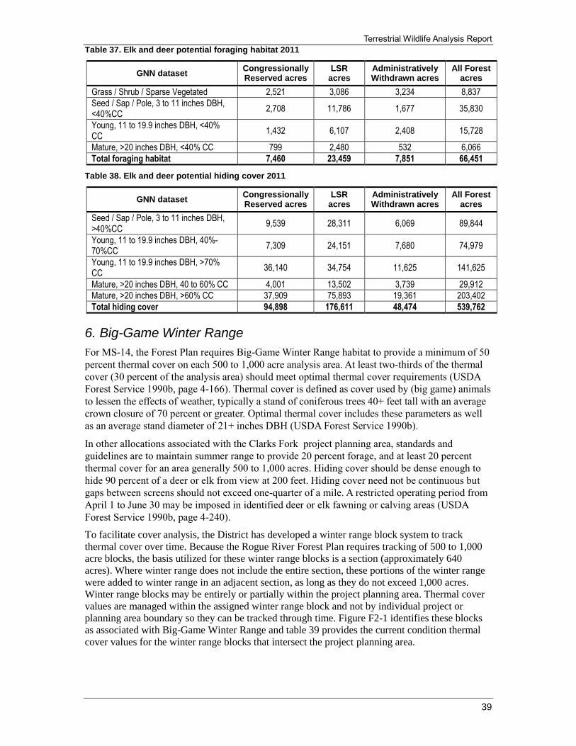
Terrestrial Wildlife Analysis Report
39
Table 37. Elk and deer potential foraging habitat 2011
GNN dataset Congressionally Reserved acres
LSR acres
Administratively Withdrawn acres
All Forest acres
Grass / Shrub / Sparse Vegetated 2,521 3,086 3,234 8,837
Seed / Sap / Pole, 3 to 11 inches DBH, <40%CC
2,708 11,786 1,677 35,830
Young, 11 to 19.9 inches DBH, <40% CC
1,432 6,107 2,408 15,728
Mature, >20 inches DBH, <40% CC 799 2,480 532 6,066
Total foraging habitat 7,460 23,459 7,851 66,451
Table 38. Elk and deer potential hiding cover 2011
GNN dataset Congressionally Reserved acres
LSR acres
Administratively Withdrawn acres
All Forest acres
Seed / Sap / Pole, 3 to 11 inches DBH, >40%CC
9,539 28,311 6,069 89,844
Young, 11 to 19.9 inches DBH, 40%-70%CC
7,309 24,151 7,680 74,979
Young, 11 to 19.9 inches DBH, >70% CC
36,140 34,754 11,625 141,625
Mature, >20 inches DBH, 40 to 60% CC 4,001 13,502 3,739 29,912
Mature, >20 inches DBH, >60% CC 37,909 75,893 19,361 203,402
Total hiding cover 94,898 176,611 48,474 539,762
6. Big-Game Winter Range
For MS-14, the Forest Plan requires Big-Game Winter Range habitat to provide a minimum of 50
percent thermal cover on each 500 to 1,000 acre analysis area. At least two-thirds of the thermal
cover (30 percent of the analysis area) should meet optimal thermal cover requirements (USDA
Forest Service 1990b, page 4-166). Thermal cover is defined as cover used by (big game) animals
to lessen the effects of weather, typically a stand of coniferous trees 40+ feet tall with an average
crown closure of 70 percent or greater. Optimal thermal cover includes these parameters as well
as an average stand diameter of 21+ inches DBH (USDA Forest Service 1990b).
In other allocations associated with the Clarks Fork project planning area, standards and
guidelines are to maintain summer range to provide 20 percent forage, and at least 20 percent
thermal cover for an area generally 500 to 1,000 acres. Hiding cover should be dense enough to
hide 90 percent of a deer or elk from view at 200 feet. Hiding cover need not be continuous but
gaps between screens should not exceed one-quarter of a mile. A restricted operating period from
April 1 to June 30 may be imposed in identified deer or elk fawning or calving areas (USDA
Forest Service 1990b, page 4-240).
To facilitate cover analysis, the District has developed a winter range block system to track
thermal cover over time. Because the Rogue River Forest Plan requires tracking of 500 to 1,000
acre blocks, the basis utilized for these winter range blocks is a section (approximately 640
acres). Where winter range does not include the entire section, these portions of the winter range
were added to winter range in an adjacent section, as long as they do not exceed 1,000 acres.
Winter range blocks may be entirely or partially within the project planning area. Thermal cover
values are managed within the assigned winter range block and not by individual project or
planning area boundary so they can be tracked through time. Figure F2-1 identifies these blocks
as associated with Big-Game Winter Range and table 39 provides the current condition thermal
cover values for the winter range blocks that intersect the project planning area.

Clarks Fork Wildlife Habitat Enhancement and Fuels Treatment Project
40
Table 39. Big-Game Winter Range thermal cover values
Block # Block total acres
Thermal total acres
Thermal percent
Optimal thermal
total acres
Optimal thermal percent
Total percent optimal thermal
and thermal
110 644 110 17 26 4 21
113 650 74 11 19 3 14
114 751 264 35 122 16 51
117 864 266 31 107 12 43
116 646 319 49 74 11 61
115 891 276 31 80 9 40
119 481 161 33 201 42 75
Figure 1: Big Game Winter Range Blocks
7. Effects of Fuels Treatments on Roosevelt Elk
Direct and Indirect Effects
Underburning treatments could reduce small woody material allowing room for forage plants to
grow. This would provide additional forage benefits for big game. Fuels treatments would be
designed to retain the majority of hiding cover within both winter and summer range. However,
fuels prescriptions may reduce hiding cover on some acres by scorching small diameter (3 inches
or less DBH) trees. Loss of hiding cover could lead to a slight increase in vulnerability for elk
during hunting seasons. However, much of this area is already relatively open and roaded.
Implementation of underburns will increase forage values and habitats and the project is expected
to have an beneficial impact on elk overall
Determination of Effect
Fuels treatments in the Clarks Fork project planning area would increase the forage component in
many stands for big game for a period of 5 to 15 years. These same treatments would slightly
reduce hiding cover over the same acres and over the same time period. The proposed action
would maintain thermal cover values in treated stands because underburning treatments are
designed to have minimal effect on forest canopies.

Terrestrial Wildlife Analysis Report
41
Based on these factors the overall direct, indirect, and cumulative effects would result in a
positive trend of habitat by increasing forage in the project planning area. Therefore, the Clarks
Fork Project would not contribute to an adverse trend in viability on the Rogue River National
Forest for elk, and are consistent with the Forest Plan, and thus continued viability of elk is
expected on the Rogue River portion of the Rogue River-Siskiyou National Forest.
Cumulative Effects
The list of past, present, and reasonably foreseeable future actions was reviewed to determine
potential effects to Roosevelt elk. The only actions which would contribute to potential
cumulative effects is the Big Butte Springs Timber Sales Project because the effects may overlap
in time and space.
The scale for cumulative affects analyses to elk is the Clarks Fork project planning area. The Big
Butte Springs Timber Sales fall within the Clarks Fork project planning area. This project was
designed to maintain forest health and habitat diversity, reduce risk of insect and disease
infestations, reduce fuel loading and the effects of wildfire, and increase the quality of riparian
vegetation. There are approximately 4,006 acres of Big Butte Springs Timber Sale units within
the Clarks Fork project planning area. Of the 4,006 acres, there are approximately 681 acres of
Big Butte Springs units that are not included in the Clarks Fork Project.
This project was designed to maintain forest health and habitat diversity, reduce fuel loading and
the effects of wildfire, and increase the quality of habitats for elk and other species. The Clarks
Fork Project will contribute to higher quality elk habitats by increasing the quality and quantity of
forage.
H. Black-Tailed Deer (Odocoileus hemionus columbianus)
1. Conservation Status
NatureServe (http://www.natureserve.org/explorer/servlet/NatureServe)
Global – G5 – Secure
Oregon Department of Fish and Wildlife (ODFW) –
Harvested as a game animal west of Cascade Crest
(http://www.dfw.state.or.us/resources/hunting/big_game/index.asp#big_game_regs)
Distribution
West of Cascade Crest in Oregon.
2. Habitat Use
Black-tailed deer are an edge-adapted species using dense hiding cover during the day, emerging
in the morning and evening to feed in more open areas (Maser et al. 1981). Throughout much of
western Oregon, black-tailed deer reside year-round in relatively flat areas at mid to low
elevations, on south facing slopes dominated by vine maple (Acer circinatum), huckleberry
(Vaccinium spp), and salal (Gaultheria shallon) plant communities (ODFW 2008).
Black-tailed deer rely upon several different successional stages of vegetation to meet their life
needs. Areas with heavy canopy closure are used during all seasons. In summer, areas of heavy
canopy closure are used to facilitate thermal regulation during periods of high temperatures.
During winter, heavy canopy closure moderates temperatures and intercepts snowfall during
winter storms.

Clarks Fork Wildlife Habitat Enhancement and Fuels Treatment Project
42
The reduction of snow depth under heavy canopy reduces energetic expenditure during
movements of deer and provides areas of browse that would normally be under the snow surface.
Areas with little or no overstory canopy cover are important for deer as forage areas. Forest gaps
and natural openings provide optimal conditions for shrubs and forbs to grow, which deer depend
on for forage.
Very few black-tailed deer remain on the High Cascades Ranger District in winter. Deer generally
migrate sometime in October to lower elevation private timberlands to seek acorns and avoid
deep snow. Snowpack covers available forage and makes movement difficult, resulting in an
energy deficit. Deer generally begin migrating back on to the District in March to May depending
on annual snow conditions.
3. Food Habits
Deer are relatively small ruminants unable to process large volumes of poor quality forage, as
compared to elk and cattle. Deer require high-quality forage, and overall body condition affects
many aspects of biology and survival. For example, productivity and winter survival are higher
when deer begin the winter with large reserves of fat (ODFW 2008).
For deer to maintain fitness, particularly during winter and breeding seasons, they must have
access to adequate year-round forage. Plant consumption by black-tailed deer varies and is
affected by seasonal quantity (availability) and quality (nutritional value). The nutritional value of
forage varies by plant species and time of year, generally being higher when the plant is actively
growing and lower after senescence in the fall and winter (ODFW 2008).
The fitness of an animal is dependent on the quality of forage and metabolic requirements of the
animal. The nutritional needs to maintain fitness for adults are normally less than the
requirements for growth and maintenance of young animals. Females that are pregnant or
lactating also require higher quality and quantities of forage. Nitrogen (protein) content is
commonly used as an indicator for nutritional value of forage (Ramsey and Krueger 1986).
Einarsen (1946) found that body condition of back-tailed deer was positively correlated with
crude protein in forage. Only a portion of crude protein is digestible, and insufficient levels of
protein were linked to decreased growth rates in fawns (Verme and Ozogo 1980), reproduction
(Verme 1965), and antler development (French et al. 1956). To maintain optimal growth, adult
deer and elk require about 12 to 16 percent crude protein (7.3 to 10.9 percent digestible protein)
in their diets (French et al. 1956).
The availability of forage varies considerably across Oregon’s black-tailed deer range.
Temperature and precipitation patterns affect forage type and availability, including diversity and
quantity of vegetation. Precipitation in western Oregon varies; in general annual rainfall is higher
in northwest coastal areas and less in the southwest interior.
As an example, Valsetz in northwest Oregon receives 131 inches of precipitation annually, while
Ashland in the southwest interior averages 20 inches per year (Western Regional Climate Center,
1936-2007, unpublished data). Temperature gradients are also diverse across black-tailed deer
range with lower temperatures in the Cascade Mountain and higher elevation Coast Ranges
compared to the interior valleys and coastal areas (ODFW 2008).
In southwestern Oregon Wedgeleaf (Ceanothus cuneatus) provides a bulk of the winter feed for
black-tailed deer in many areas (Randall et al. 1994). Studies have shown that Wedgeleaf makes
up 60 to 90 percent of the winter diet of black-tailed deer in that portion of the region studied, an
area located on the Oregon-California border in the Siskiyou Mountains of southwestern Oregon
(ODFW 1996).

Terrestrial Wildlife Analysis Report
43
4. Populations Trend and Viability
Home Range
Miller (1970) calculated average annual home range areas for various sex and age-classes of
black-tailed deer in the 138 hectare Cedar Creek enclosure. His findings are as follows: adult
females (69.6 hectares), adult males (100.4 hectares), 2 year-old females (76.9 hectares), 2 year-
old males (98.8 hectares), yearling females (38.9 hectares), and yearling males (59.9 hectares).
Average monthly home ranges ranged from 12.8 to 39.6 percent of average annual home ranges.
Annual census for black-tailed deer is conducted by ODFW biologists on the Rogue WMU,
which includes portions of the Rogue River National Forest and the Clarks Fork project planning
area. Censuses are conducted in both spring and fall, either by walking or driving along pre-
established routes. The results of these censuses are shown in table 40.
Table 40. Estimated annual deer population, Rogue Wildlife Management Unit
Year Population estimate
1971 9,293
1972 16,806
1973 18,466
1974 15,109
1975 17,497
1976 23,873
1977 26,109
1978 28,179
1979 29,496
1980 24,082
1981 23,454
1982 20,131
1983 27,364
1984 25,148
1985 22,890
1986 26,652
1987 22,304
1988 22,597
1989 21,761
1990 25,482
1991 22,388
1992 25,168
1993 16,556
1994 16,388
1995 17,225
1996 15,406
1997 13,462
1998 14,277
1999 14,716
2000 12,124
2001 15,657
2002 12,961
2003 10,348
2004 11,037
2005 16,159
2006 20,858
2007 20,388
2008 24,786
2009 20,879
2010 20,737

Clarks Fork Wildlife Habitat Enhancement and Fuels Treatment Project
44
Rogue River Land and Resource Management Plan (1990)
Deer winter range was considered to be less than 4,000 feet elevation in the 1990 Rogue River
Forest Plan. Core winter range is that portion of total winter range occupied by 90 percent of the
population 90 percent of the winters. If unusually severe snow conditions make core winter range
unsuitable, the deer tend to move off-Forest to lower elevation private and BLM lands. These
areas were referred to as critical winter range.
The presumption in 1990 was that deer exhibited the same habitat needs as elk, and that deer did
not appear to be as sensitive to changes in those conditions. Summer range requirements were
also presumed to be similar to those of elk. Meadows, brush fields, and other early successional
stages (artificially created and otherwise) provided the majority of forage for both deer and elk.
Thermal cover was also considered to be needed on the summer range to reduce heat stress on
animals (USDA Forest Service 1990a, page III-86).
As with elk, winter range was initially considered to be limiting deer production capability on the
Forest. It was expected that the 67,700 acres allocated to winter range management would
improve carrying capacity as management objectives for winter range were implemented (USDA
Forest Service 1990b, page IV-92). Habitat capability projections were expected to increase in the
first two decades (17 and 33 percent respectively) after the Forest Plan was implemented due to
improved winter range conditions. During the third decade, summer range would begin to
become limiting on deer production capability. By the end of the fifth decade, deer production
capability was expected to return to about 10 percent above the 1990 levels. From the sixth
through tenth decades, production capability would fluctuate between 5 percent below to 8
percent above 1990 levels (USDA Forest Service 1990b, page IV-93).
In 1990, there were no surveys available that indicated the actual number of deer on the Forest.
Trend counts were conducted by Oregon Department of Fish and Wildlife (ODFW) personnel,
but were only an index of herd size in relation to past years. Establishing the baseline for deer on
the Forest at the time the Forest Plan was written is problematic. There are three separate
references in the Rogue River Forest Plan Final Environmental Impact Statement which appear to
be in conflict. Based on the ODFW estimates of the total deer population and the percentages of
suitable habitat within the three Oregon Wildlife Units on the Forest, the Forest’s population was
estimated to be approximately 12,000 animals.
The Forest used a population model that, based upon seral stages, predicted an existing
population of approximately 21,000 deer fforest-wide. The model was indexed to the figures
derived from ODFW surveys. The model was not capable of predicting actual carrying capacity
of deer, but was an index of overall habitat quality expressed in numbers of animals (USDA
Forest Service 1990b, page III-86).
Northwest Forest Plan (1994)
The Record of Decision (ROD) for amendments to Forest Service and Bureau of Land
Management planning documents within the range of the northern spotted owl [commonly
referred to as the Northwest Forest Plan], amended Standards and Guidelines of existing Forest
Plans on over 24 million acres of federal lands within the range of the northern spotted owl
(USDA Forest Service and USDI Bureau of Land Management 1994b). The Rogue River Land
and Resource Management Plan was amended by this decision. Standards and guidelines in
existing plans still applied where they were more restrictive or provided greater benefits to late-
successional forest-related species than the standards and guidelines in the Northwest Forest Plan
ROD.

Terrestrial Wildlife Analysis Report
45
Since inception of the Forest Plan, the Rogue River National Forest has emphasized retention of
both nesting/roosting/foraging (NRF) and dispersal habitats for northern spotted owl. Generally,
this habitat is multistoried, 80 years old or more (depending on stand type and structural
condition), and has sufficient snags and down wood to provide opportunities for nesting, roosting,
and foraging. The canopy closure generally exceeds 60 percent. Other attributes include a high
incidence of large trees with various deformities (e.g., large cavities, broken tops, mistletoe
infestations, and other evidence of decadence); large snags; large accumulations of fallen trees
and other woody debris on the ground; and sufficient open space below the canopy for owls to fly
(Thomas et al. 1990). When these stands meet the 70 percent canopy cover minimum, they are
generally considered to be optimal thermal cover for deer and elk. Dispersal habitat is forested
habitat with canopy closure greater than 40 percent, average diameter greater than 11 inches
DBH, and flying space for owls in the understory, but does not provide the components found in
NRF. Where dispersal stands meet the 70 percent canopy cover minimum, they are generally
considered to be thermal cover for deer and elk.
Since implementation of the Northwest Forest Plan, silvicultural prescriptions for timber sales
have emphasized thinning in both NRF and dispersal stands. Thinning prescriptions, as opposed
to regeneration prescriptions, resulted in a major change in resultant stands in terms of habitat for
both deer and elk. Prior to implementation of the Northwest Forest Plan, regeneration harvests
(clear cuts, seed tree cuts, and shelterwoods) provided high-quality forage areas for big game
adjacent to both thermal and optimal thermal stands. Natural succession allowed for the forb and
shrub layers to propagate at high-densities throughout the harvest unit for a period of 5 to 10
years or more until seedlings over-topped and shaded out the forage species.
Attainment of probable sale quantity (PSQ) required covering much larger planning areas and
timber harvesting over many more acres after the Northwest Forest Plan was implemented.
Silvicultural prescriptions in young commercial (dispersal) stands typically reduces the canopy
cover to near 40 percent, which still allows for spotted owls to use them for moving between NRF
stands. Reducing canopy cover to near 40% provides openings and allows sunlight to reach the
forest floor.
This can stimulate the growth of the herbaceous and shrub layer if these plants already occur in
the understory. This can provide a short-term (5 to 15 years) increase in the forage base for both
elk and deer until canopy of the remaining trees once again shade out the understory growth.
The same prescription reduces thermal cover for big game if the stand was at 70 percent or more
canopy cover prior to harvest. It may also reduce hiding cover for a period of time until the shrub
layer reaches 3 to 5 feet in height. Thinning in older (NRF) stands generally retains optimal
thermal conditions because silvicultural prescriptions retain multi-layered structure and 60
percent canopy cover.
5. Elk and Deer Current Condition (2011)
Currently, forage habitat for elk and deer is the primary limiting factor on the Forest, constituting
less than 10 percent of the Forest land base (table 37). The west side of the Forest provides good
forage in designated Big-Game Winter Range for black-tail deer (there are very few if any elk on
that side of the Forest) due to a preponderance of low elevation non-conifer forest lands and an
active fuels and habitat enhancement program (over 5,500 acres of Big-Game Winter Range on
the Siskiyou Mountains Ranger District have been treated in the last 5 years). However, the
Cascade portion of the Forest, due to different forest types and management activities, is deficient
in the amount of forage habitat available to elk and deer. Elk and deer thermal and hiding cover
have increased significantly across the Forest, although in some areas of Big-Game Winter
Range, still not to that amount prescribed in the original Rogue River Forest Plan (tables 35, 36
and 38).

Clarks Fork Wildlife Habitat Enhancement and Fuels Treatment Project
46
6. Big-Game Winter Range
For MS-14, the Forest Plan requires Big-Game Winter Range habitat to provide a minimum of 50
percent thermal cover on each 500 to 1,000 acre analysis area. At least two-thirds of the thermal
cover (30 percent of the analysis area) should meet optimal thermal cover requirements (USDA
Forest Service 1990b, page 4-166). Thermal cover is defined as cover used by (big game) animals
to lessen the effects of weather, typically a stand of coniferous trees 40 feet or more tall with an
average crown closure of 70 percent or more. Optimal thermal cover includes these parameters as
well as an average stand diameter of at least 21 inches (USDA Forest Service 1990b).
In other allocations associated with the project planning area, standards and guidelines are to
maintain summer range to provide 20 percent forage, and at least 20 percent thermal cover for an
area generally 500 to 1,000 acres. Hiding cover should be dense enough to hide 90 percent of a
deer or elk from view at 200 feet. Hiding cover need not be continuous, but gaps between screens
should not exceed one-quarter of a mile. A restricted operating period from April 1 to June 30
may be imposed in identified deer or elk fawning or calving areas (USDA Forest Service 1990b,
page 4-240).
To facilitate cover analysis, the District has developed a winter range block system to track
thermal cover over time. Please see section G, 6, above for more detail on analysis for Big-Game
Winter Range.
7. Effects of Fuels Treatments on Black-tailed Deer
Direct and Indirect Effects
Underburning treatments could reduce small woody material allowing room for forage plants to
grow. This would provide additional forage benefits for big game. Fuels treatments would be
designed to retain the majority of hiding cover within both winter and summer range. However,
fuels prescriptions may reduce hiding cover on some acres by scorching small diameter (3 inches
or less DBH) trees. Loss of hiding cover could lead to a slight increase in vulnerability for black-
tailed deer during hunting seasons. However, much of this area is already relatively open and
roaded. Implementation of underburns will increase forage values and habitats and the project is
expected to have an beneficial impact on black-tailed deer overall.
Determination of Effects
Fuels treatments in the Clarks Fork project planning area would increase the forage component in
many stands for big game for a period of 5 to 15 years. These same treatments would slightly
reduce hiding cover over the same acres and over the same time period. The proposed action
would maintain thermal cover values in treated stands because underburning treatments are
designed to have minimal effect on forest canopies. Based on these factors the overall direct,
indirect, and cumulative effects would result in a positive trend of habitat by increasing forage in
the project planning area. Therefore, the Clarks Fork Project would not contribute to an adverse
trend in viability on the Rogue River National Forest for black-tailed deer, and are consistent with
the Forest Plan, and thus continued viability of elk is expected on the Rogue River portion of the
Rogue River-Siskiyou National Forest.
Cumulative Effects
The list of past, present, and reasonably foreseeable future actions was reviewed to determine
potential effects to Roosevelt elk. The only actions which would contribute to potential
cumulative effects is the Big Butte Springs Vegetation Management project because the effects
may overlap in time and space.

Terrestrial Wildlife Analysis Report
47
The scale for cumulative affects analyses to elk is the Clarks Fork project planning area. The Big
Butte Springs Timber Sales fall within the Clarks Fork project planning area. This project was
designed to maintain forest health and habitat diversity, reduce risk of insect and disease
infestations, reduce fuel loading and the effects of wildfire, and increase the quality of riparian
vegetation. There are approximately 4,006 acres of Big Butte Springs Timber Sale units within
the Clarks Fork project planning area. Of the 4,006 acres, there are approximately 681 acres of
Big Butte Springs units that are not included in the Clarks Fork Project.
This project was designed to maintain forest health and habitat diversity, reduce fuel loading and
the effects of wildfire, and increase the quality of habitats for elk and other species. The Clarks
Fork Project will contribute to higher quality black-tailed deer habitats by increasing the quality
and quantity of forage.
Neo-Tropical Migratory Birds/Landbirds
The Migratory Bird Treaty Act of 1918 (MBTA).
Implements various treaties and conventions between the U.S., Canada, Japan, Mexico and the
former Soviet Union for the protection of migratory birds. Under the act, it is unlawful to pursue,
hunt, take, capture (or kill) a migratory bird except as permitted by regulation (16 U.S.C. 703-
704). The regulations at 50 CFR 21.11 prohibit the take, possession, import, export, transport,
sale, purchase, barter, or offering of these activities, or possessing migratory birds, including nests
and eggs, except under a valid permit or as permitted in the implementing regulations (Director's
Order No. 131). A migratory bird is any species or family of birds that live, reproduce or migrate
within or across international borders at some point during their annual life cycle.
The U.S. Fish and Wildlife Service (FWS) is the lead federal agency for managing and
conserving migratory birds in the United States; however, under Executive Order (EO) 13186 all
other federal agencies are charged with the conservation and protection of migratory birds and the
habitats on which they depend. In response to this order, the BLM and Forest Service have
implemented management guidelines that direct migratory birds to be addressed in the NEPA
process when actions have the potential to negatively or positively affect migratory bird species
of concern.

Clarks Fork Wildlife Habitat Enhancement and Fuels Treatment Project
48
Executive Order 13186 (66 Fed. Reg. 3853, January 17, 2001)
“Responsibilities of Federal Agencies to Protect Migratory Birds”
This Executive Order directs federal agencies to avoid or minimize the negative impact of their
actions on migratory birds, and to take active steps to protect birds and their habitat. This
Executive Order also requires federal agencies to develop Memorandum of Understandings
(MOU) with the FWS to conserve birds including taking steps to restore and enhance habitat,
prevent or abate pollution affecting birds, and incorporating migratory bird conservation into
agency planning processes whenever possible.
PIF Bird Conservation Regions (BCR’S)
Bird Conservation Regions (BCRs) are ecologically distinct regions in North America with
similar bird communities, habitats, and resource management issues. BCR’s are a hierarchical
framework of nested ecological units delineated by the Commission for Environmental
Cooperation (CEC). The CEC framework comprises a hierarchy of 4 levels of eco-regions. At
each spatial level, spatial resolution increases and eco-regions encompass areas that are
progressively more similar in their biotic (e.g., plant and wildlife) and abiotic (e.g., soils, drainage
patterns, temperature, and annual precipitation) characteristics.
A mapping team comprised of members from United States, Mexico, and Canada assembled to
develop a consistent spatial framework for bird conservation in North America. The team's US
members met in to apply the framework to the United States and developed a proposed map of
BCRs. The map was presented to and approved by the US North American Bird Conservation
Initiative (NABCI) Committee during its November 1999, meeting. The map is a dynamic tool.
Its BCR boundaries will change over time as new scientific information becomes available. It is
expected that the map will be updated every three years. More information on BCR’s can be
found at http://www.nabci-us.org/bcrs.htm.
The overall goal of these BCR lists are to accurately identify the migratory and resident bird
species (beyond those already designated as federally threatened or endangered) that represent
our highest conservation priorities.
BCR lists are updated every five years by the US Fish and Wildlife Service.

Terrestrial Wildlife Analysis Report
49
The Birds of Conservation Concern 2008- (updated every 5 years
In December, 2008, the U.S. Fish and Wildlife Service released The Birds of Conservation
Concern Report (BCC) which identifies species, subspecies, and populations of migratory and
resident birds not already designated as federally threatened or endangered that represent highest
conservation priorities and are in need of additional conservation actions.
While the bird species included in BCC 2008 are priorities for conservation action, this list makes
no finding with regard to whether they warrant consideration for Endangered Species Act (ESA)
listing. The goal is to prevent or remove the need for additional ESA bird listings by
implementing proactive management and conservation actions. It is recommended that these lists
be consulted in accordance with Executive Order 13186, “Responsibilities of Federal Agencies to
Protect Migratory Birds.”
Description of Species, Habitat and Management Requirements
The Conservation Strategy for Landbirds in Coniferous Forests of Western Oregon and
Washington version 2.0 (Altman and Alexander 2012) and BCC species list for BCR 5
for the Clarks Fork project area was reviewed. Those species and habitats that are within
the project area are incorporated and effects disclosed in this analysis. Table 41 displays a
list of Birds of Conservation Concern (BCC) in the Clarks Fork treatment units that are
known or likely to be present in the Planning Area and could be affected by the proposed
actions. In addition, priority bird species for varying habitats within the project planning
area are summarized in Table 42.
Table 41. Partners in Flight focal bird species and habitat in coniferous forests of western Oregon
and Washington (Altman and Alexander, 2012, Table 9)
Impacts of fuels treatments to NTMBs vary depending on the habitats of different bird species
listed above and varying species life history strategies. Since the project actions will not be
removing mid to overstory canopy and consist of controlled, low-severity underburning, the
impacts to NTMBs will absent or minimal and short-term. Saab et al. 2007 analyzed several avian
response studies to low-severity prescribed burning and concluded that resident and migratory
bird species in the Pacific Northwest more frequently respond positive or neutral after the first
year of burning. Few species respond negatively and studies suggest that the impacts are few and
lasting only one year post-treatment.
Habitat Condition Habitat attribute Bird species
Coniferous forest Old-growth / Mature Large snags; large trees; mid-story tree layers
Pileated woodpecker; Brown creeper; Varied thrush
Coniferous forest Mature/Young Varied canopy closure; deciduous understory; forest floor complexity;
Hermit warbler; Hammond’s flycatcher; Wilson’s warbler; Winter wren
Coniferous forest Sapling/Seedling Deciduous shrub layer Orange-crowned warbler
Mixed Forest Unique Large hollow trees; landscape mosaic forest
Vaux’s swift; Blue (Sooty) grouse
Mixed Forest SW Oregon Mixed Forest
dense shrub understory; shrub-herbaceous interspersion; forest canopy edge; post-fire
Nashville warbler; Hermit thrush; Western tanager; Lazuli bunting

Clarks Fork Wildlife Habitat Enhancement and Fuels Treatment Project
50
Species that are associated with large trees, snags and mid-story tree layers will benefit from fuels
treatments. Habitat for pileated woodpecker, brown creeper, varied thrush, vaux’s swifts, hermit
warbler and Hammond’s flycatcher will be maintained as overstory and midstory tree layers will
not be removed. Bark/wood foragers and aerial insectivores respond more favorably to low-
severity, prescribed burning after one year due to an increase in insects for forage and cavities for
nesting (Smucker et al. 2005; Saab et al. 2007). It is possible to lose large diameter trees to
prescribed burning activities due to scorching, but mitigations are implemented to limit this.
However, scorching of some large diameter trees will increase the number of snags that provide
nesting and foraging for bark/wood foragers and aerial insectivores (Saab et al. 2007). Fuels
treatments will also benefit bird species associated with mature forest because treatments will
reduce the possibility of severe, stand replacement wildfires.
Winter wren and orange-crowned warblers are associated with young, seedling/sapling habitat
and specific understory features. It is predicted that initial fuels treatments will remove understory
conditions required for winter wren, orange-crowned warbler and other species with similar
requirements. However, low-severity underburning that maintains soil temperature below 175
degrees C stimulates regrowth of vegetation and understory features will return to original
conditions as well as provide additional habitat. Areas that are not burned or partially burned can
provide birds that require early-seral, understory features refugia while vegetation regrows in
treated areas.
It is also predicted that species persisting in mixed forest, particularly associated with a dense
shrub understory, will be impacted only in the short-term by fuels treatments. Nashville warbler
and hermit thrush will benefit as vegetation regrowth provides an increase in foliage insects for
foraging.
Disturbance operations and smoke is a concern for NTMBs. Efforts should be made to reduce
impacts to nesting birds that may be present in the project planning area that may be directly
impacted by underburning operations. Timing of operations should occur outside of the spring
breeding/nesting season to the extent possible (May 15-July 15). Underburning must be
conducted within the specified prescription identified in the burn plan.
Woodpeckers within the planning area include pileated woodpecker, hairy woodpecker, downy
woodpecker and northern flicker. Generally, insectivorous bird species benefit from burning as
insect availability increases (Saab et al. 2007). Aerial insectivores have been documented as
having positive responses and increases in populations after low-severity fires. In particular,
mountain and western bluebird have shown dramatic population increase after 0-4 years after
underburning (Smucker et al. 2005; Saab et al. 2007).

Terrestrial Wildlife Analysis Report
51
Table 42. Bird Conservation Region (BCR) 5- Northern Pacific Rainforest and USFWS Birds of Conservation Concern (BCC) found on within the Clarks Fork project planning area and effects of proposed project actions. Species listed are those that are not already addressed in the PIF focal species
Species General habitat requirements Impacts to species
Northern Goshawk (Accipiter gentillis)
Nests in mature forests with larger trees; and open understories. Average patch size of the core nest area varies based on available habitat conditions, 74 acres found by McGrath et al. (2003) in northeastern Oregon and central Washington.
Goshawk nesting habitat will not be impacted. If goshawk nests are detected, they will be protected from smoke and noise disturbance during the nesting season from March 1 to August 31. Foraging habitat will be increased and maintained by the reduction of understory layers so that prey is more visible.
Olive-sided Flycatcher (Contopus cooperi)
Associated with natural or man-made openings in conifer forest with tall trees or snags available for perching and singing. Found near water along wooded shores; at the juxtaposition of late- and early-successional forest; and in open or semi-open forest stands with low percentage canopy cover.
Project treatments will be benefit olive-sided flycatchers by maintaining open areas and reducing shrubs. The species will also benefit as vegetation regrowth recruits insects for foraging. Fuels treatments will also maintain and possibly create snags for perching and singing.
Rufous Hummingbird (Selasphorus rufus)
Found in wide variety of habitats, though it shows a breeding preference for late-successional forest with well-developed understory of flowering herbaceous plants and shrubs. Primarily associated with forest edges and openings.
Fuels treatments will benefit hummingbirds by stimulating regrowth of herbaceous and nectar-producing plants as well as increase insects for foraging. Treatments will also benefit the species by maintaining and creating openings for aerial courtship display.
Purple Finch (Carpodacus purpureus)
Breeds primarily in moderately moist open or semi-open coniferous forests. Also frequently found in mixed coniferous-deciduous forests, edges of bogs, and riparian corridors at low to mid-elevations.
Habitat for purple finch will be maintained and treatments will benefit foraging opportunities as burning will stimulate growth of vegetation and insect populations.
Willow Flycatcher (Empidonax traillii)
Breeding habitat is characterized by dense shrubs and/or tall herbaceous plants with scattered openings of shorter herbaceous vegetation. Nesting and migratory habitat in sw. Oregon is almost exclusively riparian zones, typically willows.
Initial fuels treatments will reduce dense shrubs and herbaceous plants for willow flycatcher breeding habitat. Impacts will be minimal as treatments will stimulate new growth and increase insect populations for foraging.
Oregon Vesper Sparrow (Pooecetes gramineus affinis)
Elevated perches for singing and a grass-dominated understory for foraging and nesting. In the Rogue River basin, Browning (1975) reported occurrence in open habitats of mixed-conifer forest zone during breeding, and throughout the valley during migration.
Fuels treatments will maintain and may create snags for perching and singing. The species is predicted to benefit from treatments as a result of increased grass habitat and open areas for foraging and nesting.
Clarks Fork Wildlife Habitat Enhancement and Fuels Treatment Project
52
IV. Other Rare and Uncommon Species
A. Rare or Uncommon Species – Northwest Forest Plan
On December 17, 2009, the U.S. District Court for the Western District of Washington issued an
order in Conservation Northwest, et al. v. Sherman, et al., No. 08-1067-JCC (W.D. Wash.),
granting Plaintiffs’ motion for partial summary judgment and finding NEPA violations in the
Final Supplemental to the 2004 Supplemental Environmental Impact Statement to Remove or
Modify the Survey and Manage Mitigation Measure Standards and Guidelines (USDA Forest
Service and USDI Bureau of Land Management, June 2007). In response, parties entered into
settlement negotiations in April 2010, and the Court filed approval of the resulting Settlement
Agreement on July 6, 2011.
Projects that are within the range of the northern spotted owl are subject to the Survey and
Manage standards and guidelines in the 2001 ROD, as modified by the 2011 Settlement
Agreement. The Clarks Fork Project falls within one of the four exemptions listed in the October
11, 2006 modified injunction NEA v. Rey; specifically, exemption (d) The portions of projects
involving hazardous fuels treatments where prescribed fire is applied. Any portions of hazardous
fuel treatment projects involving commercial logging will remain subject to the survey and
manage requirements except for thinning of young stands younger than 80 years old under
subparagraph (a) of this paragraph.
The Northwest Forest Plan provided Protection Buffers (USDA Forest Service and USDI Bureau
of Land Management, page C-19) and additional standards and guidelines for those species
determined to be specific rare and locally endemic species, and other uncommon species in the
forest Matrix. Most of these species habitat have been discussed in previous sections of this EA.
The species which use snag or cavity nesting habitat and may occur in the Clarks Fork project
planning area are: bats (fringed, long-eared, and long-legged myotis; silver-haired, pallid, and
Townsend’s big-eared). The effects for the species that are known or suspected to be present in
the project planning area are discussed in the sensitive species section of the Terrestrial Wildlife
Biological Evaluation.
B. Survey And Manage Species
1. Pygmy Nuthatch (Sitta pygmaea)
This species requires ponderosa pine as a habitat component. This species has only been
documented once on the High Cascades Ranger District (Barrett 2010). The individual was in a
winter mixed-species flock east of Willow Lake within the project area. Treatments such as those
proposed in the Clarks Fork Project that favor large pine species as well as improve snag habitats
will assist in the retention and creation of suitable nesting and foraging habitat for the species.
2. Flammulated Owl (Otus flammeolus)
This species is closely associated with the mixed conifer forest habitat type, but it requires
ponderosa pine in its habitat. Flammulated owls are closely associated with multi-story,
moderate-closed canopy closure structural conditions. Trees with cavities are an important habitat
element for this species. Some of the project units are considered suitable for this species, though
its presence has not been documented within the project planning area.

Terrestrial Wildlife Analysis Report
53
The maintenance of multi-story, moderate canopy closure stands and the expected increase of
snag habitats should improve habitat for the species within the project planning area.
3. Great Gray Owl (Strix nebulosa)
In North America, this owl is found from Alaska south to the Sierra Nevadas in California, and
east to Ontario and Maine. They are known to occur within the range of the northern spotted owl.
Winter range is similar to the breeding range except for the species’ tendency to wander
irregularly south in winter (Bull and Duncan 1993). The range for this species includes the project
planning area. This species is purportedly associated with meadows and natural opening greater
than 10 acres. Although there are no natural openings or meadows within the project planning
area that are 10 acres or greater, the District has four verified records of great gray owls within
the Clarks Fork project planning area. It is assumed that these individuals are using some of the
open forb and grass habitats within the planning area to hunt gophers and voles. All known sites
will be protected from initial spring burns. Fall burns are expected to improve foraging
habitats for this species within the planning area.
4. Red Tree Vole (Arborimus longicaudus)
The project planning area is outside the range of the red tree vole. There are no records of the
species from within the project planning area. Surveys were not conducted for this species.
C. Forest Plan Species
The 1990 Rogue River Forest Plan contains standards and guidelines for the northern spotted owl
(discussed as a federally threatened species in the Terrestrial Biological Evaluation), cavity nester
species (discussed as MIS species in this Wildlife Analysis Document), deer and elk (discussed as
MIS species in this Wildlife Analysis Document), bald eagle (discussed as a Forest Service
sensitive species in Terrestrial Biological Evaluation), and peregrine falcon (discussed as a Forest
Service sensitive species in Terrestrial Biological Evaluation). Bald eagle, osprey and peregrine
falcon do not occur within the Clarks Fork project planning area. Goshawks are discussed below.
Habitat and individuals are present within and/or adjacent to the project planning area.
1. Northern goshawk (Accipter gentiles)
Reproductive home ranges for this species consist of three components: foraging, nesting, and
post-fledgling areas. Foraging habitat consists of a mosaic of large trees, snags, and down logs
interspersed with openings, which support a wide array of prey species. Nests are typically built
on one of the largest trees within dense patches of large old trees within a stand; they can use
alternative nest sites from year to year. Post-fledgling areas surround the nest and are made up of
a 300 to 600 acre mosaic of large mid-aged trees and snags with large down logs and small
opening with herbaceous cover (Marshall et al. 2003).
Currently, there are no known goshawk nests within the Clarks Fork project planning area. No
nests were detected by field biologists during field reconnaissance for project planning efforts.
However, the District has four records of goshawks within the planning area. If goshawk nest
sites are detected, they would be protected from disturbing activities during the nesting season
from March 1 to August 31. If monitoring has shown that no nesting attempt has been initiated or
that a nesting attempt has failed by June 1, the nest site would be considered inactive and the nest
site restriction may be waived.

Clarks Fork Wildlife Habitat Enhancement and Fuels Treatment Project
54
Literature Cited American Ornithologist Union. 1983. Checklist of North American Birds. Baltimore, Maryland.
Altman, B. and J.D. Alexander. 2012. Table 9 in Habitat Conservation for Landbirds in
Coniferous Forests of Western Oregon and Washington. Version 2.0. Oregon-Washington
Partners in Flight (www.orwapif.org) and American Bird Conservancy and Klamath Bird
Observatory.
Aubry, K.B. and C.M. Raley. 1996. Ecology of pileated woodpeckers in managed landscapes on
the Olympic Peninsula. Wildlife Ecology Team 1996 Annual Report, pages 70-74. USDA
Forest Service, Pacific Northwest Research Station, Olympia Washington.
Aubry, K.B. and C.M. Raley. 2002. “Selection of nest and roost trees by pileated woodpeckers in
coastal forests of Washington.” Journal of Wildlife Management 66(2): 392-406.
Barrett, N.M. (retired High Cascades Ranger District wildlife biologist). 2010. Personal
communication with Jeff VonKienast.
Bull, E.L. and T.W. Heater. 2000. “Resting and denning sites of American martens in northeastern
Oregon.” Northwest Science 74(3): 179-185.
Bull, E.L., T.W. Heater, and J.F. Shepard. 2005. “Habitat selection by the American marten in
northeastern Oregon.” Northwest Science 79(1): 37-43.
Bull, E.L. and R.S. Holthausen. 1993. “Habitat use and management of pileated woodpeckers in
northeastern Oregon.” Journal of Wildlife Management 57(2): 335-345.
Buskirk, S.W. 1992. “Conserving circumboreal forests for martens and fishers.” Conservation
Biology 6: 318-320.
Buskirk, S.W. and L.F. Ruggiero. 1994. “American Marten.” In: The Scientific Basis for
Conserving Forest Carnivores; American Marten, Fisher, Lynx, and Wolverine in the
Western United States. General Technical Report RM-254. (Fort Collins, Colorado:
USDA Forest Service, Rocky Mountain Forest and Range Experiment Station), 38 -73.
Cahall, R.E. 2007. Influences of salvage logging on forest birds after fire in the eastern Cascades,
Oregon. Masters Thesis. Oregon State University.
Cahall, R.E. and J.P. Hayes. 2008. “Influences of postfire salvage logging on forest birds in the
eastern Cascades, Oregon, USA.” Forest Ecology and Management 257: 1119-1128.
Christensen, A.G., L.J. Lyon, and J.W. Unsworth. 1993. Elk management in the northern region:
considerations in forest plan updates or revisions. Gen. Tech. Rep. INT-303. Ogden, UT:
USDA Forest Service, Intermountain Research Station.
Cook, J.G, L.L. Irwin, L.D. Bryant, R.A. Riggs, and J.W. Thomas. 2004. Thermal cover needs of
large ungulates: a review of hypothesis tests in transactions of the 69th North American
Wildlife and Natural Resources Conference: 708-726.
Einarsen, A.S. 1946. Crude protein determination of deer food as an applied management
technique. Transactions North American Wildlife Conference 11: 309-312.

Terrestrial Wildlife Analysis Report
55
Elchuk, C.L. and K.L. Weibe. 2003. Home range size of northern flickers (Colaptes auratus) in
relation to habitat and parental attributes. Canadian Journal of Zoology. 81(6);954-961.
Forest Ecosystem Management Assessment Team (FEMAT). 1993. Forest ecosystem
management: an ecological, economic, and social assessment. U.S. Government Printing
Office 1993-793-071.
French, C.E., A.S. McEwan, N.D. McGruder, R.H. Ingram, and R. W. Swift. 1956. “Nutrient
requirements for growth and antler development in white-tailed deer.” Journal of Wildlife
Management 20: 221-232.
Haggard, M. and W.L. Gaines. 2001. “Effects of stand-replacement fire and salvage logging on a
cavity-nesting bird community in Eastern Cascades, Washington.” Northwest Science
75(4): 387-396.
Hargis, C.D., J.A. Bissonette, and D.L. Turner. 1999. “The influence of forest fragmentation and
landscape pattern on American martens.” Journal of Applied Ecology 36: 157-172.
Harper, J.A., et al. 1987. Ecology and management of Roosevelt elk in Oregon. Revised edition.
Oregon Department of Fish and Wildlife.
Hartwig, C.L. 1999. Effect of forest age, structural elements, and prey density on the relative
abundance of pileated woodpecker (Dryocopus pileatus abieticola) on south-eastern
Vancouver Island. Masters Thesis. University of Victoria, British Columbia.
Hartwig, C.L., D.S. Eastman, and A.S. Harestad. 2004. “Characteristics of pileated woodpecker
(Dryocopus pileatus) cavity trees and their patches on southeastern Vancouver Island,
British Columbia, Canada.” Forest Ecology and Management 187: 225-234.
Haynes, R.W., B.T. Bormann, D.C. Lee, and J.R. Martin (tech. eds.). 2006. Northwest Forest
Plan—the first 10 years (1994-2003): synthesis of monitoring and research results. Gen.
Tech. Rep. PNW-GTR-651. Portland, OR: USDA Forest Service, Pacific Northwest
Research Station. Available online at: http://www.fs.fed.us/pnw/publications/gtr651/
Hochholter, P.A. 2010. Course woody debris, region and series, by decay class and snags, region
and series, final. Unpublished data. USDA Forest Service, Pacific Northwest Region,
Rogue River-Siskiyou National Forest, Medford, Oregon.
Huff, M.H. and C.M. Raley. 1991. “Regional patterns of diurnal breeding birds communities in
Oregon and Washington.” In: Wildlife and Vegetation of Unmanaged Douglas-fir Forests.
PNW-GTR-285. (Portland, Oregon: USDA Forest Service, Pacific Northwest Research
Station), 177-205.
Johnson, D.H. and T.A. O’Neil (eds.). 2001. Wildlife-habitat relationships in Oregon and
Washington. Oregon State University Press, Corvallis, Oregon.
Jones, L.L.C. and M.G. Raphael. 1991. Ecology and management of marten in fragmented
habitats of the Pacific Northwest. Progress report: fiscal year 1991. Olympia, WA: USDA
Forest Service, Pacific Northwest Research Station.

Clarks Fork Wildlife Habitat Enhancement and Fuels Treatment Project
56
Kirk, T.A. and W.J. Zielinski. 2009. “Developing and testing a landscape habitat suitability model
for the American marten (Martes americana) in the Cascades Mountains of California.”
Landscape Ecology 24: 759-773.
Korfhage, R.C. 1974. Summer food habits of elk in the Blue Mountains of northeastern Oregon
based on fecal analysis. Masters Thesis. Washington State University.
Korfhage, R.C. and C. Roche. 2007. Elk forage utilization. Unpublished Report. USDA Forest
Service, Rogue River-Siskiyou National Forest, High Cascades Ranger District, Prospect,
Oregon.
Kreisel, K.J. and S.J. Stein. 1999. Bird use of burned and unburned coniferous forest during
winter. Wilson Bull 111:243-250.
Lundquist, R.W. 1988. Habitat use by cavity-nesting birds in the Southern Washington Cascades.
Masters Thesis. University of Washington.
Lyon, L.J. 1983. “Road density models describing habitat effectiveness for elk.” Journal of
Forestry 81(9): 592-594, 613.
Mannan, R.W., E.C. Meslow, and H.M. Wight. 1980. “Use of snags by birds in Douglas-fir
forests, western Oregon.” Journal of Wildlife Management 44(4): 787-797.
Marcot, B.G., B.C. Wales, and R. Demmer. 2003. Range maps of terrestrial species in the Interior
Columbia River Basin and Northern Portions of the Klamath and Great Basins. PNW-
GTR-583, Portland, OR: USDA Forest Service, Pacific Northwest Research Station, and
USDI Bureau of Land Management. Available online at:
http://www.fs.fed.us/pnw/publications/gtr583/
Marshall, D.B., M.G. Hunter, and A.L. Contreras (eds.). 2003. Birds of Oregon: a general
reference. Oregon State University Press, Corvallis, Oregon.
Maser, C., B.R. Mate, J.F. Franklin, and C.T. Dyrness. 1981. Natural history of Oregon Coast
mammals. Gen. Tech. Rep. PNW-133. USDA Forest Service, Pacific Northwest Forest
and Range Experimental Station, Portland, Oregon.
Mellen, T.K. 1987. Home range and habitat use of pileated woodpeckers, western Oregon.
Masters Thesis. Oregon State University.
Mellen, T.K., E.C. Meslow, and R.W. Mannan. 1992. “Summertime home range and habitat use
of pileated woodpeckers in western Oregon.” Journal of Wildlife Management 56: 96-
103.
Mellen-McLean. 2011. Pileated woodpecker habitat relationship model. USDA Forest Service.
Pacific Northwest Region. Portland, Oregon.

Terrestrial Wildlife Analysis Report
57
Mellen-McLean, K., B.G. Marcot, J.L. Ohmann, K. Waddell, S.A. Livingston, E.A. Willhite, B.B.
Hostetler, C. Ogden, and T. Dreisbach. 2009. DecAID, the decayed wood advisor for
managing snags, partially dead trees, and down wood for biodiversity in forests of
Washington and Oregon. Version 2.1. USDA Forest Service, Pacific Northwest Region
and Pacific Northwest Research Station; USDI Fish and Wildlife Service, Oregon State
Office; Portland, Oregon. Available online at:
http://www.fs.fed.us/r6/nr/wildlife/decaid/index.shtml
Miller, F.L. 1970. “Distribution patterns of black-tailed deer (Odocoileus hemionus columbianus)
in relation to environment.” Journal of Mammology 51: 248-260.
Nelson, S.K. 1988. Habitat use and densities of cavity nesting birds in the Oregon Coast Ranges.
Masters Thesis. Oregon State University.
Oregon Department of Fish and Wildlife (ODFW). 1996. Deer and decadence-an examination of
management strategies for the rejuvenation of overmature Ceanothus couneatus.
Unpublished Paper by Jim Colloran, CBEC Intern. Edited by ODFW Rogue District
Wildlife Staff.
Oregon Department of Fish and Wildlife (ODFW). 2003. Oregon’s Elk Management Plan. Salem,
OR: Oregon Department of Fish and Wildlife.
Oregon Department of Fish and Wildlife (ODFW). 2008. Draft Oregon black-tailed deer
management plan. Oregon Department of Fish and Wildlife, Salem, Oregon.
Raley, C.M. and K.B. Aubry. 2006. “Foraging ecology of pileated woodpeckers in coastal forests
of Washington.” Journal of Wildlife Management 70(5): 1266-1275.
Ramsey, K.J. and W.C. Krueger. 1986. Grass-legume seeding to improve winter forage for
Roosevelt elk: a literature review. Special report 736. Department of Rangeland
Resources, Agricultural Experiment Station, Oregon State University, Corvallis, Oregon.
Randall, W.R., R. Keniston, D.N. Bever, and E.C. Jensen. 1994. Manual of Oregon trees and
shrubs. Oregon State University, Corvallis, Oregon.
Raphael, M.G. and L.L.C. Jones. 1997. Characteristics of resting and denning sites of American
martens in central Oregon and western Washington. In: Martes: taxonomy, ecology,
techniques, and management. (Alberta, Canada: Provincial Museum of Alberta,
Edmonton), 146-165.
Rowland, M.M., M.J. Wisdom, B.K. Johnson, and J.G. Kie. 2000. “Elk distribution and modeling
in relation to roads.” Journal of Wildlife Management 64(3): 672-684.
Russell, R.E., V.A. Saab, and J.G. Dudley. 2007. “Habitat-suitability models for cavity-nesting
birds in a postfire landscape.” Journal of Wildlife Management 71(8): 2600-2611.
Available online at:
http://www.rmrs.nau.edu/publications/russell_et_al_2007/russell_et_al_2007.pdf
Saab, V.A., R.E. Russell, and J.G. Dudley. 2007. “Nest densities of cavity-nesting birds in relation
to postfire salvage logging and time since wildfire.” Condor 109: 97-108.

Clarks Fork Wildlife Habitat Enhancement and Fuels Treatment Project
58
Saab, V.A., R.E. Russell, and J.G. Dudley. 2009. “Nest-site selection by cavity-nesting birds in
relation to postfire salvage logging.” Forest Ecology and Management 257: 151-159.
Skovlin, J.M., P. Zager, and B.K. Johnson. 2002. “Elk habitat selection and evaluation in North
American elk ecology and management.” Smithsonian Institution Press.
Slauson, K. and W.J. Zielinski. 2009. Characteristics of summer and fall diurnal resting habitat
used by American martens in coastal northwestern California. Northwest Science.
Volume 83, No.1.
Smucker, K.M., R.L. Hutto and B.M. Steele. 2005. Change in bird abundance after wildlife:
importance of fire severity and time since fire. Ecological Applications 15(5): 1535-1549.
Thomas, J.W., M.G. Raphael, R.G. Anthony, E.D. Forsman, A.G. Gunderson, R.S. Holthausen,
B.G. Marcot, G.H. Reeves, J.R. Sedell, and D.M. Solis. 1993. Viability assessments and
management considerations for species associated with late-successional and old-growth
forests of the Pacific Northwest. Washington, DC: USDA Forest Service, U.S.
Government Printing Office.
United States Department of Agriculture, Forest Service. 1990a. Final Environmental Impact
Statement. Land and Resource Management Plan. Rogue River National Forest. USDA
Forest Service, Pacific Northwest Region, Rogue River National Forest, Medford,
Oregon.
United States Department of Agriculture, Forest Service. 1990b. Rogue River National Forest
Land and Resource Management Plan. USDA Forest Service, Pacific Northwest Region,
Rogue River National Forest, Medford, Oregon. Available online at:
http://www.fs.usda.gov/Internet/FSE_DOCUMENTS/stelprdb5315122.pdf
United States Department of Agriculture, Forest Service. 1995. Upper Big Butte Watershed
Analysis. Rogue River National Forest. Butte Falls, Oregon.
United States Department of Agriculture, Forest Service. 2009. Clark’s Fork habitat assessment,
field survey data. Unpublished data. USDA Forest Service, Rogue River-Siskiyou
National Forest, High Cascades Ranger District, Prospect, Oregon.
USDA Forest Service. 2011. Rogue River National Forest Management Indicator Species Forest-
Wide environmental baseline and species accounts. Unpublished Report. USDA Forest
Service, Rogue River-Siskiyou National Forest, Medford, Oregon.
United States Department of Agriculture, Forest Service, and United States Department of the
Interior, Bureau of Land Management. 1994a. Final Supplemental Environmental Impact
Statement and Record of Decision on Management of Habitat for Late-successional and
Old-growth Forest Related Species within the Range of the Northern Spotted Owl. USDA
Forest Service, Pacific Northwest Region, Portland, Oregon.

Terrestrial Wildlife Analysis Report
59
United States Department of Agriculture, Forest Service, and United States Department of the
Interior, Bureau of Land Management. 1994b. Record of Decision for Amendments to
Forest Service and Bureau of Land Management Planning Documents Within the Range
of the Northern Spotted Owl. USDA Forest Service, Pacific Northwest Region, Portland,
Oregon. Available online at: http://www.reo.gov/library/reports/newroda.pdfVerme, L.J.
1965. “Reproductive studies on penned white-tailed deer.” Journal of Wildlife
Management 29: 74-79.
Verme, L.J. and J.J. Ozogo. 1980. “Influence of protein energy intake on deer fawns in autumn.”
Journal of Wildlife Management 44: 315-324.
Verts, B.J. and L.N. Carraway. 1998. Land mammals of Oregon. University of California Press,
Berkeley, California.
Wahl, T.R., B. Tweit, and S. G. Mlodinow (eds.). 2005. Birds of Washington: status and
distribution. Oregon State University Press, Corvallis, Oregon.
Zielinski, W.J. and N.P. Duncan. 2004. “Diets of sympatric populations of American martens
(Martes americana) and fishers (Martes pennanti) in California.” Journal of Mammology
85(3): 470-477.
Zielinski, W.J., K.M. Slauson, C.R. Carroll, C.J. Kent, and D.G. Kudma. 2001. “Status of
American martens in coastal forests of the Pacific states.” Journal of Mammalogy 82:
478-490.

Clarks Fork Wildlife Habitat Enhancement and Fuels Treatment Project
60
Attachment 1 – Mitigation and Minimization Measures
Big-Game Winter Range (BGWR) Mitigation
Prescribe fire within Big-Game Winter Range are subject to a restriction from December 1 to
April 30 unless a specific waiver is authorized by the District Ranger.
Neotropical Migratory Bird Mitigations
Efforts should be made to reduce impacts to nesting birds that may be present in the project
planning area that may be directly impacted by broadcast burning operations. Timing of
operations should occur outside of the spring breeding/nesting season to the extent possible (May
15 to July 15). Underburning operations must be conducted within the specified prescription
identified in the burn plan. Spring/early summer burning operations may be required during initial
entries due to high fuel loading.
Fisher/American Marten
For large snags (20 inches or greater DBH), scratch lines will be constructed around the base
prior to ignition operations to reduce potential of consumption of denning habitats by prescribed
fire. Wherever possible, snags that catch fire will be suppressed if they do not pose a safety threat
to personnel.
Snags and Coarse Woody Material Retention
For large snags (20 inches or greater DBH), scratch lines will be constructed around the base
prior to ignition operations to reduce potential of consumption by prescribed fire. Wherever
possible, snags that catch fire will be suppressed if they do not pose a safety threat to personnel.
Great Gray Owl and Northern Goshawk
Great Gray Owl nest sites shall be subject to seasonal restrictions outlined within the Survey and
Manage Settlement Agreement. Northern Goshawk nests are subject to seasonal restrictions
outlined in the Rogue River National Forest Land and Resource Management Plan, Standards and
Guidelines.