Embed Size (px)
Citation preview
COMPANY PRODUCT GUIDE
High-Resolution Underwater Acoustic Imaging, Measurement, and Automation Systems
Teledyne BlueViewMaking Impossible Jobs Possible
Teledyne BlueView Product Guide
2 3
Teledyne BlueView Product Guide
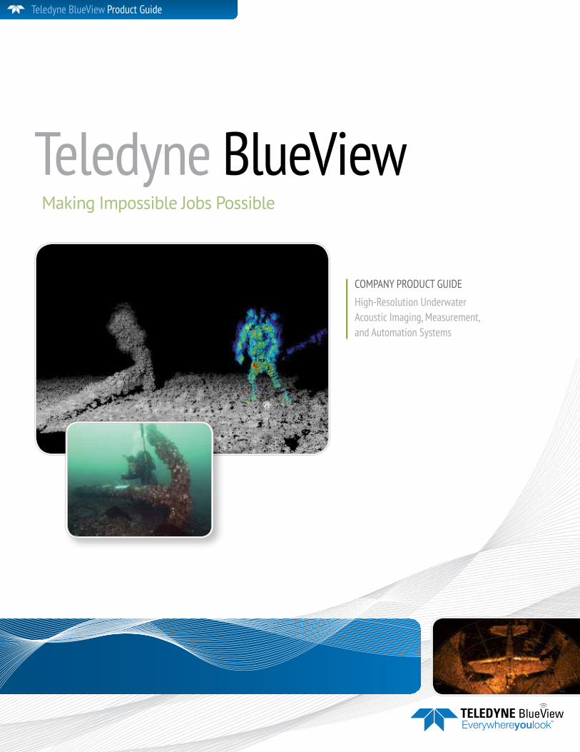
Making Impossible Jobs PossibleTeledyne Blueview provides an assortment of sonar solutions that are ideally suited to our customer’s underwater imaging and measuring needs. Highly compact, low power, and versatile sonar solutions provide high-quality industry-leading delivera-bles that expand underwater imaging capabilities.
Teledyne BlueViewTeledyne BlueView
Underwater Vision Solutions2D Multibeam Imaging SonarTeledyne BlueView’s 2D Sonar Systems are easy to integrate and easy to operate, providing real-time imagery to aid navigation, inspection, monitoring, tracking, and detection for a wide variety of underwater operations.
Multibeam Profilers and Gap-Fill SonarTeledyne BlueView multibeam profilers are high- frequency narrow-beam solutions designed to yield high-resolution near-field data. Multibeam profilers are used for a wide variety of applications on ROVs, AUVs, and surface vessels.
OEM SonarTeledyne BlueView develops customized sonar solutions for integrators, vehicle manufacturers, and operators that are specifically designed to meet their needs.
3D Mechanical Scanning SonarTeledyne BlueView’s 3D Multibeam Scanning Sonars create high-resolution, fully interactive 3D point clouds, capturing accurate measurements of underwater infrastructure, objects of interest, construction sites, and other areas in need of survey.
Image courtesy Collins Engineers, Inc.
4 5
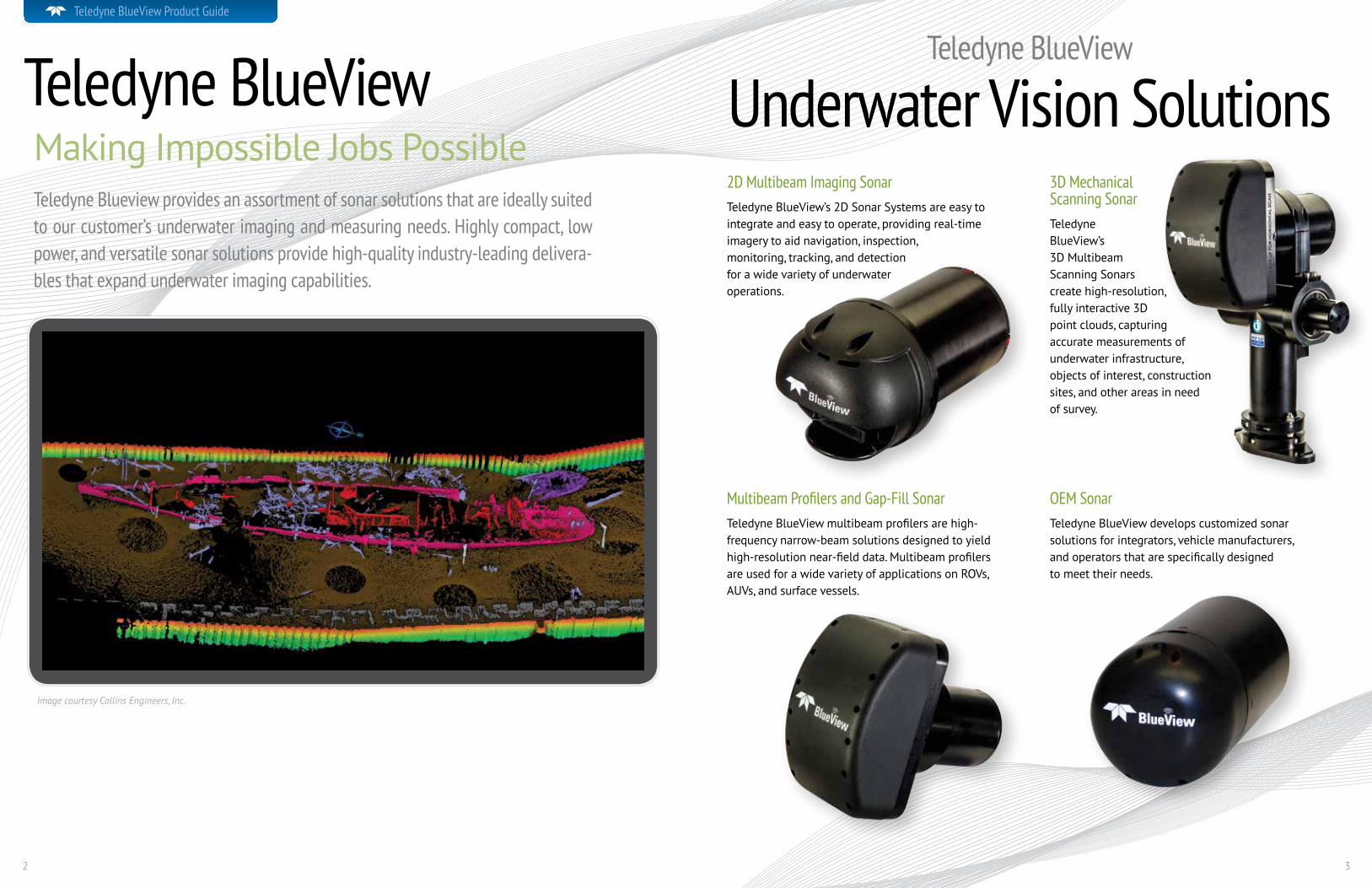
Multibeam Imaging Sonar2DNear-Infinite PossibilitiesTeledyne BlueView 2D imaging sonars deliver real-time, high-resolution video-like imagery, even in very low and zero-visibility conditions. In clear water conditions, situational awareness is significantly increased beyond the optically imaged scene. Fast update rates, high acoustic frequencies, compact size, and industry-leading target track-ing make our products the preferred choice in leading-edge multibeam sonar. With the widest range of models available, we offer you the most choices in field-of-view, range, and depth. Teledyne BlueView makes using your 2D Multibeam Imag-ing Sonar easy with “plug-and-go” operation and multiple deployment options, including:
• ROV Systems • Diver Hand-Held Systems
• Boat-Mounted Systems • AUV Systems
• Portable Tripod Systems • Fixed Position Systems
All Teledyne BlueView 2D multibeam imaging sonar systems include ProViewer® operating software, accessories, and a one-year warranty. We also offer an advanced Software Development Kit (SDK) that enables access to raw data files and sonar controls to make integration into complex monitoring systems easy.
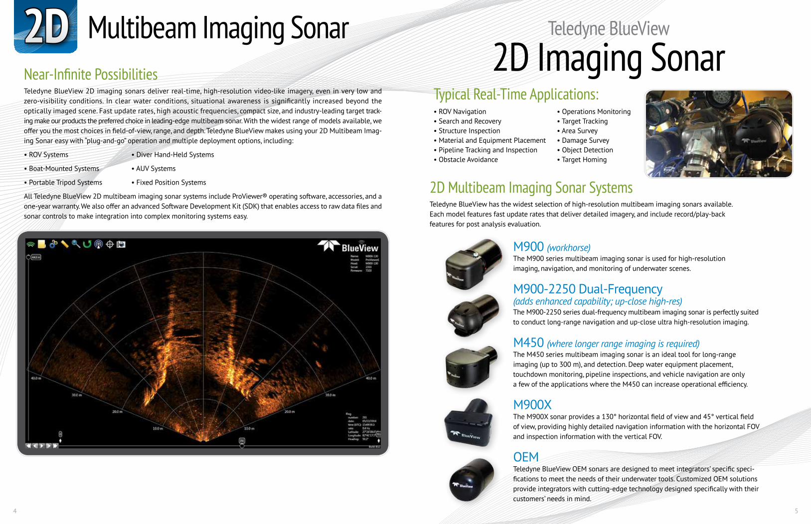
Typical Real-Time Applications:• ROV Navigation • Operations Monitoring• Search and Recovery • Target Tracking• Structure Inspection • Area Survey• Material and Equipment Placement • Damage Survey• Pipeline Tracking and Inspection • Object Detection• Obstacle Avoidance • Target Homing
Teledyne BlueView
2D Imaging Sonar
2D Multibeam Imaging Sonar SystemsTeledyne BlueView has the widest selection of high-resolution multibeam imaging sonars available. Each model features fast update rates that deliver detailed imagery, and include record/play-back features for post analysis evaluation.
M900 (workhorse)The M900 series multibeam imaging sonar is used for high-resolution imaging, navigation, and monitoring of underwater scenes.
M900-2250 Dual-Frequency(adds enhanced capability; up-close high-res)The M900-2250 series dual-frequency multibeam imaging sonar is perfectly suited to conduct long-range navigation and up-close ultra high-resolution imaging.
M450 (where longer range imaging is required)The M450 series multibeam imaging sonar is an ideal tool for long-range imaging (up to 300 m), and detection. Deep water equipment placement, touchdown monitoring, pipeline inspections, and vehicle navigation are only a few of the applications where the M450 can increase operational efficiency.
M900XThe M900X sonar provides a 130° horizontal field of view and 45° vertical field of view, providing highly detailed navigation information with the horizontal FOV and inspection information with the vertical FOV.
OEMTeledyne BlueView OEM sonars are designed to meet integrators’ specific speci-fications to meet the needs of their underwater tools. Customized OEM solutions provide integrators with cutting-edge technology designed specifically with their customers’ needs in mind.

6 7
2D 2D Multibeam Imaging Sonar (continued)
Teledyne BlueView
2D Imaging ApplicationsCivil Engineering
Energy Hydrography
Salvage
M900-2250 Dual-FrequencyDouble VisionThe dual-frequency 900 kHz and 2250 kHz provide the most versatility of any 2D imaging sonar. The 900 kHz offers high-resolution long-range navigation, object detection, and obstacle avoidance, while the 2250 kHz provides ultra-high resolution at close range. ROV navigation, hull inspections, structure inspections, diver monitoring, and search and recov-ery are a few applications that benefit from the dual-frequency’s imaging capabilities.
Long-range navigation. Up-close inspection.
M900 M900/2250 M450 M900XSonar Field-of View 90 or 130° 130° 90 or 130° See footnte Max Range 100 m (328 ft) 100 m (328 ft) / 20 m (66 ft) 300 m (984 ft) 100 m (328 ft) Optimum Range 2-60 m (6.6-197 ft) 2-60 m (6.6-197 ft) / 0.5-7 m (1.6-23 ft) 5-175 m (16-574 ft) 2-60 m (6.6-197 ft) Beam Width 1 x 20° 1 x 20° (900k Hz) / 1 x 10° (2250 kHz) 1 x 10° 1 x 20° Beam Spacing 0.18° 0.18° 0.18° 0.18° No. of Beams (90, 130 FOV) 512, 768 768 512, 768 768 Hor / 256 Vert Range Resolution 1.3 cm (0.54 in) 1.3 cm (0.54 in) / 0.6 cm (0.25 in) 2.7c m (1.1 in) 1.3 cm (0.54 in) Update Rate* within Optimum Range Up to 25 Hz Up to 25 Hz Up to 25 Hz Up to 25 Hz Operating Frequency 900k Hz 900 kHz / 2250 kHz 450k Hz 900 kHz
Interface Supply Voltage 12-48 VDC 12-48 VDC 12-48 VDC 12-48 VDC Max Power Consumption** 20 W 2250 kHz - 25.8 W 24 W 20 W 900 kHz - 20 W Connectivity Ethernet Ethernet Ethernet Ethernet
Mechanical Weight in Air (std/deep) 4 lbs / 10.54 lbs 4.3 lbs / 11 lbs 5.5 lbs / TBD 5.4 lbs Weight in water (std/deep) 0.86 lbs / 5.09 lbs 0.95 lbs / 5.1 lbs 2.0 lbs / TBD 1.6 lbs Depth rating (std/deep) 1000 m (3280 ft) / 1000 m (3280 ft) / 1000 m (3280 ft) / 1000 m (3280 ft) 4000 m (13120 ft) 4000 m (13120 ft) 4000 m (13120 ft) 4000 m (13120 ft) Dimensions*** (L x W x H) 7.56 in x 4.0 in x 4.0 in 8.6 in x 5.0 in x 5.0 in 9.0 in x 7.7 in x 4.0 in 8.7in x 7.0 in x 4.0 in (std/deep) (4.0 inch can) / (4.0 inch can) / (4.0 inch can) / (4.0 inch can) 10.2 in x 5.0 in x 5.0 in 10.2 in x 5.0 in x 5.0 in 10.5 in x 7.7 in x 5.0 in (5.0 inch can) (5.0 inch can) (5.0 inch can)* Range-dependent Note: M900X contains two separate arrays; one 130 x 20° FOV horizontal and one 45 x 20° FOV vertical.** Non-VDSL unit at 24 VDC*** Length does not include connector length
2D IMAGING TECHNICAL SPECIFICATIONS
8 9
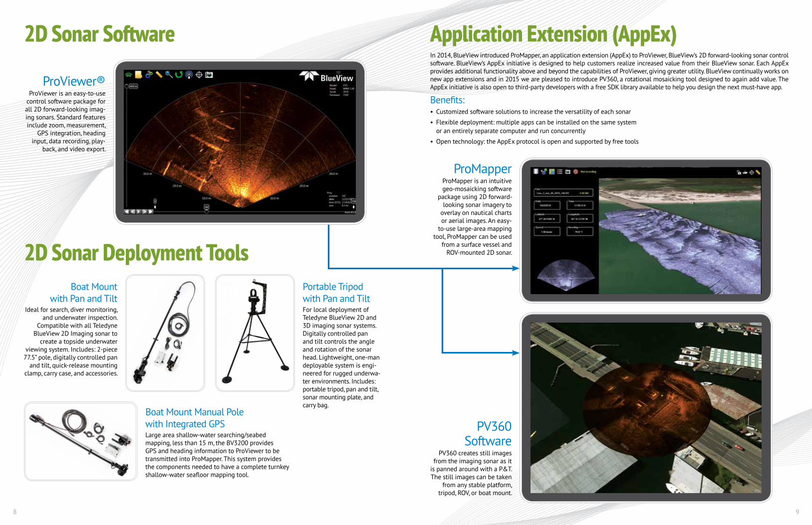
2D Sonar Software
2D Sonar Deployment Tools
Boat Mount Manual Pole with Integrated GPSLarge area shallow-water searching/seabed mapping, less than 15 m, the BV3200 provides GPS and heading information to ProViewer to be transmitted into ProMapper. This system provides the components needed to have a complete turnkey shallow-water seafloor mapping tool.
ProViewer®ProViewer is an easy-to-use
control software package for all 2D forward-looking imag-ing sonars. Standard features include zoom, measurement,
GPS integration, heading input, data recording, play-
back, and video export.
ProMapperProMapper is an intuitive geo-mosaicking software
package using 2D forward- looking sonar imagery to
overlay on nautical charts or aerial images. An easy-
to-use large-area mapping tool, ProMapper can be used
from a surface vessel and ROV-mounted 2D sonar.
PV360 Software
PV360 creates still images from the imaging sonar as it
is panned around with a P&T. The still images can be taken
from any stable platform, tripod, ROV, or boat mount.
Application Extension (AppEx)In 2014, BlueView introduced ProMapper, an application extension (AppEx) to ProViewer, BlueView’s 2D forward-looking sonar control software. BlueView’s AppEx initiative is designed to help customers realize increased value from their BlueView sonar. Each AppEx provides additional functionality above and beyond the capabilities of ProViewer, giving greater utility. BlueView continually works on new app extensions and in 2015 we are pleased to introduce PV360, a rotational mosaicking tool designed to again add value. The AppEx initiative is also open to third-party developers with a free SDK library available to help you design the next must-have app.
Benefits:• Customized software solutions to increase the versatility of each sonar
• Flexible deployment: multiple apps can be installed on the same system or an entirely separate computer and run concurrently
• Open technology: the AppEx protocol is open and supported by free tools
Boat Mount with Pan and Tilt
Ideal for search, diver monitoring, and underwater inspection.
Compatible with all Teledyne BlueView 2D Imaging sonar to
create a topside underwater viewing system. Includes: 2-piece
77.5” pole, digitally controlled pan and tilt, quick-release mounting
clamp, carry case, and accessories.
Portable Tripod with Pan and TiltFor local deployment of Teledyne BlueView 2D and 3D imaging sonar systems. Digitally controlled pan and tilt controls the angle and rotation of the sonar head. Lightweight, one-man deployable system is engi-neered for rugged underwa-ter environments. Includes: portable tripod, pan and tilt, sonar mounting plate, and carry bag.
10 11
Teledyne BlueView multibeam profilers are high-frequency narrow-beam solutions designed to yield high-resolution near-field data. Commercial off-the-shelf solutions or customizable to suit special applications, the profilers are used for a diverse range of applications. Resolution is opti-mized by selecting the appropriate frequency to match the range.
Forming part of BlueView’s 3D system, they are also frequently used for high-resolution gap-fill and seabed mapping applications from AUVs. Recent special integrations have also seen the product used for a variety of offshore applications, such as the scanning of subsea structures or pipe egress monitoring from a lay vessel’s stinger.
Multibeam Profiler
Gap-Fill Software SolutionTeledyne BlueView has developed a software interface to quickly combine the multibeam profiler data with most side-scan data formats to create “gap-free” side-scan data. This software also allows operators to combine the profile point cloud data with other bathymetric data for export into previously mentioned industry-standard point cloud software packages.
Amphora images provided by the Ocean Exploration Trust and University of Rhode Island using MB1350-90.
3D
Applications:
• Gap-Fill
• High-Resolution Site Survey
• Seabed Mapping
• Mine Countermeasures
Product Description:
• 1.35 MHz or 2.25 Mhz
• Hardware trigger—allows remote trigger-ing of single or multiple profiler heads
• 1 PPS pulse—allows for precise time synchronization
• Standard NMEA and XYZi outputs enable simple data export to industry standard packages—Teledyne PDS, EIVA, HYPACK, QPS, LEICA, AUTOCAD, etc.
3D Multibeam Profiler Scanner. ROV deployment.
Multiple deployment
options
Boat deployment.
Topographic profiler data collected from Ocean Exploration Trust and University of Rhode Island using MB1350-90.
Profiler data collected from surface vessel with MB1350-45.
MB2250-N MB2250-W MB1350-N MB1350-WSonar Field-of View 40° 80° 40° 80° Max Range 10 m (32 ft) 10 m (32 ft) 30 m (98 ft) 30 m (98 ft) Optimum Range 0.5-7 m (1.6-23 ft) 0.5-7 m (1.6-23 ft) 1-20 m (3.2-65 ft) 1-20 m (3.2-65 ft) Beam Width 1 x 1° 1 x 1° 1 x 1° 1 x 1° Beam Spacing 0.18° 0.18° 0.18° 0.18° Number of Beams 256 512 256 512 Range Resolution 0.6 cm 0.6 cm 1.1 cm 1.1 cm Update Rate* within Optimum Range Up to 30 Hz Up to 30 Hz Up to 30 Hz Up to 30 Hz Operating Frequency 2.25 MHz 2.25 MHz 1.35 MHz 1.35 MHz
Interface Supply Voltage 12-48 VDC 12-48 VDC 12-48 VDC 12-48 VDC Max Power consumption** 20 W 20 W 20 W 20 W Connectivity Ethernet Ethernet Ethernet Ethernet
Mechanical Depth rating (std/deep) 1000 m (3280 ft) 1000 m (3280 ft) 1000 m (3280 ft) 1000 m (3280 ft) 4000 m (9842 ft) 4000 m (9842 ft) 4000 m (9842 ft) 4000 m (9842 ft) Dimensions*** (L x W x H) 8.2 in x 4.3 in x 4.0 in 8.2 in x 8.1 in x 4.0 in 9.0 in x 11.8 in x 4.4 in 9.0 in x 11.8 in x 4.4 in (std/deep) (4.0 inch can) / (4.0 inch can) / (4.0 inch can) / (4.0 inch can) / 10.4 in x 5.0 in x 5.0 in 10.4 in x 8.1 in x 5.0 in 10.75 in x 6.3 in x 5.0 in 10.75 in x 11.8 in x 5.0 in (5.0 inch can) (5.0 inch can) (5.0 inch can) (5.0 inch can)* Range-dependent** Non-VDSL unit at 24 VDC*** Length does not include connector length
12 13
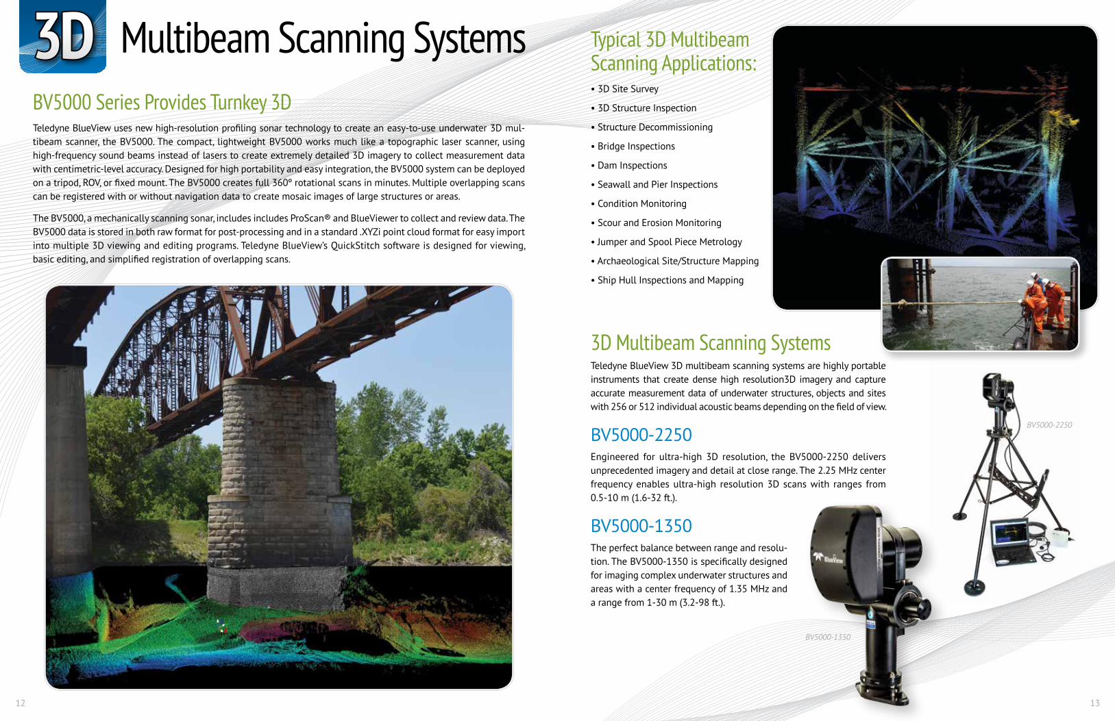
Multibeam Scanning Systems3DBV5000 Series Provides Turnkey 3DTeledyne BlueView uses new high-resolution profiling sonar technology to create an easy-to-use underwater 3D mul-tibeam scanner, the BV5000. The compact, lightweight BV5000 works much like a topographic laser scanner, using high-frequency sound beams instead of lasers to create extremely detailed 3D imagery to collect measurement data with centimetric-level accuracy. Designed for high portability and easy integration, the BV5000 system can be deployed on a tripod, ROV, or fixed mount. The BV5000 creates full 360º rotational scans in minutes. Multiple overlapping scans can be registered with or without navigation data to create mosaic images of large structures or areas.
The BV5000, a mechanically scanning sonar, includes includes ProScan® and BlueViewer to collect and review data. The BV5000 data is stored in both raw format for post-processing and in a standard .XYZi point cloud format for easy import into multiple 3D viewing and editing programs. Teledyne BlueView’s QuickStitch software is designed for viewing, basic editing, and simplified registration of overlapping scans.
Typical 3D Multibeam Scanning Applications:• 3D Site Survey
• 3D Structure Inspection
• Structure Decommissioning
• Bridge Inspections
• Dam Inspections
• Seawall and Pier Inspections
• Condition Monitoring
• Scour and Erosion Monitoring
• Jumper and Spool Piece Metrology
• Archaeological Site/Structure Mapping
• Ship Hull Inspections and Mapping
3D Multibeam Scanning SystemsTeledyne BlueView 3D multibeam scanning systems are highly portable instruments that create dense high resolution3D imagery and capture accurate measurement data of underwater structures, objects and sites with 256 or 512 individual acoustic beams depending on the field of view.
BV5000-2250Engineered for ultra-high 3D resolution, the BV5000-2250 delivers unprecedented imagery and detail at close range. The 2.25 MHz center frequency enables ultra-high resolution 3D scans with ranges from 0.5-10 m (1.6-32 ft.).
BV5000-1350The perfect balance between range and resolu-tion. The BV5000-1350 is specifically designed for imaging complex underwater structures and areas with a center frequency of 1.35 MHz and a range from 1-30 m (3.2-98 ft.).
BV5000-2250
BV5000-1350

14 15
3D 3D Multibeam Scanning Systems (continued)
Teledyne BlueView
3D Scanning ApplicationsInfrastructure Inspection
Archaeology Undercut Evaluation
Pre and Post Remediation/Construction Validation
MultiDetectThe 3D scanning sonar can now be set up to pick multiple points along individual beams; up to 10. Being set by the user during a scan or post-processed into each scan allows users to collect more detail on intricate objects, structures, and areas scanned.
QuickScan3D scanning sonar operators can now select scan speed in the setup window (up to 10° a second) prior to conducting each scan. By optimizing the ping rate for the working environ-ment and increasing the speed of each scan, on a project with multiple drop locations the operator can reduce the amount of time needed to complete the project.
MotionScan3D scanning can now be accomplished from a dynamic platform with integration of heading, pitch, roll and posi-tion sensors. These sensors will compensate for movement, and 3D scanning data can be collected from a surface ves-sel or an ROV that is not completely stable.
New 3D Scanning Features
MultiDetect OFF.
MultiDetect ON.
BV5000-1350 BV5000-2250 Sonar Field-of View 40° 40° Max Range 30 m (98 ft) 10 m (32 ft) Optimum Range 1-20 m (3.2-65 ft) 0.5-7 m (1.6-23 ft) Beam Width 1 x 1° 1 x 1° Beam Spacing 0.18° 0.18° Number of Beams 256 256 Range Resolution 1.1 cm (0.43 in) 0.6 cm (0.25 in) Update Rate* within Optimum Range Up to 30 Hz Up to 30 Hz Operating Frequency 1.35 MHz 2.25 MHz
Interface Supply Voltage 110-260 VAC or 24 VDC 110-260 VAC or 24 VDC Max Power Consumption** 45 W 45 W Connectivity Ethernet / USB Ethernet / USB
Mechanical Depth rating (std/deep) 1000 m (3,280 ft) / 3000 m (9,842 ft.) 1000 m (3,280 ft) / 3000 m (9,842 ft.) Sonar, Pan and Tilt dimensions (L x W x H) (std/deep) 9.0 in x 10.4 in x 16.8 in / 10.8 in x 10.4 in x 16.8 in 8.2 in x 10.4 in x 16.8 in / 10.4 in x 10.4 in x 16.8 in Tripod dimensions*** (H x W) 36 in x 40 in 36 in x 40 in* Range-dependent** Non-VDSL unit at 24 VDC*** Tripod legs telescope to 60 in x 60 in
3D MULTIBEAM TECHNICAL SPECIFICATIONS
16 17
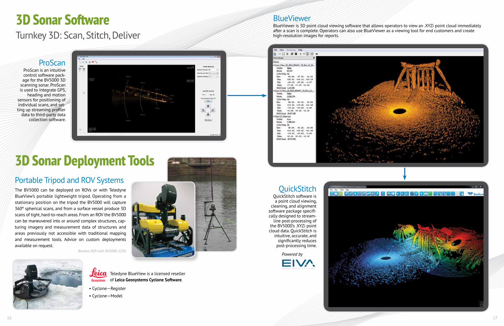
3D Sonar SoftwareTurnkey 3D: Scan, Stitch, Deliver
Teledyne BlueView is a licensed reseller of Leica Geosystems Cyclone Software.
• Cyclone—Register
• Cyclone—Model
BlueViewerBlueViewer is 3D point cloud viewing software that allows operators to view an .XYZi point cloud immediately after a scan is complete. Operators can also use BlueViewer as a viewing tool for end customers and create high-resolution images for reports.
ProScanProScan is an intuitive control software pack-age for the BV5000 3D
scanning sonar. ProScan is used to integrate GPS,
heading and motion sensors for positioning of individual scans, and set-ting up streaming profiler
data to third-party data collection software.
3D Sonar Deployment ToolsPortable Tripod and ROV SystemsThe BV5000 can be deployed on ROVs or with Teledyne BlueView’s portable lightweight tripod. Operating from a stationary position on the tripod the BV5000 will capture 360º spherical scans, and from a surface vessel produce 3D scans of tight, hard-to-reach areas. From an ROV the BV5000 can be maneuvered into or around complex structures, cap-turing imagery and measurement data of structures and areas previously not accessible with traditional mapping and measurement tools. Advice on custom deployments available on request.
Benthos ROV with BV5000-1350.
QuickStitchQuickStitch software is a point cloud viewing,
cleaning, and alignment software package specifi-cally designed to stream-
line post-processing of the BV5000’s .XYZi point
cloud data. QuickStitch is intuitive, accurate, and
significantly reduces post-processing time.
Powered by
18 19
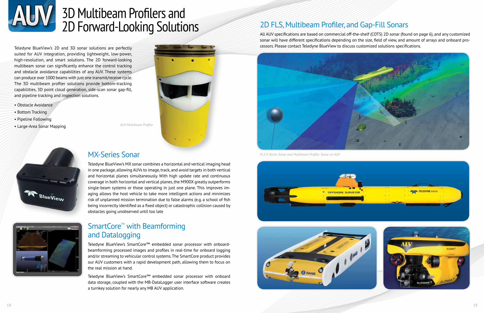
3D Multibeam Profilers and 2D Forward-Looking SolutionsAUV
Teledyne BlueView’s 2D and 3D sonar solutions are perfectly suited for AUV integration, providing lightweight, low-power, high-resolution, and smart solutions. The 2D forward-looking multibeam sonar can significantly enhance the control tracking and obstacle avoidance capabilities of any AUV. These systems can produce over 1000 beams with just one transmit/receive cycle. The 3D multibeam profiler solutions provide bottom-tracking capabilities, 3D point cloud generation, side-scan sonar gap-fill, and pipeline tracking and inspection solutions.
• Obstacle Avoidance
• Bottom Tracking
• Pipeline Following
• Large-Area Sonar Mapping
MX-Series SonarTeledyne BlueView’s MX sonar combines a horizontal and vertical imaging head in one package, allowing AUVs to image, track, and avoid targets in both vertical and horizontal planes simultaneously. With high update rate and continuous coverage in both horizontal and vertical planes, the M900X greatly outperforms single-beam systems or those operating in just one plane. This improves im-aging allows the host vehicle to take more intelligent actions and minimizes risk of unplanned mission termination due to false alarms (e.g. a school of fish being incorrectly identified as a fixed object) or catastrophic collision caused by obstacles going unobserved until too late
SmartCoreTM with Beamforming and DataloggingTeledyne BlueView’s SmartCore™ embedded sonar processor with onboard-beamforming processed images and profiles in real-time for onboard logging and/or streaming to vehicular control systems. The SmartCore product provides our AUV customers with a rapid development path, allowing them to focus on the real mission at hand.
Teledyne BlueView’s SmartCore™ embedded sonar processor with onboard data storage, coupled with the MB-DataLogger user interface software creates a turnkey solution for nearly any MB AUV application.
2D FLS, Multibeam Profiler, and Gap-Fill SonarsAll AUV specifications are based on commercial off-the-shelf (COTS) 2D sonar (found on page 6), and any customized sonar will have different specifications depending on the size, field of view, and amount of arrays and onboard pro-cessors. Please contact Teledyne BlueView to discuss customized solutions specifications.
AUV Multibeam Profiler
FLS X Series Sonar and Multibeam Profiler Sonar on AUV
20 21
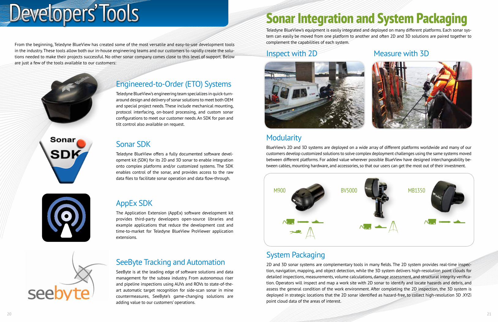
Sonar Integration and System PackagingTeledyne BlueView’s equipment is easily integrated and deployed on many different platforms. Each sonar sys-tem can easily be moved from one platform to another and often 2D and 3D solutions are paired together to complement the capabilities of each system.
ModularityBlueView’s 2D and 3D systems are deployed on a wide array of different platforms worldwide and many of our customers develop customized solutions to solve complex deployment challenges using the same systems moved between different platforms. For added value wherever possible BlueView have designed interchangeability be-tween cables, mounting hardware, and accessories, so that our users can get the most out of their investment.
System Packaging2D and 3D sonar systems are complementary tools in many fields. The 2D system provides real-time inspec-tion, navigation, mapping, and object detection, while the 3D system delivers high-resolution point clouds for detailed inspections, measurements, volume calculations, damage assessment, and structural integrity verifica-tion. Operators will inspect and map a work site with 2D sonar to identify and locate hazards and debris, and assess the general condition of the work environment. After completing the 2D inspection, the 3D system is deployed in strategic locations that the 2D sonar identified as hazard-free, to collect high-resolution 3D .XYZi point cloud data of the areas of interest.
M900 BV5000 MB1350
Inspect with 2D Measure with 3D
Developers’ ToolsFrom the beginning, Teledyne BlueView has created some of the most versatile and easy-to-use development tools in the industry. These tools allow both our in-house engineering teams and our customers to rapidly create the solu-tions needed to make their projects successful. No other sonar company comes close to this level of support. Below are just a few of the tools available to our customers:
Engineered-to-Order (ETO) SystemsTeledyne BlueView’s engineering team specializes in quick-turn-around design and delivery of sonar solutions to meet both OEM and special project needs. These include mechanical mounting, protocol interfacing, on-board processing, and custom sonar configurations to meet our customer needs. An SDK for pan and tilt control also available on request.
Sonar SDKTeledyne BlueView offers a fully documented software devel-opment kit (SDK) for its 2D and 3D sonar to enable integration onto complex platforms and/or customized systems. The SDK enables control of the sonar, and provides access to the raw data files to facilitate sonar operation and data flow-through.
AppEx SDKThe Application Extension (AppEx) software development kit provides third-party developers open-source libraries and example applications that reduce the development cost and time-to-market for Teledyne BlueView ProViewer application extensions.
SeeByte Tracking and AutomationSeeByte is at the leading edge of software solutions and data management for the subsea industry. From autonomous riser and pipeline inspections using AUVs and ROVs to state-of-the-art automatic target recognition for side-scan sonar in mine countermeasures, SeeByte’s game-changing solutions are adding value to our customers’ operations.
22 23
Sonar Deployment AccessoriesEngineered for quick and easy deployment of Teledyne BlueView 2D imaging sonar systems.
Pan and TiltA pan and tilt allows opera-tors with directional control of the sonar. From a fixed platform, vessel, or moving platform, a pan and tilt helps optimize orientation and grazing angle to provide the clearest imagery.
Heavy PlateThe heavy deployment plate allows operators to success-fully deploy a BV5000 or a 2D sonar with pan and tilt to the bottom in higher current situations or in areas where a tripod or ROV would be unsuited, e.g. where the gradient of sea/lake/river bed is rapidly changing or where a user wishes to image close in under a structure.
Sonar Reference TargetSRTs are used to help distin-guish common overlapping sections of scans in areas that are featureless. The SRTs help data processors register more accurately and quickly with the easily identifiable common object.
EXC-600 Ethernet ExtenderExtends sonar communica-tion over copper wires from 200ft to <2,000 ft.
CablesA wide variety of cables to test and operate our 2D and 3D systems. Available in the standard lengths:• Sonar cables • Cable whips• Sonar, pan and tilt cablesStandard connectors in-clude: Impulse MKS, Burton, and SeaNet (alternative available on request)
Sonar ClampEngineered to fit all Tele-dyne BlueView 2D and 3D sonar, these 4” and 5” O.D. clamps allow quick on-and-off mounting onto an ex-isting structure or platform. Rugged, lightweight clamp features two (2) heavy duty bolt-mounting points for easy installation
Teledyne BlueView Extended WarrantiesProtect your underwater vision investments with an extended warranty from Teledyne BlueView, Inc. Extended warranties are available for all imaging sonar systems and can be purchased in 1-year increments. Contact Teledyne BlueView Customer Support for details at +1-425-492-7400 or via email at [email protected].
Accessories BlueView TrainingTeledyne BlueView’s training programs provide customers with theoretical, hands-on, and in-the-field experience to prepare participants for real-world scenarios. We know our customers’ time is valuable, so courses are designed to transfer knowledge from the trainers to students efficiently and effectively. Courses can be held at the customer’s facil-ity, at Teledyne BlueView’s headquarters, or at a specified location. The program length and content depends on the purchased equipment; usually 1-3 days with a mixture of in-classroom presentations/activities and in-the-field hands-on activities.
Teledyne BlueView also has a regularly scheduled 3-day comprehensive course for the entire product line called BlueView University (BVU). This course is designed to train individuals on the operation, usage, and im-plementation of Teledyne BlueView’s 2D and 3D sonar systems.
Course Outline:• Introduction to the Teledyne
BlueView Product Line
• Basic Sonar Theory
• 2D User Training (software, equipment, applications, and best-use practices)
• 3D User Training (software, equipment, applications, and best-use practices)
• 3D Data Review, Reprocess, and Registration
• Project Planning using TBV Products
• Equipment Maintenance Procedures
A Teledyne Marine Company
A Teledyne BlueView Product Guide
Specifications subject to change without notice. © 2015 Teledyne BlueView, Inc. All rights reserved.
Teledyne BlueView18702 North Creek Parkway, Suite 100, Bothell, WA 98011 USA Tel. +1-425-492-7400 • Fax +1-425-492-7401 • E-mail: [email protected]
For more information visit the Teledyne BlueView website.
• Sample Data
• Software
• Case Studies
• News
• Drawings
• Manuals