Embed Size (px)
Citation preview

Telecom Implementation

Conceptual Diagram of PDA/ Mobile Conceptual Diagram of PDA/ Mobile ApplicationApplication
User & User & Role Role
ManagemeManagementnt
GEO GEO Spatial Spatial Data Data
MaintenanMaintenance Using ce Using MobileMobile
CustomizeCustomized Query d Query
Builder & Builder & Analysis Analysis Report Report

Total SolutionTotal Solution
User(APCCF, CCF, DFO, RFO)
Database Server
Application Server
GIS Server
WebGIS
Content Authoring
Hosting
Connectivity

1. MIS Functionalities in PDA: MIS functionality like Event Reporting, Registering of First Investigation Report, Passing of Vouchers, nursery
operations will be handled by this application
2. GIS Functionalities in PDA: Real time tracking of the Forest Beat security with position information such as the exact location, speed and
the time. Geo-coding of the locations / species if any along the trail of the route. Ability to calculate the distance traveled and route between the two points. Integrate with the Digital Maps of Forest (Presuming that GIS data is available). It shall be sole responsibility of
GIPL / Gujarat Forest department to provide digital data. Development of interface with GPRS network and Tetra network as appropriate. Tracing the Location of each PDA that is in the field Verifying of the location of Forest Boundary Pillars details along with their location. Tracing / Location of Plantation and Nursery details. Audit log of movement of personnel. Interfacing to Gujarati and English. User Access Control Management. Interfacing to the MIS database. Capturing and Uploading Polygon details, drainage lines, boundary lines etc. from PDA application to the
Central server in the DC. Processing the captured data from PDA, generating MIS reports, alerts, etc. Query Tool. OTAR
Scope of PDA/Smart phone based Protection, Scope of PDA/Smart phone based Protection, Surveillance and Tracking System For Gujarat Surveillance and Tracking System For Gujarat
Forest DepartmentForest Department

System ArchitectureSystem Architecture
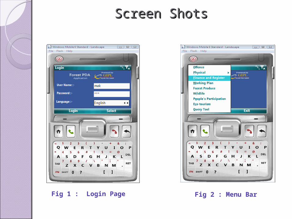
Screen ShotsScreen Shots
Fig 1 : Login Page Fig 2 : Menu Bar

Mobile GIS ApplicationMobile GIS Application
Map display Map Menu
Zoom InZoom Out

Provision for the Over the Air Updates (OTAR) of the mobile application. Command Control Room provides visibility of entire forest staff on single
forest map. Control room officer allocate and dispatch reinforcement in case of SOS
Emergency. GPS fitted in Windows mobile of forest staff collects his locations
information and transmits it back to the Control room via GSM Network. The communication system which is dispatcher operated should receive
SOS from be forest staff, gather geographical and other details , identify proximate forest staff or re-enforcement, send instruction and generate reports based on queries.
Three types of communication mode needs to be implemented 1.Voice 2.Text 3. Email for SOS recording as well as forwarding.
[contd.]
Command Control Room Command Control Room Application (Integrated Web Application (Integrated Web
Application)Application)

Tree Cutting EventTree Cutting Event

Online tracking of Forest PersonnelOnline tracking of Forest Personnel

GIS data editingGIS data editing
Edit spatial and Non-spatial data with single window
Track the edits
Synchronize the data with MIS
Sketch tools for point, line and polygon

. . . .
..