Embed Size (px)
Citation preview

Tectonophysics, 180 (1990) 123-137
Elsevier Science Publishers B.V., Amsterdam - Printed in The Netherlands
123
Holocene tectonic deformation along the western margins of the Dead Sea
Michael Gardosh, Ze’ev Reches and Zvi Garfunkel
Department of Geology, Hebrew University, Jerusalem, 91904 (Israel)
(Revised version accepted July 1,1989)
ABSTRACT
Gardosh, M., Reches, Z. and Garfunkel, Z., 1990. Holocene tectonic deformation along the western margins of the Read Sea. In: R.L. Kovach and Z. Ben-Avraham (Editors), Geologic and Tectonic Processes of the Dead Sea Rift Zone. Tecto~ophys~cs, 180: 123-137.
To assess the young tectonic activity along the western margins of the Dead Sea and north of the lake, faults were studied within sediments which are up to 60,000 years old. The western margins of the Dead Sea are dominated by normal, step faults which are exposed up to 2 km east of the morphological escarpment of the basin. The rate of subsidence accommodated by these normal faults is estimated to be about 0.85 mm/y. The distribution of the faults suggests that Holocene fault activity was most intense in the northwestern comer of the Dead Sea. North of the lake, left-lateral slip along the Jordan fault produced both local compression and extension. Small reverse faults and folds exposed along this fault indicate a minimum left-lateral slip rate of 0.7 mm/y.
The Dead Sea basin is a pull-apart structure, about 15 km by 80 km in ‘size, located along the Dead Sea transform (Fig. 1). Like other pull-aparts along the transform, it was formed mainly in post-Miocene times (e.g. Garfunkel, 1981). Our objective here is to resolve some details of the Holocene deformation and its rate. For this pur- pose we studied in detail the Holocene faulting along the western margins of the Dead Sea and north of the lake.
Young normal faults were traced on aerial pho- tographs and sought in the field. The displace- ments of Holocene and Late Pliestocene sediments were measured in exposures along stream banks, and detailed topo~ap~c profiles were measured across well-preserved fault scarps (Fig. I>. The strike-slip motion was studied along the main strike-slip fault of the Dead Sea transform, east of Jericho (Figs. 1 and 2).
The Dead Sea transform separates the Sinai- Israel subplate, which is a part of the African plate, from the Arabian plate (Fig. 1) (Freund, 1965; Garfunkel, 1981). The transform has had a cumulative left-lateral displacement of about 105 km since the Miocene. Several pull-apart basins and push-up swells developed along the trans- form. The Dead Sea basin is one of the largest and deepest pull-aparts in this system, being 80 km long and 5-15 km wide.
This basin is bounded by two strike-slip faults, the Jordan and the Arava faults (Garfunkel et al., 1981) (Fig. 2). The Jordan fault can be traced from the west side of the Dead Sea (Neev and Hall, 19X), through the Jordan Valley. The Arava fault can be traced from the west side of the northern Gulf of Elat to the east side of the Dead Sea basin (Fig. 1). In the west and east the Dead
~-1951/~/$03.50 @ 1990 - Elsevier Science Publishers B.V.

124 M. GARDOSH ET AL
Fig. 1. Lucation map of the study area.
HOLOCENE TECTONISM ON THE DEAD SEA MARGINS 125
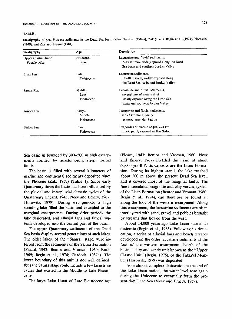
TABLE 1
Stratigraphy of post-Pliocene sediments in the Dead Sea basin (after Gardosh (1987a), Zak (1967), Begin et al. (1974), Horowitz (1979), and Zak and Freund (1981)
Stratigraphy Age
Upper Clastic Unit/ Holocene-
Fatza’el Mbr. Present
Description
Lacustrine and fluvial sediments, 2-15 m thick, widely spread along the Dead Sea basin and southern Jordan Valley
Lisan Fm. Late Pleistocene
Lacustrine sediments, lo-40 m thick, widely exposed along the Dead Sea basin and Jordan Valley
Samra Fm. Middle- Late Pleistocene
Lacustrine and fluvial sediments, several tens of meters thick,
locally exposed along the Dead Sea basin and southern Jordan Valley
Arnora Fm.
Sedom Fm.
Early- Middle Pleistocene
Plio- Pleistocene
Lacustrine and fluvial sediments, 0.5-3 km thick, partly exposed near Har Sedom
Evaporites of marine origin, 2-4 km thick, partly exposed at Har Sedom
Sea basin in bounded by 300-500 m high escarp- ments formed by anastomosing steep normal faults.
The basin is filled with several kilometers of marine and continental sediments deposited since the Pliocene (Zak, 1967) (Table 1). Since early Quaternary times the basin has been influenced by the pluvial and interpluvial climatic cycles of the Quatemary (Picard, 1943; Neev and Emery, 1967; Horowitz, 1979). During wet periods, a high standing lake filled the basin and extended to the marginal escarpments. During drier periods the lake desiccated, and alluvial fans and fluvial sys- tems developed into the central part of the basin.
The upper Quatemary sediments of the Dead Sea basin display several generations of such lakes. The older lakes, of the “Samra” stage, were in- ferred from the sediments of the Samra Formation (Picard, 1943; Bentor and Vroman, 1960; Roth, 1969; Begin et al., 1974; Gardosh, 1987a). The lower boundary of this unit is not well defined; thus the Samra stage could include a few lacustrine cycles that existed in the Middle to Late Pleisto- cene.
The large Lake Lisan of Late Pleistocene age
(Picard, 1943; Bentor and Vroman, 1960; Neev and Emery, 1967) invaded the basin at about 60,000 yrs B.P. Its deposits are the Lisan Forma- tion. During its highest stand, the lake reached about 200 m above the present Dead Sea level, and it covered most of the marginal faults. The fine intercalated aragonite and clay varves, typical of the Lisan Formation (Bentor and Vroman, 1960; Begin et al., 1974), can therefore be found all along the foot of the western escarpment. Along this escarpment, the lacustrine sediments are often interlayered with sand, gravel and pebbles brought by streams that flowed from the west.
About 14,000 years ago Lake Lisan started to desiccate (Begin et al., 1985). Following its desic- cation, a series of alluvial fans and beach terraces developed on the older lacustrine sediments at the foot of the western escarpment. North of the basin, a silty and sandy unit known as the “Upper Clastic Unit” (Begin, 1975), or the Fatza’el Mem- ber (Horowitz, 1979) was deposited.
From almost complete desiccation at the end of the Lake Lisan period, the water level rose again during the Holocene to eventually form the pre- sent-day Dead Sea (Neev and Emery, 1967).
32.‘00’ JORDAN RIVER
LEGEND y* CSctive Faults
4. * Active Diapirs - Other Faults
M. GARDOSH ET AI
Holocene tectonic features
~or~ul fudts of the western margin of the Dead
Sea basin
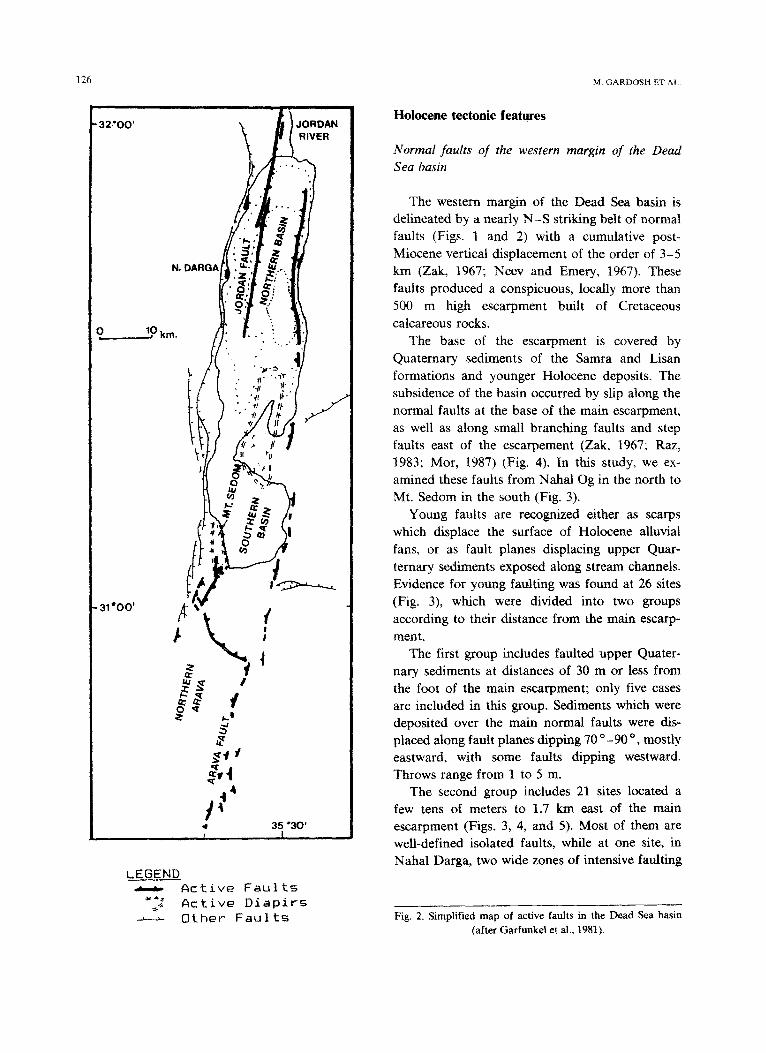
The western margin of the Dead Sea basin is delineated by a nearly N-S striking belt of normal faults (Figs. 1 and 2) with a cumulative post- Miocene vertical displacement of the order of 3-5 km (Zak, 1967; Neev and Emery, 1967). These faults produced a conspicuous, locally more than 500 m high escarpment built of Cretaceous calcareous rocks.
The base of the escarpment is covered by Quaternary sediments of the Samra and Lisan formations and younger Holocene deposits. The subsidence of the basin occurred by slip along the normal faults at the base of the main escarpment, as well as along small branching faults and step faults east of the escarpement (Zak, 1967; Raz, 1983; Mor, 1987) (Fig. 4). In this study, we ex- amined these faults from Nahal Og in the north to Mt. Sedom in the south (Fig. 3).
Young faults are recognized either as scarps which displace the surface of Holocene alluvial fans, or as fault planes displacing upper Quar- ternary sediments exposed along stream channels. Evidence for young faulting was found at 26 sites (Fig. 3), which were divided into two groups according to their distance from the main escarp- ment.
The first group includes faulted upper Quater- nary sediments at distances of 30 m or less from the foot of the main escarpment; only five cases are included in this group. Sediments which were deposited over the main normal faults were dis- placed along fault planes dipping 70 o -90 O, mostly eastward, with some faults dipping westward. Throws range from 1 to 5 m.
The second group includes 21 sites located a few tens of meters to 1.7 km east of the main escarpment (Figs. 3, 4, and 5). Most of them are well-defined isolated faults, while at one site, in Nahal Darga, two wide zones of intensive faulting
Fig. 2. Simplified map of active faults in the Dead Sea basin (after Garfunkel et al., 1981).

HOLOCENE TECTONISM ON THE DEAD SEA MARGINS
N. KIDRON
DEAD SEA
Fig. 3. Location of active faults found in the present study.
1
127
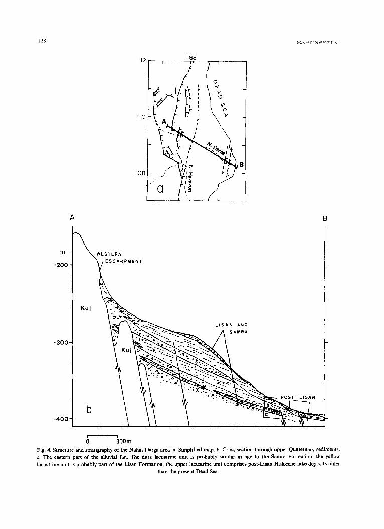
appear. These two zones are about 200 m apart, 1.5 km east of the escarpment (Fig. 4~). The western zone is 50 m wide and it contains many tens of faults and listric detachment surfaces. These faults disturb sediments of the base of the Lisan Formation, but they do not disturb the overlying sediments. The eastern zone is 30 m wide and it contains seven normal faults which offset sediments younger than the Lisan Forma- tion. The age difference between the sediments in these two zones indicates that the eastern zone is at least 50,000 years younger than the western zone. The faults in both zones indicate extension in the ESE-WNW direction.
Fault scarps on alluvial fans in Nahal Kidron
Scarp geomeby Fault scarps on surfaces of alluvial fans are the
most conspicuous expression of Holocene faulting. Such scarps were found at several sites and they are most clearly developed in the Nahal Kidron area, which is described here (Fig. 5).
The alluvial fans in Nahal Kidron area cover a 7 km long and 0.5-1.5 km wide region between the western escarpment and the Dead Sea shore (Fig. 5). They are composed of unconsolidated, poorly sorted, subangular to angular gravel peb- bles and boulders mostly derived from the calcare-
ous rocks of the escarpment and are interlayered with thin beds of silt and sand. These alluvial deposits form a 2-5 m thick cover on the soft lacustrine beds of the Lisan Formation. The fans were deposited on the shores of Lake Lisan by streams which flowed from the west. The wave
action along the shores produced horizontal beach terraces (Bowman, 1971). The gradual retreat of the lake exposed the alluvial fans, which still re- tain their original slope of 6 “-8 o eastward.
The fault scarps in the Nahal Kidron area offset the upper part of the Lisan Formation and the overlying alluvial deposits. The scarps range in length from a few tens of meters to more than 1 km. Two scarps are 1.5 km long (Fig. 5). The scarps trend N-S, subparallel to the main fault escarpment, and most of them face eastward. We found seven small grabens that form 15-40 m wide depressions (Fig. 5). Soils which accumulated
128
m
-200
-400
B
ESCARPNlENT
LISAN AHD
SAMRA
0- 300m
Fig. 4. Structure and stratigraphy of the Nahal Darga area a. Simplified map. b. Cross section through upper Quaternary se&nents.
c. The eastern part of the alluvial fan. The dak lacustrine unit is probably similar in age to the Samra Formation, the yellow
lacustrine unit is probably part of the Lisan Formation, the upper lacustrine unit comprises post-Lisan Holocene lake deposits older than the present Dead Sea.

HOLOCENE TECTONISM ON THE DEAD SEA MARGINS 129
-E-
_~lOOm _ LEGEND
FINE GRAIN LACUSTRINE
SEDIMENTS
FLUVIAL SEDIMENTS
CRETACEOUS CARBONATES
Fig. 4 (continued).
in these elongated depressions support some vege- tation due to their poor drainage.
The fault scarps differ from the beach terraces mentioned above by being discontinuous, locally bent, and by forming small grabens. They also lack the cover of large boulders typical of the beach terraces (Bowman, 1971). Furthermore, while beach terraces are always horizontal, some fault scarps are slightly inclined.
The geometry of 29 fault scarps and 18 beach terraces was measured. The maximum slope angle of the scarps ranges from 14” to 50 ‘, with one case of 80” (Fig. 6). According to Wallace (1977), the maximum slope angle in unconsolidated sedi- ments is an age indicator: the steeper the angle, the younger the slip event. Following the scarp terminology of Wallace (1977), we recognize three groups: Seventeen scarps of WC&I slopes with max- imum slope angles of 15 “-25 ‘, eight scarps of debris slopes with maximum angles of 30”-37 O, and four scarps of free faces with maximum an- gles of 40 “-80° (Fig. 6). All the slopes of the measured beach terraces are smaller than 35 O.
The height of the fault scarps allows us to estimate the vertical fault displacement (Wallace,
1980). In Nahal Kidron, the heights of the scarps range from 0.6 to 7.5 m, with one exceptional case of 20 m. The heights vary along the individual scarps. For example, the 20 m height measured on a scarp north of Nahal Kidron (Fig. 5) decreases to 4 m a few hundred meters northward. Since both the crest and the toe of a fault scarp tend to shift due to the degradation of the original fault plane, the measured scarp height is not equal to the original vertical fault displacements (Fig. 7). Wallace (1980) proposed correcting for this effect by measuring the misalignment of the two seg- ments of the faulted surface (Fig. 7). Application of this method to fourteen faults in the Nahal Kidron area yielded displacements ranging from 0.7 to 5.2 m.
Age of the fault scarps The fault scarps in Nahal Kidron obviously
postdate the disturbed fan sediments. These fans were deposited above the Lisan Formation, during the desiccation of Lake Lisan. The desiccation began about 14,000 years ago and the lake reached its lowest level about 2000 years later (Begin et al., 1985). Several scarps appear between beach ter-

130 M. GARDOSH El 4,.
LEGEND
Fault scarp
Beach terrace __---
S”spected fault scarp -
Main escarpment Of
western border faults
Stream
-.-.-
. -.-,. -4.
Topographic profile
acrc.*s fault Icarp
1 lkm
Fig. 5. Fault scarps which offset Holocene alluvial fans in the Nahal Kidron area in the northwestern comer of the Dead Sea.

HOLOCENE TECTONISM ON THE DEAD SEA MARGINS
-290 w E
rn6,mlanR
-3&J-
-310 -
Fig. 6. Profiles across eroded fault warps and grabens. Nahal Kidron area locations in Fig. 5.
races and locally cut these terraces. Thus, the scarps formed when the water level was low and they are younger than 13,000 years old.
131
We found only four free faces (see above). Wallace (1977) estimated that in the arid climate of north-central Nevada, free faces in unconsoli-
dated sediment are degraded after about 2000 years. We estimate that in the Dead Sea area too, free faces indicate events which occurred during the last 2000 years.
Figure 8 show the relationships between the maximum slope angle of the fault scarps and the scarp height for Nahal Kidron faults. The slope- height relationships in unconsolidated sediments are considered by several authors as indicators of the degradation rate of fault scarps. Bucknam and Anderson (1979) studied young faults in central Utah and found empirically that the slope angle is proportional to the logarithm of scarp height and decreases with age. Nash (1980) used diffusion analysis to show that the maximum scarp angle is nonlinearly proportional to the height and age of the scarp. He utilized Bucknam and Anderson’s (1979) measurements of 12,000 year old faults to derive the degradation parameters for the young fault scarps in Utah (eqn. 6 in Nash, 1980).
The slope-height data for Nahal Kidron scarps (Fig. 8) are not sufficient for determining the degradation parameters of the Dead Sea area. Thus, we used the relationships derived by Buck- nam and Anderson (1979) for comparison (con-
-354
-356
-358
-380
-382
-364
-368
3 -368
f -370
cr
i -372
-374
-376
-378
-380
-382
-384
FAN SLOPE= 7’
\
FAULT DIP= 70
AH= 7.5m \
AD- 5.2m
\ , , , I I t i
0 20 40 60 6D
DISTANCE (m)
Fig. 7. Estimate of the vertical displacement along faults in Nahal Kidron using the method of Wallace (1980) shown in the insert. AH-height of scarp; AD = vertical component of fault displacement. Profile 9.

132 M GARDOSH ET AL.
50
40
2
3 30
it
s
s 20
R
d
10
0
2 4 6 a
SCARP HElGhl (ml 0 measured slops
Fig. 8. Height-slope relationships in fault scarps. Squares indicate scarp height versus maximum slope in the Nahal Kidron area: continuous curves indicate the slope angles determined by empirical height-slope relationships of scarps in Utah, the upper curve for scarps which are a few thousand years old (Fish Spring site) and the lower curve for scarps which are 12,000 years old (Drum Mts.
site) (Bucknam and Anderson, 1979).
tinuous curves in Figure 8). The curves appear to Holocene subsidence rate
bound the data points of the Nahal Kidron scarps. The subsidence of the Dead Sea basin in Nahal
This apparent similarity of the slope-height rela- Kidron area was computed for profiles 9 and 6
tionships in central Utah and in the Dead Sea marked in Fig. 5. The two profiles, each a few
suggests, a similarity of degradation rates. hundred meters long, trend E-W and intersect
-320
-330
-340
PROFILE 6
0 40 60 120 160 200 240
DISTANCE (m)
Fig. 9. Subsidence due to faulting along profile 6 (location in Fig. 5). V.T. = vertical throw; the cumulative subsidence atong this profile is 13.3 m.

133 HOLOCENE TECTONISM ON THE DEAD SEA MARGINS
121
i )
LEGEND
ROCKS OLDER THAN LISAN Fm.
MAIN STRIKE SLIP FAULT, DASHED WHERt INFERRED
MAIN NORMAL FAULTS
120 10
Fig. 10. The southern end of the Jordan fault and the northwestern comer of the Dead Sea (after Reches and Hoexter, 1981). Location 1 and 2 are the trenches of Reches and Hoexter (1981), location 3 is the trench investigated in the present study.
two and seven faults respectively (Fig. 7 and 9). The cumulative subsidence due to the slip along the faults intersected by the two profiles is 8.2 and 13.3 m. Thus, the mean subsidence rate in the Nahal Kidron area for the last 13,000 years is 0.83 mm/y. This is a minimum value as internal defor- mation, overall tilting of the alluvial fan and ad-
ditional faults that may be active away from the profiles were ignored.
Strike-slip motion along the Jordan fault
The Jordan fault is the dominant strike-slip segment north of the Dead Sea basin. This seg-

134 M. GARDOSH ET AL.
ment extends for more than 100 km from the western side of the Dead Sea to the Sea of Galilee. It displaces the Lisan Formation and younger fill of the Jordan Valley (Fig. 10) (Garfunkel et al., 1981). The magnitude of the horizontal offset along the Jordan fault during the Quatemary has not been determined in the field.
Reches and Hoexter (1981) studied the histori- cal activity of the Jordan fault east of Jericho.
They mapped the young sediments along the fault in several up to 4.5 deep trenches near Ein Hagla (Fig. 10). Pottery found in these trenches ranges in age from a few hundred years to 3000 years old. These authors found evidence for two earthquakes at approximately 2000 and 1200 yrs B.P., and measured 3.5 m of local subsidence to have oc- curred during the last 2000 years. In some trenches, Late Pleistocene layers are folded with dips of up to 90°, whereas in other trenches the same layers are offset by normal faults and crossed by open fissures. These local variations from compression to extension are probably related to undulations in the surface of the Jordan fault.
Fig. 10). We found a 20 m wide zone of compres- sive structures along the Jordan fault, including open folds and flexures with dips of up to 28”, and several reverse faults which dip between 37 ‘/116’ and 85°/1160 (Fig. 11). The vertical offset along the reverse faults is 0.3-1.6 m. At this site, the Jordan fault changes its regional strike from NlO” E (Reches and Hoexter, 1981) to N26” E (Fig. 10). Thus, these compressive struc- tures comprise a small push-up swell resulting from the left-lateral slip.
The deformed sediments in the trenches are part of the Lisan Formation and younger sedi- ments of the Upper elastic Unit of Begin (1975). The Lisan beds comprise typical alternations of aragonite and clay varves. The Upper Clastic Unit is 7.5 m thick here; the lower half includes brow- nish red laminated clay and silt and sand layers, and the upper half is a massive layer of sand and silt with some lenses of pebbles (Fig. 11).
We studied the deformation of Lisan and post-
Lisan sediments in two new 3 m deep trenches dug north of Ein Hagla and close to the trenching site of Reches and Woexter (1981) (location 3 in
Two lines of evidence suggest that the upper part of the post-Lisan sediments at this site is younger than 4000 years old. First, terrestrial snails collected from this layer south of the compressive structures were examined by ammo acid racmiza- tion and estimated to have an age of 30004000 years B.P. (Goodfriend, pers. commun.). Second,
-N-
I
l,lSAN FM. UPPER CLASTIC MBR.
ARAGONITE AND CLAY VARVES CLAY
._. _- El , ._‘_ SAND AND SILT
b FINE CONGLOMERATE
Fig. 11. The compressive structures exposed in the trench north of Ein Ha& (location 3 in Fig. 10). Here, the Jordan fault, in the center of the structure, strikes N26”E.

HOLOCENE TECTONISM ON THE DEAD SEA MARGINS 135
this layer is similar in appearance to, and it can be correlated with, the sediments found in the
trenches studied by Reches and Hoexter (1981) about 500 m southward (Fig. lo), which contain pottery artifacts that are 3000 years old or younger. Based on these age estimates, the age of the fault- ing and folding of this layer is 3500-4000 yrs at most.
To calculate the shortening associated with the structures shown in Fig. 11 we compared the length of the folded layers with the horizontal distance between the two end points of the fold and also used the inclinations and the vertical throws of the faults. The total calculated horizon- tal shortening in the N26OE direction (coincident with the local strike of the Jordan fault) is 2.4 m. Because the fault surface at the site changes its strike from N1O”E to N26”E, the calculated shortening across the N26 o E segment is the least amount of left-lateral displacement along the Jordan fault (Fig. 10). For the 3500-4000 yrs estimated age of the deformed sediments, and the 2.4 m calculated shortening, the smallest rate of left-lateral slip along the Jordan fault is about 0.7 mm/yr. The implications of this rate are discussed below.
Discussion and summary
Extension along the western margins of the Dead
Sea
The results presented above show that the west- ern margins of the Dead Sea underwent continu-
ous E-W extension during the Holocene. This is demonstrated by slip along N-S striking normal faults and deformation zones. No evidence was found for significant left-lateral slip along these faults. Thus, the Holocene activity west of the Dead Sea is compatible with the normal faulting observed on the older fault surfaces of the western escarpment (Raz, 1983; Mor, 1987).
The active faults west of the Dead Sea are discontinuous. Fault scarps are seldom more than a few hundred meters long, and faults exposed in streams usually cannot be traced from one stream to the other. No backward tilting or concave shovel-like structures were found. Although most
faults dip eastward, some dip westward, and thus small grabens are formed (Fig. 9).
The Holocene faulting along the western margins of the Dead Sea basin occurs in N-S striking belts which extend for a few kilometers east of the dominant escarpment (Figs. 4 and 5). Such belts appear in Nahal Darga, Nahal Kidron and Nahal Ye’elim (Gilat and Agnon, 1981). In Nahal Darga, the Holocene tectonic activity seems to migrate with time from the western escarpment eastward. Here, the older activity occurred prim- arily along the dominant escarpment; the younger activity, of Samra to intra-Lisan age, was con- centrated in a zone about 1.5 km east of the main escarpment. The post-Lisan faults are located about 200 m farther to the east (Fig. 4).
A minimum subsidence rate of about 0.85 mm/yr was calculated in the Nahal Kidron fault zone. Zak and Freund (1981) estimated from drill- ing results a thickness of 3.5 km for the Amora and Lisan formations (Pleistocene) (Table 1). This thickness corresponds to a subsidence rate of l-2 mm/yr, which is broadly similar to our present results.
Most of the young faults along the western margins were found in the northern part of the lake (Fig. 3). Intense underwater subsidence in the center of the northern lake (Fig. 2) was also found by Neev and Hall (1978). It seems that the north- em part of the lake was the most active part of the basin during the Holocene.
Lxft-lateral slip within the rift
Unlike the fault zones of the western margins, the Jordan fault is a well-defined continuous single lineament which lacks a prominent fault scarp (Fig. 10). Both compressive and extensional fea- tures are locally developed along this fault e.g., the folds and reverse faults mapped here (location 3 in Fig. lo), or the flexures and small grabens found by Reches and Hoexter (1981) in the Ein Halga trenches (locations 1 and 2 in Fig. 10). Larger structures of a similar character are the Yabis graben and the Zahret el-Qurein dome found close to the central part of the fault (Garfunkel et al., 1981). These local structures are push-up swells and pull-apart basins of various scales associated with bends and steps in the surface of the Dead

136 M. GARDGSH ET AL.
Sea transform (Freund et al., 1968; Garfunkel et al., 1981). The compressive structures reported here (Fig. 11) developed along a bend to the right along the Jordan fault; this is in agreement with the known left-lateral slip. Compressional features are apparent on a seismic reflection section across the Jordan fault north of the Dead Sea, as recently reported by Rotstein and Bartov (1989).
The Dead Sea is a pull-apart basin along the Dead Sea transform. It may be anticipated that the subsidence rate of the basin is linked to the left-lateral slip rate. However, we find no simple relationships between the rates. From the amount of shortening along the structures in Fig. 11 we estimated a minimum slip rate of 0.7 mm/yr. This rate is smaller than previous estimates: 0.8-1.7 mm/yr from Garfunkel et al. (1981), 2.2 mm/yr of seismic slip from Ben-Menahem (1981) 9 mm/yr of Holocene slip from Reches et al. (1987), 10 mm/yr of Late Pleistocene-Recent slip from Freund et al. (1968), and 20 mm/yr of Plio- Pleistocene slip from Steinitz and Bartov (1986). Garfunkel et al. (1981) suggested that the Holo- cene slip rate along the Dead Sea transform is slower than the long-term slip rate. The rate found in the present study supports this suggestion. On the other hand, the Holocene subsidence rate of 0.85 mm/yr determined here (see above) differs only by a factor of two from the Pleistocene subsidence rates of 1-2 mm/yr calculated from the thickness of the basin fill.
In their study of the trenches of Ein Hagla, Reches and Hoexter (1981) found evidence of two historical earthquakes. According to the analysis in the present paper, a minimum of 2.4 m of horizontal slip occurred during the last 3500-4000 years, namely 1.2 m in 2000 years. If part of this slip is associated with the seismic events de- termined by Reches and Hoexter (1981) which occurred during the last 2000 years, each of the events caused about 0.6 m of left-lateral slip. Clearly, due to the lack of more evidence we cannot distinguish between co-seismic and aseismic slip.
Acknowledgements
Many thanks to Uri Mor and the late Ran Gerson for constructive and useful discussions.
Glen Goodfriend of the Weizman Institute, Re- hovot, made age estimates of two samples of land snails. The study was in part supported by grant 86/200/228 from the Ministry of Energy and Infrastructure.
References
Begin, Z.B., 1975. The geology of the Jericho area. Isr. Geol.
Surv. Bull., 67: 35 pp. Begin, Z.B., Erhlich, A. and Nathan, Y., 1974. Lake Lisan: the
Pleistocene precursor of the Dead Sea. Isr. Geol. Surv.
Bull., 63: 30 pp.
Begin, Z.B., Broecker, W., Buchbinder, B., Druckman, Y..
Kaufman, A., Magaritz, M. and Neev, D., 1985. Dead Sea
and Lake Lisan levels in the last 30,000 years. A pre-
liminary report. Isr. Geol. Surv. Rep. GSI/29/85, 18 pp.
Ben-Menahem, A., 1981. Variation of slip and creep along the
Levant Rift over the past 4500 years. Tectonophysics, 80:
183-197.
Bentor, Y.K. and Vroman, A., 1960. Geological map of Israel.
Scale, l:lOO,OOO. Sheet 16: Mount Sdom. Isr. Geol. Surv.
(2nd ed.).
Bowman, D., 1971. Geomorphology of the shore terraces of the
late Pleistocene Lisan Lake (Israel). Palaeogeogr.,
Palaeoclimat. Palaeoecol., 9: 183-209.
Bowman, D. and Gerson, R., 1986. Morphology of the latest
Quaternary surface-faulting in the Gulf of Elat region,
eastern Sinai. Tectonophysics, 128: 97-119.
Buckman, R.C. and Anderson, R.E., 1979. Estimation of
fault-scarp ages from scarp height-slope angle relationship.
Geology, 7: 11-14.
Freund, R., 1965. A model of the structural development of
Israel and adjacent areas since Upper Cretaceous times.
Geol. Mag., 102: 189-205.
Freund, R., Zak, I. and Garfunkel, Z., 1968. Age and rate of
the sinistral movement along the Dead Sea Rift. Nature,
220: 253-255.
Gardosh, M., 1987a. Stratigraphy and tectonic activity of the
Late Quatemary in the Dead Sea Basin. M. SC. Thesis,
Hebrew Univ., Jerusalem, 73 pp. (in Hebrew with English
Abstr.).
Gardosh, M., 1987b. Water composition of Late Quaternary
lakes in the Dead Sea Rift. Isr. J. Earth Sci., 36: 83-89.
Gardosh, M. and Mor, U., 1988. Sedimentary and tectonic
phases in the development of the north-western margins of
the Dead Sea, field trip. Isr. Geol. Sot. Annu. Conv. (En
Boqeq) (in Hebrew).
Garfunkel, Z., 1981. Internal structure of the Dead Sea leaky
transform (rift) in relation to plate kinematics. Tectono-
physics, 80: 81-108.
Garfunkel, Z., Zak, I. and Freund, R., 1981. Active faulting in
the Dead Sea rift. Tectonophysics, 80: l-26.
Gilat, A. and Agnon, A., 1981. Geological map of En Boqeq-
Mezada area. Scale, 1:20,000. Isr. Geol. Surv. Rep.
MM/2/81.

HOLOCENE TECFONISM ON THE DEAD SEA MARGINS 137
Horowitz, A., 1979. The Quatemary of Israel. Academic Press,
New York, 394 pp.
Mor, U., 1987. The geology of the Judean Desert in the area of Nahal Darga. M. Sc. Thesis, Hebrew Univ., Jerusalem, 112 pp. (in Hebrew with English Abstr). and Geol. Surv. Isr. Rep. 21/87.
Nash, D.B., 1980. Morphologic dating of degraded fault scarps. J. Geof., 88: 353-360.
Neev, D. and Emery, K.O., 1967. The Dead Sea; Depositional processes and environments of evaporites. Isr. Geol. Surv.
Bull., 41: 147 pp. Neev, D. and Hall, J.H., 1978. The Dead Sea geophysical
survey, 19 July-l August, 1974. Hr. Geol. Surv. Rep.
Mg/l/78,49 pp. Picard, L., 1943. Structure and evolution of Palestine with
comparative notes on nei~~u~g countries. Geol. Dep., Hebrew Univ., Jerusalem.
Quennell, A.M., 1959. Tectonics of the Dead Sea rift. In: Int. Geol Congr., 20th (Mexico, 1956). Asoc. Serv. Geol. Afr.
Raz, E., 1983. The geology of the Judean Desert in the area of Ein Gedi. Isr. Geol. Surv. Rep S/3/83, 110 pp. (in Hebrew).
Reches, Z. and Hoexter, D.F., 1981. Holocene seismic and
tectonic activity in the Dead Sea area. Tectonophysics, 80:
235-254. Reches, Z., Erez J. and Garfunkel, Z., 1987. Sedimentary and
tectonic features in the northwestern Gulf of Elat, Israel.
Tectonophysics, 141: 169-180. Roth, I., 1969. The geology Wadi el-Qilt area. M. SC. Thesis
Hebrew Univ., Jerusalem (in Hebrew with English Abstr.). Rotstein, Y. and Bartov, Y., 1989. Compressional features
along the Dead Sea Rift. Isr. Geol. Sot. AMU. Meet.
(Ramot), p. 130 (Abstr). Steinitz, G. and Bartov, Y., 1986. The 1985 timetable for the
tectonic events along the Dead Sea transform. Terra Cog-
nita, 6: 160. Wallace, R.E., 1977. profiles and ages of young fault scatps,
north-central Nevada. Geol. Sot. Am. Bull., 88: 1267-1281.
Wallace, R.E., 1980. Discu~ion-nomo~ams for estimating components of fault displacement from measured height of fault scarp. Bull. Assoc. Eng. Geol., 17: 39-45.
Zak, I., 1967. The geology of Mount Sedom. Ph. D. Thesis, Hebrew, Univ. Jerusalem 208 pp. (in Hebrew with English Abstr.).
Zak, I. and Freund, R., 1981. Asymmetry and basin migration in the Dead Sea rift. Tectonophysics, 80: 27-38.