Embed Size (px)
Citation preview

Technical Working Group Report
Port Geographe
[November 2020]

1
Report
Prepared for Department of Transport
Prepared by David Chamizo
Date November 2020
Objective number: A14427943
Version control
Version No.
Date Prepared by Revision or issue description Issued to
A 29/10/20 D Chamizo First Draft TWG, City of
Busselton
B 10/11/20 D Chamizo Final Report
TWG, City of
Busselton, Minister
for Transport
Amendment record
This guidelines document is reviewed to ensure its continuing relevance to the systems and process that it describes. A record of contextual revisions is listed in the following table.
Page No. Context Revision Date

2
Contents
EXECUTIVE SUMMARY _________________________________________ 3
PROJECT INTRODUCTION AND BACKGROUND____________________ 6
Introduction ________________________________________________ 6
History of Port Geographe ____________________________________ 6
Model Design and Research __________________________________ 7
Environmental Management Framework _________________________ 8
PROJECT OBJECTIVES AND STRUCTURE _______________________ 10
Project Objectives __________________________________________ 10
Project Structure ___________________________________________ 10
Recommendation Categories _________________________________ 12
RECONFIGURATION PERFORMANCE ___________________________ 13
Issues and Objectives for Reconfiguration ______________________ 13
Western Beach ____________________________________________ 14
Wonnerup ________________________________________________ 15
Entrance Channel __________________________________________ 16
Littoral (nearshore) Transport_________________________________ 16
Western Beach Wrack ______________________________________ 18
Sand Bypassing ___________________________________________ 22
Summary _________________________________________________ 25
PROPOSED IDEAS FOR IMPROVEMENT _________________________ 26
Western Beach Ideas (Total of 15 ideas generated) _______________ 26
Wonnerup Ideas (Total of 11 ideas generated) ___________________ 47
Channel Entrance / Lagoon (Total of 8 ideas generated) ___________ 61
COMMUNITY FEEDBACK ON DRAFT RECOMMENDATIONS ________ 73
Community Representative Submissions _______________________ 73
Online Survey Results ______________________________________ 74
RECOMMENDATIONS _________________________________________ 80
Western Beach ____________________________________________ 82
Entrance Channel / Lagoon __________________________________ 84
Wonnerup ________________________________________________ 85

3
Executive Summary
Construction of reconfigured breakwater structures at Port Geographe was completed in late 2014. Five years later in December 2019, the Department of Transport (DoT) in partnership with the City of Busselton between them appointed five technical experts, as well as representatives of the City of Busselton and Department of Transport to make up a Technical Working Group (TWG). TWG member, Linden Clarke, presented an assessment of the performance of the reconfigured structures at Port Geographe from implementation in late 2014 to December 2019. The TWG collaborated to identify, evaluate and recommend strategies to further improve performance and improve coastal management at Port Geographe.
The history and condition of the beach immediately west of the new breakwaters, colloquially referred to as ‘Western Beach’ together with the beach at Wonnerup and the Channel Entrance / Lagoon were considered. Key management issues and community concerns, such as wrack accumulation on the Western Beach and erosion along Wonnerup beach, were highlighted for review.
The assessment process generated a total of 34 improvement ideas including four community submissions, comprising 15 ideas for the Western Beach, 11 for Wonnerup and eight for the Channel Entrance / Lagoon. Each idea was assessed in terms of what would create the most advantageous outcome. The assessment considered: functionality as well as social, environmental and ‘knock on’ impacts, and potential costs. The recommendations for each idea were categorised as either ‘implement’, trial’, ‘investigate further’, or ‘not recommended at this time’.
Following careful assessment, the TWG recommends a combination of actions to improve the performance of the reconfigured structures at Port Geographe. This includes:
• Trialling of wrack pushing works on the Western Beach earlier in winter prior to suitable winter storms. The aim being to assist natural bypassing of wrack, reduce the accumulation of wrack on the Western Beach; and potentially reduce the amount of wrack entering the entrance channel.
• Investigation of a separate management plan to the Environmental Monitoring and Management Plan (EMMP) to address amenity targets at the Western Beach.
• Investigation into low profile groynes on the Western Beach to reduce local sand erosion.
• A trial of sand bypassing to Wonnerup from the western extent of the Port Geographe Coastal Management Area (PGCMA). The trial would be limited in scope and involve dredging rather than trucking.
• Reuse of the small volume of clean dredged sand accumulated at the offshore disposal area to supplement beach nourishment (sand placement) at Wonnerup.
Following the release of the TWG’s preliminary recommendations, the TWG reviewed and considered community feedback received prior to finalising the recommendations presented in this report. Consequently, the following changes have been made to the report:
• Strong community support for the first recommendation listed above resulted in a decision to begin trialling of early wrack pushing works in August 2020 rather than waiting for finalisation of the TWG report.
• Trial of sand bypassing from the western end of PGCMA to Wonnerup beach - Additional details are provided with regards to the technical justification for the recommendation, the limited scope of works and works methodology. This is to better explain the benefits and

4
address community concerns related to western beach amenity and disruption during the works. Implementation of this recommendation is now planned for late 2021.
• Sourcing sand from Vasse River mouth - recommendation changed from ‘not recommended at this time’; to ‘investigate further’ based on strong community support.
• Investigation into the removal and beneficial reuse of dry wrack from the Western Beach. Recommendation changed from not recommended at this time to investigate this idea further based on strong community support.
A summary of the proposed timing to implement each of the key recommendations is provided in the following Table:
Recommendation Timing
Recommended for immediate action
Trialling of wrack pushing works on the Western Beach earlier in winter prior to suitable winter storms.
Commenced in August 2020. Data collected from monitoring program to guide timing of any additional works in 2021.
Reuse of the small volume of clean, dredged sand accumulated at the offshore disposal area to supplement beach nourishment (sand placement) at Wonnerup.
Planning for this work undertaken as part of the 2020/2021 maintenance dredging campaign. Works are planned to be performed during February 2021.
Recommended for further investigation
Investigation of a separate management plan to the Environmental Monitoring and Management Plan to address amenity targets at the Western Beach.
To be performed in 2021.
Investigation of low profile groynes on Western Beach to reduce local sand erosion.
To be performed in 2021.
Trial of sand bypassing from western end of PGCMA to Wonnerup beach.
Trial from late 2021.
Investigation into the removal and beneficial reuse of dry wrack from the Western Beach.
Initial investigation in late 2020. Further investigation may be warranted in 2021.
Sourcing sand from Vasse River mouth. Initial discussions held with the regulator. Further investigation to be performed in 2021.
The TWG have agreed that the success of the trials and investigations above will be reviewed
and evaluated prior to recommending they be included in the ongoing management approach.
Furthermore, the outcomes of these trials and investigations would be assessed prior to the
investigation of other ideas, as detailed in the ‘Recommendations’ section of this report.
Table 4, in the recommendations section of this Report, provides a snapshot of the ideas the TWG believe warrant further attention for each of the three locations, either by trial or further investigation.

5
Port Geographe Technical Working Group Experts
Prof. Charitha Pattiaratchi
Prof. Charitha Pattiaratchi holds Bachelors, Masters and PhD degrees from the University of
Wales, UK. He has been at the University of Western Australia for over 30 years and currently holds the position of professor of coastal oceanography. Prof. Pattiaratchi has supervised over
65 research students and 150 honours students and has published over 466 articles/reports on coastal oceanography, which include over 180 in peer-reviewed international journals. He has received more than $40 million in research funding. Prof. Pattiaratchi's research interests are in
coastal physical oceanography and coastal sediment transport, with emphasis on field experiments and numerical modelling. He has played an active role in examining climate change
effects in coastal regions of Western Australia, particularly in terms of ocean currents, wind and wave climate, sea level variability, coastal flooding and beach stability.
Murray Burling
As Managing Director for RPS’ energy consultancy in Australia and Asia Pacific, Murray heads
up a large team of consultants specialising in metocean measurement and studies, oceanographic modelling, oil spill risk assessment, data management and dissemination, seismic operations, energy asset evaluation and due diligence, marine geology, geophysics,
petroleum engineering, risk management solutions and more.
An accomplished coastal engineer and marine modelling specialist, Murray has been at the forefront of metocean science and technology for more than 20 years, consulting for a wide variety of clients and projects throughout the world. Combining years of technical experience
in oceanographic modelling with a passion for project excellence and cross-disciplinary collaboration, Murray is a driving force behind RPS’ ocean science innovation globally – including new metocean measurement techniques and proprietary data management,
modelling and visualisation software and our support of the offshore renewables sector.
Linden Clarke
Dr Linden Clarke is a Principal Engineer with BMT and is qualified as a physical oceanographer and coastal engineer. His experience of over 25 years includes planning, design and feasibility of
ports; metocean instrument deployment; numerical analysis; coastal management, hydrodynamic modelling and water quality studies; dredging planning and project management. He specialises in coastal processes, measurement and modelling of marine circulation and water quality. Linden
has extensive field experience and is adept in the use and deployment of hydrodynamic, water quality and survey instrumentation. Since the reconfiguration of Port Geographe in 2014 Linden
has worked closely with DoT providing coastal monitoring and management advice for the Port Geographe Coastal management Area.
Matt Eliot
Matt is a civil engineer with twenty-five years’ experience specialising in coastal geomorphology, hazard assessment and active coastal management. He has undertaken a wide range of projects
from small scale coastal protection works through to national scale coastal investigations. His involvement with Port Geographe extends from 2005, with a number of contributions regarding
water quality and walling in the canals, as well as coastal management issues with respect to sand and seagrass. He has also supported the City of Busselton in development of long-term coastal management plans.
Stuart Barr
Stuart Barr is a senior coastal engineer from Shore Coastal, with more than 20 years coastal experience and based in the southwest region. He has been involved in many coastal engineering
projects along the Geographe Bay coastline for the last 12 years, including the breakwater reconfiguration at Port Geographe in 2014. Shore Coastal was engaged by the City of Busselton to
provide technical coastal engineering advice during the Technical Working Group process.
In addition to the five Technical Working Group Experts, officers from the Department of Transport and City of Busselton contributed to the process in addition to coordinating and facilitating the contents of the Report.
Department of Transport: Steve Jenkins, Executive Director; Donna West, Director Coastal Facilities Management; Justin Fifield, Project Engineer; David Chamizo, Port Geographe Project Manager;
James Holder, Manager Maritime Projects: Fangjun Li, Coastal Management Manager; Maritime Project Manager; Casey Jeffrey, Senior Project Officer
City of Busselton: Oliver Darby, Director Engineering and Works Services Sharon Woodford-Jones, Land and Property Leasing
Coordinator
6
Project Introduction and Background
Introduction
Construction of reconfigured breakwater structures at Port Geographe was completed in late 2014. Five years later, the outcome of a meeting on 5th December 2019 between DoT, the City of Busselton and community representatives was that a technical working group was agreed to be formed. In January 2020, DoT and the City formed a technical working group consisting of five technical experts as well as representatives of DoT and the City to review the performance of the reconfigured structures and make recommendations about what actions could be undertaken to improve performance.
Half-day workshops were held on 11th February, 6th March, and 20th March. During these workshops, objectives were agreed, a review of the reconfiguration performance was presented, a range of different ideas were generated and considered to address the various issues at Port Geographe.
The ideas, which include proposals from community representatives, have been reviewed to determine if improvements can be made to the management approach. This report outlines the Technical Working Group’s (TWG) assessment of the ideas and recommendations of proposals to implement, trial or investigate further.
Prior to the release of this report, a draft version of the report was released to the public for review and comment. An online survey was conducted to capture and summarise community feedback for each of the recommendations presented in the draft report. This information has also been presented to community representatives for their review and feedback. The community feedback was taken into account by the TWG when finalising the recommendations in the report.
History of Port Geographe
Port Geographe, a marina and residential canal estate development, was developed in the early nineties. The design incorporated a sand bypass system to transfer sand across the harbour entrance from the west (upstream) to nourish (place sand at) the beaches at Wonnerup in the east. However, artificial bypassing became a challenging issue because of the presence of seagrass wrack, which was trapped along with sand west of the marina entrance. As a result, huge volumes of seagrass wrack and sand accumulated on the Western Beach each year, leading to significant erosion on the down-drift side of the marina at Wonnerup. As parties to the original Development Deed entered into by the Port Geographe developer, both the State (Minister for Transport) and the City of Busselton came into assist.
Despite a number of novel ideas and joint venture capital injections during the course of construction of the canal estate it became apparent that bypassing such large volumes of sand and wrack to satisfy the coastal maintenance obligations linked to the development were unsustainable.

7
Figure 1: Port Geographe Marina – Original Breakwater Configuration – Photo taken September 2013
Model Design and Research
The University of Western Australia (UWA) and Edith Cowan University commenced investigating solutions to the coastal problems at Port Geographe in 2007, working with modelling software developers DHI to develop a numerical model to simulate the coastal dynamics at Port Geographe. UWA undertook hydrodynamic, seagrass wrack and sediment modelling prior to developing an engineering design intended to provide the best outcomes for Port Geographe.
A total of eight scenarios, including the original configuration, were assessed using the numerical model. The recommended reconfiguration (Figure 2) involved the following changes to the original layout:
• Reconfiguration of the shape and length of the marina entrance structures
• Removal of the ‘Moonlight Bay’ groynes to reduce trapping of sediment and seagrass wrack
at these locations
• Re-alignment of the development foreshore.
• Modification of the eastern seawall to address beach erosion at Wonnerup.

8
Figure 2: Recommended reconfiguration (red lines show the recommended changes overlying the previous construction layout)
The Port Geographe Sediment and Seagrass Reference Group provided support for the UWA concept in its recommendation to the Port Geographe Community Consultation Forum (PGCCF) October 2010. The outcomes and expectations of the PGCCF were as follows:
• A dramatic reduction in unnatural seagrass accumulation is expected BUT not total
elimination;
• Wonnerup Beach erosion will be reduced or halted BUT not entirely and further work may
be required;
• The marina entrance will be maintained with no comparatively adverse flushing or water
quality outcomes BUT periodic dredging will be required;
• The pocket beaches will be removed HOWEVER the lagoon and other benefits will offset this;
• Implementation is still subject to successful negotiation and may be staged to spread cost, monitor success and manage the associated impacts.
Environmental Management Framework
Following completion of the construction works in 2015 (Figure 2), the project moved into a maintenance and operation phase. The Department of Transport (DoT) has ongoing responsibility for the area around the reconfigured coastal structures, known as the Port Geographe Coastal Management Area (PGCMA). The PGCMA incorporates the beach area west of Port Geographe ('Western Beach'), the entrance channel and Wonnerup Beach (Figure 3).

9
Figure 3: April 2020 aerial image showing the extent of Port Geographe Coastal Management Area
The management framework that DoT, as the proponent for the PGCMA, is required to work under, by the Minister for Environment, is governed by Ministerial Statement 990 which includes several conditions. DoT developed an Environmental Monitoring and Management Plan (EMMP). to address these ministerial conditions. Compliance with the EMMP is monitored by the Department of Water and Environmental Regulation. A summary of the components of the Ministerial Statement and the EMMP is as follows:
• Ministerial Statement 990 – Minister for Environment
− DoT must demonstrate compliance with the EMMP for the PGCMA, which it is required to review and revise periodically for approval by the Department of Water and Environmental Regulation (DWER) formerly the Office of the Environmental Protection Authority (OEPA)
The following conditions are addressed to the satisfaction of the CEO of DWER within the EMMP:
− DoT must maintain beach profiles on beaches east and west of the development, within
the project area, to the requirements of the CEO
− DoT shall annually bypass, dredge or remove trapped seagrass wrack and or sediment accumulated west of the harbour entrance, to the requirements of the CEO
− DoT shall transfer sufficient sand to Wonnerup Beach for coastal protection, to the requirements of the CEO
Therefore, to meet the requirements of the CEO of DWER, the DoT undertakes monitoring and management of Port Geographe in accordance with the EMMP.

10
The EMMP has the following primary targets:
• Western Beach Seagrass Wrack
− volume less than 60,000m³ (by December).
− hydrogen sulphide (H2S) concentration less than 0.1ppm (24 hour average)
• Wonnerup Sediment movement
− sediment loss (erosion) less than30,000m³
• Entrance Channel
− entrance channel cross section greater than120m².
Project Objectives and Structure
Project Objectives
The objectives of the technical working group are to:
• Improve the understanding of what has happened / is happening right now in terms of
coastal processes affecting accumulation and bypassing of sand and wrack
• Identify and evaluate ideas aimed to maximise improvement to the management approach and minimise detrimental impacts.
• Identify opportunities to improve the management measures undertaken to achieve better outcomes for the community
• Provide recommendations for consultation with community stakeholders.
Project Structure
The timeline for technical working group activity is summarised in Figure 4.

11
Figure 4: Timeline of Technical Working Group Process
The idea assessment process, from original idea generation to presentation of findings to the community, is summarised as follows:
• Assessment of the performance of the reconfigured structures, in terms of impact on sea grass and sand movement, against the outcomes predicted during the design process (presented to the TWG)
• Evaluation of why the outcomes, which have occurred, happened compared to expected outcomes during the design process (discussed during the workshops)
• Recommendations for improvements to structures / maintenance methods which would improve performance by:
o Development of concept solutions / works options to improve the bypassing performance of the structures for wrack and sand.
o Understanding the advantages and disadvantages of each of the concept solutions.
o Development of strategies to improve the management approach

12
Figure 5: Summary of Technical Working Group process leading up to Community Workshop
Recommendation Categories
Recommendations are provided under four categories, defined as:
• Implement – Idea to be implemented as a change or improvement to the current
management practice
• Trial – Idea to be trialled and monitored to assess the effectiveness of implemented actions
• Investigate Further – Further work is recommended to investigate, determine feasibility and review likelihood of success in greater detail.
• Not recommended at this time – Idea not preferred as an option to go forward at this time. No further work currently planned.

13
Reconfiguration Performance
The purpose of this section of the report is to provide a high-level summary of the performance of the reconfigured structures at Port Geographe following completion in late 2014. The summary is presented for each of three components.
This section was prepared by Dr. Linden Clarke of the TWG (DoT’s coastal advisor since 2015) and was presented to the members of the TWG.
The Port Geographe Coastal Management Area (PGCMA) four components (Figure 6):
• Western Beach
• Marina access Channel
• Revetment
• Wonnerup Beach
Issues and Objectives for Reconfiguration
The objectives for the reconfiguration project were to:
(i) improve the natural bypassing of seagrass wrack and sand from the Western Beach; (ii) decrease the annual quantity of wrack accumulation on the Western Beach (improving
summer amenity and reducing hydrogen sulphide odour); and (iii) increase the natural supply of sand to Wonnerup Beach (reducing the sand deficit).
The performance assessment is based on monitoring data and observations from pre-reconfiguration to the end of 2019.
14
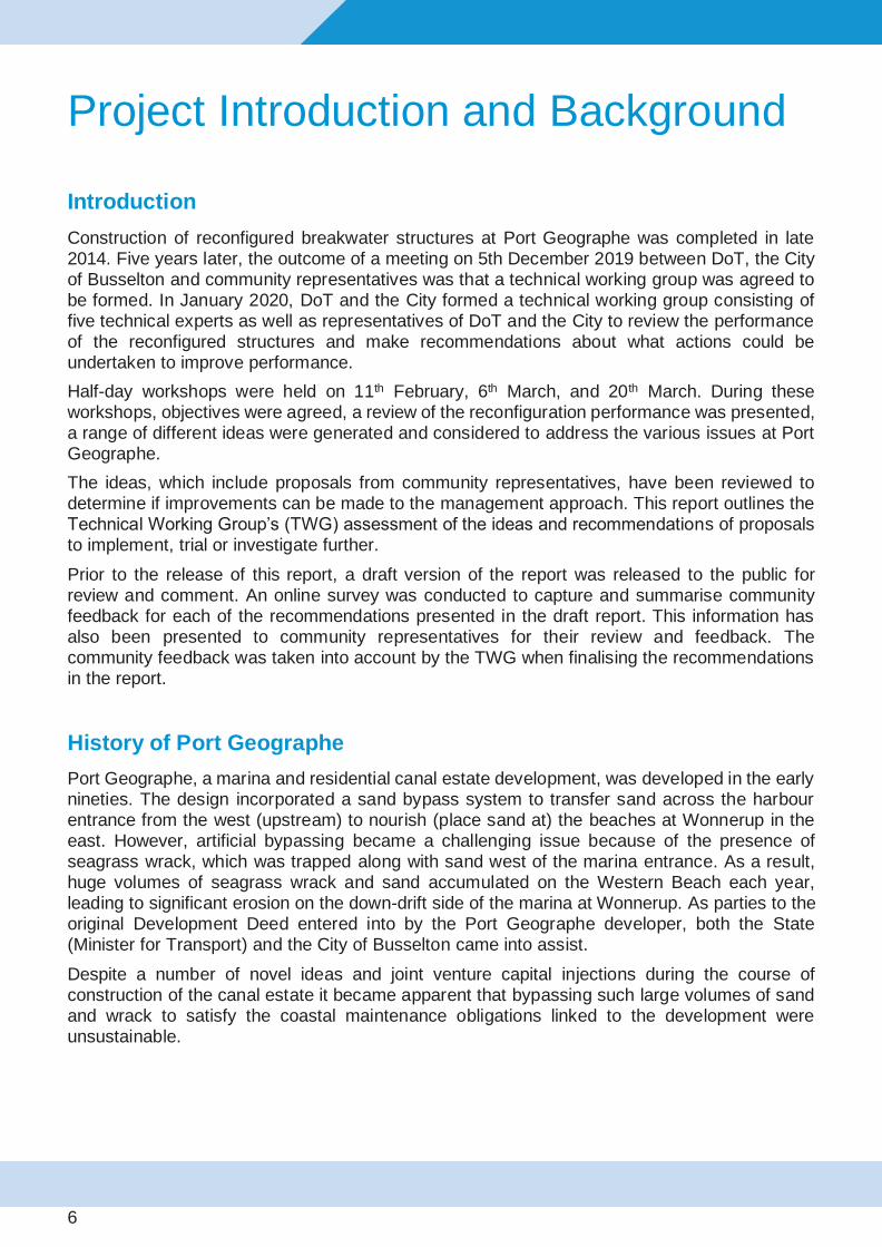
Figure 6: Port Geographe original (upper panel) and reconfigured (lower panel) structures, and sections of the PGCMA
Western Beach
Annual estimated pre- and post-reconfiguration wrack volumes on the Western Beach are shown in Figure 7. Pre-reconfiguration volumes indicate the quantity of wrack mechanically bypassed from the Western Beach to Wonnerup Beach, whereas post-reconfiguration volumes indicate surveyed quantity of wrack remaining on the Western Beach in December each year.
Since the reconfiguration no mechanical bypassing of wrack to Wonnerup has been undertaken. Minor works to facilitate natural bypassing involved pushing wrack into the water (approximately 2,000m3 per year in 2017, 2018 and 2019) or moving wrack to the back of the beach (approximately 2,000m3 per year in 2018 and 2019).
The pre-reconfiguration wrack volumes shown in Figure 7. were estimated at the time of the wrack removal works during spring based on the quantity of material physically handled (i.e. loaded and trucked). This includes material from the beach and likely some from below water. Post-reconfiguration wrack volumes were quantified by manual measurement (in 2015) and by conventional and drone survey (from 2016 onward) of wrack above water level only. Post-reconfiguration volumes shown represent quantity remaining on the beach within the PGCMA in mid-late December.
Acknowledging the differences in wrack volume estimation times and methods, since reconfiguration the recorded average annual wrack volume on the Western Beach has reduced significantly.

15
Figure 7: Estimated wrack volume on the Western Beach from 1996 to 2019 (Note: differing measurement methods pre- and post -reconfiguration as described above) Sources: Damara report (1996-2009 data), Project Closeout reports (2010-2019 data)
Wonnerup
The volumes of sand placed (through bypassing or nourishment (placing sand)) at Wonnerup Beach Pre- and post-reconfiguration are shown in Figure 8.
The pre-reconfiguration volumes are based on the quantity of sand mechanically bypassed from the Western Beach to Wonnerup Beach, whereas post-reconfiguration volumes indicate the quantity of sand trucked from land-based sand pits and from channel maintenance dredging.
Since reconfiguration the average annual sand volume for nourishment of Wonnerup Beach has reduced from 62,000m3 to 21,000m3, a reduction of 66%. While the section of Wonnerup within the PGCMA since the reconfiguration has been in compliance with the EMMP, East Wonnerup has seen substantial erosion and required construction of four groynes by the City of Busselton between 2017 and 2020.
Figure 8: Volume of sand nourishment on Wonnerup Beach from 1996 to 2019
0
50
100
150
200W
rack
Vo
lum
e (x
000
m3)
Year
Pre-reconfiguration estimated wrack volume bypassed mechanically (m3 )
During reconfiguration wrack volume bypassed mechanically (m3)
Post-reconfiguration wrack volume on Western Beach in December (m3)
020406080
100120140160
Wra
ck V
olu
me
(x
00
0m
3)
Year
Pre-reconfiguration estimated sand volume bypassed mechanically (m3 )
During reconfiguration sand volume bypassed mechanically (m3)
Wonnerup Nourishment (m3)
16
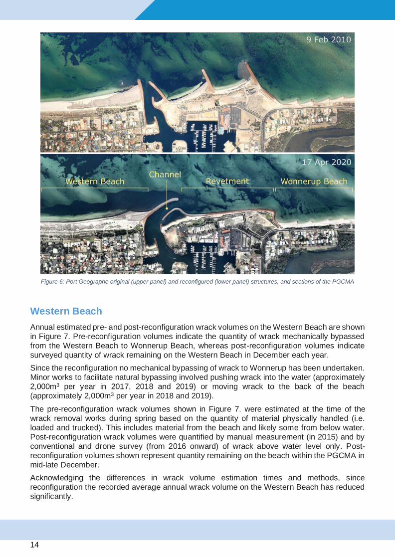
Entrance Channel
Pre- and post-reconfiguration maintenance dredging volumes for the marina channel are shown in Figure 9. Dredging volumes are based on comparing differences between pre- and post-dredging surveys.
Since reconfiguration the average annual maintenance dredging volume has increased from 9,000m3 to 21,000m3, an increase of 133%.
Figure 9: Volume of channel maintenance dredging from 1996 to 2019
Littoral (nearshore) Transport
Sand and wrack are transported by waves and currents generated by wind.
The average seasonal distribution of wind speed and direction at Busselton is shown in Figure 10 and illustrates the following key points:
• Summer winds are predominantly offshore
• Storms in autumn and early winter can have very strong winds from the north
• Storms in later winter have more westerly strong winds
• Spring has fewer and more moderate strength west wind events
Sand and wrack transport close to shore (littoral transport) is driven by the wave and wind direction relative to the orientation of the coast. The coast at Port Geographe faces north-northwest. Therefore, winds from the north and northeast typically drive littoral transport westward whereas winds from the northwest and west typically drive littoral transport eastward (Figure 11).
As waves approach the shore they travel into shallower water and break. Waves breaking at an angle to the shore drive an alongshore current. This wave breaking and induced alongshore current are the primary mechanisms for wrack transport along the coast. When wind and wave energy is directly onshore, the alongshore current induced by wave breaking may be weak, even during a strong storm.
0
10
20
30
40
50
60
Dre
dge
d V
olu
me
(x 0
00m
3)
Year
Pre-reconfiguration channel maintenance dredged volume (m3)
During reconfiguration channel dredged volume (m3)
Post-reconfiguration channel maintenance dredged volume (m3)

17
Winter storms are predominantly associated with the passage of low-pressure systems and cold fronts across the southwest of Western Australia. During a single storm the wind direction may rotate significantly from northerly to south-westerly, resulting in the littoral transport direction changing from westward to eastward. The frequency and intensity of storms vary significantly from year to year. Furthermore, each storm differs in the sequence of wind direction and strength. This results in significant variability in the transport and accumulation of wrack and sand, and the resulting changes on the beach each year.
Jan-Mar (summer) Apr-Jun (autumn) Jul-Sept (winter) Oct-Dec (spring)
Wind rose
Wind rose (on-
shore only)
Figure 10: Quarterly average wind roses for Busselton (BoM wind Busselton Jetty 2015-2019)

18
Figure 11: Transport direction in response to wind direction at Port Geographe
Western Beach Wrack
Accumulation
Accumulation of wrack along the Western Breakwater and Western Beach is considered to be a result of the high rate of wrack arriving from the west which exceeds the rate at which waves and currents can transport this material past the Western Breakwater (natural bypassing). While the rate of transport along the Western Breakwater is reduced compared to the rate of transport along a sandy beach, the following observations provide evidence that there is a degree of natural bypassing in this area:
(i) the presence of wrack in the water and streaming eastward from the end of the western breakwater during winter (Figure 14),
(ii) the accumulation of wrack in the entrance channel, and (iii) the natural removal of significant quantities of wrack from the Western Beach during
each spring in 2015-2019.
The supply of wrack from the seagrass meadows in Geographe Bay can be expected to vary from year to year. However, for any year the available supply of wrack material is expected to be greatest immediately prior to the onset of the winter storm season. The rate at which this supply is delivered to the shore depends on the characteristics of the storms during early winter. During the latter part of winter, the rate of supply from offshore meadows reduces significantly

19
as earlier storms have already harvested most of the available wrack. The minimal fresh supply of wrack toward the shore means that storms in late winter and early spring have more potential to promote the natural bypassing of wrack that has accumulated on the beach and in shallow water.
The design of the reconfigured rock structures at the marina entrance and the Western Beach was intended to allow sand and wrack being transported eastward to naturally pass the Western Breakwater, rather than being trapped against the pre-reconfiguration breakwater. The reconfiguration included both the rock structures and the shape of the Western Beach, with the sandy beach extending approximately halfway to the end of the Western Breakwater. Wave breaking along this beach was intended to facilitate littoral transport along, and past, the end of the breakwater.
Since reconfiguration, strong early winter storms have eroded the narrow sandy beach along the Western Breakwater (what is referred to as the “pocket”), transporting this sand westward. Subsequently, storms with stronger westerly winds replaced the eroded sand with wrack, which typically extends as a platform into deeper water. This sequence is illustrated in Figure 12 through photographs taken from the site during 2017.
The deeper water along the front of this wrack platform results in a weaker alongshore current and reduced littoral transport. Consequently, wrack being transported into this area tends to accumulate into a dense slurry of wrack and water in front of the wrack platform. This slurry absorbs much of the incident wave energy in this area, further reducing the capacity for wrack to be transported along and past the end of the breakwater. During winter the wrack accumulated on the beach and floating in front can be rearranged by powerful storms; some may bypass during strong westerly winds, but more may also be added, transported from the west. Typical maximum volumes of wrack during winter on the Western Beach since reconfiguration are estimated to be between 35,000 and 50,000m3 (Figure 13). In 2020, the estimated maximum wrack volume was the largest since reconfiguration at approximately 84,000 m3.
Natural Bypassing
Wrack removal from the Western Beach progresses from west to east and typically occurs in spring, once there is reduced wrack supply from offshore. Wrack movement mainly occurs during moderate to strong westerly winds, which are occasional wind events in spring, and highly variable between years. The combination of wave agitation along the front of the wrack platform and the coastal current induced by the wind, has been observed to result in the mobilising and bypassing of 20,000-40,000m3 of wrack from September to December (Figure 13). Compact wrack cliffs along the waterline can be very resistant to erosion. Since 2017, this natural removal of wrack has been assisted by mechanically breaking up the high and compacted face of the wrack platform a few days prior to forecast westerly wind events.

20
Figure 12: (Left) Erosion of the “Pocket” of the Western Beach sand during strong north winds in June 2017 and backfilling with wrack during westerly winds in July 2017. (Right) monthly wind roses for June (top) and July (bottom) 2017

21
Figure 13: (Top) Western Beach wrack volume from 2015 to 2020. (Bottom) Cumulative alongshore transport potential at Port Geographe from 2015 to 2020
Figure 14: Natural bypassing of wrack along Western Breakwater during moderate westerly winds on 29 Sept 2019

22
Channel Dredging
The natural bypassing of wrack facilitated by the reconfigured structures has resulted in an increase in the quantity of wrack being transported across the marina entrance channel. The increase in channel wrack volume is related to the increase in natural bypassing. Under the previous configuration, more wrack was retained on the Western Beach and mechanically bypassed rather than bypassing naturally.
A portion of this wrack is entrained by currents moving it in and out of the entrance, with approximately 20,000m3 per year deposited within the channel. This has led to an increase in maintenance dredging of the channel to ensure navigability.
Sand Bypassing
Western Beach
Between November 2014 and December 2019, the volume of the Western Beach within the PGCMA has increased by approximately 150,000m3, with the majority being sand. It is estimated that less than 30,000m3 of this is wrack on the shore, either moved to the back of the beach or in shallow water offshore. This increase in sand volume is the result of net eastward transport and limited natural bypassing of sand past the reconfigured Western Breakwater. This is evidenced by limited accumulation of sand either in the channel or along the revetment.
During winter, when wrack extends along the shoreline up to 1-2km west of the marina, the wrack covers the sand out to a shallow depth, inhibiting sand transport. As wrack is progressively removed from west to east along the beach in late winter and spring the sandy beach face is exposed to waves and eastward transport of sand follows the tail of the wrack. However, as described earlier, the deeper water and abundance of wrack adjacent to the Western Breakwater significantly diminishes the alongshore transport capacity for wrack, and more so for sand. Consequently, the natural net eastward transport of sand is essentially terminated along the Western Beach. This is evident in the lobe of accretion a few hundred metres west of the breakwater (Figure 15).
From 2012 to 2020 no sand has been mechanically bypassed from the Western Beach, in order to provide an opportunity for the reconfigured Western Beach to adjust and stabilise to natural conditions, and for monitoring of this process.

23
Figure 15: Aerial images taken August 2015 (left) and October 2019 (right) showing new lobe feature due to sand
accretion on Western Beach
Wonnerup Beach
The key issues at Wonnerup Beach are:
• Minimal natural sand feed onto Wonnerup beach – beach erosion requiring nourishment
• Groynes at Wonnerup retain sand resulting in less natural sand feed onto East Wonnerup –
rate of erosion on East Wonnerup is greater than for Wonnerup.
The absence of any significant natural or mechanical bypassing of sand from the Western Beach has meant that supply of sand to Wonnerup Beach has relied on nourishment (i.e. sand placement). This has been achieved through trucking of sand from inland sand pits. On average, less sand has been placed since reconfiguration compared to prior. Although the reduced nourishment volume has maintained the Wonnerup beach profile and shoreline position since reconfiguration, East Wonnerup beach has experienced progressive sand loss and erosion (Figure 16). The rock groynes along Wonnerup Beach reduce the rate of local sand erosion but also limit the rate at which sand feeds to East Wonnerup Beach. However, their influence is ultimately determined by the rate of bypassing from the Western beach.

24
Figure 16: Change in beach volume from November 2014 to December 2019

25
Summary
The performance of the reconfigured entrance to Port Geographe marina over the last five years can be summarised as:
• The reconfiguration has resulted in the annual average volume of wrack remaining on the
beach in December being less than 20% of pre-reconfiguration volumes
• The rate of natural wrack bypassing is limited by deep water along the Western Breakwater and suppression of alongshore transport processes by a dense wrack slurry
• Natural dispersion of wrack from the Western Beach has been enhanced by minor works to break up the compact cliff along the wrack platform
• Natural bypassing of sand around the Western Breakwater has been less than expected due to wrack and deep water
• Increased natural bypassing of wrack has led to an increased accumulation of wrack in the entrance channel and consequently an increase in annual maintenance dredging requirements
• A significant reduction in natural sand bypassing around the Western Breakwater has led to an accumulation of at least 120,000m3 of sand along the Western Beach since reconfiguration
• The same reduction in natural sand bypassing has resulted in the requirement of continued nourishment of Wonnerup Beach, which has been supplied from sand pits and channel dredging
• The rate of nourishment at Wonnerup Beach has not balanced the rate of erosion at East Wonnerup Beach. This has occurred despite the ongoing mechanical nourishment of Wonnerup Beach.

26
Proposed Ideas for Improvement
The ideas listed in this section comprise those proposed by the TWG during the workshop brainstorming sessions, as well as those ideas proposed by community representatives as part of submissions requested for consideration during the TWG workshops.
Western Beach Ideas (Total of 15 ideas generated)
The primary objective of the Western Beach ideas is to reduce the amount of wrack which accumulates and remains on this beach. For many of the ideas the aim is to do this by improving natural bypassing of wrack.
Western Beach 1 - Breaking up and pushing wrack into water during winter and spring (community submission)
Idea summary:
This proposal would involve works commencing earlier than works trialled in the spring of 2018 and 2019, and if appropriate from mid-winter, assisting the mobilisation of seagrass off the beach to increase bypassing of wrack past the Western Breakwater. As in the trials, the works would focus on breaking up the front compacted face of the accumulated wrack, west of the Western Breakwater within the PGCMA. This would allow wave action to mobilise wrack, so it is more easily transported by longshore currents.
Works are proposed to commence earlier in the year than the trials in 2018 and 2019, starting from mid-winter. To achieve the greatest benefit from such works they would be undertaken a few days prior to forecast storms capable of producing strong alongshore transport of seagrass wrack from west to east. Criteria have been developed to identify suitable storms which could offer the best chance of transport of wrack from west to east.

27
Figure 17: Idea Western Beach 1 - Breaking up and pushing wrack into water during winter and spring (community submission)
Outcomes:
It was agreed by the TWG that this idea presents a viable option which could possibly achieve greater natural bypassing of wrack from west to east. Pros and cons of this approach, noted by the TWG, are shown in the table below:
Pros
• Potential to reduce the area of beach covered by wrack by the end of spring
• Short duration of works (immediately prior to suitable storms) carried out during
the low season reduces disruption to the local community
• Potential for these works to reach the area that becomes trapped in the corner
adjacent to the western breakwater
• Performing wrack pushing works earlier (in winter) mitigates the risk of spring
storms not eventuating
Cons
• Access to the front of the wrack may require greater effort or different equipment as waves and water levels are higher
• There may be an effective limit to the amount of wrack that can be bypassed around the breakwater in given conditions, based on observations that show too much wrack in the water dampens energy that drives wrack transport and may reduce the bypassing rate.
• Increased potential for some material to be moved towards Busselton (e.g. during storm winds that drive transport from east to west)
• An increase in natural bypassing may result in an increase in the quantity of
wrack that accumulates in the entrance channel.

28
The criteria for storm selection to guide the timing of wrack pushing works would be reviewed throughout a trial period. This is to avoid undertaking works prior to conditions where wrack bypassing is not likely to occur. Ongoing monitoring of weather conditions against these criteria would inform the timing of short wrack pushing campaigns. A contractor with suitable machinery would need to be prepared to commence work at short notice during suitable weather windows.
Use of different equipment and work locations may occur to help determine the most effective methods, including for when water levels are higher, or where wrack extends further offshore.
Earlier in winter the beach wrack may extend west of the PGCMA into the Ngari Capes Marine Park where mechanically moving wrack from the beach into the water is expected to require approval by regulatory agencies before works can be conducted in the Marine Park.
Monitoring of trialled works will allow for assessment of the performance of earlier wrack pushing.
Category: Trial

29
Western Beach 2A – Reduce EMMP target wrack volume on western beach down to 10,000m³ (community submission)
Idea Summary:
Since the reconfiguration of the western breakwater at Port Geographe, the approach to management of the western beach has been to largely leave the beach unchanged unless the Environmental Monitoring and Management Plan (EMMP) threshold levels are at risk of being exceeded (60,000m3 wrack volume by December or 0.1ppm hydrogen sulphide level).
One of the submissions received by the community has suggested a reduction in the threshold level for management action from 60,000m3 down to 10,000m3.
Figure 18: Photo of Western Beach taken on 20/12/2019. The estimated volume of wrack on the Western Beach (within the
PGCMA) at this time was approximately 10,000m3

30
Outcomes:
It was agreed by the TWG that this idea does not directly address the question of beach amenity because volume of wrack is not a direct measure of how the beach looks and how it can be used. Advantages and disadvantages of the idea, noted by the TWG, are listed in the table below:
Pros • Would ensure that by December each year a volume of 10,000m³ or less of
wrack would be present on the Western Beach
Cons
• The EMMP targets have been developed to minimise environmental and health
impacts. Reducing the EMMP trigger levels would change the reason for
intervention from an environmental/health issue to a beach amenity issue.
• Implementation of a 10,000m³ target volume would necessitate intervention
works on the Western Beach during many years, which would be more
disruptive to the local community and result in additional odour.
• It is noted that quantities of wrack (with associated odour impact) occurred on
the western beach prior to construction of the original marina.
• By the end of 2018 and 2019 the volume of wrack, on the Western Beach, approached 10,000m³. At the end of 2019 the amount and location of wrack still raised many concerns with the community
The technical working group, noted that for the reasons above, an arrangement should be sought separate to the EMMP, with the specific goal of defining beach amenity targets and management actions to achieve them. Rather than changing the EMMP, it was proposed that DoT look into establishing a collaborative framework with the City of Busselton and community to develop appropriate measures aimed at improving amenity along the Western Beach. This proposed idea is covered in idea Western Beach 2B below.
Category: Not recommended at this time
31
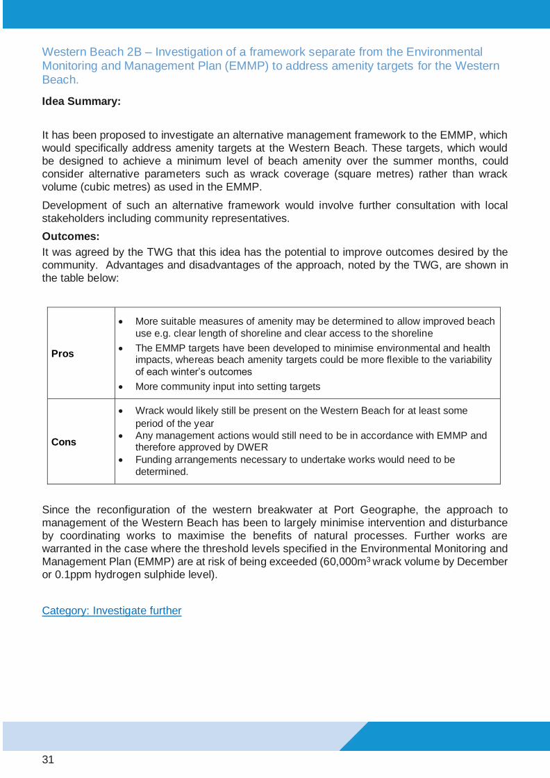
Western Beach 2B – Investigation of a framework separate from the Environmental Monitoring and Management Plan (EMMP) to address amenity targets for the Western Beach.
Idea Summary:
It has been proposed to investigate an alternative management framework to the EMMP, which would specifically address amenity targets at the Western Beach. These targets, which would be designed to achieve a minimum level of beach amenity over the summer months, could consider alternative parameters such as wrack coverage (square metres) rather than wrack volume (cubic metres) as used in the EMMP.
Development of such an alternative framework would involve further consultation with local stakeholders including community representatives.
Outcomes:
It was agreed by the TWG that this idea has the potential to improve outcomes desired by the community. Advantages and disadvantages of the approach, noted by the TWG, are shown in the table below:
Pros
• More suitable measures of amenity may be determined to allow improved beach
use e.g. clear length of shoreline and clear access to the shoreline
• The EMMP targets have been developed to minimise environmental and health impacts, whereas beach amenity targets could be more flexible to the variability
of each winter’s outcomes
• More community input into setting targets
Cons
• Wrack would likely still be present on the Western Beach for at least some
period of the year
• Any management actions would still need to be in accordance with EMMP and therefore approved by DWER
• Funding arrangements necessary to undertake works would need to be
determined.
Since the reconfiguration of the western breakwater at Port Geographe, the approach to management of the Western Beach has been to largely minimise intervention and disturbance by coordinating works to maximise the benefits of natural processes. Further works are warranted in the case where the threshold levels specified in the Environmental Monitoring and Management Plan (EMMP) are at risk of being exceeded (60,000m3 wrack volume by December or 0.1ppm hydrogen sulphide level).
Category: Investigate further

32
Western Beach 3 – Continue with Current Management Approach
Idea summary:
To allow for comparison, the option to continue with the existing approach was evaluated using the same assessment methodology as the other proposed ideas.
This approach was also supported in one of the community submissions.
Outcomes:
This option rated well but as this approach has been used for the past 5 years, the technical working group considered potential improvements. Advantages and disadvantages of this approach are summarised in the following table:
Pros
• Approach was shown to be successful in 2018 due to late storm patterns
• Meets expectations of those in the community who are opposed to extensive
mechanical works on the Western Beach or those in favour of taking a wait and
see approach to management.
• No increase to capital cost and annual maintenance cost
• The spring works (breaking up compacted face of the wrack prior to storms) restricts the spatial area where wrack is present and limits extent where work is
undertaken.
Cons
• The volume of wrack remaining on the Western Beach did not meet the majority
of the community’s expectation with respect to amenity by December 2019
• If a forecast storm fails to eventuate following wrack pushing works, wrack is likely to remain in the water along the Western Beach instead of bypassing
around the breakwater
• There is a limit to the amount of wrack that can be bypassed past the breakwater in given conditions. Observations indicate that a lot of wrack in the
nearshore area dampens energy that drives bypassing. Over-saturating the
nearshore area with too much wrack may be detrimental to natural bypassing.
• Except in 2015 and 2016 the current management approach has not removed
the wrack in the pocket adjacent to the Western Breakwater
Category: Investigate further (at a later time)

33
Western Beach 4 – Right-Angle Low-Profile Sandbag Groynes (community submission)
Idea summary:
This option involves construction of two or more right-angle, low-profile sandbag groynes adjacent to the western breakwater (Figure 19). The purpose of the construction is to stabilise the sand profile in the pocket next to the breakwater and to encourage greater bypassing of seagrass wrack.
Figure 19: Western Beach 4 – Right-Angle Low-Profile Sand Bag Groynes

34
Outcomes:
This option was considered by some members of the TWG to be more viable than idea Western Beach 8 (community submission). Advantages and disadvantages of this approach are shown in the table below:
Pros
• Potential to partly reduce sand erosion in the pocket during north-easterly wind / wave
events
• Installation works could be short term with minor disruption and maintenance works
likely to also be minor
• Low capital cost and likely to increase trapping of sand in the adjacent area
• Sandbag groynes have the benefit of being relatively easy to remove if a trial is
deemed unsuccessful.
Cons
• While construction of additional groynes is expected to trap more sand, they can also trap more wrack. It is noted that the marina featured right angle groynes prior to the
reconfiguration which trapped wrack.
• The sand and wrack interaction / dynamics on the Western Beach is complex making it difficult to predict the performance of the proposed structures. Further investigation
may be required to better understand the impacts of adding sandbag groynes.
• The presence of underlying wrack would require removal and infill for sandbag
groynes to be installed effectively.
The technical working group highlighted the complexity of this area (i.e. managing sand movement) and have emphasised that any decision to proceed to a trial should be based on the outcomes of further investigation, such as a more detailed assessment or numerical modelling.
Category: Investigate further

35
Western Beach 5 - Remove wrack and replace with sand
Idea Summary:
An option considered for reducing the amount of seagrass wrack along the western beach is to remove the wrack by trucking it off site. Wrack would then be replaced by sand to recreate the equivalent shoreline profile (Figure 20).
Figure 20: Idea Western Beach 5 – Remove seagrass wrack from Western Beach and replace with sand
Outcomes:
Pros and cons of this approach are shown in the table below:
Pros
• Removal of wrack would result in improved beach amenity and could address
concerns associated with accumulation of wrack on the Western Beach.
• Replacement of wrack with sand would recreate a new shoreline profile
Cons
• This proposal is similar to what was done as part of the entrance reconfiguration. Re-occurrence of characteristic winter storms is likely to result in the same erosion of sand and accumulation of wrack within 1-2 years. As a result, this is considered a
short-term solution only.
• High impact to the local community in terms of disruption, noise and odour each time
this is undertaken.
• Low value for money given expense and expected short duration of improvement
Category: Not recommended at this time

36
Western Beach 6 – Remove wrack and realign sand to post reconfiguration (steep) profile in PGCMA – transport excess sand to Wonnerup
Idea summary:
This option is to return the Western Beach to a similar profile to that put in place as part of the 2014 breakwater reconfiguration works. The purpose being to mimic the profile which initially accumulated little wrack.
Figure 21: Idea Western Beach 6– Remove wrack (shaded red) from beach
Outcomes:
Pros
• Removal of wrack would result in improved beach amenity and could address
concerns associated with accumulation of wrack on the Western Beach.
• Restoration of beach profile could potentially assist natural bypassing of wrack if sand
at pocket beach remains in place.
Cons
• The proposal was considered to have too low a chance of success. This is due to historical performance when the reconfiguration beach design profile was previously
constructed at the end of 2014.
• The wrack would have to be mechanically transported to, and disposed of within Geographe Bay waters but within the PGCMA (i.e. off Wonnerup Beach) with potential
negative impacts
• High impact to the local community in terms of disruption, noise and odour
• Poor value for money as relatively high cost for wrack removal and beach realignment
and expected short duration of improvement
Category: Not recommended at this time

37
Western Beach 7 – Nourish beach west of wrack to form sand shoreline in summer up to breakwater (offshore sand source)
Idea summary:
This strategy involves placement of sand onto the beach west of the existing seagrass wrack (as indicated in below figure). It is expected that this sand would be transported east by waves and currents, which could form (or widen) a sandy shoreline up to the western breakwater.
Figure 22: Idea Western Beach 7 - Nourish beach west of wrack to form sand shoreline in summer up to breakwater (offshore
sand source)
Outcomes:
Pros
• Potential for improved beach amenity on the Western Beach if placed material is
transported east to form a sandy shoreline up the western breakwater.
• If sand is transported toward the Western Breakwater the beach profile could potentially
assist natural bypassing of wrack if sand reaches as far and stays at the pocket beach.
Cons
• There is already several kilometres of sandy beach available as a sand source to be
transported eastward by natural conditions.
• Any sandy shoreline adjacent to the Western Breakwater is expected to be eroded and replaced by wrack during early winter storms as occurred in the 2-3 years following
completion of the reconfiguration
• Sand is naturally accreting (transported from further west) within the management area,
in the order of ~25,000m³ per year
• Improvements from this approach are expected to be short-lived based on the last 5 years of observations with wrack likely to accumulate against the breakwater in
following seasons.
Category: Not recommended at this time
38
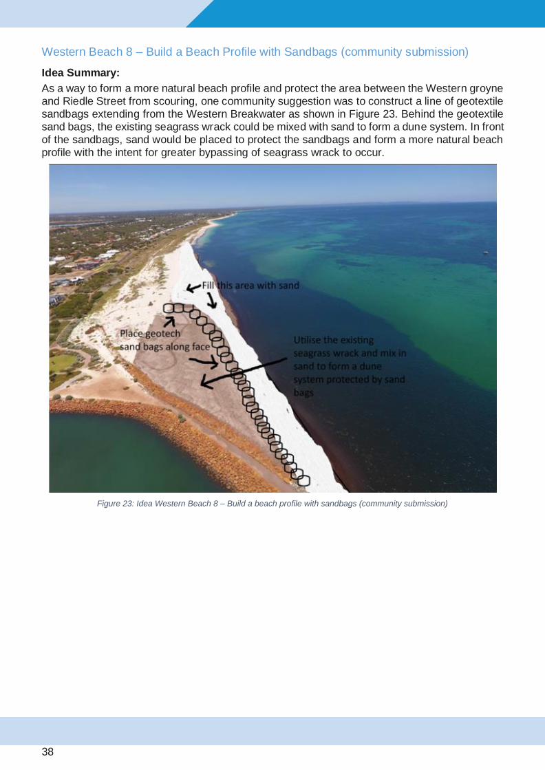
Western Beach 8 – Build a Beach Profile with Sandbags (community submission)
Idea Summary:
As a way to form a more natural beach profile and protect the area between the Western groyne and Riedle Street from scouring, one community suggestion was to construct a line of geotextile sandbags extending from the Western Breakwater as shown in Figure 23. Behind the geotextile sand bags, the existing seagrass wrack could be mixed with sand to form a dune system. In front of the sandbags, sand would be placed to protect the sandbags and form a more natural beach profile with the intent for greater bypassing of seagrass wrack to occur.
Figure 23: Idea Western Beach 8 – Build a beach profile with sandbags (community submission)

39
Outcomes:
Pros and cons of this approach are shown in the table below:
Pros • If successful, this strategy could improve both beach amenity and natural bypassing of
wrack.
Cons
• In general, the idea was considered to have too low a chance of success and it was
not clear that it could be effective at reducing accumulated wrack volumes.
• If the sandbags were at a steep slope, there is unlikely to be a beach in front of the sandbags as any sand placed there would likely be washed away. If it were a gentle slope it would be very expensive due to the height required to ensure wrack does not
overtop the sandbags and becoming trapped on the platform.
• Potential for detrimental effects along the beach west of the sandbags in the form of
erosion (shifts the pocket issue to the west)
• Additional wrack works would be required to remove the wrack prior to placement of
sandbags.
• The sandbag profile would need to be nearly as high as the breakwater to prevent the
beach behind the sandbags being a wrack platform
• A significant amount of design investigation work would be required before selecting
any suitable concept.
• Poor value for money given high capital cost for design and installation and low
chance of success
Category: Not recommended at this time

40
Western Beach 9 - Reinforced shoreline: Sandbags placed seaward of breakwater
Idea summary:
This idea proposes placing sandbags seaward of the western breakwater which could create a flatter slope with the aim of promoting wave breaking, which induces stronger longshore currents to drive more wrack bypassing. The TWG noted that bypassing of wrack past the Western Breakwater is currently limited partly because the slope of the breakwater is too steep to allow for significant wave breaking along its length.
It is noted that this idea differs from Ideas West 4 and West 10 in that the proposed location of the sandbags is designed to only affect coastal processes in front of the breakwater, rather than being placed to trap sand in the pocket area of the Western Beach.
Figure 24: Idea Western Beach 9 - Reinforced shoreline: Sandbags seaward of breakwater
Outcomes:
Pros • If successful, this idea has the potential to improve natural bypassing of wrack past
the Western Breakwater.
Cons
• It was considered to have too low a chance of success due to the depth of water at the end of the Western Breakwater, which would prevent wave breaking and not develop enhanced longshore currents. Therefore, it is not clear that it could be
effective at reducing accumulated wrack volumes.
• High capital cost as a large footprint would be required and large quantity of rock or
sandbags
Category: Not recommended at this time

41
Western Beach 10 – Tracer study
Idea summary:
Performing a tracer study, which involves tracking the movement of individual particles, as a way to improve understanding of sediment pathways at the Western Beach.
Figure 25: Idea Western Beach 10 - Tracer study
Outcomes:
Pros and cons of this approach are shown in the table below:
Pros • Potential to improve understanding of sediment pathways at the Western Beach.
Cons
• It is considered to provide only limited benefit and only a small possibility of achieving
improved understanding of sediment movement at the site.
• It would be difficult to perform at a site with significant wrack presence.
• It can be particularly time consuming and labour intensive to conduct such a tracer study. For this reason and the comments above, it was not considered to be a viable
option.
Category: Not recommended at this time
42
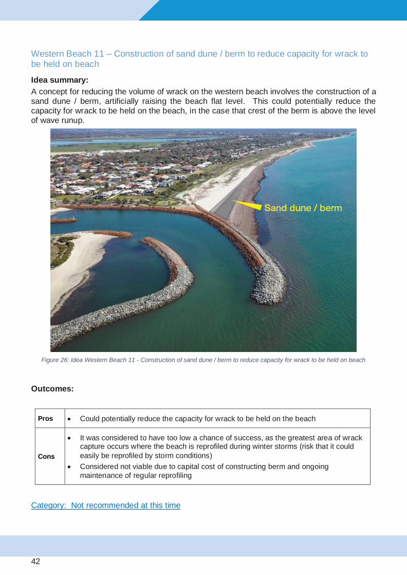
Western Beach 11 – Construction of sand dune / berm to reduce capacity for wrack to be held on beach
Idea summary:
A concept for reducing the volume of wrack on the western beach involves the construction of a sand dune / berm, artificially raising the beach flat level. This could potentially reduce the capacity for wrack to be held on the beach, in the case that crest of the berm is above the level of wave runup.
Figure 26: Idea Western Beach 11 - Construction of sand dune / berm to reduce capacity for wrack to be held on beach
Outcomes:
Pros • Could potentially reduce the capacity for wrack to be held on the beach
Cons
• It was considered to have too low a chance of success, as the greatest area of wrack capture occurs where the beach is reprofiled during winter storms (risk that it could
easily be reprofiled by storm conditions)
• Considered not viable due to capital cost of constructing berm and ongoing
maintenance of regular reprofiling
Category: Not recommended at this time

43
Western Beach 12 – Construct submerged breakwater off end of Western Breakwater
Idea summary:
The concept of a submerged breakwater was suggested as a method for protecting the pocket beach, located adjacent to the western breakwater, from being scoured out by wave energy from the north/northeast. The submerged structure would be constructed from sand bags or rock and act as an artificial reef. The position and orientation of the breakwater concept would provide local sheltering of the pocket beach next to the Western Breakwater from northerly waves, while also potentially enhancing bypassing of wrack from west to east by funneling eastward coastal currents past the end of the breakwater.
Figure 27: Idea Western Beach 12 - Construct submerged breakwater off end of Western Breakwater
Outcomes:
Pros • Could potentially protect the pocket beach sand from being eroded and transported
west by sheltering against wave energy from the north/north-east
Cons
• It was considered to have too low a chance of success (risk that it would be ineffective
at reducing sand erosion adjacent to breakwater)
• Waves coming from the north/north-east typically have a short wavelength (seas), which means that the crest of the breakwater would need to be close to or above the
water level to significantly reduce transmission of waves from this direction.
• Poor value for money with high capital cost
Category: Not recommended at this time

44
Western Beach 13 – Reinforced shoreline: Sandbags to west of breakwater
Idea summary:
This concept involves the placement of sandbags to the west of the breakwater to protect the pocket beach next to the Western Breakwater from erosion. It would be necessary to create a gentle slope approximately 1 (vertical) in 5 (horizontal) or less.
Figure 28: Idea Western Beach 13 – Reinforced shoreline: Sandbags to west of breakwater
45
Outcomes:
Pros • Could be effective at protecting sand at the pocket beach from erosion and reduce the
volume of wrack trapped at this location.
Cons
• It was considered to have too low a chance of success (not clear that it could be effective at reducing accumulated wrack volumes). Enough uncertainty (coastal
engineering, and timing) to discount as option.
• Design investigation work would be required before selecting a suitable concept.
• Not viable due to high capital cost for design and installation with low chance of
success
• Potential for detrimental effects along section of beach to the west of sandbags in the
form of erosion (shifts the pocket issue west)
• Additional wrack works would be required to remove the wrack prior to placement of
sandbags.
• Storm erosion in this area would likely expose the sandbags during winter making it necessary to extend the sandbag coverage well below water level at a gentle slope of
about 1 in 5.
Category: Not recommended at this time

46
Western Beach 14 – Remove wrack from beach and do nothing
Idea summary:
This idea involves removal of wrack from the western beach. The resulting sand beach profile would then be left unchanged.
Figure 29: Idea Western Beach 14 – Remove wrack from beach and do nothing
Outcomes:
Pros • Removal of wrack would result in improved beach amenity and could address
concerns associated with accumulation of wrack on the Western Beach.
Cons
• It was considered to have too low a chance of success.
• The wrack would have to be taken elsewhere. It would likely have to be retained in the
system with potential negative impacts if this is at Wonnerup Beach
• It is not clear that this approach would be effective at reducing accumulated wrack volumes for any length of time, given that the pocket adjacent to the breakwater is
likely to refill with wrack within a year.
• High impact to the local community in terms of disruption, noise and odour
• Poor value for money as expense would likely only provide a short-term improvement.
Category: Not recommended at this time

47
Wonnerup Ideas (Total of 11 ideas generated)
The primary objective of the Wonnerup ideas is to identify more sustainable sources of sand for beach nourishment or reduce the requirement for sand nourishment.
Wonnerup 1 - Mechanical sand bypassing from Western Beach (west end of PGCMA)
Idea summary:
This idea involves taking sand that has accumulated since 2015 toward the western end of the PGCMA, on the Western Beach, and placing it on Wonnerup Beach. This would assist in maintaining alongshore sand transport, that would occur naturally if Port Geographe was not present. Sand at the pocket beach adjacent to the western breakwater would be left alone. The area where sand could be taken is a location which has seen strong sand accretion (build-up) over the last 5 years. The location and volume of sand which would be used could be taken in a way which would not impact the “pocket”, next to the Western Breakwater. Furthermore, sand would be taken only from areas where it has accreted over the past two years.
The erosion of Wonnerup Beach is primarily associated with the blocking of alongshore eastwards sediment transport by Port Geographe. This has historically been managed by annual bypassing of sand trapped on the updrift side of the breakwaters, along the Western Beach. This is standard practice around the world for managing downdrift erosion associated with constructing and operating a harbour on a sandy coastline, and providing a sustainable supply of sediments to the downdrift coastline. Sand has not been bypassed at Port Geographe since 2012.
In Western Australia, the EPA typically requires proponents of maritime developments on sandy coasts to undertake sand bypassing (e.g. Dawesville Channel, Mandurah Ocean Entrance). This is to "maintain the geophysical processes that shape coastal morphology so that the environmental values of the coast are protected" (EPA 2006 Environmental Factor Guideline - Coastal Processes).
Surveys undertaken by the Department of Transport show more than 220,000m3 of material (sand and seagrass) has been trapped on the Western Beaches between 2014 and 2019. During this period, the erosion at Wonnerup has been managed primarily by importing sand purchased from commercial sand suppliers, which has a very high cost and is not sustainable in the longer term. There has been 60,000m3 net erosion of the downdrift beaches between Port Geographe and Wonnerup between 2014 and 2019.
The need for a wide beach adjacent to the western breakwater to assist the natural bypassing of seagrass wrack is acknowledged. Bypassing of this material to Wonnerup would need to ensure adverse impacts on wrack bypassing, and residential and beach amenity, is minimised. This requires consideration of a sustainable beach alignment (wrack modelling), potentially sourcing sand further west along the beach, and pumped options where feasible.

48
Figure 30: Idea Wonnerup 1 – Mechanical sand bypassing from Western Beach (compartments 5 & 6)
Outcomes:
Pros
• This option would offer significant cost savings (~50% reduction) compared to the
existing method of trucking from onshore sand pits.
• This option would be more sustainable than existing nourishment arrangements
(noting external sand supply is likely to be more expensive into future)
• At the present rates of accretion on Western Beach (West End of PGCMA and immediately west of PGCMA), there is sufficient material to meet annual Wonnerup
requirements
• Bypassing of sand from west to east maintains natural sediment transport across
the Port Geographe entrance
• Sand bypassing from the Western Beach to Wonnerup is a tenet of the Ministerial conditions and the environmental approval process for redistributing sand within
the PGCMA are already in place.
• Reduces demand on, and increases sustainability, of existing commercial sand
supplies for the region which are limited.
Cons
• Removing sand from the Western Beach is seen by part of the community as detrimental for wrack bypassing performance of the reconfigured structures. Sand to only be taken from the western end of Western Beach where sand has accreted
in the past 5 years to mitigate such concerns.
• Works on the beach (particularly trucking) would likely cause disruption; dredging
may be least disruptive to the amenity
Category: Trial
49
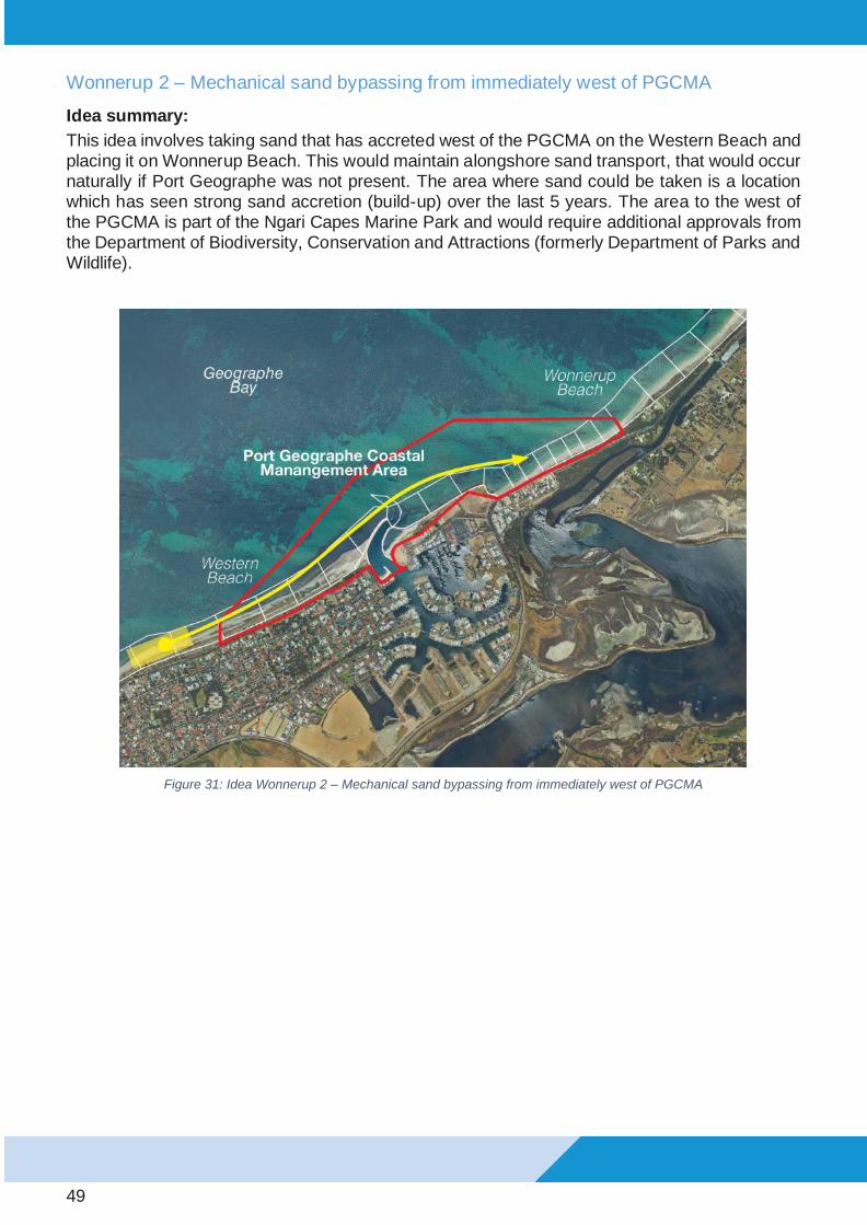
Wonnerup 2 – Mechanical sand bypassing from immediately west of PGCMA
Idea summary:
This idea involves taking sand that has accreted west of the PGCMA on the Western Beach and placing it on Wonnerup Beach. This would maintain alongshore sand transport, that would occur naturally if Port Geographe was not present. The area where sand could be taken is a location which has seen strong sand accretion (build-up) over the last 5 years. The area to the west of the PGCMA is part of the Ngari Capes Marine Park and would require additional approvals from the Department of Biodiversity, Conservation and Attractions (formerly Department of Parks and Wildlife).
Figure 31: Idea Wonnerup 2 – Mechanical sand bypassing from immediately west of PGCMA

50
Outcomes:
Pros
• Nourishing Wonnerup Beach with Western Beach sand maintains sand transport along the coast, with benefits for East Wonnerup if annual bypass rates match
annual accretion rates on the Western Beach
• Community perception would be easier to manage as material would be taken from
more than 1km away from the Western Breakwater
Cons
• Longer distance to Wonnerup Beach adds to pumping cost potentially making truck
transport more economical than dredging.
• Environmental approval for sourcing sand within the Marine Park may be much more challenging than the existing approvals within PGCMA (even for land-based
equipment)
• Works on the beach (particularly trucking) may cause greater disruption to beach
amenity, therefore dredging may be preferred
Category: Not recommended at this time

51
Wonnerup 3 – Reuse dredged sand from offshore disposal area
Idea summary:
A sand supply option to supplement material from onshore sand pits (or Western Beach) is to reuse sand that has accumulated from maintenance dredging of the marina channel and placed at the offshore disposal area (Figure 32).
Figure 32: Idea Wonnerup 3 – Reuse dredged sand from offshore disposal area
Outcomes:
Pros
• Expands capacity of the offshore dredge disposal area, for channel maintenance
dredging.
• Takes the sandy material placed during previous dredging works and redistributes this sand to Wonnerup which assists in maintaining alongshore sand transport
across Port Geographe marina.
Cons
• It may be more difficult to ensure sand will be completely clear of wrack content.
Although sand will be targeted, dredging of some incidental wrack may occur.
• This is not a sustainable sand source. The volume of material presently available would only be sufficient for 1-2 years to supplement other sand sources for
Wonnerup nourishment. Additional sources would also be required.
Category: Implement

52
Wonnerup 4 – Source sand from Vasse river mouth (Backpassing)
Idea summary:
Sourcing of sand from Vasse river mouth for beach nourishment at Wonnerup.
Figure 33: Idea Wonnerup 4 – Source sand from Vasse river mouth (Backpassing)
Outcomes:
Pros • Potential for significant cost saving compared to the existing method of trucking sand
from onshore pits.
Cons
• Not a sustainable option. Volume of material presently available would only be
sufficient for 1-2 years to supplement other sand sources for Wonnerup nourishment
• Trucking along the beach with off-road trucks would temporarily impact beach amenity. Potential safety and disruption issues associated with blocking access to
~2.5km stretch of beach as articulated vehicles drive along it.
• Use of road trucks would likely require double costly handling of material.
• Lower chance of obtaining environmental approval for sand supply source. The area is within the Ngari Capes Marine Park, is a protected Australian RAMSAR Wetland
site and borders an Aboriginal heritage site. Also the limited quantity of sand available
may not be sufficient to justify the process of obtaining approvals.
Category: Investigate further (changed from Not recommended at this time based on strong community support)

53
Wonnerup 5 – Source sand from local mineral sand mine
Idea summary:
Sourcing of clean sand for beach nourishment from a local mineral sand mine site, as an alternative to the current method of sourcing sand from onshore sand pits.
Figure 34: Idea Wonnerup 5 – Source sand from Illuka’s Capel mine (or other local mine)
Outcomes:
This idea will only be considered if a suitable source (meeting all other aesthetic and value for money requirements) is identified.
Pros
• Would be as effective as current management, except using sand from a mine
site instead of sand from a pit.
• Considered worthy of further investigation on the proviso that the material is free
of contaminants and an acceptable match in terms of colour and grain size
Cons
• Possible negative perception of placing clean sand from a mine site on the
beach.
• Only worthwhile if sand is suitable, price is better and is considered more
sustainable over the longer-term than the alternatives
Category: Not recommended at this time

54
Wonnerup 6 – Do nothing (await natural bypassing from Western Beach) (community submission)
Idea Summary:
It has been proposed in one of the community submissions that based on their independent assessment of sand accretion along the Western Beach, natural bypassing of sand from the Western Beach in the next 1-2 years could eliminate the need to import sand for nourishment of Wonnerup beach.
Outcomes:
Pros
• This approach would allow more time to determine whether the Western Beach can bypass wrack and sand naturally, without the need for mechanical intervention on the
Western Beach.
Cons
• This idea is considered unlikely to work based on current observations and trends.
• Even if accretion reaches the end of the western breakwater, the depth of water at 3m will mean that sand accretes in the channel, rather than bypassing, such that dredging
will always be required.
• Ministerial conditions require that Wonnerup beach profiles be maintained. Halted nourishment is expected to lead to excessive erosion of Wonnerup Beach exposing infrastructure behind the beach to inundation and damage and risking DoT non-
compliance with Ministerial conditions.
Category: Not recommended at this time

55
Wonnerup 7 – Source sand with a larger grain size (alternative source)
Idea summary:
It was suggested that nourishing Wonnerup beach using coarser material (sand with a larger average grain size) could be beneficial, given that coarser material is known to be more resistant to erosion by storms. It is noted that it is general practice for imported sand to be slightly coarser than the in-situ (existing) material.
Outcomes:
This idea will only be considered if a suitable source (meeting all other aesthetic and value for money requirements are met) is identified.
Pros • Coarser material may be more resistant to erosion. However, during storm wave events
any benefit of coarser sand may be marginal.
Cons
• Being more selective of material grain size may require sand to be screened and trucked from more distant locations likely resulting in higher cost than current
maintenance nourishment campaigns.
• Coarser sand may have a different feel and may not match the colour of the
surrounding beach sand (aesthetic issues)
• There is concern over the long-term availability of coarse sand.
• Potentially more environmental hurdles if excavation below the water table is required
to obtain coarser sand.
Category: Not recommended at this time

56
Wonnerup 8 - Extend Eastern Revetment Nib
Idea summary:
An extension of the ‘nib’ at the eastern revetment was suggested to increase protection against erosion at Wonnerup beach, particularly the section of beach adjacent to the eastern revetment.
Figure 35: Idea Wonnerup 8 – Extend Eastern Revetment Nib
Outcomes:
Pros • It could provide the adjacent beach with additional protection from erosion
Cons
• It was considered unlikely to function successfully as it would only protect a short section of beach within ~100m of the structure, which isn’t an area at
high risk of erosion.
• This option does not address the net export of sand from Wonnerup Beach
and the absence of a significant input of material to replace it.
• This option would not improve the likelihood of meeting EMMP targets
• High capital cost with low chance of success.
Category: Not recommended at this time

57
Wonnerup 9 – Large-scale nourishment with dredged material from offshore sand source
Idea summary:
This option involves placing up to 1 million m3 of sand on/near Wonnerup beach during a single, large nourishment campaign, as an alternative to the current strategy of placing smaller volumes of material when required (typically on an annual basis). If the average annual loss of sand due to beach erosion along Wonnerup is conservatively estimated to be ~50,000 m3/year, a single large nourishment campaign could equate to up a natural supply of at least 20 years of material.
This strategy has been implemented in the Netherlands and would involve the use of a trailing suction hopper dredger (Figure 37) to dredge sand from a nearby offshore location (up to 5-10km offshore) and pumping material toward the beach from the dredge.
Figure 36: Idea Wonnerup 9 – Large-scale nourishment with dredged material from offshore sand source

58
Figure 37: Example of a Trailing Suction Hopper Dredge “rainbowing” material for beach nourishment in Queensland
Outcomes:
Pros
• A single campaign could provide a nourishment source for up to 20 years of
protection, eliminating the need for bypassing or importing from pits.
• Unit cost of beach nourishment ($/m3) could be significantly lower than for
existing nourishment works.
Cons
• Environmental impacts would need to be assessed with a risk that approvals
may not be granted
• Risk of overwhelming the adjacent inlet
• High upfront cost
• Will result in significant change to the existing Wonnerup Beach environment. Local community would need to first be consulted and educated on the matter
prior to any investigation into implementation.
Category: Investigate further (at a later time)

59
Wonnerup 10 - Construct four new groynes (for east of PGCMA up to inlet)
Idea summary:
Construct additional sandbag groynes east of Wonnerup Town beach. Since this idea was first raised, two additional sandbag groynes (now four along East Wonnerup) have been constructed by the City of Busselton to address downdrift erosion from Port Geographe (refer to Figure below indicating the position of the four sandbag groynes).
This action appears to be retaining sand between the groynes resulting in increased beach width. However, this local improvement does not change the rate of sand supply to the beach east of the groynes which is expected to see continued erosion unless sand supply to Wonnerup is increased.
Figure 38: Idea Wonnerup 10 - Aerial photo showing newly constructed sand bag groynes at East Wonnerup
Outcomes:
Category: Already implemented by City of Busselton

60
Wonnerup 11 – Source sand from sand bar within the PGCMA
Idea summary:
This idea involves dredging sand from a nearshore sand bar, to be used as an alternative source of material for beach nourishment. Material would likely have to be taken from within the PGCMA for easier environmental approval (noting that area outside PGCMA is marine park).
Figure 39: Idea Wonnerup 11 – Source sand from nearshore sandbar within the PGCMA.
Outcomes:
Pros • Unit cost of beach nourishment ($/m3) could be significantly lower than for
existing nourishment works from inland sand pits.
Cons
• The rate of sediment replenishment of nearshore sand bars is uncertain and
unlikely to be sustainable as a long term sand source.
• The impacts of removing material from offshore sand bars are unknown. Potential impacts include: changes to coastal waves and currents, increasing the amount of storm energy that reaches the shoreline (due to reduced offshore sheltering by sand bars); changes to nearshore processes; and knock
on impacts to seagrass habitat in adjacent areas.
• The grain size of the sand may potentially be too small, given that the surface layer of sand bars typically has a smaller grain size than that found on the
beach. This is an issue because finer material is more easily eroded.
• Obtaining environmental approval to extract sand from offshore sand bars is
likely to take time and require further monitoring and assessment.
Category: Not recommended at this time

61
Channel Entrance / Lagoon (Total of 8 ideas generated)
The objective of each of the channel entrance ideas is to reduce the shallowing of the navigation channel due to wrack and sand entering. Therefore, the intention is to reduce the level of intervention required to ensure that navigability is maintained and water quality in the canals and lagoon is not compromised.
Channel 1 – Push wrack off Western Beach earlier to limit amount of wrack entering channel
Idea summary:
This idea is the same as Idea Western Beach 1 - Breaking up and pushing wrack into water during winter and spring (community submission). It has been noted that most wrack accumulation in the channel has been observed to occur in October and November. This may be due to more wrack bypassing during this period.
These works would break up the front compacted face of the accumulated wrack, west of the western breakwater within the PGCMA to allow wave action to mobilise it so it is more easily transported by longshore currents.
Works would commence, earlier than previous trials, in the late winter). To achieve the greatest benefit works be undertaken immediately prior to storm activity capable of producing strong alongshore transport of seagrass wrack from west to east. The intention is to mobilise more wrack during winter’s stronger storms, and thereby potentially increase the likelihood of transporting wrack past the entrance rather than enter into it.
Figure 40: Idea Channel 1 – Push wrack off western beach earlier to limit amount of wrack entering channel

62
Outcomes:
Pros • Activity would potentially help to clear western beach.
• Beach amenity potentially improved by late spring / early summer.
• There can be efficiency with a shared approach with Western Beach earlier wrack
pushing
Cons • Timing for intervention is weather dependent – i.e. pushing wrack in ‘suitable’ weather
relies on wind conditions to bypass around the breakwater rather than into channel.
• Wrack pushed off the beach early at the eastern end of the PGCMA will likely be replaced by wrack moving past. Wrack pushed off the beach early at the western end of
the PGCMA would likely be removed naturally in late winter anyway (based on
observations to-date).
• If wrack is pushed off the western beach earlier and if it successfully bypasses the
breakwater, then it is likely that the channel will receive just as much wrack, just earlier.
• More equipment (dozers and excavators) required to clear the beach earlier due to
higher water levels.
Category: Trial

63
Channel 2 – Reduce dredging to central section leaving narrower channel – possible interim trawling/agitation
Idea summary:
This idea involves limiting the extent of wrack dredging in the channel (red area in Figure 41 to be left undredged) to a suitable navigable width, leaving some wrack mass on the east side of the bend. This would allow assessment of whether tidal flushing over summer months is able to expel undredged wrack.
An additional aspect raised as part of this idea is to revisit the feasibility of small wrack trawling campaigns or agitation dredging to remove wrack more economically than dredging.
Figure 41: Idea Channel 2 – Reduce dredging to central section leaving narrower channel
Outcomes:
Pros • Potential to reduce maintenance dredging requirements within the entrance channel
Cons • Leaving wrack in the channel for longer results in higher risk to navigation, higher probability of reduced flushing of marina and canals, and increased chance of poor
water quality events.
• Possible reduced amenity / boating (recreational & commercial) access in/out the
marina.
• Odour may be an issue if wrack is left in the water and lagoon flushing is limited.
• Trawling at Port Geographe has historically proved to be unsuccessful due to the large
wrack volume.
• Any use of trawling/agitation would likely only work as a complimentary action to
dredging.
• The unit cost for trawling is typically more expensive than the unit cost of dredging.
Category: Not recommended at this time

64
Channel 3 – Investigate if a deeper outer entrance is increasing wrack entrainment into the channel (model impact of a shallower outer entrance)
Idea summary:
Review the depth of dredging immediately outside the entrance of the current dredge design to determine if the deeper pocket is inhibiting the natural bypassing of wrack and if reducing the depth is possible.
Figure 42: Idea Channel 3 - Investigate if deeper outer entrance (shaded red area) is increasing wrack entrainment into the
channel
Outcomes:
Pros • Potential to reduce the ingress of wrack into the entrance channel
Cons • Minor changes to the depth at the entrance are not expected to change the processes
that are driving the wrack accumulation.
• It is considered unlikely to change the need for dredging.
Category: Not recommended at this time
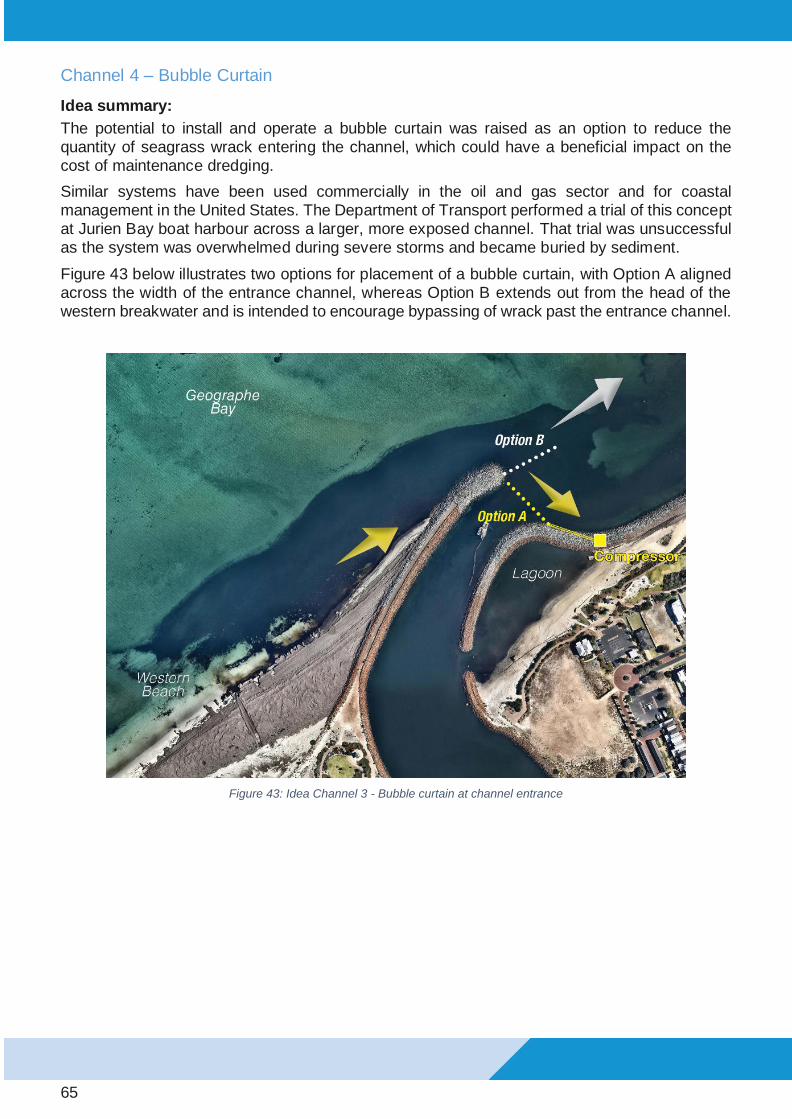
65
Channel 4 – Bubble Curtain
Idea summary:
The potential to install and operate a bubble curtain was raised as an option to reduce the quantity of seagrass wrack entering the channel, which could have a beneficial impact on the cost of maintenance dredging.
Similar systems have been used commercially in the oil and gas sector and for coastal management in the United States. The Department of Transport performed a trial of this concept at Jurien Bay boat harbour across a larger, more exposed channel. That trial was unsuccessful as the system was overwhelmed during severe storms and became buried by sediment.
Figure 43 below illustrates two options for placement of a bubble curtain, with Option A aligned across the width of the entrance channel, whereas Option B extends out from the head of the western breakwater and is intended to encourage bypassing of wrack past the entrance channel.
Figure 43: Idea Channel 3 - Bubble curtain at channel entrance

66
Outcomes:
Pros • High cost of dredging may allow bubble curtain to be a more cost-effective option.
Running during strategic periods would lower running costs.
• Improved odour in channel with less wrack entrained.
Cons • Relatively high running and maintenance costs
• Untested in environments with high wrack volumes and stronger currents expected to be experienced at Port Geographe Marina (must withstand the highest waves during
storms). Further design of the system would be required to withstand the exposure.
• Equipment breakdown and service periods likely to be required, anchoring hose to seabed could be hazardous to navigation, system would need to be retrieved if
dredging is still required.
• Value for money has yet to be proven by a case study in a similar environment
elsewhere given initial capital expenditure, as well as maintenance and running costs
• Bubble curtains placed on the seabed tend to produce additional sand features, which
are often problematic
Category: Investigate further (at a later time)
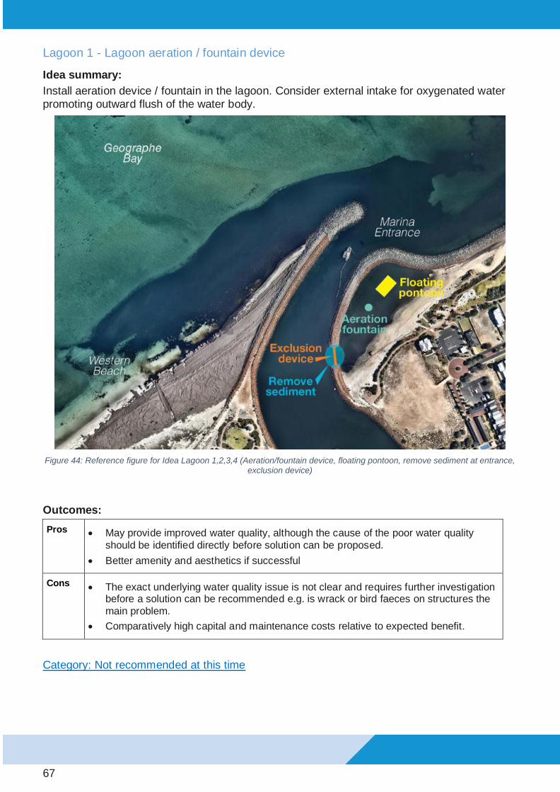
67
Lagoon 1 - Lagoon aeration / fountain device
Idea summary:
Install aeration device / fountain in the lagoon. Consider external intake for oxygenated water promoting outward flush of the water body.
Figure 44: Reference figure for Idea Lagoon 1,2,3,4 (Aeration/fountain device, floating pontoon, remove sediment at entrance,
exclusion device)
Outcomes:
Pros • May provide improved water quality, although the cause of the poor water quality
should be identified directly before solution can be proposed.
• Better amenity and aesthetics if successful
Cons • The exact underlying water quality issue is not clear and requires further investigation before a solution can be recommended e.g. is wrack or bird faeces on structures the
main problem.
• Comparatively high capital and maintenance costs relative to expected benefit.
Category: Not recommended at this time

68
Lagoon 2 - Install floating pontoon
Idea summary:
Installation of floating pontoon to add attraction/function to the lagoon water body.
Outcomes:
Pros • Low capital cost
• Improved amenity
Cons • Does not improve the water quality
• Would need to ensure diving hazard is not created / risk of injury liability.
• Increase risk of complaints unless water is of good swimming quality year
round
• Would need maintenance replacement.
This idea was not preferred because as a solution on its own, it will not improve the water quality in the lagoon, unless used in conjunction with an aeration / fountain device (Idea Channel 5.1).
Category: Not recommended at this time

69
Lagoon 3 – Remove sediment and siltation at lagoon entrance to enhance flushing
Idea summary:
As a way to improve the quality of water in the lagoon for swimming, it was suggested that removal of sediment and wrack at the lagoon entrance (Figure 44) could be performed to enhance flushing.
Outcomes:
Pros • If feasible, channel dredging could be extended to include dredging into the lagoon
entrance.
• Improved amenity – offers long term benefit if undertaken biennially.
Cons • Area would infill next winter/spring with wrack
• This would be an ongoing maintenance cost to add to the dredging campaign (if
achievable with the same dredge)
• A high cost when compared to the benefit.
Category: Not recommended at this time

70
Lagoon 4 – Wrack excluding device (Net, Bubble Curtain)
Idea summary:
The implementation of a wrack excluding device, in the form of a net or a bubble curtain, at the lagoon entrance was proposed as a method for improving water quality within the lagoon.
Outcomes:
Pros • Potentially low risk to trial the bubble curtain performance to exclude wrack from the
lagoon.
• Improved amenity if successful
• No significant disruption to amenity.
Cons • Net may clog up with wrack, bio-fouling or other debris and cease functioning/create a
worse issue.
• Net is significant risk to wildlife
• Keeping a net in place and maintaining it (cleaning) would be cost and effort
intensive. Feasibility really low in terms of making it work.
• Not clear if any wrack build-up in the lagoon needs to be resolved in order improve
the quality of the lagoon
Category: Not recommended at this time

71
Table 1: Complete summary of all TWG ideas and their Recommendations
Idea ID # Idea Description Recommendation Category
Western Beach 1 Breaking up and pushing wrack into
water during winter and spring
(community submission)
Trial
Western Beach 2A Reduce target wrack volume on
western beach down to 10,000m³
(community submission)
Not recommended at this time
Western Beach 2B Investigation of a framework separate
from the EMMP to address amenity
targets for the Western Beach
Investigate Further
Western Beach 3 Continue with Current Management
Approach
Investigate Further (at a later
time)
Western Beach 4 Two Right-Angle Low-Profile Sandbag
Groynes (community submission)
Investigate Further
Western Beach 5 Remove wrack and replace with sand Not recommended at this time
Western Beach 6 Remove wrack and realign sand to post
reconfiguration (steep) profile (in
PGCMA) – transport excess sand to
Wonnerup
Not recommended at this time
Western Beach 7 Nourish beach west of wrack to form
sand shoreline in summer up to
breakwater (offshore sand source)
Not recommended at this time
Western Beach 8 Build A Beach Profile with Sandbags
(community submission)
Not recommended at this time
Western Beach 9 Reinforced shoreline: Sandbags placed
seaward of breakwater
Not recommended at this time
Western Beach 10 Tracer study Not recommended at this time
Western Beach 11 Construction of sand dune / berm to
reduce capacity for wrack to be held on
beach
Not recommended at this time
Western Beach 12 Construct submerged breakwater off
end of Western Breakwater
Not recommended at this time
Western Beach 13 Reinforced shoreline: Sandbags to west
of breakwater
Not recommended at this time
Western Beach 14 Remove wrack from beach and do
nothing
Not recommended at this time

72
Wonnerup 1 Mechanical sand bypassing from
Western Beach (west end of PGCMA)
Trial
Wonnerup 2 Mechanical sand bypassing from
immediately west of PGCMA
Investigate Further (at a later
time)
Wonnerup 3 Reuse dredged sand from offshore
disposal area
Implement
Wonnerup 4 Alternative sand supply options –
Vasse river mouth (Backpassing)
Investigate Further
Wonnerup 5 More sustainable sand supply options –
Iluka’s Capel mine (or other local mine)
Not recommended at this time
Wonnerup 6 Do nothing (await natural bypassing
from western beach) (community
submission)
Not recommended at this time
Wonnerup 7 Sourcing of sand with a larger grain
size (alternative source)
Not recommended at this time
Wonnerup 8 Extend Eastern Revetment Nib Not recommended at this time
Wonnerup 9 Large-scale nourishment with dredged
material from offshore sand source
Investigate Further (at a later
time)
Wonnerup 10 Construct four new groynes (for east of
PGCMA up to inlet)
Already implemented by CoB
Wonnerup 11 Source sand from nearshore sand bar
within the PGCMA
Not recommended at this time
Channel 1 Push wrack off Western Beach earlier
to limit amount of wrack entering
channel
Trial
Channel 2 Reduce dredging to central section
leaving narrower channel – possible
interim trawling/agitation
Not recommended at this time
Channel 3 Investigate if deeper outer entrance is
increasing wrack entrainment into
channel (model impact of stopping
deepening of outer entrance)
Not recommended at this time
Channel 4 Bubble Curtain to reduce wrack/sand
entering channel
Investigate Further (at a later
time)
Lagoon 1 Lagoon aeration / fountain device Not recommended at this time
Lagoon 2 Install floating pontoon
Not recommended at this time
Lagoon 3 Remove sediment and siltation at
entrance to enhance flushing
Not recommended at this time
Lagoon 4 Wrack excluding device (Net, Bubble
Curtain)
Not recommended at this time

73
Community Feedback on Draft Recommendations
Community Representative Submissions
On 24 July 2020, nine community representatives, including members from the Port Geographe Land Owners Association, the Port Geographe Action Group and Wonnerup Residents Association, were invited to attend a presentation of the Technical Working Group process and draft recommendations. Other meeting attendees included the five Technical Working Group experts, staff from the Department of Transport and the City of Busselton.
The community representatives present at the meeting were given an opportunity to provide feedback on the draft recommendations and overall plan, both verbally and in writing via a feedback sheet. A summary of the level of support for each recommendation, as expressed by the community representatives in writing, is presented in Table 2.
Table 2: Summary of the level of support, as provided by the community representatives who were present at the meeting on 27 July 2020.
Community
representative
level of support
Trial earlier
commenceme
nt of wrack
pushing
Investigation
of separate
management
plan to the
EMP
Investigation
and
assessment of
low profile
groynes
Trial of sand
bypassing to
Wonnerup
Beach
Reuse of the
small volume
of clean
dredged sand
Strongly Oppose 1 0 1 3 2
Oppose 0 0 1 2 0
Support 3 4 4 2 3
Strongly Support 4 4 3 1 4
Don't Know 1 1 0 1 0
Total 9 9 9 9 9
The recommendations presented in the draft report were generally well supported by the community representatives present at the meeting. The recommendation which was not supported by the majority of community representatives was the trial of sand bypassing from the Western Beach to Wonnerup beach (Idea Wonnerup 1). This was primarily due to a concern that taking sand from the Western Beach would have a negative impact on future beach amenity, by delaying the establishment of a beach profile that would support greater natural bypassing of wrack. The TWG deliberated over this feedback and jointly agreed the recommendation would remain due to its technical merit, however, they agreed not to proceed immediately but to use another sand source for the next campaign. Further clarification was also provided at the November meeting with community representatives regarding the technical merit of the recommendation.

74
Online Survey Results
Following the public release of the draft Technical Working Group Report and associated recommendations in late July 2020, members of the public were invited to participate in an online survey. The survey process improved the understanding of the importance of various amenity aspects to the community and the level of support for each of the actions proposed in the draft TWG report.
48 responses were received from the community by the survey closing date. A summary of the survey results is provided below.
First Proposed Action: Breaking up and pushing wrack into water during winter and spring (community submission)
• There was overall support for the trial of the idea, with consideration for timing of
consequence of the works.

75
Second Proposed Action: Investigation of a framework separate from the EMMP to address amenity targets for the Western Beach
• There was general support for the idea to improve general amenity, with others still interested to see a reduction in the wrack volume target, which is not the intent of the alternative amenity management framework. Another comment noted it seemed unfair to focus amenity at this particular beach over others (across the State).

76
Third Proposed Action: Investigation into Right-Angle Low-Profile Sandbag groynes on Western Beach to reduce sand erosion
• There was considerably varied feedback on this recommendation. Many welcomed the investigation as a positive step; others uncertain about the impacts; and some strongly opposing with the concern hard structures will cause wrack to accumulate.

77
Fourth Proposed Action: A trial of sand bypassing to Wonnerup Beach from the western extent of the Port Geographe Coastal Management Area
• There was a low level of support for this recommendation, with the primary feedback being that taking sand from the western beach will have a detrimental effect on beach amenity in future years. It is acknowledged that the technical justification for this approach was not made sufficiently clear in the draft report and further explanation has been provided in this final report reflecting the TWG’s support of the future implementation of the recommendation.

78
Fifth Proposed Action: Reuse dredged sand from offshore disposal area for beach nourishment at Wonnerup
• There was a high level of support for this option given the knowledge of two large offshore sandbanks that have continued to grow. The community would also like the offshore disposal area considered for the Western Beach.

79
Technical Working Group Response to Community Feedback
The following information is provided to clarify the position of the Technical Working Group in response to feedback received from the community:
Table 3: Summary of changes to the TWG recommendations based on community consultation.
Community Feedback Item Technical Working Group’s Response
Preference to avoid taking sand from the western beach for beach nourishment at Wonnerup
The TWG considered these comments but jointly agreed there are strong technical merits to this recommendation. Refer to Appendix A for additional detail.
The recommendation for this remains the same, although this is now planned to occur in late 2021.
Support for investigation or trial of sourcing sand from Vasse River mouth for beach nourishment
This idea was assessed as Idea Wonnerup 4 and did not score highly when assessed during the TWG workshops. However, due to the level of community support it is recommended to investigate further the technical merits of this option including the required environmental and heritage related approvals. The recommendation has been changed to reflect this.
Support for removal of wrack from Western Beach, with wrack to be used as a resource e.g. fertilizer.
The TWG has recommended to investigate this idea further, with a particular emphasis on potential options to use wrack as a resource such as fertiliser or soil conditioner. The investigation will explore the potential feasibility including potential uses, likely demand, possible logistics and operating costs. If suitable, this could be included as a potential management action as part of the planned separate management plan. The recommendation has changed to reflect this.

80
Recommendations
This section of the report outlines the ideas that are recommended to be implemented, trialled or investigated further. Each idea has been categorised based on how well the Technical Working Group anticipated it would perform with respect to function, value for money, knock on impact, social and environmental consideration.
The most suitable ideas have been selected based foremost on whether they are likely to function well and provide the desired benefit. If an idea is recommended it will either be implemented, trialled or investigated further depending on its individual benefits or issues.
The ideas considered strongest by the TWG will be considered as priorities for implementation, trial or investigated further at the earliest opportunity. A summary of the recommendations is provided in Table 4.
Following careful assessment, the TWG recommends the following actions:
• Trialling of wrack pushing works on the Western Beach earlier in winter prior to suitable winter storms. The aim being to assist natural bypassing of wrack, reduce the accumulation of wrack on the Western Beach; and potentially reduce the amount of wrack entering the entrance channel
• Investigation of a management plan separate to the Environmental Monitoring and Management Plan (EMMP) to address amenity targets for the Western Beach.
• Investigation into low profile groynes on Western Beach to reduce local sand erosion.
• Trial of sand bypassing from western end of PGCMA to Wonnerup beach - Additional details provided with regards to the technical justification for the recommendation, the limited scope of works and methodology. This is to better explain the benefits and address community concerns related to western beach amenity and disruption during the works. The recommended works will be delayed until late 2021.
• Reuse of the small volume of clean dredged sand accumulated at the offshore disposal area to supplement beach nourishment (sand placement) at Wonnerup.
• Sourcing sand from Vasse River mouth - recommendation changed from not recommended at this time to investigate this idea further based on strong community support.
• Investigation into the removal and beneficial reuse of dry wrack from the Western Beach. Recommendation changed from not recommended at this time to investigate this idea further based on strong community support.

81
Table 4: Snapshot Summary of Recommendations to ‘Implement’, ‘Trial’, and ‘Investigate Further’
Location of Trial/
Investigation Description Category
Snapshot: Action and Timeframe
Western
Beach:
4 Ideas
Breaking up and pushing wrack
into water during winter/spring
(immediately prior to suitable
storm events) (Idea 1 of 15)
Trial Perform trial in 2020 - determine
storm selection criteria - ensure
equipment availability - monitor
effectiveness of trial with respect
to wrack clearing (Note: trial
works commenced in August
2020). Engage with DBCA to
investigate requirements for
approval to push wrack off the
beach within the Marine Park.
Investigation of a framework
separate from the EMMP to
address amenity targets for the
Western Beach (Idea 2B of 15)
Investigate
Further
Further investigation and
discussions to develop a l
separate framework and criteria
(outside the EMMP) to improve
beach amenity. Review process
and funding
Right-angle low-profile sand-
bag groynes at pocket beach
adjacent to western breakwater
(Idea 8 of 15)
Investigate
Further
Further investigation to determine
if concept is technically feasible.
This may include a desktop study
or numerical modelling.
Remove wrack and use as a
resource (Idea 5/6/14 of 15)
Investigate
Further
Further investigation into viability
of this approach, including local
market demand for wrack (eg.
agriculture)
Wonnerup:
3 Ideas
Reuse dredged sand from
offshore disposal area for
beach nourishment (Idea 3 of
11)
Implement Implement during next
maintenance dredging campaign.
Action required to mitigate hazard
to navigation
Bypassing sand from west end
of Western Beach PGCMA
(Compartment 5 & 6) (Idea 1 of
11)
Trial Proposed to trial during late 2021
or early 2022– monitor trial and
review effectiveness
Source sand from Vasse river
mouth (Idea 4 of 11)
Investigate
Further
Further investigation into costs
and benefits associated with this
sand source option.
Channel:
1 Idea
Push wrack off Western Beach
earlier – to reduce wrack
entering channel (Idea 1 of 8)
Trial Perform trial in 2020 - determine
storm selection criteria - ensure
equipment availability - monitor
effectiveness of trial with respect
to channel infilling

82
Western Beach – Progress against Recommendations
Western Beach 1 – Breaking up and pushing wrack into water (during winter & spring)
Based on a strong level of support from community representatives, a decision was made by the Department of Transport with support from the City of Busselton, to perform a trial of earlier wrack pushing works on the Western Beach. These works commenced on 20 August 2020 and have been performed over short campaigns (one to two days), prior to suitable weather events predicted to produce eastward transport of wrack.
Table 5: Dates and hours of wrack pushing works performed during 2020 trial period
Pushing Dates Hours of Work
20-Aug 10
21-Aug 10
3-Sep 8.5
4-Sep 9
7-Sep 9
8-Sep 2
25-Sep 7
29-Sep 3
30-Sep 3
7-Oct 5
Regular drone flights were scheduled to monitor the effectiveness of the trials by assessing the change in wrack footprint and volume following wrack pushing campaigns. Data collected over this period will be used to refine the selection criteria that guide the timing and work methods for future wrack pushing campaigns.

83
Western Beach 2B – Investigation of a separate framework to the EMMP to address amenity targets at the Western Beach
It is recommended that DoT, in collaboration with CoB and other stakeholders, investigate the process of developing a separate management framework aimed at improving amenity along the Western Beach. This would be a separate framework to the EMMP. The EMMP must be in place to the satisfaction of the Department of Water and Environmental Regulation (DWER) and therefore does not directly align with amenity considerations.
The separate management framework would aim to encompass the following:
• Good understanding between management actions, coastal processes and beach amenity
• Clearly defined community values or uses, including the setting of unambiguous management goals
• Clearly identified and appropriate beach amenity indicators and targets
• Adoption of cost-effective strategies aimed at improving outcomes with respect to beach amenity objectives
An example of a potential beach amenity indicator could be the length of sandy beach (clear of wrack) at the shoreline within the western beach side of the PGCMA. From an amenity perspective, this may be considered a more suitable indicator than wrack volume (as used in the EMMP).
It will be important to ensure that any indicators and management targets reflect the effects of inaction as well as action in terms of the impacts on the amenity and usability of that area. For example, management actions involving the mechanical removal of wrack will need to consider both the short-term impacts (disruption, increased odour) and the medium-term benefits (reduced wrack on the beach).
While initial discussions have commenced regarding the potential of such an amenity framework and its implementation, funding sources for this arrangement would also need to be considered as part of this investigation.

84
Western Beach 4 –Right-angle low-profile sandbag groynes
It is proposed that an initial investigation into the feasibility, benefits, impacts and costs be undertaken with agencies working collaboratively.
Local stabilisation of sand at the eastern end of Port Geographe Western Beach has been proposed as a possible means to enhance the effectiveness of wrack and sand bypassing at the harbour entrance. The opportunity to use the existing hydrodynamic, wrack and sediment transport model of Port Geographe (UWA 2015) to explore options for stabilisation has been suggested. However, the most appropriate approach to assessing the feasibility, performance and cost of this solution within the complex nearshore setting will be carefully considered prior to launching the investigation or implementation.
If there are concerns raised in the investigation further assessment, such as numerical modelling of both sand and wrack transport, may be necessary. This would aim to assess feasibility and consider multiple options to determine an optimal arrangement.
If the initial investigation confirms this idea could be functional without impacts, the next step could involve a trial.
A scope of work has been discussed and drafted. The funding of subsequent steps including a trial would need to be considered as part of the initial investigation.
Entrance Channel / Lagoon
Channel 1 – Push wrack off Western Beach earlier – aim: to reduce wrack entering channel 1
It is recommended to perform a trial of wrack pushing off the Western Beach during winter, which is as per Idea - Western Beach 1. This would be done to with the aim to increase wrack bypassing during the suitable winter storms which may reduce the volume of wrack entering the harbour overall. Further work is required prior to the trial to:
• Determine storm selection criteria
• Develop wrack pushing strategy.
• Ensure availability of suitable equipment
It is also recommended that this is closely monitored to assess the effectiveness of the trial with respect to reducing channel infilling. This will help to determine whether this approach provides sufficient value to become an ongoing component of the management strategy.
Progress against this action item is the same as Western Beach 1 above.

85
Wonnerup
Wonnerup 1 - Bypassing sand from west end of Western Beach PGCMA (Compartments 5 and 6)
It is recommended that a trial of bypassing sand from the Western Beach at the west end of the PGCMA (between Morgan St and Guerin St) be undertaken. A trial of this option is recommended as a priority due to the accretion of sand at the western end of the PGCMA over the past 5 years. It is recommended that the volume bypassed from the Western Beach during the trial not exceed the volume accreted in the past 2 years and be taken from the area furthest from the Western Breakwater within the PGCMA (Figure 45). This could be undertaken as part of the dredging campaign in late 2021 at shallow depth to minimise visible difference to the above water beach profile.
Figure 45: Proposed dredging area for trial of sand bypassing from Western Beach to Wonnerup
The effectiveness of this trial will be monitored and reviewed.
Wonnerup 3 - Reuse dredged sand from offshore disposal area for beach nourishment
Following community support received for this idea, planning has commenced to implement this recommendation at the earliest opportunity. These works are expected to commence in February 2021 and involve approximately two weeks of dredging. Approximately 20,000 m3 of material is planned to be dredged during these works.

86
Wonnerup 4 – Source Sand from Vasse River mouth
Following community support for this idea, a decision was made to begin a further investigation into the feasibility of sourcing sand from the Vasse River mouth. In October 2020, a meeting was held between DoT and the Department of Biodiversity, Conservation and Attractions (DBCA), who are the regulatory body responsible for reviewing and approving any works to be performed within the Ngari Capes Marine Park. Feedback received from DBCA during this meeting indicate that a significant amount of work will be required before approval to source sand from this location can be granted.
The rate of accretion of sand in the vicinity of the Vasse River mouth has also been re-assessed. The accretion volume from 2014 to 2019 is approximately 20,000 m3. This potential resource is similar to the offshore disposal area, such that it could represent a source for one year of nourishment but is not expected to be an ongoing sustainable source.
Further work will be performed to determine whether the benefits achieved from sourcing a limited volume of sand from this location outweigh the cost of obtaining the necessary environmental and heritage approvals as well as any other associated impacts.

Appendix A – Additional Technical Justification for TWG
Recommendation to Trial Idea Wonnerup 1 - Mechanical sand
bypassing from Western Beach (west end of PGCMA)

Monitoring of Port Geographe through the EMMP has demonstrated reduced severity of sand and wrack problems since the entrance reconfiguration. However, the modified entrance has not wholly removed sand and wrack challenges from the harbour entrance and adjacent coast. Management requirements at Port Geographe have been related to three main issues at three locations:
• Wrack accumulation on the Western Beach; • Navigational constraints through the Entrance Channel; and • Erosion along the wider Wonnerup Beach.
Overall, there is a single issue, that Port Geographe entrance, under the full range of conditions experienced, modifies sand and wrack transfers compared to behaviour of the coast without a harbour entrance. This is an inescapable outcome, with management to address negative consequences.
Although reconfiguration has improved ‘ambient’ (without human intervention) wrack bypassing, sand transfer past the entrance has apparently been less effective, potentially due to wrack impeding alongshore sediment transport near the entrance.
A consequence of reduced transfer effectiveness is a tendency to accumulate sediment to the west, where sand can accumulate broadly along the beach, where it has limited influence on rates of alongshore sediment transport. This mechanism supports updrift ‘filling’ with the reoriented section of beach achieving a ‘net stable’ alignment, although seasonally varying. Bypassing of the entrance can still occur, but it is driven by strong westerly weather conditions, rather than realignment of the beach.
A key implication of the observed pattern of development is that sand extraction for mechanical bypassing should not be removed from the section of shore that has reoriented. The excavated

area will preferentially infill, reducing the capacity for ‘natural’ wave-driven bypassing. In contrast, sand extracted from the area of accumulation further west, provided a concave shape is not formed, will have limited effect on natural bypassing.
Potential management actions have been presented as options, however these are a mix of complementary and non-complementary activities, for the three different areas. Strategic evaluation of preferred actions aimed to identify at least one action for each existing issue, avoiding a combination of non-complementary options – including options that may be plausible, but were deemed likely to be less effective than the preferred option.
In consideration of overall management requirements, the Working Group aimed to address each management issue, rather than neglect one issue in preference to another. Although more sand on the Western Beach provides improved beach amenity, its pattern of growth suggests limited additional ‘natural’ bypassing with further accumulation. Consequently, the accumulated sediment was considered an appropriate source to address the downdrift erosion occurring along the wider Wonnerup foreshore due to restricted bypassing