Embed Size (px)
Citation preview

; N A S A TECHNICAL NOTE
h h cv CI Y
PLATE DRIFT I N THE AFAR AND ISSAS TERRITORY (FRENCH SOMALIA) AND EASTERN ETHIOPIA AS SEEN ON SPACE PHOTOGRAPHY
by Dietrich Bannert
Manned S'acecra, Center Houston, Texas 77058
?
NATIONAL AERONAUTICS AND SPACE ADMINISTRATION WASHINGTON, D. C. JUNE 1972
https://ntrs.nasa.gov/search.jsp?R=19720020695 2018-06-16T10:37:51+00:00Z

TECH LIBRARY KAFB, NM
I. REPORT NO. 2. GOVERNMENT ACCESSION NO.
NASA TN D-6277 a. T I T L E AND SUQTITLE
PLATE DRIFT IN THE AFAR AND ISSAS TERRITORY (FRENCH SOMALIA) AND EASTERN ETHIOPIA AS SEEN ON SPACE PHOTOGRAPHY
TECHNICAL REPORT STANDARD TITLE PAGE
7. AUTHOR(S)
Dietrich Bannert, MSC
9. PERFORMING ORGANIZATION NAME AND ADDRESS
Manned Spacecraft Center Houston, Texas 77058
12. SPONSORING AGENCY NAME AN0 ADDRESS
National Aeronautics and Space Administration Washington, D. C. 20546
IS. SUPPLEMENTARY NOTES
5. RECIPIENT'S CATALOG NO.
5. REPORT DATE
June 1972 6. PERFORMING ORGANIZATION CODE
8. PERFORMING ORGANIZATION REPORT NO.
MSC 5-253
10. WORK UNIT NO.
914-50-16-12-72
11. CONTRACT OR GRANT NO.
13. REPORT TYPE AND PERIOD COVERED
Technical Note
14. SPONSORING AGENCY CODE
16. AQSTRACT
Apollo 9 photographs of the region northwest of the Gulf of Tadjura have been studied. The occurrence of a large region of basement rocks, probably crystalline in nature, with a strongly faulted overlayer has been recognized and has been named the Tadjura uplift. Study of this region is adding detailed knowledge to the literature on the phenomenon of plate drift in the southern Red Sea region.
17. KEY WORDS (SUPPLIED BY AUTHOR) 18. DISTRIQUTION STATEMENT
* Plate Drift
* Red Sea * Afar Triangle * Space Photography
Continental Drift
19. SECURITY CLASSIFICATION 7.0. SECURITY CLASSIFICATION
(THIS REPORT) (THIS PAGE)
21. NO. OF PAGES 72. PRICE
None 26 None
* For sale by the National Technical Information Service,Springfield, Virginie,22151

TECTONIC FEATURES IN THE AFAR AND I SSAS
TERRITORY (FRENCH SOMALIA) AND EASTERN
ETHIOPIA AS SEEN ON SPACE PHOTOGRAPHY
By Diet r ich Banner t* Manned Spacecraft Center
SUMMARY
The eastern part of Ethiopia (the northern part of the Afar region) bordering the southern Red Sea was investigated by using conventional aerial photography and Apollo 9 space photography. The results of these investigations make it obvious that parts of the African continent are drifting eastward. They follow the counterclockwise-drifting Arabian Peninsula, which causes the southern opening of the Red Sea. South of 15" north latitude, however, a funnellike narrowing of the Red Sea is obvious. At this
, location, there are two eastward-drifting uplifts on the African continent, which con- sist of pre-Tertiary Mesozoic rocks slightly metamorphic Paleozoic rocks, and crys- talline rocks. One uplift is called the Danakil Mountains, and farther to the south is the second uplift, which has been detected on Apollo 9 photographs and is termed the Tadjura uplift. On the space photographs, which have been studied in stereoscopic pairs, the tectonic structures have been analyzed, and the results have been coordi- nated with the results of previous investigations of approximately 5000 aerial photo- graphs taken over the northern part of the Afar region. Thus, for the first time, a photogeologic map showing the distribution of different rocks, as well as a complex tec- tonic study of this area, could be prepared. Ground survey data were available for the region north of 13" north latitude and for a small region northwest of the Gulf of Tadjura. The space between the African craton and the drifting uplifts is filled by a graben system, where since the early Tertiary age, clastic and saline sediments have been deposited, together with huge masses of plateau-forming Afar Basalt. During the Pleistocene age, this development continued. However, instead of the widespread and uniform Afar Basalt, volcanoes of basaltic and acid alkali-rich composition were formed (the Aden Volcanic Series), and some of them a re still active. The distribution of sediments, of small uplifts in the graben region, and of acid extrusive rocks of the
, Aden Volcanic Series is significant and allows conclusions to be formed concerning , plate-drifting mechanics. This distribution also allows detailed structural analysis.
With the increase of field observations, variations in the tectonic concept are to be expected.
*Senior postdoctoral research associate of the National Research Council assigned to the NASA Manned Spacecraft Center, on leave from the Geological Survey in Germany.

INTRODUCTION
The familiar term "continental drift" is now more correctly called "platform tectonics. '' Geophysical investigations of the ocean floors during the past 20 years have brought new and better data on continental movement and on sea-floor spreading (refs. 1 and 2). The effect of these movements on land surfaces can result in faults and folds. Rotation of the Arabian Peninsula along the Red Sea rift, in a counterclock- wise direction away from Africa, has been proved (refs. 3 and 4). According to ref- erences 3 and 4, the opening of the Red Sea took place after the Miocene age. The spreading has now reached an amount 0.1222 radian (7") away from an imaginary center located south of Cyprus, in the eastern Mediterranean Sea. It has been stated that right-lateral slip faults along the Jordan Rift Valley compensate for the expected heavy distortions near this imaginary center, and these faults cause counterclockwise rotation of different blocks in the Judaean and the northern Negev Mountains, which a r e west of the Dead Sea.
By usin'g the Apollo 9 orbital space photography of the African-Arabian area, and by taking advantage of the unique synoptic views thereby provided, overlays were made on 40.6- by 40.6-centimeter (16 by 16 inches) paper prints. On these overlays, the re- sults of stereoscopic investigations on 20.3- by 20.3-centimeter (8 by 8 inches) trans- parencies, enlarged from the original 70-millimeter space photographs, have been traced. The structural and tectonic features, together with the distribution of different rock types, are clearly shown in the space photographs and can be related to the dis- placements involved in the continental drift of this region. This study accomplished a further extension of the intended purpose of orbital photography. Earlier work (ref. 5) for the northern part of the Red Sea was based on Gemini photographs and provided a first impression of the future use of earth-looking space photography.
The crews of the Gemini and Apollo missions are to be congratulated for obtaining the excellent photographs of the Afar, Red Sea, and Gulf of Aden regions. Many NASA Manned Spacecraft Center (MSC) personnel supported these photographic experiments, and their assistance is gratefully acknowledged. Finally, I wish to thank David L. Amsbury and John L. Kaltenbach of MSC and Paul Lowman of NASA Goddard Space Flight Center for their timely advice and assistance.
GENERAL GEOLOGY
The greatest movement and the widest spreading of the Arabian Peninsula are located at the southern end of the Red Sea rift. This spreading, which is clearly vis- ible, extends southward along the Red Sea to near Massaua, Ethiopia, at 15" north latitude, where the opening reaches a width of 300 kilometers. Farther south, however, the spreading decreases to a width of 30 kilometers of open sea in the Strait of Bab el Mandeb (figs. 1 and 2). As suggested by Laughton (ref. 4), a separate counterclock- wise movement of the Danakil Mountains takes place in the northern part of the Afar region. Investigations of aerial photographs and field surveys have revealed new data about the geology in this remote region (ref. 6). According to reference 6, the geology of the region between the Gulf of Zula in the north and 13" north latitude in the south is as follows.
2

Precambrian, Cambrian (lightly metamorphosed), and transgressive Jurassic sandstones and limestones compose the eastern and western flanks of an upper Tertiary graben named the Danakil graben (figs. 3 and 4). Clastic, calcareous, and gypsiferous marginal sediments of the Pliocene and perhaps of the Miocene age, called the Danakil Series (ref. 6), are found in the center of the graben (fig. 4), where more than 3000 meters of saline deposits havebeen drilled. The deepest point in the graben, 130 meters below sea level, indicates a recent downfaulting of the graben. During the late Tertiary age, huge masses of plateau-forming Afar Basalt (ref. 7) flowed over the southern extension of the Danakil graben. These basaltic masses could be ascribed to the marginal sediments in the graben region. Pleistocene and Recent Aden Volcanic Series magmas penetrated the entire region, creating an outpouring of olivine basalts (refs. 8 and 9), acid ignimbrites, and acid lavas. In the Danakil graben, recent vol- canic activity is almost completely restricted to the central rift-in-rift (ref. 10). In the northern part of this rift-in-rift, an uplift of basement rocks borders on the west, which leads to the Ethiopian Highlands (fig. 3(b)). To the east, many steps approach the basement of the Danakil mountains. These facts indicate the presence of an asym- metrical graben with a movement of its eastern flank as shown by the arrow in fig- ure 3(b). The Danakil graben opens to the southeast in a funnellike shape and can be traced southward to 13" north latitude (refs. 6 and 9). The adjacent region to the south is characterized by the frequent occurrence of acid extrusive rocks of the Aden Vol- canic Series and by crossed tectonic lines (ref. 10). These acid extrusive rocks cannot be ascribed to the northern extension of the Wonji fault belt of Mohr (ref. ll), because this fault belt does not exist in the northern part of the Afar region. Southward, at approximately 12" north latitude, a graben is present, with Lake Abbi? located at its lowest point. This graben (figs. 3 and 4) does not seem to be as deep as the Danakil graben. To the west of this shallow graben is a region that is only slightly affected by tectonic movements and that extends to the escarpment of the Ethiopian Highlands. Eastward, to the Gulf of Tadjura, several smaller grabens are present, and some have an annular shape (refs. 11 to 13). The region of annular grabens is composed of faulted Afar Basalt that has been partly covered by lavas of the Pleistocene Aden Volcanic Series (fig. 5). The identification of these rock types was made in the region north of 13" north latitude (ref. 6) and was recently verified in a field survey. Therefore, the transition from the use of aerial photography to Apollo 9 space photography for geologic interpretation of this region presented no difficulties. The small grabens, as well as the region north of the Gulf of Tadjura (insert, fig. 3(a)), have been investigated on space photographs. These investigations are described in the remainder of this report.
STRATIGRAPHY
I As shown in figures 4 and 5, the region northwest of the Gulf of Tadjura is covered by Afar Basalt of the Tertiary age, which is partly overlain by basaltic and acid lavas of the Pleistocene Aden Volcanic Series. North of the Gulf of Tadjura, base- ment rocks are present beneath the Afar Basalt. These older basement rocks appear to have lithologic characteristics similar to those found in rocks of the Danakil Moun- tains in the north (crystalline rocks with overlying Mesozoic rocks). The International Geological Map of Africa (ref. 14) shows only a small outcrop of basement rocks near the town of Tadjura. The suggestion has been made that this region, shown in figure 6, be called the Tadjura uplift. The origin of the sedimentary rocks outlined by small circles in figure 5 is undetermined. These sedimentary rocks cover the Afar Basalt north of the Tadjura uplift, and the sedimentary rock surfaces seem to be smooth and
3

without any major drainage system (fig. 6). Internal drainage could be present, as in limestones, and it is suggested that these sedimentary rocks are very young and a r e probably coastal deposits of the Red Sea and of the Gulf of Aden.
TECTONICS
Two different tectonic systems dominate the region northwest of the Gulf of Tadjura: (1) the Tadjura uplift in the ea-st and (2) several annular grabens in the west. As seen in figure 6, the striking of the joints (probably dissecting Mesozoic rocks) is about north-northwest. The shape of the Tadjura uplift indicates a northeastward motion. The northern shoreline of the Gulf of Tadjura is very conspicuous and is formed by east-west-striking faults along which the gulf is downfaulted. These faults a r e dissected by northeast-striking left-lateral transcurrent faults which indicate a northeast motion vector. The transcurrent faults extend off shore for some distance, as recorded in recent bathymetric and geophysical surveys (ref. 15).
The southern shoreline of the gulf, however, presents no evidence of transcurrent faults. This shoreline strikes strictly east-west, and only two transcurrent faults with a minor amount of offset are observed in the western part. As the bathymetric chart of the region (fig. 1 of ref. 15) shows, the downfaulting along the southern east-west- striking shoreline takes place several miles off shore. Nevertheless, the difference between the northern and southern shoreline is conspicuous. Apparently, in addition to its downfaulting characteristics, the southern east-west-striking fault has a sideslip function (ref. 13) with a right-lateral displacement along which the Tadjura uplift is separating from a southern uplift of crystalline rocks called Aysha horst by Mohr (ref. 11). The western part of the Gulf of Tadjura is called Ghubbet Kharab and is shaped by a northwest-striking graben. This graben extends to the annular Gawa graben (fig. 5). Frequent right-lateral transcurrent faults can be observed. These features indicate a northeastward movement of the whole Tadjura uplift, including the western part that is covered by Afar Basalt. The western border of the drifting Tadjura uplift may be indicated by a long lineation detected on Apollo 9 photographs (figs. 6 and 7). In figure 3(a), this lineation is shown as the line L---L. At the point where this linea- tion crosses to other (east-west and north-south striking) major lineations, a volcanic field of the youngest basalts of the Aden Volcanic Series is present (figs. 3 and 5). Two facts indicate that, to the south, this lineation could be a flexure fault. East of the lineation, toward the Tadjura uplift, the covering Afar Basalt is dissected into tilted blocks that dip slightly southwestward, indicating the approach of the basement rocks of the Tadjura uplift to the surface. West of the lineation, the Afar Basalt is dissected into many horst and graben structures (fig. 3(c)) which generally strike northwestward, as mentioned previously. These features could indicate a greater depth of the basement rock and a zone of inhomogeneity and differentiated mobilization caused by the drifting of the Tadjura uplift.
One unique feature in the Afar region is a system of obvious annular grabens, which is to the west of the Tadjura uplift (figs. 5 and 7 to 9). These grabens were first mentioned by Mohr (refs. 11 and 13) and were mapped on aerial photographs at the scale of 1: 60, 000 (ref. 12 and fig. 9). If the tectonic features are considered to be caused by crustal movements, different and individual movements of the adjoining blocks border- ing the annular grabens can be assumed (fig. 10). This hypothesis is the best explana- tion of the lack of graben structures immediately north of region A in figures 10 and 11.
4

DIFFERENCES IN INTERPRETATION OF AERIAL AND SPACE PHOTOGRAPHS
Figure 9 shows a photogeologic map of the region of annular grabens. Ground surveys have been made only in the southwestern part of this region (ref. 6). Since basaltic and acid volcanoes are relatively easy to distinguish on aerial photographs, a greater problem is the differentiation between the Afar Basalt -and the covering, older basalt of the Aden Volcanic Series (ref. 10). It is often impossible to distinguish these two types of basalt if there are no typical lava flows on the slopes of volcanoes of the Aden Volcanic Series. Even on ground surveys, distinguishing between the two types of basalt is nearly impossible. Space photographs, however, show a clear differentiation between the two basaltic lavas. The reason for such clear differentiation seems to be that space photographs have less resolution and greater tonal color differences than aerial photographs. The surfaces of both the Afar Basalt and the older basalts of the Aden Volcanic Series are outwashed and have many small depressions that are filled with recent deposits of material which has probably been transported by the wind. In most instances, it is impossible to differentiate between the two types of basalt on aerial photographs with a scale of 1: 60, 000. On space photographs, however, the small depressions cannot be seen because of the lesser resolution and the smaller scale, and only the large depressions are discernible. The number of depressions per square unit differs for the two types of basalt; therefore, with the additional aid provided by the tonal color contrasts in space photographs, it is possible to outline the boundaries be- tween the basaltic units.
Region A, approximately 25 kilometers in diameter and trending in a northwest- southeast direction, is marked by the lack of major fractures and faults, which is visible on both aerial photographs and space photographs (figs. 7 to 9). It is, therefore, assumed that this region is an individual block that is rotating and following the northeastward-moving Tadjura uplift. A zone of right-lateral east-northeast-striking transcurrent faults indicates this motion.
There are two points of particular interest regarding the tectonic movements of the northern part of the Afar region. Between the Ethiopian Highlands in the mest and the Danakil Mountains and the Tadjura uplift in the east, several large outcrops of Mesozoic rocks and crystalline rocks are found (figs. 3 and 4). It is suggested that these outcrops are isolated blocks, each drifting separately in the space opened in the progress of crustal separation. This open space is filled continuously by upward- moving basalt from the deep oceanic crust (ref. 9). In addition, the distribution of acid extrusive rocks of the Aden Volcanic Series is very conspicuous. Tazieff (ref. 16) notes that, according to chemical composition, the basaltic material which forms ranges in the center of the Danakil graben apparently has a different origin than the acid and basaltic materials in the western part of the Danakil graben. From study of aerial and space photographs, it could be assumed that acid extrusive rocks do not occur in regions where strong drifting is suggested (fig. 12(a)), with the ex- ception of the occurrence of some very small acid volcanoes. In the horst regions adjacent to regions of strong drifting (fig. 12(b)), acid volcanoes occur frequently but are not alined in a structure like the hypothetical Wonji fault belt (ref. 11).
5

Another advantage of space photography is that a synoptic view over large areas is provided by the photographs. Thus, it is possible to determine that the intensity of tectonic movements decreases to the north. This decrease is not clearly visible on the map prepared from aerial photographs (fig. 9). From photograph to photograph, the amount and density of the fractures decrease in small steps. The interpreter of aerial photography may change his scale of value regarding tectonic features (e. g., large, medium, or small faults) in the same steps. The result is that, on the geologic map (fig. 9), important grabens with major downfaulting are found north of the annular grabens and are comparable with the Gawa graben in the south. However, on the geo- logic map (fig. 5), prepared from space photographs, it can be seen that this interpre- tation does not provide the true proportions of the tectonic features.
CONCLUSIONS
In remote regions, space photography provides a rather detailed knowledge of rock distribution, provided the circumstances a r e adequate to allow geologic interpre- tation. The knowledge of rock distribution and rock identification, together with clearly visible fracture and joint patterns, has been the basis for tectonic investigations leading to a more detailed analysis of drift motions along the southern end of the Red Sea rift. The analysis shows that parts of the African craton (or African plate) are drifting, isolated in the space between Africa and the northeastward-moving Arabian Peninsula. In the future, space photography will help increase knowledge about general geologic features in many poorly mapped regions of the world and will provide more detailed knowledge about plate motions on the land surfaces.
Manned Spacecraft Center National Aeronautics and Space Administration
Houston, Texas, October 26, 1970 914-50-16-12-72
6

1.
2.
3.
4.
5.
I . 6.
7.
8.
9.
10.
11.
12.
13.
14.
REFERENCES
Hurley, Patrick M. : The Confirmation of Continental Drift. Scientific American, vol. 218, no, 4, Apr. 1968, pp. 52-64.
Anon. : The World Rift System. Report of Symposium, Ottawa, Canada, 4-5 September 1965. Can. Geol. Surv. Paper 66-14, 1966.
Girdler, R. W. : The Role of Translational and Rotational Movements in the Formation of the Red Sea and Gulf of Aden. In The World Rift System, Can. Geol. Surv. Paper 66-14, 1966, pp. 65-77.
Laughton, A. S. : The Gulf of Aden, in Relation to the Red Sea and the Afar De- pression of Ethiopia. In The World Rift System, Can. Geol. Surv. Paper 66-14, 1966, pp. 78-97.
Abdel, Gawad M. : Geological Structures of the Red Sea Inferred from Satellite Pictures. Ch. 4 of Hot Brines and Recent Heavy Metal Deposits in the Red Sea Area, E. T. Degens and D. A. Ross, eds., Springer-Verlag he., New York, 1969.
Bannert, D. ; Brinckmann, J. ; =ding, K. ; Knetsch, G. ; Kursten, M.; and Mayrhofer, H. : Zur Geologie der Danakil - Senke (NiJrdliches Afar, NE-Athiopien). Geologische Rundschau, vol. 59, no. 2, 1970, pp. 409-443.
Mohr, P. A. : The Ethiopian Rift System. Geophysical Observatory Bull. (Addis Ababa) vol. 11, 1967, pp. 1-65.
Mohr, P. A. : The Geology of Ethiopia. Paper VII, University College of Addis Ababa Press, 1962.
Tazieff, H. ; Marinelli, G. ; Barberi, F. ; and Varet, J. : Geologie de 1'Afar Septentrional. Paper presented at Symposium A. J.V. (Naples, Italy), 1968.
Bannert, D. : Fotogeologische Untersuchungen im Nordlichen Afar (Athi0pien)- Beiheft. Z. Geologischen Jahrbuch der Bundesanstalt fur Bodenforschung, Hannover, Germany, in press.
Mohr, P. A. : Major Volcano-Tectonic Lineament in the Ethiopian Rift System. Nature, vol. 213, no. 5077, Feb. 18, 1967, pp. 664-665.
Bannert, D. : Geologie auf Satellitenbildern. Naturwissenschaftliche Rundschau, vol. 22, no. 12, Dec. 1969, pp. 517-524.
Mohr, P. A. : Transcurrent Faulting in the Ethiopian Rift System. Nature, vol. 218, no. 5145, June 8, 1968, pp. 939-940.
ASGA-UNESCO: Geological Map of Africa, sheet 6. Scale, 1: 5,000,000. Paris, 1963.
7
! r

15. Peter, George; and DeWald, Omar E. : Geophysical Reconnaissance in the Gulf of Tadjura. Geol. SOC. Amer. Bull. , vol. 80, no. 11, Nov. 1969, pp. 2313-2316.
16. Tazieff, Haroun: The Afar Triangle. Scientific American, vol. 222, no. 2, Feb. 1970, pp. 32-40.
NASA - MSC
a

30" h
30" E
20" N
10" N
30" E 40" E
30" N
50" E
20" N
LO" N
40" E 50" E
Figure 1. - The Red Sea, the Gulf of Aden, and the adja- cent parts of Africa and Arabia. Small black arrows indicate local tectonic movements. Large white arrows indicate rotation of the arabian Peninsula. Lines with short tick marks indicate major faults, with tick marks pointing to the downfaulted side.
9
f .
. .. .
. ..

Figure 2. - Gemini photograph S-66-38423, eastward-looking view. In the fore- ground a r e the Ethiopian Highlands. The width of the Red Sea (left) decreases toward the Strait of Bab el Mandeb; then, the sea joins the Gulf of Aden. The eastern coast of the Red Sea is built by the northeastward-drifting Arabian Peninsula. Between the Ethiopian Highlands and the Red Sea is the northern part of the Afar region. The light-colored salt plain of the Danakil graben is interrupted by an outpouring of black basalt. (Also see figure 4. ) Bordering the Red Sea a r e the Danakil Mountains and the Tadjura uplift, which are drift- ing away from the escarpment of the Ethiopian Highlands and are causing the funnellike narrowing of the Red Sea. The insert shows the region covered by the photograph; lines with short tick marks indicate major faults, with tick marks pointing to the downfaulted side.
10

0
0 +
nrrm
""- L7
Dc L"L
TU
6 (3
15'
14'
13"
1;"
40" E 41' E
40" E 45" E 50" E
.So N
0' N
1. N
?N
'N
Pre-Tertiary Mesozoic and Paleozoic rocks and crystalline rocks Main Occurrence of Tertiary plateau-forming Afar Basalt - Upper Tertiary to Recent sediments and Pleistocene lavas of the
Aden Volcanic Series (No data available north of the Gulf of Zula and along the Red Sea coastline)
of the Aden Volcanic Series Main volcanoes and fissures of the Pleistocene to Recent basalts - 111111
Acid volcanoes of the Men Volcanic Series rrrrm Main graben faults. with tick marks pointing todownfaulted side Major faults and structural trends Lmg lineations indicating strike observed on space photography Shear fault zone, right-lateral displacement Shear fault zone, left-lateral displacement
Lineatim, probably the western limit of the Tdjura uplift Danakil graben
Tadjura uplift Gulf or Zuta Cross section A Cross section B
- -
Key for insert
Regions with Pre-Tertiary rocks (graben margins) Rift-in-rift structure of basaltic rocks located in the center d
the R e d Sea and the Gulf d Wen according to reference4: in the onshore areas, Pleistocene to Recent Aden Volcanic Series rocks (mainly basalts)
Region investigated on space photographs Region d geologic map compiled from aerial photography
Major graben faults. with tick marks pointing to dormfaulted side
(a) Schematic sketch map.
Figure 3. - The northern part of the Afar region in eastern Ethiopia.
11

$.* ...... ...... ...... ..... ..... ..... .... .... .... ... ... ...... ...... .... .... .... .... - - Basalts of t he Aden Volcanic Series Lm] Pre-Tertiary rocks
DG Danakil graben /\ Faults - Direction of motion
(b) Cross section A, along 14" north latitude.
= Basalts of the Aden Volcanic Series Frr) Pre-Tertiary rocks rm ] Afar Basalt
Faults - Direction of motion L Lineation, probably the western l imit
of the Tadjura upl i f t
(c) Cross section B, along 12" north latitude.
Figure 3. - Concluded.
12

._ - . .
15"N
l4oN
40"E 41 "E 42"E 43"E I I
lacustrine deposits Recent fluviate and
-1 Upper Tertiary and vary sediments
I
extrusive Aden . .
15"N

13"N
12Oh
11Oh
I I 1 40"E 41 "E 42"E 43OE
3"N
2 "N
O N
Figure 4. - Geologic sketch map of northern Afar. The region north of the Gulf of Tadjura was prepared )"L. on the basis of information from Apollo 9 space photographs, and the rest of the map was prepared w from information obtained from aerial photographs and ground surveys.

Fans Clastic debris Fine-grain sediments. with high reflection in periodically inundated lakes
El White saline (?) deposits
@Coastal sediments and shorelines
B Light-brown sediments overlying Afar Basalt
Aden Volcanic Series m B a s a l t s of the Aden
Volcanic Series with flow pattern
0 Acid volcanoes
Cinder cones
Eil Caldera
lol Volcano
0 Plateau-forming Afar Basalt
Mesozoic and older rocks
Undetermined
Young Tertiary- Pleistocene
Miocene
Pre-Tertiary
'L Shoreline
EZlWadil - Shear fault, left-lateral displacement - Shear fault, right-lateral displacement
DStratigraphic contact
IBoundar i e s within a geological unit P M a i o r and minor faults,
with ticks with tick marks pointing to downfaulted side
I-/,clFractures and joints
=Lineations
Figure 5. - Geologic map of the region north of the Gulf of Tadjura, prepared on the basis of information from Apollo 9 space photographs. Black on the insert map indicates the region shown on the geologic map. On the insert, lines with short tick marks indicate major graben faults, with tick marks pointing to the downfaulted side.


(a) The Gulf of Tadjura and the Tadjura uplift (right) overlain by black Afar Basalt. The intensity of tectonic movement increases to the southwest (left).
Figure 6. - Apollo photograph 889-23-3539 and orientation map of regions shown in Apollo 9 photographs.
17

13" h
12" h
41" E 42" E 43" E I D A N A K ~ L M O ~ N T A I N ~
I
41" E 42" E 43" E
13" N
12" N
(b) Sketch map showing part of the northern Afar region and the coverage by Apollo 9 photographs. Lines with short tick marks indicate major graben faults, with tick marks pointing to the downfaulted side.
Figure 6. - Concluded.
18

Figure 7. - Apollo photograph 889-23-3538. (Overlaps the region shown in 889-23-3539. Investigation could be done in stereoscopic view for the whole region. ) This photograph shows the complex of annular grabens. In the center of the photograph a r e the youngest basalts of the Aden Vol- canic Series (black). The acid extrusive rocks of the Aden Volcanic Series have a rougher surface and a lighter color than the basalts of the Aden Volcanic Series. . .
19
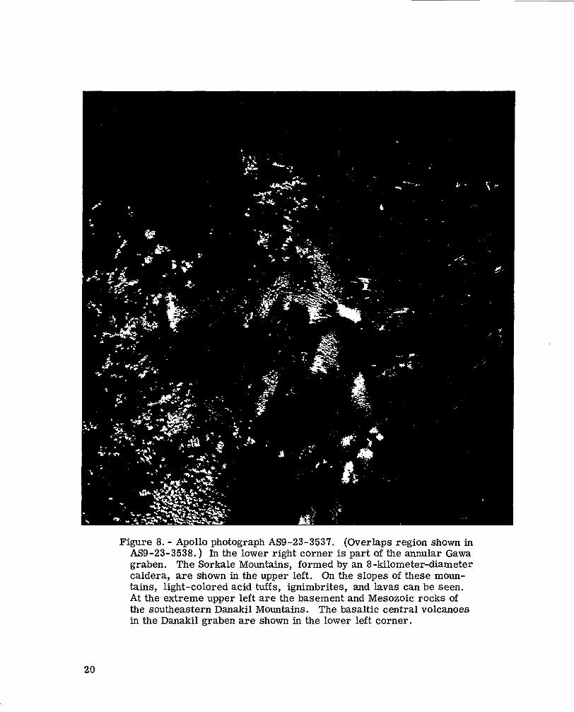
Figure 8. - Apollo photograph AS9-23-3537. (Overlaps region shown in AS9-23-3538. ) In the lower right corner is part of the annular Gawa graben. The Sorkale Mountains, formed by an 8-kilometer-diameter caldera, are shown in the upper left. On the slopes of these moun- tains, light-colored acid tuffs, ignimbrites, and lavas can be seen. At the extreme upper left are the basement and Mesozoic rocks of the southeastern Danakil Mountains. The basaltic central volcanoes in the Danakil graben are shown in the lower left corner.
20

Recent deposits Youngbasalticvolcanoes Men Lineations Old basaltic volcanoes Volcanic Dip Acid volcanoes Series wadi
Cinder cones ' m R o a d
Faults, with tick marks pointing to downfaulted side
0 Afar Basalt
Figure 9. - Annular grabens in northern Afar. Photogeologic map prepared on the basis of information from aerial photographs with a scale of 1: 60,000.
21

N N
A B
\ \ \ \
0 0
"- Approximate boundary of unit A Fault l ines
(a) Outlines of the different blocks before separation.
Figure 10. - Suggestion of motions forming the annular Gawa graben in northern Afar.

. . .L .
. - . .
”” Minor faults Graben faults, with tick marks pointing - Shear fault, right-lateral displacement
to downfaulted s ide
(b) Present situation with black arrows indicating the relative separation. White arrow indicates the drifting motion of unit A.
Figure 10. - Concluded.

Afar Basalt
mj Basement rocks - lateral displacement Shear faul t , r ight-
Water surface "" - - -"
Figure 11. - Schematic block diagram of the complex of annular grabens in northern Afar.

40" E 45" E 50" E
15" I\
10" N
I -
I -
15" N
10" N
40" E 45" E 50" E
(a) Assumed plate drift. Gray regions indicate the assumed present separation and spreading. Black arrows indicate direction of local separation. White arrows show the direction of drift of larger units.
Figure 12. - Southern Red Sea and Gulf of Aden region.
25

40" E 45" E
15" N
10" N
c
I -
I -
- 40" E
A R A B I A
10" N
45" E (b) Horst regions. Dotted areas are uplifts and regions with frequent acid volcanism
(Aden Volcanic Series).
Figure 12. - Concluded,