Embed Size (px)
Citation preview
Technical Manualfor
NJPDES Discharge to Ground WaterPermits
New Jersey Department of Environmental Protection
Division of Water QualityBureau of Nonpoint Pollution Control
June 2002
James E. McGreevey, GovernorBradley M. Campbell, Commissioner
2
Foreword
What is the purpose of this Technical Manual?This Manual is intended to provide guidance to permittees, consultants, and other interestedparties regarding the New Jersey Pollutant Discharge Elimination System-Discharge to GroundWater (NJPDES-DGW) permitting program for ongoing discharges. This guidance includesinstructions for preparing administratively and technically complete applications. It also outlineswhat types of permits are available. This Manual includes references to other existingsupplemental technical guidance documents that provide additional information regarding theNJPDES-DGW program. Additional information may also be obtained by visiting the Divisionof Water Quality website (www.state.nj.us/dep/dwq).
The types of discharges covered by this Manual are typically from approved operations and notdischarges associated with unintentional “spills” or “releases” of contaminants or historicalcontamination. These approved operations discharge wastewater of known quantity and qualityof pollutants to the ground. Examples include discharges of sanitary wastewater from housingdevelopments, schools, businesses and industries, as well as discharges of non-hazardousindustrial wastewater and some stormwater discharges. These discharges typically do notrepresent hazardous situations or lead to the creation of contaminated ground water sites becausethey can be controlled at the source. If you are interested in pursuing information regarding theremediation of contaminated sites, please call the Hazardous Site Science Element at (609) 633-6801.
Using this ManualTo expedite the permit process the Department recommends that you familiarize yourself withthe contents of the Manual prior to contacting the Bureau of Nonpoint Pollution Control (BNPC)and proceeding with the permit process. After you become familiar with the contents of thisManual, you should arrange a pre-application meeting by sending a written request to the BNPCor by fax to (609) 984-2147.
How is this Manual organized?This Manual is organized into two parts.
• Part 1 contains general information that provides an overview of the NJPDES-DGWpermit program, its purpose, importance, and how to obtain a permit.
• Part 2 discusses specific technical guidance and a checklist of information you will needto compile and submit to the BNPC for technically complete applications.
R:\ResourceCntr\Tech manuals\Groundwater\Techman Final June2002

3
PART 1: GENERAL OVERVIEW
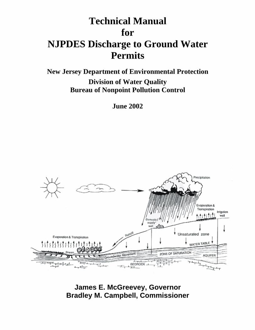
What is the NJPDES-DGW permit program?The New Jersey Water Pollution Control Act (WPCA, N.J.S.A. 58: l0A et seq.) authorizes theDepartment to regulate and control the discharge of pollutants into the waters of New Jersey.This authority is implemented through the NJPDES regulations (N.J.A.C. 7:14A-l et seq.) and itsaffiliated permit programs. In the early 1980’s, the NJPDES-DGW permitting program wascreated. In accordance with the regulations, every discharge of pollutants to ground waters ofthe State requires a NJPDES-DGW Permit.
However, there are certain exceptions in the rule which are clarified later in the Manual.
What is the goal of the program?The goal of the NJPDES-DGW permitting program is to restore, enhance and maintain theground water quality of New Jersey. This goal is achieved pursuant to the WPCA and theGround Water Quality Standards (GWQS), which can be found at N.J.A.C. 7:9-6 et seq. TheGWQS designate ground water classifications throughout the state, designated uses, and groundwater quality criteria and constituent standards. Currently the state’s ground water is dividedinto 3 classes:
• Class I — Ground Water of Special Ecological Significance (mostly the Pinelands &Natural Areas)
• Class II — Ground Water for Potable Water Supply (most of the state)
• Class III — Ground Water with Uses other than Potable Supply (much smaller areas)
Every ground water discharge in the State will impact one of these three classes of ground water.As described above, each class has a primary goal that is to be achieved. The GWQS are basedon the quality of ground water not influenced by discharges.
How are the NJPDES regulation’s goals achieved?The primary tool for achieving the regulation’s goals are the NJPDES-DGW permits issued bythe Department. There are several types of NJPDES-DGW permits ranging from individualpermits to general permits. Each NJPDES-DGW permit issued by the Department is developedto restore, enhance, and maintain the ground water quality of the State, in accordance with theGWQS.
Permits contain appropriate conditions appropriate for each discharge. Conditions ideally reflectthe level of risk posed by each discharge to its surrounding environment with just the rightamount of regulatory oversight to address the risk. Conditions range from minimal, such as BestManagement Practices (BMPs), to more stringent, such as requirements to treat wastewater priorto discharge.
In order to demonstrate compliance with the GWQS, NJPDES-DGW permits may include anyor all of the following components: BMPs and preventative measures; discharge limitationsand/or monitoring requirements and ground water monitoring programs. The Departmentcollectively refers to these components as the “Ground Water Protection Program” which isknown as “GWPP” (pronounced “gwip”). A GWPP Plan can be developed by the Department,or by the permittee. The GWPP Plan presents for the public record what a facility does, or willdo, to ensure compliance with the applicable environmental protection standards.
4
The scope of the NJPDES-DGW program
The NJPDES-DGW program regulates discharges of pollutants that may impact ground water.The NJPDES rules (N.J.A.C. 7:14A) require any person who discharges pollutants to obtain aNJPDES permit. Under the rules at N.J.A.C. 7:14A-1.2,
A ‘discharge’ means an intentional or unintentional action oromission resulting in the releasing, spilling, leaking, pumping,pouring, emitting, emptying, or dumping of a pollutant into the watersof the State, onto land or into wells from which the pollutant mightflow or drain into such waters, or into waters or onto lands outside thejurisdiction of the State which pollutant enters the waters of the State,and shall include the release of any pollutant into a municipaltreatment works. A leak into a secondary containment system whichdoes not involve a release into the waters or lands of this State is not a“discharge” for purposes of applying the rules under this chapter toviolations of the Underground Storage of Hazardous Substances Act,N.J.S.A. 58:11-49 et seq. and the rules promulgated pursuant thereto,N.J.A.C. 7:14B.”
This definition is rather broad, so it is useful to examine three categories of discharges:
• Discharges that are exempt from the requirement to obtain a NJPDES permit;
• Discharges that are subject to NJPDES but for which a permit is not required at this time;
• Discharges that require a permit;
The following section discusses these issues.
Discharges that are exempt from the NJPDES-DGW permit program The following ground water discharges are exempt by regulation from the requirement to obtaina NJPDES-DGW permit:
• Discharges from individual subsurface sewage disposal systems that are designed,constructed, installed and operated in compliance with The Realty ImprovementSewerage and Facilities Act, N.J.S.A. 58:11-23 et seq., and Standards for IndividualSubsurface Sewage Disposal Systems, N.J.A.C. 7:9A (also known as Chapter 199).These systems receive approvals from the local Health Departments.
• Return flows from irrigated agriculture.
• Past discharges, except those existing permitted discharges identified in N.J.A.C. 7:14A-7.2(c). This exemption includes discharges that are from past spills and other un-permitted releases that are subject to the requirements of N.J.A.C. 7:26-E. Thisexemption also applies to landfills that stopped operating prior to January 1, 1982.
• Any discharge not to exceed 60 calendar days and in compliance with the instructions ofa Department on-scene coordinator or remedial project manager pursuant to 40 CFR 300(the National Oil and Hazardous Substances Contingency Plan) or 33 CFR 153.10(e)(Pollution by Oil and Hazardous Substances), and the Spill Compensation and ControlAct, N.J.S.A. 58:10-23.11.
• Any discharge in compliance with the instructions of an On-Scene Coordinator pursuantto 40 CFR 300 (The National Oil and Hazardous Substances Pollution Plan) or 33 CFR

5
153.10(e) (Pollution by Oil and Hazardous Substances), and the State Spill Compensationand Control Act, N.J.S.A. 58:10-23.11;
• Any introduction of pollutants from nonpoint source agricultural and silviculturalactivities, including runoff from orchards, cultivated crops, pastures, range lands, andforest lands. This paragraph does not exempt the point source discharges fromconcentrated animal feeding operations as defined at N.J.A.C. 7: 14A-1.2, fromconcentrated aquatic animal production facilities as defined at N.J.A.C. 7: 14A-l.2, fromsilvicultural point sources as defined at N.J.A.C. 7:14A-l.2, or to aquaculture projects asdefined at N.J.A.C. 7:14A-l.2.
Discharges to ground water that are subject to NJPDES but for which a permit isnot required at this time Although the NJPDES-DGW permit program covers a broad range of discharge activities, thereare many common discharges listed below that the Department considers de minimus and do notrequire a permit at this time.
De minimus discharges share several common traits: (1) pollutants are directed to the groundsurface where they are expected to infiltrate into the ground and eventually into ground water,and will not create a constant ponded or flowing fluid condition, (2) pollutants are non-hazardous, and (3) these discharges do not pose a significant risk to ground water quality.Examples of this type of discharge are listed below:
• Discharges of stormwater from residential areas.
• Discharges of stormwater runoff from parking lots, or rooftops, where no pollutants arestored.
• Discharges of wastewater from intermittent washing the exterior of trucks, cars, andhouses etc., including outdoor car washing at car dealer’s facilities. This does notinclude actual car wash facilities with injection wells or infiltration basins, and it does notinclude washing involving hazardous detergents such as those used for power washing ofboats.
• Discharges of clean water from sump pumps used to dewater basements.
• Discharges of dewatered construction sites which- must be conducted in accordance withChapter 251 (soil erosion control).
• Discharges of stormwater from salt piles which are contained under roofs and on pads.
• Discharges from the draining of swimming pools or back washing of pool filters. Ifundertaken in accordance with the provisions of N.J.A.C. 7:14A-8.5(b)5.
• Discharges from water softeners at residences and small businesses.
• Discharges of small quantities of dredge spoils:
<5000 cubic yards of spoils from the Atlantic coast from Cape May to Sandy Hook; <1000 Cubic yards with no residential or recreational exposure.
Please refer to the document entitled “The Management and Regulation of DredgingActivities and Dredged Material in New Jersey’s Tidal Waters” available from the DEPOffice of Dredging.
• Discharges from existing dredge disposal sites where new dredge spoils are not beingdeposited.
• Discharges of condensate from air conditioners and steam pipes.

6
• Discharges of solid waste deemed to be “Beneficial Reuse” material by the Department’sDivision of Solid Waste.
(Note: this list represents many discharge situations brought to the Department’s attention overthe years. If you feel you have a de minimus discharge that is not listed, call the BNPC to see ifthe list can be expanded to include your discharge.)
Discharges for which a NJPDES-DGW permit is required If your discharge is not exempt by regulation, then you will be required to apply for a NJPDES-DGW permit. Examples of discharge activities for which people need to apply for a permitinclude but are not limited to discharges of sanitary wastewater from housing developments,schools, businesses, factories, etc., and discharges of industrial wastewater and some stormwaterdischarges. Please refer to N.J.A.C. 7:14A-7 for clarification.
These discharges often use the following regulated units:
• Injection wells (including subsurface disposal systems serving facilities with anaggregate design flow in excess of 2,000 gpd);
• Infiltration/percolation lagoons;
• Spray irrigation;
• Overland flow systems;
• Surface impoundments;
• Dredge spoils;
• Residuals surface impoundments.
What about sanitary landfills and hazardous waste facilities? The regulations for landfills and hazardous waste facilities are very specific, and they must befollowed explicitly. If you believe you must implement a monitoring program of this type,please contact the BNPC or Division of Solid Waste, at the phone numbers shown in Table 1.You should ask for specific guidance and/or examples of GWPP plans that have been approved.Persons responsible for discharges to ground water from sanitary landfills, as provided for inN.J.A.C. 7:26, shall conduct ground water monitoring in accordance with N.J.A.C. 7:14A-9.Persons responsible for discharges to ground water from hazardous waste facilities, as defined inN.J.A.C. 7:26, shall conduct ground water monitoring in accordance with N.J.A.C. 7:14A-10.
HOW TO APPLY FOR A NJPDES-DGW PERMIT
The application checklist items Once it has been determined that you need a NJPDES-DGW permit for your discharge, you mustsubmit an application. The Department has created a checklist outlining all administrativerequirements. The checklist and necessary forms may be obtained from the Bureau of PermitManagement (BPM), the BNPC or our website (http://www.state.nj.us/dep/dwq/forms.htm).
Each applicant should start by reviewing the checklist to determine the information necessary fora complete application which includes the submission of a TECHNICAL REPORT. Part 2 ofthis Manual will assist you in completing this Report.

7
Types of NJPDES-DGW permits There are 3 types of NJPDES-DGW permits:
• Individual Permits
• General Permits
• Permit-by-Rule (see 7:14A-7.5 and 8.5 for a complete listing)
INDIVIDUAL PERMITS Individual permits are written specifically for each facility and its unique setting andoperational considerations.
There are two types of individual permits.
• GWPP Permits (the applicant develops the GWPP Plan)
• Custom permits (the Department develops the GWPP Plan)
GWPP Permits The GWPP permit consists of two components, 1) a Ground Water Protection Program(GWPP) Plan, and 2), the permit shell. The unique feature of a GWPP Permit is that theGWPP Plan is a document, prepared by the permittee, which upon BNPC approval, isincorporated into the NJPDES-DGW permit by reference. The portion of the permitdeveloped by the BNPC contains the regulatory requirements associated with allNJPDES-DGW permitted facilities. The GWPP affords the permittees the opportunity tosubmit revised GWPP Plans for approval as site specific changes occur. The revisedGWPP Plans may be approved quickly with consultation from the BNPC. After theBNPC approves the GWPP, it is incorporated into the permit document and is publicnoticed for public comment.
The GWPP permit is ideal for anyone who wants a more active role in the creation(specific conditions) and maintenance of their permit. Detailed guidance for developinga GWPP Plan is available from the BNPC in a Manual titled “Guidelines for DevelopingGround Water Protection Program Plans,” or at the DWQ web-site. In addition, theBNPC holds training sessions each year. Please call the BNPC for further information.
Custom Permits The custom permit includes a GWPP Plan developed by BNPC staff based oninformation from the “Technical Report” submitted by the applicant, and also containsthe regulatory requirements associated with all NJPDES-DGW permitted facilities.BNPC staff work with the applicant through the development of the permit and theapplicant is generally offered the ability to review the permit prior to issuance of the draftpermit.
GENERAL PERMITS When a large number of discharges can be regulated using a uniform and consistent approach,the Department issues General Permits. General Permits are created and issued to facilities thatinvolve similar types of operations, discharge the same types of waste, engage in similar disposalpractices and require similar monitoring. The advantage of a General Permit is that the permit isnoticed for public comment and issuance process once, for the entire state. Then, it is a simplematter for the applicant to apply for the permit via a “Request for Authorization” (RFA) andsubmit the required technical requirements. Once the Department is satisfied the proposed
8
discharge qualifies for the general permit, an authorization is issued. More General Permits arein development at this time because the BNPC has found this method of permitting is veryefficient.
Existing NJPDES-DGW General Permits
The following NJPDES- DGW General Permits are currently available from the Department:
• I1 - Basin Discharges at Operating Landfills
• 12 - Potable Water Treatment Plants
• T1 – Existing Subsurface Sewage Disposal (Septic systems)
• SM - Scrap Metal General Permit
The I1 General Permit is for Basin Discharges at Operating Landfills. This General Permitauthorizes stormwater basin discharges at operating sanitary landfills. The permit is for siterunoff into sedimentation basins, retention basins, detention basins, and surface impoundments(collectively referred to as basins). This runoff flows into basins without contacting landfillrefuse. The permit includes monitoring and other permit requirements.
The I2 General Permit is for Potable Water Treatment Plants. This General Permit coverspotable water treatment plants (WTP) discharging filter backwash and clarifier water to outdoorbasins. The discharge results the treatment of raw water to drinking quality standards, whichoften requires the removal of low concentrations of iron, manganese, organic matter, and traceamounts of other metals. When filters are backwashed or when clarifiers are cleaned, thewastewater generated is usually discharged to a basin that ultimately discharges to groundwater.The general permit requires sampling of accumulated sludge from the basins in addition to otherpermit requirements.
The T1 General Permit is for Existing Sanitary Subsurface Sewage Disposal Systems servingfacilities with an aggregate wastewater design flow in excess of 2,000 GPD. To be eligible, thesubsurface sewage disposal system(s) must have been designed and approved in accordance withthe Standards for Individual Subsurface Sewage Disposal Systems (N.J.A.C. 7:9A et seq.) or itsprecursors, prior to January 1, 1990. This permit requires routine inspections and maintenance.
The SM Scrap Metal General Permit regulates the scrap metal processing and automotivedismantling industries. This is one of several stormwater general permits the BNPC hasdeveloped in recent years to regulate nonpoint pollution. This permit requires theimplementation of BMPs and monitoring.
PERMIT-BY-RULE Certain discharges to ground water are permitted by rule. Rules specifying eligibility are foundat N.J.A.C. 7:14A-7.5 and 8.5. The types of permit-by-rule that currently exist are listed below.If you have any questions about any of these, please call the BNPC or one of the other relevantlead agencies identified in the descriptions.
Existing Discharges Eligible For Permit-By-Rule
The following activities or discharges are eligible for a permit by rule.
• Discharges to ground water from activities associated with the flushing or cleaning ofpotable water mains and fire water systems, including hydrants and sprinklers;
• Discharges to ground water from activities associated with the development of potablewells;

9
• Discharges to ground water from activities associated with the development and samplingof monitoring wells in accordance with a NJPDES permit;
• Discharges to ground water, where the discharge does not exceed 30 calendar days, fromwells which test aquifers for the purpose of obtaining hydrogeologic data. This permit byrule does not apply when the Department is remediating a contaminated site as defined inN.J.A.C. 7:26C-1.3;
• Discharges to ground water from individual subsurface sewage disposal systems, otherthan those excluded under N.J.A.C. 7:14A-8.1(b)2, that are designed, constructed,installed and operated in compliance with the Realty Improvement Sewerage andFacilities Act (N.J.S.A. 58:11-23 et seq.), and the Standards for Individual SubsurfaceSewage Disposal Systems (N.J.A.C. 7:9A), where applicable.
• Discharges to ground water from injection wells used as a component of closed loop heatpump systems constructed according to any well permit condition(s)/standards adoptedpursuant to N.J.S.A. 58:4A-4. 1 et seq. All closed loop systems shall contain only fluidsthat are allowable under conditions of such well permit, and are leak proof such that theonly discharge is heat content.
• Injection wells used as components of an open loop heat pump system constructed inaccordance with all applicable well construction requirements of N.J.A.C. 7:10-12. Anysuch injection well shall discharge water into the same aquifer from which the water wasdrawn and with a quality that is the same as the ambient ground water, except for heatcontent.
• Air conditioning or cooling water return flow injection wells that are constructed inaccordance with all applicable well construction requirements of N.J.A.C. 7:10-12 thatdischarge water into the same aquifer from which the water was drawn and with a qualitythat is the same as the ambient ground water, except for heat content.
• Underground injection of swimming pool filter backwash water and water softenerbackwash water into seepage pits, when the activity is conducted in accordance withN.J.A.C. 7:14A-8.18.
• Underground injection wells associated with the feasibility or engineering design studiesnecessary to obtain or comply with a water supply allocation permit pursuant to N.J.A.C.7:19 or NJPDES permit pursuant to this chapter.
• Underground injection of stormwater runoff from the roofs of buildings, so long as theroofs are devoid of pollutant sources and devices (for example, motors, tanks, drums) thatcontain pollutants.
• The following permits-by-rule are for discharges to ground water which occur when theDepartment is remediating a contaminated site as defined in N.J.A.C. 7:26C-1.3, pursuantto the rules at N.J.A.C. 7:14B implementing the Underground Storage of HazardousSubstances Act (N.J.S.A. 13:1K-6 et seq.), the requirements of the Industrial SiteRecovery Act (N.J.S.A. 13:1K-6 et seq.), or when the owner or operator of acontaminated site is conducting remediation under Department oversight, or therequirements of the Spill Compensation and Control Act (N.J.S.A. 58:10-23.11), or theProcedures for Department Oversight of the Remediation of Contaminated Sites atN.J.A.C. 7:26C;
� Discharges to ground water, not to exceed 90 calendar days, from pilot treatmentplants to obtain engineering design data;
� Discharges related to in situ biotreatability studies where the discharge will notexceed 180 calendar days from the first date of discharge;

10
� Discharges to ground water not to exceed 30 calendar days from wells to test aquifersfor the purpose of obtaining engineering design data;
� Discharges to ground water not to exceed 90 calendar days from any other facility orequipment associated with the monitoring, engineering, remedial alternativesactivities, or design studies necessary to evaluate a contaminated site;
� Discharges to ground water to remediate contamination from discharge of heating oilas defined at N.J.A.C. 7:14A-1.2, at a residential building of four (4) units or less.
What constitutes a technically complete application? A technically complete application is one that includes all the information necessary to constructa high quality GWPP Plan and provides all the information necessary to demonstrate compliancewith the GWQS. The requirements for compiling this information are specified in N.J.A.C.7:14A-7.9, and are explained further in Part 2. If you plan to operate facilities such as operatinglandfills or hazardous waste facilities, additional information required is specified in N.J.A.C.7:14A-7.10 and 7.15.
The BNPC recognizes that all the information in the regulations is not necessary in order todevelop a technically complete application and acceptable GWPP Plan. N.J.A.C. 7:14A-7.9(a)1allows for flexibility, and after consulting with the BNPC some specific items may not berequired.
PART 2: TECHNICAL GUIDANCE
DEVELOPING A TECHNICAL REPORT The NJPDES regulations specify that certain technical information must be submitted for everyNJPDES-DGW permit application. This information is generally submitted in a package calledthe Technical Report. A complete Technical Report describes each discharge and how it will bemanaged. It should present the technical data in a format that describes the waste, its biologicaland chemical makeup, proposed level of treatment, disposal method and location of and risk tosensitive receptors. If you pursue the GWPP permit approach, please refer to the GWPPGuidance Manual in addition to this Manual.
The minimum requirements of the Technical Report are specified in N.J.A.C. 7:14A-7.9.However, for convenience, below you will find detailed instructions for compiling the technicalinformation necessary to prepare the Technical Report.
A complete Technical Report must consist of the following information unless otherwisespecified by the BNPC in accordance with N.J.A.C. 7:14A-7.9. Additional or alternativeinformation may be required depending on the particular details of the project.
The general structure of the Technical Report should include the items as organized as below:
• Site Description
• Pollutant Characterization
• Treatment of Wastewater/Pollutants (Option 1 or 2)
• Soils, Geology and Water Quality Information

11
Site Description
FACILITY OPERATIONEach application should include a detailed description of the facility. Specify the nature of theestablishment by identifying all activities and operations conducted at the site. Also, provide thesquare footage of each building, number of employees and the maximum population the facilityis designed to serve on a daily basis. If operation of the facility is seasonal, specify dates ofoperation. If shift work is conducted, specify the number and duration of shifts. Please includethe source of all sanitary, non-sanitary wastes and stormwater discharged to ground water (i.e.lavatory, cafeteria/kitchens, showers, floor drains, laboratory, water softeners, non-contactcooling water, process waste streams and outdoor material storage areas). The aggregatesanitary wastewater design flow of the facility and the maximum daily discharge of non-sanitarywastes must be established. For all non-sanitary wastes, please provide information, including aMaterial Safety Data Sheet (MSDS), for each pollutant or chemical stored on-site and a detaileddescription of all processes which generate non-sanitary pollutants.
SITE PLANS AND MAPS1. A plot plan of the facility should be prepared showing:
• all property boundaries;
• municipal tax block and lot information;
• all surface water bodies, wetlands and all areas prone to flooding as identified on Stateflood delineation maps including any necessary buffer areas associated with eachwatershed management area and sub-watershed the facility is located in and the directionof ground water flow;
• existing and proposed surface elevations of the property using 2-foot contour intervalsunless otherwise approved;
• all ground water monitoring wells;
• all soil borings, soil test pits and permeability tests;
• all existing and proposed buildings and roadways
• all water supply wells. Include the depth of the screened interval and yield;
• all stormwater management facilities (i.e. detention/retention basins, catch basins,drainage swales, etc.);
• all outdoor materials storage areas;
• all underground storage tanks;
• all rock outcrops or sinkholes, gullies and other erosional features.
2. Include an 8 1/2” by 11” plan showing only property boundaries and locations of allbuildings, pollutant treatment, storage and disposal areas. This plan is often incorporatedinto permits.
3. In addition to the plot plan, a general map (USGS 7.5 minute topographic map) must beincluded. It must designate site property boundaries, adjacent property ownership and landuse, surface water bodies, water supply wells, dwellings, wetlands, mines, quarries, dumps,oil and gas wells, and roads within one-half mile of the facility boundaries. This informationis useful in identifying pollutant sources and their proximity to sensitive receptors. Plotplans and other technical drawings must be sealed by a New Jersey licensed Professional

12
Engineer.
4. Well Search: Well searches should be conducted in the expected direction of plumemigration, and/or within areas of capture zones of wells within one-half mile of the facility.The Bureau of Water Allocation should be contacted to collect the well search information.If the facility is located in an area where potable water supply is limited to individual supplywells, it may be necessary for additional searches to be conducted. These should includeinformation from local health departments or door-to-door surveying, if necessary.
The well search should be focused on demonstrating the possible interactions betweencontaminant plumes and wells. You may be required to do an assessment of the likelihood ofthe plume interacting with wells. This will entail knowledge of well depth, screen length,pumping capacity, aquifer characteristics, capture zones, etc.
5 Watershed Information: The watershed and subwatershed in which the facility is locatedmust be specified. This information can be obtained from the Office of WatershedManagement at the numbers listed below. These offices may also be contacted to obtainconsistency determinations required for certain DGW applications.
Northwest Watershed Area Upper Delaware River,Walkill, Pochuck, Papakating,Central Delaware Tributaries
(609) 633-3812
Northeast Watershed Area Pompton, Pequannock,Wanaque, Ramapo, LowerPassaic, Saddle, Hackensack,Pascack, Hudson, Upper andMid-Passaic, Whippany,Rockaway
(609) 633-1179
Raritan Watershed Area Elizabeth, Rahway, North &South Branch Raritan,Woodbridge, Lower Raritan,South River, Lawrence Brook,Millstone River,
(609) 633-7020
Atlantic Coastal WatershedArea
Monmouth Watersheds,Barnegat Bay Watersheds,Mullica, Wading River, GreatEgg Harbor, Tuckahoe, CapeMay Watersheds
(609) 984-6888
Lower Delaware WatershedArea
Maurice, Salem, Cohansey,Lower Delaware Tributaries,Rancocas Creek andCrosswicks Creek
(609) 633-1441
Pollutant CharacterizationIn order to assess the impact the discharge may have on the environment, a pollutant

13
characterization is required for each discharge in accordance with N.J.A.C. 7:14A-7.9(d)2.However, it is the Department’s experience that not all the constituents in N.J.A.C. 7:14A-7.9need be characterized, based on risk or knowledge of the source. Therefore, the followingsections describe what is typically required to be characterized for sanitary discharges andindustrial discharges.
POLLUTANT CHARACTERIZATION FOR SANITARY DISCHARGESSanitary sewage is defined as “any liquid waste containing animal or vegetable matter insuspension or solution, or the water carried wastes resulting from the discharge of water closets,laundry tubs, washing machines, sinks, dishwashers, or any other source of water carried wasteof human origin or containing putrescible material. This term specifically excludes industrial,hazardous or toxic wastes and materials.”
For sanitary discharges, include a description of the design quantity and quality of effluentdischarged to ground water for the following parameters which are common to most sanitarywaste streams (if discharge monitoring reports are available, please include them).
• flow (gallons-per-day) gpd
• pH (SU)
• ammonia-nitrogen (mg/l)
• nitrate-nitrogen (mg/l)
• fecal coliform (# colonies/l00 ml)
POLLUTANT CHARACTERIZATION FOR INDUSTRIAL DISCHARGESIf your waste cannot be characterized as sanitary, it is by default industrial, even if only a smallfraction of the waste is non-sanitary. Because there are so many industrial chemicals, guidancefor characterizing the waste is specified in N.J.A.C. 7:14A-7.9(d)2.
Determination of Environmental Performance Standards and the Pointof ComplianceAfter characterizing the pollutants, it must be decided which pollutants represent a concern.Once you have a list of these pollutants, you need to demonstrate through a technical discussionhow you will be able to achieve the applicable environmental performance standards (EPS) at apoint of compliance. Depending on the regulated unit, and its location with respect to sensitivereceptors and the risk of the discharge to those receptors, the EPS vary. Thus, there can differentstandards for each pollutant. For sanitary discharges, the Department offers a default set ofpollutants to characterize (see list above).
How to establish the relevant Environmental Performance StandardsThe Technical Report or GWPP must include a statement regarding the applicable EPS, the riskthe pollutants of concern represent to sensitive receptors, and how one intends to achieve theEPS and minimize the risk.
At a minimum, all DGWs including injection wells, are required to achieve the EPS called theGround Water Quality Standards (GWQS), as specified in N.J.A.C. 7:9-6. These are chemicaland/or biological constituent standards designed to protect human health and the environment.In addition, other relevant performance standards exist for sanitary landfills and hazardous wastefacilities, and those standards required to protect against impacts to surface water and humancontact.

14
The Technical Report must indicate whether the facility is located in a Class I, II, or III groundwater area, and shall include the appropriate letter designation such as I-A, I-PL, etc. It willusually be necessary for the applicant to discuss this with the BNPC during the pre-applicationmeeting, because determining the appropriate Ground Water Classification is very important andrequires a thorough understanding of the GWQS. Furthermore, if the discharge is located inclose proximity to a surface water body where surface water quality would be impacted, anassessment of the surface water quality criteria for that stream may be required to establish anappropriate EPS.
Establishing the point of complianceOne of the most important tasks in developing a permit is establishing the point of compliance.The point of compliance is where the GWQS will be met for the pollutants specified in yourpermit. Often a map or series of maps and geologic cross-sections will be needed to clarify thepoint, or points, of compliance. The zone between the source of the discharge and the point ofcompliance is considered a Classification Exception Area (CEA) and the concentration ofpollutants can be above the GWQS in this area without permit noncompliance. Traditionally,points of compliance have been hydraulically upgradient of a potable well, surface water body orproperty boundaries. You will need to discuss with the BNPC the specifics as to exactly wherethe point(s) of compliance are for each parameter of concern. You can also have different pointsof compliance for different pollutants because it is known that pollutants behave differently inthe subsurface environment. For example, some pollutants are almost totally adsorbed byunsaturated soils, such as phosphorus, but other pollutants, such as nitrate, may persist for longdistances in ground water. In addition, some pollutants may be prone to alteration in theenvironment and become even more toxic. For example, TCE, a common industrial solvent,often converts in the ground to vinyl chloride, a known carcinogen. Table 3 shows common EPSas related to different categories of discharges.
Table 3 Environmental Performance Standards Relevant to Different Discharges
Discharge Category Environmental Performance Standards
Discharges toimpoundments that arenot designed to leak toground water.
• Compliance with the GWQS (different for Class I, II, III).• No hydraulic overloading.• No leaks.• BMPs to protect against leaks.• Risk assessment to determine the impact of leaks.
Discharges to groundwater that do not meetGWQS prior todisposal.
(Option 1)
• Compliance with the GWQS (different for Class I, II, III).• No hydraulic overloading.• No ponding.• Maintenance of an unsaturated zone below the disposal area.• No mounding that would encroach upon a surface water
body/wetland area, basement, or other property.• Plume delineation and risk assessment in reference to
environmental receptors.• Zone of Endangering Influence if deep well injection N.J.A.C.
7:14A-8.12(a)1.

15
Discharges to groundwater of wastewaterthat meets the GWQSprior to disposal. (Option 2)
• Compliance with the GWQS (different for Class I, II, III).• No hydraulic overloading.• No ponding.• Maintenance of an unsaturated zone below the disposal area.• No mounding that would encroach upon a wetland or surface
water, basement, or other property.• Zone of Endangering Influence if deep well injection N.J.A.C.
7:14A-8.12(a)1.
Establishing the level of wastewater treatmentThe application must demonstrate that the discharge will comply with the GWQS and applicableEPS, and must include a clear statement outlining the proposed level and method of treatmentthat will be used. Treatment methods can range from minimal, such as allowing the ground towork as a treatment unit, to advanced, such as tertiary wastewater treatment plants. There arebasically 2 options for treatment:
OPTION 1This Option allows pollutants to be directed into the ground or onto the ground surface at aconcentration greater than the GWQS, and reliance on natural attenuation processes in theground (dilution, absorption, filtration, biodegradation, etc.) to treat the pollutant(s) as necessary.The application will need to include some type of dilution, vegetative uptake calculation and/orabsorption model, or other calculations to show that the soil and/or ground water is capable oftreating the pollutants to the GWQS by the point of compliance. You may also need to provideadditional treatment of the waste and reduction of the concentration of the pollutants prior toground water disposal. Ground water monitoring wells are typically required to ensure that theGWQS are achieved at the point of compliance.
As stated earlier, Option 1 allows the applicant to perform dilution or attenuation modeling thatdemonstrates that the GWQS for specified pollutants can be met at a point(s) downgradient ofthe disposal area. For most discharges, the modeling approach typically involves predicting thefate of discharged pollutants and how sensitive receptors are impacted. The point, or points ofcompliance downgradient, will be defined as the downgradient sensitive receptor(s) such assupply wells, surface waters, or the downgradient property boundary. In general, nitrate-nitrogen is a good indicator of a human health or environmental impact threat from sanitarywastewater on ground water, however ammonia-nitrogen is more of a concern if a surface waterbody is likely to be impacted. For industrial or non-sanitary discharges, dilution modeling isdependent on the chemical characteristics of the individual pollutants of concern. Anappropriate model or multiple modeling programs may be necessary to estimate the impacts fromthe discharged pollutants.
Selection of Option #1 requires that the permittee demonstrate through dilution modeling orplume delineation that the GWQS can be achieved upgradient of sensitive receptors and/or thedowngradient property boundary. This is an option most commonly used for large septicsystems or treatment plants located in the Pinelands (where the standard for nitrate-nitrogen is 2mg/l). These systems discharge many constituents at a level greater than the GWQS. Prior tochoosing the dilution/absorption model option, the permittee must establish that ambient groundwater concentrations are below the maximum concentrations as defined in Table 1 of N.J.A.C.7:9-6 for each pollutant of concern. If background water quality is above the standards, the

16
permittee must assess the reasons for the parameter being above the standard and report thosefindings in the application. If background water quality is of concern, dilution may not be anoption for achieving the GWQS.
The dilution model must be able to both quantify the characteristics and delineate the boundariesof the wastewater plume, while accounting for initial piezometric conditions and backgroundground water quality along with other pertinent hydrogeologic characteristics of the site. TheGWQS must be met at the downgradient points of compliance. If potable wells are the majorconcern, monitoring wells should be positioned at a point between the expected path and depthof the plume and before potable well capture zones. In addition, the monitoring wells should bepositioned a sufficient distance from the potable wells that allows for ample warning time andpossible remediation if a plume is detected threatening the safety of a potable well.
In the case where plumes are predicted to discharge to surface water bodies, you should contactthe appropriate surface water permitting bureau to determine if further courses of action arenecessary. You may be required to perform dilution modeling or predict mass loadings to thesurface water body, or uptake calculations of pollutants by wetlands organisms, or othermeasures as stipulated by the Department.
Based on the results of your modeling efforts, discharge limits should be proposed for eachpollutant of concern. In the case of nitrate-nitrogen dilution modeling for sanitary discharges, aninitial value of 40 mg/l entering the ground water may be used without further consultation fromthe BNPC. If you would like to use a different value, you must consult with the BNPC forapproval.
If the BNPC determines ground water dilution is a viable method of meeting GWQS at thedowngradient compliance point, a NJPDES-DGW permit will be issued with dischargelimitations and monitoring requirements based on the results of the dilution model. Groundwater limitations and monitoring requirements will be established based on the GWQS.Monitoring wells are typically required to assess compliance with the GWQS, as needed.
Characteristics of a good modelUse and application of any model must meet the following criteria andrequirements:
• The model must have a history that documents its ability to represent realworld situations;
• The set of equations that govern ground water flow and pollutanttransport, and the derivation of these equations must be presented;
• The numerical methods used to solve the set of ground water flow andpollutant transport equations must be presented;
• The Boundary Conditions and Initial Conditions used in solving theground water flow and pollutant transport equation sets should berepresented both mathematically and in narrative format;
• A technical narrative describing the model to be used and a justificationof its application in the subject context must be presented. This shouldinclude whether the model is finite element, finite difference or someother approach.
• Perform mass balance calculations on selected elements of the model toverify physical validity;
• Limits and confidence on modal predictions should be established andstated in the beginning of the modeling report; and

17
• All inputs and outputs to the model should be listed and explained indetail.
OPTION 2This is where engineered treatment of the pollutants to a level equal to or less than the GWQSprior to discharge to ground water is provided. In this case, the point of compliance is measuredat a location before the wastewater is discharged to the ground. This is often referred to asmeeting the standards at the “end-of-pipe” via man-made treatment works. Selection of Option 2generally expedites the review of the application because of the more extensive technical dataand dilution modelling needed to support Option 1 projects. Option 2 allows the applicant toprovide a treatment system for discharges that discharges effluent meeting the limits, specified inTable 5 below, prior to disposal. The list may be reduced or expanded on a case-by-case basisbased on the type of facility and discharge.
Selection of Option 2 requires the permittee to notify the BNPC in writing that the treatmentsystem will be designed, constructed and operated in such a manner that the following dischargelimits in Table 5 will be met at a point prior to discharge to the disposal system. If a surfacewater body is anticipated to be impacted, these limits may change based upon the surface waterquality limitations.
Table 5. Discharge Limits For Typical Monitored Sanitary Parameters
PARAMETER Class II-A Class I-PL
Total Nitrogen (maximum) (N03 -N +NH3-N)
10 mg/l 2 mg/l
Fecal Coliform (daily max.) 200 col/ l00 ml 200 col/l00 mlChlorine * *
Volatile Organics ** **
* Chlorination is not an acceptable means ofdisinfection for ground water discharges.
** The discharge of non-sanitary wastes is prohibited. Thefacility will be required to monitor for the presence of non-sanitary wastes on at least an annual basis. Increased monitoringmay be required based on the type of facility and the presence andpotential discharge of non-sanitary wastes.
If Option 2 is chosen, the wastewater treatment plant shall be designed, constructed and operatedto meet the above referenced discharge limitations. Because Option 2 minimizes risks tosensitive receptors and does not require time consuming dilution modeling evaluations, a draftNJPDES-DGW permit will typically be issued in a much shorter period of time than if Option 1is chosen. Further, since Option 2 limits the discharge of nutrients, particularly nitrate–nitrogen(limited in the permit as Total Nitrogen) to a quality not exceeding the GWQS, the Departmentwill not require ground water quality monitoring wells to monitor nutrients provided dischargelimits are consistently met as specified in a final NJPDES-DGW permit. A minimum of oneground water monitoring well may be required to be installed immediately adjacent to thedisposal area if, in the Department’s opinion, the discharge setting is considered a high risk to asensitive receptor and/or to monitor ground water elevations. Effluent limitations for fecalcoliform will be required to be consistent with the effluent limitations for the Beneficial Reuse ofWastewater if unrestricted public access to the disposal area is proposed.

18
Soils, Geologic and Water Quality Information
The applicant is required to specify how pollutants will enter the ground water. The technicalreport or GWPP plan must indicate the type of regulated unit through which the pollutant will, orcould potentially (in the case of lined surface impoundments), enter the ground. There should bea statement that the activity will involve a subsurface disposal bed, spray irrigation system, orinfiltration percolation lagoon, etc. Common to all of these methods of discharging water intothe ground is establishing how much water the ground can absorb, which should be expressed asgallons per day per square foot (gal/day/ft2). In the case of surface impoundments, you simplyneed to demonstrate that the liner is impermeable. See details in the Technical Guidance ForSizing and Positioning of Spray Irrigation Systems. Overland Flow Systems.Infiltration/Percolation Lagoon Systems, and Surface Impoundments, available on the DWQwebsite.
This section includes technical information required to assess the ground’s ability to acceptwastewater and attenuate pollutants. It is intended for both shallow or surficial disposal to theunsaturated zone, which often rely on the soil for additional treatment, and deep well injection,which is usually to a saturated formation. The format details the technical information requiredfollowed by an explanation as to why the information is important. The technical submissionshould include a discussion on how the results of the on-site investigations demonstrates theviability of the ground water discharge proposal. Based on your pre-application meeting, youmay need to provide any or all of the following technical information. Geologic and soilsreports must be signed by a geologist or pedologist or other individual experienced with geology,soils, hydrogeology, etc.
DEPTH TO BEDROCK
A determination must be made to determine the depth to bedrock (soil thickness) below eachdisposal area for geological provinces other than the Coastal Plain. Specify the type of bedrockand the method used in making this determination (e.g. geophysical survey, boring, publication,etc.).
For shallow discharges, this information is useful in helping to assess the risk of pollutantspassing directly into bedrock fractures without first passing through a sufficient layer of soilwhich acts as a filter. Bedrock is often the location of “deeper” potable ground water and thefractures in bedrock are often extensive and wide enough to allow pollutants to easily migrategreat distances.
SOIL DESCRIPTION
A complete soil description obtained from a minimum of one soil pit within 25 feet of eachdisposal area and a sufficient number of soil borings to provide a representative cross-section ofthe soil characteristics within each disposal area must be submitted. Additional testing may berequired depending upon the nature and extent of the project and the soil characteristics. Soilborings should be to a minimum depth of 20 feet or to bedrock, whichever is shallower, or to adepth that supports the type of dilution/absorption modeling used. Soil descriptions must bebased upon the USDA soil classification system. Soil horizons that may not be permeableenough for the given loading rate must be identified and specifications regarding how the

19
problem will be alleviated must be provided. Detailed information on the development of theSoil Description is outlined below:
• Sufficient borings shall be made of the entire area of the proposed property tocharacterize and verify the ground water conditions beneath the site with respect to thetypes of material, uniformity, hydraulic conductivity, porosity and depth to groundwater. Borings should employ a grid pattern, wherever possible, such that there is, at aminimum, one boring in each major geomorphic feature. The borings pattern shallenable the development of detailed cross sections through the entire area of theproposed subdivision in order to sufficiently define the geology:
� i. Subsurface data obtained from borings shall be collected by standard undisturbedsoil sampling techniques for engineering properties, and split spoon sampling orstandard penetration tests for engineering indexes and classification. Diamond bitcoring shall be used for rock borings. Samples shall not be composited. Samplingintervals for the borings shall be determined by the geologist or geotechnicalengineer. It is recommended that sampling be performed on a continuous basis ineach boring for the first 20 feet below the lowest elevation of the land disposalsystem and collected at five foot intervals thereafter;
� ii. All borings shall be a minimum depth of 20 feet below the lowest elevation ofwastewater disposal within the proposed disposal area. The Department reservesthe right to require deeper minimum depth in areas in which 20 feet is not sufficientto describe the geologic formation and ground water flow patterns below theproposed disposal sites in regard to potential contaminant migration paths;
� iii. Boring logs shall be submitted for each boring, recording rock and soilconditions encountered. Each log shall include a soil or rock description inaccordance with the USDA Soil Classification System or the Rock QualificationDescription System, method of sampling, the depth of soil or rock, the water levelsencountered, the blow counts, the soil tests and dates. All depths described withinthe boring log shall be correlated to New Jersey Geodetic Control Survey Datum;and
� iv. Samples from each significant soil /rock class encountered shall be collected bystandard undisturbed sampling techniques and analyzed for bulk density, porosityand hydraulic conductivity. It is recommended that a sufficient number of samples,as determined by the geologist or geotechnical engineer, be analyzed for the indexproperties to verify the uniformity or non uniformity of the geologic formationencountered.
For shallow discharges, this information is useful in helping to assess the spatial distribution ofsoils and predicted permeability. In general, a thick layer of unsaturated soil spread out over alarge area that allows adequate movement of water is desirable. A minimum desired thickness ofthe unsaturated soil is dependent on the type of pollutant, level of treatment and the proposedloading rate.
SOIL TEXTURE
A textural grain size analysis of soil samples collected at the proposed level of infiltration andeach discrete soil horizon within the zones of treatment and/or disposal must be included.

20
Additional samples at deeper horizons may need to be collected and analyzed, especially if thesoil in zone of disposal is more hydraulically restrictive than the soil in the zone of treatment. Inthe case of soil replacement systems for sanitary wastewater disposal, the textural grain sizeanalysis may only be required to be performed on a sample of the fill to be used. In the eventthat less than 4 feet of fill is used, or for any other type of disposal system, the textural grain sizeanalysis must be performed on both the select fill and the native soil to a depth of 4 feet beneaththe proposed level of infiltration.
For shallow discharges, this information is useful to help assess the filtering capacity of thenatural soil and its permeability. If the native soil is found to be inadequate for a given purpose,suitable fill material may be required.
DEPTH TO WATER TABLE
Depth to the seasonal high water table and the static water table below each disposal area mustbe determined. Specify the method used in making these determinations. Describe all perchedor special water table conditions. Generally, there are two acceptable methods for determiningthe depth to the seasonal high water table. The highest layer within or below the soil profile thatexhibits mottling is an indication of the seasonal high water table, except when the water table isobserved at a level higher than the level of mottling. The second method of determiningseasonal high water table is to install piezometer wells in the area of the proposed disposalsystem to monitor the static water level. This monitoring must be conducted during the period ofJanuary through April (inclusive) and must encompass at least three separate observation events.These observations must not occur more frequently than once per every two weeks. Allowancesmust be made in interpretation of data from excessively wet or dry periods.
For shallow discharges, this information is used to help assess the thickness of the unsaturatedzone.
PERMEABILITY
A determination of the permeability of the soil within each disposal area expressed as hydraulicconductivity (k). In order to determine the permeability of the most hydraulically restrictivelayer below the proposed disposal area, permeability tests must be performed on each differentsoil horizon and/or rock substratum. This testing must occur to a minimum depth of 20 feet or tothe static water table to determine vertical permeability. Horizontal permeability must beestablished below static water level. For individual disposal areas greater than 2,000 gpd, theresults of percolation tests alone do not satisfy the requirement for the determination of verticaland horizontal conductivity.
Hydraulic conductivity (k) must be determined in the upper most saturated zone. The methodsused and number of tests used to determine hydraulic conductivity must provide an adequatehydraulic characterization of on-site conditions to demonstrate that the aquifer can accept thevolume of discharge proposed. The Department has outlined below the minimum testingrequirements necessary for NJPDES-DGW permit applications based upon volume of dischargeproposed.
Volume of Discharge
per disposal area
Type of Test Required Number ofTests
Required

21
< 2,000 gpd Any approved method as stated in N.J.A.C. 7:9A *b
2,000 - 5,000 gpd Single well slug or bail tests (rising or falling head) *c
5,001 gpd-20,000 gpd Single well short term pumping test (minimum 30minutes) *a
*c
> 20,000 gpd Multiple well short term pumping test (minimum 30minutes) *a
*d
*a The duration of the test must provide adequate stress on the aquifer to be consistent withthe proposed discharge and should reflect on-site conditions.
*b The number of tests must be consistent with the requirement in N.J.A.C. 7:9A.
*c A minimum of 2 tests performed in a well installed within the proposed disposal area.
*d A minimum of 2 tests performed in 3 wells, with the pumping well installed within theproposed disposal area and 2 observation wells located at 90o to the pumping well.
Based on the above field testing, derive the following aquifer properties for each disposal area:
• hydraulic gradient (i)
• transmissivity (T)
• velocity (v)
This information is useful in sizing the disposal area and predicting the velocity, mounding andshape of ground water plumes emanating from the source.
When designing a traditional septic system, meaning the treatment of sanitary sewage is onlyfrom a septic tank, the following Long Term Acceptance Rate (LTAR) formula should beutilized to calculate the maximum permissible loading rate to the disposal area:
LTAR = 5k - [1.2/log(k)]
Where k = the hydraulic conductivity of the infiltrative surface in feet/minute.
Notes: the formula will automatically convert the units of ft/minute into a result expressed asgpd/sqft.
0.75 gpd/sqft is the maximum allowable loading rate for pressure dosed systems;
0.62 gpd/sqft is the maximum allowable loading rate for gravity systems.
The LTAR is a formula derived on the expectation that a “biomat” of microscopic organismswill form on most soils receiving only primary treated sewage. Although the underlying soilmay be more permeable, the biomat creates a layer that is less permeable, and an increase in thesize of the disposal field is warranted to prevent hydraulic failure at the infiltrative surface.Results of the LTAR should be used as one method of sizing the disposal area. If you would liketo use a different method, please contact the Department.
GEOLOGIC FORMATION
Provide the name and geologic age of the formation receiving the wastewater. Include a general

22
narrative description of the major characteristics of the geological formations of the regionwhere the proposed disposal site will be located including thickness, lithology, structuralfeatures, degree of weathering and amount of overburden. The type(s) of bedrock formations inthe area can be obtained by using geologic maps available through the New Jersey GeologicSurvey. However, if bedrock is encountered during in-situ subsurface investigation, the exactformations should be identified by an appropriate environmental or geologic professional. Basedon the location of the project you may be required to submit additional geological information asoutlined below:
A generalized geologic map
• A generalized geologic map and geologic cross sections, based upon publishedmaterial and mapping available from USGS and NJGS or unpublished mappingacceptable to the NJGS, for the area including the disposal site and region, and shouldinclude, but not be limited to:
• Bedrock outcrop;
• Dip and strike of sedimentary formations and foliation trend and dip angles of igneousand metamorphic rocks;
• Faults and predominant shear zone trends;
• Joint and fracture trends in bedrock including dip angles; and
• Trend direction of solution channels in carbonate rocks and sink holes.
This information is used to determine the classification of ground water, either Class I, II or III,and any special concerns related to the geology and classification.
MOUNDING ANALYSIS
Perform a ground water recharge mounding analysis. Include the methodology and supportingdocumentation for the model used. The lateral extent of the mounding analysis must besufficient to demonstrate how the mound will effect nearby wells, excavations, basements,stormwater basins, surface water bodies/ wetlands areas, etc. If there is more than one disposalarea, indicate how the mounds will interact with one another.
Many mounding models/calculations use transmissivity as one of the main factors.Transmissivity is often expressed as
T = kb,
where k is the hydraulic conductivity and b is the saturated thickness of the aquifer. Whenderiving the value for “b”, aquifer thickness, you may use the depth of borings on site withoutconsultation from the BNPC. However, if you wish to use another method that will result in athicker aquifer, such as basing thickness on geologic maps of the area, or geophysical methods,you should consult the BNPC for additional guidance.
The mounding analysis must be calculated using the most restrictive soil horizon that will remainin the disposal area. The mounding analysis must be accompanied with a cross section of thedisposal area depicting the lateral extent of the elevation of the mound. The mound height mustbe calculated to a minimum of 400 feet from the center of each disposal area. The distance must
23
be increased if there is a sensitive receptor nearby and the mound height at 400 feet demonstratesa potential impact to sensitive receptor.
One example of a computer mounding model can be found in Ground Water, Volume 22,Number 1. The paper is published by Molden, Sunada, and Warner (1984). Another computerprogram used to provide mounding analysis, and has been used successfully in the NJPDES-DGW permit application process is ModFlow®. However, any ground water mounding analysismay be used as long as the input parameters and the method of analysis consider all of thesignificant hydraulic conditions at the analyzed site.
For shallow discharges, a mounding analysis is often needed to demonstrate that the groundwater below a disposal unit will not “mound up,” encroach on the required unsaturated zone,break the surface of the ground at the disposal area or downslope, and create an overland flowsituation. It is also desirable to maintain an unsaturated zone between the infiltrative surface andthe top of the mounded water table because it is known that unsaturated soil is a great aid inattenuating pollutants. In the case of sanitary discharges, viruses and pathogens are known to beremoved through the filtering capacity of unsaturated soils. Since the water table becomesmounded, and is not flat, the configuration of the mound must be considered to ensure that theaeration zone exists and will be maintained during periods of maximum discharge under seasonalhigh water table conditions. Much of the literature on this topic suggests that between two (2)and four (4) feet of unsaturated suitable soil must be provided in order to attenuate biologicalcontaminants. For this reason, all applicants for discharges of sanitary wastewater mustdemonstrate a minimum of four (4) feet of unsaturated zone exists between the top of themounded seasonal high water table and the infiltrative surface. The Department may reduce therequired unsaturated zone to two (2) feet of unsaturated zone if disinfection of the wastewater isproposed.
GROUND WATER FLOW DIRECTION
The direction of ground water flow in the vicinity of each disposal area using one of thefollowing methods for any existing facility must be determined. The applicant shall summarizethe information on a piezometric map, based upon information outlined below, which mayinclude available data including, but not limited to, existing topography, surface drainage andexisting well data. The map shall include the direction of ground water flow in the vicinity ofeach disposal area and the area and extend a minimum of one-half mile beyond the disposalarea(s) .
If the proposal is for a newly constructed facility or for facilities that are expanding and have noquantitative ground water elevation data, Option (A) must be used.
(A) Ground water flow direction shall be based on piezometer wells installed in the vicinity ofthe wastewater disposal area. Depth of the wells should be adequate to measure the directionof ground water flow within the first occurrence of ground water. If multiple disposal areasare utilized in different areas of the site, a minimum of three piezometers per disposal areashould be installed. Specify the time and dates the wells were sampled and the ground waterelevations. Discuss how seasonal changes and tides may effect the water table. Thepiezometer wells must be located on the plot plan and the direction of ground water flowindicated.
Prior to installing the piezometer wells, the applicant should contact the Bureau of WaterAllocation at (609) 292-2957 concerning well permit requirements. All piezometer wells must

24
be surveyed (elevation and location), to Department requirements, by a licensed New Jerseyland surveyor.
Properly installed piezometer wells may also be used as ground water monitoring wells forNJPDES-DGW permit monitoring requirements provided the wells are constructed accordingto Department specifications and are located in positions suitable to provide representativesamples of the ground water impacted by the discharge. In most cases, the use of two inchinside diameter piezometer wells is acceptable for ground water monitoring purposes. Fourinch wells are recommended for deeper wells. The location of monitoring wells constructed toprovide the information required for the application is the sole responsibility of the applicant.
(B) The applicant can estimate the direction of ground water flow based on existing well data,topography, geological reports, surface water flow patterns, etc. However, use of this methodmay not accurately determine the direction of ground water flow. If this method is usedinitially, it may require the installation of additional wells as a permit requirement or in aDepartment initiated permit modification, if data shows additional wells are appropriate.
BACKGROUND GROUND WATER QUALITY
The need to establish background ground water quality is dependent on several factors. Thesefactors include the type of treatment proposed, the monitoring approaches that will be employed,and/or the need to establish an affirmative defense for demonstrating an upgradient source ofpollutants.
• Background samples shall consist of analyses for the parameters associated with thepollutants in the discharge;
• The well(s) used to characterize background water quality shall be located whereunaffected, or if not possible where least impacted, by the discharge. Data shall beprovided to show that background water quality wells are located in the hydrologic units asthe wells subsequently used to monitor the impact of the discharge and screened at theappropriate depth of concern. For example, if there is a concern about how a contaminantmay impact surface water in the expected path of the plume, the wells establishingbackground should be screened across the water table upgradient of the surface water;
• Background ground water quality should be established through the collection of severalsampling events, rather than a single discrete value, to provide for a statistically significantbackground water quality value. In order to obtain a valid sample that enables anassessment of central tendency (mean, median, standard deviation), a minimum of 5independent samples must be collected and analyzed over a time period which isrepresentative of variability in the ground water (i.e., seasonal, spatial, etc.). Regulationstipulates that all samples must be collected within eighteen (18) months of theDepartment’s receipt of your application;
• The parameters to be analyzed must be determined in consideration of the pollutantcharacterization discussed earlier in this Manual. Once analyzed, the sample data fromeach independent event should be pooled for each parameter and central tendencies that areappropriate to the distribution of the data (e.g. parametric or non-parametric) must then becalculated.
The wells used to establish the piezometric map may also be used to obtain the above referencedground water samples provided they are screened within the appropriate aquifer (usually the

25
uppermost aquifer).
Existing facilities proposing to expand shall provide the BNPC with the results of ground waterquality monitoring downgradient of the existing disposal area to determine if the facility is incompliance with the GWQS. If the facility is not proposing additional pretreatment, substantialmodifications or relocation of the disposal areas and has shown that the existing discharge is notin compliance with the GWQS, ground water dilution may not be a viable method of achievingcompliance in the downgradient monitoring wells and additional pretreatment will be required.
INSTRUCTIONS FOR DETERMINING ALTERNATIVE FLOW DATA FOR SANITARYDISCHARGES To determine if a facility requires a NJPDES-DGW permit the design flow of the facility must bedetermined based on the design criteria found in N.J.A.C. 7:9A. At times an applicant will wishto design their system based on actual flow because the applicant believes the design criteria arenot reflective of the operation of their particular facility. Although the disposal bed may bedesigned for a lower flow, this does not negate the requirement for a NJPDES-DGW permit. Asan option, the BNPC allows the use of actual flow data obtained from similar facilities (or thefacility in question when the proposed expansion is consistent with the existing use) in order topredict a more individualized “alternate” design flow. The use and size and hours of operationof the facility must be identical if actual water use data is proposed. For example collectingactual water use from an existing church to be used as the basis for determining the design flowof a proposed church is not acceptable if the existing church does not have a large kitchen, multi-purpose room or classrooms and the proposed church includes these amenities. The used ofactual water use would also not be appropriate for designing a commercial strip store whichwould experience a variety of types of tenants. The method of determining an alternate designflow is as follows:
The applicant should discuss the details of collecting and assessing actual flow data with theBNPC and the appropriate Bureau of Engineering (BE) to establish acceptable guidelines.Typical guidelines are outlined below.
Collect actual flow data on a daily basis over an agreed upon time period (minimum 3-months)covering the peak seasonal operational period. When collecting the data, both the peak dailymaximum and the average daily flow need to be determined. All individual daily readings mustbe submitted along with a detailed description of the type of facility (number of golfers, students,etc), hours of operation, and a detailed description of the operation which demonstrates how thedata is reflective of the operation of the proposed facility.
Once the peak and average actual flows are known, the alternate design flow can be based onthe greater of two values: 1) the highest daily maximum reading, or 2) the average daily flowplus a 50% safety factor, whichever is higher. Use the new design flow in subsequent calculations. There is no guarantee the alternatedesign flow value will be acceptable to the BNPC and BE, although if the methodologies arefollowed as outlined above, the value is typically acceptable.
This method is applicable to most situations, however, on a case-by-case basis the BNPC will

26
review other methods. Once an alternate flow value has been accepted by the BNPC, it can beused for re-rating existing systems or designing expansions or entirely new systems. NJPDES-DGW permits may be written/modified as needed to correspond with the new alternate flowvalues.
If there are no water or wastewater records available, the Department design flow standards mustbe used. In the case of large systems, an alternative safety factor for use with the average flowvalues may be considered depending on individual projects.
In cases where an expansion is being proposed to an existing facility peak (or modified average)daily flows for the existing structure must be added to the Department’s design flow standardsfor the proposed portion of the project. Exceptions may be made in cases where the use of theproposed addition is identical to the existing use (such as schools). The design capacity can beobtained by adding the peak (or modified average) daily flow of the existing facility to a proratedflow for the proposed expansion.
The above guidelines are to be used when determining the adequacy of existing systems inrelation to the volume of wastewater that can be handled. However, it is still the responsibilityof the applicant to ensure compliance with the permitted flow. In cases where the BNPCdetermines that the average and peak flow-data is within the flow limitations outlined in theNJPDES-DGW permit, the BNPC may modify the permit to authorize the expansion of thescope of the project. Should the flow data show the expansion would cause an increase in thepermitted flow, the permittee must obtain a NJPDES-DGW permit for an expansion of thepermitted flow for the facility.
APPENDICES
Definitions Ground Water Protection Standards (GWPS):The standards found in N.J.A.C. 7:9-6, N.J.A.C. 7:14A-8, 9, or 10. Different standardsare applicable to different types of regulated units or facilities.
GWPP or GWPP Plan:A Ground Water Protection Plan, as identified in N.J.A.C. 7:14A-7.6. It is a plan thatestablishes the method a facility will use to demonstrate compliance with the applicableEPS or GWPS. The GWPP can be developed by the applicant or by the Department. Aseparate guidance document is available from the Department that describes the detailedinstructions for developing a GWPP.
Infiltration/percolation lagoons:"Infiltration percolation lagoon" means a natural topographic depression, man-madeexcavation, or diked area formed primarily of earthen materials (although it may be linedwith man-made materials), which is designed to transmit pollutants to the subsurface andwhich is not an injection well.
Injection wells:"Injection well" means a well, septic system, subsurface disposal bed, cavity, tube or pipe,or any structure used to deliver fluids directly to a point below the ground surface.

27
Land disposal of dredge materials:Any placing of dredge spoil on to the land which can leach into the ground water."Dredge spoils" means sediments, known as spoils, removed during dredging operations.
Overland flow:"Overland flow" means the controlled discharge, by spraying or other means, of pollutantsonto sloping land with maintained vegetation where a proportion of the wastewater mayappear as runoff. Overland flow is also the movement of pollutants across the surface ofthe land where infiltration may occur.
Residuals surface impoundments:A surface impoundment that holds residuals. "Residual" means a solid waste that consistsof the accumulated solids and associated liquids which are by-products of a physical,chemical, biological, or mechanical process or any other process designed to treatwastewater or any other discharges subject to regulation under the State Act. Forpurposes of this chapter, residual includes, but is not limited to, marketable residualproduct, sludge and sewage sludge. Residual excludes screened vegetative waste and gritand screenings.
Spray irrigation:"Spray irrigation" means a system for land application of pollutants, over maintainedvegetated ground surfaces using sprinkler heads or nozzles as a method of application."Standards for residual use or disposal" means the standards at N.J.A.C. 7:14A-20, 7:26,7:27 and 40 CFR Parts 257, 258 and 503 which govern minimum requirements forresidual quality, management practices, and monitoring and reporting applicable toresidual or the use or disposal of residual by any person. These standards may include,but are not limited to, standards for sewage sludge use or disposal.
Surface impoundments:“Surface impoundment” or “impoundment” means a facility or part of a facility which is anatural topographic depression, a man-made excavation, or a diked area formed primarilyof earthen materials (although it may include a liner). It is designed to hold anaccumulation of liquid or solid wastes or wastes containing free liquids, and is not aninjection well. Examples of surface impoundments are holding, storage, settling andaeration pits, ponds, and lagoons.
Technical Report:A Summary of all the Technical Information identified in N.J.A.C. 7:14A-7.9, or asexplained in 'Plain English" in Part 2.2. The Technical Report can be submitted as aGWPP by following the GWPP Guidance.
Other Guidance Documents Available from the DWQ Additional Guidance and information sheets are produced form time to time, and areavailable by request. Please call the BNPC or look at the DWQ website athttp://www.state.nj.us/dep/dwq/ Currently, the following Guidance is available:
• Guidelines for Designing, Constructing, and Spray Irrigation Systems, Overland FlowSystems, Infiltration/Percolation Lagoon Systems, and Surface Impoundments. Thisguidance document has been produced for anyone intending to engineer on of theregulated units describes in this topic heading. It is a compilation of recognized

28
practices and procedures for designing commonly used mechanisms to manage thedisposal of liquid and solid pollutants.
• Guidance For Preparing Applications For 50 Or More Realty ImprovementCertifications
• Guidelines For Developing Ground Water Protection Program Plan