Embed Size (px)
Citation preview

ENVIRONMENTAL IMPACT ASSESSMENT CITY OF SUMMERSIDE WIND FARM
FINAL REPORT
Submitted to: City of Summerside
Summerside, Prince Edward Island
Submitted by: AMEC Earth & Environmental,
A Division of AMEC Americas Limited Fredericton, New Brunswick
August 2008
TE51100

TE51100-Summerside Wind Farm Final Report-5Sep2008-ct-cjy-jb-st.doc AMEC Earth & Environmental, a division of AMEC Americas Limited 25 Waggoners Lane Fredericton, New Brunswick E3B 2L2 Tel + 1 (506) 458-1000 Fax + 1 (506) 450-0829 www.amec.com
August 22, 2008
TE51100
Mr. Greg Gaudet City of Summerside 94 Ottawa Street Summerside, PE C1N 1W3 Dear Mr. Gaudet:
Re: Final Report Environmental Impact Assessment for City of Summerside Wind Farm
AMEC Earth & Environmental, a division of AMEC Americas Limited is pleased to provide 12 hardcopies and 12 electronic copies on CD of the above-mentioned report. We have enjoyed working on this project with you and we look forward to providing services to your department in the future. Sincerely,
Janet Blackadar, M.Sc.F, CCEP Project Manager Direct Tel.: 1.506.450.8855 Direct Fax: 1.506.450.0829 E-mail: [email protected] JB/cjy

City of Summerside Environmental Impact Assessment City of Summerside Wind Farm – Final Report Summerside, PE August 22, 2008
TE51100-Summerside Wind Farm Final Report-5Sep2008-ct-cjy-jb-st.doc Page (i)
EXECUTIVE SUMMARY The City of Summerside proposes to erect four wind turbines and construct the infrastructure for the transmission of the generated electricity to the City of Summerside’s substation. The City of Summerside Wind Farm, hereafter referred to as the “Project” would be located at the extreme northern municipal boundary of the City of Summerside next to Malpeque Bay. This area will hereafter be referred to as the “Study Area”. The Study Area has been used in the past and currently for the purpose of growing crops and includes six adjoining properties with three zoning categorizations: institutional, agricultural, and conservation (wetlands). The Study Area has minimal residential development around its perimeter and can meet the provincial requirements of a setback three times the height of the turbine from any residential development (R. Estabrooks, pers.comm., 2008). The Project Site perimeter is approximately two kilometres from the Slemon Park airport which is a registered, but not certified, airport. The proposed Project implementation will take place in three Stages. Stage One will include the installation of 6.0 MWs of electrical wind power by October 2009. Stages Two and Three entail an additional 6.0 MWs of electrical wind power when funding becomes available. The operational life of this project’s assets is twenty-five years, at which time the assets will have to be replaced or decommissioned. The turbine proposed is the Vestas V90 with a 3 MW output. The goal of the Project is to help displace fossil fuel generated energy with renewable resource energy. It is expected to annually displace 31 GWhs of electricity when the wind farm is fully developed. This project will benefit the City of Summerside, the Province, and Canada on many fronts, such as:
• Helping attain Canada's objective of reducing total greenhouse gas emissions to 6 percent below 1990 levels by the year 2010.
• Compliance with Prince Edward Island’s Renewable Energy Act. • Lower dependence on imports of electricity to the City of Summerside. • Increased stability of electricity costs within the City of Summerside. • Economic development benefits to the local area.

City of Summerside Environmental Impact Assessment City of Summerside Wind Farm – Final Report Summerside, PE August 22, 2008
TE51100-Summerside Wind Farm Final Report-5Sep2008-ct-cjy-jb-st.doc Page (ii)
TABLE OF CONTENTS
PAGE
1.0 PROJECT SUMMARY......................................................................................................... 1 1.1 STRUCTURE OF THE DOCUMENT .......................................................................... 1 1.2 PROJECT PROPONENT............................................................................................ 1 1.3 TITLE OF PROJECT................................................................................................... 2 1.4 PROJECT LOCATION ................................................................................................ 2 1.5 ESTIMATED CAPACITY OF WIND FARM ................................................................. 4 1.6 CONSTRUCTION SCHEDULE................................................................................... 4 1.7 AGENCIES INVOLVED IN ENVIRONMENTAL ASSESSMENT ................................ 4
1.7.1 Municipal Agency Involvement in the Project .................................................. 4 1.7.2 Provincial Agency Involvement in the Project.................................................. 4 1.7.3 Federal Agency Involvement in the Project ..................................................... 5
1.8 REGULATORY FRAMEWORK................................................................................... 5 1.9 AUTHOR OF ENVIRONMENTAL IMPACT STATEMENT.......................................... 5
2.0 PROJECT DESCRIPTION................................................................................................. 10 2.1 THE PROJECT PROPONENT.................................................................................. 10 2.2 PROJECT BACKGROUND....................................................................................... 10
2.2.1 National and Regional Political Considerations............................................. 10 2.3 PURPOSE OF PROJECT......................................................................................... 11
2.3.1 Justification for the Project ............................................................................ 11 2.3.2 Project Objectives.......................................................................................... 11
2.4 SUMMARY OF PROJECT ........................................................................................ 12 2.5 LOCATION OF PROJECT ........................................................................................ 12
2.5.1 Land Ownership ............................................................................................ 14 2.5.2 Key Environmental and Cultural Features..................................................... 14
2.6 DETAILED PROJECT ACTIVITIES .......................................................................... 14 2.6.1 Construction Phase ....................................................................................... 14
2.6.1.1 Surveying Activities......................................................................... 16 2.6.1.2 Site Preparation .............................................................................. 16 2.6.1.3 New and Existing Access Roads .................................................... 16 2.6.1.4 Delivery of Equipment..................................................................... 17 2.6.1.5 Wind Turbine Assembly .................................................................. 17 2.6.1.6 Crane Pads, Unloading and Lay-down Areas................................. 17 2.6.1.7 Foundations .................................................................................... 18 2.6.1.8 Interconnection Cabling .................................................................. 18 2.6.1.9 Transmission Line........................................................................... 20 2.6.1.10 On-site Substation .......................................................................... 20 2.6.1.11 Service Building .............................................................................. 20 2.6.1.12 Gates and Fencing ......................................................................... 20 2.6.1.13 Parking Lots.................................................................................... 21

City of Summerside Environmental Impact Assessment City of Summerside Wind Farm – Final Report Summerside, PE August 22, 2008
TE51100-Summerside Wind Farm Final Report-5Sep2008-ct-cjy-jb-st.doc Page (iii)
2.6.1.14 Turbine Commissioning .................................................................. 21 2.6.2 Operation Phase............................................................................................ 21
2.6.2.1 Road Maintenance.......................................................................... 21 2.6.2.2 Turbine Operations ......................................................................... 21
2.6.3 Decommissioning Phase ............................................................................... 21 2.6.4 Future Stages of the Project.......................................................................... 22
3.0 SCOPE OF THE ASSESSMENT....................................................................................... 23 3.1 SCOPE OF THE PROJECT AND ITS ASSESSMENT ............................................. 23 3.2 METHODOLOGY OF ENVIRONMENTAL ASSESSMENT ...................................... 23 3.3 TEMPORAL AND SPATIAL BOUNDARIES OF THE PROJECT ............................. 25 3.4 CONSULTATION PROGRAM................................................................................... 26
3.4.1 Public Consultation........................................................................................ 26 3.4.2 Consultations with Stakeholders and Interest Groups................................... 27
3.4.2.1 Slemon Park Corporation ............................................................... 27 3.5 REGULATORY CONSULTATION ............................................................................ 28 3.6 ISSUES SCOPING AND VEC SELECTION (SCOPE OF THE ASSESSMENT) ..... 28
3.6.1 Issues Scoping .............................................................................................. 36 3.7 APPROACH TO DETERMINATION OF SIGNIFICANCE......................................... 37
4.0 ENVIRONMENTAL AND SOCIO-ECONOMIC SETTING................................................. 40 4.1 GEOPHYSICAL ENVIRONMENT ............................................................................. 40
4.1.1 Soil and Soil Quality ...................................................................................... 40 4.1.2 Geology (Acid Rock Drainage) ...................................................................... 41 4.1.3 Seismicity ...................................................................................................... 41 4.1.4 Hydrogeology/Groundwater........................................................................... 41 4.1.5 Sub-surface Resources ................................................................................. 42
4.2 AQUATIC ENVIRONMENT....................................................................................... 42 4.2.1 Aquatic Habitats ............................................................................................ 42 4.2.2 Aquatic Fauna ............................................................................................... 43 4.2.3 Surface Hydrology ......................................................................................... 43 4.2.4 Surface Water Quality ................................................................................... 43 4.2.5 Sediment ....................................................................................................... 45
4.3 TERRESTRIAL ENVIRONMENT .............................................................................. 45 4.3.1 Flora .............................................................................................................. 45
4.3.1.1 Closed / Restored Landfill............................................................... 46 4.3.1.2 Hay Field......................................................................................... 46 4.3.1.3 Fallow cropland............................................................................... 46 4.3.1.4 Old Field ......................................................................................... 47 4.3.1.5 Old Apple Orchard .......................................................................... 47 4.3.1.6 Forest.............................................................................................. 47 4.3.1.7 Shrubswamp (wetland) ................................................................... 47 4.3.1.8 Salt Marsh (wetland) ....................................................................... 47
4.3.2 Fauna ............................................................................................................ 48

City of Summerside Environmental Impact Assessment City of Summerside Wind Farm – Final Report Summerside, PE August 22, 2008
TE51100-Summerside Wind Farm Final Report-5Sep2008-ct-cjy-jb-st.doc Page (iv)
4.3.2.1 Local and Migratory Birds ............................................................... 48 4.3.2.2 Bats................................................................................................. 49
4.3.3 Species at Risk.............................................................................................. 50 4.3.3.1 Flora Species at Risk...................................................................... 51 4.3.3.2 Fauna Species at Risk.................................................................... 53
4.3.4 Designated Areas and Other Critical Habitat Features ................................. 53 4.3.4.1 Demonstration Woodlots................................................................. 54 4.3.4.2 Wildlife Management/Protection Areas........................................... 54 4.3.4.3 National Wildlife Areas/Migratory Bird Sanctuaries ........................ 55 4.3.4.4 Designated Wetlands/Eastern Habitat Joint Venture Areas (EHJVs)55 4.3.4.5 Critical Natural Areas...................................................................... 55 4.3.4.6 Nature Reserves............................................................................. 56 4.3.4.7 National and Provincial Parks......................................................... 56
4.3.5 Wetland Resources ....................................................................................... 56 4.3.5.1 Wetland Resources ........................................................................ 56 4.3.5.2 Wetland Identification...................................................................... 56
4.4 ATMOSPHERIC ENVIRONMENT ............................................................................ 57 4.4.1 Climatology.................................................................................................... 57 4.4.2 Ambient Air Quality........................................................................................ 58
4.5 SOCIO-ECONOMIC SETTING ................................................................................. 61 4.5.1 Population Demographics ............................................................................. 61 4.5.2 Local Economy .............................................................................................. 62 4.5.3 Land Use ....................................................................................................... 63
4.5.3.1 Industrial ......................................................................................... 63 4.5.3.2 Commercial..................................................................................... 63 4.5.3.3 Planned Development .................................................................... 65 4.5.3.4 Residential ...................................................................................... 65 4.5.3.5 Fisheries ......................................................................................... 65 4.5.3.6 Agricultural ...................................................................................... 65 4.5.3.7 Forestry........................................................................................... 66
4.5.4 Community Services and Infrastructure ........................................................ 66 4.5.4.1 Transportation Infrastructure........................................................... 66 4.5.4.2 Electricity ........................................................................................ 67 4.5.4.3 Cultural/Institutional ........................................................................ 67 4.5.4.4 Communication and Radar Systems .............................................. 67 4.5.4.5 Emergency Services....................................................................... 69
4.5.5 Existing Noise Level ...................................................................................... 70 4.5.6 Heritage and Archaeological Resources ....................................................... 70
4.5.6.1 Phase 1 Background Desktop Review............................................ 71 4.5.6.2 Phase 2 Preliminary Field Examination .......................................... 73 4.5.6.3 Phase 3: Field Evaluation ............................................................... 74
4.5.7 Recreation Areas and Tourism...................................................................... 75 4.5.8 Land and Resources Used for Traditional Purposes by Aboriginal Persons.75
4.5.8.1 Aboriginal Fisheries ........................................................................ 76

City of Summerside Environmental Impact Assessment City of Summerside Wind Farm – Final Report Summerside, PE August 22, 2008
TE51100-Summerside Wind Farm Final Report-5Sep2008-ct-cjy-jb-st.doc Page (v)
4.5.9 Safety Issues ................................................................................................. 76 4.5.10 Visual Landscape .......................................................................................... 76
5.0 IMPACT ASSESSMENT, MITIGATION AND RESIDUAL EFFECTS ASSESSMENT ..... 78 5.1 GEOPHYSICAL ENVIRONMENT ............................................................................. 79
5.1.1 Soil Quality .................................................................................................... 79 5.1.2 Pathways and Activities................................................................................. 79 5.1.3 Boundaries .................................................................................................... 79 5.1.4 Impact Assessment ....................................................................................... 79
5.1.4.1 Soil Admixing .................................................................................. 79 5.1.4.2 Soil Erosion..................................................................................... 79 5.1.4.3 Soil Compaction.............................................................................. 79 5.1.4.4 Loss of Productive Area.................................................................. 80
5.1.5 Mitigation ....................................................................................................... 80 5.1.6 Residual Impacts ........................................................................................... 80
5.2 TERRESTRIAL ENVIRONMENT .............................................................................. 81 5.2.1 Fauna ............................................................................................................ 81
5.2.1.1 Local and Migratory Birds ............................................................... 81 5.2.1.2 Impact Assessment – Disturbance and Avoidance......................... 85 5.2.1.3 Bats................................................................................................. 86
5.2.2 Species-at-Risk ............................................................................................. 90 5.2.2.1 Flora Species at Risk...................................................................... 90 5.2.2.2 Recommended Mitigation ............................................................... 91 5.2.2.3 Significance of Residual Effects...................................................... 91 5.2.2.4 Faunal Species at Risk ................................................................... 91 5.2.2.5 Potential Effects on Species at Risk ............................................... 92 5.2.2.6 Clearing, Grubbing, and Excavation Activities ................................ 92
5.2.3 Wetlands........................................................................................................ 94 5.2.3.1 Pathways and Activities .................................................................. 95 5.2.3.2 Boundaries...................................................................................... 95 5.2.3.3 Impact Assessment ........................................................................ 95 5.2.3.4 Mitigation ........................................................................................ 96 5.2.3.5 Significance of Residual Effects...................................................... 98
5.3 ATMOSPHERIC ENVIRONMENT ............................................................................ 98 5.3.1 Air Quality ...................................................................................................... 98
5.3.1.1 Pathways and Activities .................................................................. 98 5.3.1.2 Boundaries...................................................................................... 98 5.3.1.3 Impact Assessment ........................................................................ 98 5.3.1.4 Mitigation ........................................................................................ 99 5.3.1.5 Residual Impacts .......................................................................... 100
5.4 SOCIO-ECONOMIC ENVIRONMENT .................................................................... 100 5.4.1 Local Economy ............................................................................................ 100
5.4.1.1 Pathways and Activities ................................................................ 100 5.4.1.2 Boundaries.................................................................................... 100

City of Summerside Environmental Impact Assessment City of Summerside Wind Farm – Final Report Summerside, PE August 22, 2008
TE51100-Summerside Wind Farm Final Report-5Sep2008-ct-cjy-jb-st.doc Page (vi)
5.4.1.3 Residual Impacts .......................................................................... 102 5.4.2 Land Use ..................................................................................................... 102
5.4.2.1 Agricultural .................................................................................... 102 5.4.2.2 Transportation Infrastructure......................................................... 103
5.5 ARCHAEOLOGICAL AND HERITAGE RESOURCES ........................................... 104 5.6 HUMAN HEALTH AND SAFETY ............................................................................ 105
5.6.1 Pathways and Activities............................................................................... 106 5.6.1.1 Construction and Decommissioning ............................................. 106 5.6.1.2 Operation ...................................................................................... 106
5.6.2 Boundaries .................................................................................................. 107 5.6.3 Impact Assessment ..................................................................................... 107
5.6.3.1 Occupational Safety...................................................................... 107 5.6.3.2 Shadow Flicker ............................................................................. 109 5.6.3.3 Noise............................................................................................. 111
5.7 AESTHETICS: VISUAL RESOURCES ................................................................... 115 5.7.1 Pathways and Activities............................................................................... 115 5.7.2 Boundaries .................................................................................................. 116 5.7.3 Impact Assessment ..................................................................................... 116 5.7.4 Mitigation ..................................................................................................... 116 5.7.5 Residual Impacts ......................................................................................... 118
5.8 ACCIDENTS AND MALFUNCTIONS...................................................................... 118 5.8.1 Pathways and Activities............................................................................... 118 5.8.2 Boundaries .................................................................................................. 119 5.8.3 Impact Assessment ..................................................................................... 119
5.8.3.1 Accidental Spills and Leaks .......................................................... 119 5.8.3.2 Icing .............................................................................................. 120 5.8.3.3 Breakage ...................................................................................... 122 5.8.3.4 Traffic Accidents ........................................................................... 124
6.0 EFFECTS OF THE ENVIRONMENT ON THE PROJECT .............................................. 126 6.1 EXTREME WEATHER............................................................................................ 126 6.2 GLOBAL CLIMATE CHANGE ................................................................................. 127
7.0 CUMULATIVE EFFECTS ASSESSMENT ...................................................................... 128 7.1 BOUNDARIES......................................................................................................... 128 7.2 OTHER PROJECTS IN THE AREA ........................................................................ 128 7.3 IMPACT ASSESSMENT ......................................................................................... 128
8.0 POTENTIAL ENVIRONMENTAL IMPACTS AND CUMULATIVE EFFECTS................. 131
9.0 ENVIRONMENTAL EFFECTS MONITORING ................................................................ 144
10.0 CONCLUSION ................................................................................................................. 145
11.0 LIST OF SUPPORTING DOCUMENTS .......................................................................... 146

City of Summerside Environmental Impact Assessment City of Summerside Wind Farm – Final Report Summerside, PE August 22, 2008
TE51100-Summerside Wind Farm Final Report-5Sep2008-ct-cjy-jb-st.doc Page (vii)
12.0 CONTACT LIST............................................................................................................... 154
13.0 GLOSSARY..................................................................................................................... 156
14.0 ACRONYMS .................................................................................................................... 157
LIST OF TABLES
Table 1.1 UTM Geographical Coordinates............................................................................ 2 Table 1.2 Proposed Construction Schedule.......................................................................... 4 Table 1.3 Environmental Legislation and Guidelines which may be Applicable to the
Proposed Project ................................................................................................... 7 Table 2.1 Property Identification Numbers, Tenure and Zoning within the Project
Area..................................................................................................................... 14 Table 2.2 Surveys Conducted, Personnel Qualifications and Survey Periods .................... 16 Table 3.1 Non-Governmental Organizations and Local Resource Representatives
Contacted, their Affiliation and Topics Discussed ............................................... 27 Table 3.2 Regulatory Representatives from Federal, Provincial and Municipal
Organizations Contacted, their Affiliation and Topics Discussed ........................ 29 Table 3.3 Issues Scoping: Summary of VEC Selection and Pathway Analysis .................. 30 Table 3.4 Criteria to be Considered in the Assessment of Potential Environmental
Effects ................................................................................................................. 39 Table 4.1 Marine Species of Malpeque Bay........................................................................ 44 Table 4.2 Marine Species of the Gulf of St. Lawrence ........................................................ 44 Table 4.3 Habitat at / Adjacent to each Site ........................................................................ 46 Table 4.4 Plant Species of Concern Potentially in the Study Area...................................... 51 Table 4.5 Bird Species of Concern in the Study Area (ACCDC) ......................................... 53 Table 4.6 Air Quality Guidelines in Prince Edward Island ................................................... 59 Table 4.7 Population Profile ................................................................................................ 61 Table 4.8 Average Daily Traffic Volumes on Routes Near the Project Area ....................... 66 Table 5.1 Definitions of Level of Impact after Mitigation Measures..................................... 78 Table 5.2 Potential Impacts on Birds................................................................................... 82 Table 5.3 Noise Levels at Various Distances from Typical Construction Equipment .......... 93 Table 5.4 Noise Levels Associated with Common Environments and Sources ................ 113 Table 8.1 Summary of Environmental Impacts.................................................................. 132 Table 8.2 Summary of Cumulative Effects ........................................................................ 143
City of Summerside Environmental Impact Assessment City of Summerside Wind Farm – Final Report Summerside, PE August 22, 2008
TE51100-Summerside Wind Farm Final Report-5Sep2008-ct-cjy-jb-st.doc Page (viii)
LIST OF FIGURES
Figure 1.1 Map Identifying Location of the Summerside Wind Farm in the Province of
Prince Edward Island and Site Layout................................................................... 3 Figure 2.1 Overhead Aerial Photo Showing the Location of Turbines, Access Roads,
Connection Cables, Transmission Lines, Property Boundaries, Lay Down Areas and Substation .......................................................................................... 13
Figure 2.2 Geographic Context of Project Site Identifying Key Environmental and Cultural Features................................................................................................. 15
Figure 2.3 Typical Site Clearing and Laydown Configuration of Turbine.............................. 19 Figure 3.1 Approach to Environmental Impact (Effects) Assessment .................................. 24 Figure 4.1 Obstacle Limitation Surfaces............................................................................... 64
LIST OF APPENDICES Appendix A Environmental Protection Plan Appendix B Memorandum of Understanding between the City of Summerside and Slemon
Park Airport Appendix C Wetlands Data Sheets Appendix D Bird Survey Results Appendix E Summerside Wind Plant Assessment of Noise and Flicker Impacts Appendix F Nav Canada Assessment – Impact of Wind Turbine Farm on Instrument
Landing System Appendix G Mi’kmaq Confederacy and Native Peoples Council Response

City of Summerside Environmental Impact Assessment City of Summerside Wind Farm – Final Report Summerside, PE August 22, 2008
TE51100-Summerside Wind Farm Final Report-5Sep2008-ct-cjy-jb-st.doc Page (1)
1.0 PROJECT SUMMARY
1.1 Structure of the Document This report documents the assessment of the environmental effects of the proposed construction, operation and decommissioning of the Summerside Wind Farm (“the Project”). This assessment was conducted in accordance with the requirements of the Prince Edward Island (PEI) Environmental Protection Act (EPA) and the Canadian Environmental Assessment Act (CEAA). The report utilizes the “Environmental Impact Statement Guidelines for Screenings of Inland Wind Farms Under the Canadian Environmental Assessment Act”. The report is divided into the following sections: Section 1.0 Provides basic information on project’s proponent, location, schedule and
regulatory environment. Section 2.0 Provides the need and justification for the project as well as a description of the
Project activities. Section 3.0 Describes the scope of the environmental assessment, consultations undertaken
and the temporal and spatial boundaries. Section 4.0 Describes the environmental and socio-economic setting of the study. Section 5.0 Describes the assessment of all the environmental and socio-economic issues
identified as relevant for the proposed project. Section 6.0 Describes the effects of the environment on the project. Section 7.0 Presents the assessment of cumulative effects. Section 8.0 Presents tables which summarize potential environmental impacts and
cumulative effects. Section 9.0 Describes environmental effects monitoring recommended. Section 10.0 Conclusion. Section 11.0 List of Supporting Documents. Section 12.0 Personal Communications. Section 13.0 Glossary of Terms. Section 14.0 Acronyms.
1.2 Project Proponent The City of Summerside (“the City”) became an official city in 1995, through the amalgamation of St. Eleanor's, Wilmot and a portion of Sherbrooke. Since then, the City has been rapidly growing (InfoPEI, 2006). Currently, the City owns and operates its own electric utility and services for approximately 6600 residences and businesses. The City’s installed capacity of electricity consists of 10.48 MWs of diesel fired generation and operates on a cold standby, operating reserve mode. Over the 6 year period of 2002-2007, the Summerside generator utilized an average of 13,855 litres (L) of fuel per year, 74% of which was diesel fuel and the remainder being heavy fuel such as bunker oil. Within this period, during the years 2003 to 2006, all fuel utilized was diesel fuel.

City of Summerside Environmental Impact Assessment City of Summerside Wind Farm – Final Report Summerside, PE August 22, 2008
TE51100-Summerside Wind Farm Final Report-5Sep2008-ct-cjy-jb-st.doc Page (2)
Summerside has shown its willingness to develop a wind farm within or immediately adjacent to the City’s municipal boundaries and has selected the old St. Eleanor’s landfill site and adjacent land areas for this possible use. This area has good indicative wind speeds for wind farm development and has a very low density of residents. This conforms to a desire to decrease its dependency on out-of-Province electricity, use renewable energy, recycle ecologically impacted sites and reduce visual impact of the wind turbine siting.
City of Summerside Wind Farm Development 275 Fitzroy Street Summerside PE C1N 1H9 Mr. Greg Gaudet, P.Eng. Director of Municipal Services City of Summerside Office: 902-432-1272 Fax: 902-436 4255 Email: [email protected]
1.3 Title of Project City of Summerside Wind Farm.
1.4 Project Location The windfarm will be located at the northern extremity of the City limits (46.44°N X 63.80°W). Summerside is in Prince County, PEI (Figure 1.1). Universal Transverse Mercator (UTM) geographical coordinates for the turbine locations are provided in Table 1.1.
Table 1.1 UTM Geographical Coordinates UTM Turbine Name Easting Northing
T1 438339 5142636 T2 438729 5142594 T3 438842 5143323 T4 438270 5142111
Note: UTM Zone 20, in NAD 83 datum The entire Project Area as shown in Figure 1.1 represents 102 hectares (ha) (252 acres). The general land use and vegetative communities on the site are 50% agriculture or open grasslands, 31 % wetlands (salt marsh and wet shrub lands) and 19% are forested.

City of Summerside Environmental Impact Assessment City of Summerside Wind Farm – Final Report Summerside, PE August 22, 2008
TE51100-Summerside Wind Farm Final Report-5Sep2008-ct-cjy-jb-st.doc Page (3)
Figure 1.1 Map Identifying Location of the Summerside Wind Farm in the Province of Prince Edward Island and Site Layout

City of Summerside Environmental Impact Assessment City of Summerside Wind Farm – Final Report Summerside, PE August 22, 2008
TE51100-Summerside Wind Farm Final Report-5Sep2008-ct-cjy-jb-st.doc Page (4)
1.5 Estimated Capacity of Wind Farm The Project will be implemented in Three Stages. Stage One will consist of the installation of two wind turbines (T1 and T2) with a capacity of 3 MWs each, generating a total of 6.0 MWs of electrical wind power for this Stage of the Project. Stages Two (T3) and Three (T4) will each add an additional wind turbine with a capacity of 3 MWs each, thereby generating an additional 6.0 MWs for an overall Project total of 12 MWs of electrical wind power.
1.6 Construction Schedule The estimated construction schedule is depicted in Table 1.2.
Table 1.2 Proposed Construction Schedule Project Activity Date Funding In Place for Project September, 2008 Environmental Assessment Completed & Reviewed September, 2008 Navcan/Aerodrome Safety Approval October, 2008 Gather Engineering Information for Wind Turbine Site October, 2008 Selection of Wind Turbine Manufacturer and Order October, 2008 Engineering Design and Layout of Wind Farm (Earthworks) October, 2008 Order of Long Lead Time Equipment October, 2008 Site Earthworks Construction Begin November, 2008 69kV Transmission Line Build Begins November, 2008 Wind Turbine Erection Begins July, 2009 Site Earthworks Construction Ends August, 2009 69kV Transmission Line Build Ends August, 2009 Wind Turbine Erection Ends September, 2009 Commissioning of Phase 1 (Possibly Phase 2) October, 2009
1.7 Agencies Involved in Environmental Assessment
1.7.1 Municipal Agency Involvement in the Project
The City of Summerside, is the Proponent for this Project.
1.7.2 Provincial Agency Involvement in the Project
An environmental assessment approval under the PEI Environmental Assessment (EA) Regulations for wind power generation is required for the Project. The Province of Prince Edward Island’s Department of Environment, Energy and Forestry (PEIDEEF) has the mandate to oversee the Provincial EA Approval process. The project must also comply with requirements under the Planning Act Subdivision and Development Regulations for setbacks from buildings and other structures.

City of Summerside Environmental Impact Assessment City of Summerside Wind Farm – Final Report Summerside, PE August 22, 2008
TE51100-Summerside Wind Farm Final Report-5Sep2008-ct-cjy-jb-st.doc Page (5)
1.7.3 Federal Agency Involvement in the Project
The project requires an environmental screening under CEAA because of potential federal funding. Infrastructure Canada is expected to provide funding for this project under the Municipal Rural Infrastructure Fund (MRIF). In Atlantic Canada MRIF funding is delivered through the Atlantic Canada Opportunities Agency (ACOA). To help meet the requirements of a federal EA and receive funding, the City has followed the guidelines stated in the document titled “Environmental Impact Statement Guidelines for Screenings of Inland Wind Farms Under the Canadian Environmental Assessment Act”. Environment Canada (EC) is expected to review the project with regards to its mandate. Also, a review by TerraChoice Environmental Marketing is expected. This environmental program and consulting services firm is the official manager of EC’s Environmental ChoiceM Programme (ECP), an initiative of EC to promote the generation of electricity from naturally occurring energy sources such as wind power. Those energy producers that meet the requirements of the program will be issued with an EcoLogo that identifies the source as being “Green”. In order to meet the criteria of the program, the proponent will need to meet the fifteen requirements listed in the Environmental Choice Program Sufficient Evidence Document, “CD-003: Electricity – Renewable Low-impact Wind-powered Generators”. Fisheries and Oceans Canada (DFO) reviewed the project and no request for authorization to harmfully alter, disrupt, or destroy fish habitat (HADD) under Section 35(2) of the Fisheries Act is required. Transport Canada (TC) reviewed the project for potential to affect any navigable waterways potentially affected by the Project. No navigable waterways were found, therefore an application under Section 5(1) of the Navigable Waters Protection Act (NWPA) will not need to be completed and submitted to TC. Pursuant to the Aeronautics Act and Aviation Regulations, an aeronautical obstruction clearance is required from TC for approval of the turbine heights and the turbine lighting.
1.8 Regulatory Framework The construction, operation, and maintenance of the Summerside Wind Farm will be undertaken in accordance with all applicable legislation, regulatory approvals, and relevant guidelines. Table 1.3 provides a list of environmental legislation, approvals, and guidelines that may be applicable to the proposed Project.
1.9 Author of Environmental Impact Statement Information: AMEC Earth & Environmental,
a division of AMEC Americas Limited 25 Waggoners Lane

City of Summerside Environmental Impact Assessment City of Summerside Wind Farm – Final Report Summerside, PE August 22, 2008
TE51100-Summerside Wind Farm Final Report-5Sep2008-ct-cjy-jb-st.doc Page (6)
Fredericton, New Brunswick E3B 2L2 Janet Blackadar Office: 506-450-8855 Fax: 506-450-0829 Email: [email protected]

City of Summerside Environmental Impact Assessment City of Summerside Wind Farm – Final Report Summerside, PE August 22, 2008
TE51100-Summerside Wind Farm Final Report-5Sep2008-ct-cjy-jb-st.doc Page (7)
Table 1.3 Environmental Legislation and Guidelines which may be Applicable to the Proposed Project
Acts/Regulations/ Guidelines Section/ Regulations Requirement Department or
Agency
1. Provincial Acts and Regulations
Archaeological Sites Protection Act
S. 4(1) Permit required to conduct an archaeological investigation.
PEI Department of Community and Cultural Affairs (DCCA)
S. 2
PEI DCCA
General Regulations Licensing of installations Permit to Supply Energy
Electrical Inspection Act
Canadian Electrical Code Regulations Compliance with Regulations
S. 9-11 incl Approval of Environmental Impact Assessment (EIA) Watercourses, Buffer Zones, Forested Buffer Zones
PEIDEEF
Air Quality Regulations Schedule A: Ambient Air Contaminant Ground Level Concentration Standards
Excavation Pits Regulations Permit required for excavation
EPAct
Sewage Disposal Systems Regulations Permit required for construction
Fire Prevention Act S.31 Control of fires during forest clearing PEI DCCA Highway Traffic Act Special permit required if vehicle
configuration not authorized PEI Department of Transportation and Public Works (DTPW)
General Regulations General PEI DCCA Fall Protection Regulations Fall Arrest System Scaffolding Regulations If utilized
Occupational Health and Safety Act
Workplace Hazardous Materials Information System Regulations General
Planning Act Subdivision and Development Regulations Permit required PEI DCCA Renewable Energy Act General PEIDEEF Minimum Purchase Price Regulations
Compliance with regulation
Net-Metering System Regulations Compliance with regulation Roads Act S. 4.1
Section 46
Granting of Easements along Public Roads Overweight Vehicle Permit
DTPW

City of Summerside Environmental Impact Assessment City of Summerside Wind Farm – Final Report Summerside, PE August 22, 2008
TE51100-Summerside Wind Farm Final Report-5Sep2008-ct-cjy-jb-st.doc Page (8)
Acts/Regulations/ Guidelines Section/ Regulations Requirement Department or
Agency Highway Access Regulations
Entrance way Permit DTPW
Public Utility Easement (Fees) Regulations Easement Fees DTPW Wildlife Conservation Act S. 7 Endangered, Threatened, and Species of
Special Concern PEIDEEF
2. Provincial Policies and Guidelines PEI Wetland Conservation Policy
General Compliance to “No Net Loss” of wetlands or wetland function through avoidance, minimization or compensation
PEIDEEF
PEI Watercourse and Wetlands Alteration Guidelines
General Permit required for all alterations made within 20 metres (65 feet) of any watercourse or wetland boundary
PEIDEEF
PEI Environmental Impact Assessment Guidelines
PEIDEEF
3. Federal Statutes
CEAA 5.5(1) Ensure environmental consideration incorporated into planning process (federal, money, lands, or jurisdiction).
Canadian Environmental Assessment Agency (The Agency)
Federal Wetlands Policy No net loss of wetland function. EC Fisheries Act S.32 Prohibition of destruction of fish except as
authorized. DFO
S.35 Prohibition of work or undertaking that causes HADD of fish habitat unless authorized.
DFO
S. 36 Prohibition of deposit of a deleterious substance into waters frequented by fish.
EC (on behalf of DFO)
S.37(1) Requires submission of Plans to DFO. DFO Migratory Birds Convention Act (MBCA)
S 6
Prohibits activities that will result in negative effects on migratory birds (listed under the MBCA) or their eggs, nests and young.
EC
S 5.1
Prohibition of deposit of a deleterious substance into migratory bird habitat.
EC

City of Summerside Environmental Impact Assessment City of Summerside Wind Farm – Final Report Summerside, PE August 22, 2008
TE51100-Summerside Wind Farm Final Report-5Sep2008-ct-cjy-jb-st.doc Page (9)
Acts/Regulations/ Guidelines Section/ Regulations Requirement Department or
Agency Species At Risk Act (SARA) Prohibits activities that will result in
negative effects on Species At Risk (listed in Schedule 1 of SARA) or their Critical Habitat (as identified in a species Recovery Plan).
EC
Aeronautics Act Aviation Regulations Approval by TC for aeronautical obstruction clearance.
TC
4. Guidelines and Standards Environmental Impact Statement Guidelines for Screenings of Inland Wind Farms under the Canadian Environmental Assessment Act
EC
Wind Turbines and Birds – A Guidance Document for Environmental Assessment
General Canadian Wildlife Service (CWS) - EC
Technical Information and Guidelines on the Assessment of the Potential Impact of Wind Turbines on Radiocommunication, Radar and Seismoacoustic Systems
Radio Advisory Board of Canada (RABC) and the Canadian Wind Energy Association (CanWEA)
Recommended Protocols for Monitoring Impacts of Wind Turbines on Birds
General CWS – EC
Canada-Wide Standards Canada – Wide Standards for Particulate Matter (PM) and Ozone, Canadian Council of Ministers of the Environment (CCME), June 2000;
Health Canada EPA
National Ambient Air Quality Objectives (NAAQOs) National Advisory Committee (NAC) Working Group on Air Quality Objectives and Guidelines (WGAQOG)

City of Summerside Environmental Impact Assessment City of Summerside Wind Farm – Final Report Summerside, PE August 22, 2008
TE51100-Summerside Wind Farm Final Report-5Sep2008-ct-cjy-jb-st.doc Page (10)
2.0 PROJECT DESCRIPTION
2.1 The Project Proponent The project proponent is the City of Summerside.
Greg Gaudet, P.Eng., Director of Municipal Services City of Summerside 94 Ottawa Street Summerside, PE C1N 1W3 Direct Line: 902-432-1272 Facsimile: 902-436-4255 E-mail: [email protected] Website: www.city.summerside.pe.ca
2.2 Project Background
2.2.1 National and Regional Political Considerations
Due to continued and increased reliance on fossil fuels in Canada and around the world there is growing economical and environmental concern. Per capita, Canada is one of the highest producers, contributing about 2% of the global total of greenhouse gas emissions (GHG). In Canada, approximately 74% of total GHG emissions in 2003 resulted from the combustion of fossil fuels and over 81% of emissions were from the Energy Sector (Environment Canada, 2005a). To address the potential effects of increasing atmospheric concentrations of carbon dioxide (CO2), the Canadian Government is participating in the United Nations Convention on Climate Change. The Canadian Government has developed a Voluntary Challenge Registry on Canada's Climate Change with the objective of reducing Canada's total GHG emissions to 6 percent below 1990 levels by the year 2010. In 2006, a “Made-in-Canada” initiative was implemented (Environment Canada, 2006). Coinciding with the National abatement efforts the Province of PEI legislated, in the fall of 2004, the Renewable Energy Act. This Act requires all electric utilities to have at least 15% of their electrical energy requirements be supplied from renewable energy sources by 2010 and 30% by 2016. As of March 2007, in PE, 77% of electricity is generated from fossil fuels, 11.8% from imported and oil-fired electricity, 9.5% from biomass (cordwood, sawmill residue and municipal garbage) and 1.7% from wind (Pers. Comm Ronald Estabrooks, Energy Advisor, PEIDEEF, 2007). Combustion of fossil fuels generates harmful pollutants such as sulfur dioxide (SO2), oxides of nitrogen (NOx), mercury, volatile organic compounds (VOCs) as well as GHG

City of Summerside Environmental Impact Assessment City of Summerside Wind Farm – Final Report Summerside, PE August 22, 2008
TE51100-Summerside Wind Farm Final Report-5Sep2008-ct-cjy-jb-st.doc Page (11)
emissions. These contribute to climate change and directly impact human and environmental health.
2.3 Purpose of Project
2.3.1 Justification for the Project
The purpose of the Project is to displace fossil fuel generated energy with renewable resource energy. It is expected to annually displace 31 Giga-watt hours (GWhs) of electricity when the wind farm is fully developed. Currently, the City of Summerside purchases 77 percent of its power requirements from NB Power and the remaining 23% from West Cape Energy, operators of the wind farm in West Cape, PEI. (City of Summerside, 2006). According to the PEIDEEF, renewable energy is in great demand within PEI. The article “Energy Framework and Renewable Energy Strategy, PEI Department of Environment and Energy, June 2004” describes the provincial energy strategy and the role that renewable energy sources will play in PEI’s future. The government of PEI wants “to ensure that residents of PEI have access to secure and competitively priced energy supplies, which are acquired and consumed in an efficient and environmentally responsible manner…”. Progress began in June of 2003, when the PEI Energy Corporation hosted six separate public consultation sessions gathering community members from across the Island. The meetings explained the current energy situation. At that time, PEI relied on imported oil supplies (80%), imported and oil fired electricity (13%), biomass (6.5%) and electricity from on-island wind power (0.5%) to satisfy energy requirements. Questions were posed to gain input from Islanders as to how the Province should incorporate renewable sources into the future energy approach. Based on the information sessions and participation from residents of PEI, the Province will proceed with the Renewable Energy Strategy. The province is committed to a “Renewable Portfolio Standard” for electricity of at least 15% by 2010. Wind Power is an ideal energy source on the Island, therefore an establishment of an additional 40 MWs of wind capacity. Wind energy is a proven technology. For every kilowatt-hour (KWh) of electricity generated by wind turbines, the potential exists to displace one KWh of fossil fuel generated electricity and its corresponding polluting emissions. In addition, a reduction on the reliance of fossil fuels lowers the environmental impact and risk associated with their extraction, processing, transportation and use, as well as reducing PEI’s dependency on imports of electricity. For PEI, it is the technology with the greatest promise as a renewable energy resource.
2.3.2 Project Objectives
Direct, measurable benefits of the Project to the City of Summerside, the Province, and Canada will be:
• reduced emissions thereby aiding to attain Canada’s objective of reducing Canada's total GHG emissions to 6 percent below 1990 levels by the year 2010;

City of Summerside Environmental Impact Assessment City of Summerside Wind Farm – Final Report Summerside, PE August 22, 2008
TE51100-Summerside Wind Farm Final Report-5Sep2008-ct-cjy-jb-st.doc Page (12)
• compliance with PEI’s Renewable Energy Act; • lowered dependence on imports of electricity to the Province; • to help stabilize electricity costs within the Province; and • economic development benefits to the local area.
2.4 Summary of Project The site selected for the Summerside Wind Farm is located next to Malpeque Bay, (46.44°N X 63.80°W) within the Gulf of Saint Lawrence on the northern municipal boundary of the City of Summerside. The Project Area includes the old St. Eleanor’s landfill site and is adjacent to a sewage lagoon for the City. The Project Area has been used in the past and currently for the purpose of growing agricultural crops. The Project Area has minimal residential development around its perimeter and can meet the provincial requirements of a setback three times the height of the turbine from any residential development. The Project Site perimeter is approximately two kilometres (km) from the Slemon Park airport which is a registered, but not certified, airport. The project will consist of erecting up to four Vestas V90 wind turbines, each capable of producing 3MW for a total project production of 12MW. Overhead, 34.5 kilovolt (kV) collector cables will connect each turbine to the on-site substation. At the wind farm’s substation, power will be stepped up to 69 kV and then sent to the City of Summerside’s substation on Ottawa Street by a 4.0 km above ground transmission line. The transmission line will be adjacent to exiting public roads. The transmission line route chosen is in immediate proximity to the current 69 kV transmission line T-11 currently owned by Maritime Electric Company Limited (MECL). The construction of the 69 kV transmission line along Lyle Road and Dekker Road will be on the opposite side of the road to existing housing. Approximately 1.5 km of new, private access road will be constructed in order to gain access to turbine locations. Access to the site will be gained by the existing Dekker Road and Lyle Road. The scope of the project includes the construction, operation, modification, and decommissioning of the proposed wind farm, including associated components and activities such as: access roads, turbine transportation and assembly, and transmission line installation.
2.5 Location of Project Figure 2.1 below presents an overhead aerial photo showing the detailed location of all Project components and activities. These include turbine locations, roads, connection cables, the on-site substation and transmission line and property delineations.

City of Summerside Environmental Impact Assessment City of Summerside Wind Farm – Final Report Summerside, PE August 22, 2008
TE51100-Summerside Wind Farm Final Report-5Sep2008-ct-cjy-jb-st.doc Page (13)
Figure 2.1 Overhead Aerial Photo Showing the Location of Turbines, Access Roads, Connection Cables, Transmission Lines, Property Boundaries, Lay Down Areas and Substation

City of Summerside Environmental Impact Assessment City of Summerside Wind Farm – Final Report Summerside, PE August 22, 2008
TE51100-Summerside Wind Farm Final Report-5Sep2008-ct-cjy-jb-st.doc Page (14)
2.5.1 Land Ownership
The Project Area includes six properties and three zoning categorizations: institutional, agricultural, and conservation (wetlands). Table 2.1 identifies the properties by Property Identification Number (PID), tenure and zoning category. Table 2.1 Property Identification Numbers, Tenure and Zoning within the Project Area
PID Tenure Zone 70581 Private Owner Agricultural 70615 PEI Government Institutional 70623 City of Summerside Institutional 401893 Private Owner Conservation 595157 PEI Government Institutional 70797 Private Owner Agricultural
Access to and permission to use all properties that carry project components (turbines, access road, substation), has been obtained from the respective owners.
2.5.2 Key Environmental and Cultural Features
There are several environmental and cultural features in the general area of the Project that potentially could be affected by the Project. These are presented in Figure 2.2 showing the geographical context of the site. These include:
• Environmental Features • Coastal salt water marshes. • Malpeque Bay.
• Land Use Features
• Former St. Eleanor’s Landfill. • Sewage lagoon for the City of Summerside. • Residential development around its perimeter. • The Summerside Airport at Slemon Park.
2.6 Detailed Project Activities Figure 2.1 depicts the infrastructure locations within the Project Area upon completion of the entire Project.
2.6.1 Construction Phase
The overall Summerside Wind Farm Project will be constructed in three stages. Stage One consists of two, 3MW turbines resulting in 6.0 MW of electrical wind power installed and commissioned by October 2009. Stages Two and Three entail an additional 6 MW of

City of Summerside Environmental Impact Assessment City of Summerside Wind Farm – Final Report Summerside, PE August 22, 2008
TE51100-Summerside Wind Farm Final Report-5Sep2008-ct-cjy-jb-st.doc Page (15)
Figure 2.2 Geographic Context of Project Site Identifying Key Environmental and Cultural Features
City of Summerside Environmental Impact Assessment City of Summerside Wind Farm – Final Report Summerside, PE August 22, 2008
TE51100-Summerside Wind Farm Final Report-5Sep2008-ct-cjy-jb-st.doc Page (16)
electrical wind power when funding becomes available. All electrical installations and materials will be in compliance with the province of PEI’s Electrical Inspection Act and the Canadian Electrical Code. All construction activities outlined below will be addressed in the Project Environmental Protection Plan (EPP), a draft of which is provided in Appendix A. Site-specific EPPs will be developed for each turbine construction site.
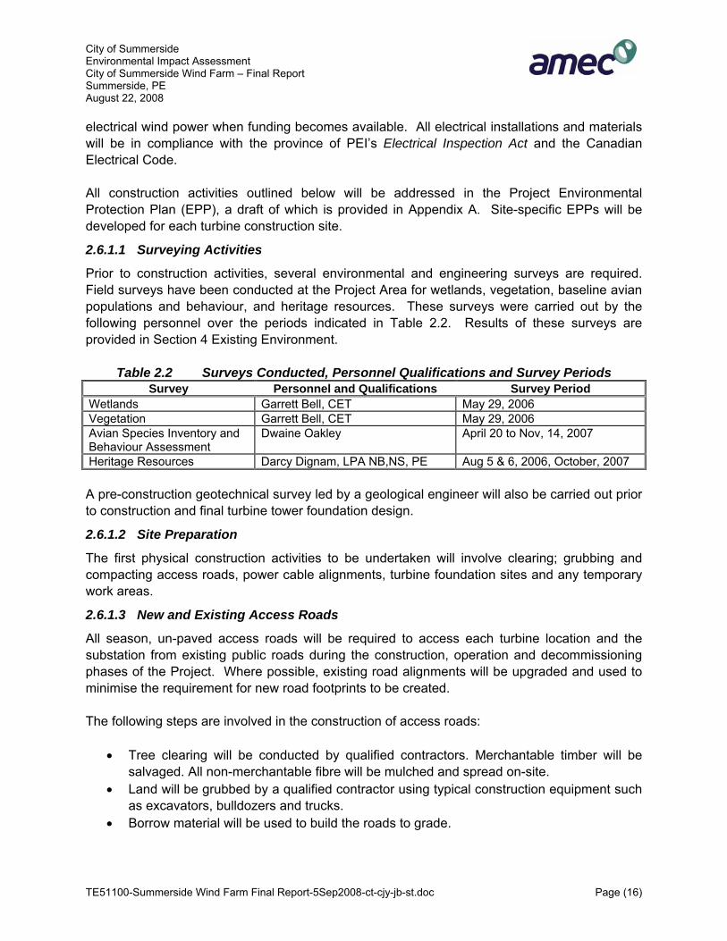
2.6.1.1 Surveying Activities
Prior to construction activities, several environmental and engineering surveys are required. Field surveys have been conducted at the Project Area for wetlands, vegetation, baseline avian populations and behaviour, and heritage resources. These surveys were carried out by the following personnel over the periods indicated in Table 2.2. Results of these surveys are provided in Section 4 Existing Environment.
Table 2.2 Surveys Conducted, Personnel Qualifications and Survey Periods Survey Personnel and Qualifications Survey Period
Wetlands Garrett Bell, CET May 29, 2006 Vegetation Garrett Bell, CET May 29, 2006 Avian Species Inventory and Behaviour Assessment
Dwaine Oakley April 20 to Nov, 14, 2007
Heritage Resources Darcy Dignam, LPA NB,NS, PE Aug 5 & 6, 2006, October, 2007 A pre-construction geotechnical survey led by a geological engineer will also be carried out prior to construction and final turbine tower foundation design.
2.6.1.2 Site Preparation
The first physical construction activities to be undertaken will involve clearing; grubbing and compacting access roads, power cable alignments, turbine foundation sites and any temporary work areas.
2.6.1.3 New and Existing Access Roads
All season, un-paved access roads will be required to access each turbine location and the substation from existing public roads during the construction, operation and decommissioning phases of the Project. Where possible, existing road alignments will be upgraded and used to minimise the requirement for new road footprints to be created. The following steps are involved in the construction of access roads:
• Tree clearing will be conducted by qualified contractors. Merchantable timber will be salvaged. All non-merchantable fibre will be mulched and spread on-site.
• Land will be grubbed by a qualified contractor using typical construction equipment such as excavators, bulldozers and trucks.
• Borrow material will be used to build the roads to grade.

City of Summerside Environmental Impact Assessment City of Summerside Wind Farm – Final Report Summerside, PE August 22, 2008
TE51100-Summerside Wind Farm Final Report-5Sep2008-ct-cjy-jb-st.doc Page (17)
• In agriculture sites, top soil/over burden will be removed from the road surface, kept separate from sub-soils, and reused during site rehabilitation.
• The road surface will be compacted to provide a smooth, erosion resistant, safe surface. • Left over grubbed material will be used to restore borrow pits.
Stage 1 road requirements for T1 and T2, (Figure 2.1) require 0.2 km of new access roads, involving no tree clearing. For Stages 2 and 3, in order to service the turbine locations shown as T3 and T4 in Figure 2.1, approximately 0.6 km of new roads will need to be constructed and 0.9 km of existing roads and trails upgraded to accommodate heavy equipment to be used during turbine installation and operations. All roads surfaces will be approximately 6 meters (m) wide to enable equipment and support vehicles to access the sites. These roads will require approximately 10 m to be cleared, grubbed and compacted. There are no known watercourses to be crossed however ditching and cross drainage will likely be required. It is estimated that for all Project Stages, the road requirements will result in the removal of 0.5 ha of forest production and 0.75 ha of agriculture production.
2.6.1.4 Delivery of Equipment
Turbine parts will be delivered by specialized, heavy transport trailer trucks, and a heavy lifting crane will be brought in to erect the turbines. All turbine parts and the machinery will be delivered via Highway 1A and local rural roads. It will be the responsibility of the turbine supplier to schedule, delivery and obtain appropriate transportation and safety permits as per the Province’s Highway Traffic Act.
2.6.1.5 Wind Turbine Assembly
Figure 2.3 shows a typical site clearing and lay-down area configuration for the installation of the Vestas V90 3MW turbines. Based on the proposed locations of the turbines, it is recognized by the Proponent that this typical installation will require site-specific modifications to accommodate environmental constraints such as wetland buffers. Installation of turbine T3 will be in proximity to salt marsh buffers. Prior to any site work, a Watercourse and Wetland Alteration (WAWA) Permit will be obtained.
2.6.1.6 Crane Pads, Unloading and Lay-down Areas
An area (approximately 20 m X 25 m) adjacent to each wind turbine will be prepared to support the heavy lift crane. The crane pads and unloading areas have the same construction requirements as the access roads. There will be an area immediately adjacent to the foundation (approximately 25 m X 75 m) required for the tower, turbine and blade components to be unloaded and stored prior to installation. The turbine and blade lay-down areas require specific grades to allow the components to be unloaded and stored. Once the turbine has been installed, the land will be returned to its original use.

City of Summerside Environmental Impact Assessment City of Summerside Wind Farm – Final Report Summerside, PE August 22, 2008
TE51100-Summerside Wind Farm Final Report-5Sep2008-ct-cjy-jb-st.doc Page (18)
The total area of temporary work space required for each turbine is less than 0.3 ha, therefore ultimately requiring a total of 0.6 ha for the completion of Stage One and an additional 0.3 ha for the completion of each of the future Stages Two and Three. All lay down areas will be rehabilitated.
2.6.1.7 Foundations
Foundations for the turbine towers will be fabricated using steel reinforced concrete. The following steps are involved in construction of turbine foundations:
• Excavation of area (approximately 20 to 30 m2). • Compacting perimeter of the excavation. • Installation of form work, rebar, backfilling and placement of concrete for tower base. • Disposal of excess material.
A backhoe will be used to excavate the foundation. Subsoil will be moved and used to in-fill any hollows on-site and or be removed from the site. The foundation itself will then be backfilled and compacted with selected fill and subsoil. The foundations will be left for a minimum period of one month to set before tower erection. Following the erection of the towers, any disturbed areas adjacent to the work area will be re-seeded with existing crops as appropriate. The final foundation design will be subject to the results of the pre-construction geotechnical survey, however; generally the depth of foundation is typically approximately 3 m. No blasting will be required as the underlying bedrock is rippable.
2.6.1.8 Interconnection Cabling
Each turbine will be connected to the future on-site substation by a combination of underground (within 30 m of the turbine base) and overhead 34.5 kV cables. The underground cable will be installed, along with fibre-optic communication cable in a trench. A self-propelled trencher or backhoe will dig a trench measuring approximately 1 m wide and 1.0 m deep. The bottom of the trench will then be covered with a layer of sand before laying the cable. The cable is protected by covering it with planks prior to backfilling.

City of Summerside Environmental Impact Assessment City of Summerside Wind Farm – Final Report Summerside, PE August 22, 2008
TE51100-Summerside Wind Farm Final Report-5Sep2008-ct-cjy-jb-st.doc Page (19)
Figure 2.3 Typical Site Clearing and Laydown Configuration of Turbine

City of Summerside Environmental Impact Assessment City of Summerside Wind Farm – Final Report Summerside, PE August 22, 2008
TE51100-Summerside Wind Farm Final Report-5Sep2008-ct-cjy-jb-st.doc Page (20)
Metal signage will be used to mark the location of the buried cables. Short sections (approximately 30 m) of underground cables are required at each turbine and the substation.
2.6.1.9 Transmission Line
The 4.0 km transmission line connecting the Summerside Wind Farm substation to the City of Summerside’s substation at Ottawa Street will be erected. A specially equipped utility truck will be used to drill holes in the ground and wooden poles placed approximately 50 m-70 m apart. Except for approximately 500 m passing through an agricultural field, the entire transmission line will follow existing roadways on land owned by the City. The section of transmission line crossing the agricultural lands is along a property line and adjacent to the MECL owned T-11 69 kV high voltage transmission line currently feeding the City.
2.6.1.10 On-site Substation
In order to connect the collector cables to the transmission line, a substation is necessary to step up the 34.5 kV power coming from the wind plant’s collector system to 69 kV. The construction activities associated with this Project component are:
• clearing of land and sub-grade preparation, requiring a footprint of approximately 100 m X 100 m (1ha);
• installation of grounding network; • installation of surface fill and fencing; • construction of concrete bases for substation components; • delivery and installation of substation units; • use of cranes to receive the transformer and large equipment; and • connection of substation to transmission line.
2.6.1.11 Service Building
An existing building will be refurbished to serve as the control/service building during construction and operating phases of the Project. This building was used in the past as the scale house for the landfill operations and currently has electricity. Running water and sewage will be installed. The sewage system will be connected to an existing septic system and drainage field.
2.6.1.12 Gates and Fencing
Chain-link security fencing will enclose the substation with one locked access gate for maintenance purposes. Fencing will be a minimum of 3 m tall with access restricting wire at the top. A motion activated alarm and lighting system will be installed to detect unauthorized entrance.

City of Summerside Environmental Impact Assessment City of Summerside Wind Farm – Final Report Summerside, PE August 22, 2008
TE51100-Summerside Wind Farm Final Report-5Sep2008-ct-cjy-jb-st.doc Page (21)
2.6.1.13 Parking Lots
A parking lot capable of accommodating service vehicles at the substation will require approximately 0.25 ha of area. The parking lot will be paved or chip sealed.
2.6.1.14 Turbine Commissioning
The final activity of the construction Phase is testing prior to start-up and physical adjustments to the turbines (eg. blade pitch).
2.6.2 Operation Phase
The operational life of the Summerside Wind Farm will be from September 2009 to August 2034. Operation of the wind farm will begin with the commissioning of two turbines T1 and T2 after they have been erected. The lifecycle of the project is expected to be at least 25 years and may be longer. At the end of the lifecycle, further advances in technology may justify the replacement of critical components to modernize or even expand the output rating of the initial machines.
2.6.2.1 Road Maintenance
During the operation of the wind farm, the access roadways will be maintained at a level suitable to boom truck-sized vehicles, but on a level below that required for heavy cranes. Re-grading and rolling of the access road may periodically be required to maintain it for heavy lifting equipment (in case of major repairs). Ditches along the road will have to be regularly maintained as well.
2.6.2.2 Turbine Operations
The wind turbines selected for this project operate within a range of wind speeds from 14.4 km/hr to 90 km/hr (Vestas, 2007). During periods that wind conditions are below the minimum or exceed the maximum, the turbines cut-out and do not produce energy. Operational control is accomplished using microprocessor-based control of all the turbine functions with the option of remote monitoring. Output regulation and optimisation is accomplished via OptiSpeed® and OptiTip® pitch regulation. Windmills will not operate in cases of mechanical breakdown, extreme weather and during periods of regular maintenance.
2.6.3 Decommissioning Phase
After 25 years, the Summerside Wind Farm will be either refurbished or decommissioned. This phase will run from September 2033 to September 2034. De-commissioning of the wind farm would require de-installation and removal of all physical components and machinery from the site. The access roads would remain, if the landowners so desired. The gathering-up lines, sub-station and control building would be removed. Concrete turbine pads and building foundations will be removed to a reasonable depth and re-claimed, unless the landowner wishes to use them as they are. The equipment used for the de-

City of Summerside Environmental Impact Assessment City of Summerside Wind Farm – Final Report Summerside, PE August 22, 2008
TE51100-Summerside Wind Farm Final Report-5Sep2008-ct-cjy-jb-st.doc Page (22)
construction would be essentially the same as for the construction (e.g. heavy lifting and transport equipment, earth moving equipment and trucks to transport waste materials). If the turbines are refurbished to increase the project lifetime, heavy transport vehicles and a heavy lifting crane would also be necessary to transport turbine parts and to de-construct and re-construct the turbines. All transformer and turbine liquids will be carefully collected, removed off-site and deposited in a licensed facility. Any areas disturbed by project activities will be re-vegetated to prevent erosion. This includes the access roads, unless the landowner wants to retain them. Off-site land use would be limited to the right-of-way for a power line from the wind-farm control house to the grid interconnection.
2.6.4 Future Stages of the Project
Stages 2 and 3 will see the construction of an additional 6.0 MWs of electrical wind power. This will occur as funding becomes available and is expected to occur between 2009 and 2020.

City of Summerside Environmental Impact Assessment City of Summerside Wind Farm – Final Report Summerside, PE August 22, 2008
TE51100-Summerside Wind Farm Final Report-5Sep2008-ct-cjy-jb-st.doc Page (23)
3.0 SCOPE OF THE ASSESSMENT
3.1 Scope of the Project and its Assessment The scope of the project includes those components of the proposed development that should be considered part of the project for the purposes of the EA (Natural Resources Canada, 2003, WPPI). The scope of the project is determined by the responsible authorities (RAs).
3.2 Methodology of Environmental Assessment To facilitate the review of identified issues, an understanding and description of the environment within which the activities will occur, or potentially have an influence on, was developed from a review of existing information. Potential positive and negative interactions between Project activities and the environment were identified. Where negative interactions were anticipated and potential effects were a concern, methods for mitigating the effects were proposed. An EA is a complete process, which should begin at the earliest stages of planning and remain in force throughout the life of a project, moving through a series of stages listed below and as shown in Figure 3.1.
Step 1: Describing the project and establishing environmental baseline conditions. Step 2: Scoping the issues and establishing the boundaries of the assessment. Step 3: Assessing the potential environmental effects of the project, including residual
and cumulative effects. Step 4: Identifying potential mitigative measures to eliminate or minimize potential
adverse effects. Step 5: Environmental effects monitoring and follow-up programs.
The technique of Beanlands and Duinker (1983) and the guidance provided by various federal and provincial documents were employed to assist in the design and conduct of the EA. This approach emphasizes the use of Valued Environmental Components (VECs) as the focal points for impact assessment. Generally, VECs are defined as those aspects of the ecosystem or associated socio-economic systems that are important to humans. The EA focused on the evaluation of potential interactions between project components and activities on the one side, and VECs that were identified through an issues scoping process on the other side. Two approaches were taken to identify the potential VECs. First, those parameters for which provincial or federal regulations are in place were identified. The second approach used for the identification of VECs involved a scoping exercise based on experience gained during other comparable environmental assessments; consultation with the public and the scientific community, supplemented by available information on the environment surrounding the

City of Summerside Environmental Impact Assessment City of Summerside Wind Farm – Final Report Summerside, PE August 22, 2008
TE51100-Summerside Wind Farm Final Report-5Sep2008-ct-cjy-jb-st.doc Page (24)
Figure 3.1 Approach to Environmental Impact (Effects) Assessment
proposed project; and the technical and professional expertise of AMEC. During the scoping process, “all relevant issues and concerns related to the proposed project and assessment are identified and prioritized” (Natural Resources Canada, 2003 (WPPI)).

City of Summerside Environmental Impact Assessment City of Summerside Wind Farm – Final Report Summerside, PE August 22, 2008
TE51100-Summerside Wind Farm Final Report-5Sep2008-ct-cjy-jb-st.doc Page (25)
For the purpose of this EA, the interactions (effects) between project activities and Environmental Components of Concern (ECCs) are examined to select a defined set of VECs that will be assessed. The significance of potential interactions and the likelihood of the interactions are also considered. Possible measures to mitigate impacts are identified, and where residual impacts are identified, measures to compensate have been considered. Impact of malfunctions and accidents, as well as cumulative effects, are to be included in the evaluation of the environmental effects (Natural Resources Canada, 2003, WPPI). The assessment of the potential effects of the environment on the Project, including extreme weather events, was conducted during the Project design phase. Any mitigative Project design modifications that may have been required were incorporated in the final Project design that is described in this document.
3.3 Temporal and Spatial Boundaries of the Project The traditional approach to project bounding involves assessing changes to the environment within the physical boundaries of development. Beanlands and Duinker (1983) determined that in order to properly evaluate impacts, physical and biological properties must be determined temporally and spatially. This approach has been taken for the determination of bounds for the assessment of the proposed project. The effects of a specific project activity on a VEC may differ in both space and time from the effect of any other activity. Some project activities may have long-term consequences, while others will be of short duration. Temporal project bounding for the proposed Project includes the short-term construction activities (Summer and Fall 2008, similar period Stage 2 and Stage 3) as well as the long-term operation of the wind energy facility (turbine lifetime 25 years) and its decommissioning including site remediation. There is some temporal variability, since a refurbishment of the turbines at the end of their regular lifetime is likely. This refurbishment will likely double the lifetime of the wind generator facility. Also, the duration of the effects is likely to vary with the VEC and the project activity. Therefore, different temporal boundaries may be used to reflect:
• the nature and duration of the effect; • the characteristics of the indicator; and • the types of actions and projects that will need to be considered within the cumulative
effects assessment. For the purposes of this Study, the temporal bounds for each Stage of the Project have been categorized into three phases:
• Phase 1: Construction Period. • Phase 2: Operations and Maintenance. • Phase 3. Decommissioning/Refurbishment.
City of Summerside Environmental Impact Assessment City of Summerside Wind Farm – Final Report Summerside, PE August 22, 2008
TE51100-Summerside Wind Farm Final Report-5Sep2008-ct-cjy-jb-st.doc Page (26)
The spatial boundaries for assessing potential effects will typically be established by determining the spatial extent of an effect of a project component or a project activity. The physical boundaries of the site are as shown on Figure 1.1. The physical (spatial) boundaries of the project may vary depending on the individual VEC. For example, for endangered plant species, the project boundaries will be restricted to the lay-down areas, access roads and ancillary structures. However, for socio-economic impacts, the boundary extends the project footprint to include the City of Summerside at a minimum. It is recognized that for some environmental components the spatial boundaries will change over time (Stage 1 through Stage 3) however, using a precautionary approach, the effects of the entire project are assessed within this EA. Scientific and technical knowledge, input from the public, professional experience and traditional knowledge will be used to develop the temporal and spatial boundaries.
3.4 Consultation Program An early Public Open House and Information Session were held May 4, 2006 to present information on the Project and the Study Area, and to explain the regulatory and environmental assessment process. Personal invitations to the Public Information Session were faxed to key stakeholders, federal and provincial regulators. Aside from the information session, meetings and inquiries were made with several stakeholders, regulators and interest groups. Information sessions are intended to provide stakeholders (e.g. regulators and the public) as well as the scientific community, with a forum to address any concerns with the Project or related activities. Another public information session was held in April 2008.
3.4.1 Public Consultation
A Public Open House was held May 4, 2006, and another on April 21, 2008 at the St. Eleanor’s Community Centre. The following methods were employed to inform the general public with information on the Project:
• personal letters of invitation mailed to property owners; • community signage; and • notice of the public open house in local newspapers.
Approximately 12 people attended the May 2006 session and 20 attended the April 2008 session. Representatives from the City of Summerside, AMEC Earth & Environmental, and a wind expert (Carl Brothers) were in attendance at each session. Information on the proposed

City of Summerside Environmental Impact Assessment City of Summerside Wind Farm – Final Report Summerside, PE August 22, 2008
TE51100-Summerside Wind Farm Final Report-5Sep2008-ct-cjy-jb-st.doc Page (27)
turbines, their locations, and the environmental assessment activities and process were available for the attendees. Although turnout was low, feedback was generally very positive. Telephone call-backs to property owners and key stakeholders were undertaken in follow-up. Another Public information Session is anticipated by the Proponent in September 2008 to update interested parties on progress and changes made to the Project. In accordance with requirements under CEAA, the federal government will ensure that consultations with Aboriginal persons and parties are undertaken. In this case, these consultations are being conducted by the coordinating department, Pubic Works and Government Services Canada (PWGSC).
3.4.2 Consultations with Stakeholders and Interest Groups
Numerous environmental Non-Governmental Organizations (NGOs) and local resource people with local historical knowledge were consulted during the preparation of the EA. In certain circumstances, these NGOs and persons provided baseline environmental and social information. In other circumstances, their professional opinions and perspectives were obtained. Table 3.1 provides the list of persons contacted, their affiliation and information discussed.
Table 3.1 Non-Governmental Organizations and Local Resource Representatives Contacted, their Affiliation and Topics Discussed
Contact Affiliation Topics Discussed
Tom Duffy Ducks Unlimited (DU) Wetlands, DU Project Sites Wade Lewis Ducks Unlimited (DU) Wetlands, DU Project Sites Laurel Bernard Nature Conservancy (NC) Wetlands and NC Project Sites Bruce Smith Island Nature Trust (INT) Wetlands and INT Project Sites, Wildlife
and Wildlife Habitat Almut Beringer University of Prince Edward Island Research Sites Darrel Guigon University of Prince Edward Island,
Naturalist Wildlife
Dr. Andrew Trivett University of Prince Edward Island Wind Regimes Alan McLennan Eastern Habitat Joint Venture
(EHJV) Wetlands and EHJV Project Sites
Jackie Waddell Island Nature Trust (INT) Species at Risk Morley Pinsent AMEC E&E contact Local Environmental and Social Setting
3.4.2.1 Slemon Park Corporation
Slemon Park Corporation (SPC) is a private corporation established in 1991. The Summerside Airport (CYSU) is owned and operated by SPC and is a full service Fix Base of Operations (FBO). The closest point of the airport’s runway system is over 1 km from the Project area.

City of Summerside Environmental Impact Assessment City of Summerside Wind Farm – Final Report Summerside, PE August 22, 2008
TE51100-Summerside Wind Farm Final Report-5Sep2008-ct-cjy-jb-st.doc Page (28)
A meeting was held with SPC January 11, 2006. This meeting was requested by AMEC in order to gain as complete as possible understanding of the issues which SPC has with the location and construction of the proposed Summerside Wind Farm. Morley Pinsent represented AMEC, Bill Thompson, President and CEO, Larry Gaudet, Director of Marketing and Development, and Tom Capstick, Airport Manager all attended on behalf of SPC. Subsequent meetings have been held between the proponent and SPC which have resulted in a Memorandum of Understanding (MOU) on the Project (Appendix B).
3.5 Regulatory Consultation AMEC and the Proponent have consulted with representatives from several federal and provincial regulatory agencies, local government representatives, and resource managers in order to identify any issues specific to the proposed project and identify appropriate mitigation strategies. The agencies/individuals consulted, and the topics of these consultations are noted in Table 3.2.
3.6 Issues Scoping and VEC Selection (Scope of the Assessment) Issues scoping is an important part in the VEC identification process. The issues scoping process for this assessment included: review of past, relevant environmental and scientific reports; review of public concerns; regulatory agency consultation; and the study team’s professional judgment. Based on this information, a preliminary list of ECCs was developed, and the Project VECs were selected (Table 3.3). This part of the environmental assessment serves to identify those environmental components that are likely to be affected by the Project. ECCs with existing federal or provincial environmental regulations, such as endangered species and migratory species, are all of concern and were selected as VECs. Issues that regulators were concerned about were also selected as VECs, e.g. most birds were of concern for CWS due to the coastal location of the project. In addition, any issues raised by the public, as well as most ECCs with an existing pathway, have been selected as VEC. If not, the exclusion is explained. The potential interactions between project components or project activities and ECCs, specifically VECs, are identified during an issues scoping process. Environmental components include the biological, physical and socio-economic environment. As a result of this process, the actual assessment will focus (only) on issues/components of concern. During the scoping process, “all relevant issues and concerns related to the proposed project and assessment are identified and prioritized” (Natural Resources Canada, 2003 (WPPI)).

City of Summerside Environmental Impact Assessment City of Summerside Wind Farm – Final Report Summerside, PE August 22, 2008
TE51100-Summerside Wind Farm Final Report-5Sep2008-ct-cjy-jb-st.doc Page (29)
Table 3.2 Regulatory Representatives from Federal, Provincial and Municipal Organizations Contacted, their Affiliation and Topics Discussed
Contact Affiliation Topics Discussed Dan Busby CWS Bird Survey Methodology Pete Hickland CWS Bird Survey Methodology Greg Wilson PEIDEEF
Entire Provincial EIA
Kevin Blair EC, Environmental Assessment Section
Project Description Avian Baseline Data Effect on Birds MBCA and Associated Regulations Wetlands Bats Wildlife at Risk Effects of the Environment on the Project
Harry Holman PEI DCCA Heritage Resource Impact Assessment Charlotte Stewart PEI DCCA Heritage Resource Impact Assessment Rosemary Curley PEIDEEF • Project Description
• Avian Baseline Data
• Effect on Birds
• Migratory Birds Convention Act and Associated Regulations (MBCA)
• Wetlands
• Bats
• Wildlife at Risk
• Effects of the Environment on the Project
Sandra Jamieson PEIDEEF • Land Use
Don Jardine PEIDEEF • Land Use
Allison Denning Health Canada (HC) • Noise
• Location of Residences
• Air Quality
• Aesthetics
George Somers DEEF • Hydrology
• Surface Water
• Ground Water
Danny Birt DEEF • Forest Cover

City of Summerside Environmental Impact Assessment City of Summerside Wind Farm – Final Report Summerside, PE August 22, 2008
TE51100-Summerside Wind Farm Final Report-5Sep2008-ct-cjy-jb-st.doc Page (30)
Table 3.3 Issues Scoping: Summary of VEC Selection and Pathway Analysis
Environment/ Resources
Environmental/Socio-Economic Components of
Concern (ECC)
Pathway ECC
Avoided During Site Selection
VEC
Yes No Yes No Yes No
Interactions with Project Activities/Components and
Possible Pathways
Rationale for Inclusion/Exclusion as Valued Environmental/Socio-Economic Component
(VEC)
Soil and Soil Quality X X X Construction: clearing and grubbing, excavation, spills, compaction, erosion Operations: spills, land removed from production for duration of the project
Included as VEC: potential for spills during construction, land removed from future production
Geology (ARD) X X X Excluded: Bedrock is calcareous sandstone, not considered to possess acid generating materials.
Seismicity X X X Operations: Seismic activity could affect structural integrity of turbine towers
Excluded: PEI not an active seismic region
Hydrogeology/Groundwater X X X Construction: excavation of foundations, spills,
Excluded as VEC: no blasting is required, nearest well is over 200 m from site. Encompassed with other VEC - Wetlands
Geophysical Environment
Sub-surface Resources X X X Excluded as VEC: Project will not interact with subsurface resources nor restrict potential development.
Aquatic Environment
Fish Habitat X X X Excluded as a VEC – No pathway identified
Fish X X X Excluded as a VEC – No pathway identified Surface Hydrology X X X Construction: clearing, grubbing and
excavation, Excluded as VEC: no water courses identified, surface water quality is addressed as part of Wetlands
Surface Water Quality X X X Construction: clearing and grubbing, excavation, spills, erosion
Excluded as VEC: no human receptors, surface water quality is addressed as part of Wetlands
Contaminated Sediment X X X Excluded as VEC: all project components have been sited to avoid the decommissioned landfill

City of Summerside Environmental Impact Assessment City of Summerside Wind Farm – Final Report Summerside, PE August 22, 2008
TE51100-Summerside Wind Farm Final Report-5Sep2008-ct-cjy-jb-st.doc Page (31)
Table 3.3 Issues Scoping: Summary of VEC Selection and Pathway Analysis
Environment/ Resources
Environmental/Socio-Economic Components of
Concern (ECC)
Pathway ECC
Avoided During Site Selection
VEC
Yes No Yes No Yes No
Interactions with Project Activities/Components and
Possible Pathways
Rationale for Inclusion/Exclusion as Valued Environmental/Socio-Economic Component
(VEC)
Flora • Agriculture
• Forest
• Wetland
X X X Construction: clearing and grubbing, excavation,
Excluded as VEC: Floral issues are encompassed within Wetlands and Floral Species at Risk
Fauna • Mammals
• Local and Migratory Birds
• Bats
X X X Construction/decom: noise, visual impacts and the presence of humans (workers in the area), habitat loss by clearing and grubbing, excavation, equipment: silt run-off, infilling; fuel spills. Operations: collisions with turbines, lights, barrier effect, toxic leaks and spills, habitat destruction
Included as VEC: protected by regulation, project site is adjacent to important Ramsar site with high level of bird breeding, foraging and migration staging. Bats also considered. No project interaction with terrestrial mammals.
Terrestrial Environment
Species at Risk • Flora Species at Risk
• Fauna Species at Risk
X
X
X
X
X
X
Construction/decom: noise, visual impacts and the presence of humans (workers in the area), habitat loss by clearing and grubbing, excavation, equipment: silt run-off, infilling; fuel spills. Operations: collisions with turbines, lights, barrier effect, toxic leaks and spills, habitat destruction
Included as a VEC – Protected by statute/regulation. If a species is endangered, effects on individuals may be considered significant.

City of Summerside Environmental Impact Assessment City of Summerside Wind Farm – Final Report Summerside, PE August 22, 2008
TE51100-Summerside Wind Farm Final Report-5Sep2008-ct-cjy-jb-st.doc Page (32)
Table 3.3 Issues Scoping: Summary of VEC Selection and Pathway Analysis
Environment/ Resources
Environmental/Socio-Economic Components of
Concern (ECC)
Pathway ECC
Avoided During Site Selection
VEC
Yes No Yes No Yes No
Interactions with Project Activities/Components and
Possible Pathways
Rationale for Inclusion/Exclusion as Valued Environmental/Socio-Economic Component
(VEC)
Designated Areas and Other Critical Habitat Areas • Demonstration Woodlots,
• Wildlife Management/Protection Areas
• National Wildlife Areas/Migratory Bird Sanctuaries
• Designated Wetlands/Eastern Habitat Joint Venture Areas (EHJVs)
• Critical Natural Areas
• Nature Reserves
• National and Provincial Parks
X
X
X
X
X
X X
X
X
X
X
X
X
X
X
X
X
X
X X
Construction/decom: noise, visual impacts and the presence of humans (workers in the area), habitat loss by clearing and grubbing, excavation, equipment: silt run-off, infilling; fuel spills. Operations: collisions with turbines, lights, barrier effect, toxic leaks and spills, habitat destruction
Excluded as VEC – Critical Natural Areas (RAMSAR site) and IBA addressed in other VECs, Birds, Wetlands and Species at Risk
Wetland Environment X X X Construction/decom: potential for erosion during clearing and grubbing, excavation, fuel spills. Operations: transformer and equipment: toxic leaks and spills;
Included as a VEC – Protected by regulatory authorities (Federal and Provincial no net loss in wetland function policy). Turbine T3 and T4 within or adjacent to buffer of salt marsh.
Air Quality • Ambient air (Human Health
and Safety)
X X X Construction/decom: Dust from construction and transport equipment, construction of turbines, transformers: air emissions (exhaust fumes, leaks, vapour), dust.
Included as a VEC - protected by statute/regulation (SO2, NOx, PM; CO, (HC). Minor quantities will be produced for short time during construction of project.
Atmospheric Environment
• Climatology X X X Construction/decom: Emissions (exhaust fumes, leaks, vapour) from construction and transport equipment
Excluded as VEC – will be addressed as part of Air Quality
Socio-Economic Environment

City of Summerside Environmental Impact Assessment City of Summerside Wind Farm – Final Report Summerside, PE August 22, 2008
TE51100-Summerside Wind Farm Final Report-5Sep2008-ct-cjy-jb-st.doc Page (33)
Table 3.3 Issues Scoping: Summary of VEC Selection and Pathway Analysis
Environment/ Resources
Environmental/Socio-Economic Components of
Concern (ECC)
Pathway ECC
Avoided During Site Selection
VEC
Yes No Yes No Yes No
Interactions with Project Activities/Components and
Possible Pathways
Rationale for Inclusion/Exclusion as Valued Environmental/Socio-Economic Component
(VEC)
• Population Demographics
• Local Economy (expenditures, local business and employment)
• Industry and Commerce
X X X Construction/decom.: Employment opportunities for local population, operational expenditures, heavy lift crane could interfere with airport operations Operations & Maintenance: new permanent employment opportunities. Presence of turbine towers will interfere with airport operations
Included as a VEC – Potential to increase beneficial effects of local construction, operational expenditures and employment; Included as VEC- Concern about impact on approach heights at Summerside Airport at Slemon Park which could affect retention of clientele.
Local Economy and Community
• Recreation and Tourism X X X Construction: delivery of turbine components, Operations: Visual appearance
Excluded as VEC: Addressed in Visual Landscape and Transportation:
Land Use • Industry/Commercial X X X Construction: large construction equipment (tall cranes) Operations: interaction between Air Park and Turbines
Excluded as VEC – Summerside Airport at Slemon Park addressed as Local Economy
• Planned Development X X X Excluded as a VEC - no new land use developments planned in Study Area
• Residential X X X Construction/decom: clearing and grubbing, excavation, equipment: noise, air emissions, dust Operations: turbines, rotor noise, toxic leaks/spills; shadow flicker,
Excluded as a VEC – Included with other VECs (Air Quality, Human Health and Safety; Accidents and Malfunctions, Visual Landscape)
• Cultural/Institutional X X X Excluded as VEC: Project activities will not interact with cultural or institutional resources.
• Communications and Radar Systems
X X X Operations: turbines could potentially affect air traffic systems at Slemon Park
Excluded as VEC – Summerside Airport at Slemon Park addressed as Local Economy
• Fisheries X X X Excluded as VEC: Project activities will not interact will recreational or commercial fisheries.

City of Summerside Environmental Impact Assessment City of Summerside Wind Farm – Final Report Summerside, PE August 22, 2008
TE51100-Summerside Wind Farm Final Report-5Sep2008-ct-cjy-jb-st.doc Page (34)
Table 3.3 Issues Scoping: Summary of VEC Selection and Pathway Analysis
Environment/ Resources
Environmental/Socio-Economic Components of
Concern (ECC)
Pathway ECC
Avoided During Site Selection
VEC
Yes No Yes No Yes No
Interactions with Project Activities/Components and
Possible Pathways
Rationale for Inclusion/Exclusion as Valued Environmental/Socio-Economic Component
(VEC)
• Agricultural X X X Construction: clearing and grubbing of agriculture land for foundations and lay down areas, Operations: areas of foundations and road, and substation removed from agriculture production
Included as VEC: potential interruption to agriculture operations, areas removed from production.
• Forestry X X X No commercial forestry activities in Project Area
• Transportation Infrastructure
X X X Construction: transportation of turbine components to Project Site.
Included as VEC: Construction requires large cranes and the delivery of turbines by highway during tourist season, this could cause traffic delays, aggravation and damage to roads.
Community Emergency Services
• Medical Services
• Fire Protection Services
• Police Protection Services
X X X Construction: potential for accidents and malfunctions during all construction activities. Operations: potential for accidents and malfunctions during all maintenance activities.
Excluded as VEC: addressed within Accident and Malfunctions
Heritage and Archaeological Resources
• Pre-historic Heritage Resources
• Historic Heritage Resources
X X X Construction/decom. clearing and grubbing, excavation, surface disruption.
Included as a VEC – field surveys to date have shown no such resources in the project foot print, on-site monitoring will be required during construction.
First Nation/Aboriginal Communities
• Aboriginal Fisheries
• Traditional Land uses
X X X Excluded as VEC – no project interaction with Aboriginal Fisheries, No traditional land use has been identified to the proponent
Human Health and Safety
• Noise X X X Construction: clearing, grubbing and installation of towers Operations: noise from rotors
Included as VEC: noise from construction activities is temporary and not expected to disturb residents, noise from rotors has been modelled and turbines located to mitigate potential affects.
• Shadow Flicker X X X Operations: sunlight shining at certain low angles through the rotating rotors can cause a periodic flickering of light.
Included as VEC: shadow flicker modelling results depict that several dwellings will potentially experience over 30 hours per year.

City of Summerside Environmental Impact Assessment City of Summerside Wind Farm – Final Report Summerside, PE August 22, 2008
TE51100-Summerside Wind Farm Final Report-5Sep2008-ct-cjy-jb-st.doc Page (35)
Table 3.3 Issues Scoping: Summary of VEC Selection and Pathway Analysis
Environment/ Resources
Environmental/Socio-Economic Components of
Concern (ECC)
Pathway ECC
Avoided During Site Selection
VEC
Yes No Yes No Yes No
Interactions with Project Activities/Components and
Possible Pathways
Rationale for Inclusion/Exclusion as Valued Environmental/Socio-Economic Component
(VEC)
• Occupation Heath and Safety
X X X Construction: during all construction activities there is the potential for workplace injuries, whether by accidents or equipment malfunctions.
Included as VEC: potential workplace accidents and mechanical failures
Aesthetics and Visual Landscape
• ViewScape X X X Construction: large construction equipment will be visible from surrounding area. Operations: Rotors and towers will be visible from Summerside and the surrounding area.
Included as VEC: wind farms are known to influence local aesthetics
Accidents and Malfunctions
• Soils and Soil Quality
• Wetlands
• Hydrogeology/Groundwater
• Water resources
• Air Quality
• Human and Occupational Health and Safety
X X X Construction: Spills, accidental release of hazardous substances, traffic accidents Operations: spills and accidental release of hazardous substances, traffic accidents, icing and breakage
All potential effects due to accidents and malfunctions

City of Summerside Environmental Impact Assessment City of Summerside Wind Farm – Final Report Summerside, PE August 22, 2008
TE51100-Summerside Wind Farm Final Report-5Sep2008-ct-cjy-jb-st.doc Page (36)
Environmental and social components protected by federal statute are:
• Fish and Fish Habitat (Fisheries Act). • Migratory Birds (MBCA). • Species at Risk (SARA). • Air Traffic Safety (Aeronautics Act).
In addition, there are both the Federal and Provincial Policies on Wetland Conservation, protecting wetlands.
3.6.1 Issues Scoping
The first step in the selection of VECs involved issues scoping to identify ECCs, and was based on:
• Concerns expressed by various stakeholders, including the scientific community, as well as comments from the public, government departments and agencies.
• Review of applicable statutes and regulations. • Consideration of available literature and reference materials. • Previous assessment experience, including landfill development experience.
Perceived public concerns related to social, cultural, economic, or aesthetic values, as suggested by Beanlands and Duinker (1983). The approach to the selection of VECs involves an initial evaluation to determine the likelihood of an interaction or linkage (pathway) between ECCs and project activities, including all the components of the Project. Where linkages between ECCs and project activities exist and potential effects are of concern, these components are selected as VECs and subject to further analyses. ECCs with existing federal or provincial environmental regulations, such as endangered species and migratory species, are all of concern and were selected as VECs. Other potential VECs were identified during the scoping exercise. Issues that regulators were concerned about were also selected as VECs, e.g. most birds were of concern for CWS due to the coastal location of the project. In addition, any issues raised by the public, as well as most ECC with an existing pathway, have been selected as VEC. If not, the exclusion is explained. The existing environment baseline description and the impact assessment focus on the selected VECs. Where a linkage between proposed project activities and the ECCs is absent, or is deemed unlikely to result in an effect, no further analysis is required. The evaluation of the ECCs resulted in the following Project VECs:

City of Summerside Environmental Impact Assessment City of Summerside Wind Farm – Final Report Summerside, PE August 22, 2008
TE51100-Summerside Wind Farm Final Report-5Sep2008-ct-cjy-jb-st.doc Page (37)
• Geophysical Environment • Soil and Soil Quality
• Terrestrial Environment • Fauna
• Local and Migratory Birds • Bats
• Species at Risk • Flora Species at Risk • Fauna Species at Risk
• Wetlands
• Atmospheric Environment • Air quality
• Socio-Economic Environment
• Local Economy • Industry and Commerce • Land Use
• Agricultural • Transportation Infrastructure
• Heritage and Archaeological Resources • Human Health and Safety
• Noise • Shadow Flicker • Occupational Health and Safety
• Aesthetics and Visual Landscape • Viewscape
• Accidents and Malfunctions
3.7 Approach to Determination of Significance The assessment or determination of the significance of potential effects will be based on the framework/criteria provided in the CEAA, with consideration of other relevant Federal and Provincial regulatory requirements. The Responsible Authority’s Guide summarizes the requirements of CEAA, which has been successfully applied to similar projects in the past, and has been widely accepted by government and regulatory agencies within Canada, as the standard for the completion of EAs.

City of Summerside Environmental Impact Assessment City of Summerside Wind Farm – Final Report Summerside, PE August 22, 2008
TE51100-Summerside Wind Farm Final Report-5Sep2008-ct-cjy-jb-st.doc Page (38)
The Reference Guide entitled "Determining Whether A Project Is Likely To Cause Significant Adverse Environmental Effects" included in the Responsible Authority’s Guide (The Agency, 1994) will be used as the basis for determining the significance of identified potential effects. This determination consists of the following steps:
• determine whether the environmental effect is adverse; • determine whether the adverse environmental effect is significant; and • determine whether the significant environmental effect is likely.
Although the terms "adverse," "significant" and "likely" are not directly defined, The Agency (1994) provides criteria to facilitate interpretation (Table 3.4). Significance of adverse effects will be directly related to regulatory guidelines and statute requirements where applicable. The assessment will determine whether the residual environmental effects of the Project are significant or non-significant after application of mitigative measures. For the purposes of the EA, an effect will be defined as the change effected on a VEC(s) as a result of Project activities. A Project induced change may affect specific groups, populations, or species, resulting in modification of the VEC(s) in terms of an increase or decrease in its nature (characteristics), abundance, or distribution. Effects will be categorized as either negative (adverse) or positive. Any adverse effects will be determined to be significant or non-significant in consideration of assessment criteria discussed above. The Assessment will focus on those interactions between the VECs and Project activities, which are likely. Table 3.4 presents the criteria to be considered in the assessment of potential environmental effects – According to the Reference Guide: Determining Whether A Project is Likely to Cause Significant Adverse Environmental Effects, (CEAA, 1994). ECCs protected by statute are:
• Fish and fish habitat (Fisheries Act). • Migratory birds (MBCA). • Species at Risk (PEI Wildlife Conservation Act, SARA). • Structures or historic sites of national interest (Historic Sites and Monuments Act).
In addition, there is the Federal Policy on Wetland Conservation and the Province of Prince Edward Island’s Wetland Conservation Policy.
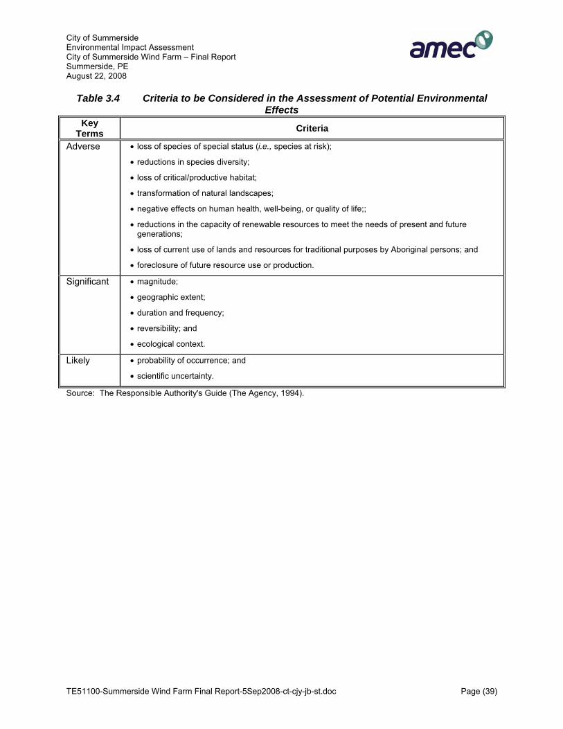
City of Summerside Environmental Impact Assessment City of Summerside Wind Farm – Final Report Summerside, PE August 22, 2008
TE51100-Summerside Wind Farm Final Report-5Sep2008-ct-cjy-jb-st.doc Page (39)
Table 3.4 Criteria to be Considered in the Assessment of Potential Environmental Effects
Key Terms Criteria
Adverse • loss of species of special status (i.e., species at risk);
• reductions in species diversity;
• loss of critical/productive habitat;
• transformation of natural landscapes;
• negative effects on human health, well-being, or quality of life;;
• reductions in the capacity of renewable resources to meet the needs of present and future generations;
• loss of current use of lands and resources for traditional purposes by Aboriginal persons; and
• foreclosure of future resource use or production.
Significant • magnitude;
• geographic extent;
• duration and frequency;
• reversibility; and
• ecological context.
Likely • probability of occurrence; and
• scientific uncertainty.
Source: The Responsible Authority's Guide (The Agency, 1994).

City of Summerside Environmental Impact Assessment City of Summerside Wind Farm – Final Report Summerside, PE August 22, 2008
TE51100-Summerside Wind Farm Final Report-5Sep2008-ct-cjy-jb-st.doc Page (40)
4.0 ENVIRONMENTAL AND SOCIO-ECONOMIC SETTING This section provides a description of the environmental and the socio-economic setting for the Study Area (Figure 1.1), and includes those components of the environment potentially affected by the proposed Project, or which may influence or place constraints on the execution of Project-related activities. The environmental setting is presented to allow assessment of the impact of the proposed Project. Description of the setting includes an overview of regional and local atmospheric, geological, aquatic and terrestrial characteristics in addition to designated areas and other critical habitat features of the proposed Project.
4.1 Geophysical Environment PEI is in the Gulf of St. Lawrence, off the Atlantic coast of the Canadian mainland. PEI is in one of the three sub-units of the Appalachian region, called the Maritime Plain. The plain is an area of low relief (Douglas, 1970). The land within the Study Area is level and flat with site topography sloping north toward Middle Creek and east toward Compton Creek, both of which discharge into Malpeque Bay located approximately 1500 metres to the north (MGI, 1999). The Study Area is between the 20 and 30 m contour lines (PEI Atlas, 2005).
4.1.1 Soil and Soil Quality
Based on the Canadian Land Inventory (CLI), soils in the Study Area are rated as Class 2F in terms of agriculture productivity. This Class of soils is described as having moderate limitations that restrict the range of crops and have low natural fertility. For commercial forest production, the CLI rates the soils as Class 5, lands having severe limitations. The Study Area is located in a primarily agricultural area with active and abandoned agriculture fields, a decommissioned landfill, forest and wetlands. The surficial geology of the Study Area consists of 0.3 to 5 metres of clayey sand till based on historical drilling (17 boreholes) and test pitting (14 backhoe test pits) (Betcher, 1977). Turbine T1 will be situated between an abandoned apple orchard/ field and T2 in a cultivated field. T3 will be between an actively cultivated field and a salt marsh and T4 adjacent to a lagoon. Each turbine will remove 30 m2 of soil productivity in their respective sites, for the duration of the Project. All temporary work space to be used as lay down areas has been sited in agriculture areas and will total 0.75 ha. These areas will be returned to original production upon completion of the construction phase. The substation and parking lot will be located on currently abandoned agriculture lands and an old orchard, requiring approximately 1 ha in total.

City of Summerside Environmental Impact Assessment City of Summerside Wind Farm – Final Report Summerside, PE August 22, 2008
TE51100-Summerside Wind Farm Final Report-5Sep2008-ct-cjy-jb-st.doc Page (41)
New access roads and the underground cable the road requirements will result in the removal of 0.5 ha of forest production and 0.75 ha of agriculture production for the duration of the Project.
4.1.2 Geology (Acid Rock Drainage)
The bedrock underlying the Study Area is composed predominantly of sandstone with some calcareous claystone breccia and claystone, siltstone and mudstone (Betcher, 1977, pers. comm. George Somers, 2007). The primary issue pertaining to the geological substrate is any potential exposure of sulphide-containing rocks to oxygen (atmospheric conditions), e.g. through construction activities. This exposure can lead to Acid Rock Drainage (ARD) (Howells and Fox, 1997). ARD is characterized by low pH (pH 2-4) and a high content of dissolved metals (Howells and Fox, 1997), in particular aluminum, manganese and iron, as well as trace elements such as copper, nickel and cobalt, from the rock (Zentilli and Fox, 1997). Often, bacteria are involved in the oxidation, but the reaction also occurs abiotically. The rate of acid formation is dependent on the type of sulphide mineral and environmental conditions such as ambient temperature, the amount of rainfall, the presence or absence of bacteria, and the availability of oxidants (Fox et al., 1997). The sulphide concentrations in the “redbeds” of PEI are low and there is no potential for ARD in the Study Area (pers. comm.. George Somers, 2007).
4.1.3 Seismicity
Prince Edward Island is not in an earthquake zone (InfoPEI, 2007). The potential for an earthquake of sufficient magnitude to disrupt the operation of the wind farm is remote and not likely to occur in the project’s temporal boundaries (25 years).
4.1.4 Hydrogeology/Groundwater
The groundwater divide is approximately 30 m south of Middle Creek and the majority of groundwater drains north-easterly towards Compton Creek at a gradient of approximately 0.01. According to previous studies the hydraulic conductivity of the area is highly variable (2.77 X 10⁻⁵ to 5.43 X 10⁻³ cm/s) and particle size analyses showed an average sand content of approximately 70% from site samples (Betcher, 1977). According to George Somers (PEIDEEF, Water Management Division) the general chemistry of the Study Area has a slightly alkaline pH of 7 to 8 and a hardness value of approximately 120 mg/L. These values can be highly variable as has been demonstrated through historical data amassed in the MGI risk assessment report (1999). In addition to general chemistry, organic parameters such as pesticides, chlorinated organic compounds and petroleum hydrocarbons were sampled and not found to be in significant quantities with the exception of naphthalene and toluene in one well location. It should be noted that this sampling occurred prior to any groundwater or stream dilution. Heavy metals were also analyzed in the 1999 MGI risk assessment and ten metals exceed the Aquatic Life criteria for one or more of the sample locations: Aluminum, Arsenic, Cadmium, Chromium, Copper, Iron, Lead, Selenium, Silver and Zinc. It should be noted that this criteria may not be appropriate

City of Summerside Environmental Impact Assessment City of Summerside Wind Farm – Final Report Summerside, PE August 22, 2008
TE51100-Summerside Wind Farm Final Report-5Sep2008-ct-cjy-jb-st.doc Page (42)
since neither the groundwater or the lagoon water are aquatic habitat and significant dilution will occur prior to impact on a valued aquatic habitat. There are a number of municipal/industrial wells in addition to private domestic wells in the general area. The City of Summerside and Slemon Park service municipal/industrial wells to the area surrounding the Study Area. Residences located near the Study Area are serviced through private wells (George Somers, pers.comm.). The closest private well is approximately 200 m up gradient from the northern edge of the Study Area (MGI, 1999). Based on the anticipated evacuation depth of approximately 3 m and the rippable nature of red sandstone, blasting will not be required.
4.1.5 Sub-surface Resources
Prince Edward Island has no current commercially developed mineral resources however interest exists in oil and gas exploration. According to InfoPEI, “Prince Edward Island's hydrocarbon potential has yet to be fully assessed as, to date, only eighteen exploratory wells and one re-entry well have been drilled on and around the province”. Much of PEI is underlain by seams of coal of various thicknesses. Located too deep for economic extraction, these coal formations may provide the Province with energy in the form of coalbed methane. The presence of the wind farm will not interfere with any future exploration or ultimate development of mining activities.
4.2 Aquatic Environment
4.2.1 Aquatic Habitats
There are two water courses in the Study Area: Middle Creek and Compton Creek. Compton Creek is in the Eastern portion of the Study Area and considered to be an intermittent stream due to no flow periods during the summer (MGI, 1999). The Project Site is bordered to the north by Middle Creek. Both streams flow into the Malpeque Bay. The fish habitat in the Middle Creek and Compton Creek flowing both north of and through the Project Area is highly degraded. Malpeque Bay is a coastal lagoon system protected from the open sea (Gulf of St. Lawrence) by a 25 km-long coastal sandspit and dune formation. A 1000 m-wide channel at the eastern tip of the sandspit provides for the main exchange of tidal waters between the bay and open ocean. Some 23 small rivers and creeks contribute fresh water to this lagoon, thus producing principally an estuarine regime. Numerous small salt marshes (average size 5 ha) are scattered along the coastline which is characterized by a band of intertidal sand-mud that varies in width from 0.5 m to 1000 m. The majority of the bay is shallow (average depth 4 m, maximum 13 m) with numerous shoals. These shallow, productive, coastal waters account for 31% of the site area, and eel grass (Zostera marina) dominates half (3800 ha) of this area. The 25 km protecting
City of Summerside Environmental Impact Assessment City of Summerside Wind Farm – Final Report Summerside, PE August 22, 2008
TE51100-Summerside Wind Farm Final Report-5Sep2008-ct-cjy-jb-st.doc Page (43)
sandspit has wide sand beaches (260 ha) and several small saline ponds. Areas of overwash occur at intervals, but an extensive dune system vegetated with marram grass (Ammophila breviligulata) dominates. The bay contains nine islands, five wooded and four covered with grasses and shrubs (Environment Canada, 2006). To the extent possible, the Project works have been sited to avoid and therefore not interact with the wetlands, watercourses and watercourse buffers. In order to mitigate noise and shadow flicker to as many residences as possible, as well as to reduce potential barrier affects to avian fauna by maintaining a 400 m distance between towers, the configuration of the wind farm places T3 and T4 approximately 10 to 20 m from the salt marsh.
4.2.2 Aquatic Fauna
The streams, despite their degraded condition, do support some life, namely brook trout (Salvelinus fontinalis) and sticklebacks (Gasterosteus aculeatus) (R. MacFarlane, pers.comm., 2006). Compton Creek runs through the Project Area and is considered to be an intermittent stream due to no flow periods during the summer (MGI, 1999). The fish species found in Malpeque Bay are typically estuarine in nature (Table 4.1). It is important to consider the size and mass amounts of marine species habitat located within Malpeque Bay and the Gulf of St. Lawrence. The Bay is famous for its high quality oyster production and is also home to mussels, soft shell, razor and bar clams as well a thriving lobster population. Several species can be found outside of Malpeque Bay in the Gulf of St. Lawrence (Fisheries and Oceans (DFO), 2006). The fish and shellfish in the area can be found in Table 4.1 and 4.2 (DFO, 2006 & R. MacFarlane, 2006)
4.2.3 Surface Hydrology
The Study Area falls within the hydrometric subdivision 1CB as defined by Environment Canada (Environment Canada, 1986). All surface runoff from this subdivision drains into Malpeque Bay, 5% of which originates from Middle Creek and 95% from Compton Creek (MGI, 1999). Middle Creek drains predominantly up gradient lands in agricultural production. Compton Creek also drains predominantly up gradient lands in agricultural production and, in addition, receives overland discharges from a municipal sewage treatment lagoon. The access road requirements of the Project are located in areas that will have minimal if any interaction with surface flows. There are no known watercourses directly within the footprint of any project activities. Proper cross drainage will be installed. Erosion control measures employed to protect wetlands will address potential surface water issues.
4.2.4 Surface Water Quality
The general chemistry of surface waters is similar to that found in groundwater, with the exception of a slightly higher hardness value of 150 mg/L (MGI, 1999).

City of Summerside Environmental Impact Assessment City of Summerside Wind Farm – Final Report Summerside, PE August 22, 2008
TE51100-Summerside Wind Farm Final Report-5Sep2008-ct-cjy-jb-st.doc Page (44)
Table 4.1 Marine Species of Malpeque Bay
Common Name Scientific Name
American Lobster Homerus americanus
Herring Clupea harengus American Eel Anguilla rostrata Soft Shell Clam Mya arenaria Bar Clam Spisula solidisima Razor Clam Ensis directus Blue Mussel Mytelis edulis American Oyster Crassostrea virginica Quahog (confirm) Mercenaria mercenaria American Smelt Osmerus mordax Atlantic Silverside Menidia menidia Mummichog Fundulus heteroclitus heteroclitus Banded Killifish Fundulus diaphanous diaphanous Brook Trout Salvelinus fontinalis
Alewife (Gaspereau) Alosa pseudoharengus
Mackerel Scomber scombrus Blue-backed herring Alosa aestivalis Stickleback Apeltes quadracus
Table 4.2 Marine Species of the Gulf of St. Lawrence
Common Name Scientific NameRock Crab Cancer irroratusSea Urchin Strongytocentrotus drobachiensis Atlantic Cod Gadus morhua Winter Flounder Pseudopleuronectes americanus Atlantic Mackerel Scomber scombrus
Bluefin Tuna Thunnus thynnus
City of Summerside Environmental Impact Assessment City of Summerside Wind Farm – Final Report Summerside, PE August 22, 2008
TE51100-Summerside Wind Farm Final Report-5Sep2008-ct-cjy-jb-st.doc Page (45)
An issue of concern is the potential surface water discharge from the historical landfill located on the Gallant property found between the locations of the turbines. Compton Creek is susceptible to dry periods in the summer (MGI, 1999). All project activities have been sited to avoid the former landfill. The potential interactions between the Project and surface water are the same as for Wetlands. Mitigation measures to be implemented to protect Wetland will also serve to protect surface water quality.
4.2.5 Sediment
In 1999 a sediment sample was taken at one location from the Compton Creek streambed upstream of the confluence of the lagoon discharge and Compton Creek by MGI. It was determined that the sediment sample exceeded CCME Probable Effect Levels for cadmium, chromium, copper, lead, and zinc in addition to hydrocarbons in the lube oil range (993 mg/kg). No pesticides were detected in the sediment sample. MGI hypothesized that the elevated concentrations of these heavy metals and hydrocarbons were due to inputs from the adjacent Gallant property, the up gradient subject site or lands further up Compton Creek. The project will not interact with the discharge from the sewage lagoon or Compton Creek.
4.3 Terrestrial Environment
4.3.1 Flora
PEI has been heavily impacted by humans, the majority of which has been transformed into farmland. Loucks (1962) identifies most of the west and along the northern shore of PEI, where the Study Area is located, as being within the Prince Edward Shore (Maritime Lowlands Ecoregion). According to Rowe (1972), conifers are prominent with forest stands of white spruce, black spruce (Picea mariana), balsam fir (Abies balsamea), and tamarack (Larix laricina). Red maple (Acer Rubrum), and occasional eastern white pine (Pinus strobus), red spruce (Picea rubens), eastern white cedar (Thuja occidentalis), and eastern hemlock (Tsuga canadensis) can also be found. The Project Area (see Figure 1.1) encompasses 102 ha of which, one half (50 %) is open fields for agriculture and the decommissioned landfill, one third (31 %) wetlands. Forested areas cover the remaining 19%. On May 29, 2006, an early season vegetation survey was conducted at the Project Area to provide a more detailed description and accounting for vegetative conditions. At that time, early flowering plants were all in bloom, such as violets (Viola sp.), avens (Geum sp.), and yellow clintonia (Clintonia borealis). No species at risk were observed. Based on the field survey, the Project Area was divided into 8 terrestrial vegetative habitats as follows:

City of Summerside Environmental Impact Assessment City of Summerside Wind Farm – Final Report Summerside, PE August 22, 2008
TE51100-Summerside Wind Farm Final Report-5Sep2008-ct-cjy-jb-st.doc Page (46)
• Closed / Restored Landfill (Open Field); • Hay Field (Open Field); • Fallow cropland (open Field); • Old Field (Open Field); • Old Apple Orchard (Forested); • Forest (Forested); • Shrub swamp (Wetland); and • Salt marsh (Wetland).
The proposed windmill sites are located within and adjacent to the vegetative habitats listed above as indicated in Table 4.3. A description of each vegetative habitat is provided below.
Table 4.3 Habitat at / Adjacent to each Site Habitat Type Site Name Within Adjacent (0-30 m)
T1 Field/Old Apple Orchard Shrub swamp (wetland) Closed / Restored Landfill
T2 Hay Field Old Field T3 Open Field Salt marsh (wetland)
T4 Open Field Lagoon/ Shrub swamp (wetland) Closed / Restored Landfill
4.3.1.1 Closed / Restored Landfill
The landfill has been closed for several years and the smooth mound is covered with a soil cap and revegetated with grasses, such as fescues, quack grass (Elytrigia repens), timothy (Phleum pratense), and (in some areas) sapling conifer trees. Many weeds and shrubs have also colonized the landfill surface such as sow thistle (Sonchus sp.), buttercups (Ranunculus sp.), meadowsweet (Spirea alba), alder (Alnus sp.), and dogwood (Cornus sp.)
4.3.1.2 Hay Field
Hay fields are planted with agronomic grass species such as fescues and barley. A few other weedy species, typical of field margins, were identified such as cherries (Prunus sp.), raspberries (Rubus sp.), hawkweed (Heiracium piloselloides), and buttercups.
4.3.1.3 Fallow cropland
Fallow cropland is planted with nitrogen fixing vegetation such as clover (Trifolium sp.), alfalfa (Medicago setiva), with many weedy species including cinqfoils (Potentilla sp.), goldenrods (Solidago sp.), and asters (Aster sp.). The presence of scotch lovage (Ligusticum scothicum) and freshwater cordgrass (Spartina pectinata) in the field are indications of the nearness to the coast.

City of Summerside Environmental Impact Assessment City of Summerside Wind Farm – Final Report Summerside, PE August 22, 2008
TE51100-Summerside Wind Farm Final Report-5Sep2008-ct-cjy-jb-st.doc Page (47)
4.3.1.4 Old Field
Old field is former marginal cropland, usually low lying and somewhat wetter than the adjacent croplands. These areas are vegetated with a variety of high and low shrubs, native and introduced grasses, and sapling to mature trees. Trees and herbaceous vegetation are typical of cool coastal (boreal) habitats with open structure.
4.3.1.5 Old Apple Orchard
Like old fields, the old cropland is vegetated with a variety of high and low shrubs, native and introduced grasses, and sapling to mature trees; however, many of the trees are apple trees (Malus sp.). The apple trees were in bloom at the time of the survey and appeared (from the top of the landfill) to be evenly distributed throughout the former orchard. Other terrestrial species are typical of cool boreal forest habitats, more or less identical to the forest habitat described below.
4.3.1.6 Forest
Typical boreal forest of the coastal maritime region, dominated by dense coniferous trees (mainly black spruce (Picea mariana) and balsam fir (Abies balsamifera)) with a sparse herb layer of bunch berry (Cornus canadensis), starflower (Trientalis borealis), sarsaparilla (Smilax regelii), yellow clintonia, and wood ferns (Dryopteris sp.). The trees are generally stunted and blow down (fallen trees) approached 40% in places indicating very high winds on this exposed coastline.
4.3.1.7 Shrubswamp (wetland)
The shrubswamp is dominated by alder and willow (Salix sp.), and sweet-gale (Myrica gale) with a dense groundcover of touch-me-nots (Impatiens capensis), cinnamon fern (Osmunda cinamomea), sensitive fern (Onoclea sensebilis), and cattails (Typha sp.). This wetland type forms a freshwater margin at the landward edge of saltmarsh areas and occupies low-lying drainage paths (sometimes stream channels) in the terrain.
4.3.1.8 Salt Marsh (wetland)
The saltmarsh wetlands border the Malpeque Bay north of Summerside. Vegetation is typical of regularly flooded saltmarsh including salt water and freshwater cord-grass (See Wetland Field Data Sheet in Appendix C). Other salt tolerant species include cattails, sea lavender, sweet grass, salt water bulrush, scotch lovage, and sea-side goldenrod. Large driftwood in the marsh indicates that higher high tide and storm-surges overtop the bank. A broad shrubby zone dominated by Spartina pectinata occupies the fresh margin of the wetland, while areas nearer to the shore are dominated by Spartina patens with few pannes. The two habitats intermingle gradually over 10 to 20 m. Vegetation and wrack line indicate that most of the saltmarsh areas are flooded daily. An extended shrub-zone at the wetland margin indicates a regular storm-surge influence as well. Mature forest borders the wetland at the upland edge. Wildlife observed include seagulls, bittern, and meadow vole. Tracks and nibbled vegetation indicate small mammal such as rabbit, fox, and possibly domestic cat. Small fish were observed in the channels and were greatly abundant along the tidal shoreline at high tide. Previous agricultural

City of Summerside Environmental Impact Assessment City of Summerside Wind Farm – Final Report Summerside, PE August 22, 2008
TE51100-Summerside Wind Farm Final Report-5Sep2008-ct-cjy-jb-st.doc Page (48)
activity has affected a very small marginal portion of wetland habitat. Areas of coniferous forest and shrubswamp grow up to the wetland margin to the south and west.
4.3.2 Fauna
The terrestrial fauna of interest in context of the proposed wind farm are avian populations. These fauna have the potential to interact with the towers, rotors and guylines. PEI does have resident populations of other terrestrial fauna such as furbearers (fox, coyotes, rabbits etc.) that are of social interest but are not likely to have adverse interactions with the project.
4.3.2.1 Local and Migratory Birds
Based on the Atlas of the Breeding Birds of the Maritimes, there are 81 species of birds that may breed (ie, confirmed or probable breeding) in the area surrounding the proposed site for breeding (Erskine, 1992), See Table 1, Appendix D. Malpeque Bay is a designated Ramsar site due to the very high levels of waterfowl use during spring and fall migration periods. The original focus of the Ramsar Convention was on wetlands as a habitat for waterfowl, but over the years, it has developed into an international instrument dealing with wetlands from a broader point of view. No major studies of migratory birds have been carried out at the site. However, waterfowl use has been documented by aerial surveys conducted by EC and the PEI Department of Fisheries, Aquaculture and Environment (RAMSAR, 2006). An avian survey was conducted for this project from April to November 2007. Malpeque Bay is also identified as one of six “Important Bird Areas of Canada” (IBA) in PEI. According to the IBA web site two colonies of double-crested cormorants occur on Islands in the Bay, representing approximately 4,500 nests and about 2% of the Canadian population. The mouth of Malpeque Bay is a nesting site for the globally threatened piping plover (Charadrius melodus). It is an important staging area for very large numbers of geese and ducks during spring and autumn migration periods. Peak numbers of Canada geese (Branta canadensis) reach 14,000 in spring, with as many as 20,000 during autumn. Of particular importance to these geese are the eel grass flats and intertidal areas near Courtin Island (Bunbury Island), at the mouth of Indian River and in Darnley Basin. Up to 3,000 red-breasted merganser (Mergus serrator), 1,200 greater scaup (Athya marila), 1,500 black duck (Anas rubripes) and 750 green-winged teal (Anas crecca carolinensis) can be observed in the peak autumn periods. Smaller numbers of pintail (Anas acuta), goldeneye (Bucephala clangula) and surf scoter (Melanitta perspicillata) also occur. Shorebirds are abundant about the Bay from mid-July to early autumn, and several pairs of nesting piping plover occur at the mouth of Malpeque Bay. Some of the islands are colonial nesting sites for seabirds, and Courtin Island is the largest great blue heron (Ardea herodias) colony in the Province, with 300 birds. Ultimately, this site supports more than 1% of the population of Canada geese (RAMSAR, 2006).

City of Summerside Environmental Impact Assessment City of Summerside Wind Farm – Final Report Summerside, PE August 22, 2008
TE51100-Summerside Wind Farm Final Report-5Sep2008-ct-cjy-jb-st.doc Page (49)
Furthermore, the Atlantic Canada Conservation Data Centre (ACCDC) database was consulted to obtain records of rare avian species occurrences within a 5 km radius of the Project Area. Results are presented in Section 4.3.3.2 below within Fauna Species at Risk. All migrating birds are protected under the federal MBCA. Since both breeding and migrating birds have the potential to be impacted by the wind turbines, a comprehensive field inventory of breeding and migrating birds was developed. Multiple individual surveys were carried out from April 25, 2007 to November 14, 2007, focusing on different bird target groups. All surveys were carried out by Dwaine Oakley who has over 25 years of birding knowledge and is trained in the methods of scientific bird observation and data collection. An overview of the surveys, including the schedule, is given in Appendix D. The field program for the bird surveys was coordinated with Rosemary Curley (PEIDEEF), Dan Busby (CWS), and Peter Hicklin (CWS), following guidance provided by CWS, PEIDEEF and EC. Data was collected according to the parameters set out in the guidance document, “Baseline Information Requirements for Evaluation of Effects of Wind Power Facilities on Migratory Birds in Atlantic Canada”. It also follows the rules set out in the in the CWS guidance documents, “Wind Turbines and Birds – A Guidance Document for Environmental Assessment” (CWS, 2006) and “Wind Turbines and Birds - A Background Review for Environmental Assessment” (CWS, 2005). The bird surveys were conducted over a period of 44 days. Approximately 34,536 sightings representing 145 different bird species were recorded (Table 4.3, Appendix D) at 8 point-count locations (Figure 4.1, Appendix D) distributed throughout the Study Area. The sample points were located in the general proximity of the proposed turbine locations at the commencement of the surveys and to provide a through, representative coverage of the habitat conditions and bird movements. The highest number of sightings occurred in September, when 13,434 individuals were observed in total, though the highest number of sightings/day actually occurred in October as 2337 sightings/day was calculated (Table 4.5, Appendix D). The highest number of species identified in a month was also highest in October, with a total of 3,619 species being identified in the Study Area. The busiest bird migration times at the Study Area were during the month of April, with the arrival of Canada geese, and between August and November with the departure of the shorebirds.
4.3.2.2 Bats
There are four species of bats known to occur within the Province, including the hoary bat (Lasiurus cinereus), big brown bat (Eptesicus fuscus), little brown bat (Myotis lucifugus), and the northern long-eared bat (Myotis septentrionalis). Hoary bats are not typically attracted to buildings or other human structures, and they stay well-hidden in foliage throughout the day. However, they travel in waves and are often found in the company of birds. Hoary bats are the most widespread of all bats and don't emerge to feed until after dark, but they may be seen soon after sundown during migration. They sometimes

City of Summerside Environmental Impact Assessment City of Summerside Wind Farm – Final Report Summerside, PE August 22, 2008
TE51100-Summerside Wind Farm Final Report-5Sep2008-ct-cjy-jb-st.doc Page (50)
make round trips of up to 40 km on the first foraging flight of the night, and then make several shorter trips, returning to the day roost about an hour before sunrise. Between late summer and early fall, they start their long journey south, migrating to subtropical and possibly even tropical areas to spend the winter (BatCon, 2006). Unlike the hoary bat, the big brown bat will move into close human contact, taking up residence in buildings and other man-made structures. They are found in virtually every habitat ranging from timberline meadows to lowland deserts, though it is most abundant in deciduous forest areas. The big brown bat is often observed in suburban areas of mixed agricultural use. Common maternity roosts can be found in buildings, barns, bridges, and even bat houses. They are generalists in their foraging behaviour and habitat selections, seemingly showing little preference for feeding over water vs. land, or in forests vs. clearings (BatCon, 2006). The little brown bat is abundant throughout forested areas and is especially associated with humans, often forming nursery colonies containing hundreds, sometimes thousands of individuals in buildings, attics, and other man-made structures. In addition to day roosts in tree cavities and crevices, little brown bats seem quite dependent upon roosts which provide safe havens from predators that are close to foraging grounds. Little brown bats forage over water where their diet consists of aquatic insects, mainly midges, mosquitoes, mayflies, and caddis flies. They also feed over forest trails, cliff faces, meadows, and farmland where they consume a wide variety of insects, from moths and beetles to crane flies. Individuals can catch up to 1,200 insects in just one hour during peak feeding activity (BatCon, 2006). The northern long-eared bat (formerly Myotis keenii), is widely distributed across eastern North America and is found in dense forest stands typically choosing maternity roosts beneath exfoliating bark and in tree cavities. Relying upon caves and underground mines for hibernation sites, the northern bat typically chooses cooler sites than the other three species. This species is generally more solitary and is most often found singly or in very small groups. During the summer, the northern long-eared bat appears especially reliant upon forested habitats and is found in greater densities in the northern areas of its range than in the south. Little is known about its food habits, although it has been observed foraging along forest edges, over forest clearings, at tree-top level, and occasionally over ponds (BatCon, 2006).
4.3.3 Species at Risk
Available information on the known occurrence of floral and faunal species at risk in the Study Area was compiled and reviewed to determine their presence relative to construction of the City of Summerside Wind Farm. Sources included published listings of occurrences of such species (e.g., SARA, Committee on the Status of Endangered Wildlife in Canada (COSEWIC), as well as consultations with provincial government agencies and researchers (e.g., ACCDC). COSEWIC and SARA categorize rare species into three main groups according to their status within the province:

City of Summerside Environmental Impact Assessment City of Summerside Wind Farm – Final Report Summerside, PE August 22, 2008
TE51100-Summerside Wind Farm Final Report-5Sep2008-ct-cjy-jb-st.doc Page (51)
• Endangered (E): A wildlife species facing imminent extirpation or extinction. • Threatened (T): A wildlife species likely to become endangered if limiting factors are not
reversed. • Special Concern (SC): A wildlife species that may become a threatened or an
endangered species because of a combination of biological characteristics and identified threats.
An information request was submitted to the ACCDC for a list of occurrences of species at risk within and near the proposed Study Area (within 5 km of proposed wind farm). The paragraphs below detail species at risk that could potentially occur in the vicinity of the proposed project. S1, S2, and S3 ranked species at risk are considered to be extremely rare to uncommon and are discussed in the following sections. S rankings and their qualifiers are described below. S1 Extremely rare throughout its range in the Province. S2 Rare throughout its range in the Province. S3 Uncommon throughout it range or found in a restricted range in the Province.
S* B Breeding. S* N Non-breeding.
SH Historical: Element occurred historically throughout its range in the province (with expectation that it may be rediscovered), perhaps having not been verified in the past 20 - 70 years (depending on the species), and suspected to be still extant.
4.3.3.1 Flora Species at Risk
In 2007, COSEWIC and SARA listed the Gulf of Saint Lawrence Aster (Symphyotrichum laurentianum) as threatened within the province of PEI. The following plant species of concern are identified in Table 4.4 as known to occur within 5 km of the Project Site and therefore potentially occurring within the Project Area (ACCDC, 2006). None of these species have been found to exist within the Project Area.
Table 4.4 Plant Species of Concern Potentially in the Study Area Common Name Scientific Name S-Rank Habitat*
American Water-Pennywort Hydrocotyle Americana S3 Moist woods, meadows, and thickets
White-Top Fleabane Erigeron annuus S1SE Open grassy areas, disturbed soils and waste areas.
Balsam Groundsel Packera paupercula SH Ledges and rocky shores Robbins Squaw-Weed Senecio (Packera)
schweinitziana S1 Swampy mixed woods
Broad-Leaved Goldenrod Solidago flexicaulis S2S3 Rich mixed or hardwood stands
Large-Leaf Goldenrod Solidago macrophylla S1 Moist, mostly coniferous stands

City of Summerside Environmental Impact Assessment City of Summerside Wind Farm – Final Report Summerside, PE August 22, 2008
TE51100-Summerside Wind Farm Final Report-5Sep2008-ct-cjy-jb-st.doc Page (52)
Common Name Scientific Name S-Rank Habitat* Large-Leaf Wood-Aster Eurybia macrophylla S2 Moist to dry soils, hemlock-
northern hardwoods, beech-maple or pine forests, Appalachian spruce-fir forests, aspen, pine or open spruce woodlands, thickets, clearings, shaded roadsides
Swamp Birch Betula pumila S2 Boggy thickets and wet shrubby meadows
Canada Sand-Spurry Spergularia Canadensis S3? Coastal, salt-marshes and estuaries
Purple Sandspurry Spergularia salina S3? Coastal, salt-marshes and estuaries
Fleshy Stitchwort Stellaria crassifolia SH On wet banks, marshes and similar cold, wet places often near the coast
Northern Stitchwort Stellaria borealis S2S3 Seeps, springs, and streamlets in cool woods and swamps
Gronovius Dodder Cuscuta gronovii S2 Damp meadows and along shores
Pale Corydalis Corydalis sempervirens S2 Forest clearings, rock outcrops, areas disturbed by burning and machinery
Downy Willow-Herb Epilobium strictum S2S3 Wet meadows, boggy swales, and marshes
Seabeach Dock Rumex pallidus S1? Coastal sands, shores and gravel roadsides
Fountain Miner's-Lettuce
Montia fontana SH About spring rills, usually coastal shores, and wet ledge crevices, associated with Stellaria crassifolia
Bristly Dewberry Rubus hispidus S3 Clearings and open woods Balsam Poplar Populus balsamifera S2? Along shores, along edges of
moist fields, and alluvial bottomlands
Heart-Leaved Willow Salix eriocephala S3S4 Gravely or sandy shores Crawford Sedge Carex crawfordii S3S4 Along roadsides and sandy
shores, clearing Mackenzie Sedge Carex mackenziei S1S2 Saline or brackish marshes,
head of salt marshes Red Bulrush Blysmus rufus S1S2 Brackish to salt marshes Large Yellow Lady's-Slipper Cypripedium parviflorum
var. pubescens S2 Calcareous rocky river banks
Note: * Habitat as described in Hinds, 2000 Flora of New Brunswick. Although the above noted at-risk species are potentially found within the Study Area, recommendations have been made in Section 5.0 to ensure that essential habitat and the species themselves are not harmed.

City of Summerside Environmental Impact Assessment City of Summerside Wind Farm – Final Report Summerside, PE August 22, 2008
TE51100-Summerside Wind Farm Final Report-5Sep2008-ct-cjy-jb-st.doc Page (53)
4.3.3.2 Fauna Species at Risk
SARA (Species at Risk Act, 2008) lists the piping plover, eskimo curlew and Barrow’s goldeneye as Schedule 1 within PEI (Table 2.2, Appendix D). SARA also lists the Monarch butterfly (Danaus plexippus) as species of special concern. In addition, one marine fish, the Atlantic wolffish (Anarhichas lupus) is also designated by SARA as a species of special concern within the province. In addition the striped bass (Morone saxatilis) and common nighthawk (Chordeiles minor) are listed by COSEWIC as Threatened. Three bird species are listed by COSEWIC in 2008 as endangered within the province of PEI. These are the eskimo curlew (Numenius borealis), red knot rufa subspecies (Calidris canutus rufa) and the piping plover (Table 2.2, Appendix D). The red knot and the short-eared owl were both observed during the 2007 field survey of the Study Area. COSEWIC includes the American eel (Anguilla rostrata), short-eared owl (Asio flammeus), rusty blackbird (Euphagus carolinus), Barrow’s goldeneye, Atlantic walrus (Odobenus rosmarus rosmarus) and the Monarch butterfly as species of special concern within the province. The following bird species of concern are identified in Table 4.5 as occurring within 5 km of the Project Area (ACCDC, 2006):
Table 4.5 Bird Species of Concern in the Study Area (ACCDC) Common Name Scientific Name S-Rank Habitat
Red-breasted Merganser Mergus serrator S2B,S5N Saltwater habitats Ring-billed Gull Larus delawarensis S1B,S5N Wetland-open water Barn Swallow
Hirundo rustica S3B
Nests communally in mud nests under bridges, in barns & caves
Bobolink Dolichonyx oryzivorus S3B
Frequents open habitats & grasslands
4.3.4 Designated Areas and Other Critical Habitat Features
Available information on designated areas and other habitat features identified as sensitive or critical was compiled and reviewed to determine their location in relation to the Study Area. A number of natural areas within the Province of PEI have been either formally protected or inventoried as sites of potential significance and are recommended for protection as Conservation Areas or Significant Natural Areas. According to the Natural Areas Protection Act (2004), a natural area:
• contains natural ecosystems or constitutes the habitat of rare, endangered or uncommon plant or animal species;
• contains unusual botanical, zoological, geological, morphological or palaeontological features;

City of Summerside Environmental Impact Assessment City of Summerside Wind Farm – Final Report Summerside, PE August 22, 2008
TE51100-Summerside Wind Farm Final Report-5Sep2008-ct-cjy-jb-st.doc Page (54)
• exhibits exceptional and diversified scenery; • provides haven for seasonal concentrations of birds and animals; or • provides opportunities for scientific and educational programs in aspects of the natural
environment. The areas identified below are referred to as Designated Areas in this report. Conservation Areas are federally or provincially managed areas and are identified by EC (Protecting Our Natural Heritage: Conservation Areas in Atlantic Canada, Environment Canada, Undated). Categories under the heading of Conservation Areas include:
• Demonstration Woodlots. • Wildlife Management/Protection Areas. • National Wildlife Areas/Migratory Bird Sanctuaries. • EHJVs.
Categories under the heading Significant Natural Areas include:
• Critical Natural Areas. • Nature Reserves. • National and Provincial Parks.
All of the Conservation Areas and Significant Natural Areas listed above have been identified by Federal and/or Provincial regulatory authorities as areas for consideration and protection. A description of the above-noted areas is provided in the following sections.
4.3.4.1 Demonstration Woodlots
Six forest management properties have been established by the PEIDEEF. These woodlots are designed to provide woodlot owners, forest contractors and members of the general public with visible evidence of the results of proper forest management and help to increase public awareness of Island forests. Open to the public, they exhibit many interesting aspects of current forestry techniques, as well as provide information on natural history, Island history, wildlife management and forest ecology. There are no Demonstration Woodlots located within the Study Area.
4.3.4.2 Wildlife Management/Protection Areas
PEIDEEF, Forests, Fish and Wildlife Division, is responsible for managing approximately 29,000 acres (11,736 ha) of provincially-owned land for the public of PEI. This is made up of 78 per cent forest cover or 22,480 acres (9,097 ha) with the remaining area consisting of both fresh and saltwater wetlands, agricultural lands and access roads (InfoPEI, 2005).

City of Summerside Environmental Impact Assessment City of Summerside Wind Farm – Final Report Summerside, PE August 22, 2008
TE51100-Summerside Wind Farm Final Report-5Sep2008-ct-cjy-jb-st.doc Page (55)
To date, the Forests, Fish and Wildlife Division has designated nine Wildlife Management Areas (WMAs) consisting of 13,420 acres (5,431 hectares). These lands are protected under the Wildlife Conservation Act and are to be maintained for the protection, management and conservation of wildlife and its habitat. Some of these lands also carry designation as a Natural Area under the Natural Areas Protection Act, restricting certain management activities to protect the areas natural feature for which it was protected (InfoPEI, 2005). There are no WMAs located within the Study Area.
4.3.4.3 National Wildlife Areas/Migratory Bird Sanctuaries
These areas are reserved federally for the protection of wildlife and enhancement of habitat (Canada Wildlife Act, 1973 and Migratory Bird Convention Act, 1994 respectively), and have legal restrictions on some activities. There are no National Wildlife Areas or Migratory Bird Sanctuaries located within the Study Area.
4.3.4.4 Designated Wetlands/Eastern Habitat Joint Venture Areas (EHJVs)
There are no designated wetland project sites established by EHJV located within the Study Area (Alan McLennan, personal communication). There are no designated wetland project sites established by DU located within the Study Area (Wade Lewis, pers.comm.).
4.3.4.5 Critical Natural Areas
Malpeque Bay, located to the east adjacent the Study Area, was designated as the 30th Ramsar site in Canada on April 28th, 1988. Malpeque Bay is a coastal lagoon system protected from the open sea (Gulf of St. Lawrence) by a 25 km long coastal sandspit and dune formation. A one-km wide channel at the eastern tip of the sandspit provides for the main exchange of tidal waters between the Bay and open ocean. There are approximately 23 small rivers and creeks that contribute fresh water to this wetland, thereby creating an estuarine regime. The Bay covers an area of 24,440 ha and consists of 700 ha of salt marsh, 7,600 ha of shallow estuarine water and flats, 80 ha of saline ponds, 640 ha of sand dunes, 260 ha of sand beach, 2,200 ha of islands and 12,960 ha of open water (CWS, 2001). Malpeque Bay is also identified as one of six IBAs (PE001) in PEI. The Bay is of international importance for several reasons. The mouth of Malqeque Bay is a nesting site for the globally threatened piping plover (Charadrius melodus). It is an important staging area for very large numbers of geese and ducks during spring and autumn migration periods. Peak numbers of Canada geese (Branta canadensis) reach 14,000 in spring, with as many as 20,000 during autumn. Up to 3,000 red-breasted mergansers (Mergus serrator), 1,200 greater scaup (Aythya marila), 1,500 American black duck (Anas rubripes) and 750 green-winged teal (A. crecca carolinensis) can be observed during peak autumn periods. Smaller numbers of northern pintail (Anas acuta), common goldeneye (Bucephala clangula) and scoter

City of Summerside Environmental Impact Assessment City of Summerside Wind Farm – Final Report Summerside, PE August 22, 2008
TE51100-Summerside Wind Farm Final Report-5Sep2008-ct-cjy-jb-st.doc Page (56)
spp. (Melanitta spp.) also occur. Shorebirds are abundant in the Bay from mid-July to early autumn. The area is also important for breeding waterbirds. Some of the islands are colonial nesting sites for seabirds, and Courtin Island is the largest great blue heron (Ardea herodias) colony in the Province, with 300 birds. The site supports more than 1% of the individuals in a population of Canada geese. The Bay is a highly threatened area of estuarine eelgrass marshes (Zostera marina) and supports a major habitat area for economically important shellfish production (CWS, 2001).
4.3.4.6 Nature Reserves
Non-government organizations may purchase/lease private lands to be protected (e.g. Nature Conservancy of Canada, INT, university research centres, or private corporation conservancies). There is no Nature Reserve located in the Study Area.
4.3.4.7 National and Provincial Parks
National parks and Provincial parks are designated and managed by Parks Canada and the PEI Department of Economic Development and Tourism, respectively. There are no National or Provincial parks located within the Study Area.
4.3.5 Wetland Resources
4.3.5.1 Wetland Resources
Wetlands are defined by the PEI Environmental Protection Act (2005) as “lands commonly referred to as marshes, salt marshes, swamps, bogs, flats and shallow water areas that are saturated with water long enough to promote wetland or aquatic biological processes which are indicated by poorly drained soil, water-tolerant vegetation, and biological activities adapted to a wet environment.” The Federal government has established a “no net loss of wetland function” policy in co-operation with the Provinces (Environment Canada, 1991). In addition to the provincial Watercourse/Wetland Alteration Guidelines, the Province in 2003 has also created a Wetland Conservation Policy with commitments to the “no net loss of wetland function” objective and identifying specific wetlands and wetland types as Provincially Significant. Activities proposed within Provincially Significant Wetlands are usually subject to severe restrictions (InfoPEI, 2005). Under the Watercourse and Wetlands Alteration Guidelines any disturbance of the ground within 10 m of a watercourse or wetland boundary needs a permit. Therefore, wetland surveys were conducted to identify the presence and extent of wetland habitat near the Project.
4.3.5.2 Wetland Identification
Wetlands were located within the Study Area based on a field reconnaissance and assessment by Garrett Bell, CET with AMEC on May 29, 2006. The results of this field assessment characterize the wetland as a salt marsh bordering the Malpeque Bay (See Figure 2.2). The approximate area of this saltmarsh is 23 ha.

City of Summerside Environmental Impact Assessment City of Summerside Wind Farm – Final Report Summerside, PE August 22, 2008
TE51100-Summerside Wind Farm Final Report-5Sep2008-ct-cjy-jb-st.doc Page (57)
Large driftwood in the marsh indicates that higher high tide and storm-surges overtop the wetland. Vegetation is typical of regularly flooded saltmarsh including salt water and freshwater cord-grass (See wetland field data sheet in Appendix C). Other salt tolerant species include cattails, sea lavender, sweet grass, salt water bulrush, scotch lovage, and sea-side goldenrod. A broad shrubby zone dominated by Spartina pectinata occupies the fresh margin of the wetland, while areas nearer to the shore are dominated by Spartina patens with few pannes. The two habitats intermingle gradually over 10 to 20 m. Vegetation and wrack line indicate that most of the saltmarsh areas are flooded daily. An extended shrub-zone at the wetland margin indicates a regular storm-surge influence as well. Mature forest borders the wetland at the upland edge. Wildlife observed include seagulls, bittern, and meadow vole. Tracks and nibbled vegetation indicate small mammal such as rabbit, fox, and possibly domestic cat. Small fish were observed in the channels and were greatly abundant along the tidal shoreline at high tide. Previous agricultural activity has affected a very small marginal portion of wetland habitat. Areas of coniferous forest and shrub swamp grow up to the wetland margin to the south and west.
4.4 Atmospheric Environment
4.4.1 Climatology
The climate of the Study Area is described below. The information is based upon climate normals from the following EC weather station over the time periods specified: Summerside Airport, PEI (71-2000). The climate of PEI is strongly influenced by the ocean which subsequently delays the onset of the seasons. Generally the winters are milder than the rest of the provinces in Canada, spring is late and cool, summers are modest and breezy and autumn is mild. The ocean acts as a giant heat pump drawing heat from the waters in the autumnal and early winter months and then cooling the air for the greater part of the spring and summer seasons. From January to early April, when the Gulf and straits become ice covered, the Island becomes as continental as the interior of New Brunswick (Environment Canada, 2002). The mean annual temperature is 5.6ºC with a mean annual maximum of 9.7ºC and a mean annual minimum of 1.4ºC. The daily mean temperature remains below 0ºC for the months of December through March. The extreme maximum and minimum temperatures recorded are 33.3 and -29.9oC respectively (Environment Canada, 2005b). Of the total of 1078 mm annual precipitation, (total water equivalent of snowfall plus rainfall), 806 mm (approximately 75 percent) falls as rain. The precipitation is well distributed throughout the year, both in terms of amount and the number of days with precipitation. The largest amounts of precipitation occur in the months of November, December and January

City of Summerside Environmental Impact Assessment City of Summerside Wind Farm – Final Report Summerside, PE August 22, 2008
TE51100-Summerside Wind Farm Final Report-5Sep2008-ct-cjy-jb-st.doc Page (58)
(Environment Canada, 2005b). The island is relatively fog free with on average 37 days with fog occurring in Summerside, PEI (Environment Canada, 2002). The lowest visibility occurs most frequently during the winter months (Kingsley and Whittam, 2001). With regards to lightning, according to a flash density map, PEI experiences on average 42 lightning flashes per one hundred square kilometre per year in the period from 1998 to 2002, cloud-to-cloud and cloud-to-ground counts combined (MSC, 2003). Summerside, PEI was ranked in the top 5 cities of having the windiest days (40 km/h or more) annually (Environment Canada, 2003a). The Study Area experiences 6-6.5 m/s at 30 m above ground level (AGL), 7-7.5m/s at 50 m AGL, and 7.5-8m/s at 80 m AGL which is considered to be good to very good wind speeds. Annually and during the summer, the predominant wind direction is from the south. During winter months the predominant wind direction is from the west (PEI Energy Corp. and Université de Moncton, 2005).
4.4.2 Ambient Air Quality
Air quality is influenced by the concentrations of air contaminants in the atmosphere. Air contaminants are emitted by both natural and anthropogenic sources and are transported, dispersed, or concentrated by meteorological and topographical conditions. Studies conducted in the 1970s have shown that the Atlantic Provinces have been identified as a region susceptible to elevated smog conditions. The majority of the air pollution is a result of long-range transport (LRT) of air pollution generated from the industrialized regions of eastern United States, southern Ontario and Quebec. Poor air quality negatively impacts human health resulting in an increased number of respiratory infections (Environment Canada, 2003b). The Study Area is predominantly agricultural and fisheries with some industrial usage. Currently the City of Summerside Electric Utility utilizes diesel generators to satisfy the utility’s electricity requirements leading to low to moderate air quality concerns in the region. This project is expected to have a positive impact on the regional air quality through potential reduction in diesel electrical generation. It will also contribute to Canada’s overall effort to reduce emissions under the “Made-in-Canada” initiative to reduce total GHG emissions to 6 percent below 1990 levels by the year 2010 and comply with Prince Edward Island’s Renewable Energy Act. Since 2006, air quality in PEI is routinely monitored by the Provincial and Federal Governments at stations located in Wellington, Southampton, and Charlottetown. The Wellington station is the most proximal to the Study Area and is approximately 16.5 km, straight line distance from Summerside. Data for Ground Level Ozone and PM2.5 are measured – the two main components of smog.

City of Summerside Environmental Impact Assessment City of Summerside Wind Farm – Final Report Summerside, PE August 22, 2008
TE51100-Summerside Wind Farm Final Report-5Sep2008-ct-cjy-jb-st.doc Page (59)
Table 4.6 lists the air quality standards under the Environmental Protection Act, Air Quality Regulations established by the province of PEI.
Table 4.6 Air Quality Guidelines in Prince Edward Island Averaging Period
Pollutant 1 Hour 8 Hour 24 Hour 1 Year
Carbon monoxide 35 mg/m3 15 mg/m3
Hydrogen sulphide 15 μg/m3 5 μg/m3
Nitrogen dioxide 400 μg/m3 100 μg/m3
Sulphur dioxide* 900 μg/m3 300 μg/m3 60 μg/m3
Total Suspended Particulate 120 μg/m3 70 μg/m3
• Particulate Matter (PM)
The term PM refers to those particulates in the air, such as smoke, soot, and dust that remain suspended in the air and do not settle out readily. PM is a broad class of chemically and physically diverse substances that can either be in a solid or liquid state, or in a combination of these two states. PM greater than 10 μm in size create problems such as visibility reduction, soiling, material damage, and vegetation damage. PM becomes a potential hazard to health when the particle size is less than 10 μm in diameter (PM10). Such particles are commonly generated from building materials, combustion, human activities, and outdoor sources, including atmospheric dust and combustion emissions from mobile and stationary sources (Washburn & Gillis and Associates (WGA), 1996). However, PM10 data for the Study Area is not currently available. In 2000, the CCME developed the Canada-Wide Standards for PM and Ozone. The CCME established a Canada Wide Standard PM2.5 on a 24 hour average of 30 µ/m3, based on the 98th percentile annual ambient measurements, averaged over three consecutive years. In 2006, the average fine particulate level (PM2.5) at the Wellington monitoring station was 10 μg/m3. To the end of September 2007, it was 11 μg/m3.
• Carbon Monoxide (CO)
CO is formed from the incomplete combustion of carbon compounds. There are no monitoring stations recording CO concentrations in the Summerside area. The PEI Air Quality regulations has set an air quality guideline for CO of 35 mg/m3, for a 1 hour averaging period and 15 mg/m3
for an 8 hour averaging period.
• Nitrogen Oxides (NO and NO2)
Nitric oxide (NO) is released in the exhaust of internal combustion engines and furnaces. NO is an unstable compound and is readily converted to nitrogen dioxide (NO2). Air quality guidelines

City of Summerside Environmental Impact Assessment City of Summerside Wind Farm – Final Report Summerside, PE August 22, 2008
TE51100-Summerside Wind Farm Final Report-5Sep2008-ct-cjy-jb-st.doc Page (60)
currently exist for NO2 concentrations. NO2 contributes to the formation of acid rain and is a primary precursor pollutant in the formation of smog. The PEI Air Quality regulations has set an air quality guideline for NO2 of 400 μg/m3, for a 1 hour averaging period and 100 μg/m3 for a yearly averaging period.
• Sulphur Dioxide (SO2)
PEI relies heavily on imported oil and imported energy production and space heating; each containing sulphur as an impurity in various concentrations. Ambient SO2 data for the Summerside Area are not currently available.
• Ground Level Ozone
PEI sources do not contribute significant emissions which result in the creation of ground-level ozone. However, PEI experiences elevated concentrations of ground-level ozone, since it lies downwind of major urban and industrialized centres in the United States and central Canada. Ground-level ozone is formed as a result of a photochemical reaction between nitrogen oxides and hydrocarbons. It is mostly generated during daylight hours, with levels highest between late spring and early fall (WGA 1996). NAAQOs (Health Canada, 1999) provide a guideline for ground level ozone of 82 ppb over a 1 hour averaging period. The Canada Wide Standard for ground-level ozone over an 8 hour averaging period is 65 ppb which is based on 4th highest annual ambient measurement, averaged over three consecutive years. In 2006, the average ground level ozone level recorded at the Wellington monitoring location was 58 ppb.
• Volatile Organic Compounds (VOCs)
VOCs all contain the element carbon, and are emitted as vapours readily at room-temperature and normal atmospheric pressure. VOCs are primary precursors to the formation of PM and ground level ozone in the atmosphere which are the main ingredients in the formation of smog. VOCs are emitted from fuels, solvents, paints, glues, etc. Natural sources of VOCs include vegetation, forest fires, and animals. VOCs are not currently monitored in the Study Area.
• Carbon Dioxide (CO2)
CO2 is a significant and best known GHG. It is projected to account for approximately half of the anticipated world temperature increase. Major contributors of CO2 are stationary sources (such as power plants) and mobile sources (particularly vehicles that burn fossil fuels, specifically oil, gasoline, and diesel). About 80 percent of all global CO2 emissions are generated as a result of human activity. The majority of the remainder stems from the burning and decay of vegetation related to deforestation (Clean Fuels Consulting Inc., 1994). To address the potential effects of increasing atmospheric concentrations of CO2, the Canadian Government is participating in the United Nations Convention on Climate Change. The

City of Summerside Environmental Impact Assessment City of Summerside Wind Farm – Final Report Summerside, PE August 22, 2008
TE51100-Summerside Wind Farm Final Report-5Sep2008-ct-cjy-jb-st.doc Page (61)
Canadian Government has developed a Voluntary Challenge Registry on Canada's Climate Change with the objective of reducing Canada's total GHG emissions to 6 percent below 1990 levels by the year 2010. In 2006, a “Made-in-Canada” initiative was implemented (Environment Canada, 2006). Ambient CO2 values are not currently available for the Study Area. However CO2 becomes well-distributed through the global atmosphere, so ambient concentrations of this parameter at one place are not likely to be a concern with respect to this Project. Global levels in 2006 are at 380 parts per million by volume (ppmv) and growing at slightly less than 3 ppmv per year (Keeling and Whorf, 2005).
4.5 Socio-Economic Setting The proposed wind farm is 5 km north of the City of Summerside in Prince County. The Project Area includes the City of Summerside and the surrounding communities of Slemon Park, Linkletter, St. Eleanors and Sherbrooke. The following sections describe the socio-economic setting of the area.
4.5.1 Population Demographics
The statistical region for this project was determined to be the Summerside Census Agglomeration. This area incorporates the City of Summerside and the surrounding communities of Slemon Park, Linkletter, St. Eleanors and Sherbrooke and was used to best reflect the area surrounding the proposed wind farm. Between 1996 and 2001 the population of Prince County declined by 0.2 percent. During the same period the population of the Summerside area increased by 1.2 percent from 16,001 in 1996 to 16,200 in 2001 (Table 4.7). This is consistent with the population of PEI which increased by 0.5 percent in the same time period (Statistics Canada, 2007).
Table 4.7 Population Profile
Location 2001 2006 % Change
Summerside (metro) 16,200 16,153 -0.3
Prince County 44,495 44,499 0.0
Prince Edward Island 135,294 135,294 +0.4
The Summerside area is relatively densely populated with a population density of 175.9 people per square km as compared to 23.9 people per square km for PEI as a whole (Statistics Canada, 2007). The majority of the population, approximately 90%, is concentrated in the City of Summerside with a population density of 511.3 people per square km. The remaining 10% live in the surrounding communities, which have a population density of 26.0 people per square km.

City of Summerside Environmental Impact Assessment City of Summerside Wind Farm – Final Report Summerside, PE August 22, 2008
TE51100-Summerside Wind Farm Final Report-5Sep2008-ct-cjy-jb-st.doc Page (62)
The total number of occupied dwellings in the area was 5,950 in 2001. The number of owned dwellings accounted for approximately 58.7 percent of total dwellings and the number of rented dwellings is 41.3 percent. The average number of persons per household in 2006 was 2.4 which mirrored the Provincial average (Statistics Canada, 2007). In 2001, the Summerside area had a working age population (those 15 years and over) of 7,625. The participation rate was 67.5 percent with an employment rate of 59.8 percent and an unemployment rate of 11.4 percent. The unemployment rate in PEI is higher, averaging 13.2 percent during 2001. In 2001 the average earnings for full time employees in the Summerside area was $33, 548, 0.1 percent higher than the Provincial average (Statistics Canada, 2006). Based on the 2001 Census, 28.9 percent of the population ages 20 to 64 have less than high school education (compared to 27.9 percent provincially). University degrees are held by 10.2 percent of the working age population (compared to 16.5 percent provincially).
4.5.2 Local Economy
Summerside has a rich history of shipbuilding and farming and a once thriving silver fox-farming industry. It was a stop on the inter-provincial railway and thus became a center for business and trade in western PEI (City of Summerside, 2006). Royal Canadian Air Force (RCAF) Station Summerside was constructed between 1940 and 1941. It was renamed Canadian Forces Base (CFB) Summerside in 1968 and remained open until 1989 (Slemon Park Corporation, 2006). A review of the metropolitan Summerside labour force by industry reveals that manufacturing and construction industries accounted for 18.9 percent of the workforce. The wholesale and retail trade sector accounted for 15.6 percent of jobs, followed closely by the health and education and business services sectors at 15.4 percent and 12.2 percent respectively (Statistics Canada, 2006). Other industries include fishery and forestry, tourism and agriculture. Following the closure of CFB Summerside the property was acquired by a private company, SPC. The area was renamed Slemon Park and is now home to companies in aviation, aerospace, diversified manufacturing, commercial and light industries. SPC owns and operates the Summerside Airport, Slemon Park Hotel, Anson's Restaurant and Pub and a residential housing operation (Slemon Park Corporation, 2006). Some of the major employers in the area include the Summerside Taxation Center, the Prince County Hospital and Slemon Park.

City of Summerside Environmental Impact Assessment City of Summerside Wind Farm – Final Report Summerside, PE August 22, 2008
TE51100-Summerside Wind Farm Final Report-5Sep2008-ct-cjy-jb-st.doc Page (63)
4.5.3 Land Use
4.5.3.1 Industrial
St. Eleanor’s Landfill
The area of the proposed wind farm includes the site of the former St. Eleanor’s landfill. It served as a landfill site for both waste from the Summerside and the surrounding area and later as a private landfill by a contract refuse hauler. The decommissioned landfill which lies between the turbines was discontinued in 1995 at which time it was covered with 0.3 m of clay (cap), 0.6 m of fill and 0.15 m of top soil (MGI, 1999). Currently, the former landfill area is an elevated grass covered field. Historical data indicates that soil contamination from Polychlorinated Biphenyls (PCB), Dichloro-Diphenyl-dichloroethylene (DDE) and Dichloro-Diphenyl-Trichloroethane (DDT) (<20, 3, and 3 ppb respectively) were below CCME Commercial Soil Quality Guidelines (Water Resources Section, 1984). In 1999 MGI Limited was retained on the behalf of the PEI Department of Technology and Environment (PEIDOTE) in Charlottetown to conduct a site evaluation using risk assessment of the former St. Eleanor’s landfill for the development of the site as a golf course. Their soil analyses for heavy metals indicate that no CCME guidelines were exceeded (MGI, 1999). In addition, no pesticides examined exceeded the Method Detection Levels (MDL). There are no project components located directly on the closed landfill therefore no potential effects by the project.
Slemon Park Airport
The area of the proposed wind farm is 4000 m within the geometric centre of the landing area at the Slemon Park Airport. The airport is the home of Prince Edward Island’s Aerospace Industry. A private corporation established in 1991, it is dedicated to providing location solutions for companies in aviation, aerospace, commercial and light industries. NavCan issues requirements for open visibility minimums for landing at airports based on a number of criteria. Primary amongst these is the highest point of a structure or physical object within a 4,000 m radius of the geometric centre of the landing area (Figure 4.1) obstacle limitation surfaces). The wind farm proposal calls for 4 windmills within 4000 m of the geometric centre of the landing area. The turbines will be in the neighborhood of 130 m (in excess of 400 feet) in height.
4.5.3.2 Commercial
No commercial land uses have been identified as occurring within or adjacent to the Project footprint. The nearest commercial centre is the City of Summerside, which contains several retail and service businesses.

City of Summerside Environmental Impact Assessment City of Summerside Wind Farm – Final Report Summerside, PE August 22, 2008
TE51100-Summerside Wind Farm Final Report-5Sep2008-ct-cjy-jb-st.doc Page (64)
Figure 4.1 Obstacle Limitation Surfaces

City of Summerside Environmental Impact Assessment City of Summerside Wind Farm – Final Report Summerside, PE August 22, 2008
TE51100-Summerside Wind Farm Final Report-5Sep2008-ct-cjy-jb-st.doc Page (65)
4.5.3.3 Planned Development
There are no other planned developments in the immediate vicinity of the Project Area (T. Jenkins, pers. comm., 2008).
4.5.3.4 Residential
The Project Area is located in the extreme northern municipal boundary of the City of Summerside. The nearest residential subdivision is Slemon Park, approximately 2 km away from the perimeter of the Project Area. Although the immediate environs of the Study Area are sparsely populated, there are approximately 40 dwellings within a zone of potential noise interface and 20 within a zone of potential visual impact (flicker) by the wind farm. Separate studies have been conducted to assess the significance of these potential impacts and are provided in Appendix E. The turbines will be visible to essentially the entire municipality of Summerside.
4.5.3.5 Fisheries
Recreational Fisheries
Recreational fisheries in the Middle Creek are predominantly for brook trout. Compton Creek, because of its intermittent nature, does not support any fish species. Although salmon can be found in some PEI rivers, the habitat of freshwater streams in the area is too highly degraded. There are several recreational fisheries in the southern portion of Malpeque Bay. These fisheries include smelt, eel, quahog, bar clams, oysters and brook trout (J. Sheidow, pers. comm., 2006). A recreational cod fishery takes place in the Gulf of St. Lawrence (DFO, 2006).
Commercial Fisheries
Commercial fisheries in Malpeque Bay are predominantly for lobster and oysters. The lobster fishery has a spring and fall season and takes place throughout the Bay. There is a herring fishery in the northern portion of the Bay. Herring is primarily used as bait for the lobster industry but there is a fall fishery for herring roe. Oyster harvesting has been a traditional and important fishery in the area. Both oyster and soft shell clam harvesting takes place in the southern portion of Malpeque Bay, near the Project Area (DFO, 2006). Additional fisheries include gaspereau, clams and rock crab (J. Sheidow, 2006).
Aquaculture
Malpeque Bay has both bottom leases for oyster culture and mid-water leases for mussel culture (J. Sheidow, 2006).
4.5.3.6 Agricultural
The proposed wind farm is located in an area of agriculture. The fields are primarily for growing potatoes in a three crop rotation along with barley and hay/clover. The area has been in agricultural production in excess of a century.

City of Summerside Environmental Impact Assessment City of Summerside Wind Farm – Final Report Summerside, PE August 22, 2008
TE51100-Summerside Wind Farm Final Report-5Sep2008-ct-cjy-jb-st.doc Page (66)
4.5.3.7 Forestry
There is no commercial forestry activity in the Project Area, nor are there any demonstration woodlots or wildlife management/protection areas. The forested area in the Project Area and the environs is limited to riparian zones along estuaries and the Malpeque Bay coast. (Figure 2.2).
4.5.4 Community Services and Infrastructure
4.5.4.1 Transportation Infrastructure
Highways
The City of Summerside is serviced by two main routes, Provincial Highway 1A and Provincial Highway 2. Access to the site will be gained through Provincial Highway 2, North Drive and the Lyle Road. Table 4.8 outlines the 2004 Annual Average Daily Traffic, Summer Average Daily Traffic and Winter Average Daily Traffic values for routes near the Project Area.
Table 4.8 Average Daily Traffic Volumes on Routes Near the Project Area
Route Annual Average Daily Traffic
Summer Average Daily Traffic
Winter Average Daily Traffic
Rte. 106 to Rte. 1A 8933 10753 7943
Rte. 1A to Rte. 121 12970 15352 11374
Rte. 121 to JR North Drive 16861 19957 14786
JR North Drive to Rte. 12 10268 15668 7383
Rte. 107 to Rte. 11 13767 20132 11238
Rte. 11 to Rte. 2 5826 6896 5109
(PEI DTPW 2006)
Rail
The railway transportation system ceased service on PEI on December 31, 1989 after 114 years of service. The railway beds have been converted into a multi-use trail system.
Air
The nearest airport to the Project Area is the Summerside Airport, located approximately 2 km away in Slemon Park. It features an 8000 foot runway, heated hangars, de-icing capabilities, landing/navigational equipment and re-fueling capabilities. There are currently no commercial

City of Summerside Environmental Impact Assessment City of Summerside Wind Farm – Final Report Summerside, PE August 22, 2008
TE51100-Summerside Wind Farm Final Report-5Sep2008-ct-cjy-jb-st.doc Page (67)
aircraft using this airport but it is open to service private, corporate, charter and military domestic and international flights (Slemon Park Corporation, 2006). The Charlottetown Airport, approximately 50 km from the Project Area, services the commercial airline traffic to and from PEI. It features two runways (7000 and 5000 feet), landing/navigational equipment and a full service terminal building.
4.5.4.2 Electricity
Prince Edward Island purchases electrical power from the Province of New Brunswick (NB). In addition, MECL operates two plants in PEI, one in Charlottetown and one in Borden to supplement the supply as the demand dictates. A proposed 69 kilovolt transmission line will run from 1.2 km west of the Project Area and along existing transmission poles to supply power to the wind farm. See wind farm layout drawing showing transmission path/route. The power corridor will be on the opposite sides of roadways from housing along the Lyle road and Dekker Roads, along the highway and through Summerside to the substation the Hendrix aerial spacer construction will be on the same structures as the currently existing T-11 transmission system owned by MECL.
4.5.4.3 Cultural/Institutional
Residents of Summerside have access to various cultural activities. The city has two theatres, heritage properties, churches, clubs and service groups. Summerside Regional Library offers free memberships and permits access to material and services at all libraries of the Provincial Library Service. The area also features the Eptek Art and Culture Centre and the International Fox Museum (City of Summerside, 2006; PEI Visitors Guide, 2005). Public education facilities for the Project Area are under the administrative jurisdiction of the Western School Board. There are six schools in the district, including one high school. There is one school under the jurisdiction of the French Language School Board (PEI Dept. of Education, 2006). Holland College maintains four campuses in the area; the Aerospace Centre and the Atlantic Police Academy in Slemon Park and the East Prince Centre and the Marine Training Centre in Summerside (Holland College, 2006). There are three private learning centres in the area; JVI Provincial Transportation and Safety Academy, Abegweit Associates and Career Skills (PEI Dept. of Education, 2006). The University of Prince Edward Island occasionally conducts events (3 to 4 per year) in Summerside and uses facilities at the high school (R. MacIntosh, 2006).
4.5.4.4 Communication and Radar Systems
Aliant Inc. is the principal communications provider in Prince Edward Island, and should be contacted prior to construction to identify any potentially affected infrastructure. Eastlink provides cable television services to homes in PEI. Wind turbines, like any tall structure, have the potential to affect the transmission of nearby radio frequency (RF) electromagnetic radiation (EMR) emitters, which are often located in the same open, elevated areas used for wind farms. The effects become serious when the turbine
City of Summerside Environmental Impact Assessment City of Summerside Wind Farm – Final Report Summerside, PE August 22, 2008
TE51100-Summerside Wind Farm Final Report-5Sep2008-ct-cjy-jb-st.doc Page (68)
lies within the primary path of transmission to the receiver (Salema, 2001). Communication systems which use RF EMR include:
• amplitude modulated (AM) and frequency modulated (FM) radio broadcasting; • television (TV) broadcasting; • radar (weather, defense and air traffic); • Coast Guard and vessel traffic communications and radar systems; • cellular phones; and • mobile radios.
TV interference is the most common problem associated with wind turbines. TV signals travel at the speed of light and antennae can receive signals from a number of paths. If one signal reflects from a tall structure, the signal delay can appear as a “ghost” image, which is a duplicate image that appears onscreen slightly right of the original. Digital and satellite systems are not affected by nearby tall structures (BBC, 2006). Approximately 10% of Canadians still use rabbit-ear antennae for television reception, though the Canadian Radio-television and Telecommunications Commission (CRTC) has ordered that all analogue transmissions are to end August 31, 2011 (CBC, 2007). Reflection and diffraction delays are too short to be detected by audio or low-speed digital signals, such as radios and cellular phones (Salema, 2001). There are two radio towers located in Summerside, which are approximately 5 km from the Project Area (Industry Canada, 2008). Studies have shown that, even with metallic turbines, FM radio interference is negligible outside a few tens of meters from the turbines, and only detectible in this range if the FM signal is particularly weak (Sengupta, 1984). For these reasons, interference is not expected outside the Project Area. RABC recommends that wind turbines be at least 80 km from Environment Canada Weather Radars (RABC, 2007). The nearest of these are located in Chipman, NB and Halifax, NS, which are both well outside this radius (Environment Canada, 2008). In February of 2008, Nav Canada issued the results of an assessment they conducted regarding the impact of the Project on the existing instrument landing system (ILS), which is an automated system used by the Summerside Airport to direct aircraft (Appendix F). The results indicated that the Project is located outside the approach surfaces of the ILS procedure design and therefore would have no effect on straight-in ILS minima. Circling minima, however, would be affected. Nav Canada stipulated four procedural changes to mitigate these effects to approaching aircraft (Nav Canada, 2008):
• the obstacle clearing centre (OCC) Sector southeast (SE) minimum altitude will be raised from 1300 feet (ft) to 1500 ft mean sea level (MSL);
• circling minima for existing instrument procedures will become 740 ft MSL (684 ft AGL) and 2 statute miles (sm) for all categories of aircraft;

City of Summerside Environmental Impact Assessment City of Summerside Wind Farm – Final Report Summerside, PE August 22, 2008
TE51100-Summerside Wind Farm Final Report-5Sep2008-ct-cjy-jb-st.doc Page (69)
• the straight-in landing minima for the area navigation (RNAV) (global navigation satellite system (GNSS)) Runway (RWY) 24 procedure will be raised to 740 ft MSL (692 ft AGL) and 2 sm; and
• for the nondirectional radio beacon (NDB) RWY 06 procedure, the procedure turn altitude would be raised to 1500 ft MSL, the final approach fix (FAF) altitude at the ‘SB’ NDB would be raised to 720 ft MSL, and the straight in minima would become 720 ft MSL (670’ AGL) and 2 sm.
The RABC also recommends that consultation with the Department of National Defence (DND) and TC take place early in the development of a wind farm. Wind farms which lie within the direct “line of site” to radar systems can create various forms of interference. Though all tall structures can interfere with radar, wind turbines are of unique concern as their rotating blades can mimic that of an aircraft, creating radar clutter. These effects are difficult to predict as DND radar and Air Traffic Control (ATC) radar have various coverage footprints and sensitivities. In addition, wind turbines can rotate 360° in order to accommodate wind direction, changing the radar cross section (RCS) accordingly (RABC, 2007). The International Energy Agency (IEA), however, concluded in their 2003 Wind Energy Annual Report that past concerns about radar interferences have been “overestimated” (IEA, 2004). The Project is located approximately 2.5 km from the Slemon Park private airport and could potentially affect air traffic systems as a 10 km consultation radius is recommended (RABC, 2007). Unlike the wind turbines used in the past, the Vestas V90 wind turbine proposed for the Project uses non-metallic blades, which are fiberglass reinforced epoxy and carbon fibres. These materials significantly minimize any effects to EMR signals that occurred with metal blades in the past as these modern materials are “virtually transparent” to EMR signals, including radio, television and microwave transmissions (Australian WEA, 2004; Swisher, 2006; Manwell, 2004).
4.5.4.5 Emergency Services
Medical Services
Medical services in the area are provided by the Prince County Hospital in Summerside. Prince County Hospital is a 102 bed acute care facility providing services in surgery, internal medicine, obstetrics, pediatrics, psychiatry, radiology, pathology, endoscopy, anesthesia, rehabilitation, oncology, and emergency (PEI Department of Health, 2006).
Fire Protection Services
There are two fire stations in the area, the Summerside Station and the St. Eleanors Station. The Summerside Station services the City of Summerside, Wilmot and Sherbrooke and the St. Eleanors Station services the areas of Linkletter, North St. Eleanors and Slemon Park. The two stations work from the same dispatch station and the equipment for both stations is available to all communities at all times. The stations have a combined force of 55 firefighters with 4 pumper trucks, one tanker truck, one 85 foot aerial platform truck and one rescue van. The entire area is covered by a 9-1-1 service. Ambulance service is provided by Island EMS Inc. (Jim Peters, pers. comm., 2008).

City of Summerside Environmental Impact Assessment City of Summerside Wind Farm – Final Report Summerside, PE August 22, 2008
TE51100-Summerside Wind Farm Final Report-5Sep2008-ct-cjy-jb-st.doc Page (70)
Police Protection Services
The area is patrolled by both the Summerside Police Force and the Royal Canadian Mounted Police (RCMP). The Summerside Police Force has a staff of 35 people and seven vehicles. There are four officers trained to serve with an island-wide tactical troop in conjunction with the RCMP. The jurisdiction of the Summerside police is within the city limits but will respond to emergency calls outside this area when needed (Dave Poirier, pers. comm., 2008). RCMP has a staff of 27 people and 12 vehicles. Their jurisdiction is eastern Prince County, excluding the City of Summerside, and a small portion of Queens County (Christina Doucette, 2008).
4.5.5 Existing Noise Level
No existing ambient noise level monitoring data are available for the Project Area. The Government of PEI has regulations for siting wind turbines at least three times their height from any residential area (Planning Act, Section 54.1 of the Subdivision and Development Regulations) (R. Estabrooks, pers. comm., 2008). Health Canada also has guidelines for noise and wind turbines. The Health Canada guidelines have been used as part of the assessment process for this Project. The Project Area is in a rural setting with low anthropogenic noise levels but is beside a waste treatment plant and within 2.5 km of a main highway and an airport. The major source of anthropogenic noise is the City of Summerside, located approximately 5 km south of the Project Area. The DCCA does not undertake noise monitoring so it has adopted the 3 times standard without scientific testing. The impact of noise on nearby residents is an important aspect of the wind plant layout. Frontier Power Systems was retained to assess noise impacts of various turbine configurations on the Study Area. Details of their assessment are found in Appendix E. The following is a synopsis of the assessment:
• The wind turbine manufacturer (Vestas) provided noise characteristics of their turbines and noise modeling software.
• The decibel level was quoted as worst-case scenario at full turbine rotation. • The modeling software utilized was Windfarmer. • There are 39 dwellings near the wind farm that may be affected by noise levels. • The generally accepted noise level, used for the purposes of this study and commonly
used in most jurisdictions in Canada, is 45 dB(A) at the receptor. • Noise levels at all receptors are below the normally accepted levels.
4.5.6 Heritage and Archaeological Resources
The Study Area has a history as an overland route from the south to the north sides of the island due to the relatively short distance (approximately 4.5 km) separating what is now Summerside Harbour from Malpeque Bay. The area of the proposed wind farm is located on the former site of the St. Eleanor’s landfill. It served a landfill site for both waste from the Summerside and the surrounding area and later as a private landfill by a contract refuse hauler.

City of Summerside Environmental Impact Assessment City of Summerside Wind Farm – Final Report Summerside, PE August 22, 2008
TE51100-Summerside Wind Farm Final Report-5Sep2008-ct-cjy-jb-st.doc Page (71)
The Project Area is adjacent to a newly constructed sewage lagoon. The land surrounding the Project Area has been intensively farmed for many years and regenerative forest surrounding the area suggests there has been previous logging disruption. If archaeological resources were once located within the Project Area, it is likely that they have been impacted through various disruptive activities. A Heritage Resource Impact Assessment (HRIA) is one component of an EA. The objectives of an HRIA are to identify, inventory, and evaluate all sites of archaeological, historical, and architectural significance within the project impact area and to assess the potential impact on these heritage resources. For the Project, the potential impact area includes the area where the proposed wind turbines will be erected and the transmission route to the City of Summerside substation. The objectives of an HRIA are accomplished via a four-phase process:
• Phase 1: Background desktop review (documentary research, Regulator consultation). • Phase 2: Preliminary field examination (visual surface survey, informational interviews). • Phase 3: Field evaluation (archaeological survey). • Phase 4: Significance determination, impact assessment, mitigation, and contingency
plan. This four-phase process is sequential and linear, which involves decision points along the way. The specific methodology used or recommended for each phase is based on the results obtained in the preceding phase. The information within this section provides a synopsis of the methodology utilized and relevant findings.
4.5.6.1 Phase 1 Background Desktop Review
Preliminary investigations were conducted for this Project during the months of January and February of 2006.
Potential Pre-historic Heritage Resources
There is evidence in the archaeological record that between 9,000 and 11,000 years ago there were people occupying areas of the present-day Maritime Provinces of Canada. These Palaeo-Indians, as they are now called, manufactured “lithic” (stone) tools of a typology called “fluted points”. These lithic points (“arrowheads”) have long narrow grooves on each side, which extend from the base of the point for some distance. This technology was used to thin an area in order to haft the point to a wooden shaft. Stone artifacts of this typology have been identified on the coastline of North Eastern PEI at Basin Head (Keenlyside, 1982:69; Maloney, 1973:2). Therefore, we can conclude that there may have been a Palaeo-Indian presence on PEI, which could possibly include the Project Area. Similar to the Passamaquoddy region in Charlotte County of NB (Blair, 1999; Bishop, 1994; Black, 1984; Davis, 1982), there have been “shell middens” found along the coast of PEI (Maloney, 1973:3). Shell middens are mounds of discarded shellfish remains that are characteristic of Pre-Contact campsites. Davis and Christianson’s coastal survey of Murray Harbour, on the east shore of PEI, identified three Pre-Contact oyster shell middens eroding

City of Summerside Environmental Impact Assessment City of Summerside Wind Farm – Final Report Summerside, PE August 22, 2008
TE51100-Summerside Wind Farm Final Report-5Sep2008-ct-cjy-jb-st.doc Page (72)
from the shoreline (Davis and Christianson, 1981). The antiquity of the sites identified in the Passamaquoddy region reportedly range between 4000 and 1500 years before the present. Again, while there is no Pre-Contact shell midden sites presently identified within the Project Area, there remains the possibility of their existence. The Malpeque Bay area of PEI was surveyed for archaeological sites by the National Museum of Canada as early as 1913 (W.J. Wintemberg) and again in 1961-2 (R. Pearson) (Keenlyside, 1982:62). The 1913 survey identified a number of sites along the north shore while the Pearson surveys simply re-examined the previously identified sites there (Keenlyside, 1982:63). In 1981 Stephen Davis conducted an archaeological coastal survey that included sections of NB, Nova Scotia (NS), and PEI coastlines (Davis, 1981). As a result of this survey, there were nine archaeological sites identified and registered in the area of Malpeque Bay. While two of these identified First Nations sites were located on islands (George/Hog Island and Bunbury Island) the other seven sites were situated along the shoreline within Malpeque Bay (Goodwood River, Ramsay Creek, Shipyard Cove, Brilliant Point, near the community of Malpeque, and two sites in Darnley Basin). All of these sites were identified through the discovery of Pre-Contact groundstone or flaked lithic tools on the surface of the ground. While none of these identified archaeological sites are located within the Project Area, they are in close proximity and indicate a presence of Pre-Contact peoples in this area. According to Clark (1959:24) “…the major concentration of Micmac [sic] on the island…was on or near the Bedeque-Malpeque isthmus.” Also mentioned in the historic literature is the possible existence of a Pre-Contact overland portage that could be located between Bedeque and Malpeque (Summerside and Malpeque Bay) within the Project Area (Maloney, 1973:6). It is believed that this area, being the narrowest part of PEI (approximately 5 km) would be the likely location of such a portage. Presently, there is no reported physical evidence of this trail.
Potential Historic Heritage Resources
There are no provincial or National historic sites identified within the proposed Project Area. However, given the long history of European visits and occupation of PEI, and more specifically the Malpeque Bay area, there remains an elevated potential for historical heritage resources within the Project Area. The first documented account of PEI was by Jacques Cartier in 1534. The Island was first mentioned as Isle St. Jean by Samuel de Champlain in 1604 (de Jong, 1973:11; Info PEI Web-site, 2006). However, it would not be until the early 1700s that continuous occupation by European settlers was recorded. In the 16th and 17th centuries the island was reportedly only visited irregularly by fishermen and traders (de Jong, 1973:11-12). In the 1720s, in addition to the French settlement located at present-day Charlottetown, there were also Acadian settlers at Malpeque (de Jong, 1973:18; Info PEI Web-site, 2006). In the period between 1730 and 1740, “…Acadian families established themselves around Malpeque Bay” (Clark, 1959:31) and were involved in grain production (de Jong, 1973:18).

City of Summerside Environmental Impact Assessment City of Summerside Wind Farm – Final Report Summerside, PE August 22, 2008
TE51100-Summerside Wind Farm Final Report-5Sep2008-ct-cjy-jb-st.doc Page (73)
Isle St. Jean changed hands from the French to the British, back to the French, and finally back to the British by the Mid-1700s (Info PEI Web-site, 2006). The British, through Major Samuel Holland, surveyed and divided the island into 67 lots (Boylan, 1973:35), but it was not until the late 1700s that “…the Loyalists were concentrated chiefly in the area of the Malpeque-Bedeque isthmus (lots 16, 17, 19, 25, and 26)…” (Clark, 1959:57). The present Project Area is located within the boundaries of Lot 17. In the mid-1800s Bedeque/Summerside was a significant shipbuilding centre and also exported timber and agricultural commodities produced in the area (Info PEI Web-site, 2006). In the late 1800s and early 1900s Malpeque Bay was an important area for oyster fishing (Clark, 1959:146). While the infamous shipwreck of the Marco Polo occurred in 1883 along the north coast of PEI (at Cavendish), there are no recorded wrecks located near the shoreline of the Project Area (Watson, 1994).
4.5.6.2 Phase 2 Preliminary Field Examination
Preliminary Field Examination
A preliminary field examination was conducted on August 5-6, 2006 by AMEC archaeologist, Darcy Dignam, for the Project impact area as proposed at that time. All on-site investigations were conducted with the permission of landowners. The visual survey for indicators of heritage resources included the proposed turbine locations, access roads, and nearby shorelines. Since the visual survey of August, 2006, the proposed locations for the turbines have been altered. In addition, the precise locations for the lay down areas, access roads, collector lines, substation, and transmission line have all been determined since the 2006 field examination. Now that turbine locations have been finalised, a visual survey will be conducted in the spring of 2008 for those areas that will be impacted by the Project that were not surveyed in 2006.1 This survey will include the proposed transmission line to the Summerside substation, the proposed collector lines and access roads connecting the turbines, the lay down areas, the substation location, and the finalised turbine locations. Turbines have been located to minimise potential for interaction with archaeological and heritage resources. In the vicinity of the initial site of T4, at the edge of an agricultural field, a 20th century refuse pile was identified.2 This dump included pieces of coal, clinker (burnt coal), 1900s clear, green, blue, and brown bottle glass shards, and corroded metal fragments. This is not deemed to be a significant heritage resource. The siting of T4 has since been placed near the lagoon to the south. The shoreline of Malpeque Bay, east and north of turbine 3, had a very broad scattering of historic artifacts that were noted, but not collected. These artifacts included the following: 1 Negative impact refers to any construction or development activity that will disturb the subsurface soils of the ground. This would include grubbing, compacting, excavating, and permanently covering an area. 2 The coordinates of this 20th century refuse pile are: N 46.43558, W 63.79130.

City of Summerside Environmental Impact Assessment City of Summerside Wind Farm – Final Report Summerside, PE August 22, 2008
TE51100-Summerside Wind Farm Final Report-5Sep2008-ct-cjy-jb-st.doc Page (74)
• Clear container glass shards (20th century). • Brown container glass shards (20th century). • “Black” container glass shards (19th century). • “Pink” container glass shards (early 20th century). • Flat glass shards. • Red brick pieces. • Other assorted 20th and 21st century plastic debris.
While a scattering of historical artifacts were identified along the shoreline, there were no concentrations of these historical artifacts; nor were there any historical features identified during the visual survey. The deposition and post-depositional movement of these historical artifacts along the shoreline can be attributed to the historic settlement in this general area and the coastal shoreline energy flux (waves, tides, currents). There is no surficial indication of historical settlement or habitation localized to the Project Area. In addition, there were no Pre-Contact artifacts or features identified during the visual pedestrian survey.
Informational Interviews
Informant interviews were conducted with representatives of local First Nations communities, archaeologists who have conducted field work in this area, and residents of PEI. It is clear that local knowledge of the general area supports both historical and archaeological documentation. However, there were no accounts regarding the specific use of the Project Area; nor was there any record of Pre-Contact artifact finds at that location. While there are numerous verbal and written accounts of a pre-historic portage between Malpeque and Bedeque Bays, presently, there is no confirmation of the precise location of this transportation route.
4.5.6.3 Phase 3: Field Evaluation
An initial field evaluation usually involves a systematic and/or strategic subsurface testing at locations where there is a high potential for heritage resources. Shovel testing is the most common method used for initial subsurface testing and involves digging, by hand, 50 cm by 50 cm holes “at predefined intervals along systematically spaced linear transects over an area” (Ferguson, 2004:11). The areas of high potential are determined as a result of the findings from Phases 1 and 2 investigations. For this Project, it was determined that the high potential areas are those areas in close proximity to the shoreline of Malpeque Bay and watercourses emptying into the Bay. The proposed location for T2 is approximately 100 m from Compton Creek. Until a visual survey is conducted of this location, it is unclear whether this location has moderate or high potential for heritage resources. A desktop review indicates that T1 has lower potential for heritage resources; however, a field examination is required in order to confirm this now that the location for this turbine has been finalised.
City of Summerside Environmental Impact Assessment City of Summerside Wind Farm – Final Report Summerside, PE August 22, 2008
TE51100-Summerside Wind Farm Final Report-5Sep2008-ct-cjy-jb-st.doc Page (75)
Following a Phase 2 field visual survey of those areas that will be impacted by the Project that were not surveyed in 2006, a Phase 3 field evaluation will be developed in consultation with the provincial regulator. The field evaluation will likely include systematic subsurface testing in the areas determined to have elevated potential for heritage resources. These areas may include the footprint and working areas associated with T3 and possibly T4, and the access road and collector lines within 100 m of a watercourse or waterbody. There may also be areas in association with T2 or along the transmission line where field evaluation subsurface testing will be recommended. The extent of the proposed Phase 3 testing will not be known until the visual survey of all impact areas has been conducted and the regulator has been consulted. The Phase 3 field evaluation for this Project will be conducted once an approval for the project has been received.
4.5.7 Recreation Areas and Tourism
The nearby City of Summerside offers a number of facilities for sports and recreation including an arena, baseball and softball facilities, a 25 m pool, tennis courts, golf course and several city parks and green spaces. Slemon Park has 2 baseball fields and a skating rink. There are no recreational areas in the immediate vicinity of the Project Area (City of Summerside, 2006 & InfoPEI, 2006). The Tourism Industry brings approximately 1 million people to PEI annually and generates approximately $350 million in annual revenues (Info PEI, 2006). The Summerside area offers several choices in campgrounds, hotels/motels and bed and breakfasts. The 275 km Confederation Trail, a multi-use trail built on former railway beds, runs from one end of the Island to the other. It is used for running, walking and biking in the summer and snowmobiling in the winter. Tourism attractions in the area include the College of Piping, Spinnakers Landing, Shipyard Market, PEI Sports Hall of Fame, antiques shops, Heritage Properties and shopping opportunities (PEI Visitors Guide, 2005). The North Cape Coastal Drive follows Route 2, 12 and 123 which passes south and west of the Project Area. The southern shoreline of Malpeque Bay features some diversified tourism infrastructure such as cottages, beaches and community developments (Morley Pinsent, personal communication.). The Lennox Island First Nation, approximately 17 km from the Project Area, operate an ecotourism venture at the mouth of Malpeque Bay (PEI Visitors Guide, 2005). There are no tourism areas in the immediate vicinity of the Project Area.
4.5.8 Land and Resources Used for Traditional Purposes by Aboriginal Persons
The Lennox Island First Nation is located at the mouth of Malpeque Bay, approximately 17 km northwest of the Project Area. It covers approximately 520 ha and has an estimated population of 245 residents. Archaeological evidence and oral traditions indicate a native presence on the shores of Malpeque Bay dating back 10,000 years. The Mi'kmaq people have had a permanent settlement on Lennox Island since at least the early 19th century. In the recent past peat and

City of Summerside Environmental Impact Assessment City of Summerside Wind Farm – Final Report Summerside, PE August 22, 2008
TE51100-Summerside Wind Farm Final Report-5Sep2008-ct-cjy-jb-st.doc Page (76)
blueberry harvesting has been the cornerstone of the economy. These industries persist today and are complemented by a burgeoning ecotourism industry (Lennox Island, 2006) Aside from the Lennox Island First Nation population living on in Lennox Island, according to the Native Council of Prince Edward Island, there are approximately another 2,300 people with Aboriginal origin in PEI. These people continue to pursue traditional activities throughout the province. To date, there have been no indications to the proponent that the proposed wind farm would have an adverse effect on traditional land use by Aboriginal people. For the purpose of this EA, the federal government, through PWSGC are conducting the consultations with Aboriginal stakeholders.
4.5.8.1 Aboriginal Fisheries
The lobster fishery, both as a commercial enterprise and a traditional food fishery, has become a staple for the Aboriginal people. There are also fisheries in herring, gaspereau, oysters and clams (J. Sheidow, 2006). The wind farm project will not interact with these fisheries.
4.5.9 Safety Issues
There are several potential safety issues for both the public and on-site workers. The potential hazards from the construction and decommissioning phases are limited to the workers, as the public will be prevented from accessing the site. The exception to this would be the transportation of materials to and from the site which extends the spatial boundaries to include public roads. Any special permits required for the delivery of turbine components using over weight or non-compliant trucking configurations will be obtained. The potential hazards from the operation phase include maintenance activities, the potential formation of ice on the turbines, and the potential for breakage of turbines or turbine blades. Maintenance hazards are limited to workers but the other scenarios pose a risk to anyone that may be near the site. Structural failure of the turbines and rotors is a rare event but can be caused by material fatigue, rotor over-speed, poor maintenance or lightning strikes. There are also safety issues regarding human health, such as shadow flicker and excessive noise levels. The Project Area is set away (approximately 400 m) from any residential subdivision area and the potential for interaction with the public is minimal.
4.5.10 Visual Landscape
The terrain of PEI is a predominantly flat to moderately undulating plain, best described as gently rolling (Agriculture Canada, 2006). Approximately 75% of the land surface is less than 45 metres above sea level (MASL) (PEI Department of Agriculture, Fisheries & Aquaculture, 2006). The plain is an area of low relief (Douglas, 1970). The land within the Study Area is level and flat with site topography sloping north toward Middle Creek and east toward Compton Creek, both of which discharge into Malpeque Bay located approximately 1500 m to the north (MGI, 1999). The Study Area will fall between the 20 and 30 m contour lines (PEI Atlas, 2005).

City of Summerside Environmental Impact Assessment City of Summerside Wind Farm – Final Report Summerside, PE August 22, 2008
TE51100-Summerside Wind Farm Final Report-5Sep2008-ct-cjy-jb-st.doc Page (77)
Based on the local topography, on clear days, the tops of the wind farm will be visible from the center of the City of Summerside and along Highway 2 the main through fare to the western end of the Province. The site of these features in the views cape will likely interest tourists and generate traffic towards the Study Area.

City of Summerside Environmental Impact Assessment City of Summerside Wind Farm – Final Report Summerside, PE August 22, 2008
TE51100-Summerside Wind Farm Final Report-5Sep2008-ct-cjy-jb-st.doc Page (78)
5.0 IMPACT ASSESSMENT, MITIGATION AND RESIDUAL EFFECTS ASSESSMENT
The construction, operation, maintenance and decommissioning of the Summerside Wind Farm have the potential to affect the biological, bio-physical and socio-economic environments. This section will describe potential interactions between the Project and the environmental components. As per the Environmental Impact Statement Guidelines for Screenings of Inland Wind Farms Under the Canadian Environmental Assessment Act, the assessment conducted following the six-step process outlined below.
• describing the project activities;* • identifying and describing the environmental component(s) that will be affected; • describing the impact of any interaction between the environment and the project; • describing the mitigation measure(s); • identifying any residual environmental effects after mitigation measures; and • determining the importance of effects after mitigation measures.
* Detailed project activities, for all Phases are provided in Section 2. This was done in order to ensure that interactions between the project components and the environment were adequately described, that the likely environmental effects are identified and properly assessed, and that the importance of any residual effect is determined. Accidents and malfunctions are addressed in Section 5.8. The importance of effects after mitigation measures (residual effects) are determined using the definitions of level of impact established in the Guidelines (Table 5.1).
Table 5.1 Definitions of Level of Impact after Mitigation Measures Level Definition
High Potential impact could threaten sustainability of the resource and should be considered a management concern. Research, monitoring and/or recovery initiatives should be considered.
Medium Potential impact could result in a decline in resource to lower-than-baseline but stable levels in the Study Area after project closure and into the foreseeable future. Regional management actions such as research, monitoring and/or recovery initiatives may be required.
Low Potential impact may result in slight decline in resource in Study Area during life of the project. Regional management actions such as research, monitoring and/or recovery initiatives would not normally be required.
Minimal Potential impact may result in slight decline in resource in Study Area during construction phase, but should return to baseline levels.

City of Summerside Environmental Impact Assessment City of Summerside Wind Farm – Final Report Summerside, PE August 22, 2008
TE51100-Summerside Wind Farm Final Report-5Sep2008-ct-cjy-jb-st.doc Page (79)
5.1 Geophysical Environment
5.1.1 Soil Quality
5.1.2 Pathways and Activities
There are several potential impacts to soil (e.g., soil admixing, erosion, compaction, and increased stoniness) that can occur during the activities associated with the construction phase of the project (e.g., construction and upgrading of roads, turbines foundation, substation, underground electrical cables installation, etc). Potential adverse impacts to soil during the decommissioning phase will be similar to the effects of construction activities.
5.1.3 Boundaries
Spatial boundaries are the areas to be cleared, grubbed and compacted. For the temporary work areas (crane pads and lay down areas), the temporal boundaries are the number of weeks in 2008-2009, when the construction activities occur, as well as a similar number of weeks during the de-commissioning phase. For the turbine foundations, roads, substation and parking lot, the temporal boundaries are the operations phase or the duration of the wind farm.
5.1.4 Impact Assessment
The potential interactions associated with the project construction phase and soils; which could result in a reduction in localized soil quality are:
• Soil Admixing. • Soil Erosion. • Soil Compaction. • Loss of Productive Area.
5.1.4.1 Soil Admixing
It is expected that topsoil stripping in the proposed project will be 10 to 15 cm. The actual depth of stripping will depend on slope position and agricultural practices. If proper measures are not employed top soil stripping can result in a degradation of soil quality by combining productive top soil with subsurface layers.
5.1.4.2 Soil Erosion
Freshly exposed soil has a higher risk of erosion especially should precipitation or high winds occur. The lay down areas and work sites will be grubbed of their top soil, thereby exposing these areas to the physical elements that cause soil erosion.
5.1.4.3 Soil Compaction
Soil compaction is required to construct the access roads and crane operating pads to the load bearing capacity required for the delivery trucks and crane. The roads will remain in this

City of Summerside Environmental Impact Assessment City of Summerside Wind Farm – Final Report Summerside, PE August 22, 2008
TE51100-Summerside Wind Farm Final Report-5Sep2008-ct-cjy-jb-st.doc Page (80)
compacted condition for the duration of the wind farm’s existence. The crane pads will be returned as close as possible to their original state by deep ploughing. Compaction will also occur as a result of the use of heavy equipment and vehicle traffic on the lay down areas.
5.1.4.4 Loss of Productive Area
The footprint of the project components (turbine foundations, roads, parking lot and sub station) represents a loss of productive area in terms of current utilization. Area removed from agricultural or forest production is minimal and will not affect the ability of the land owner to cultivate/manage the remaining area.
5.1.5 Mitigation
• The potential for soil admixing to occur will be mitigated through the stripping of topsoil from any area which requires grading and the storage of the topsoil separately from the subsoil for reuse during rehabilitation of the site.
• During the excavation for the foundation, any shallow soft rock that may be encountered will not be mixed with the topsoil.
• Because soil admixing can also result from excessive rutting of access roads, travel on the access roads will be limited following periods of heavy rain.
• Soil erosion will be mitigated by minimizing of topsoil stripping. • The time between topsoil storage and reclamation will be minimized, thus reducing
exposure of the topsoil to the wind. • Proper drainage will be incorporated into both road and foundation designs. • Approximately 1 year after construction of the wind facility has been completed, a survey
will be undertaken to ensure the long-term erosion control measures have been effective.
• If erosion control measures have not been effective, additional mitigation measures will be implemented.
• The land owners will be compensated for land removed from production as part of the land rental agreements.
• Top soil removed from the footprint of all areas grubbed will be stored and utilized in site rehabilitations.
• During the operation phase, maintenance activities will be confined to access roads.
5.1.6 Residual Impacts
It is anticipated that the residual adverse effects of the project on the soil resource will be minimal after the mitigation measures described above, as well as those described in the EPP (Appendix A), are implemented throughout the different phases of the project.
City of Summerside Environmental Impact Assessment City of Summerside Wind Farm – Final Report Summerside, PE August 22, 2008
TE51100-Summerside Wind Farm Final Report-5Sep2008-ct-cjy-jb-st.doc Page (81)
5.2 Terrestrial Environment
5.2.1 Fauna
5.2.1.1 Local and Migratory Birds
Birds have long been a concern for wind turbine generators, particularly due to the potential for collisions with the turbines. The impact best known to the public is the potential for direct bird mortality due to collisions with turbines, but other potential impacts are mortality from collisions with power lines, loss or degradation of habitat, disturbance, barrier effect, interference with normal behaviour (such as feeding, breeding), etc. These effects can be caused by activities associated with construction, operation and decommissioning of the wind farm. A detailed literature review of the interactions between birds and wind farms is provided in Appendix D. This review documents the different potential impacts and their significance on breeding/resident birds, migrating birds and by bird species and/or species groups. Any bird using the wind farm area may be impacted by the wind farm related structures and activities. Field surveys were conducted throughout the spring, summer and fall seasons in 2007 to determine if there are breeding birds, resident non-breeding birds, migratory birds or wintering birds which use the Project Area at different times of the year. Based on the bird survey conducted from April 20th, 2007 to November 14th, 2007, the Stage 1 turbines, T1 and T2 are located in the portion of the Project Area least used by birds (D. Oakley, 2007). Most of the bird activity in this portion of the Project Area related to gulls flocking to recently cultivated fields. Stage 2 and 3 turbine locations (T3 and T4) both showed significant activity by cormorants, geese and gulls, particularly during morning hours, therefore their locations were adjusted (Figure 2-2). Most studies (Dirksen et al, 1997) have shown that water fowl and water birds rarely collide with turbines because they show avoidance behaviour.
5.2.1.1.1 Pathways and Activities
Birds can potentially be impacted by a number of structures and activities related to all project phases of a proposed wind farm. The potential impacts vary with the project phase. Table 5.2 below summarizes the potential project interactions with birds, for all phases. Project boundaries are included as well. Impacts from the decommissioning phase will be largely similar to impacts from the construction phase, though the impacts will be less intense.
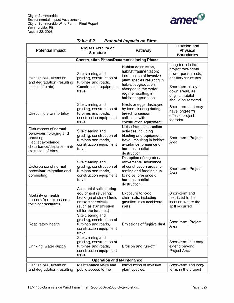
City of Summerside Environmental Impact Assessment City of Summerside Wind Farm – Final Report Summerside, PE August 22, 2008
TE51100-Summerside Wind Farm Final Report-5Sep2008-ct-cjy-jb-st.doc Page (82)
Table 5.2 Potential Impacts on Birds
Potential Impact Project Activity or Structure Pathway
Duration and Physical
Boundaries Construction Phase/Decommissioning Phase
Habitat loss, alteration and degradation (resulting in loss of birds)
Site clearing and grading, construction of turbines and roads. Construction equipment travel.
Habitat destruction, habitat fragmentation; introduction of invasive plant species resulting in habitat degradation; changes to the water regime resulting in habitat degradation.
Long-term in the project foot-prints (tower pads, roads, ancillary structures2
Short-term in lay-down areas, as original habitat should be restored.
Direct injury or mortality
Site clearing and grading, construction of turbines and roads, construction equipment travel.
Nests or eggs destroyed by land clearing during breeding season; collisions with construction equipment.
Short-term, but may have long-term effects; project footprint.
Disturbance of normal behaviour: foraging and breeding; Habitat avoidance: disturbance/displacement/ exclusion of birds
Site clearing and grading, construction of turbines and roads, construction equipment travel
Noise from construction activities including blasting and equipment travel, resulting in habitat avoidance; presence of humans; habitat destruction
Short-term; Project Area
Disturbance of normal behaviour: migration and commuting
Site clearing and grading, construction of turbines and roads, construction equipment travel
Disruption of migratory movements; avoidance of construction areas for resting and feeding due to noise, presence of humans, habitat destruction.
Short-term; Project Area
Mortality or health impacts from exposure to toxic contaminants
Accidental spills during equipment refueling; Leakage of stored fuels or toxic chemicals (such as transmission oil for the turbines)
Exposure to toxic chemicals, including gasoline from accidental spills
Short-term and restricted to the location where the spill occurred
Respiratory health
Site clearing and grading, construction of turbines and roads, construction equipment travel
Emissions of fugitive dust Short-term; Project Area
Drinking water supply
Site clearing and grading, construction of turbines and roads, construction equipment travel
Erosion and run-off Short-term, but may extend beyond Project Area.
Operation and Maintenance Habitat loss, alteration and degradation (resulting
Maintenance visits and public access to the
Introduction of invasive plant species.
Short-term and long-term; in the project

City of Summerside Environmental Impact Assessment City of Summerside Wind Farm – Final Report Summerside, PE August 22, 2008
TE51100-Summerside Wind Farm Final Report-5Sep2008-ct-cjy-jb-st.doc Page (83)
Potential Impact Project Activity or Structure Pathway
Duration and Physical
Boundaries in loss of birds) area; existence of
access roads footprint (tower pads, roads, ancillary structures2.
Direct injury or mortality
Presence and operation of turbines, and transmission lines; turbine lights
Collisions with the Structures, increased predation if project structures can be used for perching by raptors
Long-term, but restricted to Project Area and low magnitude, project footprint
Direct injury or mortality to nest and young
Maintenance of right of way, turbine site and substation site maintenance
Mowing or cutting of vegetation
Short-term, but repeatedly; restricted to Project Area
Disturbance of migration and daily movements (barrier effect)
Presence and arrangement of turbines
Turbine size, arrangement, and wing movement may form a visual barrier to bird movement, potentially exacerbated by noise
Long-term, restricted to Project Area
Disturbance of normal behaviour: foraging and breeding; habitat avoidance, displacement/ exclusion of birds
Turbine operations, maintenance using motor vehicles, vegetation management
Noise from turbine operation and maintenance activities, as well as the presence of turbines and wing movement may result in avoidance of Project Area
Short-term and long-term; greatest effect in areas with the highest noise; particularly along access roads and at turbine locations;
Disturbance of normal behaviour: foraging and breeding; habitat avoidance, displacement/exclusion of birds
Daily presence of humans and vehicles (maintenance and visitors)
Disturbance of normal behaviour such as feeding, breeding
Short-term and long term, mostly restricted to the area around access roads and turbine pads
Mortality or health impacts from exposure to toxic contaminants
Accidental spills or releases of transmission oils and/or vehicle fuel
Exposure to toxic chemicals
Short-term or long-term; restricted to the location where the spill occurred
Drinking water supply Roads and turbine pads Erosion and run-off
Short-term, but may extend beyond Project Area.
Fire
Fires caused by construction activities (land clearing), Access to the area by visors, including visitor vehicles
Fire may result in mortality, and reduction of habitat quality due to loss of vegetation or establishment of invasive species.
Short-term; Project Area and potentially beyond
Notes: 1 Table is based on BLM, 2004 2 On-site power lines will be aboveground, the power lines will follow the route of the access roads, and the substation is near existing power lines, there will be no new utility corridors.

City of Summerside Environmental Impact Assessment City of Summerside Wind Farm – Final Report Summerside, PE August 22, 2008
TE51100-Summerside Wind Farm Final Report-5Sep2008-ct-cjy-jb-st.doc Page (84)
Effects of wind turbine developments on birds fall mainly into two categories: indirect effects due to habitat loss and disturbance, among others, as well as the direct effect of injury or mortality through collisions.
Construction and Decommissioning
During construction and decommissioning phases, the activities related to construction of roads, buildings, turbines and utility lines, such as clearing and grading and turbine assembly, or their removal, can result in temporary disturbance of birds due to noise, visual impacts and the presence of humans (workers in the area). Also, land will be used for the footprint of the turbines, buildings, power lines, road and lay-down areas, resulting in an intermittent or permanent loss, fragmentation, alteration or degradation of breeding, feeding and resting habitat. Also, there may be a risk for exposure to contaminants, particularly to hazardous materials such as oil from building or turbine equipment or equipment refuelling. Other potential pathways may be fugitive dust for the construction and movement of construction equipment, negative changes to water quality due to erosion and run-off, and introduction and spread of invasive vegetation that may result in habitat degradation. Also, construction may lead to direct injury or death of adult birds, nestlings or eggs through collisions or the destruction of nests, depending on the timing of the construction activities. During the construction and de-commissioning phase, the biggest effects on birds are expected from the disturbance of habitat (BLM, 2004).
Impact Assessment – Habitat Loss
During the construction of the wind farm, habitat will be lost, altered and fragmented. This will be the biggest impact on birds during this project phase (BLM, 2004). Avoidance of areas by birds can be considered to be in effect a loss of habitat, even though the habitat is not destroyed. In this section, loss of habitat by destruction, as well as modification and degradation are considered, while avoidance will be dealt with in a later section. During the construction of the wind farm, there will be loss of habitat, as a certain area of land will be used for turbine pads, access roads and the substation. This will result in permanent loss of potential habitat, as well as feeding and resting habitat for non-breeding and migrating birds. Other land will be used for lay-down areas. Habitat on this land will be altered and disturbed, and should return to the original vegetation immediately after the end of construction, or may initially re-grow with altered vegetation (hydro-seeding). This impact will consist of a short-term loss of habitat for one or a limited number of years, until the vegetation has recovered. Bird use of this land for feeding and resting will only be impacted for the duration of construction work itself, i.e. a few weeks at each location. However, since the habitat will be altered until it has recovered the composition of the bird species using a particular area will be changed to reflect their different feeding habits.

City of Summerside Environmental Impact Assessment City of Summerside Wind Farm – Final Report Summerside, PE August 22, 2008
TE51100-Summerside Wind Farm Final Report-5Sep2008-ct-cjy-jb-st.doc Page (85)
Generally, the impact of habitat loss and alteration due to the Summerside Wind Farm Project would be considered small. All turbines will be located in fields. The amount of habitat that will be disturbed is very small compared to the total available in the Project Area. Birds that are breeding, feeding or resting, including migrating birds, will be permanently or temporarily displaced from the destroyed or altered habitat. Consequently, displaced birds may not find territory elsewhere (Rosemary Curley, personal communication). According to CWS, “wind farms may have a greater negative impact on waterbirds when a significant proportion of a local resource is displaced.” Potentially sensitive areas may include those close to breeding colonies, and/or linked to distribution of food supply (Percival, 2001). However, since the area lost is so small, the likelihood for significant adverse effects on the birds is considered nil. Care should be taken so that no unique habitat types are destroyed. All habitat found on turbine locations should be available in surrounding areas. Therefore, no bird species should be permanently displaced from the Project Area. The limited variety of habitats in the Project Area facilitates this approach. Therefore, feeding and resting birds can easily move a short distance to find suitable habitat, and the overall small reduction in habitat area should not result in negative impacts due to restriction of the food supply, which could result in competition and maybe loss of birds. There may be displacement of some breeding birds due to competition for suitable territory, if the remaining habitat is at its carrying capacity, which is not known.
Mitigation – Habitat Loss
Suggested mitigation measures include avoidance of unique habitat types and reduction measures. The area used for the project footprint has been minimized for all turbines. No lay down areas will be permitted within forested areas. Measures to prevent or minimize impacts on the hydrological regime and the introduction of invasive plant species as discussed and outlined in the section on wetlands (Section 5.3) will mitigate bird habitat effects as well.
5.2.1.2 Impact Assessment – Disturbance and Avoidance
The sight and sound of humans and vehicles and other engines are known to disturb birds. These effects therefore can occur during the construction phase as well as the operations phase, which includes maintenance activities and turbine monitoring by wind farm personnel. The disturbance can result in interruption of the regular behaviour, such as feeding, migrating and breeding. Birds tend to avoid areas where they are disturbed. If birds are displaced to avoid disturbance, this effectively means a loss in suitable habitat. Disturbance effects are species, season, and site-specific (Langston and Pullan, 2003). There are few studies on disturbance effects, and often there are no conclusive results (Langston and Pullan, 2003). Some species may habituate to these new conditions, but others do not appear to be able to do this (Langston and Pullan, 2003).

City of Summerside Environmental Impact Assessment City of Summerside Wind Farm – Final Report Summerside, PE August 22, 2008
TE51100-Summerside Wind Farm Final Report-5Sep2008-ct-cjy-jb-st.doc Page (86)
The sensitivity to disturbance varies from species to species, and may also vary with the type of behaviour that is influenced. Studies in the Netherlands demonstrated that breeding bird density near roads was less than the density away from roads (from BLM, 2004). Monitoring studies of wind farms showed that, in a given species, breeding birds were much less sensitive to turbine presences than migrating, resting birds (windenergie.de, 2005). Sounds produced by the turbine may also disturb birds, but many birds adapt to the presence over time and progressively move closer to the turbines – a behaviour known as “habituation”. Since disturbance and avoidance vary from species to species, and may also vary depending on the status of the bird (breeding, floating, migrating), the impact assessment will be carried out for separate species groups, where necessary and where literature data are available. Impacts will be more important for species-at-risk, or protected species such as migrating birds. Impacts would be larger for previously undisturbed areas. Though the frequency of pre-construction visitors in the Project Area is not known, the presence of agricultural land and a former landfill is evidence that this area is not “previously undisturbed”. Appendix D, Bird Survey Results, reviews in detail the current knowledge of avian species in the Study Area and all of the potential impacts that the proposed Project may have on them as well as their habitat. Mitigation and monitoring that can be implemented to lessen such impacts is also discussed. Based on the bird survey conducted from April 25, 2007 to November 14th, 2007 the sites selected for Stage 1 turbines T1 and T2 are the areas within the Project Area the least used by birds and should not pose a threat to migratory birds (D. Oakely, 2007). Stage 2 and 3 initial turbine locations (T3 and T4) both showed significant activity by cormorants, geese and gulls, particularly during morning hours, however are not expected to be disturbed by the presence of the turbines as there is ample area for bird movement and these types of birds generally fly at heights that do no interact with turbines. Although there is not anticipated to be issues with the initial placement of turbines T3 and T4, the placement has been revised to further minimise potential interactions wit avian species.
5.2.1.3 Bats
5.2.1.3.1 Pathways and Activities
Bats present in the Project Area could potentially be impacted by activities during the construction and the operational phase of the project. Impacts from the decommissioning phase are not expected, since all the work would be done during the day, when bats are not active, and there would be no destruction of vegetation where some bat species may roost.
Construction
During the construction phase, bats could potentially be affected indirectly by reduction on quality and quantity of habitat. They could also be impacted directly through killing of individuals during the land clearing activity.

City of Summerside Environmental Impact Assessment City of Summerside Wind Farm – Final Report Summerside, PE August 22, 2008
TE51100-Summerside Wind Farm Final Report-5Sep2008-ct-cjy-jb-st.doc Page (87)
Operations
During the operational phase, bats could be affected by collisions with turbines or infrastructure such as buildings, power lines, etc, or by noise from the turbines if it interferes with foraging (NS Museum, 2004). The presence of people in the area on a regular basis due to surveillance of the turbines and turbine maintenance or as visitors are not expected to disturb bats as most human presence will be during the daylight hours.
5.2.1.3.2 Boundaries
The spatial boundaries are the Project Area, in particular the turbine sites, the roads and the ancillary infrastructure such as the control building. Temporal boundaries are the construction phase as well as the operational phase, i.e. 25 years from the start of the first turbines in October 2009. This timeframe will have to be extended if refurbishment of the turbines occurs.
5.2.1.3.3 Impact Assessment
There are four known bat species on Prince Edward Island. None of the bat species are protected by statute however, the Northern long-eared bat is listed as S2 by NatureServe, 2006. There are no caves or large trees nearby which could be used as hibernacula or for daytime roosting by the Northern long-eared bat, but nightly migrations could occur through the Project Area. Habitat quality is low. As most northern bats migrate south for the winter, or migrate to suitable hibernacula, both resident bats and migrating bats can potentially be affected. Further investigation and field work will be continued in the spring and summer of 2008 to determine if bat breeding colonies are present and locate where high density populations exist. Impacts on bats could result from direct effects such as death of individuals related to project infrastructure, or indirect impacts due to loss or alteration of habitat. Whether an impact is significant depends on the number of bats impacted and the vulnerability of the species. Death and displacement of bats could potentially affect populations, if the number of individuals in Summerside and in PEI is very low.
Construction
During the construction phase, bats could potentially be impacted by the destruction of habitat, or directly through killing of individuals during the land clearing activity. Construction of T1 and T2 is scheduled to start in November of 2008, and will continue off and on during the summer and fall. During the spring and fall, bats would be hibernating. Several species move south for hibernation, other species seek shelter in caves, including the Northern long-eared bat that could occur in Summerside (Marina Silva, pers. comm.). It is not likely that hibernating bats will be present in the area during construction due to the absence of caves. However, the Northern long-eared bat could be present during the summer construction phase. If suitable trees exist in the Study Area, they could be home to potential nurseries containing flightless young. However, no suitable trees exist in the Study Area. In addition bat foraging activities will not be impacted by noise, as there will be no construction activities at night.
City of Summerside Environmental Impact Assessment City of Summerside Wind Farm – Final Report Summerside, PE August 22, 2008
TE51100-Summerside Wind Farm Final Report-5Sep2008-ct-cjy-jb-st.doc Page (88)
Operation
During the operational phase, bats could be impacted by collisions with turbines or other infrastructure such as buildings, or by noise from the turbines if it interferes with foraging. The presence of people in the area on a regular basis and spills of toxic chemicals could also potentially affect bats. Death and displacement of bats could potentially impact local populations, if populations are small. Since bats are nocturnal, it is not likely that they would be negatively affected by the presence of humans during the day. Turbine inspections, maintenance or general visits to the wind farm would only occur during the day. Also, several bats species have adapted to use attics or similar structures for roosting, indicating that these species are tolerant of human beings. Therefore, impacts from the presence of humans are not expected. The immediate clean up of spills of toxic chemicals is part of the EPP (Appendix A) and wetland-spill mitigation for the wind farm. Therefore, adverse effects on bats from spills are not likely. See Section 5.12 for measures to address Accidents and Malfunctions. Wind turbines are known to produce sounds. As bats use ultrasound (20 kHz and up) for echolocation of prey, there could potentially be interference with foraging activities, if the sounds from the turbine cover the frequencies that bats use for echolocation. The frequencies and volume of sound in the 20 – 60 kHz range are of particular interest (NS Museum, 2004). Also, the sounds emanating from wind farms could potentially result in bats avoiding the area, or may attract bats to the turbines (Keeley et al., 2001), thus potentially increasing the risk of collisions. However, since bats were found to forage at distances as close as 1 m from a moving turbine blade (Bach et al., 1999, in Keeley et al., 2001), it is unlikely that bats would avoid a wind farm because of sounds. There seems to be no interference with echolocation, as bats are generally able to avoid moving turbine blades, because only few resident bats collide with the turbines, even if there is a high level of bat activity around turbines (Erickson et al., 2002). Therefore, sound emissions from turbines are not expected to adversely affect foraging activities or lead to displacement of bats.
Bat Collisions
There is a potential risk to bats from collisions with turbines or ancillary structures. The risk for resident bats is different from the risk to migrating bats. Therefore the impact assessment will be carried out for resident and migrating bats separately.
Collision Risk of Resident Bats
Though there is a risk of fatal collisions with turbines when bats are present, most published reports show that mortality is generally low, though numbers may vary with the location of the wind farm. Moreover, Erickson et al. (2002) state that the collision risk for resident breeding bats is virtually nil, resulting in no apparent impact on resident breeding bats. Tolerance to human disturbance at the roost will likely be detrimental to resident bats and could cause abandonment. Recreational activities, noise from construction (vehicles, heavy machinery) near the roost may also have an effect (Garcia et al., 1995). In addition, the risk to bats is somewhat

City of Summerside Environmental Impact Assessment City of Summerside Wind Farm – Final Report Summerside, PE August 22, 2008
TE51100-Summerside Wind Farm Final Report-5Sep2008-ct-cjy-jb-st.doc Page (89)
correlated with the number of passes a bat makes across wind turbines (one mortality for every 70 passes) (Johnson et al., 2002, in Erickson et al., 2002). It can be assumed that the bat activity in the Project Area is dependent on the number of bats present. In Summerside, the number of bats living and foraging in the area is likely low, since the habitat appears to be of low quality, due to lack of roosting trees, structures or caves, and maybe high winds. Even if there is some diurnal movement, which can span 40 km (for hoary bats) between roosting sites and foraging sites near the turbines, collision risk is low because, bats generally forage below 25 m height (Erickson et al., 2002). As the lowest blade height for the turbine model chosen for the Summerside wind farm is approximately 30 m, bats are rarely expected to fly within the blade height, particularly since the trees in the area are short. Little brown bats and Northern long-eared bats were typically caught near ground level (Broders at al., 2003). Therefore, the risk from turbine strikes to resident bats at the Project Site is considered low. There will be no impacts from collisions with guy wires, since these will not be used for the attachment of turbines. The risk from collisions with power lines is considered negligible, since all on-site power lines will be underground, except for a short 20 m section at each turbine.
Collision Risk of Migrating Bats
Migrating bats are known to be at a higher risk from collisions with turbines than resident bats (Keeley et al., 2001; Erickson et al., 2002), possibly because it is believed they may turn off or reduce their echolocation calls and rely on sight (Curry and Kerlinger 2005; Van Gelder, 1956 in Keeley et al., 2001). Also, long distance migrants such as Lasiurus sp. may be more likely to fly through open areas or at heights that would bring them into contact with turbine blades or cables used for anchoring of turbines or communication towers than short distance migrants such as Myotis sp. (Keeley et al., 2001). Again, the risk is positively correlated with the number of bats passing through the turbine area, and an assessment for significance of potential impacts has to consider this, and the size of the populations.
5.2.1.3.4 Mitigation
It is recommended that the removal of tall trees and snags should be limited to the areas where it is absolutely necessary for the project construction in order to protect bat roosting areas. It is recommended that monitoring of the turbines for bat strikes be carried out for a limited time, particularly during the migration period in spring and late summer, early fall (i.e., April/May and August/September). If there are bat mortalities, they should be identified by species, when possible and reported to PEIDEEF. If mortalities occur in numbers that may cause concern, discussions with the PEIDEEF should be conducted on potential mitigation measures. A further literature survey should be carried out, which may uncover new research results, which may be used for the development of mitigation measures.

City of Summerside Environmental Impact Assessment City of Summerside Wind Farm – Final Report Summerside, PE August 22, 2008
TE51100-Summerside Wind Farm Final Report-5Sep2008-ct-cjy-jb-st.doc Page (90)
5.2.1.3.5 Residual Impacts
No significant adverse impacts are likely. There is potential that there will be bat mortalities due to the Project, however these mortalities are expected to be small in number and will not affect the overall population of bats in the area.
5.2.2 Species-at-Risk
5.2.2.1 Flora Species at Risk
Aside from the salt marsh and forested area, the Project Area is of relatively low vegetative diversity and in a manipulated nature. Half of the Project Area is currently cultivated, fallow or abandoned agriculture lands, and the most of the rest is decommissioned landfill. For these areas it is expected that the potential for floral species-at-risk is low. As the majority of the ground disturbance will occur on these manipulated areas, no significant adverse effects on plant species are likely in those circumstances. An initial field survey of the Project Area was conducted on May 29, 2006 by Garrett Bell, Senior Botanist, AMEC Earth and Environmental and no species at risk were identified at that time. The currently proposed turbine sites were not available at the time of the survey. It is recommended that the project foot print areas be evaluated for the presence of floral species-at-risk.
5.2.2.1.1 Pathways and Activities
Construction
Potential Project interactions with Flora Species at Risk and related effects resulting from Project construction activities are:
• Clearing, grubbing, and excavation activities.
Accidental release of hazardous materials/ contaminant mobilization is addressed in Section 5.8 Accidents and Malfunctions.
Operations
There are no project interactions with floral species at risk during operations.
5.2.2.1.2 Boundaries
The bounded area within which proposed Project activities could potentially interact with Species at Risk is considered to be the Project Site. In this context, a significant adverse effect on Species at Risk is defined as any effect resulting in a sustained suppression of fitness to maintain the population, or a decrease in density of the population below naturally occurring levels.

City of Summerside Environmental Impact Assessment City of Summerside Wind Farm – Final Report Summerside, PE August 22, 2008
TE51100-Summerside Wind Farm Final Report-5Sep2008-ct-cjy-jb-st.doc Page (91)
For species designated as endangered (or significant for other reasons), the loss of these species at an individual level may be considered a significant adverse effect. The temporal boundaries are limited to the duration of clearing, grubbing excavation activities.
5.2.2.1.3 Impact Assessment
Clearing, Grubbing, and Excavation Activities
Several plant species at risk have been identified as occurring within 5 km of the Project Area, however none have been identified in Project Area by either the ACCDC or field survey conducted in 2006.
5.2.2.2 Recommended Mitigation
The following mitigation to minimize adverse effects on floral species at risk is recommended:
• A field survey of all areas to be disturbed by construction activities will be conducted prior to construction.
• Mitigative measures identified for protection of wetland habitats will minimize the likelihood of adverse effects on floral species at risk.
5.2.2.3 Significance of Residual Effects
It is not likely that significant adverse residual effects will result from Project interactions with proper implementation of the identified mitigation measures.
5.2.2.4 Faunal Species at Risk
5.2.2.4.1 Birds
SARA (Species at Risk Act, 2007) lists the piping plover (Charadrius melodus melodus) and the Eskimo Curlew (Numenius borealis) as endangered within PEI. Like COSEWIC, SARA lists the Barrow’s goldeneye (Bucephala islandica) as a species of concern. The federal MBCA affords protection to all migratory birds. The Act states that no person may disturb, destroy, or take/have in their possession a migratory bird (alive or dead), or its nest or eggs, except under authority of a permit. The Act also protects bird species listed in the CWS Occasional Paper Birds Protected in Canada under the MBCA. It is important to note that some of the birds on this list do not migrate and some of the birds that are excluded are not hawks or owls. The significance of any effect on migratory species will depend in part on the permanence of that effect and the sensitivity of the particular species or habitat component effected. The most sensitive bird habitat feature in the Study Area includes wetlands, which have been avoided.
Fish Species at Risk
COSEWIC designates the striped bass (Morone saxatilis) as Threatened and the Atlantic Wolffish (Anarhichas lupus) as a species of special concern within the province. COSEWIC

City of Summerside Environmental Impact Assessment City of Summerside Wind Farm – Final Report Summerside, PE August 22, 2008
TE51100-Summerside Wind Farm Final Report-5Sep2008-ct-cjy-jb-st.doc Page (92)
includes the American eel (Anguilla rostrata). The project will not interact with fish or fish habitat. Invertebrates SARA lists the Monarch butterfly (Danaus plexippus) as species of special concern. The ACCDC data request did not identify any occurrences of the monarch butterfly within 5 km of the Project Area. The occurrence of the Monarch butterfly is highly related to the presence of the common milkweed (Asclepias syriaca). Milkweed is preferred by the Monarch butterfly for larval feeding and as a location for pupation and oviposition. No milkweed was observed during the 2006 plants survey. All areas to be disturbed will be surveyed prior to construction. If milkweed is found, they will be examined for pupa, chrysalis, or eggs.
5.2.2.5 Potential Effects on Species at Risk
Potential project interactions with Species at Risk and related effects resulting from Project construction activities are primarily clearing, grubbing, and excavation activities.
These activities have the potential to result in:
• An alteration/displacement of habitat. • Noise/physical disturbance of wildlife causing behavioural changes. • Direct mortality and destruction of active nests. • Spill and release of hazardous chemicals.
5.2.2.6 Clearing, Grubbing, and Excavation Activities
• Alteration/Displacement of Habitat
The potential effects of construction on habitat focus on the presence of Species at Risk and the location of designated areas and other critical habitat features.
• Recommended Mitigation
The following mitigation to minimize adverse effects on species at risk is recommended:
• Measures recommended minimize disturbance to bird species. • Avoidance of watercourses and wetlands will eliminate or minimize effects on Species at
Risk that use this type of habitat. • The areas to be disturbed will be surveyed for milkweed and examined for the presence
of Monarch Butterfly pupa, chrysalis and eggs. If found, plants will be flagged for avoidance and GPS recorded.

City of Summerside Environmental Impact Assessment City of Summerside Wind Farm – Final Report Summerside, PE August 22, 2008
TE51100-Summerside Wind Farm Final Report-5Sep2008-ct-cjy-jb-st.doc Page (93)
• Significance of Residual Effects
It is not likely that significant adverse residual effects will result from Project interactions with proper implementation of the identified mitigation measures.
• Noise/Physical Disturbance of Wildlife
Construction activities such as excavating and trucking will produce varying levels of noise. These noise levels will be dependant upon many factors, including weather conditions, topography, vegetation, and construction practices. Table 5.3 lists typical noise levels for various construction equipment and activities. Due to the nature of the proposed Project, noise effects are anticipated to be localized and will be in short duration in the context of the Project life cycle.
Table 5.3 Noise Levels at Various Distances from Typical Construction Equipment
Equipment dB at 15/30 m+
dB at 76 m*
dB at 152 m*
dB at 305 m*
dB at 762 m*
dB at 1524 m*
Bulldozer 85 / 80.2 71 65 59 51 45
Crane, mobile 83 / 81.3 69 63 57 49 43
(Dump) Truck 88 / 67.1 74 68 62 54 48
Front-end loader 85 / 80.2 71 65 59 51 45
Concrete mixer truck 85 / 85.2 71 65 59 51 45
Generator 81 / -- 67 61 55 47 41
Grader 85 / -- 71 65 59 51 45
Backhoe -- / 81.3 - - - - -
Roller 74 / -- - - - - -
Notes: * The estimated sound levels at various distances are based on the assumption that sound pressure diminishes by 6 db(A) with each doubling of distance.
Source: * HMMNH (1995) in BLM,2004 + CBCL , 2003
Noise or physical disturbance could encourage adult birds to avoid or be displaced from feeding, breeding, or nesting habitat. Similarly, once eggs have been laid, abandonment of nests could occur if adult birds are displaced from the nest. During construction, it can be expected that most wildlife and bird species occupying the immediate vicinity of the construction site will initially be affected. However, construction activities will be of short duration (in the context of the Project life cycle) and, therefore, it is not likely that significant effects will occur.

City of Summerside Environmental Impact Assessment City of Summerside Wind Farm – Final Report Summerside, PE August 22, 2008
TE51100-Summerside Wind Farm Final Report-5Sep2008-ct-cjy-jb-st.doc Page (94)
• Recommended Mitigation
A schedule control will be implemented for clearing activities in order to limit effects on nesting birds. Stage 1 turbine construction will not involve land clearing and not be located in areas of high bird activity (Oakley, 2007). For Stages 2 and 3, which will be located closer to areas of relatively high bird activity, all construction activities will be scheduled to avoid sensitive nesting periods (typically May 1st to August 31st) as much as possible. For construction activities required during the sensitive nesting season the following measures will be implemented:
• Clearing activities will be scheduled in consideration of critical habitat features (e.g., open water wetland areas) identified during the pre-construction field survey.
• The proponent will instruct the Environmental Inspector and contractors on the MBCA, the importance of habitat, the significance of the nesting period, and measures to be implemented to minimize any disturbance to birds/nests.
• A bird nest survey of the area will be conducted by a professional biologist/ornithologist/ birder prior to clearing activities. The bird species recorded during the survey will be used as an indicator regarding the potential nesting habitat in the area.
• The typical nesting habitat for these species would be investigated for potential nests. • Nest trees will be felled prior to or after the nesting season. • The occurrence of all identified nests will be documented.
• Significance of Residual Effects
With the implementation of the mitigation measures listed previously, it is unlikely that there will be any significant adverse effects on migratory birds or their habitat due to construction activities.
5.2.3 Wetlands
Both collectively and as individual units, wetland resources serve a variety of important ecological and socio-economic functions. Wetlands function in the maintenance of surface and groundwater resources and quality, as well as providing fish and wildlife habitat. The value of wetlands to society and their ecological value are derived from their biological productivity and biodiversity. Wetlands are generally characterized by hydrophytic vegetation, and can vary from a closed peat bog to an open lake dominated by submergent vegetation. By providing natural flood control, points of recharge and discharge of groundwater, acting as filters, and by trapping silt, wetlands play an important role in the hydrological cycle and generally enhance the water regime. As they provide habitat for a wide variety of plants and animals, they may be highly productive and often exceed adjacent uplands in their standing crops, productivity, and biodiversity. In the past, wetlands have been viewed mainly in terms of development, such as agricultural land or peat resources. However, their ecological value is now more clearly understood. Ecological wetland values may include sustenance for waterfowl, sources of fish

City of Summerside Environmental Impact Assessment City of Summerside Wind Farm – Final Report Summerside, PE August 22, 2008
TE51100-Summerside Wind Farm Final Report-5Sep2008-ct-cjy-jb-st.doc Page (95)
production, storage and slow release of water, erosion protection, and areas of aesthetic or recreational enjoyment. With increasing competition for land, particularly in urban areas, wetlands have continued to be impacted through dyking, filling, drainage, flooding, and other forms of conversion. Such use has caused the number and extent of wetlands to decrease substantially (Bond, et al., 1992). This is particularly true of coastal wetlands where historical losses in the Maritimes may be as high as 80% (Hanson & Calkins, 1996). PEI contains only 4% of vegetated wetland area in the Maritimes but includes a disproportionately high 19% of salt marsh habitat. The Malpeque region contains the second largest concentration of relatively large salt marsh areas in the province (Hanson & Calkins, 1996) including approximately 700 ha (15 %). The Project is not affecting salt marsh wetland habitat. Wetland alterations are controlled by Section 10 of the Prince Edward Island Environmental Protection Act. Before commencing a project that involves work within 10 m of or within a wetland, a WAWA permit is required. The Federal government has established a “no net loss of wetland function” policy in co-operation with the Provinces (Environment Canada, 1991). Furthermore, in 2003 the Province created a Wetland Conservation Policy with commitments to the “no net loss of wetland function” objective and identifying specific wetlands and wetland types as Provincially Significant. Activities proposed within Provincially Significant Wetlands are usually subject to severe restrictions (InfoPEI, 2005).
5.2.3.1 Pathways and Activities
The Project could potentially result in impacts on the wetland habitat, mainly through spills or other malfunctions and accidents, soil erosion and sediment deposition into the wetland and the potential for introduction of invasive species. These impacts are associated with short term activities during the construction phase and decommissioning phases, and potentially during the operation of the wind farm during maintenance activities.
5.2.3.2 Boundaries
Spatial boundaries include the Project Area, and adjacent areas that are connected hydrologically with the project footprint, both inside and outside of the Project Area. The temporal boundary includes the proposed construction, operation, and decommissioning of the Project. Construction, through commissioning of each of the turbines will occur over a 9 month period, while the operation of the Project is expected to last for a minimum of 25 years.
5.2.3.3 Impact Assessment
Wetlands were located within the Study Area based on a field reconnaissance and assessment by Garrett Bell, CET with AMEC on May 29, 2006. The results of this field assessment characterize the wetlands as a salt marsh bordering the Malpeque Bay (See Figure 2.2). Since there will be no disturbance of the wetland surface beyond the turbine foundation, impacts on habitat will be temporary, and are expected to recover fully within one or two years. This

City of Summerside Environmental Impact Assessment City of Summerside Wind Farm – Final Report Summerside, PE August 22, 2008
TE51100-Summerside Wind Farm Final Report-5Sep2008-ct-cjy-jb-st.doc Page (96)
activity will require regulatory authorization under the Watercourse/Wetland Alteration Guidelines; therefore, these impacts are considered significant. During construction, there is potential for the wetland to be impacted by erosion/sedimentation associated with the use of the temporary access road and turbine construction. Uncontrolled storage of subsurface soil generated by the foundation construction could result in moderate sediment run-off into the wetland; which could locally exceed the assimilative capacity of the saltmarsh. This would be considered a significant impact if the sedimentation resulted in suppression of vegetation growth or exceedance of local water quality guidelines. The amount of sediment run-off from the access road will be very small, given standard erosion controls (i.e, silt fence). Erosion from the access road into the wetland during operation will be extremely minimal, restricted to periods of short duration (hours or days per year) related to maintenance activities. Another potential impact involves dust and minerals from road runoff. Most fugitive dust will be formed during the construction phase from construction and movement of construction equipment, but some dust may also escape during the operation phase, (e.g. from the movement of maintenance vehicles). There is potential for introduction of invasive species, both during construction and post-construction. Seeds, roots or “rootable” fragments of invasive species may be stuck to construction/maintenance equipment and shoes of workers. Invasive species such as the alien race of common reed (Phragmites australis), are known to severely degrade wetland diversity by producing dense monocultures; which displace the range of naturally occurring vegetation species. Accidental events resulting in spills of toxic materials could result in long term or permanent significant impacts on wetland habitat and water treatment functions. Standard mitigation for accidental events is described in Section 5.8; which will minimize the potential for accidental events to occur; therefore, significant impacts are not likely.
5.2.3.4 Mitigation
Prior to construction, the proponent will need to obtain regulatory approval under the Prince Edward Island Environmental Protection Act Watercourse and Wetland Alteration Guidelines. Standard mitigation for work in wetlands will be described in the application permit. Definition of appropriate mitigative measures is largely dependant on habitat-specific construction techniques (e.g., open water vs. dry soils construction methods). However, several generally applicable mitigative measures are recommended for wetlands, including:
• avoidance of wetland habitat as much as possible; • minimizing the construction area adjacent to wetlands; • adherence to conditions of an applicable WAWA permit, specific to construction activity;

City of Summerside Environmental Impact Assessment City of Summerside Wind Farm – Final Report Summerside, PE August 22, 2008
TE51100-Summerside Wind Farm Final Report-5Sep2008-ct-cjy-jb-st.doc Page (97)
• construction following storm events which have resulted in high water levels should be conducted only as approved by qualified inspectors;
• installation of erosion control structures; • prevent discharges to any water; and • travel by construction vehicles will be minimized in temporary construction zones
adjacent to wetlands. Potential alteration/displacement of habitat may result from changes to surface water flow and direct physical disturbance of vegetation and underlying soils. Generally, maintenance of vegetation patterns (and thus habitat types) can be optimized through the following standard construction practices and mitigative measures:
• Minimize ground and vegetative disturbance by: • locating staging areas at least 30 m from the edge of wetland, where possible; and • using upland access roads wherever practical.
• Maintain vegetative diversity by:
• incorporating practices to prevent the spread of non-desirable invasive species throughout the construction area, including cleaning and inspection of construction equipment prior to use near wetland areas.
• During site restoration, mitigate effects on vegetation by:
• not applying fertilizer, lime or mulch to wetland as part of revegetation plan; • separating organic top soil from underlying soils, and stock piling separately;
returning top soil to original horizon; • re-vegetating areas devoid of vegetation; and • restoring original contours and cross drainage patterns.
In general, the best method of preventing erosion of bare soils is to encourage vegetation re-establishment as soon as possible. Section 5.8 recommends environmental awareness and preventative measures intended to mitigate potential effects of an accidental release of potentially hazardous materials, which are also applicable to the protection of wetland resources. Any spills that occur will be remediated to meet or exceed regulatory requirements. To diminish the risk of transferring invasive plants, or their seeds, rhizomes or vegetative structures, it is recommended that:
• Construction equipment (e.g., tracked vehicles) transported from elsewhere in PEI or Canada be thoroughly cleaned and inspected prior to transport to ensure that no vegetative matter is attached to the machinery. The use of a high pressure water hose to clean vehicles prior to transport may facilitate this process.

City of Summerside Environmental Impact Assessment City of Summerside Wind Farm – Final Report Summerside, PE August 22, 2008
TE51100-Summerside Wind Farm Final Report-5Sep2008-ct-cjy-jb-st.doc Page (98)
• Construction equipment will be inspected and cleaned immediately following construction near wetland areas and in areas found to support purple loosestrife.
5.2.3.5 Significance of Residual Effects
With proper implementation of the identified mitigative measures, Project impacts on wetland resources will be minimized. Post construction effects monitoring is recommended.
5.3 Atmospheric Environment
5.3.1 Air Quality
5.3.1.1 Pathways and Activities
The potential Project interactions associated with ambient air quality and the related effects are during Project construction. These include:
• overburden disturbance; • equipment operation; and • accidental release of hazardous materials.
The activities during the operational phase are not a source of significant amounts of dust, emissions or use of hazardous materials.
5.3.1.2 Boundaries
Spatial boundaries are the Project Site and the rural, inhabited areas surrounding the Project Site. The temporal boundaries are the construction period, approximately 9 months, and a similar period for subsequent turbine installations in future stages, as well as a limited number of weeks during the de-commissioning phase.
5.3.1.3 Impact Assessment
Most construction activities have the potential to contribute to environmental effects on air quality, mainly gaseous emissions, and PM. In general, any dust that is generated will be at low concentrations, and is expected to disperse within 300 m of the source.
Overburden Disturbance
The primary air quality concern during construction is the effect of PM, mainly fugitive dust on the surrounding environment. Particulate emissions during construction are associated with grubbing, excavation, backfilling, and material transport activities. The potential effect of particulates is influenced by site and weather conditions (rain and wind direction) and by preventative measures implemented during Project activities to minimize emissions. Emissions of particulates that exceed air quality guidelines may result in problems on the construction site and under special circumstances (such as strong winds), off-site. The level of particulates at construction sites depends on the silt content of the soils being disturbed,

City of Summerside Environmental Impact Assessment City of Summerside Wind Farm – Final Report Summerside, PE August 22, 2008
TE51100-Summerside Wind Farm Final Report-5Sep2008-ct-cjy-jb-st.doc Page (99)
the proportion of dry days, operator habits, construction vehicle type and speeds, vehicle weights, and the number of vehicles. Studies indicate that dust from similar construction activities (including excavation and grading) settles out very quickly, and a level of 150 µg/m3 will be exceeded at a distance of 50 m only 2% to 3% of the time (National Cooperative Highway Research Program). The Province of PEI has an acceptable level of 70 μg/m3 for an annual averaging period. During the construction and de-commissioning phase, dust is likely to be produced due to the movement of soil and gravel. Dust is a known trigger of health problems in susceptible people, e.g. asthmatic people. The effects of such attacks can be serious, even fatal. The residential area near the Project Site is small and the number of people with breathing related health problems can be expected to be small. The nearest dwelling to a turbine location is over 440 m away, therefore, adverse effects from dust are not likely. Furthermore, agricultural practises in the area typically involve exposing significantly greater amounts of soils, for longer periods of time than the Project. Construction is planned from early fall to late spring. Spring and fall are seasons of the year when the soil tends to be moist, and precipitation events are frequent (particularly in the spring), which reduces the amount of dust production. Therefore, impacts from dust formation on air quality are considered to be not significant.
Equipment Operation
Vehicles and equipment produce gaseous emissions (CO, CO2, and unburned hydrocarbons) from the combustion of fuels, gas, or diesel. Generally, emissions may cause occasional nuisance problems on construction sites; however, they typically do not present problems outside the immediate construction area. The potential effect of gaseous emissions during construction relates to the duration and intensity of the emissions. Construction for the proposed Project is expected to be limited to approximately 9 months at a time.
Accidental Release of Hazardous Materials/Contaminant Mobilization
Hazardous materials may be released to the surrounding airshed as a result of accidental spillage of solvents; Petroleum, Oil, and Lubricants (POLs); and epoxies used during Project activities. The primary air quality concern resulting from the accidental release of contaminants is the effect of solvent, hydrocarbon, and fuel vapours on air quality. See Section 5.8 for measures to address Accidents and Malfunctions.
5.3.1.4 Mitigation
Construction supervisors will use dust abatement measures (i.e water) as required to prevent complaints about nuisance dust conditions. This may include watering the gravel roads in the Project Area or soil that is moved. Also, speed limits (40 km/h) should be imposed and enforced, trucks should not be loaded with soil above the freeboard of the truck, and drop heights should be minimized when loading the trucks. Land should be moistened before

City of Summerside Environmental Impact Assessment City of Summerside Wind Farm – Final Report Summerside, PE August 22, 2008
TE51100-Summerside Wind Farm Final Report-5Sep2008-ct-cjy-jb-st.doc Page (100)
clearing and exposed soil stockpiles covered. These mitigation measures would also minimize the effect of dust on the vegetation and wetlands. Exhaust fumes can be controlled by ensuring that equipment is kept in good repair and that processes are scheduled to effectively complete construction with minimal back-tracking. These measures will minimize exhaust production with its attendant loads of gaseous emissions.
5.3.1.5 Residual Impacts
No significant adverse impacts are likely.
5.4 Socio-Economic Environment
5.4.1 Local Economy
The existing local economy in Summerside is stable, with an unemployment rate below the Provincial average and has a growing population (Section 4.2.1). The proposed wind farm will bring additional jobs and job diversity to the area. In addition, it will lessen the dependency for PEI, and specifically Summerside, on outside energy sources.
5.4.1.1 Pathways and Activities
During the construction phase, general construction work such as clearing the vegetation, grading, building roads and foundations for the turbines and substation building will be carried out. Workers, equipment and materials will be needed. During the de-commissioning phase, workforce and equipment needs will be similar to those of the construction phase, but there will be a higher need for waste removal. During the operational phase, site and turbine maintenance, such as vegetation control, road maintenance, turbine and ground cleaning, will be carried out. Workforce, equipment and materials will be needed. Slemon Park Airport is located five minutes from the City of Summerside and twenty minutes from the Confederation Bridge. The centre of the runway is located within 4000 m of the proposed Summerside wind farm which will incorporate 4 130-m turbines. The presence of cranes during construction and the turbines during operations will interfere with the landing requirements at the airport. The management at Slemon Park believe that the viability of the Summeride airport would be negatively affected due to TC’s requirements pertaining to approach height.
5.4.1.2 Boundaries
Spatial boundaries are the greater Project Area including the City of Summerside and into the adjacent rural areas. Economic impacts related to the manufacturer and the long-distance transport will not be considered, since the focus is on the local economy. The temporal boundary encompasses the construction phase, operation phase and decommissioning phase. Due to the stages of the wind farm development and the potential for refurbishment of the wind farm after its normal 25-year lifespan, there is a degree of variability in the temporal boundaries.

City of Summerside Environmental Impact Assessment City of Summerside Wind Farm – Final Report Summerside, PE August 22, 2008
TE51100-Summerside Wind Farm Final Report-5Sep2008-ct-cjy-jb-st.doc Page (101)
Impact Assessment
5.4.1.2.1 Employment and Local Economy
The construction and operation of the Summerside wind farm is likely to have positive impacts on the local economy in terms of employment. During the construction, and decommissioning phase, there will be numerous tasks that fall into the category “general construction”, which does not require training specific for wind turbines. Therefore, it can be expected that at least some workers will be hired locally. The workers assembling the turbines will be specialists, however. . Also, it is likely that local businesses will have the opportunity to provide materials, such as crushed rock for the construction of roads, as well as construction equipment. Also, the presence of the non-resident workforce will provide opportunities for businesses that provide food and accommodation, or food implements for the workers who choose to cook for themselves. During the operation phase, there is likely opportunity for local residents to gain long-term employment due to the maintenance of the wind farm. There may be a need for training. Some intermittent employment requiring no wind-farm specific training is likely available due to road maintenance, vegetation control, and general site maintenance. Also, the presence of the wind farm, offering electricity at long-term predictable pricing and predictable availability, has the potential to attract new businesses or industry, as both City Council and residents hope. Also, wind farms are known to attract tourists. While not all wind farms have been visited by tourists, there are several reports of increased numbers of visitors. For example, the number of visitors at the Atlantic Wind Test Site in PEI, increased from 1,200 in 1998 to about 65,000 after new wind turbines were installed in 2001, not including school bus tours (CBCL, 2003). Property prices are not likely to drop after the installation of the wind farm. On the contrary, a study in Australia found no drop and some increase in residential property prices adjacent to a new wind farm (AusWEA, 2005). Two studies undertaken in the US come to the same conclusion (BLM, 2004). One of these studies found increase in property values within the view shed of the wind farm. Public opinion surveys in the UK showed that 72-78 % of respondents did not notice any change in house prices near wind farms (Yes2Wind, 2005). Rental fees for the land carrying the turbines, as well as the increased tax base from business, materials and labour will increase the tax income to of the town.
5.4.1.2.2 Slemon Park
Slemon Park employees were consulted on the potential effects of the proposed wind turbines on the airport’s operations. In general they felt that without modifications to the landing systems currently used, new visibility requirements by TC would reduce the airport’s ability to retain three major tenants and attract any new similar clients.

City of Summerside Environmental Impact Assessment City of Summerside Wind Farm – Final Report Summerside, PE August 22, 2008
TE51100-Summerside Wind Farm Final Report-5Sep2008-ct-cjy-jb-st.doc Page (102)
Mitigation
Possible mitigation measures to address the concerns of the Summerside Airport at Slemon Park would be to either move the wind farm location outside of the 4000 m radius from the geometric centre of the landing area or implement an ILS. While moving the wind farm would not be feasible, the City of Summerside and SPC have entered into a MOU (Appendix B) to jointly resolve this issue to their mutual satisfaction. In this regard, Nav Canada has conducted an assessment (Appendix F) regarding the impact that the planned wind turbine farm would have on an ILS for Summerside Airport. Based on the Nav Canada assessment, an ILS may assist in mitigating the adverse effects of the wind turbines on the airport. The MOU (Appendix B) identifies that the City of Summerside the airport will work cooperatively towards possible solutions that will leave SPC with a viable operating airport facility.
5.4.1.3 Residual Impacts
Significant positive impacts on the local economy are expected during all phases of the project. Subject to approval by TC (Aeronautics Act) and assuming the City of Summerside and Slemon Park can mutually agree on the measures to address landing requirements, the Project should have no significant adverse effect on the local economy.
5.4.2 Land Use
5.4.2.1 Agricultural
5.4.2.1.1 Pathways and Activities
Construction and Decommissioning
During all construction and decommissioning activities agricultural practices on the Project Area will potentially be interfered with by the presence of heavy equipment and the temporary removal of area from production for lay down areas.
Operations
Once temporary work areas have been rehabilitated, the area will be available for agricultural practices.
5.4.2.1.2 Boundaries
Spatial boundaries are the portions of the currently cultivated fields that will be removed from access or production during within the construction phase. Economic impacts to the landowners related to the interference and loss of production will be compensated for by the proponent as part of the land rental agreements. The temporal boundary encompasses the construction phase, and decommissioning phase. Due to the stages of the wind farm

City of Summerside Environmental Impact Assessment City of Summerside Wind Farm – Final Report Summerside, PE August 22, 2008
TE51100-Summerside Wind Farm Final Report-5Sep2008-ct-cjy-jb-st.doc Page (103)
development and the potential for refurbishment of the wind farm after its normal 25-year lifespan, there is a degree of variability in the temporal boundaries.
5.4.2.1.3 Impact Assessment
The impact on the ability of the land owners to cultivate their field will be minimal.
5.4.2.1.4 Mitigation
If construction operations interfere with the ability of a landowner to cultivate their crops, monetary compensation would offset the loss of revenue. Other recommended mitigations include:
• scheduling of clearing, grubbing and excavation activities outside of the growing season; • minimization of compaction by not working while ground is wet and/or in the spring of the
year; • maintain soil horizon in agricultural areas; • maintenance of all surface drainage during construction; and • repair of any damaged tile drainage systems (not anticipated to be affected).
5.4.2.1.5 Residual Impacts
No significant adverse residual effects are expected to agricultural producers.
5.4.2.2 Transportation Infrastructure
5.4.2.2.1 Pathways and Activities
Construction and Decommissioning
The delivery of the turbine components will require the use of oversized and heavy load trucks.
Operations
There will be no project interaction with transportation routes during the operations phase.
5.4.2.2.2 Boundaries
Spatial boundaries are the public roads upon which the delivery of the turbine components will occur. The temporal boundaries are the construction periods required.
5.4.2.2.3 Impact Assessment
The impact on transportation routes and the public include possible damage to road infrastructure and interference with traffic flows.
5.4.2.2.4 Mitigation
Before transporting the crane and large turbine components, a permit under the Highway Traffic Act is needed. Also, in order to reduce traffic congestion, the following measures are recommended:

City of Summerside Environmental Impact Assessment City of Summerside Wind Farm – Final Report Summerside, PE August 22, 2008
TE51100-Summerside Wind Farm Final Report-5Sep2008-ct-cjy-jb-st.doc Page (104)
• Scheduling of deliveries should be during periods of low local traffic. • Scheduling of deliveries when seasonal weight restrictions on public roads are not in
practise. • Advance public notice should be made to local residents and the business community. • Repairs to public roads be implemented should the need arise.
5.4.2.2.5 Residual Impacts
No significant adverse residual effects are expected to roads and public traffic flow with the implementation of the mitigating measures above.
5.5 Archaeological and Heritage Resources Archaeological/heritage resources are defined as known archaeological sites, designated historic sites, and heritage structures. These resources are considered important as they are recognized by the Province and form part of a collective body of information used to understand and define the Provincial heritage. The geographical extent of any adverse effects will be the entire resource and adjacent areas associated with heritage resources that occur within the Project footprint. The magnitude of construction effects on unknown heritage resources will be high, as clearing and excavation activities will expose the resource. This effect will be immediate and irreversible. If unknown resources are encountered during either the construction or operation phase, they will be affected, and effects will be site-specific. However, the potential for significant loss of knowledge would be minimized through the initiation of a contingency plan for affected resources. As a result of conducting a preliminary background “desktop” review it is clearly evident that the Summerside-Malpeque Bay area in general has a high or elevated potential for both Pre-Contact and historic heritage resources. There is evidence in the archaeological record that people have been visiting PEI possibly as early as 11,000 years ago, and certainly as early as 3,500 years ago. During historic times, the Summerside-Malpeque Bay area has been inhabited by Acadians and British (and their descendants) since the early 1700s. The Malpeque Bay area has been utilized in the Pre-Contact and the historic past for fishing, timber procurement, and grain farming, for both subsistence and market production. According to the results of the background research conducted, there are presently no identified heritage resources located within the Project Area. However, the field investigation phase of this Project has yet to be conducted.
• Mitigation
The recommended mitigation measures include:

City of Summerside Environmental Impact Assessment City of Summerside Wind Farm – Final Report Summerside, PE August 22, 2008
TE51100-Summerside Wind Farm Final Report-5Sep2008-ct-cjy-jb-st.doc Page (105)
• Phase 2 investigations should be completed for those areas not completed in 2006 before making any conclusions regarding the heritage resources component of this EIA. These investigations require that a preliminary field pedestrian visual survey of the Project Area be conducted. The visual survey would encompass the locations of the proposed wind turbines, lay-down areas, roads and underground cable locations, the substation and the proposed transmission route to the City of Summerside’s substation. The informational interview component of the Phase 2 was conducted in 2006 with: local resident(s), landowner(s), historian(s), a representative of the Lennox Island First Nation, and a representative of the Mi’kmaq Confederacy of Prince Edward Island.
• On September 10, 2007, as part of the Federal Government responsibility for the assessment process, a copy of the December, 2006 “Environmental Impact Assessment, City of Summerside, Wind Farm” was forwarded to the Mi’kmaq Confederacy of PEI and the Native Council of PEI for their input. Based on their review, the Mi’kmaq Confederacy feel the likelihood of disturbing cultural material on the site is relatively low. The Native Council of PEI made no comments pertaining to the potential of disturbing cultural material. Please see letter received in January, 2008, regarding comments from the Mi’kmaq Confederacy and Native Peoples Council in Appendix G.
• Once Phase 2 investigations have been completed, recommendations for Phase 3 (field evaluation) activities will be identified for compliance with the regulatory bodies. Recommendations for further field investigations (Phase 3) will be proposed to the Proponent at that time.
With the implementation of mitigative measures, significant adverse residual effects to archaeological/heritage resources are unlikely to occur.
5.6 Human Health and Safety Safety of the workers and the public is a concern during the construction, operation and decommissioning phases of the wind farm. Safety hazards to the public and to the workers on-site can be caused via several pathways associated with the project. While some of the occupational hazards are the same as in any other facility, other occupational hazards are typical of wind farms. Though these occupational hazards can be minimized by adhering to safety standards and wearing protective equipment, injuries or fatalities can still occur. Public safety concerns are mostly specific for wind farms. Public health can be influenced by several activities connected to the wind farm construction and operation such as shadow flicker and noise. These impacts also include air quality which is discussed in the air quality impact assessment (see Section 5.2.). Additional safety items such as the release of contaminants, icing, breakage, and traffic are addressed in Accidents and Malfunctions (Section 5.8). Occupational health and safety are protected through both the federal and provincial Occupational Health and Safety Acts.

City of Summerside Environmental Impact Assessment City of Summerside Wind Farm – Final Report Summerside, PE August 22, 2008
TE51100-Summerside Wind Farm Final Report-5Sep2008-ct-cjy-jb-st.doc Page (106)
5.6.1 Pathways and Activities
5.6.1.1 Construction and Decommissioning
During the construction and decommissioning phases, accidents connected to the construction activities may pose a physical hazard to the workers on-site (i.e. they are occupational hazards). The public will be prevented from accessing the Project Area during that time and therefore are not at risk. Hazardous construction activities include clearing and grubbing of the land, excavation and blasting, construction of roads, excavation and construction of foundations and buildings (control building and electrical substation), delivery of equipment, assembly and erection of turbines, erection of power poles and power lines, and commissioning the turbines. During the decommissioning phase, the hazards are posed by accidents during the deconstruction activities, in particular, removal of power lines, turbines, buildings, waste, and the site remediation. These activities are potentially hazardous for the workers on-site, and not the public, which is banned from the site. During the construction and decommissioning phases, noise generated will be typical for construction activity such as transporting materials, clearing the work sites, and building the access roads, turbine foundations, turbines, and ancillary structures, as well as site clean up and re-vegetation. The noise will be caused by the operation of heavy construction equipment, such as backhoes, bulldozers, rollers, flatbed trailers, cranes, dump trucks, ready-mix trucks and field compressors. Also, the operation of pickup trucks or other smaller vehicles used to ferry workers will result in noise. In addition, construction activities such as drilling and grading used during the road and turbine foundation construction generate noise. Table 5.3 contains some examples of typical noise levels associated with construction equipment.
5.6.1.2 Operation
During the operational phase of the wind farm, potential hazards arise from activities due to routine maintenance of turbines and ancillary facilities. Therefore, during the operational phase, there are both occupational and public safety concerns. Maintenance activities, such as exchanging the transmission oils in the nacelle, pose a hazard to the workers on the site. The opportunity for shadow flicker can have an impact on the residences surrounding the Project Area. During the operation phase, noise may be associated with the presence and rotation of the turbine blades, the substation and the vehicles used for the regular visits to turbines and power lines for monitoring and maintenance activities. According to the specifications of the Vestas Wind brochure, the wind turbines produce a sound pressure level of approximately 106.4 dB(A) at the base.

City of Summerside Environmental Impact Assessment City of Summerside Wind Farm – Final Report Summerside, PE August 22, 2008
TE51100-Summerside Wind Farm Final Report-5Sep2008-ct-cjy-jb-st.doc Page (107)
5.6.2 Boundaries
With regards to occupational accidents, the spatial project boundaries are limited to the Project Site for all of the above mentioned construction, deconstruction and maintenance activities. However, regarding accidents during the transport of materials and turbine parts to and from the Project Site, the spatial project boundaries have to be extended to include the roads to and from the supply or waste disposal sites. Temporal boundaries are the short periods of construction and deconstruction activities, as well as the short periods of yearly maintenance work during the operational phase of the wind farm. The spatial boundaries for shadow flicker are set by the length of the shadow cast by each turbine, and depend on the geographical location (latitude), daytime and the time of the year. In northern latitudes, shadows are longer than in southern latitudes. Similarly, shadows in the winter and at the beginning or end of the day are longer than shadows in the summer and at noon. The temporal boundary includes the operational phase of the project (20-25 years), and may be extended if the turbines are refurbished. The spatial boundaries are set by the distance that the noise originating from the construction, operational and de-commissioning activities carries. This distance can be influenced by the presence and type of vegetation, wind direction, etc. The temporal boundaries vary with the project phase (construction, operation, de-commissioning). The construction phase will be approximately 9 months in duration, from the late spring to early fall. Deconstruction work during the de-commissioning phase is likely to proceed without interruption, thus resulting in noise being generated for a period of about 6 months. The operational phase will last for 20-25 years, and may be extended through refurbishment.
5.6.3 Impact Assessment
5.6.3.1 Occupational Safety
Occupational Safety concerns accidents involving staff and workers during construction, operation and decommissioning of the wind farm. Some occupational hazards are similar to the hazards in the heavy construction and electrical power industry. Others, however, are typical for wind farm projects, such as: rotating/spinning equipment, high winds, energizing system, heights (BLM, 2004), and especially the installation and maintenance of the turbines. The latter results in hazards similar to those associated with building high buildings or bridges. There have been studies tracking the number of injuries and fatalities associated with wind power projects, both worldwide and in the US (Sorensen 1995; Gipe 1995; in BLM, 2004). While Gipe reports 14 fatalities and several serious injuries from the 1970s to the 1990s, Sorensen reports 20 fatalities and hundreds of injuries. Gipe points out that several of the fatalities occurred in the early years of wind power development. Therefore, some fatalities may have been based on inexperience with the specific types of hazards, and are less likely to occur again. Most accidents were related to construction, but some occurred

City of Summerside Environmental Impact Assessment City of Summerside Wind Farm – Final Report Summerside, PE August 22, 2008
TE51100-Summerside Wind Farm Final Report-5Sep2008-ct-cjy-jb-st.doc Page (108)
during maintenance (e.g. 5 of the 14 fatalities). Falls, neglecting to wear safety belts, electrical burns, etc., all resulted in serious effects. The construction and decommissioning activities, including the operation of heavy equipment, have the potential to lead to accidents, which may cause physical harm to the workers involved. The potential for accidents during the operations phase is smaller, but cannot be neglected. Risks to occupational health and safety can be minimized during all phases of the project, if workers follow safety standards and use appropriate protective equipment. Still, accidents may occur. These accidents may be significant to the individual based on the severity and the potential irreversibility of the consequences. During the construction and maintenance of a wind farm, there is potential for exposure to hazardous substances. This risk, however, is considered small, as the amounts of chemicals are small, and the effects can be mitigated easily by wearing standard protective equipment.
5.6.3.1.1 Mitigation
During construction and decommissioning phases of the Project, the general public should be kept off-site at all times. As pointed out earlier, there are specific hazards related to the erection, energizing, operation and maintenance of the turbines. The International Electrotechnical Commission (IEC) has published minimum safety requirements for wind turbine generator (WTG) systems (IEC, 1992). The IEC requires that the WTG Systems manufacturer provide the operator of the wind farm with an operator’s instruction manual, which should also include additional information geared to the local conditions. The operator’s manual “should include information on system safe operating limits and descriptions, start-up and shut-down procedures, alarm response actions, and an emergency procedures plan“ (IEC, 1992, in BLM, 2004). The emergency procedures plan should cover a range of emergencies that can arise from the operation of wind generators, including: “overspeeding, icing, lightning storms, earthquakes, broken or loose guy wires, brake failure, rotor imbalance, loose fasteners, sand storms, fires, floods, and other component failures”. Information provided in this owner’s manual should be used to minimize the hazards. Mitigation measures aimed at reducing hazards related to general construction, maintenance and decommissioning activities include the following:
• Workers and operators of heavy equipment will be properly trained in order to avoid hazardous situations occurring related to the use of the heavy equipment. Also, anyone involved with excavation, road and foundation excavation, power line installation, etc., must be appropriately trained to perform the task.
• A Health and Safety Policy (HASP) and Procedures Manual should be developed specific to this Project to ensure that all staff adheres to the proper health and safety procedures. This program should be based on all federal and provincial legal standards, and industry codes of practice. The manual should document training and reporting of accidents.

City of Summerside Environmental Impact Assessment City of Summerside Wind Farm – Final Report Summerside, PE August 22, 2008
TE51100-Summerside Wind Farm Final Report-5Sep2008-ct-cjy-jb-st.doc Page (109)
• It has to be ensured that staff adheres to health and safety standards and procedures (as outlined in the federal and provincial Occupational Health and Safety Act), safe work practices, etc.
• In addition, emergency response procedures will be put in place to ensure that an injured individual will receive competent help as quickly as possible. Prince County Hospital is only a relatively short distance from the Project Site, and access to the site will be relatively easy once the access roads are constructed. Both facts will help to reduce the negative effects on the individual.
5.6.3.1.2 Residual Impacts
While the effects of an accident may be severe for the individual, accidents are expected to be rare occurrences, particularly after the implementation of mitigation measures. Based on the relatively small number of injuries and fatalities reported in connection with wind farms, the likelihood for accidents can be considered minimal. Therefore, with the implementation of the above noted mitigation measures, significant residual effects are considered to be minimal.
5.6.3.2 Shadow Flicker
Shadow flicker is the term used to describe the moving shadow cast by the moving rotors, which causes a flickering effect. The rotating blades cause an abrupt change between light and dark, which can occur at different frequencies, depending on the speed of the rotation. Rotation speed is a function of the wind speed and the size and type of the rotors. If this shadow is cast on occupied buildings, the people inside can be disturbed (Gipe, 1995; in BLM, 2004). While most people are unaffected by shadow flicker, there have been reports of people being negatively affected by it, including psychological problems. These reports are mainly from Europe, where people live close to wind farms, and wind turbines have been in operation for a long time. Early wind turbines were generally smaller, and some models had only two blades. Both features can result in very rapid shadow flicker. Modern wind turbines generally use three wing rotors, and the rotors also turn slower, due to the increased size of the turbines. The size of the shadow cast by a WTG depends mainly on the rotor size: the shadow increases with rotor size. The height of the turbine is of minor importance. An increase in height means that the shadow is cast over larger area. However, this has the positive effect in that any one location within the shadowed area is exposed for a shorter time than if it were located in a smaller shadow (Danish Wind Industry Association (DWIA), 2005). The shadow will be darkest in a column shaped area in the centre of the shadow, and the shadow north of the turbine will be shortest. In the northern hemisphere, there is no shadow south of a turbine (DWIA, 2005). Shadow flicker is considered an important issue in Europe, but not the USA. One reason for this is the geographical location (latitude). The American Wind Energy Association (AWEA,

City of Summerside Environmental Impact Assessment City of Summerside Wind Farm – Final Report Summerside, PE August 22, 2008
TE51100-Summerside Wind Farm Final Report-5Sep2008-ct-cjy-jb-st.doc Page (110)
2004) states, that shadow flicker is not a problem for the USA for the majority of the year, with the exception of Alaska, where the sun is low in the sky for most of the year. The precise location of Summerside is 46'23"N, 63'47"W, which is further south than northern USA at 49 degrees latitude (Government of PEI, 2007). However, there is a small likelihood for adverse effects from shadow flicker. While the flicker is annoying to most people affected by it, there are concerns that it may trigger epileptic seizures in the susceptible population if the frequency of the flicker is high enough (Bossanyi, et al., 2001). The threshold frequency which may trigger seizures is about 2.5 Hz - a frequency that is not reached with modern, three-blade turbine rotors. The modern turbine rotors generally have blade-passing frequencies of less than 1.75 Hz (Bossanyi et al., 2001). While there are no legal limits to the exposure to shadow flicker, a judge in Germany responded to a complaint about the “nuisance” with setting 30 hours of exposure to shadow flicker per year as an acceptable limit. Considering that shadow flicker only occurs when there is both bright sunlight and wind, the probability for shadow flicker is much reduced. In addition, any one location is only exposed to flicker for a relatively small number of minutes under these conditions, since the shadow moves. Residents in houses shaded by trees are not likely to notice any turbine shadow. An assessment of the visual impacts for this development (Appendix E) identified 24 dwellings that could be affected by shadow flicker. Ten of these dwellings exceeded the limit of 30 hours per year suggested above. For residents to the west of the Project Area the flicker will occur early in the morning (5:00-5:30 AM) in late spring and early summer and residents to the east will be affected by the setting sun (7:00-7:30 PM) in the early summer.
5.6.3.2.1 Mitigation
A minimum distance of 10 rotor diameters is recommended to reduce shadow flicker (Bossanyi et al., 2001). As discussed above, shadow flicker will be greater than 30 hours per year for selected dwellings near the Project Area. The effect of flicker should be explained to residents affected. If these individuals have further concerns a combination of the following mitigative measures should be employed:
• installation of shutters or curtains to block incoming shadow flicker; • construction/installation of a physical barrier (awning, shed, patio shelter, etc.).
5.6.3.2.2 Residual Effects
For residences to the west of the Project Area, flicker will occur at times outside the usual waking hours, therefore residual adverse effects are considered to be low. Select residences to the east will experience flicker in the early evening which may impact their lifestyle. With the implementation of mitigative measures the residual adverse effects are considered to be low.

City of Summerside Environmental Impact Assessment City of Summerside Wind Farm – Final Report Summerside, PE August 22, 2008
TE51100-Summerside Wind Farm Final Report-5Sep2008-ct-cjy-jb-st.doc Page (111)
5.6.3.3 Noise
Noise produced by the wind turbines is a frequent concern with people living close to wind farms. Noise results from the conversion of wind energy into sound when interacting with the rotors. Other project activities also result in noise. Sound is measured in decibels (dB). Audible sound range is from 0 dB (the threshold of hearing) to 140 dB (the pain threshold) (BLM, 2004). Human hearing normally detects frequencies between 20 Hz and 30 kHz but the ear does not respond equally to all frequencies and we are much more sensitive to sounds in the frequency range about 1 kHz to 4 kHz (1000 to 4000 vibrations per second) than to very low or high frequency sounds. For this reason, sound meters are usually fitted with a filter whose response to frequency is a bit like that of the human ear. The "A weighting filter" is commonly used for environmental noise and is expressed as dB(A). This scale is thought to be more reflective of human hearing, as it filters out lower frequencies, which are less damaging. The Project Area is in a rural setting with low anthropogenic noise levels but is beside a waste treatment plant and within 2.5 km of a main highway and an airport. The major source of anthropogenic noise is the City of Summerside located approximately 5 km south of the Project Area. As a rule of thumb, a 300 m buffer is generally recommended for noise mitigation around a wind turbine. Anything further than this will be below ambient noise levels. Ambient noise includes everyday sounds such as passing cars, birds singing, and leaves blowing (Wind of Freedom, 2007). The impact of the noise created by project activities depends on several factors, most of which influence sound propagation: distance from the source, height of the source, atmospheric conditions (especially humidity), intervening topography or structures, vegetation cover, wind speed, wind direction, turbulence (Beranek and Ver, 1992, in BLM, 2004), as well as background noise levels. Any sound level created by a point source such as a WTG will drop by 6 dB with each doubling of the distance, while noise from a line source, such as highways or powerlines, decreases by about 3 dB per doubling of distance (BLM, 2004). These decreases can be enhanced by the presence of vegetation, such as shrubs, topography, etc. As sound is carried on the wind, sound impacts will be larger downwind of the source than upwind. As well, sound is carried further downwind than upwind from the sources. To what degree the sounds originating from project activities are actually noticed by the receptors (people) also depends on the amount of background noise at the receptor’s location, as well as on the amount of sound produced by the wind itself. Wind itself, due to the interaction with vegetation or structures, can actually be quite noisy, for example, 32-45 dB during moderately high winds of 10 m/s (Sea Breeze, 2004). Noise impacts on people fall into three categories: 1) annoyance or nuisance - a subjective effect; 2) interference with speech, sleep, learning, etc.; and 3) physical effects such as hearing loss or anxiety. Generally, sound levels associated with environmental effects are low, therefore resulting in effects in category 1 and 2, but not category 3 (BLM, 2004). Whether noise is considered annoying depends largely on the sensitivity of the listener. However, the type of noise (constant, impulsive, low frequency, tonal, etc), circumstances and

City of Summerside Environmental Impact Assessment City of Summerside Wind Farm – Final Report Summerside, PE August 22, 2008
TE51100-Summerside Wind Farm Final Report-5Sep2008-ct-cjy-jb-st.doc Page (112)
the difference from previously existing noise, all influence the perception (US-PEIS, 2004). Tonal noise (containing discrete tones) stands out much more against background noise. While changes in noise levels of 3 dB are less noticeable, a 5 dB change is likely to result in comments, and a 10 dB change (perceived as a doubling in sound level) is highly likely to result in adverse reactions from the people impacted (BLM, 2004). The noise levels associated with construction equipment will likely vary considerably, depending on the type, model, size, and condition of the equipment, the condition of the area, and the construction schedule. Also, construction projects generally proceed in stages, and there are daily variations in activities. Each of the phases will have a different mix of equipment as the source of the noise. Therefore, the noise levels and the impact of the noise can be expected to vary considerably over the period of the construction phase. Typical noise levels from construction equipment range from about 80 to about 90 dB(A) at 15 m distance (Table 5.3). For comparison, typical sound levels associated with various common environments are generally much lower, with a few exceptions (Table 5.4). Humans whispering produce about 30 dB(A), talking about 60 dB(A) (CBCL, 2003). Noise levels will be highest during the day (i.e., when elevated noise levels are most tolerated, since people are not disturbed in their sleep, and the construction noise is partly masked by background noise). Night time noise is expected to drop to background levels, since there is no plan for construction during the night. Also, construction noise will be limited to a 9 month period from the late spring to the early fall of 2008. During the decommissioning phase, work likely will proceed uninterrupted for about 4-6 months.

City of Summerside Environmental Impact Assessment City of Summerside Wind Farm – Final Report Summerside, PE August 22, 2008
TE51100-Summerside Wind Farm Final Report-5Sep2008-ct-cjy-jb-st.doc Page (113)
Table 5.4 Noise Levels Associated with Common Environments and Sources
Location/Source Sound Level [dB(A)] Rural Residential ++ 38–46/40**
Suburban Residential++ 48–52
Urban Residential++ 58–62
Rural night - time background+ 20-40/30**
Quiet bedroom+ 35
Rustling leaves* 10
Busy general office+ 60
Car at 65 km/h at 100 m+ 55
Truck at 50 km/h at 100 m+ 65
Pneumatic Drill at 7 m+ 95
Jet aircraft at 250 m+ 105
Threshold of pain+ 140
Sources: + Sea Breeze 2004 ++ CBCL, 2003 * BLM, 2004 ** Harris, 1979; in BLM, 2004.
Considering the short and intermittent nature of the construction activities, the daily schedule, the season of the year chosen for construction, and the distance of the Project Site from the closest receptors, the impact on the people living close to the construction site and along the transport route is considered to be not significant, although intermittent truck traffic will be audible for most of the construction period. While there may be short-term annoyance, adverse effects on the health of individuals are not expected. Noise levels associated with the regular maintenance activities, such as visits to the turbines and power lines, are expected to result in a low level of noise, since light vehicles are used and they will be driven slowly. There is potential for short periods of increased noise levels, when repairs to the roads are necessary, or when there are major repairs to the turbines, including exchange of nacelles or rotors. In both cases, heavy equipment would be brought in, resulting in increased noise. Based on the distance between the Project Area and residential areas impacts on residents are not expected from the use of regular sized vehicles. Also, heavy equipment use will be very

City of Summerside Environmental Impact Assessment City of Summerside Wind Farm – Final Report Summerside, PE August 22, 2008
TE51100-Summerside Wind Farm Final Report-5Sep2008-ct-cjy-jb-st.doc Page (114)
infrequent and at considerable distance from the receptors, resulting in non-significant and short-term impacts. Mitigation measures are not necessary. During the operational phase, noise can originate from the substation (transformer and switchgear noise), vehicle traffic between the WTGs, maintenance activities and deliveries, and noise from the wind turbines themselves. The noise may have effects on humans and wildlife. The effects of operational noise, particularly from turbines, on wildlife, including birds, are dealt with elsewhere (see Section 5.6). Often, habituation can be expected. Noise produced by the wind turbines is a frequent concern with people living close to wind farms. Wind turbines produce both mechanical and aerodynamic noise (BLM, 2004). While modern wind turbines are designed and built to produce much less sound “side-effects” than earlier models, there still is a gentle “swishing” sound associated with the rotor movement, which becomes louder as the wind speed increases. This aerodynamic noise has broad-band character (BLM, 2004). It can be reduced through blade design, but cannot be avoided. As sound is carried with the wind, locations downwind from the turbines will experience a higher noise level than locations upwind, as well as for a longer distance from the turbines. An assessment of potential noise impacts in and around the Project Area was undertaken in 2007 (Appendix E). The noise characteristics of the turbines was modeled (Windfarmer software by Garrad Hassan) to identify any receptors that may experience noise levels that could be considered a nuisance. The model predicts that three dwellings surrounding the Project Area will be subjected to noise levels greater than 45 dB(A), a limit deemed acceptable in most jurisdictions in Canada.
5.6.3.3.1 Mitigation
Construction and decommissioning activities should be limited to daytime working hours. Also, there should not be any construction on weekends, particularly Sundays. Construction and decommissioning work should preferably be carried out in winter and early spring, which also would reduce impacts from dust and impacts on wildlife and vegetation. The fact that the turbines are set back at least 400 m from the nearest residences will significantly reduce the amount of noise audible in those areas. Nearby residents should be informed in advance when particularly noisy construction activities such as blasting (not anticipated on this project) will be performed. Using engine brakes should be discouraged. However should complaints be received from residents, a complaint resolution procedure has been established such that all complaints will be followed up with a telephone call and/or visit by the project manager within 24 hours of the complaint. If required, noise monitoring will be conducted at the specific residence in question. This schedule, together with the short term duration of the construction activities and the distance between source and receptors, are expected to reduce the impact on residents and visitors to a low level. Further mitigation measures are not necessary.

City of Summerside Environmental Impact Assessment City of Summerside Wind Farm – Final Report Summerside, PE August 22, 2008
TE51100-Summerside Wind Farm Final Report-5Sep2008-ct-cjy-jb-st.doc Page (115)
As avoidance is the best mitigation, the wind farm layout was designed with a set back distance of at least three times the height of the turbine between the turbine and the nearest residences. This measure will reduce noise to the level of the rural environment, similar to current noise levels in most locations. In addition, the turbines will automatically switch off at high wind speeds, thus eliminating higher noise levels at very high wind speed.
5.6.3.3.2 Residual Effects
With the implementation of the above noted mitigation measures, significant adverse residual effects are unlikely.
5.7 Aesthetics: Visual Resources Wind turbines are highly visible in any landscape, due to their size and colour. Therefore, they can produce adverse visual impacts. Adverse visual impacts can be defined as an “unwelcome visual intrusion”, or the creation of visual contrasts, that affect the quality of the landscape” (BLM, 2004). The concept of adverse visual impacts implies that steps should be taken to protect the scenic resources from unnecessary adverse effects (BLM, 2004). Though visual impacts are widely recognized as one of the most important impacts of wind farms, it is difficult to determine the significance of the impact. The impact can be described in specific terms, but the human response is highly subjective and therefore cannot be quantified (BLM, 2004). Adverse visual impacts can be grouped into three major types: unnatural intrusion of man-made appearance or disfigurement; partial degradation, reduction or impairment of the existing level of visual quality, and complete loss of the visual resources. The US Bureau of Land Management defines visual impacts as the contrast perceived by observers between existing landscapes and proposed projects and activities (BLM, 2004). Therefore, the amount of visual contrast produced will influence the degree to which a structure or “activity intrudes on, degrades or reduces the visual quality of a landscape” (BLM, 2004).
5.7.1 Pathways and Activities
During the construction phase, visual impacts may be caused by road construction, and by the accompanying disturbance of the soils and vegetation, levelling and grading the terrain, and stockpiling of soil for further use. These activities may leave visible impacts on the landscape. The same effect will result from the construction of the ancillary buildings, and the turbine pads and turbines, and lay-down areas. Dust created by the construction activities, including vehicle traffic, may enhance the visual impacts. Vehicle traffic, both from small vehicles ferrying workers and from trucks delivering equipment and turbine parts, may also result in visual impacts. During construction the large crane(s) required for the assembly of the tower and rotor structure will be visible from Summerside and the general area. The presence of the crane, although short term, may attract interested persons, both local residents to the area and tourists. This increased traffic could interfere with local residents’ daily travel and privacy.

City of Summerside Environmental Impact Assessment City of Summerside Wind Farm – Final Report Summerside, PE August 22, 2008
TE51100-Summerside Wind Farm Final Report-5Sep2008-ct-cjy-jb-st.doc Page (116)
During the decommissioning phase, the same activities and potential impacts are possible, since soil will be moved to reclaim the roadways, turbine pads and ancillary building areas. During the operation phase, visual impacts are possible from the presence and operation of the turbines, and to a small degree, from the visits of the maintenance workers as well as occasional major maintenance work or repairs using large equipment.
5.7.2 Boundaries
Spatial boundaries are the Project Area, and the area in which the turbines are visible. The temporal boundaries are the construction, operations and decommissioning phases. Once decommissioned, for the most part the visible landscape will be returned to the pre-construction condition.
5.7.3 Impact Assessment
The wind turbines in the Project Area will be highly visible in the landscape. They will be visible from Summerside and Slemon Park as well as rural areas. They will also be visible from Malpeque Bay and Highway 2. Adverse visual effects are therefore likely. Because of their size, colour and exposed location, wind turbines cannot be reduced or concealed. Significant visual impacts are therefore likely. However, it depends largely on the attitude or opinion of the viewer whether these impacts are negative or positive. Factors that contribute to negative impressions are: lattice towers, shiny surfaces, colour contrast to the surroundings, artificial, industrial appearance contrasting the natural environment, presence of logos or advertising signs, location of turbines at prominent landscape features, arrangement of turbines, etc. Glare from shiny surfaces and shadow flicker contribute to the visual impacts, as may lighting requirements. Strong, steady lighting may cause “skyglow” (BLM, 2004). Also, “untidy” arrangement of turbines may increase the negative impression. Garbage, traces of leaks from the nacelles, and otherwise dirty turbines will also result in a more negative impression on the viewer, as do “idle” turbines or turbines with parts missing (BLM, 2004). Significant visual impacts can be expected. The impacts will likely be adverse to some viewers, while for others, the impact will be positive.
5.7.4 Mitigation
While visual impacts of turbines cannot be avoided without abandoning the project, there are a number of mitigation measures that will reduce the potential for negative impacts (BLM, 2004). A number of these mitigation measures have been considered by the turbine manufacturer and during the planning of the wind farm layout. These include:
• tubular towers; • aesthetic balance in the design; • light grey colour, non reflective, not shiny steel;

City of Summerside Environmental Impact Assessment City of Summerside Wind Farm – Final Report Summerside, PE August 22, 2008
TE51100-Summerside Wind Farm Final Report-5Sep2008-ct-cjy-jb-st.doc Page (117)
• turbine model identical for all turbines; • turbines arranged in clusters where possible (no disorder); • no long lines of turbines;

City of Summerside Environmental Impact Assessment City of Summerside Wind Farm – Final Report Summerside, PE August 22, 2008
TE51100-Summerside Wind Farm Final Report-5Sep2008-ct-cjy-jb-st.doc Page (118)
• turbines are not located on elevated land points; and • information for the public using computer simulations of the landscape with the turbines.
Other mitigation measures to be considered are:
• Minimizing the lighting on the turbines to what is required for air safety, choosing flashing lights over steady lights.
• Minimizing project footprint and implement erosion control and dust abatement. • Repair turbines immediately and remove obsolete turbines instead of just switching them
off, in order to prevent the impression of idle turbines. • Clean the turbines, particularly traces of spills from the nacelle. • Remove excess materials and any ‘fugitive’ litter from the Project Area. • Avoid posting commercial signs.
Some of these mitigation measures have also been recommended as mitigation measures in conjunction with other VECs.
5.7.5 Residual Impacts
Residual adverse effects are likely despite the implementation of mitigation measures. However the level is considered to be low, since the resource (visual landscape) will recover after the decommissioning of the project.
5.8 Accidents and Malfunctions During all phases of the Project there is potential for accidents to occur. Some accidents may have significant consequences. Such events may include fires and uncontrolled releases of materials such as POLs, solvents and epoxy resins. Uncontrolled release of such materials may affect the health and safety of individuals, air quality, water quality, including surface or ground water and terrestrial or aquatic habitat, wetlands and wildlife, in particular, species-at-risk. Accidents specific to wind farms include ice-throw and blade breakage, which could impact individuals and property.
5.8.1 Pathways and Activities
Petroleum product spills can occur during site clearing and construction due to equipment malfunctions and refueling activities. Also, there may be spills of transmission oil or transformer liquids during maintenance of the turbines and transformers, spills of fuel or oil from the vehicles used for turbine and road maintenance, and leaks of transformer and transmission liquids from turbines and transformers during normal operation. Spills of paint or solvents used for turbine paint touch-ups are possible. Herbicides are not anticipated to be used so they have not been considered in the impact analysis. With respect to emergency repairs, Section 7.1 (c) of CEAA states that: notwithstanding section 5, an environmental assessment of a project is not required where, “the project is to be carried out in response to an emergency and carrying out the project forthwith is in the interest of preventing damage to property or the environment or is in the interest of public health or safety."

City of Summerside Environmental Impact Assessment City of Summerside Wind Farm – Final Report Summerside, PE August 22, 2008
TE51100-Summerside Wind Farm Final Report-5Sep2008-ct-cjy-jb-st.doc Page (119)
5.8.2 Boundaries
The temporal boundary includes the proposed construction, operation, and decommissioning of the Project. Construction of the proposed Project will occur over a nine month period, while the operation of the Project is expected to last for a minimum of 25 years. This timeframe will have to be extended if refurbishment of the turbines occurs. The temporal bounds for traffic accidents include the weeks of the construction and decommissioning activities. The spatial boundaries will vary depending on the type of accident or malfunction that occurs. Boundaries for potential spills will depend on the type of spill and the substrate. Spills on land will not migrate as far as spills in aquatic environments. Boundaries for icing and breakage are limited to the extent that parts or ice particles can travel through the air. It is anticipated that the setbacks required to reduce noise impacts is sufficient to mitigate icing and breakage impacts. The spatial boundaries for traffic accidents are the City of Summerside, as well as Highway 2, North Drive and the Lyle Road.
5.8.3 Impact Assessment
5.8.3.1 Accidental Spills and Leaks
The potential release of hazardous materials and construction debris to the surrounding environment during Project activities may increase background contaminant levels. In addition, the accidental release of petroleum products from construction equipment and wind turbines can have adverse effects. Spills or exposure to toxic substances, either directly or indirectly via contaminated soil or water, has the potential to lead to negative impacts on flora and fauna, including species at risk. If several individuals of a species are affected, it would have an impact on population level and therefore the effects would be considered significant. Adverse effects can also occur if wetlands or watercourses in and around the Project Area are exposed to contaminants. Spills have the potential to cause long-term significant adverse effects to both soil and water quality.
5.8.3.1.1 Mitigation
The fundamental approach to accidents is one of prevention through training and being prepared to respond to any emergency. The preventative measures and contingency planning identified below will be developed with reference to the CSA publication “Emergency Planning for Industry” (CAN/CSA-Z731-99). The recommended mitigation measures include:
• Reducing the need for hazardous substances by substituting for less harmful ones. • Incorporating appropriate preventative and response measures and construction
practices. • Providing environmental awareness training to contractors and workers involved in the
Project. Training will include the handling, clean-up, reporting and disposal of contaminated material.

City of Summerside Environmental Impact Assessment City of Summerside Wind Farm – Final Report Summerside, PE August 22, 2008
TE51100-Summerside Wind Farm Final Report-5Sep2008-ct-cjy-jb-st.doc Page (120)
• Maintaining appropriate spill response equipment, such as spill kits, in a readily accessible location.
• Reporting all spills to applicable authorities (e.g., 24-hour emergency reporting system 1-800-563-1633).
• The inspection of equipment (e.g., construction vehicles, exhaust systems) by the site personnel to ensure that vehicles with obvious fuel or oil leaks do not enter the Project Area.
• Vehicles will not be refueled on-site, whenever possible. • Fuel and lubricant storage, and location for equipment servicing will be maintained
outside of at least a 30m buffer from wetlands and watercourses. • A thorough inventory of hazardous materials to be used at the construction site, e.g.,
fuels, lubricants, cement, wet cement, concrete additives and agents, preservatives, solvents, paints and wastes such as waste oil should be maintained on-site and updated as needed.
Best management practices prescribe the presence of spill kits on location and on the vehicles. Spill management procedures as outlined in the contingency plan will be followed when a spill occurs. Spill kits are mandatory on-site. Any discharge will be cleaned immediately and authorities notified (e.g. PEIDEEF, DFO). Frequent investigation of the turbines and transformers will ensure that any leaks are discovered promptly. Leaks will be repaired, and spills will be cleaned up immediately.
5.8.3.1.2 Residual Impacts
With the implementation of mitigation measures, significant adverse residual effects due to accidents are unlikely to occur. The City of Summerside is committed to develop and implement an EPP (Appendix A). This plan will include contingency measures to address potential accidents or malfunctions.
5.8.3.2 Icing
Under certain weather conditions, ice can build up on the wind turbine blades, even if they are moving. This ice can be thrown off the blades, which poses a hazard to workers on-site, as well as the public in the vicinity of the turbines. Ice can build up due to melting snow or when the air temperature is below 0º Celsius, while there is humidity in the air (including rain, fog or drizzle). These conditions are relatively frequent along PEI’s Atlantic coast, even though the winter weather conditions are comparatively mild. The amount and the consistency of ice depend on the weather conditions and the operational status of the turbines (i.e. moving or stationary). Morgan et al. (1998) mention that ice build-up is greater on moving turbines than on stationary ones. Most ice shedding occurs as temperatures rise and the ice thaws from the rotor (Morgan et al., 1998). Typically, icing on the rotors and nacelle leads to automatic rotor shutdown. Restart

City of Summerside Environmental Impact Assessment City of Summerside Wind Farm – Final Report Summerside, PE August 22, 2008
TE51100-Summerside Wind Farm Final Report-5Sep2008-ct-cjy-jb-st.doc Page (121)
happens only when the ice has thawed off, and the operators re-start the turbine. However, the authors state that it is common practice for operators to speed up this process by thawing the sensors, and re-starting the still ice-covered rotors. This leads to heavy ice shedding. Few data are available on the mass of the ice pieces and the distance they travel (Morgan et al., 1998). Observations put the mass of pieces found on the ground between 0.1 and 1 kg, and the distance to 15-100 m (rotor diameter up to 60 m), but it is not known how well the area was searched. Large pieces tend to disintegrate in flight. Ice tends to fall predominantly downwind from the turbine. Also, it appears that most ice drops off rather than being thrown off (Morgan et al., 1998). To date, no fatalities have been reported as a result of icing (AWEA, 2005). AWEA also states that ice throw is of little danger to the public since the set backs required to minimize noise are usually sufficient to protect the public from any danger from thrown ice. In addition, ice build up on the rotors slows down the rotation. This is sensed in the turbines control system, and causes the turbine to shut down (AWEA, 2005). Morgan et al. (1998; in Sea Breeze 2004) state that the risk of being struck by ice thrown from a turbine is “diminishingly small” at distances over 250 m from a turbine with moderate icing. The same report points out that there were no earlier studies on this concern, and that this is probably due to the fact that there had been no reported injuries from thrown ice, despite the 6000 MW of turbine power installed world-wide. However, the authors also state that there had been several “significant incidents” in Germany in 1997-1998. A European group has studied the question of ice throw. They recommend a set back distance which is 1.5 times the sum of the turbine hub height and its rotor diameter (AWEA, 2005). Ice build up on tall structures may be an issue for occupational safety of the workers during the construction and decommissioning phase. However, Stage 1 turbine construction is scheduled for the fall of 2008. Subsequent Stages of construction will be scheduled for similar time periods. Deconstruction is not likely to be carried out during the winter. Therefore, air temperatures should be above freezing, thus preventing ice formation. Also, during both phases, the turbines blades will not be rotating, thus avoiding ice throw. In addition, workers will be trained on the hazards due to ice build up on tall structures. Ice throw will not be a hazard to the public during the construction and decommissioning phases, since the public will be banned from the Project Area during these phases, and the turbines will not be rotating. Therefore, adverse effects from ice build up are not likely during the construction and decommissioning phases. Ice being thrown off the blades in theory poses a health and safety concern for any person on the site or near the turbines, since it may result in injuries. The ice may be thrown up to 100 m (Morgan et al., 1998; in: Sea Breeze, 2004). However, ice is mainly a public safety issue, since operations personnel are trained and are more likely to avoid the hazard. On the other hand, operations staff is at greater risk from ice since they work more regularly and at shorter distances from the turbines. In addition to personal injuries, ice impacts may cause damage to residences and vehicles.

City of Summerside Environmental Impact Assessment City of Summerside Wind Farm – Final Report Summerside, PE August 22, 2008
TE51100-Summerside Wind Farm Final Report-5Sep2008-ct-cjy-jb-st.doc Page (122)
Adverse effects from ice build up and ice-throw are likely. While the frequency is relatively low, the effects are potentially severe. Therefore, ice is considered to potentially cause significant impacts, and mitigation measures should be applied.
5.8.3.2.1 Mitigation
All workers will be trained on the hazards due to ice build up on tall structures. During construction and decommissioning phases of the Project, the general public should be kept off-site at all times. The wind turbines should be set back a sufficient distance from the nearest residences, roads and public access areas for an appropriate distance to prevent ice impacts. This set back distance (safety zone) should be slightly larger than the 100 m the ice is expected to fly. Based on the recommendation by the European group mentioned above (1.5 times the sum of the rotor diameter and the hub height), this safety zone should be 150-200 m for the WTG used in Summerside. While the Owners manual provided by the wind turbine manufacturer does not provide guidance, experience gained with wind farms in Ontario indicates that a minimum distance of 150-200 m should be maintained to residences. The turbines at Summerside are set back by at least 400 m from residences. This should provide sufficient distance to avoid flying ice. However, parts of Compton Road and Lyle Road are located within this distance, as is the access road, which is rarely used. Therefore, it is recommended that operations personnel set up warning signs or warning flags on days where ice build up is potentially possible, to prevent people from using the access roads. If the signs or flags are ignored, other options will be discussed with the regulators. Operations personnel must be trained to recognize the conditions that lead to ice build up, in order for this warning system to be operated effectively. If warning signs or flags only are set up, follow-up monitoring should be carried out to find out whether the public accepts the warning. If the warning signs are ignored, other options have to be considered to keep people from entering the access roads on days with ice build up. The warning signs or flags should also be installed in the emergency access road south of the wind farm area, since people may access the Project Area by following the road and then continuing on foot.
5.8.3.2.2 Residual Impacts
A sufficient safety distance of the turbines from residences and roads, as well as the successful implementation of a warning sign system is expected to reduce the impacts after mitigation to a low level.
5.8.3.3 Breakage
While icing is a normal process (and therefore will occur regularly) during the operation of wind turbines under the climatic conditions at the Project Site, breakage of the turbine or turbine blades is qualified as an accident or malfunction.

City of Summerside Environmental Impact Assessment City of Summerside Wind Farm – Final Report Summerside, PE August 22, 2008
TE51100-Summerside Wind Farm Final Report-5Sep2008-ct-cjy-jb-st.doc Page (123)
In the past, a major safety hazard of wind turbine operations has been the breakage of a turbine blade, which results in the parts being thrown off. Blade breakage can be the result of several occurrences, though each is a rare event. Blades may break apart as a result of rotor overspeed, though this happens mostly with older and smaller turbines, and happens extremely rarely. Material fatigue can also lead to blade breakage (Hau, 2000; in BLM, 2004). It is difficult to predict the trajectory of the broken rotor blade pieces, however, it is known that a blade or turbine part has rarely travelled further than 500 m from the tower; generally, most pieces land within 100 and 200 m (Manwell et al., 2002; in BLM, 2004). Today, proper engineering design and quality control are expected to make blade breaks rare. There have been no reports of fatalities due to blade throws during all of the 20 years that the wind industry is in operation (AWEA, 2005). Also, lightning strikes have been known to cause breakage. In addition to breaks in rotor blades, the turbine tower could potentially collapse. During both construction and decommissioning phases, the rotors will be shut off, resulting in low risk of rotor blade parts being thrown off. However, there is an extremely low potential risk from collapses of the turbine towers, or, even more rarely, the rotors can drop off during construction. This hazard is posed to workers on-site and is covered under occupational safety (see above). The public will have no access to the turbine sites during the construction and de-commissioning phases. Therefore, adverse effects from breakage are not likely during these project phases. Like icing, breakage of blades poses mainly a public health and safety concern, though operations personnel may be impacted as well. Broken pieces can be thrown like projectiles, and may cause injury and even death, as well as damage to property if residences or vehicles are hit. However, no fatalities have been reported yet (see above). Since the turbines are new and will be inspected yearly, breaks from material fatigue are not expected. The biggest concern for a cause of breakage therefore is lightning strike. PEI, according to a flash density map, experiences an average of 42 lightning flashes per one hundred square kilometres per year in the period from 1998 to 2002, cloud-to-cloud and cloud-to-ground counts combined (MSC, 2003). Though breakage is considered a very rare event, the impact is considered significant, warranting mitigation measures.
5.8.3.3.1 Mitigation
The best mitigation is avoidance. Therefore, safety zones should be included in the Project design. A safety set back of 290 m reduced the likelihood of blade fragment impacts greatly (and was sufficient in Ontario, see above). A set-back of at least 500 m from residences and roads would eliminate any possibility of impacts.
City of Summerside Environmental Impact Assessment City of Summerside Wind Farm – Final Report Summerside, PE August 22, 2008
TE51100-Summerside Wind Farm Final Report-5Sep2008-ct-cjy-jb-st.doc Page (124)
Signs at the start of wind farm area will warn visitors to safety hazards connected to wind turbines, particularly the danger of lightning strikes, and advise the public to leave area during a thunder storm. A public education session should be considered for the local residents to alert them to the safety hazards and how to avoid them. If flags are installed at the start of the road system as a mitigation procedure for ice throw concerns, the flags should also be used during thunderstorms, and warning signs or flags should be set up while the storm lasts. Operations staff will have to wear protective equipment such as hard hats whenever they approach the turbines. Also, they will be trained to be aware of the potential dangers from blade breakage. The HASP Manual should include safety protocols to be followed, particularly during annual maintenance activities. Tower failure, resulting in the collapse of a turbine, is highly unlikely.
5.8.3.3.2 Residual Impacts
The residual effects after implementation of the safety measures are considered to be low, if visitors to the area obey the safety advisory on the signs posted.
5.8.3.4 Traffic Accidents
During the construction and decommissioning phases, there will be an increase in traffic in and on the roads around Summerside. Traffic related to the wind farm project will consist of automobiles carrying workers, trucks to transport soil, rock and waste, heavy lifting equipment, and flatbed trailer trucks transporting construction equipment and turbine parts. Increased traffic during certain phases of the Project could conceivably lead to a higher risk of traffic related accidents for the public. The increase in the number of vehicles of different types during the construction and decommissioning phases of the project can potentially result in a higher number of traffic related accidents. Therefore, adverse effects are likely. These accidents may cause injury to the persons involved, or even death. At the minimum, there is damage to property, i.e., the cars involved. Since many of these additional traffic participants are large, heavy vehicles, the outcome of traffic accidents can be expected to be more severe than if it were a collision with a regular car. This increase in traffic is limited to the times when construction activities occur. The construction phase is expected to stretch out over 9 months starting November 2008. During the first Stage, the majority of traffic will consist of trucks carrying road construction and foundation construction materials to and from the construction site.

City of Summerside Environmental Impact Assessment City of Summerside Wind Farm – Final Report Summerside, PE August 22, 2008
TE51100-Summerside Wind Farm Final Report-5Sep2008-ct-cjy-jb-st.doc Page (125)
The same type and amount of traffic will be found during the de-commissioning phase. Should refurbishment of the turbines occur, the traffic would be somewhat less than during the construction since the transport of earth moving equipment and road building material would be limited. The impact from the increased traffic during the construction phase is considered significant and warrants mitigation measures. During the operation phase, the traffic is not expected to increase significantly. Repairs to the turbines would necessitate heavy lifting equipment and transport of turbine parts. However, repairs are expected to be rarely necessary. In any case, repairs would be on individual turbines, so that the heavy vehicles will be on the roads only for one to two days.
5.8.3.4.1 Mitigation
Since the traffic related to the construction activities cannot be avoided, the mitigation has to focus on other methods, such as increasing the safety for the public and the transportation workers. Safety can be increased by making sure that transportation workers have been trained to adhere to safe driving rules, such as no alcohol and no cell phone use when driving, and by ensuring that they are alerted to the fact that there may be children crossing the roads at any time and any location. The people in the City of Summerside and along the route should be made aware of the times when the traffic will be increased, for example, by posting notices in public places or messages in newspaper and/or radio. Notes should be sent to the schools, to alert the children to the additional traffic, and to encourage the schools to practice traffic safety with the children.
5.8.3.4.2 Residual Impacts
Since the increase in traffic volume is limited to a short time period, if the above mitigation measures are put in place, residual effects are considered low.

City of Summerside Environmental Impact Assessment City of Summerside Wind Farm – Final Report Summerside, PE August 22, 2008
TE51100-Summerside Wind Farm Final Report-5Sep2008-ct-cjy-jb-st.doc Page (126)
6.0 EFFECTS OF THE ENVIRONMENT ON THE PROJECT Several environmental factors could have adverse effects on the project: fire, extreme weather events and global climate change. These effects have been considered during the project design phase.
6.1 Extreme Weather Extreme weather events can damage the turbines, e.g. by ice formation, hail or lightning strikes. Also, during extreme high winds or ice formation, the wind turbines will cut out, thus not producing energy and revenue. The Island seldom experiences violent local storms in the form of tornadoes, severe thunderstorms, and hailstorms, although waterspouts, the aquatic cousins of tornadoes, are somewhat more in evidence (Atlantic Climate Centre, 2006). Although local storms are rarely severe, the Island is vulnerable to the destructive forces of much more powerful Atlantic storms. These bring very high tides (storm surges), strong winds, and heavy rains. About once every summer and early fall, dissipating hurricanes tracking along the Atlantic coast expend their energy and remaining rainfalls over the Island. One of the most drenching and damaging storms of this kind occurred on September 22, 1942. Charlottetown recorded 163.8 mm of rain, the greatest daily total ever recorded for any PEI station. Winter storms bring a variety of weather conditions from hurricane force winds to heavy precipitation in all forms, and they can pass rapidly through the region or stall and batter the province for days. Winds associated with these storms on occasion exceed 100 km/h. When such storms occur at high tide, storm surges become a problem. When the centres of the storms remain to the south of the Island, precipitation reaches the Gulf and the Island in the form of snow. If the low centre passes to the north of the Island, the snow will change to freezing rain and rain. Freezing precipitation is rare, and occurs on average for about 40 hours per year (Atlantic Climate Centre, 2006). Thunderstorm days number between 9 and 12 a year on average, considerably less than in other parts of southern Canada, and thunderstorms are not of the same intensity as those experienced elsewhere (Atlantic Climate Centre, 2006). Based on the climate data available some extreme weather events are likely. However, the effects on the turbines have been considered during the project designs, and losses to productivity are not a concern. The turbine towers will be equipped with lightning protection and electronic wind speed monitoring. In the case of extreme weather conditions with wind speeds exceeding 90 km/ hr, the rotors are shut down. Significant adverse effects of extreme weather events on the project are not likely.

City of Summerside Environmental Impact Assessment City of Summerside Wind Farm – Final Report Summerside, PE August 22, 2008
TE51100-Summerside Wind Farm Final Report-5Sep2008-ct-cjy-jb-st.doc Page (127)
6.2 Global Climate Change The Intergovernmental Panel on Climate Change (IPCC) is an international organization of the world’s leading climate scientists, and is affiliated with the United Nations. According to the IPCC, the average global temperature is expected to rise by 1.4 – 5.8 ºC over the next century. In Canada the temperatures could rise by 5-7 ºC (Environment Canada, 2004b). The increases are predicted to differ depending on the region, with the highest increases in the North. The increase in temperature is attributed to GHG emissions, and CO2 is the most important GHG. The increase in average temperatures will be accompanied by an increase in severe weather events, and a rise in sea levels. Severe weather events include flood, drought and storms, and the rise in sea levels will increase the number and severity (height) of storm surges, the wave energy and erosion (Environment Canada, 2004b). According to The Canadian Centre for Climate Modelling and Analysis, projections for PEI depict a 2.32 to 2.5 oC rise in both the Annual Mean Maximum and Minimum Temperatures by the 2050s. These values are based on the Hadley Centre Coupled Model, version 3 (HadCM3) and the Canadian coupled global climate model version 1 (CGCM1), (Pers comm. Gary Lines, 2007 Meteorological Service of Canada). In 2002, a study on sea-level rise on Prince Edward Island adopted the IPCC’s central value of about 0.5 m for sea-level rise and 0.2 m for crustal subsidence in the Charlottetown area by 2100. Predictions for sea-levels show that the rise will vary from location to location, but this would most likely result in a substantial rise in the Summerside area as well (McCulloch, 2002). Summerside is located in an area of moderate sensitivity to sea-level rise (Geological Survey of Canada, 1998, in Environment Canada, 2004c). In addition, the land in the Maritimes has been subsiding by about 20 cm per century since the last ice age (Environment Canada, 2004b). Based on this information, the wind farm project in Summerside may be impacted by increased erosion (coastal turbines), flooding due to storm surges and sea-level rise, flooding from increased precipitation, increase in the number of days with ice-formation, and increased number of severe weather occurrences.

City of Summerside Environmental Impact Assessment City of Summerside Wind Farm – Final Report Summerside, PE August 22, 2008
TE51100-Summerside Wind Farm Final Report-5Sep2008-ct-cjy-jb-st.doc Page (128)
7.0 CUMULATIVE EFFECTS ASSESSMENT The CEAA also requires consideration of cumulative effects that are likely to occur in respect to the Project. The Act does not define cumulative environmental effects, but does provide a number of points that indicate what should be considered. First, all environmental effects as described in the Act can be considered cumulatively. Second, the Act states that environmental assessments must consider the cumulative environmental effects "that are likely to result from the project in combination with other projects or activities that have or will be carried out" (Drouin and LeBlanc, 1994). Future projects that are reasonably foreseeable should be considered (CEA, 1999). The term "Cumulative Effect" has been defined as:
• the summation of effects over time which can be attributed to the operation of the Project itself; and
• the overall effects on the ecosystem of the Project Area that can be attributed to the Project and other existing and planned future projects.
The Agency (1999) provides a reference guide entitled ‘Cumulative Effects Assessment Practitioners Guide’.
7.1 Boundaries For the purpose of identifying and assessing cumulative effects, the spatial dimensions can be variable, depending on the VEC that is being assessed. The cumulative effects on air quality can cover an area well beyond the footprint of the Study Area. The temporal boundaries are extended to include past, current, and known planned or reasonably foreseeable projects.
7.2 Other Projects in the Area A search of the CEAA Registry and the PEI EIA Registry identified two projects within 1 km of the site, 16 projects within 5 km and 2 projects within 10 km of the Project Site that have been initiated or approved. The projects ranged from basic infrastructure improvements such as boardwalk construction and building additions to highway reconstruction and development of a renewable energy facility. In addition, expansions to or construction of further wind farm developments in PEI have been undertaken. The Study Area lies within Zone 4 (Sherbrooke) of the PEI Zone of Inclusion for the development of renewable energy and it is possible that future wind farm development will take place within the zone. In addition, the City of Summerside has in the past and will in the future undertake small scale municipal projects such as maintenance on roads and infrastructure.
7.3 Impact Assessment Following the definitions of the term, the “residual effects on the environment”, i.e. effects after mitigation measures have been put in place, combined with the environmental effects of past, present and future projects and activities will be considered in this assessment. Also, a “combination of different individual environmental effects of the project acting on the same

City of Summerside Environmental Impact Assessment City of Summerside Wind Farm – Final Report Summerside, PE August 22, 2008
TE51100-Summerside Wind Farm Final Report-5Sep2008-ct-cjy-jb-st.doc Page (129)
environmental component” can result in cumulative effects (Natural Resources Canada, 2003, WPPI). The VECs presented in Section 5 have been examined alongside other past, present and future projects for potential adverse cumulative effects. A summary of the cumulative effects discussed are summarized in Table 5.8. The potential for cumulative effects exists for air quality, species at risk, bats/birds/migratory birds, and safety and current land use and these will be discussed below. There are no major developments such as a power plant or oil refinery underway in the Province that will have far reaching effects on the VECs discussed in this document. The examination of cumulative effects will focus on projects within an approximate 10 km radius of the Study Area as well as projects around Malpeque Bay (including Lennox Island) and present and future wind farm developments. The construction and decommissioning of many projects have potential for adverse effects on air quality. Many of the projects taking place in the general vicinity of the Study Area are construction projects which involve the use of heavy machinery and increased trucking of supplies and personnel. The projects taking place in the area and in particular within the City of Summerside are small and any effects from air quality are short term and localized. It is expected that there will be no adverse cumulative effects on air quality. PEI has several wind farm projects completed, expanding, or initiated throughout the province. There is an expectation this will result in an overall reduction in GHG emissions required for electricity generation in the province. Wind farm developments have the potential to have adverse effects on wildlife, including species at risk through displacement and disruption. The majority of the projects examined in the area are small scale projects undertaken in urban areas or within the footprint of past developments. These projects have little potential to disrupt or displace wildlife. Present and proposed wind farm developments are not in the vicinity of the Summerside project and are not expected to contribute to any potential cumulative effects. As noted in Section 5.2 the effects of any one wind farm development will have a minimal effect on local bird and bat populations, including species at risk. A higher number of turbines will likely increase the probability of collisions therefore future wind farm developments have the potential for adverse cumulative effects. Currently there are no other wind farm developments within Inclusion Zone 4 nor are any proposed (R. Estabrooks, pers. comm., 2007). The possibility exists that additional wind farms will be built within this zone. Future developments can increase the barrier effect (Section 5.11.2) for avian and bat species. The double-crested cormorant has been identified as occurring within the bounds of both the Project Area and IBA PE001. IBA Canada states that shorebird populations in the Malpeque Bay region are subject to stresses from increased human presence and disturbance in the area. The current project will involve increased human presence in the area during the construction

City of Summerside Environmental Impact Assessment City of Summerside Wind Farm – Final Report Summerside, PE August 22, 2008
TE51100-Summerside Wind Farm Final Report-5Sep2008-ct-cjy-jb-st.doc Page (130)
and operation (maintenance) periods. The general area however has been the site of both a municipal landfill and has been farmed for several years. It is not anticipated that the presence of construction and operation personnel will contribute to the stressors on the double-crested cormorant. The ring-billed gull is one of the most numerous gull species in North America (HWW, 2007) and as such is listed as an S5 species by ACCDC. PEI however is host to only one small breeding colony (not in the Study Area) and the species has been designated as an S1 species in the context of its breeding population. As with the double-crested cormorant, the breeding population of gull has survived in the presence of human activity and agricultural practices in the area. The ring-billed gull is a highly adaptable species that over the last 50 years has been recovering from past hunting pressures. As such, it can be speculated that the breeding population will grow as it has in Ontario and the Prairies. With the mitigation and monitoring presented in Sections 5.2 and 9.0 respectively, minimal residual effects are anticipated on ring-billed gull populations. Thus cumulative effects to avian and bat species are expected to be insignificant if future developments are spaced to minimize the concentration of turbines and avoid creating a barrier effect. The Summerside Wind Project will not involve extensive clearing of land. The footprint of the development lies mainly in an agricultural/coastal setting. Other projects in the area are small scale construction developments that require either no or minimal clearing of land for the construction. The current and future development of wind farms in PEI may require the clearing of lands for construction. It is expected that these developments will be sited so a minimum amount of land, particularly forested lands, are cleared. The Study Area is sufficiently far away from other current projects that habitat fragmentation is not an issue and the cumulative effects of land use are expected to be insignificant.
City of Summerside Environmental Impact Assessment City of Summerside Wind Farm – Final Report Summerside, PE August 22, 2008
TE51100-Summerside Wind Farm Final Report-5Sep2008-ct-cjy-jb-st.doc Page (131)
8.0 POTENTIAL ENVIRONMENTAL IMPACTS AND CUMULATIVE EFFECTS
In this section, the impact assessments carried out in Section 5.1 to 5.15 is summarized in two tables: a summary of the predicted environmental impacts is provided in Table 8.1 and a summary of the cumulative effects assessment is provided in Table 8.2.
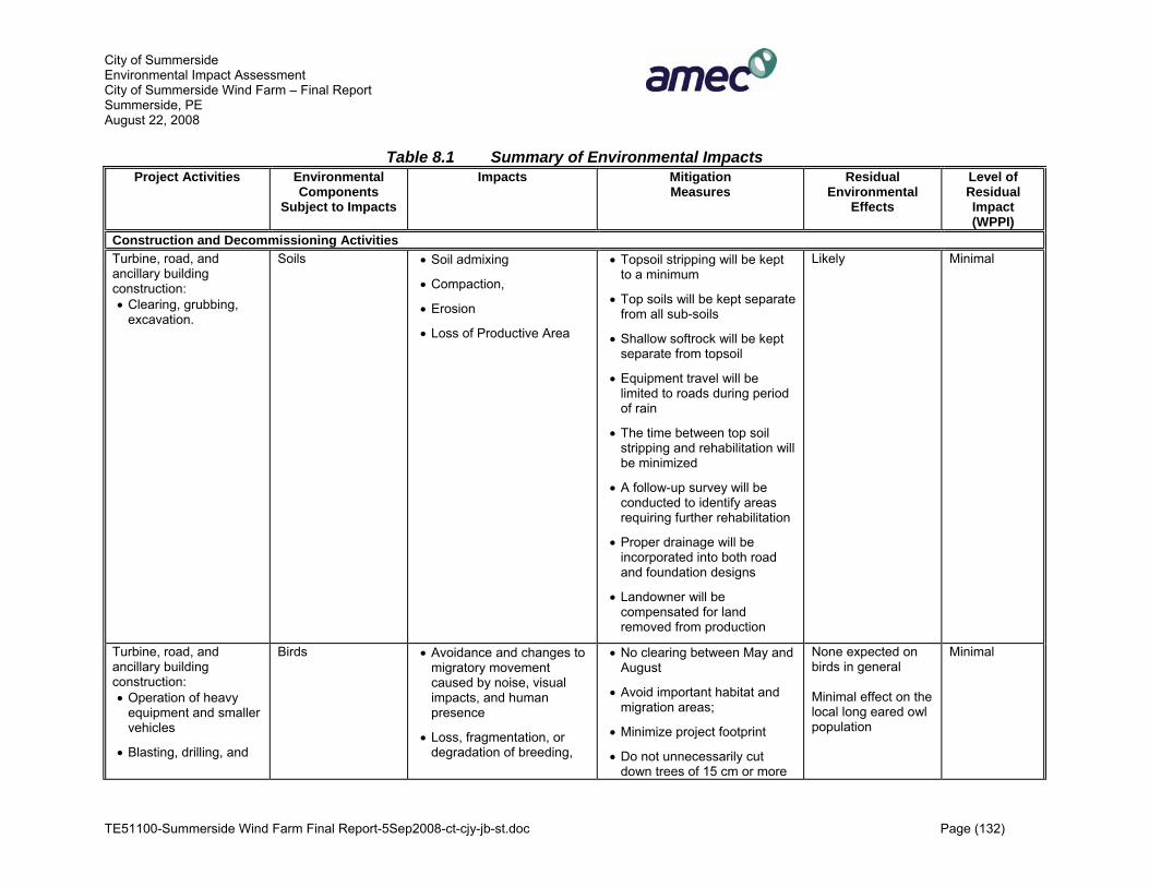
City of Summerside Environmental Impact Assessment City of Summerside Wind Farm – Final Report Summerside, PE August 22, 2008
TE51100-Summerside Wind Farm Final Report-5Sep2008-ct-cjy-jb-st.doc Page (132)
Table 8.1 Summary of Environmental Impacts Project Activities Environmental
Components Subject to Impacts
Impacts Mitigation Measures
Residual Environmental
Effects
Level of Residual Impact (WPPI)
Construction and Decommissioning Activities Turbine, road, and ancillary building construction: • Clearing, grubbing,
excavation.
Soils • Soil admixing
• Compaction,
• Erosion
• Loss of Productive Area
• Topsoil stripping will be kept to a minimum
• Top soils will be kept separate from all sub-soils
• Shallow softrock will be kept separate from topsoil
• Equipment travel will be limited to roads during period of rain
• The time between top soil stripping and rehabilitation will be minimized
• A follow-up survey will be conducted to identify areas requiring further rehabilitation
• Proper drainage will be incorporated into both road and foundation designs
• Landowner will be compensated for land removed from production
Likely Minimal
Turbine, road, and ancillary building construction: • Operation of heavy
equipment and smaller vehicles
• Blasting, drilling, and
Birds • Avoidance and changes to migratory movement caused by noise, visual impacts, and human presence
• Loss, fragmentation, or degradation of breeding,
• No clearing between May and August
• Avoid important habitat and migration areas;
• Minimize project footprint
• Do not unnecessarily cut down trees of 15 cm or more
None expected on birds in general Minimal effect on the local long eared owl population
Minimal

City of Summerside Environmental Impact Assessment City of Summerside Wind Farm – Final Report Summerside, PE August 22, 2008
TE51100-Summerside Wind Farm Final Report-5Sep2008-ct-cjy-jb-st.doc Page (133)
Table 8.1 Summary of Environmental Impacts Project Activities Environmental
Components Subject to Impacts
Impacts Mitigation Measures
Residual Environmental
Effects
Level of Residual Impact (WPPI)
grading
• Site clearing
• Presence of humans
• Accidental spills of oil, fuel
feeding, and resting habitat
• Habitat degradation by invasive species
• Changes to the water regime by erosion and runoff
• Exposure to toxic chemicals
• Respiratory health effects from dust
• Potential mortality of adults, young and eggs from collisions, or nest destruction
• Fire
in diameter
• Minimize impacts on the hydrological regime
• Avoid construction or decommissioning during breeding season
• Do not create areas of high prey density during habitat restoration
• Use native plants or no vegetation at all around turbines
• Avoid mowed lawn
• No guywires
Turbine, road, and ancillary building construction Land clearing
Species at Risk: Bats
• Reduction of quality and quantity of habitat
• Killing of individuals during land clearing activity
• Limit removal of tall trees and snags to areas absolutely necessary for construction
• Timing of work
None expected Minimal
Turbine, road, and ancillary building construction Land clearing
Species at Risk: Invertebrates
• Clearing, grubbing and excavation activities
• A field survey of all areas to be disturbed by construction activities should be conducted prior to initiation
None expected Minimal
Turbine, road, and ancillary building construction Land clearing
Species at Risk: Flora
• Clearing, grubbing and excavation activities
• A field survey of all areas to be disturbed by construction activities should be conducted prior to initiation
None expected Minimal
Turbine, road, and ancillary building
Wetlands (incl. surface water
• Disturbance, erosion and • Prior to site works, a Watercourse/Wetlands
None expected Minimal

City of Summerside Environmental Impact Assessment City of Summerside Wind Farm – Final Report Summerside, PE August 22, 2008
TE51100-Summerside Wind Farm Final Report-5Sep2008-ct-cjy-jb-st.doc Page (134)
Table 8.1 Summary of Environmental Impacts Project Activities Environmental
Components Subject to Impacts
Impacts Mitigation Measures
Residual Environmental
Effects
Level of Residual Impact (WPPI)
construction: • Operation of heavy
equipment and smaller vehicles.
quality) run-off
• Disruption of hydrology
• Loss of species diversity
• Introduction of invasive species
• Mineral input (dust)
• Water quality impairments
Alteration Permit will be obtained
• Avoid wetland areas
• No discharges to any water
• Reduce footprint
• Construction following storm events which have resulted in high water levels should be conducted only as approved by qualified inspectors
• Travel by construction vehicles will be minimized in temporary construction zones adjacent to wetlands
• Install erosion control structures (silt fences, etc.)
• Re-vegetate areas devoid of vegetation
• Clean construction equipment of soil residues before entering the site
• Implement a field monitoring program to study invasive weeds and the water regime
• Restore original contours and cross drainage patterns
• Contractor to develop and implement Environmental Management Plan (EMP)

City of Summerside Environmental Impact Assessment City of Summerside Wind Farm – Final Report Summerside, PE August 22, 2008
TE51100-Summerside Wind Farm Final Report-5Sep2008-ct-cjy-jb-st.doc Page (135)
Table 8.1 Summary of Environmental Impacts Project Activities Environmental
Components Subject to Impacts
Impacts Mitigation Measures
Residual Environmental
Effects
Level of Residual Impact (WPPI)
Turbine, road, and ancillary building construction: • Operation of heavy
equipment and smaller vehicles.
Air Quality • Formation of dust and exhaust fumes
• Use dust abatement techniques
• Impose and enforce speed limits on access roads
• Do not load trucks with soil above the freeboard
• Minimize drop heights when loading trucks
• Moisten land before clearing
• Equipment should be kept in good running order
No residual effects expected
Minimal
Construction Local Economy • Positive impact: work, income, taxes
• Interference with Slemon Park landings
• City of Summerside and Slemon Park to mutually agree on arrangements as per MoU.
Positive No residual effects expected
Positive
Turbine, road, and ancillary building construction: • Operation of heavy
equipment and smaller vehicles
• Delivery of supplies and turbine components
Transportation • Increased traffic including possible damage to roads and interference with traffic flows.
• Scheduling of deliveries should be during periods of low local traffic and when weight restrictions are not in practise
• Advance public notice should be made to local residents and the business community
• Repairs to public roads to implemented should the need arise
No significant effects expected
Low
Turbine, road, and ancillary building construction:
Human Health and Safety (Workers, residents and
• Potential physical harm to workers (accidents)
• Properly train workers involved with heavy equipment, excavation, power
None expected for icing and breakage
Minimal
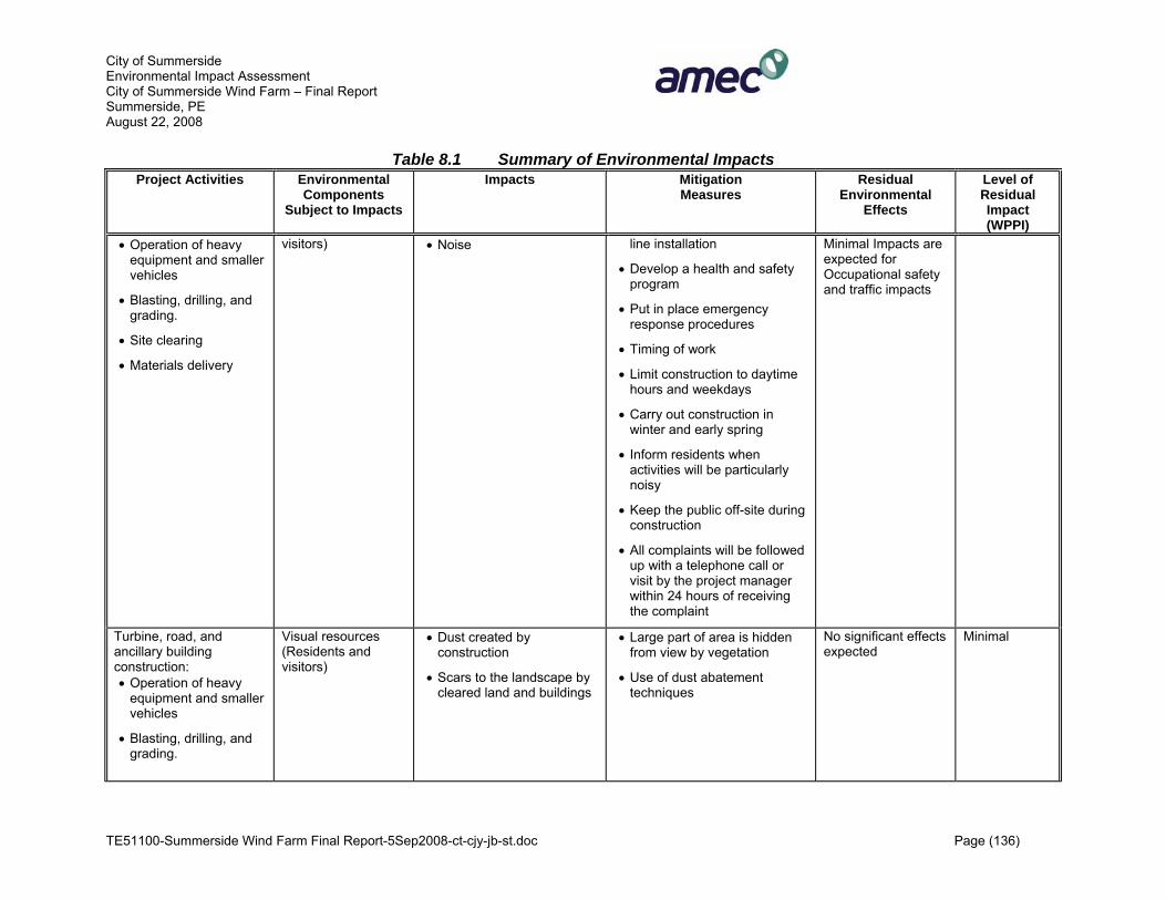
City of Summerside Environmental Impact Assessment City of Summerside Wind Farm – Final Report Summerside, PE August 22, 2008
TE51100-Summerside Wind Farm Final Report-5Sep2008-ct-cjy-jb-st.doc Page (136)
Table 8.1 Summary of Environmental Impacts Project Activities Environmental
Components Subject to Impacts
Impacts Mitigation Measures
Residual Environmental
Effects
Level of Residual Impact (WPPI)
• Operation of heavy equipment and smaller vehicles
• Blasting, drilling, and grading.
• Site clearing
• Materials delivery
visitors) • Noise line installation
• Develop a health and safety program
• Put in place emergency response procedures
• Timing of work
• Limit construction to daytime hours and weekdays
• Carry out construction in winter and early spring
• Inform residents when activities will be particularly noisy
• Keep the public off-site during construction
• All complaints will be followed up with a telephone call or visit by the project manager within 24 hours of receiving the complaint
Minimal Impacts are expected for Occupational safety and traffic impacts
Turbine, road, and ancillary building construction: • Operation of heavy
equipment and smaller vehicles
• Blasting, drilling, and grading.
Visual resources (Residents and visitors)
• Dust created by construction
• Scars to the landscape by cleared land and buildings
• Large part of area is hidden from view by vegetation
• Use of dust abatement techniques
No significant effects expected
Minimal
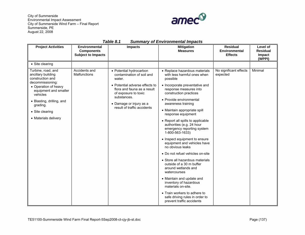
City of Summerside Environmental Impact Assessment City of Summerside Wind Farm – Final Report Summerside, PE August 22, 2008
TE51100-Summerside Wind Farm Final Report-5Sep2008-ct-cjy-jb-st.doc Page (137)
Table 8.1 Summary of Environmental Impacts Project Activities Environmental
Components Subject to Impacts
Impacts Mitigation Measures
Residual Environmental
Effects
Level of Residual Impact (WPPI)
• Site clearing
Turbine, road, and ancillary building construction and decommissioning: • Operation of heavy
equipment and smaller vehicles
• Blasting, drilling, and grading.
• Site clearing
• Materials delivery
Accidents and Malfunctions
• Potential hydrocarbon contamination of soil and water.
• Potential adverse effects to flora and fauna as a result of exposure to toxic substances.
• Damage or injury as a result of traffic accidents
• Replace hazardous materials with less harmful ones when possible
• Incorporate preventative and response measures into construction practices
• Provide environmental awareness training
• Maintain appropriate spill response equipment
• Report all spills to applicable authorities (e.g. 24 hour emergency reporting system 1-800-563-1633)
• Inspect equipment to ensure equipment and vehicles have no obvious leaks
• Do not refuel vehicles on-site
• Store all hazardous materials outside of a 30 m buffer around wetlands and watercourses
• Maintain and update and inventory of hazardous materials on-site.
• Train workers to adhere to safe driving rules in order to prevent traffic accidents
No significant effects expected
Minimal

City of Summerside Environmental Impact Assessment City of Summerside Wind Farm – Final Report Summerside, PE August 22, 2008
TE51100-Summerside Wind Farm Final Report-5Sep2008-ct-cjy-jb-st.doc Page (138)
Table 8.1 Summary of Environmental Impacts Project Activities Environmental
Components Subject to Impacts
Impacts Mitigation Measures
Residual Environmental
Effects
Level of Residual Impact (WPPI)
• Public notification of an increase in construction traffic
Operation Activities Turbine operation: • Human presence
• Maintenance of site
Soil Quality • Erosion of stripped areas • Maintenance activities will be confined to access roads
None expected Low
Turbine operation: • Human presence
• Maintenance of site
• Presence of turbines
• Accidental oil, fuel, toxic substance spills
• Turbine and infrastructure lighting
Birds • Direct mortality or injury from collisions with overhead power lines and turbines
• Electrocution from powerlines
• Disturbance and avoidance of potential breeding habitat due to human presence
• Noise may interfere with feeding, migration, and breeding
• Interference with movement due to barrier effect (avoidance of turbines)
• Erosion and runoff affecting water supply
• Increased predator
• Control visits to the area by both workers and public
• Keep workers from entering areas where no work is done and vegetation is unchanged
• Encourage public to refrain from visiting access roads during breeding season (May – end of July)
• Avoid migrating bird landfall sites
• Prevent perching and nesting on turbines, transmission lines, and meteorological towers
• Do not create areas of high prey density during habitat restoration and maintenance
• Use native plants or no vegetation at all around
Reduction in population density for birds disturbed by turbines; Limited mortality of birds (birds can return to preconstruction levels when wind farm is decommissioned) None expected for: Barrier effect, contaminant exposure, dust, water regime; fire
Low

City of Summerside Environmental Impact Assessment City of Summerside Wind Farm – Final Report Summerside, PE August 22, 2008
TE51100-Summerside Wind Farm Final Report-5Sep2008-ct-cjy-jb-st.doc Page (139)
Table 8.1 Summary of Environmental Impacts Project Activities Environmental
Components Subject to Impacts
Impacts Mitigation Measures
Residual Environmental
Effects
Level of Residual Impact (WPPI)
pressure (exposed prey)
• Fire
turbines, avoid Mountain ash trees
• Avoid mowed lawn
• Use minimum amount of and white colour aviation lighting in accordance with Transport Canada Guidelines
• Avoid or shield strong lights such as sodium vapour lights
• Implement monitoring program
Turbine operation: • Presence of power
lines, buildings, and turbines
• Presence of humans
• Exposure to toxic chemicals
Species-at-risk: Bats • Collisions with turbines, buildings, or power lines
• Interference with foraging by noise from turbines
• Presence of people on a regular basis, toxic chemical spills, and use of herbicides or pesticides may affect bats and should not be used
• Carry out monitoring for bat strikes
• Turn off turbines during few nights of fall migration
Small number of mortality (little brown bats and potentially northern long-eared bats) every year for the lifetime of the wind farm Eastern pipistrelle unlikely to occur
Low: (Little brown bats, northern long-eared bats) (Eastern pipistrelle: could be medium, but unlikely to occur)
Turbine and transformer presence, road maintenance (toxic chemicals present)
Wetlands • Reduced species diversity
• Toxic effects from chemicals substances
• Avoid herbicide use
• Immediate spill clean up
None expected
Low
Turbine operation: • Substation
• Vehicle traffic
Air Quality • Dust created from soil depleted of vegetation and from gravel access roads
• Allow vegetation cut in the lay down areas to grow back
None expected
Low

City of Summerside Environmental Impact Assessment City of Summerside Wind Farm – Final Report Summerside, PE August 22, 2008
TE51100-Summerside Wind Farm Final Report-5Sep2008-ct-cjy-jb-st.doc Page (140)
Table 8.1 Summary of Environmental Impacts Project Activities Environmental
Components Subject to Impacts
Impacts Mitigation Measures
Residual Environmental
Effects
Level of Residual Impact (WPPI)
Operation Local Economy • Positive impact: employment opportunities, income, taxes, contribution to power supply
• Interference will Slemon Park landings
• City of Summerside and Slemon Park to mutually agree on arrangements as per MoU.
Positive No residual effects expected
Positive
Turbine operation: • Presence and
operation of turbines
• Maintenance work
• Repairs using large equipment
Human Health and Safety (workers, residents, visitors)
• Accidents (physical harm)
• Shadow flicker
• Noise
• Properly train workers involved with equipment, handling, power lines, etc.
• Develop a health and safety program
• Make available an emergency procedures plan covering possible component failures
• Installation of shutters or curtains to block incoming flicker
• Establishment of vegetation shielding
• Construction/installation of a physical barrier
• Ensure a set back distance of at least 200-280 m
• Turbines automatically shut down at very high wind speeds
Impacts are expected to be low for all factors
Low
Turbine operation: • Presence and
operation of turbines
Visual Resources (Residents and visitors)
• Turbines in the natural landscape
• Strong steady lighting may
• Use tubular towers
• Create aesthetic balance in
Residual effects are likely despite mitigation measures
Low

City of Summerside Environmental Impact Assessment City of Summerside Wind Farm – Final Report Summerside, PE August 22, 2008
TE51100-Summerside Wind Farm Final Report-5Sep2008-ct-cjy-jb-st.doc Page (141)
Table 8.1 Summary of Environmental Impacts Project Activities Environmental
Components Subject to Impacts
Impacts Mitigation Measures
Residual Environmental
Effects
Level of Residual Impact (WPPI)
• Visits by maintenance workers
• Repairs using large equipment
cause “skyglow”
• Glare
• Negative impressions caused by “untidy” turbine arrangement, garbage, leaks from nacelles, idle turbines or turbines with parts missing
the design
• Use light grey colour, non reflective, not shiny steel
• Use identical turbine model for all turbines
• Arrange turbines in clusters
• Do not arrange turbines in long lines
• Do not locate turbines on elevated land points
• Minimize lighting on the turbines
• Minimize project footprint, implement erosion control and dust abatement
• Repair turbines immediately
• Clean turbines
• Remove excess materials and litter
• Avoid posting commercial signs
• Integrate information on wind energy and wind farm technology with information provided by interpretive walks and hikes in the area;
Turbine operation: • Presence and
Accidents and Malfunctions
• Potential hydrocarbon contamination of soil and
The mitigation for spills and traffic accidents for the

City of Summerside Environmental Impact Assessment City of Summerside Wind Farm – Final Report Summerside, PE August 22, 2008
TE51100-Summerside Wind Farm Final Report-5Sep2008-ct-cjy-jb-st.doc Page (142)
Table 8.1 Summary of Environmental Impacts Project Activities Environmental
Components Subject to Impacts
Impacts Mitigation Measures
Residual Environmental
Effects
Level of Residual Impact (WPPI)
operation of turbines
• Maintenance work
• Repairs using large equipment
water.
• Potential adverse effects to flora and fauna as a result of exposure to toxic substances.
• Icing and breakage
• Damage or injury as a result of traffic accidents
construction phase is sufficient for the operation phase. • Workers will be trained on the
hazards of ice build up on tall structures
• Warning signals or flags should be set up to warn of potential ice issues
• If those measures are not heeded other options must be investigated
• A safety set-back of at least 290 m will mitigate most effects of breakage.
• Staff should wear protective equipment when on-site

City of Summerside Environmental Impact Assessment City of Summerside Wind Farm – Final Report Summerside, PE August 22, 2008
TE51100-Summerside Wind Farm Final Report-5Sep2008-ct-cjy-jb-st.doc Page (143)
Table 8.2 Summary of Cumulative Effects Valued Ecosystem
Components (VECs) Description of
Project Activities Other Activities Assessment of Cumulative
Effects Level of Cumulative
Effect All All Past tree cutting None None Bird population Turbines, power lines
(Collisions) Visitors/Public access • Disturbance from public
access may add to losses from collisions
• Birds may move in from adjacent areas
Low

City of Summerside Environmental Impact Assessment City of Summerside Wind Farm – Final Report Summerside, PE April 7, 2008
TE51100-Summerside Wind Farm Final Report-5Sep2008-ct-cjy-jb-st.doc Page (144)
9.0 ENVIRONMENTAL EFFECTS MONITORING An environmental effects monitoring program (EEM) involves taking repeated measures of environmental variables or components to detect changes caused by external influences directly or indirectly attributable to a Project’s activities over time. EEM can include either a direct monitoring of VECs or monitoring of environmental parameters known to be important to the VECs. EEM studies are normally undertaken to fulfil the following objectives:
• verify EA predictions and evaluate the effectiveness of mitigation measures; • to detect undesirable changes in the environment; and/or • to improve the understanding of environmental cause and effect relationships.
The EEM will be site-specific and include documentation of the following, as appropriate:
• Wetland monitoring program to identify vegetation community changes/hydrological regime, invasive plant species and noxious weed surveys. Wetland survey plots will be delineated at the start of the wetland monitoring program.
• Noise monitoring will be conducted for a period of up to two years after the project is in operation.
• The turbine locations will be monitored for mortalities of bird and bat species due to collision with the turbines blades, or other project interactions. EC and CWS will be consulted in developing the monitoring details and data will be provided to interested regulating agencies; and
• The proposed EEM program will be submitted to EC and PEIDEEF prior to completion of construction for review and comment.
The monitoring program for birds will be developed following the CWS’ “Guidance Document for Environmental Assessment; Recommended Protocols for Monitoring Impacts of Wind Turbines on Birds”, (CWS 2006). It is anticipated that the monitoring program will consist of monitoring for mortalities during the peak spring and fall migration periods for the first two years of operation. This monitoring program will be subject to approval by EC and the Provincial government.

City of Summerside Environmental Impact Assessment City of Summerside Wind Farm – Final Report Summerside, PE April 7, 2008
TE51100-Summerside Wind Farm Final Report-5Sep2008-ct-cjy-jb-st.doc Page (145)
10.0 CONCLUSION This report addresses the environmental effects of the construction, operation and decommissioning project phases. The information to date has shown that no significant adverse residual impacts on the VECs are likely. The generation of electricity from renewable resources such as wind is in accordance with federal and provincial strategies, since it contributes to the reduction of GHG emissions and air pollutants. The Summerside Wind Farm, if approved, would contribute to the reduction of GHG emissions required to meet Canada’s and the Province of Prince Edward Island’s targets.

City of Summerside Environmental Impact Assessment City of Summerside Wind Farm – Final Report Summerside, PE April 7, 2008
TE51100-Summerside Wind Farm Final Report-5Sep2008-ct-cjy-jb-st.doc Page (146)
11.0 LIST OF SUPPORTING DOCUMENTS Agriculture Canada, 2006. Topography. Available at:
collections.ic.gc.ca/agriccan/pubweb/hs190004_f.asp.
Australian Wind Energy Association (AusWEA), 2005. Wind Farm Impacts on Local Tourism. Available at: http://www.auswea.com.au/. Accessed March 8, 2005.
AusWEA. 2004. The Electromagnetic Compatibility and the Electromagnetic Field Implications for Wind Farming in Australia. Available at: http://www.wind.appstate.edu/reports/BP10_EMC&EMF.pdf. Accessed March, 2008.
AWEA (American Wind Energy Association), 2005/4. Wind Energy and the Environment. Wind Web Tutorial. http://www.awea.org/pubs/tutorial/wwt_environment.html. Accessed February 2005.
Atlantic Climate Centre, 2006. Accessed Nov 2007 http://atlantic-web1.ns.ec.gc.ca/climatecentre/default.asp?lang=En&n=CACEE433-1
BatCon (Bat Conservation International, Inc.), 2006. Available at: www.batcon.org.
BBC, 2006. The Impact of Large Buildings and Structures (Including Wind Farms) on Terrestrial Television Reception. Available at: http://www.bbc.co.uk/reception/info/pdf/buildings_factsheet.pdf. Accessed March, 2008.
Beanlands, Gordon E., and Peter N. Duinker, 1983: An Ecological Framework of Environmental Impact Assessment in Canada. Institute for Resource and Environmental Studies, Dalhousie University, Halifax, and Federal Environmental Assessment Review Office, Hull, Canada, 132 pp.
Bishop, J.C. 1994. The Partridge Island Archaeological Project: Volume 2. The Partridge Island Site: Early and Middle Woodland-Related Assemblages. New Brunswick Manuscripts in Archaeology No. 28. Fredericton: New Brunswick Municipalities, Culture, and Housing.
Black, D.W. 1984. An Archaeological Survey of the Shores of the Grand Manan Archipelago. New Brunswick Manuscripts in Archaeology No. 5. Fredericton: New Brunswick Tourism, Recreation, and Heritage.
Blair, S.E. 1999. The Pre-Contact Archaeology of the Grand Manan Archipelago: Cultural History and Regional Integration. New Brunswick Manuscripts in Archaeology No. 29. Fredericton: New Brunswick Culture and Sport Secretariat.
BLM (Bureau of Land Management), 2004. Draft Programmatic Environmental Impact Statement on Wind Energy Development on BLM-Administered Lands in the Western

City of Summerside Environmental Impact Assessment City of Summerside Wind Farm – Final Report Summerside, PE April 7, 2008
TE51100-Summerside Wind Farm Final Report-5Sep2008-ct-cjy-jb-st.doc Page (147)
United States. U.S. Department of the Interior, Bureau of Land Management. September 2004. Available at: windeis.anl.gov/eis/guide/index.cfm.
Bond, W.K., K.W. Cox, T. Heberlein, E.W. Manning, D.R. Witty and D.A. Young. 1992. Wetland Evaluation Guide. Final Report of the Wetlands are Not Wastelands Project. North American Wetlands Conservation Council (Canada). Issues Paper, No. 1992-1. 121 p.
Bossanyi, E., Burton, T., Jenkins, N., Sharpe, D., 2001. Wind Energy Handbook. John Wiley & Sons. Ltd. P527
Boylan, D.B. 1973. Rule Britannia In Canada’s Smallest Province: A History of Prince Edward Island. Edited by F.W.P. Bolger. Canada: John Deyell Company. Pp. 33-36.
Broders, Hugh, Greg M. Quinn and Graham J. Forbes, 2003. Species Status, and the Spatial and Temporal Patterns of Activity of Bats in Southwest Nova Scotia, Canada. Northeastern Naturalist 10(4): 383 – 398.
CBC news 2007. Analogue TV Going the Way of the Dodo. http://www.cbc.ca/news/background/tech/analogue-tv.html
CBCL Limited. 2003. Pubnico Point Environmental Assessment. Prepared for Atlantic Wind Power Corporation Ltd., September 2003.
CCME (Canadian Council of the Ministers of the Environment), 2005. Canada-Wide Standards. www.ccme.ca/initiatives/standards.html; Accessed March 11, 2005.
CEAA (Canadian Environmental Assessment Agency), 1999. Cumulative Effects Assessment Practitioners Guide. Prepared by: The Cumulative Effects Assessment Working Group and AXYS Consulting Ltd. Available at www.ceaa-acee.gc.ca.
CEAA 1994. Reference Guide. Determining Whether a Project is Likely to Cause Significant Adverse Environmental Effects. Available at www.ceaa-acee.gc.ca., Accessed April 22, 2005.
CAN/CSA Z731-95 (R1999). Emergency Planning for Industry
CWS. 2001. Canada 30: Malpeque Bay, Prince Edward Island.
CWS. 2005. Wind Turbines and Birds: A Background Review for Environmental Assessment. Prepared by Andrea Kingsley and Becky Whittam. Environment Canada. Pp.12
CWS and Environment Canada, 2006. Wind Turbines and Birds. A Guidance Document for Environmental Assessment.

City of Summerside Environmental Impact Assessment City of Summerside Wind Farm – Final Report Summerside, PE April 7, 2008
TE51100-Summerside Wind Farm Final Report-5Sep2008-ct-cjy-jb-st.doc Page (148)
CWS and Environment Canada. 2007. Recommended Protocols for Monitoring Impacts of Wind Turbines on Birds. Canadian Wildlife Service - Environment Canada
City of Summerside, 2006. Available at: www.city.summerside.pe.ca.
Clark, A.H. 1959. Three Centuries and the Island: A Historical Geography of Settlement and Agriculture in Prince Edward Island, Canada. Canada: University of Toronto Press.
Curry & Kerlinger, 2005. Bats and Wind Power. Available at: www.currykerlinger.com/bats.htm.
Davis, S.A. 1981. Archaeological Resources in the Maritimes: A Coastal Survey. Prepared for: The Council of Maritime Premiers – Maritime Committee on Archaeological Cooperation. Unpublished Report.
Davis, S.A. 1982. Coastal Erosion and Archaeological Sites in Charlotte County, New Brunswick – 1980 Survey. In Archaeological Resources in the Maritimes: 1980. Reports in Archaeology No. 5. Edited by C.J. Turnbull. The Council of Maritime Premiers – Maritime Committee on Archaeological Cooperation. Fredericton, NB: Archaeological Branch, Historical resources Administration, The Province of New Brunswick.
Davis, S.A. and Christianson, D. 1981. Archaeological Resources in the Maritimes: A Coastal Survey - 1979. Report in Archaeology No. 4. In The Council of Maritime Premiers – Maritime Committee on Archaeological Cooperation. Fredericton, NB: Archaeological Branch, Historical resources Administration, The Province of New Brunswick.
de Jong, N. 1973. The French Regime, 1534-1758 In Canada’s Smallest Province: A History of Prince Edward Island. Edited by F.W.P. Bolger. Canada: John Deyell Company. Pp. 11-32.
Drouin and Leblanc, 1994 (quoted in Section 3.10).
Danish Wind Industry Association (DWIA), 2005. Sound Level Calculator for Wind Turbines. Updated May 10, 2003. URL: http:// www.windpower.org/ en/tour/ env/db/dbcalc.htm. Accessed February 2005.
Environment Canada. 1986. Atlantic Provinces: Active Hydrometric Stations Reference Index. Inland Waters Directorate, Atlantic Region.
Environment Canada. 1991. The Federal Policy on Wetland Conservation. Government of Canada. 14 pp.
Environment Canada. 2002. The Climate of Prince Edward Island. Available at: www.atl.ec.gc.ca/climate/pei.html.
Environmental Canada, 2003a. The “Weather Winners” Highlight” Available at: www.on.ec.gc.ca/weather/winners/placing-e.html.

City of Summerside Environmental Impact Assessment City of Summerside Wind Farm – Final Report Summerside, PE April 7, 2008
TE51100-Summerside Wind Farm Final Report-5Sep2008-ct-cjy-jb-st.doc Page (149)
Environmental Canada, 2003b. Is poor air quality a concern in Atlantic Canada? Available at: www.atl.ec.gc.ca/airquality/concern_e.html.
Environment Canada, 2004a. Preliminary Recommendations in Assessment Scoping for Wind Power Projects.
Environment Canada, 2004b. Impacts of Sea-Level Rise and Climate Change on the Coastal Zone of Southeastern New Brunswick. Available at: http://atlantic-web1.ns.ec.gc.ca/slr/default.asp. Accessed Jan., 2005.
Environment Canada, 2004c. Impacts of Sea-Level Rise and Climate Change on the Coastal Zone of Southeastern New Brunswick. Available at: http://atlantic-web1.ns.ec.gc.ca/slr/default.asp. Accessed Dec.22, 2004.
Environment Canada, 2005a. Canada’s Greenhouse Gas Inventory, 1990-2003. Available at: www.ec.gc.ca/pdb/ghg/inventory_report/2003_report/toc_e.cfm.
Environment Canada. 2005b. Canadian Climate Normals. Available at: www.msc-smc.ec.gc.ca/climate.
Environment Canada, 2005c. Climate Change - Overview. Available at: whttp://www.ec.gc.ca/climate/averview_Canada-e.html; Accessed January, 2005.
Environment Canada, 2006. Available at: www.atl.ec.gc.ca/wildlife/ramsar/malpeq.html.
Environment Canada, 2008. Canadian Weather RADAR. Available at: http://weatheroffice.ec.gc.ca/radar/index_e.html. Accessed March, 2008.
Erickson, W., G. Johnson, D. Young, D. Strickland, R. Good, M. Bourassa, K. Bay and K. Sernka, 2002. Synthesis and Comparison of Baseline Avian and Bat Use, Raptor Nesting and Mortality Information from Proposed and Existing Wind Developments. Report prepared for Bonneville Power Administration. December 2002.
Erskine, Anthony J., 1992: Atlas of Breeding Birds of the Maritime Provinces. Nova Scotia Museum and Nimbus Publishing Limited. 270 pp.
Fisheries and Oceans (DFO), 2006. Traditional Fisheries Knowledge Internet Mapping Application. Available at: glfgeo.dfo-mpo/tfk-ctp.
Fox, Don, Clare Robinson and Marcos Zentilli, 1997. Pyrrhotite and Associated Sulphides and Their Relationship to Acid Rock Drainage in the Halifax Formation, Meguma Group, Nova Scotia. Atlantic Geology 33, 87-103.
Garcia, P. F.J., Holroyd, S.L., Rasheed, S.A., 1995. British Columbia Environment, Status of the Spotted Bat in British Columbia. Ministry of the Environment, Lands and Parks, Wildlife Branch. Victoria. B.C.

City of Summerside Environmental Impact Assessment City of Summerside Wind Farm – Final Report Summerside, PE April 7, 2008
TE51100-Summerside Wind Farm Final Report-5Sep2008-ct-cjy-jb-st.doc Page (150)
Government of Prince Edward Island website, 2007. Place Finder. Summerside, Prince Edward Island. http://www.gov.pe.ca/placefinder/index.php3?city=Summerside
Hanson, A.R. and L. Calkins. 1996. Wetlands of the Maritime Provinces: Revised Documentation for the Wetlands Inventory. Technical Report No. 267. Canadian Wildlife Service. Atlantic Region.
Health Canada. 1999. National Ambient Air Quality Objectives For Ground-level Ozone - Science Assessment Document. Canadian Council of Resource and Environment Ministers, July 1999.
Hinds, H. 2000. Flora of New Brunswick Second Ed. University of New Brunswick, Fredericton, New Brunswick.
Hinterland Who’s Who (HWW). 2007. Species Accounts. Accessible at: http://www.hww.ca/index_e.asp.
Holland College, 2006. Available at: www.hollandc.pe.ca.
Howells, K. and D. Fox, 1998. Geophysical Methods for Detecting Shallow Sulphide Mineralization in the Halifax Formation, Nova Scotia: a Reconnaissance Study. Atlantic Geology 34, 211 – 227.
InfoPEI Web-site. February 2006. English Settlement from 1774 to Confederation. Available at: http:/www.gov.pe.ca/infopei/index.php3?number=19672&lang=E
InfoPEI, 2005, 2006. Available at: www.gov.pe.ca/infopei.
Industry Canada, 2008. Geographical Area Search. Available at: https://www.spectrumdirect.ic.gc.ca/pls/engdoc_anon/web_search.frequency_range_input. Accessed March, 2008.
International Electrotechnical Commission (IEC). 2002. TR 61400-24 First edition Wind turbine generator systems – Part 24: Lightning protection. International Electrotechnical Commission, Geneva 20, Switzerland.
International Energy Agency (IEA). 2004. IEA Wind Energy Annual Report 2003. Available : www.ieawind.org/iea_wind_pdf/PDF_2003_IEA_Annual_Report/2003IEA_WindAR.pdf
Keeley, Brian, Steve Ugorez and Dale Strickland, 2001: Bat Ecology and Wind Turbine Considerations. Presentations and Panel Discussion. Proceedings of the National Avian-Wind Planning Meeting IV, Carmel, California, May 2000. Prepared for the Avian Subcommittee of the National Wind Coordinating Committee by RESOLVE INC. Washington, DC, May 2001. Available at: www.nationalwind.org.

City of Summerside Environmental Impact Assessment City of Summerside Wind Farm – Final Report Summerside, PE April 7, 2008
TE51100-Summerside Wind Farm Final Report-5Sep2008-ct-cjy-jb-st.doc Page (151)
Keeling, C.D. and T.P. Whorf. 2005. Atmospheric CO2 records from sites in the SIO air sampling network. In Trends: A compendium of Data on Global Change. Carbon Dioxide Information Analysis Center, Oak Ridge National Laboratory, U.S. Department of Energy, Oak Ridge, Tenn., U.S.A.
Keenlyside, D. 1982. Prince Edward Island Archaeological Research 1980. In Archaeological Resources in the Maritimes: 1980. Reports in Archaeology No. 5. Edited by C.J. Turnbull. The Council of Maritime Premiers – Maritime Committee on Archaeological Cooperation. Fredericton, NB: Archaeological Branch, Historical resources Administration, The Province of New Brunswick.
Kingsley, Andrea and Becky Whittam. 2001. Potential Impacts of Wind Turbines on Birds at North Cape, Prince Edward Island. Prepared by Bird Studies Canada, Atlantic Region, on behalf of the PEI Energy Corporation.
Langston, RHW, and JD Pullan, 2003. Wind Farms and Birds: An analysis of the effects of wind farms on birds, and guidance on environmental assessment criteria and site selection issues. Report written by BirdLife International on behalf of the Bern Convention on the Conservation of European Wildlife and Natural Habitats. Strassburg, September 11, 2003. T-PVS/Inf (2003) 12. Available at: www.safewind.info/pdf/wind farmsandbirds.pdf.
Lennox Island First Nation, 2006. Available at: http://www.lennoxisland.com/
Loucks, O.L. 1962. A forest classification for the Maritime Provinces. Proceedings of the Nova Scotian Institute of Science 25: 85-167.
Maloney, J.H. 1973. The First Centuries “And in the Beginning….” In Canada’s Smallest Province: A History of Prince Edward Island. Edited by F.W.P. Bolger. Canada: John Deyell Company. Pp. 1-10.
Manwell, James F., Anthony F. Ellis, and Mohit Dua. 2004. Wind Resource Data Interpretation Report. Ipswitch, Mass. Available at: http://74.94.169.139/utilities/wind/Ipswitch%20Report.pdf
McCulloch, M.M., Forbes, D., Shaw, R. 2002. Coastal Impacts of Climate Change and Sea-Level Rise on Prince Edward Island. Geological Survey of Atlantic Canada Open File 4261
Meteorological Services of Canada (MSC). 2003. Lightning Activities in Major Cities in Canada. Available at: http://www.msc.ec.gc.ca/education/lightning/cities_e.html; Accessed January 23, 2006.
MSC (Meteorological Service of Canada), 2005 a. Flash Density Map. Available at: www.msc.ec.gc.ca/education/lightning/hot_e.html; Accessed March 9, 2005.

City of Summerside Environmental Impact Assessment City of Summerside Wind Farm – Final Report Summerside, PE April 7, 2008
TE51100-Summerside Wind Farm Final Report-5Sep2008-ct-cjy-jb-st.doc Page (152)
MSC, 2005 b. Lightnings by Province. Available at: www.msc.ec.gc.ca/education/lightninh/provinces_e.html; Accessed March 9, 2005.
National Cooperative Highway Research Program NCHRP Synthesis Report #218 Mitigation of Nighttime Construction Noise, Vibrations, and Other Nuisances, 1999. Natural Resources Canada, 2003. Accessible at:
http://www.rescer.gc.ca/programs/index.asp?CaId=107&PgId=622
NatureServe. 2006. NatureServe Explorer: An Online Encyclopedia of Life. Version 1.8. NatureServe, Arlington, Virginia. Available: www.natureserve.org/explorer.
PEI 2005 Visitors Guide. Available at: www.gov.pe.ca/visitorsguide.
PEI Department of Agriculture, Fisheries and Aquaculture, 2006. Slope/Topography/Landscape on PEI, Available at: www.gov.pe.ca/af/agweb/index.php3?number=71770.
PEI Department of Education, 2006. Available at: www.gov.pe.ca/educ.
PEI Department of Environment and Energy. 2004. PEI Energy Framework and Renewable Energy Strategy. Available at: www.gov.pe.ca/photos/original/ee_frame_rep_e.pdf.
PEI Department of Health, 2006. Available at: www.gov.pe.ca/health/index.php3.
PEI Energy Corp and Université de Moncton. 2005. The Prince Edward Island Wind Atlas. Available at: www.gov.pe.ca/envengfor/windatlas/index.html
Percival, S.M. 2001. Assessment of the effects of offshore wind farms on birds. Report ETSUW/13/00565/REP, DTI/Pub URN 01/1434.
RABC and the Canadian Wind Energy Association (CanWEA). 2007. Technical Information and Guidelines on the Assessment of the Potential Impact of Wind Turbines on Radiocommunication, Radar and Seismoacoustic Systems.
RAMSAR, 2006. The Ramsar Convention on Wetlands. Available at: www.ramsar.org.
Rowe, J.S. 1972. Forest regions of Canada. Canadian Forestry Service, Ottawa. Publication No. 1300. 172 pp.
Salema, Carlos, Carlos Fernandes, and Luca Fauro. 2001. TV Interference from Wind Turbines. Instituto Superior Tecnico and Instituto de Telecomunicaoes. Portugal.
Species at Risk Act (SARA) Registry. 2007. Accessed at http://www.sararegistry.gc.ca/default_e.cfm.

City of Summerside Environmental Impact Assessment City of Summerside Wind Farm – Final Report Summerside, PE April 7, 2008
TE51100-Summerside Wind Farm Final Report-5Sep2008-ct-cjy-jb-st.doc Page (153)
Sea Breeze, Sea Breeze Energy Inc., 2004. Proposed Knob Hill Wind Farm - Environmental Assessment Application. Available at: http://www.eao.gov.bc.ca/epic/output/html/deploy/epic_document_219_16996.html. Accessed Nov. 11, 2004.
Sengupta, Dipak L. 1984. Electromagnetic Interference Effects of Wind Turbines. Working Committee on EMI, IEA, Denmark.
Slemon Park Corporation, 2006. Available at: www.slemonpark.com.
Statistics Canada. 2007. Canadian Census. Available at: “http://www12.statcan.ca/english/census01/home/index.cfm”
Swisher, Randall. 2006. Can Wind Turbines and Military Radar Coexist? Composites World.com. Available at: www.compositesworld.com/hpc/issues/2006/November/1481.
Washburn & Gillis Associates Ltd. 1996. Proposed Maritimes & Northeast Pipeline Project - Country Harbour, Nova Scotia to St. Stephen, New Brunswick: Corridor Section - Environmental Socio-Economic Impact Assessment Study Report.
Watson, J.V. 1994. Shipwrecks & Seafaring Tales of Prince Edward Island. Canada: Hounslow Press.
Yes2Wind, 2005. www.yes2wind.com; Accessed February 11, 2005
Zentilli, Marcos and Don Fox. 1997. Geology and mineralogy of the Meguma Group and their importance to environmental problems in Nova Scotia. Atlantic Geology 33, 81-85.

City of Summerside Environmental Impact Assessment City of Summerside Wind Farm – Final Report Summerside, PE April 7, 2008
TE51100-Summerside Wind Farm Final Report-5Sep2008-ct-cjy-jb-st.doc Page (154)
12.0 CONTACT LIST
Contact Name Organization/Agency Contact
J. Brant Socio-Economic Director, Mi'kmaq Confederacy of Prince Edward Island
Dan Busby Canadian Wildlife Service 1-506-364-5037
David Christianson Museum of Nova Scotia [email protected]
Steven Davis Archaeologist, St. Mary’s University, NS [email protected]
Christina Doucette RCMP, Eastern Prince, Detachment Assistant
902-436-9300
Ronald Estabrooks Energy Advisor, PEI Department of Environment, Energy and Forestry
902-368-5011 [email protected]
Albert Ferguson ASU – Project Executive - Archaeological Resources, NB
506-453-2756
Don Forbes City of Summerside, Director of Municipal Services
902-432-1272
Todd Fraser Air & Hazardous Materials Section Head PEI Dept of Environment and Forestry
(902) 368-5037 [email protected]
Thayne Jenkins City of Summerside, Development Officer 902-436-3191
David Keenlyside East Coast Director, Museum of Civilization, Ottawa
Gary Lines Canadian Centre of Climate Modeling and Analysis, Environment Canada
902-426-5739 [email protected]
Roseanne MacFarlane
PEI Department of Agriculture, Fisheries and Aquaculture, Freshwater Fisheries Biologist
902-368-6082
Robin MacIntosh University of PEI, Registrars Office 902-556-0439
Matt McGuire Development Officer, Lennox Island First Nation
Jim Peters Summerside Fire Department, Fire Chief 902-432-4434
Dave Poirier Summerside Police, Chief 902-432-1330
Jeff Sheidow Department of Fisheries and Oceans, Fishery Officer.
902-888-4000
Marina Silva University of Prince Edward Island, Professor
902-566-0602
Garth Simmons PEI Department of Agriculture, Fisheries and Aquaculture, Compliance & Assessment Engineer
902-368-8530

City of Summerside Environmental Impact Assessment City of Summerside Wind Farm – Final Report Summerside, PE April 7, 2008
TE51100-Summerside Wind Farm Final Report-5Sep2008-ct-cjy-jb-st.doc Page (155)
Contact Name Organization/Agency Contact
Charlotte Stewart Heritage Officer, Culture and Heritage Branch, Dept. Of Community and Cultural Affairs, P.E.I.
Jamie Gallant Native Council of PEI 902-892-5314

City of Summerside Environmental Impact Assessment City of Summerside Wind Farm – Final Report Summerside, PE April 7, 2008
TE51100-Summerside Wind Farm Final Report-5Sep2008-ct-cjy-jb-st.doc Page (156)
13.0 GLOSSARY Bog A wetland where the accumulation of Sphagnum moss as peat
determines the nature of the plant community. Floating sphagnum mats may encroach over the surface of any open water.
Cumulative Effects A project’s effects on the environment combined with the effects of
projects and activities (past, existing or imminent). These may occur over a certain period of time or distance.
Environmental Assessment The process of identifying the significant environmental impacts
that a proposed project may have on the environment and the proposed mitigation efforts to minimize the impacts.
Environmental Effect With respect to a project, any change that the project may cause
in the environment, including any changes to health and socio-economic conditions, physical and cultural heritage and current land and resources used for traditional purposes by Aboriginal persons. Also included are changes to any structure or site that is of historical, archaeological, palaeontological or architectural significance, and any change to the project that may be caused by the environment.
Estuarine Wetland A tidal wetland that is usually semi-enclosed by land but have
open, partly obstructed or sporadic access to the open ocean, and in which ocean water is at least occasionally by freshwater runoff from the land.
Residual Effects Effects that remain after mitigation measures have been applied. Salt Marsh A cord grass dominated wetland. A salt marsh is characterized by
the percentage of marsh that is flooded by the mean high water mark and the number of saline to brackish ponds per hectare.
Valued Ecosystem Any part of the environment that is considered important by the Component (VEC) proponent, members of the public, scientists and government
involved in the assessment process. Importance may be determined on the basis of cultural or scientific concerns.

City of Summerside Environmental Impact Assessment City of Summerside Wind Farm – Final Report Summerside, PE April 7, 2008
TE51100-Summerside Wind Farm Final Report-5Sep2008-ct-cjy-jb-st.doc Page (157)
14.0 ACRONYMS ACCDC Atlantic Canada Conservation Data Centre ACOA Atlantic Canada Opportunities Agency AGL Above Ground Level AM Amplitude Modulated ARD Acid Rock Drainage ATC Air Traffic Control AWEA American Wind Energy Association CanWEA Canadian Wind Energy Association CCME Canadian Council of Ministers of the Environment CEAA Canadian Environmental Assessment Act CFB Canadian Forces Base CLI Canada Land Inventory CO Carbon monoxide CO2 Carbon dioxide COSEWIC Committee on the Status of Endangered Wildlife in Canada CRTC Canadian Radio-television and Communications Commission CWS Canadian Wildlife Service CYSU Summerside Airport dB(A) Decibel (A-weighted) dB Decibel DCCA Department of Community and Cultural Affairs DDE Dichloro-diphenyl-dichloroethylene DDT Dichloro-diphenyl-trichloroethane DFO Department of Fisheries and Oceans DND Department of National Defence DTPW PEI Department of Transportation and Public Works DU Ducks Unlimited DWIA Danish Wind Industry Association EA Environmental Assessment EC Environment Canada ECC Environmental Component of Concern ECP Environmental Choice Program EEM Environmental Effects Monitoring EHJV Eastern Habitat Joint Venture EIA Environmental Impact Assessment EMR Electromagnetic Radiation EPA Environmental Protection Act EPP Environmental Protection Plan FAF Final Approach Fix FBO Fixed-base Operations FM Frequency Modulated

City of Summerside Environmental Impact Assessment City of Summerside Wind Farm – Final Report Summerside, PE April 7, 2008
TE51100-Summerside Wind Farm Final Report-5Sep2008-ct-cjy-jb-st.doc Page (158)
GHG Greenhouse Gas GNSS Global Navigation Satellite System HADD Harmfully Alter, Disrupt or Destroy HASP Health and Safety Plan HC Health Canada HRIA Heritage Resource Impact Assessment IBA Important Bird Area IEA International Energy Agency IEC International Electrotechnical Commission ILS Instrument Landing System INT Island Nature Trust IPCC Intergovernmental Panel on Climate Change LRT Long Range Transport MASL Meters Above Sea Level MBCA Migratory Birds Convention Act MDL Method Detection Level MECL Maritime Electric Company Limited MOU Memorandum of Understanding MRIF Municipal Rural Infrastructure Fund MSC Meteorological Service of Canada MSL Mean Sea Level MW Megawatts NAAQO National Ambient Air Quality Objectives NAC National Advisory Committee NB New Brunswick NC Nature Conservancy NDB Nondirectional Radio Beacon NGO Non-government Organization NO Nitrogen monoxide NOx Nitrogen oxides NO2 Nitrogen dioxide NS Nova Scotia NWPA Navigable Waters Protection Act OCC Obstacle Clearing Center PCB Polychlorinated Biphenyls PEI Prince Edward Island PEIDEEF Prince Edward Island Department of Environment, Energy and
Forestry PEIDOTE Prince Edward Island Department of Technology and Environment PID Property Identification Number PM Particulate Matter POL Petroleum, Oil, Lubricant PWGSC Public Works and Government Services Canada RA Regulatory Authority

City of Summerside Environmental Impact Assessment City of Summerside Wind Farm – Final Report Summerside, PE April 7, 2008
TE51100-Summerside Wind Farm Final Report-5Sep2008-ct-cjy-jb-st.doc Page (159)
RABC Radio Advisory Board of Canada RCAF Royal Canadian Air Force RCMP Royal Canadian Mounted Police RCS Radar Cross Section RF Radio Frequency RNAV Area Navigation RWY Runway SARA Species at Risk Act SE South East SO2 Sulfur dioxide SPC Slemon Park Corporation TC Transport Canada TV Television UTM Universal Transverse Mercator VEC Valued Ecosystem Component VFR Visual Flight Rules VOC Volatile Organic Compound WAWA Watercourse and Wetland Alteration WGAQOG Working Group on Air Quality Objectives and Guidelines WMA Wildlife Management Area WTG Wind Turbine Generator

APPENDICES PROVIDED ON CD :
APPENDIX A Environmental Protection Plan
Appendix B
Memorandum of Understanding Between the City of Summerside
and Slemon Park Airport
Appendix C Wetlands Data Sheets
Appendix D
Bird Survey Results
Appendix E Summerside Wind Plant Assessment of Noise and Flicker Impacts
Appendix F
Nav Canada Assessment – Impact of Wind Turbine Farm on Instrument Landing System
Appendix G
Mi’kmaq Confederacy and Native Peoples Council Response