Embed Size (px)
Citation preview

A best practice management guide for changing coastlines
Leah Page and Veronica Thorp
ISBN: 978-0-7246-6558-7 (printed manual)
ISBN: 978-0-7246-6559-4 (pdf)
Title: Tasmanian Coastal Works Manual: A best practice management guide for changing coastlines
Author(s): Leah Page and Veronica Thorp
Publisher/place: Department of Primary Industries, Parks, Water and Environment - Tasmania
Publication date: December 2010
Design and layout: ILS Design Unit, DPIPWE Editor : Janice Bird
Disclaimer
Any representation, statement, opinion or advice, expressed or implied in this publication is made in good faith, but on the basis that
the Department of Primary Industries, Parks, Water and Environment its agents and employees are not liable (whether by reason of
negligence, lack of care, or otherwise) to any person or for any damage or loss whatsoever which has occurred or may occur in relation
to that person taking or not taking (as the case may be) action in respect of any representation or advice referred to herein..
This project was funded through the Australian Government’s ‘Caring for Our Country’ program and supported by the Tasmanian Government.
TasmanianCoastal Works
Manual

Acknowledgements
This manual has been completed by Leah Page,
based on a draft written by Veronica Thorp
in 2006. Veronica died in July 2008 and was
unable to participate in the completion of the
manual. However her substantial contribution
provided a major part of the work on which
this manual is based.
The writers would like to thank all those who contributed to this manual, especially the Steering Committee: Lynne Sparrow (Parks and Wildlife Service), Kathleen Broderick (NRM South), Phil Watson (Clarence City Council), Leanne Brown (EPA, DPIPWE) and Christine Materia (Local Government Association of Tasmania); and the staff of the Coastal and Marine Branch, Chris Rees (Manager and Steering Committee Chair), Jocelyn Phillips, Kathy Noble, Kristy Blackburn and Diana Williams.
Many other specialists and stakeholders contributed to the Manual. In some case considerable amounts of material were provided by these contributors. The chapter list on page 3 acknowledges contributors who provided significant amounts of material or consultation for a particular chapter.
Many other State Government staff contributed to the Manual and/or commented on various drafts. These include Carolyn Knight, Michael Pemberton, Jason Bradbury, Tim Rudman, Rosemary Gales, Anthony Reid, Alistair Morton, Rob Moreton, Mike Askey-Doran, Karen Stewart, Janet Smith, Tim Chappell, Andrew Wagg, Jennifer Burdon, Elizabeth Tew, Ester Guerzoni, Mike Nash, Pip Gowen, Stuart Dudgeon, Sandra Whight, Stephen Gallagher, Chris Grose, Regan Parkinson, Pete Smith, Peter Voller, Stewart Blackhall, Brian Campbell, Andrew Smith,
Letitia Lamb, Rosemary Cross, Luke Newman, Phil Thompson and Karen Steinhuis (CLS).
Local Government staff who assisted include Bridget Jupe, Dan Meldrum and Johannes May (Kingborough Council), Kerry Ford (Sorell Council), Polly Buchorn (Break O’ Day Council), Haylee Alderson and Phil Barker (Central Coast Council), Andrew Drenen (Tasman Council), Richard Greenhill and Lynda Bonar (Hobart City Council), Alli Coombe (Glenorchy City Council), Mel Kelly (Glamorgan Spring Bay Council) and Mary McParland (Clarence City Council).
Other contributors included Eric Woehler (Birds Tasmania), Oliver Strutt (Understorey Network), Ruth Eriksen (Aquatic Science), Ursula Taylor and John Chrispijn (Derwent Estuary Program), Jill Pearson (NRM South), Anna Wind (Cradle Coast NRM) Chris and Sally Johns (Southern Beaches Landcare & Coastcare), Sandy Leighton (Southern Tasmanian Councils Authority), Frances Mowling (consultant), Christine Corbett (Greening Australia), Kristy Blackburn (Southern Coastcare Association of Tasmania), Vishnu Prahalad (University of Tasmania), Peter Hopkins and Jim Caulfield (Marine & Safety Tasmania), Sharon Sherman (State Emergency Service), Peter McGlone (Tasmanian Conservation Trust), Emma Williams (NRM North), Neil Taylor (Geofabric Australia), John Easton (Conservation Volunteers Australia), Richard Mount (University of Tasmania), Moya Sharpe (Sorell School), Luke Chiu (Sport and Recreation Tasmania) and Kaylene Allen (NRM South).
Thanks is also due to consultant Chris Sharples (coastal geomorphologist) for technical information and advice on climate change and coastal geomorphology.
Special thanks to Jill Pearson (NRM South) for reviewing the document and providing comprehensive insights prior to editing.
Tasmanian Coastal Works Manualii Acknowledgements
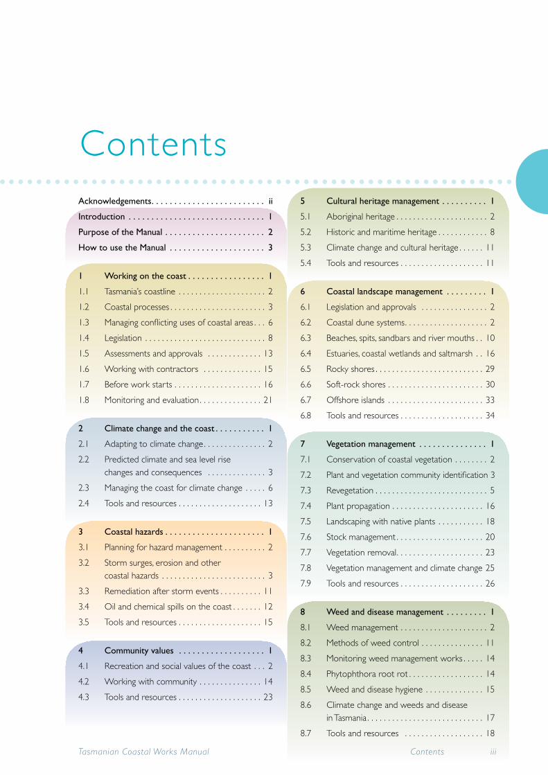
Acknowledgements . . . . . . . . . . . . . . . . . . . . . . . . . ii
Introduction . . . . . . . . . . . . . . . . . . . . . . . . . . . . . . 1
Purpose of the Manual . . . . . . . . . . . . . . . . . . . . . . 2
How to use the Manual . . . . . . . . . . . . . . . . . . . . . 3
1 Working on the coast . . . . . . . . . . . . . . . . . 1
1.1 Tasmania’s coastline . . . . . . . . . . . . . . . . . . . . . 2
1.2 Coastal processes . . . . . . . . . . . . . . . . . . . . . . . 3
1.3 Managing conflicting uses of coastal areas . . . 6
1.4 Legislation . . . . . . . . . . . . . . . . . . . . . . . . . . . . . 8
1.5 Assessments and approvals . . . . . . . . . . . . . 13
1.6 Working with contractors . . . . . . . . . . . . . . 15
1.7 Before work starts . . . . . . . . . . . . . . . . . . . . . 16
1.8 Monitoring and evaluation . . . . . . . . . . . . . . . 21
2 Climate change and the coast . . . . . . . . . . . 1
2.1 Adapting to climate change . . . . . . . . . . . . . . . 2
2.2 Predicted climate and sea level rise changes and consequences . . . . . . . . . . . . . . 3
2.3 Managing the coast for climate change . . . . . 6
2.4 Tools and resources . . . . . . . . . . . . . . . . . . . . 13
3 Coastal hazards . . . . . . . . . . . . . . . . . . . . . . 1
3.1 Planning for hazard management . . . . . . . . . . 2
3.2 Storm surges, erosion and other coastal hazards . . . . . . . . . . . . . . . . . . . . . . . . . 3
3.3 Remediation after storm events . . . . . . . . . . 11
3.4 Oil and chemical spills on the coast . . . . . . . 12
3.5 Tools and resources . . . . . . . . . . . . . . . . . . . . 15
4 Community values . . . . . . . . . . . . . . . . . . . 1
4.1 Recreation and social values of the coast . . . 2
4.2 Working with community . . . . . . . . . . . . . . . 14
4.3 Tools and resources . . . . . . . . . . . . . . . . . . . . 23
5 Cultural heritage management . . . . . . . . . . 1
5.1 Aboriginal heritage . . . . . . . . . . . . . . . . . . . . . . 2
5.2 Historic and maritime heritage . . . . . . . . . . . . 8
5.3 Climate change and cultural heritage . . . . . . 11
5.4 Tools and resources . . . . . . . . . . . . . . . . . . . . 11
6 Coastal landscape management . . . . . . . . . 1
6.1 Legislation and approvals . . . . . . . . . . . . . . . . 2
6.2 Coastal dune systems . . . . . . . . . . . . . . . . . . . . 2
6.3 Beaches, spits, sandbars and river mouths . . 10
6.4 Estuaries, coastal wetlands and saltmarsh . . 16
6.5 Rocky shores . . . . . . . . . . . . . . . . . . . . . . . . . . 29
6.6 Soft-rock shores . . . . . . . . . . . . . . . . . . . . . . . 30
6.7 Offshore islands . . . . . . . . . . . . . . . . . . . . . . . 33
6.8 Tools and resources . . . . . . . . . . . . . . . . . . . . 34
7 Vegetation management . . . . . . . . . . . . . . . 1
7.1 Conservation of coastal vegetation . . . . . . . . 2
7.2 Plant and vegetation community identification 3
7.3 Revegetation . . . . . . . . . . . . . . . . . . . . . . . . . . . 5
7.4 Plant propagation . . . . . . . . . . . . . . . . . . . . . . 16
7.5 Landscaping with native plants . . . . . . . . . . . 18
7.6 Stock management . . . . . . . . . . . . . . . . . . . . . 20
7.7 Vegetation removal . . . . . . . . . . . . . . . . . . . . . 23
7.8 Vegetation management and climate change 25
7.9 Tools and resources . . . . . . . . . . . . . . . . . . . . 26
8 Weed and disease management . . . . . . . . . 1
8.1 Weed management . . . . . . . . . . . . . . . . . . . . . 2
8.2 Methods of weed control . . . . . . . . . . . . . . . 11
8.3 Monitoring weed management works . . . . . 14
8.4 Phytophthora root rot . . . . . . . . . . . . . . . . . . 14
8.5 Weed and disease hygiene . . . . . . . . . . . . . . 15
8.6 Climate change and weeds and disease in Tasmania . . . . . . . . . . . . . . . . . . . . . . . . . . . . 17
8.7 Tools and resources . . . . . . . . . . . . . . . . . . . 18
Contents
Tasmanian Coastal Works Manual iiiContents

9 Fire management . . . . . . . . . . . . . . . . . . . . . 1
9.1 Bushfires . . . . . . . . . . . . . . . . . . . . . . . . . . . . . . . 2
9.2 Fire hazard reduction . . . . . . . . . . . . . . . . . . . . 4
9.3 Ecological burns . . . . . . . . . . . . . . . . . . . . . . . . 7
9.4 Climate change and fire . . . . . . . . . . . . . . . . . . 9
9.5 Tools and resources . . . . . . . . . . . . . . . . . . . . 10
10 Wildlife and pest management . . . . . . . . . . 1
10.1 Conservation of coastal wildlife and marine animals . . . . . . . . . . . . . . . . . . . . . . . . . 2
10.2 Seabirds . . . . . . . . . . . . . . . . . . . . . . . . . . . . . . . 9
10.3 Shorebirds . . . . . . . . . . . . . . . . . . . . . . . . . . . . 14
10.4 Injured and orphaned wildlife . . . . . . . . . . . . 20
10.5 Feral animals and introduced pests. . . . . . . . 24
10.6 Climate change, wildlife management and pests . . . . . . . . . . . . . . . . . . . . . . . . . . . . . 29
10.7 Tools and resources . . . . . . . . . . . . . . . . . . . . 30
11 Soil management and earthworks . . . . . . . . 1
11.1 Soil and water management . . . . . . . . . . . . . . 2
11.2 Excavation and ground disturbance . . . . . . . . 5
11.3 Extraction . . . . . . . . . . . . . . . . . . . . . . . . . . . . 10
11.4 Acid sulfate soils . . . . . . . . . . . . . . . . . . . . . . . 11
11.5 Tools and resources . . . . . . . . . . . . . . . . . . . . 16
12 Stormwater and crossings . . . . . . . . . . . . . 1
12.1 Drainage and stormwater management . . . . 2
12.2 Crossings – bridges, causeways and culverts 12
12.3 Tools and resources . . . . . . . . . . . . . . . . . . . . 20
13 Access management . . . . . . . . . . . . . . . . . . 1
13.1 Roads, vehicle tracks and car parks . . . . . . . . . 2
13.2 Tracks and trails . . . . . . . . . . . . . . . . . . . . . . . . 10
13.3 Boardwalks, steps, sand ladders and viewing platforms . . . . . . . . . . . . . . . . . . . . . . 18
13.4 Fences and other access control measures . 25
13.5 Signage . . . . . . . . . . . . . . . . . . . . . . . . . . . . . . . 32
13.6 Tools and resources . . . . . . . . . . . . . . . . . . . . 37
14 Structures and facilities . . . . . . . . . . . . . . . . 1
14.1 Legislation and approvals . . . . . . . . . . . . . . . . . 2
14.2 Construction work in coastal areas . . . . . . . . 2
14.3 Launching ramps and other boating facilities . 8
14.4 Buildings, toilets and other amenities . . . . . . 16
14.5 Tools and resources . . . . . . . . . . . . . . . . . . . . 20
15 Shorelinemodification . . . . . . . . . . . . . . . . . 1
15.1 Shoreline protection works . . . . . . . . . . . . . . . 2
15.2 Reclamation and dredging . . . . . . . . . . . . . . . 17
15.3 Climate change and shoreline modification . 24
15.4 Tools and resources . . . . . . . . . . . . . . . . . . . . 25
Appendices, glossary and references . . . . . . . . . . . 1
1 Summary of Legislation and policy requirements for activities . . . . . . . . . . . . . . . . 1
2 Legislation . . . . . . . . . . . . . . . . . . . . . . . . . . . . . 5
3 Where to obtain more information . . . . . . . . 9
4 Community organisations . . . . . . . . . . . . . . . 13
5 Tools and key resources . . . . . . . . . . . . . . . . . 17
Glossary . . . . . . . . . . . . . . . . . . . . . . . . . . . . . . 27
List of Acronyms . . . . . . . . . . . . . . . . . . . . . . . 43
References and further reading. . . . . . . . . . . 47
Guidelines
Tasmanian Coastal Works ManualContentsiv

1.1 South coast track in the World Heritage Area . . . . . . . . . . . . . . . . . . . . . . . . . . . . . . . . . . . . . . . . . . . . . . . . . . . . 2
1.2 Beaches and foredunes undergo major cycles of change . . . . . . . . . . . . . . . . . . . . . . . . . . . . . . . . . . . . . . . . . . . 4
1.3 Saltmarsh at Duckhole Rivulet, Pitt Water-Orielton Lagoon Ramsar site . . . . . . . . . . . . . . . . . . . . . . . . . . . . . . 7
1.4 Key state coastal legislation . . . . . . . . . . . . . . . . . . . . . . . . . . . . . . . . . . . . . . . . . . . . . . . . . . . . . . . . . . . . . . . . . . . . 9
2.1 Storm surge increases the height of the tide and wind pushes the waves further onshore . . . . . . . . . . . . . . . 4
2.2 Tidal waters of the Hunter River submerging residential areas in Newcastle . . . . . . . . . . . . . . . . . . . . . . . . . . 8
2.3 A TASMARC monitoring site is identified by a simple fixed marker . . . . . . . . . . . . . . . . . . . . . . . . . . . . . . . . . 11
3.1 The risk management process . . . . . . . . . . . . . . . . . . . . . . . . . . . . . . . . . . . . . . . . . . . . . . . . . . . . . . . . . . . . . . . . . 2
3.2 Recent erosion scarp exposing old soils at North Beach on Perkins Island . . . . . . . . . . . . . . . . . . . . . . . . . . . . 3
3.3 Evidence of flood tide levels on the banks of the Leven River in north-west Tasmania . . . . . . . . . . . . . . . . . . 4
3.4 Excavator cleaning up flood debris in the Leven River in Ulverstone in north-west Tasmania . . . . . . . . . . . . . 5
3.5 Coastal inundation event associated with king tide in NSW in January 2009 . . . . . . . . . . . . . . . . . . . . . . . . . . . 6
3.6 It may be useful to understand the history of a site by looking at a time sequence of aerial photos . . . . . . . 9
3.7 Agencies responsible for oil and chemical spills in Tasmania . . . . . . . . . . . . . . . . . . . . . . . . . . . . . . . . . . . . . . . . 12
3.8 The sunken vessel in the Tamar River in Launceston . . . . . . . . . . . . . . . . . . . . . . . . . . . . . . . . . . . . . . . . . . . . . . 14
4.1 Tasmanians have a strong affinity with the coast . . . . . . . . . . . . . . . . . . . . . . . . . . . . . . . . . . . . . . . . . . . . . . . . . . . 2
4.2 Pacific gull entangled and drowned in fishing line . . . . . . . . . . . . . . . . . . . . . . . . . . . . . . . . . . . . . . . . . . . . . . . . . . 3
4.3 Hauling boats out onto the shoreline is destructive to the vegetation and can lead to increased erosion. . . 5
4.4 Kayaking allows access to remote coastal locations such as the Bathurst Channel in south-west Tasmania . . 6
4.5 Access to coastal areas by trail bikes, quad bikes and 4WDs can be extremely destructive and should be very carefully managed . . . . . . . . . . . . . . . . . . . . . . . . . . . . . . . . . . . . . . . . . . . . . . . . . . . . . . . . . . . . . . 7
4.6 Poorly designed and sited rubbish bin in southern Tasmania . . . . . . . . . . . . . . . . . . . . . . . . . . . . . . . . . . . . . . . . 8
4.7 Rubbish bins for specific purposes such as dog faeces need to be accompanied by signage . . . . . . . . . . . . . 9
4.8 Many dog owners enjoy exercising their pets on the beach but some beaches should be dog free to provide space for wildlife . . . . . . . . . . . . . . . . . . . . . . . . . . . . . . . . . . . . . . . . . . . . . . . . . . . . . . . . . . 11
4.9 Surf club carnivals attract large numbers of people to the beach which can impact on coastal values. . . . . 13
4.10 Coastcare volunteers learning about coastal issues at a regional workshop . . . . . . . . . . . . . . . . . . . . . . . . . . . 14
4.11 School group involved in water quality monitoring . . . . . . . . . . . . . . . . . . . . . . . . . . . . . . . . . . . . . . . . . . . . . . . 16
4.12 Some local councils provide resources in the form of tool trailers to assist Coastcare and Landcare groups with their activities . . . . . . . . . . . . . . . . . . . . . . . . . . . . . . . . . . . . . . . . . . . . . . . . . . . . . . . . . . . 19
List of figures
Tasmanian Coastal Works Manual List of figures v

5.1 Aboriginal midden on north-east coast of Tasmania . . . . . . . . . . . . . . . . . . . . . . . . . . . . . . . . . . . . . . . . . . . . . . . 2
5.2 Middens provide a wealth of information about the lifestyle of Aboriginal people in a particular area . . . . . 5
5.3 Procedure for Aboriginal heritage investigations . . . . . . . . . . . . . . . . . . . . . . . . . . . . . . . . . . . . . . . . . . . . . . . . . . . 7
5.4 Shipwreck off the coast of northern Tasmania . . . . . . . . . . . . . . . . . . . . . . . . . . . . . . . . . . . . . . . . . . . . . . . . . . . . 9
6.1 Dune system at Noyhener Beach, Port Davey, in Tasmania’s south-west . . . . . . . . . . . . . . . . . . . . . . . . . . . . . . . 3
6.2 Coastal grasses trap wind-blown sand and form dunes . . . . . . . . . . . . . . . . . . . . . . . . . . . . . . . . . . . . . . . . . . . . . 4
6.3 The dune system at Friendly Beaches on Tasmania’s east coast displaying a healthy incipient dune . . . . . . . . 5
6.4 Fresh dune erosion scarp at Ocean Beach on Tasmania’s west coast . . . . . . . . . . . . . . . . . . . . . . . . . . . . . . . . . 6
6.5 Geotextile dune forming fence erected near surf club in South Australia is helping to trap sand and discourage access . . . . . . . . . . . . . . . . . . . . . . . . . . . . . . . . . . . . . . . . . . . . . . . . . . . . . . . . . . . . . . . . . . . . . . . . 8
6.6 Natural beach in northern Tasmania . . . . . . . . . . . . . . . . . . . . . . . . . . . . . . . . . . . . . . . . . . . . . . . . . . . . . . . . . . . 11
6.7 River mouths and spits, such as this one on the Prosser River, provide valuable habitat for shorebirds . . . . 13
6.8 The river training walls at Ulverstone are not preventing the build up of sediment as intended . . . . . . . . . . 15
6.9 Boullanger Bay in Tasmania’s north-west is an important wetland area for migratory birds . . . . . . . . . . . . . . 17
6.10 Red-necked stints migrate annually from the northern hemisphere to feed at
Pitt Water-Orielton Lagoon on the saltmarsh fringe . . . . . . . . . . . . . . . . . . . . . . . . . . . . . . . . . . . . . . . . . . . . . . 21
6.11 Saltmarsh at Pitt Water-Orielton Lagoon Ramsar site in south-east Tasmania . . . . . . . . . . . . . . . . . . . . . . . . . 23
6.12 This saltmarsh on private land at Rokeby is illegally accessed by vehicles . . . . . . . . . . . . . . . . . . . . . . . . . . . . 25
6.13 Damage to saltmarsh vegetation from livestock grazing is obvious when compared with ungrazed vegetation on the other side of the fence . . . . . . . . . . . . . . . . . . . . . . . . . . . . . . . . . . . . . . . . . . . . . . . . . . . . . . . 26
6.14 The south-east coast of Tasmania features dolerite cliffs that form spectacular coastlines . . . . . . . . . . . . . . . 28
6.15 The north-east coast of Tasmania boasts striking granite outcrops . . . . . . . . . . . . . . . . . . . . . . . . . . . . . . . . . . 29
6.16 Eroded soft-rock coastline in southern Tasmania . . . . . . . . . . . . . . . . . . . . . . . . . . . . . . . . . . . . . . . . . . . . . . . . . 31
6.17 Offshore islands, such as the Breaksea Islands near Port Davey in the south-west, provide important habitat for seabirds . . . . . . . . . . . . . . . . . . . . . . . . . . . . . . . . . . . . . . . . . . . . . . . . . . . . . . . . . . . . . . . . . . . . . . . . . . 33
7.1 Threatened lemon beauty head (Calocephalus citreus) occurs in the Ramsar wetland, Orielton Lagoon . . . . 2
7.2 Plants in the native pea family in Tasmania such as Bossiaea cinerea are often confused with the highly invasive gorse weed . . . . . . . . . . . . . . . . . . . . . . . . . . . . . . . . . . . . . . . . . . . . . . . . . . . . . . . . . . . . . . . . . . . . . . . . . . 5
7.3 Natural regeneration of coastal dune vegetation . . . . . . . . . . . . . . . . . . . . . . . . . . . . . . . . . . . . . . . . . . . . . . . . . . 7
Tasmanian Coastal Works ManualList of figuresvi
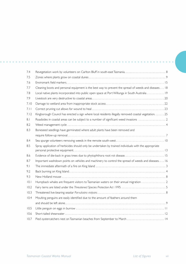
7.4 Revegetation work by volunteers on Carlton Bluff in south-east Tasmania . . . . . . . . . . . . . . . . . . . . . . . . . . . . . 8
7.5 Zones where plants grow on coastal dunes . . . . . . . . . . . . . . . . . . . . . . . . . . . . . . . . . . . . . . . . . . . . . . . . . . . . . . 9
7.6 Enviromark field markers . . . . . . . . . . . . . . . . . . . . . . . . . . . . . . . . . . . . . . . . . . . . . . . . . . . . . . . . . . . . . . . . . . . . . 15
7.7 Cleaning boots and personal equipment is the best way to prevent the spread of weeds and diseases . . . 18
7.8 Local native plants incorporated into public open space at Port Willunga in South Australia . . . . . . . . . . . . 19
7.9 Livestock are very destructive to coastal areas . . . . . . . . . . . . . . . . . . . . . . . . . . . . . . . . . . . . . . . . . . . . . . . . . . . 20
7.10 Damage to wetland area from inappropriate stock access . . . . . . . . . . . . . . . . . . . . . . . . . . . . . . . . . . . . . . . . . 22
7.11 Correct pruning cut allows for wound to heal . . . . . . . . . . . . . . . . . . . . . . . . . . . . . . . . . . . . . . . . . . . . . . . . . . . 23
7.12 Kingborough Council has erected a sign where local residents illegally removed coastal vegetation. . . . . . . 25
8.1 Roadsides in coastal areas can be subject to a number of significant weed invasions . . . . . . . . . . . . . . . . . . . 2
8.2 Weed management cycle . . . . . . . . . . . . . . . . . . . . . . . . . . . . . . . . . . . . . . . . . . . . . . . . . . . . . . . . . . . . . . . . . . . . . 4
8.3 Boneseed seedlings have germinated where adult plants have been removed and
require follow-up removal . . . . . . . . . . . . . . . . . . . . . . . . . . . . . . . . . . . . . . . . . . . . . . . . . . . . . . . . . . . . . . . . . . . . . 7
8.4 Sea spurge volunteers removing weeds in the remote south-west . . . . . . . . . . . . . . . . . . . . . . . . . . . . . . . . . . 10
8.5 Spray application of herbicides should only be undertaken by trained individuals with the appropriate personal protective equipment . . . . . . . . . . . . . . . . . . . . . . . . . . . . . . . . . . . . . . . . . . . . . . . . . . . . . . . . . . . . . . . . 13
8.6 Evidence of die-back in grass trees due to phytophthora root rot disease . . . . . . . . . . . . . . . . . . . . . . . . . . . . 15
8.7 Important washdown points on vehicles and machinery to control the spread of weeds and diseases . . . . 16
9.1 The immediate aftermath of a fire on King Island . . . . . . . . . . . . . . . . . . . . . . . . . . . . . . . . . . . . . . . . . . . . . . . . . 3
9.2 Back burning on King Island . . . . . . . . . . . . . . . . . . . . . . . . . . . . . . . . . . . . . . . . . . . . . . . . . . . . . . . . . . . . . . . . . . . . 4
9.3 New Holland mouse . . . . . . . . . . . . . . . . . . . . . . . . . . . . . . . . . . . . . . . . . . . . . . . . . . . . . . . . . . . . . . . . . . . . . . . . . 8
10.1 Humpback whales are frequent visitors to Tasmanian waters on their annual migration . . . . . . . . . . . . . . . . . 2
10.2 Fairy terns are listed under the Threatened Species Protection Act 1995 . . . . . . . . . . . . . . . . . . . . . . . . . . . . . . . 5
10.3 Threatened live-bearing seastar Parvulastra vivipara . . . . . . . . . . . . . . . . . . . . . . . . . . . . . . . . . . . . . . . . . . . . . . . . 8
10.4 Moulting penguins are easily identified due to the amount of feathers around them
and should be left alone . . . . . . . . . . . . . . . . . . . . . . . . . . . . . . . . . . . . . . . . . . . . . . . . . . . . . . . . . . . . . . . . . . . . . . . 9
10.5 Little penguin on eggs in burrow . . . . . . . . . . . . . . . . . . . . . . . . . . . . . . . . . . . . . . . . . . . . . . . . . . . . . . . . . . . . . . 11
10.6 Short-tailed shearwater . . . . . . . . . . . . . . . . . . . . . . . . . . . . . . . . . . . . . . . . . . . . . . . . . . . . . . . . . . . . . . . . . . . . . . 12
10.7 Pied oystercatchers nest on Tasmanian beaches from September to March . . . . . . . . . . . . . . . . . . . . . . . . . . 14
Tasmanian Coastal Works Manual List of figures vii

10.8 Bar-tailed godwits travel over 10 000 km from their breeding grounds in the northern hemisphere . . . . . 15
10.9 Shorebird nests are simple scrapes in the sand and difficult to detect . . . . . . . . . . . . . . . . . . . . . . . . . . . . . . . 17
10.10 Australian fur seals are curious animals and as such risk becoming entangled in marine debris . . . . . . . . . . . 20
10.11 A mass whale stranding . . . . . . . . . . . . . . . . . . . . . . . . . . . . . . . . . . . . . . . . . . . . . . . . . . . . . . . . . . . . . . . . . . . . . . 22
10.12 These penguins were killed by dogs . . . . . . . . . . . . . . . . . . . . . . . . . . . . . . . . . . . . . . . . . . . . . . . . . . . . . . . . . . . 25
10.13 Northern Pacific seastar collection is an ongoing process but can maintain some coastal areas free of the seastar pest . . . . . . . . . . . . . . . . . . . . . . . . . . . . . . . . . . . . . . . . . . . . . . . . . . . . . . . . . . . . . . . . . . . . . . . . . . . . . 26
10.14 Boat hull cleaning removes marine pests but the wash water needs to be contained and treated at the boat facility . . . . . . . . . . . . . . . . . . . . . . . . . . . . . . . . . . . . . . . . . . . . . . . . . . . . . . . . . . . . . . . . . . . . . . . . . . . . . 28
11.1 Example of sediment and erosion control measures that should be implemented on construction sites . . . 3
11.2 Construction of coastal road in southern Tasmania . . . . . . . . . . . . . . . . . . . . . . . . . . . . . . . . . . . . . . . . . . . . . . . . 6
11.3 Best practice techniques to minimise erosion when digging trenches . . . . . . . . . . . . . . . . . . . . . . . . . . . . . . . . . 9
11.4 Monosulfidic black ooze . . . . . . . . . . . . . . . . . . . . . . . . . . . . . . . . . . . . . . . . . . . . . . . . . . . . . . . . . . . . . . . . . . . . . . 12
11.5 Blue-green cloudy water is evidence of acid sulfate soil . . . . . . . . . . . . . . . . . . . . . . . . . . . . . . . . . . . . . . . . . . . 13
11.6 Acid damage to bridge . . . . . . . . . . . . . . . . . . . . . . . . . . . . . . . . . . . . . . . . . . . . . . . . . . . . . . . . . . . . . . . . . . . . . . . 15
12.1 Eroded stormwater outlet associated with public access has become a hazard . . . . . . . . . . . . . . . . . . . . . . . . 3
12.2 Inappropriately sited pipeline on beach is hazardous and looks unsightly . . . . . . . . . . . . . . . . . . . . . . . . . . . . . . 4
12.3 Inappropriate siting of stormwater outfall on beach . . . . . . . . . . . . . . . . . . . . . . . . . . . . . . . . . . . . . . . . . . . . . . . 6
12.4 Example of stormwater treatment train strategy for a typical suburban street . . . . . . . . . . . . . . . . . . . . . . . . . 8
12.5 Cornelian Bay integrated stormwater treatment train . . . . . . . . . . . . . . . . . . . . . . . . . . . . . . . . . . . . . . . . . . . . . . 9
12.6 New Town Bay floating litter trap . . . . . . . . . . . . . . . . . . . . . . . . . . . . . . . . . . . . . . . . . . . . . . . . . . . . . . . . . . . . . . 10
12.7 Lauderdale stormwater wetlands . . . . . . . . . . . . . . . . . . . . . . . . . . . . . . . . . . . . . . . . . . . . . . . . . . . . . . . . . . . . . . 10
12.8 The stormwater rain garden is effective and looks great . . . . . . . . . . . . . . . . . . . . . . . . . . . . . . . . . . . . . . . . . . . 10
12.9 The Sorell causeway bisects Pittwater-Orielton Lagoon, a Ramsar site in south-east Tasmania . . . . . . . . . . . 13
12.10 Small-scale private crossing over saltmarsh area - whilst in poor condition, it does allow the free passage of water . . . . . . . . . . . . . . . . . . . . . . . . . . . . . . . . . . . . . . . . . . . . . . . . . . . . . . . . . . . . . . . . . . . . . . . . . . . . 16
12.11 Inappropriate culvert is sited poorly and does not allow passage of fish at low flows . . . . . . . . . . . . . . . . . . 18
12.12 Wherever possible box culverts are best as they can accommodate high flows and are open at the bottom to allow for natural sediment beds . . . . . . . . . . . . . . . . . . . . . . . . . . . . . . . . . . . . . . . . . . . . . . . . . . . . . 19
Tasmanian Coastal Works ManualList of figuresviii

13.1 A coastal road in south-east Tasmania maintained by the local council . . . . . . . . . . . . . . . . . . . . . . . . . . . . . . . . 2
13.2 Cleaning soil and plant material off vehicles before entering and leaving sites will minimise spread of weeds and diseases . . . . . . . . . . . . . . . . . . . . . . . . . . . . . . . . . . . . . . . . . . . . . . . . . . . . . . . . . . . . . . . . . . . . . . . . . . 5
13.3 Erosion due to vehicle access across sandy areas can be managed with board-and-chain installations (sand ladders) . . . . . . . . . . . . . . . . . . . . . . . . . . . . . . . . . . . . . . . . . . . . . . . . . . . . . . . . . . . . . . . . . . . . . . . . . . . . . . . 7
13.4 Car park at Sandy Bay’s Long Beach incorporating bollards, large rocks and landscaping with native vegetation, is both functional and attractive . . . . . . . . . . . . . . . . . . . . . . . . . . . . . . . . . . . . . . . . . . . . . . . . . 8
13.5 Damage to sand dunes at Sandy Cape on Tasmania’s west coast . . . . . . . . . . . . . . . . . . . . . . . . . . . . . . . . . . . . 9
13.6 Coastal path at Bellerive designed for multi-use . . . . . . . . . . . . . . . . . . . . . . . . . . . . . . . . . . . . . . . . . . . . . . . . . . 12
13.7 Laying geotextile helps to protect Aboriginal heritage material by minimising future
disturbance of the midden . . . . . . . . . . . . . . . . . . . . . . . . . . . . . . . . . . . . . . . . . . . . . . . . . . . . . . . . . . . . . . . . . . . . 14
13.8 Crossing upgrade on Alum Cliffs track . . . . . . . . . . . . . . . . . . . . . . . . . . . . . . . . . . . . . . . . . . . . . . . . . . . . . . . . . . 16
13.9 Boardwalk at Windermere Bay protecting fragile coastal vegetation . . . . . . . . . . . . . . . . . . . . . . . . . . . . . . . . . 18
13.10 Steps encroached on by erosion were becoming unsafe and have since been removed . . . . . . . . . . . . . . . . 19
13.11 Steps require regular maintenance . . . . . . . . . . . . . . . . . . . . . . . . . . . . . . . . . . . . . . . . . . . . . . . . . . . . . . . . . . . . . 20
13.12 Gravel and timber step design . . . . . . . . . . . . . . . . . . . . . . . . . . . . . . . . . . . . . . . . . . . . . . . . . . . . . . . . . . . . . . . . 21
13.13 Pedestrian sand ladder minimises erosion of the dune . . . . . . . . . . . . . . . . . . . . . . . . . . . . . . . . . . . . . . . . . . . . 22
13.14 A lookout platform of stone and gravel was built to protect a shell midden at Redbill Point, Bicheno . . . . . 23
13.15 The viewing platform at Turners Beach incorporates mesh flooring to allow water, air, sand and light to penetrate to the vegetation below . . . . . . . . . . . . . . . . . . . . . . . . . . . . . . . . . . . . . . . . . . . . . . . . . . . . . . 24
13.16 The Mega Anchor design minimised disturbance of the dune during installation . . . . . . . . . . . . . . . . . . . . . . . 24
13.17 Large rocks and bollards can be used to stop vehicle access onto a walking track . . . . . . . . . . . . . . . . . . . . . 26
13.18 A simple dripline fence can act as a psychological barrier to keep people off fragile dune areas . . . . . . . . . 29
13.19 This poorly maintained coastal fencing looks unsightly and has become a hazard to the public . . . . . . . . . . 30
13.20 Some skilled and experienced fencing contractors offer fencing workshops to land managers and community groups . . . . . . . . . . . . . . . . . . . . . . . . . . . . . . . . . . . . . . . . . . . . . . . . . . . . . . . . . . . . . . . . . . . . . . . . . . 30
13.21 Each track marker is colour coded to make it easy for users to identify the track they want . . . . . . . . . . . . 31
13.22 Signs can provide important information and look great at the same time . . . . . . . . . . . . . . . . . . . . . . . . . . . 33
13.23 Some coastal facilities such as boat ramps require important information to be available
to the public, but too many signs can look cluttered . . . . . . . . . . . . . . . . . . . . . . . . . . . . . . . . . . . . . . . . . . . . . . 35
13.24 A sign at Park Beach encourages people to respect the area . . . . . . . . . . . . . . . . . . . . . . . . . . . . . . . . . . . . . . . 36
13.25 Signs can be a work of art like this bird sign at Medeas Cove in St Helens . . . . . . . . . . . . . . . . . . . . . . . . . . . 36
Tasmanian Coastal Works Manual List of figures ix

14.1 Structures in recreational areas of coastal landscapes are a necessary part of providing services . . . . . . . . . 4
14.2 The boat ramp at Ulverstone has a floating pontoon . . . . . . . . . . . . . . . . . . . . . . . . . . . . . . . . . . . . . . . . . . . . . 6
14.3 Small private skids and boat sheds are common on many of Tasmania’s beaches . . . . . . . . . . . . . . . . . . . . . . . 7
14.4 Waste management and treatment of liquid wastes from slipways . . . . . . . . . . . . . . . . . . . . . . . . . . . . . . . . . . 15
14.5 An unsightly concrete toilet has become a mosaic work of art thanks to a local artist working with the local school community . . . . . . . . . . . . . . . . . . . . . . . . . . . . . . . . . . . . . . . . . . . . . . . . . . . . . . . . . . . . . . . . . . . . . . 18
15.1 The effects of a groyne on sediment flow, deposition and erosion . . . . . . . . . . . . . . . . . . . . . . . . . . . . . . . . . . . 3
15.2 The effects of a breakwater on sediment flow, deposition and shoreline erosion . . . . . . . . . . . . . . . . . . . . . . . 4
15.3 An offshore breakwater encourages deposition on the beach . . . . . . . . . . . . . . . . . . . . . . . . . . . . . . . . . . . . . . . 5
15.4 A seawall with blocks that extend outwards to create habitats for a variety of organisms. . . . . . . . . . . . . . . . 9
15.5 Best practice rock revetment that is aesthetically pleasing and provides intertidal habitat
at Bobbin Head, Cowan Creek, Hawkesbury River, NSW . . . . . . . . . . . . . . . . . . . . . . . . . . . . . . . . . . . . . . . . . . 10
15.6 Revetment degradation . . . . . . . . . . . . . . . . . . . . . . . . . . . . . . . . . . . . . . . . . . . . . . . . . . . . . . . . . . . . . . . . . . . . . . 11
15.7 Rock revetment incorporating bench for saltmarsh and tidepool area . . . . . . . . . . . . . . . . . . . . . . . . . . . . . . . 12
15.8 Rock revetment with bench in Claydon Reserve, Kogarah Bay, Georges River, NSW . . . . . . . . . . . . . . . . . . . 13
15.9 The rock revetment at Raspins Beach on the east coast has trapped sand and is stabilised by vegetation . 14
15.10 Geotextile sand container revetment at Blythe Heads in north-west Tasmania . . . . . . . . . . . . . . . . . . . . . . . . 15
15.11 An example of construction details provided by the manufacturer for a
geotextile sand container revetment . . . . . . . . . . . . . . . . . . . . . . . . . . . . . . . . . . . . . . . . . . . . . . . . . . . . . . . . . . . 16
Tasmanian Coastal Works ManualList of figuresx

List of tables
1.1 Approval processes for coastal management activities . . . . . . . . . . . . . . . . . . . . . . . . . . . . . . . . . . . . . . . . . . . . 13
2.1 Mapped data sets for the Coastal Values data projects . . . . . . . . . . . . . . . . . . . . . . . . . . . . . . . . . . . . . . . . . . . . . 9
2.2 Where to find climate change information throughout the Manual . . . . . . . . . . . . . . . . . . . . . . . . . . . . . . . . . 12
3.1 Example of a component of the risk assessment template . . . . . . . . . . . . . . . . . . . . . . . . . . . . . . . . . . . . . . . . . . 8
3.2 Risk assessment tools currently available . . . . . . . . . . . . . . . . . . . . . . . . . . . . . . . . . . . . . . . . . . . . . . . . . . . . . . . . 10
6.1 List of Tasmanian Ramsar wetlands . . . . . . . . . . . . . . . . . . . . . . . . . . . . . . . . . . . . . . . . . . . . . . . . . . . . . . . . . . . . . 20
7.1 Recommended places to plant species on coastal dunes . . . . . . . . . . . . . . . . . . . . . . . . . . . . . . . . . . . . . . . . . . 10
7.2 Zones where native plants grow on headlands and cliffs . . . . . . . . . . . . . . . . . . . . . . . . . . . . . . . . . . . . . . . . . . 12
8.1 Weed control methods and timing for the southern temperate zone . . . . . . . . . . . . . . . . . . . . . . . . . . . . . . . . 8
9.1 Fire intervals for different coastal vegetation types for fire hazard reduction burns . . . . . . . . . . . . . . . . . . . . . 6
10.1 Examples of threatened coastal fauna in Tasmania, their current status and key threats . . . . . . . . . . . . . . . . . . 4
10.2 Migratory bird species that make the annual migration to Tasmania over the northern hemisphere winter 16
13.1 Track classifications for Australian tracks . . . . . . . . . . . . . . . . . . . . . . . . . . . . . . . . . . . . . . . . . . . . . . . . . . . . . . . . 15
13.2 Comparison of dune fence types . . . . . . . . . . . . . . . . . . . . . . . . . . . . . . . . . . . . . . . . . . . . . . . . . . . . . . . . . . . . . . 28
List of case studies
1.1 Pitt Water-Orielton Lagoon Ramsar site – an example of the complexity of managing coastal areas . . . . . . . 7
3.1 Recreational boat sinking at Seaport, Launceston, in January 2010 . . . . . . . . . . . . . . . . . . . . . . . . . . . . . . . . . . 14
8.1 Weed management on Tasmania’s south & west coasts Sea Spurge Remote Areas Teams . . . . . . . . . . . . . . 10
10.1 Protecting threatened seastars during construction works in south-east Tasmania . . . . . . . . . . . . . . . . . . . . . . 8
12.1 Water Sensitive Urban Design – Cornelian Bay . . . . . . . . . . . . . . . . . . . . . . . . . . . . . . . . . . . . . . . . . . . . . . . . . . . 9
12.2 Water Sensitive Urban Design - New Town Bay . . . . . . . . . . . . . . . . . . . . . . . . . . . . . . . . . . . . . . . . . . . . . . . . . 10
12.3 Stormwater wetlands – Lauderdale . . . . . . . . . . . . . . . . . . . . . . . . . . . . . . . . . . . . . . . . . . . . . . . . . . . . . . . . . . . . 10
12.4 Small bioretention basin in North Hobart . . . . . . . . . . . . . . . . . . . . . . . . . . . . . . . . . . . . . . . . . . . . . . . . . . . . . . 10
13.1 Track redevelopment at Alum Cliffs, Kingborough, southern Tasmania . . . . . . . . . . . . . . . . . . . . . . . . . . . . . . . 16
13.2 Minimal impact viewing platform design . . . . . . . . . . . . . . . . . . . . . . . . . . . . . . . . . . . . . . . . . . . . . . . . . . . . . . . . 24
13.3 Non-fencing access control using trail markers at Southern Beaches . . . . . . . . . . . . . . . . . . . . . . . . . . . . . . . . 31
15.1 Raspins Beach revetment . . . . . . . . . . . . . . . . . . . . . . . . . . . . . . . . . . . . . . . . . . . . . . . . . . . . . . . . . . . . . . . . . . . . . 14
List of tables and case studies
Tasmanian Coastal Works Manual List of tables and case studies xi

Tasmanian Coastal Works Manualxiv

Tasmania’s coast is a valuable and
irreplaceable asset with diverse and sensitive
natural and cultural values that require
protection. Coastal landscapes of dunes,
beaches, rocky shorelines, coastal wetlands,
estuaries and saltmarshes support important
vegetation communities and wildlife habitat.
Tasmania’s coast is also rich in Aboriginal
heritage values and an important part of
contemporary Aboriginal culture.
Diverse and significant coastal wildlife, including migratory shorebirds and waders stopover on Tasmanian wetlands, and shorebird species, hardly seen on mainland Australia, nest on more remote beaches. The cool temperate coastal waters contain significant marine communities including vast seagrass beds, kelp forests and a very high level of endemism (species only found here).
In the past, Tasmania’s coastline has hosted industries and economies ranging from shipping and transport, whaling and sealing, through to mining of lime. Today coastal areas provide essential port infrastructure and are critical to transport and shipping operations. A number of heavy industries have been established on the coast, primarily to make use of the supply of water for cooling, and other industries such as fishing and aquaculture are intrinsically reliant on coastal areas.
Beautiful or iconic stretches of coastline are often the site of tourism ventures and developments such as resorts, caravan parks and golf courses. Extensive coastal areas adjacent to our cities and towns are prime real estate for coastal subdivisions whilst more remote locations often have coastal shack communities.
Tasmanians are fortunate to have such an abundance and variety of coastal areas to enjoy for recreation, and they have a long association with living and recreating on the coast.
Greater evidence of climate change and sea level rise on coastal environments in Tasmania is expected to emerge during this century. Many stretches of Tasmania’s coastline already experience occasional inundation, and shoreline erosion events are becoming more frequent and widespread.
With the risks of inundation, erosion and recession already increasing, the management of natural and built assets needs to adapt to this threat. Climate change and sea level rise must now be considered
Introduction
Tasmanian Coastal Works Manual Introduction 1
Tab photo: Friendly Beaches dunes, east coast of Tasmania. © Leah Page.

when planning and carrying out any management or development activity in the coastal zone to manage the coast sustainably.
The coast is under pressure from human use including modifications of shoreline areas for industry and development, the removal of native vegetation, introduction of weeds, and the introduction of pollutants and excess nutrients into estuaries. The vulnerability of coastal systems to climate change is exacerbated by increasing human-induced pressures in the coastal zone (DPIPWE 2010).
The intention of this manual is to help land managers to manage coastal environments for the protection of coastal values into the future, to ensure that works practices do not impact on coastal values and to encourage coastal works that are effective and of the highest environmental standard.
The Manual will also help land managers to better understand and address the possible on-ground consequences of climate change and sea level rise.
Planning and understanding coastal land management legislation and frameworks prior to starting works is important, to save time, effort and money while doing a good job. Approvals and permits are required for most works on the coast. Follow-up inspections are advisable, to find out whether the works are successful and if maintenance is required.
Using this manual and other recommended resources, land managers will be better informed to plan the most suitable approach for the type and scale of the work being undertaken, taking into account the unique characteristics of each coastal area.
Purpose of the Manual
This manual and the accompanying guidelines provide practical information and guidance on the sustainable management of Tasmania’s coast for council staff (e.g. parks and reserve managers, engineers and planners), other on-ground coastal managers, work crew leaders and contractors. This information will help avoid unnecessary damage and make rehabilitation of coastal areas more effective.
The Manual gives guidance on which environmental management issues should be considered and how to minimise the risk of causing environmental damage and impacts on coastal values. It contains information on identifying coastal values and assets and seeking assessments and approvals. It also summarises the main legal and policy obligations for protecting coastal areas and provides sources of further information.
The Manual covers both construction and ongoing maintenance for small to medium-scale coastal management activities (including those classified as Level 1 under the Environmental Management and Pollution Control Act 1994).
The planning and approval process for industrial development and coastal subdivisions is beyond the scope of this manual. Land managers, however, have a responsibility to ensure that developments in the coastal zone minimise impacts on coastal values both during their construction and over their life span.
Managers of aquaculture facilities, golf courses, caravan parks and resorts can improve their environmental standards by following the best practice ideas throughout this manual such as maintaining native vegetation, removing weeds, protecting wildlife habitat and cultural heritage values, and reducing sediment and pollution run-off into waterways.
Introduction Tasmanian Coastal Works Manual2

How to use the Manual
The Manual is organised into 15 chapters accompanied by a series of guidelines and checklists on specific management issues or approaches that complement some chapters. These can be found at the back of the manual. Each chapter is numbered independantly to make future updates easier.
The Manual provides information on climate change impacts as they relate to specific issues. Most chapters also have a climate change section that summarises this information, where available.
Some chapters provide design and siting guidelines (where appropriate) and others contain information on key issues to consider in order to attain best practice standards. Wherever possible, case studies illustrate successful approaches to best practice coastal management techniques.
Each chapter, except Chapter 1, has a ‘Tools and resources’ section at the end of chapter to direct users to documents, maps and other resources. Website addresses are provided wherever possible. All tools and resources are also collated in Appendix 5.
Complete citations of all documents referred to in the text and listed in the tools and resources sections are provided in a reference list at the end of the manual.
Guidance for minor works undertaken by community groups is available in the Community Coastcare handbook (Thorp 2005).
Chapter overview
Chapter 1 Working on the coast
Contributors : Kathy Noble (Coastal and Marine Branch, DPIPWE), Mike Pemberton (Biodiversity Conservation Branch, DPIPWE)
Background on understanding local coastal processes (interactions of wind, waves, tides and currents) on both hard and soft elements of the changing and dynamic coastline.
Chapter 2 Climate change and the coast
Contributors: Chris Rees (Coastal and Marine Branch, DPIPWE), Chris Sharples (Consultant)
An overview of the latest climate change information, predictions for Tasmania, and some of the implications of these changes for Tasmania’s coastal environment
Chapter 3 Coastal hazards
Contributors: Chris Rees (Coastal and Marine Branch, DPIPWE), Jocelyn Phillips (Coastal and Marine Branch, DPIPWE)
Information about risk management and common coastal hazards such as storm damage and oil spills.
Chapter 4 Community values
Contributors: Kristy Blackburn (Southern Coastcare Association of Tasmania), Anna Wind (Cradle Coast NRM), Sally and Chris Johns (Southern Beaches Landcare & Coastcare Inc)
Working with the community, effective consultation and understanding social and recreational values of coastal areas.
Chapter 5 Cultural heritage management
Contributors: Elizabeth Tew (Aboriginal Heritage Tasmania), Ester Guerzoni (Heritage Tasmania)
Tasmanian Coastal Works Manual Introduction 3

Cultural heritage values, how to protect them and how to work with the Aboriginal community to manage Aboriginal heritage values.
Chapter 6 Coastal landscape management
Contributors: Chris Rees (Coastal and Marine Branch, DPIPWE), Chris Sharples (Consultant), Vishnu Prahalad (University of Tasmania), Jason Bradbury (Land Conservation Branch, DPIPWE)
An overview of the range of Tasmanian coastal landscapes and some key management practices to protect coastal landscapes and landforms.
Chapter 7 Vegetation management
Contributors: Tim Rudman (Biodiversity Conservation Branch, DPIPWE), Anthony Reid (Biodiversity Conservation Branch, DPIPWE), Christine Corbett (Greening Australia)
Information about the conservation and management of natural coastal vegetation.
Chapter 8 Weed and disease management
Contributors: Mike Askey-Doran (Land Conservation Branch, DPIPWE), Karen Stewart (Land Conservation Branch, DPIPWE), Tim Rudman (Biodiversity Conservation Branch, DPIPWE), Sandy Leighton (Southern Tasmanian Councils Authority)
Information about preventing the spread of weeds and diseases whilst undertaking coastal land management activities.
Chapter 9 Fire management
Contributors: Sandra Whight (Parks and Wildlife Service, DPIPWE)
The role of fire in coastal ecosystems and fire hazard reduction works.
Chapter 10 Wildlife and pest management
Contributors: Rosemary Gales (Biodiversity Conservation Branch, DPIPWE), Anthony Reid (Biodiversity Conservation Branch, DPIPWE), Richard Schahinger (Biodiversity Conservation Branch, DPIPWE), Alistair Morton (Marine Farming, DPIPWE), Eric Woehler (Birds Tasmania)
Information about protecting wildlife habitat and values and threatened species and managing feral animals and marine pests.
Chapter 11 Soil management and earthworks
Contributors: John Chrispijn (Derwent Estuary Program), Rob Moreton (Land Management Branch, DPIPWE), Chris Grose (Land Management Branch, DPIPWE), Regan Parkinson (Land Management Branch, DPIPWE)
Information on best practice excavation works, soil and water management plans and protecting against acid sulfate soil contamination.
Chapter 12 Stormwater and crossings
Contributors: John Chrispijn (Derwent Estuary Program)
Information on stormwater and crossings and how to minimise impacts on coastal ecosystems and values.
Chapter 13 Access management
Contributors: Lynne Sparrow (Parks and Wildlife Service, DPIPWE), Stuart Dudgeon (Parks and Wildlife Service, DPIPWE), Richard Greenhill (Hobart City Council), Jennifer Burdon (Parks and Wildlife Service, DPIPWE)
Best practice techniques for designing and constructing and maintaining roads, tracks and access infrastructure, including signs.
Chapter 14 Structures and facilities
Contributors (Julie Woolley, Marine and Safety Tasmania)
Introduction Tasmanian Coastal Works Manual4
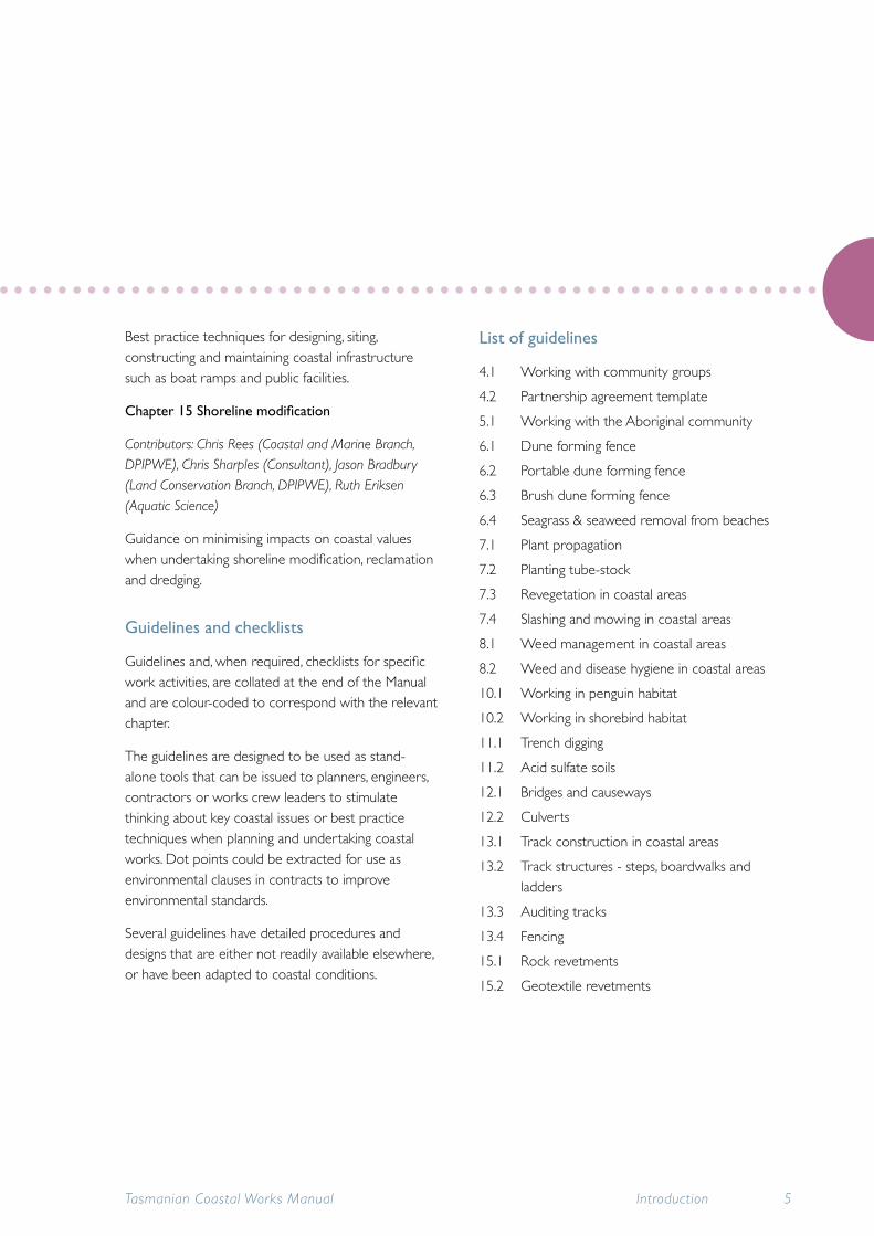
Best practice techniques for designing, siting, constructing and maintaining coastal infrastructure such as boat ramps and public facilities.
Chapter15Shorelinemodification
Contributors: Chris Rees (Coastal and Marine Branch, DPIPWE), Chris Sharples (Consultant), Jason Bradbury (Land Conservation Branch, DPIPWE), Ruth Eriksen (Aquatic Science)
Guidance on minimising impacts on coastal values when undertaking shoreline modification, reclamation and dredging.
Guidelines and checklists
Guidelines and, when required, checklists for specific work activities, are collated at the end of the Manual and are colour-coded to correspond with the relevant chapter.
The guidelines are designed to be used as stand-alone tools that can be issued to planners, engineers, contractors or works crew leaders to stimulate thinking about key coastal issues or best practice techniques when planning and undertaking coastal works. Dot points could be extracted for use as environmental clauses in contracts to improve environmental standards.
Several guidelines have detailed procedures and designs that are either not readily available elsewhere, or have been adapted to coastal conditions.
List of guidelines
4.1 Working with community groups
4.2 Partnership agreement template
5.1 Working with the Aboriginal community
6.1 Dune forming fence
6.2 Portable dune forming fence
6.3 Brush dune forming fence
6.4 Seagrass & seaweed removal from beaches
7.1 Plant propagation
7.2 Planting tube-stock
7.3 Revegetation in coastal areas
7.4 Slashing and mowing in coastal areas
8.1 Weed management in coastal areas
8.2 Weed and disease hygiene in coastal areas
10.1 Working in penguin habitat
10.2 Working in shorebird habitat
11.1 Trench digging
11.2 Acid sulfate soils
12.1 Bridges and causeways
12.2 Culverts
13.1 Track construction in coastal areas
13.2 Track structures - steps, boardwalks and ladders
13.3 Auditing tracks
13.4 Fencing
15.1 Rock revetments
15.2 Geotextile revetments
Tasmanian Coastal Works Manual Introduction 5

Appendices, Glossary and References
Appendix 1: Sets out the legislation and policy requirements for coastal management.
Appendix 2: Organises the legislation according to work activity areas.
Appendix 3: Where to obtain information; contact details for key organisations.
Appendix 4: Lists useful community and non-government organisations.
Appendix 5: Lists useful tools and products, organised by activity area.
A glossary, list of acronyms and references can be found at the end of the Manual.
Tasmanian Coastal Works Manual6 Introduction