Embed Size (px)
Citation preview

UC BerkeleyArchaeological Research Facility Stahl Reports
TitleTaraco Archaeological Project Report on 2003 Excavations at Kala Uyuni
Permalinkhttps://escholarship.org/uc/item/8d35b0ns
AuthorsBandy, MatthewHastorf, Christine A.Steadman, Leeet al.
Publication Date2004-05-18
eScholarship.org Powered by the California Digital LibraryUniversity of California

����������� ��� ���������������������������������� !���"��#�� $�&%('�)�)�* +�,����.-/�� 0���1%/23�� 54#����� 617�8�% �
Matthew Bandy, Christine Hastorf, Lee SteadmanKatherine Moore, Melissa Goodman Elgar, William Whitehead
Jose Luis Paz, Amanda Cohen, Maria Bruno, Andrew Roddick, Kirk Frye, MariaSoledad Fernadez, Jose Capriles Flores, Mary Leighton
Report submitted to the Unidad Nacional de Arqueología de BoliviaMay 18, 2004
1

9;:=<�>@?BADCFE&A�GDHI?=GDH�J1.Kala Uyuni: An Early Political Center in the Southern Titicaca Basin......................5
Taraco Peninsula Culture History.............................................................................6The Taraco Peninsula Polity.....................................................................................8Kala Uyuni................................................................................................................9This Volume............................................................................................................11
2.Mapping, Photography, Database ............................................................................13Mapping..................................................................................................................13
Methodology......................................................................................................13Results................................................................................................................14
Database..................................................................................................................15Methodology and Design...................................................................................15Implementation...................................................................................................16Results................................................................................................................16
Photography............................................................................................................163.Excavations in the AQ (Ayrampu Qontu) Sector ....................................................184.Excavaciones en el Sector KU (Kala Uyuni)............................................................21
Descripción de los Hallazgos..................................................................................22N830/E650.........................................................................................................22N890/E653.........................................................................................................24
Conclusiones...........................................................................................................285.Additional Excavations in the KU Area – N894/E639.............................................346.Excavations in the AC (Achachi Coa Kkollu) Sector ..............................................38
Excavation of ASD-1: The Lower Court:...............................................................40South Wall (Units N964.37/E923.91 and N962/E928)......................................40North Wall (Units N980.4/E928.18 and N979/E935):.......................................41East Wall and Burial #3 (Unit N972/ E933) .....................................................44West Wall (Units N975/ E917 and N975/E 916)...............................................45
Inside ASD-1: ........................................................................................................46Unit N973.6/E928.11 and Unit N968/E921.......................................................46
Unit N968/ E921............................................................................................46Excavation of ASD-3: The Upper Court.................................................................48
West Wall (N1000/E947)...................................................................................48North Wall (N1001/E955)..................................................................................50South Wall (Unit N984/E955)............................................................................51East Wall (N991/E959)......................................................................................53Center Unit (N993/E952.5)................................................................................54
Excavation of the Midden:
2
Units N990/E968 and N979/E957..........................................................................57Discussion...............................................................................................................57Concluding Remarks...............................................................................................59
7.Ceramic Analysis......................................................................................................60Early Chiripa...........................................................................................................61Middle Chiripa .......................................................................................................62Late Chiripa.............................................................................................................65Tiwanaku I..............................................................................................................74
8.Archaeobotany..........................................................................................................80In the field...............................................................................................................80In the laboratory......................................................................................................82
9.Animal Remains from the 2003 Season...................................................................83Research Approaches for Kala Uyuni Bone ..........................................................84
10.Microstratigraphy and Soils Analysis.....................................................................86Introduction.............................................................................................................86Methods...................................................................................................................86Natural Reference Samples (N1, N2)......................................................................87Excavations.............................................................................................................88
Kala Uyuni Area (KU).......................................................................................88Achachi Coa Collu Area (AC)...........................................................................89Ayrampu Qontu Area (AQ)................................................................................91
Ethnoarchaeological Study.....................................................................................92Case Study in the Copralabra Pata Area (CP)....................................................93Methods..............................................................................................................93
Summary.................................................................................................................9411.Acknowledgements.................................................................................................9612.Bibliography...........................................................................................................97
K�LNM O�PQ?.JFigure 1: Map of the Taraco Peninsula..........................................................................6Figure 2: Chronological chart........................................................................................7Figure 3: Contour Map of Coa Kkollu........................................................................13Figure 4: TAP Database Schema.................................................................................15Figure 5: Map of AQ and KU areas.............................................................................18Figure 6: AQ North Profile..........................................................................................19Figure 7: Area AQ Harris Matrix................................................................................20Figure 8: Map of AQ and KU areas.............................................................................21Figure 9: Profile of N830/E650...................................................................................22Figure 10: Plan of ASD-2 Structure............................................................................23Figure 11: Annotated photo of ASD-2 structure from West.......................................24
3

Figure 12: Color-coded Harris Matrix of KU excavations..........................................25Figure 13: Complete KU Harris Matrix.......................................................................26Figure 14: N894/E639 North profile...........................................................................35Figure 15: KUAC sunken courts and excavation units................................................38Figure 16: Harris Matrix for area AC..........................................................................39Figure 17: Unit N962/ E928, East Profile...................................................................41Figure 18: Unit N980.40/ E928.18, East Profile.........................................................42Figure 19: Unit N972/ E933, North Profile.................................................................43Figure 20: Unit N972/ E933, Wall Elevation, Interior................................................44Figure 21: Unit N973/E933, Burial #3 under court floor............................................45Figure 22: Unit N975/E916 and Unit N975/E917 Profile...........................................46Figure 23: N1000/E947, South Profile........................................................................49Figure 24: N1001 E955 West Profile..........................................................................51Figure 25: N984/E955 South Profile...........................................................................52Figure 26: N991/ E959 South Profile..........................................................................53Figure 27: Lightning Stone found between floors.......................................................54Figure 28: N993/E952.5, central monolith, in profile.................................................55Figure 29: N993/E952.5 East Profile...........................................................................56Figure 30: Early and Middle Chiripa Ceramics...........................................................63Figure 31: Middle and Late Chiripa Ceramics............................................................64Figure 32: Late Chiripa Ceramics................................................................................70Figure 33: Late Chiripa Ceramics................................................................................72Figure 34: Late Chiripa Jars.........................................................................................73Figure 35: Tiwanaku I Ceramics.................................................................................76Figure 36: Tiwanaku I Ceramics.................................................................................77
9;:=<�>@?.JTable 1: Flotation samples processed by area.............................................................82
4

RTS�U :V>@:XW/Y�OVG�L[Z]\^G`_�:�Pa>bY3c�A;>dLeHfLhgi:V>jE�?=GkHI?=P�LlGBH�m.?on/A;OpHamp?�P�G9 L@H�LNg�:qgk:Xr�:.JpLsG
Matthew Bandy and Christine Hastorf
The Titicaca Basin of Peru and Bolivia is one of the relatively few regions of theworld that witnessed an episode of primary or pristine (Fried 1967) state formation.This state, the Tiwanaku Polity, has been the focus of ongoing archaeological interestfor the better part of the past century (Albarracin-Jordan 1996; Bennett 1934;Bermann 1994; Janusek 1994; Kolata 1982, 1993; Ponce Sangines 1981, 1995). Ourunderstanding of the processes that lead to the formation of the Tiwanaku state,however, remains poorly developed. This is so despite the fact that research on thelong Formative period that preceded and led to Tiwanaku state formation began veryearly (Bennett 1936; Kidder 1943) and continued at a modest pace throughout the 20th
century (Chavez 1988; Browman 1978, 1980, 1981; Kidder 1955; Ponce Sangines1970; Portugal Ortiz 1992).
In the past decade, however, there has been an explosion of research focused on theTiticaca Basin Formative (see Stanish 2003 for a recent synthesis). A large number ofresearchers have made rapid advances in our understanding of culture history andsocial process in the Titicaca Basin Formative. The Taraco Archaeological Project(TAP) has been a participant in this most recent wave of research activity. Since1992, TAP has conducted excavations at the site of Chiripa. This work has beendesigned to provide a baseline cultural and ceramic chronology for the southernTiticaca Basin, and to identify the key social, economic, ideological and politicalprocesses taking place during the Formative. Our work at Chiripa has resulted in adetailed sequence of ritual architecture spanning the Early and Middle Formativeperiods, and has elucidated the origins and early development of the sunken courtarchitectural form and the Yaya Mama Religious Tradition (Hastorf ed. 1999; Bandy1999; Hastorf 2003) . It has also produced information on the early development ofTiticaca Basin agriculture and subsistence (Bruno and Whitehead 2003). Equallyimportantly, Lee Steadman, the project ceramicist, has produced a robust chronologyof Early and Middle Formative period ceramics (Steadman 1999, 2001).
The work of TAP took a new direction with Bandy's 1998-1999 survey of the TaracoPeninsula (Bandy 2001). Using Steadman's ceramic chronology, Bandy was able todocument the Taraco Peninsula settlement system from 1500 BC through the Spanishconquest. Significantly, this project was one of the first in the Titicaca Basin that wasable to subdivide the Formative period into relatively fine-grained chronological units(see Lemuz 2001 for another chronologically fine-grained settlement analysis).Steadman's ceramic chronology, applied in the context of regional pedestrian survey,
5

permitted us for the first time to study changes and transformations within theFormative period at a regional scale.
The 2003 excavations at Kala Uyuni mark the beginning of a new phase in TAP'sresearch. Our present project builds on questions raised by our long-term research atChiripa in light of the regional data made available by Bandy's survey. We are nowaddressing questions of social change and evolution on a regional scale.
tvuxwyuxz|{~}=�v�i�N�j�|����u������h�l��wf�&�������l{�w��The Taraco Peninsula is a modest spit of land (approximately 100 square kilometersin area) projecting into the Bolivian portion of Lake Titicaca (Figure 1). The spine ofthe peninsula is formed by the Lomas de Taraco, a low range of hills rarely exceeding4000 m.a.s.l. Politically, the peninsula is located within Canton Taraco, IngaviProvince, in the Department of La Paz, Bolivia. It lies approximately 80 km due westof the city of La Paz.
It is a common pattern cross-culturally that early agricultural village populations arenot evenly distributed at a regional scale. Instead, early agricultural village
6
Figure 1: Map of the Taraco Peninsula

populations often seemto be tightly clusteredin a relatively smallarea. Examples of suchearly agriculturalvillage concentrationsinclude the Etlasubvalley of Oaxaca,and the Ixtapalapa areaof the Basin of Mexico.The Taraco Peninsulaappears to have beensuch a concentration. Inthe Early Formative(Early/Middle Chiripaphases, see Figure 2)the population densityon the TaracoPeninsula has beenestimated to be morethan 8 persons persquare kilometer,whereas the Juli-Pomata area at thesame time (for example) had a population density of roughly 1 person per squarekilometer (Bandy 2001: 104).
The settlement dynamic of the Early and Middle Chiripa phases was fundamentallystructured by the process of village fissioning. Bandy has documented that duringthese phases villages grew no larger than about 150 persons. Upon reaching thiscritical population size, the villages would split into two or more smaller villages(Bandy 2004).
In the Late Chiripa phase, however, around 800 BC, villages ceased fissioning andbegan to grow to much larger sizes, up to almost 450 persons in some cases. Thischange in the settlement process took place at about the same time that we see theemergence at Chiripa of the Yaya Mama Religious Tradition, an integrated suite ofartifactual and architectural traits that appear to be related to public ceremonialism.Bandy (2004) and Hastorf (2003) have hypothesized that this public ritual activityserved an integrative function, allowing the formation of much larger communitiesthan was possible in earlier phases.
7
Figure 2: Chronological chart

The Late Chiripa settlement system on the Taraco Peninsula was dominated by fourmajor villages, each with a population of about 400 persons. Together, these fourvillages accounted for more than half the total population of the peninsula at the time.Chiripa was one of the major villages, and Kala Uyuni was another. Each of thesevillages appears to have been politically independent. Three of them, at least, hadtheir own ceremonial precincts with sunken courts. All shared a common politicalculture, of which the Yaya Mama Religious Tradition is the material expression. TheLate Chiripa phase may therefore be characterized as an autonomous village system,with no evidence of regional political hierarchy or the domination of one settlementby another.
t��k��t�u�wyuxz|{�}V�����N�j������u5}D{��N�d�@�This situation changed dramatically at the beginning of the Tiwanaku I phase (Figure1). During this phase most of the old villages on the Taraco Peninsula actuallydecreased in size; they lost population. This was not an episode of depopulation onthe peninsula, however; instead it was an episode of population aggregation. Forwhile most of the old villages were reduced in population, one of the four major LateChiripa phase villages grew very rapidly. This site was Kala Uyuni. During thisphase, Kala Uyuni grew from its Late Chiripa population of about 360, to a TiwanakuI phase maximum of around 900 inhabitants. In this phase, therefore, it grew to bemore than twice as large as any other village on the Taraco Peninsula. For a variety ofreasons, Bandy (2001: 190-196) has interpreted these data as indicating that KalaUyuni achieved political dominance over the other Taraco Peninsula villages. Thepeninsula for the first time was unified politically. While many archaeologists wouldterm this an instance of chiefdom formation, we prefer to use the term multi-community polity formation. Whatever term we use, however, a dramatictransformation had taken place in the history of Titicaca Basin civilization. We callthis new political entity the Taraco Peninsula Polity.
Other episodes of multi-community polity formation seem to gave taken place in thesouthern Titicaca Basin at about this same time. Tiwanaku was first occupied duringthis phase, apparently, and was probably the center of a polity similar to the TaracoPeninsula Polity. Other multi-community polities may have been centered atKallamarka, and at the site of Kanamarka/Lakaya on the Peruvian side of the lakesouth of Yunguyu (Bandy 2001: 196; Stanish et al. 1997:92-93).
Multi-community polity formation was therefore a process that was taking place inmany parts of the Titicaca Basin during the Late Formative. This process, and thepolitical institutions and relations that resulted from it, were certainly implicated inthe process of state formation that resulted in the formation of the Tiwanaku Polity atthe end of the Late Formative. An understanding of multi-community polity
8

formation in the Late Formative Titicaca Basin is clearly necessary for any adequatemodel of Tiwanaku state formation. Furthermore, multi-community polity formationis an example of what Steward (1955: 8) called “phenomena of limited occurrence.”It is a general process that took place in many regions of the world at many differenttimes. A model of multi-community polity formation for the southern Titicaca Basinwill therefore have general anthropological applicability.
For all of these reasons, the current phase of TAP's research is focused on multi-community polity formation, with special reference to the case of the TaracoPeninsula Polity. Our excavations at Kala Uyuni in 2003 were the first of threeplanned seasons of excavations devoted to exploring this research problem.
��u|��u��p�����j�The archaeological site of Kala Uyuni is located in the modern community of CoaKkollu. It is located on the south side of the peninsula between the towns of Taracoand Santa Rosa, as indicated on Figure 1. It was recorded by Bandy in his survey ofthe Taraco Peninsula. Kala Uyuni in fact consists of two separate and distinct sherdscatters, and for this reason it was initially recorded as two sites: T-232 (Kala Uyuni)and T-225 (Achachi Coa Kkollu).
T-225 is a ceramic scatter covering approximately 1.5 ha, and located on a relativelylevel terrace near the top of Cerro Achachi Coa Kkollu (Figure 3). Several workedlimestone blocks are visible on the surface, and the site is characterized by a highdensity of ceramics and other cultural materials. Excavations in 2003, discussed byCohen and Roddick in this report, revealed the presence of two sunken courts in thisarea (Figure 15). The ceramics include a high frequency of decorated sherds, as wellas sherds of exotic styles either imported from the northern Titicaca Basin ormanufacture in imitation of northern wares (Bandy 2001, Figure 6.2c, e, f). Thesunken courts and the unusual ceramic assemblage together led Bandy to propose thatthis was a specialized ritual site of the Late Chiripa phase (2001: 122-123). This fieldassessment has been confirmed by the excavations reported in this volume. Theprincipal occupation of T-225 pertains to the Late Chiripa phase (1.5 ha). Minoroccupations (0.5 ha), without any apparent monumental architectural remains, arealso documented for the Early Chiripa, Middle Chiripa, and Tiwanaku I phases. T-225 is referred to in this report as the Achachi Coa Kkollu sector, the AC area, orKUAC.
T-232 is a much larger ceramic scatter, located at the base of Cerro Achachi CoaKkollu, and southwest of T-225 (Figure 3). The entire scatter extends over some 15ha, covering the area from the base of the hill to the line of the modern road. Theentire area of T-232 is devoted to modern cultivation. There are some topographical
9

features suggestive of mounds or terraces, but these are difficult to read. The area ofthe main Middle and Late Chiripa village (the AQ area, described by Bruno in thisreport) is distinguished by a substantial raised promontory, evident on thetopographical map of the site (Figures 3 and 5). This feature is evidently a tellaccumulation, related to the long-term occupation of that part of the site, and isunrelated to any intentional construction. Some worked limestone blocks are scatteredabout the site, but no monumental architectural constructions are evident on thesurface.
The occupation of T-232 apparently began in the Early Chiripa phase. Thisoccupation was not detected on the surface of the site, but Early Chiripa materialswere encountered at the base of the AQ area excavations. By the Middle Chiripaphase T-232 had become a substantial village, covering 2.5 ha with some 127estimated inhabitants. This influx of population was related to the fissioning andabandonment of the nearby major Early Chiripa village of Cerro Choncaya (T-2)around 1000 BC (Bandy 2004). By the Late Chiripa phase, T-232 had grown to beone of the major villages on the Taraco Peninsula, covering 5.25 ha with 291estimated inhabitants. Combining T-232 with T-225, the Kala Uyuni community wasalmost as large as the contemporary occupation of Chiripa (T-1). Surface indicationssuggested that the Late Chiripa ceramic assemblage from T-232 was entirelydomestic in nature, virtually lacking decorated or specialized wares and forms. Thissuggests that T-232 was a Late Chiripa domestic village, and that the public,ceremonial space associated with that village was located not in the village itself, butrather at T-225, on top of nearby Achachi Coa Kkollu.
In the Tiwanaku I phase, T-232 grew explosively to cover 14.75 ha with an estimated883 inhabitants, becoming by far the largest site on the Taraco Peninsula. It was atthis time that we believe Kala Uyuni became the capitol of the Taraco PeninsulaPolity. The importance of Kala Uyuni in the Tiwanaku I phase is underscored by thefact that we recovered considerable numbers of Kalasasaya zoned-incised sherds fromthe surface (Bandy 2001: 166) and from excavated contexts (see Steadman'scomments in her summary of the ceramics in this volume). These ceramics are veryrare, and seem to occur almost exclusively at Tiwanaku I phase political centers (suchas Kallamarka, Kanamarka/Lakaya, and Tiwanaku itself). The occupation of T-232did not continue through the following Tiwanaku III phase, however. During theTiwanaku III phase the area of the site was reduced to 1.5 ha, quite a small village.The virtual abandonment of the site may reflect the Taraco Peninsula's incorporationinto an expanding Tiwanaku Polity at this time (Bandy 2001: 196-198). A portion ofT-232 was reoccupied in the Tiwanaku IV-V phase, however. At this time KalaUyuni was a substantial village of 5.25 ha, with an estimated population of almost300 persons. Never again, however, did Kala Uyuni achieve the importance it hadenjoyed in the Tiwanaku I phase.
10

Portions of T-232 are referred to in this volume as the KU or AQ areas. Theseexcavation areas (see Figures 3 and 5) account for only a small part, however, of avery large sherd scatter.
t��i������{��h�x�^�
This volume presents the results of the 2003 excavations at Kala Uyuni. The firstchapter, by Whitehead and Frye, provides information on our data processing systemand mapping procedures. There follow a series of chapters describing excavations inthree areas of the site.
Bruno describes excavations in the AQ area, where she excavated a deep, series ofstratified midden deposits of the Early, Middle, and Late Chiripa phases. Sheexcavated within the areas of the Middle and Late Chiripa village occupation. Thematerials from this excavation will provide invaluable data to compare with existingdata from Chiripa.
Paz and Fernandez then describe their excavations in the KU area. Their excavationswere located outside of the area of the Late Chiripa village occupation, but within themuch larger Tiwanaku I site. The most important find in this area was the stonefoundation of a small structure dating to the Tiwanaku I phase. Judging from theassociated artifacts and from the architecture, it would appear that this structureserved a non-domestic function. It may have been part of a larger complex of suchstructures in the KU area, though at the moment we have no firm evidence to thateffect.
Bruno and Leighton then describe their stratigraphic excavations in the KU area, in atrench separate from but close to that of Paz and Fernandez. Importantly, theyrecovered a series of stratified deposits that may contain refuse related to activitiescarried out in the nearby structure excavated by Paz and Fernandez.
Cohen and Roddick continue the excavation report with their account of excavationsin the upper (AC) sector of the site. Their excavation of a large number of unitsdefined two sunken courts, located adjacent to one another on the upper slopes ofCerro Achachi Coa Kkollu. Both of these courts are trapezoidal in plan, and date tothe Late Chiripa phase. Each revealed a complex sequence of construction andremodeling. One of the courts contained a sandstone monolith and a piece of portablestone sculpture in the Yaya Mama style. The other contained a human dedicatoryburial in a construction context. Just as importantly, Cohen excavated a middendeposit associated with the use of the courts. Steadman's ceramic analysis, togetherwith the excavation data, appear to indicate that the AC sector functioned as a
11

spatially distinct ceremonial sector for the Late Chiripa community of Kala Uyuni.This is a finding of great significance, as it should allow us to clearly distinguishpublic/ceremonial from domestic artifactual assemblages in the Lake Chiripa phase.Such a distinction was difficult to demonstrate at Chiripa, since ritual and domesticspaces were immediately adjacent to one another, and ritual and domestic refuse werecommonly intermingled in the same midden deposits.
The volume closes with three chapters providing basic information on specializedanalysis that was carried out in conjunction with the excavations. Steadman's chapterpresents a very informative analysis of ceramics from the 2003 season. This report isvery important for two reasons. First, it represents the first systematic description of aChiripa ceramic assemblage from a southern Titicaca Basin site other than Chiripaitself. We are pleased to say that Steadman's Chiripa chronology appears to be validfor the Early and Middle Formative periods at Kala Uyuni, as well. Secondly, itcontains the first description by TAP of a Late Formative I (Tiwanaku I) ceramicassemblage. In future seasons we expect this description to become formalized, andthe TAP chronology to extend into the Late Formative as well. This is a veryimportant undertaking, since Late Formative ceramics are at present the least wellknown of any period in southern Titicaca Basin prehistory.
Bruno and Whitehead describe the process by which flotation samples were recoveredand processed. Moore and Goodman report progress on zooarchaeological andgeoarchaeological analysis, respectively. Both of these researchers have a long-termcommitment to working with TAP, and both have worked on materials from Chiripain the past. Their work, then, forms part of an ongoing research program. Eachdescribes the work they did in the 2003 season, and provides some preliminaryinformation about their results.
The research reported in this volume is only the beginning of the second phase of theTaraco Archaeological Project's research. We expect to investigate a series of othersites on the Taraco Peninsula over the coming years. Our understanding of Formativeperiod social processes will be greatly refined by these future excavations. Just asimportantly, however, new questions and new interpretive challenges will come tolight; questions that we cannot now anticipate or imagine.
12

�.S�� :.����LsG�M; �c¡mpA=HQA=M P¢:D��miY= p£�:iHQ:D<D:�J�?
William Whitehead and Kirk Frye
TAP uses digital mapping equipment and mapping software to create topographicmaps, excavation maps, and location maps to visually represent the project area. Theuse of these technologies allows us to more accurately pinpoint our excavation unitsand archive our results for future archaeologists. A series of maps (Figures 1, 3, 5, 8,15) show the area of excavations and local excavation units and features. Whiteheadand Frye completed the mapping work during the 2003 field season.
¤�uv¥q¥k���]¦§�¨ª©¬«]T®T�¯°T±|²Equipment: The primary instrument utilized was a Leica TC800, infrared ElectronicDistance Measurement devise (EDM). This equipment allowed the survey team torecord up to 400 points a day in optimal conditions. Measurement error was
13
Figure 3: Contour Map of Coa Kkollu

approximately 1 cm per 100 horizontal meters.
Site Grid: Our first action was to establish a permanent concrete benchmark at thetop of the Cerro Achachi Coa Collu, overlooking the site. This benchmark wasarbitrarily assigned a coordinate of 1000 m North / 1000 m East / 200 m Elevation. Asecond concrete datum was placed 10 m due North from the primary datum, thusmaking it possible to reproduce the orientation of the site grid. During the course ofthe excavations a variety of secondary datum stations were placed about the site tocreate local working areas and to allow backsighting of the EDM as we progressedwith mapping.
Placement of excavation units: The corners of all excavation units were placed asclosely to meter vertices as possible, and all units were oriented to the cardinaldirections. The corners of the excavation units were established using the EDM. Withan accuracy of a few centimeters. The locations of the units on the main map areshown in Figure 3.
Computer techniques: The raw data was entered into Microsoft Excel and thenimported into Surfer 7.0 for map production. The maps were subsequentymanipulated using other drawing programs such as Adobe Illustrator 10 or AdobePhotoshop 7.0.
Predictive models for sunken court excavation: Having an accurate DigitalElevation Map was very helpful in locating and placing excavation units andallowing the accurate placement of units on an excavation grid so the data can bemapped and plotted accurately. The contour map was used to predict were the buriedwalls of the upper structure should be from the location of just a few stones. In thefield it was hard to imagine and measure where the buried walls should be, but usingthe contour map and measurements of the lower court, the upper court walls werelocated by using the lower court as a template. The excavation team was able toplace the units exactly over the North and East walls without having to guess whereto place them. This saved us considerable time in the field.
³=¨x´�µq¯¶©�´The area covered by the site map is approximately 1000 by 600 meters. The map wascreated from approximately 2300 points, covering 48 hectares for an average of onepoint for every 200 square meters. This was sufficient to define the major contoursand to produce a usable map at a 2.5 meter contour interval. With the datum set at anarbitrary 200 meters the lowest elevation was 123.25 meters and the highest 200.31meters. 200 meters of site elevation is roughly equivalent to 3900 meters above sealevel.
14

·�u���u�¸�u¹���The Taraco Archaeological Database was created to store data and to allow in-the-field analysis to be performed on all the excavation information generated during the2003 field season. The database was designed to integrate all the information fromthe excavations as quickly as possible and in an intuitive way. The current databaseis based on 5 years of experience in combining the TAP excavation technique anddatabase design. The database is in a FileMaker 6.0 format and is capable of beingused on both the Windows and Mac platforms. This flexibility was the primary reasonFileMaker was chosen, together with its ease of use and graphical interface.
§�¨ª©º«]�®T�¯°T±x²�»�¼¹®½D¨x´|¾°±k¼The data model is basedon the concept of thelocus and the event justas with the excavationtechniques. Thedatabase schema isshown in Figure X. Theprimary keys are thelocus number, eventnumber, datum number,and graphic number,which are used to trackeach record in the datafiles. The mostimportant data key is thelocus number whichalmost every record inthe data files contain,and using this at theprimary key all materialsand information can be
related to the primary excavation form and to each other. This becomes moreimportant as thousands of records are generated over the course of the excavationseason. There are four main kinds of data in the database: 1) basic excavation data, 2)logs and tracking, 3) artifacts and collections, and 4) graphics and visuals. The basicexcavation data is the Locus form, the Event log, and the Harris Matrix informationderived from the Locus forms and Event log. The Logs and Tracking Informationarea contains all the information needed to maintain control over the thousands ofphotographs, artifacts and sample bags, and location data generated during the dig.
15
Figure 4: TAP Database Schema

The primary files are Artifact Bag Tracking, Sample Collections Tracking,Elevations, and Photography logs. The Artifacts collected during the excavations(Ceramics, Lithics, Faunal Remains, Soils, Human Remains, and Flotation samples)are given to the specialist teams to process and analyze. These data files are linked tothe main database by the locus number, and are under the control of each specialistteam. All the graphics and visuals are stored and tracked in their own separate areaand represent thousands of files of photographs, scans, and hand drawn graphics. Allof these are tracked with the locus number and are linked to the main locus file.
¿hÀ�Á�¯�¨�À�¨]¼|©�»]©[¾�k¼All of the written data on the locus forms was entered into the database in the field,along with all the individual logs. This was not only convenient but also necessaryfor creating accurate lists and catalogs for local and national authorities. The fielddata was also useful for laboratory analysis.
³=¨x´�µq¯¶©�´The total amount of data produced was substantial. The database for 2003 isapproximately 5.04 Gigabytes and contains 3,274 files. The locus file contains 402records, and is 1.04 Megabytes of data. There were 230 events defined, 757 LocusHarris Matrix relationships records, 606 Event Harris Matrix relationships, 1193artifact bags were tracked, 1098 piece plotted collections made (soils, flotationsamples, and special finds), 2000 excavation elevations, 2368 digital photos, andanother 1900 slide and black and white photos were taken. Because there were notonly paper backups but also digital backups recorded on CDR media, TAP was ableto leave the field with all the information in a secure and archived format.
}.��{T�l{�¦DwyuÂ¥D�x�TAP uses photography extensively to document its excavations. Three formats ofrecording media were used in 2003: 35mm positive color slide film (Kodak E100 –ISO 100), 35mm black and white negative film (Ilford Pan 100 - ISO 100), anddigital imaging (4 Megapixel) were used. The basic strategy was to take at least onephotograph of each format for every locus excavated and multiple photographs forimportant finds. In addition, artifacts were often photographed in the field.
Each roll of film was given a number or letter designation (numbers for color slidefilm and letters for black and white) and this information was used to log the photostaken in the field on the locus forms and in a separate photo log book. Digital photoswere indexed by the date only, since these images were available to be usedimmediately.
16

Once developed, the color slides were mounted in plastic slide holders and stored inpolypropylene archive binder pages. The black and white film was cut into fiveframe strips and stored in polypropylene binder pages. Backup CDs were createdevery week to ensure that digital photos would not be lost if the main computer wereto be damaged.
Using these techniques some 2300 digital images were captured, and 1900 black andwhite negative and color slides were made (approximately 4 for each locus). Sinceeverything was photographed using both digital and physical media, TAP has thesecurity of having permanent image storage (film) and easily transferred andmanipulated images for use in documents and in the database (digital). In the futurewe plan to extend our use of digital photography to the documentation of intermediatestages of the excavation of each.
17

Ã�S _�Ä�gk:jÅp:iHÆL@A�GVJÇLsGÈHamp?É\~Ê ËÌ\&Y;Py:=ÍÎ��OÇÊ�A�GkHÆOqÏ�n/?kgjHQA/P
Maria Bruno
Between June 19 and July 10, 2003, I directed excavations in the Ayrampu Qontusector of Kala Uyuni. This area was selected for excavation based on the high densityof Early and Middle Formative period ceramics encountered by Dr. Matthew Bandyin his survey of the Taraco Peninsula (Bandy 2001). The density and utilitariancharacter of the ceramics led Bandy to conclude that this sector represented a Chirioaculture residential area. Recovery of a Chiripa period household has been a long-standing goal of the Taraco Archaeological Project and we hoped excavation of thisarea might encounter such remains. While a structure failed to materialize, nearly twometers of stratified, well-preserved midden was excavated. The associated materialpromises to provide important information on Chiripa period domestic village life.
Altogether, we opened seven contiguous 2x2 meter units (Figure 5). UnitsN857/E535, N857/E537, and N855/E536 were opened as individual 2 x 2 meter units.Unit N855/E536 was reduced to 1x1 meter and served as our sounding. We alsoopened a large area, two 4x2 meter units, referred to as unit N859/E535.
18
Figure 5: Map of AQ and KU areas
AQ area is located on the left side of the map

We began with Unit N857/E539. After removing the plow zone (approximately 20cm thick) we encountered several distinct deposits that appeared to run diagonally(south-west to north-east). Particularly suggestive were wide and linear deposits of adense orange clay that we hypothesized might be the remains of an adobe wall. Theother deposits consisted of dark, silty clay with flecks of charcoal that wehypothesized might be midden associated with the structure. An alternativeexplanation for these features, however, was that a series of strata had been depositedon a western trending slope, the crest of which was truncated by plowing. Thetruncation of these sloping strata could create a banded pattern such as we saw at thebase of the plow zone. This second scenario ultimately proved to be true, as may beappreciated in the profile of the trench (Figure 6).
First, we decided to expand horizontally and removed the plow zone from UnitN857/E535 and the large Unit N859/E535. As a result of these excavations we wereable to determine that the clay deposits did not form part of a structure. Instead, itappeared as if we had encountered a fairly complex series of superimposed middenand architectural rubble deposits. We therefore decided to rapidly excavate a 1x1meter sounding in the southwest corner of unit N855/E536 in order to determine thedepth of the site and the general stratigraphic sequence.
After completing excavation of the 1x1 meter sounding, we decided to excavate alarger area in order to obtain a good sample of stratified Chiripa period midden. Weproceeded as always in reverse stratigraphic, first excavating midden event C-3 in thewestern section of Unit N857/E535 (Figure 6). Events C-4 and C-5 were alsoexcavated in this unit, exposing Event C-6, which was previously exposed by theinitial excavations in Unit N857/E537. A 50 cm balk was left on the eastern wall ofUnit N857/N537, but we excavated Event C-6 as one locus that extended throughboth units. Beneath, we encountered Event C-7, which was perhaps the mostextensive dump of adobe-like material. The bottom of C-7 was marked by theappearance of C-8, a dark midden that extended across through both units. Since itappeared that the archaeological deposits were deeper to the east, we decided to
19
Figure 6: AQ North Profile

continue the excavations in Unit N857/E539 down to sterile so asto obtain a proper sample of the entire occupation sequence.
Altogether, we excavated 13 distinct midden events and 3 adobedump/slump events. The midden events consisted primarily ofsilty clays with varying densities of carbon and clay inclusions,ranging in color from red to yellowish-green. Several of themidden events had very high densities of fish and camelid bone.Dr. Katherine Moore found several bone weaving tools such asshuttles, spindle whorls, and combs in her analysis of the bonesfrom several of the midden deposits. There were also largequantities of ceramics in the midden deposits. In-field analysis ofthe ceramics suggests that they are overwhelming utilitarian, withvery few decorated sherds present.
The majority of these midden events date to the Late Chiripaperiod. The earliest deposit, C-18, appears to be a mixture ofEarly and Middle Chiripa, with some Late Chiripa. Whileexcavating the lowermost loci, we noted the occurrence of largepore sizes and insect disturbance by. These insects excavateburrows some 5 cm in diameter, which the often fill with a soildistinct from the primary matrix. This creates the appearance ofmany small lighter- or darker-colored circles in the soil. Dr.Melissa Goodman took a micromorphological block sample fromthis area, but her field assessment was that it was highly disturbedand that the Early and Middle Chiripa occupations/deposits (theearliest deposits in the AQ area) had most likely beenhomogenized by post-depositional bioturbation. Interestingly,however, Dr. Steadman detected a vertical separation of Earlyfrom Middle Chiripa in the ceramic assemblage of Event 18, soperhaps this movement may not have affected the larger artifacts.
The excavated deposits and their artifactual contents, therefore,support Dr. Bandy’s hypothesis that Ayrampu Qontu was aChiripa era domestic area. These midden deposits will providerich data on changes and/or continuities in domestic life duringthe Late Chiripa period and to some extent the Early and MiddleChiripa periods also.
20
Figure 7: Area AQHarris Matrix
Ð S _�Ä�gk:jÅp:qgVL@A�Gp?.JÉ?=GÇ?V>�n/?kgjHQA/P U W(Ë U :V>@:XW�Y�O�G�L�Ï
José Luis Paz, Maria Soledad Fernandez
El sector denominado Kala Uyuni del sitio homónimo es una extensa planiciecoluvial que está levemente inclinada hacia el sur, y dista aproximadamente 400metros de las orillas del Lago Titicaca. En la actualidad, este asentamiento esutilizado como terreno agrícola por varias familias campesinas de la comunidad deCoa Kkollu, y la constante práctica de acumular piedras producto de la labranza a loscostados de las parcelas ha provocado la aparición de varios montículos, los cuales seintercalan con algunos desniveles de altura que, según el diagnóstico del perforador,
se deben a los afloramientos de la roca madre. También existen varios cambios decoloración del suelo variables en intensidad y tamaño que se diseminan sin ningúnorden aparente sobre la superficie, pero la mayor parte de ellos se originaron por laacumulación de estiércol sobre el terreno. Un tercer elemento que también debe serconsiderado es la ya mencionada alta densidad de artefactos, principalmentecerámica, la cual exhibe marcados patrones de concentración y dispersión.
21
Figure 8: Map of AQ and KU areas
KU Area is to the right

Este escenario nos condicionó a utilizar un perforador manual de 4’ de diámetro paraindagar la naturaleza de los eventos estratigráficos debajo de los sectores con mayordensidad de materiales del Período Formativo Medio y Tardío, en donde se realizaron24 perforaciones orientadas en base a los ejes cardinales con intervalos de 10 ó 20metros, además de otras 4 perforaciones en el centro de las manchas más nítidas desuperficie. Este trabajo permitió identificar dos áreas de potencial interés para eldesarrollo de nuestra investigación, y en cada una de ellas se excavó un sondeo de 2 x2 metros cuyos hallazgos más sobresalientes serán descritos a continuación.
·��Â�¹z¹wI�°¥�z��hÑ���Ò��Ó�h{x����u|�@�@u�ÔÕ¦.{x�Ö=×�ØÂÙÛÚQÜ�ÝiÞ�ÙEl primer sondeo, en las coordenadas N830/E650 presenta un grueso estrato arcillofranco arenoso (7.5YR 3/6) que tiene bastantes artefactos Formativo Tardío yTiwanaku (Evento B-3), y debajo, a 50 cm. de profundidad del datum, se encontró un
pequeño depósito que contienemuchas piedras (Evento B-4) ybastantes materiales de esteúltimo período. Este interesantecaso de estratigrafía invertidaaparentemente se debe a laerosión de los depósitossuperiores, los cuales seacumularon sobre un nivel deocupación Tiwanakupreviamente existente. Además,es probable que la acumulaciónde piedras sea el relleno denivelación de una plataforma,debido a la proximidad de undesnivel de altura 4 metros
hacia el sur. Otra particularidad de este evento es la presencia de las extremidadesinferiores de un individuo adulto en el perfil oeste, las cuales se encontraban muyfragmentadas y sus superficies exhibían notorios resquebrajamientos y máculas (KateMoore com. pers.). Estos atributos nos inducen a pensar en la remoción de un entierrotemprano y en su posterior exposición a la intemperie (Schiffer 1996), pero no se hadescartado la presencia de una tumba Tiwanaku, aunque durante la excavación no sedetectó ningún rasgo formalmente construido. Un segundo contexto encima delrelleno de piedras es un pequeño fogón de 30 x 60 cm. y 15 cm. de profundidad en laesquina sureste (Evento B–5), el cual contiene mucha ceniza y cuyo corte cóncavo(Evento B-6) fue reforzado con un grueso cinturón de arcilla amarilla.
22
Figure 9: Profile of N830/E650

23
Figure 10: Plan of ASD-2 Structure

Ö=׹߹ÙàÚ¢ÜjÝiÞ�ØLa segunda unidad, en las coordenadas N890/E653, sirvió para localizar la esquinasureste de una estructura Formativa Tardía (ASD-2), diagnóstico corroborado por losanálisis cerámicos de la Dra. Lee Steadman. Esta edificación se encuentra a 1 metrode profundidad promedio bajo el datum, y para definir su forma y su extensión fuenecesario excavar otras unidades adyacentes que en total suman 12 m2.
El resultado de este trabajo fue la documentación de una estructura ligeramentetrapezoidal que tiene las esquinas externas redondeadas, pero cuya única esquinainterior es de 900. Su cimiento sur mide 3,5 m., el norte 3 m., el este 2,8 m. y el oesteno pudo ser excavado porque se encuentra en el perfil (Figura 1). Sin embargo, ladiscontinuidad de algunas piedras sugiere que este último muro no está completo,quizás por un diferente grado de conservación, una destrucción efectuada en tiemposprehispánicos o una distinta técnica constructiva.
Estos cimientos (Evento B-13) constan de una doble hilera de cantos rodados ymateriales líticos reutilizados (manos de moler, batanes rotos, etc.) que estánseparados por un espacio de 60 centímetros de grosor promedio, y en medio se
24
Figure 11: Annotated photo of ASD-2 structure from West
Observe the presence of gravels in the interior of the foundations, and the slope of Event B-9.
Evento B-12
Evento B-13
Evento B-15
Evento B-21
Evento B-77
Evento B-76
Evento B-9
Evento B-2Evento B-8
Evento B-10Evento B-61

25
Figure 12: Color-coded Harris Matrix of KU excavations
= Intrusive pit,
= Interior floor
= Exterior use surface
áâãäåæ çâ èéâéäå
ê ëì�íî¹ïðëñóò ëò íî
ê ëì�íî ï ðëñóò ëò íî
ê ëì íî ï ðëñóò ëò íîê ëì íî ï ðëñò ëò íî
ê ëì�íî]ïðëñ ò ëò íî
ê ëì íî ï ðëñ ò ëò íîê ëì íî ï ðëñ ò ëò íîáâãäåæ çâ èéâéäå
B-1
B-2
Figura 3. M atriz Harris de las excavaciones en el área Kala uyuni
B-8
B-25
B-3
B-5
B-6
B-4
B-20B-81B-26
B-63
B-64
B-80
B-82 B-79
B-19
B-9
B-60
B-16
B-61
B-62
B-75
B-76
B-99
B-77
B-17
B-57
B-78
B-15
B-10
B-22
B-23
B-24
B-11
B-12
B-13
B-18
B-21
B-14
B-7
NIVELTIWANAKU
NIVELFORMATIVO
TARDÍO
NIVELFORMATIVO
MEDIO
ESTÉRIL
NIVELCONTEMPORÁNEO
B-27
B-28

encontraron pequeños guijarros, varios núcleos deadobe rojo (10YR 3/2) y algunos tiestos de filiaciónChiripa. Todo este conglomerado, que en realidad sonlos muros de la estructura, estaba unido por una arcillaamarilla (10YR 7/6) muy compacta de 20 cm. de alto.No obstante, es nuestra impresión que el espacio entrelos alineamientos de piedra era destinado alalmacenamiento de bienes y/o productos, pero laposterior erosión de los muros relleno el mismo.
La entrada de la edificación se encuentra en la parednorte, debido a que esta es abruptamente interrumpidapor un delgado estrato de arcilla amarilla (Evento B-24)que penetra desde el exterior mediante una ligerainclinación hacia el sur.
El piso de la estructura (Evento B-12) es una capa dearcilla amarilla (2.5Y 7/4) muy compacta de 3centímetros de grosor promedio, y su superficieirregular presenta leves declives a los costados. Esterasgo estaba virtualmente limpio, y encima sedescubrieron tres pequeños depósitos de textura arcillofranco arenosa (Eventos B-10, B-11 y B-23) que seintercalan con dos delgados lentes de arcilla amarilla(Eventos B-22 y B-24). Durante la excavación, se pensóque estos lentes representaban distintos momentos deocupación, pero los análisis preliminares de la Dra. LeeSteadman señalan que ambos eventos pertenecen a lamisma fase. En consecuencia, estos lentes podríandeberse a la degradación natural del piso, o acasorepresentan distintos períodos de erosión?.
Esta sucesión de estratos y lentes fue cubierta por unacapa de arcilla amarilla (Evento B-9) que es muy gruesaen el perfil este y que posiblemente se originó por elcolapso de los muros hacia el interior, los cualesposteriormente se erosionaron. El principal argumentode esta suposición es el contacto estratigráfico entre estecontexto y los cimientos de la estructura a través de unamarcada inclinación. Otra hipótesis que también
explicaría la aparición de este evento es la caída de un techo, pero no hemos detectadorestos de paja y/o madera en el mismo.
26
Figure 13: Complete KUHarris Matrix

Afuera de la estructura se registraron dos superficies de uso. La primera, al sur(Evento B-21), presenta tenues lentes de arcilla amarilla que están dispersosirregularmente, los cuales se asocian a una significativa cantidad de materiales.Además, en el perfil este se registró un pequeño pozo cóncavo de donde se extrajo unpequeño tazón entero que tiene los bordes ondulados. Por el contrario, la superficie deuso del sector norte (Evento B-77) es más continua y compacta, posee una fuerteconcentración de ceniza que probablemente sea los restos de un fogón (Evento B-76),notorios lentes de arcilla y arena y varias piedras que están unidas por una arcillaamarilla muy dura. Su interfase contiene pocos artefactos, y al parecer, todos ellosemergieron hacia el estrato superior (Evento B- 75), encima del cual se construyó unfogón de 70 x 30 cm. y 15 cm. de profundidad (Evento B-61) que esta incrustado enel perfil este. Estos datos demuestran que ambas superficies comparten la presenciade varios lentes de arcilla que se habrían originado por la erosión de los muros deadobe, pero por lo demás, son radicalmente diferentes. La mayor compactación de lasuperficie del norte se debería a un intenso pisoteo (Schiffer 1996), y los dos fogonesque representan distintos momentos de ocupación están separados por un relleno (i.e.,B-75). Antagónicamente, la discontinuidad de la superficie de uso del sur indicaría unmenor trajín de la gente, aunque la mayor densidad de materiales señala el desarrollode varias actividades.
Otro importante contexto es el pozo de 1,20 m. de diámetro y 2,5 m. de profundidadque llega hasta el nivel estéril (Evento B-15), el cual se sobrepuso y destruyó laesquina noreste de ASD-2 (ver Figuras 1 y 2). Este rasgo de forma acampanadacontiene cuatro rellenos de textura tendiente a lo limoso (Eventos B-16, B-17, B-57 yB-78), varios lentes de ceniza, arcilla y arena y una treintena de artefactos líticosenteros (azadas, percutores, manos de mortero, etc.), siete batanes completos o rotos yvarias vasijas rotas intencionalmente, entre las cuales se pudieron reconstruir dosgrandes jarrones y algunos tazones que tienen una decoración análoga a la cerámicaKalasasaya de Tiwanaku. La presencia de estas vasijas decoradas y su roturapremeditada nos inducen a pensar que este rasgo era una ofrenda, aunque la hipótesisde un pozo de almacenamiento no esta descartada.
Interesantemente, en los perfiles de este pozo se pudo apreciar que el estrato sobre elcual se construyo la estructura ASD-2 contiene bastantes materiales de filiaciónChiripa (Evento B-14), y debajo posiblemente exista otra edificación que estaríaasociada a una compleja secuencia estratigráfica.
Todos estos contextos Formativo Tardíos (Figura 2) fueron cubiertos por un nivel deocupación Tiwanaku que esta representado por cuatro pozos intrusivos y dos gruesosestratos: El primero de estos eventos (B-80) es un enorme hoyo de forma cóncava enel perfil norte, de 2,10 x 1,10 m. y 40 cm. de profundidad, y en su interior se hallaronbastantes piedras, ceniza y suelo arcillo limoso (Eventos B-26, B-63 y B-64), además
27

de dos diminutas vasijas, delgados fragmentos de instrumentos de cobre, variasconcentraciones de cerámica y muchos huesos de pescado. La función de este rasgoes desconocida, pero tradicionalmente esta clase de contexto ha sido interpretadocomo basural (Bermann 1990; Janusek 1994). El segundo pozo (Evento B-19) está enel perfil oeste, sus dimensiones son 70 x 50 cm. y 25 cm. de profundidad y susparedes de forma acampanada fueron reforzadas con arcilla amarilla (Evento B-79).Dentro de este rasgo solo se encontró suelo arcillo limoso (Evento B-20), yposiblemente era un pozo de almacenamiento debido a que este tipo de suelogeneralmente se origina por la descomposición de los materiales orgánicos (Stein1992); además, el cinturón de arcilla amarilla pudo haber servido para facilitar laconservación de los productos secos (Janusek 2001). El tercer pozo es de 30 cm. dediámetro y 15 cm. de profundidad y también está en el perfil oeste; su corte,nuevamente de forma acampanada (Evento B-82) fue utilizado para depositar unsuelo arcillo limoso. Esta última característica apunta a un pozo de almacenamiento,pero la ausencia de arcilla amarilla en sus paredes indicaría otro uso. Finalmente, elevento B-28 es un hoyo de forma cónica de 60 x 30 cm. y 30 cm. de profundidad,donde fue colocada la caja torácica de un camélido adulto, varias partículas decarbón, bastantes huesos de pescado y suelo arcillo limoso (Evento B-27).
Estos rasgos yacen debajo de un estrato que está irregularmente distribuido (EventoB-25), el cual parece haberse formado por la deposición eólica debido a su texturapredominantemente arenosa, pero el mismo contiene una inusitada cantidad demateriales Tiwanaku. Este nivel de ocupación fue cubierto por un grueso estratoarcillo arenoso de origen coluvial que está uniformemente distribuido por toda laexcavación, y la parte superior del mismo actualmente es utilizada como la zona dearado (Evento B-2), mientras que la parte inferior (Evento B-8) permanecerelativamente intacta.
Para finalizar, cabe mencionar que toda esta compleja deposición estratigráfica fuerepresentada en una sola matriz (Figura 3), pese a que ambas excavaciones estándistanciadas por más de 30 metros, debido a que se trata de la misma área deexcavación (i.e., Kala Uyuni). También es necesario mencionar que hemos optado porenfatizar la ubicación de los rasgos culturales en la matriz Harris mediante el uso desímbolos (Paice 1991). (Christine, esto es optativo o debe ir en la parte demetodología).
��{x�qz��h�x�|�s{]�k�v�La estratigrafía del sector de Kala Uyuni se originó por la combinación de: 1) lameteorización del nivel estéril, 2) la erosión del coluvio superior, y 3) la deposicióneólica. Las dos primeras fuentes de aporte contribuyeron de forma significativa a lacomposición de los estratos, y prueba de ello es que la mayoría de los depósitos
28

tienen texturas preponderantemente arcillosas y guijarros medianos y semiesféricoscomo inclusiones predominantes. Por el contrario, la deposición eólica generalmentese presenta como un simple componente del suelo, y solo en contadas ocasiones (e.g.,los lentes de arena) aparece como un evento aislado.
Estos depósitos naturales se alternan con los rasgos culturales que “fácilmente”pueden ser reconocidos por sus texturas limosas y/o la presencia de ceniza en suinterior, además de sus obvias formas y contenidos. Sin embargo, en la construcciónde la estructura ASD-2 y de algunos pozos se utilizó una gran cantidad de arcillaamarilla, y esta alta incidencia se debe a la mayor disponibilidad de esta materiaprima en el nivel estéril, o quizás a su traslado intencional desde una cercana fuentede abastecimiento.
Una segunda característica de la deposición estratigráfica de Kala Uyuni es lapresencia de varias interfases graduales que se deben a largos procesos de estabilidad,los cuales delatan la formación de un suelo natural hablando en términosestrictamente geológicos (Schiffer 1996; Waters 1992). Otro aspecto que tambiéndebe ser tomado en cuenta es la emergencia de los materiales más tempranos hacia lasuperficie, y al parecer, la textura arcillosa de la mayoría de los estratos, laconsecuente retención de humedad por parte del suelo y la posible proximidad de unnivel freático facilitaron la actuación de un proceso de disturbio, posiblemente laarcilloturbación (Ibíd.).
Con relación a la secuencia de ocupación, la primera fase de desarrollo corresponde alPeríodo Formativo Medio y esta representada por un grueso estrato que tiene variosmateriales pero que carece de una superficie de uso. Por ende, los cimientos de laestructura ASD-2 fueron cavados sobre un depósito donde no se desarrollaba ningunaactividad predecesora, aunque el reconocimiento de algunos tiestos Chiripa en losmuros de la estructura confirma la destrucción intencionada de contextos mástempranos.
Después sobrevino un asentamiento del Período Formativo Tardío durante el cual seconstruyó la estructura ASD-2 con una clara función doméstica. Esta aseveración sefundamenta en tres hechos: 1) la inferencia de un techo, debido a que no seencontraron canales de desagüe y porque la relativa proximidad de sus murospermitía soportar el peso de un techo sin la necesidad de postes, 2) la ausencia defogones y la escasa cantidad de materiales en su interior, en contraposición a lapresencia de fogones y la alta densidad de artefactos en el exterior. Estascontradicciones demuestran que esta construcción era utilizada como un lugar dedescanso y/o como refugio contra las inclemencias del tiempo y que el resto de lasactividades se realizaban afuera (e.g., la preparación y la cocción de los alimentos), y3) el reducido espacio dentro de esta habitación solo podía servir para albergar a un
29

reducido número de personas (e.g., un núcleo familiar).
Obviamente, esta hipótesis debe ser complementada con el análisis de los materiales,pero es nuestra impresión que: 1) la mayoría de la cerámica carece de decoración yhay una clara predominancia de las vasijas de cocción y servido, 2) los escasosartefactos líticos sirven para cortar, raer y para las labores de molienda, y 3) los pocoshuesos de animales son el resultado del consumo humano.
La ocupación de esta estructura comenzó durante el Período Formativo Tardío, peroluego se dio un indeterminado lapso de abandono en el mismo período. Este hiatocausó la erosión de sus paredes, y una vez acumulados pequeños estratos y lentes dearcilla se cavó un pozo encima de una de sus esquinas (Evento B-15) para arrojarvarios artefactos líticos y diversas vasijas enteras, algunas de ellas decoradas. Esteacto posiblemente tuvo connotaciones rituales y fue conducido y/o destinado a losantiguos ocupantes de esta edificación, e inmediatamente después se produjo elcolapso intencional de sus muros. La posición horizontal de las paredes caídas facilitóla erosión de las mismas, y este proceso causó la formación del evento B-9 que estarestringido al interior de la estructura.
Toda esta interpretación se basa en los siguientes preceptos: 1) la función domésticade ASD-2, 2) la mayoría de sus materiales tienen un obvio carácter utilitario, 3) lasvasijas decoradas son de exclusivo uso ceremonial, 4) estas fueron rotas ex profeso, y5) las mismas solo se encuentran en el evento B-151. Esta dualidad estipula queciertas actividades ceremoniales no trascendían del ámbito familiar (e.g., challas,matrimonios, ritos de iniciación) y se realizaban ocasionalmente dentro de lasestructuras domésticas (Bermann 1990; Hastorf 1999). Sin embargo, las vasijasdecoradas también eran utilizadas como bienes de status, y su almacenamiento y usoselectivo era manipulado por los líderes locales y/o familiares para facilitar lasrelaciones y el intercambio con otros grupos influyentes (Bermann 1990; Browman1984; Janusek & Kolata 2003). En consecuencia, existe la posibilidad de que losmateriales del evento B-15, incluyendo los ceramios decorados, sean parte de un pozode almacenamiento.
De cualquier modo, ambas posibilidades interpretativas estipulan que la funcionalidadde los rasgos culturales es específica (entierros, fogones, estructuras, etc.), pero estadepende de contextos más amplios (e.g., tumbas en sectores habitacionales, hornos ensitios defensivos, habitaciones en lugares de peregrinaje). Estos razonamientosestablecen que no se pueden establecer divisiones taxativas entre los ordenesdomésticos y ceremoniales en base a la decoración de la cerámica, ya que ambasactividades no son excluyentes entre sí durante el Período Formativo Tardío.
1 Durante la excavación solo se pudo identificar tres tiestos decorados en las afueras de ASD-2.
30

Adicionalmente: 1) el alineamiento de piedras entre el perfil este de las excavacionesy el cimiento de ASD-2, 2) el excesivo grosor del evento B-8 que ha sido interpretadocomo un muro o techo caído y que indudablemente se prolonga hacia el este (verFigura 2), y 3) la presencia de varias piedras que están unidas por una dura arcillaamarilla (posiblemente argamasa) en la esquina noreste, nos inducen a sospechar de laexistencia de una estructura anexa a ASD-2. Estas dos estructuras estarían dispuestasalrededor de un patio en el norte, el cual puede ser reconocido por su superficie muycompacta, aunque la identificación de dos fases de ocupación contrasta con ladeposición interna de la estructura. Consecuentemente, la superficie de uso del sectorsur sería el área externa de este grupo de casas, y en ella se ejercían otro tipo deactividades.
Por otra parte, la estructura ASD-2 de Kala Uyuni muestra grandes similitudesmorfológicas y organizativas (e.g., la ubicación de sus fogones) con las edificacionesde la primera fase de Lukurmata (Bermann 1990). Otra construcción similar fuereportada por Max Portugal Ortiz (1993) en Tiwanaku, la cual ha sido atribuida a laépoca I de la cultura homónima2. Sin embargo, también existen notables diferenciasentre ASD-2 y estas estructuras, como ser: 1) la forma redondeada de sus esquinasexternas que parecen deberse a la mejor conservación de sus muros, 2) la ausencia demateriales sobre su piso que señala distintas intensidades de ocupación, el desarrollode otro tipo de actividades e incluso diferentes grados de limpieza, 3) las divergenciasen la forma y el grosor de los cimientos3 no solo apuntan a una mayor inversión detiempo y esfuerzo con relación a otras estructuras del mismo período, sino que poneen evidencia diversas técnicas constructivas y posiblemente variadas funcionalidades,y 4) la posibilidad de que el espacio intermedio entre los cimientos de ASD-2 hubiesesido destinado al almacenamiento de bienes y/o productos nuevamente apunta adistinciones de uso.
Desafortunadamente, las demás estructuras del Período Formativo Tardío no soncomparables a ASD-2. Por ejemplo, en Qeyakuntu, Janusek y Kolata (2003) hallaronun muro de forma arqueada que tiene cimientos de piedra y muros de adobe conguijarros que habrían colapsado, y esta construcción estaría asociada a un entierrohumano y varios segmentos corporales. Paradójicamente, en Kirawi, los mismosinvestigadores encontraron la esquina del “edificio rojo” de probable función ritual, lacual tiene cimientos de arcilla de este color y en su interior existen dos pisossobrepuestos completamente limpios. Una segunda construcción sería el “edificiomulticolor” que tiene cimientos de adobe de color azul o gris y muros de arcilla
2 Dentro de esta estructura se encontraron varios materiales cerámicos y líticos y un pequeño fogón(Portugal Ortiz 1993).
3 Se refiere a que los cimientos de ASD-2 constan de un doble alineamiento de piedras que estánseparadas por un espacio de 60 cm. de grosor promedio, mientras que las estructuras de Lukurmatapresentan una doble hilera de cantos rodados de 30 cm. de grosor.
31

amarilla. Dentro de esta construcción de probable función doméstica se registraron 7apisonados sobrepuestos de color rojo o amarillo, además de una patilla o banqueta decolor azul, un fogón grande, un depósito rectangular y un hueco de poste, y en suexterior un pozo para almacenar productos secos, un entierro en forma de cista de unadolescente y un área de deshecho. Un tercer sitio que tendría edificacionespertenecientes a este período es CK-70, y en el solo se descubrieron segmentos demuros que tienen tres agujeros de postes (Janusek & Kolata 2003).
Este escenario regional determina que no se puede concebir a todas las estructuras delPeríodo Formativo Tardío como homogéneas, debido a que existen notablesdiferencias en la forma, el tamaño, el estilo arquitectónico, el contenido, ladisposición de los rasgos, etc. Estas divergencias pueden reflejar simples variacionesen el comportamiento familiar (distinto aprovechamiento de los espacios, gusto,estética, etc.), cuestiones funcionales (viviendas, depósitos, etc.), de status (casas deelite, viviendas tradicionales), filiación étnica (distinciones a nivel de región, sitio obarrio, etc.) e incluso de género (viviendas familiares, de sacerdotisas, etc.). Lo ciertoes que la organización doméstica del Período Formativo Tardío luce muyheterogénea, y resulta prematuro priorizar una sola línea de interpretación en el estadoactual de las investigaciones.
Después del colapso y la erosión de los muros de ASD-2 se hizo presente unaocupación del Período Tiwanaku, pero a diferencia de otros sitios, no hubo unareocupación de la estructura ni una destrucción intencionada de la misma (Bermann1990; Janusek 1994), tal vez porque esta ya se encontraba enterrada.
Este nivel Tiwanaku se caracteriza por la apertura de varios pozos intrusivos quedifieren en forma y contenido, y si bien la funcionalidad de tres de ellos no puede serdiscutida (i.e., un fogón, un pozo de almacenamiento y una ofrenda), la interpretaciónde los dos restantes (i.e., un basural y un segundo pozo de almacenamiento) esdebatible. Estos datos demuestran que la forma del pozo determinaba el contenido delmismo, pero en algunos casos existe cierta combinación de elementos que puede seratribuida a: 1) la construcción de varios hoyos de forma diferente pero destinados a lamisma función (e.g., pozos de almacenamiento de forma cóncava o acampanada) óviceversa (e.g., pozos cóncavos utilizados como áreas de almacenamiento obasurales), 2) el desconocimiento de varios usos para estos pozos (depósitos degranos, letrinas, zanjas, etc), y 3) la ambivalente función de algunos de estoscontextos (e.g., depósitos de artefactos también utilizados como graneros, basuralesaprovechados como letrinas). Estos argumentos demuestran que no se puede concebirintuitivamente a todos los pozos como basurales, y resulta imprescindiblecorrelacionar las interpretaciones de campo con el respectivo análisis de susmateriales.
32

Una segunda particularidad de estos pozos es que todos ellos se encuentran a lamisma profundidad en un espacio muy reducido, y pese a no haberse detectado unasuperficie de uso entre ellos, es evidente que en sus alrededores existía un área dondese desarrollaron varias actividades domésticas como el almacenamiento de productos,ofrendas, etc. (Bermann 1990; Goldstein 2000; Janusek 1994; entre otros).
Sin embargo, este asentamiento Tiwanaku no debe ser entendido como una simplesuperposición estratigráfica, sino más bien, como un complejo proceso que variaba enintensidad, magnitud y dinámica de ocupación de sitio a sitio y de región a región(Berenguer & Dauelsberg 1989; Browman 1997; Stanish 2003; entre otros). Laprueba más fehaciente de esta aseveración es que las características de la deposiciónTiwanaku en Kala Uyuni e Iwawi son radicalmente diferentes, debido a que esteúltimo sitio, ubicado a solo 5 kilómetros hacia el este, presenta restos de arquitecturacívico-ceremonial (Albarracin-Jordan 1996; Burkholder 1997; Isbell et al. 2002).
33

ô S \�õ�õ L�HÆL@A�G.:�>D_�Äpgq:jÅp:�HfLhA�G�JöL�GÈH�mD? U W3\^PQ?i:Ç÷Xøúù�ûjÐ]üý_�þ à û
Maria Bruno, Mary Leighton
In order to complement the horizontal excavations being carried out by José Luis Pazand Soledad Fernandez in the Kala Uyuni area, we opened a single 2 x 2 meter unit,N894/E639, with the intention of reaching sterile and obtaining a sample of the entireoccupational history of this area.
First, we removed the plow zone (B-2). Below this we encountered a Tiwanaku IV-Voccupation that was represented in this unit by two horizontal strata, several pits, andtwo burials. Just below the plow zone is B-8, previously defined by Paz andFernandez as “soil with artifacts”. We did not encounter the yellow clay layer (B-9)below B-8, as Paz and Fernandez did, but instead came upon a medium densitymidden (B-32). This was a yellowish-brown mottled deposit of silty clay withinclusions of limestone flecks and charcoal, and high artifact density.
Several pits were intrusive into these Tiwanaku deposits. Feature 8 (B-29, B-30, B-31), Feature 9 (B-35, B-36, B-37, B-66, B-84, B-98), Feature 18 (B-42, B-43), andFeature 41 (B-38, B-86, B-87) were all pits with mixed fills that date to the TiwanakuV-VI period (see Figure 13 for Harris Matrix). Feature 41 included a cobble deposit(B-38) that may be related to some type of construction event. No other evidence ofarchitecture was encountered in this trench, however.
Perhaps the best defined contexts we have for the Tiwanaku IV-V occupation in thistrench are two burials. Burial #2, (Feature 14, Events B-40 and B-41) is a poorlypreserved grass-lined child burial. Burial # 4 (Feature 16, Events B-45, B-46, and B-85) is the tomb of a well-preserved adult accompanied by a sahumador and blackwarekero. The individual was in a seated flexed position facing east. The grave was a cysttomb lined and capped with several large batanes.
Based on present analysis of the ceramics, it appears that the Classic Tiwanaku(Tiwanaku IV-V) to Late Formative (Tiwanaku I/III) stratigraphic transition occursabout 156.30 cm below datum at B-33. This deposit is a heterogeneous, silty clayloam medium density midden with many inclusions of yellow and red clay, limestoneflecks, and charcoal. There was only a small proportion (6%) of Classic Tiwanakupottery in this stratum and it may actually relate to the upper fill of Burial #4, whichwas mistakenly combined with B-33 (Locus 5265). The majority of the ceramics areLate Formative. Below B-33, we uncovered a yellow clay loam that extended through
34

the northern part of the unit. The clay was quite regular and compact and appeared tobe a prepared surface (Event B-34, Feature 32). The ceramics from this surface are allLate Formative (Tiwanaku I-III) in date.
We also encounteredpits at this samestratigraphic level.Feature 20 (B-47, B-48), in the southeastwall of the unit, wasfilled with ash andcharcoal. Although theceramics have not beenanalyzed, the pit cut isintrusive into B-33 andwe hypothesize that thisis a Late Formative pit.Also cut into B-33 wasanother pit, Feature 22(B-49, B-50, B-53, B-54, B-55), in the centerof the unit. This pit wasabout 30 cm deep andvaried between 40-45cm in diameter . Thispit had very irregularboundaries and wasdifficult to define
during excavations. It contained four sequential fill events, two of which were almostpure ash and charcoal mixed with silty clay (B-50 and B-54), one that was a fairlydense clay loam of highly irregular thickness (B-53), and one that was primarily adark silty clay loam with some charcoal and ash (B-55). Below the floor was a smallash pit (Feature 27; Events B-51 and B-52).
At about the depth of the floor, the stratigraphy in the unit became quite complicatedand difficult to excavate. This was in part due to the presence of a pit, Feature 22,which made it difficult to follow any stratum across the unit, but also it seems thatthere were distinct depositional events in the northern and southern sectors of the unit.For example, to the south of the clay surface, at about the same depth, was a brownclay loam with artifacts (B-83) whose context was not discernible but appears to beroughly contemporaneous with B-34. Different deposits were found at relativelyequal depths in the northern and southern sections of the unit to about 155.80 cm
35
Figure 14: N894/E639 North profile

below datum, approximately 50 cm below the first Late Formative stratum. Due tothis complicated stratigraphy and often very subtle changes in depositional events,many loci had mixed events in this part of the excavation. Below, we providedescriptions of the events as they were encountered during the excavations, and laterclarified by examination of the profile and the Harris Matrix.
Beneath the clay floor (B-34) in the northern area of the unit, we encountered a loosersoil that was a brown, slightly mottled silty clay with pebble inclusions. Weinterpreted this event, B-39, as a medium density midden. Below this was a compactclay to clay loam deposit with large stains of bright yellow and orange soil and arelatively high density of artifacts. This event, B-67, appeared too thick to be a floorand was defined as a possible occupation zone. To the east, the stains of colored claycontinued. The entire area seemed to have a similar quantity of artifacts and seemedequally heterogeneous. Therefore, we excavated it as a single event (Locus 5308). Inthe profile, however, we could see that to the east there were, in fact, two distinctdeposits that were not recognized during the excavation. Two new events weredefined after their identification in the profile, B-68 a fairly homogeneous deposit ofyellow clay and B-69 a dark, organic lens.
Beneath the occupation zone (B-67), was a distinct deposit of yellow clay loam, witha lower artifact density and with charcoal inclusions, which we defined as a mediumdensity midden (B-89). During the excavation of B-89 we also encountered a fairlylarge ash deposit, B-70, which seemed to be somewhat mixed with B-89. It appearedthat perhaps bioturbation, particularly insects and animal burrowing, has disturbed thestratigraphy in the northwest corner of the unit at this depth. The high level ofdisturbance is may be related to the burial directly beneath these deposits.
Below B-89 and B-70, in the northwest corner of the unit, was a pit which containedtwo burials. The earliest burial, (Feature 31, B-73, Burial #5), was a fairly well-preserved adult in a flexed position, lying on its back and oriented east-west. Buriedwith this individual was a small Kalasasaya (red-rimmed) convex bowl. In order toremove the entire individual, we had to dig back into the western and northern walls.The skeleton was in good condition and we hope its analysis will provide much-needed bioarchaeological data on the Tiwanaku I period. Similar to the ClassicTiwanaku burial, this pit was lined and capped with large batanes. Just above thisinterment was another, less well-preserved individual (Feature 31, B-73, Burial #6).This person was even more embedded in the wall, so we just exposed the elementsthat fell within the unit, including parts of both feet and probably the right tibia andpelvis. This also appears to have been an adult or sub-adult, but we found no gravegoods associated with it.
Returning to about the depth of B-67 (approximately 156.05 cm below datum), in the
36

southern area of the unit, we encountered another distinct deposit. B-88, a highdensity midden, was a heterogeneous silty clay loam deposit with inclusions ofcharcoal, limestone fragments, variously colored clay, and pockets of sand. This eventwas deposited prior to B-39, the possible clay surface, but later than B-67, thepossible occupation zone. Directly beneath B-88 in the excavations was B-90, amedium density midden comprised of a sandy clay loam matrix with inclusions ofcharcoal. This midden appears to have been deposited prior to the midden B-89 foundin the northern part of the unit.
At about 155.80 cm below datum, we finally found a deposit that extended across theentire unit, except for where disturbed by the burial. B-91 was a dark brown claymottled with red, yellow, and orange clays, as well as charcoal. It contained manyartifacts of all classes and we defined it as a high density midden. Beneath B-91, inthe northern sector of the unit, we encountered another high density midden deposit,B-74, that was distinguished by its very high density of ash and charcoal. The finaldeposit above sterile soil was another high density midden B-92, in which wasembedded a thin lens of ash and fish bones, B-97.
These Late Formative midden accumulations are interesting in that the majority of theceramics that we recovered were often decorated and quite fine. Kalasasaya zoned-incised sherds were relatively common throughout, as were fragments of red-rimmedconvex bowls. In some cases, we encountered nearly all of the pieces of broken potsor other vessels. Based on these preliminary observations we suggest that this maynot have been domestic midden accumulation but was instead produced by moreformal, ritual or festival, activities that involved the use of specialized serving anddisplay vessels. These deposits may be related to activities carried out in and aroundASD-2, structure encountered by Paz and Fernandez (page 34).
At the outset, we were hoping to also encounter Chiripa period deposits, providinginformation on the transition from the Middle to Late Formative at the site. Althoughwe did not find any evidence of Chiripa occupation in this unit, these excavationsprovide one of the best Late Formative ceramic assemblages for the region. Analysisof the ceramics will hopefully provide a improved chronology for the Late Formativeperiods, allowing us to better differentiate Tiwanaku I and III. Additional artifactanalysis of this unit will also shed light on the nature of activities at Kala Uyuni, theproposed center of the Taraco Peninsula Polity during the early Late Formativeperiod.
37

þ S _�Ä�gk:jÅp:iHÆL@A�GVJÇLsGÈHamp?É\~E ˬ\�gDm.:ig=m=LxE&A�: U�ÿ A;>d>dOpÏ�n¡?qg�HIA�P
Amanda Cohen and Andrew Roddick
The Achachi Coa Kkollu (AC) sector of Kala Uyuni is located on communal land, ontop of a steeply sided hill (Figure 15), overlooking the Late Formative Kala UyuniVillage. The 2003 TAP excavations focused on three different activity areas atAchachi Coa Kkollu – the lower and upper sunken courts and a nearby midden. Ourexcavations were initially guided by the presence of several large white limestone
blocks protruding from the ground in the southwest corner of the area. These blockshad been originally identified by Bandy (2001: 122) while community members werein the process of digging up and inverting two of the stones as part of a local rainceremony. Their presence, together with the continued ritual significance of this areato the local community, suggested that this may have been the ceremonial sector ofthe site in prehistory. The presence of these blocks and the high surface densities ofLate Chiripa and Late Formative (Tiwanaku I/III) decorated ceramics, along with
38
Figure 15: KUAC sunken courts and excavation units
Reconstructed sunken court perimeters and midden areas are indicated.

lithic flakes, groundstone and projectile points, and specialty items such as stonelabrets, beads, and exotic imported ceramics, hinted at subsurface architecturalremains.
The 2003 excavations adjacent to the limestone blocks did indeed reveal a sunkencourt, deeply buried under a thick colluvial deposit (Event A3). We refer to this court
39
Figure 16:HarrisMatrix forarea AC

as the ‘lower court’ (ASD-1). Further exploration in the area upslope of the lowercourt identified a line of deeply bedded limestone blocks, as well as a large redsandstone block protruding from the surface. Excavations in this area revealedanother sunken court, the ‘upper court’ (ASD-3), with a standing sandstone monolithin the center. Additionally, to the northwest and east of the upper sunken court(ASD-3), the surface soil was found to be considerably darker and exhibited a highdensity of artifacts, particularly bone, distinguishing it from the surface characteristicsof the upper and lower courts themselves. Test excavations in this area revealed thepresence of a midden deposit that we interpret as being related to the activitiesperformed in the two courts.
Preliminary analysis of the ceramics from these three sections of the AC area seemsto suggest use from the Early Chiripa phase spanning through to the Late Chiripaphase, though the majority of the materials seem to be diagnostic of Late Chiripa.The structures themselves seem to have been constructed and used in the Late Chiripaphase. We await further analysis from ceramicist Lee Steadman and radiocarbon datesto confirm the structures' period of use. The excavations and associated finds arebriefly discussed below.
���jz�u��Ûuj�h�h{x�^{�����·��� ���t������j{��;��w���{T��w����� iµ�©y«��Ç»�¯N¯����F¼�¾¶©�´�Ö=ßvÝ����sØ � ÚQÜiß�!�Ø"��ß$#�»�¼ª® Ö=ß�Ý%! ÚQÜ�ß"!¹×�&The excavation of the Lower Court (ASD-1) concentrated on defining the walls andboth the interior and exterior surfaces of the structure. As in most of our Achachi CoaKkollu units, we began by excavating a thick layer of colluvium (A3), with a highlymixed cultural matrix, before reaching any unmixed cultural deposits. This dense,hard, clay-rich, deposit had the effect of disguising sub-surface features as well asslowing excavations. Fortunately, however, the aforementioned limestone blockswere visible on the surface, and the surface topography seemed to indicate thepresence of a sunken temple (see contour lines in Figure 15). We began excavatingthis part of the site with 2x1 and 3x1 meter excavation units in order to locate thewalls. These southern units revealed a highly disturbed context near the wall, witharchitecture that was for the most part wall fall, and deep deposits of clays in thetrough of the slope. Our first unit (N964.37/E923.91), on the downslope side ofASD-1, was especially shallow and disturbed, and as we placed the unit parallel to thewall, we simply encountered the top of the wall fall deposit.
40

These initial excavations did, however, allow floor and interior fill events to berecorded, as seen in the 3x1 meter unit of N962/E928 (Figure 17) – a unit that provedto be especially helpful in defining the sequence in the southern section of the court.After removing the post-abandonment depositional events (A3, A5) and the wallrubble events (A4, A6), we encountered the upper interior floor of the structure (A8).This yellow clay floor (8.5 YR 3/2) was very thin and was highly mixed (due toerosion and other post-depositional processes) with the above occupation zone and alower fill. The hard floor extended below the southern wall, demonstrating clearlythat the wall was built after the floor. Below this surface we encountered a fill levelwith some cobbles (A11, A9) and a lower clay floor with few inclusions (A12). Thisearlier floor was highly mottled, with carbon inclusions and a high density of LateChiripa sherds. The clay was moist and much easier to excavate, but this also made itdifficult to distinguish between the occupation zones and the original floor. Thereseem to have been several resurfacings of the floors, although there was no clear fillbetween the levels. It is important to note here that the floors of these structures werehighly variable and difficult to define; it was only in the process of creating a HarrisMatrix (Figure 2) that the A8 and A12 floors could be respectively linked betweenexcavation units. Below the A12 floor we encountered a sub-floor fill (A13), andfinally encountered a hard pebbly sterile deposit (A14).
Ö=('[©y«��B»�¯ ¯��)��¼�¾°©¬´�ÖVß¹×¹Ù*�+��ÚyÜ�ß"!¹×,�-#�×&»�¼ª® Ö=ß��ÂßÛÚQÜjß�ØxÞ.&0/The two excavation units of the preserved north wall of ASD-1 permitted a betterview of the lower court and a glimpse into the complex construction sequence, thewall construction technique and the exterior spaces of the court. Our units were
41
Figure 17: Unit N962/ E928, East Profile

placed based on a hypothesized size of the structure, and after a failed attempt (seeunit N973.6/E928.11 below), we succeeded in locating the northern wallapproximately 21 meters north of the southern wall (Figure 15).
After excavating the A3 colluvium in unit N980.4/E928.18, we discovered a pit filledwith ash and high densities of fish bones, along with a very low density of camelidbone, which had been excavated into the external sterile surface. As will be seenbelow, this seems to have been a standard practice for the surfaces surrounding thelower temple. We have no absolute dates on these pits yet, but if these distinctfeatures are contemporary with the structure, we propose that they represent arepeated consumption activity, perhaps representing some sort of communal feasting .
We then encountered a very large limestone block in the center of the unit (Figure18). Excavations revealed alternating limestone and cobble blocks, which weremortared with clay-rich soil. The wall in the north section was approximately 1meter wide, and preserved to approximately 1 meter in height. Many of the uppercobbles had been dislodged and created a wall fall level (A35) which extended deeplyinto the unit, and was also associated with a water-deposited sediment derived fromthe wall (A34).
Below the base of the wall (approximately 10 centimeters beneath the top of thepreserved wall) – and in contrast to the southern unit – we encountered the upper
42
Figure 18: Unit N980.40/ E928.18, East Profile
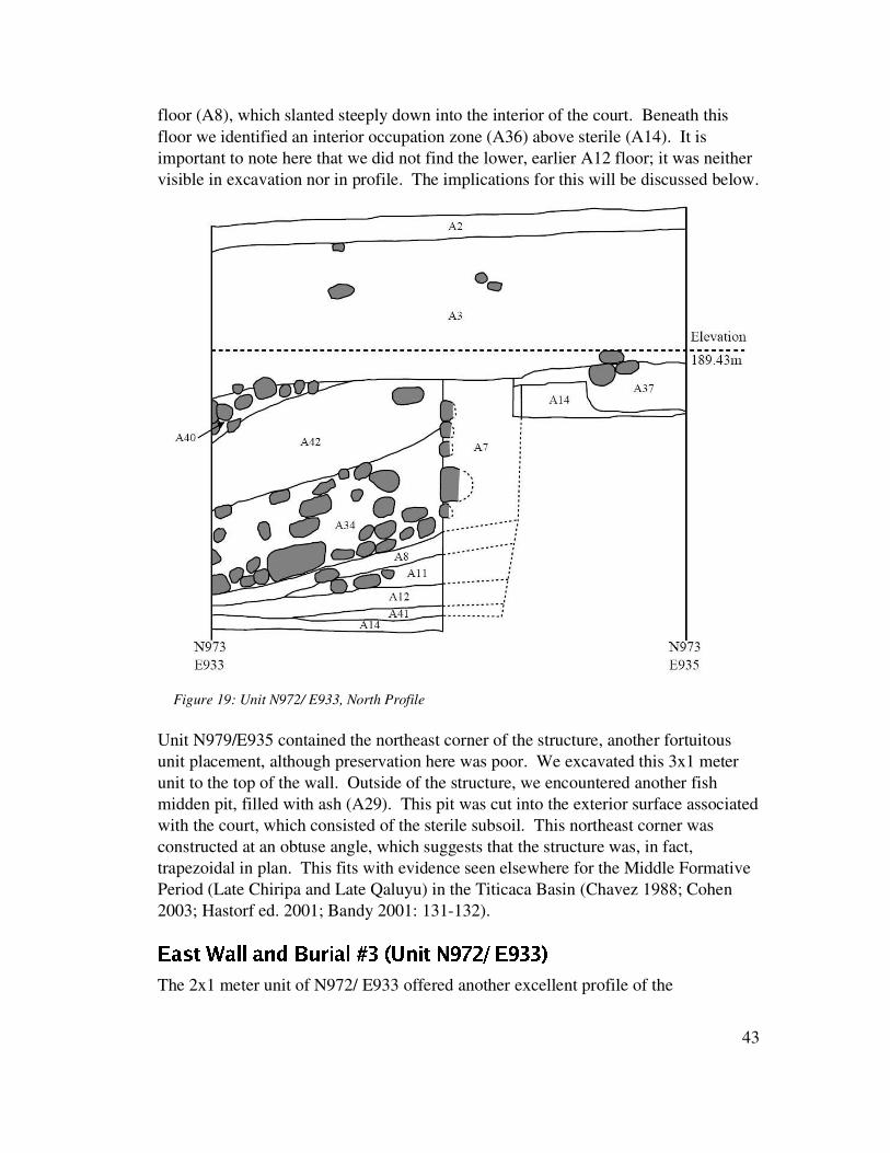
floor (A8), which slanted steeply down into the interior of the court. Beneath thisfloor we identified an interior occupation zone (A36) above sterile (A14). It isimportant to note here that we did not find the lower, earlier A12 floor; it was neithervisible in excavation nor in profile. The implications for this will be discussed below.
Unit N979/E935 contained the northeast corner of the structure, another fortuitousunit placement, although preservation here was poor. We excavated this 3x1 meterunit to the top of the wall. Outside of the structure, we encountered another fishmidden pit, filled with ash (A29). This pit was cut into the exterior surface associatedwith the court, which consisted of the sterile subsoil. This northeast corner wasconstructed at an obtuse angle, which suggests that the structure was, in fact,trapezoidal in plan. This fits with evidence seen elsewhere for the Middle FormativePeriod (Late Chiripa and Late Qaluyu) in the Titicaca Basin (Chavez 1988; Cohen2003; Hastorf ed. 2001; Bandy 2001: 131-132).
Üq»�´Â©1�B»�¯ ¯v»�¼]®32�µ4'I¾ »�¯.5jØ6���F¼�¾°©�ÖDß%�7!ÛÚpÜ�ßxØ�Ø &The 2x1 meter unit of N972/ E933 offered another excellent profile of the
43
Figure 19: Unit N972/ E933, North Profile

construction technique of the lower court, with good intact preservation of bothcobbles and limestone blocks in the wall (A7). It also offered further evidence for theupper floor being located below the base of the wall (see Figures 19 and 20). As inprevious ASD-1 units, the sterile sub-soil served as the exterior surface. We identifiedtwo additional fish bone and ash pits cut into this exterior, surface. The most notablepart of this unit, however, was Burial 3, located in the clay of the A12 (lower) courtfloor.
In the process of excavating to the interior A8 court floor, we encountered a craniumembedded in the clay. The cranium was significantly modified, and in poorcondition. After excavating the cranium, we located most of the upper body. Theindividual was buried within the lower floor, on its back , with the craniumdisarticulated and placed on its chest (Figure 21). The left arm was by its side, withthe hand under the pelvis, whereas the right arm was raised beside the head. The legs
44
Figure 20: Unit N972/ E933, Wall Elevation, Interior
A38 is the right femur of the sub-floor burial

were bent up beside the body, with both femurs running parallel to the wall, and thelower legs positioned underneath the wall. There were no grave goods found withthis individual. We interpret this body as a dedicatory or sacrificial offering, althoughwe await Deborah Blom’s analysis. This body would have created a significant bumpin the floor near the eastern wall, a visible reminder of the individual that was buriedthere (see Figure 20 profile). Below the body and the lower floor was a thin gray ash-rich lens (A41).
� ¨|´Â©1�B»�¯ ¯��)�F¼�¾¶©�´�Ö=ß��xÞaÚDÜiß�# �Ó»�¼]®�Ö=ß���ÞaÚyÜ^ß1#óÝ�&The western wall of the structure gave us a very different perspective on the court.Here we found the wall construction directly upon sterile soil, with the absence of anylimestone blocks interspersed with the cobble wall, suggesting that it represented anearlier manifestation of the court. On top of this cobble wall we encountered acoursed multi colored adobe/clay wall, with significant melting down into the lower
45
Figure 21: Unit N973/E933, Burial #3 under court floor
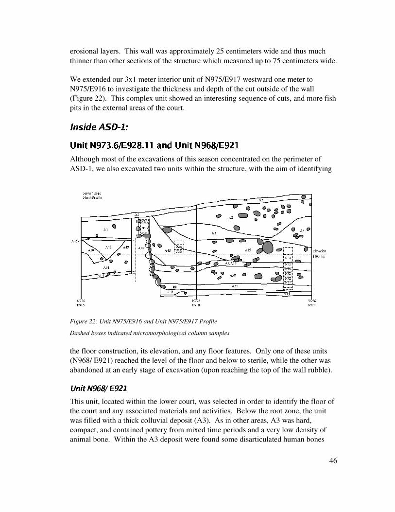
erosional layers. This wall was approximately 25 centimeters wide and thus muchthinner than other sections of the structure which measured up to 75 centimeters wide.
We extended our 3x1 meter interior unit of N975/E917 westward one meter toN975/E916 to investigate the thickness and depth of the cut outside of the wall(Figure 22). This complex unit showed an interesting sequence of cuts, and more fishpits in the external areas of the court.
8h�T�|�@Òq�9�9�·:�� ���/¼x¾°©�ÖVß%�]Ø�� Ý ÚyÜ�ß"!¹×,�-#*#�»�¼ª®3�F¼�¾¶©�Ö=ß�Ý|×ÛÚyÜ�ß*!�#Although most of the excavations of this season concentrated on the perimeter ofASD-1, we also excavated two units within the structure, with the aim of identifying
the floor construction, its elevation, and any floor features. Only one of these units(N968/ E921) reached the level of the floor and below to sterile, while the other wasabandoned at an early stage of excavation (upon reaching the top of the wall rubble).
;�<>=@?BA$CEDEF�G�H*CJI>K
This unit, located within the lower court, was selected in order to identify the floor ofthe court and any associated materials and activities. Below the root zone, the unitwas filled with a thick colluvial deposit (A3). As in other areas, A3 was hard,compact, and contained pottery from mixed time periods and a very low density ofanimal bone. Within the A3 deposit were found some disarticulated human bones
46
Figure 22: Unit N975/E916 and Unit N975/E917 Profile
Dashed boxes indicated micromorphological column samples

that seem to have been deposited with the colluvium. There was also an interestingfeature that appeared to be the remains of a burnt offering, including fragments of adog or fox jaw and burnt vegetable fibers, likely modern.
We then encountered two colluvial deposits (A19 and A20) that differed from A3.These were characterized by a low density of artifacts with a distinct soil matrix.Specifically, the clay-rich matrix of A3 was markedly different from the gritty, clayloam matrix of A19 and A20, which were also differentiated by a color change. Thissuggests that the source matrix of these deposits differed that of A3, and waspossibly related to the erosion of architecture. Beneath the colluvial deposits weretwo events (A21 and A22) that seemed to be associated with the structure'sabandonment. The matrix of A21 was different in that it contained patches of clay aswell as 10-15% pebbles. Event A22 had an even higher percentage (20-25%) ofpebbles as well as 1-2% cobbles. Both of these strata were easily distinguished fromupper colluvial strata in that they exhibited a higher density of pottery sherds thatwere better preserved (less eroded). This suggests that they were not deposited by acolluvial process. According to Steadman's ceramic analysis, the pottery in thesestrata pertained to the Late Chiripa time period. We are therefore able to surmise thatabandonment of this structure took place in the Late Chiripa phase.
Excavations in this unit identified two clay floors, indicating that the structure hadbeen remodeled during its use life. The upper clay floor exhibited one floor feature(Feature 1), a depression that was lined with the same clay that comprised the floor.This feature was filled with a high density of cultural materials and around 50%pebbles. The base of this depression did not show any signs of burning. Neither wasthis depression the result of slump above a lower pit. Indeed, upon removal of thelining, the pit was found to be cut directly into sterile. It seems that this depressionmust have served some function related t the use of the structure. The floor (A8) inwhich this depression was formed was a compact clay with limestone inclusions andexhibited a number of flat-lying artifacts on its surface. Beneath the A8 floor was afill layer (A23) that was darker in color and contained a higher density of artifacts.The lowermost floor (A12) was patchy and uneven in areas, measuring 1-2 cm inthickness. This poor condition may have been the cause for the reconstruction of thecourt. The lowermost floor had been placed above a sub-floor fill (A13) consisting ofa silty clay artifact-rich deposit. Interestingly, both floors, the sub-floor and thebetween-floor fill contained both Middle and Late Chiripa ceramics. It is likely thatthe construction material for these strata was extracted from another part of AC area,possibly from an earlier midden. This could account for the presence of MiddleChiripa materials in what are clearly Late Chiripa deposits.
47

���jz�u��Ûuj�h�h{x�^{�����·��ML��kt������q¥i¥D�ªwV��{T��w��The main goals in the excavations of the upper court were similar to those of thelower court. Specifically, the aims were to expose the court walls and to determinethe relationship between the walls and the floor. Excavations in the lower court hadalready indicated the construction technique used in the walls, as well as complicatedissues such as the floor sequence. We placed units around the structure, initially inthe western and southern walls, where we could see limestone protruding from thesurface. The location of the northern and eastern walls was estimated from theorientation and size of the lower court, which had already been determined throughexcavation. Additionally, one 2x2 meter unit was placed around a protruding redsandstone block in what turned out to be the center of the court.
These excavations showed that this sunken court, like ASD-1, was trapezoidal inplan. Also, the structure is interesting in that it is not entirely semi-subterranean likeother sunken courts with which we are familiar. Rather, depending upon thetopography, some walls line the cut of the court, while others seem to be almostentirely above the prehistoric ground surface. Still, the floor sloped steeply, so that atthe center it was approximately 60 cm below its elevation at the walls. Thestratigraphic sequence of each unit is discussed in detail below, along with thesequence of construction and remodeling of the upper court.
� ¨|´Â©1�B»�¯ ¯��yÖN# ٹٹÙàÚ¢Üjß"�$��&This unit was selected due to the position of several white limestone blocks that wereslightly protruding from the surface of the slope above the lower court. These blockswere oriented in a roughly north-south linear arrangement and were deeply bedded.We oriented this 1x2m unit with the long axis across the expected line of the wall,where one large white limestone block protruded from the surface. The west wallexcavation unit revealed a very complicated stratigraphic sequence (Figure 23).
The upper strata of this unit were similar to those in other parts of the Achachi CoaKkollu sector. The A3 stratum was extremely compact, extending more deeply in theeastern part of the unit, above what was revealed as the court interior. As expected,the unit did identify the remains of a wall – later determined to be the western wall ofa sunken court. Beneath the A3 colluvium was a layer of cobbles that we haveidentified as wall-fall. This wall-fall extended across most of the unit, concentratedto the east, and with the highest cobbles over the wall itself. Excavations revealedthat most of the wall-fall was within what would be identified as the interior of thesunken court, and a small number of cobbles had fallen to the exterior. The wall-fall(A113) had fallen on top of a stratum of colluvium (A114) that likely collected post-abandonment. This colluvium was above what was later identified as the upper floorof the upper sunken court (A116). This floor was constructed of clay, varying in
48

color from red to yellow. Removal of the wall-fall exposed what remained of thestone base of the wall, consisting of only a few in situ stones to the north of theprotruding limestone block.
The interior of the court proved to have a complicated stratigraphic sequence. Asnoted, the A116 floor was directly beneath a layer of colluvium. The upper floor wasabove an ash layer (A117) that in turn filled two pits that had been cut into an ashylens (A118) and the surface of the lower clay floor (A119). Excavation of the lowerfloor revealed an ashy sub-floor layer (A120). Removal of the lower floor revealed apit (Feature 23) that had been cut into sterile and filled with an ashy, silty clay depositwith charcoal inclusions (A121).
The exterior of the court was much less complicated. The wall fall was above anoccupation zone (A126) that consisted of artifacts embedded in a silty clay matrix.This occupation zone was above sterile and its excavation revealed a pit (R42) thathad been cut into sterile and contained a cobble fill (A161).
This unit was quite shallow compared with the majority of the units in the lowercourt. This is likely because this portion of the court was cut shallowly into theground, and the wall would have protruded above ground surface. The colluvium,therefore, barely covers the lower portion of the wall, and the majority of the wall isnot preserved. The wall itself shared similar construction techniques to those seen inASD-1, with medium sized limestone blocks interspersed with cobbles. As notedabove, this unit exposed two clay floors within the interior of the structure, indicatinga reconstruction episode. The large pits and fill events are somewhat enigmatic.
49
Figure 23: N1000/E947, South Profile

They may indicate an abandonment of the courts before they were reconstructed, ormay have pertained to rituals focused around the reconstruction. Also interesting isthe earliest pit, cut into sterile and pre-dating the placement of the court. Thissuggests that the court may have been used for some time after the cut was made, butbefore the placement of the walls and floor of the earliest court.
Ö=('[©y«��B»�¯ ¯��yÖO#�Ù¹ÙP#�Ú¢ÜqßTÞ�Þ.&The placement of this unit, with the goal to expose the north wall of the upper court,was calculated based on the dimensions of the lower court, which had already beendefined. As excavations revealed, our estimates of the upper court dimensionsmatched closely with those of the lower court.
As with other units in this sector, the uppermost strata are formed by the A3 colluvialdeposit (Figure 24). Beneath the A3 was wall fall, indicating that we were close inour estimates of court size. Removal of the wall fall (A157), a high density ofcobbles within a matrix similar to the A3 colluvium, revealed a dark, ashy deposit(A158). As with the above wall fall event, this deposit was mixed with cobbles, butwas characterized by alternating thin lenses of ash, silt, and clay that seemed to havebeen the result of water deposits. The type of deposit suggests that A158accumulated gradually, and likely represents court fill that was preserved by thecollapse of the wall. Beneath A158 was a thick ash deposit (A159) that hadaccumulated against the interior wall of the court. The A159 deposit includeddecorated pottery as well as carbon, and was likely a deposit related to the use of thestructure. Removal of the A159 deposit revealed a similar deposit (A160) that wascharacterized by alternating deposits of silt and clay within midden. It is likely, then,that A158, A159, and A160 all represent deposits that accumulated during the use ofthe structure, or immediately post-abandonment. These deposits were locatedimmediately above a thick yellow clay floor (A127), which in turn, was above sterile.
The north wall was the best-preserved wall of the upper court. The sequenceof wall construction was different from that in the other units, indicating that it hadbeen constructed either at a different time, or by a different group of individuals. Thewall construction sequence was as follows. First, the cut was made into sterile for theconstruction of the court. Next, a channel was cut into sterile to delineate the positionof the wall. This trench was filled with two rows of well-sorted cobbles. Above thiswere placed the vertical limestone uprights, of which two are located in this unit.Next, the space between the uprights was filled with cobbles to complete the wall.Finally, the clay floor was placed, buttressing up against the wall, with a steeplyangled slope. Note that in this segment of wall, the wall is constructed prior to theplacement of the floor. This fact, along with the presence of only one floor in thisarea of the court, is key to our reconstruction of the construction sequence of the
50

court.
Figure 24: N1001 E955 West Profile
� iµ�©y«��Ç»�¯N¯����F¼�¾¶©�Ö=ß¹×>��Ú¢Üqß�ÞªÞ.&The coordinates of this unit were selected due to its proximity to a large whitelimestone block protruding from the surface. This block was estimated to be close tothe southeast corner of the structure. The unit was particularly important forinformation regarding the construction sequence of the wall itself.
The surface of this unit was covered with a modern rock pile, such as are common onagricultural fields in the region. This rock pile also included a large number of stoneartifacts and ceramic sherds. Removal of the superficial rocks revealed that the pileextended beneath the surface; further excavations revealed that this area had likelybeen a rock pile for a long period of time. This rock concentration wasstratigraphically above A3 deposits. A 10% sample of the A135 and A3 depositswere screened in this unit. Removal of the A3 deposits revealed wall fall (A136)from the south and east walls, along with the fill of the court that was stratigraphicallybeneath the wall fall. Later excavations of the east wall indicated that this unit wasvery close to the corner of the structure. The fill event (A137) was flecked with
51

yellow and red clay, and carbon, and included a noticeably high number ofcarbonized ceramics. Removal of this fill event revealed the clay floor and fullyexposed the wall.
The floor sloped upwards towards the wall, passing beneath it. The slope of the floorin this unit was extreme. This floor (A116) was compact with yellow and red claypatches, along with carbon flecks and small pebbles, and the occasional cobble,embedded in the surface. The floor was positioned directly above sterile. As there isonly one floor in this unit, this serves as a clue to its position in the constructionsequence of the court – namely that it was part of the later expansion of the court.
The wall in this unit combined several white limestone uprights interspersed withcobbled sections. Within the wall was one very tall white limestone block,surrounded by smaller cobbles (Figure 25). Interestingly, however, this limestoneblock was inserted into a hole cut into sterile and later covered over by the floor. Itwould have served as an ‘anchor stone’ for the wall. This stone gives us aninteresting sequence of the wall construction in this area of the court. The sequence isas follows: The cut of the court was made into sterile, with slope towards the north,sloping down away from the wall. The vertical uprights were placed in situ, with atleast the one being anchored into the ground. The single clay floor in this unit wasthen placed above sterile, joining with the cut behind the wall. Cobbles were thenarranged above the floor and around the anchor stone to complete the wall.
The area behind the wall is not well understood due to the narrow area exposed.Beneath A3 deposits, the exterior floor (A139) was identified, a patchy clay surface
52
Figure 25: N984/E955 South Profile

with carbon inclusions. Its removal revealed a complicated sequence. However, it isclear that this area of the Achachi Coa Kkollu sector was in use prior to theconstruction of the ASD-3 court. In the very small area excavated, earlier pits as wellas an earlier floor were identified, indicating that there had been earlier use of thisarea. We cannot at present say, however, whether this earlier use involvedarchitecture. No evidence of earlier architecture was discovered. These pre-ASD-3deposits have not yet been dated.
Üq»�´Â©1�B»�¯ ¯��yÖ=ߪß$#aÚQÜ�ß�Þ�ß�&The location of this unit was estimated based on the measurements and orientation ofthe lower court. The east wall was poorly preserved due to its location on a low
saddle of the mountain. As a result, only a thin layer of the A3 colluvial depositscovered the architecture, providing little protection (Figure 26). Beneath the A3deposits were the remains of the wall fall (A136). The wall collapse was directlyabove the A116 floor on the interior of the court. The floor was highly deterioratedand difficult to identify in this unit. Excavations indicated that the east wall wouldhave protruded well above the exterior ground surface of the court.
There was only one interior floor in this section of the court. One interesting elementof this unit is the presence of midden over the exterior surface of the court. This linksthe midden to the east of the upper court (see discussion below) with the stratigraphicposition of the court. This supports the idea that at least some of this midden wasdeposited during the use of the upper court.
53
Figure 26: N991/ E959 South Profile

Q ¨x¼|©�¨�'(�F¼�¾ ©R�yÖ=ß¹ßxØ ÚQÜ�ß�ÞS!,�sÞ.&The central unit was placed around a protruding red sandstone block that was lateridentified as a standing monolith. Excavations went to sterile in the eastern half ofthe unit, and stopped above the upper floor in the western half. This unit revealed agreat deal about the construction sequence of the court, and yielded two significantsculptural finds.
The A3 deposits in this central unit were quite deep, and included occasional cobbleconcentrations. Removal of the A3 colluvium revealed a rock pile (A140) that was, in turn, above additional colluvial deposits (Figure 29). Thesubsequent colluvium (A141) was relatively rich with cobbles (about 10% density).All of the colluvial deposits were screened using a 10% sampling strategy.
Removal of the A141 colluvial depositsrevealed a stratum of cobbles. Thiscobble layer was clearly intentionallycollected and distributed around themonolith, with the cobbles mounding uptowards the monolith, in the center ofthe unit. Excavation of this cobbledeposit (A142) revealed a fill layer(A143) that had a lower density ofcobbles, but with a concentration ofcobbles in a ring around the monolith.This ring seems to have been used toprovide support to the monolith.
At this stage in the excavations, wechose to excavate the eastern half of theunit, leaving the western halfunexcavated. This decision was made so as not to destabilize the standing monolith.Removal of the A143 fill level revealed the upper floor of the sunken court. The floor(A116) consisted of yellowish and reddish patches of clay, with occasional inclusionsof pebbles and small cobbles. Beneath this floor was identified another rockyconcentration (A144), consisting of approximately 40% cobbles and 15-20% pebbles,that served as a between floor fill. Within this A144 fill event was a truly uniquediscovery.
A Yaya-Mama carved stone pestle was recovered from this stone fill (Figure 27).This small piece of sculpture is carved with a cross formee on the top, andsymmetrical serpentine patterns on either side. The base of the pestle shows signs of
54
Figure 27: Lightning Stone found between floors

having been used.Sergio Chavez(1971) has publishedsimilar examples ofthis style ofsculpture, referringto them as LightningStones. Additionalexamples apparentlyexist in thecollections of theMusee furVolkerkunde inBerlin. The KalaUyuni lightningstone seems to be theonly examplerecovered from ascientific excavationin a securestratigraphic context.
Beneath the A144fill event was thelower floor (A119)of the sunken court(Figure 28). This was a mottled clay floor that passes under the rocky support for themonolith. Excavation of the floor revealed that it was placed directly above sterile.Interestingly, however, a pit (Feature 36) was found to be cut into sterile, beneath theA119 floor (Figure 29). The fill of this pit contained cobbles and large chunks of claysimilar to that used in the construction of the floor.
These excavations revealed the full extent of the monolith as it stood above thesurface. As noted, none of the structural supports were removed. We were careful topreserve its stability. The monolith was shaped but bore no iconography.Interestingly, the excavations did reveal the construction sequence involved in theplacement of the monolith. The lower of the two floors was not associated with theplacement of the monolith. Indeed, prior to the placement of the upper floor, a pitwas dug for the monolith. The monolith was placed in the pit, with a stone supportsystem wedged into place to prevent movement. The stone fill between the floorswas then laid down, after which the upper floor was put in place. The monolith as itstands was therefore put in place at the time the upper court was remodeled.
55
Figure 28: N993/E952.5, central monolith, in profile

While the context of the fill above the floor remain uncertain, we do know thatthe monolith was intentionally buried, and the upper floor completely covered, with alarge mound of cobbles, effectively 'closing' the structure. We hypothesize that thisevent was related to a formal abandonment ritual.
���jz�u��Ûuj�h�h{x�^{��q�s�i�&¤��hÒTÒq�Â�T��=�i�d���VU�W*W,X0YZ�[W�\�]$u��jÒ^U�W�_�W`Y`��W�a�_
Two units were excavated within the midden deposit to the southeast of the uppersunken court. This area was selected because of the dark soil and the high density ofsurface artifacts. In particular, there was a high density of animal bone, which
56
Figure 29: N993/E952.5 East Profile

distinguished this area from the courts, where colluvial deposition resulted in thedestruction of most animal bone. This indicated different depositional processes atwork in the midden area. Rather than colluvial deposition, it seems that this area wasdeflated or eroded to some extent. Excavations indicated that the midden area hadbeen plowed for agricultural fields, although the plow marks suggested the use ofchakitaklla (traditional foot plows) rather than ox-drawn plows.
Within these middens we found a high density of fish and animal bone, pottery andlithic materials. An interesting find was a scattered pile of burnt, well-sorted rocks(large pebble – small cobble size) that suggest a dump after a huatia (earth oven)cooking event. The ceramics are particularly intriguing. The lower stratum in eachunit includes pottery from the Middle Chiripa phase, while the upper strata arepredominantly from the Late Chiripa phase. The presence of Middle Chiripa ceramicsindicates that there may have been an earlier ceremonial structure, or at least earlierceremonial activities, on the site of the later ASD-1 and ASD-3 sunken courts. Thishypothesis is supported by the finding of the floor exterior to the southern court wall,as revealed in unit N982 / E955.
·��@�]zª�x�¹�¹�s{��The twosunken courts excavated in the AC area have much in common, includingform, orientation, ritual activities and construction sequence and technique. Both aretrapezoidal in form, with the longest wall of the trapezoid facing south. Thetrapezoidal shape seems to have been maintained between the initial courtconstruction and the expansion. The construction of sunken courts with a trapezoidalplan is becoming a diagnostic for Middle Formative courts, also existing at Chiripa(Hastorf ed. 2001; Bandy 1999, 2001) and at Huatacoa in the northern Titicaca Basin(Cohen 2003). Excavations in the courts and the midden indicate that this sector wasoccupied during the Middle Chiripa phase. However, the courts were not constructeduntil the Late Chiripa phase. Many later court deposits incorporate midden materialdiagnostic of the Middle and Late Chiripa Periods. Interestingly, there are noTiwanaku of Late Formative artifacts associated with the use of the courts; thesecourts seem to have been abandoned after the Late Chiripa period. Analysis of thematerials recovered from the Achachi Coa Kkollu sector are not yet finished.However, initial analysis of the ceramic assemblage indicate that both decorated andutilitarian wares are present in quantity. While this evidence may suggest an earlierdomestic function for the area prior to the construction of the court, it may also bethat this area was a long-term focus of public ceremonial activity for the Kala Uyunicommunity. In other words, there may have been a range of practices, incorporating abroad range of ceramic types.
Non-ceramic evidence also supports the attribution of a ritual function to the AC area
57

at least in the Late Chiripa phase. One example is the consistent presence of pitscontaining high densities of fish bones associated with the exterior surface of thelower court. These concentrations may perhaps be interpreted as evidence of feastingin the courts, although further corroborative evidence will be necessary before thishypothesis can be substantiated. Another example of ritual activity is the placementof a human sacrificial offering beneath the east wall and floor of the lower court. Aswe described above, it is likely that this individual was decapitated, as the head wasfound placed on the chest. Further, the splayed position of this individual issuggestive of the treatment given to captives, enemies, or offerings, rather than torevered ancestors. Similar examples of human sacrificial offerings related to sunkencourt construction events have been found at the roughly contemporaneous sunkencourt at Huatacoa in the Pukara Valley(Cohen 2003).
What is clear through these excavations is that both courts underwent similar andsignificant reconstruction events. The original courts were constructed in the LateChiripa phase, yet little of those original structures has survived. The west wall of thelower court gives us a good idea of what this structure may have been like. Theinitial cut of the court was lined with a cobble wall. This earlier wall included nolimestone blocks and is therefore clearly different from the later walls. The first clayfloor was laid down after the wall was constructed. Above the base of the wall wasan upper construction of alternating bands of yellow and red clay. It is unclear why,when all other walls were reconstructed, this single western wall of ASD-1maintained the original wall construction. This may have been due to its state ofconservation, or it may have held some special meaning; this specific part of the courtwall would have been visible from the village (the KU area) below.
Sometime later, both sunken courts were remodeled. This remodeling involved anincrease in the dimensions of the structures, with expansion taking place to the northand east (as indicated by the presence only of the later of the two floors adjacent tothe north and east walls of both structures). In most cases, the walls were dismantledand reconstructed at the time of the expansion. Of course, the western wall of thelower court is an exception. It seems, in the case of the upper court, that whitelimestone anchor stones were set in place to delineate the line of the wall. Next, thenorthern wall was constructed, incorporating a well-built cobble foundation. Thenext step seems to have been the placement of the upper clay floor, which was placedabove the lower floor and any between fill between the two floors. Finally, theremainder of the wall was constructed, incorporating both white limestone blocks andunmodified cobbles.
In the case of the upper court (ASD-3), it seems that the monolith was erected at thetime this remodeling event took place. It is possible that the installation of themonolith was the motivating factor behind the expansion of this court. Whether or not
58

there was a central monolithic sculpture in the lower court (ASD-1) remainsunknown, since the center of the court was not excavated, and the colluvium fillingthe structure is much deeper. Clearly, C14 dates will aid us in refining theconstruction sequences in this part of the site.
��{x�qz��h��ÒT�e�¹¦cb����~u�w0d��All of the units excavated were backfilled, after either tyvek bags or tags were placedon the bottom and sides of the units to identify the excavated areas for any subsequentinvestigations. As both ASD-1 and ASD-3 are large structures they would clearlybenefit from further excavations in the future. The 2003 excavations have providedmuch needed data for our understanding of the Late Chiripa phase of the TaracoPeninsula and the greater Titicaca Basin. Excavations in the Achachi Coa Kkollusector showed an interesting pattern of sunken court construction and remodeling, aswell as evidence for associated court activities.
59

e S E&?=PQ:DÍ`L@g \�GD:V>bY�JqLsJ
Lee Steadman
A total of 415 bags of ceramics were recovered from the 2003 excavations at KalaUyuni, including the multiple point provenienced specimens registered from certainloci. These ceramics were registered, washed, and then transferred to the ceramiclaboratory for processing, where they were cataloged and analyzed. First, thediagnostic specimens (rims, bases, handles, decorated fragments etc.) were separatedfrom the body sherds, and placed in their own smaller bag within the larger tyveklocus bag. Body sherds of less than 1 cm2 were culled and also placed in their ownsmaller bag; these sherds will not be analyzed further as they are generally too smallto determine surface color or finish accurately. All three categories of ceramicspecimens, body sherds, diagnostics and small fragments, were counted, weighed,and recorded in the ceramic catalog database; the diagnostics specimens were alsoindividually labeled with unique specimen numbers. In total, the TaracoArchaeological Project recovered 58,168 body sherds, 6547 diagnostics and 8870small fragments during the 2003 field season.
The ceramics from loci which were chosen for further study were given one of threetypes of analysis, depending on the context of the locus. In cases where the locus wasdisturbed, but it was necessary to determine which phases were represented in thesample, the ceramics were categorized by phase and ware only. Ceramics from locithat were undisturbed, where the analysis of the materials would contribute to acomprehensive and detailed description of the ceramic assemblage from that phase inthe ceramic sequence or the activities which took place in that part of the site, weregiven a more detailed attribute analysis. Attribute analyses have been usedproductively for the definition of ceramic sequences elsewhere in the Titicaca Basin(Steadman 1995; Chávez 1992; Chávez 1980/81; Lémuz 2001) and involve theobservation and recording of individual ceramic attributes (paste, finish, surfacecolor, vessel shape, rim shape, diameter etc.) rather than the definition of a fixed setof attributes, such as is used in a typological classification (Rowe 1959; Shepard1956:307-318). Individual attribute analysis is a more sensitive and effective meansof studying changes through time than a typological approach, which necessarilystresses the similarities among ceramics rather than their differences (see Steadman1995:48-50 for further discussion). The attributes of the body sherds that weresubjected to this detailed analysis were recorded on computer coding forms.Information on the diagnostic specimens was recorded on a more detailed form thatallowed for the inclusion of more information on surface finish and details of shape,
60

manufacture, decoration etc., as well as providing a space to draw the specimen. Thistype of ceramic analysis is necessarily time consuming; as the 2003 excavationsgenerated a large volume of ceramics, some of the ceramic bags were given a lessdetailed form of attribute analysis, particularly in cases where there were multiple locifrom a single event, in which only the attributes of shape, size, exterior color andfinish, decoration, and phase were recorded.
The ceramic laboratory was lucky to have many excellent ceramic assistants duringthe 2003 field season. Virgilio Rodriguez of Tiwanaku was in charge of the registryand cataloging of the ceramic material. Working on the ceramic analysis anddiagnostic drawing were Doris Maldonado of the University of California, Berkeley,Nicola Sharratt of the University of Cambridge, England, and Christine Bare of theUniversity of Pennsylvania. The author is deeply grateful to all of them for their hardwork and dedication in the field; this report would not have been possible withoutthem. The analysis of the Kala Uyuni ceramic data is still in progress, and not all theloci have been analyzed; the following is therefore only a preliminary report on theceramic artifacts.
��uxwI�¶���=�j�@wI�°¥�uEarly Chiripa ceramics were recovered from the lowest levels of the midden deposits,those resting on sterile, in both the AQ and AC sectors of the site, although in neitherarea were the deposits from this phase completely undisturbed. The principal EarlyChiripa occupation appears to have been in the lower part of the site, in the AQsector, where a Formative period domestic occupation was uncovered during the 2003season. In the lowest levels of the midden deposits here, under the Middle and LateChiripa levels, a modest Early Chiripa occupation was discovered. Severebioturbation in this area (Goodman, this volume), has resulted in a mixing ofceramics in the lower part of this excavation unit, so that the Early Chiripa samplecontained approximately 5% Middle Chiripa ceramics originating from the depositsabove. Early Chiripa ceramics were also found at the top of the hill in the AC sector,in the lowest levels of the midden deposits located to the south and west of the uppersunken court. Early Chiripa specimens are rare in these events, however, comprisingonly about 5% of the ceramic sample in what is otherwise a predominantly MiddleChiripa ceramic assemblage, although they may once have represented a discreteevent, since disturbed. The Early Chiripa ceramics recovered from the AC and AQsectors of Kala Uyuni are similar; there is no indication of the existence of aspecialized ceramic assemblage restricted to the AC area, as will occur later in theChiripa period.
The Early Chiripa ceramic assemblage at Kala Uyuni is entirely domestic incharacter. No decorated ceramics were found at the site; decorated ceramics from this
61

phase have been recorded so far only in levels associated with the Early Chiripaoccupation underneath the central mound at Chiripa itself (Steadman 1999a, 2001).Kala Uyuni Early Chiripa ceramics are very similar to the assemblage defined atChiripa. Almost half of the sample is manufactured in a micaceous fiber-temperedpaste with biotite and translucent and opaque quartz inclusions which is characteristicof the Early Chiripa phase (Steadman 1999b:62). Ceramics are mostly slipped brownor are an unslipped brown color, and the predominant finish is a complete coverageburnish. The small sample of diagnostic shapes contains several that are characteristicand limited to the Early Chiripa phase, such as the neckless olla (Fig 30a) and thecollared olla (Fig 30b, similar to the neckless olla but with a thickened rim forming ashort collar around the opening of the vessel). These are both shapes used as cookingvessels in the Early Chiripa phase. The rest of the sample consists of short andmedium-necked ollas (Fig 30c-d, see Steadman 1995: 56-58 for vessel shapedefinitions). No bowls were recovered in the small Kala Uyuni sample. Although thisshape is less common in the Early Chiripa phase at Chiripa than later in the sequence,its absence at Kala Uyuni is surely due to the small size of the sample. The percentageof red slipped specimens is relatively low at Kala Uyuni, only 6.5% of the sample,and the percentage of specimens with the daubed stucco finish, found exclusively onthe bottoms of fiber-tempered cooking vessels (Steadman 1995:66-67; Steadman1999b), is quite high. In fact, the percentage of sooted sherds and stucco finishedsherds at Kala Uyuni is higher, and the percentage of bowls, red slipped, anddecorated specimens lower, than any of the Early Chiripa deposits at Chiripa itself,including not only the areas of civic/ceremonial activity such as Santiago and underthe mound, but also the various fill and midden deposits at that site. Compared toChiripa, then, the Early Chiripa occupation at Kala Uyuni appears to have beensmaller and more domestic in character.
¤&�eÒTÒT�N���V�j�@wQ�¶¥�uMiddle Chiripa ceramics were found in the AQ and AC sectors of Kala Uyuni, insimilar contexts as the Early Chiripa assemblages. In the AQ sector, Middle Chiripaceramics occur in the midden deposits of the Formative period domestic occupation,overlying the Early Chiripa levels. Again, bioturbation has resulted in some mixing ofthe ceramics, so that the Middle Chiripa sample from these units containsapproximately 2% Early Chiripa wares. In the AC sector, the lowest levels of themidden to the south and east of the upper court were found to have Middle Chiripadeposits, mixed with about 5% Early Chiripa as described previously. Middle Chiripaceramics were also present in the predominately Late Chiripa midden events higherup in these same units, representing at least 35% of the sample from these levels, andalso represent from 10% to 35% of the floor and subfloor fill deposits in certainsections of the Late Chiripa sunken courts, as detailed below.
62

As in the Early Chiripa phase, the Middle Chiripa ceramic assemblage at Kala Uyuniis essentially a domestic one. No decorated ceramics pertaining to this phase werefound, as they have been at Chiripa (Steadman 1999a, 2001). Attributes of paste,finish, shape and carbonization all point to an assemblage used primarily for cooking,storage, and domestic serving. The most common pastes in the Middle Chiripaassemblage have dense, translucent, rounded quartz inclusions, one with fine-sizedinclusions and the other medium. The popularity of these two pastes is particularlydiagnostic of the Middle Chiripa phase (Steadman 1998, 1999b). The percentage ofthe fine inclusion version of this paste is somewhat higher than in the Chiripa
63
Figure 30: Early and Middle Chiripa Ceramics
Early Chiripa: neckless olla (a), collared olla (b), medium-necked ollas (c-d)
Middle Chiripa: short-necked olla (e), jar (f), medium-necked ollas (g-h)

assemblage, and the medium version lower, indicating some, but not a great deal, ofregional variation in the ceramics across the Taraco peninsula during this phase.Ceramics are mostly an unslipped red brown or brown color, or are slipped brown.Slipped sherds in general are less common than in the preceding phase, a trend whichoccurred also at Chiripa, while red slips specifically decrease to only 2% of thesample. A complete coverage burnish continues to be the most common finish.Stucco finishes average 23% of the sample across the various events at the site,similar to the figures at Chiripa itself, although red slips again are less common atKala Uyuni than they are in all contexts dating to this phase at Chiripa.
The Middle Chiripa shape assemblage as recovered at Kala Uyuni consists mostly ofnecked vessels with direct rims. Two-thirds of these are medium-necked ollas (Fig30g-h, 31a-c), with a lesser number of short-necked olla forms (Fig 30e) and jars (Fig
64
Figure 31: Middle and Late Chiripa Ceramics
Middle Chiripa: medium-necked ollas (a-c), bowl (d).
Late Chiripa: cream on red bowl base (e), cream on red body sherd (f)

30f) and jars (Fig 31f). These shapes tend to be slipped brown, or have unslipped redbrown surfaces. Bowls form only 14% of the total vessel shape sample (Fig 31d).Most have slightly flared sides and direct rims, although the sample also includessome slightly convex bowls. Bowls tend to have red brown slips or unslipped redbrown surfaces; there are no red slipped or decorated bowls. There are also no largediameter bowls or large cooking vessels, those with diameters of over 27 cm. Thesevessels are found in feasting and civic/ceremonial contexts in the Middle Chiripaphase at Chiripa, where they would have been used to cook and serve the largequantities of food consumed at these gatherings (Steadman 2002). The lowerpercentage of red slipped specimens, and the absence of decorated wares and theselarge bowls, is consistent with the hypothesized village-level occupation of KalaUyuni at this time (Bandy 2001). In general bowl diameters, which range from 11 to24 cm with an average of 15cm, fall at the small end of the spectrum when comparedwith the Middle Chiripa vessel size classes at Chiripa, and the necked vessels,ranging from 14 to 25 cm with an average of 19 cm, would be classified as small andmedium. The ware manufactured in a dense, high fired, fine-textured paste whichoccurs at Chiripa in this phase (Steadman 1999b:63) is also very rare at Kala Uyuni,forming less than 1% of the sample. At Chiripa, this ware was associated with large-scale cooking vessels in pits near the Middle Chiripa sunken court, and may havebeen used for chicha production or serving at these public occasions.
The analysis of excavated ceramics is still in progress, but at present there appear tobe only slight differences in the Middle Chiripa ceramic assemblages between the ACand AQ sectors of the site. While in the Late Chiripa phase there is a clear distinctionbetween the ceramics found in these two areas, there is less indication that the ACsector was the location of any special purpose activities in Middle Chiripa times.Sooted sherds are slightly more common, and red slipped wares less common in theAC sector when compared to AQ, which could indicate more cooking activities in theformer area. Conversely, black, brown and brown slipped necked vessels, which aregenerally cooking shapes, are more common in the AQ sector, while bowls areextremely rare. Other attributes, however, such as paste, the percentage of stuccofinishes, and vessel diameters, are indistinguishable between the two sectors of thesite. The only item that may possibly distinguish the AC sector is the presence of anumber of smaller, unslipped, bowls with direct rims in this part of the site, a shapethat is absent in the AQ sector. Again, the vessel shape sample is too limited at thispoint to say whether this difference is significant, but it may be related to a smallscale or relatively informal set of serving activities taking place in and restricted tothe AC sector during this phase.
��ui�d� �����ewI� ¥�uLate Chiripa ceramics were found in the upper levels of the AQ midden at Kala
65

Uyuni, and in a variety of contexts in the AC sector; the only Late Chiripa ceramicsin the KU sector are a small number of specimens which appear to have beenoriginally incorporated into the adobes used to construct the walls of ASD-2. In theAC sector, Late Chiripa ceramics were recovered, mixed with Middle Chiripa wares,from the upper levels of the midden units to the south and east of the upper court, aswell as from the subfloor fill, both the upper and lower floors, and the post-use fill ofthe two Late Chiripa sunken courtyard structures. The ceramic assemblage recoveredfrom these courts, however, was not uniform across the structures. Althoughpredominantly Late Chiripa, the ceramic sample from the subfloor levels and bothupper and lower floors (but not the post-use fill) in the southeast corner of the lowercourt and the west side of the upper court also contained from 10% to 35% MiddleChiripa ceramics. The attributes of the ceramics in these deposits and theirdistribution match those from the mixed Late Chiripa/Middle Chiripa events of theAC midden. It seems likely that the provenience of the ceramics from the mixedsunken court events is in fact the AC midden, and that soil from this area was used inthe construction of the courts. The units with events containing mixed LateChiripa/Middle Chiripa ceramics are 968 921 and 962 928 in the lower court and1000 947 in the upper court (Unit 962 923 in the lower court had not yet beenanalyzed at the time of this writing, but will probably also prove to contain similarmixed ceramics).
The Late Chiripa phase is the first in which a substantial ceremonial sector existed atKala Uyuni, with public architecture and finely finished ceramics for serving foodand drink. Consequently, there are two distinct Late Chiripa ceramic assemblages atthe site; a domestic assemblage, with a high percentage of utilitarian and cookingceramics and few to no decorated specimens, and a higher status or ceremonialassemblage, with finer pastes, fewer cooking vessels, larger and more frequently redslipped and decorated bowls, specifically ceremonial vessels such as ceremonialburners ("incensarios"), and more red slipped, small, necked vessels for servingliquids. The high status assemblage is found only in the AC sector. In most of theexcavation units in both the upper and lower courtyards, the post-use fill over thefloor, the upper floor itself (event A8) and the fill between the upper and lower floorscontained high status Late Chiripa ceramics. Unfortunately, the only lower floor orsubfloor fill levels that have been analyzed to date are those from areas of thecourtyards that have turned out to have mixed Middle/Late Chiripa ceramicassemblages derived from the AC midden.
The domestic Late Chiripa assemblage is found in various contexts at the site. All ofthe ceramics recovered from the midden in the AQ sector, location of the Formativeperiod domestic occupation at Kala Uyuni, are domestic in character. In the ACsector, while the majority of unmixed Late Chiripa ceramic deposits contain highstatus wares, there are several events of Late Chiripa domestic ceramics. The events
66

that contain mixed Middle Chiripa/Late Chiripa domestic wares - the midden itselfand the midden-derived construction soils – have been mentioned above. There arealso several events of unmixed Late Chiripa ceramics whose provenience is againprobably from the AC midden, in this case from purely Late Chiripa levels. In twounits, the upper floor (A8) assemblage is predominantly midden-derived. In bothcases, however, a handful of large bowls and decorated specimens were also present,deposited presumably during activities in the courts. The domestic assemblage fromthese units, therefore, is not exactly the same as that from the AC midden itself,reflecting as it does the presence of some high status wares in the deposits. The otherAC location with unmixed midden-derived Late Chiripa domestic wares is the post-use fill in the southeast corner of the lower court, above the mixed Late/MiddleChiripa deposits, contrasting with the fill elsewhere in the court which containedmore high status wares.
The physical separation between the primary domestic occupation at Kala Uyuni, theAQ sector at the lower elevations, and the ceremonial area, the AC sector near the topof the hill, means that at Kala Uyuni there is a very clear differentiation between thedomestic and ceremonial/high status ceramic assemblages. This was not the case atChiripa, where the distinction between the two assemblages was less defined. Few, ifany, deposits, could be called purely and exclusively domestic, as within the area ofthe settlement itself, where the TAP excavations were located, all deposits containeda significant percentage of high status or red slipped wares, while the ceramicassemblages from civic/ceremonial events included a fairly high proportion ofcooking and other utilitarian specimens. Furthermore, many of the sooted andcooking wares that we do find at the site are clearly a by-product of large-scale foodpreparation, such as would be necessary for feasting or other public foodconsumption, rather than of household-based activities.
The separation of assemblages at Kala Uyuni leads to some notable differencesbetween the ceramics from Kala Uyuni and Chiripa. For example, the ceramic samplefrom AQ is composed of a larger proportion of purely domestic wares than anyChiripa event, with more coarse paste ceramics, fewer red slipped vessels, and morecooking ollas and jars than any context at Chiripa. Conversely, we find that the highstatus or ceremonial assemblage from the AC sunken courts is particularly weightedtowards fancier vessels. There are, of course, fewer decorated ceramics at KalaUyuni, with less variety of decorated wares, as this site is not as large nor does itenjoy the same regional importance as Chiripa, but large serving bowls and sooted"incensario" sherds make up the same proportion of the sample at the two sites, andunlike at Chiripa, there are very few utilitarian wares and coarse paste ceramics in theAC ceremonial assemblages. Cooking, even large scale cooking for feasts or otherceremonies, is mostly restricted to the AQ sector at Kala Uyuni. Food may have beencarried up to the courts directly in serving vessels, or alternatively cooked food may
67

not have been as important a part of the activities taking place in the sunken courts atKala Uyuni as it was at Chiripa. The completion of the analysis of the AC domesticmidden deposits will add another dimension to our understanding of this distinctionbetween domestic and ritual assemblages at Kala Uyuni, as this area seems to reflect athird set of activity patterns. The low percentage of red slipped and decorated wares,the lack of large serving bowls or small red-slipped ollas for serving liquids, and thehigher proportion of stucco specimens in the AC midden is directly comparable to theAQ deposits, yet the paucity of cooking vessels, and the shape, diameter and surfacefinishes of most of the necked vessels is not like AQ, but rather comparable to thehigh status assemblage from the courts.
The Late Chiripa domestic assemblage at Kala Uyuni is composed principally ofceramics tempered with very coarse, chunky, opaque white quartz inclusions. Thistemper is characteristic of Late Chiripa ceramics as defined from the site of Chiripaitself (Steadman 1999b). The ceramic assemblage from the AQ sector specifically hasthe highest percentage of ceramics manufactured in this paste, 78% of the sample,more than any context at Chiripa itself. This may be due in part to regional variationin the popularity of this paste at Kala Uyuni, but it also reflects that fact that the AQdomestic midden is more purely utilitarian than any found at Chiripa. The domesticdeposits in the AC sector also have a high percentage of this paste, although at 57%of the sample it is not as high as the AQ sector. The remainder of the Late Chiripadomestic sample is manufactured mostly in the paste with dense, translucent, roundedquartz fine inclusions. All in all, the Kala Uyuni paste assemblage is dominated by afew, particularly popular pastes, in contrast to the more varied paste distribution atChiripa, reflecting less regional contacts at this smaller settlement than at theceremonial center of Chiripa. About half the domestic sample, AC and AQ together,is unslipped, mostly brown or red brown in color, and a quarter slipped brown or darkbrown. Red slipped wares are relatively rare, 8% of the sample, and decorated wareslimited to a handful of sherds, representing 0.2% of the assemblage. A completecoverage burnish is the single most common surface finish (46% of the sample)followed by an approximately equal percentage (19 and 23%) of incompletelyburnished and stucco specimens. Both the percentage of stucco sherds and those withsooted surfaces are significantly higher than in the high status deposits.
The Late Chiripa high status assemblage at Kala Uyuni has different suite ofattributes. The paste with dense translucent, rounded fine inclusions is the single mostcommon (54% of the sample), followed by the micaceous paste (the same that hadbeen common in Early Chiripa times), which forms 25% of the sample. In the higherpercentage of these two pastes, and the much lower percentage of the paste withchunky white quartz (now only 17% of the sample), the high status assemblagediffers from the domestic one. This white quartz paste is, in fact, less common in theKala Uyuni high status assemblage than it is in similar contexts at Chiripa, again
68
reflecting a greater differentiation at Kala Uyuni between domestic and high statuscontexts. About two thirds of the high status assemblage is slipped, in red brown,brown or red. This last is the single most common color in the sample, with 22% ofthe specimens having this attribute. Half the ceramics have a complete coverageburnish, with the majority of the remainder finished with an incomplete coverageburnish.
The Late Chiripa phase witnesses the first decorated ceramics in the Kala Uyuniassemblage. Naturally, most of the decorated wares in this phase occur in the highstatus assemblages from the AC sector; 5.8% of the ceramics from the upper floorsand fill between the floors in both courts were decorated, and 3.8% of the filldeposits, for a total of 44 specimens (this figure is less than comparable contexts fromChiripa, where the percentage of decorated wares ranges from 6.7% to 14.5%). Thefirst vessels that were clearly used for ceremonial purposes also date to this phase atthe site. The two ceramic ceremonial shapes identified in the Late Chiripa assemblageat Chiripa are the ceramic trumpet and the incense burner bowl, characterized bysooted deposits in the interior. No Late Chiripa ceramic trumpets were recovered atKala Uyuni, at least in the sample analyzed so far, but four decorated specimens withcharred interiors were found. All come from finely finished cream on red bowls, andall are found in the upper floors of the courts, with specimens coming from both theupper and lower structures. There are some decorated wares as well in the domesticdeposits recovered at Kala Uyuni, but their number is very small, 9 sherds in total,representing 0.3% of the domestic sample, most from the upper floor of the AC courtsin what are otherwise midden-based assemblages.
Late Chiripa decorated ceramics at Kala Uyuni are comparable to those from the siteof Chiripa itself. Fewer of the decorated wares at Kala Uyuni are manufactured in thefine micaceous paste than at Chiripa, although when taken separately, the proportionof micaceous paste specimens in the decorated sample from the courtyard floors(40%) is directly comparable to the proportions of this paste in similar civic-ceremonial contexts at Chiripa. Cream on red ceramics form the vast majority of theKala Uyuni decorated wares, comprising 82% of the decorated ceramics (Figs 31a-f,32a). This is somewhat more than the assemblage at Chiripa, where the greatervariety of decorated wares means that cream on red ceramics make up only 74% ofthe sample, reflecting the greater level of public and ceremonial activity at that siteand its wider regional contacts. As at Chiripa, cream on red specimens are decoratedwith motifs consisting mostly of diagonal elements and triangles. The otherdecorative types present at Kala Uyuni occur only in minor quantities. These includeblack on red wares, black on red with incision separating the color areas, wide lineincised (Fig. 32b), red on cream, and modeled ceramics, all similar in style and motifto contemporary specimens from Chiripa. Most specimens are body sherds; the fewrim and base specimens that can be classified as to vessel shape are almost all flat-
69

based bowls, generally with vertical sides and thickened rims, with one example of adecorated short-necked olla.
Bowls are more common in the Late Chiripa assemblage at Kala Uyuni than in theprevious phase, forming from 17% to 27% of the classified shape assemblage, withrandom variability among the different contexts. They mostly have straight sides,with either a vertical (Fig. 32a) or slightly flared wall angle (Fig. 32c), the latter beingmore common. Rims are mostly direct, either rounded or flattened; about one quarterhave rims with thickening at the lip. As at Chiripa itself, the vertical-sided bowls tendto be larger, have more examples with thickened rims and are more often slipped red
70
Figure 32: Late Chiripa Ceramics
cream on red bowl (a), wide-line incised bowl base (b), bowls (c-e)

and/or decorated than the slightly flared shape. Bowls with a slight convexity to thewall are also present but less common, forming 39% of the bowl sample (Fig. 32d-e).Rims on the convex bowls are direct. Surface color of the bowls varies by context;60% of these vessels from the court floors are slipped red and 40% decorated, whilein the midden and midden-derived domestic assemblages only 33% of the bowls areslipped red and 6% decorated, with the remainder mostly slipped in other colors,such as red brown or brown. Bowls at Kala Uyuni tend to be smaller than at Chiripa.Average bowl diameter in the high status assemblages is 22 cm; bowls in thedomestic assemblage average 20 cm. This range is similar to the fill and wall falldeposits at Chiripa, and even the floor of the Late Chiripa sunken court at Llusco, butis not as large as the bowls associated with the Upper or Lower House structures onthe Mound, or those from the Quispe sunken court (Hastorf et al. 1998, 1999; Bandy1999, Paz 1999) which average from 26 to 28 cm in diameter.
Extra-large sized bowls, those with diameters greater than 30 cm, first appear atChiripa in the Late Chiripa phase, and are believed to be indicative of an increasinglygreater participation in public eating or feasting activities at the site, associated in allcases with sunken courtyard structures (Steadman 2002). Extra-large sized bowl alsoappear for the first time in the Late Chiripa phase at Kala Uyuni, where they are alsoassociated specifically with the sunken structures; 40% of the bowls (2 of the 5classified bowls, both decorated) from the upper floor of the courts are extra-largesized specimens, versus only 20% from the post-use fill of the courts and only 6% ofthe bowls from the domestic midden of AQ and the midden-derived AC contexts.Although the bowls from the court floors are on average smaller and less likely to bedecorated than those from comparable civic/ceremonial contexts at Chiripa, thepercentage of extra-large bowls specifically is directly comparable to the Chiripafigures.
Necked vessels in the Late Chiripa phase at Kala Uyuni are mostly either mediumnecked ollas (Figs. 33a-c) or jars (Figs. 33D-e, Fig. 34a-c); these two shapes represent44% and 43% of the necked vessels respectively. Short-necked ollas, once a popularshape in the Early Chiripa phase, are a minor component of the assemblage. Lookingat the distribution of necked vessels across the site, however, we see that althoughnecked vessels are found in roughly even proportions in all contexts, jars specificallyare considerably more common in the AQ midden, representing more than half of allthe necked vessels found there, while medium necked ollas are more common in theAC deposits, both midden-derived and high status, where they form about half of thenecked vessel sample. Necked vessels in the Late Chiripa phase served a variety offunctions, but jars appear to have been the shape used most often for cooking. Allsooted rim specimens where vessel shape can be precisely determined are jar shapes(for example Fig. 33e). Almost half the jar sample is slipped brown, the most of anynecked vessel class, which is also the most common color for sooted body sherds and
71

bases. The marked concentration of jar shapes in the AQ midden deposits stronglysuggests that the focus of cooking activities was in this sector. Most other jars at KalaUyuni are slipped red brown, while all necked vessels are burnished, with anincomplete coverage burnish being marginally more common. Almost a third of themedium-necked ollas is slipped brown, with a high percentage of unslipped pieces aswell, but red slipped vessels are also common for this shape (Fig. 33a-b), close to aquarter of the specimens. Short-necked ollas are not used for cooking in this phase inthe Chiripa sequence, but rather are a class of serving vessels found most commonlyin the high status assemblages. They are the most likely to be slipped red of anynecked vessel shape, almost a third of the sample being this color, and there are noknown brown or black specimens. Although they represent only 13% of the necked
72
Figure 33: Late Chiripa Ceramics
medium-necked ollas (a-c), jars (d-e)

vessels at the site, they form a large component (45%) of the necked vessel samplefrom the floors of the sunken courts.
Necked vessels in the AC sector of the site tend to be, on average, smaller than theAQ specimens. Average diameter of the necked vessels, both jars and ollas, from thedomestic and high status deposits in AC ranges from 18 to 19.5 cm. The AQ ollas aresimilar in size, but the jars which are so concentrated in this sector tend to be larger,averaging of 23 cm. Extra-large necked vessels, those with diameters from 30 to 34cm, associated at Chiripa with cooking for large feasts or other gatherings, are presentbut equally rare in both the AC and AQ sectors. However, the large and extra-largevessels that do occur in the AC sector are mostly red or red brown slipped, suggestinga serving function, while these same shapes in AQ are more likely to have attributesconsistent with cooking vessels. At the other end of the spectrum, small, red slippedollas, both short and medium-necked, with diameters from 8 to 15 cm are more than
73
Figure 34: Late Chiripa Jars

twice as common in the floor deposits of the sunken courts than elsewhere at the site.At Chiripa, these vessels were concentrated in ceremonial structures, where they werebelieved to have been used for serving liquids. The necked vessel assemblage fromthe floors of the sunken courts, then, with its smaller vessels, fewer jars, and moreshort-necked ollas and small red slipped vessels, is more consistent with servingactivities than the domestic assemblages from the AC sector and particularly the AQmidden.
Tiwanaku ITiwanaku I ceramics are present in the ceramic samples from the mixed upper levelsin all sectors of the site; as a small component of the predominantly Late Chiripadeposits in the upper levels of the AQ and AC sectors, and as part of a mixed depositcontaining Tiwanaku I through V ceramics in the KU sector. It is only in the KUsector, however, that unmixed Tiwanaku I ceramics were recovered. The floors andoccupation zones in and around ASD-2, as well as the clay lenses and adobe wallfallin and over ASD-2 and the deposits under the structure, all contain Tiwanaku Iceramics. In most cases these deposits are unmixed; some events contained a smallnumber of Late Chiripa wares that had originally been incorporated into the adobesused in the construction of the walls. Of the KU sample, only these events in andaround ASD-2 have been analyzed. The deep unit in the KU sector, 894 639, alsoyielded an extensive sequence of Tiwanaku I events (see Paz and Bruno, this volume)and hence a large quantity of ceramics. As this unit has not yet been analyzed, theTiwanaku I sample presently available is small; the description which follows musttherefore be considered preliminary. The early data from the field suggest that theevents immediately above the Tiwanaku I levels in this deep pit pertain to a differentphase in the ceramic sequence, presumably Tiwanaku III. Completion of the analysisof the KU sector ceramics, then, will ultimately provide us with a comprehensivedefinition of both the Tiwanaku I and III ceramic assemblages at Kala Uyuni.
The Tiwanaku I phase marks a major change in ceramic style as well as technology;Tiwanaku I ceramics differ markedly from those of the Late Chiripa phase in allattributes, including paste, surface finish and color, vessel shape and, of course,decoration. Beginning in the Tiwanaku I phase, the ceramic assemblage at KalaUyuni is no longer entirely fiber-tempered. Many of the Late Chiripa pastes carryover into this phase, most particularly the micaceous paste that had been common inEarly Chiripa times and for decorated wares in the Late Chiripa phase. The proportionof this paste, in fact, increases in the Tiwanaku I phase to 38% of the sample. Fiber-tempered wares in general, however, make up only 49% of the Tiwanaku I ceramicassemblage. The remainder is manufactured in a suite of new mineral-temperedpastes, the most common of which (35% of the assemblage) can best be described asthe micaceous paste without the fiber, as it has the same suite of inclusions, and the
74

same quantity of mica visible on the surface of the vessel. The small sample ofTiwanaku I ceramics analyzed to date suggests change through time in thedistribution of pastes within this phase; the event under ASD-2, the earliest of thoseanalyzed so far, has a higher proportion of the fiber-tempered micaceous ware andless of the mineral-tempered version than the events directly associated with ASD-2itself, where the mineral-tempered version becomes the more common of the two.Mica-tempered ceramics, with varying proportions of mineral and fiber-temperedversions, have been reported elsewhere along the southern shores of the Lake asbeing characteristic of Late Formative or Tiwanaku I assemblages (Bandy 2001:168;Janusek 2002: 44,46; Lémuz 2001: 352; Ponce 1971:18).
Attributes of surface finish and color of the Tiwanaku I ceramics show a trendtowards less attention to detail, and a more efficient and rapid mode of ceramicproduction. Almost three-quarters of the assemblage is unslipped. This is a significantincrease from the Late Chiripa phase, where unslipped ceramics ranged from only onethird to one half of the sample in different contexts at the site. A black, gray or brownunslipped color is the most common, this group forming 42% of the sample. Red slipsare relatively rare, dropping from the high figures of the Late Chiripa phase to only2% of the sample; most slipped Tiwanaku I ceramics are brown or red brown. Thelabor intensive surface finishes of the Late Chiripa phase, which were weightedheavily towards burnished vessels (70 to 80% of the vessels have some sort ofburnish) are now replaced by an assemblage where half the ceramics have a simplewiped or smoothed surface finish (see Steadman 1995: 61-65 for definition offinishes). These finishes existed in the Late Chiripa phase but were rare, representingnot more than 6% of that sample. The complete coverage burnish, once the singlemost common finish in the Late Chiripa sample, now occurs on only 6% of theceramics. A shift away from burnished finishes towards an increasingly wipedassemblage is again found elsewhere in the southern and western Lake Titicaca Basinat the onset of the Late Formative (Janusek 2002:41; Lémuz 2001:365; Steadman1995:303). Changes in how burnishes are applied to the vessel surface also occur atthis time. Previously, vessels were always finished with horizontal burnishing strokes(except on the most finely finished vessels, burnishing troughs or streaks are easy todetect). In the Tiwanaku I phase 13% of the diagnostics were burnished using verticalstrokes, a figure that will increase in subsequent Tiwanaku phases. Most of thesediagnostic specimens are bases, but include necked vessel rims as well. Again, theappearance of vertical burnishes is a hallmark of the beginning of the Late Formativeperiod elsewhere in the Lake Titicaca Basin (Steadman 1995:304).
One of the remarkable results of the 2003 TAP season at Kala Uyuni was the numberof decorated Tiwanaku I specimens that were recovered from the excavations. Theseinclude monochrome slipped or unslipped incised trumpets, and an exceptionalnumber of polychrome painted and incised wares. Outside of the burials from under
75

the fill of the Kalasasaya structure at Tiwanaku (Ponce 1971, 1993), only a handful ofpolychrome incised Tiwanaku I ceramics have been recovered from eitherexcavations or surface collection (Albarracin-Jordan et al. 1993:Fig. 15; Bandy 2001:
Fig. 7.1; Bermann 1994: Fig. 5.5; Janusek 2002:46). In the small sample of TiwanakuI ceramics that have been analyzed from Kala Uyuni (a total of 392 fragments) therewere only two decorated specimens, both from event B21, the surface outside ofASD-2. However, a quick survey of the drying screens in the field revealed
76
Figure 35: Tiwanaku I Ceramics
black, red and unslipped red-brown incised (a), incised blackware trumpet (b), jars(c-d), horizontal strap handle (e), bowls (f-h)

approximately thirty more polychrome incised sherds that have yet to be studied. Thediscovery of such a large quantity of decorated ceramics at Kala Uyuni not only willsignificantly increase the corpus of known decorated Tiwanaku I specimens fromexcavated contexts, but also supports Bandy's (2001: 176) hypothesis that this sitewas the center of a large multi-community polity during the Tiwanaku I phase. The
two decorated specimens in the analyzed sample are an unslipped incised blackwaretrumpet (Fig. 35b), and a rim with incision separating areas painted in black and redslip or left an unslipped red brown (Fig. 35a). This rim, with a wide thickened band
77
Figure 36: Tiwanaku I Ceramics
bowl with wavy rim (a), bottle with broken neck (b), fragment of a red-banded bowl, redslip on unslipped light brown surface ©, bowl with horizontal handle, rim angleunknown (d)

around the lip, is new in this phase, as is the vessel shape from which it probablycomes, a straight-necked, globular bodied olla or jar (Ponce 1971: Fig 3.1). Bowlswith charred interiors are also found associated with ASD-2, suggesting, as in theLate Chiripa phase, the burning of a ritual substance. There are three of these in thesample from in and under ASD-2, although in this case none are decorated (Fig. 35g-h).
As in other attributes, vessel shapes in the Tiwanaku I assemblage exhibit severalsignificant changes from Chiripa times. Again, the sample is small, and furtheranalysis will certainly increase our understanding of the shape assemblage. Atpresent, however, it appears as if ollas, both short and medium-necked, are rare inTiwanaku I times, as all recovered necked vessels are jars (Fig. 35c-d), mostly withmedium rather than tall necks. All rims are direct and either slightly rounded or flat,sometimes with a point on the outside of the lip (Fig. 35c), or a depression or groovearound the center of the lip left from the last stage of finishing. Both of these are newrim shapes in this phase, as is the popularity of flat rims in general. Jar diametersrange from 14 to 22 cm, with an average of 17 cm. Jars are mostly wiped at the neck,often with incomplete burnishing on the body wall, and have red brown or brownslipped surfaces. Horizontal handles on necked vessels, present but very rare in theLate Chiripa phase, are now as common as vertical forms. Jars, aside fromperforming functions of storage and serving, also were used as cooking vessels. Nosooted rims exist in the sample so far, but several bases, including a characteristicform with a thickened joint between wall and base, and a horizontal handle (Fig. 35e)exist with sooted interiors, all having attributes consistent with the jar rims in thesample.
Bowls are more common than necked vessels in the analyzed Tiwanaku I assemblage.While this may change as the analysis progresses, the proportion of bowls in theassemblage can certainly be said to increase in this phase. The vertical-walled bowlsof the Late Chiripa phase are gone, and slightly flared walled specimens are rare.Instead convex, slightly convex, and incurving bowls make up the majority of thesample (5 of the 7 specimens, Fig. 35f-h). More than any other vessel shape, thesenewly popular curved walled bowls are more likely to be mineral rather than fiber-tempered. They are fairly small (average diameter 17 cm), with incompletelyburnished or smoothed surfaces and a variety of slipped and unslipped colors. Convexor slightly convex bowls are frequently slipped red at the rim and in a band partwaydown the exterior and/or interior wall; this red banded bowl form is characteristic ofTiwanaku I assemblages around the southern Basin (Albarracin-Jordan and Mathews1990: Fig 6b; Bandy 2001: Fig. 7.2r-u; Bermann 1994:Fig. 5.4; Janusek 2002: Fig.3.11, 3.12; Ponce 1971). There are several of these specimens from the Kala Uyunisample (Fig. 36c), unfortunately mostly body sherds and not rims, with a red band oneither an slipped or unslipped light brown surface. Other special shapes recovered
78

from excavations in the KU sector include a complete flared walled bowl from abovethe lower floor of ASD-2 (Fig. 36a). This vessel is one of the three in the samplewhich have lightly sooted interiors, its wavy rim anticipating the incised scallopededge bowls that become common in the following Tiwanaku III phase. Bowls withhorizontal handles on the rim also occur in the ASD-2 sample (Fig. 36d, compareJanusek 2002: Fig. 3.11k,l), as do finely finished small bottles (Fig. 36b); thisparticular specimen has a light brown slip and a rubbed surface finish.
79

ù S \�Pyg=mD:q?kA�<.A=Hº:=GiY
Maria Bruno and William Whitehead
8h� �h�i���l�h���hÒThe use of water flotation enables us to obtain a sample of carbonized botanicalremains, small animal bones, lithics, and other artifacts from each locus excavated atKala Uyuni during the 2003 field season. Each excavator followed the same protocolfor collecting samples. At least one 10L soil sample was collected for each locus andplaced in a hefty 20L plastic bag. This “bulk” sample was taken from a singlelocation in the locus and its provenience recorded using x,y,z coordinates. Theelevation was determined by taking an average from the top and base of where thesoil was removed. If the excavator had a locus that was particularly rich in organicmaterials or information that could best be recovered through flotation, they placedall of the material in a flotation bag, regardless of volume. In contexts, such as floorsor middens, a 10L “scatter” samples could be taken if the excavated deemedappropriate. Rather than taking the soil from one specific area in the locus, soil istaken from throughout the locus to provide an average view of the matrix. With all ofthe samples, the excavator created two label tags, both containing equal informationon the locus, provenience, date, and excavators. One tag, made of tyvek paper, wasplaced inside the bag with the soil. The bag was tied with a string possessing adiamond tag with the proper information. The samples were brought back to the campeach day and stored in a shed outside the living quarters until floted.
This year we inaugurated a new flotation machine that was built in La Paz under thedirection of Christine Hastorf. The machine was built using the modified SMAPdesign (Watson 1976; Hastorf 1999), which employs a 50 gallon oil drum into whichfresh water is fed via 1.5 inch pipes and a shower head. A small Briggs and Strattonmotor pumps water into the machine. A second bucket made from a smaller oil drumand about 1/4 of the length of the large drum has a 0.5mm stainless steel mesh bottomand fits into the larger drum and rests upon two support bars inside the large drum.Both drums possess pour spouts in which the water flows out of the machine. Themachine also has two attached garden hoses with sprayers. The shower head feedingthe water into the large drum enables the water to circulate gently through the bottomof the inner bucket mesh. This motion loosens the soil allowing the finer silts andclays to sink to the bottom of the oil drum while the lighter than water material,primarily carbonized plant remains, floats to the surface. The floating material poursout of the drums via the spout and into a steel 10L bucket that is attached to hooks atthe end of the spout. The bucket has a window screen bottom so that water can flow
80

through it. A fine mesh cloth is placed on the bucket with clothes pins and catches thefloated material coming from the spout. This material is called the light fraction.Larger artifacts that are separated from the soil by the water but do not float arecaught by the mesh at the base of the inner bucket. This is called the heavy fraction.
The flotation team for 2003 was Meridith Sayre, Franz Choque, Primitivo Nina, andFacundo Llusco. Christine Hastorf and Maria Bruno carried out the training andWilliam Whitehead supervised the process. The flotation machine was operated by atleast two people everyday. We began the flotation in a spot close to Kala Uyuniwhere there was a spring and a natural pool of water. Unfortunately, the water did notregenerate enough each day to continue working here, so we moved the operationsdown to location near to the town of Coa Kkollu, named Uma Pampa where waterwas more abundant. Each day 18-24 samples were selected for processing. In total,369 flotation samples were taken and floted from the archaeological excavations. Inaddition, we floted a number of 10L samples from the a recently abandoned house(see Goodman, page 86).
To begin, each sample is transferred into a clean bucket, its volume measured, and allof its information recorded in the flot log. Then, the bucket is filled with water so asto loosen the soil before placing it into the flot machine. Meanwhile, the primaryflotation technician fills the machine with water until the level is such that the waterflows gently over the spouts. This technician continues to monitor the water level andvelocity throughout the day to assure that that no charred plant material is lost out ofthe catching bucket by overflow or splashing. He also emptied all of this water andaccumulated sludge mid-day and refilled the main bucket so as to reduce the risk ofcontamination. Once the soil in the bucket is well-soaked (about 10-20 minutes) andthe machine filled with water, the assistant flotation operator gradually pours the soilfrom one sample into the inner bucket resting in the large drum. The primarytechnician sprays the soil gently with water to minimize splashing and too speed upthe transfer of soil. The bucket is sprayed clean and set aside for the next flotationsample. The primary technician then agitates the inner bucket by moving it up anddown and in a rotational manner. This helps break up the soil and separate theartifacts. Meanwhile, the assistant sprays the fine mesh cloth as the light fractionmaterial pours out of the spout and into the material in the bucket. This helps removeany floting silts and keeps the botanical fraction clean.
The primary technician monitors the quantity of charred material floating out of theinner bucket. When it appears that no more material is on the water surface, a fish-tank filter siphon is used to suck up all remaining charred materials floating in thewater but not rising to the surface (Gumerman and Umento 1978). This is done byholding the siphon tube six inches above the bottom of the inner flotation bucket,draining the water into the light fraction catching bucket. The siphoning terminated
81

when no more charred material can be seen in the transfer tube. At this point, thewater pressure is turned off to let any remaining charred materials float to the surface.Once this is done, the water is turned on to full force and allowed to run for severalminutes to aid any heavier items flot to the top. A tea strainer is drawn through thewater, and when no more materials are found, the flotation process is complete. Thefabric with the light fraction is removed from the bucket and tied with the diamondtag originally placed with the soil sample. These samples are placed on a clothes lineto dry. The inner bucket is removed from the barrel with the heavy fraction at its base.These materials, along with the original tyvec tag written by the excavator, are pouredonto a large cloth laid on the ground, which also has the flotation number written on itwith a Sharpie waterproof pen. The heavy fraction materials dry in the sun throughoutthe day.
8h� �h�i���@u]¸�{�w�uj�h{�w��Once dry, the light fractions were transferred to clean plastic bags with the originalsample tag inside and an additional sticky label on the outside of the bag. Thesesamples have been exported to the Archaeobotany Laboratory at the University ofCalifornia, Berkeley with the permission of UNAR. These will be sorted in thelaboratory by Maria Bruno for her dissertation thesis. The dry heavy fractions werealso placed in large plastic bags with the original tyvek tag placed inside. We wereable to complete the sorting of the heavy fractions in the in-field laboratory. This wascompleted by the flotation workers Franz Choque, Facundo Llusco, and PrimitivoNina with the help and supervision of William Whitehead and Meridith Sayre. Eachheavy fraction sample was size sorted through a series of geological sieves with meshsizes of 4mm, 2mm, and 0.5mm. Bones, fish scales, charred plant remains, lithics,metals, beads, and any other special find were sorted from every fraction and screensize. Ceramics were removed only from the 4mm fraction. Burned earth wasrecovered only from the 4mm and 2mm sieves. The finds were combined by type andplaced in plastic bags with new labels indicating the provenience information fromthe original tyvek tag. The artifact types for each heavy fraction were recorded in theheavy fraction log. The artifacts were provided to each specialist for analysis. Bagswith plant remains from the heavy fractions were attached to the outside of theircorresponding light fraction bag and transported to Berkeley for analysis.
Area Total Number of FlotationSamples
Total VolumeFloated
Achachi Coa Collu 174 1612 LAyrampu Qontu 37 350 LKala Uyuni 130 1188 L
Table 1: Flotation samples processed by area
82

û S \^G=LlÍ :V>Tf�?.ÍB:DLlG�J�C P¢A�Í Hamp? �TgTg=à n¡?q:DJjA�G
Katherine Moore, University of Pennsylvania
During the 2003 TAP excavation season at the three Kala Uyuni areas, more than 300loci were excavated. Animal bone was recovered by screening through 6 mm meshfrom 280 loci. Bone from 79 of these samples was identified and described and isstored in Bolivia. Bone from the other 201 loci were loaned to me to completeanalysis in the United States. Based on the 79 loci samples analyzed so far, it can beestimated that the total number of fragments in the KU sample will be approximately100,000 to 200,000, not counting fish bones.
Large mammal bone from these samples have been identified according to taxon withreference to museum specimens and published metric standards using measurementsmade with dial calipers accurate to 0.05 mm. Weights and counts of all bonefragments were recorded in order to understand the use of different body parts and theprocess of bone fragmentation. The state of burning, modifications such as cut marksand tooth marks, and the state of weathering, erosion, and mineral deposition wererecorded for every fragment. Bone from camelids, deer, and unidentifiable largemammal bone were bagged separately and then returned to their original bag forstorage. Bone that was identified as human was bagged separately and stored withother human remains. Bone from other taxa, including birds, small mammals,amphibians, and fish, were removed from the large mammal samples and werebagged, labeled, and stored separately.
Bone was also recovered in the heavy fraction of the flotation samples through a 1mm mesh. (Fractions recovered through the 0.5 mm mesh were scanned but notsorted; it is rare that any bone at all is identifiable from this fraction). During the2003 seasons, 251 flotation samples were sorted which produced animal bone.Experience with bone samples from the Chiripa site (Moore, deFrance , andSteadman 1999) suggests that the flotation samples are particularly important instudying fish and other small scale animal remains. Gastropods and eggshell as wellas bone are recovered in these samples. An overview of the flotation samplessuggests the great variation in bone density between different excavation contexts atKala Uyuni, already noted roughly by excavators. Most samples have 5-10 gm ofbone recovered from a standard 10 l sample of soil, but several samples had morethan 100 gm of bone. A subsample of these flotation samples will be sorted,weighed, and the identifiable fish and small mammals and birds identified.
83

Bone tools, fragments of finished tools, and bones with worked surfaces are handledseparately as soon as they have been identified. Approximately 20 such tools wererecognized by excavators during excavation. Another 170 tools and tool fragmentswere identified and analyzed while examining the large animal bone recovered asfood remains. Perhaps another 300 tools could be expected from the samples of largemammals that still remain to be analyzed. Work at the Chiripa site indicates thatscrapers dominated other categories of bone tool during the later formative and thispattern appears to be the case at the Kala Uyuni sites as well. Scrapers made of longbones, scapulae, ribs, and mandibles are much more common than net gauges,weaving combs, awls or ornaments such as beads. There is a complete sequence ofbone tool manufacture in this collection, strongly suggesting that this was animportant local craft.
b��Â�x�Âu�wIzª�h��¥T¥Vwf{¹u�zÂ���Â�i�Ì{�w.��ux��u�����������j�{x���Analysis of tabulated results for the KU animal sample is in progress. Based on thework accomplished so far, three aspects of the sample are likely to produce the mostsignificant insights into prehistoric animal use.
1) Analysis of the major large mammals used at the Kala Uyuni sites. Thedomesticated and wild camelids (llama, alpaca, vicuña, guanaco) is based oncontinuing study of measurements of long bones and teeth. Recent analysis ofLake Titicaca samples of camelid bone by Moore (Moore, de France , andSteadman, 1999) and previously by Ann Webster (1993) suggests that the range ofbody sizes in Formative through Tiwanaku sites is not similar to that found inmodern populations. Modern populations divide easily between large forms(llamas and guanaco) and small forms (alpaca and vicuna) according to work inPeru (Kent 1983, Miller 1979, Miller and Gill 1990, Moore 1989). For theprehistoric altiplano of Bolivia, there appears to have been one or more camelidspecies in a size range intermediate between the large and small modern groups.Two explanations are being considered to explain this pattern: first, that modernsamples from Peru used to the develop the metric models are different fromBolivian populations because of some geographic or ecological effect. A second,and more interesting, possibility is that the prehistoric populations may haveconsisted of animals that were not, in fact, equivalent to the llamas and alpacas oftoday, but were rather animals that represented a different stage in the process ofdomestication or the results of selective breeding with different goals. Thesemetric studies will be linked to the analysis of age and sex of the individualanimals but it is already apparent that age data will be relatively scanty comparedto the abundance of metric data.
2) The importance and nature of the use of wild animals at the KU sites. Wild faunaused at the sites included wild birds, fish, vicuña, deer, and possibly guanaco. I
84

will be analyzing these remains in collaboration with Susan deFrance and DavidSteadman. In particular, the samples examined so far show heavier use of birds,and to some extent fish, than in some of Late Chiripa samples from Chiripa. Thescreened samples will be analyzed in conjunction with the flotation samples to beable to accurately estimate their dietary importance We will compile a chronologyof locus samples that will allow us to compare the importance of lake-edge faunaover time to changing lake levels and settlement patterns.
3) Analysis of animal bones and bone tools hold considerable promise in improvingour understanding of ceremonial and non-ceremonial (domestic) contexts at thesite. While some animal bones are derived from food use others seem to representofferings, based on the degree of fragmentation, burning, weathering, and theselection of skeletal elements. We also compare the range of activities and discardbehaviors indicated by the range of taphonomic signatures on bone fragments withvariation in the condition and composition of the botanical samples. We expectthat a high proportion of high-value parts of the camelid skeleton would indicateceremonial or public food preparation and distribution, but we remain aware of thehow this signal may have been blurred by a number of post-discard events.
The bone tools from KU sites indicate a range of textile working activities includingnet manufacture, the use of narrow and broad awls often associated with basketry,ceramic shaping, and leather working, and several categories of ornaments,particularly beads. Bone tool waste (blanks and failed pieces)was found in theapparent area of manufacture, while finished bone tools were found in locationswhere they were being used, cached, deposited as offerings, or discarded afterbreaking.
85
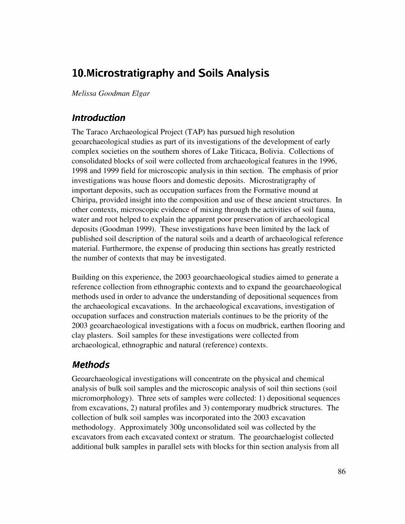
R1gDS�� L@gVP¢A�JTHÆPQ:iHÆLNM P¢:D��miYÈ:DG�õ n¡A;Ld>dJ�\^Gp:V>°YVJpLsJ
Melissa Goodman Elgar
8h�p�dwQ{�Òq��z¹�h�h{��The Taraco Archaeological Project (TAP) has pursued high resolutiongeoarchaeological studies as part of its investigations of the development of earlycomplex societies on the southern shores of Lake Titicaca, Bolivia. Collections ofconsolidated blocks of soil were collected from archaeological features in the 1996,1998 and 1999 field for microscopic analysis in thin section. The emphasis of priorinvestigations was house floors and domestic deposits. Microstratigraphy ofimportant deposits, such as occupation surfaces from the Formative mound atChiripa, provided insight into the composition and use of these ancient structures. Inother contexts, microscopic evidence of mixing through the activities of soil fauna,water and root helped to explain the apparent poor preservation of archaeologicaldeposits (Goodman 1999). These investigations have been limited by the lack ofpublished soil description of the natural soils and a dearth of archaeological referencematerial. Furthermore, the expense of producing thin sections has greatly restrictedthe number of contexts that may be investigated.
Building on this experience, the 2003 geoarchaeological studies aimed to generate areference collection from ethnographic contexts and to expand the geoarchaeologicalmethods used in order to advance the understanding of depositional sequences fromthe archaeological excavations. In the archaeological excavations, investigation ofoccupation surfaces and construction materials continues to be the priority of the2003 geoarchaeological investigations with a focus on mudbrick, earthen flooring andclay plasters. Soil samples for these investigations were collected fromarchaeological, ethnographic and natural (reference) contexts.
¤#�|�s�i{�Ò��Geoarchaeological investigations will concentrate on the physical and chemicalanalysis of bulk soil samples and the microscopic analysis of soil thin sections (soilmicromorphology). Three sets of samples were collected: 1) depositional sequencesfrom excavations, 2) natural profiles and 3) contemporary mudbrick structures. Thecollection of bulk soil samples was incorporated into the 2003 excavationmethodology. Approximately 300g unconsolidated soil was collected by theexcavators from each excavated context or stratum. The geoarchaelogist collectedadditional bulk samples in parallel sets with blocks for thin section analysis from all
86

contexts. The number of open trenches made routine sampling of soil blocksprohibitive and soil blocks were collected from well-preserved features on ajudgmental basis in consultation with the excavators. Block samples are identified onprofile and plan drawings [not included with this report].
In order to evaluate anthropogenic influences on soil, natural soil profiles are studiedin the vicinity of archaeological sites. Elevation is an important factor of soilformation in the Andes and natural reference collections were taken from elevationsparallel to the excavations to control for erosion. Bulk samples were collected fromtwo profiles by natural strata and blocks were collected judgmentally within thesesequences.
An ethnoarchaeological study was conducted in an abandoned domestic compound,site KUCP. This complex contained several distinct use-specific rooms and had beenabandoned for about fifty years. The entire compound was surveyed and bulksamples were collected from each use area (e.g. patio, animal corral, kitchen,doorway). Three rooms were excavated and sampled for bulk soils, floatationsamples and thin section soil blocks.
The total 2003 soil collection includes 229 bulk soil samples and 65 soil bocks.Priority samples were selected for export/processing based on field preservation andthe remaining samples were archived in Bolivia. 129 bulk soil samples and 50 soilblocks were exported to the US for further analysis. Permission to export thesesamples was kindly granted by UNAR of Bolivia.
Thirty thin sections were produced by Spectrum Petrographics (Winston, OR) andthese are being analyzed on a Nikon polarizing microscope in the PaleoethnobotanicalLaboratory, University of California, Berkeley following standard soilmicromophological procedures (Vepraskas 2003). Bulk samples will be processedfor particle size analysis, pH and EC. Further chemical and physical analyses will beconducted on selected samples to help determine formation and translocationprocesses as well as to aid in sourcing. For example, x-ray diffraction may be pursuedto characterize distinctive mineral components.
U�u��l��w¬u���b����Ì�ªwf���qz|�k.u]�1¥D�N�Â�il�UN .m�UonSp
The hilly Taraco region is characterized by weathered riverine deposits and naturallaucustrine terraces that are dissected by dry quebradas and waterways.Reconnaissance of the region surrounding the upland site of KUAC and the lowersites of KUAQ and KUKU identified soil profiles revealing several meters of exposeddeposits. Consistent with their deposition in ancient river systems, these soils werecharacterized by stratified deposits of rounded, size-sorted, unconsolidated particles.
87

Bands of pea gravel and cobbles were interspersed with poorly-sorted, mixed soils,fine sands or silts. The finer deposits were often highly pigmented red or yellow silt.These distinctive color and texture differences suggest possible sources of cobbles,mudbrick and decorative plasters used in prehistoric constructions.
Two natural profiles were selected for comparison to archaeological materials.Natural 1 profile was located above an eroded quebrada to the SW of the uplandtemple complex (Area AC) at roughly the same elevation as the site. A-horizondevelopment was visible on the surface followed by alternating bands of gravel,cobbles and finer material. Approximately 1.5m of this exposed profile was sampledfor loose soils and intact blocks. A distinctive red silt layer was identified abouthalfway down the exposed profile. This deposit is similar in color and texture tooccupation surfaces excavated in the AC area, as discussed below.
Natural 2 profile was located in a deep quebrada approximately 400m to the east ofthe low-lying AQ and KU areas of the site (see Figure 1). Over four meters ofstratified deposits were revealed in alternating bands similar to Natural 1. The upperstrata were predominantly red silty sand. A thick layer of yellow silty clay wasexposed at the base of the profile, which was very similar to flooring and mortarencountered in the excavations. Loose soil samples were collected at intervals fromthis profile. Replicate blocks and loose soil samples were collected from the yellowbasal stratum to test its resemblance to archaeological deposits.
���jz�u��Ûuj�h�h{x�T�qV»�¯¶»^��²jµj¼�¾sr6'̨ª»i�tq��u&
Good preservation of floors and standing architectural features in the main excavationat KUKU were promising for thin section analysis and block sampling concentratedat this site. Although there were several intrusive Tiwanaku Classico pits in this area,the clay-rich deposits appear to have preserved buried soils by limiting widespreadbioturbation between strata.
Excavation in the N980 \/E657 area centered on a series of superimposed yellow claysurfaces that were interspersed by organic-rich fill. These were associated with acurved cobble wall with yellow silty clay mortar/plaster between cobbles and liningthe wall interior. The yellow mortar/plaster was similar to the yellow natural depositsdescribed above. The superimposed clay surface are of particular interest as it wasunclear in the field if these derived from thick flooring or from melted mudbrickwalling. This deposit extends beyond the wall downhill of the site in a thin band thatend about 1 meter from the wall. This stratigraphy was difficult to relate to originalarchitecture and may represent either a platform or the foundations of a walled
88

structure. The well preserved surfaces offer the opportunity to compare use-areasacross the structure. Four columns of soil blocks were collected across these surfacesto aid these comparisons, of which three were exported.
This excavation is cut by a later intrusive pit of Tiwanaku I date. The soil matrix wasa relatively homogeneous, organic dark-brown soil interspersed with occasional thinlenses that decreased with depth. The highly organic pit fill makes intensebioturbation likely as indicated by root and soil faunal channels. However, the largerartifacts from this feature may still be reasonably in situ.
No clear architecture was apparent in the adjacent excavation (N894/E639) at thissite. The deposits were characterized by discontinuous layers of artifact-rich materialslike midden that were similar in color and texture to deposits found in the SW cornerof the excavation with the defined surfaces. If these deposits are continuous, this mayindicate undulations in the original land surface that have subsequently been leveledby infilling. However, in this area the deposits are riddled with intrusive pits andburials with high levels of disturbance and bioturbation. The red sterile upon whichthe initial anthropogenic deposits of N894/E639 are situated is also found in thenatural profile from the nearby quebrada. This stratum does not appear to be theoriginal land surface and it may be hypothesized that the area around the site wasselectively excavated to reveal the red soil. This could not be tested in theexcavations with the standing cobble wall as their great depth and artifact density didnot allow us to reach a comparable sterile level. Overall, the high disturbance andcomplex stratigraphy of N894/E639 made this excavation unit a poor candidate forintact microstratigraphy and the bulk soil samples often represented several visiblestrata. No samples were exported from this excavation.
rwv�«|»�v]«�¾ Q �»^quxv�¯N¯ µhry'¬¨ª»��Mr Q &
The KUAC excavations were aimed primarily at the elucidation of the form andperimeter of the temples rather than the identification of use-areas across the templefloor. As a result, excavation proceeded in a series of discontinuous 1x2m pitsstarting with large rock outcrops that were correctly assumed to be standing stones inwalls. The large enclosed space and depth of archaeological deposits prevented a fullexcavation of the structures. As a result, the sampling strategy for geoarchaeologicalstudies was largely opportunistic and concentrated on exposed floor sequences.Preservation and sampling conditions were generally better in the lower temple andfour soil columns were collected. Abundant cobbles and indistinct stratigraphycomplicated the recovery of soil blocks in the upper temple. In all, eighteen soilblocks were exported from KUAC and these concentrate in the lower temple. Fifty-two loose soil samples were exported from KUAC including full profiles of each pitwhere soil blocks were collected.
89

The open areas of these semi-subterranean structures had been entirely infilled sinceabandonment. The bulk of the fill was poorly-sorted silty clay containingconsiderable concentrations of cobbles and gravel. The development of an A-horizonacross the AC area indicates that these events were not recent. The composition andstructure of the fill is notable because the site is close to the summit of the hillwithout a particularly steep or large uphill slope area to contribute erosional material.Under seasonal rainfall and wind conditions, a gradual infilling of primarily finermaterial from upslope could be expected. However, the presence of large stonessuggests high energy movements, such as landsides or human agency, contributed toinfilling. This would imply considerable erosion of this hillside since its use as atemple in Late Chiripa times. The relatively unconsolidated nature of the naturalsequence observed on the hilltop supports natural infilling of the temple complex buthuman intervention cannot be entirely ruled out.
The external surfaces of the temple complex are generally composed of a red silty-clay. This deposit is very similar to a layer found in the natural profile at the sameelevation (Natural 1) and suggests that this red layer may have been selectivelyexposed around the cut features. Loose soil samples were collected to test thissuggestion. Attempts to collect an intact soil block for thin section analysis wereunsuccessful due to the rocky, crumbly nature of this deposit.
Both the preservation conditions and the sequence of deposition vary greatly betweenthe excavated pits of the temple complex. Elucidation of the construction sequencemay be complicated by changes in activities performed on the site and the possibilityof remodeling over the use-life of the temple complex. Soil sampling concentrated onfloors to help address these concerns. Superimposed floors were found in N962/E928and two columns were collected from this pit. The preservation of fine stratigraphywas better on the southern side of the pit as revealed in the profile but some finelayers were excavated as mixed-event loci. In light of the better preservation, a soilcolumn was exported from this trench.
The northern profile of N968/E921 was sampled for thin sections to form acomparison to occupational levels across the site. As the surface overburden was verysimilar to N962/E928, the upper strata were not sampled and block samplescommenced with the first possible floor (Locus 5012). The occupation deposits weresampled at intervals to include the boundaries between archaeological layers wherepossible. The basal layers have sharply defined stratigraphy and the final soil blockincluded three anthropogenic events and the sterile.
90

The excavation of the eastern temple wall (N975/E917) had a unique composite walland several well preserved occupation surfaces. A series of samples were taken alongthe southern profile at three intervals. Two samples were collected from the wallitself which contained red and yellow earthen walling that appeared to be alternatingred and yellow adobe bricks stacked above the stone wall. Before sampling, thesedeposits appeared to be formed by mudbricks because of the color separation betweenred and yellow soil. However, excavation of the feature revealed that the boundarybetween red and yellow soils so apparent on the wall surface did not extend into thewall nor did they separate along the boundary as would be expected of mudbricks.This suggests that the wall may have be made of tapielera, which is made by creatinga mold for the wall, filling it with soil, in this case apparently in colored bands, andadding just enough water to consolidate the deposit as it dries (Schiffer et al. 1987).
A soil block was collected from a yellow, clay-rich deposit at approximately 108 cmbelow the datum, 73 cm to the temple interior from the wall. The key query of thisdeposit (Locus 5380) is whether it represents a floor or wash from the earthen wallingdescribed above. The sub-floor fill (Locus 5381) was also sampled in this location.An additional column of soil blocks was taken approximately 240 cm from the wallspanning 122-180 cm below the datum. This profile started at the upper boundary ofthe yellow floor/wash deposit and spanned several occupation deposits beforereaching sterile below. A field acid test confirmed that the lower strata, including thesterile, are calcareous. This differs markedly from the basal deposits in all otherexcavated pits in the AC area and, along with the unusual nature of the wall, bringsinto question the relationship between this part of the complex to the rest of thetemple.
Single soil blocks were also collected from floors in N993/E952.5 (Locus 5345) andN1000/E947 (Locus 5136) to compare floors across the site. In addition, loose soilsamples from six other pits were also exported to further the comparisons betweenoccupation levels across the structure.
r�²�'[»�À�Á�µVzúk¼|©ºµ�r{'̨ª»i�|r}z~&
The stratified midden deposits in the AQ area appeared at first to be ideal for thinsection analysis. Soil micromorphology has been used to study midden deposits (e.g.Simpson et al. 1999) but requires close stratigraphic control. The AQ deposits, whileapparently well-stratified, had very thin and often discontinuous layers so that mostexcavated loci were composed of multiple events. The resolution of the eighteenbulk soil samples collected from the AQ area is too coarse to control formicrostratigraphy.
91

The highly organic deposits of the AQ area were disturbed by modern agriculture andbioturbation. Roots, earthworms and large tunneling insects locally called bolosriddled the excavations. Bolo burrows are 2-4cm wide and may be longer than ameter. The insects leave a hardened case at the ends of their tunnels and appear tomove both vertically and laterally. As also observed in earlier excavations at Chiripa(Goodman 1999), this high level of mixing has serious implications for preservationof the archaeological deposits.
Lee Steadman determined that the base of N857/N537 contained mixed Early andMiddle Chiripa ceramics. In order to investigate possible causes of this mixing, fourblock samples were collected from the lower deposits of the eastern wall of this pit.However, the abundant evidence of insects and roots identified during samplingsuggests that these deposits were largely homogenized by bioturbation. Thus, thechocolate-brown soil of this locus represents conflated layers and implies a loss of theoriginal stratigraphy. As the field evidence was so conclusive, further analysis of theblocks was considered unnecessary and they were not exported.
In the absence of structural features, it became clear that this site would not furtherelucidate prehispanic construction techniques and additional soil micromorphologycolumns were not collected. In light of the aims of the soil studies and the need tolimit samples for exportation, KUAQ was considered too disturbed to merit furthergeoarchaeological analysis at this time and all samples were held in the soil archive inBolivia.
���N�q��{|u�w¢zÂ��uT�ª{��N{�¦.�ezvux�>��d��Ò��A primary concern is to better understand the construction, use and abandonment ofmudbrick dwellings. Previous ethnoarchaeological studies of mudbrick structuresprovide insight into the decay of mudbrick but reveal great variation depending onlocal climate. Schiffer et al (1987) found salt promoted mudbrick decay in the hyper-arid southern Andes whereas water erosion caused most destruction of mud walls inWest Africa (Mcintosh 1974, 1977). Published studies do not parallel conditions inthe lakeside study region. Soil micromorphology studies using thin sections ofearthen construction materials include ritual house floors in India (Boivin 1999) andthe ongoing studies of Wendy Matthews and Burcu Tung at Çatalhöyük, which arelargely unpublished. These studies provide a general background for investigations inBolivia but variations in soil and environmental conditions as well as constructiontechniques are such that a local reference collection is desirable.
A study of contemporary domestic compounds was undertaken during the 2003 fieldseason to gain insight into the lifecycles of earthen structures constructed in thevicinity of archaeological sites. The ethnoarchaeological study will be presented
92

briefly here (see Goodman Elgar n.d.). Key aims of this study are the assessment ofadobe structure decomposition and the differentiation of floors from slumped adobewall material. The sequence of disintegration of intact adobe walls intoundifferentiated adobe melt is also crucial to our ability to identify these processes inarchaeological deposits. This study will also test the general model that floors andsimilar interior surfaces are maintained free of debris during use but accumulate trashand other debris once they are abandoned.
Q »�´�¨ � ©�µ�®¹²�¾N¼1©y«]¨ Q kÁR'[»x¯¶»��R'[»^�j»ª©�»�rk'¬¨ª»�� Q ��&
An abandoned domestic compound was selected for study based on the identificationof a suitable informant, the presence of multiple use-areas, a variety of mudbricktypes and evidence of remodeling. A suitable domestic compound was identified forstudy called Copralabra Pata (CP area) referring to the fact that the site had burnedbefore house construction.
Construction materials used for this compound included: adobes (mudbricks),tapialera (large mudbrick blocks), barro (mud mortar), wall mud plaster, cobbles,wood (roof beams and some doors), tortora and ichu grasses (roofing). All materialsare available locally and only eucalyptus wood would not have been available locallyin ancient times. Food processing, human habitation, animal habitation and storagewere spatially differentiated on the site. The compound was enclosed by a tapialerawall and contained two kitchens referred to as old and new, an intact room currentlyused for storage, a large abandoned room as well as chicken, guinea pig and pig/sheeppens.
§�¨ª©¬«]T®q´Our informant provided information on local demographics, house construction, useof space, abandonment and decay. Interviews were conducted in Spanish over twoweeks and approximately 1.5 hrs of video was recorded. The standing features wereplanned and photographed. Surface vegetation was cleared from all rooms, part ofthe patio and the slump adjacent the old kitchen before sampling. Loose soil andfloatation samples were collected from the primary rooms, patio and outside thecompound. Samples included ten liter bulk samples for botanical analysis, 300 gloose soil samples and intact blocks for soil micromorphology as well as phytolithand archive samples for two 1x1m units excavated on the main TAP grid (see below).The two kitchens had multiple hearths and were partly excavated and intensivelysampled.
The thin section reference collection taken from KUCP included: intact and meltedmudbricks, barro, packed earth flooring, hearths, heat treated flooring and heat treatedmudbricks. Flotation samples were collected from the SE storeroom (1), corral (1),
93

the old kitchen (3), the new kitchen (9), the abandoned house (3), the patio (2), theexcavated units (6) and a control from outside the compound (1). Sixteenmicromorphology and nineteen loose soil samples were collected from the newhouse, new kitchen and old kitchen adobes, hearths and wall slump as well as fromthe excavated leveled new house. Bulk samples were floated on site, using amodified SMAP machine. In addition to the geoarchaeological studies, Kate Moorewill study the bones and Maria Bruno will assess the botanicals as part of her doctoraldissertation. Lee Steadman identified modern ceramics in the field.
The processes of bioturbation were abundantly evident in the field. Several distinctinsect populations had colonized the compound, each selecting different niches. Forexample, yellow worms concentrated in rotting roof material, while spiders lived inthe cracks between adobes. Excavations of wall slump outside the compound showedintense levels of homogenization with the natural soil suggesting that unlessconstruction materials are highly distinct from the natural soil, they will quickly blendinto it. In contrast, buried and melted adobes within structures enjoyed a greaterdegree of preservation. However, the high levels of bioturbation by roots and soilfauna do indicate that earthen structures are vulnerable to rapid weathering under theconditions of the Taraco Peninsula.
��x���5u�w�Field observations indicated considerable bioturbation, especially by large soil fauna,at all sites in the Kala Uyuni area of the Taraco Peninsula. These observationsinformed the sampling strategy which concentrated on sequences of relativelyundisturbed occupation deposits. The ethnoarchaeological soil study is the firstcollected in South America and will greatly improve the reliability of interpretationsmade from archaeological samples.
Preliminary analyses of the thin sections recovered from archaeological contextsindicate that the association of natural and archaeological materials will not bestraightforward. The natural deposits, although indistinguishable in the field fromKUKU surfaces, appear under the microscope to contain significantly less clay thanthe archaeological materials. One well preserved floor at KUKU shows finelylaminated layers of clay. It would be tempting to suggest that these represent floorplastering events as was documented by Boivin (1999) for floors in India. However,the laminations are discontinuous with sections that are not horizontal. Furtheranalysis is necessary to determine if these laminations are actually in situ to thearchaeological site or if they derive from the parent geological deposit where theyellow soils were collected. The relationship between the naturals used in this studyand archaeological deposits may be further complicated by surface weathering of theexposed natural surfaces used as natural controls. Testing this would require
94

industrialized auguring through the deposits, which may be beyond the budget of thecurrent National Science Foundation grant.
Analysis of the ethnoarchaeological soil collections are the primary focus of currentinvestigations and the results will be presented at the Society for AmericanArchaeology Annual Meeting April 3rd, 2004 in Montreal. Further analyses of thinsections and bulk samples from archaeological contexts will be completed before thestart of the 2004 summer field season in June.
95

RkR�S \�g ÿ GDAo�o> ?põ�M�?.ÍÇ?DGkH�JThe TAP project would like to thank Eduardo Pareja, Cesar Calisaya, and JavierEscalante of the Archaeological Program of the Ministry of Culture of Bolivia whohelped with the permits and generally made us feel welcome to complete thisresearch. The community of Coa Khollo was helpful and gracious to let us into theirlives and agricultural fields. Katherine Moore gratefully acknowledges the assistanceof Jose Capriles E., Christine Bare, and Fredrik Hiebert in processing faunal materialsfor research. Melissa Goodman Elgar notes that the Taraco Archaeological Projectexcavation team collected the bulk samples and helped select areas for thin sectionsampling including Matthew Bandy, Maria Bruno, Amanda Cohen, Jose Luis Paz andAndrew Roddick. Kate Moore assisted with the ethnoarchaeological fieldwork andMaria Bruno provided useful input on the project design. William Whitehead,Richard Elgar, and Kirk Drye assisted with videotaping, photography and mapptingof the site. Thanks also to the members of the Coa Kkollu community who worked onthe excavations, including Pacifico Choquetarqui, Facundo Cruz, Andres Apaza, JuanCondori, Placido Apaza, and Primitivo Nina. We would also like to thank ElsaChoque, Alicia Limachi, Franz Choque, and Facundo Llusco.
96

Rx�.S r�Ll<�>dL@A=M�Py:=��miY
Albarracin-Jordan, Juan1996 Arqueología regional y dinámica segmentaría. Editores Plural. La Paz.
Albarracin-Jordan, Juan, Carlos Lémuz, and José Luis Paz1999 Investigaciones en Kallamarka: Primer informe de prospección. Textos
Antropológicos 6:11-123. La Paz.
Albarracin-Jordan, Juan and James E. Mathews1990 Asentamientos prehispánicos del Valle de Tiwanaku, Vol. 1. La Paz:
Producciones CIMA.
Bandy, Matthew S. 1999 The Montículo Excavations. In Early Settlement at Chiripa Bolivia. Christine
Hastorf, ed. Pp. 43-50. Contributions of the University of CaliforniaArchaeological Research Facility, 57. Berkeley: Archaeological ResearchFacility.
2001 Population and History in the Ancient Titicaca Basin. Ph.D. dissertation, De-partment of Anthropology, University of California Berkeley. Electronicdocument, http://andean.kulture.org/bandy/bandy-dissertation.pdf.
2004 Fissioning, Scalar Stress, and Social Evolution in Early Village Societies.American Anthropologist 106(2): 322-333.
Berenguer, José and Percy Dauelsberg1989 El norte grande en la orbita de Tiwanaku. En: Culturas de Chile – Prehistoria:
Desde sus Orígenes Hasta los Albores de la Conquista: 129-180. Andrés Bello.Santiago de Chile.
Bermann, Marc1990 Prehispanic household and empire at Lukurmata, Bolivia. Ph.D. Thesis,
Department of Anthropology, University of Michigan.
1994 Lukurmata: Household Archaeology in Prehispanic Bolivia. Princeton,Princeton University Press.
Boivin, N.
97

2001 'Archaeological Science as Anthropology': Space, Time and Materiality inRural India and the Ancient Past. Ph.D. thesis, Department of Archaeology,University of Cambridge.
Browman, David L.1978 The Temple of Chiripa (Lake Titicaca, Bolivia). In Matos Mendieta, R., editor,
El Hombre y La Cultura Andina, III Congreso Peruano, pages 807-813. EditoraLasontay, Lima.
1980 Tiwanaku Expansion and Altiplano Economic Patterns. Estudios Arqueológicos,5:107-120.
1981 New Light on Andean Tiwanaku. American Scientist, 69(4):408-419.
1984 Tiwanaku: development of interzonal trade and economic expansion in thealtiplano. In Social and economic organization in the prehispanic Andes: 117-142. International Series 194. BAR: Oxford.
1997 Political institutional factors contributing to the integration of the TiwanakuState. In Emergence and Change in Early Urban Societies: 229-243: Plenum.New York.
Bruno, Maria and William Whitehead2003 Chenopodium cultivation and Formative period agriculture at Chiripa, Bolivia.
Latin American Antiquity 14(3):339-355.
Burkholder, Joellen.1997 Tiwanaku and the Anatomy of Time: A New Ceramic Chronology from the
Iwawi Site, Department of La Paz. Ph.D. Thesis. Departament ofAntropology, SUNY Binghamton.
Chávez, Karen L. Mohr1980 The Archaeology of Marcavalle, an Early Horizon site in the Valley of Cuzco,
Peru. Part I. Baessler-Archiv, neue Folge, Vol. XXVIII, pp. 203-329. Berlin.
1981 The Archaeology of Marcavalle, an Early Horizon site in the Valley of Cuzco,Peru. Parts II and III. Baessler-Archiv, neue Folge, Vol. XXIX, pp.107-205,241-386. Berlin.
1988 The significance of Chiripa in Lake Titicaca Basin developments. Expedition30(3):17 26.
98

Chávez, Sergio J.1975 The Arapa and Thunderbolt stelae: A case study of stylistic identity with
implications for Pucara influence in the Area of Tiwanaku. Nawpa Pacha 13:3-26.
1992 The Conventionalized Rules in Pucara Pottery Technology and Iconography:Implications for Socio-Political Developments in the Northern Lake TiticacaBasin. Ph.D. thesis, Department of Anthropology, Michigan State University,Lansing.
Cohen, Amanda B.2003 Domestic and Ritual Architecture in the Pukara Valley Formative Period.
Paper presented at the 68th annual meeting of the Society for AmericanArchaeology Milwaukee, WI.
Fried, Morton1967 The Evolution of Political Society. Random House, New York.
Goldstein, Paul S.2000 Communities without borders: the vertical archipelago and diaspora
communities in the southern Andes". In M. Canuto and J. Yaeger, eds., TheArchaeology of Communities. A New World Perspective: 182-209. Routledge,London.
Goodman Elgar, Melissa A.1999 Micromorphology of Depositional Sequences from Monticulo and Santiago
Excavations. In Christine Hastorf (ed.), Early Settlement in Chiripa, Bolivia:Research of the Taraco Archaeological Project Berkeley, CA: ArchaeologicalResearch Facility Monograph Publications, UC, Berkeley, No 57.
2003 Ethnoarchaeological investigations of abandoned contemporary adobemudbrick dwellings near Lake Titicaca, Bolivia. Unpublished manuscript inthe author’s possession.
Hastorf, Christine A.2003 Community with the ancestors:ceremonies and social memory in the Middle
Formative at Chiripa, Bolivia. Journal of Anthropological Archaeology22:305-332.
Hastorf, Christine A., ed.1999 Early Settlement at Chiripa Bolivia. Contributions of the University Of
California Archaeological Research Facility 57. Archaeological Research
99

Facility, Berkeley.
Hastorf, Christine, Matthew Bandy, Rene Ayon, Emily Dean, Miriam Doutriaux,Kirk Frye, Rachel Goddard, Don Johnson, Katherine Moore, José Luis Paz, DanielPuertas, Lee Steadman, and William Whitehead 1998 Taraco Archaeological Project: 1998 Excavations at Chiripa, Bolivia. Report
submitted to the Dirección Nacional de Antropología y Arqueología, La Paz.
Hastorf, Christine, Matthew Bandy, Rene Ayon, Robin Beck, Miriam Doutriaux, JoséLuis Paz, Lee Steadman, and William Whitehead1999 Proyecto Arqueológico Taraco: 1999 Excavaciones en Chiripa, Bolivia.
Report submitted to the Dirección Nacional de Antropología y Arqueología,La Paz.
Isbell, William; Joellen Burkholder, and Juan Albarracin-Jordan2002 Iwawi y Tiwanaku. Gaceta Arqueológica Andina 26: 139-170. Instituto Andino
de Estudios Arqueológicos. Lima.
Janusek, John W.1994 State and Local Power in a Prehispanic Andean Polity: Changing Patterns of
Urban Residence in Tiwanaku and Lukurmata. Ph.D. Thesis, Department ofAnthropology, University of Chicago, Chicago.
2001 Asentamiento rural y campos elevados de cultivo en el valle del Río Kataridurante el Período Formativo Tardío. Textos Antropológicos, 13(1-2): 111-133.Universidad Mayor de San Andrés. La Paz.
2003 Vessels, Time, and Society: Toward a Chronology of Ceramic Style in theTiwanaku Heartland. In Kolata, A., editor, Tiwanaku and its Hinterland:Archaeological and Paleoecological Investigations of an Andean Civilization,pp. 30-94 Smithsonian Institution Press, Washington D.C.
Janusek, John W. and Kolata, Alan2001 Prehispanic Rural History in the Rio Katari Valley. In Kolata, A., editor,
Tiwanaku and its Hinterland: Archaeological and PaleoecologicalInvestigations of an Andean Civilization, pp. 129-174. Smithsonian InstitutionPress, Washington D.C.
Kent, Jonathan1982 The Domestication and Exploitation of the South American Camelids:
Methods of Analysis and their Application to CircumlacustrineArchaeological Sites in Boliva and Peru PhD dissertation: Washington
100

University. Ann Arbor: University Microfilms.
Kidder III, Alfred1943 Some Early Sites in the Northern Lake Titicaca Basin. volume 27 (1) of
American Archaeology and Ethnology, Cambridge. Peabody Museum,Harvard University.
1956 Digging in the Lake Titicaca Basin. University Museum Bulletin, 20(3):16-29.
Kolata, Alan1982 Tiwanaku: Portrait of an Andean Civilization. Field Museum of Natural
History Bulletin, 53(8):15-24.
1993 The Tiwanaku. Blackwell, Cambridge.
Lémuz Aguirre, Carlos2001 Patrones de Asentamiento Arqueológico en la Península de Santiago de
Huata, Bolivia. Licenciatura thesis, Department of Social Sciences,Archaeology Division, Universidad Mayor de San Andrés, La Paz.
McIntosh, R.J.1974 Archaeology and mud wall decay in a West African Village. World
Archaeology 6: 154-71.
1977 The excavation of mud structures: an experiment from West Africa. WorldArchaeology 9: 185-199.
Miller, G. R.1979 An Introduction to the Ethnoarchaeology of the Andean Camelids. Ph.D.
Thesis, University of California, Berkeley. University Microfilms, AnnArbor.
Miller, George R, and Ann L Gill 1990 Zooarchaeology at Pirincay, a Formative period site in highland Ecuador J
Journal of Field Archaeology. 17:49-68
Moore, Katherine M.1989 Hunting and the Origins of Herding in Highland Peru. Ph.D. Dissertation,
University of Michigan Department of Anthropology.
1999 Chiripa Worked Bone and Bone Tools. In Early Settlement at Chiripa,Bolivia: Research of the Taraco Archaeological Project. Contributions of the
101
University of California Archaeological Research Facility, Berkeley, No.57:73-94
Moore, Katherine M., S. deFrance, D. Steadman. 1999 Herds, Fish, and Fowl in the Domestic and Ritual Economy of Formative
Chiripa. In Early Settlement at Chiripa, Bolivia: Research of the TaracoArchaeological Project. Contributions of the University of CaliforniaArchaeological Research Facility, Berkeley, No. 57: 105-116.
Paice, Patricia1991 Extensions to the Harris Matriz system to illustrate stratigraphic discussion of
an archaeological site. Journal of field archaeology 18(1): 17-28.
Paz Soría, José Luis1999 Excavations in the Llusco Area. In Early Settlement at Chiripa, Bolivia:
Research of the Taraco Archaeological Project. Contributions of theUniversity of California Archaeological Research Facility, Berkeley, No. 57:31-36.
Ponce Sanginés, Carlos1970 Las Culturas Wankarani y Chiripa y su Relación con Tiwanaku. Academia
Nacional de Sciencias de Bolivia, La Paz. Publicación no. 25.
1971 La cerámica de la epoca I de Tiwanaku. Academia Nacional de Ciencias deBolivia, Publicación no. 28. La Paz.
1981 Tiwanaku: Espacio, Tiempo y Cultura. Ensayo de Síntesis Arqueológica.Editorial Los Amigos del Libro, La Paz.
1993 La cerámica de la epoca I (aldeana) de Tiwanaku. Pumapunku, Año 2, no. 4,pp.48-89. Centro de Investigaciones Antropológicas Tiwanaku, La Paz.
Portugal Ortíz. Max1992 Aspectos de la Cultura Chiripa. Textos Antropológicos 3:9-26.
1993 Trabajos arqueológicos de Tiwanaku. Textos Antropológicos 4: 9-50.Universidad Mayor de San Andrés. La Paz.
Rowe, John H.1959 Archaeological dating and cultural process. Southwestern Journal of
Anthropology 15(4):317-324.
102

Schiffer, Michael B.1996 Formation Processes of the Archaeological Record. University of Utah Press,
Salt Lake City.
Schiffer, M.B., A.M. Barón, P.P. Cortés, and J. T. Sepulveda.1987 Deterioration of adobe structures: A case study from San Pedro de Atacama,
Northern Chile. In D.T. Nash and M.D. Petralgia (eds), Natural FormationProcesses and the Archaeological Record, 10-29. Oxford: BAR InternationalSeries 352.
Shepard, Anna O.1956 Ceramics for the Archaeologist. Carnegie Institution of Washington,
Publications 609. Washington, D.C.
Simpson, I., Milek, K. and Guðmundsson, G.1999 A reinterpretation of the Great Pit at Hofstaðir, Iceland, using sediment thin
section micromorphology. Geoarchaeology 14(6): 511-530.
Stanish, Charles.2003 Ancient Titicaca: The Evolution of Complex Society in Southern Peru and
Northern Bolivia. University of California Press, Berkeley.
Stanish, C., de la Vega, E., Steadman, L., Chávez Justo, C., Frye, K., Onofre Mamani,L., Seddon, M., and Calisaya Chuquimia, P. 1997 Archaeological Survey in the Juli-Desaguadero Region of Lake Titicaca
Basin, Southern Peru. Fieldiana Anthropology. Field Museum of NaturalHIstory, Chicago.
Steadman, Lee H.1995 Excavations at Camata; An Early Ceramic Chronology for the Western
Titicaca Basin, Peru. Ph.D. Thesis, Department of Anthropology, Universityof California, Berkeley.
1998 Ceramics. In Taraco Archaeological Project: 1998 Excavations at Chiripa,Bolivia, by Christine Hastorf; Bandy, Matthew; Ayon, Rene; Dean, Emily;Doutriaux, Miriam; Frye, Kirk; Goddard, Rachel; Johnson, Don; Moore,Kate; Paz, José Luis; Puertas, Daniel; Steadman, Lee and Whitehead, WilliamReport submitted to the Directorate of the Instituto Nacional de Antropologíay Arqueología, La Paz.
1999a La Cerámica. In Proyecto Arqueológico Taraco: 1999 Excavaciones enChiripa, Bolivia, by Christine Hastorf; Bandy, Matthew; Ayon, Rene; Beck,
103

Robin; Doutriaux, Miriam; Paz, José Luis; Steadman, Lee; Whitehead,William. Report submitted to the Dirección Nacional de Arqueología yAntropología de Bolivia, La Paz.
1999b The Ceramics. In Early Settlement at Chiripa, Bolivia: Research of the TaracoArchaeological Project, ed. by Christine A. Hastorf, pp. 61-72.. Contributionsof the University of California Archaeological Research Facility, No. 57.Berkeley.
2001 Cerámica. In El Período Formativo en Chiripa, Bolivia, by Christine Hastorf,Matthew Bandy, William T. Whitehead and Lee Steadman. TextosAntropológicos Vol.13, nos.1-2, pp. 17-91. Universidad Mayor de SanAndrés, La Paz.
2002 The Yaya-Mama Religious Tradition at Chiripa. Symposium paper presentedat the 67th Annual Meeting of the Society for American Archaeology, Denver.
Stein, Julie K.1992 Organic matter in archaeological contexts. In Vance T. Holliday, ed., Soils in
Archaeology: Landscape Evolution and Human Ocupation, pp. 193-216.Smithsonian Institution Press, Washington D.C.
Steward, Julian1955 Theory of Culture Change. Urbana: University of Illinois Press.
Vepraskas, M.J. (ed.).2003 Guidelines for Analysis and Description of Soil and Regolith Thin Sections.
Madison, WI: SSSA.
Waters, Michael R.1992 Principles of Geoarchaeology: An American Perspective. University of Arizona,
Tucson.
Webster, Ann 1993 The Role of the Camelid in the Development of the Tiwanku State. Ph.D.
Thesis, University of Chicago. University Microfilms, Ann Arbor.
104