Embed Size (px)
Citation preview

FINAL BIOLOGICAL OPINION
FOR THE UPPER MISSISSIPPI RIVER-ILLINOIS
WATERWAY SYSTEM NAVIGATION
FEASIBILITY STUDY
AUGUST 2004
Prepared by:
U.S. Fish and Wildlife ServiceRock Island Field Office, Rock Island, Illinois
Marion Suboffice, Marion, IllinoisTwin Cities Field Office, Bloomington, Minnesota

BIOLOGICAL OPINION FOR THE UPPER MISSISSIPPI RIVER-ILLINOIS WATERWAY SYSTEM NAVIGATION FEASIBILITY STUDY
SUMMARY OF FINDINGS
In this Biological Opinion, the US Fish and Wildlife Service (Service)has determined that implementation of the recommended plan (project) described in the Draft Integrated Feasibility Report and Programmatic Environmental Impact Statement (EIS) for the Upper Mississippi River-Illinois Waterway System Navigation Feasibility Study, dated April 29, 2004, will not jeopardize the continued existence of the Indiana bat (Myotis sodalis), decurrent false aster (Boltonia decurrens), pallid sturgeon (Scaphirynchus albus) and Higgins eye pearlymussel (Lampsilis higginsii), but will result in incidental take of these species. Because it is a plant, take of decurrent false aster is not prohibited. However, Federal regulations prohibit any commercial activity involving this species or the destruction, malicious damage or removal of this species from Federal land or any other lands in knowing violation of State law or regulation
By letter dated May 28, 2004 the Service concurred with the Biological Assessment findings that the project is not likely to adversely affect the bald eagle (Haliaeetus leucocephalus), interior least tern (Sterna antillarum), or winged mapleleaf (Quadrula fragosa), because project impacts either will be offset by management actions proposed by the Corps, or will be negligible.
The subject Feasibility Report states that the overall goal of the project is articulated in a vision statement defined by Upper Mississippi River System (UMRS) stakeholders: “To seek long-term sustainability of the economic uses and ecological integrity of the Upper Mississippi River System”. To support that goal, four additional ecosystem-specific goals were adopted: 1) maintain viable populations of native species in situ, 2) represent all native ecosystem types across their natural range of variation, 3) restore and maintain evolutionary and ecological processes, and 4) integrate human use and occupancy within these constraints. This consultation was conducted by an interagency team which recognized that actions to achieve these goals will alternately favor and disfavor the species subject to this consultation, resulting in take where noted, but that the recommended plan should in the long term contribute to improved ecological integrity of the UMRS. The Service considered including the spectacle case (Cumberlandia monodonta) and sheepnose mussel (Plethobasus cyphyus), which are candidate species, in this biological opinion. However, because there is no listing proposal at this time, they were not included in this opinion. When they are proposed for listing, the Service will enter into formal conference with the Corps, as appropriate.
TABLE OF CONTENTS
BACKGROUND 1
SPECIES COVERED IN THIS CONSULTATION 2
CONSULTATION HISTORY 3

BIOLOGICAL OPINION 5
1.0 Description of the Proposed Action 5
2.0 Indiana bat 12
3.0 Decurrent false aster 41
4.0 Higgins eye pearlymussel 57
5. 0 Pallid sturgeon 90
REINITIATION - CLOSING STATEMENT 141

BACKGROUND
This programmatic (Tier I) consultation considers the systemic impacts of implementing the recommended plan (project) described in the Draft Integrated Feasibility Report and Programmatic EIS for the Upper Mississippi River-Illinois Waterway System Navigation Feasibility Study, dated April 29, 2004 (USACE 2004a), on listed species as projected over a 50 year period of analysis. This consultation follows the Final Biological Opinion for the Operation and Maintenance of the 9-Foot Navigation Channel on the Upper Mississippi River System (O&M BO), prepared for Tier I consultation on the effects of operating and maintaining the existing navigation system. Operation and maintenance of the navigation system includes impoundment, water level regulation, dredging and disposal, clearing and snagging, channel [regulating] structures and revetment, tow traffic, fleeting, port facilities, exotic species, contaminants, recreation, cabin leases; and General Plan Lands management.
This consultation utilizes a tiered consultation framework with the consultation resulting in a Tier I biological opinion. All subsequent projects will be Tier II consultations with Tier II biological opinions issued as appropriate (i.e., whenever the proposed project will result in unavoidable adverse effects to threatened and endangered species). The Tier I Biological Assessment (BA) (USCAE 2004b) and Biological Opinion (BO) evaluate the effects to listed species at the program or ecosystem level, and are intended to clarify any effects that may be insignificant at the site-specific level, but in totality may be substantial, rise to the level of incidental take, or result in jeopardy or adverse modification of critical habitat. Specifically, the Tier I consultation 1) evaluates how the goals of the project will alter current environmental conditions during and following completion of the project and how these anticipated changes in environmental conditions will affect threatened and endangered species occurring within the action area and 2) assesses whether the future site-specific actions that are required to meet the project goals will have the potential to adversely affect individuals within the action area. The Tier II consultations will evaluate the specific effects that are likely to occur when a future action is proposed. To ensure that the exemption of incidental take is appropriately documented, the Corps of Engineers (Corps) and the Service will implement a tiered programmatic consultation approach. As individual projects are proposed under the recommended plan, the Corps shall provide project-specific information to the Service that 1) describes the proposed action and the specific area to be affected, 2) identifies the species that may be affected, 3) describes the manner in which the proposed action may affect listed species, and the anticipated effects, 4) specifies whether the anticipated effects from the proposed project are similar to those anticipated in the programmatic BO, 5) estimates a cumulative total of take that has occurred thus far under the tier I BO, and 6) describes any additional effects, if any, not considered in the tier I consultation.
The Service will review the information provided by the Corps for each proposed project. If it is determined during this review that a proposed project is not likely to adversely affect listed species, the Service will complete its documentation with a standard concurrence letter that

refers to this BO, the tier I programmatic document (i.e., it “tiers” to it), and specifies that the Service concurs that the proposed project is not likely to adversely affect listed species or designated critical habitat. If it is determined that the proposed project is likely to adversely affect listed species or designated critical habitat, then the Service will complete a tier II BO with a project-specific incidental take statement within the annual allotted programmatic incidental take.
This consultation was conducted by an interagency Corps of Engineers (Corps) – U.S. Fish and Wildlife Service (Service) Consultation Team composed of representatives of the three Corps Districts (St. Paul, Minnesota, Rock Island, Illinois, and St. Louis Missouri) and the three Service Ecological Services Field Offices on the Upper Mississippi River System (UMRS) (Twin Cities, Minnesota, Rock Island Illinois, and Marion, Illinois). The Team members cooperated with each other in exchanging information preparing and reviewing the BA and this BO. Each Team member took responsibility for one or more species covered in the consultation. Ultimate responsibility for the content of the Biological Assessment rests with the Corps, and the ultimate responsibility for the content of this BO rests with the Service.
The outline for the Biological Assessment was similar to that prepared for the first referenced consultation and was proposed by the Corps to ensure that all necessary topics would be addressed and that the need for additional information would be minimized following completion of the Assessment. The Corps developed an initial screening matrix in an attempt to identify all of the potential impacts to listed species for subsequent assessment.
Oversight of the consultation process was provided by the Service’s Field Office Supervisors and the Corps District Office staff. Conflict resolution was the primary responsibility of the Field and District offices. A set of ground rules was jointly developed by the two agencies to guide the process.
SPECIES COVERED IN THIS CONSULTATION
This consultation covers the following species: bald eagle (Haliaeetus leucocephalus), interior least tern (Sterna antillarum), Indiana bat (Myotis sodalis), decurrent false aster (Boltonia decurrens), pallid sturgeon (Scaphirynchus albus), Higgins eye pearlymussel (Lampsilis higginsi), and winged mapleleaf mussel (Quadrula fragosa). During informal consultation, the Interagency Corps-Service Consultation Team concluded that the pink mucket pearlymussel (Lampsilis abrupta), scaleshell mussel (Leptodea leptodon), and fat pocketbook mussel (Potamilis capax) have been extirpated from the UMRS and need not be addressed. By letter dated May 28, 2004, the Service concurred with the Corps’ findings in its Biological Assessment that the project may adversely affect the decurrent false aster and pallid sturgeon. However, the Service disagreed with the scope of adverse effects for the pallid sturgeon, and did not concur with the Corps that the project would not adversely affect the Indiana bat and Higgins eye pearlymussel.
The Service considered including the spectacle case (Cumberlandia monodonta) and sheepnose mussel (Plethobasus cyphyus), which are candidate species, in this biological opinion. However, because there is no listing proposal at this time, they were not included in this opinion. When
5
they are proposed for listing, the Service will enter into formal conference with the Corps.
CONSULTATION HISTORY
July 2, 2003- First meeting with Corps to discuss BA approach and anticipated schedule.
November 19, 2003 – Corps transmits draft impacts matrix example for discussion.
December 22, 2003 – Corps transmits Navigation Improvement Effects draft.
December 24, 2003 – Corps transmits Restoration Measures draft
December 24, 2003 – Service transmits email acknowledging receipt of preconsultation material, anticipated review period, and intra-agency distribution.
January 12, 2004 – Facsimile receipt of Corps request for species list
January 16, 2004 – Service provides species list facsimile to Corps. Advised Corps regarding schedule, and suggested team approach similar to that used for O&M BA.
January 16, 2004 – Corps-Service telephone conference call to discuss schedule request review completion date estimate and set meeting date.
February 11 and 12, 2004 – Meeting at Rock Island Field Office to discuss preliminary BA information and ground rules.
March 29, 2004 – Corps- Service meeting to discuss schedule, delivers first BA copy.
April 2, 2004 – Service offices receive BA.
April 22, 2004 – Service acknowledges receipt of the BA and provides start date of April 2
April 19, 2004 –Telephone conference with Corps and Service to discuss Not Likely to Adversely Affect and Likely to Adversely Affect determinations.
May 28, 2004 – Letter from Service outlining agreements and disagreements with BA determinations.
June 3, 2004 – Meeting with Corps at Twin Cities Field Office to discuss Service position on determinations, analysis status, and potential Reasonable and Prudent Measures (RPMs) and Terms and Conditions.
June 14 and June 17,2004 - Service transmits preliminary draft sections of the BO for the pallid sturgeon to the Corps for review and comment.
6

July 1, 2004 – Service receives letter clarifying conservation measures proposed for Indiana bats.Ninety day consultation period ends.
July 2, 2004 - Service transmits preliminary draft sections of the Biological Opinion for the Higgins eye pearlymussel to the Corps for review and comment.
July 9. 2004 – Service transmits preliminary draft Project Description to the interagency team for review.
July 12, 2004 – Telephone conference between the Corps and Service
July 13, 2004 – Corps transmits comments on the project description and preliminary Biological Opinion sections.
July 19, 2004 – Corps –Service telephone conversation regarding acreage estimates for Indiana bats.
August 9, 2004 - Service receives letter clarifying conservation measures proposed for Indiana bats in response to additional interagency coordination.
August 12, 2004 – Draft Biological Opinion provided to the Corps for review and comment.
August 18, 2004 – Comments on Draft Biological Opinion received from Corps.
August 27, 2004 - Final Biological Opinion delivered to the Corps.
7
BIOLOGICAL OPINION
1.0 Description of the Proposed Action
The Upper Mississippi River-Illinois Waterway System Navigation Feasibility Study is an investigation addressing navigation system improvement and ecological restoration needs for the Upper Mississippi River and Illinois Waterway system for the years 2000-2050. For the purpose of this consultation, the Service considers that the action area includes the study area as described in the project Integrated Feasibility Report and Programmatic Environmental Impact Statement. This includes the Upper Mississippi River from Minneapolis, Minnesota to Cairo Illinois; the Illinois River from Chicago to Grafton, Illinois; and the navigable portions of the Minnesota, St. Croix, Black, and Kaskaskia Rivers. The action area also includes those floodplain portions of Illinois, Missouri, Iowa, Wisconsin and Minnesota bordering these navigable waters, which totals over 2.6 million acres. As the proposed actions affect pallid sturgeon populations in the lower Missouri and lower Mississippi River reaches, the action area also encompasses these river reaches (see section 5.2 for further discussion).
This consultation focuses on the recommended plan described in the Integrated Feasibility Report, and includes a combination of administrative, operational, and physical construction actions directed at upgrading the existing navigation system and restoring ecosystem components associated with the navigation system in the study area. With the enactment of new authority these actions would include Federal policy changes, interagency coordinating mechanism or institutional arrangement modifications, changes in operation of existing facilities, manipulation of landcover types to change habitat features, and a suite of construction activities for navigation feature improvement, navigation structure modification, and ecosystem restoration. The Integrated Feasibility Report Executive Summary contained the following features in the recommended plan:
1. Structural and nonstructural measures to include:
a. Mooring facilities at Locks and Dams 12, 14, 18, 20, 22, 24 and LaGrange. b. Switchboats at Locks and Dams 20-25. c. New 1,200 foot locks at 20-25, La Grange, and Peoria. d. Lock extensions at Locks and Dams 14 through 18.
2. Administrative measures to include:
a. Adaptive implementation to include the following decision points and congressional oversight:
1. A notification report at the end of design and before construction contract award that presents any new information resulting from monitoring river traffic and markets, and the results of any improved models and analysis.
i

2. An evaluation report upon the development and use of any new and widely accepted models concluding with a recommendation to Congress whether or not to stop, or delay lock construction.
3. An updated feasibility report requiring additional authorization before proceeding with the final five locks.
b. Continued study and monitoring of the system to include:
1. Development of an appointment scheduling system. 2. Development of a new spatial model. 3. Collection of demand elasticity data. 4. Monitoring of traffic delays and patterns. 5. Monitoring of domestic and global grain market conditions, land use, crop yield
technology, and developments in China regarding import trends.
c. Land acquisition from willing sellers, up to 35,000 acres for ecosystem restoration.
3. Mitigation for site-specific impacts and system-wide fish entrainment.
a. Bank armoring and vegetative stabilizationb. Regulating works modification.c. Reforestation and submerged aquatic vegetation plantingd. Wood structure placemente. Gravel bar placementf. Backwater restoration
4. Ecosystem restoration.
Although the period of analysis for the project is 50 years, the Executive Summary described ecosystem restoration in the context of an incremental approach, and outlined the first 15 year increment of the Alternative D* framework.
Table 1-1 provides the type and estimated number of ecosystem restoration measures to be pursued over the entire analysis period and the first 15 years. This table contains 8 general categories of measures which subsume over 2300 individual actions recorded in the Environmental Objectives Workshop report (USACE 2003).
Island building is recommended to address physical processes and restore habitats lost to inundation and erosion following lock and dam construction. Islands provide habitat diversity and reduce wind fetch that generates waves, resuspends sediments and reduces water quality and aquatic plant growth.
Fish passage, both lateral into the floodplain and longitudinal, is recommended to restore habitat connectivity that was fragmented by navigation system construction and floodplain development. Not all riverine fish are strong swimmers, yet require access to a variety of habitats to complete their life cycles. One native species, the American eel, (Anguilla rostrata) is catadromous,
i
meaning it must travel from freshwater to salt water to spawn. Other native species are potadromous and once traveled long distances in seasonal runs throughout the system and tributaries. While fish passage may also benefit invasive aquatic species, the general consensus of river fisheries biologists is that by restoring access opportunities for all species, native species will be better able to compete with non-native species.Table 1-1. Description of management measures included in the recommended plan and first 15 year increment.
Management Measures
Alternative D* 15-year Implementation Plan
Number of
Projects
Area of Benefit(acres)
Number of
Projects
Area of Benefit(acres)
Adaptive ManagementCultural Res. Management & Mitigation Forest ManagementReal Estate (35,000 acres in MVR and MVS)Ecosystem Management and Restoration Measures 1,010 388,281 225 104,986 Island Building 91 91,000 23 23,000 Fish Passage 14 4 Floodplain Restoration1 72 118,756 24 46,056 Water Level Management2 15 15 Backwater Restoration 215 124,800 38 24,800 Side Channel Restoration 147 14,700 29 2,900 Wing Dam/Dike Alteration 64 640 19 190 Shoreline Protection3 392 38,385 73 8,040
1 – Includes large and small-scale floodplain restoration, dam embankment lowering, and topographic diversity2 – Includes pool-scale drawdowns/changing to dam point control at 2 sites/reducing water level fluctuations on the IL River3 – Included bankline and island protection
Floodplain restoration encompasses a suite of actions from the relatively passive, such as hydrologic restoration (modified drainage management) and planting, to large-scale construction of water control features in existing levees, new levee or berm construction to facilitate water control, and other earthwork. Larger scale projects and earthwork are intended to restore elements of hydrology, provide topographic diversity and allow planting or other manipulation of landcover to achieve restoration of representative habitat types.
Water level management includes pool-scale drawdowns, moving the pool control point from mid-pool to the dam to effectively control pool elevations near the dam, medium scale projects using levees or berms, as noted above and small scale drawdowns using temporary pumps and control structures to artificially influence local hydrologic conditions to achieve selected habitat objectives.
Backwater restoration generally refers to dredging to regain depths and diversity lost to sedimentation. Dredging may occur with a cutterhead type dredge with disposal of dredged material on the floodplain, behind the levee, or elsewhere for beneficial use; or it may occur with a clamshell bucket or dragline and involve side casting to the shoreline, to an adjacent location for island construction, or to a barge for transport and disposal off-site.
i

Side channel restoration will involve a variety of approaches, depending on site characteristics. Such approaches include dredging, placement of stone structures to create scouring flow, notching existing closing structures to restore flow, and/or dike alterations as subsequently described. The purpose is to restore habitats lost to channel maintenance and sedimentation, and improve aquatic habitat diversity for all life stages of native fish and freshwater mussels.Wing dam and dike alterations are proposed to restore flow diversity and beneficially affect sediment distribution. The study area contains over 2,100 wing dams, closing structures, and dikes constructed since the mid 1800s for the express purpose of directing flows to a single main channel. These structures vary greatly in size and performance depending on the river reach. They have altered flows and sediment distribution patterns and contributed to structural homogeneity in aquatic habitats. Wing dams are most common above St. Louis and are not emergent or visible above normal pool elevations. Wing dikes are generally found below St Louis in the Open River and are emergent or visible at the bankline, and are functional at all river stages.
Shoreline protection generally refers to minimizing further erosion damage to remaining habitats on islands and the floodplain. This may be done through traditional bank armoring with riprap, placement of off-shore revetment, which maintains an area of aquatic habitat between the bankline and revetment, use of wood pilings, placement of downed trees, or placement of dredged material.
Administrative Actions
Adaptive management is proposed to address uncertainty in future habitat conditions and the response to restoration measures of organisms that rely on those habitats. Adaptive management will require focused experimental design to evaluate performance of both common and untried restoration practices. It will require development of both conceptual and predictive models to facilitate communication and inform restoration strategy. It will require agencies to modify their planning, regulatory, and implementation relationships (that is, institutional arrangements) to provide flexibility and improve response to shifting navigation and ecosystem needs over time. As the primary administrative action to be pursued by partner agencies, the adaptive management paradigm requires that regulatory agencies be active participants in management experiments that focus on questions critical to threatened and endangered species survival and habitat restoration programs (Stankey et al 2003). Provision of authority for ecosystem restoration along with existing authority for operation and maintenance of the navigation system will expand Corps capabilities to work outside of the navigation channel. It will allow the opportunistic use of equipment for small scale restoration work, and should increase efficiency by reducing mobilization and demobilization cost and logistics.
Forest Management is the enhancement of the Corps’ ongoing Forestry Program, which is targeted to habitat enhancement. This program is coordinated with partner natural resource agencies annually. It has been a relatively small portion of the overall Corps operation and maintenance program to date. Its enhancement is proposed to build on the expertise of Corps forestry staff and take advantage of existing interagency collaboration and coordination mechanisms.
i

The Corps has proposed to address fleeting through the development of a fleeting plan in collaboration with industry, the Coast Guard, and the Service. Originally scheduled later in the implementation phase, the Corps has agreed to move initiation of the planning process to year one of the project schedule.
Restoration Response Monitoring and Evaluation was recognized by stakeholders as an absolute necessity for successful implementation of adaptive management. Details will be project or measure-specific and are proposed to be developed by existing field level interagency coordination teams and vetted through a proposed Science Panel (USACE 2004a).
Conservation Measures
Conservation measures to minimize harm to listed species which are proposed by the action agency are considered part of the proposed action and their implementation is required under the terms of the consultation. The Corps included the following Conservation Measures in its March 2004 Biological Assessment (USACE 2004b):
Decurrent false aster
Within potential impact zones, the Corps will conduct field surveys for B. decurrens. Survey information would be provided to the Service. If the species is located, a Tier II BA would be prepared and coordinated with the Service. Individual plants that would be affected can be relocated with the Service’s approval of the transplant location.
Indiana bat
Any activities that are determined to impact potential Indiana bat habitat will prohibit tree removal/clearing during the period of April 1 to September 30, unless mist net surveys indicate that no bats are present and there is no known roosting at the site. If a site is within a 5-mile radius of hibernacula, the period is April 1 to November 15.
Forest management efforts within the range of the Indiana bat will be carried out to establish and maintain forest species and size class diversity in order to ensure a long-term supply of potential Indiana bat roosting trees.
Current Corps of Engineers operations and maintenance programs will be evaluated to determine if additional opportunities exist to promote hardwood regeneration and species diversity in floodplain forests.
Higgins eye pearlymussel
For pool level drawdowns, the following Conservation Measures avoid and minimize impacts to Higgins eye from stranding: 1. A drawdown will not be implemented that would result in lowering normal water levels more
than 1.5 feet at any of the essential, secondary, or relocation habitat areas.
i

2. A drawdown will not be implemented if pool elevation at the dam is greater than two feet above the secondary control pool elevation in excess of 20 days from April 1 to June 15 in the proposed drawdown year.
3 During the drawdown, water levels will be lowered slowly (0.1 to 0.2 foot per day), allowing the escape of native mussels from the dewatered zone. The rate of drawdown will be commensurate with the proposed level of drawdown and the location of the drawdown.
4. Studies may be completed to evaluate the distribution of Higgins eye in relationship to water depths, the ability of Higgins eye to escape the dewatered zone, and evaluation of the stranding of mussels with ongoing pilot pool drawdowns. As additional information is obtained, the preceding conservation measures will be reviewed and revised, in coordination with the Service
Pallid sturgeon
None provided in the Biological Assessment.
Interior Least Tern
Because of the potential harassment of Interior least terns during ecosystem restoration construction activities, the Corps will consult with the U.S. Fish and Wildlife Service on proposed construction projects that are scheduled between May 1 and September 30 and are within 300 feet of a least tern colony. Currently, reoccurring nesting is known at Marquette Island, Baumgard Island, Brown’s Bar and Ellis Island.
If deemed necessary by the Service, the Corps will conduct a least tern nesting survey of the construction area. The results of the survey and details of avoidance measures that will be employed during construction will be coordinated with the Service.
If a least tern colony is found within 300 feet of the construction zone, and impacts to the species cannot be avoided, the project will be conducted when the species is not in the area.
i

LITERATURE CITED
Stankey, G. H., B. T. Bormann, C. Ryan, B. Shindler, V. Sturtevant, R. N. Clark, and C. Philpot. 2003. Adaptive management and the Northwest Forest Plan, rhetoric and reality. J. Forestry, Jan./Feb. 2003, pp 40-46.
USACE (U.S. Army Corps of Engineers). 2004a. Draft Integrated Feasibility Report and Programmatic EIS for the Upper Mississippi River-Illinois Waterway System Navigation Feasibility Study. U.S. Army Corps of Engineers, Rock Island District, Rock Island, IL
USACE (U.S. Army Corps of Engineers). 2004b. Biological Assessment of the Upper Mississippi River – Illinois Waterway System Navigation Study. U.S. Army Corps of Engineers, Rock Island, St Paul, and St Louis Districts. 193pp.
i

2.0 Indiana bat (Myotis sodalis)
2.1 Status of the Species
This section presents the biological or ecological information relevant to formulating the biological opinion. Appropriate information on the species’ life history, its habitat and distribution, and other data on factors necessary to its survival are included to provide background for analysis in later sections. This analysis documents the effects of past human and natural activities or events that have led to the current range-wide status of the species. Portions of this information are also presented in listing documents, the recovery plan (USFWS 1983), the draft revised recovery plan (USFWS 1999), the Final Biological Opinion for the Operation and Maintenance of the 9-Foot Navigation Channel on the Upper Mississippi River System (USFWS 2000), and the Biological Assessment of the Upper Mississippi River-Illinois Waterway System Navigation Study (USACE 2004) and are referenced accordingly.
2.1.1 Species/critical habitat description
The Indiana bat (Myotis sodalis) was listed as an endangered species on March 11, 1967 (Federal Register 32[48]:4001) under the Endangered Species Preservation Act of October 15, 1966 (80 Stat. 926; 16 U. S. C. 668aa[c]). Eleven caves and two mines in six states were listed as critical habitat on September 24, 1976 (41 FR 41914). These sites along with other known hibernacula were classified in the Indiana Bat Recovery Plan as Priority One, containing at least 30,000 bats; Priority Two, containing 1000 to fewer than 30,000; and Priority Three with less than 1,000 bats (USFWS 1983). In the 1999 draft revised Recovery Plan, the Priority Two lower limit was reduced to 500 bats. In summary, the objectives of the Recovery Plan are to: (1) protect hibernacula; (2) maintain, protect, and restore summer maternity habitat; and (3) monitor population trends through winter censuses.
2.1.2 Life history
The Indiana bat is a medium-sized bat with a head and body length that ranges from 41 to 49 mm. The fur is described as dull pinkish-brown on the back, and somewhat lighter on the chest and belly. The ears and wing membranes do not contrast with the fur. There are no recognized subspecies. Generally, Indiana bats hibernate from October through April (Hall 1962, LaVal and LaVal 1980), depending upon local weather conditions. Figure 2-1 provides a depiction of the annual cycle). They hibernate in large, dense clusters, ranging from 300 bats per square foot to 484 bats per square foot (Clawson et al. 1980, Clawson, pers. observ. October 1996 in USFWS 2000). Upon arrival at hibernating caves in August-September, Indiana bats "swarm," a behavior in which large numbers of bats fly in and out of cave entrances from dusk to dawn, with relatively few roosting in the caves during the day (Cope and Humphrey 1977). Swarming continues for several weeks and mating occurs during the latter part of the period. Fat supplies are replenished as the bats forage prior to hibernation.
i

Figure 2-1. Indiana Bat Annual Chronology
Indiana bats tend to hibernate in the same cave at which they swarm (LaVal et al. 1976), although swarming has occurred at caves other than those in which the bats hibernated (Cope and Humphrey 1977). During swarming, males remain active over a longer period of time at cave entrances than do females (LaVal and LaVal 1980), probably to mate with the females as they arrive. After mating, females enter directly into hibernation. A majority of bats of both sexes hibernate by the end of November [by mid-October in northern areas (Kurta, pers. observ. June 1997)], but hibernacula populations may increase throughout the fall and even into early January (Clawson et al. 1980).
Indiana bats forage over a variety of habitat types but prefer to forage in and around the tree canopy of both upland and bottomland forest or along the corridors of small streams. Bats forage at a height of approximately 2-30 meters under riparian and floodplain trees (Humphrey et al. 1977). They forage between dusk and dawn and feed exclusively on flying insects, primarily moths, beetles, and aquatic insects. Females in Illinois were found to forage most frequently in areas with canopy cover of greater than 80% (Garner and Gardner 1992). The species feeds on flying insects, both aquatic and terrestrial. Diet appears to vary across the range, as well as seasonally and with age, sex and reproductive status (Murray and Kurta 2002, Lee 1993, Belwood 1979). Murray and Kurta (2002) found that diet is somewhat flexible across the range and that prey consumed is potentially affected by regional and local differences in bat assemblages and/or availability of foraging habitats and prey. For example, Lee (1993) and Murray and Kurta (2002) found that adult aquatic insects (Trichoptera and Diptera) made up 25-81% of Indiana bat diets in northern Indiana and Michigan. However, in the southern part of the species range terrestrial insects (Lepidoptera) were the most abundant prey items (as high as 85%) (Lee 1993, Brack and LeVal 1985, LaVal and Laval 1980, Belwood 1979). Kiser and Elliot (1996) found that Lepidopterans (moths), Coleopterans (beetles), Dipterans (true flies) and Homopterans (leafhoppers) accounted for the majority of prey items (87.9% and 93.5% combined for 1994 and 1995, respectively) consumed by male Indiana bats in their study in Kentucky. Diptera, Trichoptera, Lepidoptera, and Coleopterans also comprised the main prey of Indiana bats in Michigan (Murray and Kurta 2002); however, Hymenopterans (alate ants) were also taken when abundant.
Reproductively active females and juveniles exhibit greater dietary diversity than males and non-reproductively active adult females. Lee (1993) found that reproductively active females eat more aquatic insects than adult males or juveniles in Indiana. These differences in dietary demands between age groups, sex and reproductive stage is perhaps due to higher energy demands of reproductive females and juveniles. Male Indiana bats summering in or near a
i

hibernation cave feed preferentially on moths and beetles.Adult females store sperm through the winter and become pregnant via delayed fertilization soon after emergence from hibernation. Young female bats can mate in their first autumn and have offspring the following year, whereas males may not mature until the second year. Limited mating activity occurs throughout the winter and in late April as the bats leave hibernation (Hall 1962).
Females emerge from hibernation ahead of males; most winter populations leave by early May. The first maternity colony was found and several studies of Indiana bat maternity habitat were conducted in the Midwest region (Cope et al 1974). Females migrate up to 500 km northward (Kurta & Murray 2002), to form maternity colonies consisting 10 to 100 adults (Murray & Kurta 2004).
Some males spend the summer near hibernacula in Missouri (LaVal and LaVal 1980) and West Virginia (Stihler, pers. observ. October 1996, in USFWS 2000). In spring when fat reserves and food supplies are low, migration is probably hazardous (Tuttle and Stevenson 1977). Consequently, mortality may be higher in the early spring, immediately following emergence.
Females may arrive in their summer habitats as early as April 15 in Illinois (Gardner et al. 1991a, Brack 1979). During this early spring period, a number of roosts (e.g., small cavities) may be used temporarily, until a roost with larger numbers of bats is established. Humphrey et al. (1977) reported that Indiana bats first arrived at their maternity roost in early May in Indiana, with substantial numbers arriving in mid-May. Parturition occurs in late June and early July (Easterla and Watkins 1969, Humphrey et al. 1977) and the young are able to fly between mid-July and early August (Mumford and Cope 1958, Cope et al. 1974, Humphrey et al. 1977, Clark et al. 1987, Gardner et al 1991a, Kurta et al. 1996).
Female Indiana bats exhibit strong site fidelity to summer roosting and foraging areas, that is, they return to the same summer range annually to bear their young. Females typically utilize larger foraging ranges than males (Garner and Gardner 1992). Maternal activity has been recorded at approximately 233 locations rangewide (Barbara Douglas USFWS , pers. com.. 2004), by the capture of reproductive females (pregnant or lactating). The top five States by total records are Indiana (83), Illinois (38), Iowa (25), Kentucky (21), and Missouri (20). These states, along with Michigan and Ohio are considered to be the species’ core maternity range.
Male Indiana bats may be found throughout the entire range of the species. Males appear to roost singly or in small groups, except during brief summer visits to hibernacula. Males have been observed roosting in trees as small as 3 inch diameter at breast height (dbh).
The species range includes much of the eastern half of the United States, from Oklahoma, Iowa, and Wisconsin east to Vermont, and south to northwestern Florida. The Indiana bat is migratory, and the above described range includes both winter and summer habitat. The winter range is associated with regions of well-developed limestone caverns. Major populations of this species hibernate in Indiana, Kentucky, and Missouri. Smaller winter populations have been reported from Alabama, Arkansas, Georgia, Illinois, Maryland, Mississippi, New York, North Carolina, Ohio, Oklahoma, Pennsylvania, Tennessee, Virginia, and West Virginia. More than 85% of the entire known population of Indiana bats hibernates in only nine caves.
i

2.1.3 Population dynamics
Based on censuses taken at all hibernacula, the total known Indiana bat population is estimated to number about 382,350 bats (Table 2-1). The most severe declines in wintering populations have occurred in two states: Kentucky, where 200,200 bats were lost between 1960 and 2001, and Missouri, where 326,000 Indiana bats were estimated to be lost in the same period. In Indiana, populations dropped by 50,000 between the earliest censuses and 1980, but have returned to former levels in recent years. Currently, almost half of all the hibernating Indiana bats in existence (approximately 173,100) winter in Indiana.
Table 2-1.—Size of hibernating populations of the Indiana bat by region and state, based upon estimates nearest to the year indicated (Clawson 2002).
1960/1970 1980 1990 2000/2001
Southern RegionAlabama 350 350
350 250Arkansas 15,000 15,000 4,500 2,500Kentucky 248,100 102,200 78,700
47,900Missouri 399,000 342,000 150,100
73,000Tennessee 20,100 20,100 16,400 10,200Virginia 3,100 2,500 1,900 1,000 Subtotal 685,650 482,150 251,950
134,850
Northern RegionIllinois 14,800 14,800 14,900
19,300Indiana 160,300 155,200 163,500
173,100New York 20,200 21,100 26,800 34,900Ohio 150 3,600 9,500 9,800Pennsylvania 700 700 400
700 West Virginia 1,500 1,200 6,500 9,700 Subtotal 197,650 196,600 221,600
247,500
Grand total 883,300 678,750 473,550 382,350
a Not all surveys occurred exactly in the winter indicated. Population estimates for aparticular period were based on the survey nearest to the year indicated, either prior to
i

or subsequent to that year, so that all caves are represented in each period.b States with records of fewer than 100 hibernating Indiana bats were not listed.c Data were from 1998–1999.
Missouri currently holds the second largest hibernating population of Indiana bats and Illinois holds the fifth largest hibernating population (Clawson 2002). Indiana bat populations first were first surveyed in the late 1950s (Hall 1962). In the decades since then, the total rangewide population of Indiana bats declined 57% (Clawson 2002). Regional trends contrast sharply, with the southern states losing approximately 80% over the survey period, and the northern states gaining 30% (Clawson 2002).
Trees in excess of 16 inch dbh with exfoliating bark are considered optimal for maternity colony roost sites, but trees in excess of 9 inch dbh appear to provide suitable maternity roosting habitat (Romme et al. 1995). Cavities and crevices in trees may also be used for roosting. In Illinois, Gardner et al. (1991) found that forested stream corridors and impounded bodies of water, were preferred foraging habitats for pregnant and lactating Indiana bats.After the summer maternity period, Indiana bats migrate back to traditional winter hibernacula. Some male bats may begin to arrive at hibernacula as early as July. Females typically arrive later and by September the number of males and females are almost equal. Autumn “swarming” occurs prior to hibernation. During swarming, bats fly in and out of cave entrances from dusk to dawn, while relatively few roost in the caves during the day. By late September many females have entered hibernation, but males may continue swarming well into October in what is believed to be an attempt to breed with late arriving females.
2.1.4 Status and distribution
The current status and distribution of the species is described above. The reasons for listing the species were summarized in the original Recovery Plan as (1) Hibernating populations in Missouri have shown a decline over the last seven years despite an intensive cave management program; (2) The largest known hibernating population at Pilot Knob Mine, Missouri, continues to be threatened by subsidence (mine collapse); (3) Kentucky hibernating populations are not protected adequately and continue to be depressed (USFWS 1983). Clawson (2002) provided that the hibernating populations in Missouri have continued to decline, Pilot Knob Mine has undergone continued subsidence to the point at which it is unsafe to enter for survey, and Kentucky hibernating populations have also continued to decline. The species’ range-wide trend is described in Population dynamics, preceding.
Reasons for Decline
Not all of the causes of Indiana bat population declines have been determined; the decline of the species at its current rate is unknown. Although several known human-related factors have caused declines in the past, they may not solely be responsible for recent declines.
Documented causes of Indiana bat population decline include:
Disturbance and vandalism - A serious cause of Indiana bat decline has been human disturbance of hibernating bats during the decades of the 1960s through the 1980s. Bats enter hibernation
i

with only enough fat reserves to last until spring. When a bat is aroused, as much as 68 days of fat supply is used in a single disturbance (Thomas et al. 1990). Humans use (e.g., including recreational cavers and researchers) near hibernating Indiana bats can cause arousal (Humphrey 1978, Thomas 1995, Johnson et al. 1998). If this happens too often, the bats' fat reserves may be exhausted before the species is able to forage in the spring.
Active programs by State and Federal agencies have led to the acquisition and protection of a number of Indiana bat hibernacula. Of 127 caves/mines with populations >100 bats, 54 (43%) are in public ownership or control, and most of the 46 (36%) that are gated or fenced are on public land. Although such conservation efforts have been successful in protecting Indiana bats from human disturbance, they have not been sufficient to reverse the downward trend in many populations.
Improper cave gates and structures - Some hibernacula have been rendered unavailable to Indiana bats by the erection of solid gates in the entrances (Humphrey 1978). Since the 1950's, the exclusion of Indiana bats from caves and changes in air flow are the major cause of loss in Kentucky (an estimated 200,000 bats at three caves) (USFWS 1999). Other cave gates have so modified the climate of hibernacula that Indiana bats were unable to survive the winter because changes in air flow elevated temperatures which caused an increase in metabolic rate and a premature exhaustion of fat reserves (Richter et al. 1993).
Natural hazards - Indiana bats are subject to a number of natural hazards. River flooding in Bat Cave, Mammoth Cave National Park, drowned large numbers of Indiana bats (Hall 1962). Other cases of hibernacula being flooded have been recorded by Hall (1962), DeBlase et al. (1965), and USFWS (1999). A case of internal cave flooding occurred when tree slash and debris (produced by forest clearing to convert the land to pasture) were bulldozed into a sinkhole, blocking the cave's rain water outlet and drowning an estimated 150 Indiana bats (USFWS 1999).
Another hazard exists because Indiana bats hibernate in cool portions of caves that tend to be near entrances, or where cold air is trapped. Some bats may freeze to death during severe winters (Humphrey 1978, Richter et al. 1993). Indiana bats are vulnerable to the effects of severe weather when roosting under exfoliating bark during summer. For example, a maternity colony was displaced when strong winds and hail produced by a thunderstorm stripped the bark from their cottonwood roost and the bats were forced to move to another roost (USFWS 1999).
Suspected causes of Indiana bat decline include:
Microclimate effects - Changes in the microclimates of caves and mines may have contributed more to the decline in population levels of the Indiana bat than previously estimated (Tuttle, in litt. August 4, 1998). Entrances and internal passages essential to air flow may become larger, smaller, or close altogether, with concomitant increases or decreases in air flow. Blockage of entry points, even those too small to be recognized, can be extremely important in hibernacula that require chimney-effect air flow to function. As suggested by Richter et al. (1993) and Tuttle (in litt. August 4, 1998), changes in air flow can elevate temperatures which can cause an increase in metabolic rate and a premature exhaustion of fat reserves.
i

Hibernacula in the southern portions of the Indiana bat's range may be either near the warm edge of the bat's hibernating tolerance or have relatively less stable temperatures. Hibernacula in the North may have passages that become too cold. In the former case, bats may be forced to roost near entrances or floors to find low enough temperatures, thus increasing their vulnerability to freezing or predation. In the North, bats must be able to escape particularly cold temperatures. In both cases, modifications that obstruct air flow or bat movement could adversely impact the species (USFWS 1999).
Land use practices - The Indiana bats' maternity range has changed dramatically since pre-settlement times (Schroeder 1991; Giessman et al. 1986; MacCleery 1992; Nigh et al. 1992). Most of the forest in the upper Midwest has been fragmented, fire has been suppressed, and native prairies have been converted to agricultural crops or to pasture and hay meadows for livestock. Native plant species have been replaced with exotics in large portions of the maternity range, and plant communities have become less diverse than occurred prior to settlement. Additionally, numerous chemicals are applied to these intensely- cropped areas. The changes in the landscape and the use of chemicals (McFarland 1998) may have reduced the availability and abundance of the bats' insect forage base.
In the eastern U. S., the area of land covered by forest has been increasing in recent years (MacCleery 1992). Whether or not this is beneficial to the Indiana bat is unknown. The age, composition, and size class distribution of the woodlands will have a bearing on their suitability as roosting and foraging habitat for the species outside the winter hibernation season.
Chemical contamination - Pesticides have been implicated in the declines of a number of insectivorous bats in North America (Mohr 1972, Reidinger 1972, Reidinger 1976, Clark and Prouty 1976, Clark et al. 1978, Geluso et al. 1976, Clark 1981). The effects of pesticides on Indiana bats have yet to be studied. McFarland (1998) studied two sympatric species, the little brown bat (Myotis lucifugus) and the northern long-eared bat (M. septentrionalis keenii) as surrogates in northern Missouri and documented depressed levels of acetylcholinesterase, suggesting that bats there may be exposed to sublethal levels of organophosphate and/or carbamate insecticides applied to agricultural crops. McFarland (1998) also demonstrated that bats in northern Missouri are exposed to significant amounts of agricultural chemicals, especially those applied to corn. BHE Environmental, Inc. (1999) collected tissue and guano samples from five species of bats at Fort Leonard Wood, Missouri and documented the exposure of bats to p,p'-DDE, heptachlor epoxide, and dieldrin.
2.2 Environmental Baseline
This section is an analysis of the effects of past and ongoing human and natural factors leading to the current status of the species, its habitat, and ecosystem within the action area. The purpose is to describe the current status of the species within the action area and those factors that have contributed to this state. Factors affecting the species include those listed previously under Reasons for Decline. Other factors with the potential to adversely roosting habitat include pulpwood management by private industry on islands in the Open River reach, woodlot management and wetland drainage by floodplain landowners, and land management activities by
i

the States of Missouri and Illinois.
Much of the UMRS corridor represents potential summer habitat for the Indiana bat. Due to their migratory behavior, Indiana bats likely traverse or follow the Mississippi and Illinois River corridors en route to their summer habitats and in returning to their hibernacula. In doing so, they may stop and roost temporarily in suitable floodplain trees, or may select an area to spend the summer in a maternity colony.
2.2.1 Status of the Indiana bat within the action area
The action area includes the UMRS and its floodplain in 5 states. Two of these states, Illinois and Missouri, provide hibernacula designated as critical habitat. Missouri critical habitat consists of 5 caves and 1 mine in counties well outside the action area. However there are 3 counties in the action area containing Priority Three hibernacula. In Illinois, there are four Priority 2 hibernacula and two Priority 3 hibernacula in or directly adjacent to the action area, one of which is designated as critical habitat. As noted previously Missouri currently holds the second largest hibernating population of Indiana bats and Illinois holds the fifth largest hibernating population (Clawson 2002).
In Illinois, the majority of maternity colonies located have been found in bottomlands (T.Carter, SIU-C, 2004. Pers com.) roosting habitat in general contained more bottomland habitat and patches of water (Carter et al 2002). Surveys indicate that the southern portion of the action area is providing suitable summer foraging and maternity habitat (Gardner 1990, Gardner et al 1996, WDH 2002). Indiana bats demonstrate roost area fidelity (Gardner 1991, Kurta 1996, Gumbert, 2002). In addition they have been found to establish multiple roost areas within 4.75 kilometers (2.9 miles) of a hibernaculum (Gumbert 2002). As noted above, one cave which provides critical habitat is located adjacent to the action area and is within 1.5 miles of the navigation channel. Males and lactating female Indiana bats have been captured in the action area in Illinois and Missouri, and tracked to roost trees on islands and the floodplain (QST 1997, WDHES 2002, Illinois DNR unpublished 1990, Gardner et al. 1996). The action area contains a variety of habitats where the species could forage, although there are no recent summer capture records northward of Henderson County on the Mississippi River and Ford County, south of the Illinois River. These habitats include floodplain forest, backwaters, sloughs, and open water. It is likely that Indiana bats within the project vicinity will forage upon both aquatic and terrestrial insects near the canopy of floodplain forests. Floodplain forest adjacent to known hibernacula could provide other key features necessary to the Indiana bat life cycle (e.g.. swarming) and is consequently important to viability of the species. We believe it reasonable that the species may be encountered throughout the Mississippi River portion of the action area south of Muscatine, Iowa and throughout the Illinois River portion of the action area downstream from Marseilles, Illinois.
2.2.2 Factors affecting the Indiana bat environment within the action area
Disturbance and vandalism, improper gates natural hazards microclimate changes, land use in maternity range, and contaminants were discussed in status of the species, preceding. Acquisition of lands associated with the 9-Foot navigation Channel Project in the 1930s allowed
i

a shift in landcover from agriculture to bottomland forest on those lands over the last seventy years. At this time there are 27,230 acres of forested lands in the Rock Island District on Pools 17-22, and 37,090 acres of forested land in the St Louis District from Pool 24 southward. The State of Illinois owns over 60,000 acres on the Illinois Waterway from the Peoria Pool to its confluence with the Mississippi, and the bulk of that is forested. The State of Missouri owns over 23,000 acres on the UMRS above the Ohio River confluence. The floodplain forests of the UMRS are dominated by mixes of silver maple communities that occur in even-aged stands between 50 and 70 years old, and there is limited regeneration of silver maple or other trees present (UMRCC 2002). Due to this current condition, about 60 percent of forest lands in Federal ownership on the UMRS are estimated to provide an average of 40 trees per acre that provide roost tree structural features such as loose, exfoliating bark, or are dead or dying trees over 9 inches dbh (Gary Swenson, USACE pers. com. 2004). Due to limited regeneration and even-age structure, the long-term maintenance of suitable summer habitat is questionable. Despite the apparent abundance of seemingly suitable habitat, survey efforts have been infrequent, and evidence of habitat occupation is limited to the studies previously noted. It is difficult to determine the importance of the action area to recovery of the species in the absence of additional research, but given the life history information preceding, it is likely that portions of the action area are valuable maternity habitat and contribute to successful reproduction and recruitment.
The Final Biological Opinion for the Operation and Maintenance of the 9-Foot Navigation Channel on the Upper Mississippi River System (O&M BO) outlined a number of navigation-
related factors that may affect the species including impoundment and water level regulation, dredging and disposal, clearing and snagging, channel [regulating] structures and revetment, tow traffic, fleeting, port facilities, exotic species, contaminants, recreation, cabin leases, and General Plan Lands management.
2.3 Effects of the Action
This section includes an analysis of the direct and indirect effects of the proposed action on the species and/or its critical habitat and its interrelated and interdependent activities.
The Upper Mississippi River-Illinois Waterway System Navigation Study proposes to implement both navigation improvement and ecosystem restoration actions. The navigation improvement program also contains a mitigation component for unavoidable adverse impacts to natural resources of the UMRS.
The proposed action (project) is the implementation of the recommended plan contained in the Draft Integrated Feasibility Report and Programmatic EIS for the Upper Mississippi River-Illinois Waterway System Navigation Feasibility Study (USACE 2004). With the enactment of additional authorities, this project would include Federal policy changes, interagency coordinating mechanism or institutional arrangement modifications, changes in operation of existing facilities, manipulation of landcover types to change habitat features, and a suite of construction activities for navigation feature improvement, navigation structure modification, and ecosystem restoration.
i

Conservation measures to minimize harm to listed species which are proposed by the action agency are also considered part of the proposed project and their implementation is required under the terms of the consultation. The Corps included the following Conservation Measures by reference in its March 2004 Biological Assessment:
Any activities that are determined to impact potential Indiana bat habitat will prohibit tree removal/clearing during the period of April 1 to September 30, unless mist net surveys indicate that no bats are present and there is no known roosting at the site. If a site is within a 5-mile radius of hibernacula, the period is April 1 to November 15.
Forest management efforts within the range of the Indiana bat will be carried out to establish and maintain forest species and size class diversity in order to ensure a long-term supply of potential Indiana bat roosting trees.
Current Corps of Engineers operations and maintenance programs will be evaluated to determine if additional opportunities exist to promote hardwood regeneration and species diversity in floodplain forests.
Through subsequent correspondence during consultation, the agency also provided the following conservation measure:
Tree removal, timber stand improvement, and other activities determined to affect potential Indiana bat habitat will be conducted in a manner that does not adversely alter the character or habitat suitability of subject sites. Site boundaries will be determined in collaboration with the Service, respective State, and other resource experts as necessary.
Short term local impacts to individual Indiana bats in the action area during construction activity described below are expected to be outweighed by the long term landscape level benefits of proposed ecosystem restoration measures. Improved forest species diversity and structural diversity would be expected to contribute to a long term supply of suitable roost trees. Restoration measures directed at aquatic habitat improvement should contribute to the species’ forage base.
2.3.1 Direct effects
2.3.1.1 Navigation improvements
Navigation improvements with the potential to affect Indiana bats were screened and provided in BA Table 1 (USACE 2004). Effects would be realized as injury or direct mortality to adults and young bats from roost tree toppling by navigation-induced erosion, casual mooring, or fleeting; tree removal for bank shaping and armoring; and energetic stress from increased foraging and searching for new suitable foraging areas, roost areas, and roost trees by pregnant females. These effects would be likely to contribute to lower reproductive success in the action area, if roosting and foraging areas are limited at the project or site-specific scale. Clearing for construction staging, or other landcover modification close to hibernacula could alter site
i
characteristics by reducing available roost trees, changing foraging patterns or distances, and affecting fat accumulation for swarming bats, and consequently, reducing over-winter survival, resulting in unquantified take of Indiana bats. Activities occurring near hibernacula during the swarming period may also affect mating success, and thus reproductive success of the population.
The proposed conservation measures, however, are anticipated to minimize the level of exposure and the extent of impact such that neither reproductive success nor survival will be appreciably affected. First, the proposed conservation measures include restricting activities to periods when bats are not likely to be using the area. This will reduce, if not eliminate, nearly all direct exposure to project impacts. Second, the proposed conservation measures also include maintaining the character of project sites in terms of Indiana bat habitat suitability. Thus, we expect that despite alterations of habitat will occur in conjunction with navigation improvement projects, the suitability of the targeted sites will not be reduced. Although the Corps may not be successful in maintaining the character of the site every time, based on past experiences, we fully expect that through Tier II consultations exceptions will be rare. Third, the closest known hibernacula to a lock site is on the Illinois Waterway, where no additional lock work is currently proposed; therefore, the likelihood of impact to swarming and hibernating bats from navigation improvement is extremely low, and therefore, discountable.
Most of the large-scale navigation improvements which would require staging areas and forest clearing for new construction are located in the mid to lower portions of the UMRS, where Indiana bats have been collected. Table 2-2 provides the projected permanent and temporary clearing for navigation improvements, and the approximate date range for clearing and replanting temporary staging areas (USACE 1998). This acreage represents about 0.0005
percent of the total 269,404 acres of forested habitat from Pool 17 southward on the Mississippi and Peoria Pool southward on the Illinois River.
Table 2-2. Forest clearing for navigation improvements.
Permanent Temporary Total Clear NST Replant NLT Lock and Dam 20 15 ac 15.0 2011 n/aLock and Dam 21 8 ac 4.5 ac 12.5 2008 2021Lock and Dam 22 22 ac 22.0 2005 n/aLock and Dam 24 5.8 ac 5.8 2008 2021Lock and Dam 25 24 ac 24.0 2005 n/aPeoria L & D 12.5 ac 12.5 2011 2026LaGrange L & D 24 ac 19 ac 43 2008 2022Total 134.8 acres
While it may be possible to avoid most direct impacts to roosting areas and maternal colonies by scheduling construction/clearing during the non-hibernation season, it is unlikely that all direct impacts will be avoided over the 50 year project period. In addition, tree clearing and general silvicultural practices as part of forest management scheduled during the hibernation period can still alter the characteristics of suitable habitat (roost areas), rendering them unavailable to
i

pregnant bats demonstrating roosting area and/or roost tree fidelity upon emergence in the spring. We anticipate that very few instances will arise where adverse effects will be unavoidable. In those instances where unavoidable, reproduction, numbers, or distribution of Indiana bats within the action area are not likely to be appreciably reduced due to the implementation of the conservation measures proposed.
2.3.1.2 Mitigation
Mitigation planning for impacts associated with incremental increases in navigation traffic fall into four major biological areas – fishery, submersed aquatic plants, bank erosion, and backwater-side channel sedimentation. Fishery mitigation measures include large woody debris anchors, backwater improvements, dike alterations, and fish passage. Submerged aquatic plant mitigation measures include modification of river regulation to improve habitat conditions, backwater/side channel habitat protection and restoration and revegetation. Bank erosion mitigation measures include such structural measures as offshore revetments, bank protection, or vegetative/bioengineered protection. Mitigation for backwater/side channel sedimentation measures includes offshore revetment, drop structures, closure structures, bank protection, barrier island construction, and dredging.
At the programmatic scale, mitigation measures associated with erosion and bank protection have the potential to impact Indiana bats through removal of bankline trees during bank shaping activity. Per the proposed conservation measures, the Corps will coordinate with State and Federal resource agencies to evaluate site characteristics and suitability, and will develop site-specific project plans to preserve site suitability. We anticipate that only in a very few instances will adverse effects be unavoidable. In these situations, it is unlikely that an entire bat colony will be affected and activities would be limited to removal of a few trees. Furthermore, it is extremely unlikely that any such project would be implemented if maternity activity is verified. Thus, although we anticipate that a few individuals may be harmed, we do not expect the reproduction, numbers or distribution of Indiana bats will be appreciably reduced from mitigation activities.
Because mitigation measures proposed to date are similar to the ecosystem restoration component of the Upper Mississippi River-Illinois Waterway System Navigation Study, these actions are evaluated subsequently in greater detail in the Ecosystem Restoration section of this biological opinion.
2.3.1.3 Ecosystem restoration
Restoration projects are proposed to alter and improve habitat conditions on up to an estimated 96,500 acres on the Mississippi River (below Rock Island) and Illinois River portions of the study area. This acreage is considered “area of influence,” as individual project footprints may be smaller, actions should positively influence habitat quality within a larger contiguous area or area of influence. This figure represents approximately 36 percent of the total forested acreage from Pool 17 southward on the Mississippi and Peoria Pool southward on the Illinois. The estimated annual average acreage of forested habitat associated with ecosystem restoration work is 511 acres. Descriptions of proposed ecosystem restoration measures are summarized in
i

Project Description preceding, pages 7 - 12. Generally speaking we anticipate that activities associated with ecosystem restoration will not appreciably affect reproduction, numbers, or the distribution of Indian bats within the action area. Proposed conservation measures include mechanisms to avoid direct exposure to impacts and ensure site suitability and characteristics are maintained. Therefore, potential impacts (as specifically described below) to Indiana bats from actions implemented per the ecosystem restoration component of the project are expected to be minor. Portions of the action area fall within a five mile radius of known hibernacula; however, these hibernacula are well removed from the action area by topography and are not expected to fall within the boundaries of proposed ecosystem restoration measures. Thus, we anticipate that the likelihood of impact to swarming or hibernating bats from ecosystem restoration activities is extremely low and therefore discountable.
Island Building
Island building is primarily a process of dredging and placement of dredged material for the express purpose of restoring an eroded feature or providing wind and wave protection to reduce sediment resuspension, improve water clarity, provide bathymetric diversity necessary to provided habitat for a range of aquatic life stages, and provide the topographic diversity necessary to provide a range of terrestrial habitats representative of the specific river reach. No detectable effects to Indiana bats would be expected during island construction. Over the project life, some islands would be expected to be planted with preferred species or be allowed to reforest naturally. This would be expected to contribute to long-term forest species diversity and structural diversity beneficial to forest-dwelling bats, including the Indiana bat.
Fish Passage
Fish passage involving reestablishment of lateral hydraulic connectivity could involve tree removal and construction-related disturbance during the non-hibernation period. In the portion of the action area where Indiana bats may be found, reestablishing lateral connectivity is likely to involve deployment and operation of standard construction equipment to modify flood control levees and channels. Alteration of foraging habitat or roosting area characteristics via tree removal and disruption of foraging would adversely affect the Indiana bat on a temporary basis, as modification of forested habitat is expected to be insignificant with implementation of the proposed conservation measures. No effects to Indiana bats are anticipated from fish passage construction at lock and dam facilities, as no forested habitat will be involved in the projects.
Floodplain Restoration
Floodplain restoration, as described previously, includes a range of passive measures to restore and manage representative ecotypes, as well as aggressive construction measures typical of floodplain development and flood control projects. These activities occurring in close proximity to maternal roost trees or roosting areas would be expected to influence reproductive success, resulting in take of the species, if sufficient alternative roosting habitat is unavailable. Floodplain restoration includes timber stand improvement, clearing for grassland restoration, or other landcover modification that has the potential to affect area characteristics close to hibernacula and could alter site characteristics by reducing available roost trees and changing
i

foraging patterns or distances, also resulting in take. Grassland restoration typically involves periodic burning to control undesirable species and woody encroachment. Burning on federally owned General Plan Lands below Rock Island is typically carried out by Service Refuge personnel following detailed burn plans, under the Refuge Comprehensive Conservation Plan. Of the average combined estimate of 3000 acre per year acreage target, Refuge staff indicates that about 10% or 300 acres of that would occur in the vicinity of bottomland forest or forested wetland habitat in the action area (Tim Julison, USFWS, pers. comm. 2004). Another 1200 acre General Plan tract managed by the State of Missouri is being converted to open wetland and is being managed with a combination of herbicide, burning, and mechanical means to control canary grass invasion and promote native wetland vegetation. Burning on State-managed lands in the action area is minimal and has been confined to about 150 acres in Iowa on Pool 17 to favor oak regeneration over silver maple, and set back invasive canary grass. In Illinois, burning is rare on the floodplain, involving about 300 acres directed at managing willow encroachment in wetland units as necessary. Burning on the U.S. Forest Service Inageh Unit of the Shawnee National Forest currently involves up to 300 acres annually; however, future plans include reduction in burn frequency as bottomland hardwood restoration goals are achieved (Steve Widowski, pers. comm. 2004).
Water Level Management
Water level management includes both small and large-scale drawdowns to expose and consolidate sediment, stimulate valuable vegetation, and simulate natural river processes. In addition, water level management includes moving navigation pool regulation on Pools 16 and 25 from hinge point to dam point control, resulting in an estimated 1500 additional acres of inundation in the lower third of each of these two navigation Pools. Pool 16 is northward of recent Indiana bat collection, and moving its control point is therefore not anticipated to affect the species. Inundation of additional acreage in Pool 25 has the potential to increase stress and mortality on trees in the lower pool, and will thus contribute to the total number of snag trees available to roosting bats. Moving the control point will change the seasonal water surface profiles in a way that is anticipated to reduce regeneration potential in the lower navigation pool and improve regeneration potential in the upper navigation pool; therefore, the long term net effect on total available habitat may be undetectable. Thus we believe it will have no net effect on the species, after the initial increase in available roost trees.
Backwater Restoration
Backwater restoration will primarily involve dredging and dredged material placement, some of which may be used for island construction, and some of which may be used to create topographic diversity beneficial to a variety of terrestrial plants and animals. Dredged material placement often involves the deployment of standard construction equipment at the target locations and has the potential to modify or destroy roosting areas. This would place increased energetic demands on displaced bats, and, depending on the season and location, affect maternity success. Impacts to roost trees are expected to be minimized through implementation of the proposed conservation measures and maintenance of site characteristics.
Side Channel Restoration
i

Side channel restoration may potentially affect Indiana bats where construction activities involve shoreline work, construction equipment access, and roost tree removal. Such effects would be minor, temporary, and localized. There is no guarantee that suitable roost trees existing along banklines can be avoided for all projects, resulting in displacement of roosting individuals.
Implementation of the proposed conservation measures and maintenance of overall site suitability is expected to minimize effects to roost area characteristics.
Wing Dam and Dike Alteration
Wing dam and dike alteration is anticipated to be primarily performed by waterborne equipment and has minimal potential to affect Indiana bats because forested habitats will not be affected.
Island and Shoreline Protection
Island and shoreline protection potentially affecting roost trees is proposed over a total length of 148 miles in this same portion of the study area. This bankline total includes that work proposed to offset navigation-induced erosion (mitigation) and that work proposed to protect or restore shorelines and islands as part of the ecosystem component. Impacts would be expected in the form of tree removal during bank shaping and preparation for rock placement. Effects to bats would be realized in the form of increased energetic demand from primary roost tree displacement.
Administrative actions
Administrative actions are not anticipated to affect the Indiana bat, and are anticipated to facilitate the timely implementation of the conservation measures proposed. In addition, implementation of the adaptive management approach may contribute to the recovery of the species by filling in knowledge gaps through project monitoring and performance evaluation.
Interrelated and Interdependent Actions
Interrelated and interdependent actions associated with the proposed project includePort and facility development resulting from increased navigation system capacity. Such future development would have no independent utility apart from improved system capacity and could adversely affect the Indiana bat. The water-dependent location of such facilities could place them in riparian areas commonly used by the Indiana bat. Large-scale clearing for port facility construction could render previously unknown individual roost trees or an entire roosting area unsuitable for continued occupation by male bats or a maternal colony. Displacement effects would be the same as those noted previously in Direct Effects, preceding. Implementation of the proposed conservation measures is expected to minimize adverse effects to the species, and for those avoidable adverse effects, the Tier II consultation process described previously will be initiated.
i

Indirect Effects
Under the subject consultation the Service considers fleeting to be an indirect effect, since the improved navigation project may alter efficiencies in fleet locations and sizes, and thereby result in additional fleeting activity. Such activity is reasonably certain to occur as evidenced by permits sought/issued in the Rock Island District of the Corps. Fleeting and temporary casual mooring present the potential to alter bankline habitat characteristics by girdling and toppling trees during the hibernation period (i.e., adversely altering the suitability of roosting and foraging habitat) and has the potential to cause direct mortality through toppling during the non-hibernation and maternity period.
Other indirect effects are anticipated to arise from administrative actions proposed in the recommended plan, primarily partner agencies’ adoption of the adaptive management paradigm, in short “learning by doing,” and provision of additional Corps authority for ecosystem restoration. It is likely that all effects to listed species subject to this consultation cannot be foreseen at this time. Through Tier II consultations, the Corps will ensure the expected level of impact to Indiana bat will be minimal and will do this by ensuring the character of the habitat will not be reduced. And, in the rare cases where this is unavoidable, the Corps is committed to working with the Service to ensure impacts do not rise to the level of adversely affecting reproduction, numbers, or distribution of the Indiana bat. As part of the adaptive management approach, predictive models are proposed to be developed in the implementation phase of the recommended plan, and will necessarily involve elements of listed species life history. The Service expects that further collaboration among partner agencies to develop, test, and validate assumptions used in such models will result in modifications to the recommended plan that contribute to listed species recovery.
2.3.1.4 Summary
Potential impacts of the recommended plan on Indiana bats involve the cascade of effects resulting from displacement from summer roost trees and roost areas. These effects could include adult mortality from increased energy demands from searching for and establishing new territories, increased inter and intraspecific competition, and increased exposure to predation. Increased energy demands would also be expected to result in slower prenatal development or abortion, delayed parturition, slower postnatal development, delayed weaning and volancy, and increased juvenile predation risk. These effects would all contribute to decreased recruitment of Indiana bats, a species of known low fecundity. Both navigation improvement and ecosystem restoration actions proposed to be implemented are to be undertaken over a 50 year period and intended to achieve restoration and maintenance of ecological processes representative of large river ecosystems. Implementation of the proposed conservation measures will minimize the potential localized adverse effects of individual project actions on Indiana bats.
The disturbance frequency for construction of navigation improvements or ecosystem restoration would be expected to be low, occurring over one multi-year period within the 50 year period of analysis at any given location in the project area. Certain restoration-related habitat maintenance activities such as burning must by necessity be carried out during the non-hibernation period in
i

some locations, and may be expected to occur infrequently on up to 300 acres annually in the portion of the study area where bats are known to roost.
Areas proposed for clearing or new lock construction would be either permanently deforested or require post–project planting which would not restore site character or entirely regain pre-project habitat values before the end of the 50 year analysis period. The severity of disturbance will be highly variable by site and action (navigation construction or ecosystem restoration) selected. Disturbance severity for navigation improvements is expected to reach a peak between 2008 and 2034 based on the proposed schedule for new lock and lock extension construction (USACE 2004b). Disturbance from navigation improvements or ecosystem restoration will involve separate activities at sites spatially distant from each other within the action area. The effects of existing human activity, equipment operation, and navigation traffic on Indiana bats at and around each lock and dam site are unknown. Therefore, the effects of additional personnel and machinery during lock improvement would not be detectable. However, implementation of the proposed conservation measures is expected to limit the exposure of Indiana bats to disturbance from lock construction
Tree toppling due to additional navigation-induced erosion, fleeting or casual mooring, as well as removal for construction area staging lock expansion, mitigation of erosion impacts, or ecosystem restoration during the non-hibernation season may result in mortality to roosting Indiana bats. Prescribed burning, while an infrequent floodplain ecosystem management practice on the UMRS, may result in burning of occupied roost trees outside of the hibernation period (April 1 – September 30). Smoke generated during prescribed burns could also cause roosting bats discomfort or death. Burning may cause an individual roosting bat to abandon a traditionally used roost tree, or a group of bats to abandon a traditional roosting area, thereby requiring a search for and establishment of a new roosting area. Such a requirement in turn would be expected to increase energetic demands, exposure to inter and intra-specific competition, and exposure to predation while searching unfamiliar habitat, resulting in harm or harassment of individual bats.
No direct effects on hibernacula, or designated critical habitat are foreseen from implementation of the recommended plan.
Tree removal activities include: clearing of up to 134.8 acres for navigation improvements, bank stabilization work throughout the lower two thirds of the action area totaling approximately 784,000 feet or 148 miles, and various ecosystem restoration projects involving standard construction techniques and silvicultural (forest management) practices affecting up to approximately 96,500 acres of all landcover classes in the lower portions of the action area over 50 years, or about 1930 acres annually (USCOE, Henry DeHaan, pers. comm., from tables 6-24, and 14-4 in the Feasibility Report). Of this total acreage, an estimated 10% or 193 acres of forested habitat would be included in implementation of the recommended plan on an average annual basis. Silvicultural practices will generally be directed at uneven-age management and will ultimately benefit the Indiana bat through improved forest structure and species diversity. If bankline work was conservatively estimated to include a strip of forest 50 feet wide, the area associated with 148 linear miles totals approximately 900 acres over the life of the plan, or about 18 acres annually.
i

2.4 Cumulative Effects
Cumulative effects include the effects of State, local or private actions that may occur in the action area. Future Federal actions that are unrelated to the proposed action are not considered in this section because they require separate consultation pursuant to section 7 of ESA. State-owned and managed lands in the action area in Illinois comprise about 61,000 acres. Actions potentially affecting Indiana bats on these lands are limited to timber stand improvement (TSI) work directed at uneven age management, which should be beneficial to the species. Uneven-age forest management should provide a continuous supply of suitable roost trees over the long-term. Burning on State lands in the action area is minimal, unscheduled, and estimated to involve no more than 450 acres. Burning on private lands is unscheduled and occurs on an as-needed basis, primarily to control willow invasion of managed wetlands. State and private activities in the action area involve lands managed for wildlife, and focus on management for moist soil plants and wetland landcover. As roost trees in Illinois occur in highly fragmented bottomland forests close to water (Carter et. al. 2002), and maintenance of wetland landcover within the action area contributes to interspersion of forest and wetland habitats, the effects of current wetland management on Indiana bats should be beneficial. The current acreage and extent of active timber management that occurs on State lands is not known at this time. Private landowners on the Illinois River have actively enrolled in the USDA Conservation Reserve and Enhancement Program and have planted 3,300 acres of trees on former agricultural land, which is anticipated to benefit Indiana bats as future roosting and foraging habitat. Enrollment in the riparian buffer practice totals over 20,000 acres in Illinois and includes grasses, shrubs, and trees planted to stabilize streambanks and benefit aquatic life. Improved water quality and resultant increase in aquatic life will improve the insect forage base for Indiana bats. Enrollment in the new 2004 bottomland tree practice (CP 31) under the Conservation Reserve Program has just begun, with State-wide targets of 75,000 acres each for Missouri and Illinois. It is thus anticipated that, overall, private landowners will contribute to restoring landcover beneficial to the Indiana bat through their participation in USDA programs.
The Service is unaware of any other non-Federal actions that are reasonably certain to occur which may affect the Indiana bat. We are aware that that floodplain lands in private ownership associated with floodplain restoration contain approximately 7 percent forested lands; however, private management initiatives are unknown and their impact cannot be quantified at this time. Unforeseen non-Federal actions in the floodplain of the Illinois and Upper Mississippi Rivers will likely require Federal review under Section 404 of the Clean Water Act or Section 10 of the Rivers and Harbors Act. Given appropriate environmental
coordination, impacts to the Indiana bat can be avoided. Therefore, any cumulative effects due to non-Federal actions are considered to be negligible.
2.5 Conclusion
After reviewing the current status of the Indiana bat, the environmental baseline for the action area, the effects of the proposed action, and the cumulative effects, it is the Service’s biological
i

opinion that the proposed action is not likely to jeopardize the continued existence of the Indiana bat, and is not likely to destroy or adversely modify designated critical habitat.
The proposed project is not expected to affect hibernating activities or habitat. Implementation of the recommended plan, however, presents the potential to affect summer habitat for both female and male Indiana bats. In addition, small portions of the action area fall within a 5 mile radius of some hibernacula, and thus would be expected to support swarming activity in the fall. Although infrequent and likely to be minimized by the conservation measures proposed, it is likely that adverse impacts to the individuals of the species cannot be avoided entirely over the project life, and take will occur. Potential impacts to Indiana bat habitat from 7 navigation improvement projects range from clearing 5.8 acres to 43 acres on a single-event basis. Potential impacts from the ecosystem restoration component to forested areas presenting potential roosting habitat features are estimated to occur on a maximum of 511 acres distributed over multiple project sites annually. Based on the preceding estimates of the small percentage of total forested habitat affected, and conservation measures proposed by the action agency, it is expected that adverse impact to Indiana bats will be minimized but, due to the unknown distribution of roosting bats on a site-specific basis, not avoided entirely. Because site specific adverse impacts to Indiana bats are likely in only a few instances, we believe implementation of the recommended plan will not appreciably reduce reproduction, numbers, or distribution of Indiana bats within the action area or appreciably reduce the likelihood of recovery of the species over 50 years. Critical habitat for the Indiana bat has been designated at Blackball Mine; however, implementation of the recommended plan does not affect that site and no destruction or adverse modification of that critical habitat is expected.
2.6 Incidental Take Statement
2.6.1 Introduction
Section 9 of the ESA and Federal regulations pursuant to section 4(d) of the ESA, prohibits the take of endangered and threatened species, without special exemption. Take is defined as to harass, harm, pursue, hunt, shoot, wound, kill, trap, capture or collect, or attempt to engage in any such conduct. Harm is further defined by the Service to include significant habitat modification or degradation that results in death or injury to listed species by significantly impairing behavioral patterns, including breeding, feeding, or sheltering. Harass is defined by the Service as intentional or negligent actions that create the likelihood of injury to listed species to such an extent as to significantly disrupt normal behavioral patterns which include, but are not limited to, breeding, feeding or sheltering. Incidental take is defined as take that is incidental to, and not the purpose of, the carrying out of an otherwise lawful activity. Under the terms of Section 7(b)(4) and Section 7(o)(2), taking that is incidental to and not intended as part of the agency action is not considered to be prohibited taking under the Act provided that such taking is in compliance with the terms and conditions of this Incidental Take Statement. The measures described below are non-discretionary, and must be undertaken by the Corps so that they become binding conditions of any grant or permit issued to an applicant, as appropriate, for the exemption of Section 7(o)(2) to apply. The Corps has a continuing duty to regulate the activity covered by this Incidental Take Statement. If the Corps (1) fails to assume and implement the terms and conditions, or (2) fails to require an applicant to adhere to the terms and
i

conditions of the Incidental Take Statement through enforceable terms that are added to the permit or grant document, the protective coverage of Section 7(o)(2) may lapse. In order to monitor the impact of incidental take, the Corps must report the progress of the action and its impact on the species to the Service as specified in the Incidental Take Statement, pursuant to 50 CFR § 402.14(i)(3).
2.6.2 Extent of take anticipated
Incidental take of Indiana bats is expected to be in the form of injury, death, harm, or harassment of individuals. Given the conservation measures proposed by Corps, we do not anticipate any direct take of Indiana bats to occur where their presence is verified. Furthermore, as the Corps is committed to maintaining the suitability of potentially occupied sites, we do not anticipate that indirect take resulting from habitat alterations during the inactive season will result in loss of individuals. However, as our survey methodologies and information regarding the exact location of individual bats at any one moment is imprecise, we cannot ensure that the conservation measures proposed will avoid altering habitat currently being used by individuals. However, we believe following suitable survey protocols, considering past and present survey efforts and their results, habitat suitability of the area, etc., will greatly minimize the chances of concluding not present when indeed they are present. This is especially true for maternity colonies as the number of bats in a given area would be greater than for solitary males, and hence, reproductive females are more likely to be caught. Moreover, as the proposed action will span 50 years and will entail actions that occur within seemingly suitable habitat, we are reasonable certain that incidental take of a few individuals over the term of the project is likely.
Due to programmatic nature of the project, we are unable to determine where and when this take will occur. Furthermore, we also anticipate that incidental take of Indiana bats will be difficult to detect because (1) dead or injured bats are rarely discovered due to the bat’s small body size; and (2) the number of bats occupying a particular area at a particular time is highly variable and difficult to determine. Thus, it is appropriate to use a surrogate to monitor the level of take that occurs. The Service typically uses the areal extent of potential roosting habitat affected as a surrogate to monitor the level of take. Such monitoring, described at the end of this section, typically quantifies the actual versus projected amount of habitat harvested, and number of live or dead bats encountered, and age, sex, and reproductive status of live bats handled.
This incidental take statement is based on several single event clearings not to exceed an aggregate 135 acres for navigation improvement (see Table 2), and annualized timber stand improvement and tree removal activities occurring during ecosystem restoration work on an average of 193 acres, bankline work on approximately 18 acres, and prescribed burning on a maximum of 300 acres, for a total forest impact of about 511 acres annually. Since the level of incidental take of Indiana bats cannot be adequately quantified, incidental take will be estimated by the loss or abandonment of roost trees potentially occupied by Indiana bats that are contained within the total 511 acres of forested habitat estimated to be affected annually. These estimates of habitat alterations are described in the Direct Effects Summary preceding. The proposed conservation measures will ensure that every effort to identify maternity activity and maternity roosts is taken, this estimate is based on the removal of other undiscovered roost trees used by male bats. Because males roost solitarily or in small groups, we believe that few individuals are
i
likely to be exposed to impacts. Given the proposed conservation measures, we anticipate that the anticipated level of habitat alteration is likely to result in the take of less than 20 bats per year. Management activities on project lands that would significantly increase the number of acres of tree removal or burning during the non-hibernation season would be considered to affect this determination and would require reinitiation of consultation.
2.6.3 Effect of the take
In the accompanying biological opinion, the Service determines that this level of expected take is not likely to result in jeopardy to the species or destruction or adverse modification of critical habitat.
2.6.4 Reasonable and prudent measures
To ensure that the anticipated level of incidental take is commensurate with the take that occurs per the proposed action, the Corps of Engineers (Corps) and the Service is implementing a tiered programmatic consultation approach. This approach utilizes a tiered consultation framework with the subject consultation resulting in this Tier I biological opinion. All subsequent projects will be Tier II consultations with Tier II biological opinions issued as appropriate (i.e., whenever the proposed project will result in unavoidable adverse effects to threatened and endangered species).
As individual projects are proposed under the recommended plan, the Corps shall provide, for any action that may affect Indiana bats, project-specific information to the Service that (1) describes the proposed action and the specific area to be affected, (2) identifies the species that may be affected, (3) describes the manner in which the proposed action may affect listed species, and the anticipated effects, (4) specifies whether the anticipated effects from the proposed project are similar to those anticipated in the programmatic BO, (5) estimates a cumulative total of take that has occurred thus far under the tier I BO, and (6) describes any additional effects, if any, not considered in the tier I consultation. If it is determined that the proposed project may affect the Indiana bat, the Corps will provide this information in a tier II BA to document anticipated effects of the subject action.
The Service will review the information provided by the Corps for each proposed project. If it is determined during this review that a proposed project is not likely to adversely affect listed species, the Service will complete its documentation with a standard concurrence letter and specifies that the Service concurs that the proposed project is not likely to adversely affect listed species or designated critical habitat.. If it is determined that the action is likely to adversely affect listed species or designated critical habitat and these effects are commensurate with those contemplated in the programmatic BO, then the Service will complete a tier II BO with a project-specific incidental take statement within the annual allotted programmatic incidental take, and project specific Reasonable and Prudent Measures and Terms and Conditions, if appropriate.
The Service believes the following reasonable and prudent measures are necessary and appropriate to minimize impacts of incidental take of the Indiana bat:
i

1. Protect those portions of swarming areas (5-mile radius around hibernacula), maternity colonies, and male home range (2 mile radius around roost trees or capture sites) on Project (fee title or General Plan) lands by establishing management areas and prescriptions that focus ecosystem restoration measures compatible with Indiana bat management.
2. Where evidence of possible maternal colonies (lactating females or juveniles prior to August 15) is discovered, in addition to preserving the character of the site, the Service and appropriate state will be notified to determine the feasibility of project deferral, relocation, or modification. Recommendations for further site monitoring will be developed in cooperation with the Service and appropriate state.
Terms and Conditions
In order to be exempt from the prohibitions of Section 9 of the Act, the Corps of Engineers must comply with the following terms and conditions. These terms and conditions are non-discretionary.
RPM 1.
1. Management area establishment and prescriptions will be reflected in site-specific planning documents that include, but not be limited to, detailed pre and post-project monitoring, site suitability enhancement, and post-project land use (types and levels of recreation) management.
2. Monitor snag (standing dead or dying trees over nine inches diameter at breast height (dbh)) retention through routine forest inventory on project lands. If there exists an average of less than 6 snags per acre, manually create additional snags greater than 9 inches dbh. This is intended to maintain a supply of suitable roost trees.
3. Where feasible, conduct prescribed burning activities on fee title or General Plan lands during the period October 1 to March 31 unless within a 5-mile radius of a known hibernacula and then the dates are from November 15 to March 31.
RPM 2.
1. Wherever tree removal is proposed to occur, first evaluate the site potential for roosting habitat. If roosting habitat characteristics are evident, employ more detailed survey methods (such as mist netting) to further evaluate site use by Indiana bats.
2. If site investigations or monitoring activities result in the discovery of maternity sites on Project lands, roost areas used by maternity colonies will be protected by establishing a zone centered on the maternity roosting area. The actual area will be determined by a combination of topography, known roost tree locations, proximity of permanent water, and a site-specific evaluation of the habitat characteristics associated with the colony. Protective measures shall be established by developing a management strategy in cooperation with the Service and the
i

appropriate state. Strategies may include such things as survey/monitoring plans, site enhancement plans, and land use plans.
Requirements for Monitoring and Reporting of Incidental Take of Indiana Bats
Federal agencies have a continuing duty to monitor the impacts of incidental take resulting from their activities [50 CFR 402.14(i)(3)]. In doing so, the Federal agency must report the progress of the action and its impact on the species to the Service as specified below.
1. Supply the Service with an annual report, due by January 31 of each following year, that specifies:
a. the amount of suitable habitat harvested in the current year and the total harvested since issuance of the BO,
b. progress and results of any terms and conditions that were required, identified by site-specific project,
c. the number of live or dead Indiana bats encountered, andd. age, sex, and reproductive status of live bats handled.
2. Care must be taken in handling dead bat specimens that are found on project lands to preserve biological material in the best possible condition.
3. Any dead specimens found should be placed in plastic bags and refrigerated as soon as possible following discovery.
4. The finding of any dead specimen should be reported immediately to the Service’s Rock Island Field Office.
Closing
The reasonable and prudent measures, with their implementing terms and conditions, are designed to minimize the impact of incidental take that might otherwise result from the proposed action. If, during the course of the action, this level of incidental take is exceeded, such incidental take represents new information requiring reinitiation of consultation and review of the reasonable and prudent measures provided. The Federal agency must immediately provide an explanation of the causes of the taking and review with the Service the need for possible modification of the reasonable and prudent measures.
i
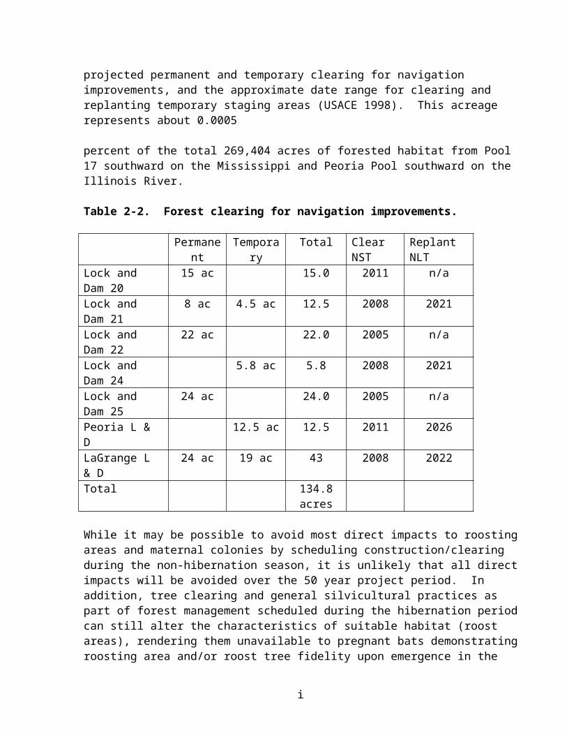
LITERATURE CITED
Barbour, R.W. and W.H. Davis. 1969. Bats of America. Univ. Press of Kentucky, Lexington. 286 pp.
Beauvais, S.L., J.G. Wiener, and G.J. Atchison. 1995. Cadmium and mercury in sediment and burrowing mayfly nymphs (Hexagenia) in the Upper Mississippi River, USA. Arch. Environ. Contam. Toxicol. 28, 178-183.
Belwood, J. J. 1979. Feeding ecology of an Indiana bat community with emphasis on the endangered Indiana bat, Myotis sodalis. M. S. Thesis, Univ. Florida, Gainesille, FL, 103 pp.
BHE Environmental, Inc. 1999. 1998 Annual report: implementation of reasonable and prudent measures and terms and conditions in the biological opinion for BRAC implementation at Fort Leonard Wood. Unpubl. Rept. 3D/E Group of BHE Environmental, Inc., Cincinnati, OH. 199 pp. + app.
Bowles, J.B. 1982. Results of monitoring of Indiana bat maternity sites in south-central Iowa. Unpubl. Report to IA Cons. Comm.
Brack, V., Jr. 1979. Determination of presence and habitat suitability for the Indiana bat (Myotis sodalis) and gray bat (Myotis grisescens) for portions of three ditches, Big Five Levee and Drainage District, Union and Alexander Counties, Illinois. U.S. Army Corps of Engineers, St. Louis, MO. 23 pp.
Brack, V., and R. K. LaVal. 1985. Food habits of the Indiana bat in Missouri. J. of Mammalogy, 66:308-315.
Brack, V., Jr., K. Tyrell, and K. Dunlap. 1991. A 1990-1991 winter cave census for the Indiana bat (Myotis sodalis) in non-priority 1 hibernacula in Indiana. Ind. Fed. Aid Proj. E-1-6, Study No. 18. Ind. Dept. Nat. Resources., Indianapolis. 45 pp.
Carter, T.C., S.K. Carroll, J.E. Hoffmann, J.E.Gardner, and G.A. Feldhamer. 2002. Landscape analysis of roosting habitat in Illinois. In The Indiana bat: biology and management of an endangered species (A. Kurta and J. Kennedy, eds.). Bat Conservation International, Austin, Texas. 253 pp.
Clark, D.R., Jr. 1981. Bats and environmental contaminants: a review. USDI Fish and Wildlife Service Special Scientific Report. Wildlife No. 235. 27 pp.
Clark, D.R., Jr., R.K. LaVal, and D.M. Swineford. 1978. Dieldrin-induced mortality in an endangered species, the gray bat ((Myotis grisescens). Science 199:1357-1359.
Clark, D.R., Jr., and R.M. Prouty. 1976. Organochlorine residues in three bat species from four localities in Maryland and West Virginia, 1973. J. Pestic. Monitor. 10:44-53.
i

Clawson, R. L., R. K. LaVal, M. L. LaVal, and W. Caire. 1980. Clustering behavior of hibernating Myotis sodalis in Missouri. J. Mammalogy, 61:245-253.
Clawson. R.L.. 2002. Trends in population size and current status. In The Indiana bat: biology and management of an endangered species (A. Kurta and J. Kennedy, eds.). Bat Conservation International, Austin, Texas. 253 pp.
Cope, J. B., A. R. Richter, and R. S. Mills. 1974. Concentrations of the Indiana bat, Myotis sodalis, in Wayne County, Indiana. Proc. Indiana Acad. Sci. 83:482-484
Cope, J. B., and S. R. Humphrey. 1977. Spring and autumn swarming behavior in the Indiana bat, Myotis sodalis. J. of Mammalogy, 58:93-95.
DeBlase, A.F., S.R. Humphrey, and K.S. Drury. 1965. Cave flooding and mortality in bats in Wind Cave, Kentucky. J. Mamm., 46:96.
Easterla, D. A., and L. C. Watkins. 1969. Pregnant Myotis sodalis in northwestern Missouri. J. of Mammalogy, 50:372-373.
EMTC (Environmental Management Technical Center). 1998. Ecological status and trends of the Upper Mississippi River System. USGS/EMTC
Gardner, J. E., J. D. Garner, and J. E. Hofmann ------. 1990. Combined progress reports: 1989 and 1990 investigations of Myotis sodalis (Indiana bat) distribution, habitat use, and status in Illinois. Progress report for the U.S. Dept. of the Interior, Fish and Wildlife Service, Twin Cities, MN. 19 pp.
Gardner, J. E., J. D. Garner, and J. E. Hofmann 1991. Summer roost selection and roosting behavior of Myotis sodalis (Indiana bat) in Illinois. Final report. Illinois Natural History Survey, Illinois Dept. of Conserv. Champaign, IL. 56 pp.
Gardner, J. E., J. E. Hofmann, and J. D. Garner. 1996. Summer distribution of the federally endangered Indiana bat (Myotis sodalis) in Illinois. Trans. Illinois St. Acad. Sci. 89, 187-196.
Garner, J.D. and J.E. Gardner. 1992. Determinations of summer distribution and habitat utilization of the Indiana bat (Myotis sodalis) in Illinois. Final Report: Project E-3. End. Sp. Act Sec. 6 Rpt. Il. Dept. Cons., Springfield, IL.
Geluso, K.N., J.S. Altenbach, and D.E. Wilson. 1976. Bat mortality: pesticide poisoning and migratory stress. Science 194:185-186.
Giessman, N., T.W. Barney, T.L. Haithcoat, J.W. Meyers, and B. Massengale. 1986. Distribution of forestland in Missouri. Trans. Missouri Acad. Sci. 20:5-14.
i
Goolsby, D.A and W.E. Pereira. 1996. Pesticides in the Mississippi River. In: Mead, R.H. ed. 1996. Contaminants in the Mississippi River, 1987-92. U.S. Geol. Surv. Circ. 1133. pp87-101. Denver, CO.
Gumbert, M. W., J.M. O’Keefe, and J.R. MacGregor. 2002 Roost fidelity in Kentucky. In The Indiana bat: biology and management of an endangered species (A. Kurta and J. Kennedy, eds.). Bat Conservation International, Austin, Texas. 253 pp.
Hall, J.S. 1962. A life history and taxonomic study of the Indiana bat, Myotis sodalis. Reading Publ. Mus. Art., Gallery Publ. 12:1-68.
Hassell, M.D. and M.J. Harvey. 1965. Differential homing in Myotis sodalis. Am. Midl. Nat. 74:501-503
Humphrey, S.R. 1978. Status, winter habitat, and management of the endangered Indiana bat, Myotis sodalis. Florida Scientist 41:65-76.
Humphrey, S. R., and J. B. Cope. 1977. Survival rates of the endangered Indiana bat, Myotis sodalis. J. of Mammalogy, 58:32-36.
Humphrey, S. R., A. R. Richter, and J. B. Cope. 1977. Summer habitat and ecology of the endangered Indiana bat, Myotis sodalis. J. of Mammalogy, 58:334-346.
ILDNR (Illinois Department of Natural Resources). 1990. Unpublished internal memorandum and site record sheet of bat capture. 6 pp.
Jacobson, R.B., and A.T. Primm. 1997. Historical land-use changes and potential effects on stream disturbance in the Ozark Plateaus, Missouri. U.S. Geol. Surv. Water-Supply Paper 2484, Denver, CO. 85pp.
Johnson, S.A., V. Brack, Jr., and R.E. Rolley. 1998. Overwinter weight loss of Indiana bats (Myotis sodalis) from hibernacula subject to human visitation. Am. Midl. Nat. 139:255-261.
Kennedy, J. and S. Ducummon. 1999. 1999 Winter bat survey in Pilot Know Mine, Iron County, Missouri. Unpubl. Rept. to the U.S. Fish and Wildlife Service, Columbia, MO. 12pp.
Jacobson, R.B., and A.T. Primm. 1997. Historical land-use changes and potential effects on stream disturbance in the Ozark Plateaus, Missouri. U.S. Geol. Surv. Water-Supply Paper 2484, Denver, CO. 85pp.
Kiser, J. D., and C. L. Elliott. 1996. Foraging habitat, food habits, and roost tree characteristics of the Indiana bat (Myotis sodalis) during autumn in Johnson County, Kentucky. Final report,Kentucky Dept. of Fish and Wildl. Resources, Frankfort, KY. 65 pp.
i

Kurta, A. 1980. Status of the Indiana bat, Myotis sodalis, in Michigan. Mich. Acad. 13:31-36.
Ladd, D. 1991. Reexamination of the role of fire in Missouri oak woodlands. In: G.V. Burger, J.E. Ebinger, and G.S. Wilhelm, eds., pp. 67-80. Proceedings of the Oak Woods Management Workshop, Eastern IL Univ., Charleston, IL.
LaVal, R.K. and M.L. LaVal. 1980. Ecological studies and management of Missouri bats, with emphasis on cave-dwelling species. MO Dept. of Cons. Terrestrial Series 8:1-53.
Lee, Y. 1993. Feeding ecology of the Indiana bat Myotis sodalis, and resource partitioning with Myotis keenii and Myotis lucifugus. M.S. Thesis, U. of Tenn., Knoxville.
MacCleery, D.W. 1992. American forests - a history of resiliency and recovery. USDA Forest Service publ. FS-540. Forest History Society, Durham, NC. 58 pp.
Marbut, C.F. 1896. Surface features of Missouri. MO Geol. Surv. Rept. 10-14-109.
McFarland, C.A. 1998. Potrential agricultural insecticide exposure of Indiana bats (Myotis sodalis) in Missouri. Unpubl. M.S. thesis, U. of MO - Columbia. 256 pp.
Meade, R.H., ed. 1995. Contaminants in the Mississippi River, 1987-92. U.S. Geol. Surv. Circ. 1133. Denver, CO
Mohr, C.E. 1972. The status of threatened species of cave-dwelling bats. Bull. Nat. Speleol. Soc. 34:33-37.
Moore, G.F. 1998. Plant communities of Effigy Mounds National Monument and their relationship to presettlement vegetation. M.S. Thesis, U. of WI, Madison.
Mumford, R. E., and J. B. Cope. 1958. Summer record of Myotis sodalis in Indiana. J. of Mammalogy, 39:586-587.
Murray, S. W., and A. Kurta. 2002. Spatial and temporal variation in diet. In The Indiana bat: biology and management of an endangered species (A. Kurta and J. Kennedy, eds.). Bat Conservation International, Austin, Texas. 253 pp.
Murray, S. W., and A. Kurta. 2004. Nocturnal activity of the endangered Indiana bat (Myotis sodalis). J. Zool., Lond. (2004) 262, 1-10.
Myers, R.F. 1964. Ecology of three species of Myotine bats in the Ozark Plateau. Unpubl. Ph.D. Dissertation, Univ. of Missouri-Columbia, Columbia, MO 210 pp.
Nelson, J.C., A. Redmond, and R.E. Sparks. 1994. Impacts of settlement on floodplain
i

vegetation at the confluence of the Illinois and Mississippi Rivers. Transactions of the IL St. Acad. Sci. (1994). Vol. 87, Nos. 3 and 4, pp. 117-133.
Nelson, J.C.. And R.E. Sparks. 1997. Forest compositional change at the confluence of the Illinois and Mississippi Rivers. Trans. Il. St. Acad. Sci. Vol. 91, Nos. 1 and 2, pp. 33-46. Reprinted by the U.S.G.S., Envl. Mgmt. Tech. Cent., Onalaska, WI. September 1998. LTRMP 98-R011. 14 pp.
Nigh, T.A., W.L. Pflieger, P.L. Redfearn, W.A. Schroeder, A.R. Templeton, and F.R. Thompson, III. 1992. The biodiversity of Missouri - definition, status, and
recommendations for its conservation. Biodiversity Task Force, Jefferson City, MO. 53 pp.
QST Environmental, Inc. 1997. Indiana bat (Myotis sodalis) survey on Cottonwood Island, Marioa and Lewis Counties, Missouri. Prepared for the U. S. Army Corps of Engineers Rock Island District. 10 pp plus appendices.
Reidinger, R.F. 1972. Factors influencing Arizona bat population levels. Unpubl. Ph.D. dissert., U. of AZ, Tucson. 172 pp.
Reidinger, R.F. 1976. Organochlorine residues in adults of six southwestern bat species. J. Widl. Manag. 40:677-680.
Richter, A.R., S.R. Humphrey, J.B. Cope and V. Brack, Jr. 1993. Modified cave entrances: thermal effect on body mass and resulting decline of endangered Indiana bats (Myotis sodalis). Conserv. Biol. 7:407-415.
Romme. R.C., K. Tyrell, and V. Brack, Jr. 1995. Literature summary and habitat suitability index model: components of summer habitat for the Indiana bat, Myotis sodalis. Report submitted to the IN Dept. Nat. Res., Div. Wildl., Bloomington, IN by 3D/Environmental Services, Inc., Cincinnati, OH. Fed. Aid Proj. E-1-7, Study No. 8. 38pp.
Saur, C. O. 1920. The geography of the Ozark highland of Missouri. Geog. Soc. of Chicago Bull. No. 7. U. of Chicago Press, Chicago. 187 pp.
Schmauch, S. and M. Tuttle. 1998. Pilot Knob Mine site evaluation. Unpubl. Rept. to the U.S. Fish and Wildlife Service, Columbia, MO. 5pp.
Schroeder, W.A. 1981. Presettlement Prairie of Missouri. MO Dept. of Cons., Jefferson City, MO. 35 pp.
Steingraeber, M.T., T.R. Schwartz, J.G. Wiener, and J.A. Lebo. 1994. Polychlorinated biphenyl congeners in emergent mayflies from the Upper Mississippi River. Envl. Sci. and Tech. 8:707-714.
i
Steingraeber, M.T. and J.G. Wiener. 1995. Bioassessment of contaminant transport and distribution in aquatic ecosystems by chemical analysis of burrowing mayflies (Hexagenia). Regulated Rivers: Research and Management 11:201-209.
Thomas, D.W., M. Dorais, and J.M. Bergeron. 1990. Winter energy budgets and cost of arousals for hibernating little brown bats (Myotis lucifugus). J. Mamm. 71:475-479.
Thomas, D. W. 1995. Hibernating bats are sensitive to non-tactile human disturbance. J. Mamm. 76:940-946.
UMRC (Upper Mississippi River Conservation Committee). 2002. Upper Mississippi and Illinois River floodplain forests, desired future and recommended actions. Upper Mississippi River Conservation Committee, Rock Island Illinois. 35 pp.
USACE (U.S.Army Corps of Engineers) 1992. Natural Resource Management Operational Management Plan, Mississippi River. U.S. Army Corps of Engineers, Rock Island District, Rock Island, IL.
USACE (U.S. Army Corps of Engineers). 1998. Identification of potential commercial navigation related bank erosion sites. Interim report for the UMR-IWW System Navigation Study.
USACE (U.S. Army Corps of Engineers). 1998. Site-specific habitat assessment. Interim report No. 7 for the UMR-IWW System Navigation Study.262pp
USACE (U.S. Army Corps of Engineers). 1999. Tier I of a two-tiered biological assessment - operation and maintenance of the Upper Mississippi River navigation project within the
St. Paul, Rock Island, and St. Louis Districts. Mississippi Valley Division, Vicksburg, MS. 111 pp. plus appendices.
USACE (U.S. Army Corps of Engineers). 2004a. Draft Integrated Feasibility Report and Programmatic EIS for the Upper Mississippi River-Illinois Waterway System Navigation Feasibility Study. U.S. Army Corps of Engineers, Rock Island District, Rock Island, IL
USACE (U.S. Army Corps of Engineers). 2004b. Biological Assessment of the Upper Mississippi River – Illinois Waterway System Navigation Study. U.S. Army Corps of Engineers, Rock Island, St Paul, and St Louis Districts. 193pp.
USFWS (U.S. Fish and Wildlife Service). 1983. Recovery Plan for the Indiana Bat. Twin Cities, MN. 23 pp.
USFWS (U.S. Fish and Wildlife Service). 1999. Agency Draft Indiana Bat (Myotis sodalis) Revised Recovery Plan. Fort Snelling, MN. 53 pp.
USFWS (US Fish and Wildlife Service) 2000. Biological Opinion for the Nantahala and Pisgah National Forests Land and Resource Management Plan, Amendment 5, on the Indiana bat. Asheville Ecological Services Field Office, Asheville, North Carolina.89 pp.
i
USFWS (US Fish and Wildlife Service) 2002. Biological Opinion, for the Monongahela National Forest Amended Land and Resource Management Plan. West Virginia Field Office, Elkins, West Virginia. 25 pp.
WDH Ecological Services. 2002. Endangered species investigation. Bat survey report. Indiana and gray bats (Myotis sodalis and Myotis grisescens) [for the] Proposed Lee Island Project, Holcim (US) Inc. Prepared for Holcim (US) Inc. Chesterfield Missouri. 11 pp plus appendices.
Yin, Y. 1999. Flooding and forest succession in a modified stretch along the Upper Mississippi River. Regulated Rivers: Research and Management, 14:217-225. Reprinted by U.S.G.S. Upper Midwest Envl. Sci. Cent., La Crosse, WI. Jan. 1999. LTRMP 99-R002. 9 pp.
Yin, Y. and J.C. Nelson. 1995. Modifications of the Upper Mississippi River and their effects on floodplain forests. Nat. Biol. Surv., Envl. Mgmt. Tech. Cent., Onalaska, WI. Feb. 1995. LTRMP 95-T003. 17 pp.
Yin, Y., J.C. Nelson, and K.S. Lubinski. 1997. Bottomland hardwood forests along the Upper Mississippi River. Natural Areas Journal 17(2): 164-173. Reprinted by U.S.G.S. Envl. Mgmt. Tech. Cent., Onalaska, WI. Nov. 1997. LTRMP 97-R025. 10pp.
PERSONAL COMMUNICATION
Carter, T. 2004. Associate Scientist, Southern Illinois University. Telephone conversation with Bob Clevenstine, Rock Island Field Office, U. S. Fish and Wildlife Service, Rock Island Illinois.
DeHaan, H. 2004. Geomorphologist, U. S. Army Corps of Engineers, Rock Island District. Telephone conversation with Bob Clevenstine, Rock Island Field Office, U. S. Fish and Wildlife Service, Rock Island Illinois.
Douglas, B. 2004. Fish and wildlife biologist, U. S. Fish and Wildlife Service, Elkins Field Office, Elkins West Virginia.. Telephone conversation and email with Bob Clevenstine. Rock Island Field Office, U. S. Fish and Wildlife Service, Rock Island Illinois.
Julison, T. 2004. Refuge Operation Specialist, U. S. Fish and Wildlife Service, Port Louisa National Wildlife Refuge. Telephone conversation with Bob Clevenstine, Rock Island Field Office, U. S. Fish and Wildlife Service, Rock Island Illinois.
Swenson, G. 2004. District forester, U. S. Army Corps of Engineers, Rock Island District. Telephone conversation with Bob Clevenstine, Rock Island Filed Office, U. S. Fish and Wildlife Service, Rock Island Illinois.
Widowsky, S. 2004. U. S. Forest Service. Shawnee National Forest. Telephone
i

conversation with Bob Clevenstine, Rock Island Field Office, Rock Island Illinois.
i

3.0 Decurrent false aster (Boltonia decurrens)
3.1 Status of the Species
This section presents the biological and ecological information relevant to formulating the biological opinion. Appropriate information on the species’ life history, its habitat and distribution, and other data on factors necessary to its survival, is included to provide background for analysis in later sections. This analysis documents the effects of all past human and natural activities or events that have led to the current status of the species. Portions of this information are also presented in listing documents, the recovery plan (USFWS 1990), the Final Biological Opinion for the Operation and Maintenance of the 9-Foot Navigation Channel on the Upper Mississippi River System (USFWS 2000) (O&M BO), and the Biological Assessment of the Upper Mississippi River-Illinois Waterway System Navigation Study (USACE 2004).
3.1.1 Species/critical habitat description
Boltonia decurrens is an early successional species that requires either natural or human disturbance to create and maintain suitable habitat. Its natural habitat is wet prairies, shallow marshes, and shores of open rivers, creeks, and lakes (Schwegman and Nyboer 1985). In the past, the annual flood/drought cycle of the Illinois River provided the natural disturbance required by this species. Annual spring flooding created open, well-lit habitat and reduced competition by killing other less flood-tolerant, early successional species. Field observations indicate that in "weedy" areas without disturbance, the species is eliminated by competition within 3 to 5 years (USFWS 1990). No critical habitat has been designated for the decurrent false aster at this time, although the Recovery Plan identified ten Illinois populations and two Missouri populations that should be protected.
3.1.2 Life history
Boltonia decurrens is a perennial plant of open wetland habitats. It reproduces vegetatively and sexually. Vegetative production of one or more basal rosettes occurs during the fall. Rosettes bolt the following spring; plants flower and set seed (achenes) from late August to early October. Smith et al. (1998) found that populations of B. decurrens increased in size at three sites studied on the Illinois River following the flood of 1993, with the greatest increase occurring at the two sites which had the most severe flooding. These results suggest that the removal of competing species by flood waters may be an important factor in maintaining populations of B. decurrens in the floodplain. B. decurrens has high light requirements for growth and achene germination (Smith et al. 1993, Smith et al. 1995), and shading from other vegetation is thought to contribute to its decline in undisturbed areas.
Boltonia decurrens exhibits a number of morphological adaptations for life on the floodplain. Stoecker et al. (1995) found B. decurrens to be extremely tolerant when maintained under conditions of root -zone saturation. All plants in the flood treatment replicate survived to the end of the study at 56 days. The formation of aerenchyma, a common plant adaptation to flooding which allows diffusion of oxygen from aerial shoots to maintain root metabolism, was extensive, increasing in adventitious roots from 26% of root cross-section area in non-flooded plants to
i

49% in flooded plants (Stoecker et al. 1995). Achenes of B. decurrens are morphologically structured for flotation and therefore presumably are adapted for dispersal on river currents. Smith and Keevin (1998) found that germination was not significantly reduced in achenes floated for 4 weeks, and 20% of achenes floated under conditions of simulated wave action were still floating after 4 weeks. These data indicate that achenes have the potential for long distance dispersal on water.
Smith and Keevin (1998) found that achenes of B. decurrens will not germinate in the dark. Achenes, which were covered with as little as 0.2 in. of sediment, did not germinate; therefore, if achenes are deposited by flood water and subsequently covered by a shallow layer of sediment, it is unlikely they will germinate. Natural or human disturbance of the soil, exposing the achenes to light, would be required for germination. Sediment type may also be an important factor in achene germination and long-term survival of populations. B. decurrens has been observed growing on a variety of soil types (Schwegman and Nyboer 1985, Smith 1991); however, laboratory studies (Smith et al. 1995) comparing achene germination and growth on two soil types, silty clay (6.7% sand, 53.3% silt, and 40% clay) and loamy sand (80% sand, 16.7% silt and 3.3% clay) indicate that germination and seedling growth were significantly greater on sand than on clay. These laboratory results suggest that the silt and clay sediment being deposited by flood events on the Illinois River (Lee and Stall 1976) is not ideal for germination and growth. Soil type may thus be important in determining the distribution pattern of this species.
Field monitoring by Schwegman and Nyboer (1985) suggested prolific achene production. B. decurrens produces about 50,000 achenes per individual, and, based on achene viability, an average plant is capable of producing about 40,000 seedlings under optimal conditions for germination (Smith and Keevin 1998). Fall seedlings overwinter and bolt and flower the following spring and summer. Spring seedlings, however, may either bolt and flower the same year or overwinter as small rosettes which bolt and flower the following year (Smith 1991). In areas where seedling production is low or nonexistent, B. decurrens populations can be maintained by basal rosette production. In fact, few seedlings are found in established populations (Moss 1997, Smith 1991). Seedling establishment is expected to be low due to the small achene size, the high light and temperature requirements for germination, and specific soil texture and microtopography requirements for germination and seedling growth (Baskin and Baskin 1988, Smith et al. 1995).
3.1.3 Population dynamics
During the consultation for the O&M BO, the species was considered to be stable ((Dr. Marian Smith, Southern Illinois University - Edwardsville. in litt. to Gerry Bade December 4, 1999). The Recovery Plan states that the species will be considered recovered after 12 stable populations have been protected by purchase, easement or cooperative management agreement. Following recent surveys, the number of populations had increased from 14 to 26 in 2002, but the number of individuals had decreased from over one million to an estimated 378,887 plants (Smith 2002). Given the fecundity of the species noted above and the long-term viability of achenes (Baskin and Baskin 2002) it is likely that wide variation will be the norm in the interannual numbers of individual plants within each known population. In the absence of other information, it is likely that the overall rangewide population of the species is stable within the species’ natural range of
i

variability, under current river management conditions.
3.1.4 Status and distribution
The status of the species is described above under Population dynamics.
Reasons for Decline and Listing
Habitat destruction and modification have been identified as the primary factors in the decline of the species, particularly of natural marshes, wet prairies, and shoreline habitats. Wetlands have been drained and converted to other uses, heavy siltation has buried suitable habitats, and construction of levee systems has altered the flooding regimes necessary for reduction of competition and prevented the dispersal of seeds to potential habitat. (USFWS 1990, Schwegman and Nyboer 1985, Smith et al. 1993, Stoecker et al. 1995, Smith et al. 1998, Smith and Keevin 1998). The decurrent false aster was listed as a threatened species by the Service on November 14, 1988 (53 FR 45861). It is a floodplain species that occurs along a 250 miles section of the lower Illinois River and nearby parts of the UMR (Schwegman and Nyboer 1985, USFWS 1990). Analysis of 19th century habitat data taken from herbarium sheets indicates that B. decurrens’ natural habitat was the shores of lakes and streams in the Illinois River floodplain and the Mississippi River floodplain in the vicinity of its confluence with the Illinois River. It ranged along a 250 mile stretch between LaSalle, Illinois, and St. Louis, Missouri. A disjunct population at Cape Girardeau, Missouri, was reported in 1976, 120 miles downstream of St. Louis (Schwegman and Nyboer 1985), but it has not been found since.
Range-wide Status
The action area encompasses the entire range of B. decurrens. The present distribution of the aster is essentially unchanged. Determining the status of an early successional species such as the decurrent false aster is difficult. Such species typically display a “boom and bust” phenomenon as colonies invade newly suitable sites, become dominant, and then decline as succession overcomes them. Determining a total population for the species is difficult because individual populations may change dramatically from year to year; some increasing, some decreasing, new ones appearing and old ones disappearing depending on site conditions. Several notable populations include Riverlands Environmental Demonstration Area, Spatterdock Bottoms and Columbia Bottoms in St. Charles County, Missouri; and Rice Lake in Fulton County, and Worley Lake in Tazewell County, Illinois (Dr. Marian Smith, Southern Illinois University - Edwardsville. in litt. to Gerry Bade December 4, 1999; ibid. January 28, 2000.). No new threats to the species since preparation of the Recovery Plan are known at this time.
3.2 Environmental Baseline
This section is an analysis of the effects of past and ongoing human and natural factors leading to the current status of the species, its habitat, and ecosystem within the action area. The purpose is to analyze the effects on the species at the action level. Factors affecting the species include habitat destruction and degradation due to water level regulation, impoundment, channel
i

maintenance, and wetland and shoreline development.
3.2.1 Status of the decurrent false aster in the action area
The action area encompasses the entire range of B decurrens, therefore its status within the action area is as described above.
3.2.2 Factors affecting the decurrent false aster environment within the action area
Habitat destruction and modification have been noted as the main reasons for the decline of the species (Schwegman and Nyboer, 1985). Shore habitats have been modified by heavy siltation and altered flood regimes. Prolonged flooding during the growing season appears to be a limiting factor (USFWS 1990). Figure 3-1 illustrates the shift in seasonal river stages over the historic period. We are unaware of any research that has been specifically done to discern the relative contribution of natural factors such as climate and precipitation versus human factors such as upland and urban development, stormwater runoff, wetland drainage, and field tiling to this change in the hydrograph.
Illinois River water levels at Copperas Creek
Figure 3-1. River stage records at the Copperas Creek gauge (Sparks et al. 1998).
While flooding benefits B. decurrens through seed dispersal and reduction of competition (Smith et al. 1998), summer flooding of recently germinated plants can be lethal depending on the depth and duration of the event. Mature plants are capable of withstanding saturated soils and display morphologic adaptions to maintain root metabolism under such conditions (Stoecker et al. 1995).
The 2000 O&M BO noted factors attributable to the 9-Foot Navigation Project that also affect the species: impoundment and water level regulation, dredged material disposal, channel regulating structures and bank revetment, fleeting, recreation, cabin leases, and General Plan
i
Land management. These are summarized as follows:
Impoundment - The initial impoundment of the Illinois River by navigation dams Locks and Dam 26 on the UMR; La Grange Lock and Dam, Peoria Lock and Dam, Starved Rock Lock and Dam and Marseilles Lock and Dam on the Illinois River) within the historic range of the aster created a series of pools. The pooling of the Illinois River resulted in the inundation of shoreline habitat. Historic collections indicate that shoreline habitat was utilized by B. decurrens (USFWS 1990). The acreage of shoreline habitat lost during the initial inundation by the navigation pools has not been quantified. It should be noted, however, that “new” shoreline would have been created or shifted to a higher elevation when the river was impounded.
Maintenance of navigation pools on the Illinois River has resulted in stable water levels during low-flow periods while locks and dams have had little effect on water stages during high water events. During low-flow periods prior to lock and dam construction, especially during drought years, the river would have receded, providing additional shoreline habitat for B. decurrens. The magnitude of impact would depend on many factors including the timing and duration of shoreline dewatering and availability of a seed bank.
Dredging and Disposal - Dredged material is usually removed from the navigation channel in the impounded reaches of the UMRS by a government or contractor-owned hydraulic cutterhead dredge and is discharged to placement sites by floating pipeline. In the Open River, it has been more common to use a hydraulic dustpan dredge that is sidecast, or discharged directly to adjacent channel border habitats. The government also uses its own mechanical dredging capability and contractors to perform smaller operations. Material is usually mechanically dredged by a clamshell bucket and placed on a deck barge for transport to a disposal site.
In the impounded or pooled reaches of the river system, dredged material was usually placed along the shoreline or occasionally in landward sites located in close proximity to the dredging site. Depending upon location, hydraulically or mechanically dredged material is placed 1) linearly along the shoreline for bankline stabilization or to rejuvenate recreational beaches that have eroded, or 2) placed in open water in channel border habitats, or 3) on sites landward of the shore to improve site suitability for planting or regeneration of desirable tree species, or 4) on land or behind levees for beneficial use stockpiles. Previous shoreline and upland placement may have destroyed populations of B. decurrens or rendered the habitat unsuitable for recolonization. However, the magnitude of impact cannot be quantified due to a lack of historical data.
Channel Structure/Revetment - Past activities related to the construction of channel training structures and revetment have likely affected B. decurrens or its habitat. Such modification included bankline grading and placement of stone (covering habitat) for bank revetment, wingdams, and closure structures. Maintenance of existing structures where shoreline modification has occurred may also have affected the species. The magnitude of these impacts cannot be quantified due to a lack of historical data. Other effects of channel regulating structures, such as redistribution of flows and sediment, may have changed overbank flooding and seed dispersal patterns at specific locations.
i

Fleeting - Development of existing fleeting areas required various levels of habitat modification, including placement of on-shore deadmen. Operation of heavy equipment and soil disturbance may have affected B. decurrens to an unknown degree. Other unregulated fleeting or casual mooring areas involving the use of shoreline trees for mooring has resulted in girdling, killing and toppling of trees which would provide marginal opportunity for achene exposure and germination. However, such effects would be expected to be short-lived and overcome by consequent shoreline erosion and/or succession at the forest edge.
Recreation - Development of existing recreation-related facilities required various levels of habitat modification including grading of shoreline areas, construction of boat ramps and docks, placement or riprap and bank revetment, and dredging access channels and harbors. The level of impact to B. decurrens or its habitat is unknown due to a lack of historical data.
General Plan Land Management - Corps of Engineers’ General Plan (GP) Lands in the St. Louis District include Riverlands Environmental Demonstration Area (EDA) managed by the Corps, Dresser Island/Spatterdock Bottoms managed by the Corps, Horseshoe Lake managed in part by the Corps and the State of Illinois) and Batchtown, Calhoun and Gilbert Lake Divisions and the Portage Island Group of the Mark Twain National Wildlife Refuge managed by the Service. B. decurrens occurs in the Gilbert Lake Division, Horseshoe Lake, the EDA and Dresser Island/Spatterdock Bottoms. In the past, certain maintenance activities such as grading and filling, bank stabilization, mowing and drainage ditch clean-out may have impacted the aster on these areas. The magnitude of these impacts is unknown due to a lack of historical data. No previous Section 7 consultation has ever been conducted for these activities.
3.3 Effects of the Action
This section includes an analysis of the direct and indirect effects of the proposed action on the species and its interrelated and interdependent activities. Factors to be considered include proximity of the action distribution timing nature of the effect duration disturbance frequency disturbance intensity and disturbance severity. The action is the recommended plan and its components described in Section 1, preceding.
The Upper Mississippi River-Illinois Waterway System Navigation Study proposes to implement both navigation improvement and ecosystem restoration actions. The navigation improvement program also contains a mitigation component for unavoidable adverse impacts to natural resources of the UMRS.
This Tier I biological opinion for the decurrent false aster evaluates the effects of these actions from a programmatic scale. Site-specific impacts will be evaluated during the Tier II planning process for specific projects and Tier II biological opinions provided to the U.S. Army Corps of Engineers for those projects that are likely to adversely affect the decurrent false aster. As the range of the species is limited to the Illinois River and counties below its confluence with the Mississippi, site-specific actions on the UMR above Mississippi river mile 221 are not likely to affect the species.
i

The action area includes the entire known range of B. decurrens; therefore, implementation of the recommended plan and its construction components is expected to kill individual plants by clearing, crushing, or burial (USACE 2004), and is likely to affect individuals and colonies of both known and unknown populations as a result of both navigation improvements and floodplain restoration. Due to the distribution of actions within the action area, the majority of populations exist in managed and monitored locations that will remain unaffected by navigation improvement or ecosystem restoration, although they are found within part of the action area defined in the Feasibility Study. The timing of actions such as drawdown, water level management, and other floodplain restoration or management actions is commonly directed at enhancing the establishment and survival of moist soil species, and would be expected to benefit B. decurrens. The nature of adverse effect is noted above and is likely to involve localized impacts of short duration to individuals within colonies, or burial of achenes that prevents germination. Disturbance frequency will vary with the plan component. Construction frequency for any particular navigation or ecosystem feature would be expected once at a given location over the 50 year period of analysis. Management action frequency for water level manipulation and moist soil management would be annual. Typical burning rotations are approximately every four years, based on Service management activity. The effect and intensity of disturbance depends on the life stage of B. decurrens at the site. Water level management or drawdowns would be expected to be beneficial and open up the soil surface seed bank to germination. Burning to reduce woody species invasion would be expected to kill mature B. decurrens present in the subject burn unit. If burning were conducted in the spring, late fall, or winter, it would have little impact on the species and clearing would be beneficial (T. Keevin pers. com. 2004). Given the relative fecundity of B. decurrens described previously, it is likely that the recovery of a colony from a prescribed burn would be rapid.
Short term impacts to individual B. decurrens during construction activity are expected to be outweighed by the long term benefits of floodplain restoration. Improved water level control, wetland restoration, and easement or acquisition of interest in the Illinois River portion of the action area will contribute to B. decurrens Recovery Plan objectives for habitat protection and management.
3.3.1 Direct effects
3.3.1.1 Navigation improvements
Continued impoundment and proposed changes in river regulation will not cause any additional impacts to the species or its habitat, i.e. no additional habitat will be lost due to inundation. Consequently, the impacts of impoundment will not threaten the survival and recovery of the species over the life of the project. The future impacts of water level regulation are not anticipated to change, as the regulatory capacity of the wicket gate dams at Peoria and LaGrange will not be altered with the addition of new lock structures. Currently, the effects of wicket gate raising and lowering create drops and spikes respectively in the tailwaters of these dams. Dam operations will be the same as in the past, i.e. stabilization of water levels during low flows and little or no affect on high flows. While natural seasonal low water levels have been eliminated by impoundment, high water and flood events will continue to provide part of the habitat disturbance on which the species depends. Consequently, the impacts of water level regulation
i

will not threaten the survival and recovery of the species over the life of the project.Tow traffic effects on B. decurrens are limited to tow-induced bank erosion. Approximately 88,795 meters of bankline in the Peoria through Pool 26 portion of the Illinois were identified as susceptible to bank erosion, and two locations within the erosional areas are adjacent to B. decurrens records (USACE 2004). Proposed mitigation for bank erosion includes bank armoring. Bank armor construction activities may adversely affect individuals by crushing or burial, but long term site stability should be beneficial to the species.
Dredging and dredged material placement will become tools for ecosystem management as well as channel maintenance under the recommended plan. Both the St Louis District and the Rock Island District have dredged material placement coordination processes in place. Prior to the discharge of any dredged material, interagency teams meet to determine the preferred placement site for the dredged material. These teams are composed of representatives of the appropriate State and Federal agencies. The U.S. Fish and Wildlife Service, along with representatives of the affected State(s), participate in these teams. Additionally, appropriate Federal and State agency representatives are coordinated with concerning endangered species. Although these teams strive to preclude impacts from dredged material placement, there is a potential that B. decurrens may occur at sites where seed has settled but the plant has not yet sprouted. Potential impacts of dredged material placement can be avoided or minimized through appropriate coordination with the Service and States. Tier II Section 7 Consultation will be conducted as necessary.
Channel regulating structures and revetments present a potential to adversely affect decurrent false aster populations that occur on bankline areas where habitat modification would occur. Such modification would include bankline grading and placement of stone (covering habitat) for bank revetment, wingdams, and closure structures. Maintenance of existing structures where shoreline modification would occur may also affect the species. There is also a potential that bank grading and associated activities could create conditions suitable for the establishment of new populations of B. decurrens due to habitat disturbance. Current construction practices for off-bank revetment, chevron dikes, and bendway weirs do not involve terrestrial habitat destruction and construction is done from the river without terrestrial staging areas.
Potential impacts of constructing and maintaining channel structures and revetment can be avoided through appropriate coordination with the Service. Tier II Section 7 Consultation will be conducted as necessary. Therefore, construction and maintenance of channel structures and revetment will not threaten the survival and recovery of the species over the life of the project.
3.3.1.2 Mitigation
The recommended plan contains 20 sites recommended for mitigation of lost backwaters and side channels on the Illinois Waterway between the Dresden and Alton Pools. Proposed mitigation involves placement of channel closing structures, bank protection, and/or dredging. The effects of these actions are similar to those described in the preceding section on navigation improvements.
3.3.1.3 Ecosystem Restoration
i
Restoration projects are proposed to alter and improve habitat conditions on up to an estimated 32,000 acres in the Illinois River portions of the study area. Descriptions of proposed ecosystem restoration measures are summarized in Project Description preceding. The conservation measure described previously will allow the action agency to develop site-specific plans that reduce the potential adverse effects to B. decurrens. We anticipate that few instances will arise where adverse effects will be unavoidable, and that where unavoidable, reproduction, numbers, or distribution of B. decurrens will be appreciably reduced.
Island Building
Island building is primarily a process of dredging and placement of dredged material for the express purpose of restoring an eroded feature or providing wind and wave protection to reduce sediment resuspension, improve water clarity, provide bathymetric diversity necessary to provided habitat for a range of aquatic life stages, and provide the topographic diversity necessary to provide a range of terrestrial habitats representative of the specific river reach. New or restored island sites may present shoreline areas suitable for colonization by B. decurrens, and depending on flood frequency may contribute to the total population of the species.
Fish Passage
Fish passage involving reestablishment of lateral hydraulic connectivity could involve tree removal and construction-related disturbance that could open up sites for temporary establishment of B. decurrens colonies. This benefit would be expected to be temporary.
Floodplain Restoration
Floodplain restoration, as described previously includes a range of passive measures to restore and manage representative ecotypes, as well as aggressive construction measures typical of floodplain development and flood control projects. These activities occurring in close proximity to maternal roost trees or roosting areas would be expected to influence reproductive success, resulting in take of the species. Floodplain restoration includes timber stand improvement, clearing for grassland restoration, or other landcover modification that has the potential to open up soil surfaces and either expose B. decurrens seed or provide open substrate for its colonization depending on flood frequency.
Water Level Management
Water level management includes both small and large-scale drawdowns to expose and consolidate sediment, stimulate valuable vegetation, and simulate natural river processes. Pool-wide drawdowns are seen as feasible on the Illinois Waterway due to river and floodplain morphometry. However, off-channel or backwater drawdowns that expose sediment for seasonal establishment of moist soil species could benefit B. decurrens and add additional seed sources if not new self-sustaining populations.
Backwater Restoration
i

Backwater restoration will primarily involve dredging and dredged material placement, some of which may be used for island construction, and some of which may be used to create topographic diversity beneficial to a variety of terrestrial plants and animals. Dredged material placement often involves the deployment of standard construction equipment at the target locations and has the potential to destroy existing B. decurrens colonies as well as open up new substrate for colonization.
Side Channel Restoration
Side channel restoration may potentially affect B. decurrens where construction activities involve shoreline work and construction equipment access. Such effects would be minor, temporary, and localized.
Wing Dam and Dike Alteration
Wing dam and dike alteration is anticipated to have the same effects noted previously in Mitigation and Navigation Improvements.
Island and shoreline protection potentially affecting bankline individuals or colonies of B. decurrens is proposed over a total length of 41 miles in this same portion of the study area. This bankline total includes that work proposed to offset navigation induced erosion and that work proposed to protect or restore shorelines and islands as part of the ecosystem component.
Interrelated and Interdependent Actions
The recommended plan contains a suite of administrative, operational, and construction activities that are directed at navigation improvement and ecosystem restoration throughout the UMRS. An interrelated activity is an activity that is part of the proposed action and depends on the proposed action for its justification. Such things as timber management and General Plan Land management are all interrelated to both the operation and maintenance of the 9-Foot Navigation Channel Project and implementation of the recommended that integrates these government functions with the ecosystem restoration component of the plan.
The St. Louis District has recently completed an Action Plan for B. decurrens on Corps of Engineers General Plan lands within the St. Louis District (USACE 1998). Development of the Action Plan was a joint effort between the U.S. Fish and Wildlife Service and the Corps of Engineers with participation from Dr. Marian Smith (Southern Illinois University - Edwardsville), an expert on the species. The action plan included a monitoring protocol and initial census, evaluation of management techniques, training of site personnel to identify the species, development of an education and outreach program, development of land management objectives, and development of a pre-action checklist for project implementation. The next step is to implement the plan and to incorporate a management protocol into the Corps’ Operational
i
Management Plan for the area.
Consistent with the Action Plan, the St. Louis District has completed Phase I (Monitoring Protocol), an initial census of the Environmental Demonstration Area, to determine the locations and general population sizes of B. decurrens (USACE in litt. to Gerry Bade, November 3, 1999). Similar management possibilities exist on other Corps lands, U.S. Fish and Wildlife Service refuge lands, and lands owned and/or managed by the Missouri Department of Conservation and the Illinois Department of Natural Resources. Implementation of this Action Plan will provide benefits to the species and enhance the potential for its survival and recovery.
An interdependent activity is an activity that has no independent utility apart from the action under consultation. The future need for additional fleeting areas is unknown. However, potential impacts of development of fleeting areas can be avoided through appropriate coordination with the Service. Tier II Section 7 Consultation will be conducted as necessary. Therefore, fleeting will not threaten the survival and recovery of the species over the life of the project.
Indirect Effects
Navigation - Tow traffic was projected to affect approximately 88,795 meters of shoreline on the Illinois River, necessitating mitigation in the form of bank protection. Increased traffic is not expected to increase the amount of susceptible bankline.
Port facilities - The future need for additional port facilities is unknown. However, potential impacts of development of port facilities can be avoided through appropriate coordination with the Service. Tier II Section 7 Consultation will be conducted as necessary. Therefore, development of port facilities will not threaten the survival and recovery of the species over the life of the project.
Exotic species - The future effects of introduced exotic species on B. decurrens cannot be predicted at this time. Given the species life history, it would be possible for disease or insects to exploit whole colonies at a time, but their ability to spread to other colonies within a population or to the disjunct populations throughout the species range is unknown. While unquantified, the presence of buried achenes in the floodplain seedbank suggests a measure of resilience to such events. The species ability to compete with invasive plant species is unknown; therefore, the potential effect of exotic species cannot be forecast at this time.
Contaminants - The effects of contaminants on B. decurrens have not been researched; however, it is considered vulnerable to herbicide use in low-lying marginal lands for crop weed control (USFWS 1990). Implementation of the recommended plan is not anticipated to contribute to current contaminant loading in the action area. Non-point source contaminants introduced from stormwater or agricultural runoff may be positively influenced by achievement of some floodplain restoration objectives, but watershed or upland treatment/restoration measures are beyond the scope of this study. Therefore, the effects of contaminants on B. decurrens cannot be
i
quantified at this time.
Recreation effects - The future need for additional government-operated recreational facilities is unknown. However, potential impacts of development of recreational facilities can be avoided through appropriate coordination with the Service. Tier II Section 7 Consultation will be conducted as necessary. Therefore, development of recreational facilities will not threaten the survival and recovery of the species over the life of the project. Development on private lands adjacent to ecosystem restoration projects is also an indirect effect, but is addressed subsequently in Cumulative Effects.
Other indirect effects are anticipated to arise from administrative actions proposed in the recommended plan, primarily partner agencies’ adoption of the adaptive management paradigm, in short “learning by doing,” and provision of additional Corps authority for ecosystem restoration. It is likely that all effects to listed species subject to this consultation cannot be foreseen at this time. As part of the adaptive management approach, predictive models are proposed to be developed in the implementation phase of the recommended plan, and will necessarily involve elements of listed species life history. The Service expects that further collaboration among partner agencies to develop, test, and validate assumptions used in such models will result in modifications to the recommended plan that contribute to listed species’ recovery Adaptive management requires a more responsive approach to problems and opportunities as they arise and agency regulatory processes can limit responsiveness. The recommended plan calls for additional authority for ecosystem restoration and will allow the use of Corps channel maintenance capabilities for restoration work in off-channel areas. Because channel maintenance priorities are dictated seasonally by the dynamics of river hydraulics and sediment transport, it will not be possible to predict where specific actions will occur on an annual basis, or on a basis that permits total avoidance of impact to the decurrent false aster. It is likely that although the long term effects of ecosystem restoration will be beneficial, logistically advantageous use of channel maintenance equipment could adversely affect individual plants and colonies on a site-specific basis.
Species response to the proposed action
Smith (2002) identified 26 populations holding an estimated 378,887 individuals in the action area, down from over million individuals in 2001. Elsewhere in the species range, recent monitoring of 28 colonies associated with a highway relocation project in Madison and St Clair counties, Illinois, resulted in summary estimates ranging from one flowering plant to over one million. Eighty percent of the colonies had higher populations in 2003 than in 2002 (Ketzner et al, 2004). The subject highway project lies within the technical study area boundary but would not be affected by implementation of the recommended plan. Populations existing on Federal and state lands are already receiving management consideration. Ecosystem restoration on those lands, as well as water level management improvements on the system that mimic the natural hydrograph, would be expected to elicit a positive response from B. decurrens. The life history previously discussed for B. decurrens demonstrates fairly specific conditions (soil type, temperature, light) necessary for establishment and persistence in the wild that may be interpreted as sensitivity to change; however, the species is actually dependent on change in the form of periodic disturbance to open new areas for colonization and seed dispersal. Research
i

indicated that factors other than fecundity are responsible for the threatened status of B. decurrens; therefore, from a reproductive potential standpoint, the species may be considered very resilient to disturbance. It would be expected to respond positively to appropriately-timed moist soil management and water level management that provide open substrate for germination. As a pioneer or fugitive species dependent on ecosystem disturbance, B. decurrens is not a likely representative of ecosystem equilibrium at the individual population or microhabitat scale, and recovery rate may not be a meaningful metric in assessing its response to the recommended plan. Colonies within populations are generally known to only persist for 3 to 5 years. However, it is a representative of the continued existence of dynamic natural processes on a landscape scale, as it is dependent on periodic flooding to reduce competition and disperse seed to newly available habitat. Two goals of the recommended plan are to maintain viable populations of native species in situ; and represent all native ecosystem types across their natural range of variation. Any improvement in water level management on the Illinois River and restoration of portions of its floodplain would be expected to maintain conditions necessary for the continued viability of B. decurrens.
3.4 Cumulative Effects
Cumulative effects include the effects of State, local or private actions that have occurred in the action area. Future Federal actions that are unrelated to the proposed action are not considered in this section because they require separate consultation pursuant to section 7 of ESA.
Changes in the Illinois river hydrograph illustrated in Figure 1 are due in part to the construction operation and maintenance of the navigation system, in part to altered hydrology from wetland drainage and agricultural activity (ditching and tiling), and in part to development throughout the upper Illinois River watershed. No estimate of the relative contribution of each factor to discharge represented on the hydrograph has been made, but it is reasonable to conclude that development will continue, and that unstable water levels will continue to dictate vegetation success in the floodway of the Illinois River. Likewise, although programs exist for wetland restoration on private lands, that agriculture will remain a dominant and determining factor in floodplain hydrology and landcover.
Some non-Federal actions in the floodplain of the Illinois and Upper Mississippi Rivers will likely require Federal review under Section 404 of the Clean Water Act (CWA) or Section 10 of the Rivers and Harbors Act. Ecosystem restoration may induce the development of adjacent agricultural properties for outdoor sporting purposes, including wetland restoration, moist soil management, and general conversion of row crop landcover to forest or grassland wildlife habitat. Such conversion would be expected to be beneficial to B. decurrens. Examples of non-Federal actions currently underway on the Illinois River floodplain that could be beneficial are those restoration projects undertaken by the Nature Conservancy at Emiquon, a 7000 acre site formerly known as Wilder Farms in Fulton County, and Spunky Bottoms, a 2026 acre site in Brown County, opposite the USFWS Meredosia National Wildlife Refuge (The Nature Conservancy 2004a & b). Also, a consortium of non-profit organizations has acquired the former Hennepin Drainage and Levee District and is in the process of reestablishing elements of the natural hydrology and native plant communities on approximately 2600 acres of floodplain
i

near Hennepin Illinois (The Wetlands Initiative, 2004).
It is possible that unauthorized activities or activities not requiring Federal review under the CWA could adversely affect the aster or its habitat. While some population exist on private lands, it is impossible to determine the magnitude of any such impacts in the absence of comprehensive surveys of all private lands within the species range.
3.5 Conclusion
After reviewing the current status of B. decurrens, the environmental baseline for the action area, the effects of the proposed action, and the cumulative effects, it is the Service's biological opinion that the proposed action is not likely to jeopardize the continued existence of the species. No critical habitat has been designated for this species; therefore, none will be affected.
3.6 Incidental Take Statement
Sections 7(b)(4) and 7(o)(2) of ESA do not apply to the incidental take of listed plant species. However, protection of listed plants is provided to the extent that ESA requires a Federal permit for removal or reduction to possession of endangered plants from areas under Federal jurisdiction, or for any act that would remove, cut, dig up, or damage or destroy any such species on any other area in knowing violation of any regulation of any State or in the course of any violation of a State criminal trespass law.
Conservation Recommendations
Section 7(a)(1) of ESA directs Federal agencies to utilize their authorities to further the purposes of ESA by carrying out conservation programs for the benefit of endangered and threatened species. Conservation recommendations are discretionary agency activities to minimize or avoid adverse effects of a proposed action on listed species or critical habitat, to help implement recovery plans, or to develop information.
1. The St. Louis District and the U.S. Fish and Wildlife Service developed an action plan for managing and protecting populations of B. decurrens on the Riverlands - Environmental Demonstration Area (EDA). The action plan included a monitoring protocol and initial census, evaluation of management techniques, training of site personnel to identify the species, development of an education and outreach program, development of land management objectives, and development of a pre-action checklist for project implementation. Implementation of this action plan is hereby recommended.
2. The Corps should provide assistance to the Service towards recovery of the species by assembling and providing all its B. decurrens survey data in GIS format. In addition, we request the Corps’ participation in updating the recovery plan and participation in related recovery actions.
i
LITERATURE CITED
Baskin, C.C. and J.M. Baskin. 1988. Germination ecophysiology of herbaceous plant species in a temperate region. Amer. J. Bot. 75:286-305.
Baskin, C.C. and J.M. Baskin. 2002. Achene germination ecology of the federally threatened floodplain endemic Boltonia decurrens. Am. Midl. Nat. 147:16-24.
Ketzner, D. P. Marcum, A. Plocher, D. Keene, and R. Larimore. 2004. Results from the decurrent false aster (Boltonia decurrens) recovery project – FAP 999 (New Mississippi River Crossing, Relocated I-70 and I-64 Connector) and FAP 14 (Il Route 3 Relocation), Madison and St Clair Counties, Illinois – 2003. Illinois Natural History Survey, Center for Wildlife Ecology, Champaign, Illinois. 15 pp.
Lee, M.T., and J.B. Stall. 1976. Sediment conditions in backwater lakes along the Illinois River - Phase 2. Il. St. Wat. Surv. Contract Report 176B. 63 pp.
Moss, J. 1997. Stage-based demography of the threatened floodplain species Boltonia decurrens. M.S. Thesis, Southern Illinois University, Edwardsville, IL.
Nature Conservancy, The. 2004a. The Emiquon Project. http.//nature.org/wherewework/northamerica/state/Illinois/preserves/art1112.html.
Nature Conservancy, The 2004b. Spunky Bottoms. http.//nature.org/wherewework/northamerica/state/Illinois/preserves/art1113.html
Schwegman, J.E. and R.W. Nyboer. 1985. The taxonomic and population status of Boltonia decurrens (Torr. & Gray) Wood. Castanea 50:112-115.
Smith, M. 1991. Life history research for decurrent false aster. Il. Dept. Cons. Contract Report, Springfield, IL. 26 pp.
Smith, M. 2002. Year 2002 inventory of decurrent false aster (Boltonia decurrens) U.S. Army Corps of Engineers, Rock Island District, final report. 5pp.
Smith, M., T. Brandt, and J. Stone. 1995. Effects of soil texture and microtopography on germination and seedling growth in Boltonia decurrens (Asteraceae), a threatened floodplain species. Wetlands 15:392-396.
Smith, M. and T. Keevin. 1998. Achene morphology, production and germination, and potential for water dispersal in Boltonia decurrens (decurrent false aster), a threatened floodplain species. Rhodora 100:69-81.
Smith, M., T. Keevin, P. Mettler-McClure, and R. Barkau. 1998. Effects of the flood of 1993 on Boltonia decurrens, a rare floodplain plant. Regulated Rivers: Research and Management 14:191-202.
i

Smith, M., Y. Wu, and O. Green. 1993. Effects of light and water-stress on photosynthesis and biomass production in Boltonia decurrens (Asteraceae), a threatened species. Am. J. Bot. 80:854-864.
Stoecker, M.A., M. Smith, and E.D. Melton. 1995. Survival and aerenchyma development under flooded conditions of Boltonia decurrens, a threatened floodplain species and Conyza canadensis, a widely distributed competitor. Am. Midl. Nat. 134:117-126.
USACE (U.S. Army Corps of Engineers). 1998. Action plan for managing and protecting populations of Boltonia decurrens. 3 pp.
_____. 2004. Biological Assessment of the Upper Mississippi River-Illinois Waterway System Navigation Study. 193pp.
_____. 1999. Tier I of a two-tiered biological assessment - operation and maintenance of the Upper Mississippi River navigation project within the St. Paul, Rock Island, and St. Louis Districts. Mississippi Valley Division, Vicksburg, MS. 111 pp. plus appendices.
_____. In litt. Correspondence to Gerry Bade, U.S. Fish and Wildlife Service, Rock Island, IL. November 3, 1999.
USFWS (U.S. Fish and Wildlife Service). 1990. Decurrent false aster recovery plan. U.S. Fish and Wildlife Service. Twin Cities, MN. 26 pp.
USFWS (U.S. Fish and Wildlife Service). 2000. Final Biological Opinion for the operation and maintenance of the 9-Foot navigation channel on the upper Mississippi River system. 240pp.
Wetlands Initive, The. 2004. The Hennepin & Hopper Lakes Project. http://www.wetlands-initiative.org/pages/page28.html
PERSONAL COMMUNICATION
Keevin, T. 2004. Senior Scientist, U. S. Army Corps of Engineers, St Louis District. Telephone conversation with Bob Clevenstine, Rock Island Field Office, U. S. Fish and Wildlife Service, Rock Island Illinois.
i

4.0 Higgins eye pearlymussel (Lampsilis higginsii)
4.1 Status of the Species
This section presents the biological or ecological information relevant to formulating the biological opinion. Appropriate information on the species’ life history, its habitat and distribution, and other data on factors necessary to its survival, is included to provide background for analysis in later sections. This analysis documents the effects of all past human and natural activities or events that have led to the current status of the species. Portions of this information are also presented in listing documents, the recovery plan (USFWS 2004), , the Final Biological Opinion for the Operation and Maintenance of the 9-Foot Navigation Channel on the Upper Mississippi River System (USFWS 2000), and the Biological Assessment of the Upper Mississippi River-Illinois Waterway System Navigation Study (USACE 2004).
4.1.1 Species /critical habitat description
The Higgins Eye Pearlymussel Recovery Plan identifies ten Essential Habitat Areas (EHAs) that are important for the recovery of the species (U.S. Fish and Wildlife Service 2004). The ten Essential Habitat Areas are: 1) the St. Croix River near Interstate (River Mile 47.5 - 48.5), 2) the St. Croix River at Hudson, Wisconsin (River Mile 16.2 - 17.6), 3) the St. Croix River at Prescott, Wisconsin (River Mile 0 – 0.2), 4) the Wisconsin River near Muscoda, Wisconsin (Orion), 5) the UMR at Whiskey Rock, at Ferryville, Wisconsin, Pool 9 (River Mile 655.8 - 658.4), 6) the UMR at Harpers Slough, Pool 10 (River Mile 639.0 - 641.4), 7) the UMR Main and East Channels at Prairie du Chien, Wisconsin, and Marquette, Iowa, Pool 10 (River Mile 633.4 - 637), 8) the UMR at McMillan Island, Pool 10 (River Mile 616.4 - 619.1), 9) the UMR at Cordova, Illinois, Pool 14 (River Mile 503.0 - 505.5), and 10) the UMR at Sylvan Slough, Quad Cities, Illinois, Pool 15 (River Mile 485.5 - 486.0). In addition, the original recovery plan described the following nine secondary habitats: 1) Guttenberg, Iowa, Pool 11 (River Mile 613), 2) Cassville, Wisconsin, Pool 11 (River Mile 607), 3) Dubuque, Iowa, Pool 12 (River Mile 580); (4) Adam Island (vicinity), Iowa, Pool 14 (River Mile 507); (5) Rapids City, Illinois, Pool 14 (River Mile 496); (6) Lower Sylvan Slough, Illinois, Pool 16 (River Mile 482); (7) Andalusia Slough, Illinois, Pool 16 (River Mile 473); (8) Barkis Island, Illinois, Pool 17 (River Mile 444); and (9) Jonas Johnson Island, Illinois, Pool 17 (River Mile 439) (U.S. Fish and Wildlife Service 2004).
4.1.2 Life history
Higgins eye occurs most frequently in medium to large rivers with current velocities of 0.5 to 1.5 feet per second and in depths of 2 to 20 feet (U.S. Fish and Wildlife Service 2004). It tends to be found in water with dissolved oxygen greater than 5 parts per million (ppm) and calcium carbonate levels greater than 50 ppm. The species is correlated with a firm, coarse sand substrate (Hornbach et al. 1995). Higgins eye usually is found in large, stable mussel beds with relatively high species and age diversity. Hornbach et al. (1995) concluded Higgins eye seemed to be associated with areas of higher mussel species richness and generally higher mussel population densities.
The reproductive cycle of Higgins eye is typical of the family Unionidae (Cummings and
i

Mayer 1992). Males discharge sperm into the surrounding water; females obtain the sperm as they siphon water for food and respiration. Eggs are fertilized in gill sacs (marsupia) in the female; fertilized eggs are retained in the marsupia until they mature into glochidia and are released. The mantle edge near the posterior shell resembles a small swimming fish that is postulated to attract predator fish. Gill tissue containing glochidia protrudes between the mantle flaps. When a fish attacks the gill tissue, glochidia are released, thus enhancing the probability that glochidia will come into contact with a host fish. Released glochidia attach themselves to the gills of host fish. Successfully attached glochidia mature and excyst from hosts' gills as juvenile mussels; they settle to the substrate and become sedentary in the substrate, if it is suitable. The species is bradytictic (i.e., a long-term breeder) retaining developing glochidia throughout the year, except for the period following glochidia release. Glochidia are carried in the gill marsupia through winter and released the following spring or summer (Baker 1928, Holland-Bartels and Waller 1988).
Holland-Bartels and Waller (1988) tested 15 species of UMR fish and reported walleye (Stizostedion vitreum) and largemouth bass (Micropterus salmoides) as the most successful host fish for Higgins eye, as determined by glochidial persistence and maturation to juvenile stage on the fish. Subsequent studies (Gordon 2001) found smallmouth bass (Micropterus dolomieui) to be a suitable host as well.
4.1.3 Population dynamics
Population dynamics are described below under Status and distribution.
4.1.4 Status and distribution
The Higgins eye pearlymussel (Lampsilis higginsii) was listed as an endangered species by the U.S. Fish and Wildlife Service (Service) on June 14, 1976 (Federal Register, 41 FR 24064). The major reasons for listing Higgins eye were the decrease in both the abundance and range of the species. As stated in the recovery plan (U.S. Fish and Wildlife Service 2004), Higgins eye was never abundant, and Coker (1919) indicated it was becoming increasingly rare around the turn of the last century. The fact that there were few records of live specimens from the early 1900s until the enactment of the Endangered Species Act in 1973 was a major factor in its listing in 1976 (U.S. Fish and Wildlife Service 2004). A variety of factors have been listed as affecting Higgins eye over time including commercial harvest; impoundment from the federal 9-Foot Channel Project; channel maintenance dredging and disposal activities; changes in water quality from municipal, industrial, and agricultural sources; unavailability of appropriate glochidial hosts; exotic species; and disease (U.S. Fish and Wildlife Service 2004).
Distribution
The historical distribution of Higgins eye is not known with certainty. While never considered an abundant species, it is believed to have been distributed widely, inhabiting the Upper Mississippi River (UMR) main stem from just north of St. Louis, Missouri, to Minneapolis-St. Paul, Minnesota (Coker 1919). It also was found in several UMR tributaries including the Ohio,
i

Illinois, Sangamon, Iowa, Cedar, Wapsipinicon, Rock, Wisconsin, Black, Minnesota, and St. Croix Rivers (U.S. Fish and Wildlife Service 2004). The range of Higgins eye has been reduced significantly from its historical distribution and now includes the UMR upstream of Lock and Dam 22 near Hannibal, Missouri, the lower St. Croix River between Wisconsin and Minnesota, the lower Wisconsin River, Wisconsin, and the lower Rock River in Illinois (U.S. Fish and Wildlife Service 2004). Based on work done by Cawley (1996), the known range of Higgins eye has been extended 98 miles to the south and 82 miles to the north of the range described in the 1983 recovery plan, based solely on the collection of dead specimens. However, since 1980, live Higgins eye have not been collected on the UMR downstream of Lock and Dam 19, though a single fresh dead specimen was collected in Pool 22 in the late 1980s (U.S. Fish and Wildlife
Major Threats
The single most significant threat to Higgins eye appears to come from zebra mussels (Dreissena polymorpha), a nonindigenous species introduced into the United States from the Black and Caspian Seas (U.S. Fish and Wildlife Service 2000). Zebra mussels were introduced into Lake St. Clair in the mid 1980s from discharge of ship ballast water. The species is now reproducing and invading North America's lakes and rivers. Zebra mussels invaded the Illinois River from Lake Michigan through the Chicago Sanitary and Ship Canal; once in the Illinois River, they quickly invaded the UMR. The invasion from Lake Michigan probably resulted from zebra mussel veligers drifting downstream through the canal system to the Illinois River. However, because zebra mussels attach to hard objects/substrates, they readily attach to the hulls of boats including commercial tows and recreational boats navigating on the Illinois and Mississippi Rivers and are consequently transported by these vessels. Unfortunately, the ability of zebra mussels to attach to boat hulls and associated equipment provided the critical vector for upstream transport on the UMRS by large commercial and recreational boats. All EHAs for Higgins eye are located in the UMR and tributaries upstream of the confluence of the Illinois River (U.S. Fish and Wildlife Service 2004). Today, zebra mussels are found in all EHAs, with the exception of the Interstate EHA on the St. Croix River.
Zebra mussels can decimate native mussels in waters where they become establish and reach high densities (U.S. Fish and Wildlife Service 2000). They affect native mussels directly by attaching to the shells of the native species and impairing feeding and filtering functions, preventing valve closure, and causing shell deformation. Zebra mussels may also indirectly harm native mussels by competing for food resources and changing the water chemistry, i.e., decreasing dissolved oxygen levels and increasing ammonia levels (U.S. Army Corps of Engineers 2004a). Furthermore, zebra mussels can prevent recolonization of native mussels in formerly suitable habitats and prevent their burrowing into substrate by forming an impenetrable layer on the bottom (U.S. Fish and Wildlife Service 2000).
Concerning potential impacts to Higgins eye, a reconnaissance study by the U.S. Army Corps of Engineers predicted that zebra mussels may adversely affect approximately 1,700 acres of prime Higgins eye habitat and eventually eliminate 573,000 individuals, or 83 percent of the total known population in EHAs and secondary habitat areas (U.S. Army Corps of Engineers 2003). A loss of this magnitude occurred at the Prairie du Chien EHA, Wisconsin, in UMR Pool 10. Studies by the Corps of Engineers in the East Channel reference site found the native mussel community decimated by zebra mussels (U.S. Army Corps of Engineers 2004a). Zebra mussels
i

were first collected in 1993, averaging two individuals per square meter. Density increased to over 10,000 individuals per square meter by 1996 (Figure 4-1), and a precipitous decline in native mussels followed (Figure 4-2). In particular, catch per unit effort of Higgins eye declined from nearly 1.0 individual per minute in 1995 to less than 0.1 individual per minute in 2000 through 2003 (Figure 4-3).
Dreissena polymorphaEast Channel, Reference Site
1
100
10000
1000000
92 93 94 95 96 98 99 00 01 02 03
Year
Den
sity
(Ind
/m2 )
Figure 4-1. Zebra mussel abundance in the East Channel at Prairie du Chien, Wisconsin. Source: U.S. Army Corps of Engineers (2004a).
UnionidsEast Channel, Reference Site
020406080
100120140160
84 85 87 88 89 90 92 93 94 96 98 99 00 01 02 03
Year
Den
sity
(Ind
/m2 )
Figure 4-2. Native mussel densities in the East Channel at Prairie du Chien, Wisconsin. Source: U.S. Army Corps of Engineers (2004a).
i

Lampsilis higginsii at East Channel
0.00.10.20.30.40.50.60.70.80.91.0
1995 2000 2001 2002 2003
Year
CPU
E (I
nd/m
in)
Figure 4-3. Catch per unit effort of Higgins eye pearlymussels (Lampsilis higginsii) at the East Channel Reference Site within the Prairie du Chien Essential Habitat Area, Pool 10, Upper Mississippi River, Wisconsin. Source: Unpublished 2003 data from the U.S. Army Corps of Engineers.
A major factor contributing to zebra mussel distribution and abundance on the UMR, and consequently the current status of Higgins eye, is the operation and maintenance of the 9-Foot Channel project authorized by Congress in the Rivers and Harbors Act of 1927. In April 2000, the Service issued a final Biological Opinion for the Operation and Maintenance of the 9-Foot Navigation Channel Project on the Upper Mississippi River System (UMRS) in Illinois, Iowa, Minnesota, Missouri, and Wisconsin (U.S. Fish and Wildlife Service 2000). In that biological opinion, we concluded that continued operation and maintenance of the 9-Foot Channel Project for an additional 50 years is likely to jeopardize the continued existence of Higgins eye due to upstream transport of zebra mussels by commercial barge transportation using the project. Our jeopardy opinion included a Reasonable and Prudent Alternative (RPA) to avoid jeopardizing the species. The RPA required the Corps of Engineers to:
1 Conduct a Higgins eye relocation feasibility analysis and prepare a Higgins eye Relocation Plan.
2. Conduct a zebra mussel reconnaissance study to determine the necessary measures, projected costs, and likelihood of success in controlling zebra mussels in the UMR.
The biological opinion also included the following Reasonable and Prudent Measures (RPMs) to minimize incidental take:
1. Implement a monitoring program for Higgins eye and other unionids in the UMR.
2. Investigate opportunities to protect live Higgins eye individuals with essential habitat areas in the UMR during the interim period between issuance of the biological opinion and implementation of the relocation phase.
i

3. Minimize upriver distribution of zebra mussels by commercial navigation through locks and dams in the UMRS.
The Corps of Engineers is implementing the reasonable and prudent alternatives and measures identified in the biological opinion (U.S. Army Corps of Engineers 2004a). To assist in their effort, the Corps of Engineers established an interagency Mussel Coordination Team (MCT) with a Partnership Agreement signed by agency heads of the U.S. Army Corps of Engineers, St. Paul and Rock Island Districts; the U.S. Fish and Wildlife Service; the U.S. Geological Survey; the National Park Service; the U.S. Coast Guard; and the Departments of Natural Resources from Minnesota, Wisconsin, Iowa, and Illinois. The purpose of the MCT is to work cooperatively with the Corps of Engineers to coordinate and plan relevant mussel studies and projects, share information on the management of native mussel resources, and control nonindigenous mussels. The status of these efforts is summarized below (U.S. Army Corps of Engineers 2004a):
1. Zebra Mussel Management – The Corps of Engineers conducted a reconnaissance study to evaluate potential zebra mussel management measures (U.S. Army Corps of Engineers 2003). The study concluded that there are potentially feasible zebra mussel control alternatives, which may be in the federal interest to pursue, and recommended a $2.1 million feasibility study be undertaken.
2. The Corps of Engineers and the MCT are conducting pilot projects to protect adult Higgins eye within EHAs by annually removing zebra mussels from individuals. The pilot projects are being conducted at the following locations in the UMR: Pool 10 (Harpers Slough), Pool 11 (Cassville), and Pool 14 (Cordova). Over 600 Higgins eye have been collected and annually cleaned of zebra mussels.
3. The Corps of Engineers developed a Higgins eye relocation action plan in collaboration with the MCT (U.S. Army Corps of Engineers 2002). The objective of this relocation effort is to establish a minimum of five new and viable populations of Higgins eye with a minimum of 500 individuals in the UMR and/or tributaries un-infested or with low-level infestations of zebra mussels. With the goal of achieving five viable populations, relocation efforts are being attempted at 10 UMR sites: Pools 2, 3, 4 and 17; Rock River in Illinois; Cedar, Iowa, and Wapsipinicon Rivers in Iowa; Wisconsin River in Wisconsin, and a site to be determined. A variety of relocation methods are being employed including adult relocation, release of glochidia inoculated free-ranging wild and hatchery fish, direct release of juveniles, and raising subadults in cages for 2 to 3 years prior to placement at a final relocation site. Over 500 age 3 subadults grown in cages have been placed in Pools 3 and 4 at their final relocation site, and approximately 8,500 age 1 and 2 subadults presently are being grown in cages. Nearly 500 adults have been moved to relocation sites in UMR Pools 2 and 3. Over 17,000 fish, each capable of producing around 70 juvenile Higgins eye, have been held in open bottom cages or released at the relocation sites from 2000 to 2004 The stocking should be completed by 2007, with augmentation thereafter. The plan includes a long-term monitoring program to assess the viability of these new populations.
i

4. A long-term program to monitor trends in abundance and distribution of Higgins eye and other native mussels in EHAs and secondary habitats has been ongoing since 2000. Seven to eight areas are sampled annually. Trends in abundance and distribution of zebra mussels in the UMRS are also being collected at these areas. Zebra mussel veliger densities are being monitored on the UMR main stem from above the head of navigation in Minneapolis, Minnesota, to Pool 24 and all major tributaries.
Since 2000, there are also positive observations on the status of Higgins eye. In 2003, a significant drop in zebra mussel densities was observed at the Prairie du Chien EHA; less than 100 individuals per square meter were found in quantitative samples (Figure 4-1). Conversely, the abundance of native mussels increased slightly in 2002 and 2003 (Figure 4-2). With respect to Higgins eye at the Prairie du Chien EHA, only one live individual was collected in each year in 1999 and 2000 (U.S. Army Corps of Engineers 2004a). However, in 2003, six Higgins eye were collected resulting in slightly higher catch per unit effort (Figure 4-3). Equally important in 2002 and 2003, the percentage of individuals and species collected that were less than 30 millimeters long increased, showing evidence of recent recruitment (Figure 4-4).
Native mussels in East Channel
0
10
20
30
40
50
60
84 85 87 88 89 90 92 93 94 96 98 99 00 01 02 03
% Ind < 30mm
# Spp <30mm
Figure 4-4. Native mussel recruitment in the East Channel at Prairie du Chien, Wisconsin. Source: U.S. Army Corps of Engineers (2004a).
Conservation Status
The range of Higgins eye has been reduced significantly from its historical distribution and now includes the UMR upstream of Lock and Dam 22 near Hannibal, Missouri, the St. Croix River between Wisconsin and Minnesota, the Wisconsin River, Wisconsin, and the lower Rock River in Illinois (U.S. Fish and Wildlife Service 2004). In the 1990s, the total population of Higgins eye in EHAs and secondary habitats was estimated to be 697,758 before the zebra mussel invasion; today, the population may have declined to 182,611 Higgins eye based on adverse effects from zebra mussels (U.S. Army Corps of Engineers 2003).
i
We are cautiously optimistic that the status of Higgins eye reproduction, numbers and distribution improved since 2000 due to (1) a decrease in abundance of zebra mussels in many areas of the UMRS; (2) an increase in recruitment at the Prairie du Chien EHA (U.S. Army Corps of Engineers 2004a); and (3) observed recruitment of Higgins eye in UMR Pool 16 (Helms 2000). Our optimism since 2000 is also based on successful Higgins eye propagation and relocation activities of the Corps of Engineers and MCT (Mussel Coordination Team 2003). Furthermore, we remain hopeful that funding will be provided to the U.S. Army Corps of Engineers to initiate the Zebra Mussel Management Feasibility Study, and implement feasible measures in a timely manner (U.S. Army Corps of Engineers 2003).
Conservation Needs
Clearly, the immediate conservation needs for Higgins eye focus on reducing adverse effects from zebra mussels. Priority Task 1.1 of the revised recovery plan is to assess and limit the impact of zebra mussels on Higgins eye (U.S. Fish and Wildlife Service 2004). In order to achieve the immediate goal of reclassifying Higgins eye to threatened status and long term goal of species recovery, at least five identified EHAs must contain reproducing, self-sustaining populations of Higgins eye that are not threatened by zebra mussels. The five EHAs must include the Prairie du Chien HHA and at least one EHA each in the St. Croix River and in UMR Pool 14 (U.S. Fish and Wildlife Service 2004). To achieve these goals, it is critical that the Corps of Engineers initiate the Zebra Mussel Management Feasibility Study and implement feasible control measures in a timely manner (U.S. Army Corps of Engineers 2003). It is likewise critical for the Corps of Engineers and MCT to continue their efforts to propagate and relocate Higgins eye.
4.2 Environmental Baseline
This section is an analysis of the effects of past and ongoing human and natural factors leading to the current status of the species, its habitat, and ecosystem within the action area. The purpose is to analyze the effects on the species at the action level.
4.2.1 Status of the Higgins eye pearlymussel within the action area
As the action area overlaps completely the range of Higgins eye, thus its status in the action area is similar to that described in the Status of the Species section. Currently, the greatest threats to Higgins eye and other native mussels of the UMRS are from nonindigenous species. Zebra mussels must be effectively managed, or their abundance and distribution controlled by natural forces (i.e. predation, diseases, habitat limitations), so that their effects no longer threaten the survival and recovery of Higgins eye. It is critical that the Corps of Engineers initiate the Zebra Mussel Management Feasibility Study and implement feasible control measures in a timely manner (U.S. Army Corps of Engineers 2003).
We are seriously concerned that additional nonindigenous species like the quagga mussel and back carp may become established in the UMRS over the next 50 years. However, we remain cautiously optimistic for the survival and recovery of Higgins eye. Our optimism is directly related to both the decreasing abundance of zebra mussels in some portions of the UMRS since
i

2000, and recent evidence of recruitment of Higgins eye at the Prairie du Chien EHA and in UMR Pool 16. We are also optimistic that implementation of the Reasonable and Prudent Alternative from the previous biological opinion will establish five new and viable populations of Higgins eye in the UMRS outside the threat of zebra mussels, and control upstream transport of zebra mussels (and potentially quagga mussels) over the next 50 years. In addition, construction of habitat restoration projects under EMP and other authorities to restore the ecological health of the UMRS will improve habitat conditions for Higgins eye and other native mussels. Likewise, efforts to conserve native mussels and facilitate public education and outreach will provide positive benefits to Higgins eye and other species. Therefore, reproduction, numbers and distribution of Higgins eye should continue to improve over the next 50 years if zebra mussels and other harmful noninvasive species can be managed, or fail to reach harmful densities.
Distribution
The range-wide distribution of Higgins eye is contained within the action area for the Upper Mississippi River-Illinois Waterway System Navigation Study and is described in the preceding section on Status of the Species.
4.2.2 Factors affecting the Higgins eye pearlymussel environment within the action area
Historically, the commercial harvest of native freshwater mussels in the UMRS peaked during the pearl button period of the 1920s and later during the cultured pearl era in the late-1980s and early 1990s (U.S. Fish and Wildlife Service 2004). Other than harvest activities such as brailing that may have influenced the entire mussel community, little is known regarding the direct impacts of commercial harvest on Higgins eye. Mathiak (1979), based on observations he made at a commercial clamming operation, concluded that hundreds of Higgins eye had probably been harvested in 1975 before the species was placed on the endangered species list (U.S. Fish and Wildlife Service 2004). Commercial harvest of mussels could result in some accidental mortality of Higgins eye. Incidental extraction from the substrate, sorting, and return of Higgins eye, especially for nondiscriminating collection methods such as brailing, could produce some Higgins eye mortality and/or abortion of the glochidia. In addition, misidentification of Higgins eye with similarly appearing commercially allowed species such as hickory nut (Obovaria olivaria) could result in mortality of Higgins eye. The five Upper Mississippi River States (Iowa, Illinois, Minnesota, Missouri, and Wisconsin) have regulated mussel harvest since the latter portion of the pearl button era in the late 1930s (Waters 1980) and are continuing to revise the regulations to strive for uniformity among the States, and protect species of state and federal concern such as Higgins eye (U.S. Fish and Wildlife Service 2004).
Since construction of the 9-Foot Channel Project approximately 70 years ago, the UMR continues to adjust from a riverine to a reservoir system. It is likely that adverse impacts to Higgins eye and other native mussels occurred from construction, operation and maintenance of the original 9-Foot Channel Project, and the thousands of channel training structures preceding it for commercial navigation purposes; however, the extent and magnitude of the impacts are largely unknown and occurred nearly a century ago (U.S. Fish and Wildlife Service 2000). Although effects of the original navigation projects likely reduced the reproduction, numbers and
i

distribution of Higgins eye to some degree, the species seemed to be stabilizing by 1993 and discussions by the Higgins Eye Recovery Team focused on revising the recovery plan and recovering the species (U.S. Fish and Wildlife Service 2004).
Unfortunately, the recent invasion of the exotic zebra mussel significantly changed this scenario. Due to upstream transport by commercial barge traffic and recreational craft, zebra mussels are now found throughout the UMR and have had significant adverse impacts on Higgins eye and other native freshwater mussels (U.S. Fish and Wildlife Service 2000). The crash of native mussels at the Prairie du Chien EHA, and observations of native mussel declines elsewhere, unequivocally indicate that zebra mussels are a significant threat to native freshwater mussels in the UMRS, including Higgins eye (U.S. Fish and Wildlife Service 2004).
It is likely that zebra mussels will continue to adversely affect Higgins eye in the foreseeable future until adequate control measures are implemented, or their abundance and distribution are significantly reduced by natural forces (i.e. predation, diseases, habitat limitations). The Corps of Engineers predicted that without implementing measures to effectively manage zebra mussels on the UMRS, the population of Higgins eye at EHAs and secondary habitats may decline from 697,758 in the 1990s before zebra mussels invaded the UMRS to 120,227 by 2015 (U.S. Army Corps of Engineers 2003).
Lake Pepin (UMR Pool 4) was one of the first areas in the upper reaches of the UMR to become infested with zebra mussels, probably due to its natural lake-like character; it is now a major source population of zebra mussels and their veligers. In addition to the UMR, zebra mussels have developed a self-sustaining population within the lower St. Croix River (R. Rowse, U.S. Fish and Wildlife Service, 2004, personal communication). Recreational boat traffic using these and other infested waters may transport zebra mussels to uninfested headwater lakes of the UMR, the St. Croix River, the Wisconsin River, or any of the other tributary watersheds (U.S. Army Corps of Engineers 2004a).
Currently, a critical area for Higgins eye and other native mussels is the segment of the UMR upstream of the middle of Lake Pepin (UMR Pool 4) to the head of navigation in Minneapolis, Minnesota. Currently, this reach contains few zebra mussels, has no known upstream source of veligers (with the exception of the lower St. Croix River which enters in UMR Pool 3), has a diverse native mussel community that is recovering from previous water quality impacts from the Twin Cities metro area, and contains several propagation and relocation sites for Higgins eye (Mussel Coordination Team 2003). In 2003, zebra mussels were discovered in Lake Ossawinnamakee in central Minnesota. This lake is less than 10 miles from the Mississippi River near Brainerd, Minnesota, an area of heavy recreational boat use (U.S. Army Corps of Engineers 2004a). From this location, zebra mussels may eventually find their way into one of the headwater lakes of the UMR, establishing a critical source population of zebra mussels and their veligers for the UMR including the Twin Cities metro area. The risk-based zebra mussel modeling that will be done as part of the Zebra Mussel Feasibility Study will provide a better understanding of zebra mussel population dynamics in the UMRS, including risks from overland transport.
i

Unfortunately, it is likely that another nonindigenous species harmful to native mussels will invade the UMRS over the next 50 years such as the quagga mussel (Dreissena bugensis). Quagga mussels are similar to zebra mussels in appearance, reproductive strategy, ability to attach to objects in the water, and adverse effects to native mussels. They are well established in the lower Great Lakes and the St. Lawrence Seaway; a specimen was found in the UMR near St. Louis, Missouri (see Internet site www.entryway.com/seagrant/feb97q.jpg). Like zebra mussels, quagga mussels could invade the UMRS from Lake Michigan through the Chicago Sanitary and Ship Canal and be transported upstream on commercial tows and recreational craft to important Higgins eye habitats. Another nonindigenous species that could affect Higgins eye in the future is the black carp (Mylopharyngodon piceus), an Asian species that was recently found in the UMR at River Mile 273 below Lock and Dam 24 (R. Maher, Illinois Department of Natural Resources, 2004, personal communication). The primary foods of black carp are mollusks and crustaceans.
On a more positive note, since the mid 1980s construction of habitat restoration/enhancement projects has been active on the UMRS. The goals of these projects are to reverse the decline of habitat and species since the 9-Foot Channel Project was constructed nearly 70 years ago. These projects include island construction, fish passage, floodplain restoration, water level management, backwater restoration, side channel restoration, wing dam/dike alteration, island and shoreline protection, increases in topographic diversity, forest management, and other ecosystem restoration.
Currently, the largest habitat restoration/enhancement program on the UMRS is the Upper Mississippi River System Environmental Management Program (EMP); it is anticipated that 132,804 acres of habitat will be restored over the next 10 years (U.S. Army Corps of Engineers 2004b, in press). Overall, the goal of these projects is to enhance/restore habitat for a variety of species, including native freshwater mussels. Conservation measures to avoid and minimize impacts to Higgins eye have been implemented on these site-specific projects in the past. These conservation measures included employing best management practices during project construction, modifying project features, or abandoning the project. We assume that these measures will be used for future projects under EMP and other authorities to avoid impacts to Higgins eye. To date, no habitat projects constructed under EMP have adversely affected Higgins eye. However, given the large number of habitat projects proposed for construction in the future, it is likely that a few Higgins eye may be adversely affected by one or more of these habitat projects. However, we believe that there is a net benefit to Higgins eye and other native mussels from restoration of the UMRS ecosystem through construction of habitat enhancement/restoration projects over the next 50 years.
Actions to conserve Higgins eye dramatically increased since 2000. Activities and accomplishments of the Corps of Engineers and the MCT in propagation and relocation of Higgins eye has led to similar conservation activities for other native mussels including the federally endangered winged mapleleaf (Quadrula fragosa). In 2004, the Upper Mississippi River Conservation Committee released a Conservation Plan for Freshwater Mussels of the Upper Mississippi River System (Upper Mississippi River Conservation Committee 2004). Public outreach efforts have also increased since 2000 with the development of the Internet web site Freshwater Mussels of the Upper Mississippi River System (http://midwest.fws.gov/mussel),
i

and numerous news articles and releases on mussel conservation activities. A partnership of state and federal biologists recently revised and reprinted the popular booklet Freshwater Mussels of the Upper Mississippi River (Bob Hay, Wisconsin Department of Natural Resources, 2004 personal communication). Activities to conserve native mussels, and efforts to educate the public on the importance of our native mussels, controlling nonindigenous species, and maintaining/restoring aquatic habitats will continue in the foreseeable future and benefit Higgins eye and other native mussels of the UMRS.
4.3 Effects of the Action
This section includes an analysis of the direct and indirect effects of the proposed action on the species and/or its critical habitat and its interrelated and interdependent activities.
The Upper Mississippi River-Illinois Waterway System Navigation Study proposes to implement both navigation improvement and ecosystem restoration actions. The navigation improvement program also contains a mitigation component for unavoidable adverse impacts to natural resources of the UMRS.
This Tier I biological opinion for Higgins eye evaluates the effects of these actions from a programmatic scale. Site-specific impacts will be evaluated during the Tier II planning process for specific projects and Tier II biological opinions provided to the U.S. Army Corps of Engineers for those projects that are likely to adversely affect Higgins eye. As no recent records of live Higgins eye have been recorded below Lock and Dam 19 (U.S. Fish and Wildlife Service 2004), any site-specific actions on the UMR downstream of Lock and Dam 19 are not likely to affect the species.
The following Standards and Guidelines were proposed by the Corps of Engineers in their Tier I Biological Assessment (Corps of Engineers 2004a) for use in avoiding/minimizing adverse impacts to Higgins eye and developing subsequent Tier II Assessments for specific projects. This process essentially follows the current Section 7 consultation process between the Corps and the Service. As a result of continued consultation, the Corps of Engineers and Service modified the original Standards and Guidelines as follows:
1. The suitability of aquatic habitat for Higgins eye, including consideration of current range, and existing mussel surveys in the project area will be reviewed to assess the presence of and impacts to Higgins eye in the direct and secondary impact zones of site-specific actions.
2. Site-specific mussel surveys will be completed where there is insufficient information on habitat suitability and mussel distribution in the impact zone to make presence/impact determinations.
3. If the preliminary Biological Assessment concludes that the proposed action is likely to adversely affect Higgins eye, conservation measures will be incorporated, to the extent feasible, into the proposed action to avoid (no effect determination) impacts, or minimize impacts so that the anticipated effects will be insignificant or discountable. Conservation measures may include employing best management practices during project construction,
i
modifying project features, or abandoning the project. In the case of water level management, specific conservation measures have been identified in the section on water regulation.
If the final Tier II Biological Assessment concludes that project actions are likely to adversely affect Higgins eye despite the conservation measures identified in 3 above, formal consultation will be initiated and a Tier II biological opinion will be issued.
4.3.1 Direct effects
4.3.1.1 Navigation improvements
Potential effects to Higgins eye from navigation improvements are summarized in Table 1 of the Tier I BA (USACE 2004b). At the programmatic scale, adverse effects to Higgins eye from navigation improvements are anticipated to be similar to those described in the biological opinion for the 9-Foot Channel Project (U.S. Fish and Wildlife Service 2000). A major issue with navigation improvements is the resulting increase in tow traffic on the UMRS over the next 50 years and subsequent environmental effects. Two approaches were used by the Corps of Engineers to address potential impacts of increased navigation traffic on native mussels (U.S. Army Corps of Engineers 2004a). In the first approach, laboratory studies were conducted to determine the effects of navigation traffic-induced changes in velocity and suspended solids on a variety of freshwater mussel physiological parameters. In the second approach, a bioenergetics model was developed to predict the effects of increased sediment loads on the threeridge mussel (Amblema plicata). The threeridge is a heavy-shelled species with similar life history to Higgins eye, and hence, is an appropriate surrogate for determining potential impacts to the species. The results of both the physiological study and the bioenergetics model indicate that the effects of increased tow traffic resulting from the proposed action would likely have minimal effects on native mussels (U.S. Army Corps of Engineers 2004a). Thus, we anticipate that reproduction, numbers and distribution of Higgins eye within the action area will not be appreciably altered by the expected increase in tow traffic.
Numerous fleeting and terminal facilities are located in the action area. Fleeting areas are typically constructed within main channel border habitats. Towboats maneuvering within fleeting areas cause resuspension of sediments, or direct contact with the bottom in shallow areas. In addition, fleeting areas and terminals often require periodic dredging, which disturbs bottom sediments. In addition, contaminated sediments may be resuspended and transferred downstream. Consequently, fleeting activities may adversely affect Higgins eye located in the action area of new fleeting/terminal facilities through direct contact with propellers/hulls, from dredging and disposal activities, or from increased sedimentation and resuspension of contaminants.
The Corps completed a Fleeting Analysis (USACE 2000) as part of the Navigation Study in order to determine if fleeting is likely to increase as a result of increased navigation traffic. The Corps concluded that no new fleeting areas are expected as a result of improvements to the navigation system. The Service disagrees with this assessment. While it is uncertain as to whether construction of additional fleeting areas will be necessary, there will be more barges moving throughout the UMRS (U.S. Army Corps of Engineers 2004a). In addition, with
i
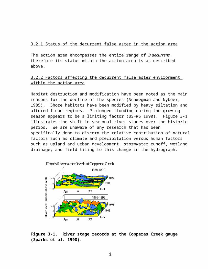
implementation of navigation improvements, tow lockage will become more efficient. For these reasons, there will likely be increased movement of barges into and out of some existing fleeting and terminal areas, or expansion of existing facilities to accommodate increased usage, either of which could adversely affect Higgins eye in the action area. However, although we anticipate that a few individuals may be harmed, we do not expect the reproduction, numbers or distribution of Higgins eye populations within UMRS will be appreciably reduced.
The Corps has proposed to develop a Systemic Barge Fleeting Plan for the UMRS (U.S. Army Corps of Engineers 2004a). However, the details of this plan remain unknown, and therefore, it is uncertain as to the extent it will address impacts associated with fleeting, including impacts to Higgins eye. The Service supports development of the Systemic Barge Fleeting Plan for the UMRS in a timely manner
Nonindigenous Species
The purpose of the navigation improvements is to accommodate and facilitate increased tow traffic within UMRS (U.S. Army Corps of Engineers 2004a). Additional tows resulting from proposed navigation improvements will transport additional zebra mussels upstream on the UMRS to Higgins eye populations and habitats unless effective control measures are implemented. As discussed in the Status and Environmental Baseline sections, the Corps of Engineers is implementing the Reasonable and Prudent Alternative (RPA) described in the biological opinion for the 9-Foot Channel Project (U.S. Fish and Wildlife Service 2000, U.S. Army Corps of Engineers 2003, 2004a). At this time, we assume, that (1) the Corps of Engineers will initiate the Zebra Mussel Management Feasibility Study; (2) the study will develop one or more feasible control measures; and (3) these measures will be implemented in a timely manner to prevent upstream transport of zebra mussels (and potentially quagga mussels) by commercial navigation on the UMRS, including any projected increases in navigation traffic as a result of the proposed action. The feasibility study will also address recreational craft using the 9-Foot Channel Project, a much more likely vector of transport to the St. Croix River and other tributaries.
As discussed in the Environmental Baseline section, a critical area for Higgins eye and other native mussels is the segment of the UMR upstream of the middle of Lake Pepin (UMR Pool 4) to the head of navigation in Minneapolis, Minnesota. Currently, this reach contains few zebra mussels, has no known upstream source of veligers (with the exception of the lower St. Croix River which enters in UMR Pool 3), has a diverse native mussel community that is recovering from previous water quality impacts from the Twin Cities metro area, and contains several propagation and relocation sites for Higgins eye (Mussel Coordination Team 2003). As a result of the proposed navigation improvements, the current traffic level of 5 tows per day at Lock and Dam 3 will increase to 8 tows per day; however, any increase in tow traffic will not occur before 2030 (U.S. Army Corps of Engineers 2004a). Considering the small incremental increase in tow traffic, that any increase in tow traffic is not projected to occur before 2030 above Lock and Dam 3, and efforts to control zebra mussel distribution and abundance over the next 10 to 15 years, we anticipate that the status of zebra mussels in the UMRS over the next 50 years will not be detectably influenced by navigation improvements proposed in the Upper Mississippi River-Illinois Waterway System Navigation Study. Hence, further impacts on Higgins eye from zebra
i

mussels are not anticipated to result from the navigation improvement program. However, it is critical that the Corps of Engineers initiate the Zebra Mussel Management Feasibility Study and implement feasible control measures in a timely manner (U.S. Army Corps of Engineers 2003).
4.3.1.2 Mitigation
Mitigation planning for impacts associated with incremental increases in navigation traffic fall into four major biological areas – fishery, submersed aquatic plants, bank erosion, and backwater-side channel sedimentation. Fishery mitigation measures include large woody debris anchors, backwater improvements, dike alterations, and fish passage. Submerged aquatic plant mitigation measures include modification of river regulation to improve habitat conditions, backwater/side channel habitat protection and restoration and revegetation. Bank erosion mitigation measures include such structural measures as offshore revetments, bank protection, or vegetative/bioengineered protection. Mitigation for backwater/side channel sedimentation measures includes offshore revetment, drop structures, closure structures, bank protection, barrier island construction, and dredging. The level and schedule of mitigation will be commensurate with the level and schedule of navigation improvements.
At the programmatic scale, most of the mitigation measures identified above have the potential for long-term beneficial impacts to Higgins eye by improving habitat conditions for the species and/or habitat conditions for fish host species. One mitigation measure that would be beneficial to the species is providing offshore lock waiting areas, therefore keeping waiting traffic away from mussel beds. This may include either mooring cells or buoys. However, it is likely that a few mitigation projects will be constructed on the UMRS over the next 50 years that adversely affect a few Higgins eye by burial from disposal of dredged material, rip rap or other construction materials, by contact with dredging equipment during construction, or changes to existing habitat conditions (flow velocity, scour and erosion). Per the proposed Standards and Guidelines, the Corps of Engineers will coordinate with State, and Federal resource agencies to develop site-specific project plans, including the placement of the structures, location of dredging and material placement, and evaluating expected changes in velocity, scour, and sediment patterns on Higgins eye. We anticipate that only in a very few instances will adverse effects be unavoidable. In these situations, it is unlikely that an entire bed or population of Higgins will be affected. Furthermore, it is extremely unlikely that any such project would be implemented if the viability of an EHA were to be threatened. Thus, although we anticipate that a few individuals may be harmed, we do not expect the reproduction, numbers or distribution of Higgins eye populations within UMRS will be appreciably reduced from mitigation activities.
Because mitigation measures proposed to date are similar to the ecosystem restoration component of the Upper Mississippi River-Illinois Waterway System Navigation Study, these actions are evaluated in greater detail in the Ecosystem Restoration section of this biological opinion.
4.3.1.3 Ecosystem restoration
Implementation of the Upper Mississippi River – Illinois Waterway System Navigation Study
i
would result in a variety of navigation and ecosystem actions. From a habitat perspective, the combined effect of implementing the ecosystem restoration component of the study would benefit approximately 400,000 acres of UMRS floodplain habitat and 2,500 miles of main stem and tributary channels resulting in significant improvements to the quality and sustainability of the ecological health of the UMRS (U.S. Army Corps of Engineers 2004a). From a programmatic scale, improving the ecological health of the UMRS will also significantly benefit native mussels including Higgins eye from water quality improvements, reduction in erosion/sedimentation and increased opportunities for movement of host fish between navigation pools, reaches and tributaries of the UMRS.
The Upper Mississippi River – Illinois Waterway System Navigation Study includes ecosystem management actions that are intended to reverse the decline of habitat and species within the UMRS proposed in these documents and studies. Specific actions include island construction, fish passage, floodplain restoration, water level management, backwater restoration, side channel restoration, wing dam/dike alteration, island and shoreline protection, topographic diversity improvements, forest management, and other ecosystem restoration measures. Overall, the goal of these actions is to enhance/restore habitat on the UMSR for a variety of species, including native freshwater mussels.
Table 9 of the Tier I BA summarizes the potential impacts to Higgins eye from ecosystem restoration actions (USACE 2004b). Conservation measures to avoid and minimize impacts to Higgins eye have been implemented on similar projects in the past. These conservation measures included employing best management practices during project construction, modifying project features, or abandoning the project. To date, resource agencies have successfully eliminated adverse effects in all but one instance1. However, given the large number of habitat projects proposed for construction in the future under the Upper Mississippi River – Illinois Waterway System Navigation Study, it is likely that Higgins eye may be adversely affected in the future by one or more habitat projects depending on where the specific project is located and if Higgins eye are in the action area. The anticipated effect associated with these restoration actions are described below.
Island Building
Many islands were present when the lock and dam system was completed (U.S. Army Corps of Engineers 2004a). In some areas islands have been lost to erosion, and in other areas they have grown as a result of sedimentation. Island building includes constructing islands from sediment
1 Until recently, Higgins eye was considered a deep water species, not occurring in water depths less than 3 feet (U.S. Fish and Wildlife Service 2004). However, numerous Higgins eye have been collected by the MCT in water depths of 1.5 to 3 feet at the Cassville mussel bed (Pool 11) and the Cordova EHA (Pool 14) (Mussel Coordination Team 2003). However, the chance of Higgins eye inhabiting very shallow water (< 1.5 feet) during normal pool elevations is highly unlikely due to the extreme environmental conditions associated with these areas (i.e., freezing, ice damage, wave action, extreme heat). In 2001, a 1.5-foot drawdown at the dam was conducted in Pool 8, and some mussels were found stranded or in very shallow water, including two Higgins eye (M. Havlik, Malacological Consultants, La Crosse, Wisconsin, 2001, personal communication). In 2001, river discharges and water levels were high most of the spring and early summer, and mussel tracks and stranded mussels were observed in floodplain forest areas after the water receded in other UMR pools as well (M. Davis, Minnesota Department of Natural Resources, 2001, personal communication). During approximately a 30-day period from April 13 to May 13, 2001, Pool 8 water elevation was more than 2 feet above the secondary control pool elevation, and exceeded 6 feet for a few days. These conditions probably contributed to the number of stranded mussels observed during the 2001 Pool 8 drawdown. It is not known if mussels actively moved to these areas or were carried there by the excessive flows, but it is often the case that mussels will be displaced outside their normal distribution during high water events by either mode (Tucker 1996, Coker et al. 1921). For future pool level drawdowns, Conservation Measures were developed by the Corps of Engineers in their Tier I BA to avoid impacts to Higgins eye from stranding (U.S. Army Corps of Engineers 2004a).
i

(sand, clay, or silt) dredged from the bottom of the river to replace islands eroded by waves and river current. Islands may also be constructed in open water areas to create sheltered off-channel habitat to promote backwater communities. Past experience has led to designs that can protect large areas (>1,000 acres) with as little as 30 acres of island. Island building can have an added benefit of protecting and establishing deepwater habitat, which provides important habitat for fish and mussels.
Island restoration is most needed in the upper pooled reaches where island erosion is most pronounced, but will apply system-wide to create wave breaks, protect bank lines, store dredged sediments, and create new side channels or off-channel habitat elsewhere, but particularly in the middle Mississippi River.
Construction of islands will improve habitat for Higgins eye and other native mussels by reducing wind fetch and waves which will decrease sediment resuspension and increase water quality in the project area. Islands will also facilitate environmental conditions in the project area that promote the growth and abundance of aquatic vegetation. Beds of aquatic vegetation also decrease sediment resuspension in the project area. However, it is likely that a few islands will be constructed on the UMRS over the next 50 years that adversely affect a few Higgins eye by burial from disposal of dredged material, rip rap or other construction materials, by contact with dredging equipment during construction, or changes to existing habitat conditions (flow velocity, scour, erosion). Per the proposed Standards and Guidelines, the Corps of Engineers will coordinate with State, and Federal resource agencies to develop site-specific project plans, including the placement of the structures, location of dredging and material placement, and evaluating expected changes in velocity, scour, and sediment patterns on Higgins eye. We anticipate that only in a very few instances will adverse effects be unavoidable. In these situations, it is unlikely that an entire bed or population of Higgins will be affected. Furthermore, it is extremely unlikely that any such project would be implemented if the viability of an EHA were to be threatened. Thus, although we anticipate that a few individuals may be harmed, we do not expect the reproduction, numbers or distribution of Higgins eye populations within UMRS will be appreciably reduced from island building activities.
Fish Passage
Native mussels like Higgins eye require a host fish for glochidia transformation (Mussel Conservation Team 2003). Prior to construction of navigation locks and dams with the 9-Foot Channel Project, host fish for native mussels had relatively unimpeded access to the entire basin stream network (U.S. Army Corps of Engineers 2004a). Natural barriers such as rapids and falls were the primary determinant of the distribution of fish stocks at that time. Now, navigation dams on the UMRS restrict upstream fish movement during most portions of a given year. Technical fishways, such as fish ladders, and naturalistic bypass channels through spillways are the primary techniques considered as ecosystem restoration measures under the Upper Mississippi River – Illinois Waterway System Navigation Study, although some benefits may be gained from modified dam operation as well. The major benefit to Higgins eye and other native mussels is increased opportunity for seasonal movement of host fish between navigation pools and reaches of the UMRS, and hence, allowing genetic exchange and population reestablishments in currently unoccupied areas.
i
Improved fish passage may facilitate more rapid upward movement of nonindigenous species such as the black carp, which might prey on small Higgins eye and other native mussels. However, the current navigation system is not a complete barrier to upstream migration and even if the proposed fish passage actions do not occur, nonindigenous black carp will probably disperse upstream and adversely affect mussels over the next 50 years.
The overall effect of improving fish passage, and improved system connectivity, has the potential to greatly improve the overall fishery of the UMRS and distribution of native mussels including Higgins eye. Increased movement of fish throughout the system increases both the probability of host fish availability, especially walleye, a preferred host species for Higgins eye (Holland-Bartels and Waller, 1988), and improves the opportunity for dispersal of Higgins eye throughout the Upper Mississippi River (U.S. Army Corps of Engineers 2004a). However, it is likely that a few fish passage projects constructed on the UMRS over the next 50 years may adversely affect a few Higgins eye by burial from disposal of dredged material, rip rap or other construction materials, by contact with dredging or other equipment during construction, or changes to existing habitat conditions (flow velocity, scour, erosion). Per the proposed Standards and Guidelines, the Corps of Engineers will coordinate with State, and Federal resource agencies to develop site-specific project plans, including the placement of the structures, location of dredging and material placement, and evaluating expected changes in velocity, scour, and sediment patterns on Higgins eye. We anticipate that only in a very few instances will adverse effects be unavoidable. In these situations, it is unlikely that an entire bed or population of Higgins will be affected. Furthermore, it is extremely unlikely that any such project would be implemented if the viability of an EHA were to be threatened. Thus, although we anticipate that a few individuals may be harmed, we do not expect the reproduction, numbers or distribution of Higgins eye populations within UMRS will be appreciably reduced from fish passage activities.
Floodplain Restoration
Floodplain habitats throughout the UMRS have been altered for many reasons (U.S. Army Corps of Engineers 2004a). In northern river reaches, dams spread water across low elevation floodplain areas and greatly increase aquatic habitat connectivity in the floodplain. Floodplain restoration in the north includes a mix of protecting some areas with islands, connecting isolated backwaters, and restoring tributary channels. In southern river reaches, the floodplain is much more developed for crop production and flood protection and is thus much more isolated from the river. Floodplain restoration in southern reaches will include a mixture of water level manipulation in management areas, wetland/habitat management in leveed areas (e.g., Wetlands Reserve Program, Conservation Reserve Program, etc.), and restoration of agricultural areas to aquatic, floodplain forest, and prairie habitats. Providing connectivity to previously isolated floodplain areas will increase flowing secondary channel habitat suitable for Higgins eye and other native mussels. However, it is likely that a few floodplain restoration projects constructed on the UMRS over the next 50 years may adversely affect a few Higgins eye by burial from disposal of dredged material, rip rap or other construction materials, by contact with dredging or other equipment during construction, or
i
changes to existing habitat conditions (flow velocity, scour, erosion). Per the proposed Standards and Guidelines, the Corps of Engineers will coordinate with State, and Federal resource agencies to develop site-specific project plans, including the placement of the structures, location of dredging and material placement, and evaluating expected changes in velocity, scour, and sediment patterns on Higgins eye. We anticipate that only in a very few instances will adverse effects be unavoidable. In these situations, it is unlikely that an entire bed or population of Higgins will be affected. Furthermore, it is extremely unlikely that any such project would be implemented if the viability of an EHA were to be threatened. Thus, although we anticipate that a few individuals may be harmed, we do not expect the reproduction, numbers or distribution of Higgins eye populations within UMRS will be appreciably reduced from floodplain restoration activities.
Water Level Management Activities
Large river ecosystems such as the UMRS are characterized by seasonal cycles of flood and drought (or low flow) (U.S. Army Corps of Engineers 2004a). A variety of ecological functions and processes are linked to this cycle. Development of water resources for hydropower or navigation typically alters and disrupts these natural cycles. In the UMRS, the flood stage of the hydrograph is relatively unaltered, but low flows have been eliminated to support commercial navigation. Water level management has the potential to be a powerful ecosystem restoration measure to improve the long-term habitat quality of the UMR for a variety of species, including Higgins eye. Pool-wide and/or system-wide drawdowns are being proposed in the Upper Mississippi River – Illinois Waterway System Navigation Study to promote aquatic vegetation, consolidate sediments, improve water quality, and modify flow distribution. These actions will enhance habitat conditions for Higgins eye by improving water quality, cleaning substrate through scouring, improving overall productivity, improving conditions for host fish species, and other ecological benefits. However, these drawdowns could adversely affect Higgins eye during the drawdown phase primarily by stranding individuals.
For pool level drawdowns, the following Conservation Measures are proposed by the Corps of Engineers in their Tier I BA to avoid impacts to Higgins eye from stranding (U.S. Army Corps of Engineers 2004a): 1. A drawdown will not be implemented that would result in lowering normal water levels
more than 1.5 feet at any of the essential, secondary, or relocation habitat areas.
2. A drawdown will not be implemented if pool elevation at the dam is greater than two feet above the secondary control pool elevation in excess of 20 days from April 1 to June 15 in the proposed drawdown year.
3. During the drawdown, water levels will be lowered slowly (0.1 to 0.2 foot per day), allowing the escape of native mussels from the dewatered zone. The rate of drawdown will be commensurate with the proposed level of drawdown and the location of the drawdown.
4. Studies may be completed to evaluate the distribution of Higgins eye in relationship to water depths, the ability of Higgins eye to escape the dewatered zone, and evaluation of the
i

stranding of mussels with ongoing pilot pool drawdowns. As additional information is obtained, the preceding conservation measures will be reviewed and revised, in coordination with the Service. For example, a study may find that Higgins eye are found at depths greater than 1.5 feet at a particular EHA, thereby facilitating a deeper drawdown at that location.
We believe that the following water level management scenarios may affect but are not likely to adversely affect Higgins eye: 1) drawdowns outside the current range of Higgins eye (i.e. UMR downstream of Lock and Dam 19); 2) minor drawdowns within existing Corps operational constraints (i.e., current drawdown zone during operation of the 9-Foot Channel Project); and, 3) drawdowns implemented with the above Conservation Measures. Other drawdowns of larger scope may adversely affect a few Higgins eye and other native mussels by stranding. In addition, drawdowns will likely involve dredging to maintain recreational and/ commercial navigation access during the event. Depending on the location of these dredge cuts, a few Higgins eye and other mussels may be adversely affected by burial from disposal of dredged material, rip rap or other construction materials, by contact with dredging or other equipment during construction, or changes to existing habitat conditions (flow velocity, scour, erosion). Per the proposed Standards and Guidelines, the Corps of Engineers will coordinate with State, and Federal resource agencies to develop site-specific project plans, including the placement of the structures, location of dredging and material placement, and evaluating expected changes in velocity, scour, and sediment patterns on Higgins eye. We anticipate that only in a very few instances will adverse effects be unavoidable. In these situations, it is unlikely that an entire bed or population of Higgins will be affected. Furthermore, it is extremely unlikely that any such project would be implemented if the viability of an EHA were to be threatened. Thus, although we anticipate that a few individuals may be harmed, we do not expect the reproduction, numbers
or distribution of Higgins eye populations within UMRS will be appreciably reduced from water level management activities.
Backwater Restoration
Many UMRS backwaters have been degraded by excessive amounts of sediment emanating from the basin, tributaries, and main stem sources (U.S. Army Corps of Engineers 2004a). The degradation results from loss of depth, poor sediment quality, poor water quality, and sediment resuspension that blocks sunlight required by aquatic plants. Remedial action can be in the form of backwater dredging, or water level management actions discussed above. Backwater dredging typically consists of dredging channels with fingers extending from the main dredge cut to a depth of 6 to 8 feet deep. Earlier projects have dredged about 20 acres, which provides enough habitat for fish from larger areas to concentrate during winter and other harsh climate conditions. The sediment resulting from the dredging portion of the project can be used to enhance aquatic areas with islands or to augment terrestrial areas with increased topographic diversity and elevation, which promotes the growth of oaks and other mast tree species.
The overall effect of backwater restoration will improve habitat for Higgins eye and other native mussels through increased plant growth, which in turn will result in decreased sediment resuspension and increased water quality in the project area (U.S. Army Corps of Engineers 2004a). However, some backwater restoration measures may adversely affect a few Higgins eye
i

in the project area from placement of structures on individuals; dredging in backwaters, and hence digging up, injuring and killing specimens found in these locations; drawdowns to consolidate sediments and increase plant growth; and from resulting changes in velocity, scour, and sediment patterns. Per the proposed Standards and Guidelines, the Corps of Engineers will coordinate with State, and Federal resource agencies to develop site-specific project plans, including the placement of the structures, location of dredging and material placement, and evaluating expected changes in velocity, scour, and sediment patterns on Higgins eye. We anticipate that only in a very few instances will adverse effects be unavoidable. In these situations, it is unlikely that an entire bed or population of Higgins will be affected. Furthermore, it is extremely unlikely that any such project would be implemented if the viability of an EHA were to be threatened. Thus, although we anticipate that a few individuals may be harmed, we do not expect the reproduction, numbers or distribution of Higgins eye populations within UMRS will be appreciably reduced from backwater restoration activities.
Side Channel Restoration
Side channels provide off-channel habitat that shields fish and other animals from the harsh conditions of the main channel. In braided channel habitats of the northern river reaches, side channels are numerous and provide an assortment of habitat conditions. Farther south, side channels are typically larger and more uniform in their configuration.
Side channels have been degraded by sedimentation and channelization. Where sedimentation is the issue, restoration includes dredging the upper and lower connections similar to what is done in backwaters. Restoration in response to channelization typically involves modifying channel regulating structures to increase connectivity between the main and secondary channels. In both cases, work within the side channel may include constructing barbs to alter flow patterns or
augmenting woody debris piles or other structures. Side channel restoration will be common throughout the UMRS.
The overall effect of side channel restoration will be to increase and improve available habitat for both Higgins eye and fish species that serve as glochidial hosts for the mussel. However, construction of these projects over 50 years may adversely affect a few Higgins eye. The direct and secondary impacts of side channel restoration activities on Higgins eye and other native mussels can be grouped into three categories – impacts from direct structure placement to restore side channels; impacts of dredging to restore side channels; and impacts of changes in velocity, scour, and sediment patterns resulting from side channel restoration actions. Per the proposed Standards and Guidelines, the Corps of Engineers will coordinate with State, and Federal resource agencies to develop site-specific project plans, including the placement of the structures, location of dredging and material placement, and evaluating expected changes in velocity, scour, and sediment patterns on Higgins eye. We anticipate that only in a very few instances will adverse effects be unavoidable. In these situations, it is unlikely that an entire bed or population of Higgins will be affected. Furthermore, it is extremely unlikely that any such project would be implemented if the viability of an EHA were to be threatened. Thus, although we anticipate that a few individuals may be harmed, we do not expect the reproduction, numbers or distribution of Higgins eye populations within UMRS will be appreciably reduced from side
i

channel restoration activities.
Wing Dam and Dike Alteration
Wing dams and dikes are prominent channel regulating structures common in main channel habitats. In northern river reaches, most wing dams are artifacts of earlier channel management efforts for the navigation project. Wing dams provide important habitat in channel border areas. In southern river reaches, and especially the middle Mississippi River reach, wing dikes are very prominent features of the channel environment. These structures are used to concentrate flow in the main channel in order to reduce the need for dredging. They were often constructed in groups called dike fields. These areas are depositional zones that often fill from the bank outward toward the channel. Notching, lowering their profile, or altering their angle to the channel are some actions that can be used to increase habitat diversity through the creation of new scour holes, sandbars, and flow refugia. When wing dike alteration is done on the dike field level, or in association with new structure placements, new side channels, islands, and off-channel areas can be created. The practice has met with great success in the middle Mississippi River.
Dike alteration will be an important component of the restoration of the middle Mississippi River reach and will have beneficial application elsewhere in the system. The overall effect of channel regulating structure alteration will be to increase and improve available habitat for both Higgins eye and fish species that serve as hosts for the species. However, construction of these projects over 50 years may adversely affect a few Higgins eye. The direct and secondary impacts of channel regulating structure alteration activities on Higgins eye and other native mussels can be grouped into two categories – impacts from direct structure placement and impacts of changes in velocity, scour, and sediment patterns resulting from channel structure alterations. Per the proposed Standards and Guidelines, the Corps of Engineers will coordinate with State, and Federal resource agencies to develop site-specific project plans, including the placement of the structures, location of dredging and material placement, and evaluating expected changes in velocity, scour, and sediment patterns on Higgins eye. We anticipate that only in a very few instances will adverse effects be unavoidable. In these situations, it is unlikely that an entire bed or population of Higgins will be affected. Furthermore, it is extremely unlikely that any such project would be implemented if the viability of an EHA were to be threatened. Thus, although we anticipate that a few individuals may be harmed, we do not expect the reproduction, numbers or distribution of Higgins eye populations within UMRS will be appreciably reduced from wing dam and dike alterations.
Island and Shoreline Protection
Island and shoreline erosion are natural processes that characterize dynamic rivers. In the UMRS, shoreline erosion may also in some areas, be affected by commercial and recreational boats and by wind-generated waves in the impounded system. Shoreline erosion may affect Higgins eye by burial of individuals and beds over time from eroded material, or changing habitat conditions as existing islands and shorelines are eroded that may have provided or protected mussel habitat.
i

Island and shoreline protection includes measures to protect the existing aquatic and terrestrial features of the river. Typical measures include riprapped shorelines, but more environmentally compatible measures including offshore revetments, plantings (bioengineering), low gradient slopes, rock groins, and others are being incorporated along with traditional measures. These measures may also be used to alter the overflow portions of the dams. Priority erosional areas have been mapped and can be targeted for protection. This measure is viewed as a habitat protection measure that maintains existing conditions to the extent possible.
The overall effect of protecting islands and shorelines from erosion will be to increase and improve available habitat for both Higgins eye and fish species that serve as glochidial hosts. However, construction of these projects over 50 years may adversely affect a few Higgins eye. The direct and secondary impacts to Higgins eye from island and shoreline protection activities can be grouped into three categories – impacts from direct placement of dredged material, rip rap, vanes, groins, revetment, and bioengineering material on individuals; dredging for construction material and access to the site and hence digging up, injuring and killing specimens found in these locations; and from resulting changes in velocity, scour, and sediment patterns. Per the proposed Standards and Guidelines, the Corps of Engineers will coordinate with State, and Federal resource agencies to develop site-specific project plans, including the placement of the structures, location of dredging and material placement, and evaluating expected changes in velocity, scour, and sediment patterns on Higgins eye. We anticipate that only in a very few instances will adverse effects be unavoidable. In these situations, it is unlikely that an entire bed or population of Higgins will be affected. Furthermore, it is extremely unlikely that any such project would be implemented if the viability of an EHA were to be threatened. Thus, although we anticipate that a few individuals may be harmed, we do not expect the reproduction, numbers or distribution of Higgins eye populations within UMRS will be appreciably reduced from island and shoreline protection measures.
Topographic Diversity
When the dams were put into operation, the floodplain water table elevation was increased in many areas. The result in the terrestrial plant communities was the elimination of flood intolerant tree species that require a dry root zone. Improving topographic diversity simulates the ridge and swale topography of the natural floodplain by using material dredged from the channel. This newly elevated land area is then planted with oaks and other mast producing trees.
Measures to increase topographic diversity include the placement of dredged material, typically in ridges, on the floodplain to raise the root zone of flood intolerant mast trees, or the creation of isolated floodplain potholes or scour holes. These measures are frequently complementary to channel maintenance and other restoration measures.
Topographic diversity is similar to dike alteration in that the measure is very localized in a relatively small area, but may have wider benefits. The measure is important to restore terrestrial plant species diversity that has been impacted by impoundment and inundation.
Most of the specific ecosystem restoration actions would occur in terrestrial settings and would not affect aquatic areas, and as such are not likely to adversely affect reproduction, numbers or
i

distribution of Higgins eye.
Forest Management
Most forest management would occur in terrestrial settings and would not have an impact on aquatic areas. Furthermore, standard forestry practices to minimize secondary erosion and impacts to the adjacent aquatic environment will be used. As such, forestry management actions are not likely to adversely affect reproduction, numbers, or distribution of Higgins eye.
4.3.1.4 Summary
Major changes that affected Higgins eye from operation and maintenance of the 9-Foot Channel Project and prior navigation improvements occurred in the years following construction and are described in the previous biological opinion (U.S. Fish and Wildlife Service 2000). Additional impacts to Higgins eye from the proposed navigation improvements and associated incremental increase in tow traffic are not likely to appreciably affect reproduction, numbers or distribution of Higgins eye in the action area. Although some risk to individuals is possible from implementation of specific navigation improvement projects, we believe that the most significant risks to Higgins eye are from zebra mussels’ persistence in the UMRS. However, for reasons explained within, we anticipate that the associated increases in commercial traffic are not likely to increase the likelihood of zebra mussel persistence. Hence, we do not expect any appreciable effects to reproduction, numbers, or distribution of Higgins eye within the action area from navigation improvements.
To date, habitat restoration/enhancement projects constructed on the UMRS have not—in all but one instance--adversely affected Higgins eye due to implementation of conservation measures during project planning to avoid impacts (see footnote on Page 17). Although the Corps and the Service fully expect this success to continue, there may be a few instances where adverse effects will be unavoidable. Given the large number and variety of habitat projects proposed for construction in the future under the Upper Mississippi River – Illinois Waterway System Navigation Study, it is likely that a few individual Higgins eye will be adversely affected by one or more habitat projects. We anticipate that the majority of these cases will be when short-term adverse effects are necessary in order to achieve long-term benefits for Higgins eyes. As such, we anticipate that over the term of the project, ecosystem restorations actions will improve the reproduction, numbers or distribution of Higgins eye within the action area.
4.4 Cumulative Effects
Cumulative effects are effects of future State, tribal, local, or private actions that are reasonably certain to occur in the action area considered in this biological opinion. Future Federal actions that are unrelated to the proposed action are not considered in this section because they require separate consultation pursuant to section 7 of ESA. The Service knows of no projects reasonably certain to occur in the action area that will produce cumulative effects.
4.5 Conclusion
i
The conclusion section presents the Service’s opinion regarding whether the aggregate effects of the factors analyzed under the environmental baseline, effects of the action, and cumulative effects in the action area .After reviewing the current status of the Higgins eye pearlymussel, the environmental baseline for the action area, the effects of the proposed action and the cumulative effects, it is the Service’s opinion that implementation of the recommended plan as proposed is not likely to jeopardize the continued existence of the Higgins eye pearlymussel. No critical habitat has been designated for this species; therefore, none will be affected.
The action area encompasses the range of Higgins eye. Programmatic benefits to Higgins eye and other native mussels will occur from implementation of the ecosystem restoration component of the Upper Mississippi River – Illinois Waterway System Navigation Study. While site-specific adverse impacts to Higgins eye are likely for a small number of actions (navigation improvements and ecosystem restoration measures), we believe that the proposed action will not appreciably reduce reproduction, numbers, or distribution of Higgins eye within the action area, or appreciably reduce the likelihood of survival and recovery of the species over 50 years.
4.6 Incidental Take Statement
4.6.1 Introduction
Section 9 of the Act and Federal regulation pursuant to Section 4(d) of the Act prohibit the take of endangered and threatened species, respectively, without special exemption. Take is defined as to harass, harm, pursue, hunt, shoot, wound, kill, trap, capture or collect, or to attempt to engage in any such activity. Harm is further defined by the Service to include significant habitat modification or degradation that results in death or injury to listed species by significantly impairing essential behavioral patterns, including breeding, feeding, or sheltering. Harass is defined by the Service as intentional or negligent actions that create the likelihood of injury to listed species to such an extent as to significantly disrupt normal behavior patterns which include, but are not limited to, breeding, feeding, and sheltering. Incidental take is defined as take incidental to, and not the purpose of, the carrying out of an otherwise lawful activity. Under the terms of Section 7(b)(4) and Section 7(o)(2), take incidental to and not an intended part of the agency action is not considered prohibited taking under the Act, provided such take is in compliance with the terms and conditions of this Incidental Take Statement.
The measures described below are non-discretionary, and must be undertaken by the Corps for the exemption in Section 7(o)(2) to apply. The Corps has a continuing duty to regulate the activity covered by this incidental take statement. If the Corps fails to assume and implement the terms and conditions, the protective coverage of Section 7(o)(2) may lapse. To monitor the impact of incidental take, the Corps must report the progress of the action and its impact on the species to the Service as specified in the incidental take statement [50 CFR 402.14(I)(3)].
4.6.2 Extent of take anticipated
The Service anticipates that direct incidental take of Higgins eye from the proposed action will be in the form of harassment and harm from both navigation and ecosystem restoration components of the Upper Mississippi River – Illinois Waterway system Navigation Study.
i

However, as the proposed action is at a programmatic scale, site- and project-specific information is lacking. Without such detailed information, it is difficult to quantify incidental take for specific projects with any degree of certainty over the next 50 years. In other words, although we are reasonably certain that adverse effects, and more specifically incidental take, will occur during implementation of the proposed action over the next 50 years, we do not have the information needed to precisely quantify the amount we anticipate will occur. Nonetheless, based on the Standards and Guidelines proposed by the Corps of Engineers, we are able to estimate a maximum level of take that could occur through implementation of the proposed action.
Very few (less than ten) navigation and habitat projects constructed on the UMRS adversely affected Higgins eye since the species was listed in 1976. This is due to successful planning efforts by the Corps of Engineers and resource agencies to avoid adverse impacts to the species. To continue these planning efforts, the Corps of Engineers proposed Standards and Guidelines to avoid and minimize impacts to Higgins eye from actions proposed in the Upper Mississippi River – Illinois Waterway system Navigation Study. Per the proposed Standards and Guidelines, the Corps of Engineers will coordinate with State, and Federal resource agencies to develop site-specific project plans to avoid and minimize impacts to Higgins eye. We anticipate that only in a very few instances will adverse effects be unavoidable. In these situations, it is unlikely that an entire bed or population of Higgins will be affected. Furthermore, it is extremely unlikely that any such project would be implemented if the viability of an EHA were to be threatened.
Based on past experience, we believe that less than 5 percent of actions (up to 50 projects) proposed under the Upper Mississippi River – Illinois Waterway system Navigation Study may adversely affect Higgins eye over 50 years. With one exception, incidental take of Higgins eye for similar projects constructed in the past on the UMRS was less than ten individuals per
i

project.2 Therefore, we believe the maximum incidental take that is likely to occur over the 50year term of the proposed action is 500 individuals. 4.6.3 Effect of the take
The Corps of Engineers (2003) predicted that the population of Higgins eye in EHAs and secondary habitats will decline from 698,000 in the 1990s to 183,000 in the 2000s due to adverse effects of zebra mussels. Using the estimate of 183,000 as representing the current population of Higgins eye at these locations, an incidental take of 500 individuals represents a loss of 0.27 percent over 50 years, or 0.005 percent per year. Other studies have shown that populations of mussels having a long life span like Higgins eye are viable when annual total mortality is less than 5 percent (D. Heath, Wisconsin Department of Natural Resources, 2004, personal communication).
Regarding effects on the distribution of Higgins eye, it is unlikely that an entire bed or population of Higgins will be affected by proposed actions and thus incidentally taken. Furthermore, it is extremely unlikely that any navigation or ecosystem project would be implemented if the viability of an EHA for Higgins eye were to be threatened. Therefore, we believe that the maximum incidental take of 500 Higgins eye is not likely to reduce the reproduction, numbers, or distribution of Higgins eye, result in jeopardy to the species, or destruction or adverse modification of critical habitat (critical habitat has not been designated for Higgins eye).
4.6.4 Reasonable and prudent measures
To ensure that the anticipated level of incidental take is commensurate with the take that occurs per the proposed action, the Corps of Engineers (Corps) and the Service is implementing a tiered programmatic consultation approach. This approach utilizes a tiered consultation framework with the subject consultation resulting in this Tier I biological opinion. All subsequent projects will be Tier II consultations with Tier II biological opinions issued as appropriate (i.e., whenever the proposed project will result in unavoidable adverse effects to threatened and endangered species).
2 That exception was past dredging activities in the East Channel of the UMR at Prairie du Chien, Wisconsin. Havlik and Marking (1980) examined dredged material deposited on an upland site after maintenance dredging by the Corps of Engineers in 1976. They documented the presence of an extremely rich mussel assemblage in the East Channel including 175 Higgins eye that were killed by dredging activities (they did not estimate total mortality). The East Channel was subsequently included within the larger Prairie du Chien EHA for Higgins eye (U.S. Fish and Wildlife Service 1983). In a 1993 biological opinion to the Corps of Engineers, the Service concluded that future channel maintenance and commercial navigation activities in the East Channel would jeopardize the continued existence of Higgins eye (U.S. Fish and Wildlife Service 1993). The Service provided protective measures to avoid the likelihood of jeopardy to Higgins eye including suspending navigation channel maintenance dredging in the East Channel between the Highway 18 Bridge and the turning basin, hazardous material spill prevention and response measures, and reinitiation of formal section 7 consultation if commercial transportation exceeded established limits. These measures reduced the likelihood that a significant number of Higgins eye would be killed from future dredging and navigation activities. Also, the invasion of zebra mussels decimated the Higgins eye population at the Prairie du Chien EHA since 1993 (U.S. Army Corps of Engineers 2004a).
i

As individual projects are proposed under the recommended plan, the Corps shall provide, for any action that may affect Indiana bats, project-specific information to the Service that (1) describes the proposed action and the specific area to be affected, (2) identifies the species that may be affected, (3) describes the manner in which the proposed action may affect listed species, and the anticipated effects, (4) specifies whether the anticipated effects from the proposed project are similar to those anticipated in the programmatic BO, (5) estimates a cumulative total of take that has occurred thus far under the tier I BO, and (6) describes any additional effects, if any, not considered in the tier I consultation. If it is determined that the proposed project may affect the Higgins eye pearlymussel, the Corps will provide this information in a tier II BA to document anticipated effects of the subject action.
The Service will review the information provided by the Corps for each proposed project. If it is determined during this review that a proposed project is not likely to adversely affect listed species, the Service will complete its documentation with a standard concurrence letter and specifies that the Service concurs that the proposed project is not likely to adversely affect listed species or designated critical habitat.. If it is determined that the action is likely to adversely affect listed species or designated critical habitat and these effects are commensurate with those contemplated in the programmatic BO, then the Service will complete a tier II BO with a project-specific incidental take statement within the annual allotted programmatic incidental take, and project specific Reasonable and Prudent Measures and Terms and Conditions, if appropriate..
The measures described below are non-discretionary, and must be implemented by the agency for the exemption in Section 7(o)(2) to apply. The Corps has a continuing duty to implement the activity covered by this incidental take statement. If the Corps fails to adhere to the terms and conditions of the incidental take statement, the protective coverage of Section 7(o)(2) may lapse.
The Service believes the following Reasonable and Prudent Measures (RPM) are necessary and appropriate to minimize impacts of incidental take of Higgins eye. The RPMs are a modification of the Standards and Guidelines found on Page 123 of the Corps of Engineers Tier I Biological Assessment, and proposed Systemic Barge Fleeting Plan (U.S. Army Corps of Engineers 2004a):
1. Implement the Higgins Eye Planning Guidelines listed below for design and implementation of navigation and ecosystem restoration actions.
2. Complete the Systemic Barge Fleeting Plan for the UMRS (U.S. Army Corps of Engineers 2004a) in a timely manner.
Terms and Conditions
To be exempt from the prohibitions of Section 9 of the Act, the Corps must comply with the following terms and conditions which implement the reasonable and prudent measures described above and outline required reporting/monitoring requirements. These terms and conditions are non-discretionary. The Service’s points of contact for coordination on all terms and conditions are Mr. Dan Stinnett, Field Office Supervisor, U.S. Fish and Wildlife Service, Twin Cities ES Field Office, 4101 East 80th Street, Bloomington, Minnesota, 55425-1665 for St Paul District
i

projects; and Mr. Richard C. Nelson, Field Supervisor, U.S. Fish and Wildlife Service, Rock Island Field Office, 4469-48th Avenue Court, Rock Island, Illinois 61201-9213 for Rock Island District projects:1. Incorporate the following Higgins Eye Planning Guidelines as an integral part of the planning
process for actions proposed under the Upper Mississippi River – Illinois Waterway System Navigation Study:
a. Review the suitability of aquatic habitat for Higgins eye site-specifically for individual projects, including consideration of current range, and existing mussel surveys in the action area to assess the presence of and impacts to Higgins eye from site-specific actions.
b. Conduct site-specific mussel surveys for Higgins eye where there is insufficientinformation on habitat suitability and/or mussel distribution in the individual project areato make presence/impact determinations. If Higgins eye are not found in the mussel survey, use the decision criteria proposed by Wilcox et al. (1993) to determine the likelihood of occurrence of Higgins eye in the individual project area.
c. If Higgins eye are likely to be adversely affected in the individual project area, coordinate with the U.S. Fish and Wildlife Service in accomplishing the following:
1. Develop and incorporate Conservation Measures into individual project plans tominimize take of Higgins eye. Conservation measures may include but are not limitedto employing best management practices during project construction, or modifyingproject features, locations or timing of construction.
For water level management projects within a pool or reach known to contain Higginseye, evaluate the following Conservation Measures for implementation during theplanning phase to minimize take of Higgins eye:
a. Limit the depth of drawdown at any of the 10 Essential Habitat Areas described in the revised recovery plan (U.S. Fish and Wildlife Service 2004), secondary habitats that are important to Higgins eye (U.S. Fish and Wildlife Service 2004), or locations on the UMR and tributaries where Higgins eye have been relocated in accordance with the Biological Opinion for Operation and Maintenance of the 9-Foot Channel Project (U.S. Fish and Wildlife Service 2000). Studies may be conducted to define the appropriate depth for a particular location(s) to minimize impacts to Higgins eye (see Item 1d below). In the absence of studies, a drawdown should not exceed 1.5 feet at any of the above habitat areas or locations.
i

b. Defer the drawdown if the pool elevation at the dam is greater than two feet above the secondary control pool elevation in excess of 20 days from April 1 to June 15 in the proposed drawdown year3.
c. Lower water levels slowly (around 0.2 foot per day) during the drawdown to facilitate the escape of native mussels from the dewatered zone. The rate of drawdown should be commensurate with the proposed level of drawdown and the location of the drawdown.
d. Conduct studies to evaluate the distribution of Higgins eye in relationship to water depths in the action area, the ability of Higgins eye to escape the dewatered zone, and stranding of mussels with ongoing water level management projects. As additional information is obtained, the preceding Conservation Measures may be reviewed and revised, in coordination with the U.S. Fish and Wildlife Service. For example, a study for a proposed drawdown may find that Higgins eye are found at depths greater than 1.5 feet at a particular EHA or other habitat area, thereby facilitating a deeper drawdown at that location while minimizing impacts to Higgins eye.
2. After conservation measures have been incorporated to minimize take of Higgins eye, coordination with the U.S. Fish and Wildlife Service, evaluate the feasibility of relocating Higgins eye from the impact area of navigation and ecological restoration actions that are likely to adversely affect Higgins eye. Factors to consider in determining feasibility include the size of the collection site (i.e. project “footprint”), substrate, water depth and flow conditions at the collection site, estimated number of Higgins eye and other mussels potentially relocated, and the availability of suitable relocation sites in the project area. If feasible, develop and implement a Higgins Eye Relocation Plan as part of the specific action and incorporate it into the Tier II Biological Assessment.
2. When appropriate, incorporate Higgins eye habitat restoration into the planning and
implementation of ecosystem restoration projects within the range of the species.Implementing mussel habitat restoration as a part of the ecosystem restoration program will contribute to the restoration/enhancement of Higgins eye habitat on the UMRS in general for conservation of the
3 In April and May 2001, the maximum elevation above normal water levels in Pool 8 was approximately 6 feet. Water levels remained 2 feet above normal pool for greater than 30 days during April through June 15, 2001. During this period, mussels moved into shallower habitats. The high waters occurring for an extended period of time prior to the Pool 8 drawdown, combined with an unusual period of drought immediately after the drawdown was initiated, greatly contributed to observed stranding of mussels during the 2001 drawdown. Stranded mussels were observed in Pool 5 and other navigation pools that did not experience a drawdown, suggesting a strong correlation between mussel stranding and the severe flooding/drought conditions of 2001 (M. Davis, Minnesota Department of Natural Resources, 2001, personal communication). This flooding scenario is rare. From 1970 to 2003, there were only 4 years (1975, 1986, 1997 and 2001) where water levels remained high (greater than 2 feet) in Pool 8 for an extended period of time (greater than 20 days) during the period April 1 through June 15. The above restriction, because of the rarity of these events, should provide an opportunity for drawdowns to occur in navigation pools while avoiding/minimizing impacts to Higgins eye.
i

species, and replace unavoidable habitat losses from specific navigation and ecosystem restoration actions, in particular.
3. During the planning process for fish passage facilities at Lock and Dam 19, study the risks to Higgins eye and other native mussels from nonindigenous black carp. The study should be conducted in coordination with the U.S. Fish and Wildlife Service and other appropriate federal and state natural resource agencies. This information will be useful in determining the feasibility of fish passage facilities at Lock and Dam 19 which currently limits upstream movement of fish on the UMR.
4. In coordination with the U.S. Fish and Wildlife Service and other appropriate federal and state natural resource agencies, initiate development of the Systemic Barge Fleeting Plan for the UMRS in Funding Year One of the Upper Mississippi River – Illinois Waterway System Navigation Capacity Improvement Project. Information from the plan will assist in locating future actions to avoid and minimize effects to Higgins eye. The fleeting plan should be completed within three years of initiation and identify (1) important Higgins eye habitat areas that should be avoided; (2) areas that are suitable for fleeting and have no or minimal impacts on Higgins eye; and (3) other measures to avoid/minimize the impacts of fleeting on Higgins eye.
Requirements for Monitoring and Reporting of Incidental Take of Higgins eye pearlymussels
Federal agencies have a continuing duty to monitor the impacts of incidental take resulting from their activities [50 CFR 402.14(i)(3)]. In doing so, the Federal agency must report the progress of the action and its impact on the species to the Service as specified below.
1. Supply the Service with an annual report, due by January 31 of each following year, that specifies:
a. the progress and results of implementing the Reasonable and Prudent Measures and their terms and conditions,
b. the location and number of live and dead Higgins eye pearlymussels handled during mussel surveys or other activities identified by specific project, date and location including River Mile, and
c. the length, height, and if possible sex and age, of each Higgins eye pearlymussel handled during mussel surveys or other activities identified by specific project, date and location including River Mile.
Closing
The reasonable and prudent measures, with their implementing terms and conditions, are designed to minimize the impact of incidental take that might otherwise result from the proposed action. If, during the course of the action, this level of incidental take is exceeded, such
i

incidental take represents new information requiring reinitiation of consultation and review of the reasonable and prudent measures provided. The Federal agency must immediately provide an explanation of the causes of the taking and review with the Service the need for possible modification of the reasonable and prudent measures.
Conservation Recommendations
Section 7(a)(1) of the Act directs Federal agencies to utilize their authorities to further the purposes of the Act by carrying out conservation programs for the benefit of endangered and threatened species. Conservation recommendations are activities to be conducted at your agency's discretion. They are designed to minimize or avoid adverse effects of a proposed action on listed species or critical habitat, to help implement recovery plans, or to develop information.
1. Participate in the implementation of the Conservation Plan for Freshwater Mussels of the Upper Mississippi River System (Upper Mississippi River Conservation Committee 2004).
2. Participate in public outreach efforts, in coordination with the Service and other resource agencies, as a means to disseminate information on life history and distribution of zebra mussels, ecological importance of native mussels including Higgins eye and winged mapleleaf (Quadrula fragosa), control measures to limit the spread of zebra mussels on the UMR and tributaries, and status of mussel propagation and relocation efforts.
In order for the Service to be kept informed of actions minimizing or avoiding adverse effects or benefiting listed species or their habitats, the Service requests notification of the implementation of any conservation recommendations.
i

LITERATURE CITED
Baker, F. C. 1928. The fresh water Mollusca of Wisconsin. Part II. Pelecypoda. Bulletin of the Wisconsin Geological and Natural History Survey, No. 70. 495 pp.
Cawley, E. T. 1996. A compendium of reports of mussel studies containing Lampsilis higginsii from the period 1980-1996. Report for the Higgins Eye Recovery Team - Fish and Wildlife Service. Environmental Research Center - Loras College, Dubuque, Iowa. 84 pp.
Coker, R. E. 1919. Fresh-water mussels and mussel industries of the United States. U.S. Dep. Int., Washington, DC, Bur. Fish., Doc. No. 805, Appx. VIII, 28 pp.
Coker, R. E., A. F. Shira, H. W. Clark, and A. D. Howard. 1921. Natural history and propagation of freshwater mussels. Bulletin of the Bureau of Fisheries 37:77-181.
Cummings, K. S., and C. A. Mayer. 1992. Field guide to freshwater mussels of the Midwest. Illinois Natural History Survey Manual 5. 194 pp.
Davis, M. 2001. Minnesota Department of Natural Resources, Lake City, MN, personal communication on mussel stranding.
Gordon, R. 2001. Lampsilis higginsii recovery project; Genoa National Fish Hatchery; 2001. Unpublished Report, Genoa National Fish Hatchery, U.S. Fish and Wildlife Service, Genoa, WI. 10 pp.
Havlik, M., and L.L. Marking. 1980. A quantitative analysis of naiad mollusks from the Prairie du Chien, Wisconsin, dredge material site on the Mississippi River. Bulletin of the American Malacological Union, 1980: 30-34.
Havlik, M. 2001. Malacological Consultants, Inc., La Crosse, WI, personal communication on mussel stranding.
Hay, B. 2004. Wisconsin Department of Natural Resources, Madison, WI, personal communication on mussel booklet.
Helms, D. 2000. Mussel relocation at the proposed ramp/jetty modification site located in Mississippi River Pool 14, Cordova, IL. Helms & Associates, Bellevue, IA. 22 pp.
Holland-Bartels, L. E., and D. L. Waller. 1988. Fish hosts for glochidia of the endangered freshwater mussel Lampsilis higginsii Lea (Bivalvia: Unionidae). Malacological Review 21: 119-122.
Hornbach, D. J., P. Baker, and T. Deneka. 1995. Abundance and distribution of the endangered mussel, Lampsilis higginsii in the lower St. Croix River, Minnesota and Wisconsin. Final Report to the U.S. Fish and Wildlife Service, Contract # 14-48-000394-1009.
i
Maher, R. 2004. Illinois Department of Natural Resources, Brighton, IL, personal communication on black carp.
Mussel Coordination Team. 2003. Saving the Higgins eye pearlymussel (Lampsilis higginsii) from extinction: 2002 status report on the accomplishments of the Mussel Coordination Team, St. Paul District Corps of Engineers, MN. 48 pp.
Rowse, R. 2004. U.S. Fish and Wildlife Service, Bloomington, MN, personal communication on zebra mussels in the St. Croix River.
Tucker, J. K. 1996. Post-flood strandings of unionid mussels. Journal of Freshwater Ecology 11(4):433-438.
Upper Mississippi River Conservation Committee. 2004. Conservation plan for freshwater mussels of the upper Mississippi River system. Upper Mississippi River Conservation Committee, 4469 48th Avenue Court, Rock Island, IL. 28 pp.
U.S. Army Corps of Engineers. 2002. Final definite project report and environmental assessment for relocation plan for the endangered Higgins eye pearlymussel (Lampsilis higginsii), upper Mississippi River and tributaries; Minnesota, Wisconsin, Iowa, and Illinois. U.S. Army Corps of Engineers, St. Paul, Minnesota, in cooperation with the interagency Mussel Coordination Team.
U.S. Army Corps of Engineers. 2004a. Biological assessment of the upper Mississippi River – Illinois waterway system navigation study. Rock Island, St. Paul and St. Louis Districts. 193 pp.
U.S. Army Corps of Engineers. 2004b. Report to congress on the environmental management program, Rock Island, St. Paul and St. Louis Districts. In press.
U.S. Fish and Wildlife Service. 1983. Higgins eye mussel recovery plan. Ft. Snelling, Minnesota. 98 pp.
U.S. Fish and Wildlife Service. 2000. Biological opinion for the operation and maintenance of the 9-foot navigation channel on the upper Mississippi River system, May 15, 2000, 243 pages.
U.S. Fish and Wildlife Service. 2004. Higgins Eye Pearlymussel (Lampsilis higginsii) Recovery Plan: First Revision. Ft. Snelling, Minnesota. 126 pp.
Wilcox, D.B., D.D. Anderson, and A.C. Miller. 1993. Survey procedures and decision criteria for estimating the likelihood that Lampsilis higginsii is present in areas in the upper Mississippi River system. In: Cummings, K.S., A.C. Buchanan, and L.M. Koch, editors. Conservation and management of freshwater mussels. Proceedings of a UMRCC
i

symposium, 12-14 October 1992, St. Louis, MO. Upper Mississippi River Conservation Committee, Rock Island, IL. p. 163 – 167.
i

5.0 Pallid Sturgeon (Scaphirynchus albus)
5.1 Status of the Species
This section presents the biological or ecological information relevant to formulating the biological opinion. Appropriate information on the species’ life history, its habitat and distribution, and other data on factors necessary to its survival, is included to provide background for analysis in later sections. This analysis documents the effects of past human and natural activities or events that have led to the current range-wide status of the species. Portions of this information are also presented in listing documents, the recovery plan (USFWS 1993), the Final Biological Opinion for the Operation and Maintenance of the 9-Foot Navigation Channel on the Upper Mississippi River System (USFWS 2000), and the Biological Assessment of the Upper Mississippi River-Illinois Waterway System Navigation Study (USACE 2004).
5.1.1 Species/critical habitat description
The pallid sturgeon (Scaphirynchus albus) was listed as an endangered species on September 6, 1990 (55 FR 36641) pursuant to the Endangered Species Act of 1973 (16USC 1531 et seq.) as amended. No critical habitat is designated for this species. The pallid sturgeon was originally described as a species by Forbes and Richardson in 1905. The pallid sturgeon is native to the Missouri and Mississippi Rivers and is adapted to the pre-development habitat conditions that existed in these large rivers. These conditions can generally be described as large, free-flowing, warmwater, turbid habitats with a diverse assemblage of physical attributes that were in a constant state of change (USFWS 1993). Floodplains, backwaters, chutes, sloughs, islands, sandbars and main channel waters formed the large-river ecosystem that provided the macrohabitat requirements for all life stages of pallid sturgeon and other native large-river fish. Today, these habitats and much of the once functioning ecosystem has been changed by human developments.
5.1.2 Life history
The type specimens for identification were collected at or near Grafton, Illinois, on the lower Illinois and Mississippi Rivers (Forbes and Richardson 1905). The species is described as having a flattened, shovel-shaped snout; long, slender, and completely armored caudal peduncle; and lacks a spiracle (Smith 1979). The mouth is toothless, protrusible, and ventrally positioned under the snout, as with other sturgeon. Pallid sturgeon are similar in appearance to the more common and darker shovelnose sturgeon (S. platyrhynchus). Pflieger (1975) reported the principal features distinguishing pallid sturgeon from shovelnose sturgeon as the paucity of dermal ossifications on the belly, 24 or more anal fin rays and 37 or more dorsal fin rays. Sexual maturity for males is estimated to be 7 to 9 years, with 2 to 3 year intervals lapsing between spawning events. Females are estimated to reach sexual maturity in 15 to 20 years, with 3 to 10 year intervals between spawning events (Keenlyne and Jenkins 1993). The length of time between spawning events depends partially on the quality and quantity of food available in their natural habitat (Keenlyne and Jenkins 1993). The fecundity of a given female may vary greatly by individual, with most spawning only a few times during a normal life span (Duffy et al. 1996). Spawning appears to be a function of floodflows (increased discharge and velocity) that
i

generate spawning migrations, temperature and interaction with other pallid sturgeon (Steve Krentz, USFWS, pers. comm. 2003). The influence of turbidity and conductivity is unknown (Steve Krentz, USFWS, pers. comm. 2003). Pallid sturgeon have adhesive eggs, therefore, spawning is thought to occur over hard substrates of gravel or cobble accompanied by moderate flow. At hatching, young pallid sturgeon begin a migration period that may continue for up to 13 days (Kynard et al. 1998). Suitable habitat and forage food must be available after yolk-sac absorption during the initial stages of larvae development. Larval pallid sturgeon have been collected in the Lower Missouri River, Middle Mississippi River and Lower Mississippi River which indicates that limited reproduction is occurring in the wild. In April and May 2001, the Missouri Department of Conservation (MoDOC) collected 40 larval sturgeon utilizing the Missouri benthic trawl (Hrabik 2002). In spring of 2003, the MoDOC collected an estimated 50 larval sturgeon in the MMR (Dave Herzog, MoDOC, pers. comm. 2004). It is unclear at this time how many of these larval sturgeon are pallid sturgeon or hybrids. From April to September 2002, the CMFRO collected 11 YOY sturgeon in Lisbon Bottoms on the Lower Missouri River. Five of these fish were identified as shovelnose sturgeon and six still need to be identified (Grady and Mauldin 2002). A total of eight larval sturgeon (4 in 2002 and 2 in 2003) have been collected in the Lower Missouri River as part of a larval fish sandbar habitat study being conducted by the University of Missouri (Kerry Reeves, Univ. of Missouri, pers. comm. 2003.). Two individuals have been identified to species, one pallid sturgeon and one shovelnose sturgeon, while the remainder awaits positive identification.
Pallid sturgeon feed on benthic macroinvertebrates and drifting invertebrates during early life stages (juveniles) (Modde and Schmulbach 1977, Carlson et al. 1985). However, older juvenile and adult pallid sturgeon are more piscivorous than the shovelnose sturgeon and switch to a diet composed of a greater proportion of fish as they mature.
5.1.3 Population dynamics
A comparison of pallid sturgeon and shovelnose sturgeon catch records provides an indication of the relative population sizes of pallid sturgeon compared to shovelnose sturgeon. At the time of their original description, pallid sturgeon composed 1 in 500 (0.20%) river sturgeon captured in the Mississippi River at Grafton, Illinois (Forbes and Richardson 1905). However, it is not known whether this apparent rarity of pallid sturgeon compared to other sturgeon was indicative throughout the range or only in this part of the Mississippi River. Historical records would indicate that pallid sturgeon were never abundant in the Mississippi River above the mouth of the Missouri River. Carlson et al. (1985) captured 4,355 river sturgeon on the Missouri and Mississippi Rivers. Eleven (0.25 percent) of these were pallid sturgeon.
Upper Missouri River - Duffy et al. (1996) reported that mark and recapture data estimated 50 to 100 adult pallid sturgeon remain in the Missouri River above Fort Peck Dam in Montana (Recovery - priority management area #1[RPMA #1]) and between 200 and 300 adult pallid sturgeon remain between Garrison Dam in North Dakota and Fort Peck Dam, which also includes the Yellowstone River (RPMA#2). More recently, the Upper Basin Recovery Work Group estimated that fewer than the original estimated number of pallid sturgeon still remain, leaving approximately 30 – 50 adult pallid sturgeon in RPMA#1 and between 89 and 236 adult pallid sturgeon in RPMA#2 (Kapuscinski 2003).
i

The pallid sturgeon sub-population in this river reach is aging and declining in status. The population is estimated at 151 individuals with 95 percent confidence intervals of 89 to 236 individuals (Kapuscinski 2003). This is down from an estimated 166 individuals in 2002 and 178 individuals in 2001. Kapuscinski (2003) estimates that this population of wild pallid sturgeon will be extinct by 2018 based on trend data collected for the period 1991-2003. The Service has interpreted Kapuscinski’s conclusion of extinction to mean that this sub-population would be extirpated by 2018.
It should be noted that Kapusinski (2003) compensated for certain assumptions that are necessary for a valid outcome from the original method used to estimate population size (Schnable mark-recapture). Certain assumptions for a valid outcome in the original analysis, which were found to be incorrect, leave insufficient data to inform the present analysis. These include the rate at which tags are shed and the uniformity of effort expended to collect fish. These assumptions result in an overestimation and underestimation, respectively. An additional assumption concerning the rate of mortality during the study period was also found to be incorrect. The original analysis assumed no mortality during the study period. Kapusinski (2003) provided an estimate of natural mortality (10 percent) and subtracted known marked individuals that died during the study. Incorporating these into the analysis to address the mortality assumption resulted in a slightly lower abundance estimate than the estimate obtained from the original analysis.
Krentz (2000) reported capturing 23 pallid sturgeon in 2000 in RPMA#2 at the confluence of the Yellowstone and Missouri Rivers. These fish were primarily collected to obtain broodstock for propagation efforts. Catch rates were calculated for the period from 1998 to 2000. The catch-per-unit-effort (CPUE) for pallid sturgeon was 0.62/hour drifting in 1998, 0.41/hour drifting in 1999 and 1.66/hour drifting in 2000. The CPUE for pallid sturgeon was 1.16/hour drifting in 2001 and 0.80/hour drifting in 2002 (Krentz et al. 2002). However, Krentz (2000) stated that caution should be used in utilizing this information for any analysis of relative abundance as the sampling was not random and productive habitats were targeted.
Yerk and Baxter (2001) reported capturing 17 adult pallid sturgeon in RPMA#2 during 2000. Eight of the adults were untagged fish. They reported that the smallest individual captured was likely a pallid/shovelnose sturgeon hybrid based on its character index value (346.1). Fifteen of these adults were captured in April at the confluence of the Missouri and Yellowstone Rivers. Yerk and Baxter (2001) also reported recapture of three hatchery reared pallid sturgeon.
Kapuscinski and Baxter (2003) summarized the second year results of a 5 year study to investigate pallid sturgeon recovery efforts in RPMA #2. During 2002, they captured 15 adult pallid sturgeon; however, only 3 of these adults were untagged individuals. They noted that the recapture rate (80 percent) was very high compared to previous years (53 percent in 2000 and 2001). Eleven of the 15 adult pallid sturgeon were captured during spring at the confluence of the Missouri and Yellowstone Rivers. The CPUE for pallid sturgeon averaged 0.18 per net drifted and 1.37 per drift hour. This compares to the CPUE of 0.50 per net drifted for 2001 (Yerk and Baxter 2000) and 1.67 per drift hour reported by Krentz (2000). In addition, they captured a total of 6 hatchery reared pallid sturgeon. They reported a catch rate for hatchery
i

reared pallid sturgeon captured in drifted trammel nets of 0.1165/hr compared to 16.19/hr for shovelnose sturgeon (Kapuscinski and Baxter 2003).
Middle Missouri River – Sport anglers have reported up to five pallid sturgeon catches per year on the Missouri River between the headwaters of Oahe Reservoir in North Dakota and Garrison Dam; however, no catches have been reported since 2002. Occasional catches were reported from the riverine reach above Gavins Point Dam to the Fort Randall Dam, suggesting that perhaps as many as 25 to 50 fish remain in each of these areas. No catches of adults have been reported since 1992. A small population also existed between Oahe Dam and the Big Bend Dam on the Missouri River in South Dakota with perhaps 50 to 100 fish remaining in the upper few miles of the riverine section above the headwaters of Lake Sharpe; however, no catches have been reported since 2001 (Steve Krentz, USFWS, pers. comm. 2003).
Lower Missouri River - Recent records of the pallid sturgeon in the Lower Missouri River from Gavins Point Dam (river mile 811.1) to the mouth of the Platte River (river mile 595.5) are rare. According to the Service’s pallid sturgeon database a total of 20 pallid sturgeon have been reported in this reach. Eight of these fish were reported for the unchannelized reach from Gavins Point Dam to Ponca, Nebraska (river mile 753.0). Thirteen of these records were reported prior to 1990. Seven pallid sturgeon have been reported since listing of the species in 1990. The Nebraska Game and Parks Commission has been conducting a study of the ecology of the Missouri River since 1998 by conducting sampling in various sections of the Missouri River including the unchannelized river below Gavins Point Dam and in the channelized river adjacent to Nebraska. In 2000, sturgeon were sampled with a modified benthic trawl. The CPUE averaged 1.54 shovelnose sturgeon in the spring and 0.24 in the summer (Mestl 2001). No pallid sturgeon were collected during this sampling effort. Additional benthic trawl sampling was conducted as part of mitigation site monitoring. This resulted in the collection of 16 shovelnose sturgeon at various locations and one pallid sturgeon which was collected at Goose Island (Mestl 2001). No data were provided concerning the pallid sturgeon in order to note whether this was a wild origin or hatchery reared fish.
During a Mississippi Interstate Cooperative Resources Agencies (MICRA) study from 1996 to 2000 (Grady et al. 2001), 21 pallid sturgeon were collected in the Lower Missouri River and Middle Mississippi River. Of the 9 pallid sturgeon collected in the Lower Missouri River, 7 were presumed to be of wild origin, while 2 were hatchery stocked fish. Of the 12 pallid sturgeon collected in the Middle Mississippi River, 1 was considered a wild origin fish and 11 were considered hatchery stocked fish (Table 6 in Grady et al. 2001). The ratio of wild pallid sturgeon to all river sturgeon collected dropped from 1 in 398 (0.25 percent) collected by Carlson et al. (1985) to 1 in 647 (0.15 percent) (Grady et al. 2001). The contribution of hatchery reared fish is evident as wild and hatchery raised pallid sturgeon accounted for 1 in 247 (0.41 percent) of all river sturgeon (Grady et al. 2001).
In 2001, the Service’s Columbia Missouri Fishery Resources Office (CMFRO) began work on the Lower Missouri River Pallid Sturgeon Monitoring and Population Assessment Project. Sampling occurred in 6 reaches along 170 river miles and resulted in collection of 4,110 fish from 11 families with 77 trawl hauls and 12 net nights (Doyle et al. 2002). No pallid or hybrid sturgeon were collected, however, 198 shovelnose sturgeon and 2 lake sturgeon were collected.
i

Fourteen YOY sturgeon were collected. While 4 of these have been identified as shovelnose sturgeon, 10 have not yet been identified to species (Doyle et al. 2002). In 2002, the CMFRO sampled 6 reaches along 200 river miles. Among the 27,903 fish collected were 12 pallid sturgeon, 12 pallid/shovelnose hybrids, 3,044 shovelnose sturgeon and 28 lake sturgeon (Doyle and Starostka 2003). Five of the pallid sturgeon were classified as juveniles. While four of these fish were from recent stocking of hatchery reared fish, one was presumed to be wild (Doyle and Starostka 2003). According to Doyle and Starostka (2003) pallid sturgeon continue to decline at a rapid rate. Within the 200 river miles they sampled, the ratio of pallid sturgeon compared to all river sturgeon decreased from 1:311 (0.32%) in the 1996-2000 MICRA study to 1:387 (0.26%) in 2002. It should be noted, however, that the sampling effort in 2002 does not reflect the same sampling effort or gear utilized during the MICRA study which was completed over a period of five years.
From January 2000 through March 2001, the CMFRO collected information on seasonal fish abundance and species composition in the area of the Highway 19 bridge replacement at Hermann, Missouri. They collected over 3000 fish including 3 pallid sturgeon, 14 hybrids and 1990 shovelnose sturgeon (Milligan 2002).
Middle Mississippi River (Upper Mississippi River miles 196.0 to 0.0) - In May 2002 the Corps’ St. Louis District initiated a three year Pallid Sturgeon Habitat and Population Demographics study in the Middle Mississippi River (MMR). The study is being carried out by staff from the Corps’ Waterways Experiment Station, the Missouri Department of Conservation (MoDOC), and SIUC. By May 2003, a total of 41 pallid sturgeon and 3,636 shovelnose sturgeon had been collected from throughout the MMR (USACE 2003a). The ratio of pallid sturgeon compared to shovelnose sturgeon (1:89) is much higher than in other parts of the pallid sturgeon’s range. As of March 2004, a total of 58 pallid sturgeon have been collected in the MMR as part of this study (Jack Killgore, USACE, pers. comm. 2004). It is conservatively estimated that approximately 60 percent of these pallid sturgeon are MoDOC hatchery reared fish released in 1994 and 1997 (Dave Herzog, MoDOC, pers. comm. 2003). It is also possible that the higher of pallid sturgeon to shovelnose sturgeon may be a result of declining numbers of shovelnose sturgeon due to commercial harvest of sturgeon flesh and roe (Dave Herzog, MoDOC, pers. comm. 2003). In 2003, the Illinois Department of Natural Resources (IDNR) collected 9 pallid sturgeon while sampling for shovelnose sturgeon in the Chain of Rocks area (river miles 189.0 to 185.0) of the MMR (Rob Maher, IDNR, pers. comm. 2003), possibly indicating this is a staging area for sturgeon spawning. This is further substantiated by the recent collection of 7 pallid sturgeon in the Chain of Rocks area by SIUC and IDNR. This includes one female thought to have black eggs (Jim Garvey, SIUC, pers. comm. 2004).
Lower Mississippi River and Atchafalaya River - During sampling in 2001, Hartfield et al. (2002) collected 383 shovelnose sturgeon (58 – 725 mm), 11 pallid sturgeon (203-785 mm) and 3 intermediates. In 2003 trawling efforts resulted in the collection of 78 shovelnose sturgeon, 5 pallid sturgeon and one intermediate near Vicksburg, Mississippi (Hartfield et al. 2004). In late 2000 and early 2001, biologists collected a total of 83 pallid sturgeon and 109 hybrid sturgeon during sampling at the Old River Control Structure at the junction of the Mississippi and Atchafalaya Rivers in Louisiana (Reed 2002). A new 4-year pallid sturgeon study was initiated in 2001 which has thus far resulted in collection of 74 sturgeon. Of these, 11 were pallid
i

sturgeon and 20 were classified as hybrids (Reed 2002).
Since 1997, the Corps of Engineers, Waterways Experiment Station has been collecting pallid sturgeon in the Lower Mississippi River, with a formal study being initiated in 2000 (Killgore 2004). A total of 2,590 shovelnose sturgeon and 115 pallid sturgeon have been collected to date. This yields a pallid sturgeon to shovelnose sturgeon ratio of 1:23 (Killgore 2004) which is a much higher ratio of pallid sturgeon than what occurs in the rest of the range of the species.
5.1.4 Status and distribution
The pallid sturgeon was listed because a review of the literature showed a sharp decline in pallid sturgeon observations over the range of the species and especially so in the Missouri River from Gavins Point Dam to the headwaters. In the 1960’s, 500 observations were made (i.e., an average of 50 per year); in the 1970’s, 209 observations (i.e. an average of 21 per year); and in the 1980’s, 65 observations (i.e., an average of about 7 per year) over the entire 5,725 kilometers (3,550 miles) of range (50 CFR Part 17). The Final Rule went on to indicate that the decline of the species appeared to correspond with expanded commercial harvest while, during the same time, recruitment began to fail. The decline, however, also followed the extensive developments of the 1950’s and 1960’s of the Missouri and Mississippi rivers. Kallemeyn (1983), and Gilbraith et al. (1988) attributed the decline, either directly or indirectly, to habitat modification. Modification of the pallid sturgeon’s habitat by human activities has blocked fish movement, destroyed or altered spawning areas, reduced food sources or ability to obtain food, altered water temperatures, reduced turbidity, and changed the hydrograph of the river system. Overfishing, pollution, and hybridization that occur due to habitat alterations also have probably contributed to the species population decline (USFWS 1993).
The historic distribution of pallid sturgeon as described by Bailey and Cross (1954) primarily included the Missouri River, the Mississippi River from the mouth of the Missouri River to the Gulf of Mexico and the lower reaches of the Platte, Kansas and Yellowstone Rivers. Records also indicated pallid sturgeon were present in the Mississippi River at Grafton, Illinois, (Forbes and Richardson 1905) and as far north as Keokuk, Iowa (Bailey and Cross 1954, Coker 1930). Today, the distribution includes the Missouri River, Middle and Lower Mississippi River, the Atchafalaya River and the lower reaches of the Yellowstone, Platte, Kansas, St Francis and Big Sunflower Rivers (Constant et al. 1997). Of the total range of approximately 3,515 river miles, 28 percent is impounded, 21 percent has been affected by upstream impoundments (altered hydrograph, temperature and sediment budget) and 51 percent is channelized (Keenlyne 1989). The amount of impounded river miles fluctuates from year to year depending on the amount of inflow into Upper Missouri River reservoirs (i.e., drought or flood conditions) and the Corps of Engineers’ operations. The channelized river miles of the Lower Missouri River and Middle Mississippi River are also affected by operation and maintenance of upstream impoundments, especially affecting sediment transport. The altered hydrograph and temperature effects are attenuated as the Missouri River progresses downstream (Robb Jacobson, USGS, pers. comm. 2003) and enters the Mississippi River. The result is a highly fragmented range of habitats with varying suitability for pallid sturgeon.
i

Due to intensive study effort in recent years, catch records have increased indicating pallid sturgeon remain scarce but are widely distributed throughout their range (Figure 5-1).
i

Figure 5-1. Rangewide Distribution of Pallid Sturgeon Catch Records
As noted with the above information, pallid sturgeon are widely distributed throughout their range and occur in small numbers relative to the closely related shovelnose sturgeon (see Table 5-1). Increasingly, the total numbers of pallid sturgeon collected during sampling reflect higher numbers of released hatchery reared fish and hybrids than wild fish. The collection of larval and juvenile pallid sturgeon is becoming more common due to increased effort and gear efficiency. However, the low numbers of these age classes suggests to most sturgeon researchers that pallid sturgeon reproduction is a rare event and recruitment from reproduction has not been documented. It should be noted that the numbers of larval and juvenile pallid sturgeon collected may also be an artifact of sampling gear bias and/or a variable level of effort aimed at these size classes.
As is shown in Table 5-1, data that are collected and reported throughout the range of the pallid sturgeon is inconsistent and difficult to compare between reaches. The Service concludes from the data represented in Table 5-1 and discussed in the text above that there is a continuous and ongoing decline in the population of adult pallid sturgeon in the Upper Missouri River reaches. Additionally, for both the Lower Missouri River alone, as well as the Lower Missouri River and the Middle Mississippi River combined, there appears to be a shift in the relative abundance of pallid sturgeon to shovelnose and other river sturgeon. Data from Grady et al. (2001) and MoDOC indicate that shovelnose sturgeon populations are either stable or declining, respectively. This indicates to the Service that there is a true reduction in the abundance of pallid sturgeon to reflect a lower ratio of pallid sturgeon compared to other sturgeon species.
i

Table 5-1. Estimates of adult pallid sturgeon and ratio of pallid sturgeon to other sturgeon from the literature and reports.
Upper Missouri River
Middle Missouri River
Lower Missouri River
Middle Mississippi River
Lower Missouri River/Middle Mississippi River Combined
Lower Mississippi River
200-300 Duffy et al. 1996
25-50 (GPD to FRD)
1:311 (0.32%)Grady et al. 2001
1:89 (1.1%)1
USACE 20031:398 (0.25%)2
Carlson et al. 1985
1:23 (4.3%)Killgore 2004
178Year 2001Kapusinski 2003
1:387 (0.26%)Doyle and Starostka 2003
1:647 (0.15%)Grady et al. 20011996-2000 Cumulative
166Year 2002Kapusinski 2003151 (89-236) (95% Confidence)Year 2003Kapusinski 20031 Ratio on Middle Mississippi River is to shovelnose sturgeon only2 Ratio is to all river sturgeon (shovelnose, lake, pallid, hybrid)
To summarize, since issuance of the 2000 Biological Opinion (USFWS 2000a), additional pallid sturgeon research and survey work has been initiated. This includes additional collection of small numbers of pallid sturgeon larvae and juveniles. However, evidence of recruitment of wild origin pallid sturgeon is lacking. The species is largely being maintained through artificial propagation programs, particularly in the Upper Missouri River where the sub-population below Fort Peck Dam is predicted to be extirpated by 2018. An exception to this is the Lower Mississippi River, where the species status is largely unknown with the exception of recent collections in several locations. Hybridization with the closely related shovelnose sturgeon in the Lower Missouri River and Mississippi remains a concern (Keenlyne et al, 1994).
Pallid sturgeon are threatened by many factors, including habitat loss and degradation, hybridization, commercial fishing, and contaminants/pollutants. These threats to the species appear to be increasing rather than decreasing and continue to adversely affect the pallid sturgeon.
i

New threats
Additional threats to the species further compound the species status. Entrainment due to dredging operations and commercial navigation traffic represents an unknown, but perhaps significant, threat to the species through direct mortality. The presence of exotic Asian carp has increased dramatically in the Missouri and Mississippi Rivers. These species compete with native river fish for food and habitat and may present a significant long-term threat to the pallid sturgeon.
5.2 Environmental Baseline
This section is an analysis of the effects of past and ongoing human and natural factors leading to the current status of the species, its habitat, and ecosystem within the action area. Factors affecting the species include those described previously under Status and Distribution, Reasons for Decline, and New Threats. In accordance with 50 CFR §402.02, the action area includes all areas to be affected directly or indirectly by the Federal action and not merely the immediate area involved in the action. The Corps’ Biological Assessment defined the project area as the Upper Mississippi River and Illinois Waterway. The Upper Mississippi River extends from the confluence of the Ohio River to Upper St. Anthony Falls in Minneapolis-St. Paul, Minnesota. The Illinois Waterway extends from its confluence with the Mississippi River at Grafton, Illinois to T.J. O’Brien Lock in Chicago, Illinois. However, beyond this project area, portions of the Lower Missouri River and the Lower Mississippi River will experience indirect effects as a result of the proposed action. These indirect effects will occur in the form of increased navigation traffic as a result of navigation improvements and improved habitat quality and biological productivity as a result of ecosystem restoration (e.g., improved water quality, improved habitat quality). Therefore, the action area for purposes of this analysis includes the Upper Mississippi River, Illinois Waterway, Lower Missouri River and Lower Mississippi River.
The past and present impacts of construction, operation and maintenance of the 9-Foot Channel Project were analyzed in the 2000 Biological Opinion (USFWS 2000a). The 2000 Biological Opinion highlighted the importance of the Middle Mississippi River to the pallid sturgeon and provides baseline information for this biological opinion for the Navigation Study. Therefore, the environmental baseline in the 2000 Biological Opinion is incorporated by reference. Environmental baseline information from the 2000 Biological Opinion is included to the extent that it will add clarity and context to this biological opinion. Otherwise the environmental baseline is based on surveys, studies, and other information obtained since 2000. In addition, the following information is also updated in the environmental baseline: 1) State, local and private actions already affecting the species or that will occur contemporaneously with this consultation; 2) unrelated Federal actions affecting pallid sturgeon that have completed formal or informal consultations; and 3) Federal and other actions within the action area that may benefit pallid sturgeon.
5.2.1 Status of the pallid sturgeon within the action area
i

The current status of pallid sturgeon in the action area remains largely unknown, but available information suggests to the Service that there may be a reduction in the abundance of wild pallid sturgeon, as reflected in generally lower ratios of pallid sturgeon to other sturgeon species. As reported in the rangewide status section on pallid sturgeon, during a MICRA study from 1996 to 2000 (Grady et al. 2001), 21 pallid sturgeon were collected in the Lower Missouri River and Middle Mississippi River. Of the 9 pallid sturgeon collected in the Lower Missouri River, 7 were presumed to be of wild origin, while 2 were hatchery stocked fish. Of the 12 pallid sturgeon collected in the Middle Mississippi River, 1 was considered a wild origin fish and 11 were considered hatchery stocked fish. The ratio of wild pallid sturgeon to all river sturgeon collected dropped from 1 in 398 (0.24 percent) collected by Carlson et al. (1985) to 1 in 647 (0.15 percent) (Grady et al. 2001). The contribution of hatchery reared fish is evident as wild and hatchery raised pallid sturgeon accounted for 1 in 247 (0.41 percent) of all river sturgeon (Grady et al. 2001). Doyle and Starostka (2003) reported the ratio of wild pallid sturgeon to all river sturgeon collected in combined 2002 samples was 1:387 (0.26 percent). Data collected from 1996-2000 within the same reaches showed a ratio of 1:311 (0.32 percent) (Grady et al. 2001). On the other hand, within the Middle Mississippi River and the Lower Mississippi River, the ratio of pallid sturgeon to shovelnose sturgeon is reported at 1:89 (1.12 percent) and 1:23 (4.34 percent), respectively (USACE 2003a, Killgore 2004).
There are a number of factors that could influence wild pallid sturgeon abundance and the different ratios of pallid sturgeon compared to other sturgeon in the catch: 1) increased harvest pressure on shovelnose sturgeon, 2) a prevalence of stocked pallid sturgeon in the catch, and/or 3) a greater rate of decline in pallid sturgeon populations. Data on declining shovelnose sturgeon populations in the Middle Mississippi River supports increased harvest pressure as being a factor. The MoDOC (Hrabik 2002) reports that catch per unit effort of shovelnose sturgeon during winter sampling using gill nets showed a dramatic decline from 1997 to 2002. From other studies, however, shovelnose sturgeon populations in the Lower Missouri River and Middle Mississippi River show no apparent excessive exploitation as would be evidenced by reduced numbers of large reproductive fish (Grady et al. 2001, Doyle and Starostka 2003). Commercial sturgeon harvest has been closed in Louisiana and Mississippi for a number of years. In the last few years the state of Arkansas closed commercial sturgeon fishing in the Mississippi River, while it is still allowed in Illinois, Missouri, Kentucky, and Tennessee.
It is also believed that capture of hatchery released pallid sturgeon is playing a major role in influencing the overall ratio of pallid sturgeon to other sturgeon. Based on the presence of coded wire tags, it is conservatively estimated that approximately 60 percent of the pallid sturgeon recently collected in the Middle Mississippi River are hatchery reared fish released in 1994 and 1997 by the MoDOC (Dave Herzog, MoDOC, pers. comm. 2003). It is unclear what factors may be influencing the relatively higher percentage of pallid sturgeon compared to shovelnose sturgeon in the Lower Mississippi River.
Within the action area there is some evidence of reproduction with the occasional capture of larval stages and juveniles. However, the population structure remains unknown. Opportunities for collection of larval and juvenile pallid sturgeon are increasing with gear improvements and targeted sampling, but the low numbers of these age classes suggest to most sturgeon researchers that pallid sturgeon reproduction is a rare event and that recruitment to reproductive age classes
i
is not occurring. However, it should be noted that the numbers of larval and juvenile pallid sturgeon collected may also be an artifact of sampling gear bias and/or a variable level of effort aimed at these size classes.
As noted above, relative abundance estimates of pallid to other sturgeon have ranged from 0.24 to 4.34 percent. Recent data from Grady et al. (2001) and Herzog (2002) in the action area indicate that shovelnose sturgeon populations are either stable or declining, respectively. This, along with increased capture of hatchery-raised fish implies that wild pallid sturgeon numbers may also be stable to declining.
5.2.2 Factors affecting the pallid sturgeon environment in the action area
Habitat loss
Lower Missouri River - In the Lower Missouri River from Gavins Pt. Dam downstream approximately 76.1 miles to Sioux City, Iowa, suitable physical habitat conditions exist; however, dam operations affect current/velocity, turbidity, water depth, substrate, temperature and the hydrograph. From Sioux City downstream approximately 139.5 miles to the mouth of the Platte River, the physical habitat conditions are substantially reduced and the hydrograph is significantly altered. From the mouth of the Platte River, downstream approximately 595.5 miles to the Mississippi River, the physical habitat conditions improve and the alterations to the hydrograph are attenuated due to the influences of tributary inflow. The transport and suspension of sediment for turbidity and habitat development and sustainability is also significantly impaired.
Since 2000, bank stabilization and maintenance continues through out this river reach. The Corps has been implementing certain habitat development aspects of the 2000 Biological Opinion for Missouri River Operations (USFWS 2000b). These include land acquisition (1,100 acres) from Gavins Point Dam to Sioux City, Iowa, to benefit piping plovers, least terns, and pallid sturgeon. During 2001 through 2003, the Corps made modifications to the navigation project that resulted in the creation of 1,365 acres of shallow water habitat. Projects included: excavation of over 400 notches in dikes; construction of reverse dikes/notches at Marion and Plowboy Bends; side channel construction at Overton Bottoms, Tobacco Island and California Bend; buried dike excavation and notching at Overton Bottoms; chevron construction and dike lowering near Nebraska City; and modification of dike maintenance at selected locations from Sioux City to the mouth to encourage aquatic habitat development.
According to the 2000 Biological Opinion for Missouri River Operations, approximately 77,000 acres (105 acres/mile) of shallow water, slow velocity habitat occurred in the predevelopment river below Sioux City, Iowa. It was estimated that approximately 2-5 percent or 2.1-5.25 acres/mile of the historical acreage remains between Sioux City and the Grand River confluence in the developed river. Since issuance of the 2000 Biological Opinion for Missouri River Operations, the Corps conducted new modeling studies which estimate that approximately 18.0 acres/mile of shallow water habitat currently occurs below the Grand River in the Lower Missouri River (6,017 total acres). The 2000 Biological Opinion for Missouri River Operations RPA specified that 20-30 acres of shallow water habitat should be created in the Lower Missouri
i

River. As such, an estimated 8,000 to 14,000 additional acres of shallow water habitat must be established.
Middle Mississippi River - The MMR historically had a meandering pattern and shifted its course over the years, leaving oxbows lakes and backwaters (Theiling 1999). The undeveloped river was shallow and characterized by a series of runs, pools and channel crossings that provided a diversity of depth (Theiling 1999). In 1824, the MMR surface area totaled 109 mi2
(87.2% riverbed, 12.8% islands) (Simons et al. 1974). In 1796, Collot (1826) surveyed the river and mapped 55 side channels. His historical account describes a very dynamic system with the capability to create and maintain a diversity of habitat types. In describing the great potential for change in the system, Collot (1826) wrote:
“The Mississippi River has not only the inconvenience of being of an immense extent, of winding in a thousand different directions, and of being intercepted by numberless islands; its current is likewise extremely unequal, sometimes gentle, sometimes rapid; at other times motionless; which circumstances will prevent, as long as both sides remain uninhabited, the possibility of obtaining just data with respect to distances. But an insurmountable obstacle will always be found in the instability of the bed of this river, which changes every year; here a sharp point becomes a bay; there an island disappears altogether. Further on, new islands are formed, sandbanks change their spots and directions, and are replaced by channels; the sinuosities of the river are no longer the same; here where it once made a bend it now takes a right direction, and there the straight line becomes a curve; here ravages and disorders cannot be arrested or mastered by the hand of man, and it would be extreme folly to undertake to describe them, or to pretend to give a faithful chart of this vast extent of waters, as we have done for the course of the Ohio, since it would not only be useless but dangerous.”
Today, the natural meandering processes of the MMR have been altered through channelization. Wingdams, revetments, closing structures and bendway weirs have fixed the channel in place, disrupting the dynamic processes that create and maintain pallid sturgeon habitat. Physical habitat in the MMR is becoming homogeneous. With construction of the nine-foot channel navigation project, the river bank top width has been reduced, side channels, islands and ephemeral sand bars have been lost, and the physical process of channel meandering has been arrested. Stabilization of the river has led to extensive levee development isolating most of the floodplain. Sediment transport and availability for habitat development have been significantly impaired as a result of Corps’ actions on both the Upper Mississippi River and the Missouri River. The result has been the loss of aquatic habitat diversity over time. This process is on-going.
Lower Mississippi River – The 954.0 river miles of the Lower Mississippi River represents approximately 25 percent of the historic range of the pallid sturgeon. This area represents perhaps the best remaining habitat available for pallid sturgeon. Although the Lower Mississippi River has been altered with channel regulating works (e.g., dikes, revetments) to promote river navigation, aquatic habitat diversity remains. This includes side channel/island complexes and backwaters. The river is much wider than the Lower Missouri River and the Middle Mississippi River. Unlike the Middle Mississippi River, levees tend to be set back, allowing more access to
i

floodplain habitats which improves foraging conditions for pallid sturgeon through production of small fish and aquatic invertebrates.
However, the amount of aquatic habitat lost as a result of channel regulation in the Lower Mississippi River has not been assessed. The Lower Mississippi River Conservation Committee has developed a Lower Mississippi River Aquatic Resource Management Plan. One objective of this plan is to identify, define, describe and delineate habitats in the Lower Mississippi River. To that end, the Lower Mississippi River Resource Assessment was authorized in the Water Resources Development Act of 2000. To date, funding has not been appropriated to complete the assessment.As of 2000 approximately 80% of the floodplain of the Middle Mississippi River had been isolated from the main channel due to levee construction. This number continues to increase as additional levee projects are constructed. Since 2000, the Ste. Genevieve 500 year levee project has been completed. Although this levee was constructed to protect the historic town, it was largely constructed along the bank of the Middle Mississippi River and provides additional flood protection for large amounts of agricultural land. The Festus/Crystal City Small Flood Control Project is currently under construction. This 100 year flood protection project is designed to protect the cities, including a wastewater treatment facility, from backwater flooding from the Mississippi River. In addition, the Corps has recently approved the Design Deficiency Study for the Bois Brule Levee and Drainage District in Missouri. This project will correct design deficiencies to ensure a 50 year level of flood project for this largely agricultural area. However, given recent adjustments in flow frequencies, the level of protection will actually be much greater than the 50 year level.
Throughout the action area, isolated backwaters, side channels and wetlands have been degraded due to incompatible agricultural practices, poor stormwater management and sedimentation. Destruction and isolation of these important floodplain features has reduced riverine productivity (Theiling et al. 2000) by decreasing energy inputs (organic matter, carbon) into the main channel and precluding seasonal flood pulses (Junk et al. 1989, Ward and Stanford 1995, Ward et al. 1999), thus reducing habitat quality for main channel fisheries. Isolation of wetlands reduces their habitat value to riverine fish, which make seasonal movements to backwaters and floodplains (USACE 1999b). Levees also contribute to increased flood heights and increased water level variability because floodwaters are confined in a smaller cross-sectional area (Belt 1975, Chen and Simons 1986, Bellrose et al. 1983). As a result, flood control projects in the action area have affected the production of forage food organisms for pallid sturgeon (macroinvertebrates and fish) and may have isolated pallid sturgeon from important rearing/feeding areas and/or seasonal refugia.
Hybridization
The rate of hybridization between pallid sturgeon and shovelnose sturgeon may be increasing in the action area. Studies in the Middle Mississippi River suggest a relatively high incidence of hybridization between shovelnose sturgeon and pallid sturgeon (Sheehan 1997a, 1997b, 1998). Sheehan et al. (1997b) and Carlson and Pflieger (1981) noted a 3:2 ratio of hybrid sturgeon to pallid sturgeon. Sheehan et al. (1997b) speculated that if this is representative of the sturgeon populations in the Middle Mississippi River, hybridization may pose a significant threat to pallid
i
sturgeon as the species continues to cross with shovelnose sturgeon. Keenlyne et al. (1994) reported that hybridization may be occurring in half of the river reaches within the range of pallid sturgeon and that hybrids may represent a high proportion of remaining sturgeon stocks.
During the MICRA study from 1996 to 2000, seven pallid/shovelnose sturgeon hybrids were collected in the Middle Mississippi River and 15 were collected in the Lower Missouri River. The rate of hybridization increased from 1 in 365 (0.27 percent) river sturgeons in the late 1970’s (Carlson et al. 1985) to 1 in 235 (0.42 percent) in the 1990’s (Grady et al. 2001).
Surveys conducted as part of the Highway 19 bridge replacement project near Hermann, Missouri, resulted in collection of 3 pallid sturgeon, 14 hybrids and 1,990 shovelnose sturgeon (0.70 percent hybrids) (Milligan 2002). In addition, as part of the Lower Missouri River Pallid Sturgeon Monitoring and Population Assessment Project, CMFRO collected 12 pallid sturgeon, 12 hybrids and 3022 shovelnose sturgeon (0.39 percent hybrids) (Doyle and Starostka 2003).
In the Lower Mississippi River, Hartfield, et al. (2002) collected 11 pallid sturgeon, 3 intermediates and 383 shovelnose sturgeon (0.76 percent intermediate). Hartfield (2002) later reported collection of 9 pallid sturgeon, 615 shovelnose sturgeon and 6 intermediates that were more similar to shovelnose sturgeon (2.0 percent intermediate).
Commercial Fishing
It has previously been reported that mortality of pallid sturgeon occurs as a result of illegal and incidental harvest from both sport and commercial fishing activities. Herzog (2002) reports that the commercial fishers observed over the years are non-discriminate in their take of sturgeon (including pallid sturgeon). Recently, the MoDOC has documented incidental/illegal harvest of pallid sturgeon as a result of commercial sturgeon fishing (Craig Gemming, MoDOC, pers. comm. 2003). The value of native sturgeon roe has increased dramatically in recent years due to the collapse of the Russian caviar industry. As the commercial harvest of shovelnose sturgeon roe increases, there will be an increased by-catch of pallid sturgeon incidental to this harvest. This has the potential to further depress pallid sturgeon populations. For example, Williamson (2002) recently summarized reports from various states for the harvest of shovelnose sturgeon (flesh and eggs). In Illinois, the harvest of shovelnose sturgeon roe has increased from 47 pounds reported in 1990 to 8,197 pounds in 2001. The commercial shovelnose sturgeon catch (flesh and roe) in Missouri increased from 12,183 pounds in 1999 to 65,128 pounds in 2001 for the Mississippi River and from 7,472 pounds in 1999 to 12,370 pounds in 2001 for the Missouri River. The increase harvest pressure of shovelnose sturgeon has also created concern for the population status of this species. Herzog (2002) reports that the catch per unit effort for Middle Mississippi River shovelnose sturgeon collections declined from 527 fish (25 net nights) in 1997 to 30 fish (20 net nights) in 2002. The high was 1,052 fish (54 net nights) in 1998. As a result, the MoDOC has proposed regulation changes to further protect sturgeon populations and the Iowa Department of Natural Resources has closed commercial sturgeon fishing in the Missouri River (Steve Krentz, USFWS, pers. comm. 2003). Commercial sturgeon harvest has been closed in Louisiana and Mississippi for a number of years. In the last few years the state of Arkansas closed commercial sturgeon fishing in the Mississippi River, while it is still allowed in Illinois, Tennessee, Kentucky, and Missouri.
i
Contaminants
Environmental contaminants may play a role in the decline of pallid sturgeon, citing fish consumption health advisories from Kansas City to the mouth of the Mississippi, representing 45 percent of the pallid sturgeon’s total range (USFWS 2000b). In addition, PCBs, cadmium (Cd), mercury (Hg), and selenium (Se) were detected at elevated but below lethal levels in tissues of three pallid sturgeon tissues from the Missouri River in North Dakota and Nebraska. Detectable levels of chlordane, DDE, DDT and dieldrin were also reported (Ruelle and Keenlyne 1994). The 2000 Biological Opinion for Missouri River Operations also hypothesized that the “prolonged egg maturation cycle of pallid sturgeon, combined with a bioaccumulation of certain contaminants in eggs, could make contaminants a likely agent adversely affecting eggs and embryo, development or survival of fry, thereby reducing reproductive success.” Environmental contaminants, although suspected to have a role in sturgeon dynamics, have only recently begun to be more fully examined in relation to sturgeon reproduction and health in both the MMR and Missouri River and more information is needed.
Coffey et al. (2000) conducted a preliminary contaminant investigation on fish collected from a chlordane consumption advisory site (contaminants known to be present) in the MMR and from a reference site without advisories (contaminants not known to be present). Results indicate that wild shovelnose collected from the consumption advisory site exhibited enlarged livers, often an indicator of contaminant exposure. These affected fish were also determined to have among the highest tissue concentrations of organochlorine compounds and metabolites. Some results were a bit contradictory, with one fish having high residue levels and no health anomalies, and some results were observed in fish from both contaminated and reference areas. However, sample sizes in this study were small. These preliminary data suggest that the role of environmental contaminants on sturgeon dynamics needs to be further evaluated.
Coffey et al. (2001) also conducted a risk assessment for MMR pallid sturgeon. Using conservative assumptions in most parts of the assessment, they determined that water and sediment may carry biologically important concentrations of contaminants, at levels reducing the food base and increasing exposure and bioaccumulation in pallid tissues. Most notable were the eight heavy metals found in sediments that have been detected in fish tissue, including in sturgeon, above adverse effect thresholds (As, Cd, Cu, Pb, Hg and Se). This is also the case for DDD, DDE, chlordane and dieldrin.
Papoulias et al. (draft preliminary results, 2003) sampled adult shovelnose sturgeon monthly in the Lower Missouri River between May 2001 and June 2002. Investigations noted an unusually high incidence of sturgeon with characteristic gonadal anomalies consistent with abnormal hermaphroditism (AH). AH in an animal is characterized by possessing both male and female gonads or abnormal gonads exhibiting both male and female characteristics within the same organ (ovo-testes). Papoulias and Tillitt (2004) noted observing the incidence of intersex as high as 13% among male shovelnose sturgeon. It is unknown whether this condition occurs in pallid sturgeon. Papoulias and Tillitt (2004) state that factors that may cause hermaphroditism in sturgeon and the consequences on reproduction are unknown. Senescence, genetic abnormalities, hybridization, radiation, chemicals, diet, temperature and environmental
i

disturbance have all been implicated in the literature. Papoulias et al. (2003) found that “gonadal abnormalities may indicate the potential for reproductive impairment in this species and others and should be investigated.”
Commercial Navigation Traffic
Previously mentioned under new threats, commercial navigation traffic within the action area is a private enterprise, however, it is also a direct effect of the Corps’ operation and maintenance of the navigation system. The effect of towboat propellers on fish populations is a concern associated with commercial navigation traffic. As part of the Restructured Mississippi and Illinois River Navigation Feasibility Study, the Corps has conducted several studies to determine the impacts of navigation traffic on fisheries resources. Of particular concern has been the entrainment of fish larvae; however, the Corps has also conducted studies to evaluate entrainment of juvenile and adult fish. Although some of these studies were initiated prior to the 2000 Biological Opinion (USFWS 2000a), much of the data/information regarding entrainment and baseline traffic effects has only recently become available. Therefore, the following information will serve to update the baseline analysis contained within the 2000 Biological Opinion.
Larval Sturgeon - Cada (1990) reported that fish eggs and larvae that pass through water currents induced by a propeller may come in contact with the blade and can experience stresses from pressure changes and shear forces. Killgore et al. (2001) evaluated mortality of icthyoplankton entrained through a scale model of a towboat propeller. Fish species tested included larval shovelnose sturgeon, larval lake sturgeon, the larvae and eggs of paddlefish, larval blue sucker and juvenile common carp. Fish were subjected to treatments at various shear stress levels ranging from 634 to 4,743 dynes/cm2 (1 dyne = the force that would give a free mass of 1 g an acceleration of 1 cm/s2) (Killgore et al. 2001). They found mortality to be a linear function of shear stress for all species and life stages. Larger larvae (e.g., shovelnose sturgeon) experienced lower mortality, while smaller larvae (e.g., lake sturgeon, blue suckers) experienced higher mortality (>75 percent). All larval species experienced delayed mortality, particularly at higher stress levels; however, common carp juveniles and paddlefish eggs did not experience delayed mortality (Killgore et al. 2001).
Shear stress from propeller jet velocities can exceed 5,000 dynes/cm2. Killgore et al. (2001) concluded that shear stress due to towboat traffic is probably a primary force contributing to the mortality of icthyoplankton entrained during vessel passage, but the magnitude of mortality is dependent on individual size of icthyoplankton. The extent of mortality would be a function of the amount of tow traffic in a given river system, towboat speed and traffic levels during the time of year when larvae are most susceptible to shear stress (e.g., early developmental phase) (Killgore et al. 2001).
In order to estimate the impacts of commercial navigation traffic on fish populations due to larval fish entrainment, the Corps conducted complex modeling studies utilizing a model called NavLEM. The following briefly explains this process:
The year 2000 traffic was utilized as the baseline condition (e.g., without project) for this
i

analysis. The results indicate that 4.8 million sturgeon larvae were entrained and killed by commercial navigation traffic in the open river for the Year 2000 (Bartell and Nair 2003). These estimated numbers of entrained and killed larvae are difficult to evaluate directly given that natural rates of larval fish mortality are high (Bartell and Nair 2003) and fish typically produce large numbers of eggs and larvae (USACE 2004b). To put this in perspective, the 4.8 million sturgeon larvae are estimated to represent approximately 0.81 percent of the sturgeon larvae produced in the open river during the year 2000 spawning season (Bartell and Nair 2003). However, this percentage is only an approximation and assumes larvae are evenly distributed across the river (Bartell and Nair 2003).
The model estimates that in the baseline condition for the Middle Mississippi River, 2,962 sturgeon equivalent adult fish were lost due to commercial navigation traffic (USACE 2004b, Bartell and Nair 2003). Utilizing the ratio of pallid sturgeon to shovelnose sturgeon of 1:84, this would equate to approximately 35 pallid sturgeon being lost in the Middle Mississippi River in the baseline condition. Further, the model estimates that 59 sturgeon recruits were lost due to commercial navigation in the Middle Mississippi River (Bartell and Nair 2003). This equates to approximately 2 pallid sturgeon recruits being lost every 3 years in the baseline condition. It should be noted that there is a great deal of uncertainty associated with modeling and estimating larval fish mortality. These uncertainties are explained in detail in Appendix ENV-E of the Navigation Feasibility Report. The actual numbers of pallid sturgeon lost in any given year would be a function of many factors, including: overall sturgeon larvae abundance, distribution of larvae in the navigation channel (vertically and horizontally), navigation traffic levels during the larval drift period and navigation channel depth.
Juvenile/Adult Sturgeon - Guetreter et al. (2003) developed a method to estimate mortality rates of adult fish caused by entrainment through the propellers of commercial towboats operating in river channels. They estimated entrainment mortality rates of adult fishes in Pool 26 of the Upper Mississippi River and Alton Pool of the Illinois River where fish kills attributed to entrainment were observed. Their estimates of entrainment mortality rates were 0.53 fish/km of towboat travel (80 percent confidence interval, 0.00 – 1.33 fish/km) for shovelnose sturgeon. They concluded that their approach applies more broadly to commercial vessels operating in confined channels, including other large rivers and intracoastal waterways.
During discussions with the Corps as they developed their Biological Assessment, the Corps expressed concerns that the entrainment mortality rates reported by Guetreter et al. (2003) overestimate mortality to shovelnose sturgeon due to towboats. Their main concerns were associated with the sampling design that resulted in filtering only a small fraction of the propwash from towboats and which was not designed to account for rare events. In addition, the Corps expressed concern that the mortality rate was based on collection of one dead shovelnose sturgeon during ambient sampling and not during trawling behind a moving towboat.
Despite a wide disparity in estimating the mortality of shovelnose sturgeon, and subsequently pallid sturgeon, attributed to commercial navigation traffic. However, the best information available indicates sturgeon are entrained by towboats. This results not only in instantaneous mortality, but delayed mortality and injuries resulting in harm. In addition, although data for other species may indicate the capability to move away from towboats, this may not be the case
i

with sturgeon. Informal and unpublished observations by USGS indicate that shovelnose sturgeon exhibit a 3-dimensional flight response, scattering in all directions, including straight upward (Steve Gutreuter, USGS, pers. comm. 2004). Such behavior may make them more susceptible to towboat entrainment than other species of fish.
Despite the difficulties, some analysis of baseline traffic mortality is warranted in order to better understand the impacts of commercial navigation traffic on pallid sturgeon. To determine the extent of shovelnose sturgeon mortality attributed to towboats, two data points are required. The first data point is the mortality rate expressed a fish/km of towboat travel. For this analysis, we have utilized the mortality rate for skipjack herring reported by Killgore et al. (2003) of 0.01 fish/km. It is recognized that this mortality rate may either underestimate or overestimate the mortality rate of shovelnose sturgeon. The mortality rate likely underestimates the mortality of all fish caused by towboat entrainment since some of the mortality attributed as being net induced by Killgore et al. (2003) likely occurred as a result of entrainment. On the other hand, the mortality rate likely overestimates the mortality rate for shovelnose sturgeon since skipjack herring are pelagic and likely more susceptible to entrainment than sturgeon or benthic fish.
To further refine the mortality estimate, consideration was given to the number of shovelnose sturgeon collected as a percentage of the overall number of fish collected in the study by Killgore et al. (2003) which is 0.02%. Therefore, the mortality rate estimate for shovelnose sturgeon is calculated as: 0.01 mortality of fish/km X 0.0002 shovelnose sturgeon/km = 0.000002 shovelnose sturgeon/km of towboat travel. It should be noted that Dettmers et al. (2001) found that shovelnose sturgeon comprised approximately 5% of the fish population in the navigation channel of Pool 26. However, they did not collect any shovelnose sturgeon in the navigation channel of the Alton Pool of the Illinois River. The disparity in the numbers of shovelnose sturgeon collected in the two studies adds further uncertainty to calculating sturgeon entrainment due to towboats.
The second data point required for this analysis is the km of towboat travel for the MMR. This information can be obtained by multiplying the baseline navigation traffic information for the MMR by the length (km) of river traveled. Table 5-2 provides baseline traffic information as provided by the Corps for the Open River and Pool 27. The baseline or future without project condition is based on the “Future Without Project – TCM Least Favorable Scenario” (USFWS 2004b). This allows a more conservative (for the species) estimate of the effects of the proposed action.
Table 5-2: Baseline Traffic – Annual (Future Without Project)
YEAR OPEN RIVER POOL 272000 10,185 8,0752010 9,778 7,6992020 9,796 7,6542030 9,957 7,6802040 10,259 7,8422050 9,818 7,309
i
Table 5-3 provides the baseline km of towboat travel based on multiplying the number of towboats by the length of river (e.g., 296.06 km for the Open River and 27.35 km for Pool 27) (per Tom Keevin, USACE, St. Louis District and Steve Bartell, Cadmus Group, Inc., Maryville, TN).
Table 5-3: Baseline KM of Tow Travel (Annual)
YEAR OPEN RIVER POOL 27 TOTAL KM2000 3,015,371 220,851 3,236,2222010 2,894,875 219,568 3,105,4422020 2,900,204 209,337 3,109,5412030 2,947,869 210,048 3,157,9172040 3,037,280 214,479 3,251,7582050 2,906,717 199,901 3,106,618
An estimate of the number of shovelnose sturgeon killed by towboat entrainment can be calculated by multiplying the mortality rate estimate (0.000002 fish/km) and the km of towboat travel estimates. From this information, an estimate of the number of pallid sturgeon killed can be determined based on the ratio of pallid sturgeon to shovelnose sturgeon in the Middle Mississippi River. This ratio varies depending on the number of sturgeon collected during ongoing sampling. For purposes of this analysis and consistency with the Corps’ Biological Assessment (USACE 2004a), the ratio utilized is 1:84 (e.g., 1 pallid sturgeon for every 84 shovelnose sturgeon. This ratio is based on the results of ongoing sampling in the Middle Mississippi River. Table 5-4 represents the baseline traffic mortality estimates for shovelnose sturgeon and pallid sturgeon. Overall, under existing conditions, it is estimated that 1 pallid sturgeon is killed every 10 years.
Table 5-4: Baseline and Incremental Increase in Traffic Mortality Estimates (Annual)
BASELINE BASELINEYEAR SHOVELNOSE
STURGEONPALLID STURGEON
2000 6.5 0.12010 6.2 0.12020 6.2 0.12030 6.3 0.12040 6.5 0.12050 6.2 0.1
Of necessity, certain assumptions are utilized in these calculations. These include: 1) Sturgeon abundance in the Middle Mississippi River is the same as in Pool 26 and the Alton Pool of the Illinois River; 2) Sturgeon entrainment by towboats is a relatively rare event, but does occur; 3) In the Middle Mississippi River, sturgeon are equally susceptible to entrainment as pelagic fish, such as skipjack herring or gizzard shad; and 4) Although pallid sturgeon are rare compared to shovelnose sturgeon, they are equally susceptible to towboat entrainment. Similar to larval fish, the actual numbers of juvenile/adult pallid sturgeon entrained in any given year would be a
i
function of many factors, including: overall sturgeon abundance, distribution of sturgeon within the navigation channel (both vertically and horizontally), navigation traffic levels, sturgeon abundance in the navigation channel during different seasons and navigation channel depth. In addition, although the rate is not measurable, many sturgeon likely suffer delayed mortality as a result injuries sustained during entrainment. Also many fish sustain non-fatal injuries, however, these may affect overall fish health and reproductive capability, resulting in harm.
In addition to the effects of point-to-point tow traffic, fleeting and terminal facilities are necessary at specific points on the river system to transfer commodities, and to provide fuel and service to towboats. Numerous fleeting and terminal facilities are located in the action area. Within the species range, these facilities are most numerous in the St. Louis Harbor, but are also widely distributed along the river system to take advantage of rail and highway transportation modes. Fleeting areas are typically constructed within main channel border habitats. Towboats maneuvering within fleeting areas cause resuspension of sediments. In addition, fleeting areas and terminals often require periodic dredging, which disturbs bottom sediments. Most often, these sediments are disposed in the open water downstream. As a result of these activities, fleeting operations likely affect macroinvertebrate production on a local scale. In addition, contaminated sediments may be resuspended and transferred downstream.
Towboats maneuver and reconfigure barges in both authorized fleeting areas and unregulated areas. The use of unregulated areas is referred to as casual mooring and has involved tying of to
larger bankline trees with braided steel cable, resulting in girdling and eventual toppling. Harbor boats and towboats maneuvering in near-shore areas contribute to bankline erosion as well as bottom sediment resuspension noted previously. Since pallid sturgeon exhibit a preference for main channel border habitats (Sheehan et al. 1998, 2002), this may result in entrainment of juvenile and adult sturgeon, thus resulting in some degree of mortality.
Commercial Sand and Gravel Dredging
In 1998, the Corps’ Waterways Experiment Station published a Technical Note that summarizes existing literature regarding potential impacts to aquatic organisms caused by entrainment during dredging and dredged material disposal operations (Reine and Clarke 1998). Entrainment in this case is defined as the direct uptake of aquatic organisms by the suction field generated at the draghead or cutterhead (Reine and Clarke 1998). Armstrong et al. (1982) reported entrainment rates that ranged from 0.001 to 0.135 fish/cy for both pipeline and hopper dredging activities. They found that both small and large fish were entrained in similar proportions, and, therefore, concluded that large fish did not actively avoid the dredge any more than small fish. Armstrong et al. (1982) reported an initial mortality rate of 37.6 percent. Larson and Moehl (1990) reported entrainment rates ranging from <0.001 to 0.341 fish/cy during a 4-year study at the mouth of the Columbia River in Oregon. The majority of fish entrained were demersal with a few pelagic species also being collected (Larson and Moehl 1990).
Buell (1992) monitored entrainment by the hydraulic dredge R.W. Lofgren during dredging operations in the Columbia River. Buell reported an entrainment rate of 0.015 fish/cy for white sturgeon (Acipenser transmontanus). Substantial numbers of juvenile white sturgeon (300 to
i

500 mm) were entrained, which was largely attributed to dredging in an area referred to as the local “sturgeon hole”. However, the overall entrainment rate reported by Buell (1992) is comparable to rates reported for other species of fish. To date, no studies have been completed in the Missouri or Mississippi Rivers to evaluate possible fish entrainment due to commercial sand and gravel dredging or navigation channel maintenance. The Corps has previously stated that entrainment of pallid sturgeon due to navigation channel maintenance dredging could not be ruled out (USACE 1999a).
Invasive Species
Since issuance of the 2000 Biological Opinion, Asian carp populations have greatly increased in the Missouri River and Mississippi River systems. Bighead carp and silver carp have become the most abundant large fish in portions of the Lower Missouri River (Duane Chapman, USGS, pers. comm. 2003). The abundance of these fish, coupled with their ability to consume massive quantities of phytoplankton and zooplankton, presents a great risk to the productivity of the Missouri River and Mississippi River aquatic food web. Bighead and silver carp have the potential to consume and retain large quantities of energy from lower trophic levels of the river’s food web. This could occur to such a degree that pallid sturgeon and most other native fishes will be negatively impacted. In addition, pallid sturgeon larvae may be preyed upon by bighead and silver carp while they are part of the ichthyoplankton.
Bighead carp - Bighead carp are known to school and occupy the upper to middle layers of the water column. They prefer large rivers and depend on velocity, a spring rise in the hydrograph and temperature regimes to spawn (Lin 1991). Five ontogenic shifts in feeding ecology of bighead carp were summarized by Lazareva et al. (1977) in fish less than 1 year of age. These included feeding on phytoplankton, then shifting to protococcaeceans, diatoms, bluegreen algae and Rotaria eggs, and finally to feeding on zooplankton exclusively. Bighead carp have a large suction volume, fast growth rates and voracious appetites enabling them to decimate concentrations of zooplankton quickly. Preliminary data from the Missouri River indicates that bighead carp can also feed on detritus, which gives them an alternate food source in periods when zooplankton concentrations are low (Duane Chapman, USGS, pers. comm. 2003).
Laird and Page (1996) state that bighead carp have the potential to deplete zooplankton populations that could negatively impact the food availability for many larval fish, adult filter feeding fish and native mussels to a significant degree. Most species of fish in the Missouri and Mississippi Rivers have a larval stage in which the fish are part of the plankton, and thus can be vulnerable to Asian carp predation. Bighead carp host a number of disease causing agents, including 2 bacteria, 1 fungus, 22 protozoa, 6 trematoda, 3 cestoda and 3 copepoda species (Jennings 1988). The impact of these agents on native fish has not been assessed.
Silver carp - Silver carp are known to school and occupy the upper to middle layers of the water column. Similar to bighead carp, silver carp feeding ecology shifts as the fish ages. As adults, they feed primarily on phytoplankton with zooplankton as a secondary food source. Due to a modified gill structure, the fish filters food items at a ratio of 248:1. Silver carp also feed on organic detritus and associated bacteria, indicating opportunistic feeding behavior. In large numbers, the silver carp has the potential to cause enormous damage to native species because it
i

feeds on plankton required by larval fish and native mussels (Laird and Page 1996) and has the potential to compete with adult native fish that rely on plankton for food (Pflieger 1997). Intraspecific feeding competition between silver carp and endemic fishes in backwater habitats, lakes, pools, etc., appears to be the greatest threat. Silver carp may also displace native river fish from spawning habitats.
Grass carp - Grass carp are herbivorous and depend on floodplain habitats for successful recruitment. In most rivers where grass carp reproduce successfully, floodplains provide a large volume of still, shallow, warm water containing vegetative cover. There are few macrophytes in the Missouri or Mississippi Rivers. However, ongoing efforts to reconnect the floodplain in these river systems, while essential to native species, will also likely benefit grass carp.
Other invasive aquatic species - There are other aquatic invasive species in the Great Lakes and Illinois River that may eventually move into the Mississippi and Missouri Rivers and which may prove to be detrimental to pallid sturgeon. These include the ruffe and round goby.
Additional Federal Project/Programs, State, Local and Private Actions
Implementation of the O&M Biological Opinion Reasonable and Prudent Alternative
In April 2000, the Service issued a jeopardy Biological Opinion (USFWS 2000a) for pallid sturgeon to the Corps of Engineers for continued operation and maintenance of the nine-foot channel navigation project on the Upper Mississippi River. The impacts of continued operation and maintenance of the nine-foot channel project on the pallid sturgeon are described in detail in the 2000 Biological Opinion are incorporated here by reference. The Corps accepted the Reasonable and Prudent Alternative (RPA) and is in the process of implementing it. The RPA called for: 1) conducting a pallid sturgeon habitat study in the Middle Mississippi River; 2) development of a pallid sturgeon conservation and restoration plan, which would include monitoring of both pallid sturgeon populations and habitat; 3) implementation of a long-term aquatic habitat restoration program to restore habitat quantity, quality and diversity; and 4) implementation of short-term aquatic habitat restoration measures (e.g., pilot projects). Although the pallid sturgeon conservation and restoration plan is still under development, to date the Corps has completed a number of pilot projects that have improved habitat conditions on a local scale. These projects include rehabilitation of Santa Fe Chute side channel, placement of woody debris piles in various locations, incorporation of woody debris into dikes during maintenance, dike notching, and construction of a chevron dike to facilitate development of a sand bar island and associated aquatic habitat. The Corps has indicated a commitment to continue to implement the RPA as described, including the long-term aquatic habitat restoration program. Thus, overall habitat conditions on the MMR should stabilize and improve over time.
Emergency Wetland Reserve Program and Wetland Reserve Program
The Service and states are working with the Natural Resources Conservation Service and the Farm Services Agency to protect and restore flood-created habitats and floodplain wetlands through the Emergency Wetland Reserve Program and the Wetland Reserve Program. These programs provide incentive payments to landowners for conservation easements (perpetual and
i

30-year). As of 2002, approximately 25,462 acres of floodplain lands along the Lower Missouri River have been enrolled in the program. Along the Middle Mississippi River, approximately 21,000 acres of floodplain lands in Illinois have been enrolled. The majority of the floodplain lands enrolled in these programs continues to be isolated from the river system due to levees. However, those lands that are connected to the river system, provide habitat for fish spawning and invertebrate production and also provide nutrients for the river system.
National Wildlife Refuge Projects
Big Muddy National Fish and Wildlife Refuge - The Big Muddy National Fish and Wildlife Refuge is authorized to acquire up to 60,000 acres (24,300 ha) of the Missouri River floodplain between Kansas City and St. Louis. To date, the Service has acquired 8,139 in 10 units and manages an additional 1,301 acres (527 ha) of Corps’ mitigation lands. Acquisition of additional refuge lands is contingent on adequate funding and willing sellers, and may take 20 to 50 years to complete. The Corps has already initiated habitat restoration (reforestation through plant succession and planting, chutes, wet prairies, etc.). Adjacent to Jameson Island in central Missouri, the Service and the Corps have modified channel training structures to increase shallow-water and sandbar habitat. The Corps and the Service are also working to maintain a navigation grade control structure at a chute created at Lisbon Bottoms during the 1993 and 1995 floods. The Corps has modified repairs to a revetment to allow continued flow through the chute. Habitat improvements have already shown positive biological results as documented in the fish use of those areas. A wide variety of fish species, including several of special concern and the pallid sturgeon, have been documented in and around those habitats. Taking full advantage of the restoration opportunities of the Refuge is expected to take many years. The long-term benefits of those areas should be evaluated to better refine potential restoration work.
Desoto National Wildlife Refuge - Desoto National Wildlife Refuge (NWR) also manages the nearby Boyer Chute NWR near Blair, Nebraska. The refuge is a joint Federal and local conservation partnership to restore a portion of Missouri River habitat that flows through the 2.5-mi (4 km) chute paralleling the river. Currently, the refuge covers approximately 2,000 ac (810 ha). The Refuge is currently working with the Corps to construct new aquatic habitats on the refuge.
Middle Mississippi River National Wildlife Refuge - The Middle Mississippi River NWR was established following the flood of 1993 and is managed as part of the Mark Twain NWR Complex. To date approximately 4,200 acres of floodprone lands have been acquired. This includes the recent acceptance of Beaver Island as a result of a donation from a partnership with Ducks Unlimited and the American Land Conservancy. The primary management goal of the refuge is to restore habitats that have been lost or degraded as a result of modifications to the floodplain and river. The Service is currently working with the Corps to implement habitat restoration projects, including sidechannel and off-channel aquatic habitat restoration for the benefit of pallid sturgeon.
Restoration stocking - In response to obvious declines in pallid sturgeon numbers and the notable lack of recruitment, MoDOC began an augmentation effort by releasing fingerlings raised at Blind Pony State Fish Hatchery. Through this effort, approximately 7,000 fingerlings were
i

released in the Missouri and Mississippi Rivers in 1994 and an additional 3,000 fingerlings were released in 1997 (Graham 1997, 1999). Since 2000, approximately 16,600 hatchery raised pallid sturgeon have been released in the Lower Missouri River. No additional hatchery reared pallid sturgeon have been released in the Middle Mississippi River or Lower Mississippi River since 1997. However, this year pallid sturgeon were collected in the Lower Mississippi River and several of these fish have been spawned at Natchitoches National Fish Hatchery (Steve Krentz, USFWS, pers. comm. 2004).
The outcome of stocking as a tool to avoid extinction and to recover pallid sturgeon will not be known for some time. To be successful, stocked pallid sturgeon must mature to spawn in suitable habitat, recruit to the population, then spawn again.
5.2.3. Summary
As noted previously, the current status of pallid sturgeon in the action area remains largely unknown. Within the action area there is some evidence of reproduction with the occasional capture of larval stages and juveniles, but an accurate estimate of age structure in the action area is not possible at this time. As noted above, relative abundance estimates of pallid to other sturgeon have ranged from 0.24 to 4.34 percent. Recent data from Grady et al. (2001) and Herzog (2002) in the action area indicate that shovelnose sturgeon populations are either stable or declining, respectively. This, along with increased capture of hatchery-raised fish implies that wild pallid sturgeon numbers may also be stable to declining.
5.3 Effects of the Action
This section includes an analysis of the direct and indirect effects of the proposed action on the species and/or its critical habitat and its interrelated and interdependent activities.
The Upper Mississippi River-Illinois Waterway System Navigation Study proposes to implement both navigation improvement and ecosystem restoration actions. The navigation improvement program also contains a mitigation component for unavoidable adverse impacts to natural resources of the UMRS.
This Tier I biological opinion for the pallid sturgeon evaluates the effects of these actions from a programmatic scale. Site-specific impacts will be evaluated during the Tier II planning process for specific projects and Tier II biological opinions provided to the U.S. Army Corps of Engineers for those projects that are likely to adversely affect pallid sturgeon.
The proposed action (project) is the implementation of the recommended plan contained in the Draft Integrated Feasibility Report and Programmatic EIS for the Upper Mississippi River-Illinois Waterway System Navigation Feasibility Study (USACE 2004). If enacted as recommended, the project will include Federal policy changes, interagency coordinating mechanism or institutional arrangement modifications, changes in operation of existing facilities, manipulation of landcover types to change habitat features, and a suite of construction activities for navigation feature improvement, navigation structure modification, and ecosystem restoration.
i

Conservation measures to minimize harm to listed species which are proposed by the action agency are also considered part of the proposed project and their implementation is required under the terms of the consultation. The Corps did not include Conservation Measures in their March 2004 Biological Assessment:
Short term impacts to pallid sturgeon at all life stages in the action area during construction activity are expected to be outweighed by the long term benefits of proposed ecosystem restoration measures. Improved aquatic habitat diversity and structural diversity would be expected to benefit the species. The long-term effects of the program on pallid sturgeon will be positive, although it is difficult at this point to determine the full extent of positive impacts. This uncertainty occurs for several reasons. Firstly, the full scope of the program and its implementation has yet to be determined. Although the types of projects to be constructed in the Middle Mississippi River are generally known, the full scope or scale of these projects remains uncertain and will be dependent upon funding levels, prioritization and the results of implementation of the adaptive management framework. Secondly, one of the major ecosystem needs for the Middle Mississippi River is floodplain restoration, including restored floodplain connectivity. However, much of the floodplain in the MMR is in private ownership, therefore, restoration in these areas will largely require cost-share partners and will require willing sellers. Even in the best situations, restoration of connectivity will be challenging. Given these limitations, it is not certain that large scale floodplain restoration will be achievable, at least not in the near term.
5.3.1 Direct effects
5.3.1.1 Navigation improvements
The range of the pallid sturgeon does not overlap with any of the proposed site-specific construction measures proposed. Therefore, this construction is not likely to adversely affect pallid sturgeon.
Commercial Navigation Traffic
Commercial navigation traffic within the action area is a private enterprise, however, it is also a direct effect of the Corps’ operation and maintenance of the navigation system. With implementation of the proposed action, navigation traffic is expected to increase in the action area. The effect of towboat propellers on fish populations is a concern associated with commercial navigation traffic. As part of the Navigation Feasibility Study, the Corps has conducted several studies to determine the impacts of navigation traffic on fisheries resources. Of particular concern has been the entrainment of fish larvae, however, the Corps has also conducted studies to evaluate entrainment of juvenile and adult fish.
Larval sturgeon - Cada (1990) reported that fish eggs and larvae that pass through water currents induced by a propeller may come in contact with the blade and can experience stresses from pressure changes and shear forces. Killgore et al. (2001) evaluated mortality of icthyoplankton
i

entrained through a scale model of a towboat propeller. Fish species tested included larval shovelnose sturgeon, larval lake sturgeon, the larvae and eggs of paddlefish, larval blue sucker and juvenile common carp. Fish were subjected to treatments at various shear stress levels ranging from 634 to 4,743 dynes/cm2 (1 dyne = the force that would give a free mass of 1 g an acceleration of 1 cm/s2) (Killgore et al. 2001). They found mortality to be a linear function of shear stress for all species and life stages. Larger larvae (e.g., shovelnose sturgeon) experienced lower mortality, while smaller larvae (e.g., lake sturgeon and blue suckers) experienced higher mortality (>75 percent). All larval species experienced delayed mortality, particularly at higher stress levels, however, common carp juveniles and paddlefish eggs did not experience delayed mortality (Killgore et al. 2001).
Shear stress from propeller jet velocities can exceed 5,000 dynes/cm2. Killgore et al. (2001) concluded that shear stress due to towboat traffic is probably a primary force contributing to the mortality of icthyoplankton entrained during vessel passage, but the magnitude of mortality is dependent on individual size of icthyoplankton. The extent of mortality would be a function of the amount of tow traffic in a given river system, towboat speed and traffic levels during the time of year when larvae are most susceptible to shear stress (e.g., early developmental phase) (Killgore et al. 2001).
In order to estimate the impacts of commercial navigation traffic on fish populations due to larval fish entrainment, the Corps conducted complex modeling studies utilizing a model called NavLEM. The Service requested the Corps to determine if the results of this modeling effort could be utilized to determine the annual mortality of adult shovelnose sturgeon that could be attributed to increased navigation traffic. This information could then be used to estimate the number of equivalent pallid sturgeon adults lost as a result of increased navigation traffic. The BA (USACE 2004a), pages 73-76, explains the methodology and results of this analysis.
A summary of the Corps’ modeling results for annualized adults lost for the open river reach (excluding Pool 27) for shovelnose sturgeon and pallid sturgeon are as follows: The pallid sturgeon equivalent adults lost is based on the ratio of pallid sturgeon to shovelnose sturgeon of 1 to 84 for the Middle Mississippi River and are presented in parentheses. The numbers reflect the equal allocation of the total number of lost adults across the 50 year planning period. Equivalent adults lost do not occur until the year 2026 as traffic increases are not expected until 2020 in this analysis. The 2020 entrainment impacts show up initially in 2026 following 5 years to reach adulthood. The results of this analysis show that for the years 2026-2035, 2036-2045, and 2046-2050 there are separate, temporally overlapping projections with associated minimum, average and maximum values.
Utilizing the ratio of pallid sturgeon to shovelnose sturgeon for the Middle Mississippi River of 1 to 84, the data from this analysis indicates a conservative estimate of 3 to 4 equivalent adult pallid sturgeon may be lost due to increased navigation traffic during the 50 year planning period. The data for Pools 16-27 was excluded from this estimation as pallid sturgeon are not known to occur in Pools 16-26. Pool 27 is a relatively short reach of the Middle Mississippi River (27.35 km) and the number of pallid sturgeon lost in this reach is expected to be a relatively minor increment that should be captured in the estimate of 3 to 4 fish for the Middle Mississippi River. The additional mortality of pallid sturgeon larvae is not expected to occur
i

until 2020 and beyond when navigation traffic is predicted to increase.
It should be noted that there is a great deal of uncertainty associated with modeling and estimating larval fish mortality. These uncertainties are explained in detail in Appendix ENV-E of the Navigation Feasibility Report (USACE 2004b). The actual numbers of pallid sturgeon lost in any given year would be a function of many factors, including: overall sturgeon larvae abundance, distribution of larvae in the navigation channel (vertically and horizontally), navigation traffic levels during the larval drift period and navigation channel depth.
Juvenile/Adult sturgeon - Guetreter et al. (2003) developed a method to estimate mortality rates of adult fish caused by entrainment through the propellers of commercial towboats operating in river channels. They estimated entrainment mortality rates of adult fishes in Pool 26 of the Upper Mississippi River and Alton Pool of the Illinois River where fish kills attributed to entrainment were observed. Their estimates of entrainment mortality rates were 0.53 fish/km of towboat travel (80 percent confidence interval, 0.00 – 1.33 fish/km) for shovelnose sturgeon. They concluded that their approach applies more broadly to commercial vessels operating in confined channels, including other large rivers and intracoastal waterways.
During discussions with the Corps as they developed their Biological Assessment, the Corps expressed concerns that the entrainment mortality rates reported by Guetreter et al. (2003) overestimate mortality to shovelnose sturgeon due to towboats. Their main concerns were associated with the sampling design that resulted in filtering only a small fraction of the propwash from towboats and which was not designed to account for rare events. In addition, the Corps expressed concern that the mortality rate was based on collection of one dead shovelnose sturgeon during ambient sampling and not during trawling behind a moving towboat.
Based on the several studies referenced above, there could be a wide disparity in estimating the mortality of juvenile/adult shovelnose sturgeon, and subsequently pallid sturgeon, attributed to commercial navigation traffic. However, the best information available indicates sturgeon are entrained by towboats. This results not only in instantaneous mortality, but delayed mortality and injuries resulting in harm. In addition, although data for other species may indicate the capability to move away from towboats, this may not be the case with sturgeon. Informal and unpublished observations by USGS indicate that shovelnose sturgeon exhibit a 3-dimensional flight response, scattering in all directions, including straight upward (Steve Gutreuter, USGS, pers. comm. 2004). Such behavior may make them more susceptible to towboat entrainment than other species of fish.Despite the difficulties, some analysis of incremental increases in traffic mortality is warranted in order to better understand the impacts of commercial navigation traffic on pallid sturgeon. To determine the extent of shovelnose sturgeon, and subsequently pallid sturgeon, mortality attributed to towboats, two data points are required. The first data point is the mortality rate expressed as fish/km of towboat travel. For this analysis, we have utilized the mortality rate for skipjack herring reported by Killgore et al. (2003) of 0.01 fish/km. It is recognized that this mortality rate may either underestimate or overestimate the mortality rate of shovelnose sturgeon. The mortality rate likely underestimates the mortality of all fish caused by towboat entrainment since some of the mortality attributed as being net induced by Killgore et al. (2003) likely occurred as a result of entrainment. On the other hand, the mortality rate likely
i

overestimates the mortality rate for shovelnose sturgeon since skipjack herring are pelagic and are likely more susceptible to entrainment than sturgeon or benthic fish.
To further refine the mortality estimate, consideration was given to the number of shovelnose sturgeon collected as a percentage of the overall number of fish collected in the study by Killgore et al. (2003) which is 0.02% (includes both Mississippi River and Illinois River samples). Therefore, the mortality rate estimate for shovelnose sturgeon is calculated as: 0.01 mortality of fish/km X 0.0002 shovelnose sturgeon/km = 0.000002 shovelnose sturgeon/km of towboat travel. It should be noted that Dettmers et al. (2001) found that shovelnose sturgeon comprised approximately 5% of the fish population in the navigation channel of Pool 26. However, they did not collect any shovelnose sturgeon in the navigation channel of the Alton Pool of the Illinois River. The disparity in the numbers of shovelnose sturgeon collected in the two studies adds further uncertainty to calculating sturgeon entrainment due to towboats.
The second data point required for this analysis is the incremental increase in km of towboat travel for the MMR. This information can be obtained by multiplying the incremental increase in navigation traffic information for the MMR by the length (km) of river traveled. Table 5-5 provides incremental increase in traffic information as provided by the Corps for the Open River and Pool 27. The future with project condition is based on the “Future With Project – TCM Most Favorable Scenario” (USACE 2004b). This allows a more conservative estimate (for the species) of the effects of the proposed action.
Table 5-5: Incremental Traffic Increases – Annual (Future With Project – Future Without Project)
YEAR OPEN RIVER POOL 272000 0 02010 1,652 1,5032020 2,949 2,6752030 4,762 4,3812040 6,502 6,0062050 6,927 6,427
Table 5-6 - provides the incremental increase in km of towboat travel based on multiplying the number of towboats by the length of river (e.g., 296.06 km for the Open River and 27.35 km for Pool 27) (per Tom Keevin, USACE, St. Louis District and Steve Bartell, Cadmus Group, Inc., Maryville, TN). Table 5-6: Incremental Increase KM of Tow Travel (Annual)
YEAR OPEN RIVER POOL 27 TOTAL KM2000 0 0 02010 489,091 41,107 530,1982020 873,081 73,161 946,2422030 1,409,837 119,820 1,529,6582040 1,924,982 164,264 2,089,2462050 2,050,808 175,778 2,226,586
i
An estimate of the number of shovelnose sturgeon killed by towboat entrainment can be calculated by multiplying the mortality rate estimate (0.000002 fish/km) and the km of towboat travel estimates. From this information, an estimate of the number of pallid sturgeon killed can be determined based on the ratio of pallid sturgeon to shovelnose sturgeon in the Middle Mississippi River. This ratio varies depending on the number of sturgeon collected during ongoing sampling. For purposes of this analysis and consistency with the Corps’ Biological Assessment (USACE 2004a), the ratio utilized is 1:84 (e.g., 1 pallid sturgeon for every 84 shovelnose sturgeon. This ratio is based on the results of ongoing sampling in the Middle Mississippi River. Table 5-7 represents the incremental traffic increase mortality estimates for shovelnose sturgeon and pallid sturgeon. Overall, under future with project conditions, it is estimated that an additional 1-2 pallid sturgeon will be killed over the 50 year project life.
Table 5-7: Incremental Increase in Traffic Mortality Estimates (Annual)
YEAR SHOVELNOSE STURGEON
PALLID STURGEON
2000 6.5 0.12010 6.2 0.12020 6.2 0.12030 6.3 0.12040 6.5 0.12050 6.2 0.1
Of necessity, certain assumptions are utilized in these calculations. These include: 1) sturgeon abundance in the Middle Mississippi River is the same as in Pool 26 and the Alton Pool of the Illinois River, 2) sturgeon entrainment by towboats is a relatively rare event, but does occur, 3) in the Middle Mississippi River, sturgeon are equally susceptible to entrainment as pelagic fish, such as skipjack herring or gizzard shad, and 4) although pallid sturgeon are rare compared to shovelnose sturgeon, they are equally susceptible to towboat entrainment. Similar to larval fish, the actual numbers of juvenile/adult pallid sturgeon entrained in any given year would be a function of many factors, including: overall sturgeon abundance, distribution of sturgeon within the navigation channel (both vertically and horizontally), navigation traffic levels, sturgeon abundance in the navigation channel during different seasons and navigation channel depth. In addition, although the rate is not measurable, many sturgeon likely suffer delayed mortality as a result injuries sustained during entrainment. Also many fish sustain non-fatal injuries, however, these may affect overall fish health and reproductive capability, resulting in harm.
During informal consultation, velocity changes resulting from passing towboats was identified as possibly adversely affecting pallid sturgeon. Increased commercial navigation traffic might cause fish displacement from low velocity habitats during cold water periods. If displacement occurs and fish continue to drift for long periods of time, survival is unlikely (USACE 2004b). Physical model studies conducted by the Corps indicate that velocities under ambient conditions in the vicinity of wingdams exceed displacement velocities for fish. With the exception of an area immediately behind the wingdam and close to the shoreline, all ambient velocities exceeded 0.10 m/sec and ranged from 0.10 to .50 m/sec (USACE 2004b). The results also indicate that
i

under existing conditions, barge traffic increases velocities in the vicinity of wingdams beyond pallid sturgeon critical swimming speeds at low temperatures (e.g., 0.15 m/s at 10 ○C, Adams et al. 2003). The magnitude of this change in velocity is dependent upon the distance of the towboat from the wingdam and whether the towboat is upbound or downbound.
During cold temperatures, pallid sturgeon are likely seeking low velocity refugia that occur in association with wingdams. As navigation induced velocity changes are persistent in the Middle Mississippi River under baseline conditions and ambient velocities often exceed displacement velocities, it is likely that pallid sturgeon actively avoid areas subject to extreme velocity changes due to navigation traffic. Therefore based on the best information available at this time, we concur with the Corps’ assessment that incremental increases in navigation traffic would have little additional effect.
5.3.1.2 Mitigation
Mitigation planning for the impacts associated with incremental increases in navigation traffic falls into four major biological areas – fisheries, submersed aquatic plants, bank erosion, and backwater-side channel sedimentation (USACE 2004a). Despite discussion in the Corps’ Biological Assessment, only fisheries and bank erosion mitigation is being applied to the Middle Mississippi River (USACE 2004b). The activities being proposed for mitigation has the potential to both adversely and beneficially affect pallid sturgeon. However, the proposed mitigation strategy is based on staged implementation depending upon staged implementation of navigation study alternatives. In addition, the proposed mitigation will be implemented within the adaptive management framework. As a result, there is a high degree of uncertainty as to whether the effects of the proposed mitigation on pallid sturgeon will be realized.
According to the Corps’ Biological Assessment (USACE 2004a), fishery mitigation measures include large woody debris anchors, backwater improvements, dike alterations and fish passage. All of the mitigation measures are designed to improve the fishery of the Mississippi River (USACE 2004b). Short-term adverse impacts to pallid sturgeon could occur depending upon location and timing of construction. This could include physical displacement and short-term decreases in forage food abundance due to construction.
However, in the long-term the effects of these measures on pallid sturgeon would be beneficial. Large woody debris anchors provide important structure for the attachment of invertebrates (Nilsen and Larimore 1973) and provide habitat for fish (Lehtinen 1997, Ward and Stanford 1995, Benke et al. 1985), both of which are important food resources for pallid sturgeon. Backwaters provide both important winter and nursery habitat for fish (Scaeffer and Nickum 1986, Bodensteiner and Lewis 1992) and are important for invertebrate production (Neuswagner et al. 1982). Large introductions of woody debris can have a major impact on channel morphology by creating local scour and deposition patterns, including initiating formation of islands and mid-channel bars (Ward and Stanford 1995). Improving side channels and backwaters would increase zooplankton, macroinvertebrate and fish production, thus improving the forage base for pallid sturgeon. Modification of wing dams/dikes would increase habitat diversity that may provide improved foraging habitat, larval/juvenile rearing habitat and seasonal refugia for pallid sturgeon.
i
Bank erosion mitigation measures include such structural measures as offshore revetments, bank protection and vegetative/bioengineered protection. Bank erosion measures could have further long-term adverse impacts to pallid sturgeon by further reducing channel meandering and the input of sediment and nutrients into the main channel. However, these effects would be difficult to quantify given that much of the MMR is already revetted and channel meandering has been arrested by existing channel regulating works structures.
Use of off-bankline revetments or incorporating woody debris into protection measures would be beneficial to pallid sturgeon by providing important riverine habitat for fish species and macroinvertebrates that serve as prey for pallid sturgeon. Bankline revetments are known to provide habitat for a rich abundance of invertebrates (Beckett et al. 1983, Payne et al. 1989) and fish (Farabee 1986). In addition, commercial fisherman capture shovelnose sturgeon on rock revetments during the spawning season, suggesting the possibility that these areas could potentially be used by pallid sturgeon for spawning (USACE 2004a, Jack Killgore, USACE, pers. comm. 2004).
5.3.1.3 Ecosystem restoration
Descriptions of proposed ecosystem restoration measures are summarized in Project Description preceding, and the Biological Assessment (USACE 2004)
Island Building
The recommended plan includes 91 island building projects throughout the UMRS. These projects have an estimated footprint impact of 30 acres each, with a total estimated area of influence of about 91,000 acres, or about 1,000 acres per project (USACE 2004a).
Depending upon the location and timing of island building and the methods utilized for construction, short term adverse effects are likely for pallid sturgeon. For example, larval pallid sturgeon have been collected at the downstream tips of islands. Building islands near these locations during life stages when pallid sturgeon utilize this habitat type may result in either mortality or displacement of larval/juvenile fish. Obtaining material for island creation from these areas may also result in mortality as young fish may be entrained or physical displacement may occur. Dredging and disposal to build islands will result in short term changes to local zooplankton, macroinvertebrate and small fish populations which may also be detrimental by reducing young pallid sturgeon prey. While pallid sturgeon evolved in highly turbid river environments, large local increases in turbidity may also impact young pallid sturgeon foraging capability and success.
However, long-term positive benefits to pallid sturgeon are anticipated as a result of island building. Island habitats provide bathymetric diversity and create rearing habitats for larval and juvenile pallid sturgeon. In addition, with island establishment, side channels are also created which provide additional aquatic habitat diversity that may also provide larval/juvenile rearing habitat and provide seasonal refugia and forage food production areas.
i

Fish passage
Fish passage structures that may impact pallid sturgeon have been proposed at Melvin Price Locks and Dam and at Kaskaskia Lock and Dam. As discussed in the Corps’ Biological Assessment, short-term adverse impacts may occur due to construction impacts (e.g., localized increases in turbidity) and potential elimination of habitat utilized by pallid sturgeon. These adverse effects are anticipated to be insignificant.
The long-term effects of these fish passage structures may be more significant, but are potentially beneficial. Historic records indicate pallid sturgeon were collected in the Mississippi River as far north as Keokuk, Iowa (Bailey and Cross 1954, Coker 1930). While pallid sturgeon have been collected in the tailwaters of Melvin Price Locks and Dam, it is extremely uncertain as to whether this species would move into Pool 26 if fish passage was provided.
There are no historic records of pallid sturgeon in the Kaskaskia River. However, pallid sturgeon commonly occur at the mouth of the Kaskaskia River and recently, have also been located in the tailwaters of Kaskaskia Lock and Dam. Providing fish passage at this location may provide the opportunity for pallid sturgeon to migrate into the Kaskaskia River for spawning. Alternatively, Kaskaskia Lock and Dam may be preventing spawning runs for the shovelnose sturgeon, thus possibly contributing to hybridization between the two species due to spawning habitat overlap. Fish passage at Kaskaskia Lock and Dam may provide increased spawning habitat for shovelnose sturgeon, reducing the amount of overlap between the species in the main channel of the Mississippi River.
Floodplain Restoration
The recommended plan calls for 16 projects below Pool 13, each with a footprint of about 5,000 acres, totaling about 80,000 acres. Short-term adverse effects to pallid sturgeon may occur depending upon techniques utilized for floodplain restoration. For example, if material is dredged from the river and disposed in floodplain areas to create ridge habitat for reforestation, such activities could have short-term adverse effects. Dredging material may result in mortality through entrainment or physical displacement of pallid sturgeon. Dredging results in short-term changes to local zooplankton, macroinvertebrate and small fish populations which may be detrimental by reducing young pallid sturgeon prey. While pallid sturgeon evolved in highly turbid river environments, large local increases in turbidity may also impact young pallid sturgeon foraging capability and success.
The long-term beneficial effects of the floodplain restoration measure on pallid sturgeon is unknown. While the importance of the seasonal flood pulse and river connection is mentioned in the Corps’ BA, there is no discussion of floodplain connectivity as part of restoration in the southern reaches. Without connectivity, flow of nutrients to the river produced by the above referenced activities will be greatly inhibited. Fish will have limited access to floodplain habitats, thus floodplain spawners which produce forage fish will not benefit from the restored habitats. Water Level Management and Dam Point Control
i

The recommended plan includes implementing water level management in 12 pools. The area of influence for a 2-foot drawdown is approximately 2,350 acres in each pool. The recommended plan also includes changing control points in Pools 25 and 16. The direct area of influence would total approximately 6,000 acres. The indirect area of influence is much larger and not easily defined. For example, fish may come from great distances to exploit flooded terrestrial areas, or energy transported from the floodplain to the river may be processed many miles away. The change in flood regimes can also directly and indirectly affect floodplain plant communities (USACE 2004a).
Water level management of backwater projects varies greatly in scope from large-scale projects using permanent management levees and fixed pumps affecting thousands of acres, to small backwaters isolated with temporary berms and drawn down with portable pumps affecting less than 100 acres. Under The recommended plan, seven backwater water level management projects, totaling 7,000 acres of influence are proposed (USACE 2004a).
The effects of water level management in the Pools and Dam Point Control on pallid sturgeon will be beneficial but are difficult to quantify. Improved aquatic plant production throughout the UMR-IWW should improve water quality in the river system. In addition, increased aquatic plant, macroinvertebrate and fish production should facilitate the transfer of energy throughout the system. Pallid sturgeon should realize some of these benefits even though the species occurs outside the area of direct impact.
Similarly, the impacts of water level management in backwaters are difficult to quantify, but overall would be generally beneficial by improving nutrient input/cycling and improving forage food production for pallid sturgeon. Some short term adverse effects could occur as a result of construction. This could result in large localized increases in turbidity and locally reduced prey items. Restricting flow into contiguous backwaters for long periods could have long term adverse impacts by preventing the flow of nutrients and prey items into the main channel for utilization by pallid sturgeon.
Backwater Restoration
The recommended plan includes 208 backwater restoration projects with a 20 acre footprint each. The result would be 124,800 acres of influence, or approximately 600 aces per project (USACE 2004a).
Backwater restoration projects may have short term adverse effects to pallid sturgeon. However, depending upon the location of the project, these effects should be minimal as pallid sturgeon are not known to directly utilize backwater habitats, particularly disconnected backwaters located in the floodplain. Large localized increases in turbidity may impact pallid sturgeon ability to successfully forage. In addition, there may be localized decreases in zooplankton, macroinvertebrates and small forage fish during and immediately after construction. Construction of closing dams or restricting flow into currently connected backwaters would have a long-term adverse impact to pallids sturgeon by precluding the use of this habitat.
i

Over the long-term, pallid sturgeon are expected to benefit from backwater restoration projects. Improved productivity in these habitats will increase pallid sturgeon forage base and improve nutrient inputs into the main channel. In addition, projects that connect backwaters to the main channel and provide deep water habitat may provide seasonal refugia depending upon the degree of connectivity.
Side Channel Restoration
Side channels serve as important nursery areas and as refugia from the swift currents and harsh environments of the thalweg (Environmental Sci. and Eng. 1982, Fremling et al. 1989). Recent evidence suggests that side channels may be important rearing areas for larval pallid sturgeon. In 1999, one confirmed and two probable larval pallid sturgeon were collected from a large sandbar complex at the lower end of Lisbon Chute, a reconnected side channel of the Missouri River (Jim Milligan and Joanne Grady, USFWS, pers. comm. 2000). More recently, MoDOC have collected larval pallid sturgeon in the Middle Mississippi River at downstream island tips (Hrabik 2002). This habitat type is associated with side channel/island complexes. In addition, adult pallid sturgeon have been captured in MMR side channels (Mike Peterson, MoDOC, pers. comm. 1999, Dave Herzog, MoDOC, pers. comm. 2003). Furthermore, side channels are an integral component of the habitat complexity of the UMR ecosystem, particularly the MMR. These areas not only provide nursery areas and refugia for fish, but serve an important role in the cycling of nutrients and in the production of food organisms for many species.
In its natural state, an alluvial river divides itself into two or more channels by the processes of either erosion or deposition. Side channels which are obliterated by deposition are replaced by new side channels caused by floods and/or river migrations. In the MMR, the river is no longer free to migrate and produce new side channels (Simons et al. 1974) due to channel training structures (e.g., wingdams, revetments, closing structures). Side channels in the MMR have been closed off and others have sedimented in (Simons et al. 1975, Theiling 1999). The loss of side channels is well documented. In 1797 there were 55 side channels (Collot 1826), 35 in 1860 (Simons et al. 1974), 27 in 1968 (Simons et al. 1974), and only 25 today (USACE 1999a). Many of the remaining side channels are not natural but were created as a result of wingdam/dike field construction. Many of those that remain are degraded and much smaller than in the past (Theiling et al. 2000) and function more as backwater habitat since they are disconnected from the main channel during large portions of the year. For example, within six study reaches analyzed, Theiling et al. (2000) noted that approximately 918 acres of secondary channel habitat was lost during the period 1950 to 1994 due to closing structures and resulting sediment accumulation and terrestrial encroachment. Of this amount, approximately 275 acres were lost from 1975 to 1994. In the absence of further human-induced changes in hydrology or geomorphology of the MMR, most of the remaining side channels may disappear (Theiling 1999). Side channels provide seasonal refugia, larval and juvenile rearing habitat and forage food production for pallid sturgeon. For this reason, the 2000 Biological Opinion RPA identified restoration of side channels as a high priority measure to preclude jeopardy to the species.
The recommended plan includes 147 side channel restoration projects with a footprint impact of approximately 100 acres per project. The total area of influence is estimated to be approximately 14,700 acres (USACE 2004a).
i

Side channel restoration may have short-term adverse effects to pallid sturgeon depending upon the location and timing of construction and the methods utilized. As larval pallid sturgeon utilize the downstream tips of islands, construction activities that impact these areas may displace larval/juvenile fish or result in direct mortality. Similarly, construction activities that impact deep water habitat in side channels during winter may displace adult pallid sturgeon. Large local increases in turbidity may also impact young pallid sturgeon foraging capability and success.
However, the long-term positive benefits of side channel restoration for pallid sturgeon should be extremely significant. Restoration of these habitats should create additional downstream island tip habitat and bathymetric diversity that will provide larval/juvenile rearing habitat. Improving depth and accessibility in sidechannels will provide additional seasonal refugia for pallid sturgeon. In addition, side channel restoration will increase zooplankton, macroinvertebrate and fish production, thus increasing pallid sturgeon prey base and providing for nutrient inputs into the main channel.
Wing Dam and Dike Alteration
The effect of channel training structures in reducing channel width and surface area, and thereby habitat diversity, was most apparent within a few years of construction. However, although occurring at a slower rate, the effects are ongoing. For example, in evaluating side channel sedimentation and land cover change in the MMR, Theiling et al. (1999) found that main channel habitat decreased by 1667 acres in the six study reaches during the period 1950 to 1994. Of this amount, approximately 412 acres were lost from 1975 to 1994. In addition, dikes and revetments have not only narrowed the river channel, but deepened it as well (Chen and Simons 1986, Nielson et al. 1984). Simons et al. (1974) gave the following example of riverbed degradation in a 14-mile reach of the MMR due to channel constriction:
By 1966 the river had been contracted to an average width of 1800 feet. The riverbed had lowered about 8 feet between 1889 and 1966. In July 1967, the Corps of Engineers selected this 14-mile reach as a test reach to develop design criteria on obtaining and maintaining a dependable 9-foot deep navigation channel [Degenhardt 1973]. Between 1967 and 1969, this test reach narrowed from 1800 feet to 1200 feet in width. In 1971, the riverbed was resurveyed. The contraction from 1800 feet to 1200 feet had resulted in a 3-foot lowering of the riverbed [Degenhardt 1973]. In 1971 the low water riverbed in the 14-mile reach between mile 140 and 154 was on the average 11 feet lower than in 1889.”
Channel training structures have also altered the natural hydrograph of the MMR by contributing to higher water surface elevations at lower discharges than in the past and to a downward trend in annual minimum stages (Simons et al. 1974, Wlosinski 1999). Wlosinski (1999) found water-surface elevations have decreased at the same low discharge of 60,000 cfs during the period from 1880 to present. The downward shift of annual minimum stages can be partially attributed to the degradation of the low-water channel by wingdams (Simons et al. 1974). River stages fluctuate as much as 15 m annually, effectively dewatering some secondary channels during low stages
i

(Fremling et al. 1989).
Notching dikes, lowering their profile, or altering their angle to the channel are some actions that can be used to increase habitat diversity through the creation of new scour holes, sandbars, and flow refugia. When wing dike alteration is done on the dike field level, or in association with new structure placements, new side channels, islands and off-channel areas can be created. The recommended plan includes 64 wing dam/dike alteration projects (five structures per project) for a total of approximately 640 acres of influence. [excerpt from USACE 2004a]
Wing dam and dike fields are utilized by pallid sturgeon. Deep scour holes that develop in association with wing dams provide seasonal refugia, particularly during winter. Pallid sturgeon also utilize the sand bar habitat that accretes between wingdams. Although their preference for this habitat is poorly understood, at a minimum it is believed these areas provide important foraging habitat. Although the 2000 Biological Opinion RPA identified modification of channel training structures as a medium priority for pallid sturgeon, wing dam/dike alterations is critical to improving habitat diversity in the MMR for a wide range of species.
Depending upon the time of year and location of construction, these projects may have short-term adverse effects for pallid sturgeon. Activities that impact existing deepwater habitat may result in displacement of pallid sturgeon. Projects that impact existing sand bar habitat may disrupt foraging habitat. However, these adverse effects are expected to occur at a local, individual dike scale. By completing restoration/enhancement projects at the scale of the dike field, long-term beneficial effects for pallid sturgeon should result by the creation of additional side channels, sand bars and scour holes. Such activities are likely to create additional larval/juvenile rearing habitat and seasonal refugia and improve forage food production. Construction of closing dams, additional revetment construction and restricting flow into contiguous backwaters may have long-term adverse effects to pallid sturgeon by reducing accessibility to important habitats like side channels and reducing forage food and nutrient inputs into the main channel.
Island Protection and Shoreline Protection
The effects of island/shoreline protection projects on pallid sturgeon are mixed. The use of revetments (in conjunction with wing dams) has largely arrested the natural meandering capability of the river, thus reducing habitat diversity. Many islands in the Middle Mississippi River have been lost, mostly due to sediment accretion in side channels. Therefore, the protection of the remaining islands will provide long-term benefits to pallid sturgeon to the extent the project protects the sidechannel and downstream island tip habitat that is important for pallid sturgeon. Long-term adverse impacts could occur as a result of constructing closing dams or additional levees. These projects could restrict access of pallid sturgeon to important habitat for larval/juvenile rearing and seasonal refugia and also impact the input of pallid sturgeon forage food and nutrients into the main channel.
Shoreline protection measures could have further long-term adverse impacts to pallid sturgeon by further reducing channel meandering and the input of sediment and nutrients into the main channel. However, these effects would be difficult to quantify given that much of the Middle
i

Mississippi River is already revetted and channel meandering arrested.
Use of off-bankline revetments or incorporating woody debris into protection measures would be beneficial to pallid sturgeon by providing important riverine habitat for fish species and macroinvertebrates that serve as prey for pallid sturgeon. Bankline revetments are known to provide habitat for a rich abundance of invertebrates (Beckett et al. 1983, Payne et al. 1989) and fish (Farabee 1986). In addition, commercial fisherman capture shovelnose sturgeon on rock revetments during the spawning season, suggesting the possibility that these areas could potentially be used by pallid sturgeon for spawning (USACE 2004a, Jack Killgore, USACE, pers. comm. 2004).
Topographic diversity
Topographic diversity projects may have both short-term adverse effects and long-term beneficial effects to pallid sturgeon depending on location and timing of construction. Obtaining dredge material from the main channel or other areas may result in entrainment of pallid sturgeon, possibly leading to mortality. However, obtaining dredge material from either main channel border or side channel habitats could create additional bathymetric diversity, including deep holes, which would be beneficial to pallid sturgeon.
Forest Management
Although a terrestrial activity, some management actions proposed to implement this ecosystem measure could impact the aquatic environment (e.g., shore pipe, boosters to reach dredged material placement sites, use small dredges to expand placement options) and could adversely affect pallid sturgeon depending upon timing and location of dredging and depending upon where dredge material is obtained. Dredging for material could result in entrainment and mortality of pallid sturgeon or displacement from larval/juvenile rearing habitats. However, additional bathymetric diversity could be created which would be a beneficial effect.
In addition, several management actions are proposed that could have long-term positive effects for pallid sturgeon. These actions generally involve floodplain reconnection and include: notching levees, setback levees, and removal of levees. Such actions would improve production of zooplankton, macroinvertebrates and fish that provide forage for pallid sturgeon. Nutrient inputs into the main channel would also be improved.
5.3.1.4. Summary
Many of the ecosystem measures proposed in the recommend plan were included in the 2000 Biological Opinion (USFWS 2000a) Reasonable and Prudent Alternative as actions necessary for the pallid sturgeon. This includes island building (e.g., restore gravel bars, restore sand bars), side channel restoration, floodplain restoration (e.g., restore floodplain connectivity, restore the riparian corridor, restore woody debris) and wing dam/dike alteration (e.g., modify training structures). The benefits of such ecosystem measures are described in recent literature on river/floodplain ecology. (Beamesderfer and Farr 1997, Benke et al. 1985, Petts et al. 1989, Ward and Stanford 1995).
i

5.4 Cumulative Effects
Cumulative effects include the effects of future state, tribal, local or private actions that are reasonably certain to occur in the action area considered in this biological opinion. Future Federal actions that are unrelated to the proposed action are not considered in this section because they require separate consultation under section 7 of the Act. The Service is unaware of any additional state, tribal, local or private actions that are reasonably certain to occur in the action area producing cumulative effects beyond those ongoing effects already considered in the Environmental Baseline.
5.5 Conclusion
After reviewing the current status of pallid sturgeon, the environmental baseline for the action area, the effects of the proposed action and the cumulative effects, it is the Service’s biological opinion that the Corps’ proposed implementation of the alternatives for navigation improvements and ecosystem restoration is not likely to jeopardize the continued existence of the pallid sturgeon. No critical habitat has been designated for this species, therefore, none will be affected.
As discussed in the 2000 BO (USFWS 2000), and section 5.2 preceding, the MMR is important to the survival and recovery of the pallid sturgeon. The range of the pallid sturgeon does not overlap with any of the proposed site-specific construction measures proposed. Therefore, this construction is not likely to adversely affect pallid sturgeon, and projected traffic increases associated with the recommended plan are estimated to increase pallid sturgeon mortality by only 1-2 fish over the entire project life. Ecosystem restoration measures will only affect a few individuals on a temporary localized basis during project construction, and will, over the project life, contribute to restoration of features beneficial to pallid sturgeon. Therefore, we do not anticipate any negative effects to the MMR population, and consequently, no reductions in reproduction, numbers or distribution of the rangewide population of pallid sturgeon.
5.6 Incidental Take Statement
5.6.1 Introduction
Section 7 of the Act and Federal regulation under Section 4(d) of the Act prohibit the take of endangered and threatened species, respectively, without special exemption. Take is defined as to harass, harm, pursue, hunt, shoot, wound, kill, trap, capture or collect, or to attempt to engage in any such conduct. Harm is further defined by the Service to include significant habitat modification or degradation that results in death or injury to listed species by significantly impairing essential behavioral patterns, including breeding, feeding, or sheltering. Harass is defined by the Service as intentional or negligent actions that create the likelihood of injury to listed species to such an extent as to significantly disrupt normal behavior patterns which include, but are not limited to, breeding, feeding or sheltering. Incidental take is defined as take that is incidental to, and not the purpose of, the carrying out of an otherwise lawful activity. Under the terms of section 7(b)(4) and section 7(o)(2), taking that is incidental to and not
i

intended as part of the agency action is not considered prohibited taking under the Act provided that such taking is in compliance with the terms and conditions of this Incidental Take Statement.
The measures described below are non-discretionary, and must be undertaken by the Corps so that they become binding conditions of any action directly implemented by the Corps or any contract, grant, or permit issued, as appropriate, for the exemption in section 7(o)(2) to apply. The Corps has a continuing duty to regulate the activity covered by this incidental take statement. If the Corps (1) fails to assume and implement the terms and conditions or (2) fails to require the contractor, grantee or permit applicant to adhere to the terms and conditions of the incidental take statement through enforceable terms that are added to the contract, grant document or permit, the protective coverage of section 7(o)(2) may lapse. In order to monitor the impact of incidental take, the Corps must report the progress of the action and its impact on the species to the Service as specified in the incidental take statement. [50 CFR §402.14(I)(3)]
5.6.2 Extent of take anticipated
The amount or extent of incidental take for pallid sturgeon can be quantified for certain aspects of the proposed action and cannot be quantified for other aspects. Based on the assumptions and estimates provided in the preceding Effects of the Action section, the Service anticipates that 4 juvenile/adult and 2 equivalent adult pallid sturgeon will be incidentally taken as a result of increased navigation traffic associated with navigation improvements during the 50 year planning period. This incidental take is expected to be in the form of killing.
The Corps proposed ecosystem restoration program will involve dredging and disposal of material in habitat utilized by pallid sturgeon. As such, pallid sturgeon may be killed by entrainment due to dredging or by disposal of material in occupied habitat. The Service anticipates that no more than 1 juvenile/adult and 20 larval pallid sturgeon per year will be killed as a result of these actions.
Incidental take of pallid sturgeon as a result of other aspects of the proposed action will be difficult to detect for the following reasons: pallid sturgeon are widely distributed in the action area; pallid sturgeon are rare and occupy habitats where detection is difficult; finding dead or impaired specimens is unlikely; and losses may be masked by seasonal fluctuations in numbers or other causes that makes detection difficult. Non-quantifiable incidental take is expected to be in the form of killing, harm and harassment. This incidental take is explained further below for each component of the proposed action.
Commercial Navigation Traffic - Not all pallid sturgeon entrained by towboat propellers are killed instantaneously. Some individuals will suffer delayed mortality. Others will suffer non-fatal injuries that may affect reproductive fitness/capability and/or long-term survival, thus causing harm.
Project Mitigation - Implementation of project mitigation measures will result in physical displacement of individual pallid sturgeon and short-term decreases in forage food abundance which is harassment.
i

Fleeting - Towboats are utilized to maneuver barges into and out of fleeting areas. Increased towboat activity will result in additional pallid sturgeon being killed or injured through towboat propeller entrainment. In addition, habitat modification associated with constructing fleeting areas, movement of barges into/out of fleeting areas and maintenance dredging will result in physical displacement of pallid sturgeon or decreases in forage food abundance which is harassment.
Ecosystem Restoration Program - Habitat restoration will result in habitat modification that will physically displace pallid sturgeon. Short-term decreases in forage food abundance will occur. These effects result in harm and harassment of pallid sturgeon.
Since the level of incidental take of pallid sturgeon for these aspects of the proposed action cannot be adequately determined, incidental take will be anticipated by: (1) loss or modification of larval/juvenile pallid sturgeon rearing habitat (downstream island tips and/or sandbars with current disrupting features); and (2) loss or adverse modification of connected side channel/backwater habitats which provide seasonal refugia and serve as forage food production areas.
Loss of larval/juvenile rearing habitat
The individual components of the Corps proposed action that are most likely to result in incidental take of larval/juvenile pallid sturgeon rearing habitat are island building and wing dam/dike alteration. According to the Corps’ Biological Assessment (USACE 2004a), 91 island building projects are proposed with a total of 91,000 acres of influence. Conservatively, it is estimated that approximately 1/3 (30) of these projects would be constructed in the Middle Mississippi River with an estimated area of influence of 30,000 acres. It is anticipated that no more than 10% of these projects would adversely impact pallid sturgeon larval/juvenile rearing habitat for a total of 3,000 acres of impact. Similarly, the Corps’ has proposed 64 wing dam/dike alteration projects with a 640 acres area of influence. It is estimated that approximately ¾ of these projects would be implemented in the Middle Mississippi River with an estimated area of influence of 480 acres. It is estimated that no more that 10% of these projects would adversely impact pallid sturgeon larval/juvenile rearing habitat for a total of 48 acres of impact. These calculations are based on the assumption that the entire area of influence would be adversely impacted. This assumption is made in order to provide the most conservative estimate (for the species) of anticipated impacts.
Loss or adverse modification of connected side channel/backwater habitat
The individual components of the Corps proposed action that are most likely to result in incidental take of pallid sturgeon seasonal refugia and forage food production areas are side channel and backwater restoration. According to the Corps’ Biological Assessment, 147 side channel restoration projects are proposed with a total of 14,700 aces of influence. Conservatively, it is estimated that approximately ½ of these projects would be constructed in the Middle Mississippi River with an estimated area of influence of 7,400 acres of influence. It is anticipated that no more than 25% of these projects would adversely affect pallid sturgeon
i

seasonal refugia and forage food production by isolating these habitats from the main channel, for a total of 1,850 acres of impact. Similarly, the Corps’ has proposed 208 backwater restoration projects with a total of 124,800 acres of influence. It is estimated that approximately ¼ of these projects would be constructed in the Middle Mississippi River with an estimated 31,200 acres of influence. It is anticipated that no more 10% of these projects would aversely affect pallid sturgeon seasonal refugia and forage food production by isolating these habitats from the main channel, for a total of 3,120 acres of impact. These calculations are based on the assumption that the entire area of influence would be adversely impacted. This assumption is made in order to provide the most conservative estimate (for the species) of anticipated impacts.
i
5.6.3 Effect of the take
In the accompanying biological opinion, the Service determined that this level of expected take is not likely to result in jeopardy to the species, or destruction or adverse modification of critical habitat.
5.6.4 Reasonable and prudent measures
To ensure that the anticipated level of incidental take is commensurate with the take that occurs per the proposed action, the Corps of Engineers (Corps) and the Service is implementing a tiered programmatic consultation approach. This approach utilizes a tiered consultation framework with the subject consultation resulting in this Tier I biological opinion. All subsequent projects will be Tier II consultations with Tier II biological opinions issued as appropriate (i.e., whenever the proposed project will result in unavoidable adverse effects to threatened and endangered species).
As individual projects are proposed under the recommended plan, the Corps shall provide, for any action that may affect Indiana bats, project-specific information to the Service that (1) describes the proposed action and the specific area to be affected, (2) identifies the species that may be affected, (3) describes the manner in which the proposed action may affect listed species, and the anticipated effects, (4) specifies whether the anticipated effects from the proposed project are similar to those anticipated in the programmatic BO, (5) estimates a cumulative total of take that has occurred thus far under the tier I BO, and (6) describes any additional effects, if any, not considered in the tier I consultation. If it is determined that the proposed project may affect the pallid sturgeon, the Corps will provide this information in a tier II BA to document anticipated effects of the subject action.
The Service will review the information provided by the Corps for each proposed project. If it is determined during this review that a proposed project is not likely to adversely affect listed species, the Service will complete its documentation with a standard concurrence letter and specifies that the Service concurs that the proposed project is not likely to adversely affect listed species or designated critical habitat.. If it is determined that the action is likely to adversely affect listed species or designated critical habitat and these effects are commensurate with those contemplated in the programmatic BO, then the Service will complete a tier II BO with a project-specific incidental take statement within the annual allotted programmatic incidental take, and project specific Reasonable and Prudent Measures and Terms and Conditions, if appropriate..
The Service believes the following reasonable and prudent measures are necessary and minimize impacts of incidental take of pallid sturgeon:
1. As referenced in the Corps’ Biological Assessment (USACE 2004a), the Corps shall implement additional towboat propeller entrainment studies to further evaluate the scope of impacts additional tow traffic will have on juvenile/adult pallid sturgeon. These studies will utilize the methodology developed by Killgore et al. (2003) or other methods as deemed appropriate. This RPM addresses incidental take associated with incremental increases in navigation traffic.
i

2. The Corps shall implement studies to more fully determine larval sturgeon densities in the Middle Mississippi River. The information obtained in these studies can then be used to further refine estimated larval pallid sturgeon mortality and measurement of equivalent adults lost. This RPM addresses incidental take associated with incremental increases in navigation traffic.
3. The Corps shall develop a fleeting plan for the Middle Mississippi River. This fleeting plan shall identify important pallid sturgeon habitat areas that should be placed “off-limits” to fleeting, identify areas that are suitable for fleeting and having no or minimal impacts on pallid sturgeon and identify other measures that should be taken to minimize the impacts of fleeting on pallid sturgeon.
4. Pre-project fisheries surveys and physical habitat surveys will be completed for each project, as appropriate, to assess the sites current value for pallid sturgeon. The need for pre-project monitoring may be determined on a site specific basis, in consultation with the Service, as not all projects will impact pallid sturgeon. This RPM addresses incidental take associated with navigation project mitigation and the ecosystem restoration program.
Terms and Conditions
In order to be exempt from the prohibitions of section 9 of the Act, the Corps must comply with the following terms and conditions, which carry out the reasonable and prudent measures described above and outline required reporting/monitoring requirements. These terms and conditions are non-discretionary.
1. The Corps shall develop a study plan for additional towboat entrainment studies in the Middle Mississippi River. This plan of study shall be developed in coordination with the Service and other fisheries sampling experts from the states, universities and/or the USGS, as appropriate. The plan of study shall be completed no later than the end of fiscal year 2010.
2. Additional towboat entrainment studies as described in the plan of study developed in Term and Condition #1 shall be completed by no later than the end of fiscal year 2015. Annual monitoring reports and a final report on towboat entrainment studies shall be provided to the Service.
3. The Corps shall develop a study plan for collecting larval sturgeon densities in the Middle Mississippi River. This plan of study shall be developed in coordination with the Service and other fisheries sampling experts from the states, universities and/or USGS, as appropriate. The plan of study shall be completed no later than the end of fiscal year 2010.
4. The Corps will revise larval sturgeon entrainment estimates for the Middle Mississippi River based on the data collected in the larval sturgeon density study. These revised estimates will be completed no later than fiscal year 2017.
i

5. In coordination with the U.S. Fish and Wildlife Service and other appropriate federal and state natural resource agencies, initiate development of the Systemic Barge Fleeting Plan for the Upper Mississippi River System in Funding Year One of the Upper Mississippi River - Illinois Waterway System Navigation Capacity Improvement Project. Information from the plan will assist in locating future actions to avoid and minimize effects to pallid sturgeon. The fleeting plan should be completed within three years of initiation and identify (1) important pallid sturgeon habitat areas that should be avoided; (2) areas that are suitable for fleeting and have no or minimal impacts on pallid sturgeon; and (3) other measures to avoid/minimize the impacts on pallid sturgeon.
Requirements for Monitoring and Reporting of Incidental Take of Pallid Sturgeon
Federal agencies have a continuing duty to monitor the impacts of incidental take resulting from their activities [50 CFR 402.14(i)(3)]. In doing so, the Federal agency must report the progress of the action and its impact on the species to the Service as specified below.
1. Supply the Service with an annual report, due by January 31 of each following year, that summarizes the progress of studies, surveys, and plans prepared in support of the preceding reasonable and prudent measures.
2. The larval sturgeon densities plan of study developed in Term and Condition #3 shall be completed by no later than the end of fiscal year 2015. Annual monitoring reports and a final report shall be provided to the Service.
3. Site specific monitoring plans will be developed and implemented during and following construction of project mitigation features and ecosystem restoration projects in order to further evaluate incidental take of pallid sturgeon. This RPM addresses incidental take associated with navigation project mitigation and the ecosystem restoration program.
4. All dead pallid sturgeon encountered during sampling and monitoring activities will be preserved on ice and provided to the University of Alabama per the Service’s cooperative agreement. Blood and tissue samples will be provided to Southern Illinois University at Carbondale for genetics analysis. The Fish and Wildlife Service Ecological Services Field Offices in Rock Island and Marion, Illinois will be notified of any dead pallid sturgeon.
Closing
The reasonable and prudent measures, with their implementing terms and conditions, are designed to minimize the impact of incidental take that might otherwise result from the proposed action. The anticipated amount of incidental take for pallid sturgeon is described above. If, during the course of the action, this level of incidental take is exceeded, such incidental take represents new information requiring reinitiation of consultation and review of the reasonable and prudent measures provided. The Corps must immediately provide an explanation of the causes of the taking and review with the Service the need for possible modification of the reasonable and prudent measures.
i

Conservation Recommendations
Section 7(a)(1) of the Act directs Federal agencies to use their authorities to further the purposes of the Act by carrying out conservation programs for the benefit of endangered and threatened species. Conservation recommendations are discretionary agency activities to minimize or avoid adverse effects of a proposed action on listed species or critical habitat, to help carry out recovery plans, or to develop information.
1. Since sturgeon show a preference for other habitats besides the main channel, providing more diverse habitats in the Middle Mississippi River should redistribute those fish out of the main channel, making them less susceptible to towboat entrainment. Therefore, we recommend accelerated habitat restoration in the MMR in order to minimize effects to pallid sturgeon.
2. In order for the Service to be kept informed of actions minimizing or avoiding adverse effects or benefiting listed species or their habitats, the Service requests notification of the implementation of any conservation recommendations.
i

LITERATURE CITED
Armstrong, D., B. Stevens, and J. Hoeman. 1982. Distribution and abundance of Dungeness crab and Crangon shrimp, and dredged-related mortality of invertebrates and fish in Grays Harbor, Washington. Technical Report. School of Fisheries, Univ. of Washington, Washington Dept. of Fisheries, and U.S. Army Corps of Engineers, Seattle District.
Bailey, R.M., and F.B. Cross. 1954. River sturgeons of the American genus Scaphirhynchus: Characters, distribution, and synonymy. Papers of the Michigan Academy of Science, Arts and Letters. 39:169-208.
Bartell, S.M., and S.K. Nair. 2003. Upper Mississippi and Illinois River Navigation Feasibility Study: Ecological Assessment of Tow Cost Model Alternatives 2, 4, 5, and 6: Part 2. Larval Fish Entrainment and Fish Population Extrapolations. Draft Report prepared by The Cadmus Group, Inc., Maryville, Tennessee, for the U.S. Army Corps of Engineers, Rock Island District, Rock Island, Illinois. 110pp + Appendices.
Beamesderfer, R.C.P., and R.A. Farr. 1997. Alternatives for the protection and restoration of sturgeon and their habitat. Environmental Biology of Fishes. 48:407-417.
Beckett, D.C., C.R. Bingham, and L.R. Sanders. 1983. Benthic macroinvertebrates of selected habitats of the lower Mississippi River. J. of Freshwater Ecology. 2:247-261.
Bellrose, F.C., S.P. Havera, F.L. Paveglio, Jr., and D.W. Steffeck. 1983. The fate of lakes in the Illinois River Valley. Biological Notes 119. Illinois Natural History Survey, Champaign, Illinois. 27pp.
Belt, C.B. 1975. The 1973 flood and man’s constriction of the Mississippi River. Science. 89:681-684.
Benke, A.C., R.L. Henry, III, D.M. Gillespie, and R.J. Hunter. 1985. Importance of snag habitat for animal production in southeastern streams. Fisheries. 10(5):8-13.
Bodensteiner, L.R., and W.M. Lewis. 1994. Downstream drift of fishes in the Upper Mississippi River during winter. J. of Freshwater Ecology. 9:45-46.
Buell, J. 1992. Fish entrainment monitoring of the Western-Pacific Dredge R.W. Lofgren during operations outside the preferred work period. Prepared for the Western-Pacific Dredging Company by Buell and Associates, Inc., Portland, OR.
Cada, G.F. 1990. A review of studies relating to the effects of propeller-type turbine passage on fish early life stages. North American J. of Fisheries Management. 10:418-426.
Carlson, D.M., and W.L. Pflieger. 1981. Abundance and life history of the lake, pallid, and shovelnose sturgeons in Missouri. Missouri Dept. of Conservation, Endangered Species Project SE-1-6. Jefferson City, Missouri.
i

Carlson, D.M., W.L. Pflieger, L. Trial, and P.S. Haverland. 1985. Distribution, biology, and hybridization of Scaphirhynchus albus and S. platorynchus in the Missouri and Mississippi Rivers. Environmental Biology of Fishes. 14(1):51-59.
Chen, Y.H., and D.B. Simons. 1986. Hydrology, hydraulics and geomorphology of the Upper Mississippi River System. Hydrobiologia. 136:5-20.
Coffey, M., J. Harshbarger, K. Phillips, C. Berg., and T. Gross. 2000. Middle Mississippi River Sturgeon Preliminary Contaminants Investigation. Final Report. U.S. Fish and Wildlife Service, Rock Island, Illinois.
Coker, R.E. 1930. Studies of common fishes of the Mississippi River at Keokuk. U.S. Department of Commerce, Bureau of Fisheries Document. 1072:141-225.
Collot, V. 1826. A journey in North America. Arthur Bertrand, Bookseller, Paris. 2 Volumes and 1 map atlas.
Dettmers, J.M., S. Gutreuter, D.H. Wahl, and D.A. Soluk. 2001. Patterns in abundance of fishes in main channels of the upper Mississippi River System. Can. J. Fish. Aquat. Sci. 58:933-942.
Doyle, W., and A. Starostka. 2003. 2002 Annual Report for the Lower Missouri River Monitoring and Population Assessment Project. Report prepared for the U.S. Army Corps of Engineers, Northwest Division. U.S. Fish and Wildlife Service, Columbia Missouri Fisheries Resources Office. January 2003. 38pp.
Doyle, W., L. Mauldin, J. Grady and J. Milligan. 2002. Lower Missouri River Pallid Sturgeon Monitoring and Population Assessment Project. Annual Report prepared for the U.S. Army Corps of Engineers, Northwest Division. U.S. Fish and Wildlife Service, Columbia Missouri Fisheries Resources Office. January 2002. 18pp.
Duffy, W.G., C.R. Berry and K.D. Keenlyne. 1996. Biology of the pallid sturgeon with an annotated bibliography through 1994. Cooperative Fish and Wildlife Research Unit, Technical Bulletin 5. South Dakota State University, Brookings.
Environmental Science and Engineering, Inc. 1982. Final Report, Great III Ecological Health Characterization. Report DACW43-81-C-00065 prepared for the U.S. Army Corps of Engineers, St. Louis District, St. Louis, Missouri.
Farabee, G.F. 1986. Fish species associated with revetted and natural main channel border habitats in Pool 24 of the Upper Mississippi River. N. Amer. J. Fisheries Management. 6:504-508.
Forbes, S.A., and R.E. Richardson. 1905. On a new shovelnose sturgeon from the Mississippi
i

River. Bulletin of the Illinois State Laboratory of Natural History. 7:37-44.
Fremling, C.R., J.L. Rasmussen, R.E. Sparks, S.P. Cobb, C.F. Bryan, and T.O. Claflin. 1989. Mississippi River fisheries: A case history. Pages 309-351 in D.P. Dodge, ed., Proceedings of the International Large River Symposium. Canadian Special Publication of Fisheries and Aquatic Sciences 106. Dept. of Fisheries and Oceans, Ottawa, Ontario, Canada.
Grady, J.M., and L. Mauldin. 2002. Columbia Fishery Resources Office Pallid Sturgeon Activities. In. R. Wilson, ed., Pallid Sturgeon Recovery Update, Issue No. 12.
Grady, J.M., J. Milligan, C. Gemming, D. Herzog, G. Mestl and R.J. Sheehan. 2001. Pallid and Shovelnose Sturgeons in the Lower Missouri and Middle Mississippi Rivers. Final Report for MICRA.
Graham, K., 1997. Missouri Department of Conservation successfully spawns pallid sturgeon in M. Dryer, editor, Pallid Sturgeon Recovery Update, Issue No. 9.
Graham, K., 1999. Pallid Sturgeon Reintroduction in Missouri, in S. Krentz, editor, Pallid Sturgeon Recovery Update, Issue No. 10.
Gutreuter, S., J.M. Dettmers, and D.H. Wahl. 2003. Estimating Mortality Rates of Adult Fish From Entrainment Through the Propellers of River Towboats. Trans. American Fisheries Society. 132:646-661.
Hartfield, P., D. Drennen, T. Slack, and R. Nassar. 2002. Sturgeon Survey in the Lower Mississippi River. In. R. Wilson, ed., Pallid Sturgeon Recovery Update, Issue No. 12.
Hartfield, P. 2002. Minutes of the Pallid Sturgeon Lower Basin Work Group Meeting. November 19-21, 2002. Vicksburg, MS.
Hartfield, P., D. Drennen, and T. Slack. 2004. Trawl Collections from the Mississippi River in the Vicinity of Vicksburg, MS. In. R. Wilson. ed., Pallid Sturgeon Recovery Update, Issue No. 14.
Herzog, D. 2002. Open River Field Station Report for January 2002. Missouri Department of Conservation, Fisheries Research, Assessment and Monitoring Section, Open River Field Station, Cape Girardeau, Missouri.
Hrabik, R.A., 2002. Missouri Dept. of Conservation Fisheries Research, Assessment, and Monitoring Section. In. R. Wilson, ed., Pallid Sturgeon Recovery Update, Issue No. 12.
Jacobson, R.B., and M.S. Laustrup. 2000. Habitat Assessment for Pallid Sturgeon Overwintering Surveys, Lower Missouri River. Report by the U.S. Geological Survey, Columbia Environmental Research Center, Columbia, Missouri.
Jennings, D.P. 1988. Bighead carp (Hypophthalmicthys nobilis): a biological synopsis. U.S. Fish
i

and Wildlife Service, Biological Report. 88(29). 35pp.
Junk, W.J., P.B. Bayley, and R.E. Sparks. 1989. The flood pulse concept in river-floodplain systems, p. 110-127. In D.P. Dodge, ed., Proceedings of the International Large River Symposium. Can. Spec. Publ. Fish. Aquat. Sci. 106.
Kapuscinski, K. 2003. Population Abundance Estimation of Wild Pallid Sturgeon in Recovery-priority Management Area #2 of the Missouri and Yellowstone Rivers, 1991-2003. Draft Report. Montana Fish, Wildlife & Parks. November 6, 2003.
Kapuscinski, K.L., and M.W. Baxter. 2003. Lower Missouri and Yellowstone Rivers Pallid Sturgeon Study, 2002 Report. Submitted to Western Area Power Administration. Montana Fish, Wildlife and Parks, Fort Peck, Montana.
Keenlyne, K.D. 1989. A report on the pallid sturgeon. U.S. Fish and Wildlife Service, Pierre, South Dakota. 20 pp.
Keenlyne, K.D., and L.G. Jenkins. 1993. Age at sexual maturity of the pallid sturgeon. Transactions of the American Fisheries Society. 122:393-396.
Keenlyne, K.D., L.K. Graham, and B.C. Reed. 1994. Hybridization between the pallid and shovelnose sturgeons. Proc. South Dakota Academy of Science. 73:59-66.
Killgore, J., C. Murphy, D. Wolff, and T. Keevin. 2003. Evaluation of Towboat Propeller-Induced Morality of Juvenile and Adult Fishes in the Upper Mississippi River System. Draft Report. 18pp.
Killgore, K.J., S.T. Maynord, M.D. Chan, and R.P. Morgan II. 2001. Evaluation of Propeller-Induced Mortality on Early Life Stages of Selected Fish Species. North American J. of Fisheries Management. 21:947-955.
Killgore, K.J. 2004. U.S. Army Corps of Engineers Research and Development Center, Waterways Experiment Station. In. R. Wilson, ed., Pallid Sturgeon Recovery Update, Issue No. 14.
Krentz, S. 2000. 2000 Summary Report of work conducted by the Missouri River FWMAO on Missouri-Yellowstone River’s Pallid Sturgeon. U.S. Fish and Wildlife Service, Missouri River FWMAO, Bismarck, North Dakota.
Kynard, B., E. Henyey, and M. Horgan. 1998. Studies on early life behavior of shovelnose sturgeon. Turner Falls, Massachusetts: U.S. Geological Survey, Biological Resources Division, Conte Anadromous Fish Research Center.
Laird, C.A., and L.M. Page. 1996. Non-native fishes inhabiting the streams and lakes of Illinois. Illinois Natural History Survey Bulletin. 35(1):1-51.
i

Lazareva, L.P., M.O. Omarov, and A.N. Lezina. 1977. Feeding and growth of the bighead, Aristichthys noblis, in the waters of Dagestan. J. of Ichthyology. 17(1):65-71.
Lehtinen, R.M., N.D. Mundahl, and J.C. Madejczyk. 1997. Autumn use of woody snags by fishes in backwater and channel border habitats of a large river. Environmental Biology of Fishes. 49:7-19.
Liebelt, J.E. 2000. Lower Missouri River and Yellowstone River pallid sturgeon study, 1999 report. Submitted to the Western Area Power Administration, Grant Agreement No. 94-BAO-709. Montana Fish, Wildlife and Parks, Helena.
Lin, Z. 1991. Pond fisheries in China. Pearl River Fisheries Institute of the Chinese Academy of Sciences. Pergamon Press. Elmsford, New York. 10-14pp.
Mestl, G.E. 2001. 2000 Missouri River Ecology. Dingell-Johnson/Wallop-Breaux Project Report by the Nebraska Game and Parks Commission. F-75-R-18. September 2001.
Milligan, J. 2002. Hermann Bridge Replacement Study Report. Report by the U.S. Fish and Wildlife Service, Columbia Missouri Fisheries Resources Office to the Missouri River Natural Resources Committee, 16th Annual Proceedings.
Neuswagner, D.J., W.W. Taylor, and J.B. Reynolds. 1982. Comparison of macroinvertebrate herpobenthos and haptobenthos in side channel and slough in the Upper Mississippi River. Freshwater Invertebrate Biology. 1:13-24.
Nielson, D.N., R.G. Rada, and M.M. Smart. 1984. Sediments of the Upper Mississippi River: Their sources, distribution, and characteristics. Pages 67-98 in J.G. Wiener, R.V. Anderson, and D.R. McConville, eds., Contaminants in the Upper Mississippi River. Butterworth Publishers, Stoneham, Massachusetts.
Papoulias, D.M., M.L. Wildhaber, and A.J. DeLonay. 2003. Fact Sheet Preliminary Data Summary: Abnormal Hermaphroditism in Shovelnose Sturgeon from the Missouri River. USGS, Columbia Environmental Research Center, Columbia, Missouri.
Papoulias, D.M., and D. Tillitt. 2004. USGS Columbia Environmental Research Center Research Activities – Contaminants. In. R. Wilson, ed., Pallid Sturgeon Recovery Update, Issue No. 14.
Payne, B.S., C.R. Bingham, and A.C. Miller. 1989. Life history and production of dominant larval insects on stone dikes in the Lower Mississippi River. Lower Mississippi River Environmental Program Report 18. U.S. Army Corps of Engineers, Mississippi River Commission, Vicksburg, Mississippi.
Petts, G.F., J.G. Imhof, B.A. Manny, J.F.B. Maher, and S.B. Weisberg. 1989. Management of fish populations in large rivers: a review of tools and approaches. p. 578-588. in D.P. Dodge,
i

ed., Proceedings of the International Large River Symposium, Can. Spec. Publ. Fish. Aquat. Sci. 106.
Pflieger, W.L. 1975. The fishes of Missouri. Missouri Dept. of Conservation, Jefferson City, Missouri. 372pp.
Reed, B., 2002. Louisiana Pallid Sturgeon Activities 2001. In. R. Wilson, ed., Pallid Sturgeon Recovery Update, Issue No. 12.
Reine, K., and D. Clarke. 1998. Entrainment by hydraulic dredges – A review of potential impacts. Technical Note DOER-E1. U.S. Army Engineer Research and Development Center, Vicksburg, MS.
Ruelle, R., and K.D. Keenlyne. 1994. The suitability of shovelnose sturgeon as a pallid sturgeon surrogate. Contaminant Information Bulletin. SD-ES-94-03. U.S. Fish and Wildlife Service, Pierre, South Dakota.
Schaeffer, W. A., and J. G. Nickum. 1986. Backwater areas as nursery habitats for fishes in Pool 13 of the upper Mississippi River. Hydrobiologia. 136:131-140.
Sheehan, R.J., R.C. Heidinger, P.S. Wills, M.A. Schmidt, G.A. Conover, and K. Hurley. 1997a. Middle Mississippi River Pallid Sturgeon Habitat Use Project. Fisheries Research Laboratory and Department of Zoology, Southern Illinois University at Carbondale, Carbondale, Illinois.
Sheehan, R.J. R.C. Heidinger, K.L. Hurley, P.S. Wills, and M.A. Schmidt. 1997b. Middle Mississippi River Pallid Sturgeon Habitat Use Project: Year 2 Annual Progress Report, December 1997. Fisheries Research Laboratory and Department of Zoology, Southern Illinois University at Carbondale, Carbondale, Illinois.
Sheehan, R.J., R.C. Heidinger, K.L. Hurley, P.S. Wills, and M.S. Schmidt. 1998. Middle Mississippi River Pallid Sturgeon Habitat Use Project: Year 3 Annual Progress Report, December 1998. Fisheries Research Laboratory and Department of Zoology, Southern Illinois University at Carbondale, Carbondale, Illinois.
Smith, P. W. 1979. The fishes of Illinois. University of Illinois Press, Urbana.
Stanford, J.A., J.V. Ward, W.L. Liss, C.A. Frissell, R.N. Williams, J.A. Lichatowich, and C.C. Coutant. 1996. A general protocol for restoration of regulated rivers. Regulated Rivers: Research and Management. 12:391-413.
Theiling, C.H. 1999. River geomorphology and floodplain features. Pages 4-1 to 4-21 in USGS Ecological status and trends of the Upper Mississippi River system: A report of the Long Term Resource Monitoring Program. USGS Upper Midwest Environmental Sciences Center, LaCrosse, Wisconsin. LTRMP 99-T001. 236pp.
i

Theiling, C., M. Craig, and K. Lubinski. 2000. Side Channel Sedimentation and Land Cover Change in the Middle Mississippi River Reach of the Upper Mississippi River System. USGS Upper Midwest Environmental Sciences Center, LaCrosse, Wisconsin. 82pp.
U.S. Army Corps of Engineers. 1999a. Tier I Biological Assessment for Operation and Maintenance of the Upper Mississippi River Navigation Project within the St. Paul, Rock Island, and St. Louis Districts.
U.S. Army Corps of Engineers. 1999b. Draft Upper Mississippi River and Illinois Waterway Cumulative Effects Study. U.S. Army Corps of Engineers, Rock Island District, Rock Island, Illinois.
U.S. Army Corps of Engineers. 2003a. Implementation of the Biological Opinion, Annual Progress Report. September 2003. U.S. Army Corps of Engineers, St. Louis District.
U.S. Army Corps of Engineers. 2004a. Biological Assessment of the Upper Mississippi River – Illinois Waterway System Navigation Study. U.S. Army Corps of Engineers, Rock Island, St. Paul, and St. Louis. 193pp.
U.S. Army Corps of Engineers. 2004b. Draft Upper Mississippi River – Illinois Waterway Navigation Feasibility Study with Draft Environmental Impact Statement. Rock Island, St. Louis, St. Paul and New Orleans Districts. 613pp + Appendices.
U.S. Fish and Wildlife Service. 1993. Pallid sturgeon recovery plan. U.S. Fish and Wildlife Service, Bismarck, North Dakota. 55 pp.
U.S. Fish and Wildlife Service. 2000a. Final Biological Opinion for the Operation and Maintenance of the 9-Foot Navigation Channel on the Upper Mississippi River System. Prepared by Region 3, U.S. Fish and Wildlife Service, Fort Snelling, Minnesota. 240 pp.
U.S. Fish and Wildlife Service. 2000b. Biological Opinion on the Operation of the Missouri River Main Stem Reservoir System, Operation and Maintenance of the Missouri River Bank Stabilization and Navigation Project, and Operation of the Kansas River Reservoir System.
Ward, J.V., and J.A. Stanford. 1995. Ecological Connectivity in Alluvial River Ecosystems and Its Disruption by Flow Regulation. Regulated Rivers: Research and Management. 11:105-119.
Ward, J.V., K. Tockner, and F. Schiemer. 1999. Biodiversity of Floodplain River Ecosystems: Ecotones and Connectivity. Regulated Rivers: Research and Management. 15:125-139.
Williamson, D.F. 2003. Caviar and Conservation: Status, Management and Trade of North American Sturgeon and Paddlefish. TRAFFIC North America. Washington, D.C. World Wildlife Fund.
Wirgin, I.I., J.E. Stabile, and J.R. Waldman. 1997. Molecular analysis in the conservation of
i

sturgeons and paddlefish. Environmental Biology of Fishes. 48:385-398.
Wlosinski, J. 1999. Hydrology. Pages 6-1 to 6-10 in USGS Ecological status and trends of the Upper Mississippi River system: A report of the Long Term Resource Monitoring Program. USGS Upper Midwest Environmental Sciences Center, LaCrosse, Wisconsin. LTRMP 99-T001. 236pp.
Yerk, D.B., and M.W. Baxter. 2001. Lower Missouri and Yellowstone Rivers Pallid Sturgeon Study, 2000 Report. Report submitted to Western Area Power Administration. Montana Fish, Wildlife and Parks, Fort Peck, Montana.
PERSONAL COMMUNICATION
Chapman, Duane, pers. comm. 2003. U.S. Geological Survey, Columbia Environmental Research Center, Columbia, Missouri.
Garvey, Jim, pers. comm. 2004. Fisheries and Illinois Aquaculture Center, Southern Illinois University, Carbondale, Illinois.
Gemming, Craig, pers. comm. 2003. Missouri Department of Conservation, Jefferson City, Missouri.
Grady, Joanne, pers. comm. 2000. U.S. Fish and Wildlife Service, Columbia FRO, Columbia, Missouri.
Gutreuter, Steve, pers. comm. 2004. U.S. Geological Survey, Upper Midwest Environmental Sciences Center, LaCrosse, Wisconsin.
Herzog, David, pers. comm. 2004. Missouri Department of Conservation, Cape Girardeau, Missouri.
Herzog, David, pers. comm. 2003. Missouri Department of Conservation, Cape Girardeau, Missouri.
Jacobson, Robb, pers. comm.. 2003. U.S. Geological Survey, Columbia Environmental Research Center, Columbia, Missouri.
Killgore, Jack, pers. comm. 2004. U.S. Army Corps of Engineers, Waterways Experiment Station, Vicksburg, Mississippi.
Krentz, Steve, pers. comm. 2003. U.S. Fish and Wildlife Service, Missouri River FWMAO, Bismarck, North Dakota.
i
Maher, Rob, pers. comm.. 2003. Illinois Department of Natural Resources.
Milligan, Jim, pers. comm. 2000. U.S. Fish and Wildlife Service, Columbia FRO, Columbia, Missouri (retired).
Reeves, Kerry, pers. comm. 2003. University of Missouri, Columbia, Missouri.
i

REINITIATION NOTICE – CLOSING STATEMENT
This concludes formal consultation on the actions outlined in the recommended plan provided in the Draft Integrated Feasibility Report and Programmatic EIS for the Upper Mississippi River-Illinois Waterway System Navigation Feasibility Study, 29 April 2004, and contained in the Corps’ Biological Assessment, dated April 2004. As provided in 50 CFR §402.16, reinitiation of formal consultation is required where discretionary Federal agency involvement or control over the action has been retained (or is authorized by law) and if: (1) the amount or extent of incidental take is exceeded; (2) new information reveals effects of the agency action that may affect listed species or critical habitat in a manner or to an extent not considered in this opinion; (3) the agency action is subsequently modified in a manner that causes an effect to listed species or critical habitat not considered in this opinion; or (4) a new species is listed or critical habitat designated that may be affected by the action. In instances where the amount or extent of incidental take is exceeded, any operations causing such take must cease pending reinitiation.
i