Embed Size (px)
Citation preview


i
Table of Contents
I. Introduction ............................................................................................................................. 1
II. Standards for Survey Personnel ................................................................................................. 3
III. Historic Preservation Planning ................................................................................................... 4
IV. Identification of Historic Properties ........................................................................................... 5
A. Research Design .................................................................................................................. 5
B. Archival Research ................................................................................................................ 6
V. Historic Context ........................................................................................................................ 8
VI. Survey ...................................................................................................................................... 9
A. Types of Survey ................................................................................................................... 9 1) Reconnaissance Level Survey (Phase I) .................................................................. 9 2) Intensive Level Survey (Phase II) .......................................................................... 10
B. Boundaries ........................................................................................................................ 10 C. Recording Surveyed Properties (Inventory Criteria) ......................................................... 11
D. Linear Resources ............................................................................................................... 11
VII. Survey Report Requirements ................................................................................................... 13
VIII. Inventory Forms...................................................................................................................... 16
A. Identifying the appropriate inventory form(s) ................................................................. 17 B. Minnesota Individual Property Inventory Form Instructions ........................................... 20
C. Minnesota Multiple Property Inventory Form Instructions ............................................. 30 C. Narratives – Individual and Multiple Property Forms ...................................................... 40
1) Narrative Description ........................................................................................... 40 2) Statement of Significance .................................................................................... 41 3) Bibliography ......................................................................................................... 41
D. Inventory Forms – Required Additional Documentation ................................................. 41 1) Photographs ......................................................................................................... 42 2) Maps .................................................................................................................... 42
IX. Submittal Requirements ......................................................................................................... 43
Submission Quick Reference Guide for all HPD survey projects.......................................................... 44
Appendix A. Architectural Style List for Inventory Form ................................................................ 45
Appendix B. Secretary of the Interior’s Standards ........................................................................ 46
Appendix C. National Register Criteria for Evaluation ................................................................... 49

1
I. Introduction
The Minnesota Historical Society’s (MNHS) Heritage Preservation Department (HPD) manages and leads preservation initiatives throughout the state. The Minnesota Historic Preservation Office (MnHPO), a unit of the HPD, administers the federal preservation program in Minnesota, a program which includes the National Register of Historic Places (National Register), Federal Historic Tax Credit Program, Section 106 Review and Compliance Program (Review and Compliance), Certified Local Government Program (CLG) as well as the Minnesota Statewide Inventory. The duties of the MnHPO are defined by the National Historic Preservation Act of 1966 (NHPA).1 The HPD also manages and administers state and federally funded grant programs and offers Field Services through its Local History Services program.
This Historic and Architectural Survey Manual is intended to be a reference for historic preservation professionals who undertake surveys which identify, evaluate, and prepare survey documentation for historic properties in the state, excluding archaeological properties. For brevity, this manual will be referred to as the “survey manual” throughout the document—not to be confused with the SHPO Manual for Archaeology Projects in Minnesota,2 which specifically informs archaeological projects. The survey manual includes instructions and procedures for preparing and transmitting an appropriate level of survey and inventory documentation to the HPD for inclusion in the Minnesota Statewide Inventory (inventory) and Minnesota Statewide Inventory Database (database). The inventory is an archive of information related to surveyed properties but is not intended to be exhaustive. Information is kept in physical form in the Minnesota Statewide Inventory Files (inventory files). Inventory files on each property can vary substantially.
The National Park Service (NPS) has, under the Secretary of the Interior’s Standards and Guidelines for Archaeology and Historic Preservation (standards) and National Register Bulletins (bulletins) established a comprehensive framework of standards and guidelines for both identification and evaluation. The instructions and procedures in this survey manual are intended to be used in conjunction with, not replace, applicable standards and guidelines.
The goal of this manual is to provide clear instructions so historic preservation professionals can complete and submit historic property survey documentation (inventory forms and/or reports) to the HPD. It is also intended to provide other interested parties with general information for making informed decisions regarding preservation planning, historic property identification, and evaluation needs.
The following guidelines represent the minimum standards for documenting historic and architectural survey projects in Minnesota. Adherence to these guidelines is required for all historic and architectural survey documentation submitted to the HPD, regardless of which program initiated the survey. When completing historic and architectural surveys in compliance with federal or state laws, it is important to
1 For more information on the MnHPO’s duties, see the statewide preservation plan on the HPD website: http://www.mnhs.org/shpo/planning/docs_pdfs/preservationplan_2012-2017.pdf.
2 SHPO Manual for Archaeology Projects in Minnesota is available on the HPD website: http://www.mnhs.org/shpo/survey/ or direct PDF link http://www.mnhs.org/shpo/survey/archsurvey.pdf.

2
note that the responsible federal or state agency may have additional survey guidance and/or documentation standards that also must be met. Minimum survey and documentation requirements include:
1. the survey and documentation must be carried out under the professional direction of a Principal Investigator that meets the Secretary of the Interior’s Professional Qualification Standards;
2. the documentation must meet all applicable Secretary of the Interior's Standards and Guidelines;
3. documentation must include the requirements outlined in this document; and 4. survey, documentation, and analysis must apply relevant NPS guidelines. The two most
applicable are: • National Register Bulletin No. 15: How to Apply the National Register Criteria for
Evaluation • National Register Bulletin No. 24: Guidelines for Local Surveys: A Basis for Preservation
Planning

3
II. Standards for Survey Personnel
The HPD requires that all historic and architectural surveys be carried out under the direction of a Principal Investigator that meets the Secretary of the Interior’s Professional Qualification Standards. Qualified professional personnel in the field of historic preservation are those who have the “defined minimum education and experience required to perform identification, evaluation, registration and treatment activities.”3 Historic preservation often requires the combination of multiple disciplines. It may be necessary to seek multiple professionals to ensure a thorough understanding of the properties and the applicable contexts. Volunteers and those without professional training may work with or under the direction of a Principal Investigator. The Professional Qualification Standards are found in Appendix B of this manual. These minimum education and professional work experience parameters are defined within the Code of Federal Regulations, 36 CFR Part 61.4
3 National Park Service, Archeology and Historic Preservation: Secretary of the Interior’s Standards and Guidelines, Professional Qualifications Standards, Accessed 26 April 2017. http://www.nps.gov/history/local-law/arch_stnds_9.htm.
4A list of the minimum professional qualifications for each discipline can be found on the NPS website: http://www.nps.gov/history/local-law/arch_stnds_9.htm or in Appendix C.

4
III. Historic Preservation Planning
Historic preservation planning is a process that organizes preservation activities including identification, evaluation, registration, and treatment of historic properties in a logical sequence. It is based on a number of important concepts that guide the development of comprehensive preservation planning. Historic contexts are the cornerstone of the planning process. Contexts provide frames of reference that establish the relative significance of cultural resources, and create a framework for making management decisions about the resources. They establish a mechanism for assessing and organizing information about patterns of prehistory and history, and about historic and cultural resources. A series of preservation goals is systematically developed for each historic context to ensure that the range of properties representing the important aspects of each historic context is identified, evaluated, and treated. Then priorities are set for all goals identified for each historic context.
Another essential component of preservation planning is a historic resources survey. The survey includes archival research and field survey, the physical search for and recording of historic resources on the ground. Surveys identify and analyze those properties that support, represent, and illustrate the historic contexts.

5
IV. Identification of Historic Properties
Identification is undertaken for the purpose of locating historic properties and requires archival research, survey fieldwork, and analysis of identified properties within applicable contexts. The requirements for identification can differ depending on project expectations and are often determined by the program under which the survey is being conducted as well as the level of survey. Archival research and survey fieldwork will always be integrated (to varying degrees) because one inevitably informs the other and both are necessary for adequate documentation and analysis.5
A. Research Design
A research design is a general term that can be applied to any type of research project. It can take the form of a standalone document, be expressed as a scope of work, or be incorporated into a survey methodology. The research design is typically done early in the survey planning process and provides the basic direction for guiding the archival research and survey fieldwork. The level of detail will depend on a number of factors, including the level of survey, which is discussed in subsequent chapters.6 Concepts for development of a research design are discussed in detail in Bulletin 24: Guidelines for Local Surveys: A Basis for Preservation Planning. At a minimum a research design should specify:
1. applicable contexts (existing and necessary); 2. research questions or issues to be addressed with respect to each historic context; 3. previous research known to have been done on such issues; 4. the kind of information expected to be researched; 5. the types of sources expected to be used; 6. the types of personnel expected to be used; 7. intended use of the survey; 8. the survey goals; 9. how the survey goals were identified; 10. focus of the survey (industrial buildings, construction era, geographic area, etc.); 11. anticipated community involvement and participation; 12. timetable for completing the project; and 13. where possible, expectation about what will be learned, or hypothetical answers to major
research questions.
5 Additional information on the standards and guidelines for documentation and analysis can be found on the NPS website: https://www.nps.gov/history/local-law/arch_stnds_5.htm.
6U.S. Department of the Interior, National Park Service, National Register Bulletin 24: Guidelines for Local Surveys: A Basis for Preservation Planning (1977, rev. 1985), Accessed 26 April 2017, https://www.nps.gov/nr/publications/bulletins/nrb24/nrb24.pdf, 29, 69-70; National Park Service, Archeology and Historic Preservation: Secretary of Interior’s Standards for Identification, Secretary of the Interior’s Guidelines for Identification, Accessed 26 April 2017, https://www.nps.gov/history/local-law/arch_stnds_2.htm.

6
B. Archival Research
Both preliminary background research, commonly known as a literature search, as well as more in depth archival research, should be undertaken before, during, and after survey fieldwork. Background research should not duplicate previous work but must consider existing information, including the inventory files. Other appropriate research includes, but is not limited to, consultation of standard historical reference works, historical maps, atlases, photographs, and other related documentation. The NPS provides considerable amount of information on archival research in Bulletin 24: Guidelines for Local Surveys: A Basis for Preservation Planning.7
Before a project is initiated, the inventory files and database must be consulted. Searching the inventory files and database does not constitute complete archival research. Additional resources must be consulted. It is the responsibility of researchers to familiarize themselves with the HPD’s current filing and database systems. Integrity and contexts change over time, therefore any eligibility determinations made ten (10) or more years from the date of the current survey are considered out of date and the property will need to be reassessed. At this time properties are categorized in the following ways:
• National Register Listed.
• NPS Determination of Eligibility (DOE): The NPS has determined that the property is eligible for listing in the National Register, but it has not been officially listed.
• Considered Eligible Finding (CEF): A federal agency has recommended that a property is eligible for listing in the National Register and MnHPO has accepted the recommendation for the purposes of the Review and Compliance process. These properties need to be further assessed before they are officially listed in the National Register.
• Considered Not Eligible Finding (CNEF): During the course of a Review and Compliance process, the property was considered not to be eligible, for the purposes of the review. These properties may need to be reassessed for eligibility under additional or alternate contexts.
• Staff Eligible Finding (SEF): MnHPO staff considers the property eligible for listing in the National Register, in circumstances other than the Review and Compliance process.
• Inventoried: Properties that are recorded in the inventory but have not be assessed for eligibility.
Requests for searches of the inventory and reports databases should be sent via email to the Survey and Inventory Coordinator. Include in the request a complete list of Township/Range/Section coordinates to be searched. For report search requests provide a reasonable list of key search terms (e.g. author name, title key word, city, etc.). Query results can be exported as Microsoft Word reports.
The HPD cannot query using shape files, nor can the results be sent in the form of shape files. The following are more details pertaining to the types of research material available at the HPD.
7 Bulletin 24, https://www.nps.gov/nr/publications/bulletins/nrb24/, 29-34.

7
• Historic Contexts: The HPD’s historic contexts are gathered together in loose-leaf notebooks. Each identified historic context consists of a written narrative defining the context's broad historical patterns, temporal limits, and geographical boundaries. A list of the currently identified historic contexts can be found on the HPD website http://www.mnhs.org/shpo/docs_pdfs/historic_contexts.pdf. Contexts have also been developed through survey and can be found by searching the reports database. Survey contexts are often more robust but limit focus to local areas, project areas, or property types.
• Minnesota Statewide Inventory Files: Historic and architectural inventory files are arranged by civil subdivision (County, City, Township). The amount of information within the inventory files can vary substantially.
o The documentation in support of individual properties that have been evaluated as eligible for listing in the National Register are filed alphabetically by county and property name. For additional information on the inventory files refer to the information in the Minnesota SHPO Architecture-History Database Metadata document available on the MnHPO website, http://www.mnhs.org/shpo/survey/architecture_database.pdf.
o A list of Minnesota properties listed in the National Register of Historic Places is available at: http://nrhp.mnhs.org/NRSearch.cfm.
• Multiple Property Documentation Forms (MPDF): These forms are not nominations in their own right but serve as a basis for evaluating the National Register eligibility of related historic properties. The Multiple Property Documentation Form streamlines the method of organizing information collected in surveys and research for registration and preservation planning purposes. The form facilitates the evaluation of individual properties by comparing them with resources that share similar physical characteristics and historical associations.8 MPDFs include in-depth context information as well as registration requirements.9 A resource to which an MPDF applies must meet the eligibility requirements set forth by the document to be eligible for listing in the National Register. A list of the currently identified MPDFs can be found on the HPD website http://www.mnhs.org/shpo/docs_pdfs/multiple_property_documentation_forms.pdf.
8 U.S. Department of the Interior, National Park Service, National Register Bulletin 16A: How to complete the National Register Registration Form (1991), Accessed 26 April 2017, https://www.nps.gov/nr/publications/bulletins/nrb16b/nrb16b_IIintroduction.htm.
9 Additional information on MPDFs and registration requirements can be found in Bulletin 16B: How to Complete the National Register Multiple Property Form which can be found on the NPS website: https://www.nps.gov/nr/publications/bulletins/pdfs/nrb16b.pdf.

8
V. Historic Context
A historic context is required for identifying historic properties. The Secretary of the Interior's Standards for Archeology and Historic Preservation define a historic context as: an organizational framework that groups information about related historic properties based on a theme, geographical area, and period of time.10 Its primary purpose is to provide the necessary historical framework for identifying and evaluating resources. Contexts can be developed around any subject; however, they are often narrowed by year of study, resource type, or geographic area. Historic contexts can also be developed at a variety of scales appropriate for Reconnaissance (Phase I) or Intensive (Phase II) surveys (See Section VI. A. - Types of Surveys), as well as for local, state, and regional planning efforts.
Additional information on writing historic contexts can be found in the 2009 NPS white paper entitled The Components of a Historic Context, which provides general guidance on writing a context.11 Applicable NPS guidelines should be used to guide content and format of historic contexts submitted to the HPD. Any context document submitted to the HPD is expected to include, at a minimum:
1. a summary of what the context encompasses; 2. a general historical background of the subject(s); 3. an explanation of the context’s parameters (methodology of study); 4. information relevant to the development of the context’s theme(s) or area(s) of significance; 5. the identification of the property types associated with the context; 6. the relevance of each National Register Criteria; and 7. a bibliography.
10 Bulletin 24, 6. 11The complete white paper can be found on the HPD website:
http://www.mnhs.org/shpo/docs_pdfs/components_historic_context.pdf or on the National Park Service website https://www.nps.gov/nr/publications/policy.htm.

9
VI. Survey
The NPS defines a survey as “a process of identifying and gathering data on a community’s historic resources. It includes field survey—the physical search for and recording of historic resources on the ground—but it also includes planning and background research before field survey begins, organization and presentation of survey data as the survey proceeds, and the development of inventories.”12 Surveys are used for planning purposes and have the potential to significantly affect a community. It is critical that the information acquired is both accurate and professional.13 If a previous survey was conducted more than ten (10) years from the current date a resurvey of the area is necessary. Survey information, especially the integrity discussion, is likely outdated after a decade. Surveys are funded in numerous ways, the most common of which are listed below. Projects can also be initiated through grant funding, private individuals, non-profit organizations, and/or local governments. It is important to verify the specific identification and evaluation requirements associated with each project.
• Surveys conducted as part of a local preservation planning program • Compliance with Federal or State regulations • Federal Certified Local Government Grants • Minnesota Historical & Cultural Heritage Grants
A. Types of Survey
Surveys are completed at the reconnaissance (Phase I) or intensive (Phase II) level. Surveyors should work with HPD staff and/or the responsible government unit to determine the appropriate level of survey for any given project.
1) Reconnaissance Level Survey (Phase I)
The intention of a reconnaissance level survey, sometimes called a windshield survey, is to collect enough data to provide a general understanding of the built environment of an area and to answer any questions posed in the survey scope of work or research design. The survey is intended to characterize the properties in relation to historic contexts and makes recommendations for additional intensive survey work. Reconnaissance level surveys completed for Review and Compliance projects often make preliminary eligibility recommendations. The HPD will comment on these findings in response to a particular project. This methodology is specific to regulatory projects and is not appropriate for other HPD surveys.
For a reconnaissance survey, it is required that a Minnesota Individual Property Inventory Form (Individual Property Form) be prepared for individual resources within the defined survey area that meet the minimum inventory criteria (See Section VI.C. – Recording Surveyed Properties). A Minnesota Multiple Property Inventory Form (Multiple Property Form) is completed for complexes or districts that
12 Bulletin 24, 2. 13 Bulletin 24, 18.

10
meet inventory criteria and are found entirely within the defined survey boundary. Resource-specific research is not required for completion of an Individual or Multiple Property Form during this level of survey. However, if a property has been previously surveyed or evaluated, is known to have an association with a historic event, has been designed by a known architect, or has an association with a significant person, that information should be conveyed on the inventory form. Guidance on completion of the inventory form fields is provided in Section VIII – Inventory Forms. In addition to inventory forms, a survey report is required for a reconnaissance level survey. Full report requirements are discussed in Section VII – Survey Report Requirements.
2) Intensive Level Survey (Phase II)
The goal of intensive level surveys is to document all historic buildings, structures, sites, objects, and potential districts in sufficient detail to permit their evaluation for listing in the National Register or local designation under criteria adopted by the local governing body. In addition to field survey to review the physical attributes of a property, surveyors should perform research to understand the historic and cultural significance of a property. It is important to note that archival research should be conducted prior to the field survey, as well as after, to assist in identification of historical and cultural associations.
For an intensive level survey, it is required that an Individual Property Form be completed for all individual properties within the defined survey area. These inventory forms should reflect all eligibility recommendations pertaining to the property. For complexes and historic districts being surveyed, a Multiple Property Form should be completed for the district or complex as well as Individual Property Forms for each resource on the property. Guidance on completion of the inventory form fields is provided in Section VIII – Inventory Forms. In addition to inventory forms, a survey report is required for an intensive level survey. Full report requirements are discussed in Section VII – Survey Report Requirements.
B. Boundaries
Surveyors should clearly establish the geographic limits of the study area. The rationale behind the survey boundary must be clearly articulated in the methodology section of the final report and, in the case of MNHS grants, in the application.14
Many factors influence the size of a defined survey boundary. Reconnaissance surveys may be limited to a defined study area, property type, or specific geographic area. Boundaries for reconnaissance surveys do not need to be justified by historical association or research. These boundaries can be based on any need so long as that need is articulated. Intensive survey boundaries, however, are defined by archival
14 Additional information on boundary determinations can be found in National Register Bulletin: Defining Boundaries for National Register Properties (1995, rev. 1997), which can be found on the NPS website: https://www.nps.gov/nr/publications/bulletins/pdfs/Boundary.pdf.

11
research or historical association. Justification of these boundaries must be based on research and context. For Review and Compliance projects, the defined survey area may be limited to the Area of Potential Effects (APE). The APE is “the geographic area or areas within which an undertaking may directly or indirectly cause alterations in the character or use of historic properties, if any such properties exist.”15
C. Recording Surveyed Properties (Inventory Criteria)
Inventoried properties are those properties within the survey boundary that meet the minimum inventory criteria or aid in answering the question posed by the survey, either directly or indirectly. Inventoried properties have associated inventory numbers as well as Individual Property and/or Multiple Property Forms, and are incorporated into the inventory. Those properties surveyed but not inventoried are included in the survey report and provide additional context (See Section VII. 9). Much of the inventory requirements depend on what type of survey is being conducted.
For intensive level surveys all properties within a survey boundary must be inventoried.
For reconnaissance level surveys only those properties which meet the following minimum inventory criteria must be inventoried:
• properties that are forty-five (45) years old or older, unless there is likelihood that it will meet National Register Criteria Consideration G: Properties That Have Achieved Significance Within the Last Fifty Years;
• properties that are known to meet National Register Criteria or local designation criteria (either individually or as part of a district);
• properties that assist in establishing an architectural or historical context for those buildings that are likely to meet these criteria; and/or
• properties that assist in supporting one or more context set forth in the survey scope of work, methodology, or research design.
D. Linear Resources
Linear resources are long, narrow resources. These can include those that are designed to convey something (people, goods, power, communications, etc.) across long distances, such as roads, trails, railroads, canals, irrigation and mining ditches, and transmission lines. Linear resources may also be designed to bound or separate areas or contain something. Examples include fences, walls, and levees.16
15 Advisory Council on Historic Preservation regulations, 36 CFR 800 – Protection of Historic Properties (incorporating amendments effective August 5, 2004), Subpart C-Program Alternatives, Section 16 Definitions, part (d), Accessed 26 April 2017, http://www.achp.gov/regs-rev04.pdf, 15.
16 Oregon Parks and Recreation Department - Guidance for Recording and Evaluating Linear Cultural Resources -Oregon State Historic Preservation Office - December 2013.

12
A linear historic district may have more than one historic development pattern, or may have more than one historic name associated with it. It may be constructed using various materials at various times, or may be interrupted by contemporary interventions. In these cases it may be appropriate to discuss the linear resource as a series of segments, defined as individual point-to-point connections along its length. The linear resource is thus considered a linear historic district with each segment considered an individual property. The length of a linear historic district and its segments must be identified even when the project or survey area only encompasses a small part of the property. The length of the linear historic district’s significance must be assessed during the initial survey; however, the integrity of only those segments that are found significant need be assessed. Additionally, associated features within the project or survey area need to be individually evaluated. Reasonable point-to-point connections are determined through archival research under each appropriate criteria and/or area of significance. Each segment with associated features such as bridges, culverts, dams, or buildings should be documented and evaluated as a linear historic district in its own right. Each segment without associated properties is documented and evaluated as an individual resource. Each linear historic district is assigned an inventory number and a Multiple Property Inventory Form is completed. Each associated feature and single resource segment is assigned an inventory number and an Individual Property Inventory Form is completed. Note: Individual federal agencies are able to establish differing documentation requirements under specific circumstances. In such cases the agreed upon documentation requirements supersede those found in this manual. Should the survey boundary encompass a linear resource, in whole or in part, contact HPD staff to determine the appropriate level of documentation necessary.
13
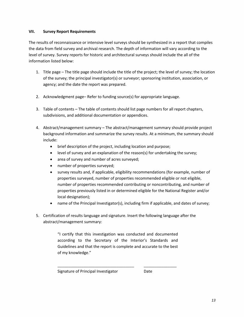
VII. Survey Report Requirements
The results of reconnaissance or intensive level surveys should be synthesized in a report that compiles the data from field survey and archival research. The depth of information will vary according to the level of survey. Survey reports for historic and architectural surveys should include the all of the information listed below:
1. Title page – The title page should include the title of the project; the level of survey; the location of the survey; the principal investigator(s) or surveyor; sponsoring institution, association, or agency; and the date the report was prepared.
2. Acknowledgment page– Refer to funding source(s) for appropriate language.
3. Table of contents – The table of contents should list page numbers for all report chapters, subdivisions, and additional documentation or appendices.
4. Abstract/management summary – The abstract/management summary should provide project background information and summarize the survey results. At a minimum, the summary should include:
• brief description of the project, including location and purpose; • level of survey and an explanation of the reason(s) for undertaking the survey; • area of survey and number of acres surveyed; • number of properties surveyed; • survey results and, if applicable, eligibility recommendations (for example, number of
properties surveyed, number of properties recommended eligible or not eligible, number of properties recommended contributing or noncontributing, and number of properties previously listed in or determined eligible for the National Register and/or local designation);
• name of the Principal Investigator(s), including firm if applicable, and dates of survey;
5. Certification of results language and signature. Insert the following language after the abstract/management summary:
“I certify that this investigation was conducted and documented according to the Secretary of the Interior’s Standards and Guidelines and that the report is complete and accurate to the best of my knowledge.”
___________________________________ _______________ Signature of Principal Investigator Date

14
6. Methodology - The methodology section is a brief discussion of the objectives, scope, and depth of the survey. It is often the same information established as part of a research design and is intended to provide background for understanding survey results. The amount of detail will depend on a number of factors, including the level of survey.17 It should clearly explain:
• applicable contexts; • previous research known to have been done on the subjects; • the types of sources used; • the types of personnel used; • the survey goals; • intended use of the survey; • focus of the survey (resource type, construction era, geographic area, etc.); • the specific boundaries of the surveyed area(s), including a map; • justification of the boundaries; • dates of field work; • methods of research, fieldwork, photography, mapping, and recording survey data • community involvement and participation; • type of format of the final deliverables (bound report, printed inventory forms, cd, GIS
files, etc.); • timetable for completing the project; and • an explanation of criteria used in evaluating properties.
7. Historic context narratives of the subject(s). For example, history of property type, geography,
settlement patterns, property use, designer biography, etc.
8. Historic and current assessment of the properties located within the survey area.
9. A list or table of inventoried properties located within the survey area. This list includes all properties for which an inventory form was completed. Include the following information for each resource:
• inventory number; • historic name, if known (if unknown, common name); • address; • approximate date of construction; • an eligibility recommendation (if appropriate); and • a thumbnail image is also recommended.
17For more information: Bulletin 24, https://www.nps.gov/nr/publications/bulletins/nrb24/nrb24.pdf, 29, 69-70; Secretary of Interior’s Standards for Identification https://www.nps.gov/history/local-law/arch_stnds_2.htm.

15
10. A list or table of resources located within the survey area that were not inventoried as well as a brief explanation why they do not meet the inventory criteria. Include the following information for each resource:
• historic name, if known (if unknown common name); • address; • approximate date of construction; • brief explanation as to why the property was not inventoried; and • a thumbnail image is also recommended.
11. Glossary and/or bibliography – Reports should be written using proper citation methods. All
reports should contain a Works Cited or Bibliography. Glossaries are not necessary, but are often helpful.
12. Maps – Including but not limited to survey area maps, photo key maps, historic maps, and various coded survey maps, as applicable.
13. Photographs or drawings – Contemporary or historic photographs or drawings that help illustrate the context(s), analysis, or finding(s) discussed within the document.

Identifying the appropriate inventory form(s)
16
VIII. Inventory Forms
Inventory forms are used to document individual resources and groups of resources that meet the inventory criteria outlined in Section VI. B. - Recording Surveyed Properties. Two inventory forms have been developed for recording properties in Minnesota: the Individual Property Inventory Form (Individual Property Form) and the Multiple Property Inventory Form (Multiple Property Form). Both inventory forms are available in a writeable PDF format on the HPD website available at: http://www.mnhs.org/shpo/survey/. The standard inventory forms are required for all HPD submissions with the exception of HPD reviewed and approved Certified Local Government standardized inventory forms.

17
A. Identifying the appropriate inventory form(s)
Properties with multiple resources such as farmsteads, complexes and historic districts must be recorded on a Multiple Property Form. List all individual resources related to the complex or district in the Associated Properties section on the form or on a continuation sheet if necessary.
Individual resources including buildings, structures, objects, and sites that individually meet inventory criteria must be recorded on an Individual Property Form; include ancillary structures in the resource count and narratives. If the individual resource is also within the boundary of a farmstead, complex, or historic district enter the historic name and inventory number of the larger property in the Associated Multiple Property Form field.
The following are examples of how to identify which inventory form or forms to use when documenting properties.
Property Form to use Notes
House, barn, rock shelter, fire tower, dam, fountain, natural feature, etc.
Individual Property Form
Complete the form in its entirety. Include all ancillary structures in the resource count and narratives.
Linear resource (road, railroad spur, canal, linear historic district segment, etc.) without associated properties*
Individual Property Form Document linear resources as structures.
Linear historic district with multiple segments (entire trunk highways, entire rail lines)*
Multiple Property Form for the entire linear historic district. Multiple Property Form for each segment that contains associated properties. Individual Property Form for each segment that does not contain associated properties.
Enter appropriate historic name(s) and inventory number(s) in the Associated Multiple Property and/or Associated Property fields to sufficiently cross reference more than one associated inventory form. Note: see instructions for documenting a linear historic district comprised of a linear resource with associated properties below.

18
Property Form to use Notes
Linear historic districts comprised of a linear resource (road, railroad spur, canal, linear historic district segment, etc.) with associated properties*
Multiple Property Form to document the linear historic district. Individual Property Forms for each resource according to the following guidelines: For reconnaissance surveys document each resource on the property that meets minimum inventory criteria, including the linear resource. Resources that do not meet the criteria should be described in the survey report and included in the resource count. For intensive surveys document all individual resources including the linear resource, within the linear historic district.
Enter appropriate historic name(s) and inventory number(s) in the Associated Multiple Property and/or Associated Property fields to sufficiently cross reference more than one associated inventory form. Note: one linear historic district may be a part of a larger linear historic district. Therefore, the property may have more than one Multiple Property Form associated with it. If applicable, enter both historic names and inventory numbers in the Associated Properties field.

19
Property Form to use Notes
Farmstead, college campus, religious complex, commercial historic district, large landscaped parks, residential areas, collections of habitation and limited activity sites, cultural landscapes, etc.
Multiple Property Form for the entire property. Individual Property Forms for each resource according to the following guidelines: For reconnaissance surveys document each resource on the property that meets minimum inventory criteria. Resources that do not meet the criteria should be described in the survey report and included in the resource count. For intensive surveys document all individual resources on the property.
Enter appropriate historic name(s) and inventory number(s) in the Associated Multiple Property and/or Associated Property fields to sufficiently cross reference more than one associated inventory form.
* Should the survey boundary encompass a linear resource, in whole or in part, contact HPD staff to determine the appropriate level of documentation necessary.

Minnesota Individual Property Inventory Form Instructions
20
B. Minnesota Individual Property Inventory Form Instructions
The Individual Property Form should be used to record individual resources. Instructions for the completion of the Individual Property Form are provided in the table below. Do not use abbreviations or codes, unless otherwise noted in the table. If additional space is needed to complete a field provide additional information on a continuation sheet(s). The continuation sheet(s) should include a header that matches that on pages 2-4 of the inventory form. For definitions and guidance on field names see National Register Bulletin 16A: How to Complete the National Register Registration Form available at: https://www.nps.gov/nr/publications/bulletins/nrb16a/).
General Information Field Name Instructions Historic Name Enter the historic name of the property.
Other Names
If the property has additional names, such as a common name, current name, or other known name, enter them in this field. Separate multiple names with a semicolon. Leave blank if no other names have been identified.
Inventory Number
Enter the inventory number assigned by the HPD. The inventory number is a three-part code that identifies the county, civil subdivision, and individual property number. For example, HE-MPC-3420: Hennepin County – Minneapolis – assigned property number. If the property does not already have an inventory number, request one from the HPD. All forms must have an inventory number prior to submittal.
Associated Multiple Property Form (Name & Inventory No.)
Enter historic name(s) and inventory number(s) of the Multiple Property Form(s) with which the individual property is associated. For example, enter the historic district name and inventory number of the district for a house that is part of a residential historic district. Note: a property associated with a linear historic district may have more than one Multiple Property Form. For example, a property associated with a segment within a longer linear historic district. Separate multiple property forms with a semicolon.

Minnesota Individual Property Inventory Form Instructions
21
General Information Field Name Instructions
New or Updated Form
Select “Updated” if the property was previously surveyed and assigned an inventory number. Select “New” if the property was not previously surveyed and/or not assigned an inventory number.
Extant
Select “Yes” or “No.” “No” will apply only to previously surveyed properties that no longer exist (have been demolished or moved) and for which an updated form is being prepared.
Survey Type
Select survey type from the dropdown menu. Select “Reconnaissance” for surveys conducted as part of the Review and Compliance process that combines Phase I/Phase II surveys. Property Evaluations are considered intensive surveys.
Review and Compliance Number
Enter MnHPO Review and Compliance Number (if known). Leave blank if a Review and Compliance Number has not been assigned or is not applicable.
Agency Project Number
Enter federal, state, or local agency project number (if known). Leave blank if no agency project number is assigned or is not applicable.
MNHS Grant Number Enter MNHS Grant Number. Leave blank if the survey is not a MNHS grant-funded project.

Minnesota Individual Property Inventory Form Instructions
22
Location Information Field Name Instructions
Street Address
Enter legal address of the property as assigned by city or county tax assessor’s office. For properties that encompass more than one address enter the appropriate address range. For example, 300-340 Mills Street. If street number is not known approximate based on other known adjacent addresses. For example, “approximately 595 Girard Avenue.” If there is no legal address or it is unknown, enter location description including the name of the road, nearby intersections, and appropriate distances to key points. For example, “approximately 150 feet south of the southeast corner of Girard Avenue and Pleasant Street.” Do not write out and do not use superscript for numbered street names. For example, use “4th,” not “Fourth” or “4th. Do not use abbreviations for road name such as Street, Avenue, West, etc. For example, do not use "St.," "Ave.," "W.," etc. North, South, East, and West should come after the street name not before it. For example, 123 Pleasant Street South. For a bridge, describe the feature carried/feature crossed. For example, Trunk Highway 7 over Huntington Creek.
County Select the county where the surveyed property is located from the dropdown menu.
If Multiple, List All Counties Below
Enter each of the counties in which the property extends if “Multiple” was selected above. Separate multiple counties with a semicolon.
City/Township
Select the city or township where the property is located from the dropdown menu. Note: A county must be selected to access dropdown options.

Minnesota Individual Property Inventory Form Instructions
23
Location Information Field Name Instructions
If Multiple, List All Cities/Townships Below
Enter each of the cities or townships in which the property extends if “Multiple” was selected above. Separate multiple cities or townships with a semicolon.
Total Acres
Provide the number of acres comprising the property. Acreage should be accurate to the nearest whole acre. If the property is substantially smaller than one acre, “less than one acre” may be entered.
USGS 7.5 Quad Name(s)
Select the appropriate USGS 7.5-minute Quad or Quads from the dropdown menu. Separate multiple Quad names with a semicolon.
Township-Range-Section Qtr fields
This section is based on the U.S. Public Land Survey System (PLSS). For more information visit the U.S. Geological Survey’s Public Land System map and article available at: http://nationalmap.gov/small_scale/a_plss.html. Enter the portion of the section where the property is located. The size of the property will determine how many of the Qtr fields are filled out. However, in most cases the Qtr fields will be completed down to the QtrQtrQtr. If the property extends into more than one section, enter information for both sections.
Urban: Subdivision
Enter subdivision name from legal description as defined by the city or county tax assessor’s office. Separate multiple blocks with a semicolon.
Urban: Block(s)
Enter block from legal description as defined by the city or county tax assessor’s office. Separate multiple blocks with a semicolon.
Urban: Lot(s)
Enter lot from legal description as defined by the city or county tax assessor’s office. Separate multiple lots with a semicolon.
Property Identification Number (PIN)
Enter the Property Identification Number from the city or county tax assessor’s office, if known. Separate multiple PINs with a semicolon.

Minnesota Individual Property Inventory Form Instructions
24
Location Information Field Name Instructions UTM Coordinates: Datum Enter the datum (1927 or 1983) for the set of UTM coordinates.
UTM Coordinates: UTM Zone
This section is based on NPS guidelines. For more information see National Register Bulletin 16A: How to Complete the National Register Registration Form available at: (https://www.nps.gov/nr/publications/bulletins/nrb16a/). Enter the UTM zone for the property based on the UTM grid. For properties consisting of ten (10) acres or less, enter the UTM reference for the point corresponding to the center of the property. For properties consisting of ten (10) acres or more, enter three (3) or more UTM references.
UTM Coordinates: Easting Enter the six (6)-digit easting site coordinate UTM Coordinates: Northing Enter the seven (7)-digit northing site coordinate
Previous Determinations Field Name Instructions
Previous Individual Determination
Select all applicable box(es). Leave blank if no previous determinations have been made.
Previous District Determination
Select all applicable box(es) if the resource is within a listed or designated historic district. If one or more boxes are checked, select if the individual resource previously contributed or did not contribute to the historic district. If there is more than one district designation, enter the National Register district historic name in this District Name section and include other district names in the statement of significance. Leave blank if no previous determinations have been made.

Minnesota Individual Property Inventory Form Instructions
25
Classification Field Name Instructions
Associated properties
Enter the historic name(s) and inventory number(s) of individual resources directly associated with the property being documented in this inventory form. For example, a garage. Note: some ancillary properties will not meet individual inventory criteria and will not have an inventory number. These should still be noted in this field, omitting the inventory number. Leave blank if there are no associated properties.
Property Category Select the appropriate category from the dropdown menu.
Number of Resources on the Property
Enter the number of resources located on the property. Include all resources, even those that were not individually inventoried, such as garages.
Function or Use Field Name Instructions Historic: Function/Use Category Select historic function or use from the dropdown menu. Historic: Function/Use Category (if other)
Enter historic function or use if “Other” was selected above.
Historic: Function/Use Subcategory Select historic function or use subcategory from the dropdown menu.
Historic: Function/Use Subcategory (if other)
Enter historic function or use subcategory if “Other” was selected above.
Current: Function/Use Category Select current function or use from the dropdown menu.
Current: Function/Use Category (if other)
Enter current function or use if “Other” was selected above.
Current: Function/Use Subcategory Select current function or use subcategory from the dropdown menu.
Current: Function/Use Subcategory (if other)
Enter current function or use subcategory if “Other” was selected above.

Minnesota Individual Property Inventory Form Instructions
26
Description Field Name Instructions
Narrative Description
Provide full narrative description in the narrative description field or on continuation sheet(s). See Section VIII. C. 1 – Narrative Description for more information.
Architectural Style
Select the appropriate architectural style of the primary resource from the dropdown menu. Select “Other” for structures (such as a road or bridge).
Architectural Style (if other)
Enter style if “Other” was selected above. If an unlisted style is assigned to the property, explain its architectural features and design elements (including construction methods) in the narrative description.
Exterior Material
Select the primary exterior material from the dropdown menu. If multiple materials are present, choose the primary facade's most prevalent. Choose the material of the main structural system for structures.
Exterior Material (if other) Enter the kind of material if “Other” is selected above.
Significance Field Name Instructions
Statement of Significance
Provide the full statement of significance narrative in the statement of significance field or on a continuation sheet(s). See Section VIII. C. 2 – Statement of Significance for more information.
Applicable National Register of Historic Places Criteria
Indicate if the property does or does not have significance for each criterion, or if more research is recommended. If more research is recommended, include the kind(s) of information needed to make a significance recommendation in the statement of significance. Leave blank if significance was not assessed or reassessed.

Minnesota Individual Property Inventory Form Instructions
27
Criteria Considerations
Check “Yes” or “No” if National Register Criteria Considerations apply. If a consideration applies, explain in the statement of significance. Leave blank if significance was not assessed or reassessed.
Area of Significance
Select the primary area of significance for a property from the dropdown menu. Leave blank if area of significance was not defined.
Additional or Other Areas of Significance
Enter additional areas of significance that apply to the property. Enter area of significance if “other” was selected above and explain the area in the statement of significance. Separate multiple areas of significance with a semicolon.
Period(s) of Significance
Enter dates for one or more periods when the property attained significance. Leave blank if period of significance was not defined.
Date Constructed Enter the year(s) of construction. If exact date is unknown or cannot be determined, use a circa date. For example, ca. 1910.
Other Significant Construction Dates
Enter other significant construction dates, such as major alterations or additions. If exact date is unknown or cannot be determined include a circa date. For example, ca. 1910. Explain significance of the date(s) in the statement of significance.
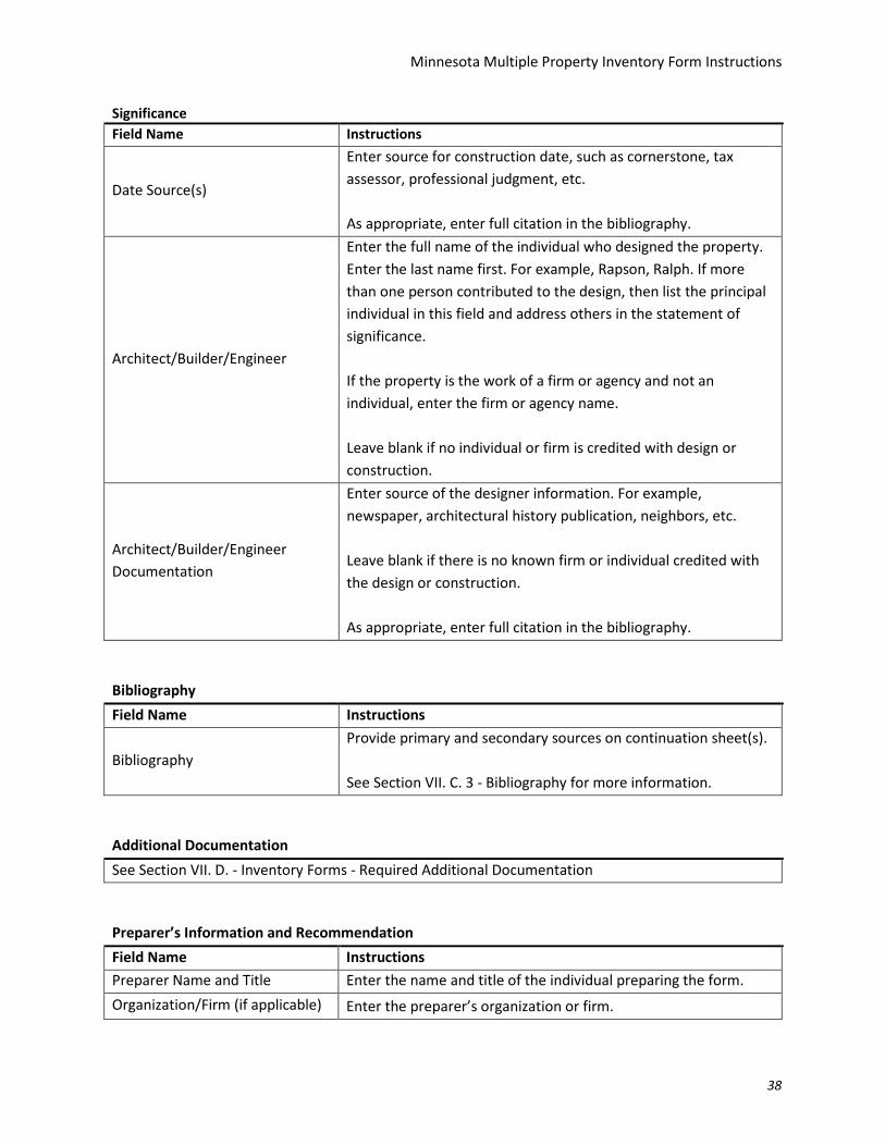
Date Source(s)
Enter source for construction date, such as cornerstone, tax assessor, professional judgment, etc. As appropriate, enter full citation in the bibliography.

Minnesota Individual Property Inventory Form Instructions
28
Architect/Builder/Engineer
Enter the full name of the individual who designed the property. Enter the last name first. For example, Rapson, Ralph. If more than one person contributed to the design, list the principal individual in this field and address others in the statement of significance. If the property is the work of a firm or agency and not an individual, enter the firm or agency name. Leave blank if no individual or firm is credited with design or construction.
Architect/Builder/Engineer Documentation
Enter source of the designer information. For example, newspaper, architectural history publication, neighbors, etc. Leave blank if there is no known firm or individual credited with the design or construction. As appropriate, enter full citation in the bibliography.
Bibliography Field Name Instructions
Bibliography
Provide primary and secondary sources on continuation sheet(s). See Section VII. C. 3 - Bibliography for more information.
Additional Documentation See Section VII. D. - Inventory Forms - Required Additional Documentation
Preparer’s Information and Recommendation Field Name Instructions Preparer Name and Title Enter the name and title of the individual preparing the form. Organization/Firm (if applicable) Enter the preparer’s organization or firm.
Date Inventory Form Prepared Provide the date the inventory form was completed (not the date fieldwork was conducted).

Minnesota Individual Property Inventory Form Instructions
29
Preparer’s Information and Recommendation Field Name Instructions
Recommended Individual Evaluation
Note preparer’s recommendation by selecting all appropriate box(es). Check the “More Information Needed for Evaluation” for potentially significant properties that have not been evaluated. Leave blank if no eligibility recommendation is being made.
Recommended District Evaluation
Check the box if the individual resource is within a historic district that is being recommended eligible for listing in the National Register or for local designation (i.e., the property is within the district boundaries and the district, as a whole, has been evaluated). If so, note the resources’ contributing or noncontributing status to that district. Include the name of the historic district and inventory number. If there is more than one district designation, enter the National Register district name and inventory number in this section. Include other district name(s) and inventory number(s) in the Associated Multiple Property Form field in the General Information section. Leave blank if no eligibility recommendation is being made.
Field Name Instructions Minnesota Historic Preservation Office Comments (HPD Use Only)
HPD use only.

Minnesota Multiple Property Inventory Form Instructions
30
C. Minnesota Multiple Property Inventory Form Instructions
The Multiple Property Form should be used to record historic districts and groups of related resources or complexes. Instructions for the completion of the Multiple Property Form are provided in the table below. Do not use abbreviations or codes, unless otherwise noted in the table. If additional space is needed to complete a field provide the information on a continuation sheet(s). The continuation sheet(s) should include a header that matches that on pages 2-4 of the inventory form. For definitions and guidance on field names see National Register Bulletin 16A: How to Complete the National Register Registration Form available at: https://www.nps.gov/nr/publications/bulletins/nrb16a/.
General Information Field Name Instructions
Historic Name
Enter the historic name of the property. As linear historic districts may have more than one Multiple Property Form (or example, segments with associated properties within a longer linear historic district), enter the historic name that corresponds to the property being documented by this form.
Other Names
If the property has additional names, such as a common name, current name, or other known name, enter them in this field. Separate multiple names with a semicolon. Leave blank if no other names have been identified.
Inventory Number
Enter the inventory number assigned by the HPD. The inventory number is a three-part code that identifies the county, civil subdivision, and individual property number. For example, HE-MPC-3420: Hennepin County – Minneapolis – assigned property number. If the property does not already have an inventory number, request one from the HPD. All forms must have an inventory number prior to submittal.
Multiple Property Category Select the multiple property category from the dropdown menu.
Multiple Property Category (if other)
Enter alternate property category (farmstead, campus, park, etc.) if “Other” was selected above.

Minnesota Multiple Property Inventory Form Instructions
31
General Information Field Name Instructions
New or Updated Form
Select “Updated” if the property was previously surveyed and assigned an inventory number. Select “New” if the property was not previously surveyed and/or not assigned an inventory number.
Extant
Select “Yes” or “No.” No, will apply only to previously surveyed properties that no longer exist (have been demolished or moved) and for which an updated form is being prepared.
Survey Type
Select survey type from the dropdown menu. Select “Reconnaissance” for surveys conducted as part of the Review and Compliance process that combines Phase I/Phase II surveys. Property Evaluations are considered intensive surveys.
Review and Compliance Number
Enter MnHPO Review and Compliance Number (if known). Leave blank if a Review and Compliance Number has not been assigned or is not applicable.
Agency Project Number
Enter federal, state, or local agency project number (if known). Leave blank if no agency project number is assigned or is not applicable.
MNHS Grant Number Enter MNHS Grant Number. Leave blank if the survey is not a MNHS grant-funded project.

Minnesota Multiple Property Inventory Form Instructions
32
Location Information Field Name Instructions
Street Address
Enter legal address of the property as assigned by city or county tax assessor’s office. Do not enter an owner’s address. Enter either the inclusive street address numbers for all properties or a rough description of the boundaries. For example, 12-193 Mills Street, 380 Selby Avenue, or 20-125 Delaware Place. Verbal boundary descriptions are also acceptable. For example, roughly bounded by Smithfield Lake, North Avenue, Lowell Avenue, and Main Street. Enter the district, forest, reserve, or other organizational division identifying the location of the property for federally owned properties. For example, Chippewa National Forest. If there is no legal address or it is unknown, enter location description including the name of the road, nearby intersections, and appropriate distances to key points. For example, “approximately 150 feet south of the southeast corner of Girard Avenue and Pleasant Street.” Do not write out and do not use superscript for numbered street names. For example, use “4th,” not “Fourth” or “4th. Do not use abbreviations for road name such as Street, Avenue, West, etc. For example, do not use "St.," "Ave.," "W.," etc. North, South, East, and West should come after the street name not before it. For example, 123 Pleasant Street South.
County Select the county where the surveyed property is located from the dropdown menu.
If Multiple, List All Counties Below
Enter each of the counties in which the property extends if “Multiple” was selected above. Separate multiple counties with a semicolon.

Minnesota Multiple Property Inventory Form Instructions
33
Location Information Field Name Instructions
City/Township
Select the city or township where the property is located from the dropdown menu. Note: A county must be selected to access dropdown options.
If Multiple, List All Cities/Townships Below
Enter each of the cities or townships in which the property extends if “Multiple” was selected above. Separate multiple cities or townships with a semicolon.
Total Acres
Provide the number of acres comprising the property. Acreage should be accurate to the nearest whole acre. If the property is substantially smaller than one acre, “less than one acre” may be entered.
USGS 7.5 Quad Name(s)
Select the appropriate USGS 7.5-minute Quad or Quads from the dropdown menu. Separate multiple Quad names with a semicolon.
Township-Range-Section Qtr fields
This section is based on the U.S. Public Land Survey System (PLSS). For more information visit the U.S. Geological Survey’s Public Land System map and article available at: http://nationalmap.gov/small_scale/a_plss.html. Enter the portion of the section where the property is located. The size of the property will determine how many of the Qtr fields are filled out. However, in most cases the Qtr fields will be completed down to the QtrQtrQtr. If the property extends into more than one section, enter information for both sections. Often linear historic districts cross through multiple sections. Complete a continuation sheet if more space is needed to record all the legal descriptions.
Urban: Subdivision
Enter subdivision name from legal description as defined by the city or county tax assessor’s office. Separate multiple subdivisions with a semicolon.
Urban: Block(s)
Enter block from legal description as defined by the city or county tax assessor’s office. Separate multiple blocks with a semicolon.

Minnesota Multiple Property Inventory Form Instructions
34
Location Information Field Name Instructions
Urban: Lot(s)
Enter lot from legal description as defined by the city or county tax assessor’s office. Separate multiple lots with a semicolon.
Property Identification Number (PIN)
Enter the Property Identification Number from the city or county tax assessor’s office, if known. Separate multiple PINs with a semicolon.
UTM Coordinates: Datum Enter the datum (1927 or 1983) for the set of coordinates.
UTM Coordinates: UTM Zone
This section is based on NPS guidelines. For more information see National Register Bulletin 16A: How to Complete the National Register Registration Form available at: (https://www.nps.gov/nr/publications/bulletins/nrb16a/). Enter the UTM zone for the property based on the UTM grid. For properties consisting of ten (10) acres or less, enter the UTM reference for the point corresponding to the center of the property. For properties consisting of ten (10) acres or more, enter three (3) or more UTM references.
UTM Coordinates: Easting Enter the six (6)-digit easting site coordinate UTM Coordinates: Northing Enter the seven (7)-digit northing site coordinate
Previous Determinations Field Name Instructions
Previous Determinations
Select all box(es) indicating previous determination(s) for the property being documented by this form. If there is more than one district designation, enter the National Register district name in this section and include other district names on a continuation sheet. Leave blank if no previous determination was made.

Minnesota Multiple Property Inventory Form Instructions
35
Classification Field Name Instructions
Number of Resources (Contributing)
Enter the number of buildings, structures, sites, and objects considered contributing to the property. Include all resources, even those that were not individually inventoried, such as garages.
Number of Resources (Noncontributing)
Enter the number of buildings, structures, sites, and objects considered noncontributing to the property. Include all resources, even those that were not individually inventoried, such as garages.
Associated Properties (Name and Inventory Number)
Enter the historic name(s) and inventory number(s) of properties directly associated with the property being documented by this form.
If the property has many ancillary individual properties, list them in a table on a continuation sheet, and include historic name, address (if known), inventory number, and contributing/noncontributing status recommendation.
Include all resources, even those that were not individually inventoried, omitting the inventory number.
Function or Use Field Name Instructions Historic: Function/Use Category Select historic function or use from the dropdown menu. Historic: Function/Use Category (if other)
Enter historic function or use if “Other” was selected above.
Historic: Function/Use Subcategory
Select historic function or use subcategory from the dropdown menu.
Historic: Function/Use subcategory (if other)
Enter historic function or use subcategory if “Other” was selected above.
Current: Function/Use Category Select current function or use from the dropdown menu.

Minnesota Multiple Property Inventory Form Instructions
36
Function or Use Field Name Instructions Current: Function/Use Category (if other)
Enter current function or use if “Other” was selected above.
Current: Function/Use Subcategory
Select current function or use subcategory from the dropdown menu.
Current: Function/Use Subcategory (if other)
Enter current function or use subcategory if “Other” was selected above.
Description Field Name Instructions
Narrative Description
Provide full narrative description in the narrative description field or on continuation sheet(s). See Section VIII. C. 1 – Narrative Description for more information.
Architectural Style
Enter all appropriate architectural styles from the Style List provided in Appendix A. Select “Other” for structures (such as a road or bridge). Separate multiple architectural styles with a semicolon.
Architectural Style (if other)
Enter style if “Other” was selected above. If an unlisted style is assigned to the property, explain its architectural features and design elements (including construction methods) in the narrative description.
Exterior Material
Select the primary exterior material from the dropdown menu. If multiple materials, choose the primary facade's most prevalent. Choose the material of the main structural system for structures.
Exterior material (if other) Enter the kind of material if “Other” is selected above.
Significance Field Name Instructions
Statement of Significance
Provide the full statement of significance narrative in the statement of significance field or on continuation sheet(s). See Section VIII. C. 2 – Statement of Significance for more information.

Minnesota Multiple Property Inventory Form Instructions
37
Significance Field Name Instructions
Applicable National Register Criteria
Indicate if the property does or does not have significance for each criterion, or if more research is recommended. If more research is recommended, include the kind(s) of information needed to make a significance recommendation in the statement of significance. Leave blank if significance was not assessed or reassessed.
Criteria Considerations
Check “Yes” or “No” if National Register Criteria Considerations apply. If a consideration applies, explain in the Statement of Significance. Leave blank if significance was not assessed or reassessed.
Area(s) of Significance
Select the primary area of significance for a property from the dropdown menu. Leave blank if area of significance was not defined.
Additional or Other Areas of Significance
Enter additional areas of significance that apply to the property. Enter area of significance if “other” was selected above and explain the area in the statement of significance. Separate multiple areas of significance with a semicolon.
Period(s) of Significance
Enter dates for one or more periods when the property attained significance. Leave blank if period of significance was not defined.
Date(s) Constructed
Enter the year(s) of construction. If exact date is unknown or cannot be determined, use a circa date. For example, ca. 1910. Enter construction date ranges for contributing resources. For example, 1890-1925.
Other Significant Construction Dates
Enter other significant construction dates, such as major alterations or additions. If exact date is unknown or cannot be determined include a circa date. For example, ca. 1910. Explain significance of the date(s) in the statement of significance.
Minnesota Multiple Property Inventory Form Instructions
38
Significance Field Name Instructions
Date Source(s)
Enter source for construction date, such as cornerstone, tax assessor, professional judgment, etc. As appropriate, enter full citation in the bibliography.
Architect/Builder/Engineer
Enter the full name of the individual who designed the property. Enter the last name first. For example, Rapson, Ralph. If more than one person contributed to the design, then list the principal individual in this field and address others in the statement of significance. If the property is the work of a firm or agency and not an individual, enter the firm or agency name. Leave blank if no individual or firm is credited with design or construction.
Architect/Builder/Engineer Documentation
Enter source of the designer information. For example, newspaper, architectural history publication, neighbors, etc. Leave blank if there is no known firm or individual credited with the design or construction. As appropriate, enter full citation in the bibliography.
Bibliography Field Name Instructions
Bibliography Provide primary and secondary sources on continuation sheet(s). See Section VII. C. 3 - Bibliography for more information.
Additional Documentation See Section VII. D. - Inventory Forms - Required Additional Documentation
Preparer’s Information and Recommendation Field Name Instructions Preparer Name and Title Enter the name and title of the individual preparing the form. Organization/Firm (if applicable) Enter the preparer’s organization or firm.

Minnesota Multiple Property Inventory Form Instructions
39
Preparer’s Information and Recommendation Field Name Instructions
Date Inventory Form Prepared Provide the date the inventory form was completed (not the date fieldwork was conducted).
Recommended District Evaluation
Note preparer’s recommendation by selecting all appropriate box(es). Check the “More Information Needed for Evaluation” for potentially significant properties that have not been evaluated. Leave blank if no eligibility recommendation is being made.
Field Name Instructions
Minnesota Historic Preservation office Comments (HPD Use Only)
HPD use only.

40
C. Narratives – Individual and Multiple Property Forms
The following instructions apply to both the Individual Property Form and the Multiple Property Form. Each narrative field on the digital PDF form is expandable. The narratives can be completed by typing directly into the box or by copying and pasting text into each box. While these fields accommodate some formatting (bold, italics, etc.), they cannot hold tables, images, or footnotes. Continuation sheets can also be used; enter “see continuation sheet” in the form field. Parenthetical citations may be used in the narratives, with full citations included in the bibliography. For citation format refer to Kate L. Turabian's Manual for Writers of Research Papers, Theses, and Dissertations (eighth edition) or other widely acceptable sources of citation.
1) Narrative Description
Reconnaissance level survey: Provide a brief description of the property. For individual properties include a discussion of its setting, overall form, type, style, method of construction, size, and significant architectural features.
For districts and complexes include the natural and designed elements, architectural styles, general physical relationships of the resources, general character, open space, etc.18 The description should focus on the exterior of the resource(s). Ancillary resources should also be listed and briefly described.
If a style is assigned to the property that is not included in the dropdown menu or the identical style list Appendix A, explain the architectural features and design elements (including construction methods) that led to the style choice.
Intensive level survey: Provide a detailed description of the property. For individual properties provide a description of the property’s exterior, including an explanation of its setting, overall form, type, style, method of construction, size, and significant architectural features. Note the architectural footprint, massing, and style, including the number of stories, exterior construction materials, roof form, architectural details, decorative elements, fenestration, porches, chimneys, outbuildings, and landscaping. If the interior is accessible, the description should also include its detail.
For properties with multiple resources, such as districts and complexes, etc., include a description of the natural and designed elements, architectural styles, general physical relationships of the resources, general character, and open spaces, etc. The narrative should describe, at minimum, the primary facades of each resource.
Include a discussion of original design features versus additions or alterations, noting the date of each. Address in detail all seven aspects of integrity.
18 For additional information on describing historic properties see Bulletin 16A, 28-34.

41
If a style was assigned to the property that was not included in the style dropdown menu, explain the architectural features and design elements (including construction methods) that led to the style choice.
2) Statement of Significance
Reconnaissance level survey: Include information about potential for significance based on the reconnaissance survey. This should include any information found on previous inventory forms.
Site-specific research is not expected to be conducted for this level of survey; it is not expected that surveyors compile a chain of title (for owner history, etc.), or review census records (for occupant history), or city directories (also for occupant history). Limit the inventory form narrative specifically to the property.
Intensive level survey: Provide property history including construction history, ownership, and analysis of the property within applicable historic contexts. Limit the inventory form narrative specifically to the property. This research should consist of both primary and secondary research. Site-specific research is expected to be conducted for this level of survey; it is expected that surveyors compile, at minimum, a chain of title (for owner history, etc.), review census records (for occupant history), and city directories (also for occupant history).
Provide a narrative detailing how the property meets or does not meet National Register Criteria A, B, C, and D at the local, state, or national level. If the property is being evaluated for local designation provide applicable criteria and discuss how the property does or does not meet those criteria. The narrative should place the property within a context of similar properties. For properties recommended eligible, detail the applicable area(s) of significance, period(s) of significance, associated context(s), and associated Multiple Property Documentation Form(s) as applicable. Note also if a property is recommended eligible with criteria considerations.19
3) Bibliography
List primary and secondary sources used to prepare the inventory form. Cite any historic contexts or Multiple Property Documentation Forms used to evaluate the property. If the inventory form was prepared as part of a survey with a final survey report, include the citation of the survey report. For citation format refer to Kate L. Turabian's Manual for Writers of Research Papers, Theses, and Dissertations (eighth edition) or other widely acceptable source of citation.
D. Inventory Forms – Required Additional Documentation
Required additional documentation should be submitted on continuation sheets that include a header that matches that on pages 2-4 of the inventory form as well as page numbers (e.g. Additional
19 Bulletin 15 can be found on the NPS website: https://www.nps.gov/nr/publications/bulletins/pdfs/nrb15.pdf.

42
Documentation 1 of 4). Submit the inventory form, continuation sheets, and all additional documentation as a single PDF.
1) Photographs
Inventory forms must contain photographs documenting the property at the time of survey. All photographs are an official record of the property or resources. Careful photographic practices should be followed. Photographs must meet the following requirements:
• photographs must be embedded on continuation sheets;
• photographs should be no smaller than 4” x 6” in size;
• at least one photograph of each primary elevation is required for every inventoried resource. Generally a 3/4 view of the resource is preferred. Additional photographs of ancillary resources
or showing the relationship of multiple resources can be included, as applicable;
• for a district or complex, include a minimum of four photographs that provide an overview of the property’s character and representative images of its resources (these are generally
referenced as “streetscape” photographs);
• provide photo captions that include the property’s inventory number, image capture date, view,
and subject. For example, ST-OWA-002, June 2017, front elevation, looking north; and
• if a resource being resurveyed is no longer extant, include a photograph of its former location.
2) Maps Location maps are required for all survey forms and must indicate the location of the resource(s) within the boundaries of the survey area. All maps must be suitable for reproduction in black and white.
Plat maps, street maps, USGS topographic maps, aerial images, or internet-based tools can be used to generate maps. For urban properties, a city plat or aerial may be an appropriate base map. For rural properties, a USGS topographic map or an aerial map may be appropriate. The map must include a scale and north arrow, and public roads should be labeled. Instructions for Individual Property Form and Multiple Property Form maps follow.
Individual Property Form: Include a map showing the property, including all ancillary structures, and the position of the property within its city or township.
Multiple Property Form: Include two maps: one showing the location of the property and its position in a larger context, such as within its city or township, and one that shows all of the resources included
within the Multiple Property Form.
The second map is a site plan and must include the boundaries of the overall property. The map must indicate the contributing/noncontributing status of each individual resource.

43
IX. Submittal Requirements
Inventory forms and continuation sheets must be submitted in both hard copy and PDF digital format for all HPD programs. If a survey is produced using an MNHS grant, submission guidelines are stated in the grants manual and agreement. Submission requirements are the responsibility of the grantee. Frequently, initial submissions or drafts require revisions based on comments provided by the HPD. Hard copy documentation (forms and reports) should be in color and double-sided. All survey materials submitted become the property of the HPD, along with copyright/reproduction rights.
Each inventory form must be saved as an individual PDF and named using the property’s unique inventory number. The HPD also asks that copies of databases or Excel tables developed for a survey project be submitted. Please coordinate with the HPD regarding submittal of additional deliverables.

44
Submission Quick Reference Guide for all HPD survey projects
A complete submission consists of both digital and print materials.
Draft Products:
• One unbound print copy of the draft survey report meeting all NPS and HPD standards and guidelines.
• One digital Word format copy of the draft survey report meeting all NPS and HPD standards and guidelines.
• One printed copy of each draft individual and multiple property inventory form, including, continuation sheets, and additional documentation meeting all HPD standards. Printed forms should be printed in color and double-sided.
• A single digital PDF that includes all draft individual and multiple property inventory forms, including, continuation sheets, and additional documentation meeting all HPD standards.
Final Products:
• One bound print copy of the final survey report meeting all NPS and HPD standards and guidelines.
• One digital Word format copy of the final survey report meeting all NPS and HPD standards and guidelines.
• One printed copy of each final individual and multiple property inventory form, including, continuation sheets, and additional documentation meeting all HPD standards. Printed forms should be printed in color and double-sided.
• One digital PDF copy of each final individual and multiple property inventory form, including, continuation sheets, and additional documentation meeting all HPD standards. Digital files should be saved individually and named using the inventory number.
To facilitate a future digital database and assist with keeping our current database accurate. The HPD requests that final submissions also include the following information, if it is available, as the HPD anticipates they will become required at a point in the future. • A complete copy of the database or Excel table developed for the survey. • An image of each surveyed property on a compact disc (CD). Preferably, each image will have a
minimum resolution of 300 ppi and be at least 3000 pixels on the longest side (approximately 8” x 10”) and named using the inventory number.

45
Appendix A. Architectural Style List for Inventory Form
The following is the list of architectural styles for the “Style” field on the inventory form. If a style is not on the list, select “Other.”.
Art Deco Art Moderne Art Nouveau Beaux Arts Brutalism Bungalow Carpenter Gothic Chateauesque Chicago Style Classical Revival Collegiate Gothic Colonial Revival Commercial Italianate Commercial Style Corporate Modernism Corporate Postmodernism Craftsman Deconstructivism Dutch Colonial Revival Eclectic Period Revival Egyptian Revival Elizabethan Elizabethan Revival English Cottage English Gothic Federal Folk Victorian French Colonial French Renaissance Revival
Georgian Georgian Cottage Georgian Revival Googie Gothic Revival Greek Revival High Victorian Eclectic High Victorian Gothic International Italian Renaissance Revival Italianate Jacobean or Jacobethan Jacobean Revival Late Gothic Revival Late Victorian Commercial Mediterranean Revival Miesian Mission/Spanish Colonial Revival Moderne Monumental Classicism Moorish Revival Neo Classical Neo-Formalism Neo-Mediterranean Neo-Modernism Neo-Traditional Neo-Tudor Octagon Mode
Organic Expressionism Oriental Revival Other Post-Medieval English Prairie Pueblo Revival Queen Anne Ranch Renaissance Revival Richardsonian Romanesque Roman Revival Romanesque Revival Rustic Second Empire Second Gothic Revival Second Modernism Second Renaissance Revival Shingle Style Skyscraper Spanish Colonial Stick/East Lake Streamlined Moderne Stripped Classical Sullivanesque Swiss Chalet, Swiss Tudor Revival WPA Rustic

46
Appendix B. Secretary of the Interior’s Standards
The following standards and criteria apply to the work detailed in this survey manual. The information is provided as a reference tool. Additional information on each standard can be found under the Secretary of the Interior's Standards and Guidelines for Archaeology and Historic Preservation and is available on the NPS website: https://www.nps.gov/history/local-law/arch_stnds_0.htm.
Professional Qualifications Standards The Professional Qualification Standards are those set by the National Park Service and are published in the Code of Federal Regulations, 36 CFR Part 61. The qualifications define minimum education and experience required to perform identification, evaluation, registration, and treatment activities. Historic preservation often requires the combination of multiple disciplines. It may be necessary to seek multiple professionals to ensure a thorough understanding of the properties and the applicable contexts.
History The minimum professional qualifications in history are a graduate degree in history or closely related field; or a bachelor's degree in history or closely related field plus one of the following:
1. At least two years of full-time experience in research, writing, teaching, interpretation, or other demonstrable professional activity with an academic institution, historic organization or agency, museum, or other professional institution; or
2. Substantial contribution through research and publication to the body of scholarly knowledge in the field of history.
Archaeology The minimum professional qualifications in archaeology are a graduate degree in archaeology, anthropology, or closely related field plus:
1. At least one year of full-time professional experience or equivalent specialized training in archaeological research, administration or management;
2. At least four months of supervised field and analytic experience in general North American archaeology, and
3. Demonstrated ability to carry research to completion.
In addition to these minimum qualifications, a professional in prehistoric archaeology shall have at least one year of full-time professional experience at a supervisory level in the study of archaeological resources of the prehistoric period. A professional in historic archaeology shall have at least one year of full-time professional experience at a supervisory level in the study of archaeological resources of the historic period.
Architectural History The minimum professional qualifications in architectural history are a graduate degree in architectural

47
history, art history, historic preservation, or closely related field, with coursework in American architectural history, or a bachelor's degree in architectural history, art history, historic preservation or closely related field plus one of the following:
1. At least two years of full-time experience in research, writing, or teaching in American architectural history or restoration architecture with an academic institution, historical organization or agency, museum, or other professional institution; or
2. Substantial contribution through research and publication to the body of scholarly knowledge in the field of American architectural history.
Architecture The minimum professional qualifications in architecture are a professional degree in architecture plus at least two years of full-time experience in architecture; or a State license to practice architecture.
Historic Architecture The minimum professional qualifications in historic architecture are a professional degree in architecture or a State license to practice architecture, plus one of the following:
1. At least one year of graduate study in architectural preservation, American architectural history, preservation planning, or closely related field; or
2. At least one year of full-time professional experience on historic preservation projects.
Such graduate study or experience shall include detailed investigations of historic structures, preparation of historic structures research reports, and preparation of plans and specifications for preservation projects.20 Secretary of Interior’s Standards and Guidelines for Archaeology and Historic Preservation Standards For Identification Identification activities are undertaken to gather information about historic properties in a particular locale. The scope of these activities depend on existing knowledge about properties; goals for survey activities developed in the planning process; current management needs.
Standard I – Identification of Historic Properties Is Undertaken to the Degree Required To Make Decisions
Standard II – Results of Identification Activities Are Integrated Into the Preservation Planning Process
Standard III – Identification Activities Include Explicit Procedures for Record-Keeping and Information Distribution21
20 The information in this section was taken directly from the National Park Service website: https://www.nps.gov/history/local-law/arch_stnds_9.htm.
48
Standards For Evaluation Evaluation is the process of determining whether identified properties meet defined criteria of significance and therefore should be included in an inventory of historic properties determined to meet the criteria. The criteria employed vary depending on the inventory's use in resource management.
Standard I – Evaluation of the Significance of Historic Properties Uses Established Criteria Standard II – Evaluation of Significance Applies the Criteria Within Historic Contexts Standard III – Evaluation Results in A List or Inventory of Significant Properties That Is Consulted In
Assigning Registration and Treatment Priorities Standard IV – Evaluation Results Are Made Available to the Public22
Standards For Historical Documentation Historic documentation provides important information related to the significance of a property for use by historians, researchers, preservationists, architects, and historical archaeologists. Research is used early in planning to gather information needed to identify and evaluate properties. (These activities are discussed in the Standards and Guidelines for Preservation Planning and the Standards and Guidelines for Identification.) Historical documentation is also a treatment that can be applied in several ways to properties previously evaluated as significant; it may be used in conjunction with other treatment activities (as the basis for rehabilitation plans or interpretive programs, for example) or as a final treatment to preserve information in cases of threatened property destruction. These Standards concern the use of research and documentation as a treatment.
Standard I – Historical Documentation Follows a Research Design that Responds to Needs Identified in the Planning Process
Standard II – Historical Documentation Employs an Appropriate Methodology to Obtain the Information Required by The Research Design
Standard III – The Results of Historical Documentation Are Assessed Against the Research Design and Integrated into the Planning Process
Standard IV – The Results of Historical Documentation Are Reported and Made Available to the Public23
21 The information in this section was taken directly from the National Park Service website: https://www.nps.gov/history/local-law/arch_stnds_2.htm.
22 The information in this section was taken directly from the National Park Service website: https://www.nps.gov/history/local-law/arch_stnds_3.htm.
23 The information in this section was taken directly from the National Park Service website: https://www.nps.gov/history/local-law/arch_stnds_5.htm.

49
Appendix C. National Register Criteria for Evaluation
Criteria for Evaluation The quality of significance in American history, architecture, archaeology, engineering, and culture is present in districts, sites, buildings, structures, and objects that:
• are associated with events that have made a significant contribution to the broad patterns of our history; or
• are associated with the lives of persons significant in our past; or • embody the distinctive characteristics of a type, period, or method of construction, or that
represent the work of a master, or distinguishable entity whose components may lack individual distinction; or
• has yielded, or may be likely to yield, information important in prehistory or history.24
A property must also meet integrity requirements to be eligible. The evaluation of integrity is often a subjective judgment, but it must always be grounded in an understanding of a property's physical features and how they relate to its significance and its surroundings.
Integrity of a Property To retain historic integrity a property will always possess several, and usually most, of the aspects. The retention of specific aspects of integrity is paramount for a property to convey its significance. Determining which of these aspects are most important to a particular property requires knowing why, where, and when the property is significant. 25 Below are the seven aspects of integrity defined by the NPS.
• Location • Design • Setting • Materials • Workmanship • Feeling • Association
24 National Register Criteria language was taken directly from the National Park Service website: https://www.nps.gov/nR/publications/bulletins/nrb15/NRB15_2.HTM.
25 Integrity discussion and aspect list was taken directly from the National Park Service website: https://www.nps.gov/nr/publications/bulletins/nrb15/nrb15_8.htm.

50
Criteria Considerations Certain kinds of properties are not usually considered for listing in the National Register. However, such properties will qualify if they are integral parts of districts that do meet the criteria or if they fall within the following categories:
A. a religious property deriving primary significance from architectural or artistic distinction or historical importance;
B. a building or structure removed from its original location but which is significant primarily for architectural value, or which is the surviving structure most importantly associated with a historic person or event;
C. a birthplace or grave of a historical figure of outstanding importance if there is no appropriate site or building associated with his or her productive life;
D. a cemetery which derives its primary significance from graves of persons of transcendent importance, from age, from distinctive design features, or from association with historic events;
E. a reconstructed property when accurately executed in a suitable environment and presented in a dignified manner as part of a restoration master plan, and when no other building or structure with the same association has survived;
F. a property primarily commemorative in intent if design, age, tradition, or symbolic value has invested it with its own exceptional significance; or
G. a property achieving significance within the past 50 years if it is of exceptional importance.26
26 Criteria considerations language was taken directly from the National Park Service website: https://www.nps.gov/nR/publications/bulletins/nrb15/NRB15_2.HTM.