Embed Size (px)
Citation preview

Volume 7 • Issue 6 • 1000355J Earth Sci Clim ChangeISSN:2157-7617 JESCC, an open access journal
Research Article Open Access
Varghese et al., J Earth Sci Clim Change 2016, 7:6 DOI: 10.4172/2157-7617.1000355
Research Article Open Access
Journal ofEarth Science & Climatic ChangeJo
urna
l of E
arthScience &Climatic Change
ISSN: 2157-7617
*Corresponding author: Prakash TN, National Centre for Earth Science Studies,Ministry of Earth Sciences, Government of India, Thiruvanathapuram-695 011, India, Telno: +91 471 2511701; Fax No: +91 471 2442280 ; E-mail: [email protected]
Received May 15, 2016; Accepted June 12, 2016; Published June 16, 2016
Citation: Varghese TI, Prakash TN, Nagendra R (2016) Depositional History of Coastal Plain Sediments, Southern Kerala, South West India. J Earth Sci Clim Change. 7: 355. doi:10.4172/2157-7617.1000355
Copyright: © 2016 Varghese TI, et al. This is an open-access article distributed under the terms of the Creative Commons Attribution License, which permits unrestricted use, distribution, and reproduction in any medium, provided the original author and source are credited.
Keywords: Quartz micro-texture; Coastal Plain; Sedimentdeposition; Transgression-Regression; Southwest India
IntroductionThe high-resolution quartz grain surface micro-textural analysis
reflects the physical, chemical and morphological changes during the sediment transport and depositional processes. The criteria for distinguishing the mechanical and chemical features of quartz grains and their implications have been established [1,2]. These features delineating the provenance and transportation history [3]. The distinct surface micro-texture differentiates the fluvial, marine, aeolian and glacial depositional environments [4] and mode of transport and diagenetic processes [5].
The coastal zone of SW India especially the southern region of Kerala encompasses the spectrum of coastal landforms such as barrier beaches, lagoon, ridge–runnel systems, wetlands and estuary. These landforms were well documented by many early researchers. Chattopadhyay [6] interpreted two sets of regression-transgression sand ridges along the Kayamkulam lagoon sector during Holocene. The N-S trending sand ridges are associated with Holocene sea level rise along with tectonic disturbances during early Holocene that had caused further sea level change whereas NNW-SSE sand ridges formed as a result of mid Holocene (6,000 - 4,000 yrs BP) sea level changes. This is well corroborated with the study presented by Nair and Padmalal [7] and Jayalakshmi et al. [8] based on borehole cores reinstating thepresent landscape of lagoons, wetlands and ridge-runnel topographyduring the Holocene marine transgression-regression events.
Towards the southern part of the ridge-runnel barrier beach system, the coast is manifested with coast perpendicular Ashtamudi estuary, which is unique in configuration located in uplifted block and antecedent in characteristics [9,10]. The laterite cappings and oxbow lakes along the eastern fringes of the estuary indicates the existence of uplifted prograded or rising coastal margin followed by subsiding interiors marked by backwater channels [11]. Several studies pertaining to Ashtamudi estuary for its textural characteristics [12], physico-chemical features of water and sediment [13], bathymetery
and its management plan [14,15] were studied. However, coastal plain sourrounding the Ashtamudi estuary for its evolutionary history is limited. Recently Nair et al. [9] and Padmalal et al. [10] reported the evolution of Ashtamudi estuary during Holocene based on the sub-surface sedimentological, palynological studies. Here we present the result of the depositional and transportation mechanism of the sub-surface sediments of the coastal plain using SEM technique based on the analysis of micro-texture of quartz grains with lithological variation in terms of texture.
Geology and GeomorphologyThe sediment core is located in the coastal plain where the Kallada
River debouches into the Ashtamudi estuary which joins to the Arabian Sea at Neendakara (Figure 1). The average depth of the estuary is < 3 m except in the eastern part where it increases up to 14 m depth [14]. The freshwater input to the estuary is from the Kallada River, a fifth order stream with a gradient of 12.6 m/km which is 121 km long and is formed by the confluence of the Kulathupuzha, Chendurni and Kalthuruthy tributaries that originated in the highlands of the Western Ghats. A few individual islets (thuruths) with very steep slopes are also within the estuary [12]. The Ashtamudi estuary is surrounded by freshwater bodies like Sasthamkotta lake, Chelupola Lake, Chittumala Lake evolved under the combined effects of sea level and climate changes during the Holocene.
Depositional History of Coastal Plain Sediments, Southern Kerala, South West IndiaVarghese TI1, Prakash TN1* and Nagendra R2
1National Centre for Earth Science Studies, Ministry of Earth Sciences, Government of India, Thiruvanathapuram-695 011, India2Department of Geology, Anna University, Chennai-600 025, India
AbstractA 15.5 m long undisturbed sediment core were collected from the coastal plain of southern Kerala, India to study
the micro-textural analysis of quartz grains to understand the fluvio-marine depositional environment. The down core variation of sediment between 0 m and 7 m shows medium to fine sand, 7 m to 10 m has sand-silt-clay, 10 m to 11 m clay which is hard and desiccated, and 11 m to 15.5 m contains silty clay rich in organic matter. The quartz surface micro-textural features shows conchoidal fractures, fracture plates, abrasion features and pits infers that the sediments undergone short period transportation and rapid deposition through mechanical processes in a fluvial regime under moderate to high-energy condition. Further, down the core the angularity of grains are reduced to become sub-rounded grains attributing to the recycled process with subaqueous solution activity. These processes can also lead to the development of linear branching-centipede solution features and oriented etch patterns. The sediments 11 m and 15.5 m depth exhibits corroded grain with solution pits and solutions crevasses indicating marine intervention followed by pressure solution, silica pellicle, silica plastering and dissolution etching features revealing prolonged digenesis deciphering the chemical processes under marine condition. Radiocarbon dating reveals that this coastal plain has undergone transgression-regression events during the last 40 kyrs BP depicting distinct textural characteristics of mechanical and chemical features reflecting the fluvio-marine depositional environment.
Citation: Varghese TI, Prakash TN, Nagendra R (2016) Depositional History of Coastal Plain Sediments, Southern Kerala, South West India. J Earth Sci Clim Change. 7: 355. doi:10.4172/2157-7617.1000355
Page 2 of 8
Volume 7 • Issue 6 • 1000355J Earth Sci Clim Change ISSN:2157-7617 JESCC, an open access journal
Figure 1: Geomorphological land forms of the study area and location of sediment core.

Citation: Varghese TI, Prakash TN, Nagendra R (2016) Depositional History of Coastal Plain Sediments, Southern Kerala, South West India. J Earth Sci Clim Change. 7: 355. doi:10.4172/2157-7617.1000355
Page 3 of 8
Volume 7 • Issue 6 • 1000355J Earth Sci Clim Change ISSN:2157-7617 JESCC, an open access journal
Geomorphologically, the coastal strip comprises lateritic cliffs of Mio-Pliocene and rocky headland at Neendakara. The coast changes its orientation from 290° to 350oN at the Neendakara headland which bring considerable variation of beach processes [16]. The study area is characterised by a barrier beach system separated from the mainland by TS canal connecting the Ashtamudi estuary in the south and Kayamkulam lagoon in the north. Along the north of the estuary, palaeostrandline deposits comprising of beach ridges (width 50 m -180 m; height 0.5 m - 1.0 m) and swales (width 50 m - 200 m) orienting in two different sets indicates marine transgression-regression (Figure 1). The surface manifestations in the form of laterite escarpments (Padappakkara area) and oxbow lakes along the eastern fringes of the estuary are suggestive of the existence of uplifted, prograded coastal margin followed by subsiding interiors marked by backwater channels [17].
The study area comprises of Archaean crystalline basement, Neogene and Quaternary sedimentary sequences. The Archaean crystalline basement is represented by garnet–biotite gneisses, khondalites and charnockites in the eastern and southeastern parts of the Kallada basin [10]. The Neogene sediments are represented by Quilon and Warkalli Formations of lower Miocene [18]. The Warkalli Formation is composed of sandstones and clays, exposed on the laterite hillocks surrounding the Sasthamkotta and Chelupola lakes. The Quilon Formation, occurring below the Warkalli Formation is represented by
fossiliferous limestone and sandy carbonaceous clay. The cliff on the banks of estuary at Padappakara is the type area for Quilon bed. The Quaternary Formations are represented by alluvial clays, sandy clays and peat on the southeastern side of the lake. The NW-SE and NNW-SSE lineaments, which are active to the present day, have given shape to the present coastal configuration of Kerala [19].
Materials and MethodsA 15.5 m long undisturbed sediment core (08° 59' 11" N, 76°
36' 49" E) was collected during 2011 using rotary drilling and were sub-sampled at 10 cm interval. Soon after the recovery of core the samples were visually interpreted for colour and sediment type. The selected samples were studied for sedimentological, mineralogical and geochemical analyses. Here in the present study the results of textural and micro-textrual of quartz grains is documented. For textural analysis Carver method [20] and statistical parameters of grain size parameters using Gradistat software [21] were adopted. For the SEM analysis; the sand grains (177μm sizes, 80 Mesh ASTM) were separated from the total grains (>63 μm) by sieving. Twenty-five quartz grains which are considered to understand the variations present in a single sample and to interpret the depositional history [22,23] were selected from the sand size fraction of each sample. The selected quartz grains were analysed using Scaning Electron Microscope (Hitachi S-3400N) to its micro-morphological features [24,25].
Results Lithology of the sediment core
The 15.5 m sediment core is divided into six (VI) major litho-units based on lithological characteristics (Figure 2 and Table 1). The unit–I comprises of top soil representing 0-2 m. The unit–II is the sand (2.0 m-7.0 m) of medium to fine grade with angular to sub-angular with traces of heavy minerals. In this unit the sand, silt and clay percentage varies from 70.09% to 99% (av. 89%), 9.67 to 11% (av. 10%) and 13.74 to 18.91% (av. 16%) respectively. The unit–III represents the muddy sediments of brownish to reddish colour (7.0 m - 10.0 m) comprises of mixture of sand with intercalation of fine sediments and broken shells. The percentage of sand varies from 30.67% to 78.87% (av. 66%), silt from 5.90% to 32.37% (av. 19%) and clay from 2.43% to 36.97% (av. 15%). The unit–IV (10.0 m-10.8 m) comprises of very hard white to greyish desiccated clay (clay av. 84%). A layer of peat (Unit–V) with a thickness of 20 cm is recorded in the core. The unit–VI (11.0 m - 15.5 m) is composed of compact black sticky clay where sediments are of silty clay with rich organic matter and plant material (sand av.5%; silt av.30%; clay av.64%).
Micro-textural analyses of quartz grains
For the SEM study the quartz grains representing the Unit II (3 m), Unit III (9 m), Unit IV (10.8 m) and Unit VI (11-12 m and 15.5 m) of the sediment core were selected based on the lithological variation of the core. Twenty three micro-texture features were identified (Figure 3) and classified into morphological (6), mechanical (11) and chemical (9) features. The frequency distribution of these micro-texture features of the selected quartz grains were categorised into four components namely abundance (70%), common (40-70%), rare (15-40%) and sparse (< 15%) respectively (Table 2).
The quartz grains of unit II (3 m) is fresh, angular shape with series of conchoidal fractures. The quartz grains of the unit III (9 m) are dominant with angular shape (Figure 3a) with high relief. The mechanical features such as abrasion along the edges of the grains,
Figure 2: Lithological section of coastal plain sediments, Southern Kerala where I- Soil, II- Riverine sand, III – Sand silt clay, IV- Desiccated clay V- Peat and VI – Silty clay.

Citation: Varghese TI, Prakash TN, Nagendra R (2016) Depositional History of Coastal Plain Sediments, Southern Kerala, South West India. J Earth Sci Clim Change. 7: 355. doi:10.4172/2157-7617.1000355
Page 4 of 8
Volume 7 • Issue 6 • 1000355J Earth Sci Clim Change ISSN:2157-7617 JESCC, an open access journal
Sl No Depth (m) Unit Sand (%) Silt (%) Clay (%) Mz (φ) SD (φ) Sk KG Sediment Type1 2.0 I 89.11 3.90 6.98 1.85 2.35 0.56 2.01 Sand2 2.7
II
70.09 11.00 18.91 4.13 4.13 0.51 1.01 Clayey Sand3 3.0 76.56 9.67 13.74 7.33 3.38 0.09 0.51 Sand4 4.0 99 - - 0.36 0.92 0 1.05 Sand5 5.0 99 - - 0.52 0.91 -0.03 1.22 Sand6 5.9 99 - - -0.45 1.27 0.14 0.72 Sand7 7.0 77.81 19.75 2.43 1.78 2.06 0.30 1.05 Sand8 8.0 III 78.87 15.25 5.88 0.98 3.58 0.34 1.15 Sand9 8.9 66.94 20.42 12.64 2.25 3.35 0.23 1.40 Silty Sand10 9.0 76.52 5.90 17.58 4.18 4.46 0.53 2.17 Sand11 9.8 30.67 32.37 36.97 4.71 5.52 -0.01 0.50 Sand Silt Clay12 10 IV 0.60 15.34 84.06 10.32 1.86 -0.75 1.20 Clay13 10.8 3.93 12.62 83.45 10.29 2.25 -0.79 1.89 Clay14 10.9 V 3.50 32.19 64.31 8.70 2.83 -0.41 0.72 Silty Clay15 11.8
VI
12.65 30.99 56.35 8.22 3.14 -0.35 0.57 Silty Clay16 12.0 8.61 25.11 66.29 9.42 2.68 -0.72 0.76 Silty Clay17 13.0 12.31 31.10 56.59 8.29 3.06 -0.28 0.64 Silty Clay18 13.8 2.97 32.90 64.13 9.03 2.68 -0.50 0.67 Silty Clay19 14.0 0.41 33.26 66.33 9.43 2.23 -0.44 0.64 Silty Clay20 15.0 0.76 27.11 72.12 9.68 2.25 -0.63 0.75 Silty Clay21 15.5 0.80 29.68 69.53 9.51 2.38 -0.60 0.72 Silty Clay
Where Mz = Mean size, SD = Standard Deviation, Sk = Skewness and KG = Kurtosis
Table 1: Sand silt and clay percentages and statistical parameters of the sediment core.
Figure 3: SEM photographs of the sub-surficial quartz grains with following observations Sample- 9 m depth (Figs. 3a and 3b) grain exhibits angular (AN), high relief (HR), parallel steps (PlS), scratches (Sc), edge abrasion (Ab), fracture plates (Fp), conchoidal fracture (Cf), breakage block (Bb), pits (Pi) showing mechanical processes; Sample- 10.8 m depth (Figs. 3c and 3d) grains are sub-rounded (SR), medium relief (MR), crescentric grooves (Cgg), upturned plates (Utp), V-shaped pits (Vp) meandering ridges (Mer), branching solution (Brs), centipede solution (Ctps) showing recycled; Sample- 11.8-12 m depth (Figs. 3e, 3f, 3g, and 3h) grain distorted shape (DS), low relief (LR), fracture plates with chemical etching (FpCe), solution pits (Spi), solution crevasses (Scr), amorphous silica (As), silica plastering (Spl), silica pellicle (Sp) indicating chemical features produced by marine intervention. Sample- 15.5 m depth (Figs. 3i and 3j) dissolution etching (de), quartz overgrowth (Qzo), honey comb structure (Hos) showing prolong diagenetic features based on marine realm.

Citation: Varghese TI, Prakash TN, Nagendra R (2016) Depositional History of Coastal Plain Sediments, Southern Kerala, South West India. J Earth Sci Clim Change. 7: 355. doi:10.4172/2157-7617.1000355
Page 5 of 8
Volume 7 • Issue 6 • 1000355J Earth Sci Clim Change ISSN:2157-7617 JESCC, an open access journal
conchoidal fracture and fracture plates (Figure 3b) are abundant (70%) followed by pits in the form of circular to v-shaped, scratches of various length ranging from small to medium in different orientation and breakage block from large to medium in size (Figure 3b) and the straight steps (Figure 3b) that are associated with conchoidal fracture are common (50%). The chemically oriented v-etched pits in the form of isoceles traingle are rare whereas other chemical features are totally negiligble (< 15%). In unit IV (10.8 m) the angularity of quartz grain is modified into sub-rounded (Figure 3c) with smooth edges in outline as compared to the quartz grains in unit II & III. The size of medium to large conchoidal fractures (Figure 3c) has reduced, smoothened and are common whereas the scratches of different length in orientation are rare. Small pits of circular in size are rare but v-shaped pits (Figure 3c) with different sizes and orientation are common. Grain breakage and crescentric grooves (Figure 3c) are chemically modified. Chemical features such as oriented etched v-shaped pits in the form of isosceles triangles are common. Mechanical upturned plates (Figure 3d) along the edges of the quartz grains are rare (<40%) with meandering ridges (Figure 3d). The mechanical features in the quartz grains are later modified by solution features leading to the formation of linear shaped branching solution originated in and enlarged a primary fracture as well as centipede sub-type feature (Figure 3d).
The surface texture of the quartz grains in Unit VI (11-12 m and 15.5 m) has abundant chemical features compared to the other units of the core. The quartz grains exhibit sub-rounded with distorted in shape and are frosted like appearance (Figure 3e). The mechanical features such as conchoidal fractures, pits, breakage block dominant in the above units have been obliterated. The quartz grains are masked with
chemical features especially in the form of solution pits and solution crevasses (Figure 3e) of >75% abundance population. The fractured plates that were formed due to mechanical action are weathered and chemically etched (Figure 3f) indicating prolonged residence of time [26]. Further, the quartz grains exhibit abundant silica pellicle (Figure 3g) features masking the upper grain surface whereas on other side the silica plastering (Figure 3g) is dominant covering the mechanical features. Deep sub-circular resembling rounded hillocks like features known as pressure solution [27] (Figure 3h) associated with isolated patches of amorphous silica (Figure 3h) is noticed. Down the unit (15.5 m), chemical features such as dissolution etching, quartz overgrowth (Figure 3i) and prolong etching of solution pits-crevasses in the form of honeycomb structure (Figure 3j) are observed.
Depositional environment
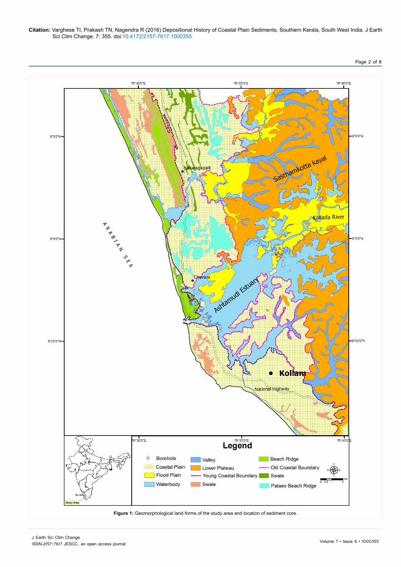
As a consequence of differential erosion, transportation and deposition, sediments laid down in different depositional environments may possess distinctive particle size distributions [28]. The lithological variation of sand-silt-clay contents of I–VI lithounits are presented in Pejrup [29] diagram (Figure 4). The result reveals that the sediments of Unit II falls under the category of II & III representing calm to violent environment. Unit III falls under the category III to IV depicting violent to most violent environment. Unit IV that is desiccated clay place under the category I indicating quiestest environment. Unit V-peat fall under the category III infering calm and the silty clay sediment representing Unit VI plots under the category III indicating calm condition. The bivariate plots of the sediment mean size against sorting [30,31] and modified [32] was utilised as they are hydraulically controlled [33] and positively correlated with the energy of the environment and the degree of sediment processing in estuarine and back barrier sediments [28]. The plot is sub-divided into three different fields representing the different energy conditions of deposition as (i) open channel- high energy fluvial and storm episodes, (ii) partially open to restricted estuary and (iii) closed basin- low energy. The mean size against sorting values representing 6 lithounits of the sediment core was superimposed into the plot (Figure 5). The Figure 5 reveals that the sediments belonging to Unit I, II & III falls under the domain of open channel indicating high energy whereas sediments belonging to the Units IV, V & VI clustered into the category of closed basin depicting deposition of sediments under low energy conditions.
Radiocarbon dating
The peat sample (10.8 m) representing Unit V and the black clay organic rich sediments (11.8 m and 15.5 m) of Unit VI were analysed for age determination using radiocarbon dating technique at Birbal Sahni Institute of Palaeobotany Lucknow, India. The result reveals that
Dep
th (
m)
Ang
ular
Sub
-rou
nded
Rou
nded
Low
Rel
ief
Med
ium
R
elie
f
Hig
h R
elie
f
Edg
e A
bras
ion
Con
choi
dal
fract
ure
Bre
akag
e B
lock
Frac
ture
P
late
s
Stra
ight
Ste
ps
Arc
uate
Ste
ps
Mea
nder
ings
R
idge
s
V-s
hape
d P
its
Scr
atch
es
Upt
urne
d P
late
sO
rient
ed
V-e
tch
Pits
Sol
utio
n P
its
Sol
utio
n C
reva
sses
Sili
ca
Pla
ster
ing
Sili
ca P
ellic
le
Pre
ssur
e S
olut
ion
Am
orph
ous
S
ilica
Qua
rtz o
ver
Gro
wth
Dis
solu
tion
etch
ing
Morphological Mechanical Features Chemical Features9.8 A R S S S A A A C A C R S C C R R S S S S S S S S
10.8 R C S S C S S C R C R R R C C R C R S S S S R S R11.8 S C R C R S S S S C S S S S R S R A A S S S R R C12.0 S C R C R S S R S S S S S R R S C A A C A A C R C15.5 S C S A C S S R S S S S S R R S R C A R S S R C A
A = Abundant (70%); C = Common (40-70%); R = Rare (15-40%), S = Sparse (<15%)
Table 2: Quartz grain surface micro-textures and their abundance of coastal plain sub-crop sediments, Southern Kerala.
Figure 4: Ternary plot showing records of depositional environment in the sediment core (after Pejrup 1988).
Citation: Varghese TI, Prakash TN, Nagendra R (2016) Depositional History of Coastal Plain Sediments, Southern Kerala, South West India. J Earth Sci Clim Change. 7: 355. doi:10.4172/2157-7617.1000355
Page 6 of 8
Volume 7 • Issue 6 • 1000355J Earth Sci Clim Change ISSN:2157-7617 JESCC, an open access journal
the black clay enriched with organic matter sediments at the depth ranging from 15.0 to 11.7 m estimated an age of 42,115 ±180 yrs BP to 40,000 yrs BP. The peat sample with an organic matter content of 47% at the depth of 11 m, which is above the black clay rich sediments show an age of 24,670±1860 yrs BP.
DiscussionThe environment in which the sediments are deposited is
significant in the study of influence of time on the grain surface textures [34]. The textural characteristics and micro-textural analysis of quartz grains of the sediment core (9.5 km east of the present day coastline) shows occurrence of both mechanical and chemical features. The top 9 m quartz grains are characterised by high occurrence of angular grains with the dominance of mechanical features consisting of fracture plates, meandering ridges, upturned plates, edge abrasion and conchoidal features associated with straight arcuate parallel steps and scratches (Figures 3a and 3b). These features indicate that quartz grains have undergone rapid deposition [35] which were derived from the nearby crystalline rocks [3] and transported under fluvial environment [22] of high-energy condition [1]. This reflected in the sediment texture showing angular grains of medium to fine sand deposited under violent to most violent environment (Figure 4). These angular grains might have been derived from the fluvial environment which is debouching into the Ashtamudi estuary. The southwest Indian monsoon strength increased tremendously during the early Holocene (13-12.5 kyr BP and 10-9.5 kyr BP) which lead to increase in flow discharge floods and scouring associated with high lake levels [36,37]. Due to this incised valley formation was initiated and was later replaced by huge thickness of fluvial deposits through mechanical processes indicating observed microtextural features of fluvial origin.
The fluvial angular grains has been modified to sub-rounded in shape from 10.0 m to 10.8 m depth indicating considerable amount of recycled sediments [25]. The mechanical features persist but chemical features in the form of linear branching solution and centipede type
(Figures 3c-3d) is dominant indicating typical chemical features produced during fluvial environment [38]. The sand-silt-clay is followed by hard-desiccated clay indicative of subaerial exposure and desiccation during a period of non-deposition corresponding to the LGM, associated lowering of water table and reduced monsoonal activity [39]. The arid climate existed during 22,000-18,000 yrs BP in the Kerala region due to weak southwest airflow, a great reduction of summer monsoonal rainfall and runoff from the Western Ghats Rivers [40]. Because of non-deposition as well as arid climate the grains remained intact with aqueous medium leading to formation of fluvial chemical features. But below 10.8 m to 15.5 m depth, the chemical features such as solution pits in the form of circular to sub-circular and solution crevasses in the form of hexagonal shape are completely distributed on the quartz grains exhibiting distorted type appearance (Figure 3e) indicating change in the deposition of sediments processes from mechanical to chemical environment. These features are formed by dissolution of silica due to increase in contact of alkali solutions [41] under the influence of marine ingression [2]. These features were associated with amorphous silica which are precipitated from sea water [42] and oriented etch pits indicating chemical processes on the quartz grains under marine environment. Further down the unit silica pellicle, pressure solution, incipient quartz over growth and prolong etching of solution pits-crevasses in the form of honey comb structure (Figures 3g-3j) are indicating the diagenesis signature relating to high degree of grains evolution under low energy marine environment [27]. This reflected in the depositional environment of sediments under calm condition of low energy environment (Figures 4 and 5).
Moreover, the radiocarbon dating estimated an age ranging from 42,000 to 40,000 yrs BP at the depth of 15.5 m to 11.7 m which indicates the first marine transgression event surrounding the coastal plain during the late Pleistocene period followed by beginning of the withdrawal of the sea during 24,670±1860 yrs BP leading to the decompostion of the vegetative material resulting in the formation of peat. This marine transgression event leads to the submergence of mangroves and other vegetation forest which might have existed along this region during 40,000 yrs BP. Shajan [43] and Narayana et al. [44] reported that the central Kerala coast i.e., Vembanad region was covered with intensive mangroves and other forest vegetation even at 40,000 yrs BP and was inundated during higher sea level stands. This infers the post-depositional processes of quartz grains took place under marine regime during the late Pleistocene. Hence, the depositional history of the coastal plain sediments underwent first marine transgression during the late Pleistocene followed by regression of the sea during the Last Glacial Maximum (LGM). Further during the Holocene high monsoon activity was reported leading to the influx of more fluvial sediments into the coastal plain thus depicting the diachronous environment.
Conclusions• Lithological variation of the coastal plain sediment core reveals
that the top 10 m is composed of medium to fine sand deposited under violent to most violent environment indicating high-energy conditions whereas below 10 m the sediments is mainly composed organic rich clay deposited under quite environment depicting the low-energy condition.
• Micro-texture of quartz grains of the top 10 m reveals the dominance of angular grains with mechanical features consisting of fracture plates, meandering ridges, upturned plates, edge abrasion and conchoidal features indicating transportation and deposition of under fluvial environment. Below 10 m the presence of micro-texture features like solution
Figure 5: Bivariate plot of mean grain size against sorting for the sediment core (after Tanner 1991).
Citation: Varghese TI, Prakash TN, Nagendra R (2016) Depositional History of Coastal Plain Sediments, Southern Kerala, South West India. J Earth Sci Clim Change. 7: 355. doi:10.4172/2157-7617.1000355
Page 7 of 8
Volume 7 • Issue 6 • 1000355J Earth Sci Clim Change ISSN:2157-7617 JESCC, an open access journal
pits, dissolution etching, pressure solution and honey comb structure are seen inferring the sediments had undergone intense chemical alteration with prolonged diagenetic changes under marine incursion.
• The coastal region of SW India was evolved during the last 40 kyrs involving series of transgression-regression events of sea level.
• Based on sediment lithological variation, micro-textural studies and dating have revealed that the coastal plain sediments were transported and deposited in a diachronous environment.
AcknowledgementsWe are grateful to the Director, National Centre for Earth Science Studies
(NCESS) for the facilities and support. This work forms the part of the Deptartment of Science and Technology (DST) sponsored project (SR/S4/ES-310/2007). Dr CM Nautiyal Senior Scientist BSIP is acknowledged for radiocarbon dating analyses. TIV is thankful to DST for the financial support in carrying out this work. Authors are thankful to Mr. Arun J John & Mr Anish S Anand for their support and help in this study.
References
1. Krinsley DH, Donahue J (1968) Environmental interpretations of sand grain surface textures by electron microscopy. Geol Soc Am Bull 79: 743 -748.
2. Rahman MH, Ahmed F (1996) Scanning electron microscopy of quartz grain surface textures of the Gondwana sediments, Barapukuria, Dinajpur, Bangladesh. J Geol Soc India 47: 207-214.
3. Armstrong-Altrin JS, Natalhy-Pineda O (2013) Microtexture of sand detrital sand grains from the Tecolutla, Nautla, and Veracruz beaches, western Gulf of Mexico, Mexico implications for depositional environment and palaeoclimate. Arab J Geosci 7: 4321-4333.
4. Chakroun A, Miskovsky JC, Zaghbib-Turki D (2009) Quartz grain surface features in environmental determination of aeolian Quaternary deposits in northeastern Tunisia. Mineral Mag 73: 607-614.
5. Udayaganesan P, Angusamy N, Gujar AR, Rajamanickam GV (2011) Surface microtextures of quartz grains from the central coast of Tamil Nadu. J Geol Soc 77: 26 -34.
6. Chattopadyay S (2002) Emergence of central Kerala coastal plain- a geomophic analysis. In: Tandon SK and Thakur B (eds.), Recent advances in geomorphology, Quaternary geology and environmental geoscience: India case studies Manisha publication, pp: 287 -298.
7. Nair KM, Padmalal D (2004) Quaternary geology and geomorphic evolution of south Kerala sedimentary basin west coast of India. Silver Jubilee Compendum Earth System Science and Natural Resource Management, Centre for Earth Science Studies, Trivandrum, 69 -81.
8. Jayalakshmi K, Nair KM, Kumai H, Santhosh M (2004) Late Pleistocene -Holocene palaeoclimatic history of the southern Kerala basin, southwest India. Gondwana Res. 7: 585 -594.
9. Nair KM, Padmalal D, Kumaran KPN, Sreeja R, Limaye RB, et al. (2010) Late Quaternary evolution of Ashtamudi-Sasthamkotta lake systems of Kerala, south west India. J Asian Earth Sci 37: 361 -372.
10. Padmalal D, Kumaran KPN, Nair KM, Baijulal B, Limaye RB, et al. (2011) Evolution of the coastal wetland systems of SW India during the Holocene evidence from marine and terrestrial archives of Kollam coast, Kerala. Quater. Inter. 237: 123 -139.
11. Nair KK (2007) Quaternary geology and geomorphology of the coastal plains of Kerala. Geological Survey of India, Special publications.
12. Prakash TN, Nair MNM, Kurian NP, Vinod M (2001) Geology and sediment characteristics. In: Black P and Baba M (eds.) Developing a management plan for Ashtamudi estuary, Kollam, India (ASR, New Zealand and Center for Earth Science Studies, Trivandrum), pp: 341 -361.
13. Nair MNM, Prakash TN, Kurain NP, Rajith K (2001) Hydrography and sediment chemistry of the Ashtamudi Estuary. In: Black KP and Baba M (eds.) Developing a management plan for Ashtamudi estuary, Kollam, India ASR, New Zealand and Center for Earth Science Studies, Trivandrum pp. 363-430.
14. Kurian NP, Mathew J, Harish CM, Shahul Hameed TS, Prakash TN (2001) Bathymetry of Ashtamudi Estuary, In: Kerry B and Baba M (eds.) Developing a management plan for Ashtamudi Estuary, Kollam, India, (ASR, New Zealand and Center for Earth Science Studies, Trivandrum) pp.329 -340.
15. Black K, Baba M (2001) Developing management plan for Ashtamudi estuary, Kollam, India. Technical Memoir (ASR, New Zealand and Center for Earth Science Studies, Trivandrum).
16. Prakash TN, Verghese AB (1987) Seasonal beach changes along Quilon District Coast, Kerala. J Geol Soc India 29: 390 -398.
17. Soman K (2002) Geology of Kerala. Geological Society of India, Bangalore.
18. Poulose KV, Narayanaswamy S (1968) The tertiaries of Kerala coast. Memoirs Geol Soc India 2: 300 -308.
19. Nair MM (1990) Structural linear trend-line patterns and lineaments of the Western Ghats, south of 13° latitude. J Geol Soc India 35: 99 -105.
20. Carver RE (1971) Procedures in sedimentary petrology. Wiley-Interscience, New York.
21. Blott SJ, Pye K (2001) GRADISTAT: a grain size distribution and statistics package for the analysis of unconsolidated sediments. Earth Surf Process Landforms 26: 1237 -1248.
22. Krinsley DH, Doornkamp JC (1973) Atlas of quartz sand surface textures. Cambridge University Press, Cambridge.
23. Baker HW (1976) Environmental sensitivity of sub-microscopic surface textures on quartz sand grains. a statistical evaluation. J Sediment Petrol 46: 871 -880.
24. Mahaney WC, Stewart A, Kalm V (2001) Quantification of SEM micro-textures useful in sedimentary environmental discrimination. Boreas 30: 165 -171.
25. Madhavaraju J, Barragán JCG, Hussain S K, Mohan SP (2009) Microtextures on quartz grains in the beach sediments of Puerto Peñasco and Bahia Kino, Gulf of California, Sonora, Mexico. Rev Mex Cien Geol 26: 367 -379.
26. Krinsley DH, McCoy FW (1977) Significance and origin of surface textures on broken sand grains in deep-sea sediments. Sedimentol 24: 857 -862.
27. Cremer M, Legigan P (1989) Morphology and surface texture of quartz grains from ODP site 645, Baffin Bay. In: Srivastava SP, Arthur M, Clement B et al (eds.) Proceedings of the Ocean Drilling Program, Scientific Results, 105: 21 -30.
28. Lario J, Spencer C, Plater AJ, Zazo C, Goy JL, et al. (2002) Particle size characterisation of Holocene back-barrier sequences from North Atlantic coasts (SW Spain and SE England). Geomorphol 42: 25-42.
29. Pejrup M (1988) The triangular diagram used for classification of estuarine sediments: a new approach. In: De Boer PL (ed.), Tide influenced sedimentary environment and facies, Riedal Publishing, pp. 289 -300.
30. Tanner WF (1991a) Suite statistics the hydrodynamic evolution of the sediment pool. In: Syvitski JPM (ed.) Principles, methods and application of particle size analysis, Cambridge University Press, Cambridge, 225 -236.
31. Tanner WF (1991b) Application of suite statistics to stratigraphy and sea-level changes. In: Syvitski JPM (ed.), Principles, methods and application of particle size analysis, Cambridge University Press, Cambridge, 283-292.
32. Spencer CD, Plater AJ, Long AJ (1998) Rapid coastal change during the mid- to late Holocene the record of barrier estuary sedimentation in the Romney Marsh region, southeast England. Holocene 8: 143 -163.
33. Griffths JC (1967) Scientific methods in the analysis of sediments. McGraw-Hill, New York.
34. Ly CK (1978) Grain surface features in environmental determination of late Quaternary deposits in New South Wales. J Sed Petrol 48: 1219 -1226.
35. Madhavaraju J, Lee YI, Armstrong-Altrin JS, Hussain SM (2006) Micro-textures on detrital quartz grains of upper Maastrichtian-Danian rocks of the Cauvery basin, south-eastern India implications for provenance and depositional environments. Geosci. Jour. 10 23 -34.
36. Overpeck J, Anderson D, Trumbore S, Prell W (1996) The southwest Indian monsoon over the last 18000 years. Clim Dyn 12: 213 -225.
37. Kale VS, Gupta A, Singhvi AK (2004) Late Pleistocene-Holocene palaeo hydrology of monsoon Asia. J Geol Soc India 64: 403-417.
38. Manker JP, Ponder RD (1978) Quartz grain surface features from fluvial environments of northeastern Georgia. J Sediment Petrol 48: 1227 -1232.

Citation: Varghese TI, Prakash TN, Nagendra R (2016) Depositional History of Coastal Plain Sediments, Southern Kerala, South West India. J Earth Sci Clim Change. 7: 355. doi:10.4172/2157-7617.1000355
Page 8 of 8
Volume 7 • Issue 6 • 1000355J Earth Sci Clim Change ISSN:2157-7617 JESCC, an open access journal
39. Nair KM, Padmalal D, Kumaran KPN (2006) Quaternary geology of southKerala sedimentary basin- an outline. J Geol Soc India 67: 165 -179.
40. Van Campo E (1986) Monsoon fluctuations in two 20,000-Yr B.P. Oxygen-isotope/pollen records off southwest India. Quater Res 26: 376 -388.
41. Hurst AR (1981) A scale of dissolution for quartz and its implications fordiagenetic processes in sandstones. Sedimentol 28: 451-459.
42. Mackenzie FT, Gees R (1971) Quartz synthesis at earth-surface conditions.Science 173: 533-535.
43. Shajan KP (1998) Studies on Late Quaternary sediments and sea levelchanges of the Central Kerala Coast, India. PhD Thesis, Cochin University ofScience and Technology, Cochin, Kerala.
44. Narayana AC, Priju CP, Rajagopalan G (2002) Late Quaternary peat deposits from Vembanad Lake (lagoon), Kerala, SW coast of India. Curr Sci 83: 318-321.