Embed Size (px)
Citation preview

The Nucleus 57, No. 3 (2020) 106-111
www.thenucleuspak.org.pk
106
The Nucleus
I S S N 0 0 2 9 - 5 6 9 8 ( P r i n t )
I S S N 2 3 0 6 - 6 5 3 9 ( O n l i n e )
Paki stan
The Nucleus
Petrophysical Analysis to Map Geological Significance of Sawan Gas Field, Sindh, Pakistan
M.J. Khan1, *U. Shakir2, M.F. Mahmood2, R. Hussain1, S.R.F. Bukhari3 and M. Khaskheli4
1Department of Earth & Environmental Sciences, Bahria University Karachi Campus, 13 National Stadium Road, Karachi
2Department of Earth & Environmental Sciences, Bahria University Islamabad Campus, Sector E-8 Shangrilla Road, Islamabad
3The State Key Laboratory of Information Engineering in Surveying, Mapping and Remote Sensing, Wuhan University, China
4Oil & Gas Development Corporation Limited, 3 Jinnah Avenue, F6/1 Blue Area, Islamabad
A R T I C L E I N F O
Article history:
Received: 26 August, 2020
Accepted: 19 February, 2021
Published: 16 April, 2021
Keywords:
Sawan,
Petrophysical evaluation,
Lower Goru,
Cretaceous sands
A B S T R A C T
This study is aimed to identify hydrocarbon-bearing zones and mapping of lithofacies in productive zones
with the help of petrophysical logs. We have followed a systematic petrophysical examination of three
wells Sawan-01, Sawan-05 and Sawan-07. Four gas-bearing zones have been identified in Cretaceous sands of Lower Goru Formation. Petrophysical logs are utilized for discrimination of lithological,
porosity and fluid based characteristics of productive sand packages out of thick interbedded shales. The
low response of Gamma Ray (GR) log discriminates sandstone beds from shale in the understudy zones. GR log also contributed to know the lithofacies distribution in the suspected productive gas zones (PGZ)
which suggest the depositional environment of Cretaceous sands. The plots of neutron porosity (NPHI)
and bulk density (RHOB) show the sampled point data density across the sandstone axis on NPHI-RHOB cross plots which validate the lithology and gas-presence in the reservoir zones. The reservoir traits
(shale content, effective porosity, water saturation and respective gas potential of the zones) are
estimated and ranked, accordingly. The best productive gas zone is identified in Sawan-5 well based on values of hydrocarbon saturation and effective porosity that is 0.86 % and 0.13% respectively.
1. Introduction
Sawan gas field (SGF) is located in the Central Indus
Basin, Pakistan which is contributing 61.7 mmscf per day in
gas production of Pakistan [1]. There are other major gas
fields such as Miano, Kadanwari and Mari located in the
vicinity of SGF. Therefore, the study area is attractive for
future exploration activities (Fig.1a and 1b). The Sawan
concession area has been well-studied to model structural
geometries using seismic surveys which helped in subsequent
phases of exploration and exploitation [2, 3]. The
interpretation and mapping of seismic data suggest that SGF
can be geologically divided into two distinct parts, Sawan
North and Sawan South. Both parts are separated by a north
west–south east trending strike-slip fault [4] covering a
regional extension of the block (212 km2). Sawan North is a
highly permeable and configured good quality sandstone
reservoir, with maximum net pay over 100 meters [5]. SGF is
affected by extensional tectonics, thereby the structural traps
are enriched with hydrocarbons. The seismic interpretation by
Ahmad and Khan [6] revealed that SGF and neighboring
fields are characterized dominantly with normal faulting and
associated strike-slip component (N-NW to S-SE). The
faulting characteristics implicate in defining structural traps
and distribution of Cretaceous sand along with the throw of
these faults. It is evident from the earthquake studies and fault
plane solution that the nature of Tertiary faults is trans-
tensional [7]. The distribution of basin-fill deposits is spatially
disturbed under the influence of tectonic episodes in the
central and lower Indus Basin [6, 7].
Fig. 1a: The geographical location of Sawan gas field in the maps and the
wells used in the petrophysical examination of the Sawan gas field.
*Corresponding author: [email protected]

U. Shakir et al. / The Nucleus 57, No. 3 (2020) 106-111
107
Fig. 1b: Location of Sawan gas field in the northeast of Sindh, Pakistan.
Regional tectonic map of Sawan gas field in the Middle Indus Basin
(After [6]).
The regional tectonic setting of the area depicts that SGF
is bounded in northeast by Mari-High, Jacobabad-High in
northwest, Tharparker-High in southeast, and Lower Indus
trough in southwest (Fig. 1b). The geological architecture of
SGF was influenced by three post-rift tectonic events: Late
Cretaceous-uplift and erosion of rocks form high land areas,
Late Paleocene-northwest trending wrench faulting (thick-
skinned) and Late Tertiary to Recent-tectonic uplift of the
Jacobabad-Khairpur High (northwest of SGF) [8]. This
tectonic uplift halted the depositional influx of Goru
Formation in proximal depositional systems positioned in
structurally deep areas of the basin [9]. These areas
contributed in the formation of structural/stratigraphic traps of
multiple oil and gas producing fields including the Sawan
field [10] by placing non-reservoir distal shales up-dip to form
major structural and stratigraphic traps [11].
The stratigraphic succession of basin-fill deposits is
shown in chronological order in Fig. 2. The Sembar
Formation represents early Cretaceous strata (dominantly
comprises organic-rich black shales and minor amounts of
black siltstone, sandstone and nodular limestone which is
thermally mature and fueled the gas in SGF and other
established neighboring fields in the region [12-14]. Lower
Goru Formation is underlain by the Sembar Formation, which
is a distinct reservoir (medium to coarse-grained sand) of SGF
(Fig. 2). The Lower Goru Formation was deposited in deltaic
shallow-marine environments [2].
Petrophysical data analysis helps in petroleum exploration
projects across the globe. A petrophysical log registers the
rock response of physical characteristics like rock density,
porosity, resistivity, radioactivity, etc., recorded along the
depth axis of the borehole [7]. The petrophysical logs are
essential for reservoir modeling based on volume of
shale, effective porosity, pore-fluid type and hydrocarbons
Fig. 2: Generalized stratigraphic sequence of Middle Indus Basin (adopted
as [7])
saturation. These estimates play a vital role in reservoir
genesis, petroleum system modeling, prospect opportunities,
risk assessment and production estimates [2, 15-17].
Petrophysical logs (such as Gamma Ray (GR), Sonic (DT),
Self-Potential (SP), Latero Log Deep (LLD), Latero Log
Shallow (LLS), Neutron Porosity (NPHI) and Bulk Density
(ROHB)) can contribute to formation evaluation in absence of
core data along with other types of logs [18]. Since the scale
of seismic and Petrophysical logs are different, the
petrophysical analysis seldom supports the multi-dimensional
seismic signatures in hydrocarbon exploration [19, 20]. The
objectives of this study are to evaluate petrophysical
characteristics of Cretaceous sandstone deposits of Lower
Goru Formation to delineate hydrocarbon potential and to
understand the variations of lithofacies within productive
zones in the SGF.
2. Dataset
The well log data of three wells namely Sawan-01, Sawan-
05 and Sawan-07 are utilized in this study. The well logs data
were provided by Directorate General of Petroleum
Concessions, Pakistan. Table 1 summarizes the basic
information of Petrophysical logs including GR, DT, LLD,
LLS, NPHI, RHOB, and SP. These logs are interpreted for
petrophysical evaluation of Lower Goru formation.
Table1: The well log data of understudy wells in SGF.
Basic dataset
available
Sawan-01 Sawan-05 Sawan-07
Latitude (X) 26.99 26.95 26.99
Longitude (Y) 68.90 68.88 68.92
Gamma Ray Log (GR)
14.3 – 3503 (m) 50-3374 (m) 50-3395 (m)
Sonic Log (DT) 300-3500 (m) 1327-3372 (m) 328-3395.3 (m)
Bulk Density Log (RHOB)
3040-3502 (m) 3127-3372 (m) 3128-3410 (m)

U. Shakir et al. / The Nucleus 57, No. 3 (2020) 106-111
108
Neutron Porosity Log (NPHI)
3040-3502 (m) 3127-3372 (m) 3130-3404 (m)
Deep Resistivity Log (LLD)
289-3494 (m) 3134-3374 (m) 330-3402 (m)
Shallow Resistivity
Log (LLS)
289-3494 (m) 3134-3374 (m) 330-3402 (m)
Total Depth (m) 3505 3375 3412
3. Methodology
The Petrophysical logs are utilized for interpretation of
geological layers particularly emphasized on Cretaceous sand
bodies encountered in the understudy wells. Reservoir
evaluation of these sand bodies is performed by estimating
petrophysical properties which include: (a) shale content, (b)
effective porosity, (c) saturation of water as a pore fluid and
(d) hydrocarbon saturation. Estimation of shale contents help
in the identification of clean sand beds [5-7, 19]. The shale
content is calculated by utilizing GR log which discriminates
the clean sand packages based on measured natural
radioactivity of the targeted zones [20, 21. Reservoir porosity
plays a significant role in productive reservoir
characterization [21]. The porosity is estimated by using the
neutron, density and the sonic log. Sonic porosity exhibits
acoustic-based measurements whereas neutron porosity and
density porosity estimated on nuclear-based measurements
[19-22]. The effective porosity (ϕ eff) is calculated in the
clean sand reservoir zones, which represent the
interconnectivity of the pore spaces. The hydrocarbon
saturation (Shc) is a function of water saturation (Sw). These
petrophysical parameters are helpful to define productive
sand reservoir zones [22].
4. Results and Discussion
Interpretational techniques were applied through well log
analysis to choose the zones of interest and estimated probable
chances for the presence of the hydrocarbons. The results of
this study can be grouped in two sets: (a) Petrophysical
examination and (b) Lithofacies modeling. Overall, GR log
profile shows sand and shale intervals in the selected wells.
The petrographic studies revealed mineralogical
characteristics of various intervals of LGF. B and C-intervals
of LGF are the main reservoir of SGF, which exhibit high
porosity and permeability (at 3000 - 3500 meters); however,
shales and siltstones of the upper Goru act as a regional seal.
4.1 Petrophysical Interpretation
The top and bottom of the clean sand reservoir zone is
identified by critical analysis of petrophysical logs (GR,
resistivity logs, NPHI and RHOB). We have interpreted four
productive gas zones (PGZ) in potential wells. The
prospective reservoir zone characterized with potential gas-
bearing characteristics is named as PGZ-1 in Sawan-01 well.
The zone ranges in depth between 3326 to 3328.5 m in
Sawan-01, Fig. 3a depicts the analytical view of the zone of
interest. It has a thickness of 2.5 m, the reservoir
characteristics of this zone are evaluated based on
petrophysical analysis. The average Vsh is 32.465%, average
Sw is 19% and effective porosity is 10.3%. The average
hydrocarbon saturation is calculated 81% (Table 2).
The productive gas zone, i.e., PGZ-2 is marked in well
Sawan-05 having a thickness of 14 meters ranging between
3276 - 3290 m depth (Fig. 3b). The average saturation of
water is 13%, hydrocarbon saturation is 87% and effective
porosity is 12.86% (Table 2). Different porosity logs were
utilized for effective porosity calculation, the separation
between different resistivity logs of invaded and uninvaded
zones showed that the sand beds in Sawan-05 well are
permeable. Therefore, the gas potential is very high in sand
beds of Lower Goru Formation.
Two productive zones, PGZ-3 and PGZ-4 are interpreted
in Sawan-07 well, which lie between 3327-3330.5 meter and
3332-3335 meter, respectively (Fig. 3c). Petrophysical
interpretation shows that the average hydrocarbon saturation
in both the productive zones are 56% and 52% and effective
porosities are 19.5% and 11.3%, respectively (Table 2). The
Petrophysical results are more promising for Sawan-1 and
Sawan-5 wells, having good hydrocarbon saturation, good
effective porosity and low water saturation.
The cross-plots of NPHI and RHOB are presenting
qualitative data of the respective zones which validate the
presence of gas in the identified sandstone packages of the
reservoir (Fig. 3d, 3e and 3f).
Fig. 3a: Selected zone of interest (shaded blue) in Sawan-01.
Fig. 3b: Selected zone of interest (shaded blue) in Sawan-05.

U. Shakir et al. / The Nucleus 57, No. 3 (2020) 106-111
109
Fig. 3c: Selected zone of interest (shaded blue) in Sawan-07.
Fig. 3d: Cross Plot of NPHI and RHOB for selected zone in Sawan-01.
Fig. 3e: Cross Plot of NPHI and RHOB for selected zone in Sawan-05.
Fig. 3f: Cross Plot of NPHI and RHOB for selected zone in Sawan-07.
Table 2: Petrophysical evaluation of prospect zones in the understudy wells.
Proposed
Gas Zone
Depth
(m)
ϕ eff
(%)
Sw
(%)
SHC
(%)
Thick.
(m)
PGZ-1 3326-3328.5 10.3 19 81 2.5
PGZ-2 3276-3290 12.86 13 87 14
PGZ-3 3327-3330.5 19.5 44 56 3.5
PGZ-4 3332-3335 11.3 48 52 3
4.2 Facies Analysis
Geological facies are rock bodies having some specific
characteristics which distinguish it from the others. Generally,
facies are distinctive rock units, deposited under certain
conditions of sedimentation and contemporaneous
depositional environments, laterally and vertically as
explained by Walther’s law [23]. Thereby the interpretation
of the lithofacies contributes to map the depositional
environment of basin-fill sedimentary deposits, to get
information about the successive sea-level changes, the
interplay between sediment supply and accommodation space
[16]. Under the influence of seal level changes, the shoreline
deposits exhibit migration.
The differentiation between shale and sand has been a
challenge for the geoscientists during the interpretation of
Lower Goru Formation. In this process, the key task is
identifying the facies, from logging and core data, and degree
to which the shale content affects the reservoir properties [24].
Lithofacies modeling helped in marking sand beds within
thick interbedded shales by utilizing GR log response. These
sand beds can be correlated with the zones of interest which
are identified during petrophysical interpretation. The Lower
Goru Formation is a proven reservoir in the Sawan field as
well as adjacent exploration and production (E&P)
concessions. The Lower Goru Formation is composed of
interbedded shale and sand packages [3]. The gamma-ray log
behavior changes within sand beds having shaly
concentrations. This lithological discrimination of sand and
shale beds is known as lithofacies modeling.
U. Shakir et al. / The Nucleus 57, No. 3 (2020) 106-111
110
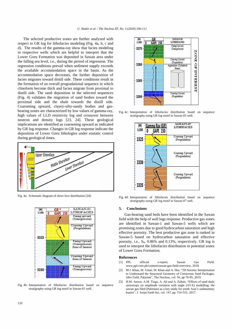
The selected productive zones are further analyzed with
respect to GR log for lithofacies modeling (Fig. 4a, b, c and
d). The results of the gamma-ray show that facies modeling
in respective wells which are helpful to interpret that the
Lower Goru Formation was deposited in Sawan area under
the falling sea level, i.e., during the period of regression. The
regression conditions prevail when sediment supply exceeds
the available accommodation space in the basin. As the
accommodation space decreases, the further deposition of
facies migrates toward distill side. These conditions result in
the formation of an overall progradational sequence in which
clinoform become thick and facies migrate from proximal to
distill side. The sand deposition in the selected sequences
(Fig. 4) validates the migration of sand bodies toward the
proximal side and the shale towards the distill side.
Coarsening upward, clayey-silty-sandy bodies and gas-
bearing zones are characterized by low values of gamma-ray,
high values of LLD resistivity log and crossover between
neutron and density logs [23, 24]. These geological
implications are identified as coarsening upward as indicated
by GR log response. Changes in GR log response indicate the
deposition of Lower Goru lithologies under eustatic control
during geological times.
Fig. 4a: Schematic diagram of shore face distribution [24].
Fig. 4b: Interpretation of lithofacies distribution based on sequence
stratigraphy using GR log motif in Sawan-01 well.
Fig. 4c: Interpretation of lithofacies distribution based on sequence stratigraphy using GR log motif in Sawan-05 well.
Fig. 4d: Interpretation of lithofacies distribution based on sequence stratigraphy using GR log motif in Sawan-07 well.
5. Conclusions
Gas-bearing sand beds have been identified in the Sawan
field with the help of well logs response. Productive gas zones
are identified in Sawan-1 and Sawan-5 wells which are
promising zones due to good hydrocarbon saturation and high
effective porosity. The best productive gas zone is ranked in
Sawan-5 based on hydrocarbon saturation and effective
porosity, i.e., Shc 0.86% and 0.13%, respectively. GR log is
used to interpret the lithofacies distribution in potential zones
of Lower Goru Formation.
References
[1] PPL official e-report, Sawan Gas Field.
www.ppl.com.pk/content/sawan-gas-field-overview, 2018.
[2] M.J. Khan, M. Umar, M. Khan and A. Das, “2D Seismic Interpretation
to Understand the Structural Geometry of Cretaceous Sand Packages, Jabo Field, Pakistan”, The Nucleus, vol. 56, pp 78-85, 2019.
[3] H.M. Anwer, A.M. Tiago, A. Ali and A. Zubair, “Effects of sand shale anisotropy on amplitude variation with angle (AVA) modelling: the
sawan gas filed (Pakistan) as a key study for south Asia’s sedimentary
basins”, J. Asian Earth Sci, vol. 147, pp. 516-531, 2017.

U. Shakir et al. / The Nucleus 57, No. 3 (2020) 106-111
111
[4] T.S. Abbas, K. Mirza and J.S. Arif. “Lower Goru Formation-3D
Modeling and Petrophysical Interpretation of Sawan Gas Field, Lower Indus Basin, Pakistan”, The Nucleus, vol. 52, pp.138-145, 2015.
[5] S.M. Siyar, M. Waqas, S. Mehmood, A. Jan, M. Awais and F. Islam, “Petrophysical characteristics of Lower Goru Formation (Cretaceous)
in Sawan gas field, Central Indus basin, Pakistan”. J. Biodiv. Envir. Sci.,
vol. 10, pp. 260-266, 2017.
[6] N. Ahmad and M.R. Khan, “Evaluation of a Distinct Sub-Play for
Enhanced Exploration in an Emerging Petroleum Province, Bannu-Kohat Sub-Basin, Pakistan”. AAPG Int. Conf. and Ex., Milan, Italy,
October 23-26, 2011.
[7] M.J. Khan, M. Ali and M. Khan, “Gamma ray-based facies modelling
of lower Goru formation: a case study in Hakeem Daho well lower
Indus basin Pakistan”, Bahria Univ. Res. J. Earth Sci., vol. 2, pp. 40-45,
2017.
[8] M.O. Baig, N.B. Harris, H. Ahmed and M.O.A. Baig, “Controls on reservoir diagenesis in the Lower Goru Sandstone Formation, Lower
Indus basin, Pakistan”, J. Pet. Geol., vol. 39, pp. 29–47, 2016.
[9] A. Berger, S. Gier and P. Kroi, “Porosity-preserving chlorite cements
in shallow marine volcanoclastic sandstones; evidence of the Sawan gas
field Pakistan”. AAPG Bull., vol. 93, pp. 595-615, 2009.
[10] N. Ahmed, P. Fink, S. Sturrock, T. Mahmood and M. Ibrahim,
“Sequence stratigraphy as predictive tool in lower Goru fairway, lower and middle Indus platform, Pakistan”, Pak. Assoc. Petro. Geoscientist,
Annual Tech. Conf., pp. 85-104, 2004.
[11] U.B. Nisar, S. Khan, M.R. Khan, A. Shahzad, M. Farooq and S.A.A.
Bukhari, “Structural and reservoir interpretation of Cretaceous lower Goru formation, Sanghar area, Lower Indus basin, Pakistan”, J.
Himalaya Earth Sci., vol. 49, pp. 41-49, 2016.
[12] I.B. Kadri, “Petroleum geology of Pakistan”, Pakistan Petroleum
Limited, Karachi, 1995.
[13] T. Azeem, Y.W. Chun, P. Khalid, I.M. Ehsan, F. Rehman and A.A.
Naseem, “Sweetness analysis of Lower Goru sandstone intervals of the
Cretaceous age, Sawan gas field, Pakistan”, Episodes: J. Int. GeoSci., vol. 41, pp. 235-247, 2018.
[14] C.J. Wandrey, B.E Law and H.A. Shah. “Sembar Goru/Ghazij composite total petroleum system Indus and Sulaiman-Kirthar geologic
Provinces Pakistan and India”, US Geolog. Survey, USA, 2004.
[15] M. Naeem, M.K. Jafri, S.S. Moustafa, N.S. AL-Arifi, S. Asim, F. Khan
and N. Ahmed, “Seismic and well log driven structural and petro-physical analysis of the Lower Goru Formation in the Lower Indus
Basin, Pakistan”, Geosci. J., vol. 20, pp. 57–75, 2016.
[16] A. Nazeer, S.A. Abbasi and S.H. Solangi, “Sedimentary facies
interpretation of Gamma Ray (GR) log as basic well logs in Central and
Lower Indus Basin of Pakistan”, Geodesy Geodyn. 7, pp. 432-443, 2016.
[17] N. Ahmad and S. Chaudhry, “Kadanwari gas field, Pakistan: a disappointment turns into an attractive development opportunity”,
Petrol. Geosci., vol.8, pp. 307–316, 2002.
[18] J.J. Chow, L. Ming-Ching and S. Fuh, “Geophysical well log study on
the paleoenvironment of the hydrocarbon producing zones in the
Erchungchi Formation, Hsinyin, SW Taiwan”, Terr. Atmos Ocean Sci.,
vol. 16, pp. 531-543, 2005.
[19] M. Ali, M.J. Khan, M. Ali and S. Iftikhar, “Petrophysical Analysis of Well Logs for Reservoir Evaluation: A Case Study of ‘Kadanwari’ Gas
Field, Middle Indus Basin, Pakistan”, Arabian J. Geosci. vol. 12, 2019.
[20] I.A.K. Jadoon, R.D. Lawrence and R.J. Lillie, “Seismic data, geometry,
evolution, and shortening in the active Sulaiman Fold-and-Thrust Belt
of Pakistan, Southwest of the Himalayas”, AAPG Bull., vol. 78, pp. 758–774, 1994.
[21] S.H. Solangi, A. Nazeer, S.A. Abbasi, L.D. Napar, P.A. Usmani and A.G. Sahito, “Sedimentology and petrographic study of B-sand of
Upper sands of Lower Goru Formation, based well cuttings and wire
line logs from wells of southern Sindh monocline, lower Indus basin, Pakistan”, Bahria Uni Res. J. Earth Sci. vol. 1, pp 45-54, 2016.
[22] G. Asquith and C. Gibson, “Basic well log analysis for geologists”,
AAPG methods in exploration series, Tulsa, pp. 2l6, 1983.
[23] F.J. Lucia, “Rock-fabric/petrophysical classification of carbonate pore
space for reservoir characterization”, AAPG bulletin, vol. 79, pp. 1275-
1300, 1995.
[24] M.H. Rider, “Geologic interpretation of well logs”, Whittles Publishing
Services, 1999.


![a.[R—Nuc:—X] b.[R---X] c.[R—Nuc:]](https://img.dokumen.tips/doc/110x75/61fae4450266133741337229/arnucx-br-x-crnuc.jpg)