Embed Size (px)
Citation preview

Vandeviver Crime Science 2014, 3:13http://www.crimesciencejournal.com/content/3/1/13
SYSTEMATIC REVIEW Open Access
Applying Google Maps and Google Street View incriminological researchChristophe Vandeviver
Abstract
Online mapping technologies such as Google Maps and Street View have become increasingly accessible. Thesetechnologies have many convenient uses in everyday life, but law enforcement agencies have expressed concernthat they could be exploited by offenders and might alter existing offending patterns and habits. For environmentalcriminologists, they have the potential to open up new approaches to conducting research. This paper draws on theresults of earlier studies in related fields and a handful of criminological studies to discuss how these online mappingapplications can trigger new research questions, and how they could be considered a valuable methodologicaladdition to criminological research.
Keywords: Google Maps; Street View; Environmental criminology; Innovation; Methodology; Methods
IntroductionAlthough Google Maps and Street View have not beendeveloped with scientific research in mind, they createinteresting possibilities for research. Several scientificdisciplines were quick to implement these web mappingapplications in their research. For instance, geographersrely on aerial photography from Google Maps as an alter-native to expensive commercial satellite imagery (Pringle2010) and biologists tap into Street View imagery toassess the habitat of certain animal species (Olea andMateo-Tomás 2013). However, while there are abundantexamples of studies that apply Google Maps and StreetView in related scientific fields, only a few crimino-logical studies have tapped into the power of onlinemapping technologies for research purposes. Whereasthe general public, offenders and law enforcement agen-cies have already discovered the power of these onlinemapping services and use them daily, criminologists,somewhat surprisingly, seem not to have fully discov-ered the advantages of using Google Maps and StreetView in their research. In this article I argue that theproliferation of online mapping technologies opens upseveral new approaches for criminologists to conductenvironmental criminological research in particular. Asmall number of criminological studies have alreadyshown that these technologies can be a valuable addition
Correspondence: [email protected] for International Research on Criminal Policy, Ghent University,Universiteitstraat 4, Ghent (9000), Belgium
© 2014 Vandeviver; licensee Springer. This is anAttribution License (http://creativecommons.orin any medium, provided the original work is p
to environmental criminological research, and thisarticle considers how they might be implemented infuture criminological research. Drawing on previouscriminological applications, I discuss how the availabilityof Google Maps and Street View can generate newresearch questions; and how they could be consideredimportant additions to the methodological toolkit ofcriminologists.This article is structured as follows. First, some back-
ground information on Google Maps and Street View isprovided, and the existing literature in relation to theirapplication in related fields and previous studies isreviewed. Next, several potential uses for these onlinemapping technologies in environmental criminologicalresearch are explored. Third, their advantages anddrawbacks are discussed. Fourth, readers are providedwith an outline of where to find additional informationon how to use these mapping technologies. Fifth, aninteresting future development of environmental crim-inological research that is rooted in the availability ofweb mapping technologies is identified, and finallyseveral suggestions for further reading are provided.
BackgroundAn introduction to Google Maps and Street ViewGoogle MapsOriginally launched in 2005, Google Maps (Google 2014c)is a free-to-use, web-based mapping service that combines
Open Access article distributed under the terms of the Creative Commonsg/licenses/by/4.0), which permits unrestricted use, distribution, and reproductionroperly credited.

Vandeviver Crime Science 2014, 3:13 Page 2 of 16http://www.crimesciencejournal.com/content/3/1/13
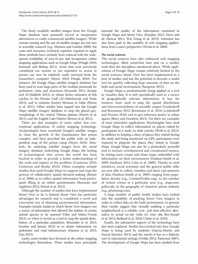
conventional cartographic maps with satellite imagery andhigh-resolution aerial photography. The maps are embed-ded with additional information on terrain, street and roadnames, famous landmarks and buildings, public transit,real-time and typical traffic information. Users can con-veniently switch between map and satellite view, or optfor a hybrid view that overlays the information available inthe map view onto the satellite view (see Figure 1). For anumber of cities worldwide, 45° aerial imagery is availableallowing users to get a better understanding of the sizeand proportions of buildings as well as observe certainlandmarks from four different perspectives.The available aerial imagery is generally believed to be
no older than three years and is updated on a regularbasis. Users can update the map data in real time usingGoogle Map Maker (Google 2014b) and, followingapproval, these updates are implemented in GoogleMaps (Sridharan 2011). The underlying aerial imagerydatabase also powers Google Earth, a downloadablegeographical information program with similar function-alities to Google Maps that allows users to access mapdata from their desktop. Three-dimensional mappingwas also made available in Google Maps in late 2011(McClendon 2011).Additional services that are available in Google Maps
include Street View, a route planner for driving, publictransit, walking and bicycling, and a business locator.Users are also able to create and share custom maps(Liebert 2013). The custom maps environment (Google2014g) allows users to add additional layers of content
Figure 1 Example of hybrid map view with typical traffic information
such as places, labels, photos, and videos to the under-lying Google Maps map. Moreover, users can draw lines,shapes and patterns directly on the map, add directions,and organize and compare up to three different datasets.Once created, custom maps can be shared and users canwork together to create a collaborative custom map.Google Maps has considerably simplified looking up
addresses, and has made mapping and cartographyaccessible to the masses. Over a billion users accessGoogle Maps and its related services such as StreetView on a monthly basis (Choudhary 2013) and theGoogle Maps mobile app is used at least once a monthby more than one in two smartphone users, making itthe most popular smartphone app worldwide (Smith2013). Essentially, Google Maps is an easy-to-use mappingapplication that allows its users to locate addresses quickly,and provides cartographic maps augmented with digitalinformation and high-resolution aerial imagery.
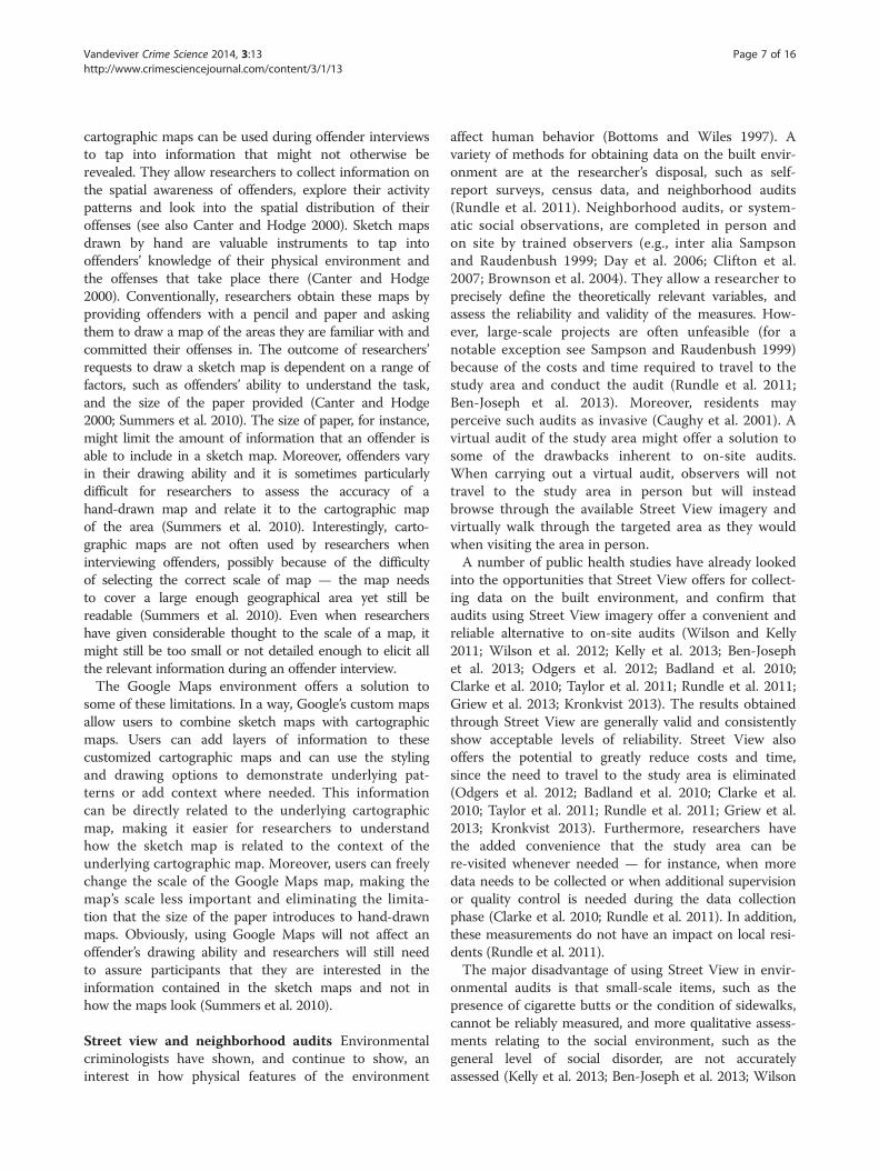
Street ViewStreet Viewa is a service available in Google Maps thatsupplements the original two-dimensional map view ofGoogle Maps with three-dimensional, 360° street-levelpanoramic imagery (see Figure 2). Launched in 2007in a handful of U.S. cities, Street View currently coverslocations on all seven continents (Google 2014j). Almosttotal coverage has been achieved in North America,Australia, Japan and most countries in Europe. AdditionalStreet View imagery is currently being collected in a rangeof countries.
.

Figure 2 Example of Street View image.
Vandeviver Crime Science 2014, 3:13 Page 3 of 16http://www.crimesciencejournal.com/content/3/1/13
Street View imagery is captured through a diverse fleetof vehicles equipped with specialist cameras (Vincent2007). After collection, photos are digitally processedand ‘stitched’ together to obtain the familiar 360° pano-ramas. These images are connected to the Google Mapsmap and embedded with information on the street nameand the approximate address. To protect the privacy ofbystanders that are inadvertently captured on camera,faces and license plates are pixelated (Google 2014h).Users can make additional requests for blurring outimages that feature the user, their family, their home ortheir car, and have tools available to request the removalof inappropriate or sensitive images.The majority of images currently captured by the
Street View fleet is of near high-definition quality (Cawley2010). Up to September 2010 the images being collectedwere low resolution, and some areas can therefore only beexperienced in Street View in low-resolution quality. Intime, the low-resolution imagery will be replaced withhigher-resolution photos. Although Street View imageryis intermittently updated and higher-resolution imageryis made available whenever possible, it is unclear howregularly these updates occur. Users can also update theavailable imagery themselves or supplement it by creatingimmersive 360° views called ‘photo spheres’ (Rapoport2013). Once these individual spheres are connected anduploaded to Street View, other users can navigate themjust like they would navigate Street View. As of April2014, users have the option to go back in time and explorehistorical imagery from past Street View collections dating
as far back as 2007 (Shet 2014). Moreover, in a limitednumber of cities users can virtually visit businessesparticipating in the Business Photos program (Chang2013). Essentially, Street View allows users to explorethe real world virtually, without losing the underlyingmap context provided by Google Maps (Vincent 2007).
Google Maps and Street View in scientific researchWeb mapping technologies have been embraced bydisciplines such as geography, archaeology and ecology,but also by several social scientific disciplines. Regard-less of the discipline, two particular applications cangenerally be distinguished. First, Google Maps andStreet View have been implemented as convenient toolsto reduce the costs and expertise needed to conductresearch. Second, a smaller number of studies haveshifted their focus towards these applications andtreat them as full-grown research subjects in theirown right, generating new and significant researchquestions.
Geography, archaeology, and ecologyResearchers working in the disciplines of geography,archaeology, and ecology quickly incorporated web-based mapping technologies into their research designs,and did so on a relatively large scale. Google Maps inparticular has been implemented in a diverse range ofstudies, although applications of Street View remainmore limited.
Vandeviver Crime Science 2014, 3:13 Page 4 of 16http://www.crimesciencejournal.com/content/3/1/13
The freely available satellite images from the GoogleMaps database have primarily served as inexpensivealternatives to costly commercial satellite imagery. Whileremote sensing and the use of satellite images are not newin scientific research (e.g., Mertens and Lambin 2000), thecosts and necessary technical expertise required to applythese methods have certainly been reduced with the wide-spread availability of easy-to-use and inexpensive onlinemapping applications such as Google Maps (Pringle 2010;Kennedy and Bishop 2011). Areas that were previouslyconsidered too remote or too expensive to access inperson can now be relatively easily surveyed from theresearcher’s computer (Myers 2010; Pringle 2010). Forinstance, the Google Maps satellite imagery database hasbeen used to scan large parts of the Arabian peninsula forprehistoric ruins and structures (Kennedy 2011; Kempeand Al-Malabeh 2013), to obtain better estimates of fishcatches in the Persian Gulf (Al-Abdulrazzak and Pauly2013), and to estimate forestry biomass in India (Plotonet al. 2011). Other studies have tapped into the GoogleMaps satellite imagery database to map the glacial geo-morphology of the central Tibetan plateau (Morén et al.2011), and the English Lake District (Brown et al. 2011).There are also examples of some rather less con-
ventional applications of online mapping technology.Archaeologists have examined Google’s satellite imagesto chart the growth of the Guantánamo Bay prisoncomplex, and have provided the public with an inde-pendent map of the prison camp (Myers 2010). Simi-larly, by analyzing satellite images from the aerialimagery database underlying Google Maps, the lootingof archaeological sites across the world has beentracked in order to provide a better understanding ofthe scale and impact of the problem (Contreras 2010;Contreras and Brodie 2010). Other examples includestudies that used Google Maps to support and map theprocess of collaborative spatial decision-making (Rinneret al. 2008) or to collect spatial information from partici-pants filling in an online questionnaire (Bearman andAppleton 2012; Snizek et al. 2013).Although the number of studies that have implemented
Street View so far is limited, Street View has particularadvantages for research and is considered a novel andconvenient way of obtaining environmental information.Examples include studies in which Street View imagery wasa source of information that allowed the habitat of certainanimal species to be assessed (Olea and Mateo-Tomás2013), or where it served as a tool to map the spatial distri-bution of a particular population (Rousselet et al. 2013;Gordon and Janzen 2013) or to obtain information onpedestrian and road infrastructure (Hanson et al. 2013;Guo 2013).Lastly, some studies have focused on the online mapping
technologies themselves. These studies have principally
assessed the quality of the information contained inGoogle Maps and Street View (Paradiso 2013; Davis andde Alencar 2011; Wai Yeung et al. 2013). Attention hasalso been paid to the usability of web mapping applica-tions from a user’s perspective (Nivala et al. 2008).
The social sciencesThe social sciences have also embraced web mappingtechnologies, albeit somewhat later and on a smallerscale than the disciplines mentioned above. While appli-cations of Google Maps remain relatively limited in thesocial sciences, Street View has been implemented in ahost of studies and has the potential to become a usefultool for quickly collecting large amounts of data on thebuilt and social environment (Sampson 2013).Google Maps is predominantly being applied as a tool
to visualize data. It is only sporadically used as a sourceof geographically relevant information. It has, forinstance, been used to map the spatial distributionand interconnectedness of scientific output (Leydesdorffand Bornmann 2012; Bornmann et al. 2014; Leydesdorffand Persson 2010) and to geo-reference poetry in urbanspaces (Berry and Goodwin 2013). Yet there are examplesof more innovative applications. Psychologists have usedGoogle Maps to collect information on places visited byparticipants in a study on daily activity (Wolf et al. 2013).In addition to keeping a diary of places they visited duringthe study and being monitored via GPS, participants wererequired to pinpoint the places they visited in GoogleMaps. Google Maps can also be a particularly powerfultool to nurture crowdsourced and crowdcasted science,by letting users create and share maps embedded withinformation on their environment (Hudson-Smith et al.2009; Kindynis 2014; Lefer et al. 2008). Thanks to suchinitiatives, social scientists and the general public alikeare now able to collect, visualize and share vast amountsof data (Hudson-Smith et al. 2009) ranging from popu-lation density (e.g., LondonProfiler.org), to the numberof violent crimes in a particular area (e.g., maps.met.police.uk), to the geography of America’s prison industry(e.g., prisonmap.com).A large number of public health studies have looked
into the suitability of studying Street View imagery inorder to collect data on the built environment. In general,their results suggest that virtually auditing a particularneighborhood is a reliable, cost- and time-effective alter-native to actual on-site visits (cf. inter alia Ben-Josephet al. 2013; Badland et al. 2010; Clarke et al. 2010).Finally, the substantive aspects of the technology have
also been explored. Studies have looked into how GoogleMaps is being used by students (García-Martín andGarcía-Sánchez 2013) and the merits it has as a didactictool in educational settings (Ovidia 2012; Patterson 2007).The development of Google Maps has been studied from

Vandeviver Crime Science 2014, 3:13 Page 5 of 16http://www.crimesciencejournal.com/content/3/1/13
a political-economic perspective and its implementationhas been situated within a historical and broader socioeco-nomic context (Lee 2010). Street View has also receivedsubstantial attention. The way that Street View representsstigmatized neighborhoods and might contribute to theirstigmatization has been criticized (Power et al. 2013).Other scholars have looked into how the implementationof Street View sparked privacy concerns (Geissler 2011)and redefined our perception of privacy (Elwood andLeszczynski 2011).
Google Maps and Street View in environmentalcriminological researchOnly a handful of criminological studies have so farimplemented Google Maps and Street View in one wayor another in their research designs. This is somewhatsurprising, since the general public, offenders and lawenforcement agencies have already discovered the advan-tages online mapping technology offers in their daily lifeand work. Iraqi and Palestinian militants have admitted tousing web-based mapping applications to select possibletargets for terrorist attacks (Levinson 2007). Similarly,graffiti writers and shoplifters in London were found touse Street View to look for new targets (Kindynis 2014).Burglars are believed to ‘google’ for potential targets andmay be using online mapping technologies when casinghomes for break-ins (Michaels 2011). Householders alsobelieve Street View might contribute to burglary (TheTelegraph 2010; Pyatt 2009; Power et al. 2013), a concernthat is shared by ex-burglars (Sterling 2011) and policeunions (De Tijd 2011) alike. Interestingly, these applica-tions also offer law enforcement agencies the opportunityb
to establish new forms of surveillance and crime control(Kindynis 2014), while simultaneously empowering ordin-ary citizens by providing them with new tools to controllaw enforcement agencies (EURONEWS 2013) or giveexpression to their concerns about crime (Hudson-Smithet al. 2009).For the few criminological studies that have imple-
mented Google Maps and Street View in their researchdesign, online mapping technologies have either beenthe object of criminological enquiry or have been usedas a methodological tool to help researchers reduce costsand overcome particular difficulties in their research.Drawing on these studies, I discuss two major aspects ofGoogle Maps and Street View in relation to environmentalcriminological research, namely: how these online map-ping applications can generate new research questions;and how they could be considered an important additionto the criminologist’s methodological toolkit.
Mapping out new research questionsWeb-based mapping technologies could themselves con-stitute the object of criminological enquiry — for instance,
law enforcement agencies and former burglars share aconcern that the availability of Google Maps and StreetView helps burglars to prepare for their offenses. It isexactly this concern that Van Daele et al. (2012) scruti-nized in a study that examined whether burglars arelikely to rely on online mapping technologies to select asuitable target.Van Daele et al. (2012) set out to examine whether the
proliferation of online mapping technologies mightcontribute to burglary and alter known burglary pat-terns. First, they explored whether it is likely or notthat burglars rely on Google Maps and Street View tosearch for potential targets. Burglars look for targets intheir awareness space (Brantingham and Brantingham1981). Before the advent of web-based mapping tools,this awareness space was established while performingroutine activities such as traveling to work or visitingfriends. This required burglars to visit potential targetsbeforehand. Now, however, by browsing through GoogleMaps and Street View burglars can become aware ofpreviously unknown areas and case potential targets.Since Google Maps and Street View enable armchair ex-ploration (McClendon 2010), the burglar’s awarenessspace and the number of potential targets are potentiallyvastly expanded.Second, Van Daele et al. (2012) examined whether the
use of Street View makes burglars rely on different tar-get characteristics than when they select a suitable targeton the street. Burglars are known to exhibit some degreeof planning (Bennett and Wright 1984) and pay atten-tion to characteristics of the built environment whenselecting a suitable target (Nee and Meenaghan 2006;Palmer et al. 2002). Target characteristics are typicallyobserved while walking down the street, but can also beassessed through the imagery available in Street View.Van Daele et al. (2012) therefore argued that it would belogical for burglars to rely on such tools during theplanning stage, since it potentially decreases the costs ofa burglary by reducing preliminary travel costs and therisks associated with casing a potential target. However,it remains unclear whether the nature of the type ofimages in Street View (e.g., snapshot, image quality,limited zoom possibility) actually allows them to carryout a detailed assessment of the suitability of a house asa burglary target.To answer their research questions, Van Daele et al.
(2012) recruited undergraduate criminology studentswho were instructed to select a characteristic burglarytarget and to give at least three reasons why it is suitable.A quarter of the participants were not given additionalinstructions and could select their target as they saw fit.The rationale for this choice was to see whether partici-pants would spontaneously use web mapping technologiesin their search. A quarter of the participants were asked to

Vandeviver Crime Science 2014, 3:13 Page 6 of 16http://www.crimesciencejournal.com/content/3/1/13
select their target on the streets, another quarter wasordered to only use Google Maps and Street View and afinal quarter was also limited to Google Maps and StreetView but had to take a photograph of the selected houseas well. This photograph was added to make the situationcorrespond more closely to an actual burglary. After all,when a burglar has selected a potential target on GoogleMaps he still has to visit the house to burglarize it.Regarding their first research question, Van Daele
et al. (2012) conclude that it is fairly unlikely thatburglars would make use of Google Maps and StreetView on a large scale. Participants that were not givenadditional instructions on how to select a target did notuse these applications spontaneously when looking fortargets. Moreover, the participants that used GoogleMaps and Street View predominantly used them toassess targets in areas they were already familiar with.The availability of online mapping technologies did notresult in participants looking for targets outside theirawareness space. In other words, participants did notrandomly explore Google Maps and Street View untilthey came across a suitable target. Their pre-establishedawareness space guided their use of the web mappingapplications and determined where they looked fortargets in these online tools. In addition, the require-ment to take a photograph of the proposed target madeparticipants predominantly look for targets near theirstarting point (Van Daele et al. 2012).Van Daele et al. (2012) also found that participants
who used Street View to select a suitable target did notrely on different target characteristics to participantswho selected targets on the street. Interestingly, partici-pants who used Google Maps and Street View to selecta target paid a considerable amount of attention to thelevel of accessibility of the neighborhood and street inwhich the target is located, although they did not paysignificantly more attention to accessibility than partici-pants that did not use Google Maps and Street View.While this study has its limitations — for instance, it
is unclear to what extent participants possessed the samelevel of experience in using web mapping applicationsand whether non-burglars such as criminology studentscan replicate burglars’ decisions on potential targets(Garcia-Retamero and Dhami 2009; Nee and Meenaghan2006) — the setup is novel and its conclusions are inter-esting. Moreover, it is, to my knowledge, the only studythat has explored how contemporary web mapping tech-nologies affect crime, and is a prime example of howGoogle Maps and Street View could become the objectof more criminological enquiry. The experiment couldpotentially be re-created using convicted burglars assubjects, to gain insight into how they make use of thesetools, or the experiment could implement additional soft-ware that tracks how web-based mapping technologies are
used when looking for targets. The introduction of StreetView in an area closely resembles a natural experimentand offers the opportunity to conduct observationalresearch. Other potential research questions that couldbe addressed are, for instance, whether homeownersdecide to pixelate their house in Street View in antici-pation of or in reaction to burglary victimization andhow is this related to their perceived fear of crime?How homeowners’ decisions to pixelate their houseaffect the chance of burglary victimization? Further-more, how does offenders’ online searching behavioraffect their offline target selection process: does theiroffline awareness space guide their online searchingbehavior or do offenders become familiar with previ-ously unknown areas through their online searchingbehavior? Does the introduction of Street View in anarea affect local crime figures? Finally, the recent avail-ability of a time-travelling option in Street View offersresearchers a chance to study the effect of changes infeatures of houses, streets or neighbourhoods on localcrime figures and crime prevention policies.
An important addition to the methodological toolkitIn addition to the research questions online mapping tech-nologies might trigger, their availability is a boon to criminol-ogists and Google Maps and Street View could becomepowerful methodological tools in criminological research(Kindynis 2014). First, they enable environmental criminol-ogists to collect data on the physical environment, often ina cost- and time-efficient manner. Using Google Maps inenvironmental criminological research might allow re-searchers to address some of the drawbacks related to usingconventional maps, and Street View seems to be particu-larly helpful as a tool to remotely collect data on the builtenvironment. Moreover, the many underlying applicationprogramming interfaces (API) could reduce the resourcesrequired to obtain certain types of information.Second, the proliferation of online mapping technologies
allows to reconsider established practices in environmentalcriminological research. Moreover, Google Maps consti-tutes a helpful tool to visualize environmental crimino-logical data and make research results easily accessibleto a broad audience.
Data collectionGoogle maps and conventional maps Conventionalmaps have often been used in criminological research tocollect data. They are particularly powerful data-gatheringinstruments when interviewing offenders and can be usedto collect information (Summers et al. 2010). Yet usingconventional maps has its disadvantages, and some ofthese could be addressed by using Google Maps.Summers et al. (2010) discuss in detail how conventional
maps such as hand-drawn sketch maps and standard
Vandeviver Crime Science 2014, 3:13 Page 7 of 16http://www.crimesciencejournal.com/content/3/1/13
cartographic maps can be used during offender interviewsto tap into information that might not otherwise berevealed. They allow researchers to collect information onthe spatial awareness of offenders, explore their activitypatterns and look into the spatial distribution of theiroffenses (see also Canter and Hodge 2000). Sketch mapsdrawn by hand are valuable instruments to tap intooffenders’ knowledge of their physical environment andthe offenses that take place there (Canter and Hodge2000). Conventionally, researchers obtain these maps byproviding offenders with a pencil and paper and askingthem to draw a map of the areas they are familiar with andcommitted their offenses in. The outcome of researchers’requests to draw a sketch map is dependent on a range offactors, such as offenders’ ability to understand the task,and the size of the paper provided (Canter and Hodge2000; Summers et al. 2010). The size of paper, for instance,might limit the amount of information that an offender isable to include in a sketch map. Moreover, offenders varyin their drawing ability and it is sometimes particularlydifficult for researchers to assess the accuracy of ahand-drawn map and relate it to the cartographic mapof the area (Summers et al. 2010). Interestingly, carto-graphic maps are not often used by researchers wheninterviewing offenders, possibly because of the difficultyof selecting the correct scale of map — the map needsto cover a large enough geographical area yet still bereadable (Summers et al. 2010). Even when researchershave given considerable thought to the scale of a map, itmight still be too small or not detailed enough to elicit allthe relevant information during an offender interview.The Google Maps environment offers a solution to
some of these limitations. In a way, Google’s custom mapsallow users to combine sketch maps with cartographicmaps. Users can add layers of information to thesecustomized cartographic maps and can use the stylingand drawing options to demonstrate underlying pat-terns or add context where needed. This informationcan be directly related to the underlying cartographicmap, making it easier for researchers to understandhow the sketch map is related to the context of theunderlying cartographic map. Moreover, users can freelychange the scale of the Google Maps map, making themap’s scale less important and eliminating the limita-tion that the size of the paper introduces to hand-drawnmaps. Obviously, using Google Maps will not affect anoffender’s drawing ability and researchers will still needto assure participants that they are interested in theinformation contained in the sketch maps and not inhow the maps look (Summers et al. 2010).
Street view and neighborhood audits Environmentalcriminologists have shown, and continue to show, aninterest in how physical features of the environment
affect human behavior (Bottoms and Wiles 1997). Avariety of methods for obtaining data on the built envir-onment are at the researcher’s disposal, such as self-report surveys, census data, and neighborhood audits(Rundle et al. 2011). Neighborhood audits, or system-atic social observations, are completed in person andon site by trained observers (e.g., inter alia Sampsonand Raudenbush 1999; Day et al. 2006; Clifton et al.2007; Brownson et al. 2004). They allow a researcher toprecisely define the theoretically relevant variables, andassess the reliability and validity of the measures. How-ever, large-scale projects are often unfeasible (for anotable exception see Sampson and Raudenbush 1999)because of the costs and time required to travel to thestudy area and conduct the audit (Rundle et al. 2011;Ben-Joseph et al. 2013). Moreover, residents mayperceive such audits as invasive (Caughy et al. 2001). Avirtual audit of the study area might offer a solution tosome of the drawbacks inherent to on-site audits.When carrying out a virtual audit, observers will nottravel to the study area in person but will insteadbrowse through the available Street View imagery andvirtually walk through the targeted area as they wouldwhen visiting the area in person.A number of public health studies have already looked
into the opportunities that Street View offers for collect-ing data on the built environment, and confirm thataudits using Street View imagery offer a convenient andreliable alternative to on-site audits (Wilson and Kelly2011; Wilson et al. 2012; Kelly et al. 2013; Ben-Josephet al. 2013; Odgers et al. 2012; Badland et al. 2010;Clarke et al. 2010; Taylor et al. 2011; Rundle et al. 2011;Griew et al. 2013; Kronkvist 2013). The results obtainedthrough Street View are generally valid and consistentlyshow acceptable levels of reliability. Street View alsooffers the potential to greatly reduce costs and time,since the need to travel to the study area is eliminated(Odgers et al. 2012; Badland et al. 2010; Clarke et al.2010; Taylor et al. 2011; Rundle et al. 2011; Griew et al.2013; Kronkvist 2013). Furthermore, researchers havethe added convenience that the study area can bere-visited whenever needed — for instance, when moredata needs to be collected or when additional supervisionor quality control is needed during the data collectionphase (Clarke et al. 2010; Rundle et al. 2011). In addition,these measurements do not have an impact on local resi-dents (Rundle et al. 2011).The major disadvantage of using Street View in envir-
onmental audits is that small-scale items, such as thepresence of cigarette butts or the condition of sidewalks,cannot be reliably measured, and more qualitative assess-ments relating to the social environment, such as thegeneral level of social disorder, are not accuratelyassessed (Kelly et al. 2013; Ben-Joseph et al. 2013; Wilson

Vandeviver Crime Science 2014, 3:13 Page 8 of 16http://www.crimesciencejournal.com/content/3/1/13
et al. 2012; Odgers et al. 2012; Rundle et al. 2011; Clarkeet al. 2010; Griew et al. 2013; Kronkvist 2013). Moreover,it is often unclear whether the images accurately reflectthe current on-site situation. The timing of the recordingmay confound what can be seen. This is especially truefor environmental features that are subject to temporalvariability (Coupe and Blake 2006; Nee and Taylor 2000;Fujita 2011), such as shrubbery and hedges, the pres-ence of cars on the street and driveway, and whethershutters are closed or lights around the house are on.Finally, the quality of the images sometimes prohibitsreliable assessments of detailed features of the builtenvironment (Ben-Joseph et al. 2013; Badland et al.2010; Taylor et al. 2011; Kronkvist 2013).Notwithstanding these disadvantages, it is a promising
and viable alternative to on-site audits that can be usedin several ways. For instance, researchers could combineonline and offline audits in their research design. Initially,online audits could be used to cover a large area, and savemoney and time. In a follow-up phase, researchers coulduses those resources to actually visit the study area.Small-scale items could then be accurately measuredand the social environment could be qualitativelyassessed. Moreover, online mapping technologies couldalso be used on-site, while the audit is conducted. SinceGoogle Maps is available on smartphones and tablets,researchers could quickly consult Google Maps to ratecertain house features without intruding on the occu-pants’ privacy (e.g., Does the house have a backyard?How large is the house? Does the garden border othergardens?) or access Street View images and make use ofthe time-travelling option to check what the street lookslike on other times of the day or year. Another examplecould be to initially geocode certain locations (e.g.,police stations, schools and certain local businesses andbars) and when researchers are near a location whileconducting the audit they are prompted to answeradditional questions or pay attention to specific features.Finally, Street View has already been successfully used
to measure environmental characteristics in environ-mental criminological research. For instance, in a studyof the mechanisms of theft of older cars (Fujita 2011),Street View imagery allowed the researcher to estimatethe number of vehicles parked on street segments inNewark, New Jersey, as well as their make, model and gen-eration. Measures of land use and physical disorder werealso obtained by auditing Street View images. Kronkvist(2013) related virtually observed physical disorder tovictimization of property crime. Comparisons of self-reported perceived levels of disorder with data on phys-ical disorder collected through Street View indicate thatvirtual audits yield reliable data on physical disorder andallow to predict neighborhood differences in victimization.Similarly, a Canadian study of the effects of physical and
social features on burglary victimization used Street Viewto virtually assess design features of houses (Apps 2012).The results from all these studies support the idea thatStreet View is a reliable tool to collect data on a rangeof environmental characteristics and that it can be usedsuccessfully in an environmental criminological setting.
Google Maps API Researchers that want to get moreout of Google Maps and Street View than the visualinterface offers, might want to consider using one of themany underlying APIs. These require researchers tohave a basic understanding of programming but allowthem to perform a variety of time and resource intensivetasks relatively easily and without cost. For instance,researchers can use the Geocoding API to easily convertaddress information into precise geographic coordinatesthat can then be plotted on a map or vice versa. ThePlaces API allows to query the Google database for placeinformation on a variety of categories such as businessesand schools. The result is a list of summary informationincluding location, business hours and price categories.More comprehensive information about a particularplace can be accessed by using the Place Details API.Journey-to-crime researchers will be particularly inter-ested in the Directions API and the Distance MatrixAPI. The former API lets users calculate directionsbetween a set of locations for a range of transportmodes including driving and walking. The latter APIprovides recommended travel distances and times for amatrix of address locations. Google’s API picker (Google2014l) provides a comprehensive overview of the availableAPIs and suggests the appropriate API for a range ofcommon things that users may want to do in GoogleMaps or Street View.
MethodRe-assessing established research practices In additionto the possibilities that Google Maps offers to collectdata, it also allows researchers to reconsider establishedpractices in environmental criminological research. Anexample of this can be found in the study by Caplanet al. (2011) in which they examined the crime-deterringeffect of police-monitored CCTV cameras on the streetsof Newark, New Jersey, and used aerial imagery fromGoogle Maps to improve the measurement of the line ofsight of CCTV cameras.Caplan et al. (2011) began with the assertion that despite
the mixed results of research, CCTV cameras are increas-ingly being installed in public spaces with the intention todeter crime. They argued that cameras inherently have alimited effect on discouraging crime. First, any deterrenceeffect will only occur at locations where there is a CCTVcamera (Farrington et al. 2007). Second, in order for acrime-deterring effect to occur, offenders need to be aware
Vandeviver Crime Science 2014, 3:13 Page 9 of 16http://www.crimesciencejournal.com/content/3/1/13
of the presence of a camera, and be concerned that it isoperating and effectively monitored and that an appropri-ate response will follow (Farrington et al. 2007; Caplanet al. 2011). Moreover, cameras have limited lines of sight,which often creates blind spots (Caplan et al. 2011) thatoffenders can exploit. Previous research rarely acknowl-edged this in research designs and therefore overestimatedthe crime-deterring effect of CCTV cameras.Caplan et al. (2011) aimed to improve the previous re-
search in three ways: by investigating the crime-deterringeffects of strategically placed and randomly placed CCTVcameras; by demonstrating a new technique for measuringthe area that is actually monitored by a particular camera,the ‘viewshed’, more accurately and realistically; and byevaluating the overall effectiveness of CCTV cameras fordeterring particular types of crime at certain types ofplace. Their second aim constitutes an excellent exampleof how the availability of Google Maps allows criminolo-gists to re-assess common research practices.In order to correctly assess the crime-deterring effect
of CCTV cameras, the viewshed must be measured asaccurately and as realistically as possible (Caplan et al.2011). This implies that viewing distances and lines ofsight should be measured correctly and that possibleblind spots need to be identified and taken into accountas well. Previously, researchers had to observe viewingdistances and lines of sight on CCTV monitors in thepolice’s camera control room and then subjectivelytransplant these onto a map in order to obtain a CCTVcamera viewshed (cf. Ratcliffe et al. 2009). This methodis time-consuming and the accuracy of the viewsheddepends on the researchers’ interpretation and ability toassess distances correctly on a two-dimensional monitorand transplant these interpretations onto a map (Caplanet al. 2011). Moreover, many researchers will not haveaccess to the CCTV camera control room and thereforecannot replicate this method. To overcome these limita-tions, Caplan et al. (2011) propose a generally accessibleand easy-to-replicate method for obtaining accurateviewshed measurements.Caplan et al. (2011) created CCTV camera viewsheds
by using aerial imagery from Google Maps. The viewingdistance of CCTV cameras was initially set at twice themedian length of a Newark block face (582 feet orapproximately 177 meters), even though cameras mightbe able to zoom and view beyond this arbitrarily set view-ing distance. Next, aerial imagery from Google Maps wasused to create viewshed polygons for each CCTV cameraincluded in the study. These aerial photographs allowedthe researchers to take into account buildings and otherbarriers that limit the line of sight of a camera. To validatethis alternative method, several cameras were randomlyselected to ground-truth the Google Maps viewshed. Thiswas done by observing viewing distances and lines of sight
on CCTV monitors in the police control room (as wasdone previously by Ratcliffe et al. 2009) and comparingthese viewsheds with those obtained from Google Maps.Caplan et al. (2011) reported minimal deviations and con-cluded that the Google Maps method is equally robust, lesstime-consuming and more easily accessible for researchers.The study by Caplan et al. (2011) is an interesting ex-
ample of how the availability of online mapping technolo-gies allows criminologists to reassess established researchpractices. While a great deal of effort had previously beeninvolved in obtaining the information required to accur-ately measure CCTV cameras’ viewsheds, the new methodimplementing Google Maps greatly reduced this while stillobtaining accurate viewshed measurements. AlthoughCaplan et al. (2011) did not use Street View in theirresearch, they could have implemented it as well. Forinstance, the imagery could have been used as an add-itional means of establishing, verifying and improving themeasurement of CCTV cameras’ lines of sight.
Data visualization Finally, Google Maps has the powerto be a useful tool to visualize environmental crimino-logical research and make the results easily accessible toa broad audience. The Slovenian Krimistat.si project(Eman et al. 2013) is an example of this particularapplication.The idea behind the Krimistati.si project was to com-
bine police data with relevant economic and socio-demographic variables, present this in an easy-to-usemapping interface that uses the Google Maps environ-ment, and make it publicly available (Eman et al. 2013).Slovenian citizens could then easily obtain informationon the distribution of reported crimes and could seewhether or not a particular type of crime had occurred intheir home neighborhood. The Slovenian police wouldhave access to the Krimistat.si project with additionalcrime mapping functionalities. The researchers expressedtheir hope that this project would make crime mappinganalyses and the outcome of such analyses more compre-hensible for the general public. Although no notable tech-nical difficulties were encountered and the Slovenian lawenforcement agencies were offered the chance to use thetool internally, the ultimate goal of the project was notachieved. Due to legal concerns surrounding the protec-tion of personal data and potential violations of theprivacy of victims, Eman et al. (2013) concluded that it iscurrently not a viable option in Slovenia to grant publicaccess to this type of information and therefore the projectwas discontinued. Moreover, financial constraints prohib-ited the Slovenian police from acquiring the Krimistat.siprogram.Regardless of the project’s lack of success, it does illus-
trate how Google Maps could be an important part ofcriminologists’ methodological toolkit. It can help to make

Vandeviver Crime Science 2014, 3:13 Page 10 of 16http://www.crimesciencejournal.com/content/3/1/13
environmental criminological research and its findingsmore accessible, and possibly more comprehensible, tothe general public by visualizing it in an environmentwith which many people are familiar.
When to use the method: strengths and weaknessesWhile these online mapping technologies are usefuladditions to scientific research in general and createseveral new approaches to conducting environmentalcriminological research in particular, they have certainstrengths and weaknesses that potential users should beaware of. This section aims to help criminologists toform an opinion on whether or not to use web mappingtechnologies in their own research project by discussingthe major strengths and weaknesses of applying GoogleMaps and Street View in research.
StrengthsThere are essentially three major strengths that will makeresearchers want to consider implementing Google Mapsand Street View in their research design.First, usability is a key element of these particular web
mapping technologies, and new developments continu-ously aim to improve their usability and the user’sexperience (Nivala et al. 2008; McClendon 2012). Noviceweb users can make use of Google Maps and StreetView, as they are not required to master specific tech-nical expertise. Moreover, it is safe to assume that mostpeople will have some familiarity with online mappingtechnologies, since many of us use these technologies inone way or another in our daily lives. Research subjectscan focus on the tasks at hand, such as performing map-ping tasks or browsing Street View imagery, instead ofneeding to figure out how to interact with the onlineenvironment. On a side note, advanced use, such asinteracting with the API, does require some familiaritywith the web mapping technologies. However, this is atask primarily set aside for the researcher, and researchsubjects in criminological research will rarely have tointeract with the API.Second, Google Maps and Street View can be accessed
around the clock, as long as there is an internet connec-tionc. Researchers and research subjects are not requiredto purchase and install potentially expensive software.Nor are they limited to the location of a computer orlaptop, since the mapping applications can also beaccessed via smartphone. Similarly, if research resultsare disseminated through a Google Maps map, thegeneral public can easily access these results as well.Third, these web mapping technologies are inexpen-
sive to use. In contrast to commercially available satel-lite imagery or street-level panoramic imagery, the useof Google Maps and Street View is essentially free ofcharge (Google 2014k). Although users will need to
make basic investments in a computer or smartphonewith internet access, there are no significant additionalcosts that come into play afterwards.
WeaknessesResearchers should also be aware that there are somemajor drawbacks to using these web mapping technolo-gies in their research. First, Google’s privacy policy(Google 2014i), terms of service (Google 2014f) and theadditional terms of service applicable to the use of Goo-gle Maps and related services (Google 2012c) should beconsulted prior to use, and the user should checkwhether the intended use violates any of the stipulations.Moreover, the user should understand what is beingstipulated in the terms of service, and should be awarethat these documents change over time. In particular,users should understand that Google collects personalinformation when you use any of their services, such asname, telephone number and credit card information(Google 2014i). Additional information that is collectedincludes device-specific information such as telephonenumber and unique device identifiers, log informationsuch as telephone logs and internet protocol addresses,and actual or approximate location information. Whilethis information is primarily used to improve Googleproducts and user experience, it might be shared withpartner companies, the general public, and upon requestwith law enforcement agencies and courts. This mightbe a particularly significant drawback in obtaining of-fenders’ consent to participate in research that makesuse of Google Maps or Street View. Moreover, whileusers retain the ownership of their intellectual propertyrights, under Google’s terms of service uploading, stor-ing, sending, or receiving content through any Googleservice grants Google a worldwide license to use, publishand distribute that content to improve or promote theirservices (Google 2014f ). Finally, users need to obtainprior written authorization from Google to publish anyof the content available in Google Maps and agree thatthey will not promote or provide instructional informationabout illegal activities (Google 2012c). Both stipulationscould seriously limit the opportunities to implementGoogle Maps in criminological research.Second, it is unclear how recent and accurate the
information contained in these applications is. WhileGoogle aims to update the Maps and Street Viewcontent on a regular basis, update schedules are notpublicly available. As a result, it is unclear whetherGoogle’s claim that the available imagery in GoogleMaps is not older than three years holds. Moreover,some of the available information will be inaccurate andreflect out-of-date situations. This is especially true forthe Street View imagery, since Google focuses onexpanding coverage and only intermittently updates

Vandeviver Crime Science 2014, 3:13 Page 11 of 16http://www.crimesciencejournal.com/content/3/1/13
existing imagery. However, users can determine the ap-proximate capture date of the available imagery either byusing Google Earth when they wish to know the date ofGoogle Maps’ aerial imagery or by checking the status barof the Street View imagery (Agarwal 2012). Moreover, therecently introduced ‘time traveling’ option (Shet 2014)allows users to see how certain areas have changed overtime (or not). As Google expands its Street View databaseand repeatedly collects footage of the same area, thisoption could become a particular powerful tool forresearchers interested in evaluating the impact of changesin the environment on crime and crime prevention.Third, users will be confronted with missing informa-
tion when using Google Maps and Street View. Obvi-ously, a large number of countries have no Street Viewcoverage at alld. Other cases of missing information aresubtler and relate to blurred-out areas in Google Maps,such as certain military installations, or pixelated housesin Street View. Moreover, users should be aware that theaddress information contained in the underlying data-base is not always accurate enough to allow someaddresses to be identified; in particular, house numbersare sometimes missing or inaccurate due to ‘noise’ in theobtained images (Goodfellow et al. 2014). This might bean important drawback when assessing house featuresusing Street View imagery. Instead of the actual address,images of the approximate address will be displayed.Moreover, the image quality is sometimes limited andwill not always allow researchers to check the housenumber. However, a recently developed algorithm that isable to recognize house numbers in Street View imagerymight solve this problem in the near future and improveaddress accuracy (Goodfellow et al. 2014).
How to use the methodReaders that plan to use Google Maps or Street View intheir research and require some additional backgroundinformation on how to use these tools, or simply wantto browse the features that are available, can consultvarious sources.The online Maps Help Center (Google 2014d) provides
a comprehensive overview of the features that GoogleMaps and Street View offer, the many tools that areavailable and how to use them. Most users will findtheir questions answered by browsing through this data-base, which can also be quickly searched by using thesearch bar. The Maps Help Center covers a variety ofsubjects, including straightforward ones such as how toget started with Google Maps and how to search andexplore a map, but also provides tips and tricks on howto create and share custom maps and what particulartools are currently available to customize a map in sucha way that it suits your particular needs. Users whowant to develop an application that taps into the power
of Google Maps or Street View should also consult theGoogle Maps Web API help site (Google 2014e), orrelated sites such as the Google Developers website(Google 2014a).Additional information on the features and tools avail-
able in Google Maps and Street View can be found onthe Google Lat Long Blog (Google 2013) and the GoogleGeo Developers Blog (Google 2012a). The Google LatLong Blog is aimed at a general audience and regularlyreceives updates and highlights newly available features(e.g., McClendon 2014), recently implemented map orimagery updates (e.g., Rapoport 2014), or simply providesexamples of how Google Maps is being implemented byresearchers or is impacting the daily life of citizens (e.g.,Erickson 2014). Users can either browse the blog or searchits contents using the search bar. As the name suggests,the Google Geo Developers Blog is aimed at developersand expects its audience to have some understanding ofhow the underlying Google Maps API functions. It is up-dated on a regular basis and provides examples of how theGoogle Maps API can be used for a variety of applications.Supplementary information and examples of how
Google Maps is being used can be found on a numberof blogs unaffiliated with Google, such as Maps Mania(Maps Mania 2014) and Google Earth Blog (Taylor 2014).
Future applications: international, comparativeenvironmental criminological researchThe availability of web-based mapping technologies couldfoster international, comparative environmental crimino-logical research in the near future. The idea behind StreetView is that it allows for the virtual exploration of the realworld (McClendon 2010). It aims to bring the real world,or at least part of it, to the user’s computer through acollection of immersive 360° panoramas. Researchers areno longer required to travel to far away or remote areas toexperience and tour them. Moreover, promising resultsfrom public health studies that have used Street View tovirtually audit the built environment suggest that it is areliable, quick and cost-effective alternative to in-person,on-site audits. In other words, this creates new opportun-ities for conducting international, comparative environ-mental criminological research (cf. Badland et al. 2010;Griew et al. 2013; Taylor et al. 2011) since some of thelogistical challenges and costs that are typical for suchprojects no longer come into play. For instance, crimino-logical knowledge could be broadened by testing environ-mental criminological theories simultaneously in multipleneighborhoods in the same city or applying them in manycities on different continents without the researchersneeding to undertake costly field trips or finding suitableobservers in every relevant setting.Data on the built environment of different neighbor-
hoods and cities can easily be collected by browsing the

Vandeviver Crime Science 2014, 3:13 Page 12 of 16http://www.crimesciencejournal.com/content/3/1/13
available Street View imagery in Google Maps. SinceStreet View brings the world to researchers’ fingertips,this can all be done systematically from a single,convenient location, probably their office, but it mightalso be their home or any other location where they hap-pen to be. Moreover, since the observers can be groupedat a single location, the lead researchers have the oppor-tunity to check in on the data collection whenever theywish to (Clarke et al. 2010; Rundle et al. 2011) and canprovide feedback to the observers when they feel it isnecessary or when the observers require it. Furthermore,as already pointed out in several previous studies (Odgerset al. 2012; Badland et al. 2010; Clarke et al. 2010; Tayloret al. 2011; Rundle et al. 2011; Griew et al. 2013), the costsand time involved with traveling to the research locationare significantly reduced and can be invested in otherparts of the research project, such as data analysis.An additional advantage is that the data can be
collected in a controlled manner, and once collected it islikely to be more comparable across different settings(Badland et al. 2010). Google collects the Street Viewimagery in a more or less standardized manner, resultingin imagery that is consistent in terms of what is capturedon camera and comparable in quality across differentsettings. Moreover, observers have direct access to geo-graphic maps and aerial imagery of the surroundings,thanks to the link with the Google Maps environment(Taylor et al. 2011). This conveniently lets them get a feelof the layout of an urban area and helps them to collectenvironmental data on places that are harder to observeusing street-level imagery alone.However, it is unclear to what extent personal charac-
teristics such as ethnicity and prior knowledge of thestudy area affect the outcome of virtual assessments(Odgers et al. 2012). In particular, does collecting datathrough Street View in different cities or countries by agroup of observers that have not visited these locationsbefore and have no established knowledge or experiencewith the country result in a reliable assessment of thebuilt environment or not? It could be that observerswith prior knowledge of the study area, because they livein the country or city of interest, are better at auditingsuch places than observers lacking this knowledge. Inorder to reliably collect international comparative envir-onmental data this will need to be assessed in detail.
ConclusionOnline mapping technologies such as Google Maps andStreet View have recently become available for a largeaudience, including offenders, law enforcement agenciesand criminologists. Although offenders admit to usingonline mapping technologies and law enforcement agen-cies have expressed concern that their availability mightalter existing offending patterns and habits, criminologists
have not yet fully embraced the possibilities these newtechnologies offer to conduct environmental crimino-logical research. This paper articulated several of thesepossibilities and highlighted different aspects of GoogleMaps and Street View in relation to environmentalcriminological research.First, the availability of these technologies triggers a
number of substantive questions that could be addressedin future criminological research. Some of these havealready been addressed in previous research (e.g., VanDaele et al. 2012) but there remain many questions tobe answered. For instance, how does offenders’ onlinesearching behaviour on Google Maps affect their offlinetarget decision process? What is the impact of home-owners’ decisions to pixelate their house on GoogleMaps on the chance of burglary victimization. Arehomeowners’ decisions to pixelate their house in StreetView a reaction to previous burglary victimization or astrategy to reduce the risk of becoming a victim? Doesthe introduction of Street View in an area result in achange in local crime figures, as has been suggested bypolice unions (cf. De Tijd 2011)? With the availabilityof a time-travelling option, other research questionsalso come to mind. For instance, do changes over timeto features of houses, streets or neighbourhoods affectcrime figures?Second, online mapping technologies are a valuable
methodological addition to environmental criminologicalresearch. They offer new ways to collect data on thephysical environment in a cost- and time-efficient man-ner. Some of the drawbacks related to using conven-tional maps in offender interviewing (Summers et al.2010) could be addressed by using Google Mapsinstead and Street View has the potential of becominga helpful tool to remotely collect data on the built envir-onment (Kronkvist 2013; Odgers et al. 2012). Over timeand as Street View coverage increases, it might fosterinternational, comparative environmental criminologicalresearch. At the same time, Google Maps and StreetView are helpful tools that allow researchers to re-assessestablished practices in environmental criminological re-search (cf. Caplan et al. 2011). Google Maps in particularconstitutes a helpful tool that allows to visualize environ-mental criminological data in a familiar mapping interfaceand disseminate research results to a broad audience(cf. Eman et al. 2013).
Suggestions for further readingApps (2012). Residential burglary in Guelph: Lookingat the physical and social predictors of break andenters. Guelph: The University of Guelph.The author examines the impact of physical and social
features on burglary victimization. Assessments of privateproperties are conducted using Street View.

Vandeviver Crime Science 2014, 3:13 Page 13 of 16http://www.crimesciencejournal.com/content/3/1/13
Caplan et al. (2011). Police-monitored CCTV camerasin Newark, NJ: A quasi-experimental test of crimedeterrence. Journal of Experimental Criminology, 7(3),255–274.This study serves as an interesting example of how
Google Maps can be inventively implemented in crimino-logical research to reconsider existing research practices.Eman et al. (2013). Crime mapping for the purpose
of policing in Slovenia: Recent developments. Revijaza kriminalistiko in kriminologijo/Ljubljana, 64(3),287–308.Part of this article discusses the Krimistat.si project.
Although discontinued, the project illustrates how GoogleMaps could be used to make the results ofcriminologicalresearch more understandable and accessible to thegeneral public.Fujita (2011). Why are older cars stolen? Examining
motive, availability, location, and security. Newark:Rutgers, The State University of New Jersey.This is one of the first studies to examine the impact
of variables measured using Street View on crime. Thisdoctoral dissertation illustrates how Street View imagerycan be used to measure environmental characteristicsthat exhibit a strong temporal variability such as numberof cars parked on the street.Kindynis (2014). Ripping up the map: Criminology
and cartography reconsidered. British Journal ofCriminology, 54(2), 222–243.Kindynis (2014) provides an elaborate and critical
discussion of criminology’s interest in mapping andcartography. Throughout the article, emergent digitalmapping technologies and their impact on criminologyare discussed. Several suggestions are provided as tohow criminologists can harness the powers of thesenew technologies to come to new empirical insightsand engage with the public.Kronkvist (2013). Systematic social observation of
physical disorder in inner-city urban neighborhoodsthrough Google Street View: The correlation betweenvirtually observed physical disorder, self-reporteddisorder and victimization of property crimes. Malmö:Malmö University.This master thesis should not be overlooked by crimi-
nologists interested in replacing on-site audits withvirtual audits should. It provides an in-depth discussionof the advantages and disadvantages of using Street Viewto collect information on the built environment inrelation to environmental criminological research.Odgers et al. (2012). Systematic social observation
of children’s neighborhoods using Google Street View:A reliable and cost-effective method. Journal of ChildPsychology and Psychiatry, 53(10), 1009–1017.Similar to Kronkvist (2013), Odgers et al. (2012) exam-
ine the suitability of a virtual neighborhood audit to
collect criminologically relevant characteristics of thebuilt environment, such as physical disorder and decay.Rundle et al. (2011). Using Google Street View to
audit neighborhood environments. American Journalof Preventive Medicine, 40(1), 94–100.Rundle et al. (2011) evaluate the feasibility of using
Street View to audit the built environment. Their articleis a good introduction to the literature on the matterand contains a comprehensive overview of the strengthsand weaknesses related to using this method.Summers et al. (2010). The use of maps in offender
interviewing. In W. Bernasco (Ed.), Offenders onoffending: Learning about crime from criminals (pp.246–272). Cullompton: Willan Publishing.Summers et al. (2010) focus on conventional maps
rather than web-based mapping technologies. Neverthe-less, this book chapter is a must-read since it providesessential background to the use of maps in general incriminological research.Van Daele et al. (2012). Technische hulpmiddelen
en doelwitselectie bij woninginbraak: Een experimen-teel onderzoek naar de invloed van Google Maps enGoogle Street View. Tijdschrift voor Criminologie, 54(4), 362–373.This study has been discussed in this article. It is, to
the author’s knowledge, the only study to date thataddresses substantive criminological questions related tothe availability of Google Maps and Street View. More-over, the authors implemented Google Maps and StreetView in their research design. It is published in Dutch.
EndnotesaWhen available (indicated by a blue hue around the
areas covered in Google Maps), Street View imagery can beviewed by zooming in beyond the highest zooming levelavailable or by dragging and dropping the Street View icon,dubbed ‘Pegman’, into a location on Google Maps.
bReaders that are using an Android smartphone or haveinstalled a Google app on their phone, and have opted-inwith sharing their location data for instance because theylike to receive live updates on weather and traffic informa-tion, might want to check out Google Maps LocationHistory (Google 2012b) to get an idea of the kind andamount of data that is currently being stored.
cThe Google Maps app for smartphones and tablets offersusers an offline viewing mode. Users can download some ofthe map information to their device and access it when nodata signal is available. Although offline viewing mode issubject to several limitations (e.g., users cannot search anoffline map, and offline maps expire after 30 days), it offersa solution for users that require access to map informationwhen no internet connection is (temporarily) available.
dMost countries in Africa, the Middle East and CentralAsia are not covered in Street View.

Vandeviver Crime Science 2014, 3:13 Page 14 of 16http://www.crimesciencejournal.com/content/3/1/13
Competing interestsThe author declares that he has no competing interests.
Authors’ contributionsCV is the sole author of this article. CV conceived of the study, performedthe literature study and drafted the manuscript.
Authors’ informationCV is a PhD student at the Department of Criminology, Criminal Law andSocial Law at Ghent University (Belgium) and a member of the Institute forInternational Research on Criminal Policy (IRCP).
AcknowledgementThis is an edited version of my presentation at the workshop on ‘Innovativeresearch methods in the study of Crime, Criminology and Criminal Policy’held at Ghent University (Belgium), on October 10, 2013. I express my mostsincere gratitude to Jean-Louis Van Gelder and Stijn Van Daele for organizingthis workshop and their invitation to participate in this special issue onInnovative Methods in Criminology. I thank Nicolas Vandeviver for providingvaluable corrections to the manuscript as well as the editors of this journaland two anonymous peer reviewers for helpful comments on a previousdraft. I acknowledge Karl Kronkvist and Tom Vander Beken for the insightfuldiscussions that helped me realize this paper. Finally, I am thankful to AlisonElks of Magenta Publishing for providing language editing assistance.
Received: 30 May 2014 Accepted: 7 November 2014
ReferencesAgarwal, A. (2012). Find the exact date of when a Google Maps image was taken.
http://www.labnol.org/internet/find-date-of-satellite-images/2964/. Accessed22 April 2014.
Al-Abdulrazzak, D, & Pauly, D. (2013). Managing fisheries from space: GoogleEarth improves estimates of distant fish catches. ICES Journal of MarineScience: Journal du Conseil, doi:10.1093/icesjms/fst178.
Apps, J. (2012). Residential Burglary in Guelph: Looking at the Physical and SocialPredictors of Break and Enters. Guelph: The University of Guelph.
Badland, HM, Opit, S, Witten, K, Kearns, RA, & Mavoa, S. (2010). Can virtualstreetscape audits reliably replace physical streetscape audits? Journal ofUrban Health-Bulletin of the New York Academy of Medicine, 87(6), 1007–1016.doi:10.1007/s11524-010-9505-x.
Bearman, N, & Appleton, K. (2012). Using Google Maps to collect spatialresponses in a survey environment. Area, 44(2), 160–169. doi:10.1111/j.1475-4762.2012.01081.x.
Ben-Joseph, E, Lee, JS, Cromley, EK, Laden, F, & Troped, PJ. (2013). Virtual andactual: relative accuracy of on-site and web-based instruments in auditingthe environment for physical activity. Health & Place, 19, 138–150. http://dx.doi.org/10.1016/j.healthplace.2012.11.001.
Bennett, T, & Wright, R. (1984). Burglars on Burglary. Aldershot: Gower.Berry, M, & Goodwin, O. (2013). Poetry 4 U: pinning poems under/over/through
the streets. New Media & Society, 15(6), 909–929. doi:10.1177/1461444812464470.
Bornmann, L, Stefaner, M, de Moya Anegón, F, & Mutz, R. (2014). Ranking andmapping of universities and research-focused institutions worldwide basedon highly-cited papers: a visualisation of results from multi-level models.Online Information Review, 38(1), 43–58.
Bottoms, AE, & Wiles, P. (1997). Environmental Criminology. In M Maguire, RMorgan, & R Reiner (Eds.), The Oxford Handbook of Criminology (3rd ed.,pp. 620–656). Oxford: Oxford University Press.
Brantingham, PL, & Brantingham, PJ. (1981). Notes on the Geometry of Crime.In PJ Brantingham & PL Brantingham (Eds.), Environmental Criminology(pp. 27–55). Beverly Hills: Sage Publications.
Brown, VH, Evans, DJA, & Evans, IS. (2011). The glacial geomorphology andsurficial geology of the South-West English Lake District. Journal of Maps,7(1), 221–243. doi:10.4113/jom.2011.1187.
Brownson, RC, Chang, JJ, Eyler, AA, Ainsworth, BE, Kirtland, KA, Saelens, BE, &Sallis, JF. (2004). Measuring the environment for friendliness toward physicalactivity: a comparison of the reliability of 3 questionnaires. American Journalof Public Health, 94(3), 473–483.
Canter, D, & Hodge, S. (2000). Criminals’ Mental Maps. In LS Turnbull, EH Hendrix,& BD Dent (Eds.), Atlas of Crime: Mapping the Criminal Landscape(pp. 186–191). Phoenix, AZ: Oryx Press.
Caplan, JM, Kennedy, LW, & Petrossian, G. (2011). Police-monitored CCTV camerasin Newark, NJ: a quasi-experimental test of crime deterrence. Journal ofExperimental Criminology, 7(3), 255–274. doi:10.1007/s11292-011-9125-9.
Caughy, MO, O’Campo, PJ, & Patterson, J. (2001). A brief observational measurefor urban neighborhoods. Health & Place, 7(3), 225–236.
Cawley, C. (2010). Understanding Google Maps - How Does it Get Street ViewPhotos. http://www.brighthub.com/internet/google/articles/64644.aspx.Accessed 12 March 2014.
Chang, E. (2013). Where are we going to eat? See inside before you decide! http://google-latlong.blogspot.be/2013/07/where-are-we-going-to-eat-see-inside.html. Accessed 12 March 2014.
Choudhary, S. (2013). Attract new customers with local ads on the Google Mapsapp adwords.blogspot.be/2013/08/attract-new-customers-with-local-ads-on.html. Accessed 11 March 2014.
Clarke, P, Ailshire, J, Melendez, R, Bader, M, & Morenoff, J. (2010). Using GoogleEarth to conduct a neighborhood audit: reliability of a virtual auditinstrument. Health & Place, 16(6), 1224–1229. doi:10.1016/j.healthplace.2010.08.007.
Clifton, KJ, Livi Smith, AD, & Rodriguez, D. (2007). The development and testingof an audit for the pedestrian environment. Landscape and Urban Planning,80(1–2), 95–110. http://dx.doi.org/10.1016/j.landurbplan.2006.06.008.
Contreras, DA. (2010). Huaqueros and remote sensing imagery: assessing lootingdamage in the Virú Valley, Peru. Antiquity, 84(324), 544–555.
Contreras, DA, & Brodie, N. (2010). Quantifying destruction: an evaluation of theutility of publicly-available satellite imagery for investigating looting ofarchaeological sites in Jordan. Journal of Field Archaeology, 35(1), 101–114.
Coupe, T, & Blake, L. (2006). Daylight and darkness targeting strategies and therisks of being seen at residential burglaries. Criminology, 44(2), 431–464.doi:10.1111/j.1745-9125.2006.00054.x.
Davis, CA, Jr, & de Alencar, RO. (2011). Evaluation of the quality of an onlinegeocoding resource in the context of a large Brazilian city. Transactions inGIS, 15(6), 851–868. doi:10.1111/j.1467-9671.2011.01288.x.
Day, K, Boarnet, M, Alfonzo, M, & Forsyth, A. (2006). The Irvine-Minnesotainventory to measure built environments: development. American Journal ofPreventive Medicine, 30(2), 144–152. doi:10.1016/j.amepre.2005.09.017.
De Tijd. (2011). Google Street View fantastische tool voor dieven (De Tijd).Elwood, S, & Leszczynski, A. (2011). Privacy, reconsidered: new representations,
data practices, and the geoweb. Geoforum, 42(1), 6–15.Eman, K, Gyoerkoes, J, Lukman, K, & Mesko, G. (2013). Crime mapping for the
purpose of policing in slovenia-recent developments. Revija za kriminalistikoin kriminologijo/Ljubljana, 64(3), 287–308.
Erickson, T. (2014). Helping our communities adapt to climate change. http://google-latlong.blogspot.be/2014/03/helping-our-communities-adapt-to.html.Accessed 10 April 2014.
EURONEWS. (2013). Turkey: Protesters use Google Maps to keep an eye on police.Farrington, DP, Gill, M, Waples, SJ, & Argomaniz, J. (2007). The effects of closed-
circuit television on crime: meta-analysis of an English national quasi-experimental multi-site evaluation. Journal of Experimental Criminology,3(1), 21–38. doi:10.1007/s11292-007-9024-2.
Fujita, S. (2011). Why are older cars stolen? Examining motive, availability, location,and security (Graduate School-Newark). Newark: Rutgers, The State Universityof New Jersey.
García-Martín, J, & García-Sánchez, J-N. (2013). Patterns of Web 2.0 tool useamong young Spanish people. Computers & Education, 67, 105–120.
Garcia-Retamero, R, & Dhami, M. (2009). Take-the-best in expert-novice decisionstrategies for residential burglary. Psychonomic Bulletin & Review, 16(1), 163–169.doi:10.3758/pbr.16.1.163.
Geissler, RC. (2011). Private eyes watching you: Google Street View and the rightto an inviolate personality. Hastings LJ, 63, 897.
Goodfellow, IJ, Bulatov, Y, Ibarz, J, Arnoud, S, & Shet, V. (2014). Multi-digit NumberRecognition from Street View Imagery using Deep Convolutional NeuralNetworks (ArXiv e-prints).
Google. (2012a). Google Geo Developers Blog. http://googlegeodevelopers.blogspot.be/.
Google. (2012b). Google Location History. https://maps.google.com/locationhistory/.
Google. (2012c). Google Maps/Earth Additional Terms of Service. https://www.google.com/intl/en_ALL/help/terms_maps.html. Accessed 22 April 2014.

Vandeviver Crime Science 2014, 3:13 Page 15 of 16http://www.crimesciencejournal.com/content/3/1/13
Google. (2013). Google Lat Long. http://google-latlong.blogspot.be/.Google. (2014a). Google Developers. https://developers.google.com/.Google. (2014b). Google Map Maker. https://www.google.com/mapmaker.Google. (2014c). Google Maps. http://maps.google.com/.Google. (2014d). Google Maps Help. https://support.google.com/maps/.Google. (2014e). Google Maps Web APIs - Google Developers. https://developers.
google.com/maps/web/.Google. (2014f). Google Terms of Service - Privacy & Terms. http://www.google.
com/intl/en/policies/terms/. Accessed 22 April 2014.Google. (2014g). My Maps. https://mapsengine.google.com/map/.Google. (2014h). Privacy and Security - About - Google Maps. http://www.google.
com/intl/en_us/maps/about/behind-the-scenes/streetview/privacy/.Accessed 12 March 2014.
Google. (2014i). Privacy Policy - Privacy & Terms. http://www.google.com/maps/about/behind-the-scenes/streetview/privacy/. Accessed 22 April 2014.
Google. (2014j). Street View coverage and frequency. https://support.google.com/maps/answer/68384?hl=en. Accessed 11 March 2014.
Google. (2014k). Usage Limits and Billing - Google Maps JavaScript API v3 - GoogleDevelopers. https://developers.google.com/maps/documentation/javascript/usage. Accessed 31 March 2014.
Google. (2014l). Which API do I need? - Google Maps API - Google Developers.https://developers.google.com/maps/documentation/api-picker.
Gordon, DLA, & Janzen, M. (2013). Suburban nation? estimating the size of Canada’ssuburban population. Journal of Architectural and Planning Research, 30(3), 197.
Griew, P, Hillsdon, M, Foster, C, Coombes, E, Jones, A, & Wilkinson, P. (2013).Developing and testing a street audit tool using Google Street View tomeasure environmental supportiveness for physical activity. InternationalJournal of Behavioral Nutrition and Physical Activity, 10(1), 103.
Guo, Z. (2013). Residential street parking and car ownership: a study ofhouseholds with off-street parking in the New York City region. Journal ofthe American Planning Association, 79(1), 32–48.
Hanson, CS, Noland, RB, & Brown, C. (2013). The severity of pedestrian crashes: ananalysis using Google Street View imagery. Journal of TransportationGeography, 33(0), 42–53. http://dx.doi.org/10.1016/j.jtrangeo.2013.09.002.
Hudson-Smith, A, Batty, M, Crooks, A, & Milton, R. (2009). Mapping for the masses:accessing Web 2.0 through crowdsourcing. Social Science Computer Review,27(4), 524–538. doi:10.1177/0894439309332299.
Kelly, CM, Wilson, JS, Baker, EA, Miller, DK, & Schootman, M. (2013). Using GoogleStreet View to audit the built environment: inter-rater reliability results. Annalsof Behavioral Medicine, 45(1), 108–112. doi:10.1007/s12160-012-9419-9.
Kempe, S, & Al-Malabeh, A. (2013). Desert kites in Jordan and Saudi Arabia:structure, statistics and function, a Google Earth study. Quaternary International,297(0), 126–146. http://dx.doi.org/10.1016/j.quaint.2013.02.013.
Kennedy, D. (2011). The “Works of the Old Men” in Arabia: remote sensingin interior Arabia. Journal of Archaeological Science, 38(12), 3185–3203.http://dx.doi.org/10.1016/j.jas.2011.05.027.
Kennedy, D, & Bishop, MC. (2011). Google earth and the archaeology of SaudiArabia. a case study from the Jeddah area. Journal of Archaeological Science,38(6), 1284–1293. http://dx.doi.org/10.1016/j.jas.2011.01.003.
Kindynis, T. (2014). Ripping up the Map: criminology and cartography reconsidered.British Journal of Criminology, 54(2), 222–243. doi:10.1093/bjc/azt077.
Kronkvist, K (2013). Systematic social observation of physical in inner-city urbanneighborhoods through Google Street View: The correlation between virtuallyobserved physical disorder, self-reported disorder and victimization of propertycrimes (Faculty of Health and Society). Malmö: Malmö University.
Lee, M. (2010). A political economic critique of Google Maps and Google Earth.Information, Communication & Society, 13(6), 909–928. doi:10.1080/13691180903456520.
Lefer, TB, Anderson, MR, Fornari, A, Lambert, A, Jason, F, & Baquero, M. (2008).Using Google Earth as an innovative tool for community mapping.Public Health Reports (1974-), 123(4), 474–480.
Leydesdorff, L, & Bornmann, L. (2012). Mapping (USPTO) patent data usingoverlays to Google Maps. Journal of the American Society for InformationScience and Technology, 63(7), 1442–1458.
Leydesdorff, L, & Persson, O. (2010). Mapping the geography of science:distribution patterns and networks of relations among cities and institutes.Journal of the American Society for Information Science and Technology,61(8), 1622–1634.
Liebert, B. (2013). Create, collaborate and share advanced custom maps withGoogle Maps Engine Lite (Beta). http://google-latlong.blogspot.be/2013/03/create-collaborate-and-share-advanced.html. Accessed 10 April 2014.
Maps Mania. (2014). Maps Mania. http://googlemapsmania.blogspot.be/.McClendon, B. (2010). Explore the world with Street View, now on all seven
continents. http://google-latlong.blogspot.be/2010/09/explore-world-with-street-view-now-on.html. Accessed 2 April 2014.
McClendon, B. (2011). Step inside the map with Google MapsGL. http://google-latlong.blogspot.be/2011/10/step-inside-map-with-google-mapsgl.html.Accessed 12 March 2014.
McClendon, B. (2012). The never-ending quest for the perfect map. http://google-latlong.blogspot.be/2012/06/never-ending-quest-for-perfect-map.html.Accessed 12 March 2014.
McClendon, B. (2014). Thank you, and welcome to the new Google Maps. http://google-latlong.blogspot.be/2014/02/thank-you-and-welcome-to-new-google-maps.html. Accessed 10 April 2014.
Mertens, B, & Lambin, EF. (2000). Land‐cover‐change trajectories in southernCameroon. Annals of the Association of American Geographers, 90(3), 467–494.
Michaels, J. (2011, 27 September). Police: Burglar used Google Maps to caseupscale suburban homes, Chicago Sun-Times. Retrieved from http://www.suntimes.com/news/metro/7911068-418/police-burglar-used-online-maps-to-case-upscale-suburban-homes.html
Morén, B, Heyman, J, & Stroeven, AP. (2011). Glacial geomorphology of the centralTibetan Plateau. Journal of Maps, 7(1), 115–125. doi:10.4113/jom.2011.1161.
Myers, A. (2010). Camp delta, Google Earth and the ethics of remote sensing inarchaeology. World Archaeology, 4(3), 455–467.
Nee, C, & Meenaghan, A. (2006). Expert decision making in Burglars.British Journal of Criminology, 46(5), 935–949. doi:10.1093/bjc/azl013.
Nee, C, & Taylor, M. (2000). Examining burglars’ target selection: interview,experiment or ethnomethodology? Psychology, Crime & Law, 6(1), 45–59.
Nivala, A-M, Brewster, S, & Sarjakoski, TL. (2008). Usability evaluation of webmapping sites. The Cartographic Journal, 45(2), 129–138. doi:10.1179/174327708X305120.
Odgers, CL, Caspi, A, Bates, CJ, Sampson, RJ, & Moffitt, TE. (2012). Systematicsocial observation of children’s neighborhoods using Google Street View: areliable and cost-effective method. Journal of Child Psychology and Psychiatry,53(10), 1009–1017. doi:10.1111/j.1469-7610.2012.02565.x.
Olea, PP, & Mateo-Tomás, P. (2013). Assessing species habitat using Google StreetView: a case study of cliff-nesting vultures. PLoS ONE, 8(1), e54582.doi:10.1371/journal.pone.0054582.
Ovidia, S-M. (2012). Heritage conservation in secondary education curriculum a didacticproposal based on the application of ICT. Procedia - Social and Behavioral Sciences,51(0), 782–786. http://dx.doi.org/10.1016/j.sbspro.2012.08.240.
Palmer, E, Holmes, A, & Hollin, C. (2002). Investigating burglars’ decisions: factorsinfluencing target choice, method of entry, reasons for offending, repeatvictimisation of a property and victim awareness. Security Journal, 15(1), 7–18.
Paradiso, M. (2013). Benchmarking the quality of geoweb: information and tacitknowledge about restaurants in three Italian Cities. Tijdschrift Voor EconomischeEn Sociale Geografie, 104(1), 18–28. doi:10.1111/j.1467-9663.2012.00742.x.
Patterson, TC. (2007). Google Earth as a (Not Just) geography education tool.Journal of Geography, 106(4), 145–152. doi:10.1080/00221340701678032.
Ploton, P, Pélissier, R, Proisy, C, Flavenot, T, Barbier, N, Rai, SN, & Couteron, P.(2011). Assessing aboveground tropical forest biomass using Google Earthcanopy images. Ecological Applications, 22(3), 993–1003. doi:10.1890/11-1606.1.
Power, MJ, Neville, P, Devereux, E, Haynes, A, & Barnes, C. (2013). ‘Why botherseeing the world for real?’: Google Street View and the representation of astigmatised neighbourhood. New Media & Society, 15(7), 1022–1040.doi:10.1177/1461444812465138.
Pringle, H. (2010). Google Earth shows clandestine worlds. Science, 329(5995),1008–1009. doi:10.1126/science.329.5995.1008.
Pyatt, J. (2009, 03 April). Angry villagers formed a human barrier to stop a GoogleStreet View car taking snaps of their homes., The Sun. Retrieved from http://www.thesun.co.uk/sol/homepage/news/article2357834.ece
Rapoport, E. (2013). Create your own Street View. http://google-latlong.blogspot.be/2013/12/create-your-own-street-view.html. Accessed 12 March 2014.
Rapoport, E. (2014). Aloha from Google Street View. http://google-latlong.blogspot.be/2014/03/aloha-from-google-street-view.html. Accessed 10 April 2014.
Ratcliffe, JH, Taniguchi, T, & Taylor, RB. (2009). The crime reduction effects ofpublic CCTV cameras: a multi‐method spatial approach. Justice Quarterly,26(4), 746–770. doi:10.1080/07418820902873852.
Rinner, C, Keßler, C, & Andrulis, S. (2008). The use of Web 2.0 concepts to supportdeliberation in spatial decision-making. Computers, Environment andUrban Systems, 32(5), 386–395. http://dx.doi.org/10.1016/j.compenvurbsys.2008.08.004.

Vandeviver Crime Science 2014, 3:13 Page 16 of 16http://www.crimesciencejournal.com/content/3/1/13
Rousselet, J, Imbert, C-E, Dekri, A, Garcia, J, Goussard, F, Vincent, B, Denux, O, Robinet,C, Dorkeld, F, Roques, A, & Rossi, J-P. (2013). Assessing species distribution usinggoogle street view: a pilot study with the pine processionary moth. PLoS One, 8(10), e74918. doi:10.1371/journal.pone.0074918.
Rundle, AG, Bader, MDM, Richards, CA, Neckerman, KM, & Teitler, JO. (2011). UsingGoogle Street View to audit neighborhood environments. American Journalof Preventive Medicine, 40(1), 94–100. doi:10.1016/j.amepre.2010.09.034.
Sampson, RJ. (2013). The place of context: a theory and strategy for criminology’shard problems. Criminology, 51(1), 1–31. doi:10.1111/1745-9125.12002.
Sampson, RJ, & Raudenbush, SW. (1999). Systematic social observation of publicspaces: a new look at disorder in urban neighborhoods. American Journal ofSociology, 105(3), 603–651. doi:10.1086/210356.
Shet, V. (2014). Go back in time with Street View. http://google-latlong.blogspot.nl/2014/04/go-back-in-time-with-street-view.html. Accessed 24 April 2014.
Smith, C. (2013, 5 September). Google+ Is The Fourth Most-Used SmartphoneApp, Business Insider. Retrieved from http://www.businessinsider.com/google-smartphone-app-popularity-2013-9#infographic
Snizek, B, Sick Nielsen, TA, & Skov-Petersen, H. (2013). Mapping bicyclists’experiences in Copenhagen. Journal of Transport Geography, 30(0), 227–233.http://dx.doi.org/10.1016/j.jtrangeo.2013.02.001.
Sridharan, K. (2011). Mapping made easier with the new Google Map Maker. http://google-latlong.blogspot.be/2011/12/mapping-made-easier-with-new-google-map.html. Accessed 12 March 2014.
Sterling, G. (2011). Ex-burglars believe Google StreetView, Facebook, Twitter & Foursquareused to plot crimes. http://searchengineland.com/burglars-favorite-tools-google-facebook-foursquare-94628.
Summers, L, Johnson, SD, & Rengert, GF. (2010). The use of maps in offenderinterviewing. In W Bernasco (Ed.), Offenders on offending: Learning aboutcrime from criminals (pp. 246–272). Cullompton: Willan Publishing.
Taylor, F. (2014). Google Earth Blog - the amazing things about Google Earth.http://www.gearthblog.com/.
Taylor, BT, Fernando, P, Bauman, AE, Williamson, A, Craig, JC, & Redman, S. (2011).Measuring the quality of public open space using Google Earth. AmericanJournal of Preventive Medicine, 40(2), 105–112. doi:10.1016/j.amepre.2010.10.024.
The Telegraph. (2010). Google Street View 'led burglars to target my garage', TheTelegraph. Retrieved from http://www.telegraph.co.uk/technology/news/7581195/Google-Street-View-led-burglars-to-target-my-garage.html
Van Daele, S, Peeters, M, Vandeviver, C, Ledure, E, & Vander Beken, T. (2012).Technische hulpmiddelen en doelwitselectie bij woninginbraak : eenexperimenteel onderzoek naar de invloed van Google Maps en GoogleStreet View. Tijdschrift voor Criminologie, 54(4), 362–373.
Vincent, L. (2007). Taking online maps down to street level. IEEE Computer,40(12), 118–120.
Wai Yeung, Y, Shaker, A, & Easa, S. (2013). Potential accuracy of traffic signs’positions extracted from Google Street View. Intelligent TransportationSystems, IEEE Transactions on, 14(2), 1011–1016. doi:10.1109/TITS.2012.2234119.
Wilson, JS, Kelly, CM, Schootman, M, Baker, EA, Banerjee, A, Clennin, M, & Miller,DK. (2011). Measuring the quality of public open space using Google Earth Acommentary. American Journal of Preventive Medicine, 40(2), 276–277.doi:10.1016/j.amepre.2010.11.002.
Wilson, JS, Kelly, CM, Schootman, M, Baker, EA, Banerjee, A, Clennin, M, Miller, DK.(2012). Assessing the built environment using omnidirectional imagery.American Journal of Preventive Medicine, 42(2), 193–199. http://dx.doi.org/10.1016/j.amepre.2011.09.029.
Wolf, PS, Figueredo, AJ, & Jacobs, WJ. (2013). Global positioning systemtechnology (GPS) for psychological research: a test of convergent andnomological validity. Frontiers in Psychology, 4, 315. doi:10.3389/fpsyg.2013.00315.
doi:10.1186/s40163-014-0013-2Cite this article as: Vandeviver: Applying Google Maps and GoogleStreet View in criminological research. Crime Science 2014 3:13.
Submit your manuscript to a journal and benefi t from:
7 Convenient online submission
7 Rigorous peer review
7 Immediate publication on acceptance
7 Open access: articles freely available online
7 High visibility within the fi eld
7 Retaining the copyright to your article
Submit your next manuscript at 7 springeropen.com