Embed Size (px)
Citation preview
INTERNATIONAL JOURNAL OF CLIMATOLOGY
Int. J. Climatol. 20: 1149–1165 (2000)
SYNOPTIC CONTROLS ON THE SURFACE ENERGY AND WATERBUDGETS IN SUB-ARCTIC REGIONS OF CANADA
RICHARD M. PETRONE* and WAYNE R. ROUSESchool of Geography and Geology, McMaster Uni6ersity, 1280 Main St. West, Hamilton, Ontario, Canada L8S 4K1
ABSTRACT
An objective hybrid classification of daily surface weather maps for central and western Canadian sub-arctic locationswas used to determine their dominant synoptic conditions during the snow free period. This classification yieldedseven dominant synoptic types for each location during the snowmelt and snow-free periods (20 April–7 September),accounting for �90% of the days in period. The effects of source regions were used to explain the observed air masscharacteristics, and their influence on the respective study locations. Cooler, drier air masses were the most frequentat both study locations. Arctic high pressure cells to the northeast brought the coolest air to the western sub-arcticsite, Trail Valley Creek (TVC), Northwest Territories, while high pressure systems approaching from the northwestbrought the coolest conditions to the central sub-arctic site, Churchill, Manitoba. Sub-tropical high pressureapproaching from the west–southwest brought warm air to TVC, whereas stationary high pressure to the southwarmed Churchill. These synoptic regimes exerted strong controls on the precipitation and evaporation componentsof the water balance as observed in terms of cloud cover, radiation and precipitation and evaporation efficiencies.Copyright © 2000 Royal Meteorological Society.
KEY WORDS: energy balance; evaporation; sub-arctic; synoptic climatology; water balance
1. INTRODUCTION
Synoptic climatology relates atmospheric circulation to the surface environment, which is defined as theplanetary boundary layer, which is about 1 km thick. It integrates the simultaneous atmospheric dynamicsand coupled response of the surface environment, and includes all the variables, scales, feedbacks andnon-linearities involved in this complex, coupled system. Yarnal (1993) describes synoptic climatology asthe ‘immediate means’ for linking the atmospheric circulation to the surface environment, and describesit as an important tool for the functional simulation of complex climate systems. The complexity of thisclimate system is greatest at the land–atmosphere interface. The heterogeneity of the surface environmentin high latitude regions, and its interaction with large-scale weather features has long been a subject ofinterest for synoptic climatological study.
Serreze and Barry (1988) showed that, for North America, most cyclonic activity during the winter andspring months is observed in the eastern Arctic, while most anticyclones are found in the Canadian Basin(western Arctic Ocean). During the summer season, most cyclones are observed in the Canadian Basin.Serreze (1995) observes that the Arctic is a region where systems, generated primarily in mid-latitudes,migrate through and occlude, and dissipate. Events of cyclogenesis and cyclolysis increase dramaticallyover land (Serreze, 1995). Most previous studies of synoptic activity have focused on the high Arcticislands, linking synoptic conditions to snow and ice ablation or general meteorological conditions. Nostudies have concentrated on the Canadian sub-arctic, which is the focus of this paper.
Barry et al. (1993) described the Arctic region as one of high sensitivity to climatic change. The strongmeridional diabatic heating gradient between the polar and middle latitudes drives baroclinic instabilityprocesses and cyclonic activity (Dethloff et al., 1996). Large changes experienced at these high latitudesinfluence not only the general circulation of the Arctic, but also sub-arctic latitudes.
* Correspondence to: School of Geography and Geology, McMaster University, 1280 Main St. West, Hamilton, Ontario, L8S 4K1Canada.
Copyright © 2000 Royal Meteorological Society

R.M. PETRONE AND W.R. ROUSE1150
Synoptic climatology is important for climate and hydrologic modelling. The climatic processes withina region are important for modelling efforts, and synoptic climatology can relate the circulation to thesurface energy and water balance (Taylor Alt, 1978; Barry et al., 1993; Yarnal and Frakes, 1997). Inaddition, synoptic climatological analysis can provide the modeller with an idea of the primary modes ofatmospheric circulation, which can provide more realistic (representative) scenarios for model runs,instead of using average climatic conditions or individual cases to drive models (Yarnal, 1993).
Two years (1996 and 1997) of surface synoptic maps were used to characterize the dominant synoptictypes for two, geographically distinctive, sub-arctic locations during the snow-free, summer period. Topromote a reliable classification based on this small data set, a hybrid classification scheme, blending thecorrelation map pattern and manual classification approaches, was used (Frakes and Yarnal, 1997). Thispaper relates this synoptic analysis to the surface energy balance of representative terrain types as detailedin the companion paper Petrone et al. (2000), to illustrate the controls exerted by the synoptic regimes onthe surface energy and water budgets.
2. STUDY REGIONS
The study regions are described in detail in the companion paper and only a short summary is given here.The central sub-arctic region (Region C) is centred near Churchill, Manitoba (58°45%N, 93°57%W) (Figure1). The surface energy balance site (site Cw) is a hummocky sedge wetland or fen with an average 0.25m of fibrous peat, overlying thick glaciomarine silty clays. The dominant vascular plants are sedges, whichdominate the hummocks. The hollows are covered in brown moss, which wets and dries as the water tablemoves above and below the surface with the rainfall–evaporation cycle.
The western sub-arctic region (Region W) is centred on the Trail Valley Creek (TVC) basin (68°45%N,133°32%W), 56 km to the northeast of Inuvik, Northwest Territories (Figure 1). Surface energy budgetdata are available for a hummocky lowland wet (site Ww) and a hummocky upland dry site (site Wd).Ww is better drained than the Churchill fen (Cw). The soil has 0.30 m of peat overlying a silty clay layer.Hummocks may be bare, support a thin lichen layer, or have a sedge tussock cover. This site hosts a thickcovering of sphagnum moss (0.20–0.25 m), especially in the interhummock areas, which is not seen at Cw.Site Wd is located on a tundra plateau. The soils are primarily mineral and in the top 0.40 m, the organiccontent is less than 5%. The interhummock areas are composed of thin organic soils. The dominantvegetation on the hummocks is composed of lichens, mosses, berries, and low deciduous shrubs. Theinterhummock areas accommodate sedges, dwarf willow and some dwarf birch.
Monthly maximum temperatures occur in July for both study locations. Region C receives more thantwice as much precipitation as Region W. The maximum monthly precipitation occurs in August in bothregions.
3. DATA AND METHODS
3.1. Data
Daily surface weather maps from 00:00, 06:00, 12:00 and 18:00 h UTC were obtained from the ArcticWeather Service, Atmospheric Environment Service, Environment Canada, for the periods 21 April–7September 1996 and 1997. The 12:00 h UTC map is used in the classification procedure, with the otherthree maps providing insight into the dynamics of the day’s weather. To account for changes in theweather over the course of the day, and to ensure that the classification is truly representative of thatparticular day, the remaining three maps from that day in addition to the preceding day’s 18:00 h UTCand the following day’s 00:00 h UTC maps are utilized. This enables a choice of the synoptic type thatbest represents the weather of the day (Yarnal, 1993; Frakes and Yarnal, 1997). The areas selected forRegions C and W analyses are shown in Figure 1.
Copyright © 2000 Royal Meteorological Society Int. J. Climatol. 20: 1149–1165 (2000)

SYNOPTIC CONTROLS ON SURFACE ENERGY AND WATER BUDGETS 1151
Figure 1. Study regions and grids used in the synoptic classification. X denotes research sites
3.2. Manual synoptic classification
The first step in the synoptic analysis requires the manual classification of the surface weather data,which is based on the Bergen School mid-latitude cyclone model, with some minor modification toaccommodate regional and local characteristics (Yarnal, 1993). The daily surface weather maps for the 2years are classified into ten synoptic types based on the 12:00 h UTC maps (Figure 2). Three of thesesynoptic types, cyclonic conditions with rain (RC), cold front passage (CF) and back of high (BH)conditions, are basic to the classic cyclone model. Four other types, elongated low pressure (EL), extendedhigh pressure (EH), high pressure to the north (HN) and high pressure to the south (HS), are introducedin this study and previous studies as alternates, when the classic Bergen model cannot be applied (Yarnal,1993; Frakes and Yarnal, 1997; Yarnal and Frakes, 1997). In addition, the pre-high conditions in theclassic Bergen model are modified to group pre-high conditions into those approaching from thenorthwest or from the west–southwest (PHB and PHP, respectively). Both of these directions result indifferent conditions at each of the study locations. High pressure conditions introduced from thenorthwest into Region W are tracking from the Beaufort Sea, whereas those approaching from thewest–southwest track from the North Pacific Ocean (Gulf of Alaska area) and flow over the Mackenzieand Richardson Mountains. High pressure systems from the north or southwest at Region C bringdifferent continental influences. The back of high conditions also divide into those proceeding to thenortheast or to the east–southeast of both locations.
Copyright © 2000 Royal Meteorological Society Int. J. Climatol. 20: 1149–1165 (2000)

R.M. PETRONE AND W.R. ROUSE1152
Figure 2. Manual classification scheme illustrating and describing the ten map patterns used. X denotes the position of the studysite
Copyright © 2000 Royal Meteorological Society Int. J. Climatol. 20: 1149–1165 (2000)

SYNOPTIC CONTROLS ON SURFACE ENERGY AND WATER BUDGETS 1153
The surface weather maps are analysed relative to the surface climate sites in each of the respectivegrids, for the purposes of relating the synoptic climatology of these areas to the respective surface energyand water budgets.
3.3. Correlation-based map–pattern classification
This classification is based on the Kirchhofer method, where a correlation coefficient or sum-of-squaresvalue is determined for every possible grid-pair in a data set (Kirchhofer, 1973). Daily griddedatmospheric data have to be prepared for each site. Each study location has a 9×9 grid (with a spacingof 100 km) of atmospheric pressure for each day, producing an 81-point matrix. Region W grid covers thenorthwestern portion of the Northwest Territories, Yukon, Alaska, Gulf of Alaska and southern BeaufortSea. Region C grid encompasses much of Hudson Bay, and the eastern Northwest Territories (Figure 1).
The daily grids of atmospheric pressure are normalized to avoid similar map patterns with verydifferent pressure values appearing not to be the same circulation type (Kirchhofer, 1973; Bradley andEngland, 1979; Yarnal, 1984, 1993). This normalization is done using
Zi=(Xi−X( )
S.D.(3.1)
where Zi is the normalized value of the grid point at location i, Xi is the atmospheric pressure value atgrid point i, X( is the mean value of all 81 points in the grid, and S.D. is the standard deviation of the 81point grid.
Once normalized, each grid is compared with all other grids in the data set by a sum-of-squaresprocedure, using
S= %N
j=1
(Zaj−Zbj)2 (3.2)
where N is the number of data points in the grid (81), Zaj is the normalized grid value at point j on daya, Zbj is the normalized grid value at point j on day b, and S is the computed Kirchhofer (S) score forthat map day. Each map has 280 ‘S scores’ assigned to it, corresponding to the other days in the dataset.A pair of maps is considered similar if the overall Kirchhofer score (S) is less than 41 (�0.5N). The mapsthat have the largest number of scores below the designated threshold, along with all the qualifyingsimilar types, are defined as ‘key days’ and grouped accordingly.
After the principal types (group of key days) are identified, the S scores are repeated, this timereassigning each map to the key day with which it has the lowest overall S score. This confirms the keyday selection and generally classifies the bulk of the days in the sample, thereby producing themap–pattern catalogue.
3.4. Hybrid synoptic classification
Frakes and Yarnal (1997) outline several problems with the manual and correlation-based techniques,such as the subjectivity associated with manual classifications and the inability of correlation techniquesto detect some patterns that may be important. To address some of these problems but still obtain thebenefits of these methods, Frakes and Yarnal (1997) developed a ‘hybrid classification’ scheme.
A manual classification is first used to create composites of the important (representative) synoptictypes, or key days. A total of ten manual types are classified using the modified Bergen scheme for bothstudy locations. These manually derived key days are then input into the automated correlation-basedprocedure, eliminating the most subjective and computer-intensive part of the procedure (Frakes andYarnal, 1997).
A correlation threshold of 0.5 is used in the correlation-based procedure and the entire data set for bothlocations is reclassified, using the manual classification types as ‘key days’. The frequencies of differentkey days for each study location are then analysed and final composite maps produced.
Copyright © 2000 Royal Meteorological Society Int. J. Climatol. 20: 1149–1165 (2000)

R.M. PETRONE AND W.R. ROUSE1154
4. RESULTS
4.1. Region C: synoptic classification
The hybrid classification yielded seven dominant synoptic types for Region C (Table I(a)), whichaccounted for 90% of all days used in the study. Type 3 (pre-high pressure conditions with the highcentred to the northwest) was the most common, accounting for approximately 20% of all days during thestudy period (Figure 3). The least common synoptic type for the region was Type 7 (high pressure to thesouth), which occurred 5% of the time (Figure 3). Although infrequent, Type 7 had the lowest mean Sscore, indicating the lowest amount of internal diversity (Bradley and England, 1979; Yarnal, 1984). Ingeneral, mean S scores ranged from 16.1 to 22.0 and were inversely related to frequency. Anotherinteresting feature of the classification for Region C was the fact that during the snow-free period,extended low pressure conditions (Type 9) were the second most dominant synoptic type, occurring 16%of the time. The elongated high pressure condition (Type 10) occurred with the same frequency as Type5 (back of high conditions with the high pressure system to the southeast). Types 4 and 6 had occurrencesof approximately 11% (pre-high conditions with the high pressure cell to the west and back of highconditions with the system to the northwest, respectively). It is clear from Table I(a) that the coldesttemperatures and largest variations in temperature for Region C were experienced with Type 3 (Figure4(a)) (high pressure system approaching from the northwest). The warmest and most consistent tempera-tures were associated with Type 7 (high pressure cell centred to the south). Cooler temperatures were alsoassociated with elongated high conditions (Type 10), whereas some of the warmer temperatures wereexperienced during extended low pressure situations (Type 9) (Table I(a)). There was substantial variationin cloud cover for each type (Table I(a)). The clearest trend was the much larger cloud amount duringextended low pressure conditions (Type 9). There was no clear correlation between cloud cover andtemperature. Vapour pressure deficits (VPD) averaged 1 mb (Table I(a)) for most types except for Types6 and 7 (back of high conditions with the high pressure cell to the northeast and high pressure systemcentred to the south, respectively) which had larger values near 2 mb.
Table I. Summary of hybrid synoptic classification applied to data from 1996 and 1997illustrating number of occurrences (n), frequency ( f ), mean Kirchhofer score (S), thestandard deviation (d) of S, temperature (T), cloud cover (cc) and VPD associated with
each synoptic type for (a) Region C and (b) Region W
f (%)n dSynoptic cc (%)T (°C) VPD (mb)Stype
(a)3.5 −1.6910.7 26923 1.291.856 19.9 18.03
0.991.1309211.298.32.419.511.031429922 1.391.55 37 13.2 16.9 2.2 3.0910.9
6 30 10.7 19.6 3.3 0.599.7 36927 1.992.12.091.5369298.697.62.516.15.3157
9 46 4.419.616.4 749313.998.8 0.991.34.922.013.23710 0.991.10.798.6 43929
(b)9.3 19.0 2.8 1.595.926 539213 0.990.9
18.19.9 1.591.2499198.594.04 28 2.3299202.794.73.219.4 1.291.212.5355339276 0.690.860 21.4 12.2 4.6 −3.799.28
1.395.38 51928 1.491.318 6.4 17.4 4.278923 1.292.79 58 20.6 12.7 4.0 6.797.3
1.592.2379245.596.32.718.110.710 30
Copyright © 2000 Royal Meteorological Society Int. J. Climatol. 20: 1149–1165 (2000)

SYNOPTIC CONTROLS ON SURFACE ENERGY AND WATER BUDGETS 1155
Figure 3. The frequency of classified synoptic types in each region
4.2. Region W: synoptic classification
Seven synoptic types were found to be significant for Region W (Figure 4(b)). These accounted for 91%of all days (Table I(b); Figure 4(b)). Type 6 (back of high conditions with the high centred to thenortheast) with a frequency of 21% was the most common (Figure 3). Type 8 (high pressure systempositioned to the north) with a frequency of 6% was the least common. Mean S scores ranged from 12.2to 19.4 and, as at Region C, were generally inversely related to frequency. Several other features were alsosimilar to Region C. Extended low pressure conditions (Type 9) were the second most dominant synoptictype (Figure 4(b)) and elongated high pressure conditions (Type 10) occurred almost as frequently as Type5 (back of high conditions with the high pressure system to the southeast). Unlike at Region C, the twopre-high conditions (high to the northwest or west) occurred with similar frequencies (9–10%).
Copyright © 2000 Royal Meteorological Society Int. J. Climatol. 20: 1149–1165 (2000)

R.M. PETRONE AND W.R. ROUSE1156
The coldest temperatures (Table I(b)) were experienced with Type 6 (back of high conditions, with highpressure cell to northeast), and Type 8 (high pressure system centred to the north). As at Region C, thesecold conditions were associated with the largest standard deviations in temperature. The warmesttemperatures and smallest standard deviation were experienced during Type 4 conditions (pre-highconditions with the high to the west) (Table I(b)). There were large standard deviations in cloud cover foreach type (Table I(b)). As in Region C, Type 9 (extended low) had a much higher mean cloud cover (78%)than all other types, and there was no correlation between cloud cover and temperature. The largest VPD(1.5 mb) was experienced with Type 4 (pre-high conditions with the high to the west) and Type 10(extended high conditions). The lowest VPDs (0.6 mb) were observed with Types 6 and 10 (back of highwith the high pressure cell to the northeast and elongated high, respectively).
Figure 4. (a) Composite maps produced by the hybrid classification scheme applied to Region C. (b) Composite maps produced bythe hybrid classification scheme applied to Region W
Copyright © 2000 Royal Meteorological Society Int. J. Climatol. 20: 1149–1165 (2000)

SYNOPTIC CONTROLS ON SURFACE ENERGY AND WATER BUDGETS 1157
Figure 4 (Continued)
4.3. Impact of synoptic climate on the surface energy balance
4.3.1. Radiation and energy balance. It is evident (Figure 5) that as the amount of cloud increased, theamount of incident solar radiation reaching the surface decreased linearly. This relationship forms animportant link between synoptic activity and the surface radiation balance. Under cloudless conditions
Copyright © 2000 Royal Meteorological Society Int. J. Climatol. 20: 1149–1165 (2000)

R.M. PETRONE AND W.R. ROUSE1158
Figure 5. Linear regressions of incident solar radiation/potential insolation (K¡/I0) on cloud cover (cc) for the two study regions.Data has been grouped according to cc in 10% intervals
K¡/I0 was the same at both sites but Region C was substantially more sensitive to cloud cover (Figure 5).This larger sensitivity was due to the greater incidence of thicker cloud cover at this site. If cloud coverhas a similar effect on longwave radiation, there should be a clear relationship between cloud cover andnet radiation, and between incident solar radiation and net radiation. A strong positive linear relationshipbetween incident solar and net radiation (r2=0.96) is demonstrated in Figure 6. Thus, net radiation alsodecreased with increasing cloud cover. Figure 7 shows this inverse linear relationship (r2=0.78) betweennet radiation and cloud cover, using mean values of net radiation grouped for fractions of cloud cover forboth regions and all sites. The cloud covers associated with the different synoptic types exert a directinfluence on the surface radiation balance, and consequently the surface energy balance.
The largest K¡ received at Region C was during pre-high conditions, with the high pressure systemapproaching from the west–southwest (Type 4; Table II). Very large K¡ also occurred with Types 7 and9. In all the situations this was a result of small cloudiness, which was due to the strong westerly flowassociated with these types that brought drier continental air into the region. Conversely, the smallest K¡
Copyright © 2000 Royal Meteorological Society Int. J. Climatol. 20: 1149–1165 (2000)

SYNOPTIC CONTROLS ON SURFACE ENERGY AND WATER BUDGETS 1159
Figure 6. Linear regressions of net radiation (Q*) on incident solar radiation (K¡) using data from all sites for both years
Figure 7. Net radiation (Q*) regressed on cc using grouped cloud cover data from all sites for both years (in 10% intervals)
at Region C occurred during back of high conditions with the high pressure system moving off to thenortheast (Type 6). During these conditions, moist, cool air was moved via the dominant easterly flowinto Region C. At Region W, the largest K¡ occurred during back of high conditions with the highproceeding to the east–southeast (Type 5) and elongated high pressure systems (Type 10; Table II). Highpressure to the east–southeast was efficient at advecting dry, warm continental air to Region W. Asobserved at Region C, under elongated high pressure conditions, the convergence of the warm, drycontinental air into the region was efficient at maintaining relatively clear conditions. The least amount
Copyright © 2000 Royal Meteorological Society Int. J. Climatol. 20: 1149–1165 (2000)

R.M. PETRONE AND W.R. ROUSE1160
Table II. Ratio of incident solar radiation/extraterrestrial solar radiation (K¡/I0),Bowen ratio (b), precipitation (P), evaporation (E), precipitation efficiency (Rij) and
evaporation efficiency (Dij) for both study regions and all synoptic types
Parameter Site Synoptic Type
3 4 5 6 7 8 9 10
K¡/I0 C 0.44 0.61 0.52 0.42 0.60 — 0.43 0.59W 0.40 0.46 0.51 0.47 — 0.33 0.48 0.49
b Cw 0.87 0.64 0.32 0.75 0.37 — 0.49 0.48Ww 0.51 0.44 0.38 0.43 — 0.56 0.47 0.50Wd 0.60 0.56 0.42 0.43 — 0.72 0.61 0.54
P Cw 2.5 0.2 5.1 1.7 0.3 — 5.9 1.0(mm) Ww 0.6 1.7 0.7 1.3 — 0.6 0.8 0.9
Wd 0.6 1.7 0.7 1.3 — 0.6 0.8 0.9E Cw 2.1 2.7 2.8 2.5 3.0 — 2.4 3.3(mm) Ww 2.1 2.2 2.5 2.7 — 1.7 2.6 2.5
Wd 1.7 1.7 2.0 2.2 — 1.4 2.0 2.1Rij C 9.5 1.6 29.4 12.2 3.5 — 28.1 5.9
W 10.3 27.5 8.9 9.7 — 15.7 6.2 13.2Dij Cw 5.5 12.7 11.3 12.2 29.7 — 7.6 13.1
Ww 14.8 14.3 12.9 8.1 — 17.1 8.1 14.8Wd 15.3 13.2 12.9 8.4 — 17.8 7.6 15.1
of K¡ received at Region W was during periods with high pressure systems centred to the north (Type 8).The corresponding low pressure system to the south led to an easterly component to the flow into theregion, importing more cloud.
The Bowen ratio (b=QH/QE) was largest at Cw with Type 3 (Table II). This corresponded with thecoldest temperatures associated with that synoptic type, a result of the strong northwest component of theflow advecting cold, relatively dry air into Region C. In addition, these pre-high conditions generallyfollowed the passage of a cold front through the area, thereby decreasing the temperature of the region,steepening the vertical temperature gradient, and enhancing QH. Both Ww and Wd sites experienced theirlargest b values with Type 8. The easterly flow brought cool, relatively moist air into the region. Thewesterly component associated with the high to the north also brought cold, moist air from the BeaufortSea area. Thus, like Type 3 at Region C, the large Bowen ratios (b) were associated with the coldesttemperatures at that location. Site Wd had a larger b than site Ww during all synoptic conditions.
The smallest observed b at Region C occurred during back of high conditions with the high pressuresystem to the east–southeast (Type 5) and Type 7 (Table II). Both of these synoptic types had strongsoutherly components to their flow, bringing warm, dry continental air to the moist Region C, therebyenhancing evaporation and decreasing b. Both Ww and Wd exhibited the lowest b with Type 5 (Table II)when the strong southeasterly flow brought warm, dry, continental air to the region.
The Bowen ratio, of course, changed as the relative magnitudes of QH and QE changed. This wasstrongly influenced by temperature as detailed in the companion paper (Petrone et al., 2000). Thistemperature control is one of the important links with the synoptic type and this is explored further belowin Section 5.
4.4. Water balance
4.4.1. Precipitation efficiency. Table II shows the precipitation amounts for the different synoptic typesat the three study sites. Type 9 gave the largest mean precipitation in Region C (5.9 mm). These largecyclonic storms with weak pressure gradients and light wind, as well as bringing their own rain, alsopromoted mesoscale precipitation effects, which in a coastal environment were very important to theregion’s water budget. At Region W, surprisingly, the most precipitation was associated with pre-highconditions with the high pressure cell approaching from the west–southwest (Type 4).
Copyright © 2000 Royal Meteorological Society Int. J. Climatol. 20: 1149–1165 (2000)
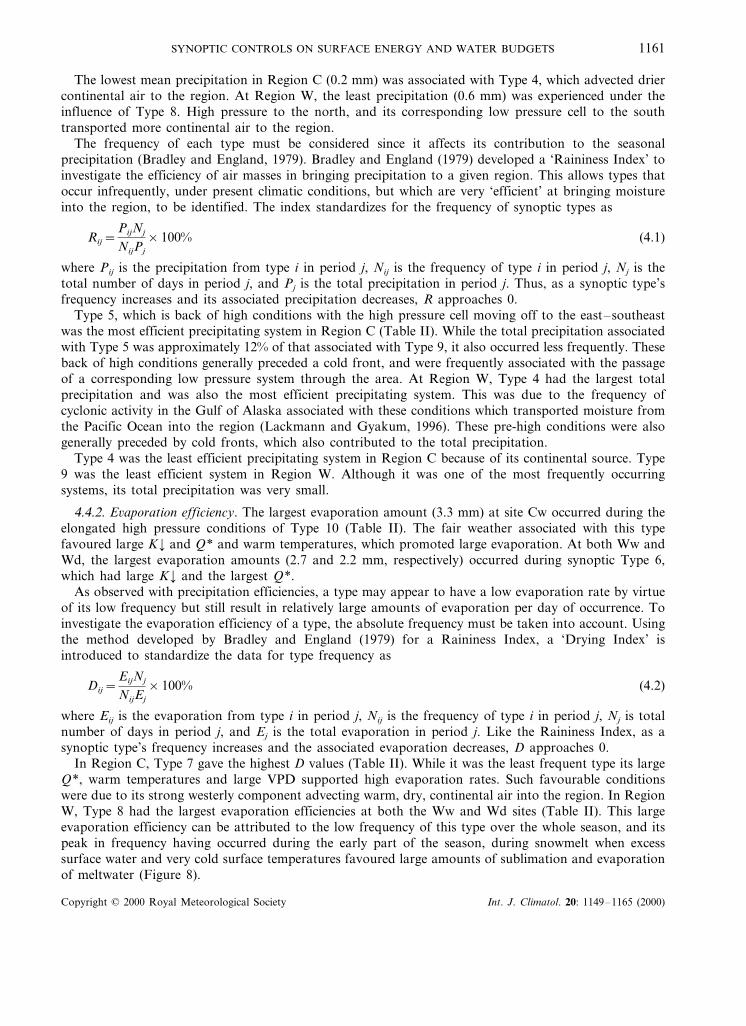
SYNOPTIC CONTROLS ON SURFACE ENERGY AND WATER BUDGETS 1161
The lowest mean precipitation in Region C (0.2 mm) was associated with Type 4, which advected driercontinental air to the region. At Region W, the least precipitation (0.6 mm) was experienced under theinfluence of Type 8. High pressure to the north, and its corresponding low pressure cell to the southtransported more continental air to the region.
The frequency of each type must be considered since it affects its contribution to the seasonalprecipitation (Bradley and England, 1979). Bradley and England (1979) developed a ‘Raininess Index’ toinvestigate the efficiency of air masses in bringing precipitation to a given region. This allows types thatoccur infrequently, under present climatic conditions, but which are very ‘efficient’ at bringing moistureinto the region, to be identified. The index standardizes for the frequency of synoptic types as
Rij=PijNj
NijPj
×100% (4.1)
where Pij is the precipitation from type i in period j, Nij is the frequency of type i in period j, Nj is thetotal number of days in period j, and Pj is the total precipitation in period j. Thus, as a synoptic type’sfrequency increases and its associated precipitation decreases, R approaches 0.
Type 5, which is back of high conditions with the high pressure cell moving off to the east–southeastwas the most efficient precipitating system in Region C (Table II). While the total precipitation associatedwith Type 5 was approximately 12% of that associated with Type 9, it also occurred less frequently. Theseback of high conditions generally preceded a cold front, and were frequently associated with the passageof a corresponding low pressure system through the area. At Region W, Type 4 had the largest totalprecipitation and was also the most efficient precipitating system. This was due to the frequency ofcyclonic activity in the Gulf of Alaska associated with these conditions which transported moisture fromthe Pacific Ocean into the region (Lackmann and Gyakum, 1996). These pre-high conditions were alsogenerally preceded by cold fronts, which also contributed to the total precipitation.
Type 4 was the least efficient precipitating system in Region C because of its continental source. Type9 was the least efficient system in Region W. Although it was one of the most frequently occurringsystems, its total precipitation was very small.
4.4.2. E6aporation efficiency. The largest evaporation amount (3.3 mm) at site Cw occurred during theelongated high pressure conditions of Type 10 (Table II). The fair weather associated with this typefavoured large K¡ and Q* and warm temperatures, which promoted large evaporation. At both Ww andWd, the largest evaporation amounts (2.7 and 2.2 mm, respectively) occurred during synoptic Type 6,which had large K¡ and the largest Q*.
As observed with precipitation efficiencies, a type may appear to have a low evaporation rate by virtueof its low frequency but still result in relatively large amounts of evaporation per day of occurrence. Toinvestigate the evaporation efficiency of a type, the absolute frequency must be taken into account. Usingthe method developed by Bradley and England (1979) for a Raininess Index, a ‘Drying Index’ isintroduced to standardize the data for type frequency as
Dij=EijNj
NijEj
×100% (4.2)
where Eij is the evaporation from type i in period j, Nij is the frequency of type i in period j, Nj is totalnumber of days in period j, and Ej is the total evaporation in period j. Like the Raininess Index, as asynoptic type’s frequency increases and the associated evaporation decreases, D approaches 0.
In Region C, Type 7 gave the highest D values (Table II). While it was the least frequent type its largeQ*, warm temperatures and large VPD supported high evaporation rates. Such favourable conditionswere due to its strong westerly component advecting warm, dry, continental air into the region. In RegionW, Type 8 had the largest evaporation efficiencies at both the Ww and Wd sites (Table II). This largeevaporation efficiency can be attributed to the low frequency of this type over the whole season, and itspeak in frequency having occurred during the early part of the season, during snowmelt when excesssurface water and very cold surface temperatures favoured large amounts of sublimation and evaporationof meltwater (Figure 8).
Copyright © 2000 Royal Meteorological Society Int. J. Climatol. 20: 1149–1165 (2000)

R.M. PETRONE AND W.R. ROUSE1162
Figure 8. Seasonal frequency distribution of classified synoptic types for (a) Churchill, and (b) Trail Valley Creek
The lowest evaporation efficiency at site Cw was associated with Type 3. Type 3 was the most frequentcondition and had the coolest temperatures and moderate VPDs, a result of the strong northwesterlycomponent to the flow. Both the Ww and Wd sites had the lowest evaporation efficiency for Types 9 and6. These extended low pressure systems were fairly warm, cloudy and moist systems which were thesecond most frequent in the basin.
Copyright © 2000 Royal Meteorological Society Int. J. Climatol. 20: 1149–1165 (2000)

SYNOPTIC CONTROLS ON SURFACE ENERGY AND WATER BUDGETS 1163
5. SUMMARY AND DISCUSSION
An objective synoptic classification for the snow free period at two Canadian Sub-arctic locations used aproven hybrid classification scheme (Frakes and Yarnal, 1997) to identify seven dominant synoptic types.The only systems not common to both sites were high pressure to the north (not important in Region C)and high pressure to the south (not represented in Region W).
In Region C, the coldest temperatures were associated with conditions when high pressure systems wereapproaching from the northwest, which funnelled cold air into the region. Their frequency was highestduring the early part of the study period when the cold air was reinforced by the cooling influence of astill frozen Hudson Bay (Figure 8). These conditions frequently followed the passage of a cold frontthrough the region. They exhibited the largest variation in temperature over the summer due to therapidly changing conditions at the source regions, as snow melted and the Arctic Ocean and Hudson Baythawed.
In Region W, the coldest temperatures were experienced when high pressure systems moved off to thenortheast and when high pressure systems were centred to the north. The former advected cold air intoRegion W as they tracked over the Polar Basin. The latter funnelled cold air into the region from thePolar Basin. Both of these types had higher frequencies during the earlier part of the season (Figure 8)and showed the largest variation in air temperature over the summer.
The warmest temperatures and smallest temperature variations observed at site C were associated withoccurrences of high pressure systems centred to the south. These occurred most frequently during the peaksummer period when the interior source region was at its warmest (Figure 8). Thus, the westerlycomponent of the flow advected warm, dry, continental air into Region C. High pressure moving off tothe northeast also demonstrated a fairly large mean VPD because it occurred most frequently in the earlyseason (Figure 8), when much of Hudson Bay and land to the northeast was still frozen and cold, dry,air was advected into Region C.
Region W experienced its warmest temperatures under the influence of high pressure systems approach-ing from the west–southwest, which were typically associated with rising pressure, clearing sky and astrong northwest wind component resulting in a relatively warm flow from the Pacific Ocean. Systemshaving to pass over the Mackenzie and Richardson Mountains to the west before reaching Region W alsodemonstrated very dry conditions.
Both regions demonstrated much variability in cloud cover between the different synoptic types, withthe exception of extended low pressure conditions. The latter comprised surface troughs or depressions,often with multiple centres overlain by an upper level trough (Yarnal, 1993), which produced weakpressure gradients and light winds conducive to extensive clouds and some precipitation. The largeamount of variability in cloud cover among the other synoptic types was attributed to the strong coastalmesoscale influences operating in both of the regions.
This synoptic classification illustrated the important synoptic regimes during the snow free period atthese sub-arctic locations under present climatic conditions. The most important link between the synopticactivity of a region and its surface energy balance operated through the impact of cloud cover on K¡ andQ*. The effect was most pronounced in Region C where there was a relatively high frequency of thickercumulus-type clouds, which caused decreases in K¡ and Q*. In Region C, clearer skies were experiencedunder pre-high conditions with the high pressure cell to the southwest. In Region W increased incidentsolar radiation was associated with back of high conditions with the high moving off to the northeast.Both of these conditions had strong continental components to their flow.
Synoptic types that transported cool, moist air to a region increased QH and QE giving larger Bowenratios. High pressure cells centred to the north of Region W brought moist, cool air to the basinincreasing the Bowen ratios of the Ww and Wd sites. In Region C, pre-high conditions with the highapproaching from the northwest brought similar air characteristics to the region, also increasing theBowen ratio at Cw. These types were also frequently associated with the passage of cold fronts. SmallerBowen ratios were observed at both sites under conditions with strong southerly components to theirflow. These conditions advected dry, warm air, decreasing the sensible heat flux while enhancing the latentheat flux.
Copyright © 2000 Royal Meteorological Society Int. J. Climatol. 20: 1149–1165 (2000)

R.M. PETRONE AND W.R. ROUSE1164
The most efficient systems at transporting moisture into the respective regions were those associatedwith the passage of low pressure systems. In Region C, the most efficient precipitating system was Type5 that generally preceded a cold front and a low centred over Region C. In Region W, the most efficientprecipitating system was Type 4, which brought large amounts of rain and occurred quite frequently dueto the associated cyclonic activity in the Gulf of Alaska.
The most efficient evaporating systems were those associated with warm, dry air and, most importantly,clear conditions. In Regions C and W, the highest evaporation efficiencies were associated with Types 7and 8, respectively. Both of these synoptic conditions exhibited some of the clearest conditions, and bothhad strong continental components to their flow regimes.
6. CONCLUSIONS
Seven synoptic types describe the summer synoptic climatology of the central and western high sub-arcticregions of Canada. Six of these are common to both regions. The frequency of individual synoptic typesranges from 5 to 20%.
In the central sub-arctic, 60% of the rain is associated with two air masses, which occur a total of 30%of the time. These two promote quite different environments. Type 9 with its elongated pressure troughoverhead is relatively warm, is cloudy, has weak solar insolation and is an inefficient evaporating system.Type 5 with high pressure to the east and low pressure approaching from the west is also relatively warmbut features moderate solar insolation and is a moderately efficient evaporating system. Its rainfall comesas short-lived frontal storms. The two driest synoptic systems provide only 8% of the rainfall and occur24% of the time. Type 4 with its pre-high anticyclonic conditions is relatively cool, has small cloudiness,large solar insolation, is a fairly efficient evaporating system. Type 10 with its extended high pressureoverhead promotes the same environmental characteristics as Type 4. The other systems in Region C havecharacteristics intermediate between these well-defined rainy and dry pairs.
In the western sub-arctic, 45% of the rain is associated with two air masses that occur a total of 16%of the time. These two promote quite different environments. Type 8 with high pressure to the north andlow pressure to the south is cool and cloudy, has weak solar insolation but is an efficient evaporatingsystem for both wet and dry sites. Type 4 with its pre-high anticyclonic conditions is very warm, has smallcloudiness, moderate solar insolation is a moderately efficient evaporating system. The two driest synopticsystems provide 16% of the rainfall and occur 33% of the time. They promote similar environments. Type5 with high pressure to the east and low pressure approaching from the west is moderately warm, hassmall cloud cover, moderate solar insolation and is a moderately efficient evaporating system. Type 9 withits elongated pressure trough overhead is relatively warm, is cloudy, has weak solar insolation and is aninefficient evaporating system. The other systems in Region W have characteristics intermediate betweenthese rainy and dry pairs.
Synoptic systems feature more distinctive characteristics in the central than in the western sub-arctic.The two synoptic systems, which are dry in the west, bring rain to the central region and one that bringsrain to the west is dry in the central region. Synoptic systems are associated with distinct radiation,thermal and moisture regimes but these differ between central and western sub-arctic regions.
With this understanding of the synoptic climatologies of the western and central sub-arctic, one isprovided with a useful climate baseline for studying these systems at the regional and local scales. Inaddition, assuming these classifications, and the associated surface interactions to be normal conditions,simulated changes in general atmospheric circulation patterns due to climatic change can be used to inferpossible responses of the surface moisture and energy budgets.
ACKNOWLEDGEMENTS
Financial support for this research has been provided by the Natural Science and Engineering ResearchCouncil of Canada and by student northern training grants from the Canada Department of Indian and
Copyright © 2000 Royal Meteorological Society Int. J. Climatol. 20: 1149–1165 (2000)

SYNOPTIC CONTROLS ON SURFACE ENERGY AND WATER BUDGETS 1165
Northern Affairs. The authors would like to thank Dr Bob Kochtubajda for his assistance in obtainingthe surface synoptic maps, and L. Dale Boudreau for his assistance in the field. Assistance in thereduction of the surface synoptic data was provided by Paula Rotenberg. Finally, the authors gratefullyacknowledge improvements and corrections suggested by the reviewers.
REFERENCES
Barry RG, Serreze MC, Maslanik JA, Preller RH. 1993. The arctic sea ice-climate system: observations and modelling. Re6iews inGeophysics 31: 397–422.
Bradley RS, England J. 1979. Synoptic climatology of the Canadian high arctic. Geografska Annaler 61A: 187–201.Dethloff K, Rinke A, Lehmann R, Christensen JH, Botzet M, Machenhauer B. 1996. Regional climate model of the arctic
atmosphere. Journal of Geophysical Research 101(D18): 23401–23422.Frakes B, Yarnal B. 1997. A procedure for blending manual and correlation-based synoptic classifications. International Journal of
Climatology 17: 1381–1396.Kirchhofer W. 1973. Classification of 500 mb patterns. Arbeitsbericht Schweiz, Meteorology Zentralanstalt, 43; 16 pp.Lackmann GM, Gyakum JR. 1996. The synoptic- and planetary-scale signatures of precipitating systems over the Mackenzie river
basin. Atmosphere–Ocean 34: 647–674.Petrone RM, Rouse WR, Marsh P. 2000. Comparative surface energy budgets in western and central subarctic regions of Canada.
International Journal of Climatology 20: 1131–1148.Serreze MC. 1995. Climatological aspects of cyclone development and decay in the arctic. Atmosphere–Ocean 33(1): 1–23.Serreze MC, Barry RG. 1988. Synoptic activity in the arctic basin, 1979–1985. Journal of Climate 1: 1276–1295.Taylor Alt B. 1978. Synoptic climate controls of mass balance variations on Devon Island ice cap. Arctic and Alpine Research 10:
61–80.Yarnal B. 1993. Synoptic Climatology in En6ironmental Analysis A Primer. Belhaven Press: London, UK.Yarnal B. 1984. A procedure for the classification of synoptic weather maps from gridded atmospheric pressure surface data.
Computers & Geosciences 10: 397–410.Yarnal B, Frakes B. 1997. Using synoptic climatology to define representative discharge events. International Journal of Climatology
17: 323–341.
Copyright © 2000 Royal Meteorological Society Int. J. Climatol. 20: 1149–1165 (2000)