Embed Size (px)
Citation preview

SVAMITVA SCHEME
Survey Of Villages And Mapping With Improvised Technology In Village Areas
1

Ministry of Panchayati Raj, GoI2
Contents
1
2
3
Introduction
Objectives
Brief Outline of Scheme Components
4 CORS
5 Survey Methodology
6
7
8
Implementation Process Flow
Activity Mapping
Monitoring & Implementation
9 Deliverables
Ministry of Panchayati Raj, GoI3
Introduction
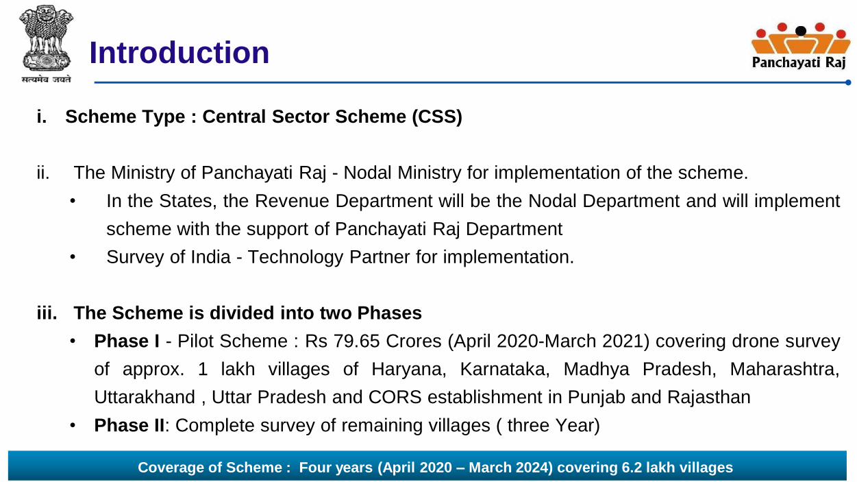
i. Scheme Type : Central Sector Scheme (CSS)
ii. The Ministry of Panchayati Raj - Nodal Ministry for implementation of the scheme.
• In the States, the Revenue Department will be the Nodal Department and will implement
scheme with the support of Panchayati Raj Department
• Survey of India - Technology Partner for implementation.
iii. The Scheme is divided into two Phases
• Phase I - Pilot Scheme : Rs 79.65 Crores (April 2020-March 2021) covering drone survey
of approx. 1 lakh villages of Haryana, Karnataka, Madhya Pradesh, Maharashtra,
Uttarakhand , Uttar Pradesh and CORS establishment in Punjab and Rajasthan
• Phase II: Complete survey of remaining villages ( three Year)
Coverage of Scheme : Four years (April 2020 – March 2024) covering 6.2 lakh villages

Ministry of Panchayati Raj, GoI4
Objectives
Provide an integrated property validation solution for rural India
Leveraging property as a financial asset by the citizens of rural India
Creation of accurate land records for rural planning.
Determination of property tax
Creation of survey infrastructure and GIS map that can be leveraged by any other department for their use.
Reduce property disputes and legal cases

Ministry of Panchayati Raj, GoI5
Brief outline of the Scheme components
S. No Scheme Component Brief Description
1 Establishment of
Continuously Operating
Reference Stations (CORS)
network
Reference stations to provide a virtual base station that allows access long-range high-accuracy
Network RTK corrections. Supports in
• Establishing Ground Control Points
• Ground truthing
• Demarcation of lands
2 Large Scale Mapping (LSM)
using Drone
Rural inhabited (abadi) area would be mapped by Survey of India using drones, to generate
high resolution and accurate maps to confer ownership property rights. Based on these maps or
data, property cards/title deeds would be issued to the rural household owners.
3 IEC Activities Awareness program to sensitize the rural population about the surveying methodology and its
benefits
4 Enhancement of Spatial
Planning Application “Gram
Manchitra”
The digital spatial data/maps created under drone survey shall be leveraged for creation of
spatial analytical tools to support preparation of GPDP.
5 Online Monitoring System Online Monitoring and reporting dashboard would monitor the progress of the activities.
6 Program Management Unit
i. National Programme
Management Unit (NPMU)
ii. State Programme
Management Unit (SPMU)
The scheme will be implemented through the regular departmental mechanisms, which will be
assisted by Programme Management Units at the National and State level.

Ministry of Panchayati Raj, GoI6
CORS ( Sample Images)
Ministry of Panchayati Raj, GoI7
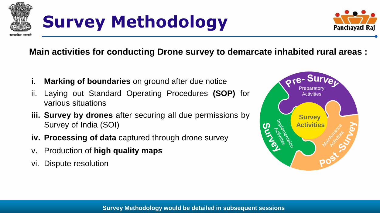
Survey Methodology
i. Marking of boundaries on ground after due notice
ii. Laying out Standard Operating Procedures (SOP) for
various situations
iii. Survey by drones after securing all due permissions by
Survey of India (SOI)
iv. Processing of data captured through drone survey
v. Production of high quality maps
vi. Dispute resolution
Survey
Activities
Preparatory
Activities
Main activities for conducting Drone survey to demarcate inhabited rural areas :
Survey Methodology would be detailed in subsequent sessions

Ministry of Panchayati Raj, GoI8
Implementation Process Flow
Timelines depicted are indicative

Ministry of Panchayati Raj, GoI9
Activity Mapping (1/4)
S.No Activities Responsibility
1. Signing of MoU between State Government and Survey of India State Revenue Department
Survey of India
2 Identify and prepare cluster of Village for Mission Mode Drone Survey State Revenue Department
Survey of India
3 Establishment of CORS network (applicable to Rajasthan & Punjab
State)
3.1 Tendering for outsourcing CORS network construction and installation Survey of India
3.2 SOI selects the suitable site with the help of State Government. The State Revenue
Department would facilitate required permission from owner for creation or establishment
of CORS network with physical security of stations.
State Revenue Department
Survey of India
3.3 Facilitation of field survey activities with support from local authorities for safety/security of
field teams & equipment, hiring of field vehicles, hiring of local labours, accommodation
for field teams etc.
State Revenue Department
3.4 Construction, installation and Commissioning of CORS station by outsourced agency Survey of India
3.5 Establishment of Control Centres. Survey of India
3.6 Operation and Maintenance of CORS Network Survey of India

Ministry of Panchayati Raj, GoI10
Activity Mapping (2/4)
S.No Activities Responsibility
4 Large Scale Mapping Using Drone
4.1 Procurement of Drone Survey of India
4.2 Pre- Survey Activities
4.2.1 Obtaining Permissions or Clearances for drone flying from DGCA, MoD, MHA etc Survey of India
4.2.2 Scanning the available rural habited maps and providing to Survey of India State Revenue
Department
4.2.3Legal Notification of Abadi area survey State Revenue
Department
4.2.4 Organise the Gram Sabha to intimate the schedule of the survey State Panchayati Raj
Department
4.2.5Provide support to sensitize the villagers about the project work and its intended benefits
leveraging RGSA funds
State Panchayati Raj
Department
4.2.6
Marking of property boundaries with Chunna lines with owners before the drone flying in the
area
State Revenue
Department
Gram Panchayat
4.2.7 Mission planning for drone flying using available maps/satellite imagery data Survey of India

Ministry of Panchayati Raj, GoI11
Activity Mapping (3/4)S.No Activities Responsibility
4.3 Survey Activities
4.3.1 Provisioning of Ground Control Points for flying Survey of India
4.3.2 Acquisition of Aerial images using Professional Survey Grade Unmanned Aerial Vehicle/ Drone forLarge Scale Mapping
Survey of India
4.3.3 Drone data processing and Feature extraction: Ortho Rectified Images, and extraction oftopographical features
Survey of India
4.3.4 Attribute entry and linking: The attributes collected/ provided (by State Government) shall be
linked with their respective features, thereby creating a digital spatial library of all the features and
their respective information. The data entry in the attributes table shall be carried out by Survey ofIndia in coordination with SPMU.
State Revenue
Department
Survey of India
4.3.5 Numbering of properties / structures within rural inhabited (abadi)/Lal dora/area as per numberingsystem provided by the State government.
State Revenue
Department
Survey of India
4.3.6 Ground-Truthing and validation of topographical features as derived from ortho- rectified images Survey of India
Gram Panchayats
4.3.7 Ground-Truthing, validation of Land Parcel maps State Revenue
Department
Survey of India

Ministry of Panchayati Raj, GoI12
Activity Mapping (4/4)S.No Activities Responsibility
4.4 Post – Survey Activities
4.4.1 Issue of notification of Joint verification of ownership State Revenue Department
4.4.2 Property ownership Adjudication State Revenue Department
4.4.3 Issue of notification for providing results of adjudication State Revenue Department
4.4.4 Inquiry Officer with the help of Gram Panchayat Resolve post survey objections
received from property owners. These may be related to correction in owner
name, property boundaries, joint holding etc. For unresolved objections /
disputes, the final decision shall rest with the District Magistrate / Collector
State Revenue Department
Gram Panchayat
4.4.5 Post Objection - Finalisation/ correction and validation of maps State Revenue Department
Survey of India
6 Final Deliverables Survey of India
7 Updation of property tax and asset register of Gram Panchayat Gram Panchayat
8 Issuance of property cards to Property Owner State Revenue Department
9 Training and Capacity building to nominated officials at State Revenue
Department
Survey of India
10 Regular updation of maps. State Revenue Department

Ministry of Panchayati Raj, GoI13
IEC Activities ( Indicative)
• Sensitization of local population about the surveying methodology and its benefits
• Communication materials in the form of manuals, flip books, poster, role plays, puppet
shows, billboards, pamphlet distribution and public announcements in villages
• Wall Paintings
• Short films on the survey and innovations by Panchayats
• Use of social media, audio visual media, community radio, special programmes/features
on television channels
• Cultural activities
• Exhibitions
• Mobile vans to disseminate information about scheme
Cost towards IEC may be utilised from RGSA funds in collaboration with PR Dept (under applicable components), as per felt need

Ministry of Panchayati Raj, GoI14
Monitoring & Implementation (1/3)
i. National Steering Committee
• Provide strategic direction and guidance to the engagement.
• Decide on policy level issues that need to be addressed from time to time
ii. Survey of India:
• Establish Project Wing - Nodal Officer for execution of the project in the State.
• Prepare detailed Annual Plans( in accordance with the Scheme Guidelines) for appraisal
and approval by the National Steering Committee (NSC).
iii. State Steering Committee (SSC)
• Provide operational guidance on the project
• Participate in all meetings and periodically review the progress of the project.
• Responsible for vetting the deliverables and recommending acceptance of deliverables
to the NSC

Ministry of Panchayati Raj, GoI15
iv. District-level Monitoring and Review Committee (DMRC)
• Review the progress of implementation of the Project
• Submit report to the State Steering Committee.
• Monitoring and oversight of the IEC funds granted.
v. State Programme Management Unit:
• Manage and monitoring of various activities under Scheme
• Support State Revenue Department, District officials, GP functionaries and Survey of
India.
Monitoring & Implementation (2/3)

Ministry of Panchayati Raj, GoI16
SVAMITVA Monitoring Dashboard
Monitoring & Implementation (3/3)
i. Monitor progress of the scheme on the Key Performance Indicators (KPIs) at National, State,
District and Village level on drill down for each KPI.
ii. Stakeholders would report scheme progress on
the Dashboard.
iii.Appraisal of States and Survey of India would
be done based on the progress reported on the
dashboard.

Ministry of Panchayati Raj, GoI17
Deliverables by Survey of India
i. CORS Network RTK service of ≤ 5 cm horizontal accuracy for five (05) years.
ii. Accurate geo-referenced digital maps
iii. Geodetic network with co-ordinates and sketches of the control points
iv. Metadata of features. Raw data of the ground survey work.
v. Proper indexed map with proper sheet number on the following scales:
a. Vertical Accuracy 0.2 m for all areas (Rural abadi area/lal dora)
b. Village Lal Dora/Abadi on 1:500 (Ortho Rectified Images at 5 cm GSD (Ground Sampling Distance); ±
5 cm Horizontal accuracy
vi. Mosaic map of Village. Spatial and non-spatial data dictionary with feature codes, feature type (line,
points and polygon) along with feature description and symbols.
vii. GIS data base prepared on 1:500 scale on UTM projection and WGS-84 datum.
viii. DEM of ≤ 20 cm vertical accuracy for the surveyed area.
ix. Hard copy maps on 1:500 scale (04 No’s each) for a village on good quality 90 GSM paper along-with pdf
copy for future printing purposes.
x. Training courses for technical staff of at various levels in IISM, Hyderabad.

Ministry of Panchayati Raj, GoI18