Embed Size (px)
Citation preview

Sustainable Land Management: South Asia Perspectives
To be presented at
Sub-regional workshop on development of the South Asia Sub-regional Action Programme
For combating desertification and Promoting sustainable land management
5-8th July 2004, Colombo, Sri Lanka
Prepared by
Nishanthi Perera Karin Fernando
South Asia Cooperative Environment Programme #10, Anderson Road, Colombo-5, Sri Lanka

Contents
1. Land use Practices a. Agriculture b. Forestry & Protected Areas c. Human settlements
2. Land degradation and desertification 3. Causes in land degradation
a. Direct b. Underlying
i. Increasing Population densities and land shortage ii. Poverty and dependency on natural resources
iii. Economic issues and policy failures c. Natural disasters and climate change
4. Responses

1. Land Use Practices • The Land area covered by the seven countries of SAARC is around 4.13 million
sq kilometers, accounting for about 3% of the land cover of the world. • The region displays an extraordinary diversity of landforms due to climatic
regimes, latitude and altitude and toprography. • The 03 major physiographic regions identified are:
The mountain belt of the Himalayas, Hindu Kush. This belt stretches along the whole northern border of the region, including parts of all countries except Sri Lanka and Maldives. The alluvial plains of the Indus and Ganges river systems of Pakistan India
and Bangladesh. The uplands of the Deccan of India, together with the central hill massif of
Sri Lanka.
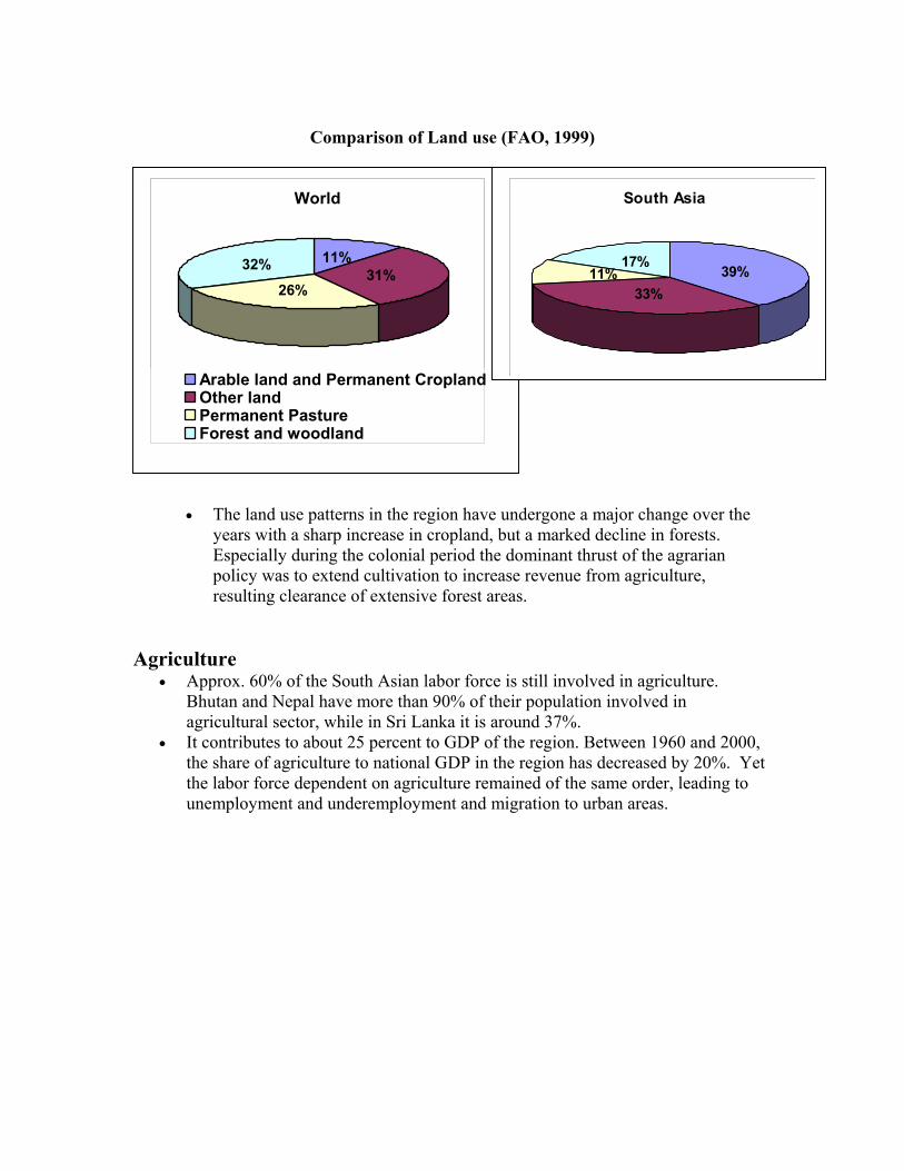
Comparison of Land use (FAO, 1999)
• The land use patterns in the region have undergone a major change over the
years with a sharp increase in cropland, but a marked decline in forests. Especially during the colonial period the dominant thrust of the agrarian policy was to extend cultivation to increase revenue from agriculture, resulting clearance of extensive forest areas.
Agriculture
• Approx. 60% of the South Asian labor force is still involved in agriculture. Bhutan and Nepal have more than 90% of their population involved in agricultural sector, while in Sri Lanka it is around 37%.
• It contributes to about 25 percent to GDP of the region. Between 1960 and 2000, the share of agriculture to national GDP in the region has decreased by 20%. Yet the labor force dependent on agriculture remained of the same order, leading to unemployment and underemployment and migration to urban areas.
World
11%31%
26%
32%
Arable land and Permanent CroplandOther landPermanent PastureForest and woodland
South Asia
39%33%
11%17%

Agriculture land use patterns
0100,000200,000300,000400,000500,000600,000700,000800,000
1961 1970 1980 1990 2000years
Agricultural Area (1000Ha)Agr Pop (1000)Fertilizer consumption (100MT)
• The regions agriculture is characterized by small landholdings in alluvial
lowlands, too many people on too little land, production largely for subsistence, and high rates of tenancy and pre modern technologies.
• Rice is the staple food crop and is usually grown under wet conditions.
The four most important agricultural systems used in the region is given in Table 1

Table 1: Major Farming Systems in South Asia (Source: FAO) Farming systems
Land area (% of the region)
Agricul. Popn (% of the region)
Principal Livelihoods
Rice 7 17 Wetland rice (both seasons), vegetables, legumes, off-farm activities
Rice-wheat 19 33 Integrated rice, wheat, vegetables, livestock including dairy, off-farm activities
Highland Mixed
12 7 Cereals, livestock, horticulture, seasonal migration
Rainfed mixed
29 30 Cereals, legumes, fodder crops, livestock, off farming activities.
Human settlements
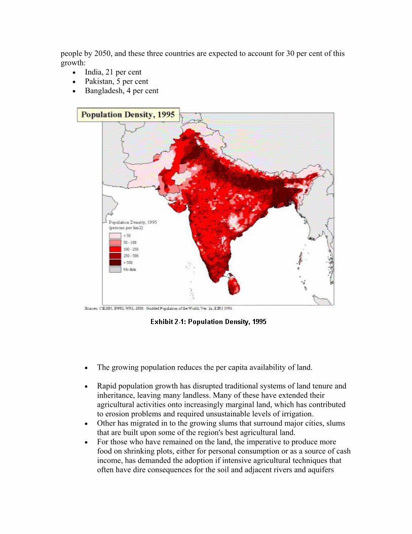
• The settlement patterns of the region are not uniform. Where land is arable, especially where irrigated, population density is high.
• Population is particularly crowded into the sharp band that runs east from the Pakistani Punjab across northern India and Nepal and into Bangladesh. This region closely follows the upper Indus Basin and Ganges-Brahmaputra River Basin.
• Additional striking concentrations of population, although geographically smaller are visible in the southern areas of the sub-continent and in coastal zones.
• Urban populations of South Asia currently average only 28 percent of the total. • Continued massive increases in urbanization in the Region are expected. The
United Nations forecasts 53 percent urbanization in Asia by 2025, with the majority of urban growth in Bangladesh, People’s Republic of China (PRC), India, Indonesia, and Pakistan
• Increasingly, megacity growth is taking the form of extended metropolitan
regions (EMRs), covering 50-100 kilometers from the city center, with polycentric structures acting as focal points in the movement of people, goods, and services. Metropolitan regional growth has typically spred along major highways, expressways, and railroad lines radiating out of urban areas, superimposing new towns, industrial estates, housing projects, and other urban forms onto areas that were previously predominantly agricultural and rural.
• South Asian cities are drowning in their own waste. In New Delhi and Mumbai, more than 1.5 tons of garbage is left rotting on the streets or in improperly maintained pits every day. The piles of garbage that clog street drains in South Asia cities contribute to floods during the rainy season, which seriously jeopardize the health of nearby residents
• Without strategic interventions in land-use management and transportation
planning, environmental and economic constraints will increasingly affect EMRs; particularly those on low-lying plains subject to flooding, subsidence, and ground and surface water contamination.
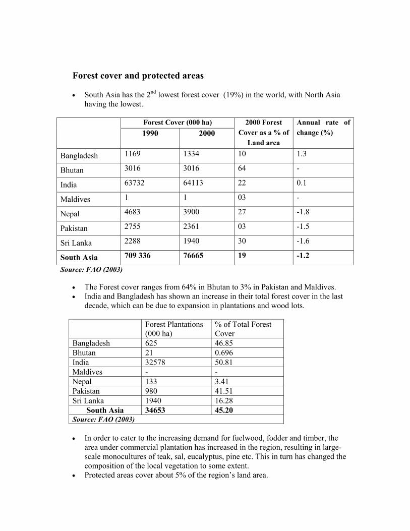
Forest cover and protected areas • South Asia has the 2nd lowest forest cover (19%) in the world, with North Asia
having the lowest.
Forest Cover (000 ha) 1990 2000
2000 Forest Cover as a % of
Land area
Annual rate of change (%)
Bangladesh 1169 1334 10 1.3
Bhutan 3016 3016 64 -
India 63732 64113 22 0.1
Maldives 1 1 03 -
Nepal 4683 3900 27 -1.8
Pakistan 2755 2361 03 -1.5
Sri Lanka 2288 1940 30 -1.6
South Asia 709 336 76665 19 -1.2
Source: FAO (2003)
• The Forest cover ranges from 64% in Bhutan to 3% in Pakistan and Maldives. • India and Bangladesh has shown an increase in their total forest cover in the last
decade, which can be due to expansion in plantations and wood lots. Forest Plantations
(000 ha) % of Total Forest Cover
Bangladesh 625 46.85 Bhutan 21 0.696 India 32578 50.81 Maldives - - Nepal 133 3.41 Pakistan 980 41.51 Sri Lanka 1940 16.28
South Asia 34653 45.20 Source: FAO (2003) • In order to cater to the increasing demand for fuelwood, fodder and timber, the
area under commercial plantation has increased in the region, resulting in large-scale monocultures of teak, sal, eucalyptus, pine etc. This in turn has changed the composition of the local vegetation to some extent.
• Protected areas cover about 5% of the region’s land area.
• The extent of land area set apart as protected areas differs between countries:
Bangladesh - 2.9 % Bhutan - 26.23% India - 4.58% Maldives- 0.1% Nepal - 18.32% Pakistan – 10.4 Sri Lanka – 13.3%
2. Land degradation and desertification
• Recent estimates indicate that in South Asia, 42% of the land is affected by one or more land degradation problems.
• 50% of the regions drylands faces the threat of desertification. As many as 63 million hectares of rainfed cropland and 16 million hectares of irrigated land have been lost due to desertification, especially in Pakistan and India.
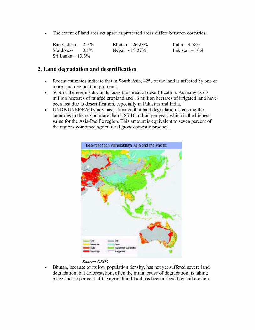
• UNDP/UNEP/FAO study has estimated that land degradation is costing the countries in the region more than US$ 10 billion per year, which is the highest value for the Asia-Pacific region. This amount is equivalent to seven percent of the regions combined agricultural gross domestic product.
Source: GEO3
• Bhutan, because of its low population density, has not yet suffered severe land degradation, but deforestation, often the initial cause of degradation, is taking place and 10 per cent of the agricultural land has been affected by soil erosion.

• The principal causes of land degradation are erosion by water followed by wind,
and biophysical and chemical degradation. • Humid zones in Bangladesh, Nepal, India and Sri Lanka are mostly affected by
water erosion. • The most devastating form of waterborne land degradation in Bangladesh is
riverbank erosion • Water logging and salinization affects between 2 and 3 million ha in Indian and
Pakistan respectively. • In Pakistan, salt build-up in the soil is known to reduce crop yields by 30 per cent. • Chemical soil degradation in the region is mainly caused by agricultural
mismanagement.
Hotspots Nutrient Depletion
Mid-altitude hills of Nepal, Northern India
Stalinization Indus river basin, Southern coast line of Sri Lanka Erosion Foothills of the Himalayas; Riverbank erosion in the major
floodplains (Ganges, Brahmaputa, Jamuna , Tista and Meghna rivers) of Bangladesh.
Agrochemical pollution
Pakistan (Heavy use of Agrochemicals)

3. Causes of Land degradation According to FOA, the causes of land degradation can be divided in to 03 categories:
a. Direct causes – unsustainable land use and inappropriate land management practices
b. Underlying causes – the reasons for which inappropriate types of land use or management are practiced.
c. Natural hazards – relate to factors of the biophysical environment that increase the risk of land degradation
a. Direct causes
• Poor Agricultural Practices: o Over extraction of water agriculture: This has to reduced the availability of
water in the down stream areas and led to salt water intrusion
Table 2: Trends in irrigation area expansion Country 1993 (ha) 2020 (ha) Rate of
Increase (%) India 50,101 68,619 36.96 Pakistan 17,120 20,538 19.96 Other South Asia 7,526 8,719 15.85 All developing countries
187,628 227,332 21.16
World 253,003 295,964 16.98
o Over-use of agrochemicals: South Asian farmers have turned increasingly to chemical fertilizers and pesticides to improve crops and to maximize yields. Although this has produced a short term increase in yields, it has permitted overcropping, which has reduced the available organic matter in the soil. Humus loss reduces the ability of the soil to retain water, speeding precipitation runoff, increasing the probability of flooding and water erosion, and making the region more vulnerable to drought.
o Introduction of high yielding monocrops
• Overgrazing by livestock: India’s livestock population, which is roughly about 13% of the world total, depends on pastures and rangelands accounting for 0.5% of the world total. This implies an average of 42 animals grazing in one ha of land against the threshold level of 5 animals per ha. In the absence of adequate gazing lands, the fodder requirements are met from forests, leading to increased deforestation.

• Industrial activities:
o Mining activities in the region is typically unorganized and unscientific in many instances. There are clear trans-boundary impacts due to poor mining practices. Eg: The dolomite mining in Bhutan, have resulted in increased landslides and soil erosion in adjoining the state of West Bengal in India; gem mining in Sri Lanka has lead to increase soil erosion in several areas of the country.
o Ship-breaking industry in Bangladesh, India, and Pakistan leads to discharge of hazardous wastes
• Deforestation o Large areas of Mangrove forests have been lost to the construction of
shrimp farms in Bangladesh, India and Sri Lanka o Dependency of rural poor on fuelwood as a energy source has lead to
forest clearance mainly in Nepal. o Shifting cultivation, commonly practiced by the hill tribes of India,
Nepal and Pakistan
Major underlying causes in Sustainable Land Management
• The direct causes of land degradation are inappropriate methods of land management. The underlying causes stem from the interaction of land resources with economic and social conditions. There is a causal nexus between land shortage, population increase, poverty, and land degradation.
1. Expanding population
• South Asia has a population density of 15 people per ha compared to world
average of 4 people per ha
South Asia World Total population (trillions) 1.455.11 6,148.11
Urban Population (as a % of total) 29.5 47.7
Annual growth rate (% for 1975-2001) 2.1 1.6
Total fertility rate (per women for 1995-2000) 3.6 2.8
Source: Human Development Report, 2003 Of the world’s ten most populous countries, three are in South Asia; India, Pakistan, and Bangladesh and the total population of the seven countries in the sub region now have exceeded the 1.4 billion mark. World population is expected to grow by some 3 billion
people by 2050, and these three countries are expected to account for 30 per cent of this growth:
• India, 21 per cent • Pakistan, 5 per cent • Bangladesh, 4 per cent
• The growing population reduces the per capita availability of land.
• Rapid population growth has disrupted traditional systems of land tenure and inheritance, leaving many landless. Many of these have extended their agricultural activities onto increasingly marginal land, which has contributed to erosion problems and required unsustainable levels of irrigation.
• Other has migrated in to the growing slums that surround major cities, slums that are built upon some of the region's best agricultural land.
• For those who have remained on the land, the imperative to produce more food on shrinking plots, either for personal consumption or as a source of cash income, has demanded the adoption if intensive agricultural techniques that often have dire consequences for the soil and adjacent rivers and aquifers
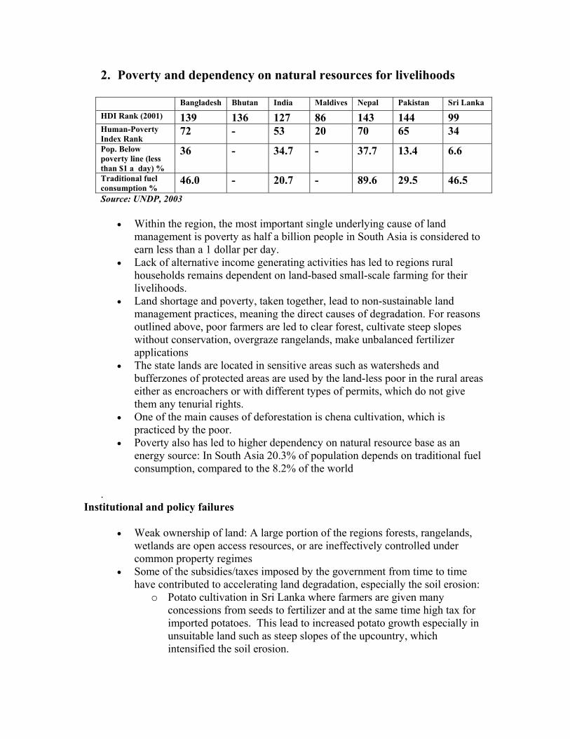
2. Poverty and dependency on natural resources for livelihoods
Bangladesh Bhutan India Maldives Nepal Pakistan Sri Lanka HDI Rank (2001) 139 136 127 86 143 144 99 Human-Poverty Index Rank
72 - 53 20 70 65 34 Pop. Below poverty line (less than $1 a day) %
36 - 34.7 - 37.7 13.4 6.6
Traditional fuel consumption %
46.0 - 20.7 - 89.6 29.5 46.5 Source: UNDP, 2003
• Within the region, the most important single underlying cause of land management is poverty as half a billion people in South Asia is considered to earn less than a 1 dollar per day.
• Lack of alternative income generating activities has led to regions rural households remains dependent on land-based small-scale farming for their livelihoods.
• Land shortage and poverty, taken together, lead to non-sustainable land management practices, meaning the direct causes of degradation. For reasons outlined above, poor farmers are led to clear forest, cultivate steep slopes without conservation, overgraze rangelands, make unbalanced fertilizer applications
• The state lands are located in sensitive areas such as watersheds and bufferzones of protected areas are used by the land-less poor in the rural areas either as encroachers or with different types of permits, which do not give them any tenurial rights.
• One of the main causes of deforestation is chena cultivation, which is practiced by the poor.
• Poverty also has led to higher dependency on natural resource base as an energy source: In South Asia 20.3% of population depends on traditional fuel consumption, compared to the 8.2% of the world
.
Institutional and policy failures
• Weak ownership of land: A large portion of the regions forests, rangelands, wetlands are open access resources, or are ineffectively controlled under common property regimes
• Some of the subsidies/taxes imposed by the government from time to time have contributed to accelerating land degradation, especially the soil erosion:
o Potato cultivation in Sri Lanka where farmers are given many concessions from seeds to fertilizer and at the same time high tax for imported potatoes. This lead to increased potato growth especially in unsuitable land such as steep slopes of the upcountry, which intensified the soil erosion.

• Globalization of the regions economy – The fast growing International Trade, affects the sustainable land resources management of South Asia in many ways
o Encourage governments to purse high trade and growth at the expense of other benefits and diverse attention from the primary products (agriculture) towards the production of secondary and tertiary products.
o Increased international completion, exposes regions industries to bankruptcy and induces government to provide subsidies such as cheap electricity, free water and lax pollution control standards to keep them surviving.
o Its shifts production from subsistence towards commercial products, which reducers the concern of the producers for long-term sustainability of resource use. Eg: cultivators focus have been shifted from the traditional sustainable copping system to more market driven cash crops. The growth of the cash crops tend to take up the best land, pushing subsistence farmers into areas with poorer soil and driving unsustainable use of chemical and agricultural devices.
3. Natural disasters and climate change
• According to the World Banks Strategy for the region, South Asia stands out as a region most vulnerable to natural disasters such as flood and cyclones. From 1990 to 1998, the region accounted for over 60 percent of disaster-related deaths world-wide.
Table: Natural disasters in India Type Location/Area Affected Pop. Cyclones Floods Droughts Earthquakes Landslides Avalanches Fires
Entire coast line of Southern India covering 9 states 08 major river valleys spreading over 40 million Ha of area of entire India Around 68% of total sown area and 16% of total area of the country spread in 14 states 56% of the total area of the country susceptible to seismic disturbances Entire sub Himalayan region and Western Ghats Many parts of the Himalayas States of Bihar, West Bengal, Orissa and North eastern states
10 million 260 86 400 10 01 140
Source: CPCB/MATMP (2001): Environmental Atlas of India
• In the Bay of Bengal, cyclones cause very heavy rainfall and sever flooding. Because of its low-lying topography, about 22 % of the land area in

Bangladesh is flooded each year. Floods in 1998 displaced as many as 25 per cent of the people. October 1999 super cyclone in Orissa India, left two million people homeless and around 800,000 hectares of standing rice crops destroyed and soil affected by the high salinity.
• Glacial Lake Outburst Flood is a concern in the Himalayan region • Uneven rain due to climate change has resulted in droughts in several parts of
the region. The droughts in 1999 affected 15% of Indias population. In Pakistan droughts between 1985 and 1987 affected millions of hectares of crops, causing an estimated loss of income of UD $ 2.4 billion.
• As a result of the attrition between the South Asian plate and the main Asian plate, the geological faults are still active. This results in earthquakes, which cause the Himalya to rise further. The earthquakes of September 1999 in Maharashta and 2000 in Gujarat of India are two of the recent examples of the level of seismic action in this area. Earthquakes in Nepal often results in landslides from unstable slopes, which have been deforested and degraded by human activities.
Climate change • Climate change variation may result in higher precipitation in certain
periods, resulting in increased intensity of flooding, or it might affect other areas by providing no rains.
• The most serious consequence of climate change to the region will be the rise in sea level.
o Over 80% of the land area in the Maldives is less than 1 m above mean sea level and therefore the country is very vulnerable to inundation and beach erosion. Presently 50% of inhibited islands and 45% of tourist resorts face varying degrees of beach erosion. Climate change and projected sea level rise will aggravate this problem.
o It can submerge 10-20% of the coastal land of Bangladesh, including the Sundarbans.
Responses 1. National- level
1. National Land use policies development and implementation 2. The widespread neglect of rural infrastructure development should be accelerated
to mitigate increased urban migration 3. Re-forestation programmes and declaration of protected areas 4. Integrated Watershed Management 5. Integrated Rural Development 6. Integrated Coastal Area and River Basin Management 7. Building awareness and local capacity 8. Introduction of sustainable technologies
a. Sloping agriculture techniques

b. Rain-water harvesting
Regional
Issues to be addressed at regional level
• As South Asia is among the most populated and impoverished regions in the world, the Regional Action Programme should focus on making a contribution to making an improvement in livelihood security in the region.
• One of the main problems facing land resource management in South Asia is the high dependency of population on agriculture as a livelihood. How this sector can be explored and expanded to provide the food security to increasing population through an advancement of agricultural research, technology and extension services must be addressed.
• Importance of giving priority to accelerate the widespread neglect of rural infrastructure development to mitigate rural-urban migration
• Addressing transboundary issues such as water resources management and disaster mitigation.
• The importance of integrating water resources management with land management
• Development of alternative energy sources for reducing the pressure on forest cover
• Importance of community participation at grass-root levels
a. Regional cooperation on improved tools and techniques on assessment and
data management and setting standards for monitoring b. Technical cooperation for developing desertification control action plans and
drought and disaster mitigation strategies c. Information sharing on good land-management practices d. Joint Research programmes to improve agricultural quality e. Increased cooperation in trade through bilateral and multilateral agreements
References 2. SAARC(1992): Regional Study on the Causes and Consequences on Natural
Disasters and the Protection and Preservation of the Environment. 3. http://www.irgltd.com/irgltd/Pubs/SA%20Env.%20Profile/trends.html 4. UNDP (2003) Human Development Report 2003: Millennium Development
Goals: A compact among nations to end human poverty 5. UN/ADB (2000): State of the Environment in Asia and the Pacific.

6. Dixon, J. and A. Gulliver with D. Gibbon. (2001) Farming Systems and Poverty: Improving Farmers' Livelihoods in a Changing World. FAO & World Bank: http://www.fao.org/DOCREP/004/ac349e/ac349e07.htm#TopOfPage
7. Making sustainable commitments-An Environment Strategy for the World Bank. http://lnweb18.worldbank.org/ESSD/envext.nsf/41ByDocName/SouthAsiaEnvironmentStrategy281KBPDF/$FILE/SAREnvStrategy2001.pdf
8. Population and Development Issues: http://www.unfpa.org/asiapacific/population.htm
9. Velayutham M (): Human Development in South Asia, 2002 Report: Land and Water issues - http://www.undp.org.in/events/HDSA02/Velayutham.doc
10. UNEP/SACEP (2001): State of the Environment- South Asia, 2001 11. http://www.fao.org/farmingsystems/maps_SAS_en.htm 12. http://www.teriin.org/energy/envsec.htm 13. http://www.adb.org/Documents/Policies/Urban_Sector/urban0201.asp 14. MEN/GOSL (2002): Second National Status Report on Land Degradation:
Implementation of the UN Convention to Combat Desertification in Sri Lanka. Submitted to the UNCCD Secretariat
15. FAO (2003): Asia-Pacific Forestry Commission: State of Forestry in Asia and the Pacific –2003: Status, changes and trends. Rap Publication 2003/22
16. FAO/UNEP/UNDP (1994): Land degradation in South Asia: Its severity, causes and effects upon the people: http://www.fao.org/docrep/V4360E/V4360E02.htm
17. -http://unfccc.int/resource/docs/natc/maldnc1.pdf 18. http://www.makingcitieswork.org/urbanWorld/south-asia 19. http://www.roap.unep.org/region/geo/Land.pdf 20. UNEP (2001): Asia-Pacific Environment Outlook 2 21. CPCB/MATMP (2001): Environmental Atlas of India.

Supplied by Social Exclusion Housing – www.social-exclusion-housing.com Visit the best affordable housing and social exclusion website, including housing problems, housing development, poverty and more.