Embed Size (px)
Citation preview

Nadarivatu Hydropower Scheme
CONSOLIDATED EIA
Environmental Impact Assessment Final Draft October 2007
E1464v5
Pub
lic D
iscl
osur
e A
utho
rized
Pub
lic D
iscl
osur
e A
utho
rized
Pub
lic D
iscl
osur
e A
utho
rized
Pub
lic D
iscl
osur
e A
utho
rized
Pub
lic D
iscl
osur
e A
utho
rized
Pub
lic D
iscl
osur
e A
utho
rized
Pub
lic D
iscl
osur
e A
utho
rized
Pub
lic D
iscl
osur
e A
utho
rized

Nadarivatu Hydropower Scheme
CONSOLIDATED EIA Environmental Impact Assessment Final Draft October 2007
Sinclair Knight Merz Level 9, FNPF Place Victoria Parade GPO 11 428 Suva Fiji Tel: +67 9 331 5770 Fax: +67 9 330 7002 Web: www.skmconsulting.com COPYRIGHT: The concepts and information contained in this document are the property of Sinclair Knight Merz Limited. Use or copying of this document in whole or in part without the written permission of Sinclair Knight Merz constitutes an infringement of copyright.
LIMITATION: This report has been prepared on behalf of and for the exclusive use of Sinclair Knight Merz Limited’s Client, and is subject to and issued in connection with the provisions of the agreement between Sinclair Knight Merz and its Client. Sinclair Knight Merz accepts no liability or responsibility whatsoever for or in respect of any use of or reliance upon this report by any third party.

Nadarivatu Hydropower Scheme - Consolidated EIA
SINCLAIR KNIGHT MERZ
I:\LTKA\Projects\LT01069 - FEA Nadarivatu EIA Reconsolidation & EMP\Deliverables\Nadarivatu Consolidated EIA Final Draft Client Issue 22 Oct 07.doc PAGE i
Contents
Executive Summary 1
1. Introduction 4 1.1 Background 4 1.2 Report Format 5 1.3 Acknowledgements 5
2. Energy Context in Fiji 6
3. Policy, Legal and Administrative Framework 11
4. Description of the Hydropower Scheme 12 4.1 Introduction 12 4.2 Location 14 4.3 Project Components and Data 14 4.4 Ancillary Infrastructure and Works 16 4.5 Operations 16 4.6 Electrification 18 4.7 Construction Methodology 18 4.8 Access and Traffic 21 4.9 Land Leases 21 4.10 Principal Environmental and Social Issues with the Project 23
5. Baseline Environmental Data 24 5.1 Introduction 24 5.2 Environmental Setting 24 5.3 Geology and Soils 25 5.4 Hydrology 25 5.5 Water Quality 28 5.6 Sediment flux 30 5.7 Fresh Water Ecosystems 31 5.8 Land-based Ecosystems 32 5.9 Physical Cultural Property / Archaeological Sites 35 5.10 Settlements and Social Environment 37 5.11 Summary 43
6. Environmental Impacts 46 6.1 Introduction 46
Nadarivatu Hydropower Scheme - Consolidated EIA
SINCLAIR KNIGHT MERZ
PAGE iiI:\LTKA\Projects\LT01069 - FEA Nadarivatu EIA Reconsolidation & EMP\Deliverables\Nadarivatu Consolidated EIA Final Draft Client Issue 22 Oct 07.doc
6.2 Construction Effects 46 6.3 Operational Effects 49
7. Socio-economic impacts 63 7.1 Introduction 63 7.2 Attitudes and perceptions 63 7.3 Traffic Impacts 69 7.4 Noise and Vibration 70 7.5 Economic Impacts 71 7.6 Physical Cultural Property / Archaeological Sites 72 7.7 Land use changes 72 7.8 Summary 72
8. Analysis of Alternatives 74 8.1 Diesel Power Generation 74 8.2 Variations on the Nadarivatu Hydropower Scheme 74
9. Mitigation 79 9.1 Introduction 79 9.2 Scheme Design 79 9.3 Community Issues 79 9.4 Construction and Work Crew Impacts 80 9.5 Ecological Flows and Management of Water Releases 80 9.6 Erosion and Sediment Control 82
10. Environmental Management Plan 84
11. Monitoring and Evaluation 88
12. Consultation Process 89 12.1 Government Land Acquisition Task Force 89 12.2 Social Impact Assessment Consultation 90 12.3 Government Agency Consultation 90
13. Summary and Conclusions 92
14. Bibliography of Environmental Studies 94
15. List of Appendices 96
Appendix A DOE Environmental Approvals
Appendix B Location Plans
Nadarivatu Hydropower Scheme - Consolidated EIA
SINCLAIR KNIGHT MERZ
I:\LTKA\Projects\LT01069 - FEA Nadarivatu EIA Reconsolidation & EMP\Deliverables\Nadarivatu Consolidated EIA Final Draft Client Issue 22 Oct 07.doc PAGE iii
Appendix C Design Plans
Appendix D 2006 Water Quality and Ecological Assessment
Appendix E Consultation Meeting Notes
Appendix F Environmental Management Plan
Appendix G Hydrological Assessment
Appendix H Archaeological Report
Appendix I 2004 Water Quality and Biological Survey

Nadarivatu Hydropower Scheme - Consolidated EIA
SINCLAIR KNIGHT MERZ
I:\LTKA\Projects\LT01069 - FEA Nadarivatu EIA Reconsolidation & EMP\Deliverables\Nadarivatu Consolidated EIA Final Draft Client Issue 22 Oct 07.doc PAGE v
Document history and status
Revision Date issued Reviewed by Approved by Date approved Revision type
Draft 19 October 07 R Lau R Lau 22 October 07 Professional
Distribution of copies Revision Copy no Quantity Issued to
Final Draft Fatiaki Gibson, FEA
Juan Quintero, Antonie De Wilde, World Bank
Printed: 22 October 2007
Last saved: 22 October 2007 05:21 PM
File name: I:\LTKA\Projects\LT01069 - FEA Nadarivatu EIA Reconsolidation & EMP\Deliverables\Nadarivatu Consolidated EIA Final Draft Client Issue 22 Oct 07.doc
Author: SKM
Project manager: Pene Burns, Rouven Lau
Name of organisation: Fiji Electricity Authority
Name of project: Nadarivatu Hydro Power Scheme
Name of document: Consolidated EIA
Document version: Final Draft
Project number: AE03336.001 / LT01069
Nadarivatu Hydropower Scheme - Consolidated EIA
SINCLAIR KNIGHT MERZ
I:\LTKA\Projects\LT01069 - FEA Nadarivatu EIA Reconsolidation & EMP\Deliverables\Nadarivatu Consolidated EIA Final Draft Client Issue 22 Oct 07.doc PAGE 1
Executive Summary The Nadarivatu Hydro Power Project is located in the Nadrau Plateau, in the highlands of Viti Levu, the main island in Fiji. The 42MW scheme, in an average year, would generate approximately 15% of the Viti Levu electricity requirements and displace 22,000 tonnes of diesel. At a growth rate of 6-7% a year, the electricity demand in Fiji is currently being serviced by a growing number of diesel power plants.
The Nadarivatu scheme involves taking water from the Sigatoka River, which flows to the south coast of Viti Levu, to the Ba River, which flows to the north coast. A 31 metre (m) weir in the head waters of the Sigatoka River diverts water through a tunnel and penstock to the Ba Power Station on the bank of the Ba River. The closest settlements are the Lewa and Buyabuya villages.
Specific EIA studies included:
Biological survey of terrestrial and aquatic species and habitats.
Social baseline assessment and impact assessment.
Hydrological modelling of modified flows in the Sigatoka and Ba Rivers.
Archaeological survey.
Water quality testing and instream ecosystem surveys in the Sigatoka and Ba catchments.
The land use in and around the project area at present is generally low intensity grazing, agriculture and occasional hunting and fishing. A number of small villages and settlements are located along the ridges of the Nadrau Plateau, high above the steeply incised river valleys. Buyabuya village is located adjacent to the Ba River and the proposed power station site. The populations are predominantly living according to traditional Fijian values and culture with a mix of subsistence and cash economies.
The rivers are not used by many people, as access into the steep valleys is very difficult. The rivers are not navigable and do not provide the primary source of protein. Domestic water supplies are taken from springs rather than the rivers, and there is no irrigated agriculture until the coastal plains.
The existing land cover consists predominantly of native forest in the steeper valleys in the Sigatoka catchment with open grasslands on the flanks and ridges of the hills. At the Ba Power Station site it is predominantly modified forest and grassland. Three threatened or vulnerable bird and bat species were located in the mature bush in the catchment during the surveys; the giant honeyeater, the masked shining parrot and Samoan flying fox.
Nadarivatu Hydropower Scheme - Consolidated EIA
SINCLAIR KNIGHT MERZ
PAGE 2 I:\LTKA\Projects\LT01069 - FEA Nadarivatu EIA Reconsolidation & EMP\Deliverables\Nadarivatu Consolidated EIA Final Draft Client Issue 22 Oct 07.doc
The creeks are typical, steep sided, upland rivers that experience high flood flows and periods of very low flow. Water quality of the rivers is generally good and typical of upland headwaters, and is similar in water chemistry to others across the plateau. The rivers supported at least six species of fish, some of which are used for food but none are endemic, rare or threatened.
The following conclusions on the scheme can be made, taking into account the scheme design, sensitivity of the environment, the needs of the host communities and the predicted impacts:
There will be no inundation of houses, settlements, farms or other productive land uses. There is no requirement to relocate families or communities.
The reservoir will inundate the river channel margins only, where invasive weed species are most prevalent due to the scouring effects of flood waters. There will be no inundation of mature forest.
The five land owning units (Mataqali) have meaningfully engaged in the land lease process and are in the final stages of signing a permanent lease to allow FEA access to construct and operate the scheme.
The habitats of the giant honeyeater, masked shining parrot and Samoan flying fox will not be affected by construction or inundation.
Discharges of sediment will affect water quality and stream bed habitat immediately downstream of the Ba and Sigatoka Rivers during construction. This will be for the duration of the construction period, and may result in sedimentation.
The diversion of water from the Qaliwana and Nukunuku Creeks will create uniformly low river flows downstream in the Sigatoka River. This will affect river flow for at least 12 kilometres, until further flow from other catchments reduces the impact.
Changes to ecosystems and fish populations will be experienced immediately downstream in the Sigatoka River as a result of the low flow periods. This includes more sedimentation and more algae growths, and potentially less fish. This will reduce in effect downstream.
Pulses of water from the power station may affect fording and other river uses downstream. This is minor given that there is low population for several kilometres downstream and low river use.
Changes to erosion and deposition patterns are also expected in the Ba River, but to a minor extent given that the river bed is mainly boulders and bedrock for several kilometres.
Disturbance to traditional village life, and in particular to Buyubuya Village, during construction as a result of the works and influx of workers to the district.
Mitigation and management has been proposed in the EIA to address these issues, including a comprehensive EMP for implementation during construction and operation of the scheme. It is considered that if these actions are implemented then the adverse effects of the project will be

Nadarivatu Hydropower Scheme - Consolidated EIA
SINCLAIR KNIGHT MERZ
I:\LTKA\Projects\LT01069 - FEA Nadarivatu EIA Reconsolidation & EMP\Deliverables\Nadarivatu Consolidated EIA Final Draft Client Issue 22 Oct 07.doc
minimised. The measures outlined in the EIA and EMP should ensure that the development could proceed and provide a significant benefit to Fiji’s power supply and future economic development.
Nadarivatu Hydropower Scheme - Consolidated EIA
SINCLAIR KNIGHT MERZ
PAGE 4 I:\LTKA\Projects\LT01069 - FEA Nadarivatu EIA Reconsolidation & EMP\Deliverables\Nadarivatu Consolidated EIA Final Draft Client Issue 22 Oct 07.doc
1. Introduction The Fiji Electricity Authority (FEA) propose to construct and operate a 42 (41.8) megawatt (MW) hydropower scheme in on Nadrau plateau in the interior of Viti Levu, the main island of Fiji. The scheme involves taking water from a 31 metre (m) weir in the head waters of the Sigatoka River catchment at the confluence of the Qaliwana and Nukunuku Creeks, through a tunnel and penstock to a power station on the bank of the Ba River. The closest settlements are the Lewa and Buyabuya villages.
The weir will have the capacity to store up to 1,009,000 cubic metres (m3) of water which, at the maximum scheme discharge of 15m3/s, is 18.7 hours storage.
This scheme is viewed as an essential development opportunity for Fiji to reduce its reliance on imported fossil fuels and develop a more sustainable long term power generation strategy. This scheme has the potential to provide approximately 15 % of the Viti Levu electricity requirements. This will in turn aid industry and development in Fiji; by ensuring power supplies are more consistent. Power costs in the long term should be more predictable as Fiji would not be so dependent on the variable global price of oil. The scheme is in line with the Government’s objectives of replacing imported diesel with indigenous renewable resources.
This report provides the Environmental Impact Assessment (EIA) for the Nadarivatu Hydro Power Scheme. It sets out the proposed project and its environmental context and outlines the potential impacts and proposed mitigation for the project.
1.1 Background In 2006 the power demand on Viti Levu had reached an overall consumption of 700 GWh per annum. Demand is estimated to be growing at 6 - 7% each year. Growth to date has been met by a combination of spare capacity in the existing hydropower schemes and additional diesel generation, however ‘brown outs’ and power cuts have become more common in recent times, as demand exceeds supply.
Fiji cannot ignore the impending energy shortage, and ‘do nothing’ is not an acceptable option.
FEA is committed to renewable energy development. This policy is consistent with current Government support for renewable energy to achieve Fiji’s commitment to the Kyoto Protocol and curb the reliance on imported diesel.
A wide variety of schemes have been investigated since 1977 for the diversion of the head waters of the Sigatoka River to the Ba River, to take advantage of the 400 to 500 m head available between the two river systems.

Nadarivatu Hydropower Scheme - Consolidated EIA
SINCLAIR KNIGHT MERZ
I:\LTKA\Projects\LT01069 - FEA Nadarivatu EIA Reconsolidation & EMP\Deliverables\Nadarivatu Consolidated EIA Final Draft Client Issue 22 Oct 07.doc
FEA, with partner Pacific Hydro Ltd, started reviewing various options for the scheme in 2003. The final scheme has been chosen following a series of conceptual designs, optimisation, environmental investigations, risk reviews and cost estimates. Pacific Hydro Ltd has since pulled out of the partnership. The total output of the scheme is 42 MW and it is estimated to produce an annual average output of 101 GWh.
1.2 Report Format This EIA report is a consolidation of the following EIA reports:
Nadarivatu Hydropower Project, Environmental Impact Assessment, Final, May 2005
Supplementary Report No. 1 to the EIA, July 2005
Supplementary Report No. 2 to the EIA, September 2006
The content has been updated where relevant to take into account the final scheme design parameters from the ‘Nadarivatu Renewable Energy Project Design Report’ July 2007, by design engineers MWH New Zealand Limited.
An overview of the Fiji environmental legislative framework and environmental context is followed by a description of the scheme in Section 4. The environmental and social context and baseline data is provided in Section 5, including detail on hydrology, water quality and instream habitats, terrestrial ecology and biodiversity, and details on the traditional Fijian livelihoods of the villages in the host communities. Potential environmental impacts are described in Section 6, followed by potential socio-economic impacts in section 7. An assessment of alternatives, mitigation, monitoring and evaluation methods and a summary of consultation is then provided in Sections 8 to 12.
1.3 Acknowledgements SKM acknowledge and thank the following contributors:
MWH New Zealand Ltd
Indra Deo, Social Impact Consultant
University of South Pacific
Government agencies for attending consultation meetings.

Nadarivatu Hydropower Scheme - Consolidated EIA
SINCLAIR KNIGHT MERZ
PAGE 6 I:\LTKA\Projects\LT01069 - FEA Nadarivatu EIA Reconsolidation & EMP\Deliverables\Nadarivatu Consolidated EIA Final Draft Client Issue 22 Oct 07.doc
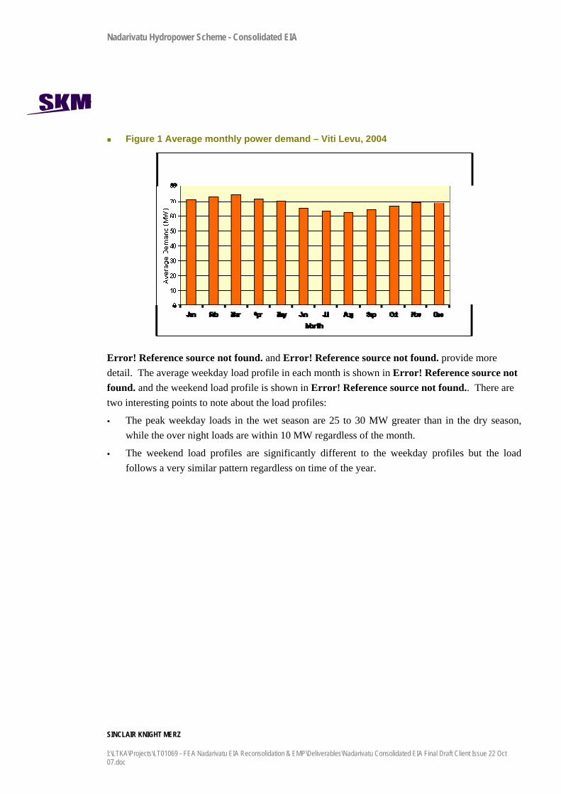
2. Energy Context in Fiji The power demand on Viti Levu has reached an overall consumption of nearly 700 GWh per annum, as shown in Error! Reference source not found..
Table 1 2006 electricity supply sources
Facility Energy Production (GWh/annum) % of production
Wailoa (hydro) 316 45% Wainikasou (hydro) 18 3% Vaturu (hydro) 6 1% Diesel 354 51% Total 694 100%
Source: FEA
This demand is growing at 6 - 7% each year.
Growth to date has been met by a combination of spare capacity in the Wailoa Hydro Power Scheme and additional diesel generation, however ‘brown outs’ and power cuts have become more common in recent times, as demand exceeds supply. Any new connections place further pressure on the supply grid.
The purpose of the proposed hydro power scheme is to contribute up to 101 GWh of electricity annually to the FEA network to meet current and future electricity demand and achieve the Government and SEL objectives for renewable energy development.
Fiji is naturally constrained in terms of hydrological and wind resources for energy generation. There are opportunities for small scale projects around the islands, but this scheme is important as it has the largest potential for electricity generation and will contribute a significant proportion of the electricity to the network once operational (approximately 15%). Additionally, there are no alternative renewable energy schemes that can be built to meet demand within the next two years. The only viable alternative in the short term is for Fiji to invest in further diesel generation capacity, or experience more frequent power shortages, brown outs and power cuts.
Error! Reference source not found. shows the average monthly power demand in Viti Levu, from 20041. This is the demand for generation and includes transmission and distribution losses. As can be seen in Error! Reference source not found., demand peaks in February and March and reaches a minimum in August.
1 Although the latest data available is 2004, and the demand will have increased, the seasonal, weekly and daily use patterns are considered to be the same in 2007.
Nadarivatu Hydropower Scheme - Consolidated EIA
SINCLAIR KNIGHT MERZ
I:\LTKA\Projects\LT01069 - FEA Nadarivatu EIA Reconsolidation & EMP\Deliverables\Nadarivatu Consolidated EIA Final Draft Client Issue 22 Oct 07.doc
Figure 1 Average monthly power demand – Viti Levu, 2004
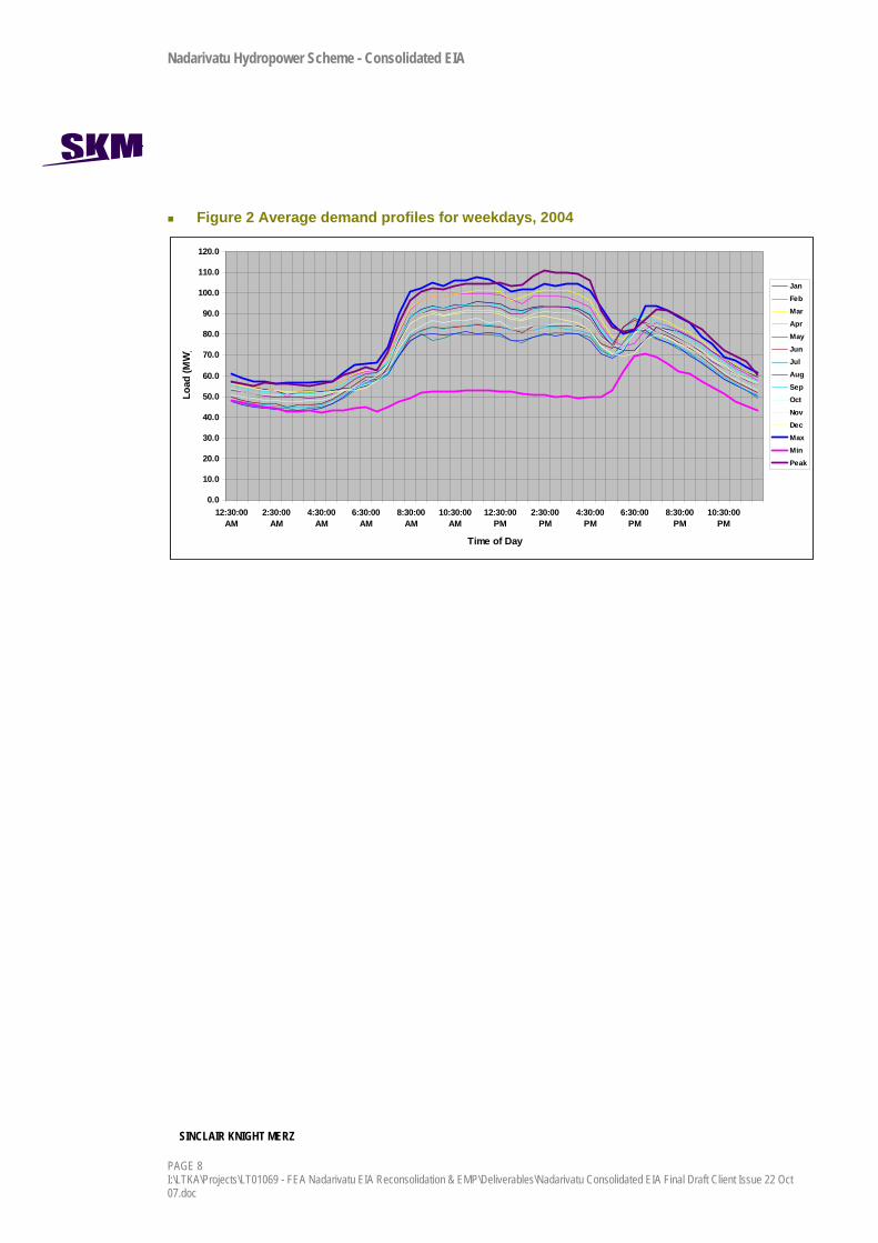
Error! Reference source not found. and Error! Reference source not found. provide more detail. The average weekday load profile in each month is shown in Error! Reference source not found. and the weekend load profile is shown in Error! Reference source not found.. There are two interesting points to note about the load profiles:
The peak weekday loads in the wet season are 25 to 30 MW greater than in the dry season, while the over night loads are within 10 MW regardless of the month.
The weekend load profiles are significantly different to the weekday profiles but the load follows a very similar pattern regardless on time of the year.
Nadarivatu Hydropower Scheme - Consolidated EIA
SINCLAIR KNIGHT MERZ
PAGE 8 I:\LTKA\Projects\LT01069 - FEA Nadarivatu EIA Reconsolidation & EMP\Deliverables\Nadarivatu Consolidated EIA Final Draft Client Issue 22 Oct 07.doc
Figure 2 Average demand profiles for weekdays, 2004
0.0
10.0
20.0
30.0
40.0
50.0
60.0
70.0
80.0
90.0
100.0
110.0
120.0
12:30:00AM
2:30:00AM
4:30:00AM
6:30:00AM
8:30:00AM
10:30:00AM
12:30:00PM
2:30:00PM
4:30:00PM
6:30:00PM
8:30:00PM
10:30:00PM
Time of Day
Load
(MW
)
JanFebMarAprMayJunJulAugSepOctNovDecMaxMinPeak
Nadarivatu Hydropower Scheme - Consolidated EIA
SINCLAIR KNIGHT MERZ
I:\LTKA\Projects\LT01069 - FEA Nadarivatu EIA Reconsolidation & EMP\Deliverables\Nadarivatu Consolidated EIA Final Draft Client Issue 22 Oct 07.doc
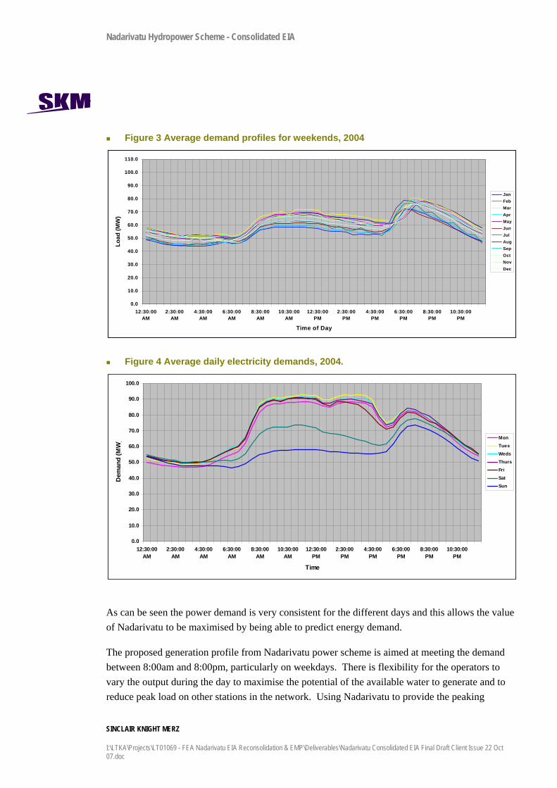
Figure 3 Average demand profiles for weekends, 2004
0.0
10.0
20.0
30.0
40.0
50.0
60.0
70.0
80.0
90.0
100.0
110.0
12:30:00AM
2:30:00AM
4:30:00AM
6:30:00AM
8:30:00AM
10:30:00AM
12:30:00PM
2:30:00PM
4:30:00PM
6:30:00PM
8:30:00PM
10:30:00PM
Time of Day
Load
(MW
)
JanFebMarAprMayJunJulAugSepOctNovDec
Figure 4 Average daily electricity demands, 2004.
0.0
10.0
20.0
30.0
40.0
50.0
60.0
70.0
80.0
90.0
100.0
12:30:00AM
2:30:00AM
4:30:00AM
6:30:00AM
8:30:00AM
10:30:00AM
12:30:00PM
2:30:00PM
4:30:00PM
6:30:00PM
8:30:00PM
10:30:00PM
Time
Dem
and
(MW
) MonTues
WedsThursFriSatSun
As can be seen the power demand is very consistent for the different days and this allows the value of Nadarivatu to be maximised by being able to predict energy demand.
The proposed generation profile from Nadarivatu power scheme is aimed at meeting the demand between 8:00am and 8:00pm, particularly on weekdays. There is flexibility for the operators to vary the output during the day to maximise the potential of the available water to generate and to reduce peak load on other stations in the network. Using Nadarivatu to provide the peaking

Nadarivatu Hydropower Scheme - Consolidated EIA
SINCLAIR KNIGHT MERZ
PAGE 10 I:\LTKA\Projects\LT01069 - FEA Nadarivatu EIA Reconsolidation & EMP\Deliverables\Nadarivatu Consolidated EIA Final Draft Client Issue 22 Oct 07.doc
capacity means that the water through put will vary significantly during most days. Further, Nadarivatu generation is mostly during the wet season when the power demand is higher. Generally the water levels will be allowed to build back up, as there is less energy demand in the weekend.

Nadarivatu Hydropower Scheme - Consolidated EIA
SINCLAIR KNIGHT MERZ
I:\LTKA\Projects\LT01069 - FEA Nadarivatu EIA Reconsolidation & EMP\Deliverables\Nadarivatu Consolidated EIA Final Draft Client Issue 22 Oct 07.doc
3. Policy, Legal and Administrative Framework The Fijian Government in 2005 passed the Environment Management Act. The Department of Environment, within the Ministry of Tourism, Labour and the Environment, is responsible for implementing the Act and the Environmental Approvals process.
Environmental Approval is required from the Department for any development proposal that meets criteria under Schedule 2, Part 1 of the Act. The Nadarivatu Hydropower Scheme development proposal requires an Environmental Approval under 1(g) a proposal for construction of a dam, artificial lake, hydro-electric scheme or irrigation project.
An Environmental Impact Assessment (EIA) must be prepared by the developer and lodged with the Department for Approval. A Terms of Reference (TOR) that outlines the scope of the works for the EIA is first prepared and lodged with the Department. Once the TOR is approved, the EIA report must be prepared in accordance with the TOR.
The Department can insist on public notification of the EIA for 21 working days, and the public can make submissions on the EIA which then must be taken into account when processing the Approval.
An EIA was lodged with the Department of Environment in May 2005 for the original Nadarivatu Hydropower Scheme. This was publicly notified for 21 working days. No submissions were received from the public. Following questions from the Department, a Supplementary Report 1 to the EIA was lodged in July 2005. An Environmental Approval was issued on 25 July 20052.
In February 2006, following design changes to the scheme, the Department agreed that a Supplementary Report No. 2 to the EIA could be lodged to document and address all of the changes to environmental and social impacts from the proposed scheme changes. The MOE would consider the information in the Supplementary Report No. 2 to the EIA and amend the original Environmental Approval to address the changes. It was considered at the time that although the Government Stakeholder Group would be involved in the processing of the change to the Environmental Approval, the application would not require public notification through the Environment Management Act 2005 process. An updated Environmental Approval was issued in November 20063. Both Environmental Approvals are valid and apply to the scheme.
2 A copy of the July 2005 Environmental Approval is provided in Appendix A. 3 A copy of the November 2006 Environmental Approval is provided in Appendix A. 5 Water quality data was compared to results in monitoring reports from the Wailoa Hydro Power Scheme.

Nadarivatu Hydropower Scheme - Consolidated EIA
SINCLAIR KNIGHT MERZ
PAGE 12 I:\LTKA\Projects\LT01069 - FEA Nadarivatu EIA Reconsolidation & EMP\Deliverables\Nadarivatu Consolidated EIA Final Draft Client Issue 22 Oct 07.doc
4. Description of the Hydropower Scheme
4.1 Introduction The proposed Nadarivatu Hydropower Scheme will divert water from the head waters of the Sigatoka River via a weir, tunnel and penstock, to a 42MW power station at the Ba River. This is represented schematically in Figure 5. The Sigatoka River flows from the Nadrau plateau in the interior of Viti Levu to the south coast. The Ba River flows from central Viti Levu to the north coast of the island.
This section provides details on the location, key scheme components and associated infrastructure.

Nadarivatu Hydropower Scheme - Consolidated EIA
SINCLAIR KNIGHT MERZ
I:\LTKA\Projects\LT01069 - FEA Nadarivatu EIA Reconsolidation & EMP\Deliverables\Nadarivatu Consolidated EIA Final Draft Client Issue 22 Oct 07.doc PAGE 13
Figure 5 Schematic of the Nadarivatu Hydropower Scheme
Nadarivatu Hydropower Scheme - Consolidated EIA
SINCLAIR KNIGHT MERZ
I:\LTKA\Projects\LT01069 - FEA Nadarivatu EIA Reconsolidation & EMP\Deliverables\Nadarivatu Consolidated EIA Final Draft Client Issue 22 Oct 07.doc PAGE 14
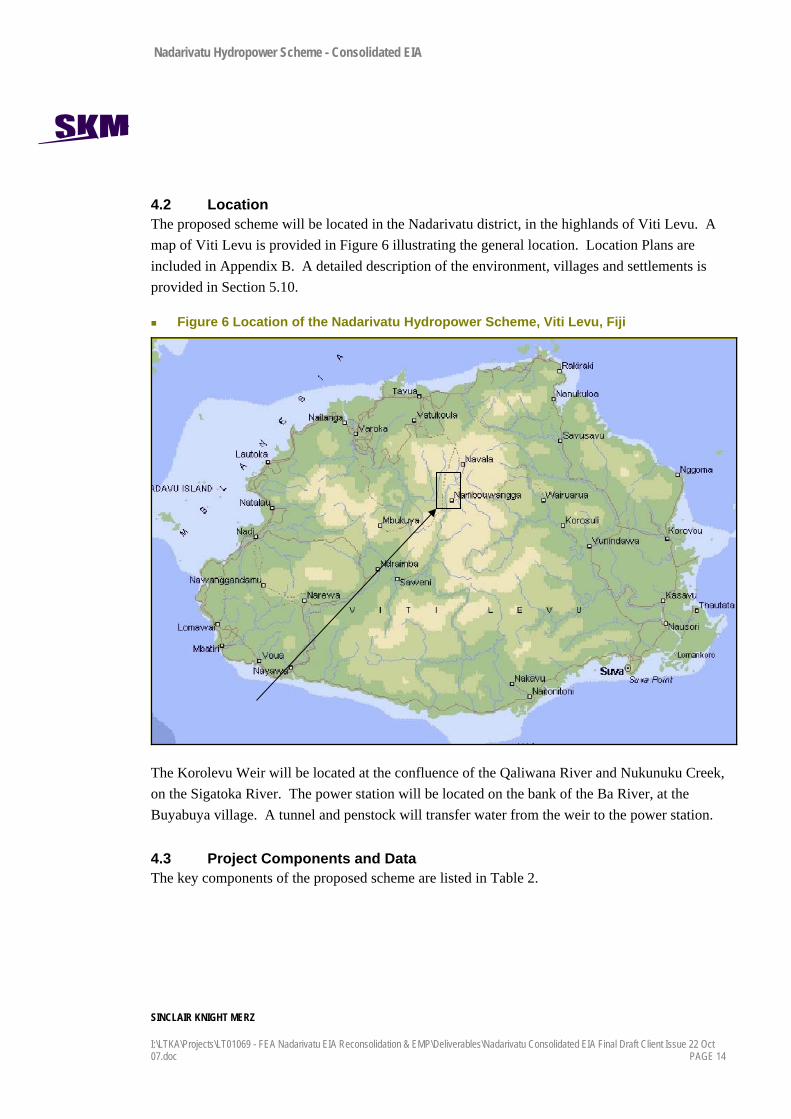
4.2 Location The proposed scheme will be located in the Nadarivatu district, in the highlands of Viti Levu. A map of Viti Levu is provided in Figure 6 illustrating the general location. Location Plans are included in Appendix B. A detailed description of the environment, villages and settlements is provided in Section 5.10.
Figure 6 Location of the Nadarivatu Hydropower Scheme, Viti Levu, Fiji
The Korolevu Weir will be located at the confluence of the Qaliwana River and Nukunuku Creek, on the Sigatoka River. The power station will be located on the bank of the Ba River, at the Buyabuya village. A tunnel and penstock will transfer water from the weir to the power station.
4.3 Project Components and Data The key components of the proposed scheme are listed in Table 2.
Nadarivatu Hydropower Scheme - Consolidated EIA
SINCLAIR KNIGHT MERZ
I:\LTKA\Projects\LT01069 - FEA Nadarivatu EIA Reconsolidation & EMP\Deliverables\Nadarivatu Consolidated EIA Final Draft Client Issue 22 Oct 07.doc PAGE 15
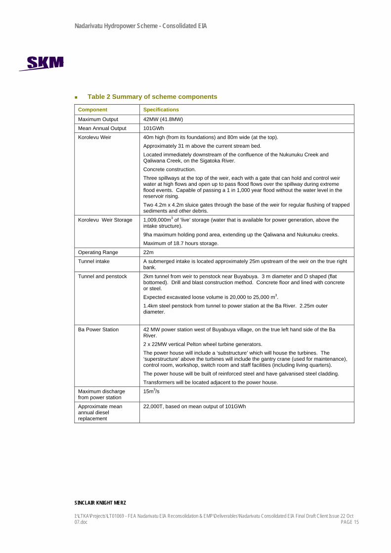
Table 2 Summary of scheme components
Component Specifications
Maximum Output 42MW (41.8MW)
Mean Annual Output 101GWh
Korolevu Weir 40m high (from its foundations) and 80m wide (at the top). Approximately 31 m above the current stream bed. Located immediately downstream of the confluence of the Nukunuku Creek and Qaliwana Creek, on the Sigatoka River. Concrete construction. Three spillways at the top of the weir, each with a gate that can hold and control weir water at high flows and open up to pass flood flows over the spillway during extreme flood events. Capable of passing a 1 in 1,000 year flood without the water level in the reservoir rising. Two 4.2m x 4.2m sluice gates through the base of the weir for regular flushing of trapped sediments and other debris.
Korolevu Weir Storage 1,009,000m3 of ‘live’ storage (water that is available for power generation, above the intake structure). 9ha maximum holding pond area, extending up the Qaliwana and Nukunuku creeks. Maximum of 18.7 hours storage.
Operating Range 22m
Tunnel intake A submerged intake is located approximately 25m upstream of the weir on the true right bank.
Tunnel and penstock 2km tunnel from weir to penstock near Buyabuya. 3 m diameter and D shaped (flat bottomed). Drill and blast construction method. Concrete floor and lined with concrete or steel. Expected excavated loose volume is 20,000 to 25,000 m3. 1.4km steel penstock from tunnel to power station at the Ba River. 2.25m outer diameter.
Ba Power Station 42 MW power station west of Buyabuya village, on the true left hand side of the Ba River. 2 x 22MW vertical Pelton wheel turbine generators. The power house will include a ‘substructure’ which will house the turbines. The ‘superstructure’ above the turbines will include the gantry crane (used for maintenance), control room, workshop, switch room and staff facilities (including living quarters). The power house will be built of reinforced steel and have galvanised steel cladding. Transformers will be located adjacent to the power house.
Maximum discharge from power station
15m3/s
Approximate mean annual diesel replacement
22,000T, based on mean output of 101GWh
Nadarivatu Hydropower Scheme - Consolidated EIA
SINCLAIR KNIGHT MERZ
PAGE 16 I:\LTKA\Projects\LT01069 - FEA Nadarivatu EIA Reconsolidation & EMP\Deliverables\Nadarivatu Consolidated EIA Final Draft Client Issue 22 Oct 07.doc
4.4 Ancillary Infrastructure and Works The following scheme components are shown on the Location Plans in Appendix B.
9.6 km of access roads; one from Nadrau Road to the Korolevu Weir and one extending the existing road to Buyabuya and the Ba River.
132 kV substation at or near the power station.
7 km of 132 kV transmission line from the Ba Power Station to the existing 132 kV Vuda / Wailoa transmission line.
A new switching station to be installed on the existing 132 kV Vuda / Wailoa transmission line.
4.5 Operations
4.5.1 Power Generation The scheme is designed to operate automatically, and will be remotely controlled as part of the Viti Levu grid from either the Wailoa Power Station or from FEA’s National Control Centre in Lautoka. However, the station will be staffed permanently for maintenance purposes.
To generate power, water is drawn from the reservoir behind the Korolevu weir, via gravity, through the tunnel and down to the Ba Power Station. Under pressure, water is forced through two turbines to generate electricity, and then discharged to the Ba River. The maximum capacity of the power scheme is 15m3/s (7.5m3/s through each turbine), which can generate a maximum of 42MW.
The generators will operate at 11 kilovolts (kV). The output will be stepped up to 132kV by two transformers, to allow the electricity to be exported to the high voltage grid.
Nadarivatu will be used to meet the weekday energy demands between 8:00am and 8:00pm. This means that water will generally be stored in the weir reservoir overnight and diverted through the power scheme during these hours. Depending on rainfall and flow in the Sigatoka catchment, demand on the grid, and capacity of other power stations on the grid, Nadarivatu may also operate outside of these hours. For example, during high flow conditions, the power station may be used at any time of the day to maximise the use of water that would otherwise be discharged to the Sigatoka River.
The mean annual generation capacity is 101GWh, and depends heavily on the rainfall in any particular year, since there is little storage behind the weir. The yearly variation in generation has been calculated between 75GWh and 132GWh.
Nadarivatu Hydropower Scheme - Consolidated EIA
SINCLAIR KNIGHT MERZ
I:\LTKA\Projects\LT01069 - FEA Nadarivatu EIA Reconsolidation & EMP\Deliverables\Nadarivatu Consolidated EIA Final Draft Client Issue 22 Oct 07.doc PAGE 17
4.5.2 Weir and Reservoir Operations Table 3 demonstrates how the weir and reservoir will be managed during various flow conditions in the Sigatoka River.
Table 3 Weir and reservoir operations
Inflow range (m3/s) Weir and Reservoir Operations
0 - 15 Spillway gates at the top of the weir would remain closed, to maximise the capture and storage of flow. Sluice gates at the bottom of the weir will be used to maintain a residual flow of 0.2m3/s downstream of the weir. This residual flow will cease if inflow into the reservoir drops below this amount. All remaining inflow is used for electricity. Water level fluctuates as generation meets demands.
15 - 70 Maximum generation low is taken. Excess water is released as residual flow or spilled over the spill way when volume is full
70 - 500 Intake will continue to operate until sediment carried in the water is greater than 0.3mm. Over this, it will be closed. Excess water is passed through the sluice which are operated to maintain the reservoir level in the normal operating range. Reservoir can be purposely drawn down at this time to assist with sluicing sediments through the Sigatoka River.
500 and above Intake tunnel is closed. Sluice gates are fully open. Spillway gates are opened and excess water is spilled. The probable maximum flood in the river of 3,250m3/s would result in the weir structure being overtopped without leading to failure.
The expected accumulation of sediment at the Korolevu Weir will be managed opening the sluice gates during major flood events to simulate natural river sediment flows as closely as possible. The gates are located near the bottom of the weir, where sediment will settle. During flood events there is lots of energy in the river to help move the sediments along the bottom of the reservoir and through the gates to downstream. The scheme operators can help to remove silt by lowering the reservoir with the sluice gates open in order to create high water velocities in the area where the silt has been deposited to help it move.
At very rare intervals it will be necessary to drain the reservoir to check whether there is any movement of major boulders in the reservoir. If there is, they may need to be blasted.
Nadarivatu Hydropower Scheme - Consolidated EIA
SINCLAIR KNIGHT MERZ
PAGE 18 I:\LTKA\Projects\LT01069 - FEA Nadarivatu EIA Reconsolidation & EMP\Deliverables\Nadarivatu Consolidated EIA Final Draft Client Issue 22 Oct 07.doc
4.6 Electrification As part of the development, and as a result of the land lease negotiation process, several of the settlements will be provided with electricity. Approximately 160 households from the following villages will be connected:
Marou Village (34 households)
Vatutokatoka Settlement (13)
Koro Village (52)
Buyabuya Village (31)
Votualevu Settlement (3)
Drala Village (27)
4.7 Construction Methodology Construction methods are currently conceptual and will be further developed with the Contractor. Civil works are likely to take at least two years. The contract for civil works is currently programmed to be let in January 2008 and full power is expected to be generated in January 2011.
4.7.1 Construction Sequence for Korolevu Weir and Tunnel Portal The following is a simplified construction sequence for the weir and tunnel intake portal:
1) Clear tracks and land at and adjacent to the weir and tunnel intake portal on the right bank of the river.
2) Create a diversion channel for the river.
3) Complete river protection works and construction on the banks of the river.
4) Construct an upstream cofferdam at the narrowest section of river approximately 12m high using a sheetpile wall connected to rock and backfilled upstream using excavated material from the bank to provide additional support to the cofferdam wall, reduce leakage and to provide a working platform and access ramp.
5) Construct a downstream cofferdam approximately 7-8m high to protect the works from downstream river flows encroaching back into the working area.
6) Complete the construction of the weir and other works.
7) Cofferdams and other temporary works would then be removed and the reservoir would be filled.

Nadarivatu Hydropower Scheme - Consolidated EIA
SINCLAIR KNIGHT MERZ
I:\LTKA\Projects\LT01069 - FEA Nadarivatu EIA Reconsolidation & EMP\Deliverables\Nadarivatu Consolidated EIA Final Draft Client Issue 22 Oct 07.doc PAGE 19
It was assumed during concept design that a diversion capacity equivalent to a one year return interval event (based on a full season of flow records, event: 185m3/s) would provide sufficient protection.
4.7.2 Resource Needs The following key materials will be required for construction:
Road metal (gravel).
Rock and soil fill.
Concrete aggregate and sand.
Cement.
Reinforcing steel.
Structural steel.
Construction timber.
Table 4 provides some of the major excavation and material quantities. Quantities are estimated based on available information only and subject to change.
Table 4 Quantities of spoil and concrete
Item Approximate Quantity (estimates only)
Cofferdams for temporary diversions 12m high upstream
11,000m3
Excavation of soft material 10,000m3
Excavation of rock 67,000m3
Reinforced concrete 19,100m3
The types of materials and potential sources are discussed below.
Aggregate, Sands and Gravels In the immediate project area, deposits of natural sand and gravel are scarce. Potential extraction sites for alluvial sands and aggregates have been identified at the following sites:
Qalimaca Creek, located approximately 3km from the proposed dam site along the access road. Limited quantity.

Nadarivatu Hydropower Scheme - Consolidated EIA
SINCLAIR KNIGHT MERZ
PAGE 20 I:\LTKA\Projects\LT01069 - FEA Nadarivatu EIA Reconsolidation & EMP\Deliverables\Nadarivatu Consolidated EIA Final Draft Client Issue 22 Oct 07.doc
Nadala and Nukunuku Creek Floodplains upstream of the weir site. In these areas, the creeks have a relatively flat gradient and meander through floodplains, wetlands and alluvial terraces. Sufficient quantities of sand and gravel could be obtained from these areas.
Extraction of the alluvial deposits would be by conventional excavation along the creek bed and carted by large trucks to the sites where the material would be crushed and stockpiled. The rate of extraction may be limited by access in the smaller creek beds. However for the larger deposits the extraction rate is likely to be in the order of 8 to 10 trucks per hour maximum.
Sources of aggregate for reinforced concrete will come from the coast.
Soil Material Overburden soils are widespread throughout the project area. Limited quantities of soils are required for the project and it is expected to be available as surplus material from cut excavations for access roads and other earthworks. The soils would be carted by truck and stockpiled at the required sites as necessary.
Rock Fill Materials Materials suitable for rock fill are abundant throughout the entire project area. For river protection, rock is available as basalt boulders located throughout the adjacent river and creek channels.
4.7.3 Workers Camp A workers camp will be sited to the north of Buyabuya Village on the Lewa ridge, adjacent to the Lewa Road.
The camp will provide accommodation for up to 180 people along with kitchen, entertainment, washing facilities, workshops, store houses, vehicle garages, fuel and oil storage and diesel generators. The camps will be self sufficient for water supply, waste water treatment, solid waste removal, health services, electricity, security and general supplies.
4.7.4 Work Areas Work areas for storage, concrete batching plants, site huts, toilets, diesel generators etc. are necessary in areas shown on the location plans in Appendix B. These areas will need to be cleared and flattened.

Nadarivatu Hydropower Scheme - Consolidated EIA
SINCLAIR KNIGHT MERZ
I:\LTKA\Projects\LT01069 - FEA Nadarivatu EIA Reconsolidation & EMP\Deliverables\Nadarivatu Consolidated EIA Final Draft Client Issue 22 Oct 07.doc PAGE 21
4.8 Access and Traffic Access to the scheme will be via the existing Nadarivatu Road from its junction with Queens Highway just north of Tavua. Much of the heavy traffic will travel from Lautoka Port, along the Queens Highway, bringing cement, steel, construction equipment and power station components. Traffic will be a combination of heavy vehicles, people carriers and work utilities.
4.9 Land Leases The land is owned by the host communities. There are five land owning units, or Mataqali:
Navinoji
Ekubu
Betogodrogodro
Votualevu
Lega
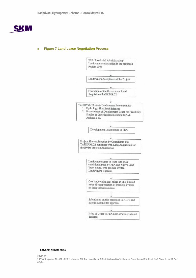
FEA, with the Government land Acquisition Task Force, has been in negotiation with Mataqali since 2003, initially for development leases to investigate and survey the sites, and then for construction and occupation. Details of the consultation are provided in Section 12. The process to date is illustrated in Figure 7.
Nadarivatu Hydropower Scheme - Consolidated EIA
SINCLAIR KNIGHT MERZ
PAGE 22 I:\LTKA\Projects\LT01069 - FEA Nadarivatu EIA Reconsolidation & EMP\Deliverables\Nadarivatu Consolidated EIA Final Draft Client Issue 22 Oct 07.doc
Figure 7 Land Lease Negotiation Process

Nadarivatu Hydropower Scheme - Consolidated EIA
SINCLAIR KNIGHT MERZ
I:\LTKA\Projects\LT01069 - FEA Nadarivatu EIA Reconsolidation & EMP\Deliverables\Nadarivatu Consolidated EIA Final Draft Client Issue 22 Oct 07.doc PAGE 23
Temporary development leases were secured in 2004 for two years. The permanent land lease agreement being reached currently is for construction and operation, and includes both a rental based on occupied area, and a royalty payment based on kilowatt hours sold by the scheme. Rentals will be reviewed every five years and royalty payments every ten years.
4.10 Principal Environmental and Social Issues with the Project Downstream changes to flow, habitat and sediment processes in the Ba and Sigatoka Rivers.
Large temporary construction workforce causing risks to villagers and village life.
Land leases and compensation to Mataqali.

Nadarivatu Hydropower Scheme - Consolidated EIA
SINCLAIR KNIGHT MERZ
PAGE 24 I:\LTKA\Projects\LT01069 - FEA Nadarivatu EIA Reconsolidation & EMP\Deliverables\Nadarivatu Consolidated EIA Final Draft Client Issue 22 Oct 07.doc
5. Baseline Environmental Data
5.1 Introduction This section characterises the physical and social environment in which the development will take place. The information provided here forms the basis on which the impacts of the project have been assessed.
5.2 Environmental Setting The project is located on the Nadrau plateau on Viti Levu. The plateau rises steeply from the pacific coast to elevations of over 1,000 m. The topography of the plateau is characterised by rolling to steep mountainous terrain dissected by deeply incised rivers, creeks and gorges. The roads, settlements, grazing and gardening are generally located on the rolling ridgelines, and the river gorges are generally bush clad and uninhabited.
Figure 8 Image of Nadrau Plateau looking north east to Nabiaurua Creek, Ba headwaters
The Sigatoka and Ba Rivers, and their tributaries, drain the west and south flanks of the plateau. In the vicinity of the proposed project the topographical relief is over 600 m, from the Ba River (El. 200+/- m) to the top of Lewa ridge (El.800+/- m) dividing the Qaliwana and Ba watershed.

Nadarivatu Hydropower Scheme - Consolidated EIA
SINCLAIR KNIGHT MERZ
I:\LTKA\Projects\LT01069 - FEA Nadarivatu EIA Reconsolidation & EMP\Deliverables\Nadarivatu Consolidated EIA Final Draft Client Issue 22 Oct 07.doc PAGE 25
The river valleys in the plateau are typically notched or V-shaped. Side slopes are formed by a sequence of vertical cliffs and steep slopes, separated by more gentle slopes and near-horizontal benches. The shapes of the valleys and slopes have been formed by weathering of volcanic and sedimentary formations, faulting and large-scale land slides and slumps.
5.3 Geology and Soils The geology of the Nadrau plateau consists of relatively young sedimentary and volcanic rock formations (Miocene and Pliocene periods of the Tertiary era). The scheme lies entirely within the Ba Group, which can be subdivided into the following three formations:
Vatukoro Greywacke - medium to fine-grained sedimentary rocks derived from volcanic debris; predominantly sandstone, siltstone, tuff, and breccia.
Nukunuku Volcanics - basalt and volcanic breccia.
Intrusive Rocks – monzonite and mafic sills (created from intrusions of molten magma cooled after eruption within sedimentary and volcanic formations).
The soils in the Qaliwana, Lewa and Ba River areas are Navai clay loam, Nadarivatu red-brown clay and the Nadarivatu brown clay, primarily derived from the volcanic and sedimentary bedrock. Large blocks of basalt “float” are scattered throughout the topsoils and are frequently exposed on the surface or at the base of steep slopes.
Alluvial materials occur in the channels of rivers and creeks as shallow deposits of well-rounded gravels, cobbles and boulders of basalt up several meters in diameter.
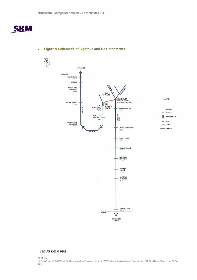
5.4 Hydrology Water will be diverted from the Sigatoka River to the Ba River. The Sigatoka River flows from the Nadrau Plateau to the south coast of Viti Levu. The Ba River flows parallel to the Sigatoka River from Nadrau Plateau to the south before flowing northward to the north coast of Viti Levu. The catchments are illustrated in the schematic in Figure 9.
Nadarivatu Hydropower Scheme - Consolidated EIA
SINCLAIR KNIGHT MERZ
PAGE 26 I:\LTKA\Projects\LT01069 - FEA Nadarivatu EIA Reconsolidation & EMP\Deliverables\Nadarivatu Consolidated EIA Final Draft Client Issue 22 Oct 07.doc
Figure 9 Schematic of Sigatoka and Ba Catchments
Nadarivatu Hydropower Scheme - Consolidated EIA
SINCLAIR KNIGHT MERZ
I:\LTKA\Projects\LT01069 - FEA Nadarivatu EIA Reconsolidation & EMP\Deliverables\Nadarivatu Consolidated EIA Final Draft Client Issue 22 Oct 07.doc PAGE 27
5.4.1 Data Hydrological data for the Nukunuku, Qaliwana, and the Ba has been interpreted by MWH from a combination of rainfall and recorded flow data to estimate inflow to the proposed weir for scheme utilisation. Flow data for both creeks was obtained for the period of 1981-1992 and 2004-early 2005. Rainfall-runoff modelling was used to generate a stream flow time series from 1990-1999. To be consistent with the design of the scheme, the data used by MWH has been accepted as the baseline hydrology for the impact assessment.
No flow or rainfall data was obtained for the Ba catchment so a synthetic stream flow time series was generated based on the data generated for the Qaliwana Creek. For more information on the data, refer to Appendix G.
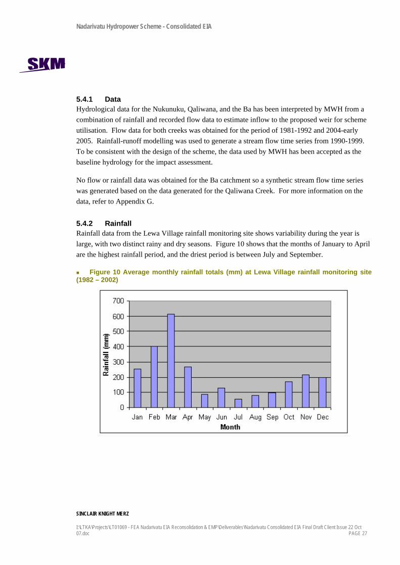
5.4.2 Rainfall Rainfall data from the Lewa Village rainfall monitoring site shows variability during the year is large, with two distinct rainy and dry seasons. Figure 10 shows that the months of January to April are the highest rainfall period, and the driest period is between July and September.
Figure 10 Average monthly rainfall totals (mm) at Lewa Village rainfall monitoring site (1982 – 2002)

Nadarivatu Hydropower Scheme - Consolidated EIA
SINCLAIR KNIGHT MERZ
PAGE 28 I:\LTKA\Projects\LT01069 - FEA Nadarivatu EIA Reconsolidation & EMP\Deliverables\Nadarivatu Consolidated EIA Final Draft Client Issue 22 Oct 07.doc
5.4.3 Sigatoka River Hydrology The Sigatoka River has a catchment area of approximately 530 km2. The headwaters of the Sigatoka catchment comprises of two tributaries flowing north to south: the Nukunuku Creek with a catchment area of 19.2 km2; and the Qaliwana Creek with a catchment area of 54.9 km2. They meet at the Korolevu weir. The catchment upstream of the Korolevu weir is approximately 7.6% of the Sigatoka River flow.
The Qaliwana and Nukunuku catchments are typical highland, headwater creeks, characterised by:
High flow variability due to short, steep catchments and regular large rainfall events.
High flood peak flows because of very intense rainfall, steep catchments, and limited infiltration from clay soils.
Rapid drop in river flow during times of no rainfall, because of the steep catchment, the underlying rock is fractured and so water seeps into the ground, and because there is little inflow from the surrounding ground to provide ‘base-flow’.
Low minimum flows occurring relatively frequently, although for limited duration.
Using the 1981-1992 flow data, the natural minimum flow in the Sigatoka River at the confluence of the two creeks is approximately 0.2m3/s.
The mean flows are much greater than the median flows, which is typical for high elevation catchments with high intensity rainfall.
5.4.4 Ba River The Ba River has a catchment area of approximately 45 km2 and flows in a north to south direction upstream of the proposed discharge from the Ba Power Station. Downstream of the discharge the river turns to flow in a north-west direction to the north coast of Viti Levu and the Ba Passage. The catchment upstream of the power station is approximately 5% of the total Ba River flow.
The Ba behaves in a similar way to the Nukunuku and Qaliwana, but has a larger catchment and therefore has slightly more flow and takes longer for flood flows to recede than the other two.
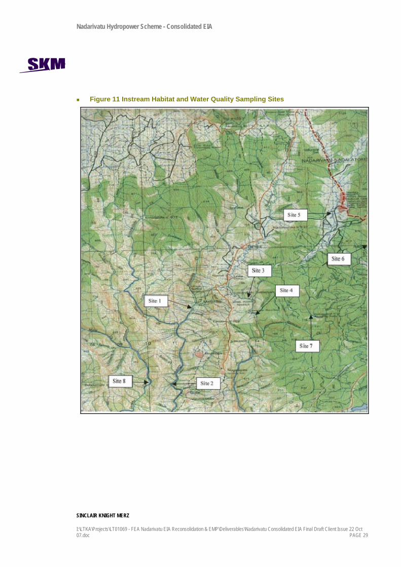
5.5 Water Quality Three field surveys were undertaken between 2004 and 2006 to determine baseline water quality. The sites are shown in Figure 9 and described in Table 5. The sites were chosen to represent upstream control sites and downstream impact sites for the proposed weir and power station. A separate control site away from the scheme was used at Savatu Creek.
Nadarivatu Hydropower Scheme - Consolidated EIA
SINCLAIR KNIGHT MERZ
I:\LTKA\Projects\LT01069 - FEA Nadarivatu EIA Reconsolidation & EMP\Deliverables\Nadarivatu Consolidated EIA Final Draft Client Issue 22 Oct 07.doc PAGE 29
Figure 11 Instream Habitat and Water Quality Sampling Sites

Nadarivatu Hydropower Scheme - Consolidated EIA
SINCLAIR KNIGHT MERZ
PAGE 30 I:\LTKA\Projects\LT01069 - FEA Nadarivatu EIA Reconsolidation & EMP\Deliverables\Nadarivatu Consolidated EIA Final Draft Client Issue 22 Oct 07.doc
Table 5 Description of instream habitat and water quality sampling sites
Catchment Site No.
Purpose and Description of Monitoring Site
Savatu Creek 8 CONTROL: Savatu Creek access from Drala
1 UPSTREAM: Marou Village (above proposed power station) Ba River
2 IMPACT: Drala Village (below proposed power station)
Nukunuku Creek 3 UPSTREAM: Above hydrological station (approximately 1km above proposed Korolevu Weir and intake)
Qaliwana Creek 7 UPSTREAM: 50m above hydrological recording station (approximately 1km above proposed Korolevu Weir and intake)
Sigatoka River 9 IMPACT: Below confluence with Nukunuku and Qaliwana Creeks (approximately 200m below proposed Korolevu Weir and intake)
Samples were taken and analysed for a range of general parameters, nutrients, cations, anions and trace metals. Details are included in Appendix D. For the majority of sites and parameters, water quality was good, and typical of highland, headwater catchments (based on New Zealand and Australian water quality guidelines, ANZECC, 2000).
A number of minor exceedences of ANZECCC guideline values were observed particularly at the Koro village site. Water quality is similar to that in the neighbouring Monasavu and Wailoa catchments4.
5.6 Sediment flux The main sources of sediment in the head waters are instream gravels and sand. Very little erosion or exposed land surfaces are noticeable in the catchments, nor are there any major earthworks or extractive industries, except for small scale forestry, that provide sediment sources to the rivers. Therefore, sediment inputs and sediment transport is primarily associated with rainfall events and increased stream flow in the Sigatoka and Ba head waters, where velocities increase to the point where sediment is dislodged from the stream bed and from land in the catchment.
No data exists for catchment sediment flux for this project. MWH (2007) has estimated an annual average sediment flux through the Sigatoka River at the point of the reservoir at 800,000m3/yr, based on comparisons with the adjacent Monasavu catchment.
Nadarivatu Hydropower Scheme - Consolidated EIA
SINCLAIR KNIGHT MERZ
I:\LTKA\Projects\LT01069 - FEA Nadarivatu EIA Reconsolidation & EMP\Deliverables\Nadarivatu Consolidated EIA Final Draft Client Issue 22 Oct 07.doc PAGE 31
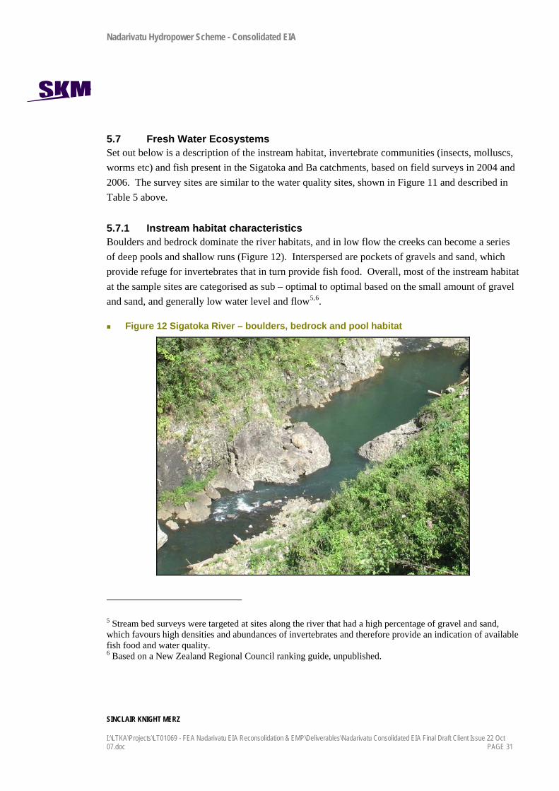
5.7 Fresh Water Ecosystems Set out below is a description of the instream habitat, invertebrate communities (insects, molluscs, worms etc) and fish present in the Sigatoka and Ba catchments, based on field surveys in 2004 and 2006. The survey sites are similar to the water quality sites, shown in Figure 11 and described in Table 5 above.
5.7.1 Instream habitat characteristics Boulders and bedrock dominate the river habitats, and in low flow the creeks can become a series of deep pools and shallow runs (Figure 12). Interspersed are pockets of gravels and sand, which provide refuge for invertebrates that in turn provide fish food. Overall, most of the instream habitat at the sample sites are categorised as sub – optimal to optimal based on the small amount of gravel and sand, and generally low water level and flow5,6.
Figure 12 Sigatoka River – boulders, bedrock and pool habitat
5 Stream bed surveys were targeted at sites along the river that had a high percentage of gravel and sand, which favours high densities and abundances of invertebrates and therefore provide an indication of available fish food and water quality. 6 Based on a New Zealand Regional Council ranking guide, unpublished.
Nadarivatu Hydropower Scheme - Consolidated EIA
SINCLAIR KNIGHT MERZ
PAGE 32 I:\LTKA\Projects\LT01069 - FEA Nadarivatu EIA Reconsolidation & EMP\Deliverables\Nadarivatu Consolidated EIA Final Draft Client Issue 22 Oct 07.doc
The presence of periphyton (algae) growth at the majority of sites is ranked as ‘marginal’ or ‘poor’ because periphyton was visible, obvious and prolific and covered much of the substrate at the time. This indicates long periods of low or no flow, and a supply of nutrients that feed the algae. Prolific periphyton can smother habitats for fish and insects and is undesirable.
Densities and number of taxa for invertebrates overall are moderately high at all sites, showing high diversity which is beneficial to fish and indicates good quality water. Where habitat conditions are optimal, such as at sites in Qaliwana Creek (upstream site), Nukunuku Creek (downstream impact site) and Savatu Creek (control site), mayflies and caddisflies dominate; species which are typically most sensitive to changes in habitat and water quality, and are good fish food. Where habitat conditions are sub optimal to marginal such as in the Ba River (upstream site) and Nadala Creek, the fauna was dominated by flies, moths, leeches and worms which are less ideally suited species for fish food and can tolerate lower quality water.
A total of six species of freshwater fish were identified by a variety of methods (including spotlighting, hand-lining, netting, and electro-fishing). Four of the six species are native, are widely distributed throughout the Fijian freshwater systems and are not at threat or endangered. The other two fish species are introduced; tilapia and eastern mosquito fish, and are also abundant throughout Fiji. Villager interviews identified a further eight species that may also be present. Overall no endemic or endangered species were identified, and the fish resources are unremarkable.
5.8 Land-based Ecosystems Terrestrial ecology surveys, including vegetation, birds, mammals, amphibians and reptiles, were carried out by the Institute of Applied Science (IAS), Fiji, and summarised in IAS (2004). Overall, the diversity of the native flora for the proposed development sites is relatively low compared to similar intact forest systems elsewhere in Fiji.
5.8.1 Vegetation / Land Cover Four sites were surveyed in the general area of the scheme:
Site 1. Confluence of Tubunabeka Creek and Ba River (near the power station)
Site 2. Nukunuku Creek
Site 3. Nadala Creek
Site 4. Qaliwana Creek
Nadarivatu Hydropower Scheme - Consolidated EIA
SINCLAIR KNIGHT MERZ
I:\LTKA\Projects\LT01069 - FEA Nadarivatu EIA Reconsolidation & EMP\Deliverables\Nadarivatu Consolidated EIA Final Draft Client Issue 22 Oct 07.doc PAGE 33
Plant species composition varies distinctly between sites. There is a general trend in land cover on the plateau of dense forest to the east, thinning out to grassland to the west. This pattern is generally attributed to the climatic conditions getting drier to the west and to the higher population density, easier access and higher levels of clearance of forest for timber and grazing to the west.
Table 6 presents a summary of the types of species that were identified at each site and are discussed in the sections below.
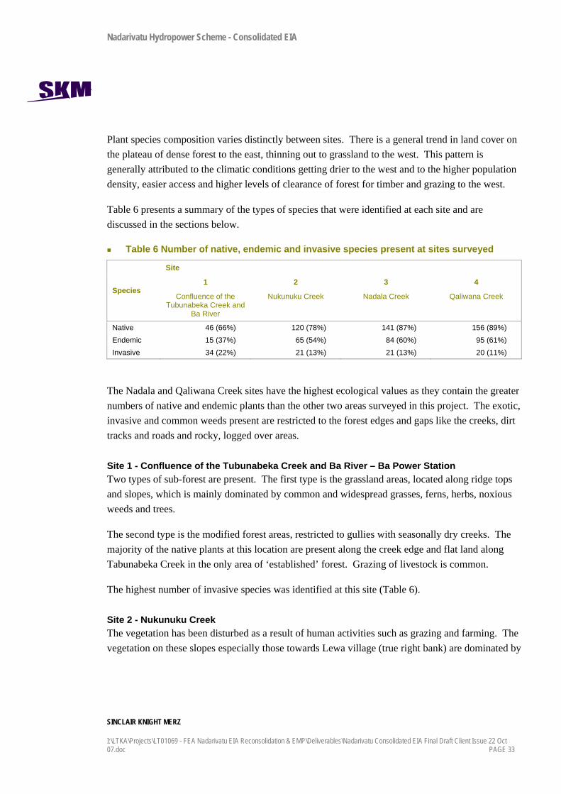
Table 6 Number of native, endemic and invasive species present at sites surveyed
Site
Species 1
Confluence of the Tubunabeka Creek and
Ba River
2
Nukunuku Creek
3
Nadala Creek
4
Qaliwana Creek
Native 46 (66%) 120 (78%) 141 (87%) 156 (89%) Endemic 15 (37%) 65 (54%) 84 (60%) 95 (61%) Invasive 34 (22%) 21 (13%) 21 (13%) 20 (11%)
The Nadala and Qaliwana Creek sites have the highest ecological values as they contain the greater numbers of native and endemic plants than the other two areas surveyed in this project. The exotic, invasive and common weeds present are restricted to the forest edges and gaps like the creeks, dirt tracks and roads and rocky, logged over areas.
Site 1 - Confluence of the Tubunabeka Creek and Ba River – Ba Power Station Two types of sub-forest are present. The first type is the grassland areas, located along ridge tops and slopes, which is mainly dominated by common and widespread grasses, ferns, herbs, noxious weeds and trees.
The second type is the modified forest areas, restricted to gullies with seasonally dry creeks. The majority of the native plants at this location are present along the creek edge and flat land along Tabunabeka Creek in the only area of ‘established’ forest. Grazing of livestock is common.
The highest number of invasive species was identified at this site (Table 6).
Site 2 - Nukunuku Creek The vegetation has been disturbed as a result of human activities such as grazing and farming. The vegetation on these slopes especially those towards Lewa village (true right bank) are dominated by
Nadarivatu Hydropower Scheme - Consolidated EIA
SINCLAIR KNIGHT MERZ
PAGE 34 I:\LTKA\Projects\LT01069 - FEA Nadarivatu EIA Reconsolidation & EMP\Deliverables\Nadarivatu Consolidated EIA Final Draft Client Issue 22 Oct 07.doc
common pasture species, shrubs and trees. On the true left bank, although grazing occurs, the vegetation tends to be more forested and is dominated by trees. This site has the highest number of naturalised and invasive plants of the four surveyed, which is likely to be due to the level of local farming and livestock husbandry activities.
Site 3 - Nadala Creek The vegetation is typical of that which has been intensively logged as evidenced by the absence of very large trees greater than 50 cm diameter at breast height (dbh). Logging of mature pines occurred in the area approximately 10 years ago. The presence of noxious and invasive species is indicative of the floristically degraded nature of the area, which is primarily due to extensive vegetable farming and livestock grazing.
The creek flats are dominated by invasive, common species. The creek edge and slopes above the flood line tends to be dominated by more endemic and native species.
Site 4 - Qaliwana Creek This creek is the most forested of the three creek systems assessed. The forest cover along the slope is closed and two distinctive canopies are evident with shrub species dominating the understorey. The forest is relatively intact and native tree species are well represented. Overall, tree sizes are small (dbhs ranging from 30cm to 40cm) with occasional larger specimens. The creek flats are dominated by common, invasive weeds.
The least number of naturalised and invasive species (11% (20 species)) were recorded at this site (Table 6).
Rare and Endangered Species A review of the Fiji National Biodiversity Strategy and Action Plan (BSAP) (BSAP, 1998) identified 42 rare and threatened plants vascular plant species that were considered to have the potential to be present in the habitat in the proposed development area. These species were identified as requiring immediate conservation measures by national government to ensure their protection (BSAP, 1998, in IAS, 2004).
None of these species were identified in the surveys.

Nadarivatu Hydropower Scheme - Consolidated EIA
SINCLAIR KNIGHT MERZ
I:\LTKA\Projects\LT01069 - FEA Nadarivatu EIA Reconsolidation & EMP\Deliverables\Nadarivatu Consolidated EIA Final Draft Client Issue 22 Oct 07.doc PAGE 35
5.8.2 Birds and Mammals A total of 35 species of birds were recorded in the field surveys, of which eighteen species are native and thirteen are endemic. Eight species of mammal was recorded, of which two are native.
In all sites introduced mammals (mongoose, cats, cattle and horses) are plentiful and are likely to be a key reason for the low diversity of native birds in the area.
Approximately 20 bird species were recorded from Tabunabeka Creek (Buyabuya Village) and approximately 30 species at both the Lewa and Qaliwana sites. All the species recorded are common in any forest or bush in Viti Levu with the exception of the two threatened species (giant forest honey eater and masked-shining parrot) that were identified in the Nukunuku and Nadala / Qaliwana localities. There was anecdotal evidence from locals of the existence of the rare or endangered peregrine falcon and the red-throated lorikeet in the area but they were not seen in the survey.
The Samoan flying fox was identified at the majority of the sites and is significant as it is listed by the IUCN as vulnerable.
5.8.3 Amphibians and Reptiles Of the five species found, two are endemic (the Fiji tree frog and Pygmy snake-eyed skink), two are native (barred tree skink and the skink-toed gecko) and one introduced (House gecko). The pygmy snake-eyed skink to date has only been recorded as a coastal species. This is the first confirmed inland record. It was not in an area likely to be affected by the development.
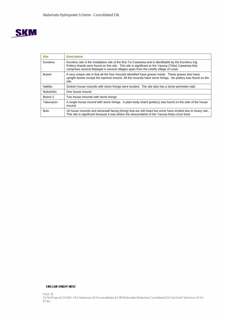
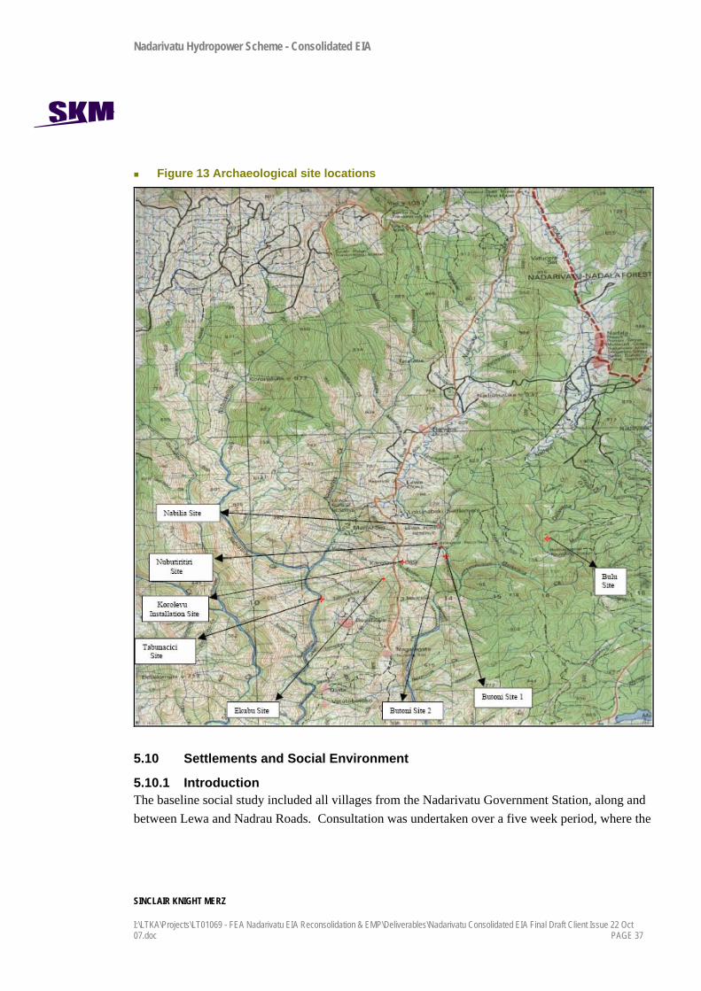
5.9 Physical Cultural Property / Archaeological Sites An archaeological survey conducted by the Fiji Museum involved site identification, surface surveying, site mapping and the recording of Oral Tradition. Eight sites were identified and surveyed during this field survey. The sites surveyed are listed in Table 7 and detailed in Figure 13. The full Fiji Museum report is attached in Appendix H. The most important sites for this project are Nubutiritiri, Butoni and Butoni 2, which are adjacent to the Nukunuku Creek, but upstream of the extent of flooding from the Korolevu Weir.
Table 7 Summary of archaeological sites
Site Description
Ekubu House mounds. The site is significant to the Ekubu Mataqali members who are residing in Lewa, Marou and Buyabuya villages. The Ekubu clan members moved and resided on this site from Navinoti after the installation ceremony of the first Tui Cawanisa at Korolevu was conducted.
Nadarivatu Hydropower Scheme - Consolidated EIA
SINCLAIR KNIGHT MERZ
PAGE 36 I:\LTKA\Projects\LT01069 - FEA Nadarivatu EIA Reconsolidation & EMP\Deliverables\Nadarivatu Consolidated EIA Final Draft Client Issue 22 Oct 07.doc
Site Description
Korolevu Korolevu site is the installation site of the first Tui Cawanisa and is identifiable by the Korolevu trig. Pottery shards were found on this site. This site is significant to the Yavusa (Tribe) Cawanisa that comprises several Mataqali in several villages apart from the chiefly village of Lewa.
Butoni A very unique site in that all the four mounds identified have graves inside. These graves also have upright stones except the topmost mound. All the mounds have stone linings. No pottery was found on the site.
Nabilia Sixteen house mounds with stone linings were located. The site also has a stone perimeter wall.
Nubutiritiri One house mound.
Butoni 2 Two house mounds with stone linings.
Tabunacici A single house mound with stone linings. A plain body shard (pottery) was found on the side of the house mound.
Bulu 18 house mounds and stonewall facing (lining) that are still intact but some have eroded due to heavy rain. This site is significant because it was where the descendants of the Yavusa Nubu once lived.
Nadarivatu Hydropower Scheme - Consolidated EIA
SINCLAIR KNIGHT MERZ
I:\LTKA\Projects\LT01069 - FEA Nadarivatu EIA Reconsolidation & EMP\Deliverables\Nadarivatu Consolidated EIA Final Draft Client Issue 22 Oct 07.doc PAGE 37
Figure 13 Archaeological site locations
5.10 Settlements and Social Environment
5.10.1 Introduction The baseline social study included all villages from the Nadarivatu Government Station, along and between Lewa and Nadrau Roads. Consultation was undertaken over a five week period, where the

Nadarivatu Hydropower Scheme - Consolidated EIA
SINCLAIR KNIGHT MERZ
PAGE 38 I:\LTKA\Projects\LT01069 - FEA Nadarivatu EIA Reconsolidation & EMP\Deliverables\Nadarivatu Consolidated EIA Final Draft Client Issue 22 Oct 07.doc
consultant lived in the villages and undertook a series of interviews with different people in the villages. Transcripts are provided in Appendix E.
Since the inception of the planning phase of the scheme in 2003, the FEA Lands Department has operated a Task Force Group, which includes FEA staff, CEO’s of government ministries and representatives from the villages and settlements. The Task Force Group was set up to negotiate access to land, land leases, compensation and to discuss other needs and issues of the locals. The Task Force members have been very cooperative and there has been positive feedback to date regarding the scheme and the process of negotiations.
This section outlines the contemporary living conditions, social organisation, economy and infrastructure in the study area.
5.10.2 Villages, Settlements, Housing and Social Organisation The local residents live in villages and settlements, dispersed widely along the two roads that run along the ridges of the Nadrau Plateau.
In rural areas Fijians traditionally live together in villages called koros whereas Indo Fijians live individually on their farms. But now due to increase in population and pressures of modern living, Fijians too are moving out of koros to live in small settlements on their farms. This phenomenon is quite evident from the number of settlements in the project area.
The houses in the villages are of mixed type. The traditional bure is increasingly being replaced by modern building materials. The roofs are made up of corrugated iron sheets. Sawn timber is used as the framework. The wall is either of timber or corrugated iron sheets. The floor could be of dirt, timber or in some cases concrete and the rafters are exposed.
However, in villages like Koro, Buyabuya and Marou one can still find some bure houses. Traditional construction materials are used such as un-sawn timber, bamboo, grass and reeds. Sometimes a combination of traditional and modern materials is used in building houses.

Nadarivatu Hydropower Scheme - Consolidated EIA
SINCLAIR KNIGHT MERZ
I:\LTKA\Projects\LT01069 - FEA Nadarivatu EIA Reconsolidation & EMP\Deliverables\Nadarivatu Consolidated EIA Final Draft Client Issue 22 Oct 07.doc PAGE 39
Figure 14 Buyabuya Village
Even the village community bures are built using modern building materials. It is not uncommon to find community halls with roofing iron, walls of corrugated iron sheets, and concrete flooring.
The traditional Fijian organisation is still prevalent to a large extent in the villages but communal living is increasing yielding place to family centred living. This is because of modern economic pressures where every need has to be paid for such as education, health care, transportation, water, electricity, housing, food, household goods, etc.
In the context of a family in traditional Fijian villages, women and men have distinct roles. The health, education, social, and spiritual needs of children are looked after by mothers. Women also cook, wash, clean and are engaged in household chores. They fetch firewood, draw water, and when time permits they work in the food gardens. Women are also involved in taking farm produce to the market and doing weekly shopping for groceries and other family needs. Women also devote their time to social and cultural obligations.
In the project area men are involved in subsistence activities as well as cash generating activities. The food gardens are generally initiated by men that include clearing the land, burning the scrub, ploughing, digging and preparatory cultivation. The care of the livestock, which includes bullocks
Nadarivatu Hydropower Scheme - Consolidated EIA
SINCLAIR KNIGHT MERZ
PAGE 40 I:\LTKA\Projects\LT01069 - FEA Nadarivatu EIA Reconsolidation & EMP\Deliverables\Nadarivatu Consolidated EIA Final Draft Client Issue 22 Oct 07.doc
and dairy animals, rests with men. Almost daily, after breakfast, men and sometimes women go and work on their food gardens. By noon they return home with garden produce, have lunch, rest and in the afternoon, if there are no social obligations, they go back to the farm.
However, the extended family system is still common to some extend. It is not uncommon to find parents, grown-up children, married, and unmarried brothers living under the same roof. The next higher level of organisation to family is tokatoka. A number of tokatokas form a mataqali (clan) - the land owning unit. The head of a mataqali is known as turaga ni mataqali. A number of mataqalis form a yavusa (tribe). The head of yavusa is called turaga ni yavusa (chief).
Turaga ni Mataqali, Turaga ni Yavusa and Turaga ni Tikina are traditional titles which are acquired by accession on passing away of an incumbent. These titles, especially the higher ones, are increasingly being disputed or unresolved.
The formal and administrative point of contact in a village is Turaga ni Koro. They should be first contacted before any involvement with a village. The position of Turaga ni Koro is administrative and any one can be elected to the position by consensus. The position is rotated periodically.
5.10.3 Water supply For drinking, cooking, washing, bathing, and watering animals the villagers use either river water or spring water. All villages have access to spring water. During dry months the springs can dry up and families supplement their needs with river water.
Water is conveyed to the village by PVC pipes. Some villages have tanks to store water while others construct a small reservoir at the source. In the case of Marou village, a natural spring of excellent quality water flows through the village.
5.10.4 Energy sources For cooking and heating the predominant source of energy is firewood. Open fire cooking is prevalent. Kerosene and gas is occasionally used for cooking by some households. Gas cylinders are bought from Tavua.
The villages with reticulated power supply are Naiyaca, Lewa, Nagatagata, Nadala, Navai, and Nadrau. A pre-paid card system is used to pay for electricity. Cards are available locally; there is one outlet in Lewa and another in Nadala village. For lighting the households in these villages use electric bulbs or tube lights.
Nadarivatu Hydropower Scheme - Consolidated EIA
SINCLAIR KNIGHT MERZ
I:\LTKA\Projects\LT01069 - FEA Nadarivatu EIA Reconsolidation & EMP\Deliverables\Nadarivatu Consolidated EIA Final Draft Client Issue 22 Oct 07.doc PAGE 41
Villages in the project area that do not have reticulated power supply are Koro, Drala, Buyabuya, and Marou.
5.10.5 Subsistence Activities Subsistence activities form an integral and important part of the rural economy. Root crops such as dalo, dalo ni tana, sweet potato, cassava, yams, etc. are grown for daily consumption. These crops traditionally form part of the diet called kakana dina. These staples are supplemented by vegetables traditionally known as i-coi. A wide variety of vegetables are grown including cabbage, bele, rourou, tubua, baigan, chillies, tomato, carrot, bell pepper, etc. The flood plains of Nadala and Navai are fertile and especially suited for growing vegetables.
Tree crops and fruit are cultivated. Fruit trees commonly grown include papaya, citrus, breadfruit, jackfruit, plantain, mango and vudi.
Small livestock are also raised for subsistence. These include poultry, pigs, and in some cases ducks. Some farmers keep dairy cows as well. Bullocks are kept for draft purposes.
Wild fruit are gathered in season. Hunting wild pigs with pack of dogs is a favourite pastime for some villagers. On the hills surrounding the villages of Marou, Buyabuya and Koro villagers in small groups occasionally hunt wild goats and bulls.
Men and women both go fishing in the rivers and waterways that flow through the project area, however it is not a large component of their lifestyle or diet and they are not dependant on the local fish resources as primary sources of protein. Line, net and spear fishing are the methods employed to catch fish. According to the villagers, some sections of the Ba River, especially near Koro village, serve as the nursery ground for fish breeding and certain pools serve are reserved for fishing on special occasions only.
5.10.6 Economic activities An average family earns about $FJ5000 to $FJ7000 per annum.
Farming is a common economic activity for majority of the households in the project area. People grow crops mentioned above for subsistence as well as for market. They consume whatever they can and the surplus is sold in Tavua market.
Every village has at least one village store which caters to the daily needs of the villagers. The stores stock processed and packaged goods which have a long shelf life since refrigeration is not

Nadarivatu Hydropower Scheme - Consolidated EIA
SINCLAIR KNIGHT MERZ
PAGE 42 I:\LTKA\Projects\LT01069 - FEA Nadarivatu EIA Reconsolidation & EMP\Deliverables\Nadarivatu Consolidated EIA Final Draft Client Issue 22 Oct 07.doc
available. Goods sold include, among others, rice, flour, sugar, tea, biscuits, canned fish, canned meat, salt, kerosene, soap, detergent and cigarettes.
Operating a carrier service is an economic activity that generates cash income for some families. Generally the carrier operators are from the villages of Nadala and Navai. They service the villages along Lewa and Nadrau roads. On Tuesdays and Fridays the carriers ply between the villages and Tavua town, the main shopping centre.
Bee keeping and honey extraction is a recent enterprise. Since there is a large forage space, honey business appears to be lucrative. One litre of honey is sold for $10 to $12.
Livestock are also bartered or sold for cash in the villages. Other items which people sell for cash include tabua, mats, and handicrafts.
5.10.7 Roading and Traffic Two major roads service the area. Lewa Road starts from Nadarivatu Junction and ends at Koro village. Nadrau Road begins at Nadarivatu Junction and passes through Yauyau to Nadrau village. The roads are not sealed, and access is by four wheel drive vehicles or by carriers during fair weather only. Landslides and slips are common during wet weather, blocking vehicle access.
A bus service operates only between Tavua town and Waikubukubu village. Because of the poor condition of road, bus operators refuse to provide service beyond Waikubukubu. Private carrier fares are relatively expansive; a return fare Koro-Tavua is $16, Nagatagata-Tavua is $14, and Lewa- Tavua is $12. It costs around $60 to $70 to hire a carrier from Koro village to Tavua town.
None of the roads have footpaths and hence they are used by both vehicle and foot traffic. Due to the large distances between villages and to the coastal towns, there is minimal pedestrian traffic outside the villages themselves. Larger distances are travelled by catching a carrier ride and sometimes on horseback, however children may walk some distance daily to and from schools.
A traffic survey was undertaken on a Tuesday and Friday from 6:30am to 5:30pm to determine the existing level of traffic adjacent to the site. Local residents advised that these were the two busiest days for traffic movement in the area. Carrier trucks are the most common type of vehicle on the road, and Fiji Pine is currently the largest single user of the roads.
Nadarivatu Hydropower Scheme - Consolidated EIA
SINCLAIR KNIGHT MERZ
I:\LTKA\Projects\LT01069 - FEA Nadarivatu EIA Reconsolidation & EMP\Deliverables\Nadarivatu Consolidated EIA Final Draft Client Issue 22 Oct 07.doc PAGE 43
5.10.8 Media and Communications Radio is the most popular means of mass media in the area. Some people have video or DVD players. Tapes and discs are hired from shops in Tavua. There is an RT radio transmitter communication service in the area. Each village has a few EasyTel landline phones. Most parts of the project area are beyond the reach of the mobile phone network.
5.10.9 Public Offices and Services Tavua is the main service centre for the residents of the project area. Only a few government departments with skeletal staff are present at the Nadarivatu Government Station. For most civil registrations such as births, deaths, and marriages people have to travel to Tavua.
There is one health centre at Nadarivatu and two nursing stations; one at Nagatagata village and another at Nadrau village. The health centre is staffed by a nurse medical practitioner and a staff nurse, the former sharing her time between Tavua hospital and Nadarivatu. Most of the primary health care needs are delivered from the health centre and nursing stations but patients are referred to Tavua for medical emergencies and serious health problems.
There is no police station or post at Nadarivatu. The area comes under the jurisdiction of Tavua Police Station. There appears to be no serious law and order problems in the area. Village life is still regulated by Fijian protocol and every day conflicts are resolved through traditional mechanisms.
5.11 Summary The following is a summary of the key sensitive environmental and social parameters in the development area.
5.11.1 Environmental Parameters in the Qaliwana / Nukunuku Catchment The land cover at the weir and intake site, and the reservoir, is a mix of invasive weed species
along the margins of the creeks, and shrub and forest cover on the steep sided catchments. No significant flora was identified during the surveys.
The nearest village is Lewa, approximately 6km from the weir site, and above the creek on the Nadrau Plateau.
The hydrology of the creeks represents a steep low base flow river that responds quickly to rainfall and consequently drops quickly. Peak flows can be very high compared to normal base flow.
Nadarivatu Hydropower Scheme - Consolidated EIA
SINCLAIR KNIGHT MERZ
PAGE 44 I:\LTKA\Projects\LT01069 - FEA Nadarivatu EIA Reconsolidation & EMP\Deliverables\Nadarivatu Consolidated EIA Final Draft Client Issue 22 Oct 07.doc
IUCN threatened listed giant forest honey eater and masked-shining parrot were found during surveys, along with the Samoan flying fox, listed as vulnerable.
No significant amphibians or reptiles were identified near the weir site.
River habitats were predominantly boulders and bedrock, and ranked ‘optimal’ to ‘sub-optimal’, with some periphyton / algae growth and a moderate diversity of invertebrates. No endemic, rare or endangered fish species were identified.
Six archaeological sites were located within the Nukunuku catchment and Butoni 2 is adjacent to the creek, upstream of the maximum extent of the weir reservoir.
5.11.2 Environmental Parameters in the Ba Catchment The area around the proposed power station and tunnel portal is predominantly grassland with
livestock grazing the common land use. Some forested areas exist in the steeper gullies. There was no significant flora identified at this site.
Buyabuya village is very close to the power station and tunnel portal sites, adjacent to the Ba River, and will effectively be the ‘host’ community. The river is used by villagers for fishing, emergency water supply and amenity uses (food preparation, cleaning etc).
The hydrology of the river represents a steep low base flow river that responds quickly to rainfall and consequently drops quickly. Peak flows can be very high compared to normal base flow.
No rare or threatened bird species were observed, which is indicative of the lack of good available habitat.
River habitats were boulders and bedrock, and ranked ‘sub-optimal’, with limited periphyton / algae growth and a moderate diversity of invertebrates. No endemic or endangered fish species were identified.
5.11.3 Social and Economic Context The villages and settlements in the development area are low in population density and the people are indigenous Fijians, with a mix of subsistence and low income livelihoods. The host communities for the scheme are primarily Lewa village near the Korolevu Weir and Buyabuya village at the Ba Power Station.
Traditional social values and customs are still in practice. The villages are supported by government funded health care and education. Road access is via four wheel drive or carrier trucks, as the road is windy, steep and unsealed. Traffic is very low, and the road is shared with pedestrians, horses and livestock. Only parts of area are electrified.

Nadarivatu Hydropower Scheme - Consolidated EIA
SINCLAIR KNIGHT MERZ
I:\LTKA\Projects\LT01069 - FEA Nadarivatu EIA Reconsolidation & EMP\Deliverables\Nadarivatu Consolidated EIA Final Draft Client Issue 22 Oct 07.doc PAGE 45
The main service town is Tavua, approximately two hours drive from Lewa village.
The rivers are not used by many people, as access into the steep valleys is very difficult. The rivers are not navigable and do not provide the primary source of protein. Domestic water supplies are taken from springs rather than the rivers, and there is no irrigated agriculture until the coastal plains.

Nadarivatu Hydropower Scheme - Consolidated EIA
SINCLAIR KNIGHT MERZ
PAGE 46 I:\LTKA\Projects\LT01069 - FEA Nadarivatu EIA Reconsolidation & EMP\Deliverables\Nadarivatu Consolidated EIA Final Draft Client Issue 22 Oct 07.doc
6. Environmental Impacts
6.1 Introduction The effects on the environment are distinctly different during construction and operation. Construction related effects are primarily erosion, and sediment and other contaminant-laden discharges to the water ways, affecting water quality. During operation, the primary effects are around the changes in the flow regime in the Ba and Sigatoka Rivers, that potentially impact on river habitat, sediment transport, water quality and riparian groundwater levels.
6.2 Construction Effects
6.2.1 Erosion / loss of soil Earthworks will contribute to a large amount of soil movement around the development site as some sites are cleared and others are built up or modified. The erosion risk is considered high given the steep topography, high and intense rainfall, scale of earthworks and the characteristics of the overburden in the area (easily erodeable).
The loss of soil is not considered to be of significant importance because the scale, methods and location of the proposed construction works, the low productivity value of the soils and the lack of economic uses for soil at the development sites currently.
The management controls to reduce soil erosion and protect soils will be detailed in the construction environmental management plans. The mild temperatures and regular rainfall will assist in rehabilitation of sites through rapid plant establishment. Overall the soil resources in the area should not be adversely affected.
6.2.2 Sediment Discharges to Sigatoka and Ba Rivers The key potential impact is sediment discharges in both river systems. The potential impacts associated with increased sediment loads in water bodies are well documented (ARC 1996; Waters 1995). Sediment can affect habitat and aquatic organisms while in suspension in the water and as deposited material on the streambed and banks (Table 8).
Table 8 Potential impacts to water courses due to sediment disturbance during construction
Mechanisms Response Stream Impacts
Site clearance Instream works
Runoff with Increased suspended solids
Reduced water clarity and appearance. Reduced light penetration causing reduced primary
productivity (reducing food and habitat amount for

Nadarivatu Hydropower Scheme - Consolidated EIA
SINCLAIR KNIGHT MERZ
I:\LTKA\Projects\LT01069 - FEA Nadarivatu EIA Reconsolidation & EMP\Deliverables\Nadarivatu Consolidated EIA Final Draft Client Issue 22 Oct 07.doc PAGE 47
Mechanisms Response Stream Impacts
Road construction Spoil sites Tunnel spoils discharges.
concentrations. invertebrates, fish and birds), and reduced nutrient processing during photosynthesis.
Reduced numbers of aquatic invertebrates due to downstream drift.
Bank scour and instability. Asphyxiation / damage to gills of fish and the mouth parts
of filter feeders. Reduced visibility and avoidance behaviour by fish,
interfering with migration, feeding and breeding. Reduced water quality for horticulture, rural and stock
water supplies and other water uses. Changes in water temperature.
Increased deposition of fine material.
Smothered plants / periphyton, reducing primary production and ability of grazers to feed.
Loss of habitat for fish to lay eggs and adverse impacts on the ability for fish eggs to reach maturity.
Reduced ability for fish to feed on benthic invertebrates. Changes to stream channel, bank shelter and water depth
and flow by forming bars and filling pools increasing channel flooding potential.
Source of sediment for re-suspension and transport downstream, leading to further deposition.
The decomposition of sediment inputs with a high organic matter content can deoxygenate the waters, resulting in fish / invertebrate kills.
Smothering of gravel / cobble substrates can reduce the interstitial habitat for invertebrates. This can result on changes to the number and type of invertebrates species present from sensitive to more tolerant species such as worms. This, in turn, can lead to a change in fish populations due to loss of preferred food species.
The extent of any impact and the ability of the habitat to recover from the deposition of fine material depends on the following key factors:
The natural substrate and existing quality of the habitat.
The presence or absence of sensitive invertebrate and fish species.
The extent of sediment deposits from existing sources such as stock access, stream bank erosion, and vegetation clearance.
The duration of earthworks and the amount of exposed land in the catchment at any one time.
Climatic conditions and the seasonal timing of earthworks.
The volumes of sediment and size of particle.
The ability of the stream to flush out the deposited material which depends on the channel characteristics and the size of the catchment.
The presence of fish and invertebrates within the catchment to recolonise the habitat.

Nadarivatu Hydropower Scheme - Consolidated EIA
SINCLAIR KNIGHT MERZ
PAGE 48 I:\LTKA\Projects\LT01069 - FEA Nadarivatu EIA Reconsolidation & EMP\Deliverables\Nadarivatu Consolidated EIA Final Draft Client Issue 22 Oct 07.doc
It will be impossible to avoid discharges and disturbances of fine sediments into the water courses. However, a number of mitigation measures are proposed to assist in minimising the impacts of sedimentation during construction (refer Section 9 and Environmental Management Plan).
High concentrations of suspended sediment (and / or low clarity) could possibly cause avoidance behaviour in some of the fish species present. A key mitigation measure is the staging of works to ensure that small sections of catchment are affected at any one time and that there are tributaries within the catchment for fish to move into during any pulses of suspended solids that may occur.
Consistent with the situation that occurs currently, high concentrations are only expected during storm events or when there are upper catchment disturbances that increase sediment loads, and clarity would quickly return to background levels. Therefore, the effects are considered to be temporary and consistent with that which occurs naturally. The existing aquatic ecosystems (including invertebrate, fish and algae) are already adapted to these short term increases in sediment loads.
Sediment deposition is likely to have a short-term, minor impact due to:
The limited presence of pollution-sensitive invertebrate species over the project area.
The somewhat sub-optimal nature of much of the instream habitat.
The retention of riparian vegetation adjacent to the watercourses where possible to act as a buffer zones to assist in trapping sediments before reaching the watercourse, along with other erosion mitigation measures during earthworks.
The natural frequent occurrence of short term, higher velocity flows to 'flush' the system.
The ability of the watercourses to be re-colonised by fish and invertebrates from above and below the disturbed sites.
The temporary nature of the construction works.
The lack of remarkable or sensitive fish species that would be affected by sediment.
6.2.3 Tunnel construction and dewatering The construction of the tunnel will involve dewatering operations as the tunnel is expected to intersect water seeps within the rock and then form a conduit for that water to flow out to the surface. The extent of dewatering required is unknown based on preliminary geotechnical investigations, and so adaptive management is required during the construction process to control the dewatering process. The tunnel drainage will contain crushed rock material and products such as concrete and nitrates from explosives residues. Particles of pollutants will be entrained in any

Nadarivatu Hydropower Scheme - Consolidated EIA
SINCLAIR KNIGHT MERZ
I:\LTKA\Projects\LT01069 - FEA Nadarivatu EIA Reconsolidation & EMP\Deliverables\Nadarivatu Consolidated EIA Final Draft Client Issue 22 Oct 07.doc PAGE 49
resulting drainage waters and any discharge of these to the river could cause adverse effects on the ecology.
The main mitigation option available is to provide settlement ponds at the exit of the tunnel portals prior to discharge to the river. These would be prior to discharge to the Sigatoka and Ba Rivers. These should be sized appropriately for the incoming flows and particle sizes to deposit the majority (75%) of incoming suspended sediments. Settlement ponds should be designed to contain all the incoming waters. Consideration should be given to settlement methods such as the use of flocculants if necessary.
The operation and management regime for these features should be identified in the Construction and Workers Camp Management Plan in the Environmental Management Plan.
6.3 Operational Effects
6.3.1 Hydrological Changes The operation of the Nadarivatu Hydropower Scheme gives rise to the following key changes to the flow regimes of the Sigatoka and Ba catchments:
A decrease in the mean flow of the Sigatoka River, and a residual flow below the Korolevu Weir of 0.2m3/s for most of the year. It will result in extended periods of stable, low flow (at or near the residual flow of 0.2m3/s) punctuated by flushing flows resulting from periods of high rainfall.
At median flow in the Sigatoka River this results in a 7% decrease at the river mouth.
An increase in the mean flow of the Ba catchment.
A maximum increase in flow at any time in the Ba River of 15m3/s. At median flows, this is equal to 100% increase in flows at the river mouth. At a median power station discharge and median river flow, this is equal to a 10% increase in flows at the river mouth.
During low flow periods the Ba River will experience a daily pattern of increased flows in the anytime between 8am and 8pm, from the power station discharge.
The following sections describe the effects of the scheme on flows in the Sigatoka and Ba rivers.
6.3.1.1 Sigatoka River Figure 15 illustrates the impact of the proposed scheme on the Sigatoka River downstream of the proposed weir using data from 1994 to 1995. The dark hydrograph shows the natural river flow
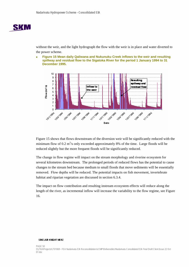
Nadarivatu Hydropower Scheme - Consolidated EIA
SINCLAIR KNIGHT MERZ
PAGE 50 I:\LTKA\Projects\LT01069 - FEA Nadarivatu EIA Reconsolidation & EMP\Deliverables\Nadarivatu Consolidated EIA Final Draft Client Issue 22 Oct 07.doc
without the weir, and the light hydrograph the flow with the weir is in place and water diverted to the power scheme.
Figure 15 Mean daily Qaliwana and Nukunuku Creek inflows to the weir and resulting spillway and residual flow to the Sigatoka River for the period 1 January 1994 to 31 December 1995.
Figure 15 shows that flows downstream of the diversion weir will be significantly reduced with the minimum flow of 0.2 m3/s only exceeded approximately 8% of the time. Large floods will be reduced slightly but the more frequent floods will be significantly reduced.
The change in flow regime will impact on the stream morphology and riverine ecosystem for several kilometres downstream. The prolonged periods of reduced flows has the potential to cause changes to the stream bed because medium to small floods that move sediments will be essentially removed. Flow depths will be reduced. The potential impacts on fish movement, invertebrate habitat and riparian vegetation are discussed in section 6.3.4.
The impact on flow contribution and resulting instream ecosystem effects will reduce along the length of the river, as incremental inflow will increase the variability to the flow regime, see Figure 16.
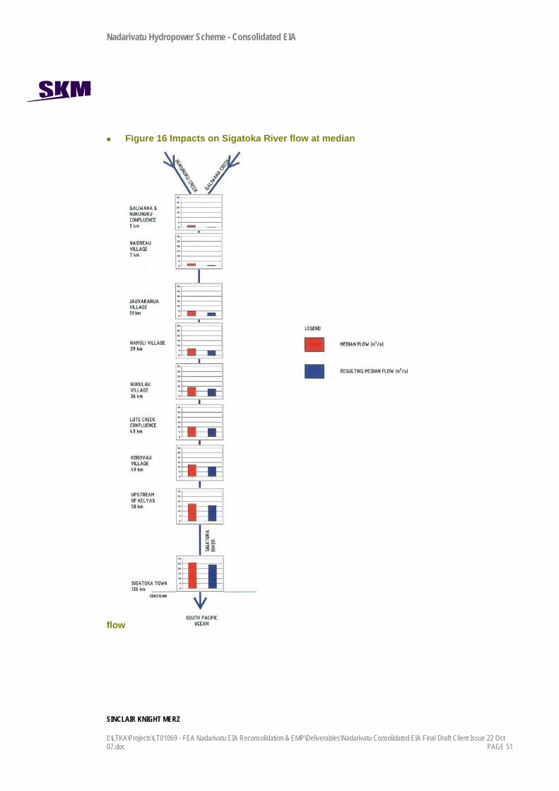
Nadarivatu Hydropower Scheme - Consolidated EIA
SINCLAIR KNIGHT MERZ
I:\LTKA\Projects\LT01069 - FEA Nadarivatu EIA Reconsolidation & EMP\Deliverables\Nadarivatu Consolidated EIA Final Draft Client Issue 22 Oct 07.doc PAGE 51
Figure 16 Impacts on Sigatoka River flow at median
flow

Nadarivatu Hydropower Scheme - Consolidated EIA
SINCLAIR KNIGHT MERZ
PAGE 52 I:\LTKA\Projects\LT01069 - FEA Nadarivatu EIA Reconsolidation & EMP\Deliverables\Nadarivatu Consolidated EIA Final Draft Client Issue 22 Oct 07.doc
At the coast the impact will be negligible. The flow is decreased by 7%, which wouldn’t be noticeable to most river users and would not have a measurable impact on riparian or instream habitat or sedimentation.
6.3.1.2 Ba River Figure 17 shows the average daily natural Ba River flows (the light hydrograph) together with modified average daily flows (the dark hydrograph) as a result of the proposed scheme discharge for the 1994 to 19957 year. The plot shows that flows will be elevated for five or six out of every seven days because it is not planned to generate every day. Furthermore, generation generally will only be part of the day so the actual increase in flow due to generation will be higher than the average for the day (maximum 15 m3/s).
Figure 17 Mean daily Ba River flow and modified flow for the period 1 January 1994 to 31 December 1995.
The duration of increased flows in the Ba River relative to the natural flows immediately downstream of the powerhouse is increased. The impact of the elevated flows will decrease downstream because incremental inflow will become less relative to the natural flow. In the reach immediately downstream of the powerhouse discharge impacts on the stream morphology and
7 Estimated from rainfall data and correlation to Sigatoka catchment flow data.

Nadarivatu Hydropower Scheme - Consolidated EIA
SINCLAIR KNIGHT MERZ
I:\LTKA\Projects\LT01069 - FEA Nadarivatu EIA Reconsolidation & EMP\Deliverables\Nadarivatu Consolidated EIA Final Draft Client Issue 22 Oct 07.doc PAGE 53
riverine ecosystems could be significant. The increased flows could result in significant erosion of the river bed and reshaping of the channel. The increased flows could also impact on the in-stream habitat and riparian vegetation.
The impact of the addition of median flows from the powerhouse (approximately 3m3/s) to the Ba River on the flow downstream is shown in Figure 18.
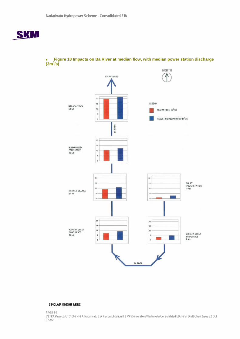
Nadarivatu Hydropower Scheme - Consolidated EIA
SINCLAIR KNIGHT MERZ
PAGE 54 I:\LTKA\Projects\LT01069 - FEA Nadarivatu EIA Reconsolidation & EMP\Deliverables\Nadarivatu Consolidated EIA Final Draft Client Issue 22 Oct 07.doc
Figure 18 Impacts on Ba River at median flow, with median power station discharge (3m3/s)

Nadarivatu Hydropower Scheme - Consolidated EIA
SINCLAIR KNIGHT MERZ
I:\LTKA\Projects\LT01069 - FEA Nadarivatu EIA Reconsolidation & EMP\Deliverables\Nadarivatu Consolidated EIA Final Draft Client Issue 22 Oct 07.doc PAGE 55
At the power station, there is an approximate 200% increase in median flow. The degree of change in flow reduces as you travel downstream, to an increase of only 10% at Nalaga town at the river mouth. This effect wouldn’t be noticeable to most river users and would not have a measurable impact on riparian or instream habitat or sedimentation.
In order to describe the maximum possible impact on flows in the Ba River, the same calculation was done to find the percentage increase in median river flows as a result of a maximum powerhouse discharge of 15m3/s8. The village of Navala, approximately 24km downstream, could potentially see a 200% increase in median river flow during these times. Overall, in the Ba River at Nalaga town (62km downstream), there is potential for median flow to double during times when the scheme is operated continuously at full capacity for an extended duration (ie discharging for enough time that the pulse of water is noticed at the coast). These figures do not imply a doubling of the median flow for the Ba River, rather that the natural median flows will be doubled for the small amount of the time annually when the powerhouse is operating at maximum capacity.
Because the scheme is ‘run of river’ due to limited storage, the worst case scenario described above will not occur often, as maximum power station discharges are likely to occur during high flows or receding flows in the Ba River, where extra flow in the river will have less effect. During low flow, the power station is more likely to run at a lower capacity and discharge less water per second.
Starting Generation and the Discharge Pulse One advantage of hydropower generation when managing supply to the national electricity grid is that start-up and shut-down times are short. However, the disadvantage is that flow in the river can change rapidly with no warning given to downstream users of the river. The impact on downstream users will relate to the change in water depth, velocity and inundated width of the river. The proposed discharge from the Ba Powerhouse will have an effect on river depths. The scale of effect in terms of overall rise of water levels and the timing of a maximum 15 m3/s generation “pulse” down the Ba River has been estimated using topographical maps and simple hydrology.
The effect of the flow pulse would occur at Navala village (approx. 24km downstream of the Ba powerhouse) about 5 hours after the discharge commenced. This is illustrated in Figure 19.
8 Results table is provided in Appendix G.

Nadarivatu Hydropower Scheme - Consolidated EIA
SINCLAIR KNIGHT MERZ
PAGE 56 I:\LTKA\Projects\LT01069 - FEA Nadarivatu EIA Reconsolidation & EMP\Deliverables\Nadarivatu Consolidated EIA Final Draft Client Issue 22 Oct 07.doc
Figure 19 Estimated changes in river depths and travel time for discharge pulse, Ba River
At rates of rise less than 2 m/hour, the water level rise should not pose any threat to in-stream water users. There is ample time in most cases for users of the river to be aware of an increase in flow, and enable safe exit of the river as appropriate. At the Ba powerhouse, much sharper rises may be
Nadarivatu Hydropower Scheme - Consolidated EIA
SINCLAIR KNIGHT MERZ
I:\LTKA\Projects\LT01069 - FEA Nadarivatu EIA Reconsolidation & EMP\Deliverables\Nadarivatu Consolidated EIA Final Draft Client Issue 22 Oct 07.doc PAGE 57
experienced, and at this site, suitable measures may be taken to warn river users of flow variability, particularly the residents of Buyabuya village.
6.3.2 Riparian Groundwater Levels
6.3.2.1 Sigatoka Catchment Inspection of the 1:250,000 topographical map of Fiji has shown potential riparian aquifers located adjacent to the Sigatoka River downstream of Kelyas (57.7km downstream of the Qaliwana and Nukunuku confluence). These riparian aquifers are likely to a decline in the water table level adjacent to the river, assuming a direct connection between the aquifer and the river. This decline is unlikely to have any significant impacts on existing groundwater users.
6.3.2.2 Ba Catchment Inspection of the 1:250,000 topographical map of Fiji has shown potential riparian aquifers located adjacent to the Ba River downstream of Hiniku Creek confluence (28.7km downstream of the power station). These riparian aquifers are likely to show a slight increase in the water table level adjacent to the river, assuming a direct connection between the aquifer and the river.
6.3.3 Changes to Natural Sediment Regime
6.3.3.1 Sigatoka Catchment Reservoir flushing and sluicing is expected to be carried out during flood events greater than approximately 40m3/s and at least six times per year (average flood event of 90m3/s). The sluice gates will pass the majority of flows, including residual flows, which will help to shift sediment through the river system at low and moderate flows, at near natural rates.
It is unlikely that during flood events, any measurable impact of sediment quality will occur during flushing of the weir. The overall sediment flux and transport mechanisms will be similar to larger floods. However, for low to medium flows and minor freshes, modification of sediment flux through the weir will reduce the sediment in the outgoing stream flow.
To mitigate these effects the scheme construction, including the Korolevu Weir, and effective operation of the weir and water take from the upper Sigatoka River catchment, shall include the following provisions:
Monitoring of sediment quality above, at and below the weir will be undertaken on a six monthly basis during construction and operation of the scheme.
Nadarivatu Hydropower Scheme - Consolidated EIA
SINCLAIR KNIGHT MERZ
PAGE 58 I:\LTKA\Projects\LT01069 - FEA Nadarivatu EIA Reconsolidation & EMP\Deliverables\Nadarivatu Consolidated EIA Final Draft Client Issue 22 Oct 07.doc
The weir sediment sluicing shall coincide with a suitable river input flow of at least 40m3/s. This is approximately the 99th percentile flow, which occurs on average, about 4 days (in duration) per year, and would provide sufficient flushing flows and allow suitable sediment re-distribution below the weir.
6.3.3.2 Ba Catchment Additional flow from the power station, with reduced sediment load due to the settling conditions in the Korolevu Reservoir, will result in more energy in the Ba River to move instream sediment. There is a risk that some bed and bank erosion or destabilisation could occur as a result. Because of the boulder and bedrock nature of the river bed for several kilometres downstream of the power station, this is not considered to be a significant effect on river geomorphology or water quality.
6.3.4 Surface Water Quality and Ecology
6.3.4.1 Sigatoka River The key impacts relating to the operation of the weir potentially relate to changes in stream ecology and the quality of water downstream of the weir due to the extended periods of low flow and the direct loss of stream habitat beneath the footprint of the weir and associated infrastructure, and the upstream area inundated by the water body.
Water Quality The potential impacts on water quality relate to the size and operating regime of the reservoir, including the inundation of vegetation and the effects from decomposition. The effects are considered minor, as follows:
As a ‘run of river’ scheme, the residence time of water behind the weir will be short, limiting the time for chemical reactions or stagnation to occur.
The water body behind the weir when full will not be typically deep over its length and will be long and narrow, stretching up the Nukunuku and Qaliwana Creeks. This reduces the potential for stratification of oxygen and temperature in the reservoir, and the penetration of light, that can change water chemistry.
It is anticipated that it will be full for approximately 8% of the time and when it is full it will not exceed the natural flood levels in the creek bed. The highly variable lake levels and potentially rapid draw down times further decreases the likelihood that the water within the reservoir will become stratified resulting in anoxic conditions.

Nadarivatu Hydropower Scheme - Consolidated EIA
SINCLAIR KNIGHT MERZ
I:\LTKA\Projects\LT01069 - FEA Nadarivatu EIA Reconsolidation & EMP\Deliverables\Nadarivatu Consolidated EIA Final Draft Client Issue 22 Oct 07.doc PAGE 59
Sluicing of sediments behind the weir will be timed to coincide with floods when sediment loads are naturally high. This means there should not be large releases of sediment laden water when the rest of the river is in low flow, low turbidity conditions.
Ecology The potential changes relate to the creation of a new water body behind the weir and the impacts of the existing biological communities downstream of the weir following the reduction in flow.
The habitat, including the wetted area, of the new water body will be highly variable due to the fact that the water levels will vary so dramatically over short periods of time due to the limited storage capacity.
The potential impacts on aquatic ecology are considered as follows:
Below the weir it is possible that benthic algae or periphyton cover will be more prolific for longer periods during the low flow conditions. Flood flows below the weir will still have the capacity to remove nuisance algae growths, they will just be less frequent.
Reduction of instream habitat for macroinvertebrate colonisation and fish below the weir due to a reduction in wetted channel area particularly along the varial zone (river channel edge).
It is likely that ecological impacts will extend for some kilometres downstream. Figure 16 presents a comparison of median flows for the proposed weir with the median flow for distances downstream on the Sigatoka River. It is not until Jauvakarua, 21km downstream, that flows would be considered similar to the natural flow.
A number of mitigation measures will be documented in the Environmental Management Plan to assist in minimising the impacts of the weir on the downstream aquatic environment.
In addition, it is anticipated that the potential impacts will be minimised due to the following factors:
A flow of 0.2m3/s will be maintained as a residual discharge (unless flows are less than this entering the weir) for 90% of the time (the discharge will be greater for higher input flows above 15.2m3/s). It is anticipated that this flow should be sufficient to maintain a similar ecological community that currently exist downstream.
The fish fauna in the Qaliwana Creek are not rare, endangered, endemic and are not abundant.
The habitat supporting macroinvertebrate communities at sites located above and below the weir structure is limited and the communities present are not considered to be particularly
Nadarivatu Hydropower Scheme - Consolidated EIA
SINCLAIR KNIGHT MERZ
PAGE 60 I:\LTKA\Projects\LT01069 - FEA Nadarivatu EIA Reconsolidation & EMP\Deliverables\Nadarivatu Consolidated EIA Final Draft Client Issue 22 Oct 07.doc
sensitive to changes in water quality. No species of any particular ecological concern were identified.
Due to the flashiness of the existing flows, existing habitat for macroinvertebrates in the varial zone is expected to be limited.
Direct Loss of Habitat The weir and spillway structures will occupy a small area of stream channel and banks (approximately 0.2 ha). The habitat lost consists primarily of several large pools which although potentially provide refuge for fish, is not considered to be a very productive part of the creek due to the lack of gravels and cobbles for insect (fish food) refuge. Given the amount of pool habitat available further downstream, the loss of habitat is minor and is not considered to be significant overall.
6.3.4.2 Ba River The key potential impacts of the discharge of the water taken from the Qaliwana and Nukunuku Creeks relate to changes in:
water quality, due to the introduction of water from the adjacent catchments and the increase in flows; and
stream ecology, including fish and macroinvertebrate communities, due to the potential changes in water quality and the introduction of water from adjacent catchments.
These are addressed in detail below.
Water Quality The potential physical and chemical changes in water quality that could occur downstream of the discharge from the power station are dependent on:
The quality of water in Korolevu Weir and in the Ba River at the time of the discharge.
The amount of finer deposited material downstream of the power station at the time of discharge.
Overall, the potential impacts relating to changes in water quality are anticipated to be minimal due to the following:
The three catchments (Nukunuku, Qaliwana and Ba) lie in very close proximity to each other and have very similar characteristics in terms of land-use, rainfall received, etc. Any changes in water quality that may occur due to an increase in rainfall such as changes in suspended

Nadarivatu Hydropower Scheme - Consolidated EIA
SINCLAIR KNIGHT MERZ
I:\LTKA\Projects\LT01069 - FEA Nadarivatu EIA Reconsolidation & EMP\Deliverables\Nadarivatu Consolidated EIA Final Draft Client Issue 22 Oct 07.doc PAGE 61
solids and turbidity, temperature changes, nutrient and trace metal contents, etc would be similar in each of the three water bodies.
The location of the power station and discharge is area that is characterised by bedrock with little or no fine material in the immediate vicinity. It is unlikely that any local material will become entrained.
Ecology The extent of the hydrological influence in the Ba River is significant during receding and median river flows and maximum scheme discharge flows. The potential impacts relate to the increase in flow and the possible changes in water quality downstream of the discharge. The key potential impacts are as follows:
A reduction in the benthic algae or periphyton due to increased water velocities.
Changes in the fish species and macroinvertebrate communities to species better adapted to increased flows and the changes in habitat related to the different hydrological regime.
An increase in the amount of habitat available for macroinvertebrate communities and fish due to an increase in the wetted channel area particularly along the varial zone.
A number of mitigation measures are proposed to assist in minimising the impacts of the dam on the downstream aquatic environment. In addition, it is anticipated that the impacts will be minimised due to the following factors:
The operational criteria in terms of the amount of water discharged to the Ba River will ensure that the increase in flows are unlikely to be ecologically significant.
The maximum flows discharged will not exceed the highest flows experienced in the river.
The ramping up and down of flows discharged from the power station to the stream will allow fish to avoid higher flows by moving into tributaries or refuge areas within the river itself.
The fish fauna in the Ba River, like the adjacent creeks, is characterised by low species diversity. No species of any particular ecological concern were identified in studies.
Prawns were also identified as being a source of food for local villagers. It is unlikely that the increase in flow will significantly impact on the abundance of this crustacea.
The macroinvertebrate community at sites located above and below the dam structure is not considered to be particularly sensitive to changes in water quality. No species of any particular ecological concern were identified.

Nadarivatu Hydropower Scheme - Consolidated EIA
SINCLAIR KNIGHT MERZ
PAGE 62 I:\LTKA\Projects\LT01069 - FEA Nadarivatu EIA Reconsolidation & EMP\Deliverables\Nadarivatu Consolidated EIA Final Draft Client Issue 22 Oct 07.doc
Abundance of algae such as periphyton may decrease or be confined to slower areas of reach as a result of the increases in flow velocities. This could result in a decrease in the levels of oxygen levels produced through photosynthesis, but overall is perceived as a positive impact as the flows will to prevent algal build-up to nuisance levels.
Surveys have shown that the fish species present are common throughout all catchments. In addition, fish screens at the intake will reduce adult fish. Juveniles may pass through uninjured.
6.3.5 Terrestrial Ecology No critical natural habitats or species will be directly or indirectly affected by the project. The majority of vegetation clearance and inundation will be of shrubs and grassland consisting extensively of naturalised species, and creek flats dominated by invasive weed species and the effects are considered less than minor.
Three key protected fauna species are present in the wider area; the giant forest honeyeater (threatened status), masked-shining parrot (vulnerable status) and Samoan flying fox (vulnerable status) but are not at not at risk from the scheme.

Nadarivatu Hydropower Scheme - Consolidated EIA
SINCLAIR KNIGHT MERZ
I:\LTKA\Projects\LT01069 - FEA Nadarivatu EIA Reconsolidation & EMP\Deliverables\Nadarivatu Consolidated EIA Final Draft Client Issue 22 Oct 07.doc PAGE 63
7. Socio-economic impacts
7.1 Introduction The total project footprint is quite minimal and this project is low impact. There will be no resettlement of villages or dwellings, nor will the scheme affect or inundate agricultural or productive land in the catchment. The location of the impoundment is remote and several kilometres from the nearest village. Flooding of villages, dwellings or productive land is not a risk upstream or downstream of the weir or power station.
Land acquisition and easement consultation has been extensive agreements with land owners are in the final stages of being signed. Local villagers are fully supportive of the project as it will result in benefits with respect to rural electrification, improved road access and premium and rental payments for the duration of the long term lease. The consultation process carried out by the FEA, the Native Lands Trust Board and local villagers has been long term, consistent and fully participatory.
During construction there will be disruption to village life. This chapter examines both the benefits and adverse impacts that are likely to eventuate from the project proposal, based on consultation that was undertaken for the EIA and through the land lease negotiation process.
7.2 Attitudes and perceptions With regard to this project, the attitude and perceptions of the residents are influenced to some extent by the Monasavu Hydropower Scheme development in the 1980’s, in the neighbouring catchment. There was no consultation at the time of Monasavu, and consequently no community inputs into the project. It is acknowledged by the communities that the Task Force meetings and social impact assessment work has contributed greatly to the community being involved in the process and being kept informed.
Though residents have some reservations and concerns about the present project, they are not against it, and feedback has generally been positive and cooperative to date. The residents do perceive that the project would result in loss of certain natural amenities but they realise that these can be balanced with the benefits from the scheme.
The identity of an indigenous Fijian and his or her visceral attachment to vanua is an emotive and sensitive issue. This is reflected in the fact that every Fijian house has (or used to have) a name, every Fijian knows the mataqali to which he or she belongs, and the Tikina and Yasana he / she

Nadarivatu Hydropower Scheme - Consolidated EIA
SINCLAIR KNIGHT MERZ
PAGE 64 I:\LTKA\Projects\LT01069 - FEA Nadarivatu EIA Reconsolidation & EMP\Deliverables\Nadarivatu Consolidated EIA Final Draft Client Issue 22 Oct 07.doc
hails from. Furthermore, Fijians, especially those living in rural areas, have close attachment to their ancestors and their ancestral artefacts such as burial grounds, koro makawa, ceremonial and coronation sites of yore, cultural and traditional icons, sacred sites, etc. The need to protect and preserve them was emphasised during consultation.
The residents hold certain social norms and values close to their hearts. They would like outside workers to follow Fijian village protocol and be sensitive to traditional village life.
7.2.1 Employment and local economic impacts Initial figures indicate that up to 180 workers will be employed on the project. The landowners and other residents in the area have asked for first preference for jobs, particularly the unskilled positions. Recruitment for skilled jobs will depend upon qualification, experience and availability of personnel. However, for unskilled jobs a broad policy of recruiting from locals first will be adopted. Employment will be managed by the contractors and they will be required to have an office where jobs can be advertised and locals can seek work. Work will also be advertised through the villages through word of mouth.
The main benefits of the project to the villagers include cash employment and income earning opportunities through provision of goods and services. With increased cash income the families are expected to improve their standard of living in terms of housing, household goods and appliances, tools and implements, education, sanitation and hygiene, etc. This was experienced in the Monasavu area.
There is also value in the opportunity to learn and improve skills. The community is likely to be enriched by skill transfer and by training on the job.
7.2.2 Sites of Cultural and Traditional Importance The need to preserve cultural artefacts and traditional landmarks which includes old village sites (koro makawa), burial ground of ancestors, coronation grounds of high chiefs, mataqali identities, etc was emphasised, especially by elders. There will be no destruction or inundation of any sites identified by Fiji Museum and if any sites, remains or artefacts are found during construction, a procedure will be invoked to protect them.
7.2.3 Increase in Workforce Population and Work Camp Related Issues One of the key impacts perceived by the residents during construction of the scheme is the management of the worker’s camps and the related issues with an influx of people into the district.
Nadarivatu Hydropower Scheme - Consolidated EIA
SINCLAIR KNIGHT MERZ
I:\LTKA\Projects\LT01069 - FEA Nadarivatu EIA Reconsolidation & EMP\Deliverables\Nadarivatu Consolidated EIA Final Draft Client Issue 22 Oct 07.doc PAGE 65
They can demand on services and resources in the district, bring unwanted extra people into the area, and can interrupt traditional lifestyles and customs. Many people worked on the Monasavu project, and shared negative and positive experiences during consultation and are wary of transient work forces.
The temporary workers will require retail services, security services, health facilities, law enforcement and resources to deal with accidents and emergencies. There is concern by the residents that present infrastructure such as roads and communications, and services such as health care, is not adequate to meet the requirements of the influx of workers and that the villagers will suffer as a result. This can be mitigated to an extent by ensuring the worker’s camps are self sufficient in terms of power, water supply and other infrastructure and services.
Intrusion on Traditional Lifestyles A change in the population demographics is anticipated due to an influx of predominantly young males of Fijian, Fijian Indian and foreign nationalities. There is a concern also that the workforce could bring family, prostitutes and other service providers with them, swelling the transient population beyond the workers camp capacity.
People working on the scheme from outside of the district may not be aware of the traditional, semi subsistence lifestyles of the Fijian residents. Issues such as increased noise, invasion of privacy and disrespect for traditions can occur. Residents have asked for tolerance and respect from the contractors and workers to maintain their livelihoods as much as possible during the construction period.
The workforce will be controlled by the contractors, who will be responsible for managing the camp sites, the workers (on and off duty at the camps) and communicating with the villagers regarding workplace risks. Contractors will be required to address the awareness of village protocol and Fijian lifestyle, as well as ensure the camp has suitable infrastructure and services so as not to adversely affect the infrastructure and services of the villages. FEA will have a liaison person at site also, to accept complaints and deal with any issues of the villagers.
Water Supply Water supply for the camps and construction site compounds would be sourced from local small streams. This would be similar to the method of water supplies for villages and settlements in the area. Given appropriate rate of take and storage there should not be an adverse effect of the takes. Potential management options for any impacts associated with water supply could include:
Nadarivatu Hydropower Scheme - Consolidated EIA
SINCLAIR KNIGHT MERZ
PAGE 66 I:\LTKA\Projects\LT01069 - FEA Nadarivatu EIA Reconsolidation & EMP\Deliverables\Nadarivatu Consolidated EIA Final Draft Client Issue 22 Oct 07.doc
Water takes should leave a residual flow in the creek.
Abstraction should be to holding tanks to buffer peak demands.
Consideration should be given to a supply in the Ba catchment that does not adversely affect the Buyabuya village supply. The location of the supply should be discussed and agreed in consultation with the villagers.
Sewage Disposal Sewage effluent will be reticulated into a standardised septic tank treatment system and then the treated effluent disposed to a low-rate dosing land disposal system. Given appropriate choice of treatment and the location of disposal, the adverse effects should be minimal. Sewerage disposal methods should be designed to the standards outlined in the Australia / New Zealand Standard for the Management of On Site Sewage Systems AS/NZ1547: 2000.
Waste Disposal There shall be no burning of waste on site.
All waste shall be removed from site and disposed of at an approved facility (such as a municipal landfill).
There should be no on-site environmental impacts from solid waste disposal.
Decommissioning The villagers would like to see that the camp site is properly decommissioned and rehabilitated. This is a policy of FEA and will be a condition of contract with the contractors.
7.2.4 Gender Analysis and Family Level Impacts In this predominantly subsistence life style, the gender roles are well defined, and much of the time is taken in growing crops and raising livestock to feed the family. There is also some degree of underemployment and considerable leisure activities. This lifestyle is likely to undergo change with the advent of the proposed project. Those employed full time will have to balance their work along side subsistence activities and family welfare. Managing finances may be a new skill to be learnt along side the skills required for construction. All these factors will have to be understood and addressed by villagers as they choose to enter paid employment.
7.2.5 Land Use in the Catchment Area Residents have raised concern about changes to land use and access to land in the catchments upstream of the weir. There will be no change to access to land not permanently inundated or built
Nadarivatu Hydropower Scheme - Consolidated EIA
SINCLAIR KNIGHT MERZ
I:\LTKA\Projects\LT01069 - FEA Nadarivatu EIA Reconsolidation & EMP\Deliverables\Nadarivatu Consolidated EIA Final Draft Client Issue 22 Oct 07.doc PAGE 67
upon as part of the scheme. FEA is not seeking control of catchments. The land lease process is assessing the rents and royalties to compensate land use.
7.2.6 Impacts on infrastructure Along with the concern about competition for infrastructure from the workers camp, there is also concern regarding damage to underground water pipes running close to or across the road, overhead utility wires (telephone or electric), road-side structures etc. from heavy vehicle movements.
Contractors will review infrastructure and service delivery. For example, the roads will need upgrading and maintaining in order to allow access for heavy vehicles. Communication networks will be required for communications between the site and suppliers and contractors in Fiji and abroad.
The overarching policy is for infrastructure to be maintained or repaired to the original state by contractors. Villagers should not be adversely affected, and would benefit from any improvements made to existing infrastructure as a result of the project.
Tunnel Impacts on Spring Drinking Water Residents have asked whether the tunnels would have an impact on aquifers and, more importantly, springs that provide potable water. The tunnel alignment does not interfere with any springs in the vicinity of any of the villages or settlements and will not affect potable water supplies.
7.2.7 Impacts on water and river uses Modified flows in the Sigatoka catchment are most likely to affect the Nadrau and Naga villages. Concerns have been raised in terms of fishing effort and upstream flooding risk. These two concerns of the villagers are discussed in turn.
Loss of fishing in the Sigatoka catchment is a concern of the villagers. Fishing efforts may need to change as a result of the weir being installed, but the mitigating circumstances are:
The reservoir (and the road leading to the reservoir) may improve fishing access, such as the case at Monasavu.
It is acknowledged that villagers travel around the district to go fishing and therefore have many catchments to fish from that will remain unaffected.

Nadarivatu Hydropower Scheme - Consolidated EIA
SINCLAIR KNIGHT MERZ
PAGE 68 I:\LTKA\Projects\LT01069 - FEA Nadarivatu EIA Reconsolidation & EMP\Deliverables\Nadarivatu Consolidated EIA Final Draft Client Issue 22 Oct 07.doc
Flooding of the plains upstream of the scheme was of concern to the villagers, particularly when the scheme involved the Qaliwana dam and a 38 ha reservoir. For the proposed scheme, there is considered little flooding risk in the upper catchments.
Residents in the district, particularly from Buyabuya, Drala, and Koro voiced concerns about increased flows in the Ba River from the scheme discharge. Their concerns related to:
Changes to water quality and the ability to use the river for drinking water.
Flooding.
Safety during river use, and the ability to ford the river, especially near Koro village.
Fishing.
Changes to leisure and recreation amenity.
As discussed in the hydrology sections above, the Ba River will experience changes in river flow velocity and height over the course of a day.
FEA will develop operating systems that allow for a ramping up and down of the scheme to avoid sharp changes in flow in the Ba River. Villagers will be notified of the operating arrangement so that they can manage their river uses accordingly. Because most of the time the scheme will be operating around the median discharge of 1.19 m3/s, the downstream impacts will be minor and should not alter the current river uses of downstream villagers.
The Ba River flooding regime will not be altered as a result of the project. Water quality is not anticipated to impact on the use of river water for potable supply, since changes in water quality in the reservoir are not anticipated to be major and any differences in water characteristics in the discharge will be mitigated during mixing with the Ba River. Fish stocks will not be adversely affected, but their range could change due to an increase in flow. Fishing efforts may change as a result, but total catch should not be affected.
7.2.8 Natural Disaster / Disaster Management The project area residents were concerned of weir structure failure or landslides during the construction phase due to natural disasters or other reasons, and whether the people living downstream would be affected. The residents also questioned whether there would be a disaster response plan.
Weir failure and large scale earth movements are considered by FEA to be very low likelihood, but obviously of high consequence if they were to occur. Extensive geotechnical study work is being

Nadarivatu Hydropower Scheme - Consolidated EIA
SINCLAIR KNIGHT MERZ
I:\LTKA\Projects\LT01069 - FEA Nadarivatu EIA Reconsolidation & EMP\Deliverables\Nadarivatu Consolidated EIA Final Draft Client Issue 22 Oct 07.doc PAGE 69
undertaken to minimise the risk of earth movement during and following construction. Further work in the construction phase will provide the engineers with adequate information to build the weir according to international standards to withstand the risk of failure from floods and earthquakes.
Flood flows are not predicted to behave any differently once the scheme is in place, and there is no requirement for a flood warning system with this scheme.
7.2.9 Communications through the project Locals have asked to stay informed through the project and continue to be involved. Specifically:
Feedback to the community regarding the issues and concerns raised during consultation.
Developing village protocol that could serve as a guideline for outside workers.
Education and orientation of outside workers to Fijian culture and social norms before the start of work.
Awareness and education of groups such as teachers, school children and pedestrians regarding traffic hazards in the project area.
7.3 Traffic Impacts The construction period for the scheme will be between two to three years. During this time there will be a large amount of vehicle movements from Lautoka to the site. Lautoka is the nearest heavy industry centre and international port. Most of the plant and imported materials will need to be brought to the site via Lautoka.
Traffic hazards were one of the concerns that was considered important during community consultation. A perception of the increased size, number and frequency of the vehicles and the present condition of the road was cause for concern. In the case of Naiyaca, Lewa, Nadala, and Navai villages, the present road passes through the villages with homes on either side.
Traffic management will be a key part of the Construction Environmental Management Plan. Traffic cannot be minimised, but can be managed. Potential management options include:
Development of a traffic management plan for the project.
Incorporation of traffic management including potential timing restrictions into site management plans.
Developing speed restrictions where necessary.

Nadarivatu Hydropower Scheme - Consolidated EIA
SINCLAIR KNIGHT MERZ
PAGE 70 I:\LTKA\Projects\LT01069 - FEA Nadarivatu EIA Reconsolidation & EMP\Deliverables\Nadarivatu Consolidated EIA Final Draft Client Issue 22 Oct 07.doc
Identifying site access routes for vehicles and installing safety signage along the main roads at regular intervals.
Through ongoing project communications with the community, notice of traffic movements can be made. It will be up to the village leaders to then communicate to school children, teachers and other road users as necessary.
7.4 Noise and Vibration The main noise and vibration sources during construction would be:
Excavation work including blasting and drilling.
Soil / overburden / vegetation removal with bulldozers.
Equipment and material deliveries by heavy vehicles.
The worker’s camp and personnel transport.
Concrete batching plant operation.
Of these the blasting is liable to be loudest but more infrequent over the construction period. General construction and heavy machinery noise would be significant noise sources and more continuous. Traffic-related noise impacts are likely to be noticed by more people in the area due to the close proximity of the road to the dwellings. This could potentially be managed by timing restrictions on site access, works and the development traffic management plans.
In the Sigatoka catchment, given the low use of the area by people and distance to settlements, there would be minor effects on the local populations as a result of the noise of site activities, and little management would be required.
Within the Ba catchment activities such as blasting and construction noise would be heard at Buyabuya village and the blasting / tunnelling activities may cause vibration within the village. The combined disturbance impacts on the residents of Buyabuya would have the potential to be one of the major impacts on rural village life of the construction period.
Managing the timing of works and site activities, and providing warning systems for blasting, would be the most appropriate management options for the noise producing activities at this site. These management controls should be included in the Construction Environmental Management Plans.

Nadarivatu Hydropower Scheme - Consolidated EIA
SINCLAIR KNIGHT MERZ
I:\LTKA\Projects\LT01069 - FEA Nadarivatu EIA Reconsolidation & EMP\Deliverables\Nadarivatu Consolidated EIA Final Draft Client Issue 22 Oct 07.doc PAGE 71
A key factor of work limitation timing could be that noisy activities are limited to weekday daytime operations and potentially Saturdays. Days of rest for the local communities such as Sundays and religious / state holidays should be observed at least for noise producing or otherwise disturbance producing activities. These controls and restrictions would need to be developed in consultation and agreement with the local village.
Post construction there will be negligible noise sources operating in the area. The system will require little maintenance and as such vehicle movements will be very limited. The power plants and other features including transmission lines will emit low levels of noise that could be heard in the immediate vicinity and these are likely to be as a constant, low background noise emission. Therefore during operation it is likely that noise effects will be minor.
7.5 Economic Impacts Economic impacts of the project are expected to benefit Fiji on a local and national scale. The largest economic impact of the Nadarivatu scheme will occur during construction although there will likely also be some positive operational impacts.
The Construction Impact can be considered in terms of:
Employment Impact: A large amount of employment benefit is expected to be captured by the project area. The maximum number of direct jobs at any one time is approximately 180.
Local demographic impact: During construction a large temporary workforce will enter the region and be accommodated at site camps. Whilst these workers will largely contain there activities to the camps and construction site it is likely that there will be some interaction with local villages including making purchases at village stores and purchasing surplus crops.
Skills acquisition: workers from the project area are currently unskilled, however during construction they will be exposed to modern construction techniques and as a result will acquire additional skills.
The Operational Impact can be considered in terms of:
Diesel fuel reduction: Current levels of diesel consumption for electricity generation require large volumes of diesel to be imported into Fiji every year. This leaves the cost of electricity generation in Fiji highly susceptible to both oil price and exchange rate fluctuations. Construction of the scheme will reduce diesel input requirement by approximately 22,000 tonnes a year.

Nadarivatu Hydropower Scheme - Consolidated EIA
SINCLAIR KNIGHT MERZ
PAGE 72 I:\LTKA\Projects\LT01069 - FEA Nadarivatu EIA Reconsolidation & EMP\Deliverables\Nadarivatu Consolidated EIA Final Draft Client Issue 22 Oct 07.doc
Carbon Emissions: It has been estimated for Fiji that diesel generation produces 0.656 tonnes of carbon emissions per MWh. At this level of abatement, Nadarivatu and the associated ability to run Wailoa more efficiently will reduce CO2 emissions by approximately 66,000 tonnes per year.
Carbon Trading (carbon treaty liability reductions): The Nadarivatu project would have associated carbon credits as Fiji is a signatory to the Kyoto Protocol should the project achieve CDM accreditation permitting carbon trading on the international carbon trading market.
Development of industry is closely linked with the provision of a reliable electricity source. Current electricity supply in Fiji cannot meet demand, leading to brown-outs and the increased reliance on high cost diesel generation. By improving the reliability of the electricity system through adequate supply, Fiji will further the prospects for industry development.
7.6 Physical Cultural Property / Archaeological Sites There will be no damage or inundation of any recorded archaeological site. Any incidental finds will be protected through Chance Finding Procedures in the Environmental Management Plan.
7.7 Land use changes Land use would be lost wherever buildings and structures will occupy land and where inundation will occur from the Korolevu Reservoir. The power station, weir, reservoir and intake structures are on marginal and steep land adjacent to creeks, where there are no productive land uses presently. Social impacts associated with the land use loss have been considered by FEA and land owners during the land lease negotiation processes. The ability for the communities to earn rents and royalties for use of marginal land is considered beneficial to the communities.
Land use in the surrounding catchments should not be affected by construction or operation of the scheme. Hunting and grazing can still occur without disruption, or any loss in range or habitat requirements. As a result of the project there should be more access to new lands for increased utilisation as a result of the new access road development. This is evaluated as a positive social impact.
7.8 Summary The following conclusions on the scheme can be made, taking into account the scheme design, sensitivity of the environment, the needs of the host communities and the predicted impacts:
There will be no inundation of houses, settlements, farms or other productive land uses. There is no requirement to relocate families or communities.

Nadarivatu Hydropower Scheme - Consolidated EIA
SINCLAIR KNIGHT MERZ
I:\LTKA\Projects\LT01069 - FEA Nadarivatu EIA Reconsolidation & EMP\Deliverables\Nadarivatu Consolidated EIA Final Draft Client Issue 22 Oct 07.doc PAGE 73
The reservoir will inundate the river channel margins only, where invasive weed species are most prevalent due to the scouring effects of flood waters. There will be no inundation of mature forest.
The five land owning units (Mataqali) have meaningfully engaged in the land lease process and are in the final stages of signing a permanent lease to allow FEA access to construct and operate the scheme.
The habitats of the giant honeyeater, masked shining parrot and Samoan flying fox will not be affected by construction or inundation.
Discharges of sediment will affect water quality and stream bed habitat immediately downstream of the Ba and Sigatoka Rivers during construction. This will be for the duration of the construction period, and may result in sedimentation but will not have long term effects.
The diversion of water from the Qaliwana and Nukunuku Creeks will create uniformly low river flows downstream in the Sigatoka River. This will affect river flow for at least 12 kilometres, until further flow from other catchments reduces the impact.
Changes to ecosystems and fish populations will be experienced immediately downstream in the Sigatoka River as a result of the low flow periods. This includes more sedimentation and more algae growths, and potentially less fish.
Pulses of water from the power station may affect fording and other river uses downstream in the Ba River. This is minor given that there is low population for several kilometres downstream and low river use.
Changes to erosion and deposition patterns are also expected in the Ba River, but to a minor extent given that the river bed is mainly boulders and bedrock for several kilometres.
Disturbance to traditional village life, and in particular to Buyubuya Village, during construction as a result of the works and influx of workers to the district.

Nadarivatu Hydropower Scheme - Consolidated EIA
SINCLAIR KNIGHT MERZ
PAGE 74 I:\LTKA\Projects\LT01069 - FEA Nadarivatu EIA Reconsolidation & EMP\Deliverables\Nadarivatu Consolidated EIA Final Draft Client Issue 22 Oct 07.doc
8. Analysis of Alternatives There are two key alternatives to the 42MW Nadarivatu Hydropower Scheme, which are discussed in turn in this section:
1) Diesel power generation.
2) Variations on the Nadarivatu Scheme.
As discussed in the introductory sections of this report, ‘do nothing’ is not an acceptable alternative, because even with demand management programmes, the energy demand on Viti Levu is growing at a rate that will not be met by the current supply network in the near future.
8.1 Diesel Power Generation Presently, the only viable alternative to providing up to 101 GWh of power annually is diesel generation. There are no alternative renewable energy schemes of this scale that can be built to meet demand within the next two years. Diesel generation is expensive in comparison and the costs are anticipated to rise in the foreseeable future.
The Nadarivatu scheme should displace approximately 22,000 tonnes of diesel annually, and approximately 66,000 tonnes of CO2 emissions annually.
8.2 Variations on the Nadarivatu Hydropower Scheme The possibility of a hydropower scheme at Nadarivatu has been under investigation since 1977. In 2003, FEA formed a joint venture company, Sustainable Energy Ltd. with Pacific Hydro Ltd. of Australia, which commenced preliminary investigations and design for the scheme options. In 2004, a more detailed Sigatoka-Ba Hydropower Scheme was developed which consisted of:
A 60m dam at the junction of the Qaliwana and Nadala Creeks.
A maximum of 11.5 m3/s flow would be diverted into a 2km tunnel to a 10MW power station at the Nukunuku River with a 100m head.
A second intake consisting of a 7m weir and two 50% desanders would be located on the Nukunuku adjacent to the power station.
The combined 15 m3/s flow would be routed through a 2km tunnel and 1.5 km penstock to a second 44MW, 360m head station on the Ba River with four 11MW twin jet Pelton turbine generators.
The total energy production of the scheme was expected to be 122GWh/annum in a mean year.

Nadarivatu Hydropower Scheme - Consolidated EIA
SINCLAIR KNIGHT MERZ
I:\LTKA\Projects\LT01069 - FEA Nadarivatu EIA Reconsolidation & EMP\Deliverables\Nadarivatu Consolidated EIA Final Draft Client Issue 22 Oct 07.doc PAGE 75
An EIA was compiled for this project and approved by the DoE in July 2005.
Figure 20 Original Sigatoka – Ba Hydropower Scheme
Because of concerns about the cost of the dam, presence of the Butoni 2 archaeological site at the weir, and access to land for two intakes and two power houses, FEA carried out additional analysis of alternative scheme configurations. This analysis included 42 different scheme configurations in addition to the original scheme. The report concluded that the original scheme and an alternative scheme with a single intake at the junction of the Qaliwana and Nukunuku Rivers were the most economic options. The one intake, one power house option, with a weir height of 20 m and flooded
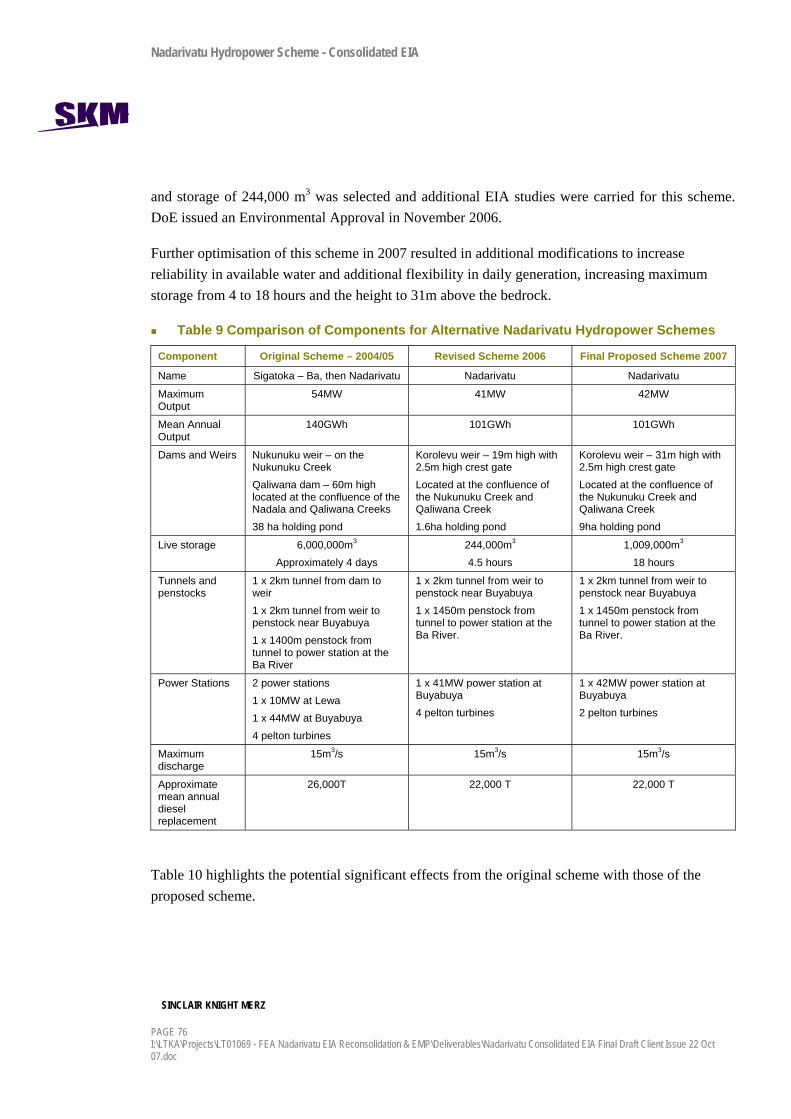
Nadarivatu Hydropower Scheme - Consolidated EIA
SINCLAIR KNIGHT MERZ
PAGE 76 I:\LTKA\Projects\LT01069 - FEA Nadarivatu EIA Reconsolidation & EMP\Deliverables\Nadarivatu Consolidated EIA Final Draft Client Issue 22 Oct 07.doc
and storage of 244,000 m3 was selected and additional EIA studies were carried for this scheme. DoE issued an Environmental Approval in November 2006.
Further optimisation of this scheme in 2007 resulted in additional modifications to increase reliability in available water and additional flexibility in daily generation, increasing maximum storage from 4 to 18 hours and the height to 31m above the bedrock.
Table 9 Comparison of Components for Alternative Nadarivatu Hydropower Schemes
Component Original Scheme – 2004/05 Revised Scheme 2006 Final Proposed Scheme 2007
Name Sigatoka – Ba, then Nadarivatu Nadarivatu Nadarivatu
Maximum Output
54MW 41MW 42MW
Mean Annual Output
140GWh 101GWh 101GWh
Dams and Weirs Nukunuku weir – on the Nukunuku Creek Qaliwana dam – 60m high located at the confluence of the Nadala and Qaliwana Creeks 38 ha holding pond
Korolevu weir – 19m high with 2.5m high crest gate Located at the confluence of the Nukunuku Creek and Qaliwana Creek 1.6ha holding pond
Korolevu weir – 31m high with 2.5m high crest gate Located at the confluence of the Nukunuku Creek and Qaliwana Creek 9ha holding pond
Live storage 6,000,000m3
Approximately 4 days 244,000m3
4.5 hours 1,009,000m3
18 hours
Tunnels and penstocks
1 x 2km tunnel from dam to weir 1 x 2km tunnel from weir to penstock near Buyabuya 1 x 1400m penstock from tunnel to power station at the Ba River
1 x 2km tunnel from weir to penstock near Buyabuya 1 x 1450m penstock from tunnel to power station at the Ba River.
1 x 2km tunnel from weir to penstock near Buyabuya 1 x 1450m penstock from tunnel to power station at the Ba River.
Power Stations 2 power stations 1 x 10MW at Lewa 1 x 44MW at Buyabuya 4 pelton turbines
1 x 41MW power station at Buyabuya 4 pelton turbines
1 x 42MW power station at Buyabuya 2 pelton turbines
Maximum discharge
15m3/s 15m3/s 15m3/s
Approximate mean annual diesel replacement
26,000T 22,000 T 22,000 T
Table 10 highlights the potential significant effects from the original scheme with those of the proposed scheme.
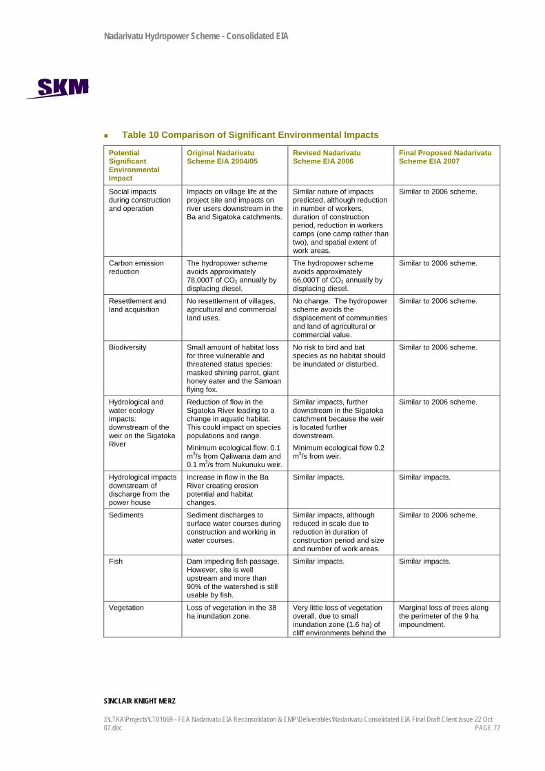
Nadarivatu Hydropower Scheme - Consolidated EIA
SINCLAIR KNIGHT MERZ
I:\LTKA\Projects\LT01069 - FEA Nadarivatu EIA Reconsolidation & EMP\Deliverables\Nadarivatu Consolidated EIA Final Draft Client Issue 22 Oct 07.doc PAGE 77
Table 10 Comparison of Significant Environmental Impacts
Potential Significant Environmental Impact
Original Nadarivatu Scheme EIA 2004/05
Revised Nadarivatu Scheme EIA 2006
Final Proposed Nadarivatu Scheme EIA 2007
Social impacts during construction and operation
Impacts on village life at the project site and impacts on river users downstream in the Ba and Sigatoka catchments.
Similar nature of impacts predicted, although reduction in number of workers, duration of construction period, reduction in workers camps (one camp rather than two), and spatial extent of work areas.
Similar to 2006 scheme.
Carbon emission reduction
The hydropower scheme avoids approximately 78,000T of CO2 annually by displacing diesel.
The hydropower scheme avoids approximately 66,000T of CO2 annually by displacing diesel.
Similar to 2006 scheme.
Resettlement and land acquisition
No resettlement of villages, agricultural and commercial land uses.
No change. The hydropower scheme avoids the displacement of communities and land of agricultural or commercial value.
Similar to 2006 scheme.
Biodiversity Small amount of habitat loss for three vulnerable and threatened status species: masked shining parrot, giant honey eater and the Samoan flying fox.
No risk to bird and bat species as no habitat should be inundated or disturbed.
Similar to 2006 scheme.
Hydrological and water ecology impacts: downstream of the weir on the Sigatoka River
Reduction of flow in the Sigatoka River leading to a change in aquatic habitat. This could impact on species populations and range. Minimum ecological flow: 0.1 m3/s from Qaliwana dam and 0.1 m3/s from Nukunuku weir.
Similar impacts, further downstream in the Sigatoka catchment because the weir is located further downstream. Minimum ecological flow 0.2 m3/s from weir.
Similar to 2006 scheme.
Hydrological impacts downstream of discharge from the power house
Increase in flow in the Ba River creating erosion potential and habitat changes.
Similar impacts. Similar impacts.
Sediments Sediment discharges to surface water courses during construction and working in water courses.
Similar impacts, although reduced in scale due to reduction in duration of construction period and size and number of work areas.
Similar to 2006 scheme.
Fish Dam impeding fish passage. However, site is well upstream and more than 90% of the watershed is still usable by fish.
Similar impacts. Similar impacts.
Vegetation Loss of vegetation in the 38 ha inundation zone.
Very little loss of vegetation overall, due to small inundation zone (1.6 ha) of cliff environments behind the
Marginal loss of trees along the perimeter of the 9 ha impoundment.

Nadarivatu Hydropower Scheme - Consolidated EIA
SINCLAIR KNIGHT MERZ
PAGE 78 I:\LTKA\Projects\LT01069 - FEA Nadarivatu EIA Reconsolidation & EMP\Deliverables\Nadarivatu Consolidated EIA Final Draft Client Issue 22 Oct 07.doc
Potential Significant Environmental Impact
Original Nadarivatu Scheme EIA 2004/05
Revised Nadarivatu Scheme EIA 2006
Final Proposed Nadarivatu Scheme EIA 2007
weir. Vegetation mainly weed and quick-growing invasive species.
Physical cultural resources
Archaeological sites damaged or flooded at Lewa.
No threat to archaeological sites at Lewa.
Similar to 2006 scheme.

Nadarivatu Hydropower Scheme - Consolidated EIA
SINCLAIR KNIGHT MERZ
I:\LTKA\Projects\LT01069 - FEA Nadarivatu EIA Reconsolidation & EMP\Deliverables\Nadarivatu Consolidated EIA Final Draft Client Issue 22 Oct 07.doc PAGE 79
9. Mitigation
9.1 Introduction The following list of proposed mitigation and abatement measures are detailed in this section:
A comprehensive Environmental Management Plan is proposed as a tool for ongoing control and review of mitigation measures, this forms Section 10of this report.
Optimised scheme design.
Pro-active community liaison and management of potential social impacts.
Management of workers and work camp effects.
Hydrological controls on the scheme during construction and operation.
Erosion and sediment control measures.
9.2 Scheme Design This renewable energy project will avoid the discharge of approximately 66,000 tonnes of CO2, as a result of replacing diesel generation, the only other short term solution to electricity generation in Viti Levu.
Through the process of optimising the scheme design, the following design features reduce or mitigate potential impacts on the environment:
Minimising the amount of inundation levels in the Qaliwana and Nukunuku Creeks, while maximising potential power generation. This was achieved by optimising the location of the weir and the weir height, and removing the 60m high dam from the original scheme.
Avoiding the inundation of settlements, dwellings and productive agricultural or industrial land.
Avoiding the inundation of archaeological sites along the Nukunuku Creek, by removing the weir at the Nukunuku Creek near Lewa, from the original scheme.
Pools formed at the base of the weir can be used for fish capture and transfer methods to be used in future if necessary.
9.3 Community Issues Social impacts should be mitigated through ongoing communications with the villagers, including:
Feedback to the community regarding the issues and concerns raised.
Developing village protocol that could serve as a guideline for outside workers.

Nadarivatu Hydropower Scheme - Consolidated EIA
SINCLAIR KNIGHT MERZ
PAGE 80 I:\LTKA\Projects\LT01069 - FEA Nadarivatu EIA Reconsolidation & EMP\Deliverables\Nadarivatu Consolidated EIA Final Draft Client Issue 22 Oct 07.doc
Education and orientation of outside workers to Fijian culture and social norms before the start of work.
Awareness and education of hazards and nuisances (such as noise and dust) during construction.
Awareness and education of villagers regarding the operational regime and the consequential changes in the Ba River.
Timing and location of noisy or dusty construction methods to be sensitive to village life. Work to be carried out in daylight, in typical working hours. Concrete batching plants and other noisy equipment to be located as far as practical from villages.
9.4 Construction and Work Crew Impacts The following mitigation is proposed to control the adverse issues arising from the operation of the workers camps:
The take of water from streams for water supplies should leave residual flows in the watercourses.
Any water supply sources in the Ba catchment should be located so that it does not adversely affect the Buyabuya village supply.
Sewerage disposal methods should be designed to the standards outlined in the Australia / New Zealand Standard for the Management of On Site Sewage Systems AS/NZ1547: 2000.
All solid wastes shall be removed from site and disposed of at a municipal landfill.
Water takes should leave a residual flow in the creek.
Abstraction should be to holding tanks to buffer peak demands.
9.5 Ecological Flows and Management of Water Releases The proposed Nadarivatu scheme construction and operation shall consider the following provisions for control of catchment hydrology, and any requirements for compliance of proposed minimum flows and discharges to natural water.
9.5.1 Sigatoka Catchment The scheme shall include the following provisions:
During weir construction there shall be suitable by-pass of Qaliwana and Nukunuku Creek flow i.e. the natural flow regime should be unaffected by the construction of the weir.

Nadarivatu Hydropower Scheme - Consolidated EIA
SINCLAIR KNIGHT MERZ
I:\LTKA\Projects\LT01069 - FEA Nadarivatu EIA Reconsolidation & EMP\Deliverables\Nadarivatu Consolidated EIA Final Draft Client Issue 22 Oct 07.doc PAGE 81
Post weir construction and during initial filling of the weir, suitable provision via sluice gates shall enable a minimum of 200 L/s flow continuation to the Sigatoka River below the weir, at catchment input flows of 200 L/s and above.
The sluice gates shall be in operation over the full range of weir storage, and shall provide 200 L/s to the river as a continuous residual flow when applicable.
Monitoring of catchment input flow to the weir, and residual flow released, shall be provided by continuous measurement / recording. Residual flows released shall be reduced in conjunction with monitored input flow to the weir.
Provision is to be made for suitable release of flood flows down the river.
The take of water from the weir for scheme operation shall be up to 15000 L/s.
9.5.2 Ba Catchment The effective operation of the Ba Power Station discharge to the Ba River shall include the following provisions:
The discharge of water to the Ba River for scheme operation shall be up to 15000 L/s.
Flow from the Ba Power Station to the Ba River shall be ramped up and down at a rate no greater than 1000 L/s flow per minute, to avoid unnecessary sediment transport during median to mean flows, and to avoid sudden loss of habitat from stream flow reduction.
Appropriate early warning system in place at Ba Power house to warn of impending hydropower discharges to the Ba River.
Sediment concentrations from the Ba power station should remain below 17mg/L for Ba River flows at / or below the natural mean (estimated at 2822 L/s).
Flow monitoring prior to, during and after power scheme construction should provide for compliance and operational requirements.
Proposed automated river flow monitoring at the following project sites:
Qaliwana River at Bulu – currently operating.
Ba River at below Ba power house – new.
Proposed automated river flow monitoring stations downstream in each river:
Sigatoka at Korovouiti (10 – 12km downstream).
Ba at Nivala (8 - 10km downstream).

Nadarivatu Hydropower Scheme - Consolidated EIA
SINCLAIR KNIGHT MERZ
PAGE 82 I:\LTKA\Projects\LT01069 - FEA Nadarivatu EIA Reconsolidation & EMP\Deliverables\Nadarivatu Consolidated EIA Final Draft Client Issue 22 Oct 07.doc
Survey cross-sections on the Ba River are to be completed at at least the following locations: Ba, Koro, Becamoui, Cuave, Nivala and Toge.
Survey cross sections on the Sigatoka River are to be completed at least six locations downstream.
Survey data to be used to more accurately determine the rate or rise and the total rise in river depth from power station discharges to the Ba River.
9.6 Erosion and Sediment Control Erosion and sediment discharges will be managed through the Construction Environmental Management Plan. Key mitigation measures are:
Phasing of work, a key erosion control and earthworks principle, to reduce the amount of area that is disturbed at any one time should be undertaken. The potential effects from erosion and sedimentation should therefore be restricted to the areas exposed.
There should be no earthworks in the bed of watercourses other than that required for the weir and intake construction and the construction of the power station. Culverts should be placed in the initial stages of the development to minimise vehicle movements through watercourses during the earthworks. All earthworks in or adjacent to watercourses should utilise sediment and erosion control measures as prescribed in the Construction Environmental Management Plan. Emphasis should be placed on reducing flow velocities and retaining sediment on site, particularly at locations where the surface water discharges to the drainage network and on steeper slopes.
Principles for earthworks management include:
Soils should be reused where possible in the development – this is the low cost option for the contractors and should reduce the need for spoil sites and the need to import fill.
Stockpiling should be minimised.
Earthworks and spoil sites shall avoid water courses where possible.
Stockpiling shall occur at least 10 m from water courses.
Earthworks and land clearance should be minimised.
Stockpiles and exposed soils should be compacted as much as practical.
Soil should not be left exposed for long periods of time and land should be rehabilitated with native grasses to reduce erosion risk.

Nadarivatu Hydropower Scheme - Consolidated EIA
SINCLAIR KNIGHT MERZ
I:\LTKA\Projects\LT01069 - FEA Nadarivatu EIA Reconsolidation & EMP\Deliverables\Nadarivatu Consolidated EIA Final Draft Client Issue 22 Oct 07.doc PAGE 83
Timing of the works so that vegetation / soil stripping on steeper slopes occurs in the drier season.
Minimisation of the area of land left bare prior.
Provision of cutoff drains at road sides and frequent culverts.
These factors should be included in the Construction and Workers Camp Management Plan.

Nadarivatu Hydropower Scheme - Consolidated EIA
SINCLAIR KNIGHT MERZ
PAGE 84 I:\LTKA\Projects\LT01069 - FEA Nadarivatu EIA Reconsolidation & EMP\Deliverables\Nadarivatu Consolidated EIA Final Draft Client Issue 22 Oct 07.doc
10. Environmental Management Plan A comprehensive Environmental Management Plan (EMP) has been proposed to control activities associated with the project, which could have adverse effects. This is provided in Appendix F. It sets out the environmental and social principles to be applied to the project, based on the impact assessment in this document and the proposed mitigation measures. The plan is designed to cover the construction and operational impacts.
10.1.1 Description of Components The EMP is designed as the overriding document in a hierarchy of control plans. The EMP components are illustrated in Figure 21.
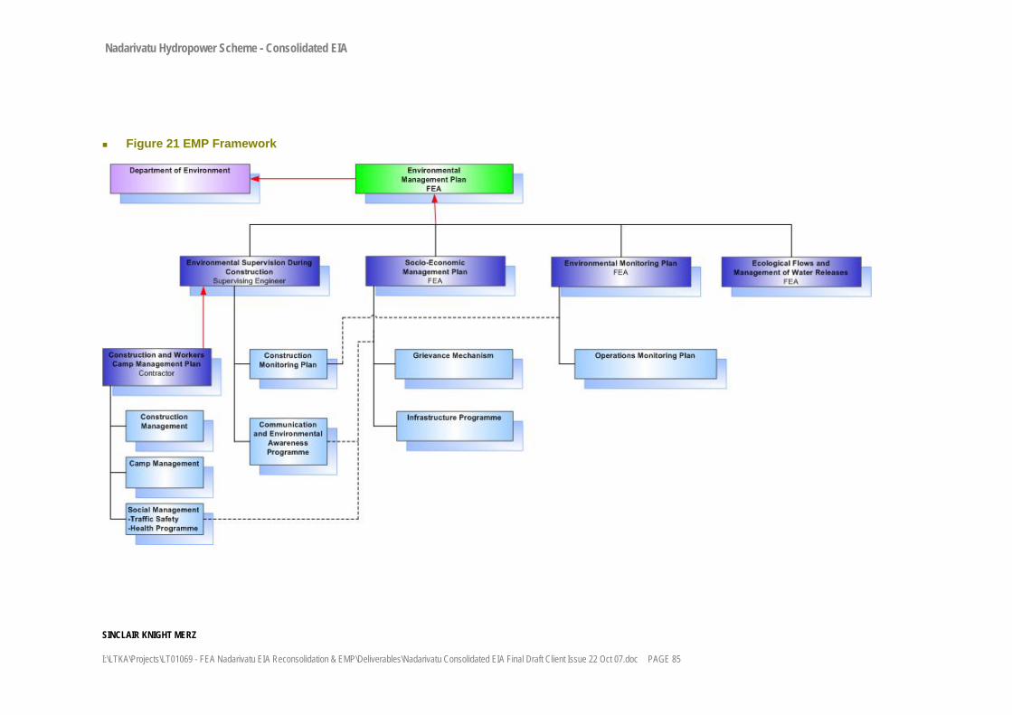
Nadarivatu Hydropower Scheme - Consolidated EIA
SINCLAIR KNIGHT MERZ
I:\LTKA\Projects\LT01069 - FEA Nadarivatu EIA Reconsolidation & EMP\Deliverables\Nadarivatu Consolidated EIA Final Draft Client Issue 22 Oct 07.doc PAGE 85
Figure 21 EMP Framework

Nadarivatu Hydropower Scheme - Consolidated EIA
SINCLAIR KNIGHT MERZ
I:\LTKA\Projects\LT01069 - FEA Nadarivatu EIA Reconsolidation & EMP\Deliverables\Nadarivatu Consolidated EIA Final Draft Client Issue 22 Oct 07.doc PAGE 86
1) Construction and Workers Camp Management Plan, which shall contain:
Construction Management Plan: This plan will control the adverse impacts associated with erosion and sediment discharges from all earthworks activities.
Camp Management Plan: This plan will outline the operational controls on various aspects of the project including traffic management, noise and vibration management and operation of the workers camps.
Social Management Plan: This plan will address on site and off-site site social issues specially regarding health and social issues arising from the influx of workers and camp followers.
2) Environmental Supervision during Construction
Supervision of compliance with the EMP by contractors will be the responsibility of the Supervision Engineer. The Environmental Unit in FEA will have oversee the performance of the Supervision Engineer, review supervision reports on environment and make recommendations as needed during the construction process. The Environmental Unit will provide the necessary information and reports to DoE. Regardless of the above scheme, DoE will carry out its own monitoring and inspection of the project.
3) Socioeconomic Management Plan
This plan shall identify all necessary activities, institutional arrangements and budget to maximise benefits for the local communities, including:
Communication and Environmental Education and Awareness Programme (responsibility of the Supervising Engineer)
Infrastructure programme for local communities, including rural electrification (FEA)
Health programme (Contractor)
Traffic safety and regulations (Contractor)
Grievance mechanism (FEA)
4) Environmental Monitoring Plan
Detailed water quality, ecology and hydrological monitoring programs shall be included in the EMP to assess the impacts on water quality and ecology from construction and operation. Monitoring locations are to be based on baseline monitoring sites. Environmental monitoring during construction will be implemented by the Supervision Engineer. During operation, FEA will carry out the monitoring plan.
5) Ecological Flows and Management of Water Releases
During operation the EMP shall provide for control of catchments hydrology and sediment management at the weir and discharges from the weir and power station. The EMP shall

Nadarivatu Hydropower Scheme - Consolidated EIA
SINCLAIR KNIGHT MERZ
I:\LTKA\Projects\LT01069 - FEA Nadarivatu EIA Reconsolidation & EMP\Deliverables\Nadarivatu Consolidated EIA Final Draft Client Issue 22 Oct 07.doc PAGE 87
include the recommendations in the EIA to mitigate environmental impacts and comply with the conditions of Environmental Approvals.
The plans are dynamic documents, which may be subject to change or modification as a result of project development or changes on the sites. All plans must be approved by DOE prior to application.
The draft EMP is provided in Appendix F.

Nadarivatu Hydropower Scheme - Consolidated EIA
SINCLAIR KNIGHT MERZ
I:\LTKA\Projects\LT01069 - FEA Nadarivatu EIA Reconsolidation & EMP\Deliverables\Nadarivatu Consolidated EIA Final Draft Client Issue 22 Oct 07.doc PAGE 88
11. Monitoring and Evaluation The monitoring programme for the Nadarivatu project will be implemented as part of the EMP. The Environmental Monitoring Plan, one of five sub-plans of the EMP, sets out the ongoing monitoring required to assess the impacts of the scheme during construction and operation.
The outline to the Environmental Monitoring Plan is provided as an appendix to the EMP, which is Appendix F to this document. It covers the following:
Water quality, fish and instream habitat monitoring during construction.
Water quality, fish and instream habitat monitoring during operation.
Flow monitoring in the Sigatoka and Ba Rivers.
Cross-section surveys of the Ba River.
The plan will also develop procedures for monitoring the effectiveness of procedures to implement the mitigation measures discussed in the EIA and formalised in the Environmental Approvals.
Evaluation of the mitigation measures and monitoring results will also form part of the EMP. The procedures for evaluation are documented in the EMP in Appendix F. The results of monitoring and review of procedures shall be assessed against the predicted environmental effects in the EIA, and the EMP shall be updated where the environmental outcomes are not satisfactory.

Nadarivatu Hydropower Scheme - Consolidated EIA
SINCLAIR KNIGHT MERZ
I:\LTKA\Projects\LT01069 - FEA Nadarivatu EIA Reconsolidation & EMP\Deliverables\Nadarivatu Consolidated EIA Final Draft Client Issue 22 Oct 07.doc PAGE 89
12. Consultation Process There have been three distinctive consultation strategies with the hydropower project:
Government Land Acquisition Task Force meetings– FEA Lands Department, Native Land Trust Board, CEO’s of government ministries and representatives from the villages and settlements. The Task Force was set up to negotiate access to land, land leases, compensation and to discuss other needs and issues of the locals and FEA.
Interviews, participant observation, village meetings and other techniques by a social scientist as part of the Social Impact Assessment study during the initial EIA study in 2004.
Stakeholder group meetings – sharing the draft EIA with staff from government agencies.
FEA are committed to consulting with land owners throughout construction and operation.
12.1 Government Land Acquisition Task Force The land acquisition process commenced at the feasibility stage of the project in 2003, with FEA and the Provincial Administration of Ba province taking the lead role in the consultation process with land owners. This process was to evaluate the views and opinions of the landowners in general in their acceptabnce or otherwise of the project implementation on their land. The first meetings were conducted a Nadala and Lewa villages in the Savatu District as the head villages where the project land had been identified.
There were three rounds of talks completed before the landowners accepted the development of the proposed scheme on their land. The Task Force group was then developed to facilitate and assist the Native Land Trust Board and FEA in the talks to acquire the land area. The members of the Task Force were:
Commissioner Western Division (Chairman)
Provincial Administrator, Ba
District Officer Tavua/Nadarivatu
Roko Tui Ba
Native Land Trust Board
Ministry of Lands
Ministry of Forests
FEA
It was the role of the Task Force to identify the best mode of land acquisition that would benefit the land owners, FEA, NLTB and Government, where a win-win situation could be adopted.

Nadarivatu Hydropower Scheme - Consolidated EIA
SINCLAIR KNIGHT MERZ
I:\LTKA\Projects\LT01069 - FEA Nadarivatu EIA Reconsolidation & EMP\Deliverables\Nadarivatu Consolidated EIA Final Draft Client Issue 22 Oct 07.doc PAGE 90
Through 2003 and 2004, discussions with the seven Mataqali / land owning units, focussed on access to the site for investigations and feasibility studies. Landowners were cooperative and provided consent. Some villagers were employed to work with the consultants during the two year phase. Consultations were in mostly in the Fijian language, using traditional Fijian meeting and negotiation methods.
It was always understood by land owners and the Task Force that when feasibility studies were completed the actual land acquisition talks for a permanent lease would commence. During the project, the scheme footprint was reduced and the number of Mataqali was reduced from seven to five. These talks commenced in 2005 and are at the final stages presently, where land leases are currently being signed by the Mataqali.
12.2 Social Impact Assessment Consultation A Fijian-born social impact consultant consulted with the host communities near the beginning of the project, in 2004, during the development of the EIA for the original hydropower scheme. He engaged a variety of methods to define the social setting, communicate the project concepts, determine the peoples’ concerns and assess the potential impacts on their social and cultural values. Following background research on the area, he used ‘participant observation’ by living in various villages for a short period of time over four weeks to observe the life and living patterns of the villagers. While living in the villages, he also conducted targeted interviews and held group meetings to discuss the project. In particular, village elders, leaders and those who were involved in the nearby Monasavu hydropower scheme construction were targeted.
This consultation was kept separate from the Task Force meetings so that issues other than land acquisition and compensation could be discussed, and so that other people from the villages, including women and young people, who are often left out of formal meetings on land issues, could have their concerns heard.
The consultant discussed general concepts of the scheme, including the location of key infrastructure, the workers camps, and construction-related effects. Many of the people understood the likely disruptions during construction having experienced the Monasavu project. They could draw on those experiences to describe the likely social impacts and their preference for mitigation measures.
Transcripts of the consultation meetings are provided in Appendix E.
12.3 Government Agency Consultation The draft EIA and draft Supplementary EIA No.2 reports were both presented to government agencies in a workshop where their comments could be discussed. The agencies involved were:

Nadarivatu Hydropower Scheme - Consolidated EIA
SINCLAIR KNIGHT MERZ
I:\LTKA\Projects\LT01069 - FEA Nadarivatu EIA Reconsolidation & EMP\Deliverables\Nadarivatu Consolidated EIA Final Draft Client Issue 22 Oct 07.doc PAGE 91
Department of Energy
Department of Mineral Resources
Town and Country Planning
Department of Environment
Department of Agriculture
Native Land Trust Board
The draft reports were also sent to key staff for comment prior to finalising.
The minutes from the meetings are provided in Appendix E. The main concerns related to the downstream effects on land users and river users, including flooding and sedimentation, and on electrification of the nearby villages.
Nadarivatu Hydropower Scheme - Consolidated EIA
SINCLAIR KNIGHT MERZ
I:\LTKA\Projects\LT01069 - FEA Nadarivatu EIA Reconsolidation & EMP\Deliverables\Nadarivatu Consolidated EIA Final Draft Client Issue 22 Oct 07.doc PAGE 92
13. Summary and Conclusions The Nadarivatu Hydro Power Project is part of a programme of developments being undertaken by FEA. Renewable energy is seen as a key source of future power for Fiji and this project would generate approximately 15% of the Viti Levu electricity requirements.
The development of this renewable energy source has a number of benefits for Fiji, these include:
The project represents an opportunity for Fiji to reduce its reliance on imported fossil fuels and develop a more sustainable long-term power generation strategy.
The power generation provided by the scheme would be equivalent to replacing an average of 66,000 T of CO2 emissions annually.
Industry and development in Fiji will benefit by ensuring power supplies are more consistent.
Temporary employment will be created in the project area with local workers being employed for suitable positions.
Specific EIA studies included:
Biological survey of terrestrial and aquatic species and habitats.
Social baseline assessment and impact assessment.
Hydrological modelling of modified flows in the Sigatoka and Ba Rivers.
Archaeological survey.
Water quality testing and instream ecosystem surveys in the Sigatoka and Ba catchments.
The land use in and around the project area at present is generally low intensity grazing, agriculture and occasional hunting and fishing. A number of small villages and settlements are located along the ridges of the Nadrau Plateau, high above the steeply incised river valleys. Buyabuya village is located adjacent to the Ba River and the proposed power station site. The populations are predominantly living according to traditional Fijian values and culture with a mix of subsistence and cash economies.
The existing land cover consists predominantly of native forest in the steeper valleys in the Sigatoka catchment with open grasslands on the flanks and ridges of the hills. At the Ba Power Station it is predominantly modified forest and grassland. Three threatended or vulnerable bird and bat species were located in the mature bush in the catchment during the surveys; the giant honeyeater, the masked shining parrot and Samoan flying fox.
The creeks are typical, steep sided upland rivers, that experience high flood flows and periods of very low flow. Water quality of the rivers is generally good and typical of upland headwaters, and

Nadarivatu Hydropower Scheme - Consolidated EIA
SINCLAIR KNIGHT MERZ
I:\LTKA\Projects\LT01069 - FEA Nadarivatu EIA Reconsolidation & EMP\Deliverables\Nadarivatu Consolidated EIA Final Draft Client Issue 22 Oct 07.doc PAGE 93
is similar in water chemistry to others across the plateau. The rivers supported at least six species of fish, some of which are used for food but none are endemic, rare or threatened.
The following conclusions on the scheme can be made, taking into account the scheme design, sensitivity of the environment, the needs of the host communities and the predicted impacts:
There will be no inundation of houses, settlements, farms or other productive land uses. There is no requirement to relocate families or communities.
The reservoir will inundate the river channel margins only, where invasive weed species are most prevalent due to the scouring effects of flood waters. There will be no inundation of mature forest.
The five land owning units (Mataqali) have meaningfully engaged in the land lease process and are in the final stages of signing a permanent lease to allow FEA access to construct and operate the scheme.
The habitats of the giant honeyeater, masked shining parrot and Samoan flying fox will not be affected by construction or inundation.
Discharges of sediment will affect water quality and stream bed habitat immediately downstream of the Ba and Sigatoka Rivers during construction. This will be for the duration of the construction period, and may result in sedimentation.
The diversion of water from the Qaliwana and Nukunuku Creeks will create uniformly low river flows downstream in the Sigatoka River. This will affect river flow for at least 12 kilometres, until further flow from other catchments reduces the impact.
Changes to ecosystems and fish populations will be experienced immediately downstream in the Sigatoka River as a result of the low flow periods. This includes more sedimentation and more algae growths, and potentially less fish.
Pulses of water from the power station may affect fording and other river uses downstream. This is minor given that there is low population for several kilometres downstream and low river use.
Changes to erosion and deposition patterns are also expected in the Ba River, but to a minor extent given that the river bed is mainly boulders and bedrock for several kilometres.
Disturbance to traditional village life, and in particular to Buyubuya Village, during construction as a result of the works and influx of workers to the district.
Mitigation and management has been proposed in the EIA to address these issues, including a comprehensive EMP for implementation during construction and operation of the scheme. It is considered that if these actions are implemented then the adverse effects of the project will be minimised. The measures outlined in the EIA and EMP should ensure that the development could proceed and provide a significant benefit to Fiji’s power supply and future economic development.

Nadarivatu Hydropower Scheme - Consolidated EIA
SINCLAIR KNIGHT MERZ
I:\LTKA\Projects\LT01069 - FEA Nadarivatu EIA Reconsolidation & EMP\Deliverables\Nadarivatu Consolidated EIA Final Draft Client Issue 22 Oct 07.doc PAGE 94
14. Bibliography of Environmental Studies Allen, G.R. 1991: Field Guide to the Freshwater Fishes of New Guinea. Publication No.9 of the Christensen Research Institute Madang, New Guinea. Pp 9 - 209.
Allen, G. R.; Midgley, S. H.; Allen, M. 2002. Field Guide to the Freshwater Fishes of Australia. Western Australian Museum, Perth, Western Australia 6000. Pp 14.
Auckland Regional Council 1996: The environmental impacts of accelerated erosion and sedimentation. ARC environmental division technical publication No. 69.
Auckland Regional Council 1999: Erosion and sediment control. Guidelines for land disturbance activities. Technical publication No. 90.
Auckland Regional Council, 2003, Stormwater Management Devices: Design Guidelines Manual (TP 10) 2nd Ed. Auckland Regional Council.
Australia/New Zealand Standard for the Management of On Site Sewage Systems AS/NZ1547:2000
BSAP 1998. Technical Group 3 Report.
Environment Waikato 1995: Design guidelines for earthworks, tracking and crossings.
IAS 2004. Baseline water quality and biological survey of the proposed new hydroelectricity generating sites at the headwaters of the Ba and Sigatoka Rivers. Report prepared for the Fiji Electricity Authority. Institute of Applied Sciences, University of South Pacific.
Keith, P. 2003: Biology and ecology of amphidromous Godiidae of the Indo - Pacific and the Caribbean regions. Journal of Fish Biology 63: 831 - 847
McDowall, R. M. 2004: Ancestry and amphidromy in island freshwater fish faunas. Fish Fisheries. 5: 75 - 85.
MWH 2004a. Sustainable Energy Ltd Report for Sigatoka-Ba Hydro Power Project Preliminary Design MWH New Zealand Ltd, November 2004. Dunedin.
MWH 2004b. Geologic Mapping and Reconnaissance Report.
MWH. 2006. Nadarivatu Hydropower Project Environmental Impact Assessment Scheme Description.

Nadarivatu Hydropower Scheme - Consolidated EIA
SINCLAIR KNIGHT MERZ
I:\LTKA\Projects\LT01069 - FEA Nadarivatu EIA Reconsolidation & EMP\Deliverables\Nadarivatu Consolidated EIA Final Draft Client Issue 22 Oct 07.doc PAGE 95
MWH. 2007. Nadarivatu Renewable Energy Project Design Report. July 2007.
SKM 2005a. Sigatoka Ba Hydro Power Project. Economic Impact Assessment.
SKM 2005b. Sigatoka Ba Hydro Power Project. Freshwater Ecological and Water Quality Investigations.
SKM. 2005ac. Nadarivatu Hydropower Project EIA (Final).
SKM. 2005d. Nadarivatu Hydropower Project Appendices. (Final).
SKM. 2005e. Nadarivatu Hydropower Project Supplementary Report 1 to the EIA.
SKM. 2006. Nadarivatu Hydropower Project Supplementary Report 2 to the EIA.
Waters, T. F. 1995: Sediment in streams. Sources, biological effects and control. American fisheries society monograph 7.
Young, R., Smart, G., & Harding, J.S. (2004). Impacts of hydro-dams, irrigation schemes and river control works. In: Freshwaters of New Zealand (Harding, J.S., Mosley, P., Pearson, C., Sorrell, B., eds). New Zealand Limnological and Hydrological Societies, Christchurch.

Nadarivatu Hydropower Scheme - Consolidated EIA
15. List of Appendices Appendix A DOE Environmental Approvals
Appendix B Location Plans
Appendix C Design Plans
Appendix D 2006 Water Quality and Ecological Assessment
Appendix E Consultation Meeting Notes
Appendix F Environmental Management Plan
Appendix G Hydrological Assessment
Appendix H Archaeological Report
Appendix I 2004 Water Quality and Biological Survey

Nadarivatu Hydropower Scheme - Consolidated EIA
Appendix A DOE Environmental Approvals

Nadarivatu Hydropower Scheme - Consolidated EIA
Appendix B Location Plans

Nadarivatu Hydropower Scheme - Consolidated EIA
Appendix C Design Plans

Nadarivatu Hydropower Scheme - Consolidated EIA
Appendix D 2006 Water Quality and Ecological Assessment

Nadarivatu Hydropower Scheme - Consolidated EIA
Appendix E Consultation Meeting Notes

Nadarivatu Hydropower Scheme - Consolidated EIA
Appendix F Environmental Management Plan

Nadarivatu Hydropower Scheme - Consolidated EIA
Appendix G Hydrological Assessment

Nadarivatu Hydropower Scheme - Consolidated EIA
Appendix H Archaeological Report

Nadarivatu Hydropower Scheme - Consolidated EIA
Appendix I 2004 Water Quality and Biological Survey