Embed Size (px)
Citation preview

Supporting Volume Project Description
Keeyask Generation Project Environmental Impact Statement
June 2012
GULL LAKE
O'NEIL BAY
NELSON
RIVER
Look ing Back Creek G - 3
S - 11
S - 2a
G - 1
N - 5
N - 6
S - 4
Q - 1
N - 21
S - 2b
S - 17a
S - 2a
N - 21
S - 2b
N - 5
S - 18
S - 17b
Q - 7
DATA SO URCE:
DAT E CREAT ED:
CREATED BY:
VERSIO N NO:
REVIS ION DAT E:
QA/Q C:
COORDINAT E SYST EM :
UTM NAD 1983 Z15N
0 0.45 0.9 Miles
0 0.55 1.1 Kilom etres
B Size
Land
scap
e BTB
- DE
C 20
11Fil
e Loc
ation
: \\ge
odat
a\war
ehou
se\W
areh
ouse
_Gro
ups\P
ower
_Sup
ply\P
rojec
ts\Ke
eyas
k\Map
s\EIS
\Cha
pter
4_Pr
ojec
tDes
cript
ion\M
XDs\D
raft3
\Kee
yask
_Pro
jectF
ootpr
intOp
eratio
nPha
se_2
0120
411.m
xd
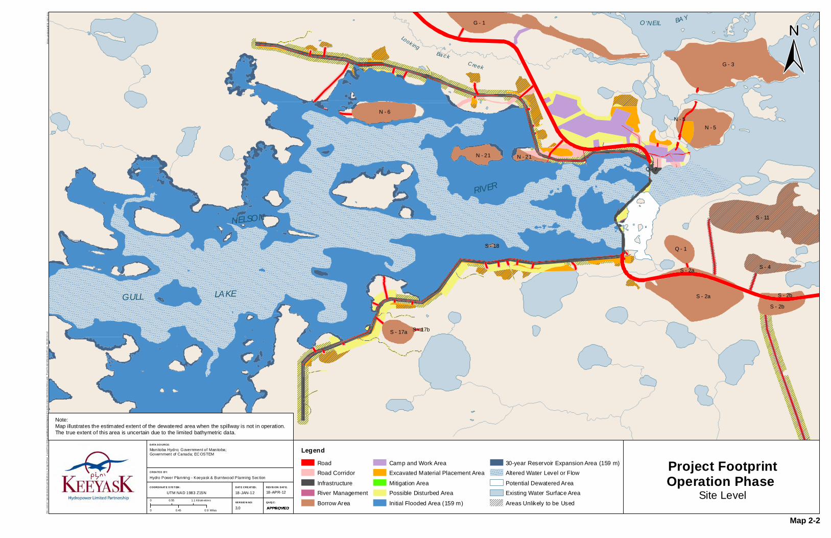
Project FootprintOperation Phase
Site Level
Manitoba Hydro; Government of Manitoba;Government of Canada; EC OSTEM
Hydro Power Planning - Keeyask & Burntwood Planning Sec tion
3.0 Approved
18-APR-1218-JAN-12
LegendRoadRoad CorridorInfrastructureRiver ManagementBorrow Area
Camp and Work AreaExcavated Material Placement AreaMitigation AreaPossible Disturbed AreaInitial Flooded Area (159 m)
30-year Reservoir Expansion Area (159 m) Altered Water Level or FlowPotential Dewatered Area Existing Water Surface AreaAreas Unlikely to be Used
Note:Map illustrates the estimated extent of the dewatered area when the spillway is not in operation.The true extent of this area is uncertain due to the limited bathymetric data.
Map 2-2

DATA SO URCE:
DAT E CREAT ED:
CREATED BY:
VERSIO N NO:
REVIS ION DAT E:
QA/Q C:
COORDINAT E SYST EM :
GULL LAKE
Cache Lake
Clark Lake
NELSON
RIVER
Wilson Channel
Apetowachakamasik Lake
Carscadden Lake
Butnau Riv er
Butna u R iver
Kettl e
River
Gillrat Lake
Josl in Lake
South Moswakot River
Looking Back Cre ek
STEPHENS LAKE
SPLIT LAKE
Fox Lake Cree NationA Kwis Ki Mahka Reserve
PR 280
North Access Road
Propose d South Access RoadGillam
UTM NAD 1983 Z15N
0 2 4 Miles
0 3 6 Kilom etres
B Size
Land
scap
e BTB
- DE
C 20
11Fil
e Loc
ation
: \\ge
odat
a\war
ehou
se\W
areh
ouse
_Gro
ups\P
ower
_Sup
ply\P
rojec
ts\Ke
eyas
k\Map
s\EIS
\Cha
pter
4_Pr
ojec
tDes
cript
ion\M
XDs\D
raft3
\Kee
yask
_Pro
jectF
ootpr
int_2
0120
424.m
xd
Project FootprintOverview
Construction and Operation Phase
Manitoba Hydro; Government of Manitoba;Government of Canada; EC OSTEM
Manitoba Hydro - Hydro Power Planning
3.0 Approved
25-APR-1218-JAN-12
LegendRoadRoad CorridorInfrastructureRiver ManagementBorrow AreaCamp and Work Area
Excavated Material Placement AreaMitigation AreaPossible Disturbed AreaReservoir ClearingInitial Flooded Area (159 m)30-year Reservoir Expansion Area (159 m)
Altered Water Level or FlowPotential Dewatered Area Existing Water Surface AreaAreas Unlikely to be Used
GULL LAKE
Cache Lake
Clark Lake
NELSON
RIVER
Wilson Channel
Apetowachakamasik Lake
Carscadden Lake
Butnau Riv er
Butna u R iver
Kettl e
River
Gillrat Lake
Josl in Lake
South Mos wakot River
Looking Back Cre ek
STEPHENS LAKE
SPLIT LAKE
North Access Road
Pro pose d South Access Road
Fox Lake Cree NationA Kwis Ki Mahka Reserve
Gillam
PR 280
Open WaterHydraulic Zone of Influence
Construction Phase
Operation Phase
Open WaterHydraulic Zone of Influence
Note:Map illustrates the estimated extent of the dewatered area when the spillway is not in operation.The true extent of this area is uncertain due to the limited bathymetric data.
Map 2-3

DATA SO URCE:
DAT E CREAT ED:
CREATED BY:
VERSIO N NO:
REVIS ION DAT E:
QA/Q C:
COORDINAT E SYST EM :
PR 280
UTM NAD 1983 Z15N
0 1 2 Miles
0 1 2 Kilom etres
ProposedKeeyask G.S.
B Size
Land
scap
e BTB
- DE
C 20
11Fil
e Loc
ation
: \\ge
odat
a\war
ehou
se\W
areh
ouse
_Gro
ups\P
ower
_Sup
ply\P
rojec
ts\Ke
eyas
k\Map
s\EIS
\Cha
pter
4_Pr
ojec
tDes
cript
ion\M
XDs\D
raft3
\Kee
yask
_Lea
sedL
ands
_201
2062
5.mx
d
Leased Lands Manitoba Hydro; Government of Manitoba; Government of Canada
Manitoba Hydro - Hydro Power Planning - GIS & Special Studies
1.0 XXX/YYY/ZZZ
25-JUN-1201-JUN-12
LegendLand Required - Not in WaterLand Required - In WaterAccess Roads & Transmission LinesSwitch Station & Construction PowerLands Currently Leased
Highway
Note:The cadastral data shown is a generalized map representationof property boundaries as shown on survey plans registeredin the Winnipeg Land Titles Office and has been mathematicallyadjusted or manipulated. As such it must not be interpretedby the user as defining the true location of any parcel'sboundaries on the ground, nor its true size and area.
Map 2-4

DATA SOURCE:
DATE CREATED:
CREATED BY:
VERSION NO:
REVISION DATE:
QA/QC:
COORDINATE SYSTEM:
UTM NAD 1983 Z15N
0 0.2 0.4 Miles
0 0.25 0.5 Kilometres
ProposedKeeyask G.S.
B S
ize
Land
scap
e B
TB
- D
EC
201
1Fi
le L
ocat
ion:
\\ge
odat
a\w
areh
ouse
\War
ehou
se_G
roup
s\P
ower
_Sup
ply\
Pro
ject
s\K
eeya
sk\M
aps\
EIS
\Cha
pter
4_P
roje
ctD
escr
iptio
n\M
XD
s\D
raft3
\Kee
yask
_Prin
cipa
lStr
uctu
res_
2012
0404
.mxd
Principal Structures
Manitoba Hydro; Government of Manitoba; Government of Canada; KGSA;Manitoba Hydro Artist Concept Rendering - November 2011
Manitoba Hydro - Hydro Power Planning - GIS & Special Studies
2.0 JCL/MES/MWZ
11-APR-12 03-NOV-11
S T E P H E N S L A K E
G U L L L A K E
Note:Map illustrates the estimated extent of the dewatered area when thespillway is not in operation. The true extent of this area is uncertaindue to the limited bathymetric data.
Artist's Rendering - Concept Only
FLOW
Map 2-5
JL/AMB/MES

DATA SOURCE:
DATE CREATED:
CREATED BY:
VERSION NO:
REVISION DATE:
QA/QC:
COORDINATE SYSTEM:
UTM NAD 1983 Z15N
0 0.2 0.4 Miles
0 0.25 0.5 Kilometres
Tailrace ChannelIntake Channel
ApproachChannel
DischargeChannel
North Access
Road
B S
ize
Land
scap
e B
TB
- D
EC
201
1Fi
le L
ocat
ion:
W:\W
areh
ouse
_Gro
ups\
Pow
er_S
uppl
y\P
roje
cts\
Kee
yask
\Map
s\E
IS\C
hapt
er4_
Pro
ject
Des
crip
tion\
MX
Ds\
Dra
ft3\K
eeya
sk_L
ocat
ion_
Pow
erho
use_
Spi
llway
_Cha
nnel
s.m
xd
Powerhouse andSpillway Channels
Principal Structures
Manitoba Hydro; Government of Manitoba; Government of Canada;KGS Acres; Manitoba Hydro Artist Concept Rendering - November 2011
Manitoba Hydro - Hydro Power Planning - GIS & Special Studies
1.0 JCL/YYY/ZZZ
25-JUN-12 07-MAR-12
S T E P H E N S L A K E
G U L L L A K E
Note:Map illustrates the estimated extent of the dewatered area when thespillway is not in operation. The true extent of this area isuncertain due to the limited bathymetric data.
Artist's Rendering - Concept Only
FLOW
Legend
Highlighted Infrastructure
Infrastructure
Access Road
Exisiting Water Area
Initial Flooded Area (159 m)
Potential Dewatered Area
0 0.25 0.5 Miles
0 0.25 0.5 Kilometres
Map 2-6
JL/AMB/MES

DATA SOURCE:
DATE CREATED:
CREATED BY:
VERSION NO:
REVISION DATE:
QA/QC:
COORDINATE SYSTEM:
UTM NAD 1983 Z15N
0 0.095 0.19 Miles
0 0.1 0.2 Kilometres
B S
ize
Land
scap
e B
TB
- D
EC
201
1Fi
le L
ocat
ion:
W:\W
areh
ouse
_Gro
ups\
Pow
er_S
uppl
y\P
roje
cts\
Kee
yask
\Map
s\E
IS\C
hapt
er4_
Pro
ject
Des
crip
tion\
MX
Ds\
Dra
ft3\K
eeya
sk_P
ower
hous
e_S
pillw
ay_T
rans
ition
s.m
xd
Wing Walls and Transition Structure Locations
Manitoba Hydro; Government of Manitoba; Government of Canada; KGSA;Manitoba Hydro Artist Concept Rendering - November 2011
Manitoba Hydro - Hydro Power Planning - GIS & Special Studies
2.0 JCL/MES/MWZ
07-JUN-12 03-NOV-11
S T E P H E N S L A K E
G U L L L A K E
Note:Map illustrates the estimated extent of the dewatered area when thespillway is not in operation. The true extent of this area is uncertaindue to the limited bathymetric data.
Artist's Rendering - Concept Only
P o w e r h o u s e
S p i l l w a y
FLOW
FLOW
Legend
Transition
Principal Structures
Wing Wall
WALL C
WALL D
WALL A
WALL B
WALL E
SouthTransitionStructure
NorthTransitionStructure
NorthTransitionStructure
SouthTransitionStructure
Map 2-7
JL/AMB/MES

DATA SOURCE:
DATE CREATED:
CREATED BY:
VERSION NO:
REVISION DATE:
QA/QC:
COORDINATE SYSTEM:
GULL LAKE
NELSON
RIVER
Look ing Back Creek
North Access Road
Proposed South Access Road
UTM NAD 1983 Z15N
0 0.45 0.9 Miles
0 0.55 1.1 Kilometres
ProposedKeeyask G.S.
B S
ize
Land
scap
e B
TB
- D
EC
201
1Fi
le L
ocat
ion:
\\ge
odat
a\w
areh
ouse
\War
ehou
se_G
roup
s\P
ower
_Sup
ply\
Pro
ject
s\K
eeya
sk\M
aps\
EIS
\Cha
pter
4_P
roje
ctD
escr
iptio
n\M
XD
s\D
raft3
\Kee
yask
_Dyk
es_S
truc
ture
Typ
es_2
0120
606.
mxd
Dykes Structure Types
Company, Source, Etc.
Department - Section
1.0 XXX/YYY/ZZZ
26-JUN-12 04-JUN-12
Legend
Dykes - StuctureTypeZoned Impervious Core Dyke
Freeboard Dyke
Granular Dyke
Dyke Access Road
Initial Flooded Area (159 m)
Existing Water Level
Infrastructure
Access Road
Proposed Access Road
Map 2-8
JL/AMB/MES
50 45 40 35 30 25 20 15 10 5 0 -5
168
164
160
156
152
148
144
140
136
132
128
124
540
520
500
480
460
440
420
GULL LAKE
Clark Lake
Assean River
NELSON
RIVER
pe o ac a a asLake
Carscadden Lake
Gillrat Lake
Joslin Lake
Looking Back Cre ek¾ÀPR 280
North Access Road
Proposed South Access Road
±
UTM NAD 1983 Z15N
B S
ize
Land
scap
e B
TB
- D
EC
201
1Fi
le L
ocat
ion:
W:\H
ydra
ulic
-Sec
tion-
Dat
a\R
iver
s\N
elso
n\G
ull\E
IS\D
raw
ings
&Fi
gure
s\H
PP
Req
uest
s\M
ap_4
_4_4
v1_r
5_W
ater
Pow
erA
ctA
ppVe
rsio
n3.m
xd
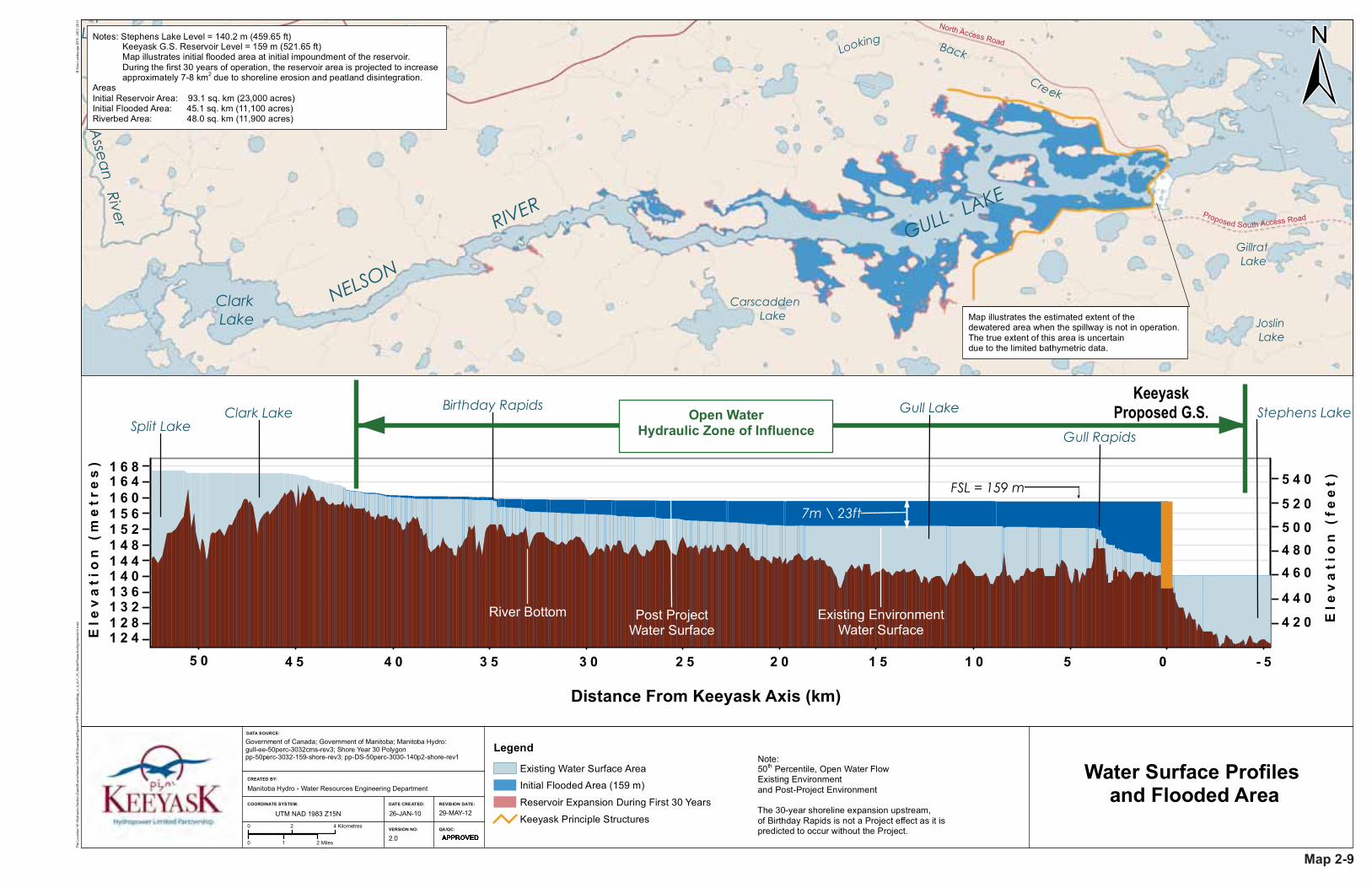
Water Surface Profiles and Flooded AreaManitoba Hydro - Water Resources Engineering Department
2.0 JJM/WJD/ZZZ
29-MAY-12 26-JAN-10
Legend
Existing Water Surface Area
Initial Flooded Area (159 m)
Reservoir Expansion During First 30 Years
Keeyask Principle Structures
Notes: Stephens Lake Level = 140.2 m (459.65 ft) Keeyask G.S. Reservoir Level = 159 m (521.65 ft) Map illustrates initial flooded area at initial impoundment of the reservoir. During the first 30 years of operation, the reservoir area is projected to increase approximately 7-8 km2 due to shoreline erosion and peatland disintegration.AreasInitial Reservoir Area: 93.1 sq. km (23,000 acres)Initial Flooded Area: 45.1 sq. km (11,100 acres)Riverbed Area: 48.0 sq. km (11,900 acres)
KeeyaskProposed G.S.
Post ProjectWater Surface
River Bottom Existing EnvironmentWater Surface
Birthday Rapids
7m \ 23ft
Stephens LakeOpen WaterHydraulic Zone of InfluenceSplit Lake
Clark Lake Gull Lake
Gull Rapids
Ele
va
tio
n (
fee
t)
5 0 0
4 4 0
4 6 04 8 0
4 2 0
5 2 0
5 4 0
Ele
va
tio
n (
me
tre
s) 1 6 8
1 5 61 6 01 6 4
1 3 21 3 61 4 01 4 41 4 81 5 2
1 2 41 2 8
5 0 3 03 54 04 5 1 01 52 02 5 05 - 5
Distance From Keeyask Axis (km)
Note: 50th Percentile, Open Water Flow Existing Environment and Post-Project Environment
The 30-year shoreline expansion upstream, of Birthday Rapids is not a Project effect as it is predicted to occur without the Project.
Map illustrates the estimated extent of thedewatered area when the spillway is not in operation. The true extent of this area is uncertain due to the limited bathymetric data.
Government of Canada; Government of Manitoba; Manitoba Hydro:gull-ee-50perc-3032cms-rev3; Shore Year 30 Polygonpp-50perc-3032-159-shore-rev3; pp-DS-50perc-3030-140p2-shore-rev1
DATE CREATED:
CREATED BY:
VERSION NO:
REVISION DATE:
QA/QC:
COORDINATE SYSTEM:
0 1 2 Miles
0 2 4 Kilometres
FSL = 159 m
DATA SOURCE:
Map 2-9
JL/AMB/MES

DATA SOURCE:
DATE CREATED:
CREATED BY:
VERSION NO:
REVISION DATE:
QA/QC:
COORDINATE SYSTEM:
Flooded Area
Construction Phase Boat Launch and Barge Landing
Access Trail
Operation Phase Boat Launch and Barge Landing
Portage Route
Construction & Operation Phase Boat Launch and Barge Landing Access Trail and Portage Route
UTM NAD 1983 Z15N
0 0.2 0.4 Miles
0 0.25 0.5 Kilometres
ProposedKeeyask G.S.
B S
ize
Land
scap
e B
TB
- D
EC
201
1Fi
le L
ocat
ion:
\\ge
odat
a\w
areh
ouse
\War
ehou
se_G
roup
s\P
ower
_Sup
ply\
Pro
ject
s\K
eeya
sk\M
aps\
EIS
\Cha
pter
4_P
roje
ctD
escr
iptio
n\M
XD
s\D
raft3
\Kee
yask
_Sup
port
ingI
nfra
stru
ctur
e_20
1205
01.m
xd
Supporting Infrastructure
Manitoba Hydro; Government of Manitoba; Government of Canada; KGSA;Manitoba Hydro 2010 10cm Color DOI
Manitoba Hydro - Hydro Power Planning - GIS & Special Studies
2.0 JCL/MES/MWZ
25-JUN-12 03-AUG-11
S T E P H E N S L A K E
G U L L L A K E
Legend
Initial Flooded Area (159 m)
Infrastructure
Proposed Access Road
Access Road
Boat Launch (Barge Landing)
Portage Route
Boat Launch Access Trail
Potential Barge Landing Location
FLOW
Potential Barge LandingLocations
0 2 41 Kilometers
0 0.9 1.8 2.70.45 Miles
Map 2-10
JL/AMB/MES

Ice Boom
Alternative Ice Boom TrailCorridor - Option B
Planned Ice Boom TrailCorridor - Option A
Planned Ice BoomBoat Launch
Alternative Ice BoomBoat Launch
North Access Road
DATA SOURCE:
Ice Boom Location, Access and
Public Safety MeasuresUTM NAD 1983 Z15NDATE CREATED:
CREATED BY:
VERSION NO:
REVISION DATE:
QA/QC:
1.0 JCL/MES/ZZZ
04-OCT-11
Option A
Planned Ice Boom Access Trail Alignment Alternatives
Planned Ice Boom Access Trail Corridor
File
Loc
atio
n: \\
geod
ata\
war
ehou
se\W
areh
ouse
_Gro
ups\
Pow
er_S
uppl
y\P
roje
cts\
Kee
yask
\Map
s\E
IS\C
hapt
er4_
Pro
ject
Des
crip
tion\
MX
Ds\
Dra
ft3\K
eeya
sk_I
ceB
oom
_Pub
licS
afet
y.m
xd
12-JUN-12
Manitoba Hydro; Government of Manitoba; Government of Canada; KGSA;Manitoba Hydro 2010 10cm Color DOI
COORDINATE SYSTEM:
0 0.15 0.3 Miles
0 0.2 0.4 Kilometres
Manitoba Hydro - Hydro Power Planning - GIS & Special Studies
G U L L L A K E Gull
RapidsFLOW
Note: The North Access Road is being built during2011-2012 as part of the Keeyask InfrastructureProject (KIP). The KIP is separate from the KeeyaskGeneration Project.
Option B
Alternative Ice Boom Access Trail Corridor
Legend
Warning Sign
Buoy and Strobe Light
Safety Boom
B S
ize
Land
scap
e B
TB
- O
CT
201
1
~90m
~90m
~660m
FLOW
Map 2-11
JL/AMB/MES

DATA SOURCE:
DATE CREATED:
CREATED BY:
VERSION NO:
REVISION DATE:
QA/QC:
COORDINATE SYSTEM:
UTM NAD 1983 Z15N
B S
ize
Land
scap
e B
TB
- D
EC
201
1Fi
le L
ocat
ion:
W:\W
areh
ouse
_Gro
ups\
Pow
er_S
uppl
y\P
roje
cts\
Kee
yask
\Map
s\E
IS\C
hapt
er4_
Pro
ject
Des
crip
tion\
MX
Ds\
Dra
ft3\K
eeya
sk_S
tage
Iand
Sta
geII_
Div
ersi
on_
2012
0517
.mxd
Stage I and II River Diversion
Manitoba Hydro; Government of Manitoba; Government of Canada;KGS Acres Ltd.; Manitoba Hydro - Water Resource Engineering
Manitoba Hydro - Hydro Power Planning - GIS & Special Studies
1.0 XXX/YYY/ZZZ
13-JUN-12 13-FEB-12
Helicopter PadCamp
Work Area
North Access Road
Quarry Cofferdam
SpillwayCofferdam
Ice BoomStage I Island
Cofferdam
ConstructionSub-Station
North ChannelRock Groin
PowerhouseCofferdam
Central DamCofferdam
Work Area
Proposed SouthAccess Road
NorthDyke
Stage INorth Channel
Cofferdam
RockGroin
Helicopter PadCamp
Work Area
North Access Road
Work Area
North ChannelCofferdam
Tailrace Channel SummerLevel Cofferdam
Transmission TourSpur
Quarry Cofferdam
Stage II IslandCofferdamSpillway
Cofferdam
South Dam Upstream Cofferdam
Ice Boom
Central Damand Central
Dam Cofferdam
Stage I IslandCofferdam
ConstructionSub-Station
North ChannelRock Groin
Powerhouse Cofferdam
South Dam Downstream Cofferdam
NorthDyke
SouthDyke
RockGroin
Proposed SouthAccess Road
STAGE I DIVERSION JUNE 2014 TO JULY 2017
STAGE II DIVERSION AUGUST 2017 TO OCTOBER 2019
0 0.25 0.5 Miles
0 0.3 0.6 Kilometres
Legend
Work Area and Construction Camp
Earthfill Structure (Complete)
Bedrock Excavation Area
Concrete/Steel Structure
Dewatered Area
Existing Water Surface Area
Flooded Area
Access Road
Proposed Access Road
NELSON RIVERNELSON RIVER
Map 2-12
JL/AMB/MES

DATA SOURCE:
DATE CREATED:
CREATED BY:
VERSION NO:
REVISION DATE:
QA/QC:
COORDINATE SYSTEM:
G - 3
S - 11
G - 1
S - 2a
N - 21
N - 5
S - 5
N - 6
S - 2b
S - 18
Q - 7
B - 1S - 4
Q - 1
S - 17a
Q - 8
S - 17b
E - 1
Q - 9
PR 280
North Access Road
Proposed South Access Road
UTM NAD 1983 Z15N
0 0.85 1.7 Miles
0 1 2 Kilometres
ProposedKeeyask G.S.
B S
ize
Land
scap
e B
TB
- D
EC
201
1Fi
le L
ocat
ion:
\\ge
odat
a\w
areh
ouse
\War
ehou
se_G
roup
s\P
ower
_Sup
ply\
Pro
ject
s\K
eeya
sk\M
aps\
EIS
\Cha
pter
4_P
roje
ctD
escr
iptio
n\M
XD
s\D
raft3
\Kee
yask
_Bor
row
Sou
rces
Qua
rrie
s_20
1205
22.m
xd
Borrow Sources and Quarries
Potential
Manitoba Hydro; Government of Manitoba; Government of Canada; KGSAcreas; Manitoba Hydro 1999 1m Black & White DOI
Manitoba Hydro - Hydro Power Planning - GIS & Special Studies
3.0 JCL/MES/ZZZ
22-MAY-12 09-FEB-12
Legend
Material SourcesGranular Borrow
Impervious Borrow
Rock Quarry
Access Road
Proposed Access Road
Keeyask Principal Structures
Initial Flooded Area (159 m)
Map 2-13
JL/AMB/MES

DATA SOURCE:
DATE CREATED:
CREATED BY:
VERSION NO:
REVISION DATE:
QA/QC:
COORDINATE SYSTEM:
GULL LAKE
Cache Lake
Ferris Bay
Kettle Rapids
Wilson Channel
C re
Sky Pilot
Bo ots
Creek
Butna u R iver
River
Sky Pilot Lake
Gillrat Lake
Joslin Lake
ver
Looking Back Cre ek
Ke ttle R
ive
r
STEPHENSLAKE
Gillam
Proposed South Access RoadButnau Dam
ProposedKeeyask G.S.
138-
kV T
L R
C60
138-kV TL R26K
138-kV TL KN36
Bip
oles
l &
ll
PR 280
PR 280
North Access Road
Butnau Road Fox Lake Cree NationA Kwis Ki Mahka Reserve
UTM NAD 1983 Z15N
0 1 2 Miles
0 1.5 3 Kilometres
B S
ize
Land
scap
e B
TB
- D
EC
201
1Fi
le L
ocat
ion:
\\ge
odat
a\w
areh
ouse
\War
ehou
se_G
roup
s\P
ower
_Sup
ply\
Pro
ject
s\K
eeya
sk\M
aps\
EIS
\Cha
pter
4_P
roje
ctD
escr
iptio
n\M
XD
s\D
raft3
\Kee
yask
_Acc
essR
ds_2
0120
625.
mxd
Access Roads
Manitoba Hydro; Government of Manitoba; Government of Canada;KGS Acres Ltd.
Manitoba Hydro - Hydro Power Planning - GIS & Special Studies
1.0 XXX/YYY/ZZZ
26-JUN-12 22-FEB-12
Legend
Access Road
Proposed Access Road
Roadway To Be UpgradedProvincial Road
Proposed Road Corridor
Rail
Transmission Line
ButnauDam
Keeyask Principal Infrastructure Axis
Existing Water Level Area
Initial Flooded Area (159m)
ProposedKeeyask G.S.
Map 2-14
JL/AMB/MES

DATA SOURCE:
DATE CREATED:
CREATED BY:
VERSION NO:
REVISION DATE:
QA/QC:
COORDINATE SYSTEM:
JoslinLake
EthelLake
Ross Wright Bay
O'NEIL BAY
Gillrat L
ake
Wilson Channel
Cache Lake
BUTNAU
RIVER
KETTLE
RIVER
STEPHENS LAKE
RIVER
KETTLE
STEPHENS LAKEek
Gillam
Proposed South Access Road
SC_3Gull Rapids Creek
SC_4Unnamed Tributaryof Stephens Lake
SC_5Gillrat Lake Creek
SC_6Buntau Weir
North Access
Road
PR 280
Fox Lake Cree NationA Kwis Ki
Mahka Reserve
Bip
oles
l &
ll
138-kVTL KN36
138-
kVTL
KN
36
138-kV TL KN36
138-kV TL KN36 138-kV TL R26K
UTM NAD 1983 Z15N
0 1 2 Miles
0 1 2 Kilometres
B S
ize
Land
scap
e B
TB
- D
EC
201
1Fi
le L
ocat
ion:
J:\M
FA_G
IS\G
IS_M
aps\
SD
FD
\Kee
yask
_Sou
thA
cces
sRoa
d_S
trea
mC
ross
ings
_With
Pic
ture
s of
Loc
atio
ns_2
0120
608.
mxd
South Access Road Stream Crossings
Manitoba Hydro; Government of Manitoba; Government of Canada;KGS Acres Ltd.; Manitoba Hydro 1999 Black & White 1m 1999 DOI; North /South Consultants Inc.
Manitoba Hydro - Hydro Power Planning - GIS & Special Studies
1.0 XXX/YYY/ZZZ
08-JUN-12 22-FEB-12
Legend
Access Road
Proposed Access Road
Existing Highway
Proposed Road Corridor
Proposed Stream Crossing
Rail
Transmission Line
Butnau Dam
Keeyask Principal Infrastructure Axis
Existing Water Level Area
Initial Flooded Area (159m)
ProposedKeeyask G.S.
0 0.5 10.25 Miles
0 0.6 1.20.3 Kilometers
0 0.5 10.25 Miles
0 0.6 1.20.3 Kilometers
0 0.5 10.25 Miles
0 0.6 1.20.3 Kilometers
0 0.5 10.25 Miles
0 0.6 1.20.3 Kilometers
© North South Consultants, 2004 © North South Consultants, 2004
© North South Consultants, 2004 © Manitoba Hydro, 2011
Map 2-15
JL/AMB/MES

DATA SOURCE:
DATE CREATED:
CREATED BY:
VERSION NO:
REVISION DATE:
QA/QC:
COORDINATE SYSTEM:
UTM NAD 1983 Z15N
0 0.1 0.2 Miles
0 0.1 0.2 Kilometres
B S
ize
Land
scap
e B
TB
- D
EC
201
1Fi
le L
ocat
ion:
W:\W
areh
ouse
_Gro
ups\
Pow
er_S
uppl
y\P
roje
cts\
Kee
yask
\Map
s\E
IS\C
hapt
er4_
Pro
ject
Des
crip
tion\
MX
Ds\
Dra
ft3\K
eeya
sk_B
oatla
unch
_Acc
essR
oute
s_20
1205
09.m
xd
Boat Launch andAccess Routes
Manitoba Hydro; Government of Manitoba; Government of Canada
Manitoba Hydro - Hydro Power Planning - GIS & Special Studies
1.0 XXX/YYY/ZZZ
10-MAY-12 25-MAR-12
Legend
Boat Launch
Portage Route
Access Trail
Access Road
Keeyask Principal Structures
Construction Phase
Operation Phase
G U L L L A K ES T E P H E N S L A K E
S T E P H E N S L A K E
G U L L L A K E
Portage Route
Potential Location of Access Trail
Note:The Location of boat launches and portagealignments are subject to change.
North Access Road
North Access Road
PowerhouseNorth Dyke
Access Trail
Map 2-16
JL/AMB/MES

DATA SOURCE:
DATE CREATED:
CREATED BY:
VERSION NO:
REVISION DATE:
QA/QC:
COORDINATE SYSTEM:
D6-I
D20-I
D26-I
D13-I
D21-I
D18-I
D16(1)-E
D25-I
D19-I
D30-E
D5-E
D12(1)-ED10-I
D27(4)-E
D31(2)-I
D12(2)-E
D29(2)-I
D29(1)-I
D35(1)-E
D14(2)-I
D8-E
D17-E
D24-ED23(1)-E
D28(1)-E
D9-I
D4-ED3-E
D23(3)-E
D23(2)-E
D7-E
D1(2)-I
D28(2)-E
D2(1)-E
D27(3)-E
D31(1)-E
D28(3)-E
D27(2)-E
D34-E
D32-E
D2(2)-E
D33-E
D1(1)-E North Access Road
Proposed South Access Road
UTM NAD 1983 Z15N
0 0.45 0.9 Miles
0 0.55 1.1 Kilometres
ProposedKeeyask G.S.
B S
ize
Land
scap
e B
TB
- D
EC
201
1Fi
le L
ocat
ion:
\\ge
odat
a\w
areh
ouse
\War
ehou
se_G
roup
s\P
ower
_Sup
ply\
Pro
ject
s\K
eeya
sk\M
aps\
EIS
\Cha
pter
4_P
roje
ctD
escr
iptio
n\M
XD
s\D
raft3
\Kee
yask
_EM
PAs_
2012
0522
.mxd
Excavated Material Placement Areas
Manitoba Hydro; Government of Manitoba; Government of Canada; KGSAcreas; Manitoba Hydro 1999 1m Black & White DOI
Manitoba Hydro - Hydro Power Planning - GIS & Special Studies
2.0 JCL/MES/MWZ
22-MAY-12 09-FEB-12
Legend
Excavated Material Placement Area
Access Road
Proposed Access Road
Keeyask Principal Structures
Initial Flooded Area (159 m)
Map 2-17
JL/AMB/MES

DATA SOURCE:
DATE CREATED:
CREATED BY:
VERSION NO:
REVISION DATE:
QA/QC:
COORDINATE SYSTEM:
UTM NAD 1983 Z15N
0 0.2 0.4 Miles
0 0.25 0.5 Kilometres
ProposedKeeyask G.S.
B S
ize
Land
scap
e B
TB
- D
EC
201
1Fi
le L
ocat
ion:
\\ge
odat
a\w
areh
ouse
\War
ehou
se_G
roup
s\P
ower
_Sup
ply\
Pro
ject
s\K
eeya
sk\M
aps\
EIS
\Cha
pter
4_P
roje
ctD
escr
iptio
n\M
XD
s\D
raft3
\Kee
yask
_Pub
licS
afet
y_C
onst
ruct
ion_
2012
0612
.mxd
Waterways Public Safety Measures
Construction Phase
Manitoba Hydro; Government of Manitoba; Government of Canada; KGSA;Manitoba Hydro 2010 10cm Color DOI
Manitoba Hydro - Hydro Power Planning - GIS & Special Studies
1.0 JCL/MES/ZZZ
13-JUN-12 03-AUG-11
S T E P H E N S L A K E
G U L L L A K E
Gull Rapids
Legend
Ice Boom
Safety Boom
Access Trail
Buoys
Boat Launch
Danger Sign
Warning Sign
Dangerous Waterway Zone
Warning Waterway Zone
Proposed Access Road
Access Road
Infrastructure
Flooded Area
FLOW
Powerhouse
Spillway
Map 2-18
JL/AMB/MES

DATA SOURCE:
DATE CREATED:
CREATED BY:
VERSION NO:
REVISION DATE:
QA/QC:
COORDINATE SYSTEM:
North Dyke
Powerhouse
Spillway
South Dyke
UTM NAD 1983 Z15N
0 0.2 0.4 Miles
0 0.2 0.4 Kilometres
ProposedKeeyask G.S.
B S
ize
Land
scap
e B
TB
- D
EC
201
1Fi
le L
ocat
ion:
\\ge
odat
a\w
areh
ouse
\War
ehou
se_G
roup
s\P
ower
_Sup
ply\
Pro
ject
s\K
eeya
sk\M
aps\
EIS
\Cha
pter
4_P
roje
ctD
escr
iptio
n\M
XD
s\D
raft3
\Kee
yask
_Pub
licS
afet
y_O
pera
tion_
2012
0613
.mxd
Waterways Public Safety Measures
Operation Phase
Manitoba Hydro; Government of Manitoba; Government of Canada; KGSA;Manitoba Hydro Artist Concept Rendering - March 2012
Manitoba Hydro - Hydro Power Planning - GIS & Special Studies
1.0 XXX/YYY/ZZZ
13-JUN-12 04-APR-12
Legend
Safety Boom
Fence
Guard Rail
Potential Portage Route
Boat Launch
Danger Sign
Portage Sign
Warning Sign
Boom Anchor Point
Siren & CCTV
Dangerous Waterway Zone
Warning Waterway Zone
Barricade
Buoys
S T E P H E N S L A K E
Artist's Rendering - Concept Only
Map 2-19
JL/AMB/MES

DATA SOURCE:
DATE CREATED:
CREATED BY:
VERSION NO:
REVISION DATE:
QA/QC:
COORDINATE SYSTEM:
GULL LAKE
Cache Lake
Ferris Bay
Kettle Rapids
Wilson Channel
Long Spruce Rapids
Little Kettle Lake
North
Angling
Lakes
Carscadden Lake
Butnau
River
North
Ang
ling
Rive
r
Wilso
n
Cre
ek
Leslie Sky Pilot Creek
Brooks
Bo ots
Creek
Butna u R iver
Kettle
River
Sky Pilot Lake
Gillrat Lake
Joslin Lake
Butn
au
R
iver
wakot River
ver
Looking Back Cre ek
Butnau Lake
Ke ttle R
ive
r
STEPHENSLAKE
138-kV TL KN36
138-
kV T
L R
C60
500-kV TL Bipoles 1 & 2
RadissonConverter Station
North Access Road
Proposed South Access RoadGillam
PR 280
PR 280
Kettle G.S.
Long Spruce G.S.
Proposed Keeyask G.S.
UTM NAD 1983 Z15N
0 1.5 3 Miles
0 2 4 Kilometres
B S
ize
Land
scap
e B
TB
- D
EC
201
1Fi
le L
ocat
ion:
\\ge
odat
a\w
areh
ouse
\War
ehou
se_G
roup
s\P
ower
_Sup
ply\
Pro
ject
s\K
eeya
sk\M
aps\
EIS
\Cha
pter
4_P
roje
ctD
escr
iptio
n\M
XD
s\D
raft3
\Kee
yask
_Pre
limin
aryT
rans
mis
sion
Line
s_C
onst
ruct
ion_
2012
0522
.mxd
Manitoba Hydro; Government of Manitoba; Government of Canada;Manitoba Hydro - Transmission; Manitoba Hydro - Water ResourceEngineering (PP_95perc_4327_159_shore_rev5)
Manitoba Hydro - Hydro Power Planning - GIS & Special Studies
2.0 XXX/YYY/ZZZ
22-MAY-1213-FEB-12
Proposed Keeyask G.S.
Thompson
Winnipeg
Hudson Bay
LakeWinnipeg
LegendTransmission Line (Existing)
Construction Power Line (Proposed)
Back-up Construction Power Transmission Line
Route Alternative Option A
Route Alternative Option B
Route Alternative Option C
Generating Station (Existing)
Converter Station (Existing)
Keeyask Principal Structures
Transmission Substation (Proposed)
Potential Dewatered Area
Initial Flooded Area (159 m)
Exisiting Water Level
Highway
Access Road
Proposed Access Road
Alternative RoutesBack-up Construction Power Line
1 - 138kV to Radisson Station
Construction Power - 138 kV
Construction PowerStation
Construction PowerStation
DewateredArea
ConstructionPower 138 kVNotes:
All proposed Transmission Lines are Alternative Routes undergoing initial stages of the siteselection process. Alignment and other design parameters are preliminary and subject to change
Map illustrates the estimated extent of the dewatered area when the spillway is not in operation.The true extent of this area is uncertain due to the limited bathymetric data.
Keeyask Transmission Project
Preliminary Transmission Corridors During Keeyask Generation Project
Construction PhaseMap 2-20
JL/AMB/MES
DATA SOURCE:
DATE CREATED:
CREATED BY:
VERSION NO:
REVISION DATE:
QA/QC:
COORDINATE SYSTEM:
GULL LAKE
Cache Lake
Ferris Bay
Kettle Rapids
Wilson Channel
Long Spruce Rapids
Little Kettle Lake
North
Angling
Lakes
Carscadden Lake
Butnau
River
North
Ang
ling
Rive
r
Wilso
n
Cre
ek
Leslie Sky Pilot Creek
Brooks
Bo ots
Creek
Butna u R iver
Kettle
River
Sky Pilot Lake
Gillrat Lake
Joslin Lake
Butn
au
R
iver
wakot River
ver
Looking Back Cre ek
Butnau Lake
Ke ttle R
ive
r
STEPHENSLAKE
138-kV TL KN36
138-
kV T
L R
C60
500-kV TL Bipoles 1 & 2
RadissonConverter Station
North Access Road
Proposed South Access RoadGillam
PR 280
PR 280
Kettle G.S.
Long Spruce G.S.
Proposed Keeyask G.S.
UTM NAD 1983 Z15N
0 1.5 3 Miles
0 2 4 Kilometres
B S
ize
Land
scap
e B
TB
- D
EC
201
1Fi
le L
ocat
ion:
\\ge
odat
a\w
areh
ouse
\War
ehou
se_G
roup
s\P
ower
_Sup
ply\
Pro
ject
s\K
eeya
sk\M
aps\
EIS
\Cha
pter
4_P
roje
ctD
escr
iptio
n\M
XD
s\D
raft3
\Kee
yask
_Pre
limin
aryT
rans
mis
sion
Line
s_O
pera
tion_
2012
0522
.mxd
Keeyask Transmission Project
Preliminary Transmission Corridors During Keeyask Generation Project
Operation Phase
Manitoba Hydro; Government of Manitoba; Government of Canada;Manitoba Hydro - Transmission; Manitoba Hydro - Water ResourceEngineering (PP_95perc_4327_159_shore_rev5)
Manitoba Hydro - Hydro Power Planning - GIS & Special Studies
2.0 XXX/YYY/ZZZ
22-MAY-1213-FEB-12
Proposed Keeyask G.S.
Thompson
Winnipeg
Hudson Bay
LakeWinnipeg
Legend
Transmission Line (Existing)
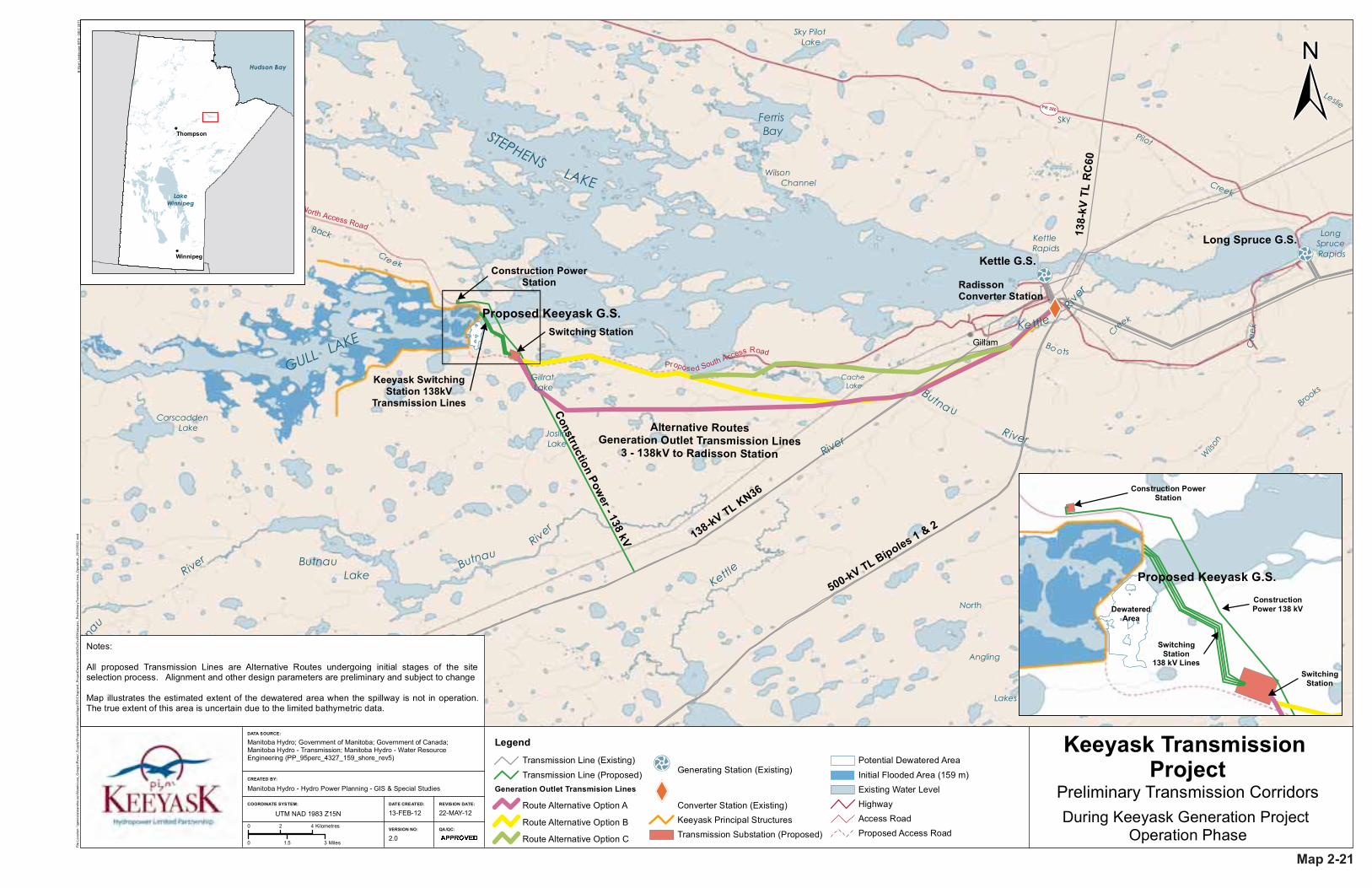
Transmission Line (Proposed)Generation Outlet Transmision Lines
Route Alternative Option A
Route Alternative Option B
Route Alternative Option C
Generating Station (Existing)
Converter Station (Existing)Keeyask Principal StructuresTransmission Substation (Proposed)
Potential Dewatered Area
Initial Flooded Area (159 m)Existing Water LevelHighwayAccess RoadProposed Access Road
Construction Power - 138 kV
Construction PowerStation
Switching Station
Keeyask SwitchingStation 138kV
Transmission Lines
Construction PowerStation
SwitchingStation
DewateredArea
ConstructionPower 138 kV
SwitchingStation
138 kV Lines
Notes:
All proposed Transmission Lines are Alternative Routes undergoing initial stages of the siteselection process. Alignment and other design parameters are preliminary and subject to change
Map illustrates the estimated extent of the dewatered area when the spillway is not in operation.The true extent of this area is uncertain due to the limited bathymetric data.
Alternative RoutesGeneration Outlet Transmission Lines
3 - 138kV to Radisson Station
Map 2-21
JL/AMB/MES

DATA SOURCE:
DATE CREATED:
CREATED BY:
VERSION NO:
REVISION DATE:
QA/QC:
COORDINATE SYSTEM:
GULL LAKE
CarscaddenLake
O'NEIL BAY
NELSON
RIVER
Look ing Back Creek North Access Road
Proposed South Access Road
UTM NAD 1983 Z15N
0 0.55 1.1 Miles
0 0.7 1.4 Kilometres
ProposedKeeyask G.S.
B S
ize
Land
scap
e B
TB
- D
EC
201
1Fi
le L
ocat
ion:
\\ge
odat
a\w
areh
ouse
\War
ehou
se_G
roup
s\P
ower
_Sup
ply\
Pro
ject
s\K
eeya
sk\M
aps\
EIS
\Cha
pter
4_P
roje
ctD
escr
iptio
n\M
XD
s\D
raft3
\Kee
yask
_Bio
phys
ical
Env
ironm
enta
lMiti
gatio
nAre
as_2
0120
523.
mxd
Biophysical Environmental Mitigation Areas General Locations
Manitoba Hydro; Government of Manitoba; Government of Canada; KGSAcres. (Design Memo's GN 9.8.11, GN 9.8.10, GN 9.8.3)
Manitoba Hydro - Hydro Power Planning - GIS & Special Studies
4.0 XXX/YYY/ZZZ
23-MAY-12 12-APR-12
Legend
Planned Lake Sturgeon Spawning Habitat
Potential Lake Sturgeon Spawning HabitatPotential Young-Of-Year Lake Sturgeon Habitat
Planned Lake Whitefish Spawning HabitatPlanned Lake Whitefish and Walleye Spawning Habitat
Planned Fish Egress Channel
Potential Bird Island HabitatPotential High Quality WetlandsKeeyask Principal Structures
Initial Flooded Area (159 m)
NELSON
RIVER
Birthday Rapids
Upstream NearBirthday Rapids
Map 2-22
JL/AMB/MES